Technical Memorandum
Annex 18
ANNEX 18: GUIDELINES FOR LANDSCAPE AND VISUAL IMPACT ASSESSMENT
1. General
1.1. Landscape and visual impact assessment shall be directed towards the predicting and judging the significance of the effects that new development may have on landscape and visual resources, landscape with distinctive character and visual amenity. This Annex describes the general approach and methodology for assessment of landscape and visual impacts. The methodology may vary from case to case, depending on the nature of the issues. However, it must be admitted that such an assessment involves subjective judgement and preference. The perception and aspiration of the community on particular landscape features must be taken into account.
2. The Need for Landscape and Visual Impact Assessment
2.1 The procedures for determining the need for landscape impact assessment and visual impact assessment are outlined in Appendix A and Appendix B respectively. The landscape with distinctive character/resources to be considered are described in Note 1 to Appendix A.
2.2 The need for landscape impact assessment and visual impact assessment will be considered independently following the approach as set out in the Appendix A and Appendix B.
3. Study Process
3.1 A landscape and visual impact assessment shall cover the following:
- defining the scope and contents of the study;
- a baseline study to provide for a comprehensive and accurate description of the baseline landscape and visual characters and resources;
- impact studies to identify the potential landscape and visual impacts and predict their magnitude and potential significance; and
- recommendations on design and/or mitigation measures and implementation programme.
4. Scope and Contents
4.1 In setting the scope of the study, the following aspects shall be considered:
- limits of the assessment area;
- key issues to be addressed;
- level of details required for baseline studies;
- key public viewing points to be covered;
- approach and methodology to be used for impact assessment and judging impact significance;
- alternatives;
- other development if cumulative impacts are to be assessed.
5. Baseline Study
5.1 The main objective of the baseline study is to provide an understanding of the landscape in the area that may be affected, and to establish a visual envelope or a zone of visual influence in which the development might be visible, the visual amenity which might be affected, and public viewers who may experience views towards the development.
5.2 The baseline study shall present a brief account of the landscape and visual characters and resources of the assessment area. Their levels of details should be appropriate and proportional to the scale and type of development and the significance of the landscape and visual impacts likely to occur. It shall focus particularly on the sensitivity of the landscape and visual system and its ability to accommodate change.
6. Landscape Impact Assessment Study
6.1 Landscape impact assessment shall assess :
- direct impacts upon specific landscape elements, in particular on landscape with special interest, distinctive quality and value;
- the overall pattern of landscape elements that give rise to landscape character, and local and regional distinctiveness.
6.2 Examples of landscape with distinctive character/resources are set out in Note 1 to Appendix A.
7. Visual Impact Assessment Study
7.1 Visual impact assessment shall focus on permanent impacts and assess the significance thresholds including magnitude of changes and sensitivity of viewers.
7.1.1 Magnitude of Changes
- Visual composition – Impacts on visual balance, compatibility, harmony, unity or contrast;
- Visual obstruction – Impacts on condition, quality and character of visual resources;
- Visual change – Impacts on changes with direct sightlines (considering degree of visibility and viewing distance) to the existing and future public views by comparing before and after the proposed development.
7.1.2 Sensitivity of Viewers
- Type of viewers and value of existing views (if applicable).
8. Design and Mitigation Measures
8.1 Alternative design that would avoid or reduce the identified impacts on landscape; and/or visual amenity shall be thoroughly examined before adopting other mitigation or compensatory measures to alleviate the impacts.
8.2 Possible measures that may mitigate or compensate the impacts include:
- remedial - e.g. facade treatment, design elements/features and buffer plantings; and
- compensatory - e.g. landscape treatment, compensatory planting, creation of interesting landscape or visual features.
8.3 A practical programme for the implementation of the recommended mitigation measures with responsible parties shall be worked out. These shall be integrated with the overall development programme of the whole project.
8.4 While design that would enhance the landscape and visual quality shall be encouraged and adopted, architectural design and landscaping arrangement would normally be revised or further developed in the detailed design stage. Flexibility would be allowed for applicant to enhance the landscape and visual design at later stages of the project.
8.5 For a project under Schedule 3 to the Ordinance which does not involve designated projects under Schedule 2 or if detailed information for the designated projects under Schedule 2 is not available, the landscape impact assessment and the visual impact assessment should contain a broad assessment of the potential landscape and visual impacts arising from the project.
9. Presentation Methods
9.1 To illustrate the landscape and visual impacts of a project, as well as effects of the mitigation measures, choice of appropriate presentation methods is important. These methods include perspective drawings, plans and section/elevation diagrams and photomontage to demonstrate the relationship with the setting. These methods shall be used extensively to facilitate communication among the concerned parties.
9.2 The technical details of preparing the illustrations shall be recorded. To facilitate verification of the accuracy, the Authority will reserve the right to examine the full details.
Appendix A
The flow chart below summarizes the general procedures in determining the need for a landscape impact assessment for a designated project. A literature review and/or preliminary site visit may be required for checking whether there will be any direct impact of special landscape significance.
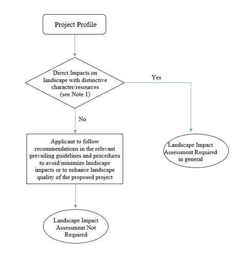
Note 1: Examples of Landscape with Distinctive Character/Resources
Country Parks, coastal protection areas, conservation areas, wetlands, areas of high landscape value, scenic spots, hilltops, ridgeline, rivers, mature woodlands, special water features, nature reserves, Sites of Special Scientific Interest, historic landscapes, sites of cultural heritage, sites with Old and Valuable Tree, stone wall tree, tree of particular interest, etc.
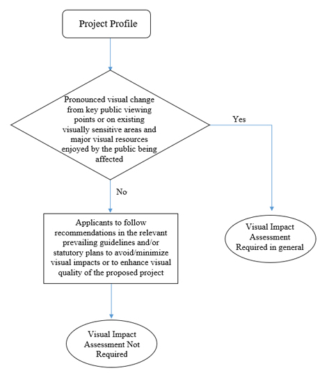
Appendix B
The flow chart below summarizes the general procedures in determining the need for a visual impact assessment to identify and predict the permanent impacts of a designated project.

|
