

CONTENTS
1.4 Summary of Construction Works
1.5 Summary of EM&A Programme Requirements
2.4 Monitoring Parameters, Frequency and Duration
2.6 Monitoring Schedule for the Reporting Month
3 Silt Curtain monitoring and audit
3.4 Monitoring Parameters, Frequency and Duration
4.3 Monitoring Locations and Frequency
5 Conclusions and Recommendations
LIST OF TABLES
Table 1.1 Contact Information of Key Personnel
Table 2.1 Water Quality Monitoring Equipment
Table 2.2 Locations of Impact Water Quality Monitoring Stations
Table 2.3 Water Quality Monitoring Parameters, Frequency and Duration
Table 2.4 Summary of Water Quality Monitoring Results in the Reporting Period
Table 3.1 Silt Curtain Monitoring Equipment
Table 3.2 Water Quality Monitoring Parameters, Frequency and Duration
Table 3.3 Summary of Silt Curtain Monitoring Results in the Reporting Period
Table 4.1 Marine Mammal Observation Equipment
LIST OF FIGURES
Figure
1.1 Alignment of
AAE-1 Cable System within Hong Kong
Figure
2.1 Locations of
Water Quality Monitoring Station
LIST OF APPENDICES
Appendix
A Project Organization
Appendix B Environmental Mitigation Measures
Implementation Schedule
Appendix C Calibration
Certificates of Monitoring Equipment
Appendix D EM&A Monitoring Schedules
Appendix E Summary of
Action / Limit Level
Appendix
F Water Quality Monitoring Results
Executive
Summary
The EM&A programme for the Project commenced on 11 July 2017. The impact environmental monitoring include water quality monitoring, silt curtain monitoring and marine mammal observations.
This report documents the findings of EM&A works conducted in the period from 1 to 31 July 2017.
Breaches of Action and Limit Levels for Water Quality Monitoring
One (1) Action Level exceedance of Suspended Solids at E3 at Mid-Flood tide on 12 July 2017 was recorded in the reporting month. This exceedance was considered not likely to be caused by this Contract’s activities after investigation.
Four (4) Action Level exceedances of Dissolved Oxygen at surface & middle level at L1 (Mid-Flood, 11 July 2017), E3 (Mid-Flood, 11 July 2017), G1 (Mid-Ebb, 12 July 2017) and G2 (Mid-Ebb, 20 July 2017) were recorded in the reporting month. These exceedances were considered not likely to be caused by this Contract’s activities after investigation.
One hundred and twenty (120) Action Level exceedances of Dissolved Oxygen at bottom level of all monitoring locations at both Mid-Ebb and Mid-Flood tide every monitoring day were recorded in the reporting month. These exceedances were considered not likely to be caused by this Contract’s activities after investigation.
No exceedance of Limit Level of water quality was recorded in the reporting month.
Breaches of Action and Limit Levels for Silt Curtain Monitoring
No exceedance of Limit Level of silt curtain monitoring was recorded in the reporting month.
Marine Mammal Observation
No cetacean was observed in the exclusion zone for 30 minutes before the installation works start on 11, 12, 13 and 20 July 2017.
Complaint, Notification of Summons and Successful Prosecution
No environmental complaint, notification of summons and successful prosecution was received in the reporting month.
1
Introduction
1.1 Background
1.1.1 The AAE-1 Cable System (the Project) will be one of the first cable systems connecting Hong Kong, Singapore, Middle East, Africa and Europe, providing an alternative low latency route between the Far East and Europe. The entire AAE-1 Cable, spanning approximately 25,000 km from Hong Kong to France. Within Hong Kong, the length of the AAE-1 Cable is approximately 27.65km, as shown in Figure 1.1.
1.1.2 AAE-1 is to be constructed by the AAE-1 Consortium, which includes PCCW Global (HK) Ltd (PCCWG), who is responsible for the installation of the Project within Hong Kong.
1.1.3 A Project Profile was prepared to assess potential environmental impacts associated with the installation of the submarine telecommunications cable system within Hong Kong. The Project Profile was submitted to the Environmental Protection Department (EPD) under section 5(1)(b) and 5(11) of the Environmental Impact Assessment Ordinance (EIAO) for application for permission to apply directly for an Environmental Permit (EP) (Application No. DIR-244/2016). Permission granted by EPD via an approval letter dated 2 March 2016 (Ref. EP2/H18/C/10).
1.1.4 The Project Profile recommended carrying out precautionary water quality monitoring to ensure no adverse impacts to the water quality, marine ecology and fisheries. Also, as a precautionary measure, a 250m “marine mammal exclusion zone” around the cable laying barge shall established during the cable installation works to prevent marine mammals from being adversely affected.
1.2 Scope of Report
1.2.1 This is the first monthly Environmental Monitoring and Audit (EM&A) Report and this report presents a summary of the environmental monitoring and audit works, list of activities and mitigation measures of the Project in July 2017.
1.3 Project Organization
1.3.1 The project organization is shown in Appendix A. The key personnel contact names and numbers are summarized in Table 1.1.
Table 1.1 Contact Information of Key Personnel
|
Party |
Position |
Name |
Telephone |
Fax |
|
IEC (SMEC Asia Limited) |
Independent Environmental Checker |
Vivian Chan |
3995 8100 |
3995 8101 |
|
Contractor (Hong Kong Marine Contractors Limited) |
Project Director |
Colman Chan |
6193 4729 |
2693 2984 / 31053985 |
|
Operation Director |
Dominic Chan |
6193 4736 |
||
|
Administrative Director |
Kevin Chan |
6193 4737 |
||
|
ET (AECOM) |
ET Leader |
Y W Fung |
3922 9366 |
2371 7609 |
1.4 Summary of Construction Works
1.4.1 Details of the construction works carried out by the Contractor in this reporting period are listed below:
- Horizontal Directional Drilling (HDD)
- Surface laying by diver
- Cable burial works
1.4.2 The environmental mitigation measures implementation schedule are presented in Appendix B.
1.5 Summary of EM&A Programme Requirements
1.5.1 The EM&A programme required environmental monitoring for water quality monitoring, silt curtain monitoring and marine mammal observations. The EM&A requirements for each parameter described in the following sections include:
- All monitoring parameters;
- Monitoring schedules for the reporting period;
- Action and Limit levels for all environmental parameters;
- Event / Action Plan;
- Environmental mitigation measures, as recommended in the Project Profile; and
- Environmental requirement in contract documents.
2
Water Quality Monitoring
2.1 Monitoring Requirements
2.1.1 In accordance with the Updated EM&A Manual, the impact water quality monitoring was conducted each day during which cable burial will be carried out from Ch.500m to Ch.10km in the Project.
2.2 Monitoring Equipment
2.2.1 The brand and model of water quality monitoring equipment is given in Table 2.1.
Table 2.1 Water Quality Monitoring Equipment
|
Equipment |
Brand and Model |
|
Dissolved Oxygen Meter |
YSI 6820
|
|
Water Temperature Meter |
|
|
Salinity Meter |
|
|
Turbiditimeter |
|
|
Water Sampler |
Kahlsico Water Sampler |
|
Echo Sounder |
Eagle Cuda-168 |
|
Global Positioning System |
JRC DGPS 224 Model JLR-4341 with J-NAV 500 Model NWZ4551 |
|
Current Velocity and Direction Meter |
Falmouth Scientific ACM-PLUS-200 |
2.3 Monitoring Locations
2.3.1 In accordance with the Updated EM&A Manual, the stations for impact water quality monitoring are presented in Table 2.2 and shown in Figure 2.1.
Table 2.2 Locations of Impact Water Quality Monitoring Stations
|
Type of Station |
Station |
Location |
Easting |
Northing |
|
Water Quality Monitoring Station |
L1 |
Shek O Headland SSSI |
844603.15 |
809861.64 |
|
E1 |
Cape D’Aguilar Marine Reserve |
844778.20 |
808054.89 |
|
|
E2 |
Cape D’Aguilar Marine Reserve |
845185.03 |
807739.10 |
|
|
E3 |
Cape D’Aguilar Marine Reserve |
845355.75 |
807285.37 |
|
|
E4 |
Coral Communities at the Coast of Sung Kong |
847839.10 |
805957.97 |
|
|
E5 |
Coral Communities at the Coast of Waglan Island |
849742.30 |
805816.65 |
|
|
E6 |
Coral Communities at the Coast of Po Toi |
845546.99 |
804968.77 |
|
|
E7 |
Coral Communities at the Coast of Beaufort Island |
844690.12 |
805570.31 |
|
|
B1 |
Shek O Gazetted Bathing Beach |
844039.63 |
809802.72 |
|
|
G1 |
Gradient Station |
847740.12 |
806441.12 |
|
|
G2 |
Gradient Station |
849648.03 |
806387.80 |
|
|
G3 |
Gradient Station |
844719.38 |
809049.95 |
|
|
G4 |
Gradient Station |
845294.36 |
806542.02 |
|
|
G5 |
Gradient Station |
846049.55 |
806023.13 |
|
|
Control Station |
C1 |
Control Station |
848340.92 |
803652.59 |
2.4 Monitoring Parameters, Frequency and Duration
2.4.1 The monitoring parameters, frequency and duration of water quality monitoring are summarized in Table 2.3.
Table 2.3 Water Quality Monitoring Parameters, Frequency and Duration
|
Parameter |
Frequency and Duration |
|
Turbidity, Suspended Solids, Dissolved Oxygen, Temperature and Salinity |
Each day during which cable burial will be carried out, at mid-flood and mid-ebb tides |
2.5 Monitoring Methodology
2.5.1 The water quality monitoring procedures are presented in the following:
Ÿ All monitoring equipment were checked and calibrated before use. Responses of sensors and electrodes were also checked with certified standard solutions before each use.
Ÿ The interval between 2 sets of monitoring was not less than 36 hours.
Ÿ Duplicate in-situ measurements and water sampling were carried out in each sampling event.
Ÿ Measurements were taken at 3 water depths, namely, 1m below water surface, mid-depth and 1m above sea bed, except where the water depth less than 6m, the mid-depth station may be omitted. Should the water depth be less than 3m, only the mid-depth station was monitored.
Ÿ Analysis of suspended solids was carried out by ALS Technichem (HK) Pty Ltd. Sufficient water samples were collected at the monitoring stations for carrying out the laboratory analysis. The analysis followed the standard methods as described in APHA Standard Methods for the Examination of Water and Wastewater, 19th Edition (APHA 2540D for SS).
Ÿ Water samples for suspended solids measurements were collected in high density polythene bottles, packed in ice (cooled to 4oC without being frozen), and delivered to a HOKLAS laboratory as soon as possible after collection.
Ÿ All monitoring equipment were certified by a laboratory accredited under HOKLAS. Calibration certificates of all monitoring equipment are provided in Appendix C.
2.6 Monitoring Schedule for the Reporting Month
2.6.1 The schedule for environmental monitoring in July 2017 is provided in Appendix D.
2.7 Action/Limit Levels
2.7.1 A baseline water quality monitoring for 15 locations were carried out 3 days per week for 4 weeks between 9 May 2017 and 3 June 2017. Action and Limit Levels for water quality were established and summarized in Table 2.4 and Appendix E.
2.8 Results and Observations
2.8.1 The water quality monitoring was conducted on 11, 12, 13 and 20 July 2017. The monitoring results are summarized in Table 2.4. Detailed water quality monitoring data are presented in Appendix F.
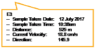
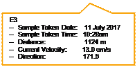
2.8.2 One (1) Action Level exceedance of Suspended Solids at E3 at Mid-Flood tide on 12 July 2017 was recorded in the reporting month.
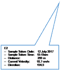
2.8.3 Exceedance was recorded at 10:36 am. According to the map below, the distance between the Cable Laying Barge (at 10:22 am) and E3 (at 10:36 am) is approximately 525m, which is larger than that from E2 (at 10:19 am) of approximately 299m. This indicates that E2 is likely to be higher potentially influenced by the Project’s activities with a smaller distance from the Cable Laying Barge. However, the Suspended Solids recorded at E2 complied with the Action/Limit Level, thus which is smaller than that recorded at E3.
2.8.4 The current velocity and direction recorded at E3 were 18.8 cm/s and 145.9 degree respectively, water quality impact was unlikely to be caused by this Project’s activities.
2.8.5 This exceedance was considered not likely to be caused by this Project’s activities after investigation.
![]()

![]()
![]()
![]()
![]()

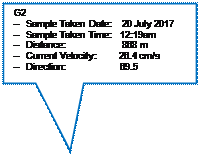
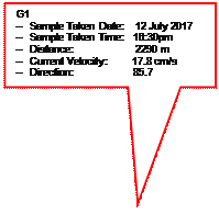
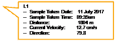
2.8.6 Four (4) Action Level exceedances of Dissolved Oxygen at surface & middle level at L1 (Mid-Flood, 11 July 2017), E3 (Mid-Flood, 11 July 2017), G1 (Mid-Ebb, 12 July 2017) and G2 (Mid-Ebb, 20 July 2017) were recorded in the reporting month. Exceedances were in the range of 6.02 – 6.22 mg/L, which exceeded slightly the Action Level of 6.26 mg/L.
2.8.7 The distance between the
Cable Laying Barge at the nearest time and L1 (at 9:35 on 11 July 2017), E3 (at
10:28 on 11 July 2017), G1 (at 16:30 on 12 July 2017) and G2 (at 12:19 on 20
July 2017) are approximately 1604m, 1124m, 2290m and 868m respectively. These
exceedances were considered not likely to be caused by this Project’s
activities due to the large distance between the monitoring locations and the
Cable Laying Barge.
![]()

![]()


![]()
![]()
![]()
![]()

2.8.8 One hundred and twenty (120) Action Level exceedances of Dissolved Oxygen at bottom level of all monitoring locations at both Mid-Ebb and Mid-Flood tide every monitoring day (11 – 13, 20 July 2017) were recorded in the reporting month. Exceedances were in the range of 4.0 – 6.0 mg/L, which exceeded slightly the Action Level of 6.10 mg/L.
2.8.9 The concentrations of Dissolved Oxygen at bottom level at Control Station (C1) were in the range of 4.02 – 5.12 mg/L, which exceed the Action Level. This indicates that low concentration of Dissolved Oxygen was occurring over a large area including the areas well outside the influence of the Project’s activities.
2.8.10 These exceedances were considered not likely to be caused by this Contract’s activities after investigation.
2.8.11 Proper mitigation measures on water quality (e.g. maximum speed of the Cable Burial Tool shall be limited) have been provided to reduce adverse impacts on water quality during construction activities. The effective implementation of mitigation measures ensured the compliance with action and limit levels of water quality during the reporting period.
2.8.12 The event action plan is presented in Appendix G.
|
||
|
Table 2.4 Summary of Water Quality Monitoring Results in the Reporting Period
|
Locations |
Parameters |
|||||||||||||||
|
Salinity (ppt) |
Dissolved Oxygen (mg/L) |
Turbidity (NTU) |
Suspended Solids (mg/L) |
|||||||||||||
|
Result |
Action Level |
Limit Level |
Result (Surface & Middle) |
Action Level |
Limit Level |
Result (Bottom) |
Action Level |
Limit Level |
Result |
Action Level |
Limit Level |
Result |
Action Level |
Limit Level |
||
|
L1 |
Avg. |
31.2 |
N/A |
N/A |
6.98 |
6.26 |
4 |
4.76 |
6.10 |
2 |
1.04 |
2.60 |
3.34 |
2.86 |
7.10 |
10.10 |
|
Min. |
24.4 |
6.02 |
4.15 |
0.68 |
1.62 |
|||||||||||
|
Max. |
37.3 |
7.96 |
5.43 |
1.55 |
4.32 |
|||||||||||
|
E1 |
Avg. |
30.9 |
7.20 |
4.76 |
1.07 |
3.39 |
||||||||||
|
Min. |
21.8 |
6.65 |
4.11 |
0.62 |
1.70 |
|||||||||||
|
Max. |
37.3 |
7.71 |
5.46 |
1.62 |
5.05 |
|||||||||||
|
E2 |
Avg. |
30.8 |
7.06 |
4.69 |
1.25 |
3.39 |
||||||||||
|
Min. |
21.5 |
6.32 |
4.17 |
0.90 |
1.47 |
|||||||||||
|
Max. |
37.3 |
7.95 |
5.13 |
1.55 |
6.45 |
|||||||||||
|
E3 |
Avg. |
30.6 |
7.08 |
4.85 |
1.25 |
4.03 |
||||||||||
|
Min. |
21.8 |
6.02 |
4.16 |
0.88 |
2.70 |
|||||||||||
|
Max. |
37.3 |
8.16 |
5.46 |
1.67 |
7.33 |
|||||||||||
|
E4 |
Avg. |
30.2 |
7.05 |
4.84 |
1.35 |
3.02 |
||||||||||
|
Min. |
17.2 |
6.35 |
4.07 |
0.77 |
1.37 |
|||||||||||
|
Max. |
37.3 |
8.14 |
5.73 |
1.73 |
5.05 |
|||||||||||
|
E5 |
Avg. |
30.2 |
7.25 |
4.80 |
1.44 |
3.21 |
||||||||||
|
Min. |
18.5 |
6.39 |
4.07 |
1.18 |
1.20 |
|||||||||||
|
Max. |
37.4 |
8.45 |
5.60 |
1.57 |
5.20 |
|||||||||||
|
E6 |
Avg. |
29.5 |
7.33 |
4.92 |
1.23 |
3.72 |
||||||||||
|
Min. |
14.7 |
6.58 |
4.01 |
0.72 |
1.77 |
|||||||||||
|
Max. |
37.3 |
8.50 |
5.72 |
1.55 |
5.70 |
|||||||||||
|
E7 |
Avg. |
30.3 |
7.12 |
4.81 |
1.21 |
3.87 |
||||||||||
|
Min. |
21.5 |
6.50 |
3.96 |
1.02 |
2.78 |
|||||||||||
|
Max. |
37.2 |
7.56 |
6.04 |
1.57 |
5.15 |
|||||||||||
|
B1 |
Avg. |
30.3 |
7.29 |
5.15 |
1.09 |
3.28 |
||||||||||
|
Min. |
24.4 |
6.35 |
4.35 |
0.47 |
1.73 |
|||||||||||
|
Max. |
36.6 |
8.29 |
5.71 |
1.57 |
5.08 |
|||||||||||
|
G1 |
Avg. |
29.6 |
7.20 |
4.84 |
1.27 |
3.49 |
||||||||||
|
Min. |
17.4 |
6.22 |
4.00 |
0.68 |
2.73 |
|||||||||||
|
Max. |
37.3 |
8.24 |
5.65 |
1.55 |
5.93 |
|||||||||||
|
G2 |
Avg. |
30.5 |
7.32 |
4.71 |
1.36 |
3.30 |
||||||||||
|
Min. |
18.9 |
6.16 |
4.05 |
0.93 |
1.78 |
|||||||||||
|
Max. |
37.4 |
8.85 |
5.25 |
1.65 |
4.63 |
|||||||||||
|
G3 |
Avg. |
31.5 |
7.19 |
4.70 |
1.06 |
3.83 |
||||||||||
|
Min. |
24.4 |
6.78 |
4.09 |
0.60 |
2.35 |
|||||||||||
|
Max. |
37.4 |
7.75 |
5.33 |
1.52 |
6.48 |
|||||||||||
|
G4 |
Avg. |
30.4 |
6.99 |
4.75 |
1.27 |
3.33 |
||||||||||
|
Min. |
21.9 |
6.26 |
3.97 |
0.98 |
1.83 |
|||||||||||
|
Max. |
37.2 |
7.72 |
5.35 |
1.58 |
4.37 |
|||||||||||
|
G5 |
Avg. |
29.8 |
7.24 |
4.90 |
1.30 |
3.28 |
||||||||||
|
Min. |
18.0 |
6.65 |
4.05 |
0.98 |
1.58 |
|||||||||||
|
Max. |
37.2 |
8.20 |
5.66 |
1.58 |
4.72 |
|||||||||||
|
C1 |
Avg. |
30.3 |
7.28 |
N/A |
N/A |
4.70 |
N/A |
N/A |
1.42 |
N/A |
N/A |
3.12 |
N/A |
N/A |
||
|
Min. |
17.4 |
6.40 |
4.02 |
1.15 |
1.22 |
|||||||||||
|
Max. |
37.4 |
8.67 |
5.12 |
1.62 |
5.37 |
|||||||||||
3
Silt Curtain monitoring and audit
3.1 Monitoring Requirements
3.1.1 In accordance with the Updated EM&A Manual, the silt curtain monitoring was conducted each day during which cable burial will be carried out from Ch.500m to Ch.2.5km in the Project.
3.2 Monitoring Equipment
3.2.1 The brand and model of water quality monitoring equipment is given in Table 3.1.
Table 3.1 Silt Curtain Monitoring Equipment
|
Equipment |
Brand and Model |
|
Turbiditimeter |
WTW Turb 430T |
|
Echo Sounder |
Eagle Cuda-168 |
|
Global Positioning System |
JRC DGPS 224 Model JLR-4341 with J-NAV 500 Model NWZ4551 |
3.3 Monitoring Locations
3.3.1 In accordance with the Updated EM&A Manual, water quality monitoring “inside” the silt curtain (S1) (i.e. between burial tool and the silt curtain) and “outside” of the silt curtain (S2) (i.e. between the silt curtain and Cape D’Aguilar Marine Reserve) were conducted.
3.4 Monitoring Parameters, Frequency and Duration
3.4.1 The monitoring parameters, frequency and duration of water quality monitoring are summarized in Table 3.2.
Table 3.2 Water Quality Monitoring Parameters, Frequency and Duration
|
Parameter |
Frequency and Duration |
|
Turbidity |
Hourly basis, |
3.5 Monitoring Methodology
3.5.1 The water quality monitoring procedures are presented in the following:
Ÿ All monitoring equipment were checked and calibrated before use. Responses of sensors and electrodes were also checked with certified standard solutions before each use.
Ÿ Duplicate in-situ measurements were carried out in each sampling event.
Ÿ Measurements were taken at 1m above sea bed.
Ÿ All monitoring equipment were certified by a laboratory accredited under HOKLAS. Calibration certificates of all monitoring equipment are provided in Appendix C.
3.6 Limit Level
3.6.1 Water quality is considered to be unaffected by cable burial works if the monitoring result at S1 is <20% above the SDAILYBASELINE value. If the monitoring result at S1 is ≥20% above the SDAILYBASELINE value, then the results will be evaluated against the Limit Level. The Limit Level for S2 was established by the equation, S2LIMIT = (S1 – SDAILYBASELINE) * 15% + SDAILYBASELINE, and summarized in Table 3.3.
3.7 Results and Observations
3.7.1 The silt curtain monitoring was conducted on 11 and 12 July 2017. The silt curtain monitoring was not carried out from 13 July 2017 onwards as cable burial works from Ch.500m to Ch.2.5km were completed on 12 July 2017. The monitoring results are summarized in Table 3.3.
3.7.2 SDAILYBASELINE recorded for 11 and 12 July 2017 are 1.065 and 1.740 NTU respectively. The values of 20% above the SDAILYBASELINE values are 1.278 and 2.088 NTU respectively.
3.7.3 Four (4) recorded S1 average turbidity is ≥20% above the SDAILYBASELINE value in the reporting month. Monitoring results which are ≥20% above the SDAILYBASELINE value were recorded at 14:31 pm and 16:30 pm on 11 July 2017 and at 14:05 pm and 15:05 pm on 12 July 2017. Limit Levels of S2LIMIT were established to evaluate these monitoring results.
3.7.4 No exceedance of Limit Level (i.e. S2LIMIT = (S1 – SDAILYBASELINE) * 15%) + SDAILYBASELINE) was recorded in the reporting month.
3.7.5 Proper mitigation measures on water quality (e.g. maximum speed of the Cable Burial Tool shall be limited) have been provided to reduce adverse impacts on water quality during construction activities. The effective implementation of mitigation measures ensured the compliance with limit levels of water quality during the reporting period.
3.7.6 The event action plan is presented in Appendix G.
Table 3.3 Summary of Silt Curtain Monitoring Results in the Reporting Period
|
Date |
Location |
Sampling Hour |
Sampling Start Time |
Turbidity (NTU) |
Average Turbidity (NTU) |
SDAILY BASELINE |
20% above SDAILY BASELINE |
Limit Level |
||
|
S2 Limit |
Exceedance |
|||||||||
|
11 July 2017 |
S1 |
1st |
13:30 |
0.94 |
0.88 |
0.910 |
1.065 |
N |
N/A |
N |
|
S2 |
0.77 |
0.80 |
0.785 |
|||||||
|
S1 |
2nd |
14:31 |
1.80 |
1.88 |
1.840 |
Y |
1.181 |
N |
||
|
S2 |
0.91 |
0.85 |
0.880 |
|||||||
|
S1 |
3rd |
15:30 |
1.22 |
1.23 |
1.225 |
N |
N/A |
N |
||
|
S2 |
0.99 |
0.90 |
0.945 |
|||||||
|
S1 |
4th |
16:30 |
1.50 |
1.53 |
1.515 |
Y |
1.133 |
N |
||
|
S2 |
1.08 |
1.03 |
1.055 |
|||||||
|
12 July 2017 |
S1 |
1st |
10:05 |
1.75 |
1.56 |
1.655 |
1.740 |
N |
N/A |
N |
|
S2 |
1.18 |
1.24 |
1.210 |
|||||||
|
S1 |
2nd |
11:05 |
2.08 |
2.00 |
2.040 |
N |
N/A |
N |
||
|
S2 |
1.38 |
1.46 |
1.420 |
|||||||
|
S1 |
3rd |
12:05 |
1.76 |
1.86 |
1.810 |
N |
N/A |
N |
||
|
S2 |
1.40 |
1.37 |
1.385 |
|||||||
|
S1 |
4th |
13:05 |
2.02 |
2.11 |
2.065 |
N |
N/A |
N |
||
|
S2 |
1.54 |
1.58 |
1.560 |
|||||||
|
S1 |
5th |
14:05 |
2.22 |
2.31 |
2.265 |
Y |
1.819 |
N |
||
|
S2 |
1.21 |
1.26 |
1.235 |
|||||||
|
S1 |
6th |
15:05 |
2.23 |
2.09 |
2.160 |
Y |
1.803 |
N |
||
|
S2 |
1.23 |
1.36 |
1.295 |
|||||||
|
S1 |
7th |
16:05 |
1.88 |
1.88 |
1.880 |
N |
N/A |
N |
||
|
S2 |
1.58 |
1.51 |
1.545 |
|||||||
|
S1 |
8th |
17:05 |
1.51 |
1.47 |
1.490 |
N |
N/A |
N |
||
|
S2 |
1.17 |
1.20 |
1.185 |
|||||||
|
S1 |
9th |
18:05 |
2.03 |
2.05 |
2.040 |
N |
N/A |
N |
||
|
S2 |
1.29 |
1.34 |
1.315 |
|||||||
4
Marine mammal observation
4.1 Monitoring Requirements
4.1.1 In accordance with the Updated EM&A Manual, marine mammal observations were conducted each day during which cable burial will be carried out from Ch.500m to Ch.10km in the Project.
4.2 Monitoring Equipment
4.2.1 Table 4.1 summarizes the equipment used for the marine mammal observation.
Table 4.1 Marine Mammal Observation Equipment
|
Equipment |
Brand and Model |
|
Binocular |
Olympus 8 x 42 EXWP I |
|
Camera |
Nikon D90 18-105mm zoom lens |
|
Global Positioning System |
JRC DGPS 224 Model JLR-4341 with J-NAV 500 Model NWZ4551 |
4.3 Monitoring Locations and Frequency
4.3.1 In accordance with the Updated EM&A Manual, marine mammal observations were conducted in which the qualified observer stand on the upper decks of the barge and scan the 250m exclusion zone for at least 30 minutes before the installation work starts.
4.4 Results and Observations
4.4.1 Marine mammal observations were conducted on 11, 12, 13 and 20 July 2017.
4.4.2 The weather were mainly sunny with good visibility. Sea conditions were mainly at a Beaufort Sea State of 2 to 4.
4.4.3 No cetacean was observed in the exclusion zone for 30 minutes before the installation works start on 11, 12, 13 and 20 July 2017.
5
Conclusions and Recommendations
5.1.1 One (1) Action Level exceedance of Suspended Solids at E3 at Mid-Flood tide on 12 July 2017 was recorded in the reporting month. This exceedance was considered not likely to be caused by this Contract’s activities after investigation.
5.1.2 Four (4) Action Level exceedances of Dissolved Oxygen at surface & middle level at L1 (Mid-Flood, 11 July 2017), E3 (Mid-Flood, 11 July 2017), G1 (Mid-Ebb, 12 July 2017) and G2 (Mid-Ebb, 20 July 2017) were recorded in the reporting month. These exceedances were considered not likely to be caused by this Contract’s activities after investigation.
5.1.3 One hundred and twenty (120) Action Level exceedances of Dissolved Oxygen at bottom level of all monitoring locations at both Mid-Ebb and Mid-Flood tide every monitoring day were recorded in the reporting month. These exceedances were considered not likely to be caused by this Contract’s activities after investigation.
5.1.4 No exceedance of Limit Level of silt curtain monitoring was recorded in the reporting month.
5.1.5 No cetacean was observed in the exclusion zone for 30 minutes before the installation works start on 11, 12, 13 and 20 July 2017.
5.1.6 No environmental complaint, notification of summons and prosecution was received in the reporting month.