Table of Contents
Volume I
1. INTRODUCTION
1.1 EIA Requirement
1.2 Background to the Study
1.3 Revised Scope of Work
1.4 Scheme Transportation Benefits
1.5 Scope and Objectives of the EIA
1.6 EIA Report Structure
2. PROJECT
DESCRIPTION
2.1 Description of the East Rail Extension
Hung Hom to Tsim Sha Tsui
2.2 Construction Contracts
2.3 Overall Project Programme
2.4 Construction Issues
3. ENVIRONMENTAL
LEGISLATION AND STANDARDS
3.1 Introduction
3.2 Noise
3.3 Air Quality
3.4 Water Quality
3.5 Land Contamination
3.6 Waste Management
3.7 Archaeology and Cultural Heritage
3.8 Landscape and Visual Issues
3.9 Hazard
4. ASSESSMENT
SCOPE AND METHODOLOGY
4.1 Introduction
4.2 Spatial and Temporal Scope
4.3 Impact Assessment Terminology
4.4 Noise
4.5 Air Quality
4.6 Water Quality
4.7 Land Contamination
4.8 Waste Management
4.9 Archaeology and Cultural Heritage
4.10 Landscape and Visual Issues
5. NOISE
ASSESSMENT
5.1 Noise Sensitive Receivers and Baseline
Condition
5.2 Construction Phase
5.3 Operational Phase
6. AIR QUALITY
6.1 Prediction and Evaluation of Impacts
6.2 Dust Control Measures
6.3 Construction Dust Monitoring
6.4 Operational Air Quality
7. WATER QUALITY
7.1 Introduction
7.2 Construction Phase
7.3 Recommended Mitigation Measures
7.4 Operational Phase
8. LAND
CONTAMINATION
8.1 Background
8.2 Exposure Assessment Methodology
8.3 Summary of Risk Assessment for the East
Rail Extension
8.4 Waste Disposal Requirements
9. WASTE
MANAGEMENT
9.1 Introduction
9.2 Construction Waste
9.3 Waste Management Planning
9.4 Waste Disposal Plan
10. ARCHAEOLOGY
AND CULTURAL HERITAGE
10.1 Geological and Topographical Setting
10.2 Baseline Conditions
10.3 Assessment of Impacts
10.4 Recommended Mitigation
11. LANDSCAPE
AND VISUAL ISSUES
11.1 Existing Landscape and Visual Context
11.2 Sources of Impact
11.3 Existing Visual Context
11.4 Landscape Planning
11.5 Assessment of Visual Impacts
11.6 Residual Impact
11.7 Land Use
12. HAZARDS
12.1 Nearby Hazardous Facilities
13. ENVIRONMENTAL
MONITORING AND AUDIT PROGRAMME
13.1 General
14. CONCLUSIONS AND RECOMMENDATIONS
14.1 EIA Objectives
14.2 Overview of the EIA Findings
14.3 Conclusion of Technical Assessments
14.4 EIA Mitigation Implementation
ReferenceS
BIBLIOGRAPHY AND PHOTO/MAPS RESOURCES
Abbreviations
List of Tables
Table 3.2.1a ANLs for
Construction Noise other than Percussive Piling
Table 3.2.1b Noise Standards for Daytime Construction
Activities
Table 3.2.2a Acceptable Noise Levels (ANLs)
Table 3.3.1a Hong Kong Air Quality Objectives
Table 3.4.2a Standards for Effluents Discharged into the
Inshore Waters of Victoria Harbour Water Control Zone (All units in mg/L unless
otherwise stated; all figures are upper limits unless otherwise indicated)
Table 4.5.1a Emission Factors for Site Activities
Table 4.5.1b Dust Particle Size Distribution
Table 4.7.3a Review of Historical Maps
Table 4.7.3b Review of Aerial Photographs
Table 4.8.1 Marine Sediment Quality
Table 4.10.1 Landscape Impact Assessment Definition
Table 4.10.2 Landscape Impact Assessment Matrix
Table 4.10.3 Degree of Residual Impact
Table 4.10.4 Acceptability of Residual Impact
Table 5.1 Noise Sensitive Receivers -
Construction Phase
Table 5.2 Noise Sensitive Receivers - Operational
Phase
Table 5.3 Groundborne Noise Sensitive Receivers -
Operational Phase
Table 5.4 Predicted Construction Noise Levels
without Mitigation
Table 5.5a Residual Noise Exceedances and Duration
with Reduced Plant Quantity, Use of Quiet Plant and Portable Noise Barriers
(Worksites 2, 5 & 5A)
Table 5.5b Residual Noise Exceedances and Duration
with KCRC Specific Measures (Worksites 6 & 7)
Table 5.6 Recommended Glazing Upgrading
Requirements
Table 5.7 Maximum Permissible Sound Power Levels
of TST Fixed Plant
Table 6.1 Predicted Maximum Ground Level 1-hour
TSP Concentrations
Table 6.2 Predicted Maximum Ground Level 24-hour
TSP Concentrations
Table 6.3 Predicted Dust Levels Due to Blasting
Table 7.1 Summary Statistics of 1997 Water
Quality of Victoria Harbour WCZ
Table 8.1 Summary of Risk Categorisation
Table 8.2 Summary
of Potential Risks Associated with Land Contamination and the Future East Rail
Extension
Table 9.1 Estimated Volumes of Excavation
Table 9.2 Waste Disposal Transportation
Evaluation
Table 10.1 The Intersection of these Maps with
Highlighted Areas of Archaeological Focus
Table 11.1 Tree Survey Results
Table 11.2 Proposed New Trees by Location
Table 11.3 Visually Sensitive Receivers and Their Existing
Views
Table 11.4 Construction Phase Visual Impacts
Table 11.5 Proposed Location for Transplanted Trees
Table 11.6 Summary of Mitigation Measures and
Residual Impacts
Table 11.7 Summary of Mitigation Measures and
Residual Visual Impacts
Table 11.8 Implementation, Management and
Maintenance of Landscape Works
LIST OF Figures
Figure 1.1 Study
Area and Rail Extension Alignment
Figure 1.2 Canton
Road Alignment
Figure 2.1a ETS
Station and Pedestrian Interchange Subway Layout
Figure 2.1b ETS
Station and Pedestrian Interchange Subway Layout - Previous (Middle Road)
Scheme
Figure 2.2 ETS
Station Site Plan Showing Key Constraints
Figure 2.3 Typical
Landscaped Deck Section
Figure 2.4 Plan
of the ETS showing Cross Sections
Figure 2.5 ETS
Cross Sections A & B
Figure 2.6 ETS
Cross Sections C & D
Figure 2.7 ETS
Cross Sections E & F
Figure 2.8a Subway
Arrangement Plan
Figure 2.8b Middle
Road Station - General Arrangement Plan at Concourse Level
Figure 2.8c Pedestrian
Interchange Subway Plan - Concourse Level
Figure 2.9a Overrun Tunnel Plan at Tunnel Roof Level
Figure 2.9b Overrun Tunnel Sections
Figure 2.10a ETS Station and Salisbury Road Underpass Overlap Plan for Rail
Level
Figure 2.10b ETS Station and Salisbury Road Underpass Overlap Sections for
Rail Level
Figure 2.10c Project
Works Areas
Figure 2.11 Project Agreement Baseline Programme-Tsim Sha Tsui
Figure 2.12 Typical Section Preliminary Construction Sequence of
Interchange Subway
Figure
2.12(Cont’d) Typical Section
Preliminary Construction Sequence of Interchange Subway
Figure 4.1 Boreboles
Located in Closest Proximity of the Middle Road Petrol Station
Figure 5.1 Location
of Noise Sensitive Receivers
Figure 5.2 Locations
of Vent Shaft
Figure 5.3 Location
of Ho ManTin Traction Substation
Figure 5.4 Location
of Above Ground Alignment
Figure 5.5 Typical
Example of Movable Noise Barrier for Construction Activities
Figure 5.6 Constraints
Upon the Use of Enclosure Along Mody Road
Figure 6.1 Location
of Air Quality Sensitive Receivers
Figure 7.1 Water
Quality Sampling Locations in Open Waters of Hong Kong in 1997
Figure 7.2 Diversion
of Cooling Water Intakes and Outfalls and Drainage Pipes
Figure 8.1 Area
of Potential Contaminated Landuse
Figure 9.1 Possible
Spoil Disposal Routes to Hung Hom Barging Point
Figure 10.1 Early
Reclamations in the Tsim Sha Tsui Area
Figure 10.2 Borehole 8 on Middle Road (Taken from Site
Investigation Plan KCRC)
Figure 10.3 Looking
Over Tsim Sha Tsui Bay from Signal Hill, 1860’s View
Figure 10.4 Detail
of Tsim Sha Tsui Battery
Figure 10.5 Tsim
Sha Tsui Battery on the Southern Tip of Kowloon
Figure 10.6 Historical
Records Mentioning Tsim Sha Tsui and Kwun Chung Batteries
Figure 10.7 Signal
Hill Tower and the Time-ball
Figure 10.8 Map
of Kowloon, 1863, Showing Topography of early Tsim Sha Tsui.
Figure 10.9 Sketch
Based on the 4-Inch “Collinson” Map, 1845
Figure 10.10 Detail
of “Plan of Kowloon”; 1887 in which part of Tsim Sha Tsui Bay has already been
Reclaimed
Figure 10.11 Location
of Areas of Archaeological Potential
Figure 10.12 Signal
Hill Retaining Wall
Figure 10.13 Signal
Hill Garden
Figure 10.14 Cultural
Heritage Structures, Sites and Objects on Signal Hill
Figure 10.15 Signal
Hill Tower
Figure 10.16 Pre-World
War II Building at Signal Hill Site
Figure 10.17 Signal
Hill Battery
Figure 10.18 Iron
Winch on Signal Hill
Figure 10.19 Iron
Bolt for Hoisting Structure on Signal Hill
Figure 10.20 Concrete
Anchor for Hoisting Structure on Signal Hill
Figure 10.21 Stone
with Inscriptions on Signal Hill
Figure 10.22 Remains
of Old Structures on Signal Hill
Figure 10.23 11
Mody Road
Figure 10.24 18
Mody Road
Figure 10.25 23-27
Mody Road
Figure 10.26 29
Mody Road
Figure 10.27 30
Mody Road
Figure 10.28 Hand-painted
Sign, 16 Mody Road
Figure 10.29 Cultural
Heritage Resources Within the Study Area
Figure 10.30 Hong
Kong Island, left, and Tsim Sha Tsui, c1845
Figure 10.31 Kowloon
Encampment, March 1860
Figure 10.32 Map
of Kowloon Peninsula, 1860
Figure 10.33 Kowloon
Royal Observatory on Signal Hill, c1916
Figure 10.34 Plan
of Kowloon, 1863
Figure 10.35 Signal
Hill, Clock Tower and KCR Station, c1962
Figure 10.36 Signal
Hill and its Auxiliary Structures, date unknown
Figure 10.37 Signal
Hill Tower
Figure 10.38 Interior
of Signal Hill Tower
Figure 10.39 Viewsheds
of Signal Hill Garden
Figure 10.40 Signal
Hill and Holt’s Wharf, 1962
Figure 10.41 Tall
Buildings Surrounding Signal Hill
Figure 10.42 Time-ball
Tower of Marine Police Station, c1900
Figure 11.1 Aerial
View of Eastern Part of Site
Figure 11.2 Aerial
View of Western Part of Site
Figure 11.3a Landscape
Character Area
Figure 11.3b Landscape
Character Area
Figure 11.3c Landscape
Character Area
Figure 11.4 Existing
View and Post Construction Photo Montage of the Ho Man Tin Site for the KCRC
Traction Sub Station
Figure 11.5 Landscape
Character Photographs
Figure 11.6 Landscape
Character Photographs
Figure 11.7 Typical
Views from Hong Kong Coliseum and Nikko Hotel
Figure 11.8 Typical
Views from Nikko Hotel Looking South
Figure 11.9 Typical
Views from Shangri-La Hotel Looking South
Figure 11.10 Typical
Views from New World Hotel Looking North and East
Figure 11.11 Typical
Views from Holiday Inn Hotel and Hyatt Regency Hotel
Figure 11.12 Champion
Tree No. 250
Figure 11.13 Champion
Tree No. 251
Figure 11.14a Visual
Envelope and Visually Sensitive Receiver Locations
Figure 11.14b Visual
Envelope and Visually Sensitive Receiver Locations
Figure 11.14c Visual
Envelope and Visually Sensitive Receiver Locations
Figure 11.15 Proposed
Landscape Master Plan for Hung Hom to Wing On Plaza along Salisbury Road
Figure
11.15(Cont’d) Proposed Landscape Master
Plan for Hung Hom to Wing On Plaza along Salisbury Road
Figure 11.16 Proposed
Landscape Master Plan for Wing On Plaza Garden
Figure 11.17 Proposed
Landscape Master Plan for the Middle Road Children’s Playground
Figure 11.18a Residual
Visual Impact Assessment
Figure 11.18b Residual
Visual Impact Assessment
Figure 11.18c Residual
Visual Impact Assessment
Figure 11.19a Post
Construction Photo Montage of the Scheme as Viewed from Hotel Nikko (Low Level
View)
Figure 11.19b Post
Construction Photo Montage of the Scheme as Viewed from Hotel Nikko (High Level
View)
Figure 11.20 Photo
Montage of the Proposed Reinstatement and Enhancement of the Landscape on
Salisbury Road
Figure 11.21 Photo
Montage of the Post Construction Wing On Plaza Garden
Figure 11.22 View
A Existing View of Signal Hill Garden and Middle Road Children’s Playground
Figure 11.23 View
A Post Construction Photo Montage for Signal Hill Garden and Middle Road
Children’s Playground
Figure 11.24 View
B Existing View of Signal Hill Garden and Middle Road Children’s Playground
Figure 11.25 View
B Post Construction Photo Montage for Signal Hill Garden and Middle Road
Children’s Playground
Figure 11.26 Aerial
View of Existing Signal Hill Garden and Middle Road Children’s Playground
Figure 11.27 Aerial
View of Reinstated Signal Hill Garden and Middle Road Children’s Playground
Figure 11.28 View
of Existing Signal Hill Garden and Middle Road Children’s Playground from Tsim
Sha Tsui Promenade
Figure 11.29 View
of Reinstated Signal Hill Garden and Middle Road Children’s Playground from
Tsim Sha Tsui Promenade
Figure 11.30 View
of Existing Park Entrance of Middle Road Children’s Playground
Figure 11.31 View
of Proposed Station and Park Entrance of Middle Road Children’s Playground
Figure 11.32 View
of Existing Roundabout Area Outside Nikko Hotel at Pedestrian Level
Figure 11.33 View
of Reinstated Roundabout Area Outside Nikko Hotel at Pedestrian Level
Volume II
Appendices
APPENDIX A EPD EIA
Study Brief No. ESB-016/1998
APPENDIX B Figure
Presenting Railway Development Study Alignment Options
APPENDIX C Cooling
Water Discharge Assessment
APPENDIX D1 Sample
Train Noise Calculation
APPENDIX D2 Plant
Inventories for Construction Noise Predictions
APPENDIX D3 Sample
Calculations for Construction Noise Predictions
APPENDIX D4 Preliminary
Study on Indirect Technical Remedies
APPENDIX D5 Construction
Program
APPENDIX D6 Preliminary
Study on the Silent Piler
APPENDIX D7 Subway
Construction Evaluation
APPENDIX D8 Details of KCRC Proposed Construction
Plan for Mitigating Construction Noise of Pedestrian Interchange Subway and
Middle Road Station Entrances
APPENDIX D9 Noise
Mitigation Options Review
APPENDIX E Classification
of Sediments by Metal Content (mg/kg dry weight)
APPENDIX F Sample
Output Files of the FDM Model
APPENDIX G Correspondence
with Fire Services Department
APPENDIX H Contamination
Assessment Plan (CAP)
APPENDIX I Environmental
Monitoring and Audit Manual
APPENDIX J Schedule
of Mitigation Implementation
APPENDIX K Archaeological
Setting
APPENDIX L1 Tree
Assessment Schedule
APPENDIX L2 Tree
Survey Plan
APPENDIX L3 Evaluation
of Tree Value
APPENDIX L4 Tree
Transplanting Location Plan
1.
Introduction
The Kowloon-Canton Railway Corporation
(KCRC) has commissioned Hyder Consulting Limited (Hyder) to undertake an
Environmental Impact Assessment (EIA) of the proposed East Rail Extension Hung
Hom to Tsim Sha Tsui (hereafter known as the Project). The need for an EIA study was defined in a
Preliminary Environmental Review (PER) for the proposed project completed in
June 1998(1). This report
incorporated recommendations for further assessment on the key technical
environmental issues and the EIA scope has been defined in the EPD Study Brief,
drawing on the findings of this PER.
The proposed rail extension project is
classified as a designated project under Schedule 2 of the Environmental Impact
Assessment Ordinance (EIAO) which was enacted in April 1998. Thus, this project must comply in full with
the requirements of the EIAO process.
In accordance with the EIAO a Project Profile was submitted to the
Environmental Protection Department (EPD) for application of an EIA Study
Brief. Subsequently, EPD issued, under
the EIAO (Cap.499) Section 5(7), an EIA Study Brief No.ESB-016/1998 for KCRC
Extension from Hung Hom to Tsim Sha Tsui.
The EPD Study Brief is presented in Appendix A.
The Study Area and rail alignment are
presented in Figure 1.1 which illustrates the key project components including:
above ground railway from Hung Hom Station to the cross harbour tunnel (CHT); a
tunnel section along Salisbury Road and the East Tsim Sha Tsui Station (ETS)
and associated access arrangements.
This project is a discrete, ‘stand-alone’
project. However a longer term proposal
is to further extend the line from East Tsim Sha Tsui to connect to the West
Rail Line at West Kowloon via the Canton Road Alignment given in Figure 1.2.
The KCRC operates one of the most heavily
used railways in the world with over 500 train trips every day. Projected growth requires that the existing
railway network be expanded by constructing extensions to the East Rail
network.
Under sections 4.4.2(f) and (g), and
section 3 of Annex 20 of the Technical Memorandum on Environmental Impact
Assessment Process (TMEIA) consideration of alternative alignment options is
required. The relevant studies that
have considered rail alignment options are therefore discussed below.
As
part of the Railway Development Study Phase II (Part 1), the Railways Development Office of the Highways Department
commissioned a team of consultants to undertake a Feasibility Study for a new
rail line extension to the East Rail network from Hung Hom to Tsim Sha
Tsui. The Feasibility Study, inter alia, determined the alignment for
this extension and this was reported in the Railway
Development Study (RDS) Phase II (Part 1) Final Report, Tai Wai to Ma On Shan
and KCR Extension to Tsim Sha Tsui, Maunsell et al, December 1997 (EFS). The RDS Phase II Part 1 Report was
presented to and endorsed by the ACE in April 1997.
The Tsim Sha Tsui (TST) Extension was
studied in the RDS Phase II (Part 1), where two possible alignments were
identified. The Salisbury Road
alignment is the same as the Middle Road alignment from Hung Hom in the eastern
section, but from the Kowloon Shangri-la Hotel the alignment continues along
and under the southern portion of Salisbury Road finishing at the Star Ferry
Bus Terminal. The station that was
proposed was located under Salisbury Road between Nathan Road and Canton
Road. Construction impacts on the Space
Museum, the Cultural Centre, the Peninsula Hotel and traffic flows through Tsim
Sha Tsui were predicted to be significant.
A figure illustrating the two alignment options as considered in the RDS
Phase II, is presented in Appendix B.
Both alignments were presented to the Urban
Council through the Urban Services Department.
The Middle Road alignment was preferred to that along Salisbury Road as
it better served east Tsim Sha Tsui and had less impacts during construction.
For these reasons and due to the significant passenger movements and
connections required with the MTR the Middle Road alignment was selected for
further study. It was also considered that extension to West Kowloon could be
better achieved by that alignment.
Assessment of the Middle Road alignment was
undertaken by a team of consultants led by Hyder and the formal EIA submission
was made to Government in December 1999.
A major concern raised by a number of Government Departments and also
members of the public (at KCRC public consultation meetings) was the cutting of
Signal Hill. Recent work by KCRC’s detailed design consultant, identified an
alignment option which could be more easily constructed and that would avoid
cutting of Signal Hill. The revised
scheme was based on the Salisbury Road alignment with the ETS located below
the Middle Road Children’s
Playground. Due to the apparent
environmental benefits of this revised alignment, KCRC commissioned Hyder to
undertake an EIA of the amended scheme.
This EIA report presents the findings of the revised assessment.
In addition to the revised rail alignment,
to satisfy concerns raised by various Government Departments the project scope
has now been revised from the RDS alignment as follows:
i.
The
ETS station will be re-aligned closer to Salisbury Road and clear of Signal
Hill with the concourse under the Middle Road Children’s Playground and Wing On
Plaza Garden. The platforms of the ETS
will accommodate full 12-car trains.
ii.
The
reversing sidings and overrun tunnels along Middle Road to the west of the
station will be eliminated. Short
minimum length overruns are provided beyond the ends of the platforms under
Salisbury Road.
iii.
The
alignment of the interchange subway connecting the ETS and the Mass Transit
Railway Corporation’s (MTRC) Tsim Sha Tsui Station will be revised to pass under
Blenheim Avenue instead of Minden Row.
The width will be increased to enhance the capacity. Entrances will be introduced at the junction
of Mody Road/Hanoi Road and near Cornwall Avenue.
iv.
An
interchange subway will also connect Wing On Plaza Garden and Mody Road via
Chatham Road.
v.
A station entrance / subway along
Middle Road with access on both sides of Nathan Road junction.
1.4
Scheme Transportation Benefits
The TST Extension will provide a direct KCR
link to the employment areas of the Kowloon Peninsula and a second interchange
at TST with the MTR, thereby relieving Kowloon Tong of increasing passenger
demands. This will improve
accessibility for residents of the New Territories and provide for a more
efficient and integrated rail transportation network. Furthermore the line has the potential to be
extended to connect with the Western Corridor Railway via the possible Canton
Road Alignment. This would provide a
cross Kowloon link and further improve rail accessibility in Kowloon and the
Territory as a whole.
The scheme is consistent with current
initiatives in Government Transport Policy, which give emphasis to promoting
public transportation, particularly by rail.
The further provision of mass transport facilities in a very crowded and
busy location is an environmentally preferred method of transportation.
The interconnecting subways between the ETS
and the MTR have been selected based on the need to minimise construction
impacts and to provide the most convenient routing for the predicted passenger
movements. Subways have avoided Nathan
Road due to the existing services constraints and the future option of
extending this alignment beyond Nathan Road.
The subway connection route has been recommended in the Tsim Sha Tsui
Interface Study Stage C, MVA - Maunsell, 1997.
1.5.1
Objectives
The EIA objectives are unchanged from the
orginal EPD Study Brief as follows:
i.
to describe the proposed East Rail
Hung Hom to Tsim Sha Tsui Extension and associated works together with the
requirements for carrying out the proposed project;
ii.
to identify and describe the elements
of the community and environment likely to be affected by the proposed project,
and/or likely to cause adverse impacts upon the proposed project, including
both the natural and man-made environment;
iii.
to identify and quantify emission
sources and determine the significance of impacts on sensitive receivers and
potential affected uses;
iv.
to identify any potential landscape
and visual impacts and to propose measures to mitigate these impacts;
v.
to propose the provision of
infrastructure or mitigation measures so as to minimise pollution,
environmental disturbance and nuisance during construction, operation of the
proposed project;
vi.
to identify, predict and evaluate the
residual (i.e. after practical mitigation) environmental impacts and cumulative
effects expected to arise during the construction, operational phases of the
proposed project in relation to the sensitive receivers and potential affected
users;
vii. to identify, assess and specify methods, measures and standards, to
be included in the detailed design, construction, operation of the proposed
projects which are necessary to mitigate these impacts and reduce them to
acceptable levels;
viii. to investigate the extent of side effects of proposed mitigation
measures that may lead to other forms of impacts;
ix.
to identify constraints associated
with the mitigation measures recommended in the study; and
x.
to design and specify the
environmental monitoring and audit requirements necessary to ensure the implementation
and the effectiveness of the environmental protection and pollution control
measures adopted.
1.5.2
Scope
The scope of work for this EIA study is
summarised as follows:
i.
collate
and review background data and information on the project and the existing
environment;
ii.
conduct
field surveys of the study area;
iii.
identify
sensitive receivers (SRs) within the vicinity of the study area (500m from
either side and along the full stretch of the proposed railway alignment);
iv.
assess
the potential environmental impacts likely to arise from the construction and
operation of an approximately 1.0 km railway track, with ancillary facilities
including a new station and a traction substation; and
v.
identify
and recommend practical mitigation measures to reduce the potential impacts
identified in the assessment.
The overall scope of work also includes:
i.
Undertake
an analysis of the potential groundborne noise and vibration impacts on
property adjacent to the proposed railway alignment and recommend appropriate
mitigation measures where necessary.
ii.
Provide
technical advice and support to any Public Consultation Programme associated
with the project, including attendance at District Board, Urban Council and
concern group meetings.
In accordance with the Study Brief, there
are a number of technical requirements for assessing specific environmental
impacts. These are clearly defined in
Clauses 3.7 to 3.13 which are noise impact assessment, hazard to life, water
quality impact, construction waste management impact, land contamination impact,
landscape and visual impact, and heritage impact assessment. In order to provide a comprehensive EIA,
KCRC/Hyder have included assessment in other technical areas including air
quality and archaeology.
1.6
EIA Report Structure
The Report structure following this
introduction is summarised as follows:
i.
Section 2 provides a general overall
description of the Works associated with the East Rail Extension Hung Hom to
Tsim Sha Tsui, including the overall project programme;
ii.
Section 3 contains the relevant legislation
and standards which are applicable to the study of the project;
iii.
Section 4 contains the assessment
methodology used for each technical area of the project including noise, air
quality, water quality, land contamination, waste management, landscape /
visual and archaeology, cultural and heritage issues;
iv.
Sections 5-12 contain the assessment of
each of the technical areas including findings of investigations,
identification of potential impacts and recommended mitigation measures;
v.
Section 13 contains an outline of the
environmental monitoring and audit requirements and programme for the project;
and,
vi.
Section 14 contains the summary and
conclusions of the EIA and mitigation implementation information.
The Report figures are provided on a
section by section basis at the end of each section. In addition a list of References,
a Bibliography and a list of Abbreviations used in the EIA Report
are provided after the main text and are followed by the Appendices.
2.
project description
2.1.1
Introduction
The KCRC Extension from Hung Hom to TST is
formed by extending a pair of tracks from the existing East Rail Station at
Hung Hom southwards into an underground East-West alignment to a station
located below the Middle Road Children’s Playground. Interchange with the MTRC TST Station located in Nathan Road will
be provided from this new underground station (the ETS). The scheme is presented in the following
figures:
·
Figure 2.1a presents the ETS and
pedestrian interchange subway layout in plan view.
(The
equivalent figure for the pre-revised alignment (Middle Road alignment) is
presented for comparison purposes as Figures 2.1b)
·
The key constraints of the ETS are
shown in Figure 2.2.
·
Figure 2.3 shows a typical landscape
deck section of ETS and the cross sections of the ETS are provided in Figures
2.4-2.7.
·
Figures 2.8a shows the Subway
Arrangement Plan of the ETS and the Middle Road Station Entrances are shown in
Figure 2.8b. Figure 2.8c shows the
pedestrian interchange subway plan at concourse level.
·
Figure 2.9a shows the overrun tunnel
plan at tunnel roof level and its cross sections are shown in Figures 2.9b.
·
Figure 2.10a shows the ETS station and
Salisbury Road Underpass overlap plan at rail level and Figure 2.10b shows
cross sections of the overlap sections.
Figure 2.10c shows the Project Works Areas.
2.1.2
Review of Planning and Development
Control Framework
The scheme falls under Kowloon Planning
Area No. 1. Approved TST Outline Zoning
Plan No. S/K1/11. The area has been
developed as an important commercial and tourist centre in Kowloon. A recent improvement in the area is the
designation of an LDC Development Scheme Plan Area (the area bounded by Hanoi
Road, Mody Road, Bristol Avenue and Carnarvon Road). The site will be developed for commercial uses with public open
space.
Signal Hill together with the Middle Road
Children’s Playground constitutes a sizeable district open space. The Signal Tower has been preserved and
renovated to provide visitors with views of the Harbour and surrounding areas.
The public promenade runs along the SE waterfront linking the Hung Hom KCRC
Station and Hong Kong Coliseum with the Hong Kong Cultural Centre at the tip of
Kowloon peninsula. This is also
connected to additional open space in the Wing On Plaza Garden.
Under Part II point 4 (of the Railways
Ordinance Chapter 519) a scheme has
been prepared for the extension of the Railway, setting out the general nature
and effects of the Project.
Authorisation and specific conditions for the scheme are determined
under this Ordinance and land required for the scheme is taken to be required
for a public purpose.
2.1.3
Alignment Constraints
The alignment is constrained by the
following key factors:
i.
Crossing of the CHT entrance above the
existing tunnel entrance;
ii.
The need to avoid private land such as
the Mariner’s Club;
iii.
Champion Tree No. 251 in Salisbury
Road;
iv.
Two private treaty pedestrian
interchange subways under construction in Salisbury Road;
v.
Vertical height requirements to cross
over the MTR in Nathan Road should this be required in future transport
planning;
vi.
Significant passenger numbers which
has a direct bearing on the size of the station required, platform lengths, and
the routing of the subways etc.;
vii. Utilities along Salisbury Road, Mody Road, Blenheim Avenue and
Chatham Road; and
viii. Signal Hill and its historic
and cultural significance.
2.1.4
Alignment Description
On leaving Hung Hom Station the alignment
enters a box structure and a 300m radius curve as it commences to descend and
pass clear of the International Mail Centre (IMC) between the Hung Hom By-Pass
piers and over the CHT. It then further
descends as it continues straight along Salisbury Road. The rail level at the Station is
-12.5mPD. The Station level has been
lowered to gain vertical clearance needed to design around the Salisbury Road
underpass. The Station itself is
located along Salisbury Road and provides for a straight island platform which
is preferred operationally.
To ensure that adequate traction power at
25kv 50Hz is available to support the extension of East Rail an additional 25kv
feeder (traction) station is required.
A site or the additional traction station has been identified within the
Ho Man Tin Livestock unloading sidings located to the north of Hung Hom
Station. The new traction station will
be fed from China Light and Power Co. Ltd.'s 132kv supply. Since this site is located within KCRC’s
grounds and is a relatively minor structure located alongside the existing rail
line, no unacceptable environmental impacts are anticipated. Illustrations to demonstrate the low key
visual impacts are provided in the Landscape and Visual Impacts Section -
Section 11.
The Project will be constructed under four
works contracts as described below and shown on the attached sketches.
2.2.1
Contract HCC-300 - East Tsim Sha Tsui
Station
This contract comprises the following major
items of work -
i.
The
main station box approximately 300m long by 35m wide-excavated to a depth of
about 16m below existing ground level.
This extends from Wing On Plaza Garden to the Middle Road Children’s
Playground running along Salisbury Road.
ii.
A
station concourse under Wing On Plaza Garden to a depth of about 16m below
ground level.
iii.
Salisbury
Road underpass approximately 370m long, 30m wide and up to 12m below ground
level extending from the Sheraton Hotel to Wing On Plaza. To apply for the environmental permit for
the Underpass the applicant should refer to the EIA Report for Salisbury Road
Underpass and Associated Road Improvement Works including Middle Road Traffic
Circulation System.
iv.
All
associated utility works, road works and temporary diversions. This is a Highways Project to be entrusted
to KCRC for construction. A separate
EIA report has been submitted to EPD by HyD and endorsed by the ACE in 1999.
2.2.2
Contract HCC-301 - Hung Hom to Tsim
Sha Tsui Tunnels
This contract comprises -
i.
A
length of cut and cover tunnel approximately 650m long, 19m wide and up to 16m
below ground level running from the CHT to opposite the Kowloon Shangri-la
Hotel.
ii.
A
length of partially buried tunnel from the CHT to the International Mail Centre
(IMC) including the CHT crossing and a ventilation structure.
iii.
A
new access road to the IMC constructed over a portion of the Harbour.
iv.
Temporary
and permanent diversions of utilities, roads and footbridges, including a
number of large private cooling mains.
2.2.3
Contract HCC - 302 - Subways
i.
A
subway linking the new station with MTR Tsim Sha Tsui Station running under
Mody Road, Blenheim Avenue and Signal Hill.
ii.
A
subway / station entrance along Middle Road to Nathan Road.
2.2.4
Contract HCC 400 - Hung Hom Station
and Homantin Substation
This contract comprises:
i.
Modification works to the existing
Hung Hom Station to facilitate the railway extension; and
ii.
Construction of a traction substation
at Ho Man Tin.
2.2.5
Landscape Design
The
Landscape design:
i.
assumes
a cut-and-cover method of construction, and proposes that no portion of Signal
Hill is cut.
ii.
maximises
flat land provision for park facilities.
This is achieved by placing various station requirements beneath a
landscape deck, namely:
·
three
station entrances;
·
an
access road and taxi drop-off area;
·
station-related
E&M facilities including
transformer rooms, switch rooms,
a generator room, and various other plant rooms including chiller rooms; and
·
Salisbury
Road underpass planned pedestrian interchange subway exit (at Chatham Road).
The landscape deck will include variable
planting depth typically of 2m, for successful establishment of vegetation
above the deck. The landscape deck will
step down along the edge of Salisbury and Chatham Roads, at suitable distances
away from the pavements, to minimise impact of the deck on the
streetscape. These stepped terraces
along the Salisbury/Chatham Road pavements will be well planted, and given a
sloping planting bed in certain locations, to maximise the visible presence of
vegetation.
The western end of the park will remain at
street level so as to preserve the Champion tree no. 251 and provide a gradual
rise to the deck level.
It is anticipated that the overall project
programme from the commencement of Detailed Design in mid - 1999 to completion
of all civil works will take approximately 60 months. The civil works contract is anticipated to take approximately 44
months. Figure 2.11 illustrates the
Project Agreement Baseline Programme for the key activities. A more detailed construction programme is
included in Appendix D5.
2.4.1
Construction Works Areas
The construction of the above Project is
constrained by the lack of suitable working space within the immediate Study
Area. As a consequence practical
construction management of materials, plant and equipment, personnel and waste
arising requires careful attention in project planning.
To maintain an efficient working programme
the station excavation works in Middle Road Children’s Playground and in Wing
On Plaza Garden will proceed concurrently.
Also due to the lack of working space, parts of Salisbury Road would
be temporarily used as construction
working areas. All of these areas will
be reinstated following the completion of the construction.
2.4.2
Tunnel Construction Methods
Salisbury
Road Rail Tunnel
A number of construction techniques have
been considered for the tunnel sections along existing roads with a view to
minimising disturbance and overall environmental impact. Construction of the Salisbury Road tunnel by
bored tunnelling methods was reviewed
in early studies and considered to be impractical for the following reasons:
i.
insufficient cover depth; (the tunnel
is exposed above ground for 0.2km of its length and for 0.4km the cover is less
than the diameter of the tunnel). For
bored tunnels a two diameter cover is necessary to achieve the arching effect
for safe bored tunnelling operations;
ii.
the proximity to the sea wall (the
base of which is porous) creates potential stability and groundwater ingress
problems for the construction works;
iii.
tunnel design normally assumes
continuous ground conditions for an infinite distance either side of the tunnel
or at least twice the tunnel diameter.
Again this minimum criteria can not be met because of the adjacent
seawall. The asymmetric loading would
lead to instability of both the tunnel and the seawall.
iv.
the vertical alignment is constrained
by the need to cross over the existing Cross Harbour Tunnel; to pass under
utilities; to achieve an acceptable station platform level; and also to
maintain suitable clearance across the MTRC tunnels in Nathan Road should this
be required at a future date.
Cut and cover construction
will therefore be used for the railway tunnel along Salisbury Road.
Pedestrian
Interchange Subway
The Interchange Subway connects the new ETS
station concourse under Middle Road Children’s Playground with the existing MTR
Tsim Sha Tsui station concourse under Nathan Road.
For the pedestrian interchange subway
connections along Mody Road, Blenheim Avenue and across Chatham Road, a shallow
and broad subway is the design objective.
The level of the subway is fixed by the levels of the two railway
stations to which the subway has to connect.
The concourse level of the MTRC TST station is -4.25mPD and the ETS
concourse is at about -4.75mPD. This
allows the subway to be virtually level, the ideal conditions for passenger
comfort and convenience and also for the installation of moving walkways to
further enhance convenience.
Ground level in the area is generally
between 4.0 and 4.5mPD giving a clearance above the tunnel of 3 to 3½ metres
and an excavation depth of 10½ to 11 metres.
The former is adequate to allow construction under existing utilities
but insufficient cover for bored tunneling techniques to be practicable. On the other hand, the depth is such that
large piling equipment does not have to be used to construct the subway using
cut and cover methods.
The pedestrian interchange subway, apart
from serving rail passengers, will operate as a public subway with a number of
entrances/exists to ground level. These
entrances/exits include those at Bristol Avenue, Cornwall Avenue, Hanoi Road
and Mody Road. Provision will also be
made for connection into the LDC Development at Hanoi Road. A typical section preliminary construction
sequence of interchange subways are shown in Figure 2.12.
Given the requirements for connecting the
subway at various locations to ground level, the adoption of a deep subway (a
bored tunnel would need to be 15m below existing ground level), would entail
very long staircase/escalator structures, which would sterilise more land and
offer little benefit to subway users in terms of comfort and convenience. If the subway is not attractive to its
users, the purpose of building it would be defeated. Thus, cut and cover construction is proposed and it is desirable
that the subway be designed as shallow as possible for the obvious benefits to
its users, as well as minimising the technical difficulties during
construction. Deeper bored subways for
example, at Times Square are fundamentally different. Due to the deep MTRC Island Line, the platform level at Causeway
Bay is -23.5mP.D and the subway which serves rail passengers only, is at
-20mP.D. Even if deep bored tunnel were
to be adopted, there are still sections of the subway which will require cut
and cover construction, e.g. at the reconnection with the MTR station box, relocation
of vent shaft, entrances at Mody Road / Bristol Avenue, Cornwall Avenue, Hanoi
Road, and the noise problem would be similar.
The possibility of using bored tunnels has been reviewed in detail but a
number of factors rule against it.
a)
The ends of the subway are at fixed
levels and the maximum permissible gradient would be about 1 in 20 thus
limiting the depth to which the subway could descend. Steps would not be acceptable from a safety point of view and
would also reduce capacity.
b)
The subway varies in width from
section to section, thus requiring manual techniques. In any event, its short length would rule out mechanical shields.
c)
For much of its length the tunnel
would have limited cover requiring the use of extremely slow, high risk
techniques. The specialist equipment
needed to service techniques would be large and in place for a long time.
d)
The deeper subway would require large
entrances using more road space and creating greater inconvenience to
passengers.
e)
The entrances can not be tunnelled and
the open cut can only be partially decked.
This would be likely to cause significant noise impacts related to the
greater amount of cut and cover construction associated with the large
entrances required for a deep bored subway.
This aspect would be likely to negate any environmental benefits
associated with the bored subway.
Therefore the tunnelling method, even if
possible, would be likely to result in as much, if not more, disruption and
similar noise impacts than the proposed method. The finished product would be inferior and inconvenient and there
would be added risk during the construction period.
Signal Hill Bored Tunnel
The subway
connection under Signal Hill will be constructed as a bored tunnel since there
is sufficient rock depth in this location.
Careful construction as a bored tunnel (with strict construction
contractual precautions enforced) is also considered the most appropriate
construction method to ensure the protection of Signal Hill Tower and
associated structures.
3.
ENVIRONMENTAL Legislation and Standards
This section describes the regulatory
requirements and criteria against which the potential or predicted impacts of
the construction and operation of the East Rail Extension Hung Hom to Tsim Sha
Tsui were evaluated.
Most of the relevant legislation, criteria
or guidelines are those produced, adopted or accepted by the Hong Kong SAR
Government. In some cases, the
provisions of international conventions and agreements may also apply;
similarly, if a specific type of impact or issue is not addressed by Hong Kong
SAR Government requirements, or more stringent performance requirements are
considered necessary or desirable, appropriate international standards, codes
of practices may be adopted.
In addition to the standards and guidelines
set out below, the EIAO and the TMEIA (EIAO, Cap 499,S16) provides guidance on
the methodology to be used for undertaking environmental assessment in Hong
Kong. This EIA is based on the EPD EIA
Study Brief No. ESB-016/1998 and will follow the procedures as set out in the
EIA Ordinance.
3.2.1
Construction Phase
Control over the generation of construction
noise in Hong Kong is governed primarily by the Noise Control Ordinance (NCO)
and the EIAO. Technical Memoranda (TMs), which stipulate control approaches and
criteria, have been issued under the NCO and EIAO. These TMs prescribe the permitted noise levels for construction
activities depending upon working hours. The TMs, which are applicable to the
control of noise from construction activities, include:
·
Technical
Memorandum on Noise from Construction Work other than Percussive Piling (TM1);
·
Technical
Memorandum on Noise from Construction Work in Designated Areas (TM2); and
·
TMEIA.
The NCO criteria for the control of noise from powered mechanical
equipment (PME) are dependent on the type of area containing the noise
sensitive receivers (NSRs). The NCO requires that noise levels from
construction activities at affected NSRs to be less than a specified Acceptable
Noise Level (ANL) which depends on the Area Sensitivity Rating (ASR). The ANLs
for construction work in designated areas are more stringent than those given
in TM1, as stated in Table 3.2.1a.
Table 3.2.1a ANLs for Construction Noise other than Percussive Piling
|
Time
Period
|
Area
Sensitivity Ratings
|
|
|
A
|
B
|
C
|
|
All weekdays during the evening (1900 to 2300 hours), and
general holidays (including Sundays) during the day and evening times
|
60 (45)
|
65 (50)
|
70 (55)
|
|
All days during the night-time (2300 to
0700 hours)
|
45 (30)
|
50 (35)
|
55 (40)
|
Note: Figure in brackets are ANLs for
construction work in designated areas
The construction activities of the proposed
work will need to be planned and controlled in accordance with the NCO. A Construction Noise Permit (CNP) is
required for the use of powered mechanical equipment (PME) during the
restricted hours (between 1900 and 0700 and at any time on a general holiday).
The procedures set out in TM1 and 2 are used by the EPD to determine whether or
not a CNP should be issued. CNPs will not automatically be granted and will be
assessed on a case by case basis by the Authority. The granting of a CNP is
subject to conditions stated in the permit and it may be revoked at any time
for failure to comply with the stated conditions.
The use of specified powered mechanical
equipment (SPME), other than percussive piling, and the undertaking of
Prescribed Construction Work (PCW) during the restricted hours are controlled
by TM2. Construction plant or equipment
classified as SPME under TM2 are hand-held breakers, bulldozers, concrete mixer
lorries, dump trucks and poker vibrators. PCW includes the erection or
dismantling of formwork or scaffolding, handling of rubble, wooden boards,
steel bars, or scaffolding material, hammering, and the disposal of rubble
through plastic chutes.
The Area Sensitivity Ratings assumed in
this EIA report are for indicative assessment only. Despite any description or assessment made in the EIA report on
construction noise aspects, there is no guarantee that a construction noise
permit (CNP) will be issued for the project construction. The Noise control Authority will consider a
well-justified CNP application, once filed, for construction works within
restricted hours as guided by the relevant Technical Memoranda issued under the
Noise Control Ordinance (NCO). The
Noise Control authority will take into account contemporary conditions /
situations of adjoining land use and any previous complaints against
construction activities at the site before making their decision in granting a
CNP. Nothing in this EIA report shall
bind the Noise Control Authority in making his decision. If a CNP is to be issued, the Noise Control
Authority shall include in it any condition they think fit.
The noise impacts arising from general
construction works during normal working hours (0700 to 1900 hours on any day
other than Sundays or public holidays) at buildings with openable windows are
assessed in accordance with the TMEIA. Table 3.2.1b presents the recommended
noise standards.
Table 3.2.1b Noise Standards for Daytime Construction Activities
|
Uses
|
Acceptable Noise Standards
(Leq, 30min dB(A))
|
|
All domestic premises including temporary
housing accommodation
|
75
|
|
Hotels and hostels
|
75
|
|
Educational institutions
|
70
|
|
|
65
(During examinations)
|
3.2.2
Operational Phase
Noise from fixed sources will be evaluated
in accordance with the TMEIA. Noise from sources such as electrical and
mechanical plant will be assessed with reference to the Technical Memorandum on
Noise from places, other than Domestic Premises, Public Places or Construction
Sites (TM3), issued under the Noise Control Ordinance. Train operational noise
will also be assessed according to the TMEIA.
Annex 5 of the TMEIA provides further
criteria for assessing fixed noise sources and recommends noise limits of 5dB(A)
below the NCO limits stated in Table 3.2.2a.
Table 3.2.2a Acceptable Noise Levels (ANLs)
|
Time Period
|
Area Sensitivity Ratings
|
|
|
A
|
B
|
C
|
|
Daytime (0700 to 1900 hours)
|
60
|
65
|
70
|
|
Evening (1900 to 2300 hours)
|
|
|
|
|
Night-time (2300 to 0700 hours)
|
50
|
55
|
60
|
It should be noted that fixed noise sources
are controlled under section 13 of the NCO.
At the time of investigation the Noise Control Authority shall determine
noise impact from concerned fixed noise sources on the basis of prevailing
legislation and practices being in force, and taking account of contemporary
conditions / situations of adjoining land uses. Nothing in this EIA report shall bind the Noise Control Authority
in the Context of law enforcement against al the fixed noise sources being
assessed.
The NCO do not specifically control ground
borne noise and vibration from railways within buildings. The ANL of the NCO are specified at the
facade of the building for incident airborne noise impacts and for transmission
of noise from building to building where these are structurally coupled. In terms of controlling ground borne noise
and vibration, common law relating to environmental nuisance will be the
ultimate mechanism for abatement of unacceptable impacts. Therefore, it will be the responsibility of
KCRC to ensure an acceptable standard of design is achieved in the railway to
avoid nuisance in the community.
In defining acceptable limits for the
groundborne noise, reference has been made to acceptability criteria adopted by
the American Public Transportation Association and the Federal Transit
Association. Consideration was also
given to typical operational conditions where these overseas criteria are based
compared to the future operations of the East Rail. Taking all these into account, a criterion in terms of maximum
overall noise level of 30 dB(A) during a train passby has been defined. It was then adopted in the PER for assessing
the operational groundborne noise impacts.
3.3.1
Air Pollution Control Ordinance
Air quality is regulated under the
provisions of the Air Pollution Control
Ordinance, Cap. 311 (APCO) (Ref. 5), which controls air pollutant emissions
from industrial activities and other stationary sources. Under the current legislation, the Statement
of Air Quality Objectives (AQOs), presented in Table 3.3.1a, provides the
statutory AQOs for the Air Control Zones (ACZs) that have been declared for the
whole of the Territory. Certain
specified processes are named under the APCO and have specific controls
attached. Thus far, the only
construction activities which will be controlled as specified processes are rock crushing and cement works (concrete
batching plant), the Contractor will require a specified process licence if he
needs to operate any such plant.
Table 3.3.1a Hong Kong Air Quality Objectives
|
Pollutant
|
Concentration mg/m3 (i)
Averaging Time
|
|
|
1 Hour (ii)
|
8 Hours (iii)
|
24 Hours (iii)
|
3 Months (iv)
|
1 Year (iv)
|
|
Sulphur
Dioxide
|
800
|
|
350
|
|
80
|
|
Total
Suspended Particulates (v)
|
|
|
260
|
|
80
|
|
Respirable
Suspended Particulates (v)
|
|
|
180
|
|
55
|
|
Nitrogen
Dioxide
|
300
|
|
150
|
|
80
|
|
Carbon
Monoxide
|
30000
|
10000
|
|
|
|
|
Photochemical
Oxidants (as ozone) (vi)
|
240
|
|
|
|
|
|
Lead
|
|
|
|
1.5
|
|
|
(i) Measured at 298ºK (25ºC) and 101.325
KPa(one atmosphere)
(ii) Not to be exceeded more than three
times per year.
(iii) Not to be exceeded more than once
per year.
(iv) Arithmetic means.
(v) Photochemical oxidants are
determined by measurements of ozone only
|
The resultant dust levels in terms of total
suspended particulates at the nearby air sensitive receptors need to be within
the AQO 24-hour limit of 260mg/m3. In addition, the dust levels at the site
boundary should be controlled within an hourly limit of 500 mg/m3. This limit
is stipulated in the TMEIA and is recommended by EPD to prevent unmitigated
dust impacts due to construction projects.
3.3.2
Air Pollution Control (Construction
Dust) Regulation
The Regulation defines notifiable and
regulatory works for achieving the purpose of dust control for a number of
activities. The Regulation requires any
notifiable work shall require advance notice to EPD. It also requires the contractor to ensure that the notifiable
work and regulatory work will be carried out in accordance to the Schedule of
the Regulation. Dust control and
suppression measures are provided in the Schedule. Notifiable works are site formation; reclamation; demolition,
foundation and superstructure construction for buildings; and road
construction. Regulatory works are building
renovation, road opening and resurfacing, slope stabilisation, and activities
which are potential sources of dust arising as given in Parts II & III of
the Schedule. Examples of these
activities are stockpiling, dusty material handling, excavation, concrete
production, etc. This project is
expected to include both notifiable and regulatory works.
The regulatory requirements and standards
to protect water quality include the Water Pollution Control Ordinance (WPCO),
its subsidiary technical memoranda, and various technical circulars issued by
the Works Branch and the EPD as described below. Whilst the technical circulars are non-statutory, they are
generally accepted as best practice guidelines in Hong Kong and have been
adopted for this assessment.
3.4.1
Water Pollution Control Ordinance
(WPCO)
Under the Water Pollution Control Ordinance (WPCO), Hong Kong waters are
subdivided into 10 Water Control Zones (WCZs).
Each WCZ has a designated set of statutory Water Quality Objectives (WQOs).
Works for this study fall within the Victoria Harbour Phase II WCZ and
the WQOs for this WCZ will apply to any waste water discharges from the Tsim
Sha Tsui works to Victoria Harbour.
3.4.2
Technical Memorandum on Standards for
Effluents Discharged into Drainage and Sewerage Systems, Inland and Coastal
Waters
The parameters of most concern during the
construction phase will be suspended solids (SS) and dissolved oxygen (DO)
levels for inshore and marine water discharge.
The WQOs against which impacts shall be assessed are as follows:
·
SS
levels : Activities during the
construction phase must not cause the natural ambient SS level to be raised by
more than 30% nor give rise to accumulation of SS in Victoria Harbour which may
adversely affect aquatic communities; and
·
DO
levels : DO levels should not be less
than 2 mg/l within 2 m of the seabed and below 4 mg/l at an average of three
water depths (1 m below the water surface; mid-depth; and 1 m above sea bed)
for Victoria Harbour.
All discharges during both the construction
and operational phases of the TST Extension are required to comply with the
Technical Memorandum for Effluents Discharged into Drainage and Sewerage
Systems, Inland and Coastal Waters (TM) issued under Section 21 of the WPCO,
which defines the acceptable discharge limits to different types of receiving
waters. Under the TM, effluents
discharged into the drainage and sewerage systems, inshore and coastal waters
of the WCZs are subject to pollutant concentration standards for particular
volumes of discharge. These are defined
by the Environmental Protection Department (EPD) and specified in licence
conditions for any new discharge within a WCZ.
The pertinent discharge limits for Victoria Harbour WCZ and are listed
in Table 3.4.2a.
In addition, there are non-statutory
guidelines to control the water quality of cooling and flushing water of the
identified seawater pumping stations.
The applicable criterion of SS specified by operators of several cooling
water intakes is 140 mg/l. This limit
has been recommended in the Central Reclamation Phase III, Final EIA, 28
February 1997 to be the upper tolerance threshold for SS at cooling water
intakes. Water Supplies Department
(WSD) has also specified their WQOs at intake points of sea water pumping
stations for toilet flushing. The WSD's
WQOs of sea water for SS and DO are less than 10 mg/l and greater than 2 mg/l,
respectively.
Table 3.4.2a... Standards for Effluents Discharged
into the Inshore Waters of Victoria Harbour Water Control Zone (All units in mg/L
unless otherwise stated; all figures are upper limits unless otherwise indicated)
|
Flow rate
(m3/day)
Determinand
|
£10
|
>10 and £200
|
>200 and £400
|
>400 and £600
|
>600 and £800
|
>800 and £1000
|
>1000 and £1500
|
>1500 and £2000
|
>2000 and £3000
|
>3000 and £4000
|
>4000 and £5000
|
>5000 and £6000
|
|
pH (pH units)
|
6-9
|
6-9
|
6-9
|
6-9
|
6-9
|
6-9
|
6-9
|
6-9
|
6-9
|
6-9
|
6-9
|
6-9
|
|
Temperature (oC)
|
40
|
40
|
40
|
40
|
40
|
40
|
40
|
40
|
40
|
40
|
40
|
40
|
|
Colour (lovibond units) (25 mm cell length)
|
1
|
1
|
1
|
1
|
1
|
1
|
1
|
1
|
1
|
1
|
1
|
1
|
|
Suspended solids
|
50
|
30
|
30
|
30
|
30
|
30
|
30
|
30
|
30
|
30
|
30
|
30
|
|
BOD
|
50
|
20
|
20
|
20
|
20
|
20
|
20
|
20
|
20
|
20
|
20
|
20
|
|
COD
|
100
|
80
|
80
|
80
|
80
|
80
|
80
|
80
|
80
|
80
|
80
|
80
|
|
Oil & Grease
|
30
|
20
|
20
|
20
|
20
|
20
|
20
|
20
|
20
|
20
|
20
|
20
|
|
Iron
|
15
|
10
|
10
|
7
|
5
|
4
|
2.7
|
2
|
1.3
|
1
|
0.8
|
0.6
|
|
Boron
|
5
|
4
|
3
|
2.7
|
2
|
1.6
|
1.1
|
0.8
|
0.5
|
0.4
|
0.3
|
0.2
|
|
Barium
|
5
|
4
|
3
|
2.7
|
2
|
1.6
|
1.1
|
0.8
|
0.5
|
0.4
|
0.3
|
0.2
|
|
Mercury
|
0.1
|
0.001
|
0.001
|
0.001
|
0.001
|
0.001
|
0.001
|
0.001
|
0.001
|
0.001
|
0.001
|
0.001
|
|
Cadmium
|
0.1
|
0.001
|
0.001
|
0.001
|
0.001
|
0.001
|
0.001
|
0.001
|
0.001
|
0.001
|
0.001
|
0.001
|
|
Other toxic metals individually
|
1
|
1
|
0.8
|
0.7
|
0.5
|
0.4
|
0.25
|
0.2
|
0.15
|
0.1
|
0.1
|
0.1
|
|
Total toxic metals
|
2
|
2
|
1.6
|
1.4
|
1
|
0.8
|
0.5
|
0.4
|
0.3
|
0.2
|
0.14
|
0.1
|
|
Cyanide
|
0.2
|
0.1
|
0.1
|
0.1
|
0.1
|
0.1
|
0.05
|
0.05
|
0.03
|
0.02
|
0.02
|
0.01
|
|
Phenols
|
0.5
|
0.5
|
0.5
|
0.3
|
0.25
|
0.2
|
0.13
|
0.1
|
0.1
|
0.1
|
0.1
|
0.1
|
|
Sulphide
|
5
|
5
|
5
|
5
|
5
|
5
|
2.5
|
2.5
|
1.5
|
1
|
1
|
0.5
|
|
Total residual chlorine
|
1
|
1
|
1
|
1
|
1
|
1
|
1
|
1
|
1
|
1
|
1
|
1
|
|
Total nitrogen
|
100
|
100
|
100
|
100
|
100
|
100
|
80
|
80
|
50
|
50
|
50
|
50
|
|
Total phosphorus
|
10
|
10
|
10
|
10
|
10
|
10
|
8
|
8
|
5
|
5
|
5
|
5
|
|
Surfactants (total)
|
20
|
15
|
15
|
15
|
15
|
15
|
10
|
10
|
10
|
10
|
10
|
10
|
|
E.coli (count/100 ml)
|
5000
|
5000
|
5000
|
5000
|
5000
|
5000
|
5000
|
5000
|
5000
|
5000
|
5000
|
5000
|
3.4.3
Construction Site Drainage Guidelines
The Practical Note for Professional Persons
on Construction Site Drainage (PN1/94) issued by the EPD provides basic
environmental guidelines for the handling and disposal of construction site
discharges to minimise impacts on water quality.
The Land Contamination Assessment follows
the guidelines outlined under Annex 19 section 3.1 and 3.2 of the TMEIA. Reference has also been made to the criteria
detailed within the EPD’s Practice Note for Professional Persons PN 3/94 “Contaminated Land Assessment and Remediation”,
and EPD’s “Guidance Notes for
Investigation and Remediation of Contaminated Sites of Petrol Filling Stations,
Boatyards and Car Repair /Dismantling Workshops”, May 1999.
The following
legislation covers the handling, treatment and disposal of wastes in Hong Kong.
·
Waste
Disposal Ordinance (Cap354)
·
Waste
Disposal (Chemical Waste) (General) Regulation (Cap354)
·
Land
(Miscellaneous Provisions) Ordinance (Cap 28); and
·
Public
Health and Municipal Services Ordinance (Cap 132) - Public Cleansing and
Prevention of Nuisances (Urban Council) and (Regional Council) By-laws.
3.6.1
Waste Disposal Ordinance
The Waste Disposal Ordinance (WDO)
prohibits the unauthorised disposal of wastes, with waste defined as any
substance or article which is abandoned.
Construction waste is not directly defined in the WDO but is considered
to fall within the category of “Trade Waste”.
Trade Waste is defined as waste from any trade, manufacturer or
business, or any waste building, or civil engineering materials.
Under the WDO, wastes can only be disposed
of at a licensed site. A breach of
these regulations can lead to the imposition of a fine and/or a prison
sentence. The WDO also provides for
the issuing of licences for the collection and transport of wastes. Licences are not, however, currently issued
for the collection and transport of construction and/or trade wastes.
3.6.2
Waste Disposal (Chemical Waste) (
General) Regulation
Chemical wastes as defined under the
Disposal (Chemical Waste) (General)
Regulation includes any substance being scrap material, or unwanted
substances specified under Schedule 1 of the regulation, if such substance or
chemical occurs in such a form,
quantity or concentration so as to cause pollution or constitute a danger to
health or risk of pollution to the environment. The definition is sufficiently general that liaison with the
regulators (EPD) is required to confirm whether some wastes are deemed to be
chemical wastes or not.
A person should not produce, or cause to be
produced, chemical wastes unless he is registered with EPD. Any person who contravenes this requirement
commits an offence and is liable upon conviction to a fine of up to HK $200,000
and to imprisonment for up to 6 months.
The current fee for registration is HK$325.
Producers of Chemical Wastes must treat
their waste utilising on-site plant licensed by EPD or have a licensed
collector take the wastes to a licensed facility. For each consignment of waste, the waste producer, collector and
disposer of the wastes must sign all relevant parts of a computerised trip
ticket. The system is designed to allow
the transfer of wastes to be traced from site to disposal - a cradle to grave
approach.
The Regulation prescribes the storage
facilities to be provided on site including labelling and warning signs. To minimise the risks of pollution and
danger to human health or life, the waste producer is required by the
Regulation to prepare and make available written procedures to be observed in
the case of emergence due to spillage, leakage or accidents from the storage of
chemical wastes. He must provide
employees with training in such procedures.
3.6.3
Land (Miscellaneous Provisions)
Ordinance
Construction wastes which are wholly inert
may be taken to public filling areas.
Public filling areas usually form part of land reclamation schemes and
are operated by the CED. The Land
(Miscellaneous Provisions) Ordinance requires that public filling licences are
obtained by individuals or companies who deliver suitable construction wastes
to public filling areas. The licences
are issued by the CED as delegated from the Director of Lands.
Individual licences and windscreen stickers
are issued for each vehicle involved.
Under the licence conditions public filling areas will accept only inert
building debris, soil, rock and broken concrete. There is no size limitation on the rock and broken concrete, and
a small amount timber mixed with other suitable material is permissible. The material should, however, be free from
marine mud, household refuse, plastic, metal, industrial and chemical waste,
animal and vegetable matter or any other material considered unsuitable by the
dump supervisor.
3.6.4
Public Cleansing and Prevention of
Nuisance by-Laws
These by-Laws provide further control on
the illegal tipping of wastes on unauthorised (unlicensed) sites. The illegal dumping of wastes can lead to
fines of up to HK$200,000 and imprisonment for up to 6 months.
3.6.5
Other Relevant Documents and
Guidelines
The following documents and guidelines also
relate to waste management and disposal in Hong Kong:
·
Waste
Disposal Plan for Hong Kong (December 1989), Planning Environment and Lands
Branch, Hong Kong Government Secretariat;
·
Works
Bureau Technical Circular No. 5/98 On Site Sorting of Construction Waste on
Demolition Sites;
·
Environmental
Guidelines for Planning in Hong Kong (1990), Hong Kong Planning and Standards
Guidelines, Hong Kong Government; and
·
New
Disposal Arrangements for Construction Waste (1992), Environmental Protection
Department and Civil Engineering Department.
3.7.1
EIA Ordinance
The two criteria for evaluating impacts to
cultural heritage sites are specified in Annex 10 of the TMEIA:
a)
The general presumption in favour of
the protection and conservation of all sites of cultural heritage because they
provide an essential, finite and irreplaceable link between the past and the
future and are points of reference and identity for culture and tradition.
b)
Adverse impacts on sites of cultural
heritage shall be kept to the absolute minimum."
3.7.2
Antiquities and Monuments Ordinance
(Cap 53)
The EIAO (Ord. No. 9 of 1997, Schedule 1,
A262) further specifies that "sites of cultural heritage mean an antiquity
or monument, whether being a place, building, site or structure or a relic, as
defined in the Antiquities and Monuments
Ordinance (Cap. 53) and any place, building, site or structure or a relic
identified by the AMO to be of archaeological, historical or palaeontological
significance."
Therefore, to an important extent,
questions of significance are resolved by the AMO which, in its Ordinance and
after consultation with the "Authority" and the AAB, is given the
power to "declare monuments" (Cap. 53, Section 3), only 67 of which
have been so "declared" since 1976.
In its mission to survey, record and preserve Hong Kong's cultural
heritage, the AMO and AAB use an internal reference system, with no statutory
status, according to three grades:
Grade I: a building of
'outstanding' merit which should be preserved at all costs;
Grade II: a building of
'special' merit, thus efforts should be made to selectively preserve; and
Grade III: a building of
'some' merit, but not yet qualified for consideration as a possible monument.
Most of the cultural heritage resources in
the Study Area are not "declared"; only the Signal Hill Tower has
been assigned a Grade (II), AMO Reference 770006. However, several sites of cultural heritage in the Study Area
provide "essential, finite and irreplaceable links" between the past
and future, and are "points of reference and identity for culture and
tradition" in Hong Kong. They are
considered to be of cultural interest, even if not declared as monuments.
Under the Antiquities and Monuments
Ordinance (Cap 53) the Antiquities Authority (the Secretary for Home Affairs)
may, after consultation with the Antiquities Advisory Board (AAB) and with
Government approval, declare any place, building, site or structure which the
Antiquities Authority considers to be of public interest by reason of its
historical, archaeological or palaeontological significance, to be a monument,
historical building, archaeological or palaeontological site or structure. Once declared to be a site of public
interest, no person may undertake acts which are prohibited under the
Ordinance, such as to demolish or carry on building or other works, without
permission from the Antiquities Authority.
The Antiquities and Monuments Office (AMO)
of the Home Affairs Bureau acts as the
executive arm of the Antiquities Authority.
The AMO also serves the Antiquities Advisory Board (AAB) who are
responsible for advising the Government on sites which merit protection. The office has responsibility for the
protection of buildings and items of historical interest and areas of
archaeological significance. The search
for excavation of all archaeological material is regulated and monitored by the
Antiquities Authority who require applicants to hold a license from the
Antiquities Authority.
Archaeological sites are identified and
recorded by the AMO as they are revealed through systematic survey, casual
finding and/or the EIA process. All
such archaeological sites are considered to be of cultural heritage value and
their preservation in totality must be taken as the primary aim of the EIA
process.
3.7.3
Criteria for Cultural Heritage Impact
Assessment (CCHIA).
Criteria for the assessment of cultural
heritage are presented in Annex 10
and Annex 19 of the TMEIA but more specific requirements and guidelines are set
out by The Home Affairs Bureau in the Criteria for Cultural Heritage Impact Assessment
(CCHIA). The CCHIA stipulate that if
this is not possible, amelioration must be achieved by the reduction of
potential impacts and preservation be means of detailed cartographic and
photographic survey or preservation of an archaeological site “by record”, i.e.
through excavation to extract the maximum data as the very last resort. Projects are not to cause excessive impact
on archaeological and historically important sites unless there is adequate
protection or mitigation measures or a satisfactory rescue plan is proposed.
3.7.4
Assessing cultural significance:
applying commonly accepted, professional criteria and standards
Before assessing the impact of any proposed
activities within the Study Area, it is fundamental to understand what makes
the site important. In other words,
what is its significance? The problem
is that the question of significance is difficult to define with absolute
precision in the case of any cultural resource.
As explained in the methodology (Section
4.12), although the EIAO provides the AMO with the final determination of
significance, the Antiquities and Monuments Ordinance does not precisely define
significance. Furthermore, the
Ordinance limits the AMO to a declaration of "monuments" rather than
to "districts" or historic areas more broadly conceived. To assist the AAB in its rating of
buildings, AMO has used a non-statutory grading system. However, this system is not particularly
well-suited to deal with a constellation of culturally significant resources in
a Study Area such as the ones at issue here.
Therefore, in addition to AMO's criteria, our Study Team has also looked
at commonly accepted professional criteria from beyond Hong Kong that are
concerned with the significance of cultural heritage sites.
Several internationally-recognised
organisations have specified standards and criteria that address the issue of
how to specify significance. Some
documents, such as the International Charter for the Conservation and
Restoration of Monuments and Sites (the Venice Charter), focus primarily on
architectural "monuments", while others such as UNESCO's World
Heritage List highlight cultural sites that have been deemed to be "of
outstanding universal value."
Given Signal Hill Tower's situation as a Grade II historic building that
seems to embody less than "universal value", it is more appropriate
to turn to other sources for guidance about the significance of cultural
heritage sites in the Study Area. To
better understand the significance of such sites, we have therefore primarily
used the measures of the following organisations and/or documents dealing with
significance published by these organisations.
They are: (1) the World
Monuments Fund [hereafter WMF]; (2) the U.S. National Register Program and the
National Council for Preservation Education [USA]; and (3) the Australia ICOMOS
charter for the conservation of places of cultural significance [the Burra
Charter].
3.7.5
International Standards
The WMF, a private non-profit organisation
founded in 1965, established a World Monuments Watch program in 1995, for which
it defined significance as "the intrinsic artistic and/or historic
importance of a site within its cultural context." The WMF emphasises
varying, as opposed to absolute standards of significance. These include (a) a site's influence on
other sites, (b) a site's being a symbol of an economic system, (c) a site's
links to industrial and technological development, (d) a site's relationship to
a larger architectural movement, or (e) a site's reflection of vernacular and
traditional culture. Underlying these
varying standards is the fact that "in order to meet the criterion of
significance. it is necessary that a
site have importance within its cultural context, defined in artistic, social,
economic, technological, or traditional terms2." As demonstrated below, Signal Hill has
importance within its cultural context, as defined by several of these terms.
3.7.6
U.S. Standard
The U.S. National Park Service (NPS)
administers the National Register Program, where criteria for significance are
spelled out in federal legislation (36 CFR 60). The National Council for Preservation Education (NCPE), a
non-profit organisation with a mission to advance preservation education both
in academe and among the general public, has been at the forefront of ongoing
efforts in the U.S. to better understand what the WMF calls "varying
standards of significance." In
March 1997, for example, NCPE along with the NPS organised a major conference
that centered on the question of historical significance, which "should be
interpreted as encompassing both tangible and intangible realms of the past;
that is, both the built environment and the myriad of forces that have given it
shape and meaning over time3."
Avoiding a precise textbook definition, several professional
presentations at this conference emphasised how complex the definitions of
significance had become since 1966, when the National Register was established
using criteria for national, state and local significance. Using any of the measures of significance
articulated at the NCPE conference, Signal Hill has clear local, and possibly
national significance.
3.7.7
Australian Standard
Since its creation in 1979, the Burra
Charter has become not only "the standard for heritage conservation
practice in Australia", but also a fundamental conservation document for
use world-wide "to express the basic principles and procedures that should
be followed in looking after important places4." In Article 1 the Charter defines
"cultural significance" as the "aesthetic, historic, scientific
or social value for past, present or future generations." As demonstrated below, Signal Hill embodies
cultural significance in all four of these respects.
The methodology for undertaking the
landscape and visual impact assessment is in
accordance with Annex 18 of the TMEIA.
The main elements of the assessment are given below.
The Landscape and Visual Impacts are
considered as follows :
·
landscape
impact assessment shall assess the source and magnitude of developmental
effects on the existing landscape elements, character and quality in the
context of the site and its environs; and
·
visual
impact assessment shall assess the source and magnitude of effects caused by
the proposed development on the existing views, visual amenity, character and
quality of the visually sensitive receivers within the context of the site and
its environs.
These are evaluated in accordance with
Annex 10 of the TMEIA.
The requirement to undertake the hazard
assessment performed as part of the East Rail Extension Hung Hom to Tsim Sha
Tsui EIA is defined in the EPD Study Brief for “the storage of explosives
on-site”. Since explosives are not to be stored overnight on the site, as
specified in the Study Brief, no requirement of a hazard assessment for
explosive transport and storage is considered necessary in this study.
4.
ASSESSMENT SCOPE and METHODOLOGY
The scale and complexity of the East Rail
Extension Hung Hom to Tsim Sha Tsui requires that a carefully structured,
systematic and consistent approach is applied to the EIA process. This section defines the physical and
temporal scope of the overall project and each of the various specialist
assessment tasks, defines the meaning of terminology that may be used to describe
assessment outcomes in particular specialist areas, and presents the impact
predication methodologies to be employed in the various assessment tasks.
4.2.1
Spatial Scope
In its broadest sense, the spatial scope of
the EIA is the physical area over which changes to the environment are likely
to occur as a result of the Project. In
practice, the spatial scope will be limited to those areas where there is a
reasonable likelihood of change to the environment resulting in impacts on resources
or receivers.
The actual physical scope will differ
between the specialist areas of assessment discussed in the following sections.
For example, the assessment of impacts to landuse will be limited to areas of
land to be acquired for the construction and operation of the new railway. By contrast, the assessment of changes to
visual amenity may be extended beyond an initial study corridor of 500 metres
either side of the alignment, if it is felt that sensitive visual receivers at
greater distances will be adversely affected by the construction of the new
railway.
4.2.2
Temporal Scope
The temporal scope of the EIA is the same
for each of the specialist disciplines.
For assessing impacts arising from construction activities, the temporal
scope is from the date of commencement of site works (assumed to be the Year
2000) to the date immediately prior to the opening of the railway (assumed to
be 2004).
It is assumed that this rail extension will
reach design capacity approximately 10 years after commissioning. Therefore, the temporal scope for assessing
operational impacts covers the period from commissioning to 2011. The assessment of impacts in 2011 makes
allowance for planned changes to the baseline conditions in the intervening
period.
Environmental impacts likely to arise from
the decommissioning of the railway are not included in the scope of the EIA as
it has been assumed that this section of the East Rail Extension will be
operational for the foreseeable future.
In evaluating and describing an impact, an
EIA assessment must consider the standards and criteria (whether quantitative
or qualitative) set out in the Environmental Impact Assessment Ordinance and
the associated Technical Memorandum.
In some cases, especially where qualitative criteria are used or where
no specific criteria exist, a consensus of professional judgement about the
acceptability or significance of an impact may be sought.
However, the significance of an impact is
not merely a measure of its compliance with a standard or criteria nor of its
perceived acceptability. Significance
may also involve questions of :
·
The
magnitude of the impact and the size of the exceedance;
·
The
number of people affected and their sensitivity;
·
The
scale or amount of the resources affected and their value and sensitivity; and
·
The
tractability of the issue or problem.
A number of different approaches are being
taken in describing predicated impacts in this EIA study.
Firstly, for areas where quantified
standards or criteria are used, an impact may be described as acceptable or in
compliance (on the one hand) and unacceptable or failing to comply (on the
other hand). Generally speaking, an
impact which does not comply is considered as significant, and the measure of
its significance will take into account the factors listed above. Impacts relating to air quality, water
quality, noise, waste management and hazards are evaluated in this way.
Secondly, issues such as impacts on
landscape for which no quantitative criteria are applied are described with
terms indicating a gradation of significance.
For example, landscape impacts are rated as “very slight”, “slight”,
“moderate”, “substantial” or “very substantial”.
Finally, areas such as archaeology and
culture, landuse and land contamination use no particular terminology for
acceptability or significance, relying largely on professional judgement and
common terms of speech to describe the importance and significance of impacts.
4.4.1
Construction Phase
The assessment of construction noise
impacts has identified all existing and committed landuses in the vicinity of
the development, selected representative receivers which are generally nearest
to the alignment, using specific information obtained from engineering design
consultants concerning activity scheduling and plant teams and following the
methodology stated in TM1 (see Section 3.2), and quantified the expected
impacts at the receivers. References
are also made from BS5228 in case suitable noise data of specific construction
plant are not available from TM1. The
technical methodology outlined in TM1 is as follows:
i.
locate
NSRs that may be affected;
ii.
determine
plant items for corresponding construction activities based on information
provided by the engineering design consultants;
iii.
determine
the sound power levels of the plant items according to the information stated
in TM1;
iv.
calculate
the correction factors including facade correction, distance and barrier
attenuation;
v.
predict
the construction noise levels at the NSRs in the absence of any mitigation
measures.
Mitigation measures are then evaluated and
recommended where necessary to control the impacts at the affected NSRs
adequately.
4.4.2
Blasting
Although the blasting may give rise to
noise and vibration impacts, there are no statutory procedures and criteria
under the NCO and EIAO for assessing these impacts. They are beyond the scope of the EIA.
The administrative and procedural control
of all blasting operations in Hong Kong is vested in the Mines and Quarries
Division (M&Q) of the Civil Engineering Department (CED). The M&Q require a blasting assessment to
be carried out by qualified blasting specialists. The contractual controls on blasting will provide mitigation of
possible impacts on nearby sensitive landuses.
In order to minimize the risk of loss in human life and damage to
properties (including the Signal Hill Tower), the maximum charge to be
detonated for the blasting will be limited.
The number of blasts per day is unlikely to be more than one and
blasting will be limited to daytime only.
The blasting will be part of the excavation activity for the ETS
construction. The excavation will take
about 15 months. In addition, liaison
campaigns to adequately inform the nearby community prior to any blasting
activity will be launched to minimise possible nuisance or complaints.
4.4.3
Operational Phase
The operational noise impact assessment has
followed the Technical Memorandum for the Assessment of Noise from Places Other
Than Domestic Premises, Public Places or Construction Sites (TM3). The
operational noise criteria are described in Section 3.2.2.
The study area is classified as urban, an
Area Sensitivity Rating of B has been assigned in the assessment for the NSRs
that are not influenced by road traffic noise from major roads. Whilst an Area
Sensitivity Rating of C has been assigned for the NSRs that are influenced by
road traffic noise from main roads, either directly or indirectly.
The Area Sensitivity Rating for the NSRs
located near Nathan Road (between Mody Road and Salisbury Road) and Mody Road
(between Nathan Road and Chatham Road South) should be “B”. As described in “The Annual Traffic Census
1997” published by the Transport Department, the AADT figures on the Cross
Harbour Tunnel Approach Road and Princess Margaret Road are above 30,000
vehicles, thus, these roads are considered as “Influencing Factors”. The Area
Sensitivity Rating for the NSRs near Kowloon (Hung Hom) Station and Ho Man Tin
Traction Substation is therefore “C”.
Fixed Plant Noise
The assessment of the fixed plant noise has
employed standard acoustic principles in the prediction of the maximum
at-source noise levels to ensure acceptability in the receiving environment.
These maximum noise levels should be used by the detailed design team to devise
mitigation, (including equipment enclosures and silencers) in order to meet
acceptable noise limits at NSRs.
Train Noise
Airborne train noise has been modelled
using a methodology agreed with the EPD.
(see Appendix D1) for calculating the Leq(period) in the reference time bands given by the HKPSG and NCO, and uses
comparative source data for the electric multiple unit (EMU) provided by KCRC.
Only passenger trains will be running on the Hung Hom to Tsim Sha Tsui
Extension.
The train noise source term of an EMU has
been provided by the KCRC with a maximum 86dB(A) at a distance of 25m and speed
of 100 kph. It is based on the EMU source term for East Rail Spur line. The standard formulae used in the prediction
methodology for the proposed alignment are shown in Appendix D1. A conservative approach is adopted for
predicting the train noise by assuming a train speed of 100kph although it is
likely to be lower.
4.5.1
Construction Phase
Air
sensitive receivers (ASRs) are defined in Annex 12 of the TMEIA. They include any domestic premises, hotels,
hospitals, clinics, nurseries, temporary housing accommodation, schools,
educational institutions, offices, factories, shops, shopping centres, places
of public worship, libraries, courts of law, sports stadiums, performance arts
centres. Other premises or places with
which, in terms of duration or number of people affected, has a similar
sensitivity to air pollution as the above premises and places is also considered to be air sensitive.
Potential
dust impacts on the ASRs have been predicted with the aid of the US EPA
approved model, Fugitive Dust Model (FDM), specifically designed for computing
dust dispersion from fugitive dust emission sources.
Emission
rates of the dust sources and their corresponding particle size distribution
used in the model have been estimated based on the PER and the USEPA
publication, Compilation of Air Pollutant Emission Factors, 5th
Edition (AP-42). Emission factors for
various site activities are given in Table 4.5.1a, while the assumed size distribution
of dust particle are given in Table 4.5.1b.
Table
4.5.1a Emission Factors for Site
Activities
|
Activities
|
Emission Factors
|
Remarks
|
|
Material Handling
|
1.96 x 10 -7 g m-2s-1
|
Ref: PER
|
|
Excavation
|
1.89 x 10 -7 g m-2s-1
|
Ref: PER
|
|
Hauling on Paved Roads within station worksites
|
1.008 x 10 -3 g m-1s-1
|
Ref: AP-42 Sect 13.2.1
·
silt loading: 2.4 g m-2
·
vehicle weight: 30 tons
·
trucks per day
·
control efficiency with watering:
50%
|
|
Blasting
|
27.5 g blast-1
|
AP-42 Section 11.9-5.
Assume blast area width of 5 m x 5 m, and
blasting point 2m above ground level
|
|
|
|
|
Table
4.5.1b Dust Particle Size Distribution
|
Dust Size (mm)
|
Particle Fraction (1)
|
|
|
Material handling/ Excavation
|
Paved Road
|
|
2.5
|
0.095
|
0.031
|
|
5.0
|
0.105
|
0.0
|
|
10
|
0.16
|
0.0131
|
|
15
|
0.14
|
0.156
|
|
30
|
0.50
|
0.682
|
Note: (1) Reference: Compilation of Air Pollutant
Emission Factors, 5th Edition, USEPA
A
full year sequential meteorological data, measured at Hong Kong Observatory’s
Tsim Sha Tsui Station, were used for the modelling. The data include air temperature, wind speed, wind direction,
Pasquill stability class and atmospheric mixing height.
The
construction of Salisbury Underpass is entrusted to the East Rail Extensions
works, and their cumulative impact has been assessed in this Study. Both the maximum 1-hour and 24-hour
cumulative TSP levels at the ASRs have been predicted. The annual average TSP
level of 87 mg m-3 recorded at the nearest EPD fixed air quality
monitoring station, Central /Western Station, was included as the background.
The
24 hour dust levels from the East Rail construction are extrapolated from the
one hour maximum levels, and assumed for a twelve hour daily working
period. Therefore, the 24-hour average
corresponds to 50% of the modelling results that assume a full day operation.
To
assess the blasting activities, it has been confirmed that the frequency of
blasting will be no more than one per day; and a complete blasting event is
expected to last for approximately an hour.
There will be no concurrent activities being undertaken within the same
site when blasting takes place.
Therefore, blasting dust impacts have been assessed separately from
other activities. The 1-hour TSP levels
for blasting have been assessed separately from other site activities. The 1-hour TSP levels have been predicted at
downwind distances up to 200 m from the blasting site.
4.5.2
Operational Phase
No
significant operational impacts are anticipated since the trains will run on
electricity and operate mostly underground.
Any exhaust vents connected to the ventilation shafts are expected to be
orientated to face away from the nearest ASRs.
4.6
Water Quality
4.6.1
Spatial Scope
Land based impacts may comprise both point
and non point (via surface water runoff, construction site erosion etc.)
sources of water pollution. Thus, the water
quality assessment study area encompasses both local and directly affected
waters, and water sensitive receivers(WSRs) located downstream and remote from
the proposed works.
4.6.2
Construction Phase
Introduction
Potential water quality impacts during the
construction phase comprise land-based and marine impacts. Drainage Impact Assessment (DIA) was
conducted by the KCRC’s appointed consultant5, to establish
engineering solutions to reduce impacts of the East Rail construction on
drainage systems. The detailed water
quality assessment in this Final Assessment Report has condensed the DIA
findings and recommendations in terms of ensuring the adequacy of environmental
protection of water sensitive receivers (WSRs).
Prediction Methodology
Present construction designs were reviewed
to assess the proximity of the East Rail Extension construction activities to
existing and committed WSRs. All WSRs
were identified in accordance with the guidance provided in the HKPSG, the EIAO
TM and through detailed literature reviews, supplemented where necessary by
field surveys and area appraisals.
Construction type, sequence and duration
were reviewed to identify activities likely to impact upon identified water
bodies and WSRs.
Following the identification of WSRs and
potential water quality impacts, the scale, extent and severity of potential
net (i.e. unmitigated) construction impacts were evaluated, wherever possible
quantitatively, taking into account all potential cumulative effects including
those of adjacent projects, with reference to the WPCO criteria.
Where net water quality impacts were
predicted to exceed the appropriate WPCO criteria, practical water pollution
control measures / mitigation proposals were identified to ensure compliance
with reference to the WPCO criteria for the beneficial uses of the marine water
bodies and fresh water courses.
4.6.3
Operational Phase
Introduction
It is currently expected that water quality
impacts during the operation of the railway will not be significant. In addition to the construction phase DIA,
an operational phase DIA was conducted by the engineering Design Consultants to
establish engineering solutions to reduce impacts of the East Rail operational
drainage on downstream drainage systems.
General Land and Marine Impacts
The railway alignment has been reviewed to
assess the proximity of the rail or any associated operational facilities to
existing and future committed WSRs.
Following the review of the East Rail
operation, the potential adverse effects, scale, extent and severity of
potential net (i.e. unmitigated) impacts were assessed and evaluated, wherever
possible quantitatively, taking into account all potential cumulative
effects. Water quality impacts were
assessed with reference to the Water Quality Objectives and the assessment
criteria in Annex 6 of the TMEIA.
The Land Contamination Assessment follows
the guidelines outlined in Annex 19 sections 3.1
and 3.2 of the TMEIA, as required under Clause 3.11 of the Study Brief. Reference has also been made to the criteria
detailed within the Practice Note for
Professional Persons PN 3/94 “Contaminated Land Assessment and Remediation”,
where appropriate.
A review of the historical and current land
use was undertaken as part of the PER1. This indicated the potential for land contamination based upon
previous industrial usage and the existance of underground oil storage tanks
associated with the petrol filling station located on Middle Road.
4.7.1
Methodology
The objectives of the Land Contamination
Assessment have been :
i.
to identify any potential for
contaminants to be present in the ground from current and historic land use
activities within the study area;
ii.
to determine whether migration
pathways exist for any of the identified contaminants;
iii.
to determine the presence and likely
extent of any potential risks to the environment, to the proposed works or to
site users/workers;
iv.
to collate and assess all the
available information which can then be used to determine the design and scope
of any more detailed site investigations prior to consideration of the waste
disposal options or design of any remedial works.
The Land Contamination Assessment comprised
a desk-based study in conjunction with a walkover of the study area. No intrusive site investigation or analysis
was undertaken as part of this assessment.
The assessment has included the following activities:
i.
review of information detailed within
the PER undertaken for the project;
ii.
review of geological, hydrogeological
and hydrological information from earlier geotechnical reports to establish
environmental sensitivities at the site and its environs;
iii.
review of historical maps and aerial
photographs to identify previous usage of the study area and its immediate
surroundings in order to identify potential sources of land contamination;
iv.
contact with the regulatory
authorities in order to obtain information on the identified fuel
installations;
v.
walkover of the study area to assess
current land uses;
vi.
preparation of a report, outlining the
findings and recommendations, including requirements for any further work.
4.7.2
Current Land Use
A walkover of the study area was carried
out on 18th March 1999. Current land use within the study area comprises mixed retail,
commercial and some residential properties.
The Middle Road Children’s Playground, the Wing On Plaza Garden and the
TST promenade are the key areas of public open space in the Study Area. The Hong Kong Coliseum and International
Mailing Centre lie to the south of Hung Hom Station and the Cross Harbour
Tunnel Road and toll gate to the west.
The Hong Kong Coliseum and Hung Hom Station are elevated on an
engineered podium and along the east of Salisbury Road the undercroft area is
used as a truck/bus parking depot.
Hotel, retail and commercial properties are
located along the Salisbury Road and Middle Road sections of the
Extension. A petrol filling station
(operated by Caltex) is located on Middle Road, to the immediate west of the
Middle Road Children’s Playground.
No current industrial land uses have been
identified within the study area and no potential sources of land contamination
have been identified from current uses other than the petrol filling station on
Middle Road and a fuel installation located at the CHT toll gate.
Details on both fuel installations were
requested from site management and the
Fire Services Department (FSD) who are responsible for licence issue under the
Dangerous Goods Ordinance. Information
was requested on the nature of the installations (location, capacity,
installation dates, construction design), maintenance records (including tank
integrity test results) and potential likelihood that any spillage’s /
leakage’s may have taken place. FSD
reported (see Appendix G) that since the issue of both licences there are no
records of any supply/storage tank or fuel line failure/leakage, at either of
the installations. No other fuel
installations have been identified within the vicinity of the East Rail
Extension.
Consultation with Caltex also indicated
that there are no records of any tank or fuel line failures or repairs since
May 1997, when Caltex took possession of the site from Shell Hong Kong
Ltd. Three underground storage tanks
serve the petrol station (11,375 litre capacity for each) and are located to the
immediate east of the site, within the Middle Road Children’s playground with
fuel lines behind the road. Tank
integrity tests performed in July 1997 demonstrated that the installations were
sound and in good condition.
Installation dates for the tanks were not available. The petrol station site is leased by Caltex
from the Government Property Agency and the tenancy expires in May 2000. Under the lease agreement, Caltex are not under any obligation to remove the
fuel installations (including underground tanks, lines, etc.).
The Cross Harbour Tunnel Co. Ltd., supplied
limited information regarding their installation at the CHT toll gate although
they reported that there were no records of any tank failures, repairs or
leakage. The underground fuel tank has
a 1500 gallon capacity and was installed in 1972. There are no records of any tank integrity tests being performed.
4.7.3
Historic Land Use
To obtain information on the historical use
of the study area (and the surrounding area) the maps and aerial photographs as
summarised in Tables 4.7.3a and Table 4.7.3b were reviewed :
Table 4.7.3a Review of Historical Maps
|
Scale
|
Date
|
Description of land use
|
|
8
inches : 1 mile
|
1863
|
TST area designated as planned “battery” with limited reclamation.
Study area principally not reclaimed.
|
|
8
inches : 1 mile
|
1887
|
Limited reclamation and development . Majority of TST labelled as “War Department” land.
|
|
8
inches : 1 mile
|
1902-1903
|
Further reclamation of TST and some limited development. Railway line runs adjacent to the
alignment of Chatham Road, cuts across Salisbury Road to the south of Middle
Road and then south of Salisbury Road into Kowloon Station. Sidings and go-downs to the south of
Salisbury Road on reclaimed land
|
|
8
inches : 1 mile
|
1924
|
As per 1902.
|
|
8
inches : 1 mile
|
1947
|
Expansion of go downs and docks to the south of Salisbury
Road. Recreation grounds between the
railway and Chatham Road.
|
|
4
inches : 1 mile
|
1964
|
Railways lines etc.…as per 1947 although reclamation works to the
east in progress.
|
|
1
: 15,000
|
1990
|
Reclamation of the study area complete. Hung Hom Station moved to current location.
|
Source: Mapping Hong Kong. A Historical Atlas. H Empson
Table 4.7.3b Review of Aerial Photographs
|
Date
|
Description of Land Use
|
|
1963
|
Railway
line, station and sidings located to the south of Salisbury Road. Godowns and piers present to the south of
Middle Road and Salisbury Road, open area to the west and adjacent to the
Middle Road Children’s Playground.
|
|
1967
|
Railway
as per 1963. Building now located to
the west of Middle Road Children’s Playground.
|
|
1968
|
As per
1967.
|
|
1969
|
As per
1967.
|
|
1972
|
As per
1967.
|
|
1975
|
Petrol
filling station on Middle Road appears to be present. Railway lines still in place although go
down area to the south of Salisbury Road appears to be under construction.
|
|
1984
|
Reclamation/construction
to the south of Salisbury Road on-going.
Railway line removed.
|
|
1986
|
Reclamation
complete. Construction appears to be
on-going within parts of the area south of Salisbury Road.
|
|
1988
|
Construction
appears complete.
|
|
1991
|
No
discernible changes.
|
The earliest map reviewed dated from 1863
indicated that the majority of the area of the proposed East Rail Extension was
un-reclaimed. The area of Tsim Sha Tsui
(TST) remained relatively undeveloped except for battery and military use. Reclamation works were evident throughout
TST from 1863 and extend eastwards. By
1902, the Kowloon-Canton Railway line runs adjacent to the existing alignment
of Chatham Road on reclaimed land, cutting across Salisbury Road to the south
of Middle Road and terminating south of Salisbury Road at Kowloon Station. Godowns and piers are also located to the
south of Salisbury Road and to the east of Kowloon station on reclaimed
land.
By 1947 some expansion of the godowns and
piers to the south of Salisbury Road are apparent, with recreation grounds
located between the railway line and Chatham Road. There are no discernible changes in land use until 1964 when
extensive reclamation works are evident within the study area and to the east
of TST. The railway line and Kowloon
station have been removed by 1984 and construction works within the reclamation
area appear complete by 1988.
4.7.4
Geology
The geological map (Sheet 11, HGM20,
1:20,000) shows the majority of the area of the East Rail Extension to be
underlain by reclaimed land.
Reclamation works are indicated on the geological map to have commenced
as early as 1904, with the majority of the East Rail Extension reclaimed by
1964.
The area of the proposed ETS Station and associated underpasses
through Signal Hill and along Mody Road, are the sole areas of the Extension
which are directly underlain by natural ground, which comprises a medium
grained granite.
A geotechnical investigation for the
preliminary design work for the East Rail Extension was carried out and reported
in 1998 (Maunsells 1998). This
geotechnical report identified that the area from Hung Hom to the Kolwoon
Shangri-la Hotel (located on Salisbury Road) is covered by fill ranging from 6m
to 15m in thickness. The fill typically
comprises a silty fine sand, with variable quantities of concrete and brick
fragments, which is underlain by silty marine sand and sand deposits.
From the Kowloon Shangri-la Hotel to just
east of Chatham Road, fill thickness ranges from between 3m to 13m. To the west of Chatham Road and towards the
area of the proposed station, Signal Hill rock head is present. The site investigation indicated that Signal
Hill comprises between 0.9-3m of fill, overlying 16-24m of weathered granite which
is in turn underlain by unweathered granite (bedrock).
Borehole logs (using the geotechnical
report’s references) for EREBH10 (located in the Middle Road Children’s
Playground) indicate a fill depth of 1.9m comprising slightly silty sand,
underlain by extremely weak, completely to highly decomposed granite. Within EREBH8 and EREBH9 (located along
Middle Road) fill was present to depths between 6m to 7.9m below ground level
and underlain by extremely weak, completely decomposed granite. The borehole locations are given in Figure
4.1. No environmental analysis of soil
or groundwater samples was carried out as part of the geotechnical
investigation.
4.7.5
Groundwater
The groundwater regime was monitored and
reported within the geotechnical investigation (Maunsells 1998). Within the Middle Road area, the groundwater
level varies between 2.9 to 0.2 mPD (ground surface at 4.2 to 3.6 mPD). Along
Salisbury Road to Hung Hom Station groundwater levels vary from 1.7 to 1.4 mPD
(ground surface and conditions similar to Middle Road).
In view of the extent of hardstanding
throughout the area, variations in groundwater levels recorded are likely to
predominantly be a result of tidal influence, with fluctuations reported to
correlate with tidal changes according to the geotechnical investigation.
4.7.6
Surface / Coastal Waters
The TST area is heavily developed and
predominantly covered by buildings and hardstanding. Surface water run-off therefore discharges to storm water sewers
and into Victoria Harbour. No surface
water courses are present within the area of the East Rail Extension.
Victoria Harbour is within 50m (at its
closest point) of the Extension, which was gazetted as the Victoria Harbour
(Phase 2) Water Quality Zone in 1995 under the Water Pollution Control
Ordinance.
Water quality within Victoria Harbour is
affected by industrial, sewage and cooling water discharges. A sewage outfall, located off TST promenade
discharges into Victoria Harbour and monitoring results reported within the EPD
Marine Water Quality Report (1997) indicate non compliance with Water Quality
Objectives (WQOs) for total inorganic nitrogen and an increasing trend in
E-coli concentrations, which were also exceeded.
4.8.1
Assessment Factors
The assessment and evaluation of
environmental impacts from waste generation is based on three factors:
i.
the type and rate of waste generated;
ii.
the amount of main waste types
generated; and
iii.
the proposed reuse, backfilling,
storage, transport, treatment and disposal methods, and the impacts of these
methods.
4.8.2
Prediction and Evaluation of Impacts
The nature and amount of the waste arising
from the construction of the Project and the potential environmental impacts
which may arise from their handling, storage, transport and disposal are
discussed in detail under the headings of each waste type. The criteria for evaluating waste management
implications are taken from Annex 7 of the TMEIA. The types of waste arising and the disposal options are discussed
below:
4.8.3
Public Fill
Public fill materials will, where
practicable, be reused in abutments and miscellaneous work such as landscaping,
whilst excess materials comprising of inert rock and sand will be taken to
reclamation sites or public filling areas as advised by the Fill Management
Committee. Given the inert nature of
this material, reuse on-site or in reclamation construction is unlikely to have
any unacceptable environmental impacts relating to its disposal. However, the handling and transportation of
this material will require assessment and evaluation to determine the most
favourable options. Given the location
of the project, transportation by barge would be favoured providing suitable
handling arrangements can be determined.
4.8.4
Construction and Demolition Waste
The storage, handling, transport and
disposal of construction and demolition wastes have the potential to create
similar visual, water, dust and associated traffic impacts to those associated
with the storage and disposal of excavated materials as described above. However, the impacts related to demolition
wastes will potentially be greater than those relating to construction because
of the larger volumes to be handled, the dust generating nature of the
materials and the activities necessary to sort and store demolition
wastes. As such, consideration should
also be given to demolition wastes.
The only source of demolition waste is from
the works associated with the existing Hung Hom Station. It should be determined, prior to
demolition, whether any of the materials comprising the demolition wastes are asbestos
materials. If this is the case, an
asbestos abatement plan must be drafted including specific mitigation measures
relating to asbestos removal and disposal.
The disposal of construction and demolition
wastes is unlikely to raise any long term concerns because of the nature of
most construction wastes. In accordance
with an EPD policy, implemented to conserve void space at landfill sites,
construction waste must not be disposed of at a landfill site if it contains
more than 20% inert material by volume.
Segregation of wastes at construction sites therefore is necessary
before disposing of inert materials at public filling areas for reclamation
works and putrescible materials at controlled landfill sites. The segregation of materials to prevent
wastes from going to landfill will also assist in minimising costs should
landfill charges be introduced.
Construction and demolition wastes
currently form approximately 35% of the annual take-up of limited landfill void
available in Hong Kong, although this proportion has varied over recent
years. Therefore, it is important to
minimise, wherever possible, the waste being delivered to landfill.
4.8.5
Marine Sediment
The construction of the proposed
International Mail Centre Access Road, may involve a need to excavate and
dispose of a very small quantity of marine sediments from one piling
location. In view of known historic
industrial discharges into Victoria Harbour, there is a potential that sediment
materials are contaminated.
The quality, quantity and programme for the
removal of sediment will be assessed in accordance with the EPD TC No. 1-1-92, Classification of Dredged Sediment for
Marine Disposal. Sediment Quality
The EPD Marine Water Quality Report (1997)
was reviewed to obtain preliminary data on the likelihood of sediment contamination. Analytical data for sediment samples
collected within close proximity to the proposed location of the access road
indicated that materials would be classified as contaminated and would require
special disposal requirements. Data is
summarised within Table 4.8.1 below:
Table 4.8.1 Marine Sediment Quality
|
Determinand
|
Concentration
|
Classification according to
Technical
Circular No. 1-1-92
|
|
Cadmium
|
0.0-0.9
mg/kg
|
A
|
|
Chromium
|
0-49
mg/kg
|
A
|
|
Copper
|
³65
mg/kg
|
C
|
|
Lead
|
0-64
mg/kg
|
A
|
|
Mercury
|
0-0.7
mg/kg
|
A
|
|
Nickel
|
0-34
mg/kg
|
A
|
|
Zinc
|
0-140
mg/kg
|
A
|
|
PCBs
|
11-20
mg/kg
|
**
|
|
PAHs
|
>200
mg/kg
|
**
|
**no criteria quoted within the Technical
Circular.
The guideline values (metal) detailed
within the EPD Technical Circular are presented within Appendix E. For the 7 metals analysed, all results were
grouped as Class A (uncontaminated), except for copper which is Class C
(unsuitable for normal marine disposal).
Values for organic determinands (PAHs, PCBs) are not defined within No.
1-1-92. It is also noted that a new sediment
management framework will be in place in the year 2002.
One of the supporting columns of the
proposed access road is in the Harbour water.
The potential impact on the sediment regime in Victoria Harbour will be
assessed.
4.8.6
Chemical Waste
Chemical wastes may pose serious
environmental and health and safety hazards if not stored and disposed of in an
appropriate manner as outlined in the Chemical Waste Regulations and the Code
of Practice on the Packaging, Labelling and storage of Chemical Wastes (Chemical
Waste COP). The hazards include.
i.
toxic effects to workers;
ii.
adverse effects on air, water and land
from spills;
iii.
fire hazards; and
iv.
biological disruption to sewage
treatment works where waste enters the sewage system.
Chemical wastes will arise principally as a
result of maintenance activities. It is
difficult to quantify the amount of chemical wastes which will arise from
construction activities since it will be highly dependent on the Contractor’s
on-site maintenance intentions and the amount of plant and vehicles utilised.
4.8.7
General Refuse
The storage of general refuse has the
potential to give rise to adverse environmental impacts. These include odour if waste is not
collected frequently, windblown litter, water quality impacts if waste enters
water bodies and visual impact. The
sites may also attract pests, vermin and other disease vectors if the waste
storage area is not well maintained and cleaned regularly. In addition, disposal of wastes, at sites
other than approved landfills, can also lead to similar adverse impacts at
those sites.
The Archaeological and Cultural Heritage
Impact Assessment programme comprised four tasks as follows:
4.9.1
Data Collection
This task involved the collection of data
regarding the geology and geomorphology of the area including: geological maps,
borehole data, early maps of the area and aerial photographs. The data has been
used to reconstruct the topography and landforms within the study area at
various times during history and prehistory. Information has also been collated
regarding historic land use and any possible structural remains, which may be
under the present surface.
A desktop study was conducted by consulting
several libraries, archives and offices that hold information regarding the
Study Area. These included the
Antiquities and Monuments Office, the Lands Department, the Public Records
Office, the Hong Kong History Museum and libraries at Hong Kong University and
the Chinese University of Hong Kong.
Some data was graphic in nature (e.g., historic maps and aerial
photographs) while other data was more documentary (e.g., archival records and
historic anecdotes). To better
understand the cultural significance of the sites in question, this data was
complemented with architectural information that helps place the sites in a
proper contemporary context.
4.9.2
Detailed Field Evaluation and Watching
Brief Programme
To assess the value of relevant
archaelogical and cultural heritage sites, it was fundamental to visit the
Study Area and understand the remaining historic fabric of the sites that are
potentially impacted by the proposed development. An initial reconnaissance-level survey of the site was made and
then, having studied historic maps and aerial photographs, significant
landscape features and historic objects were studied in subsequent visits. The Signal Hill Tower was examined carefully
to better comprehend its technological, stylistic and structural nature. Other structures and objects at the Signal
Hill site and adjacent to it within the Study Area were also scrutinised, which
has seen dramatic landscape changes, especially since 1907 when the Tower was
erected. Field investigations
supplemented the desktop study.
A programme of field evaluation of impacted
areas of Signal Hill has been designed.
In addition, a programme has been outlined for the monitoring and retrieval of data and archaeological material
within an urban development context.
4.9.3
Assessment of Archaeological Potential
Data from the previous tasks has been
examined in the light of the planned engineering works and a map of
archaeological potential prepared indicating areas where deposits might be
expected to occur, and the potential nature of the deposits.
4.9.4
Assessment of Potential Impacts on
Archaeological Resources and Sites of Cultural Heritage
To the extent possible with currently
available documentation, attempt has been made to ascertain the areas of
potential effect implied by the proposed developments. However, a truly comprehensive inventory of
potential impacts has been limited by the following factors:
i.
access
to the site's entirety was denied (e.g., for safety reasons, not being able to
access the steep, extreme southern end of the Signal Hill site); and
ii.
some
of those impacts (e.g., from possible blasting and tunnelling) are of a
geotechnical nature, and require attention by design consultants during the
detailed design to minimise any
potential damage to the historic structure of Signal Hill.
4.9.5
Mitigation Measures
Recommendations for Mitigation: The levels of impact which result from the
various planned works have been considered in terms of the assigned levels of
archaeological potential. After consultation with the AMO, recommendations have
been made for mitigation of these impacts. The mitigation required could
include field evaluation of areas of Signal Hill which might be affected by the
works and a watching brief to be carried out during the excavation and
construction phase of the engineering works.
Attempt has been made to use the
conclusions derived from the analysis of this archaeology and cultural heritage
assessment as a basis for further debate and discussion among the relevant
authorities concerning the future use of the sites in question. The proposed mitigation measures are meant
to protect the affected sites of cultural heritage and to enhance their meaning
for the general public.
4.10.1
Landscape Impact Assessment
The assessment of the potential impacts of
a proposed scheme on the existing landscape comprises two distinct sections :
i.
baseline
survey; and
ii.
potential
landscape impacts assessment.
A baseline survey of the existing landscape
character and quality has been undertaken from site inspections and desktop
surveys. Landscape elements considered
include :
·
local
topography;
·
woodland
extent and type;
·
other
vegetation types;
·
built
form;
·
patterns
of settlement;
·
land
use, including open space;
·
details
of local materials, styles, streetscapes, etc.;
·
prominent
watercourses; and
·
cultural
and religious identity.
Confirmed developments either within the
Study Area or adjacent to it are also considered. The baseline survey will form the basis of the landscape context
by describing broadly homogenous units of similar character. The landscape character is rated into low,
medium or high depending not only on the quality of elements present but also
their sensitivity to change and local or regional importance. The quality of the landscape is not only
related to its visual amenity.
The assessment of the potential landscape
impacts of the proposals will result from
i.
identification
of the sources of impact, and their magnitude, that would be generated during
construction and operation of the scheme; and
ii.
identification
of the principal landscape impacts, primarily in consideration of the degree of
change to the baseline conditions. The
impacts are considered systematically in terms of the landscape elements, the
site and its context.
The overall landscape impact is a product
of the following factors :
·
the
landscape character and its quality;
·
source,
nature and magnitude of potential impacts;
·
the
degree of change caused by each of the impacts to the existing landscape;
·
tolerance
of the landscape to absorb the change;
·
significance
of this change in consideration of the local and regional areas and other
developments;
·
cumulative
effects on the landscape of this and neighbouring proposals; and
·
identification
of plant species of significant value which should be conserved.
The degree of impact is defined in Table
4.10.1 as follows:
Table 4.10.1 Landscape Impact Assessment Definition
|
Negative / Beneficial Impacts
|
|
Significant:
|
Moderate:
|
Slight:
|
Negligible:
|
|
adverse/beneficial
impact where the proposal would cause significant deterioration or
improvement in existing landscape quality
|
adverse/beneficial
impact where the proposal would cause a noticeable deterioration or
improvement in existing landscape
quality
|
adverse/beneficial
impact where the proposal would cause a barely perceptible deterioration or
improvement in the existing landscape quality
|
no
discernible change in the existing landscape quality
|
The analysis of the degree of impact is
based on the following matrix, Table 4.10.2:
Table 4.10.2 Landscape Impact Assessment Matrix
|
|
High
|
Moderate
Impact
|
Moderate
/ Significant Impact
|
Significant
Impact
|
|
MAGNITUDE
OF CHANGE
|
Medium
|
Slight
/ Moderate Impact
|
Moderate
Impact
|
Moderate
/ Significant Impact
|
|
|
Low
|
Slight
Impact
|
Slight
/ Moderate Impact
|
Moderate
Impact
|
|
|
|
Low
|
Medium
|
High
|
|
|
|
SENSITIVITY
/ QUALITY
|
The above matrix will apply in the assessment
of the majority of situations, however, in certain cases a deviation form this
may occur, e.g. the impact may be so major that a significant impact may occur
to a low quality element.
4.10.2
Visual Impact Assessment
The assessment of the potential visual
impact of the scheme comprises two distinct parts :
i.
baseline survey; and
ii.
visual impact assessment.
The baseline survey of all views towards
the proposals is undertaken by identifying:
·
the
visual envelope or visual zone within which the proposed development may be
contained either wholly or partially within views. This must also include indirect effects such as off-site
construction activities; and
·
the
visually sensitive receivers (VSRs) within the visual envelope whose views will
be affected by the scheme.
The potential receivers are considered as
three groups:
i.
views from residences - the most sensitive of receivers due to the high potential of
intrusion on the visual amenity and quality of life,
ii.
view from workplaces - less sensitive than above due to visual amenity being less
important within the work environment; and
iii.
views from public areas - including all areas apart from the above, e.g., public parks,
recreation grounds, footpaths, roads, harbour, etc. Sensitivity of this group
depends on the transitory nature of the receiver, e.g. sitting in a park or
travelling on a highway. Also
considered is the degree of view or glimpsed views.
The sensitivity of each group is also
influenced by its location and direction of view relative to the scheme.
Typical viewpoints from within each of the visually sensitive groups are
identified and their views described. Both present and future visually
sensitive receivers will be considered.
The baseline survey will form the basis of
the visual character and quality of the site.
The assessment of the potential visual impacts will result from:
i.
identification of the sources of
visual impacts, and their magnitude, that would be generated during
construction and operation of the scheme; and,
ii.
identification of the principal visual
impacts primarily in consideration of the degree of change to the baseline
conditions.
The impact assessment will relate to the
typical viewpoints within the visual receiver group, as identified previously,
and their existing and potential views subsequent to the scheme
development. The visual impact will
result from consideration of the following:
·
character
of existing view;
·
quality
of existing view;
·
context
and location of the visually sensitive receiver;
·
visual
receiver group sensitivity;
·
degree
of change to existing views;
·
other
views available to visual receiver group; and
·
the
cumulative effects on views of this and other neighbouring developments.
The degree of visual impact is rated in a
similar fashion to the landscape impact, i.e. significant, moderate, slight and
negligible. The impacts may be
beneficial or adverse.
4.10.3
Mitigation Measures
The identification of the landscape and
visual impacts will highlight those sources of conflict requiring design
solutions or modifications to reduce the impacts, and, if possible, blend the
development and associated activities in with the surrounding landscape. These mitigation measures should take into
account factors including :
·
woodland,
tree and shrub planting of new or disturbed slopes, amenity strips and areas,
central reservations and adjacent to any new structures;
·
consideration
of the contouring of new slopes in order to blend them in with the existing
topography;
·
earth
mounding and screening, structural or vegetated;
·
highlighting
unacceptable impacts and considering alternative scheme proposals;
·
treatment
of structural forms;
·
hard
landscape, furniture and other landscape; and
·
significant
landscape elements.
This will result in the formation of
landscape mitigation proposals, which will alleviate the previously identified
landscape and visual impacts as far as possible.
4.10.4
Residual Impact
The Residual Impacts are those that remain
after the proposed mitigation measures have been implemented. This is often 10 to 15 years after the
proposed scheme has been open to normal operation when the soft landscape
mitigation measures are deemed to have reached a level of maturity which allows
them to perform their original design objectives.
The level of impact is derived from the
degree or magnitude of change that the proposals would cause to the view that
would have existed during this period if the proposed scheme had not been
constructed. This concerns the quality
of the landscape and its sensitivity or ability to tolerate change, and takes
into account the beneficial effects of the proposed mitigation. The degree of impact is derived from the
following matrix:
The degree of impact is considered as
follows:
Table 4.10.3 Degree of Residual Impact
|
High
|
Acceptable with mitigation
|
Unacceptable / acceptable with mitigation
|
Unacceptable
|
|
Medium
|
Acceptable / acceptable with mitigation
|
Acceptable with mitigation
|
Unacceptable / acceptable with mitigation
|
|
Low
|
Acceptable
|
Acceptable / acceptable with mitigation
|
Acceptable with mitigation
|
|
None
|
Low
|
Medium
|
High
|
|
Sensitivity
|
Quality of View or Landscape Character
that would have existed
|
The acceptability of the residual impact is
considered as follows:
Table 4.10.4 Acceptability of Residual Impact
|
Residual
Impacts
|
|
Beneficial
The project will complement
the landscape and visual character of its setting, will follow the relevant
planning objectives and will improve overall and visual quality.
|
Acceptable
There will be no
significant effects on the landscape, on significant visual effects caused by
the appearance of the project, or no interference with key views.
|
Acceptable with mitigation
There will be some adverse effects, but these can be
eliminated, reduced or offset to a large extent by specific measures.
|
Unacceptable
The adverse affects are
considered too excessive and would
not be reduced to an acceptable level by mitigation.
|
Undetermined
Significant adverse effects
are likely but the extent to which they may occur or may be mitigated cannot
be determined from the study. Further
detailed study will be required for the specific effects in question.
|
5.
Noise Assessment
Noise
Sensitive Receivers (NSRs) have been identified in accordance with the TMEIA
requirement. The existing landuse along
the proposed railway alignment and the Salisbury Road Underpass mainly
comprises hotels and commercial buildings.
These premises are
air-conditioned and do not rely on openable windows for ventilation. A staff quarters
for the Hong Kong Polytechnic University is near the Hung Hom Station.
In
the vicinity of the pedestrian interchange subway, a number of residential
buildings have been identified along Mody Road and Blenheim Avenue. Some of those along Mody Road will be
demolished for redevelopment by the Land Development Corporation.
Construction
Phase
Within
the Study Area, there will be eight separate worksites. The worksite locations are shown in Figure 5.1.
Some temporary worksites allocated for site office and material storage
uses will be located in Hung Hom Bay, Yau Ma Tei and Ho Man Tin areas.
Construction activities are not expected at these temporary worksites. The
temporary worksite at Hung Hom Bay is adjacent to the Harbour, and disposal of
spoil from the site by barging is anticipated.
Operational noise impact from this temporary site is not expected as the
NSRs at Hung Hom South Road will be more than 500m away.
The
identified construction phase NSRs are listed in Table 5.1 and shown in Figure
5.1.
A
traction substation will be constructed at Ho Man Tin. The construction will not involve any
substantial civil works, therefore construction noise impact is not expected.
The
eight worksites which have been considered for the noise assessment are :
i.
advanced works at Mody Lane and Mody
Road (Worksite 1);
ii.
reprovisioning work at Hung Hom
Station (Worksite 2);
iii. provision of new access to the International Mail Centre (IMC)
(Worksite 3);
iv.
tunnel construction along Salisbury
Road (Worksite 4);
v.
station work east of Chatham Road
(Worksite 5);
vi.
station work west of Chatham Road
(Worksite 5A);
vii. station entrances at Middle Road (Worksite 6);
viii. construction of an underground pedestrian link between Mody Road and
Tsim Sha Tsui MTR Station (Worksite 7).
Table
5.1 Noise Sensitive Receivers -
Construction Phase
|
Noise Sensitive Receivers
|
Relevant Worksites
|
Shortest distance from notional point(1) of worksite (m)
|
|
N1
|
Pak
Sui Yuen
|
2
|
94
|
|
N2
|
No.
5-7 Chatham Road
|
5
|
47
|
|
N3
|
Star
Mansion
|
5A
|
90
|
|
N4
|
Far
East Mansion
|
5A
|
102
|
|
|
|
6
/ 6S
|
11
|
|
N5
|
Minden
Apartment
|
7
/ 7B
|
53
|
|
N6†
|
Minden
House
|
7
/ 7N
|
5
|
|
N7*
|
No.
30 Mody Road
|
7
/ 7E
|
5
|
|
N8*
|
No.
18 Mody Road
|
7
/ 7D
|
7
|
|
N9
|
Peninsula
Apartment
|
7
/ 7C
|
6
|
|
N10
|
Mirador
Mansion
|
7
/ 7A
|
6
|
|
N13
|
Ocean
View Court - Western facade
|
7
/ 7G
|
6
|
|
N14
|
Ocean
View Court - Eastern facade
|
7
/ 7H
|
6
|
|
N16†
|
Lyton
Building
|
7
/ 7M
|
5
|
Note: (1) Definition of a notional point is in
accordance with TM1
*N7 & N8 would be subject to similar noise exposure.
†N6 & N16 would be
subject to similar noise exposure.
Operational
Phase
Airborne
and groundborne noise impacts would be a potential concern. Possible sources of airborne noise arising
from the East Rail Extension are:
i.
fixed electrical and mechanical plant
(including ventilation systems) which are in the vicinity of the passenger
station, traction substation and ventilation buildings; and
ii. train operations.
Train
noise within the tunnel would propagate along the tunnel alignment and escape
from the tunnel portal at Hung Hom. Any
NSRs located adjacent to the tunnel portal could be impacted by the noise.
The
NSRs likely to be affected by the airborne noise are listed in Table 5.2 (also
see Figures 5.1, 5.3 & 5.4).
Locations of vent shafts are shown in Figure 5.2.
Table
5.2 Noise Sensitive Receivers -
Operational Phase
|
Noise Sources
|
Nearest NSR
|
Shortest Distance (m)
|
|
Vent
Shaft 1
|
Mirador
Mansion (N10)
|
6
|
|
Vent
Shaft 5
|
No.
5-7 Chatham Road (N2)
|
60
|
|
Vent
Shaft 8
|
No.
5-7 Chatham Road (N2)
|
53
|
|
Vent
Shaft 6
|
Pak
Sui Yuen (N1)
|
115
|
|
Vent
Shaft 7
|
Ocean
Views Court (N13)
|
6
|
|
Traction
Substation
|
Shun
Man House (N17)
|
155
|
|
Train
Noise
|
Pak
Sui Yuen (N1)
|
112
|
Note: There
will be no immediate neighbouring NSRs
for vent shafts 2, 3 and 4. Adjacent buildings will be the Mariner’s Club
(33m and 19m away from Vent Shafts 2 and 3), and the Kowloon Shangri-la Hotel
(20m away from Vent Shaft 4). These
existing buildings are provided with air conditioning.
The
airborne noise levels from fixed plant and train operations were predicted at
the NSRs, according to the shortest separation distance between the noise
source and the NSR.
Groundborne
noise is due to vibration generated from underground railway operations. The vibration propagation path starts from
the railway track, then through the tunnel structure, to the surrounding soil,
and into the structure of any buildings close to the tunnel. The groundborne noise usually manifests
itself as a rumble. It depends on the
resultant groundborne vibration levels at the NSRs. The groundborne noise
sensitive receivers are listed in Table 5.3.
Table
5.3 Groundborne Noise Sensitive
Receivers - Operational Phase
|
Noise Sensitive Receivers
|
Approximate shortest offset distance from the underground structure wall
of the alignment (m)
|
|
VSR
1
|
Shangri-La
Hotel
|
17
|
|
VSR
2
|
Wing
On Plaza
|
2
|
|
VSR
3
|
Mariner’s
Club
|
12
|
|
VSR
4
|
New
World Hotel
|
36
|
|
VSR
5
|
Sheraton
Hong Kong Hotel
|
4
|
5.2.1
Potential Sources of Impact
The
extensive use of PME for various construction activities will be the major
source of construction noise impact.
Eight major worksites have been defined above.
Cut
and cover method will be employed for constructing the underground facilities
including the underground railway tunnels, pedestrian interchange subway,
station entrances and the ETS. Figure
2.12 shows the construction sequence for the pedestrian interchange subway, it
would also be similar for other facilities constructed by the cut and cover
method. Rock excavation by blasting
will be required for the station construction and a bored tunnel section of the
pedestrian interchange subway underneath Signal Hill. Detailed activities are as follows :
i.
use of excavator mounted hydraulic
breakers for site preparation and general breaking activities;
ii. preparatory drilling for chemical grouting where hard ground or
obstructions are encountered;
iii. installation of diaphragm walling panels/or pipe piles;
iv. use of excavators to remove spoil generated from underground works;
v. use of bored and sheet piles to enable road decking and for
temporary trench support;
vi. use of rock drills at ETS Station for slope treatment works and
blastholes;
vii. use of a large number of construction plant for general station and
tunnel construction work; and
viii. reinstatement of roads.
Below
is a brief description of works to be undertaken at each worksite. A
construction plant inventory has been estimated according to KCRC’s preferred
approach to the construction. This
assumes the necessary quantity of plant to carry out the construction work in
an efficient and effective manner in order to meet the master programme for
implementing the railway project.
Appendix D2 gives details of this plant inventory specific to each
worksite and the estimated activity sound power levels.
As
initial predictions and analyses of the construction noise impacts, revealed
that construction activities for the pedestrian interchange subways would give
rise to adverse daytime noise impacts.
To deal with this adverse situation KCRC will place stringent limits on
the noisy activities which would be carried out in close proximity to the
NSRs. This will be achieved by dividing
the worksites into smaller sections and writing contract specifications to
prevent the noisiest operations being carried out in adjacent areas at the same
time, as well as limiting the duration of these activities in any area to not
more than 13 weeks. All plant used will
be the quietest available for the intended purpose, electrically driven
wherever practicable. Temporary and
permanent pile walls will be installed using electrically driven
“down-the-hole” drills; mains electricity supplies will be used to eliminate
the use of generators; centralized electrically powered compressed air
facilities, with appropriate containment to reduce noise levels, will be used
in place of mobile compressors. Centralised concrete pumping facilities will
also be used where possible. More details
are given in Section 5.2.3.
A
bored tunnel option has also been reviewed (details are given in Appendix
D9). However, it involves more
complicated construction, would be inconvenient for users and offers only
limited overall environmental benefits (with some NSR locations better and some
much worse) in terms of noise impact duration compared to the proposed cut and
cover construction.
Worksite 1 - Advanced
Works at Mody Lane and Mody Road: Utilities such as gas mains, foul sewers and
drainage culverts will be diverted from their present location along Salisbury
Road to Mody Road. Construction
activities involved are site preparation, trench support, excavation and
reinstatement.
Worksite 2 -
Reprovisioning Works for Hung Hom Station: Existing platforms, services and structures
will be reprovisioned to allow for the proposed extension. The works will involve site preparation,
regrading or formation, station construction, concreting and demolition.
Worksite 3 - New Access to
the IMC above Harbour: Access to the IMC will be reprovisioned along the south side of
the structure by constructing a three lane bridge. Other operational
arrangements and small scale demolition works within the IMC will also be
required. In addition, some minor road regrading works along the Cross Harbour
Tunnel Approach Road will be undertaken.
This involves demolition, marine piling, RC beam installation, deck
construction, and road regrading.
Worksite 4 - Tunnel
Construction Along Salisbury Road: This section will be constructed using cut
and cover methods. Construction activities will be site preparation,
excavation, tunnel box construction, and concreting.
Worksite 5 - Tsim Sha Tsui
East Station (East): The method of diaphragm walling within the soft ground east of
Chatham Road will be used as a temporary trench support and cofferdam to
prevent water ingress. The station box will subsequently be constructed inside
the diaphragm walls. The construction activities will involve chemical
grouting, site preparation, sheet piling, diaphragm walling, road decking, surface
excavation, station construction, tunnel box construction, backfilling, and
road reinstatement.
Worksite 5A - Tsim Sha
Tsui East Station (West): Hard rock conditions
necessitate the use of drill and blast excavation for station construction west
of Chatham Road. Site preparation for the slope cutting, excavation by
blasting, station construction, concreting, and backfilling will be
undertaken. The blasting will only be
undertaken during daytime, and the frequency of the blasting is unlikely to be
more than once a day.
Worksite 6 - Middle Road
Station Entrances: Cut and Cover techniques will be
used for construction of the entrances with micro-tunnelling for short sections
under sensitive utility services and over the existing MTR tunnels under Nathan
Road. Pipe piles will be used to
provide foundations for road decking.
Subsequent subway box construction and concreting works will be
undertaken beneath the temporary road deck using top-down construction
methods. Chemical grouting, site
preparation, road decking, surface excavation, subway box construction,
backfilling and road reinstatement will be carried out.
Worksite 7 - Works on a
Pedestrian Link from Mody Road to MTRC Station: A bored tunnel will be constructed in the
section under Signal Hill and cut and cover tunnelling in the section from
Blenheim Avenue to Mody Road.
The
major construction activities of the pedestrian subway construction have been
grouped under three headings as follows:
1. Piles & Deck - site preparation, pipe piling and road decking;
2. Construction - excavation and tunnel box construction; and
3. Reinstatement - backfilling and road reinstatement.
The
tunnel box construction will be undertaken beneath the temporary road deck.
5.2.2
Impacts Prediction and Evaluation
Predictions
and analyses of the construction noise impacts were by means of spreadsheets. Facade noise levels at the NSRs were calculated based on the SWLs
and corrections for distance attenuation given in TM1.
The
predicted noise levels without mitigation are given in Table 5.4. Sample
calculations are shown in Appendix D3.
The predictions reveal that without mitigation there would be
exceedances above the criteria at the majority of the NSRs. The assessment criteria are given in Table
3.2.1b.
It
is expected that the construction of the pedestrian interchange subway and the
Middle Road Station Entrances will give rise to adverse daytime noise impacts,
and substantial mitigation measures will be necessary in order to fully
ameliorate the impacts. A further
description of the extent and the causes of the exceedances is given below.
Table 5.4........ Predicted Construction Noise
Levels without Mitigation
|
NSRs
|
N1
|
N2
|
N3
|
N4
|
N4
|
N5
|
N6
|
N7
|
N8
|
N9
|
N10
|
N13
|
N14
|
|
Work Site
|
|
|
|
|
|
|
|
|
|
|
|
|
|
|
Activity
|
2
|
5
|
5A
|
5A
|
6
|
7
|
7
|
7
|
7
|
7
|
7
|
7
|
7
|
|
Site Preparation
|
81
|
78
|
71
|
82
|
90
|
80
|
100
|
84
|
97
|
99
|
98
|
99
|
99
|
|
Regrading/Formation
|
71
|
-
|
-
|
-
|
-
|
-
|
-
|
-
|
-
|
-
|
-
|
-
|
-
|
|
Demolition
|
71
|
-
|
-
|
-
|
-
|
-
|
-
|
-
|
-
|
-
|
-
|
-
|
-
|
|
Excavation
(Drill & Blast)
|
-
|
-
|
78
|
89
|
-
|
-
|
-
|
-
|
-
|
-
|
-
|
-
|
-
|
|
Station
Construction
|
73
|
79
|
73
|
84
|
-
|
-
|
-
|
-
|
-
|
-
|
-
|
-
|
-
|
|
Grouting
|
-
|
80
|
-
|
-
|
92
|
-
|
-
|
-
|
-
|
-
|
-
|
-
|
-
|
|
Concreting
|
78
|
-
|
69
|
80
|
-
|
-
|
-
|
-
|
-
|
-
|
-
|
-
|
-
|
|
Sheet Piling -
Oscillating
|
-
|
77
|
-
|
-
|
-
|
-
|
-
|
-
|
-
|
-
|
-
|
-
|
-
|
|
Bored Piling
|
|
|
|
|
|
|
|
|
|
|
|
|
|
|
- Excavation
|
-
|
-
|
-
|
-
|
-
|
81
|
101
|
85
|
98
|
100
|
99
|
100
|
100
|
|
-Concreting
|
-
|
-
|
-
|
-
|
-
|
82
|
102
|
86
|
99
|
101
|
100
|
101
|
101
|
|
Diaphragm
Walling
|
|
|
|
|
|
|
|
|
|
|
|
|
|
|
- Walling
|
-
|
78
|
-
|
-
|
-
|
-
|
-
|
-
|
-
|
-
|
-
|
-
|
-
|
|
- Concreting
|
-
|
74
|
-
|
-
|
-
|
-
|
-
|
-
|
-
|
-
|
-
|
-
|
-
|
|
- Breaking
|
-
|
84
|
-
|
-
|
-
|
-
|
-
|
-
|
-
|
-
|
-
|
-
|
-
|
|
Road Decking
|
-
|
78
|
-
|
-
|
90
|
80
|
100
|
84
|
97
|
99
|
98
|
99
|
99
|
|
Excavation (at
surface)
|
-
|
84
|
-
|
-
|
90
|
77
|
97
|
81
|
94
|
96
|
95
|
96
|
96
|
|
Tunnel/Subway
Box Construction
|
|
|
|
|
|
|
|
|
|
|
|
|
|
|
- Formation
|
-
|
76
|
-
|
-
|
88
|
78
|
98
|
82
|
95
|
97
|
96
|
97
|
97
|
|
- Concreting
|
-
|
77
|
-
|
-
|
87
|
78
|
98
|
82
|
95
|
97
|
96
|
97
|
97
|
|
Backfilling
|
-
|
80
|
61
|
72
|
90
|
77
|
97
|
81
|
94
|
96
|
95
|
96
|
96
|
|
Road
Reinstatement
|
-
|
79
|
-
|
-
|
91
|
78
|
98
|
82
|
95
|
97
|
96
|
97
|
97
|
Notes: - Means no such activity.
Bold indicates predicted noise level exceeds the noise criterion of 75dB(A).
Alignment
Construction
The
alignment construction at Worksite 2 without mitigation would result in
exceedances of 3 to 6dB(A) at N1. The
noise impacts are due to site preparation and concreting.
ETS
Construction
The
ETS construction at Worksite 5A without mitigation would result in 3dB(A)
exceedances at N3 due to the excavation activity (drill and blast). The Mariner’s Club would provide effective
protection to N3 against the noise from the ETS construction. There would be 7
- 14dB(A) exceedances at N4 due to the ETS construction at Worksite 5A.
For
the ETS construction at Worksite 5 which is adjacent to the Salisbury Road
Underpass, there would be 1-9dB(A) exceedances at the eastern facade of N2, due
to a range of activities for site preparation, station construction, grouting,
sheet piling, etc.
Pedestrian
Interchange Subway and Middle Road Station Entrances Construction
Due
to the proximity of NSRs to the pedestrian interchange subway construction
along Mody Road (Worksite 7), the un-mitigated construction activities would
lead to exceedances of 2 - 7dB(A) at N5, 22 - 27dB(A) at N6, 19 - 24dB(A) at
N8, 21 - 26dB(A) at N9, N13 and N14 and 20 -25dB(A) at N10.
The
construction of the Middle Road Station Entrances without noise mitigation
would result in exceedances of 11 - 17dB(A) at N4 as a result of close
proximity distance for the site and the NSR.
5.2.3
Review of Possible Mitigation Options
Possible
mitigation options are discussed in Appendix D9 in terms of their typical noise
attenuation effectiveness and applicability for this project. Identified constraints or limitations of use
for specific measures as well as the ease of implementation in actual practice
are addressed. Some are the outcome of
consultation with government departments (i.e. EPD and FSD), KCRC and the
detailed design consultants. The
options reviewed have been categorised into the following hierarchy according
to the approach of noise control :
·
At
Source (S) - Reduction of Plant Number, Use of Quiet Plant, Alternative
Construction Methods, Reduction of Plant Operating Time.
·
Along
Propagation Path (P) - Portable Noise Barriers, Fixed or Movable Enclosures,
Acoustic Shrouds, Full Decking.
·
At
Receiver (R) - Indirect Technical Remedies by means of Improved Window Glazing
and Air-conditioning.
·
Management
(M) - Contractual Control, e.g. Use of Specialized Equipment, Particular
Contract Specification in Terms of Environmental Noise Limits.
It
is anticipated that by reducing the plant quantity, using quiet plant, and
using portable noise barriers, it would be sufficient to mitigate the noise
impacts of the railway alignment construction.
This is verified in the options evaluation in Section 5.2.4. A typical example of a portable noise
barrier is provided in Figure 5.5. The actual design and construction can be
determined by the Contractor. It is
recommended that such a barrier should be constructed of panels or materials
with a superficial density of at least 20 kg/m2. Its maximum practical height should be no
more than 3 m above ground, to ensure compliance with wind loading, structural
stability and safety issues when in use.
However,
the above measures will not be adequate for mitigating the impacts of the
pedestrian interchange subway and the Middle Road Station Entrances
construction, which are over 10dB(A) for most cases and substantial measures
will be required. Although a full
enclosure is normally an appropriate solution for mitigating such severe
exceedances, there will be practical difficulties for its use. The key
constraints upon its practicality are illustrated in Figure 5.6 with details
given in Appendix D9. These include
that the enclosure would be very close to windows of the lower floor
residential units, imposing nuisance and a safety risk to these residents in
the event of fire or accident. A full
enclosure would limit the access of fire engines and the use of fire fighting
water hoses as there would be insufficient room outside of the enclosure. The use of the enclosure will also constrain
the construction works and prolong the construction period.
As
stated earlier a bored tunnel option has also been reviewed with details given
in Appendix D9. It is not considered to
be practical or appropriate.
The
EIA identified that a conventional mitigation approach will be unable to
achieve the required noise reductions, therefore, a number of specific measures
will be implemented by KCRC, which are summarized below with details being further
described in Appendix D9 :
·
more
refined phasing and sequencing of construction activities;
·
use
of electrically driven plant whenever practicable;
·
eliminate
mobile generators through the use of temporary mains supply;
·
use
of containers to accommodate concrete pumping equipment;
·
use
of alternative construction plant which is quieter;
·
use
of shrouds to mitigate noise wherever possible; and
·
fully
decking of the worksite during excavation and subway box construction.
5.2.4
Mitigation Options Evaluation
Prediction
details for different combinations of noise mitigation measures being
incorporated are given in Appendix D9.
Alignment
Construction
Table
5.5a demonstrates that by reducing the plant quantity, using quiet plant, and
using portable noise barriers, the noise impact of the railway alignment
construction (refers to N1 for Worksite 2) would be fully mitigated.
ETS
Construction
Table
5.5a also demonstrates that with the above measures, the noise impact of ETS
construction (refers to Worksites 5/5A) would be fully mitigated at N3, but
there would be 2 - 4dB(A) residual exceedances at N2 due to grouting, sheet
piling and road reinstatement of Worksite 5; and 6 - 9dB(A) residual
exceedances at N4 due to site preparation, excavation (drill & blast) and
station construction of Worksite 5A.
Pedestrian
Interchange Subway and Middle Road Station Entrances Construction
Table
5.5b shows that with the KCRC specific measures, the residual exceedances of
the pedestrian interchange subway construction (Worksite 7) along Mody Road
would be within 10dB(A) except for N6 and N16 where there could be 11dB(A)
residual exceedances. For the
construction activities to be undertaken in Middle Road (Worksite 6), the residual exceedances would be within
5dB(A).
It
should be noted that the specific measures would further reduce the maximum
residual exceedances by 10dB(A) when compared with the combined measures of
reduced plant quantity, quiet plant, and the use of portable noise barriers.
(see Appendix D9 for details).
It
is anticipated that the above residual impacts will be unable to be mitigated
adequately for achieving the TMEIA requirements, therefore, KCRC have confirmed
that indirect technical remedies (ITR) will be utilised as the last resort to
mitigate the residual noise impacts.
The ITR is the provision of suitable window glazing and air conditioning
to the affected NSRs during the construction period. It will be put in place before the construction phase of the
works which cause the residual exceedances.
The
ITR implementation is expected to involve the following tasks :
·
devise
the ITR reimbursement scheme;
·
set
criteria for identifying households which are qualified for the ITR
·
identify
households which are qualified for the ITR;
·
advise
the qualified households of the ITR scheme;
·
assess
the existing insulation conditions of the qualified households by Quantity
/Building Surveyors;
·
confirm
to the qualified households the reimbursement to which they are entitled; and
·
recommend
a list of KCRC approved Contractors to the qualified households for undertaking
the ITR work.
Table
5.5a Residual Noise Exceedances and
Duration with Reduced Plant Quantity, Use of Quiet Plant and Portable Noise
Barriers (Worksites 2, 5 & 5A)
|
NSRs
|
N1
|
N2
|
N3
|
N4
|
|
 Work Site Work Site
|
|
|
|
|
|
Activity
|
2
|
5
|
5A
|
5A
|
|
Site Preparation
|
-
|
-
|
-
|
6
(5.6)
|
|
Excavation (Drill and
Blast)
|
N/A
|
N/A
|
N/A
|
8
(14)
|
|
Station Construction
|
-
|
-
|
-
|
9
(11)
|
|
Grouting
|
N/A
|
4
(28)
|
N/A
|
N/A
|
|
Concreting
|
-
|
N/A
|
-
|
-
|
|
Sheet Piling -
Oscillating
|
N/A
|
2
(28)
|
N/A
|
N/A
|
|
Diaphragm Walling
|
N/A
|
-
|
N/A
|
N/A
|
|
Road Decking
|
N/A
|
-
|
N/A
|
N/A
|
|
Excavation (at surface)
|
N/A
|
-
|
N/A
|
N/A
|
|
Subway/Tunnel Box
Construction
|
N/A
|
-
|
N/A
|
N/A
|
|
Backfilling
|
N/A
|
-
|
-
|
N/A
|
|
Road Reinstatement
|
N/A
|
3
(28)
|
N/A
|
N/A
|
Notes: N/A: Not applicable
( ) exceedance duration in months - NB
The durations for N2 are not cumulative
- indicates no exceedances above the 75dB(A) noise criterion
Table
5.5b Residual Noise Exceedances and
Duration with KCRC Specific Measures (Worksites 6 & 7)
|
NSRs
|
N4
|
N6/N16
|
N7/N8
|
|
 Work Site Work Site
|
6S
|
7N/7M
|
7E/7D
|
|
Activity
|
dB(A)
|
Months
|
dB(A)
|
Months
|
dB(A)
|
Months
|
|
Pipe & Deck (a)
|
4
|
3.2
|
11
|
2.8
|
8
|
3.0
|
|
Construction (b)
|
1
|
6.7
|
8
|
4.9
|
4
|
5.4
|
|
Reinstatement (c)
|
4
|
3.7
|
11
|
2.3
|
8
|
2.8
|
Notes: (a)
includes site preparation, pipe pile wall and road decking at different
times.
(b) includes excavation, shoring and subway construction at different times.
(c) includes back filling and road reinstatement at different times.
NB The total duration of noise exceedance at NSRs will be equal to the sum of
individual duration.
Table 5.5b (Con’t) Residual
Noise Exceedances and Duration with KCRC Specific Measures (Worksites 6 &
7)
|
NSRs
|
N9
|
N10
|
N13
|
N14
|
|
 Work Site Work Site
|
7C
|
7A
|
7G
|
7H
|
|
Activity
|
dB(A)
|
Months
|
dB(A)
|
Months
|
dB(A)
|
Months
|
dB(A)
|
Months
|
|
Pipe & Deck (a)
|
10
|
2.6
|
9
|
3.2
|
10
|
2.8
|
10
|
2.6
|
|
Construction (b)
|
7
|
4.6
|
6
|
4.9
|
7
|
5.1
|
7
|
4.9
|
|
Reinstatement (c)
|
10
|
2.3
|
9
|
2.8
|
10
|
2.8
|
10
|
2.3
|
Notes: (a)
includes site preparation, pipe pile wall and road decking at different
times.
(b) includes excavation, shoring and subway construction at different times.
(c) includes back filling and road reinstatement at different times.
NB The total duration of noise exceedance at NSRs will be equal to the sum of
individual duration.
Details
of the reimbursement methods is subject to a further study under a separate
KCRC contract. For identifying a
household which is qualified for the ITR, the following criteria are proposed :
·
the
household is expected to be subject to a residual noise exceedance of 5dB(A) or
above; and
·
the
duration of the residual noise impact at the building facade of that household
is 1 month or greater.
The
estimated number of households which would be qualified for the ITR according
to the above criteria is 381 in terms of flats. This figure tends to be conservative as it does not preclude
existing households which are fitted with air-conditioners. For details refer to Appendix D4.
5.2.5
Construction Noise Permit
In
accordance with EPD’s advice, the Area Sensitive Rating for the NSRs located
near Nathan Road (between Mody Road and Salisbury Road) and Mody Road (between
Nathan Road and Chatham Road South) should be “B”. The predicted mitigated noise levels at these NSRs exceed the
daytime noise criterion. It is envisaged that EPD would reject the applications
for CNPs for evening and night-time works as the noise criteria for these time
periods are more stringent than daytime.
5.2.6
Cumulative Impacts
Cumulative
impact on N4 is expected due to combined worksite activities. N4 will be impacted by the Worksites 5A and
6 due to the close distances to the two sites.
The predicted noise level at N4 has subsequently been increased by
3dB(A) as appropriate.
The
assessment of noise impacts from the construction of Salisbury Road Underpass
has been undertaken previously and reported in the EIA for Salisbury Road Underpass and Associated Road Improvement Works
- Final EIA Report, Maunsell, March 1999. In accordance with the EIA
report, there will be no adverse construction noise impacts expected at the
buildings close to the site as all nearest buildings are centrally air
conditioned and do not rely on openable windows for ventilation. If based on an
estimated total sound power level of 122 dB(A) due to the construction of
Salisbury Road Underpass, the predicted noise levels of Salisbury Road
Underpass construction are in the range of 60 – 67dB(A) at the nearby NSRs N4
and N14. Compared to the noise levels
from the East Rail Extension construction, which are in a range of 76 - 86
dB(A), the impact of the road works would be insignificant.
5.2.7
Recommended Noise Mitigation
The
following noise mitigation measures are recommended in four distinct
levels.
Level
1 - Good site practices and noise management techniques
Level
2 - Use of movable noise barriers and site hoarding;
Use of quiet PME and working methods; and
Reduction of number of plant to be used on site where practical
Level
3 - KCRC specific measures
Level
4 - Use of indirect technical remedies.
5.2.7.1
Levels 1 and 2
Both
Levels 1 and 2 mitigation are on site measures necessary to avoid uncontrolled
noise impacts, and will be implemented for all worksites except Worksites 6 and
7. Details of good site practice and
management are described below. As
their noise reduction benefits can vary according to specific site conditions
and operations, they cannot be assumed to guarantee a particular level of noise
reduction.
i.
Only well-maintained plant should be
operated on-site and plant should be serviced regularly during the construction
programme;
ii. Machines and plant (such as trucks, cranes) that may be in
intermittent use should be shut down between work periods or should be
throttled down to a minimum;
iii. Plant known to emit noise strongly in one direction, where possible,
be orientated so that the noise is directed away from nearby NSRs;
iv. Silencers or mufflers on construction equipment should be properly
fitted and maintained;
v. Mobile plant should be sited as far away from NSRs as possible; and
vi. Material stockpiles and other structures should be effectively
utilised, where practicable, to screen noise from on-site construction
activities.
5.2.7.2
Level 3
The
KCRC specific measures will be implemented for Worksites 6 and 7. They can be summarized as follows :
i.
more refined phasing and sequencing of
construction activities;
ii.
use of electrically driven plant
whenever practicable;
iii. eliminate mobile generators through the use of temporary mains
supply;
iv.
use of containers to accommodate
concrete pumping equipment;
v.
use of alternative construction plant
which is quieter;
vi.
use of shrouds to mitigate noise
wherever possible;
vii. full decking of the worksite during excavation and subway box
construction.
5.2.7.3
Level 4
The
extent of ITR will be subject to a further site investigation under a separate
KCRC contract. The ITR will be put in
place prior to the commencement of the works which cause residual exceedances
(see Implementation Schedule for details).
The current estimation of the ITR requirements is summarized in Table
5.6 below, it is subject to verification through the detailed design process.
References can be drawn from the TMEIA and the HKPSG for details regarding
different insulation categories.
Table 5.6 Recommended
Glazing Upgrading Requirements
|
Noise Sensitive Receivers
|
Street adjacent to the Facades of the Building which Require ITR
|
Recommended ITR Glazing Type† *
|
Estimated Number of Flats Requiring ITR
|
|
N4
|
Far
East Mansion
|
Middle
Road
|
I
|
51
|
|
N6
|
Minden
House
|
Minden
& Blenheim Avenues
|
II
|
8
|
|
N7
|
No.30
Mody Road
|
Mody
Road
|
I
|
6
|
|
N8
|
No.
18 Mody Road
|
Mody
Road
|
I
|
6
|
|
N9
|
Peninsula
Apartment
|
Mody
Road
|
II
|
54
|
|
N10
|
Mirador
Mansion
|
Mody
Road
|
I
|
52
|
|
N13
|
Ocean
View Court - Western facade
|
Mody
Road
|
II
|
80
|
|
N14
|
Ocean
View Court - Eastern facade
|
Mody
& Chatham Roads
|
II
|
80
|
|
N16
|
Lyton
Building
|
Mody
& Chatham Road
|
II
|
44
|
|
Estimated Total No. of
Flats Requiring ITR
|
381
|
†Type I - openable well-gasketted window, 6mm pane, or transmission
loss (TL) of 28dB or above in 250Hz octave-band and sound transmission class
(STC) 31 or above.
Type II - openable well-gasketted window, 8mm pane, or TL of 32dB or
above in 250Hz octave-band and STC 34 or above.
* Glazing type for the worst affected flat and it is subject to
further verification under a separate KCRC Contract .
It is recommended that the
construction noise should be monitored during the entire construction
period. This ensures that the
construction noise fully complies with the TMEIA requirements. The recommended monitoring schedule in terms
of monitoring stations, frequency of both baseline and impact noise monitoring,
methodology, etc. are provided in the EM&A Manual (Appendix I). The recommended noise monitoring stations
are chosen from the impact prediction points of the EIA. They are subject to further review by the
Independent Environmental Checker, EPD and the Contractor’s environmental team,
depending on their accessibility, availability and so on.
5.3
Operational Phase
5.3.1
Fixed Plant Noise
Noise
generation from fixed plant associated with an underground railway is
principally associated with tunnel ventilation. The technical scope of this
study is to determine, through the use of standard acoustic principles, a
maximum at-source noise level specification to ensure acceptability in the
receiving environment. The specifications will be used by the system designers
to provide adequate mitigation within the systems.
Several
tunnel ventilation shafts shall be required along the TST Extension. Eight sets of ventilation shafts have been
identified and considered in this assessment. These are located at Mody Road,
Hanoi Road, Middle Road Children’s Playground, Wing On Plaza Garden and close
to the Hong Kong Coliseum (Figure 5.2). There will also be a traction
substation at Ho Man Tin located to the north of the interchange between
Chatham Road North and Princess Margaret Road (Figure 5.3 ).
Prediction
of Impacts
The
noise specifications for each potential source of fixed plant noise have been
determined by considering the maximum permissible sound power levels (SWL) to
achieve compliance with the relevant noise criteria at the nearest NSR. In the
predictions, assuming no intermittent or tonal sources, corrections have been
included for separation distance and facade reflection.
Table
5.7 presents the maximum permissible SWLs for each of the East Rail Extension
fixed plant noise sources required to ensure compliance with Annex 5 of the
TMEIA.
Table
5.7 Maximum Permissible Sound
Power Levels of TST Fixed Plant
|
Fixed Plant
|
Nearest NSR
|
Shortest Distance (m)
|
ASR[1]
|
ANL-5 Leq(30min) dB(A)
|
Permissible SWL dB(A)
|
|
Vent
Shaft 1
|
Mirador
Mansion
|
6
|
B
|
50
|
71
|
|
Vent
Shaft 5
|
No.
5-7 Chatham Road
|
67
|
B
|
50
|
86
|
|
Vent
Shaft 8
|
No.
5-7 Chatham Road
|
53
|
B
|
50
|
84
|
|
Vent
Shaft 6
|
Pak
Sui Yuen
|
115
|
C
|
55
|
101
|
|
Vent
Shaft 7
|
Ocean
View Court
|
6
|
B
|
50
|
71
|
|
Traction
Substation
|
Shun
Man House
|
155
|
C
|
55
|
104
|
Note:
[1] - Cross Harbour Tunnel Approach Road and Princess Margaret Road are
considered to be Influencing Factors.
In any event, the ASR assumed here is for indicative assessment only
given the preliminary status of plant layout.
It should be noted that fixed noise sources are controlled under section
13 of the NCO. Nothing in this report
shall bind the Noise Control Authority in assessing noise from these sources
upon receipt of complaints. EPD shall
assess the noise impacts based on the contemporary conditions/situations.
Although
the above permissible SWL would ensure the noise achieves the ANL-5 criterion,
a general specification of 75dB(A) at 1 m from each vent shaft is recommended,
except vent shafts 1 and 7 at Mody Road which require a more stringent limit of
71dB(A). These minimize the likelihood
of noise nuisance in public open areas due to the vent shafts.
Mitigation
For Ventilation Shafts and Buildings
Ventilation
fan noise, and consequently vent noise is characterised primarily by turbulent
air flow and tonal noise. Turbulent air
flow can be minimised by careful consideration of the fan positioning, avoiding
areas where turbulence is likely to occur such as close to heaters, coolers or
ductwork bends. Tonal noise can be
minimised by optimising the fan speed and pitch of the blades. Where more than one fan is used, fan speeds
should be selected to prevent low frequency noise being generated.
Fan
noise can be reduced further by providing an acoustic enclosure and fitting
silencers. Noise emanating from vents
can further be reduced by fitting attenuators.
All
fans should be maintained in good working condition to prevent any unnecessary
noise such as the high frequency whine that can be generated by worn bearings.
Mitigation
For Traction Substation
Noise
from traction substations can be minimised by providing acoustic enclosures
around transformers, particularly the cooling fans, and ensuring that all
equipment is maintained in good working condition.
5.3.2
Train Operational Noise
Potential
Impacts
The
proposed alignment for the East Rail Extension begins southward at the KCR
Kowloon (Hung Hom) Station. Heading south-west, the alignment descends from the
existing station platform and passes over the Cross Harbour Tunnel, after which
it continues to descend along Salisbury Road until it reaches a rail level of
approximately -8mPD near the Wing On Centre (at a depth of approximately 13m
from the ground surface). No airborne noise will arise from the underground
rail alignment. Only a short section of the alignment is above ground near
Kowloon (Hung Hom) Station Podium, but the train noise will be screened by the
tunnel wall, thus eliminating noise impacts to the nearby NSRs. Assessment has
been made for this above ground railway alignment (Figure 5.4 ).
Train
System
In
accordance with the PER, the headways before 0700 and after 2400 are considered
to be roughly 2 - 3 minutes for the East Rail Extension. Therefore, there will
be 10 - 15 trains per half-hour for the night-time period.
The
NSRs that would be affected by train noise impacts have been identified as the
south-eastern facades of Pak Sui Yuen (Figure 5.4 ). The ASR for this NSR
should be “C” as the Cross Harbour Tunnel Approach Road is considered as an
Influencing Factor. The facade noise levels were predicted at this selected
location in order to determine the train noise impacts.
Prediction
of Impacts
A
spreadsheet was constructed, based on the methodology described in Section
4.4.3, to predict the train noise levels at the identified NSR. Detailed sample
calculations are presented in Appendix D1. The predicted night-time noise level
(Leq,30min) due to airborne noise at the NSR is 59 dB(A) which has been
corrected for facade reflection, and based on a 100 kph train speed for a
conservative noise prediction. It is
within the night-time ANL of 60dB(A) in terms of Leq,30min for Area
Sensitivity Rating C.
5.3.2.1
Groundborne Noise
The railway alignment will
run from Hung Hom Station to East Tsim Sha Tsui Station through a cut-and-cover
tunnel box, which will be located beneath the Victoria Harbour side of
Salisbury Road. The tunnel box will be
founded on soft fill, sandy silt and alluvium, with the rock head at a depth
significantly below that of the tunnel invert.
There will be a double crossover located opposite the Empire
Building. The structure of primary
concern from a ground and structure radiated noise standpoint along this track
section is the Kowloon Shangri-la Hotel.
Given the set back distance
and geology, groundborne noise and vibration impacts on the Kowloon Shangri-la
or any other adjacent structure are not anticipated from the train operations,
therefore, no restrictions on trackform are recommended. The double crossover is located diagonally
to the south east of the hotel, but at considerable setback; thus, it is not
likely that floating slab track (FST) would be required under this special trackwork.
However, given the increase in vibration due to passage of trains over the
points and crossings, and the sensitivity of the Kowloon Shangri-la, further
consideration of the crossover trackform type should occur during detailed
design.
The
Sheraton Hotel, the New World Hotel and the Mariners Club may be affected by
the track over run. The Sheraton Hotel
will be the closest to the alignment.
As the rock head through this track section will be just below the cut-and
cover tunnel box, which will be founded on soft fill, sandy silt and alluvium,
there is a potential that groundborne noise levels within the guest rooms of
the hotel may exceed the 30dB(A) noise criterion. Therefore, it is recommended
that FST be installed through the East Tsim Sha Tsui Station and the track over
run in order to protect these properties from the ground borne noise and
vibration during train operations.
However, the extent and appropriate design of FST will be undertaken
during detailed design.
6.
Air Quality
6.1
Prediction and Evaluation of Impacts
The PER1 revealed that no
adverse impacts from dust arising from the construction of the East Rail
Extension are anticipated even in the worst case scenario. Potential cumulative dust impacts arising
together with works for Salisbury Road Underpass have been reviewed and assessed
in this section.
Excavation, loading and unloading of
materials are potential dusty activities at all the worksites. There will be no haul roads for the
worksites adjacent to main access roads (e.g. Salisbury Road, Mody Road), and trucks
will be loaded on public road areas resumed for the construction works. Haul roads are only expected at the station
worksites (i.e. worksites 5 and 5A).
Vehicle washing facilities will be provided at the exit points of these
station worksites and off site fugitive dust emission from the trucks will be
minimal.
Neither a concrete batching plant nor a
rock crusher are expected at any of the worksites for this project.
A total of 37 air sensitive receivers
(ASRs), namely A1-A15 and A17-A38, have been identified for this assessment and
their locations are presented in Figure 6.1.
The Wing On Plaza Garden will be resumed as a worksite for the station
east construction and is therefore not included in the list.
The maximum TSP levels due to the
construction activities of Salisbury Road Underpass and haul roads in station
worksites have been modelled and the results are shown in Tables 6.1 and
6.2. Unmitigated TSP levels for the
construction of East Rail Extension have been predicted in the PER. With the incorporation of mitigation
measures stipulated in the Air Pollution Control (Construction Dust) Regulation
(e.g. watering on dusty activities), the TSP levels from construction of East
Rail Extension would be reduced by 50%.
The mitigated TSP levels from the East Rail Extension have been
estimated and shown in these Tables.
Cumulative TSP levels from the construction activities of Salisbury Road
Underpass, haul roads in station worksites are also given in Tables 6.1 and
6.2.
Table 6.3 gives the predicted dust levels at
various distances from the blasting site, the dust impacts at the site boundary
and all ASRs would comply with the AQOs.
Also the dust impacts near the site boundary should not be a concern as
the site is expected to be evacuated shortly before and after the blasting.
Sample output modelling files and the paved
road dust emission factor calculation are given in Appendix F.
Table 6.1 Predicted Maximum Ground Level 1-hour
TSP Concentrations
|
Air Sensitive Receivers
|
Salisbury Road Underpass and Haul Roads (1) (mg/m3)
|
East Rail Extension (1) (2)
(mg/m3)
|
Cumulative Impact of Underpass and the East Rail (1) (mg/m3)
|
|
A1 International Mail Centre
|
98
|
133
|
144
|
|
A2 Pak Sui Yeun
|
101
|
175
|
189
|
|
A3 Fire Services Headquarters
|
103
|
175
|
191
|
|
A4 Chinachem Golden Plaza
|
102
|
131
|
146
|
|
A5 Hotel Nikko Hong Kong
|
105
|
220
|
238
|
|
A6 South Seas Centre
|
105
|
88
|
105
|
|
A7 Grand Standard Harbour View Hotel
|
109
|
177
|
198
|
|
A8 Urban Council Centenary Garden
|
109
|
133
|
155
|
|
A9 Regal Meridien Hotel
|
113
|
88
|
114
|
|
A10 Empire Centre
|
116
|
133
|
162
|
|
A11 Royal Garden Hotel
|
119
|
88
|
120
|
|
A12 Tsim Sha Tsui Centre
|
139
|
177
|
229
|
|
A13 Houston Centre
|
133
|
88
|
133
|
|
A14 Shangri-la Hotel
|
206
|
179
|
298
|
|
A15 Wing On Plaza
|
293
|
137
|
343
|
|
A17 New World Centre
|
154
|
176
|
243
|
|
A18 Tokyu
|
208
|
176
|
297
|
|
A19 Hermes House
|
166
|
187
|
266
|
|
A20 Middle Road Car Park
|
260
|
187
|
359
|
|
A21 Far East Mansion
|
165
|
229
|
307
|
|
A22 Titus Square
|
149
|
229
|
291
|
|
A23 Sheraton Hong Kong Hotel
|
229
|
229
|
371
|
|
A24 Kowloon Hotel
|
130
|
273
|
316
|
|
A25 Peninsula Hotel
|
135
|
273
|
321
|
|
A26 Hankow Centre
|
111
|
141
|
164
|
|
A27 YMCA Building
|
114
|
141
|
167
|
|
A28 Hecny Tower
|
196
|
132
|
240
|
|
A29 Lyton Building
|
169
|
131
|
213
|
|
A30 Ocean View Court
|
174
|
131
|
218
|
|
A31 Continental Orient Commercial
Centre
|
153
|
131
|
197
|
|
A32 Proposed LDC Redevelopment
|
144
|
131
|
188
|
|
A33 Proposed LDC Redevelopment
|
132
|
132
|
176
|
|
A34 CF Commercial Tower
|
146
|
132
|
190
|
|
A35 No. 5 Mody Road
|
123
|
133
|
169
|
|
A36 Peninsula Apartment
|
125
|
133
|
171
|
|
A37 Mirador Mansion
|
117
|
91
|
121
|
|
A38 Holiday Inn Hotel
|
117
|
91
|
121
|
Note (1) Background level of 87 mg/m3 included.
(2)
Estimated based on Final Report, TST Extension: PER, ERM, 1998
Table 6.2 Predicted
Maximum Ground Level 24-hour TSP Concentrations
|
Air Sensitive Receivers
|
Salisbury Road Underpass and Haul Roads (1) (mg/m3)
|
East Rail Extension (1) (2)
(mg/m3)
|
Cumulative Impact of Underpass and the East Rail (1) (mg/m3)
|
|
A1 International Mail Centre
|
88
|
110
|
111
|
|
A2 Pak Sui Yeun
|
88
|
131
|
132
|
|
A3 Fire Services Headquarters
|
88
|
131
|
132
|
|
A4 Chinachem Golden Plaza
|
88
|
109
|
110
|
|
A5 Hotel Nikko Hong Kong
|
88
|
154
|
155
|
|
A6 South Seas Centre
|
88
|
87
|
89
|
|
A7 Grand Standard Harbour View Hotel
|
88
|
132
|
133
|
|
A8 Urban Council Centenary Garden
|
89
|
110
|
112
|
|
A9 Regal Meridien Hotel
|
89
|
87
|
90
|
|
A10 Empire Centre
|
89
|
110
|
112
|
|
A11 Royal Garden Hotel
|
90
|
87
|
90
|
|
A12 Tsim Sha Tsui Centre
|
90
|
132
|
135
|
|
A13 Houston Centre
|
92
|
87
|
92
|
|
A14 Shangri-la Hotel
|
95
|
133
|
141
|
|
A15 Wing On Plaza
|
139
|
112
|
164
|
|
A17 New World Centre
|
105
|
132
|
150
|
|
A18 Tokyu
|
102
|
132
|
146
|
|
A19 Hermes House
|
112
|
137
|
162
|
|
A20 Middle Road Car Park
|
108
|
137
|
157
|
|
A21 Far East Mansion
|
103
|
158
|
174
|
|
A22 Titus Square
|
94
|
158
|
165
|
|
A23 Sheraton Hong Kong Hotel
|
96
|
158
|
167
|
|
A24 Kowloon Hotel
|
91
|
180
|
184
|
|
A25 Peninsula Hotel
|
91
|
180
|
184
|
|
A26 Hankow Centre
|
89
|
114
|
116
|
|
A27 YMCA Building
|
89
|
114
|
116
|
|
A28 Hecny Tower
|
104
|
109
|
126
|
|
A29 Lyton Building
|
102
|
109
|
124
|
|
A30 Ocean View Court
|
102
|
109
|
124
|
|
A31 Continental Orient Commercial
Centre
|
98
|
109
|
120
|
|
A32 Proposed LDC Redevelopment
|
95
|
109
|
117
|
|
A33 Proposed LDC Redevelopment
|
93
|
109
|
116
|
|
A34 CF Commercial Tower
|
95
|
109
|
117
|
|
A35 No. 5 Mody Road
|
93
|
110
|
115
|
|
A36 Peninsula Apartment
|
94
|
110
|
116
|
|
A37 Mirador Mansion
|
92
|
89
|
94
|
|
A38 Holiday Inn Hotel
|
93
|
89
|
95
|
Note (1) Background level of 87 mg/m3 included.
(2)
Estimated based on Final Report, TST Extension: PER, ERM, 1998
Table 6.3 Predicted
Dust Levels Due to Blasting
|
Downwind distance from blasting site
(m)
|
Hourly TSP level* (mg/m3)
|
|
10
|
87
|
|
15
|
87
|
|
20
|
87
|
|
25
|
96
|
|
30
|
140
|
|
35
|
217
|
|
40
|
282
|
|
45
|
315
|
|
50
|
323
|
|
100
|
236
|
|
200
|
145
|
* Background TSP level of 87 mg/m3 measured at Central/Western has been included.
The above predictions indicate that the
cumulative impacts from the construction of Salisbury Road Underpass together
with the East Rail Extension are all within the criteria of 500 mg/m3 for one hour, and 260 mg/m3 for 24 hours, even under the worst case scenario
that construction works are undertaken in parallel at all work sites.
Although the above predictions indicate no
significant dust impacts due to the construction of the East Rail Extension and
the Salisbury Road Underpass, nevertheless the following dust control measures
are recommended during the construction phase of the project to ensure
compliance with the TSP criterion.
These measures are specified in the Schedule 2 of the Air Pollution
Control (Construction Dust) Regulation.
Site Boundary and Entrance
i.
vehicle washing facilities including a
high pressure water jet shall be provided at every discernible or designated
vehicle exit point; and
ii.
the area at which vehicle washing
takes place and the section of the road between the washing facilities and the
exit point shall be paved with concrete, bituminous or hardcore material.
Access Haul Roads
i.
each and every main haul road shall be
paved with concrete, bituminous hardcore materials or metal plates, and kept
clear of dusty materials; or
ii.
haul roads should be sprayed with
water or a dust suppression chemical so as to maintain the entire road surface
wet.
Exposed Earth
i.
exposed earth should be properly
treated by compaction, hydroseeding, vegetation planting or seating with latex,
vinyl, bitumen within six months after the last construction activity on the
site or part of the site where there is exposed earth.
Stockpile
Any stockpile should be either;
i.
covered entirely by impervious
sheeting,
ii.
placed in an area sheltered on the top
and the three sides, or
iii.
sprayed with water or a dust
suppression chemical so as to maintain the entire surface wet.
Loading, unloading or transfer of dusty
materials
All dusty materials should be sprayed with
water immediately prior to any loading or transfer operation so as to maintain
the dusty material wet.
Debris Handling
i.
any debris should be covered entirely
by impervious sheeting or stored in a debris collection area sheltered on the
top and the three sides.
ii.
before debris is dumped into a chute,
water should be sprayed so that it remains wet when it is dumped.
Site Clearance
i.
the working area for the uprooting of
trees, shrubs, or vegetation or the removal of boulders, poles, pillars should
be sprayed with water immediately before, during and immediately after the
operation so as to maintain the entire surface wet.
ii.
all demolished items shall be covered
by impervious sheeting or placed in area sheltered on the top and the three
sides within a day of demolition.
Blasting
i.
the areas within 30m from the blasting
area shall be wetted with water prior to blasting.
ii.
blasting shall not be carried out
under high wind conditions such as when typhoon signal No. 3 or above is
hoisted unless prior permission of the Commissioner of Mines is obtained.
iii.
the blasting operations should be well
arranged and take appropriate precautions to minimise dust generation, such as
use of blast nets and canvas covers, etc.
The Contractor shall also ensure the
following site practices are implemented :
i.
open burning of debris, construction
wastes, vegetation or other materials on the site is prohibited.
ii.
dust nuisance is prevented at all
times.
iii.
all vehicles have their engines turned
off while parked on the site.
It
is recommended that dust monitoring should be undertaken during the entire
construction period to ensure compliance with the TMEIA requirements as well as
the adequacy of the recommended dust control measures.
The
EM&A manual (Appendix I) has provided recommendations on the number of
monitoring stations, frequency of both baseline and impact dust monitoring,
monitoring methodology, etc. The
recommended monitoring stations are some of those impact prediction
points. They are subject to further
review by the Independent Environmental Checker, EPD and the contractor’s
environmental team, depending on their accessibility, availability and so on.
6.4
Operational Air Quality
No operational impacts are anticipated
since the trains will run on electricity and operate mostly underground. Since the ventilation shafts and air intakes
will be at or near street level, the inlet and exhaust vents will be positioned
to face away from all ASRs and facing towards the Harbour if possible.
7.
Water Quality
This section provides a detailed assessment
of the potential water quality impacts associated with the construction and
operation of the Project, based on the updated engineering design information
provided by the KCRC.
The key focus of this section is to assess
the potential generation and discharge of waste waters, which may cause adverse
water quality impacts on water sensitive receivers (WSRs) if not properly
controlled. Where appropriate,
mitigation measures have been proposed to control all potential water quality
impacts so that residual discharge levels meet the Technical Memorandum on Standards Discharged into Drainage and Sewerage
Systems, Inland and Coastal Waters.
Table 7.1 Summary
Statistics of 1997 Water Quality of Victoria Harbour WCZ
|
|
|
Victoria Harbour (Central)
|
|
Determinand
|
|
VM4
|
VM5
|
|
Temperature (°C)
|
|
23.1
|
23.1
|
|
|
|
(16.6-27.6)
|
(16.7-27.6)1
|
|
Salinity (ppt)
|
|
30.6
|
30.5
|
|
|
|
(27.1-32.8)
|
(26.1-32.7)
|
|
Dissoloved
Oxygen (mg/L)
|
|
4.4
|
4.2
|
|
|
Bottom
|
(3.2-6.7)
|
(3.0-5.6)
|
|
Dissolved Oxygen
(% Saturation)
|
|
66
|
66
|
|
|
Bottom
|
(54-85)
|
(52-78)
|
|
|
|
61
|
58
|
|
|
|
(48-88)
|
42-73)
|
|
pH
|
|
8.0
|
7.6
|
|
|
|
(7.5-8.2)
|
(6.7-8.1)
|
|
Secchi Disc
Depth (m)
|
|
2.5
|
2.2
|
|
|
|
(1.2-4.5)
|
(4.5-4.0)
|
|
Turbidity (NTU)
|
|
4.0
|
4.3
|
|
|
|
(1.9-8.8)
|
(1.5-7.2)
|
|
Suspended Solids
(mg/L)
|
|
5.7
|
6.4
|
|
|
|
(2.0-19.7)
|
(1.6-13.3)
|
|
5-day
Biochemical Oxygen Demand (mg/L)
|
|
0.8
|
0.8
|
|
|
|
(0.4-1.7)
|
(0.4-1.6)
|
|
Ammoniacal
Nitrogen (mg/L)
|
|
0.27
|
0.27
|
|
|
|
(0.09-0.38)
|
(0.07-0.40)
|
|
Unionized
Ammonia (mg/L)
|
|
0.009
|
0.006
|
|
|
|
(0.004-0.018)
|
(0.003-0.013)
|
|
Nitrite Nitrogen
(mg/L)
|
|
0.01
|
0.02
|
|
|
|
(<0.01-0.04)
|
(<0.01-0.04)
|
|
Nitrate Nitrogen
(mg/L)
|
|
0.11
|
0.11
|
|
|
|
(0.03-0.45)
|
(0.05-0.38)
|
|
Totoal Inorganic
Nitrogen (mg/L)
|
|
0.40
|
0.40
|
|
|
|
(0.24-0.57)
|
(0.25-0.53)
|
|
Total Kjeldahl
Nitrogen (mg/L)
|
|
1.09
|
1.07
|
|
|
|
(0.32-1.50)
|
(0.46-1.5)
|
|
Total Nitorgen
(mg/L)
|
|
1.23
|
1.20
|
|
|
|
(0.36-1.64)
|
(0.51-1.64)
|
|
Orthophoshate
Phosphorus (mg/L)
|
|
0.05
|
0.05
|
|
|
|
(0.03-0.08)
|
(0.02-0.08)
|
|
Total Phosphorus
(mg/L)
|
|
0.10
|
0.11
|
|
|
|
(0.06-0.18)
|
(0.06-0.22)
|
|
Silica (as SiO2)
mg/L)
|
|
1.1
|
1.2
|
|
|
|
(0.5-2.0)
|
(0.5-2.2)
|
|
Chlorophyll-a (mg/L)
|
|
1.8
|
1.4
|
|
|
|
(0.7-5.6)
|
(0.4-4.2)
|
|
Phaeo-pigment (mg/L)
|
|
1.2
|
0.9
|
|
|
|
(0.2-2.9)
|
(0.2-2.2)
|
|
E.coli
(cfu/100mL)
|
|
8159
|
7494
|
|
|
|
(3567-19000)
|
(2400-22733)
|
|
Faecal Coliforms
(cfu/100mL)
|
|
12948
|
13223
|
|
|
|
(5200-39667)
|
(4333-44000)
|
Note : 1.
Except as specified, data presented are depth-averaged data.
2. Data
presented are annual arithmetic means except for e.coli and faecal coliforms
which are geometric means.
3. Data enclosed in
brackets indicate the ranges.
7.2.1
Water Sensitive Receivers (WSRs)
Water quality impacts resulting from the
Project will be evaluated based on the proximity of WSRs, which have been
identified in accordance with the TMEIA.
The receiving water body during the construction and operation of
the works will be Victoria Harbour. Due
to the highly urbanised nature of the Kowloon peninsula, there are no natural
streams located within the Project construction area. There are, however, a number of seawater pumping stations and
associated cooling water intakes along the Tsim Sha Tsui promenade for either
the cooling systems of commercial buildings or domestic wastewater arising
throughout the area. The WSRs could potentially be impacted by increases in
suspended solids and associated siltation problems.
There are no marine biological SRs such as mariculture zones,
commercial fisheries or shell fisheries in the vicinity of the Project. Victoria Harbour is considered to be of low
relative sensitivity as a result of the existing poor water quality. However, by 2001 the SSDS Phase 1 will be in
operation and water quality can be expected to improve significantly. It therefore important to prevent any
further deterioration resulting from construction or operation of the Project.
There are nine cooling water intakes and outfalls near Grand
Stanford Harbour View Hotel that will be directly affected by the TST
Extension, as shown in Figure 7.2. The
properties served by these intakes and outfalls include:
·
Hotel
Nikko;
·
Chinachem
Golden Plaza;
·
Royal
Garden Hotel;
·
Regal
Meridian Hotel;
·
Empire
Centre;
·
South
Seas Centre;
·
Grand
Stanford Harbour View Hotel;
·
Hong
Kong Polytechnic University; and
·
Queen
Elizabeth Hospital (QEH).
As the proposed railway tunnel alignment conflicts with the present
locations of these cooling mains, extensive diversion has been proposed to
facilitate construction of the railway, which is also shown in Figure 7.2.
There is also a possible conflict between the existing East Tsim Sha
Tsui 2590 mm x 2515 mm box culvert, which crosses Salisbury Road to its outfall
near Empire Centre, and the proposed Project railway tunnel. The culvert will be required to be diverted
100 m westward along the north side of Salisbury Road to the west of Mody Lane
near Tsim Sha Tsui Centre. The culvert
can then traverse the Project tunnel to its outfall to the harbour. Since effluent from the existing cooling
water outfalls is discharged directly into Victoria Harbour, the rediversion of
the culvert will not cause further marine water quality impact.
The Project alignment will not lie adjacent
to the Tsim Sha Tsui waterfront.
However, part of the alignment will be built next to the seaward side of
the IMC. Eleven marine piles with a
diameter of less than 1.5m will pass through the existing seawall. Although no contaminated mud is expected to
be dredged, dewatering from piling on top of the existing seawall foundation
may generate effluent containing high levels of suspended solids. This effluent will require settlement prior
to discharge to remove suspended particulates.
7.2.2
Baseline Conditions
EPD's routine water quality monitoring
programme data from stations VM4 and VM5 (Figure 7.1), which are nearest to the
Project alignment, provides an acceptable reference of the baseline water
quality for the Project. A summary of
the most recently published EPD monitoring data (for 1997) collected at these
stations are presented in Table 7.1.
The summary data indicate that Victoria
Harbour is heavily influenced by freshwater discharges from stormwater drains
and sewers, with E. coli numbers
ranging from 2400 - 22,733 per 100 ml (the WQOs has no specification of E. coli for marine water). A large quantity of organic matter with high
oxygen demand enters the water column from the sewers, resulting in oxygen
depletion in the bottom layer of the water column, especially in the summer
(when the vertical mixing is weak).
Furthermore, due to the construction of Central Reclamation Phase I (CRI),
the background level of the suspended solids fluctuated from 1.6 mg/l to
19.7 mg/l. The concentration levels of DO and Biochemical Oxygen Demand
(BOD) range from 3 to 6.7 mg/l and from 0.4 to 1.7 mg/l respectively. The depth-averaged DO level was
approximately 4.7 mg/l and BOD depth-averaged concentration was 0.8 mg/l (the
WQOs has no specification of BOD for marine waters). These data indicate that the marine water quality near the
coastline of Tsim Sha Tsui has been subjected to serious pollution from human
activities.
7.2.3
Potential Sources of Construction
Impacts
Potential water quality impacts arising
from the construction of the Project are predicted to include the following:
i.
construction
runoff and drainage;
ii.
tunnelling;
iii.
excavation
and demolition materials;
iv.
sewage
effluent; and
v.
general
construction activities at the site, including water pollution from debris and
rubbish.
7.2.4
Prediction of Impacts
Construction Runoff and Drainage
Construction
Runoff
Runoff from construction sites may contain
increased sediment loads, debris and various contaminants. Potential sources of water pollution from
the Project runoff include :
i.
runoff and erosion from site surfaces,
drainage channels and earth working areas;
ii.
any dewatering activities as a result
of marine piling (adjacent to IMC);
iii.
illegal discharge of bentonite
slurries and other grouting materials;
iv.
wash water from dust suppression
sprays and wheel washing facilities; and
v.
fuel, oil and lubricants from
construction vehicles and equipment.
Construction runoff may cause physical,
chemical and biological effects. Any
increase in sediment loads and debris from the site could accumulate, leading
to blocked channels, and associated local flooding when heavy rainfall occurs,
as well as affecting the water quality in Victoria Harbour.
Chemical and biological effects may also
arise as a result of construction runoff.
Primary chemical effects may result from liquids containing significant
quantities of concrete and cement derived materials, including concrete wash. These may include localised increases in
turbidity and discolouration, localised elevations in pH, and accretion of pH
solids. Bentonite slurry and other
grouting material within runoff could also contribute to these chemical effects
within the water column.
A number of secondary effects may also arise
including:
i)
toxic effects to marine biota due to
elevated pH values;
ii)
reduced decay rates of faecal
micro-organisms due to decreased light penetration; and
iii)
a localised increase in the proportion
of un-ionised ammonia.
Drainage
Drainage along the alignment of the TST
Extension comprises storm water pipes, local highway drainage and foul
sewers. The storm water drainage system
along Salisbury Road discharges to Victoria Harbour via three main drainage
outfalls, while the sewers connect to a screening plant in East Tsim Sha
Tsui. The drainage along Hankow Road
and Kowloon Park Drive connects into the Middle Road drainage system which
connects into the main drainage system in Nathan Road and eventually discharges
to Victoria Harbour.
Most of the foul sewers will be retained
without diversion. About 10 storm water
drains will require replacement or diversion.
The need for temporary construction stage diversions of storm, water drains
and the re-alignment of sewers have been identified in the Drainage Impact Assessment
by Maunsell5, KCRC Extension to Tsim Sha Tsui, Phase II (Part 1),
Report KD2, Highways, 1996. These
include :
i.
the diversion of the East Tsim Sha
Tsui box culvert 100 m westward along Salisbury Road, a 1350 mm diameter
stormwater pipe which is currently proposed to be diverted under the Hung Hom
Bypass project and a 1050 mm diameter stormwater drain at Salisbury Road;
ii.
the re-alignment of the cooling water
intake pipes under Salisbury Road and the stormwater outfall close to the
existing cooling water pumping station; and
iii.
the temporary support of the existing
sewers will be required during station construction and the ETS will be
designed to avoid the new sewerage works.
In addition, an action plan has been identified in
more recent reports to overcome the conflicts between the proposed railway
tunnel alignment and the existing cooling water mains and drainage culverts:
i.
a drain must be built along the north
side of the future railway tunnel to pick up the stormwater drainage cut off by
the railway tunnel.
ii.
detailed design will confirm whether a
new culvert (minimum internal
dimensions 1100 mm x 1100 mm) will be required parallel to the stormwater
culvert to pickup the existing seven 450mm diameter cooling main outfalls at
Salisbury Road near Grand Stanford Harbour View Hotel. The new culverts will intersect the existing
2590 mm x 2515 mm box culvert near The Urban Council Centenary Garden. All three culverts will need to be diverted
along the north side of Salisbury Road and then across the railway tunnel box
near Tsim Sha Tsui Centre;
iii.
Chinachem Golden Plaza and Hotel Nikko
intakes will need to be diverted down Mody Road and Mody Lane. The Hotel Nikko main diversion will be
approximately 380 m long and the Chinachem diversion will be approximately 365
m long;
iv.
once all the diversions have been
completed and commissioned, the north side of Salisbury Road will be opened up
to remove the existing mains and build the new culverts. The new culverts must be completed before the
outfall pipes can be redirected away from the railway alignment; and
v.
other relatively minor local
diversions will be required to the intake mains across Salisbury Road such that
they do not clash with the proposed culvert diversions.
The potential water quality impact during
the reprovision and re-alignment of drainage pipes and culverts will be limited
to runoff and erosion from site surfaces and earth working areas, which can be
controlled to within acceptable levels.
Small amounts of waste water may also be released during the disconnection
of the various drainage pipes.
Tunnelling
Cut
and Cover Tunnelling
During wet periods, rainfall and surface
runoff entering exposed cut and cover tunnel sections could lead to
construction runoff with high suspended solids (SS) content. Mitigation should
be designed to reduce the influx of rainwater into the exposed cut and cover
works areas.
Bentonite and some chemical grouting will
be required for diaphragm walling works and, as a result, may contaminate
surface runoff. The wastewater generated
during the tunnel construction will contain high concentrations of SS and
require settlement prior to discharge.
Suspended matter will arise from Bentonite and some chemical grouting,
excavation works, rainwater infiltration etc. Oil interceptors should also be
installed to remove the oil, lubricants and grease from the wastewater arising
from tunnelling works.
Drill
and Blast Tunnelling
Sections of rock tunnel will be constructed
and are expected to generate wastewater laden with suspended solids, grouting
derivatives, lubricants and oils. For this construction activity sufficient
space must therefore be provided for treatment of wastewater prior to
discharge. Treatment should include settlement of suspended solids and oil and
grease removal.
Excavated and Demolition Materials
Tunnelling will generate public fill
material requiring handling and transportation off-site, and this will be
common to all tunnelling construction methods.
The excavated materials will mainly
comprise rock, sand and rubble that may be disposed of at a public filling
area. Marine deposits (comprising primarily marine and alluvial sands with some
silt and clay layers), alluvium and colluvium may also be excavated during
tunnel construction. The volume of excavation should be quantified, and
classified (according to the EPD Technical Circular No. 1-1-92). Marine disposal of excavated marine
deposits, alluvium and colluvium must follow the guidelines and instructions of
the Works Branch Technical Circular No. 22/92 and Buildings Ordinance Office
PNAP 155. No insurmountable water
quality impacts are expected to arise provided the Government guidelines and
instructions are followed. Solid waste
management is discussed in Section 9.0.
Sewage Effluent
Sewage is characterised by high levels of
BOD, ammoniacal compounds, E. coli
and SS. Sewage effluent generated from
on-site construction workforce will also have the potential to cause water
pollution. It is currently anticipated
that there will be a maximum of approximately 1000 workers working on-site on a
full-time basis. Owing to the lack of
established guidelines for sewage generation rates for construction sites, the
recommended design rate for offices, specified in the Guidelines for the Design of Small Sewage Treatment Plants, EPD Solid
Waste Control Group, March 1990
has been used for this assessment. A
volume of approximately 56m3 per day could be generated by 1000
workers working along the alignment.
Significant water quality impact will occur only if the domestic sewage
is discharged directly into the receiving water body without any treatment.
International
Mail Centre Access Road
The proposed IMC Access Road is a 3-lane
road of 12m wide and approximately 140m long, supported by four columns. Three of the columns will be built on top of
the existing pier, and one will be constructed in the water. In so far as the
impact on the water quality is concerned, only the supporting column in the
water needs to be considered. Two
possible construction methods are envisaged at this moment in time. One is construction from within a steel
framed caisson. Any dredging will be carried out within the steel frame, there
will be no spillage of sediments or contaminants into the ambient receiving water
resulting from the dredging activity itself.
However, the effluent from dewatering the dredging spoils can contain
high concentration of contaminated sediments.
The effluent should go through a settling process to remove the
contaminated sediments before being discharged to local drainage systems. The other construction method is by piling
the column down into the sea bed. The
disturbance to the surrounding sea bed material by the downward piling action
will be negligible as compared to the natural tidal and wave actions in the
Victoria Harbour. As such, no
mitigation measures are required for the latter scenario.
General Construction Activities
Construction activities have the potential
to cause water pollution from debris and rubbish, such as packaging and used
construction materials, entering the water column and resulting in floating
refuse in the vicinity of the site that reduces the aesthetic quality of the
water body. Appropriate site practices
and house-keeping requirements should be implemented to control these impacts.
It is important that appropriate measures
are implemented to control runoff and drainage and thereby prevent high loading
of SS from entering the Victoria Harbour.
Good site management is essential to minimise surface runoff, soil erosion
and sewage effluents.
Construction site runoff and drainage
should be prevented or minimised in accordance with the guidelines stipulated
in EPD’s Practice Note for Professional Persons on Construction Site Drainage,
Professional Persons Environmental Consultative Committee, 1994 (ProPECC PN
1/94). Good housekeeping and stormwater best management practices, detailed
below, should be implemented to ensure the runoff from construction areas and
any stored excavated material complies with the WPCO and no unacceptable impact
on the WSRs arises due to the construction of the Project. All discharges from the construction site
should be controlled to comply with the standards for effluents discharged into
the Victoria Harbour under the Technical Memorandum.
Construction Runoff and Drainage
Construction runoff related impacts
associated with tunnelling and above ground construction activities can be
readily controlled through the use of appropriate mitigation measures, in
accordance with the ProPECC Practise Note, which includes the use of :
·
sediment
traps for all off-site discharges;
·
wheel
washing facilities for vehicles leaving the site; and
·
adequate
maintenance of drainage systems to prevent flooding and overflow.
Areas of key
concern will be any construction areas using bentonite slurries and other
grouting materials as well as construction sites near the shoreline such as the
alignment at the seaward side of IMC.
All temporary
and permanent drainage pipes and culverts provided to facilitate runoff
discharge should be adequately designed for the controlled release of storm
flows. All sediment traps should be
regularly cleaned and maintained. The
design of efficient silt removal facilities should be based on the guidelines
in Appendix A1 of the ProPECC PN 1/94. The temporarily diverted drainage should be
reinstated to its original condition when the construction work has finished or
the temporary diversion is no longer required.
Sand and silt in
the wash water from the wheel washing facilities, which ensure no earth, mud
and debris is deposited on roads, should be settled out and removed before
discharging into storm drains. The
section of the site between the wheel washing bay and the public road should be
paved to prevent wash water or other site runoff from entering public road
drains.
Portable sediment tanks constructed from
waste bins of approximately 6 to 8m3 capacity are recommended as a
general mitigation measure which can be used along the TST Extension for
settling runoff prior to disposal off site.
Alternatively, silt traps should be installed along the drainage
channels or pipes to remove suspended solids from extracted ground water prior
to disposal. Oil interceptors should be
provided in the drainage system and regularly emptied to prevent the release of
oil and grease into the storm water drainage system after accidental
spillage’s. The interceptor should have
a access road to prevent flushing during periods of heavy rain.
Tunnelling
The cut and cover tunnelling work should be
conducted incrementally to limit the amount of construction runoff generated
from exposed areas during the wet season (April to September).
Pumped discharge should pass through
settlement tanks prior to off-site discharge.
Bentonite slurries used in diaphragm wall
construction should be reconditioned and reused wherever practicable. Used bentonite slurry disposal will only be
permitted to be discharged to the storm drains if it is treated to the TM
standards as set out in Table 7.1. Any
bentonite that is left unused should be temporarily stored in a closed
warehouse on the site (or work areas) and transported away from the site when
construction is completed. The handling
and disposal of bentonite slurries should follow the requirements as set out in
the Practice Note for Professional Persons ProPECC PN 1/94.
Water used in the construction of bored
tunnel should, as far as practicable, be recirculated after sedimentation. When final disposal is required, the
wastewater should undergo a sedimentation process before being discharged via
silt traps and oil interceptors.
Excavated and Demolition Materials
Temporary open storage of excavated
materials used for backfill on site should be covered with tarpaulin or similar
fabric during storm events. Any washout
of construction or excavated materials should be diverted to the drainage
system via appropriate sediment traps.
Stockpiling of the excavated material can be minimised by scheduling the
construction program in a way that one section of the tunnel can be constructed
and completed before the excavation works of the next section.
Sewage Effluent
To minimise any potential water quality
impacts due to the poor handling of domestic sewage effluents from on-site
workers, it is recommended that on-site portable toilet facilities be provided
with the sewage collected by a reputable sewage collector for disposal at an
appropriate sewage treatment works. In
addition, several work sites designated to be resumed for construction works
such as Wing On Plaza Garden and Middle Road Children’s Playground contain
public toilet facilities and these should be used in preference to ensure
sewage impacts are minimised.
International Mail Centre Access Road
During the operation stage, i.e. when the
supporting columns are in place, the existing natural flows in the vicinity of
the access road will be slowed down.
Some deposit will form underneath the access road as a result. The deposition process will continue until a
regime state is reached. Under the
regime state, deposition will be balanced by suspension and there will be no
net deposition or erosion. The total
amount of deposition and the speed of reaching the regime state will depend on
the dimension and the interval of the supporting columns. However, the impact will be limited to a small
strip with the length and width similar to the access road above the
water. Furthermore, the deposit will be
purely from the settlement of the suspended sediments travelling from within
the Victoria Harbour, no new sediments are generated from the entire process.
The effluent generated from dewatering the
dredging spoils of constructing the supporting columns in the water, can
contain highly contaminated sediments.
The effluent should undergo a sedimentation process and be collected for
treatment in public sewage treatment works.
Monthly monitoring of the water depth
changes around the intakes is recommended.
Depending on the water depth changes monitored, some maintenance
dredging or relocation of the sea water intakes may be required.
7.3.1
Residual Impacts
Provided that mitigation is implemented
effectively no significant residual water quality impacts are predicted. Key recommendations include:
i.
Recommended mitigation measures
including appropriate drainage and surface water runoff collection facilities are
incorporated into the construction area;
ii.
Any diversions of drainage pipes or
channels are constructed so as to allow the water flow to the discharge point
or outfall without any overflow or washout;
iii.
All temporary drainage diversions are
reinstated to the original condition after the completion of construction; and
iv.
All construction site/works area
discharges comply with the TM standards of the WPCO.
Any practical options for the diversion and
re-alignment of drainage should comply with both engineering and environmental
requirements. It is considered that
controls on discharges from land-based construction activities and proper site
management procedures, as referenced above, will minimise residual water
quality impacts to acceptable levels.
7.4.1
Potential Sources of Impact
Potential sources of impact on water
quality from the operation of Project could include the following :
i)
runoff
from rail track and operational tunnel drainage;
ii)
station
runoff;
iii)
sewage
generation at ETS; and
iv)
cooling
water discharges.
7.4.2
Prediction of Impacts
Runoff from Rail Track and Operational Tunnel
Drainage
Water quality impacts could result from
tunnel seepage potentially contaminated with oil and grease from passing trains
if such materials reach a water body.
Where oil and lubricating fluids could be spilt, runoff must be diverted
through silt and oil traps before being discharged into the existing public
sewerage system. Track drainage
discharges will contain oil, grease, rail grindings and grit that may cause
clogging of pumping units and downstream impacts on public stormwater drains.
Station Runoff
Rainwater runoff from the station structure
is expected to be “clean” and therefore should have no impact on the WSRs.
Sewage Generation
Domestic sewage will be generated from the
ETS and discharges will be connected to the foul sewer system.
Cooling Water Discharge
Air conditioning for the railway station
has been considered by the KCRC, but due to the potential visual impact of the
air vents along the TST promenade water cooling is currently preferred.
Discharge of cooling water into the
Victoria Harbour has the potential to induce thermal impact upon the receiving
water. There is no detailed design
information yet regarding the cooling water discharge from the station. According to Hyder’s experience in designing
part of West Rail, the required cooling water can be up to 0.24 m3/s,
equivalent to 20,736 m3/day.
The discharge of such a quantity of cooling water will have thermal
impact on the receiving water. Thermal
plume modelling is required to quantify the impact as the TMEIA guidance on
effluent temperature is only applicable to a discharge flowrate of no greater
than 6000 m3/day. The
thermal plume assessment is included as Appendix C. The assessment concludes that the maximum plume width under all
scenarios tested is less than 7m, occurring in the dry season with the ambient
tidal current velocity of 0.1m/s. The
worst case temperature rise at 6 m from the discharge point and under zero
ambient velocity, is only 1.6°C. It is predicted that the temperature rise
from cooling effluent discharge will always be less than the worst case
scenario and therefore within an acceptable level.
7.4.3
Evaluation of Impacts
The net (unmitigated) water quality impacts
on the WSRs will arise from discharges from the station and rail/track. Impacts on water quality from operation of
the Project are evaluated below.
Runoff
from Rail Tracks and Operational Drainage: Drainage from rail tracks via pumping
stations and tunnel drainage is expected to contain limited amounts of oil and
grease. Where oils and lubricating
fluids could be spilt, runoff should be diverted to silt and oil traps before
being discharged to the existing public stormwater drain system.
Sewage: Sewage effluents will be discharged
directly to the existing sewerage infrastructure and therefore adverse water
quality impacts are not expected.
Provided the quantities of sewage and drainage effluents comply with the
TM standards before discharge into foul sewers, it is predicted that there will
be no further deterioration of the water quality in Victoria Harbour WCZ due to
the Project operational phase.
7.4.4
Recommended Mitigation Measures
No detrimental operational water quality
impacts are expected if appropriate mitigation measures are implemented. Together with regularly cleaning and
maintenance practices, operational water quality will comply with the WPCO
standards. Two sources of water may
arise including seepages of groundwater which should be unpolluted and runoff
from the track which may contain oil and grit. The following measures should be
incorporated, as appropriate, into the operation of the station :
i.
A surface water drainage system should
be provided to collect operational tunnel seepage. Where oils and lubricating fluids could be spilt, the operational
tunnel discharge and track runoff should pass through the oil and grit/silt
interceptors/chambers to remove oil, grease and sediment before being disposed
to the public stormwater drainage system;
ii.
Unpolluted groundwater should be
discharged to the storm drains via a sediment trap;
iii.
Sewage effluents generated at the
station are required to meet the TM standards prior to discharge. Sewage should be directed to the public foul
sewer system;
iv.
The efficiency of silt traps and oil
interceptors is dependent on regular cleaning and maintenance. These installations should be regularly
cleaned and maintained in good working order;
v.
Oil contents of the oil interceptors
should be collected and transferred to the Chemical Waste Treatment Facility at
Tsing Yi or other appropriate disposal site; and
vi.
The design of the sanitary fitments
and drainage works should take into account the guidelines published in
Drainage Plans subject to comment by the EPD, Practice Note for Professional
Persons, EPD (ProPECC PN 5/93).
7.4.5
Residual Impacts
With the adoption and incorporation of
appropriate drainage and effluent collection systems, minimal residual
operational water quality impact is expected.
8.
Land Contamination
Health, safety
and environmental considerations associated with the possible land
contamination in the study area are addressed below by adopting a site-specific
qualitative approach to identify the risk to human health or environmental
harm. This assessment will establish
the need for any further site investigations.
The guiding principle behind this approach is an attempt to establish
connecting links between the hazardous source (i.e. hydrocarbons), via an
exposure pathway to a potential receptor.
Risk assessment
is the process of collating known information on a hazard or set of hazards in
order to estimate actual or potential risks to receptors. The receptor may be human health (e.g. site
workers, future site users), future construction materials / buildings or a
water body. Receptors can be connected
with the hazard via one or several exposure pathways (e.g. the pathway of
direct contact). Risks are generally
managed by isolating or removing the hazard, isolating the receptor, or by
intercepting the exposure pathway. Without
the three essential components of a source (hazard), pathway and receptor,
there can be no risk. Thus, the mere
presence of a hazard at a site does not mean that there will necessarily be
attendant risks.
The potential
sources, pathways and sensitive receptors associated with possible land
contamination have been identified. A
qualitative risk assessment has then been carried out to examine whether there
is a potential link. Results are
presented in the summary Table 8.1.
8.1.1
Potential Contaminants
The following
contaminants associated with the current and historic land uses have been
identified :
i.
petroleum hydrocarbon products from
spillages/leakages at fuel installations; and
ii.
range of contaminants associated with
the historic land uses e.g. godowns, railway line.
8.1.2
Pathways
The mere
presence of a potential hazard does not infer a risk. The exposure pathway determines the dose delivered to the
receptor (i.e. the local environment) and the effective dose determines the
extent of the adverse effect on the receptor.
The pathway which transports the contaminants to the receptor or target
generally involves conveyance via soil, water or air.
Potential
environmental fate and exposure pathways specific to the East Rail Extension
are summarised below :
·
direct
contact, incidental ingestion or inhalation of contaminated materials;
·
localised
migration of contamination via surface or groundwater; and
·
migration
of potentially hazardous gas through permeable strata and risk of explosive
hazard.
8.1.3
Receptors
The varying effects
of a hazard on individual receptors depends largely upon the sensitivity of the
target. Receptors include any people,
animal or plant populations, or natural/economic resources within the range of
the source which are connected to the source by a transport pathway. The following site specific receptors have
been identified:
·
Human
health (site workers and future site users);
·
Marine
waters (Victoria Harbour); and
·
Structures
/ Buildings associated with the East Rail Extension.
By considering the source, pathway and
receptor, an assessment is made with reference to the significance and degree
of the risk. By assessing this
information, a measure of whether the source contamination can reach a target
or receptor is made. This in turn is
used to determining whether it is of a major or minor significance.
i.
the likelihood of an event
(probability); [takes into account both the presence of the hazard and receptor
and the integrity of the pathway].
ii.
the severity of the potential
consequence [takes into account both the potential severity of the hazard and
the sensitivity of the receptor].
A categorisation of risk is summarised
below :
Table 8.1 Summary
of Risk Categorisation
|
Term
|
Description
|
|
Very high
risk
|
There is a high probability that severe harm could arise to a
designated receptor from an identified hazard at the site without appropriate
remedial action.
|
|
High risk
|
Harm is likely to arise to a designated receptor from an
identified hazard at the site without appropriate remedial action.
|
|
Moderate risk
|
It is possible that without appropriate remedial action harm could
arise to a designated receptor but it is relatively unlikely that any such
harm would be severe.
|
|
Low risk
|
It is possible that harm could arise to a designated receptor from
an identified hazard but it is likely that at worst, this harm if realised
would normally be mild.
|
|
Negligible
risk
|
The presence of an identified hazard does not give rise to the
potential to cause significant harm to a designated receptor.
|
The method of dealing with identified risks
and the level of significance of those risks is a function of the proposed land
use. The assessment of risk for the
East Rail Extension is summarised in Table 8.2 and areas of potential
contaminating land use are shown in Figure 8.1. The likelihood for excavated materials to be contaminated and the
potential need for special disposal requirements are addressed separately.
Table 8.2 ....... Summary
of Potential Risks Associated with Land Contamination and the Future East Rail
Extension
|
Source
|
Pollutant
|
Receptors
|
Pathways to Receptor
|
Associated Hazard
[Potential Severity]
|
Likelihood of Occurrence
|
Risk
|
|
Fuel Installation – Middle
Road
|
Hydrocarbons
|
Humans – site workers/
future site users
|
Direct contact, ingestion,
inhalation
|
Health risk if ingested or
inhaled, irritation on dermal contact. [Medium]
|
Low Likelihood
Available records indicate no reports of any leakages / tank failures and
integrity tests demonstrate tank in sound condition. Caltex present since
1997 and no previous data available.
In view of the age of the installation (since ~1975) however a
potential for historic leakages/spillages exists. Site investigation would categorise level of risk.
|
Moderate to Low risk
|
|
|
|
Marine waters
|
Migration through permeable
strata.
|
Contamination of Victoria
Harbour [Mild]
|
Low Likelihood
Victoria Harbour located 200m away and existing water quality is poor.
|
Low risk
|
|
|
|
Below Ground structures/
services
|
Direct Contact
|
Degradation of building
materials
[Medium]
|
Low Likelihood
Available records indicate no reports of any leakages / tank failures and
integrity tests demonstrate tank in sound condition. Site investigation would categorise level
of risk from historic leakages/spillages (prior to 1997).
|
Moderate to Low risk
|
|
|
|
Humans/ Structures
|
Migration through penneable
strata
|
Accumulation of potentially
hazardous gases and explosive hazard several
|
Unlikely
For a potential explosive hazard to exist high contamination levels would
need to be present. Available records
indicate no reports of nay leakages/lank failures and integrity tests
demonstrate tank in sound condition.
|
Moderate to Low risk
|
|
Fuel Installation – Cross
Harbour Tunnel toll gate
|
Hydrocarbons
|
Humans – site workers/
future site users
|
Direct contact, ingestion,
inhalation
|
Health risk if ingested or
inhaled, irritation on dermal contact. [Medium]
|
Unlikely
Available records indicate no reports of any leakages / tank failures
although no results of tank integrity tests provided. Installation however is located to the west
and outside of the East Rail alignment, which will be above ground. Extent of below ground works therefore
limited and low potential for direct contact.
|
Low risk
|
|
|
|
Marine waters
|
Migration through permeable
strata.
|
Contamination of Victoria
Harbour [Mild]
|
Low Likelihood
Victoria Harbour located 200m away and existing water quality is poor.
|
Low risk
|
|
Fuel Installation – Cross
Harbour Tunnel toll gate
|
Hydrocarbons
|
Below Ground structures/
services
|
Direct Contact
|
Degradation of building
materials
[Medium]
|
Unlikely
Available records indicate no reports of any leakages / tank failures. Installation however is located to the
west and outside of the rail alignment, which will be above ground. Extent of below ground works therefore
limited and low potential for direct contact.
|
Low risk
|
|
|
|
Marine waters
|
Migration through permeable
strata.
|
Accumulation of potentially
hazardous gases and explosive hazard (Severe)
|
Unlikely
For a potential explosive hazard to exist high contamination levels would
need to be present. Available records
indicate no reports of nay leakages/lank failures and integrity tests
demonstrate tank in sound condition.
|
Moderate to Low risk
|
|
Historic Land use –
railway, godowns
|
Range - e.g. oils, coal
(PAHs, metals), asbestos
|
Humans – site workers/
future site users
|
Direct contact, ingestion,
inhalation
|
Health risk if ingested or
inhaled, irritation on dermal contact. [Medium]
|
Low Likelihood
Former railway line and godowns/buildings intercept the proposed East TST
station along the eastern side and extent of any contamination dependent upon
nature of operations. Construction
will below ground and potential for .
Level of risk categorised by focused site investigation.
|
Moderate to Low risk
|
|
|
|
Marine waters
|
Migration through permeable
strata.
|
Contamination of Victoria
Harbour [Mild]
|
Low Likelihood
Victoria Harbour located 100m away and existing water quality is poor.
|
Low risk
|
|
|
|
Below Ground structures/
services
|
Direct Contact
|
Degradation of building
materials
[Medium]
|
Low Likelihood
Former railway line and godowns/buildings intercept the proposed East TST
station along the eastern side and extent of any contamination dependent upon
nature of operations. Construction
will below ground and potential for .
Level of risk categorised by focused site investigation.
|
Moderate to Low risk
|
The risk to humans (including site workers
and future site users) and any below ground structures of the East Rail
Extension due to potential hydrocarbon contamination at Middle Road petrol
filling station is considered to be low to moderate.
Available records indicate no reports of
any leakages or tank failures at the petrol station and integrity tests
demonstrate that the tanks located in the Middle Road Children’s Playground are
in sound condition. Caltex however have
only occupied the site since 1997 and no previous data has been available for
review. According to the historical
land use review, the Middle Road petrol station has been present since
~1975. A potential for historic and
unrecorded spillages therefore exists, although given the likely time lapsed
since their occurrence and the potential for degradation, the extent of any
contamination may be limited. Since extensive
below ground works will be involved with the construction of the proposed East
TST station within this area, the potential presence of any contaminated
materials will be of significance. A
site investigation focused within the area of the petrol station would
categorise the level of contamination and subsequently, any potential risk.
The potential risk to humans and any below
ground structures due to historical contamination (railway line and
godowns/buildings) is considered to be low
to moderate. The former railway line and godowns/buildings
intercept the proposed East TST station along the eastern side and the extent
of any contamination will be dependent upon the nature of operations (the
railway line was present for over 60 years).
Due to the extent of the sub surface works in this area, a focused site
investigation would categorise the level of contamination and subsequently, any
potential risk.
The Cross Harbour toll gate fuel
installation is considered to present a low
risk to the East Rail Extension.
The installation is located to the west and outside of the footprint of
the Extension, which will be above ground at this point. The extent of below ground works within this
area will therefore be limited and there will be a low potential for direct
contact with any contaminants which may be present. Available records indicate no reports of any leakages / tank
failures although no tank integrity test results are available. The groundwater regime within the area
(which is expected to fluctuate with tidal changes) is also unlikely to result
in migration towards the Extension.
In view of the distance of Victoria Harbour
from potentially impacted areas and the current poor water quality of the
receiving water, Victoria Harbour is classified to have a low sensitivity and
the potential impact from the presence of any contamination at the site is
considered to be low.
The majority of the East Rail Extension is
located on reclaimed land (post 1964) and the underlying fill material should
be inert and uncontaminated. No
potentially contaminating land uses have been identified within the most
recently reclaimed areas. Prior to the
finalisation of the disposal route the nature of the materials should be
verified.
8.4.1
Recommendations
A moderate to low potential risk for
contamination has been identified within the area of the Middle Road petrol
filling station and the former railway line, which may have a potential impact
upon the East Rail Extension. The
underground tanks for the petrol station are located in Middle Road Children’s
Playground, at the proposed location of the East TST station. The former railway line intersects the
eastern side of the proposed station area.
A focused, intrusive investigation is
therefore required in order to define the full extent of any contamination
within this area. This will identify
the need/scope of any remedial works and special disposal requirements to be
defined. The SI works are not
recommended at this sage in the project due to the extensive disturbance to the
Middle Road Children’s Playground. The
investigation and remediation is proposed at the commencement of the
engineering SI works prior to construction.
“The Contamination Assessment Plan (CAP)
should be implemented and the Contamination Assessment Report (CAR) and Remediation
Action Plan (RAP) should be approved before the award of the project
construction contract involving the concerned sites. This is to allow the remediation/mitigation measures recommended
in the RAP to be incorporated in the project construction contract. If there is separate contract for the
remediation works, such remediation works must be completed prior to the
construction of the project works. The
tasks that are likely to be required for land contamination assessment during
the subsequent stages of the Project development are:
1.
Review the Contamination Assessment
Plan (CAP) attached in Annex H of this report; and perform a site visit to
identify detailed sampling locations and test parameters;
2.
Submit the amended CAP for EPD’s
agreement;
3.
Perform site investigation according
to the agreed CAP to ascertain the scale and level of land contamination;
4.
Report the findings of the site
investigators in a Contaminated Assessment Report (CAR), and, if land
contamination is confirmed, prepare a Remediation Assessment Plan (RAP) for
agreement with EPD; and
5.
If applicable, the contaminated site
shall be remediated in accordance with the approved CAR/RAP.
In view of the extent of hardstanding and
likely presence of underground services within the area, boreholes are
recommended. Boreholes will enable soil
samples to be collected and allow standpipes to be installed for groundwater
monitoring and to monitor for the potential presence of volatile organic gases. All borehole locations will be dependent
upon accessibility and the extent of below ground services.
Supervision of the borehole installation
should be provided by a qualified Environmental Scientist, ensuring that the
works are carried out to the required standard, at the most suitable locations
and that monitoring standpipes are appropriately installed to allow future
monitoring. Samples should be taken
from all boreholes for subsequent laboratory testing. All soils should be logged and described in accordance with the
appropriate standards (e.g. British Standard (BS5930) – Code of Practice for
Site Investigation). Typically four
samples (3 soil and 1 groundwater) should be submitted for analysis from each
borehole as a minimum, although this will be dependent upon site observations
during the drilling programme.
Analysis of the samples will be dependent
upon the findings of the intrusive investigation but should include analysis
for volatile organics (including BTEX compounds), total petroleum hydrocarbons,
pH, metals, sulphate and PAHs. Leaching tests such as TCLP (Toxicity
Characteristic Leaching Procedure) may be required in the event that elevated
concentrations of contaminants are detected.
All standpipes installed should be purged
(typically three well volumes) and sampled following the completion of site
works. This will enable the collection
of representative groundwater samples which may then be submitted for chemical
analysis.
Recommendations with regard to any remedial
works may then be made based upon the results of the site investigation. Such recommendations should include an
outline design of any remedial works, broad cost estimates and consideration of
potential liability/risk management in the long term. In the event that contaminated materials are present, any
material excavated as part of the construction works will require special
disposal considerations. Special
handling and health and safety procedures must also be in place to ensure that
site workers are not exposed to any unacceptable risks and no adverse impacts
are sustained by the local receiving environment (including air and water
quality). Contaminated material left
in-situ may result in a potential risk to the underground structure and
building design control measures may be required.
9.
Waste Management
This Section
identifies the possible waste arisings from the construction and operation of
the East Rail Extension - Hung Hom to Tsim Sha Tsui and discusses the potential
for environmental impacts. The options
for waste minimisation, reuse and recycling have been considered together with
waste treatment, storage, collection, transport and disposal requirements for
the construction phase.
The operational
waste will include material from servicing and replacement parts for the
rolling stock and facilities. It is
anticipated that much of this waste will arise at the service depots and will
not be distinguished from the existing waste arising.
Other
operational wastes will include general rubbish collected in refuse bins etc.
at the station and subway areas. This
waste can be dealt with by an extension of the existing waste management
systems and will not be significant. As
such no major waste streams are anticipated to arise during the operational
phase of the railway extension.
9.2.1
General
The construction and excavation activities
of the East Rail extension which may create significant waste streams include
drilling, blasting, site formation, station foundations, cut and cover
tunnelling and subway formation. This assessment considers impacts arising from
waste handling and disposal in accordance with the TMEIA Annex 15, including
the following areas:
i.
potential hazard
ii.
air and odour emission
iii.
noise;
iv.
wastewater discharge; and
v.
public transport.
This section specifically addresses the waste arising
and disposal options whereas the associated impacts above are included in the
relevant technical sections of the EIA.
9.2.2
Potential Sources of Waste Arising
General
Construction activities will result in the
generation of a variety of wastes and can be divided into distinct categories
based on their contents, as follows:
·
excavated
material (uncontaminated inert material for public filling areas)
·
excavated
contaminated material (potentially in the vicinity of underground storage
tanks, although not anticipated to be significant);
·
construction
and demolition waste; (including public fill for public filling areas and C
& D waste for landfill disposal).
·
marine
sediment;
·
chemical
waste; and
·
general
refuse.
The volumes and nature of each of these
waste types arising from the construction of the railway extension have been
reviewed and are presented in Table 9.1 and described below.
Excavated Material
Excavated material may comprise of inert
rock and sand or reclamation fill material removed from the ground and sub-surface. In addition to spoil from tunnel boring and
cut and fill construction, excavated material will be generated at the proposed
stations from the excavation of the station caverns and the digging of building
foundations. Material from rock
excavation will comprise volcanic or granite, with those portions from surface
and shallow sub-surface being partially or completely decomposed (CDG,
CDV). Soft materials excavated will
vary from sand to clay.
There will be considerable volumes of
excavated material generated from the railway construction works, particularly
from tunnelling and station excavations, with an estimated total bulk volume of
381,617 m3 soil and 229,439 m3 rock. Ideally some backfilling of these excavated
materials would occur on site, in the cut and cover tunnels and station
complexes. However, because the Project
timing is unlikely to allow for this, the majority of excavated materials will
have to be disposed off-site, with only a small number of backfilling
opportunities identified.
Excavated Contaminated Materials
Some excavated materials may be
contaminated due to past land-use activities, and as such will require special
handling and disposal procedures. This
issue is being addressed separately in the form of a Preliminary Investigation
of Potentially Contaminated Land and a Contamination Assessment Plan is
included in this report.
Construction and Demolition Waste
Construction waste comprises unwanted
materials generated during construction, including rejected structures and
materials, materials which have been over ordered or are surplus to
requirements and materials which have been used and discarded. Waste will arise from a number of different
activities carried out by the Contractor during construction and maintenance
and may include:
·
wood
from formwork and falsework;
·
equipment
and vehicle maintenance parts, including machinery used in tunnel boring;
·
materials
and equipment wrappings;
·
waste
bentonite and spoil contaminated with bentonite
·
unusable
or surplus cement/grouting mixes; and
·
damaged/surplus/contaminated
construction materials.
It is expected that the volume of
construction waste generated by the construction activities will not deviate
significantly from that arising on other similar projects. The total
construction waste arising from the construction of the East Rail extension is
estimated in the order of 5,000 m3.
Demolition wastes are generated as a result
of site clearance and site formation works.
Demolition wastes may include:
·
brick,
concrete, reinforcing bars and other rubble;
·
derelict
equipment, plant and furniture;
·
wood
and general refuse;
·
felled
trees; and
·
asbestos
bearing materials potentially arising from the Hung Hom Station works. (Note -
this will be confirmed during detailed design and any asbestos identified will
be handled in accordance with the Chemical Waste Regulations).
Depending upon the nature of such
structures and the activities which have been undertaken in them, demolition
waste may be inert, mixed with putrescibles, or contaminated. The uncontaminated waste should be reused if
found to be suitable for public filling, otherwise this material will be
delivered to landfill for disposal.
Disposal of asbestos waste should follow the Waste Disposal (Chemical Waste)
(General) Regulation governing disposal to ensure that appropriate precautions
are adopted in the handling and transportation. The estimated volume is 15,000m3.
Chemical Waste
A complete list of such substances is
provided under the Chemical Waste Regulations, however, substances likely to be
generated by construction activities for the East Rail will, for the most part,
arise from the maintenance of the plant and equipment. These may include the following:
·
scrap
batteries or spent acid/alkali from their maintenance;
·
used
engine oil from servicing;
·
used
air, oil and fuel filters from machinery;
·
spent
mineral oils/cleaning fluids from mechanical machinery; and
·
spent
solvents/solution, some of which may be halogenated, from equipment cleaning
activities.
Estimates suggest that monthly arising at
each station site will consist primarily of a few hundred litres of used
lubricating oils and small quantities of waste battery acids.
General Refuse
The presence of a construction site with
large numbers of workers and site offices and canteens will result in the
generation of a variety of general refuse materials requiring disposal. General refuse may include food wastes and
packages, waste paper and packaging from construction materials.
Approximately 15-25 construction site
workers have been assumed to be resident on any site at any time with a total
workforce which could be as high as 1,000 at the peak. Based on this peak figure and a generic
estimate of waste generation per worker per day of 0.65 kg, the total amount of
general refuse is estimated to be 650 kg per day. Assumed average waste density in the order of 100-200kg m-3. Estimates based on these figures suggest
that the general refuse produced by all sites will be about 3-6m3
per day.
9.2.3
Bulk Excavation Volumes
The average daily rate during the peak
excavation period is predicted to be 2,000 cubic metres in terms of bulk
volume. Table 9.1 below summarises the
key values.
Table 9.1 Estimated
Volumes of Excavation
|
Area
|
Total Bulk Soil Volume (m3)
|
Total Bulk Rock Volume (m3)
|
|
Station West
|
59,528
|
75,024
|
|
Station West
Concourse
|
29,443
|
29,373
|
|
Overrun Tunnel
|
32,223
|
-
|
|
Station East
|
51,918
|
42,763
|
|
Station East
Concourse
|
83,001
|
-
|
|
CH870 - CH952
|
31,292
|
-
|
|
Chatham Road
|
-
|
26,387
|
|
Interchange
Subway at Mody Road / Blenheim Avenue
|
74,233
|
19,684
|
|
Underpass
|
19,978
|
36,208
|
|
Total
|
381,617
|
229,439
|
Based upon initial estimates of excavated
material and the tentative construction sequence, it has been estimated that
the greatest demand for spoil removal from the collective sites will occur in
February 2002. The quantities for this
period have therefore been adopted for the generation of vehicular traffic.
9.2.4
Waste Disposal Options
Excavated material and construction waste
can be transported offsite by truck and then either disposed of directly by
road or via the existing Hung Hom barging point. A sea frontage site is available at Hung Hom Bay although this
site has no space for stockpiling.
Disposal by truck is the most commonly used
method for waste transportation in Hong Kong.
Waste arising could be loaded onto trucks and transferred directly to
the disposal site e.g. public filling areas.
Flexibility and efficiency are the advantages of this method. However, truck transportation has the
potential for imposing environmental nuisance to the sensitive receivers in the
vicinity. Fugitive dust, vehicular
emissions, noise and local traffic loading are major environmental issues. These can be mitigated by careful planning
and by imposing noise and dust mitigation measures.
Since the construction site is located relatively
close to Victoria Harbour and an existing barging point is available at Hung
Hom, barge transportation is a possible option. This method has the benefit of minimising overall vehicular
emissions, traffic noise and congestion on major roads.
9.3.1
Waste Management Plan
KCRC should require the Construction
Contractor to prepare a Waste Management Plan (WMP). Such a plan would include:
·
Objectives
of WMP
·
Contractor
Communications and Responsibilities
·
Statutory
and Non-statutory Requirements
·
Procedures
for Storage, Collection and Transportation of Waste
·
Waste
Disposal
·
Training
·
Waste
Monitoring and corrective Action Plan
9.3.2
Waste Management Hierarchy
The preferred options are those considered
to have the least impacts and are more sustainable in a long term context. Hence, the hierarchy is as follows:
·
avoidance
and minimisation, i.e. not generating waste through changing or improving
practices and design;
·
reuse
of materials, thus avoiding disposal generally with limited reprocessing; and
·
treatment
and disposal, according to relevant laws, guidelines and good practice.
The Waste Disposal Authority should be
consulted by the Contractor on the final disposal of wastes.
This hierarchy is used to evaluate waste
management options, thus allowing maximum waste reduction and presenting cost
savings. For example, by reducing or
eliminating over-ordering of construction materials, waste is avoided, and
costs are reduced both in terms of purchasing and in disposing of wastes.
9.3.3
Excavated Materials
Uncontaminated inert materials may be
reused or delivered to public filling areas etc. depending on the waste
properties and Government advice.
During the course of this EIA the Fill Management Committee of CED has been
consulted and advised that the quantity of material is manageable within their
current disposal operations. However,
they have suggested that the wastes should be reused in the first instance
existing on KCRC projects, including West Rail construction. The second option for public fill arising
from the year 2000 to late 2002 would be to use the public filling area site at
Pak Shek Kok. From the year 2003
onwards there are two options as follows:
i.
disposal at the Kwai Chung public
barging point; and
ii.
disposal at reclamation sites in
Tseung Kwan O.
9.3.4
Construction and Demolition Waste
It has been estimated that approximately
5,000m3 of construction wastes and 15,000m3 of demolition
waste will arise through the construction of this East Rail Extension. In order to minimise waste arising and keep environmental
impacts within acceptable levels, the mitigation measures described should be
adopted.
Careful design, planning and good site
management can minimise over ordering and waste of materials such as concrete,
mortars and cement grouts. If feasible,
the movable noise enclosures used at each site should be designed so that the
construction materials are reusable.
The design of formwork should maximise the use of standard wooden panels
so that high reuse levels can be achieved.
Alternatives such as steel formwork or plastic facing should be
considered to increase the potential for reuse. Plywood containing tropical hardwoods shall not be used for
hoarding or formwork.
It should be determined whether any
asbestos bearing materials exist within the buildings scheduled for
demolition. In this respect, the
service of a specialist asbestos consultant, registered as such with the EPD
should be engaged, to conduct comprehensive survey for asbestos containing
materials within the building and submit an Asbestos Investigation Report
(AIR). If the AIR identifies the need,
an Asbestos Abatement Plan should be submitted to EPD for comment at least 28
days prior to the commencement of the demolition works. If this is the case, all asbestos containing
materials within the existing buildings should be removed and disposed of in
accordance with the Air Pollution Control (Amendment) Ordinance No. 13 of 1993
(APC(A)O), Part IX, Sections 69 to 73, and Code of Practice on the Handling,
Transportation and Disposal of Asbestos, Environmental Protection Department,
1993 (Asbestos CoP), prior to any demolition works.
In accordance with the New Disposal
Arrangements for Construction Waste, EPD and CED, 1992, disposal of
construction waste can either be to a specified landfill, or at a public
filling area, with the latter being the preferred option. Construction and demolition wastes currently
comprise approximately 35% of the waste input to landfills. In order to maximise landfill life
Government policy prohibits the disposal of construction waste at landfill if
it contains more than 20% inert materials by volume. Such inert wastes should be sorted on site as stipulated in Works Bureau Technical Circular No. 5/98. Construction wastes should be disposal of at
public filling areas, where they have the added benefit of offsetting the need
for removal of materials from terrestrial borrow areas for reclamation purpose.
If diaphragm walls are constructed, it is
recommended that the bentonite should be reused after filtering of spoil, rock
etc. The filtered spoil can be
treatment as construction waste and disposed to landfill. The spent bentonite can be disposed of at
landfill as ordinary waste.
9.3.5
Chemical Waste
For the processes which generate chemical
waste, it may be possible to find alternatives
which generate reduced quantities or even no chemical waste, or less
dangerous types of chemical waste.
Chemical waste that is produced, as defined
by Schedule 1 of the Waste Disposal (Chemical Waste) (General) Regulation, 1992
should be handled as follows.
Containers used for the storage of chemical
wastes should:
i.
be
suitable for the substance they are holding, resistance to corrosion,
maintained in a good condition, and securely closed;
ii.
have
a capacity of less than 450 litres unless the specifications have been approved
by the EPD; and
iii.
display
a label in English and Chinese in accordance with instructions prescribed in
Schedule 2 of the Regulations.
Disposal of Chemical waste should:
i.
be
via a licensed waste collector; and
ii.
be
to a facility licensed to receive chemical waste, such as the Chemical Waste
Treatment Facility (CWTF) which also offers a chemical waste collector service
and can supply the necessary storage containers; or
iii.
be
to a reuser of the waste, under approval from the EPD, note that the Centre for
Environmental Technology operates a Waste Exchange Scheme which can assist in
finding receivers or buyers.
9.3.6
General Refuse
General Refuse generated on-site should be
stored in enclosed bins or compaction units separate from construction and
chemical wastes. This should be
disposed of on a daily or every second day basis to minimise odour, pest and
litter impacts. The burning of refuse
on construction sites is prohibited by law.
9.3.7
Marine Sediment
No dredging is required during the construction. Post construction maintenance dredging may
be required at the support pier for the new access road. This will depend on whether sediments have
built up to levels which affect the water flows in Victoria Harbour. Besides, as mentioned in Section 7,
monitoring of the sediment will be carried out in order to determine the
contamination of the sediment. In this
case the sediment classification will be devised based on the new regulations
in place after 31st December 2001. The
current sediment classification is attached as Appendix E.
9.3.8
Summary
This section summaries the waste management
requirements and provides practical recommendation which can be enforced to
minimise the environmental impacts which may arise from the generation, reuse,
treatment, storage, transport and disposal of wastes.
Waste reduction is best achieved at the
planning and design stage. Good
management and control at the design stage is necessary to prevent the
generation of significant amounts of waste.
For unavoidable waste arisings, reuse and disposal are the most
practical when segregation occurs on the construction site.
The criteria for sorting waste is described
in New Disposal Arrangements for Construction Waste. Waste containing in excess of 20% by volume of inert material
should be segregated from waste with a larger proportion of putrescible
material.
The Contractor should be required to
segregate construction waste materials on-site to facilitate re-use, recycling
and waste disposal practice in accordance with the best available technology,
as follows:
a)
Inert construction waste material when
deemed suitable for reclamation or land formation shall be disposed of to
public filling areas;
b)
Inert material deemed unsuitable for
reclamation or land formation and non-inert construction waste material shall
be disposed of at public landfills.
c)
Chemical waste as defined by Schedule
1 of the Waste Regulations (Chemical) 92, shall be stored in accordance with
approved methods defined in the Regulations and the chemical waste disposed of
at the Chemical Waste Treatment Facility at Tsing Yi or as determined by EPD.
Proper storage and site practices will
minimise the damage or contamination of construction materials and prevent them
from becoming wastes. On site measures
may be implemented which promote the proper disposal of wastes once
off-site. For example having separate
skips for inert (rubble, sand, stone) and non-inert (wood, organic, etc.) waste
would help to ensure that the former are taken to public filling areas, while the
latter are properly disposed of at control landfills. If wood and organic material can be separated as they arise this
will avoid cross contamination with other waste streams and facilitate sale or
reuse. Waste brought to public filling
areas will not incur any charges,
whilst that taken to landfill may be charged.
Thus, separating waste may also help to reduce disposal costs, should
landfill charging be introduced.
It is recommended that :
i.
wastes should be handled and stored in
a manner which ensures that they are held securely without loss or leakage
thereby minimising the potential for pollution;
ii.
only waste collectors authorised to
collect the specific category of waste concerned should be employed;
iii.
stockpiles shall be covered;
iv.
removal of demolition wastes should
coincide with the demolition work;
v.
appropriate measures should be
employed to minimise windblown litter and dust during transportation by either
covering trucks or transporting wastes in enclosed containers. Reference should be made to “WBTC No.18/99 Particular Specification
Clause for Vehicles Carrying Dusty Materials”;
vi.
the necessary waste disposal permits
should be obtained from the appropriate authorities, if they are required, in
accordance with the Waste Disposal Ordinance (Cap 354), Waste Disposal
(Chemical Waste) (General) Regulation (Cap 354) and the Land (Miscellaneous
Provisions) Ordinance(Cap 28);
vii. collection of general refuse should be carried out frequently;
viii. waste should be disposed of at licensed sites and site staff and the
civil engineering Contractor should develop procedures to ensures that illegal
disposal of wastes does not occur.
ix.
waste storage areas should be well
maintained and clean regularly;
x.
the possible presence of asbestos
bearing materials within the Hung Hom Station should be investigated and
mitigated, in accordance with the APC(A)O and the Asbestos CoP;
xi.
Training and instruction of
construction staff should be given at the site to increase awareness and draw
attention to waste management issues ands the need to minimise waste
generation;
xii. The environmental monitoring shall include trip ticket usage to
ensure proper disposal and avoidance of fly tipping. The environmental team shall audit the implementation of the trip
ticket system for solid waste disposal by:
·
random site inspections of vehicles
leaving and entering the site;
·
auditing of waste disposal records to
ensure that the number of trucks leaving the site corresponds with the number
of delivery’s at the landfill.
xiii. Due to the size of this project and the amount of waste requiring
disposal it is proposed that a recording system is implemented to assess the
effectiveness of waste reduction, recycling and disposal. The waste
documentation should incorporate the following:
·
waste management objectives as stated
in the “Environmental Management Plan” at the outset of the project;
·
results of project waste management
audits;
·
records of waste disposal by category
of waste;
·
records of truck movements required in
waste disposal operations; and
·
evaluation of the effectiveness of
waste management in terms of reduction, recycling and re-use.
9.4.1
Disposal Method and Route
All excavated material would be moved by
truck from the respective holding areas throughout the site to the barging
point in Hung Hom Bay. Spoil from the
tunnel contract and the majority of the station contract will be moved using
Routes A and B, as shown on Figure 9.1 while the subway excavation (Area 6)
will utilise Route C.
The following table presents the average
hourly trucks using key sections of the road network:
Table 9.2 Waste
Disposal Transportation Evaluation
|
Section of Road
|
Transportation Requirement
|
|
|
Hourly
Trucks
|
Daily
PCUs
|
|
Nathan Rd - Middle Rd to Salisbury Rd
|
51
|
1,020
|
|
Salisbury Rd - Middle Rd to Chatham Rd
|
102
|
2,040
|
|
Salisbury Rd - Chatham Rd to Mody Lane
|
121
|
2,420
|
|
Salisbury Rd - Mody Lane to Hung Hom
Bypass
|
147
|
2,940
|
|
Mody Lane - Salisbury Rd to Mody Rd
|
27
|
540
|
|
Mody Rd - Nathan Rd to Chatham Rd
|
4
|
80
|
9.4.2
Conclusions
Transport by road requires a large vehicle
fleet and will result in some 254 daily vehicular kilometres. In addition, the impact of traffic during a
potential incident along one of the designated routes is likely to represent
the worst case in terms of attributed additional traffic queue length. The entire works are very susceptible to
delays caused by traffic incidents and where the rate of spoil removal is
critical to the ongoing excavation, any substantial delay could result in a
suspension of the entire works.
The truck movements themselves can be
accommodated on the existing road network, based on the existing road capacity,
however, the actual circulation of traffic will require further study at
detailed design to ensure that the risk of traffic jams is minimised.
10.
Archaeology and cultural Heritage
The basic geology of the Kowloon Peninsula
consists of medium grained granite with some fine-grained granite
outcrops. Early photographs and maps
show the flat, low-lying land behind the beach of Tsim Sha Tsui Bay, punctuated
with three hills, including Signal Hill (a large hillock, with a maximum
elevation of 39.9m PD). Site
investigation reports reveal 0.90 to 3.5m of fill or colluvium on top of
weathered in situ soil.
The coastline and topography of Kowloon
Peninsula have changed considerably since the year 1900. Major reclamations were undertaken in the
years of 1904, 1924, 1945 and 1982
(Figure 10.1.) to the east of the peninsula and in Tsim Sha Tsui Bay. The
methods used in the pre-war reclamations are unknown. It can be seen from bore
hole data that fill in the study area ranges from a depth of 6 to 10m,
overlying marine sands. Bore hole BH 8, located in Middle Road (Figure 10.2 )
contained cultural material in the form of brick and china fragments mixed with
shell fragments in a gravel matrix at -1.80 to -3.70m. The material from the boreholes was not
available for examination and thus, cannot be described in detail. The latter
depth marks the lowest fill deposit in this bore hole. This, along with the
fact that marine sands here are described as being shell filled, denotes the
likely possibility that this deposit marks the stratigraphic division between
the original landform and reclamation fill.
Appendix K for Archaeological Setting is being finalized and will be
incorporated in the final version.
10.2
Baseline Conditions
Site survey undertaken as part of this EIA
has identified a number of potential archaelogical sites, buildings, sites and
objects of known archaeological, cultural and historic interest within the
project area including:
·
potential
prehistoric archaeological sites;
·
potential
historical archaeological sites;
·
Signal
Hill Tower;
·
two
pre-World War II structures located downhill and west of the Tower;
·
a
series of objects of cultural and historical importance on the Hill itself;
·
two
historic, masonry retaining walls on the south side of the Hill; and
·
several
vernacular buildings and culturally significant objects of the early 20th
century, located along or near Mody Road.
10.2.1
Potential Prehistoric Archaeological
Sites
According to the Archaeological Setting,
two types of archaeological deposits may exist beneath the study area namely
prehistoric and historic archaeological sites. There are no recorded
prehistoric archaeological sites within the study area. Preliminary assessment of the potential for
archaeological resources has shown that a sandbar, often associated with
prehistoric sites, lies within the study area; early photographs and maps place
it somewhere in the area of Mody and Peking Roads (Figure 10.3 ). Although
the bay and large alluvial plain would suggest the potential for prehistoric
occupation, extensive development will have modified and disturbed any original
deposits to an unknown extent. The
likelihood of in-situ prehistoric archaeological deposits being revealed within
the lower levels of the study area is therefore low, but not to be entirely
discounted.
10.2.2
Potential Historical Archaeological
Sites
Research has identified buildings in the
Tsim Sha Tsui area and features of the
19th and early 20th century landscape. Some of these features are known or believed
to have been situated within the study area and structural and other remains of
them may be unearthed during excavations for the planned works. The exact location of others may be
immediately outside the relevant area or be unknown; however, they serve to
indicate the extent to which the Kowloon Peninsula, and Tsim Sha Tsui in
particular, were occupied in the years preceding modern development.
·
Tsim
Sha Tsui Battery
Tsim Sha Tsui (Jianshazui or Changying) Battery was
constructed on a coastal knoll on the southern tip of the Kowloon Peninsula in
the 20th year of the Dao Guang reign (1840) in the Qing dynasty. Its
function was protection against piracy.
The walls of the battery were 3.33m in height, with battlements on all
sides. Gun ports were constructed underneath. Inside were offices, barracks,
temples and gunpowder magazines (Figure 10.4 ). It was manned by a lieutenant
and 75 soldiers.
The battery was
abandoned in January of the 21st year of the Dao Guang reign (1841)
due to the difficulty of reinforcing such an isolated location. In March of the same year it was occupied by
British forces and in May it was demolished and the bricks shipped to Hong Kong
Island for use in construction of Fort Victoria on Kellet Island.
The exact location of
the battery is unknown; however, it is described as being at the foot of Tsim
Sha Tsui Hill (Figure 10.5 ), to have been rectangular in shape and to have
faced directly on to foreign ships. (Lau 1995: 19).
·
Kwun
Chung (Guanchong or Lam Chung) Fort
This fort was
similarly built on a coastal hill at the southern end of Kowloon Peninsula, and
was of similar dimensions. Its construction dates to the same year, 1840. It was manned by a captain and a sergeant with
a garrison of 130 soldiers. With Tsim
Sha Tsui Battery it had a total of 56 cannon ( Figure 10.6 ).
The Kwun Chung Fort
was evacuated in January 1841, at the same time as the Tsim Sha Tsui Battery,
due to its remoteness; in May of 1841 during the Opium War it was bombarded by
British forces.
·
Whitfield
Barracks
The Whitfield Barracks were
situated on the present site of Kowloon Park.
The buildings parallel with Haiphong Road belong to this complex built
in 1861 by Major General Whitfield after the cession of Kowloon Peninsula. The barracks were called stables by locals
because the army kept horses there; it was also referred to as Mo Lo Barracks,
a reference to the fact that the soldiers were predominantly Indian (Leung
1993).
·
Signal
Hill Tower
The Tower is located
on Signal Hill (previously known as Blackhead Point) immediately to the north
of the proposed Tsim Sha Tsui Station site.
The tower appears on the AMO's list of historic buildings as Grade 2
(AMO Ref: 770006). It was rebuilt in
1907 to house the time-ball which had previously been located at the Marine
Police Headquarters nearby (Figure 10.7 ).
An additional storey was added to the structure in 1927 and borehole
data indicates the existence of an air-raid shelter on the northern side of the
hill.
·
Tsim
Sha Tsui Village
The location of Tsim
Sha Tsui village is marked on maps as early as 1863 (Empson 1992: 133 - Figure
10.9); a group of structures set in fields extending south from what is now
Observatory Hill. Lau (1995 : 5) refers
to the murder of a Chinese villager at Tsim Sha Tsui Tsuen by a British soldier
in 1839, and an ensuing diplomatic incident.
·
Cho
Pai Tsuen Village
This village lay just
to the north of the study area (Figure 10.8 ). All incense produced in Lek Yuen
Po up to San On district and also all porcelain manufactured at Tai Po Wun Yiu
passed through this village en route to export by sea. A pier in Tsim Sha Tsui,
called Heung Po Tau, was used for the export of both of these products (Lau 1995 : 12).
·
Agricultural
fields
Period maps and
photographs show wide areas of agricultural land extending across the Kowloon
peninsula, and associated temporary buildings and structures (Figure 10.8 ).
·
Piers
and Wharves
A number of piers and
wharves around the base of Signal Hill are illustrated on maps of the 19th
C (Figure 10.9 )
·
Original
beach coastline
The original
coastline of Tsim Sha Tsui Bay comprised a deep sandy bay between the two rocky
headlands of Tsim Sha Tsui and Signal Hills (Figures 10.9 and 10.11 ). Maps and photographs show it to have been a low sand bar backed
by the flat plain of the Kowloon Peninsula. A stream entered the bay at its
eastern end, just below Signal Hill.
The beach formation and the land immediately behind may well have been
the site of prehistoric and/or early historic occupation.
·
Unidentified
structures on the beach of Tsim Sha Tsui Bay
A photograph dated to
the 1860s (Hacker 1997), taken from Signal Hill looking westward, shows a large
structure on the beach (Figure 10.3 ). It consists of a rectangular walled
compound with substantial gates, enclosing a double-roofed building and an area
of what appears to be gardens. Immediately to the north of this enclosure
another building can be see with a conventional shed roof.
·
Reclamations
Some of the more prominent historical
features of the study area are the reclamations which were constructed from the
end of the 19th century (Figure 10.10 ). The reclamations have intrinsic value as they testify to the
methods and technologies in use at this time.
The early reclamations have seawalls built with granitic blocks and
filled with sand and soil (Hudson 1970 : 160-166). The lack of information available about these early reclamations
highlights the need for information retrieval.
Historical records refer to the use of
housing debris as part of the fill of reclamations, for example, in the Bonham
Strand Reclamation and Kai Tak Runway.
The remains of piers and quays, which were destroyed during the
reclamation process, may also have been used as fill. The possibility exists that such structural debris may be found
in the KCRC excavations.
Tsim Sha Tsui Bay was reclaimed
substantially by 1904, when it occurs on maps and in written sources. Further reclamation took place recently in
1982. Hung Hom Bay was also reclaimed
in 1904, 1924, 1945 and substantially in 1964.
Evidence of the historical buildings and
structures discussed above may be discovered during the construction associated
with the rail project, either as in situ foundations or as building debris.
10.2.3
Existing Conditions of Signal Hill and
Its Sites of Cultural Heritage
Signal Hill is located in southern Kowloon
facing Victoria Harbour, bounded on the west by Middle Road and Minden Row, on
the east by Chatham Road South, on the north by Minden Avenue and on the south
by a park that faces Salisbury Road.
The hill is approximately 40 metres high and measures approximately 110
metres from east to west, and 80 metres from north to south. There are steep slopes on three sides of the
hill, all except on the west where the current entrance to the hill is located,
adjacent to a refuse collection point on Minden Row, north of the Mariner’s
Club. On the south side of the hill
there are two, massive, historic retaining walls, each constructed using large,
dressed granite, ashlar blocks (see Figure 10.12). The larger retaining wall, rising from grade to a height of
approximately 20 metres, begins at the eastern edge of the Mariner’s Club and
extends to the hill’s southeast corner.
It thus forms the northern boundary of the park. At the base of the hill’s southeast corner a
more recently constructed, less elevated stone wall extends around the hill on
its eastern side.
The second retaining wall on the hill’s
steep southern side near the summit is semicircular in shape, extends
approximately 5 metres from the summit’s edge and is associated with the site’s
former battery, which faces the New World Hotel and Victoria Harbour. At the wall’s eastern and western
extremities the wall rises approximately 2 metres from grade and at its
midpoint is 8-10 metres tall. A modern
steel fence extends the full length of the southern edge of the hill,
preventing access to the dangerous steep slope. A view of the Signal Hill Garden as shown in Figure 10.13 is on
the right hand side of the Mariner’s Club.
The hill contains several non-contributing
resources that date from the early 1980s when the hill was re-landscaped by the
Urban Council. These include several
park benches; low concrete retaining walls; a series of concrete walkways and
steps that extend from the hill’s northwest base; two concrete utility
structures; and an open concrete pavilion with a Chinese-style, tiled, hipped
roof.
More significantly, on top of the hill and
sloping to the west there are also several structures, sites and objects of
cultural interest, see Figure 10.14. Besides the retaining walls noted above,
these include:
i.
the Signal Hill Tower;
ii.
two pre-World War II brick structures
west and downhill of the Tower;
iii.
four concrete gun emplacements within
the arc of the former battery;
iv.
an historic iron winch, uncovered and
located behind a modern steel fence to the east of the Tower;
v.
several other significant remnants
(e.g., bolts, anchors and concrete slabs) associated with the masts, guide
wires and hoisting operations that historically occurred at the site;
vi.
two stone cubes inscribed with “W.D.L.
64”, indicating evidence of the site’s historic status as “War Department
Lands”; and
vii. several remains of foundations, as well as brick and concrete rubble
from demolished, historic outbuildings.
Signal Hill Tower
This was originally constructed in 1907 as
a roughly square, three-storey, 18-meter-high, red brick structure using
English bond. The structure has
elaborately chamfered corners, thus changing its shape to a polygon. The exterior elevations are accentuated by dressed granite,
neo-classical details at the structure’s base, in a string course between the
ground floor and first floor, in two upper-storey cornices and around the
segmentally-arched entrance door and several wood-framed windows (see Figure
10.15). In 1927, to enhance the
structure’s visibility from the nearby harbour, an additional storey was added
to the original mass, extending its height 20 feet and surmounting it with a
low concrete dome and mast. A portion
of that mast survives and it is via an exterior steel ladder extending from a
window on the east. The bricks used in
the addition matched the original ones and therefore the fourth storey does not
have the appearance of being a later addition.
The interior of the Tower has historic concrete-framed floors between
all three levels, and there is a steel spiral stair, with historic iron
railings, that connects all floors.
Pre-World War II Brick Structures
The two, brick, pre-World War II structures
are roughly rectangular in shape and are aligned north-south at the base of a
slope west of the Tower (Figure 10.16).
The more southern, one-storey structure rests on a concrete foundation,
is painted yellow and has a slightly pitched, rolled asphalt roof. It is currently being used as an office for
the Landscape Team of the garden. The
structure has an open arcade along its west elevation, created by 7 brick piers
and a steel truss covered with galvanized metal. Several iron-framed, hinged windows with concrete sills and
lintels pierce the eastern and southern elevations, and there are remnants of a
flagpole at the centre of the base of the southern elevation.
The two structures are separated by a space
of approximately 5 metres, over which there is a corrugated roof supported by
several concrete piers that connects the two buildings. Concrete steps also link the two
structures. The more northern, two-storey, unpainted brick structure (now used
primarily as a public toilet) has had a more recent brick addition attached to
its southern façade. The now-flat roof
has been altered with a brick parapet.
Although the structures now have different massing and complexions, it
is possible that they were built at roughly the same time, by virtue of similar
brick bonding, concrete sills and lintels, and brick buttressing on their
eastern elevations.
Concrete Gun Emplacements
The four concrete cannon emplacements in
the southern battery are sloped to permit guns to be rolled onto their flat
bases. The Signal Hill Battery is shown
in Figure 10.17.
Historic Iron Winch
The iron winch (Figure 10.18 ) which has
been painted white is located in a fenced-in area to the east of the Tower has
exposed gears, but lacks its full complement of parts.
Historic Remnants Associated with Hoisting
Operations
There are at least five objects that seem
to relate to the masts and hoisting functions formerly performed at the
site. One is a series of 9 iron bolts
anchored to the ground in a chain-like fashion and protected by a deteriorating,
low, concrete and granite retaining wall (Figure 10.19 ). These historic objects are located
approximately 5 metres northwest of the above-mentioned winch, and immediately
south of a modern concrete gutter. The
four other objects are polygonal, smooth concrete blocks, each of which has
either a circular bolt or the remains of that bolt, that presumably were used
to hold wires or ropes for hoisting signals at the site. One is located approximately 15 metres
southwest of the yellow pre-World War II structure, a second is approximately
10 metres south of that structure, a third is between the Tower and the more
northern pre-World War II structure (Figure 10.20 ), and a fourth is found west
of that structure.
Cube-shaped Stone Blocks
The two granite blocks inscribed with
“W.D.L. 64” are located southeast of the yellow pre-World War II
structure. One of these blocks appears
to be granite with a more legible inscription (Figure 10.21), is at the base of
a retaining wall located approximately 5-10 metres southeast of the yellow
building’s corner. Another, dressed
from a different kind of hard stone, is approximately 5 metres further south,
on a small rise and under a modern steel handrail adjacent to a concrete path.
Remains of Foundations
In several locations there are remains of
foundations, bricks, concrete and one stone lintel that are probably associated
with former structures on the site (Figure 10.22 ). When these were demolished and the site re-landscaped in the
early 1980s, most of these remains were covered over and remain relatively
obscure. Three of these remnants can be
seen on a small rise located immediately south of the Tower’s entrance. Brick and concrete rubble is found in an
area between a one-storey utility structure and the battery, as well as south
of the yellow pre-World War II structure.
The stone lintel is serving as a backdrop for two large plants on a rise
approximately 20 metres south of that yellow structure.
Possible Undiscovered Cultural Heritage
Resources
There is a relatively slim possibility that
historic tunnels might exist at some location on the hill. Indeed gun emplacements are known to have
been located at the foot of Signal Hill from at least the 1860s. Although such batteries generally were
constructed in association with underground casements/munition stores, they are
likely to have been destroyed by development activity over the past
century. It has been confirmed that
some geotechnical investigations were conducted to determine whether such
tunnels existed, and the results were negative. However, there is a slim possibility that some tunnelling might
have been conducted at Signal Hill similar to, but probably not as extensive as
what exists at the Marine Police Headquarters.
10.2.4
Existing Conditions of Adjacent Sites
within the Study Area
Along Mody Road there are at least five,
mid-rise (4-6 stories tall), urban vernacular structures that reflect important
cultural and economic qualities of this portion of Tsim Sha Tsui (see Figure
10.29 for a plan of these structures):
i.
a 5-storey, round-cornered structure
at the southwest corner of Mody Road and Cornwall Avenue (Figure 10.23 );
ii.
a 4-storey structure with open
balconies at the northeast corner of Mody Road and Minden Row (Figure 10.24 );
iii.
a 5-storey structure at no. 23-27 Mody
Road, on the northern side of the street (Figure 10.25 );
iv.
a 6-storey, round-cornered structure
adjacent to (3), at 29 Mody Road, on the southwest corner of Hanoi Road (Figure
10.26 ); and
v.
a 4-storey structure at the southwest
corner of Mody Road and Blenheim Avenue (Figure 10.27 ).
They are excellent examples of mid-20th century, multi-functional,
concrete architecture in Hong Kong, reflecting Modernist-style tendencies and
contributing to a varied and lively streetscape in this portion of Kowloon.
In addition to the structures themselves, there are historic objects
such as advertising signs cantilevered over the street that relate to important
cultural activities in, and impart important local qualities to the area. Two noteworthy examples of these signs are:
i.
a hand-painted sign associated with
the Peninsula Apartments and Nita Fashions, at 16 Mody Road (Figure 10.28 );
and
ii.
a neon sign at 23-27 Mody Road,
associated with Maison Jorgette (refers to Figure 10.25 ).
However, all the above buildings except 18
Mody Road will be demolished for redevelopment by the Land Development
Corporation. Further assessment of the
impact is beyond the scope of this EIA.
10.2.5
Potential Cultural Heritage
Significance of Signal Hill
Signal Hill possesses a potential cultural
significance which derives from its historic, scientific, architectural,
aesthetic and social qualities or values.
Historical Synopsis
Signal Hill, also known in English as
Blackhead's Hill and in Chinese as Tai Pau Mai, has been a significant landscape
feature of southern Kowloon for centuries7. Maps and photographs from as early as the
1840s, such as Figure 10.30 , suggest that the hill, nearly 40 metres high, was
one of three or four higher elevations at the headlands of southern Kowloon. The southern base of the hill had "an
extensive deep water frontage8."
There is no evidence of the hill's being
used as a settlement prior to British occupation. In fact, locating a residential settlement on such a high
elevation would have run contrary to traditional Chinese geomantic
practices. Instead, the site was
probably first used as a military site (see Figure 10.31), possibly by the
Chinese but, certainly by the British Government even before the 1860 lease of
Kowloon Peninsula (see Figure 10.32 ) outlined in the Convention of
Peking. The Kowloon East Battery was
built at the base of Signal Hill in ca. 1842, complementing Tsim Sha Tsui
Battery, the larger British military presence on Tsim Sha Tsui Hill, where the
Marine Police Headquarters is now located (Grade 1 Declared Monument, AMO Ref.
770010)9. Plans and maps of
the area from the 1860s further attest to Signal Hill's military function as a
battery, although since the site was not mentioned in any of the 1854
improvements to British military locations coincident with Britain's war with
Russia, it is possible that the battery had ceased to function by then. The Signal Hill site was one of several in
Kowloon during the later 19th century that represented jurisdictional
struggles, literal turf battles, between the British War Department, which
viewed Kowloon as one large cantonment possibility, and the colonial
Government, which "wanted to lay out Kowloon in plots for building and
recreation to ease existing pressure on Hong Kong Island". At some point between 1860 and 1887 the site
was granted to the War Department as Lot #1110.
In 1903 the site was given an additional
use as an elevated place where two masts were erected (see Figure 10.33), one
for wind and tidal movements (also serving as a typhoon signal) and the other to indicate the national flag of
ships entering the harbour11.
Between 1903 and 1906 the Government decided to erect a time-ball tower
on the Hill to replace the one at the Marine Police Headquarters (1884). In 1906 tunnelling work started and the
tower was completed in 190712.
Almost immediately after construction, a
retaining wall was built, cutting part of the hill in association with the
construction of a major road (now known as Chatham Road South) and with the
impending, even more significant construction of the KCR rail-lines and station13. As new, taller buildings continued to be
built around the site in the 1910s and as the 1922 Town Planning Scheme was
implemented soon thereafter, bringing with it construction that affected Signal
Hill Tower's visibility, an extra storey and a dome were added to the tower in
192714. Because of
technological improvements, radio time service was considered more effective
and it replaced the time-ball method.
The time-ball device ceased to operate on 30 June 1933.
During World War II the Signal Hill Tower
was used as a temporary ammunition store15. By 1958 the Radio Monitoring Unit moved to a
new station at Nga Tau Kok and at approximately the same time the War
Department surrendered its claim to Signal Hill, which the Government then
considered releasing for development16. However, in the 1960s this proposal, never
formally instituted, was probably thwarted by urban planners working in the
Planning Office because they were conscious of the historical value of the
Signal Hill Tower and wanted to keep the Hill as a variation to the more
commonplace flat land in southern Kowloon that had been obtained from
reclamation, particularly in 1904, 1924 and 1945. In 1971 portions of the original Kowloon Observatory adjacent to
the Tower were demolished, but in 1978 the Urban Council decided to
rehabilitate the tower (without restoring its time signal system) and
re-landscaped the site as a public garden17.
Military Historical Significance
(a) Prior to British colonisation of Hong Kong in the 1840s, Signal Hill
occupied a strategic location used by Chinese for both military and marine
functions. Before the Opium War, the
Chinese Commissioner Lin Zexu had already recognized that high points in Tsim
Sha Tsui would be crucial to stop the attack of foreign armies. In June 1841 he therefore commissioned the
construction of two forts in Tsim Sha Tsui and Kwun Chung18.
Areas along the coast of Tsim Sha Tsui were
closely related to Sino-British wars in the 19th century. A map of Kowloon in 1860 (see Figure 10.34 )
indicates that there were about five forts located along the coastline of the
southern Kowloon Peninsula; Signal Hill was probably one of them.
The forts were either destroyed by the
British army soon after the Opium Wars or were demolished in the course of
subsequent urban development19.
Therefore, the site's significance is in part associated with the Opium
War, one of the most crucial events associated with Hong Kong's history. The site constitutes one of the SAR's
surviving relics that attest to 19th century military struggles between the
Chinese and British Governments related to the colonial possession of Hong
Kong.
(b) The site's military
historical significance is heightened by its geographical and historical
association with the Marine Police Headquarters, 3000 feet distant from, and on
an axis with Signal Hill along and beyond Middle Road.
Not only was the Headquarters a military
complement to Signal Hill, but it was the location of Hong Kong's first
time-ball tower, which operated from January 1885 until Signal Hill Tower's
completion in 1907.
(c) The site's military
significance is further strengthened by its historical role in World War II,
when ammunition was stored in the tower and when, possibly, anti-aircraft guns
were located at the south side of the hill.
The concrete gun emplacements facing the Harbour held the last guns
there: four British 25-pound cannons
used for ceremonial salute20.
Scientific Significance
(a) Signal
Hill's Time-ball System
Signal Hill Tower was erected to replace a
similarly configured tower at the nearby Marine Police Headquarters (see Figure
10.42). The fundamental reason for both
towers was to calibrate time in the Hong Kong colony, which some business
executives considered necessary for shipping purposes. In 1877 several influential shipmasters
requested that the Government construct a Royal Observatory, which was
completed in 1884 on Mount Elgin, Kowloon; now a Grade 1 Declared
Monument. Also in 1877, to standardize
ships' chronometer, the same group urged that a time-ball be dropped from an
elevation aboard a naval vessel in the harbour21. In the 1860s at a key location in Victoria
on Hong Kong Island, a prominent clock tower had been erected that served a
similar standardizing purpose for those on land, but this tower was not visible
from the middle of the harbour. By 1882
a red ball was being dropped at 1 p.m. daily from a tall mast of a harbour
vessel, but in 1884 when the Marine Police Headquarters was built, the design
included a circular tower surmounted by a mast and a large, hollow copper ball
that could be dropped from the top of that mast, replacing the less permanent
naval mast and descending ball22.
The Marine Police Headquarters was also where typhoon signals were
hoisted from highly visible masts, but in 1903 the Government decided to move
those masts to Signal Hill and by 1906 the Government also decided to transfer
the time-ball function to the newly planned Signal Hill Tower. The time-ball apparatus was moved from the
Marine Police Headquarters on 7 December 1907 and the first time-ball signal
was dropped at 1 p.m. on 8 January 1908; the last was on 30 June 193323.
There were four key elements in the
time-ball apparatus: (a) a hollow
copper ball, which fitted over (b) an 18-foot mast that was secured at the
Tower's rooftop but which had either a wire or rope attached to a (c) hoist,
located in the top floor of the Tower, that was aided in its raising and
lowering functions by (d) an air cylinder, placed on the middle (first) floor
of the structure to cushion the ball's descent24. Presumably after 1927, when 20 feet were
added to the Tower's height, this system functioned somewhat differently, but
exact details remain unknown. Although
there is no conclusive proof, it is possible that the circular-shaped erosion
in the concrete flooring of the Tower's middle level was caused by the air
cylinder's placement there.
As a prominent timepiece in southern
Kowloon, Signal Hill Tower helped bring a western standard of time to a Chinese
society that lived with other senses of time.
Signal Hill Tower, then, was yet another means of delivering the
colonists' version of order. By
training Chinese residents to abide by western time measures, the colonial
administration was assisting industrialists in their pursuit of commercial and
industrial activities25.
Signal Hill Tower, then, played a key role in this importation of
western scientific principles to Hong Kong.
It was a prelude not only to radio service time after 1933, but also to
the clock tower erected between 1913 and 1916 by the KCRC at its first rail
terminus in Tsim Sha Tsui (now demolished).
Figure 10.35 shows the Signal
Hill and Clock Tower, KCR Station.
(b) Signal
Hill's Significance as a Meteorological Site
Signal Hill Tower was not only a
calibration device for time keeping; it was also a fixed reference point in
space, at Latitude 22 degrees, 17'51".9, Longitude 114 degrees,
10'29".2, as specified by colonial meteorologists in March 1908 who used
the Royal Observatory Anemometer Mast 26. This was important because the Signal Hill Tower was a place
where "weather signals [were] exhibited day and night" and where
typhoon warnings, in particular, could be transmitted from the Royal
Observatory (located further north in Kowloon) to vessels in Victoria
Harbour. The signals were stored in the
ground-floor level of the Tower, from whence they could be moved efficiently in
time of need. Historic and aerial
photographs show that in addition to the Tower itself, several low-rise
structures were erected south and west of the Tower within a few years of its
construction. These probably served
auxiliary functions, but most details associated with them remain obscure (see
Figure 10.36 ). Some of these
structures were demolished in the early 1970s, while two of them remain, west
and downhill of the Tower. Therefore,
Signal Hill Tower was not an island unto itself. Instead, it maintained an important scientific link with other
facilities in Kowloon, on the one hand because of its time-ball function with
the Marine Police Headquarters, and on the other hand because of its
meteorological function with the Royal Observatory.
Architectural Significance
Signal Hill Tower derives its architectural
significance on the basis of its uniqueness in its cultural context, its
stylistic associations with larger architectural movements abroad and its
technological qualities.
(a) Uniqueness in its cultural context -
Although Signal Hill Tower was partially based upon a nearby precedent at the
Marine Police Headquarters, that precedent was subsequently demolished. No other time-ball towers were erected in
Hong Kong. There are indications that
at one time a small number of other treaty port cities along the China coast
also had time-calibrating towers for marine use, but no similar surviving
structures27 were found at the time this EIA was being undertaken.
(b) Stylistic associations with larger
architectural movements - Through its materials, massing and style, Signal Hill
Tower sent two kinds of architectural signals:
that it hailed from a western, predominantly British architectural
tradition and that it was stylistically up-to-date. The architect of the Tower remains unknown, although it is likely
that it was designed by a British architect in the Public Works Department,
whose Director of Public Works, Mr. William Chatham, had worked in Hong Kong
since 1890, became Director of the P.W.D. three years later, and worked in the
territory until at least 191728.
Whoever designed the Tower based its design upon the building type of an
observatory which, in the western tradition, became especially significant in
the late 17th century when Claude Perrault designed the Observatoire in Paris
(1667-72), one portion of which was a polygonal, three-storey tower surmounted
by a dome and containing an interior circular staircase. The architect of Signal Hill Tower
incorporated similar features in his design.
Several European cities modelled their
observatories after the Observatoire, including Greenwich (1675-6), Berlin
(1700-11) and St. Petersburg (1718-34).
During the 18th century almost all European "observatories were
built within fortified cities, designed as towers with generally small and
transportable instruments usually accommodated on the top floor29." As mentioned above, Signal Hill was
previously a fortified site and the instruments for the time ball had been
transported from the Marine Police Headquarters and were partially accommodated
on the top floor.
One of the most influential British
observatories of the 18th century was the Radcliffe Observatory in Oxford,
designed by James Wyatt in 1773 and completed in 1794. Wyatt (1746-1813) "was one of the most
creative English architects of his generation, and in his hands the Radcliffe
Observatory (now part of Green College) was transformed into one of the major
monuments of English neoclassicism30." Wyatt patterned his octagonal tower after
the Hellenistic Tower of the Winds in Athens (2nd century BC), which had been
recently illustrated in Stuart and Revett's very popular Antiquities of Athens (1762).
Wyatt used neoclassical elements to adorn the Observatory's facades and
placed a spiral staircase in the interior.
Whoever designed Signal Hill Tower (see Figure 10.37) would have
certainly been familiar with the Radcliffe Observatory, and the similarity of
the Tower's polygonal shape, neoclassical detailing and interior staircase to
the Radcliffe Observatory suggest a plausible, if not-yet-substantiated connection.
The Signal Hill Tower, like several other
surviving Hong Kong monuments of that period, is an Edwardian-style structure
set within the context of complex artistic trends in contemporary Britain
(1890-1914), where the popularity of the Arts and Crafts Movement was
juxtaposed with a popular revival of English Baroque architecture (sometimes
termed "Wrenaissance"). As
one historian has noted, "there is certainly no convenient list of
characteristics that can be ascribed to all of the period's practitioners31." Nonetheless, one of the dominant stylistic
characteristics of the period was a tendency to use brickwork as the backdrop
for neoclassical-style, masonry detailing, such as H. Fuller Clark's Boulting
& Sons Offices, London (1903); Reginald Blomfield's Moundsmere Manor,
Hampshire (1908); or Sir Ernest George's Royal Academy of Music, London
(1911). Somewhat exaggerated,
neoclassical-style, sculptural treatments were also popular32. The architect(s) of the Signal Hill Tower
used similar artistic devices in his/their Hong Kong design.
(c)
Technological qualities - As mentioned above, Signal Hill Tower is a
brick structure with dressed stone ornamentation. However, its interior concrete framing heightens its significance
because this concrete reflects a popular contemporary tendency to use an
up-to-date, structural technology with more eclectic exterior façade treatments33. The Tower exhibits two variants of concrete
framing, one with rectilinear framing elements (e.g., between the ground and
first floors, and in the flooring of the upper storey), and the other
reflecting a slightly arched structure (e.g., between the first and second
floors). Historians have noted that
there were several, popular, European, concrete framing systems being developed
at the time the Tower was built34.
One of the most widespread was the Hennebique system, which was marketed
worldwide by 1910. It has not been
proved conclusively that the Tower used a Hennebique system, but it is clear
that the architect(s) of the Tower was/were very familiar with contemporary
structural technologies. This is an
excellent local example of the dispersion of this concrete technology. More recently, Hong Kong has become
world-renowned for its architectural and engineering dexterity in the use of
massive concrete frames; Signal Tower
is in some respects an unsuspecting predecessor to these much more recognized
qualities associated with Hong Kong’s architecture. Figure 10.38 is a view of
the interior of the Tower.
Aesthetic and Social Significance
Cultural heritage is shared by society as a
whole. However, there is no clear
definition of social value in either the EIAO or the Antiquities and Monuments
Ordinance. The Burra Charter
(Australia) defines social value as embracing the qualities for which a place
has become a focus of spiritual, political, national or other cultural
sentiment for either a majority or minority group35. Signal Hill should be regarded as a place of
social value because of its associations with various events related to the
early colonial history of Hong Kong.
Despite the fact that the traditional or historic connections with the
past is better known by older generations, the public at large may still have
an opportunity to learn about the social value of the site via better
interpretation and/or heritage education.
Unlike the clock tower near the Cultural
Centre, Signal Hill Tower is now obscured by many, nearby, higher-rise towers
that largely serve commercial uses.
However, this does not disqualify structures and objects related to the
Signal Hill and other sites holding cultural significance in the Study Area
from being distinctive, aesthetically- and socially-valuable features of Hong
Kong. The Hill is one of the few original
landscapes that exist more or less as they did before the arrival of the
British. Even though the Hill has been
altered on its southern face for road construction in the 1910s, it still
retains most of its original natural landscape. In fact, the value of Signal Hill as a special landscape feature
in an urban district experiencing intense development pressure and massive
reclamation was acknowledged by the Planning Office (now Department) in the
1960s, when the Office objected to proposals that land on Signal Hill be used
for development. A viewshed of Signal
Hill Garden is shown in Figure 10.39 .
Aside from being a natural landscape in the
midst of flat, reclaimed land that’s been intensely built upon, Signal Hill is
also an accessible public place where one of Hong Kong’s most significant
features, Victoria Harbour, can be seen from a higher elevation in a natural
setting. Signal Hill functions as a
resting and gathering place for those who seek relief from the surrounding
urban bustle. For example, the Hill is
favoured by many tai chi enthusiasts36.
10.2.6
Other Potential Culturally Significant
Sites in the Study Area
Tsim Sha Tsui experienced intense
development immediately after World War II.
Several textile merchants located factories in this area. Buildings were constructed whose upper
stories were both residential and industrial, and whose ground level spaces
served commercial functions. Godowns
were also located south of the Signal Hill, such as the large Holt’s Wharf
structures (see Figure 10.40) between the former KCR tracks and the harbour
that were demolished to give way to the New World Hotel and related commercial
spaces.
Although no remains of the godowns survive,
there are several examples of industrial/residential structures both in and
near the Mody Road portion of the Study Area.
Most of these are now dwarfed in scale by more recently constructed,
higher-rise commercial structures with curtain walls, such as those found on
Middle Road in the Study Area (see Figure 10.41 ).
The TMEIA, Annex 10 presents the criteria
for evaluation of impacts to sites of cultural heritage in general as :
i.
The general presumption in favour of
the protection and conservation of all sites of cultural heritage because they
provide an essential, finite and irreplaceable link between the past and the
future and are points of reference and identity for culture and tradition.
ii.
Adverse impacts on sites of cultural
heritage shall be kept to the absolute minimum.
Regarding archaeological sites, the Criteria for Cultural Heritage Impact
Assessments states that it is good practice to recognise a site early in
the planning stage and to preserve it in situ by avoidance. If this is not possible mitigation must be
proposed.
In order to assess the degree and nature of
impacts which the planned works may have on potential archaeological deposits
it was necessary to overlay map data:
·
original
coastline and topography from early maps
·
geological
maps and information collated from sub-surface investigations in the study area
·
maps
of reclamation stages
·
map
of known and/or approximate locations of historical features
·
maps
of planned engineering works
Table 10.1 The
Intersection of these Maps with Highlighted Areas of Archaeological Focus
|
Works
|
Location
|
Impacted Geomorphology
|
Impacted Reclamations
|
Archaeological Potential
|
Recommended Field Evaluation Methodology
|
|
1. Above ground rail
|
Hung Hom Station to
cross-harbour tunnel
|
Marine sand
|
Entirely on reclamation
(1964)
|
None
|
None required
|
|
2. Tunnel sections of rail
|
Along Salisbury Rd. to TST
East Station
|
Marine sand
|
Reclamation (1964)
|
None
|
None required
|
|
|
|
|
Reclamation (1924)
|
Possible re-use of
architectural material as fill
|
Monitoring of fill; no
underlying deposit expected
|
|
3. Overruns
|
Along Middle Rd.
|
Granite coastline
Marine sand intertidal
Stream bed
|
Most of Middle Rd. on
reclamation (1904)
|
Possible re-use of
architectural material as fill
Possible in situ deposits
along former coastline
|
Monitoring of fill; and
removal of underlying deposits
|
|
4. Station
|
Middle Road Childrens
Playground & Wing On Plaza Garden
|
Decomposing and in situ
granite; underlying marine sands
|
|
Possible in situ deposits
|
Testing of areas to be cut
|
|
5. Access tunnel
|
Along Blenheim and Mody
Rds.
|
Granite hillslope and
lowland
Granite coastline
Marine sand intertidal
Stream bed
|
West end of Mody Rd. on
reclamation (1904)
|
Possible re-use of
architectural material in fill
Possible in situ deposits
in original landforms
|
Monitoring of fill and
removal of underlying deposits
|
|
6. Entrances
|
Mody/Hanoi Rd. and at
Cornwall Rd.
|
Granite hillslope and
lowland
|
|
Possible re-use of
architectural material as fill
Possible in situ deposits
in original landforms
|
Monitoring of fill; and
removal of underlying deposits
|
As presented in Table 10.1 the areas of
archaeological interest within the study area are the following:
·
Areas
where 1924 and 1904 reclamation will be impacted
·
Areas
where original coastline will be impacted
·
Areas
where original hill and plain landscape features will be impacted
Figure 10.11 illustrates the specific locations where potential for
archaeological deposits exists. These
are confined to Signal Hill itself and the areas immediately adjacent. The remaining sections of the alignment are
in areas of later reclamation and therefore of no archaeological interest.
Construction of the rail extension and
associated works will have no direct impact on any known archaeological
resources and will not require cutting of Signal Hill. For excavation works and cut and cover
tunnelling, it is accepted by the AMO that preservation in situ of any
archaeological finds, whether prehistoric or historical, would not be
feasible. However, preservation by
record would be required. This would
entail identification and detailed recording prior to removal. The standard methodology employed to achieve
this within an urban development context is detailed below and consists of
monitoring the excavation process and retrieving data where appropriate.
A programme will be required to be
integrated into the engineering works schedule, comprising two elements:
1. Monitoring of material as it is excavated during engineering works
2. Retrieval of material from any underlying deposits of original
landform revealed by excavation
10.3.1
Monitoring Programme
It is recommended that a programme of
monitoring be used to systematically observe the excavations associated with
construction. As presented in Table 10.1, the areas where this will be required
include :
·
Area
of pre-1924 reclamation to the east of Signal Hill
·
Area
of pre-1924 reclamation and original landforms along Middle Road
·
Areas
of pre-1924 reclamation and original landforms along Mody and Blenheim Roads
and their intersections with Hanoi and Cornwall Roads
This programme should be undertaken by a
qualified archaeological consultant, to be contracted separately for this phase
of works. The monitoring process will require a minimum of two archaeologists
to be present on the works site when an area assessed as having archaeological
potential is undergoing works. The area of archaeological interest consists of
all strata below the present road surface and pavement down to levels of
decomposing rock or rock head. It is unrealistic to carry out these monitoring
procedures for 100% of the site, considering the scale of works. Hence, an
appropriate sampling procedure must be developed by the contracted
archaeologists, taking into account both the resources available for the
archaeological monitoring and time constraints.
The monitoring process itself should entail
observation and recording of the stratigraphy and contents of the excavations
as they are removed by machinery during the normal course of the engineering
works. The archaeologists should be allowed access to the excavated material
for physical examination and sample collection, as required. These procedures
will not interfere with the progress of the works. Liaison will be required
between the archaeologists and the site engineers.
In the event that any archaeological
material is identified by the monitoring archaeologists during the engineering
works, the archaeologists will require access to the excavation area for an
expeditious retrieval of the archaeological material and recording of any
relevant archaeological features. The following retrieval methodology has been
designed to maximise the amount of recoverable archaeological information, whilst minimizing any delay to the engineering
programme.
10.3.2
Retrieval Programme
A retrieval methodology is outlined below
to be employed in the event that
original landscape features or
architectural features come to
light during excavation. If such features are revealed cessation of
works will be required while a written, drawn and photographic record is
undertaken. Environmental samples will
be taken and all artefacts will be retrieved for further study. Interruption to
the engineering schedule will be minimal. The period of cessation of works
would depend on the material concerned, although every effort will be made to
minimise the interruption to the programme.
In order to increase efficiency and
minimize delay, it is recommended that a set of Guidelines be prepared by the
archaeological consultants in conjunction with the AMO before the project
begins. These guidelines should define the nature and degree of recording and
retrieval required for the different categories of archaeological material
likely to be encountered. It must be noted that archaeological monitoring of
engineering works in urban areas has never been applied in Hong Kong, thus, the
AMO is dedicated to retrieving the maximum amount of information possible about
archaeological deposits located in urban contexts. This type of monitoring
programme has been successfully integrated into engineering projects in
numerous countries over many years. There are, hence, a large number of methods
and practices that can be adopted and adapted for use locally. Thus, with a set
of AMO approved guidelines and methodology in place before works begin, the
archaeological criteria will be able to be satisfied with an absolute minimum
of delays to the engineering schedule. A report on the study programme and
findings will be prepared to AMO standards
If such features are revealed cessation of
works will be required while a written, drawn and photographic record is
undertaken. Environmental samples will be taken and all artefacts will be
retrieved for further study. Interruption to the engineering schedule will be
minimal. The period of cessation of works would depend on the amount and type
of archaeological material concerned, although every effort will be made to
minimize the interruption to the programme.
10.3.3
Potential Sources of Impacts
There is minimal potential for impacts on
identified cultural heritage resources in the Study Area, since the scheme
avoids any cutting of Signal Hill.
However, there is some potential for impacts on archaeological resources
potentially uncovered by the construction works.
10.3.4
Impact Prediction and Evaluation
The survey has identified several sources
of concern for sites of cultural heritage in the Study Area. As-yet-undiscovered resources, such as the
remains of the ca. 1842-54 battery or tunnels that might exist under the hill,
could also be adversely affected.
Direct physical damage to artefacts could result from the proposed
tunnelling under Signal Hill for the creation of pedestrian passageways to facilitate
access to the proposed station.
However, foundations, walls and the surface of Signal Hill would not be
impacted by the construction of bored tunnels.
Other kinds of physical damage could occur
because of proposed blasting activities on or near the south side of the
hill. The large masonry blocks
associated with the retaining walls and battery are particularly at risk in
this regard, but other resources could also potentially be affected, for
example, by falling debris or vibrational effects.
Physical damage could occur to a myriad of
cultural heritage structures, sites or objects noted above, that are not now
either recognized, protected, or interpreted appropriately. These could include moving resources from
their original location (thus weakening their integrity), inadvertently
trampling or compacting resources, or exposing resources to heightened levels
of dust, debris and/or other aspects of pollution.
This rail extension will facilitate
mass-transit transportation for many Hong Kong people. However, when buses, taxis or private
vehicles are inevitably drawn to the site, and when thousands of people daily
pass through the area (albeit in covered tunnels for the most part), there are
potential risks to cultural resources that could easily experience
substantially greater use.
There is a likelihood that there will be a
substantial alteration of culturally valued viewsheds, such as those from
Signal Hill Tower to Victoria Harbour, or conversely from vantage points
looking toward the culturally significant site, which could occur as a result
of the proposed construction.
This significant site of cultural heritage
risks losing its integrity due to the cumulative effect of the redevelopment of
the area by Land Development Corporation and the proposed railway extension
. In part this is because the
"hill" aspect of Signal Hill might lose its meaning in the context of
a possible chain of developments associated with the station's construction. Similar contextual concerns relate to the
sites of cultural interest in the Study Area lying outside the boundaries of
Signal Hill itself. If historic and
other signs that contribute to a particular sense of place along and near Mody
Road are encouraged to be removed and not replaced, then the neighbourhood north
of Signal Hill risks being dramatically changed from a visual standpoint.
The key word in the preceding paragraph is
"context", because what is at issue in terms of the impacts to the
site's integrity is how the visual context of the site and its surroundings
will be altered.
10.4
Recommended Mitigation
It is recommended that the following
mitigation measures should be considered in consultation with the various
interested parties.
10.4.1
Minimizing Impacts
Controls on Tunnelling Works Through Signal
Hill
Structural engineers will station
monitoring equipment on Signal Hill for the duration of the contract to ensure
that there is no structural damage to the tower and associated artefacts.
Minimize the Amount of Blasting
Blasting is tightly controlled under the Mines
and Quarries Division (M&Q) of the Civil Engineering Department (CED). The M&Q require a blasting assessment to
be carried out by qualified blasting specialists. Following this assessment the recommended controls will become
contract conditions to be enforced on-site.
Minimize Damage to Structures and Objects on
Signal Hill during Construction
Protective shields should be placed around
the small historic objects on Signal Hill, including the winch and historic
stone blocks, which are located within the Signal Hill Garden, as well as
protective scaffolding with a cover around Signal Hill Tower itself, to
mitigate against any unforeseen damage during construction.
Signal Hill Tower, Old Office and Toilet
Block - Prior to commencement of construction work on-site, protective
scaffolding shall be erected around/within the buildings as necessary, in order
to prevent any major movement of the structure, as directed by a Registered
Structural Engineer.
10.4.2
Rectifying and Compensating for
Impacts
Incorporate a Heritage Education Component
into the Station Design
If the station's construction proceeds as
planned, then Tsim Sha Tsui will again be transformed by a major infrastructure
intervention, one of several that have dramatically altered the landscape of
southern Kowloon. In fact, for nearly
100 years the KCRC has played a major role in Tsim Sha Tsui's transformation,
from the construction of the original Tsim Sha Tsui station in the early 20th
century to its demolition in the 1970s.
It would be possible to feature in the station a more educational
explanation of these and other changes.
This would be a wonderful opportunity for KCRC to explore the history of
Tsim Sha Tsui in a creative manner, while also rectifying some of the adverse
impacts of the station's construction.
An oral history component to this venture could be included, with local
residents sharing their memories of the site and its context.
In order to partially replace lost public
areas due to the project, the existing disused footpaths on the north slope of
the site above Minden Road could be upgraded and made safety for use by the
public.
Restore Some Historic Functions to the Signal
Hill Site
It has been 67 years since the time ball
descended from the top of the Tower, but it might be a rectifying contribution
to the site if the project led to a decision to restore the time ball
mechanism, complete with mast, air cylinder and copper ball; reconstruct the
masts that once hoisted signals; and rejuvenate and/or replace the bolts that
held the wires or ropes. Re-enactments
might be not only of interest to locals, but also to tourists. Even if full restorations were not
desirable, the Signal Hill site is in woeful need of better interpretative
signs, activities and incentives to connect it more meaningfully with people
associated with its cultural context.
11.
Landscape and Visual Issues
11.1.1
General Landscape Context
The
Project site is linear and runs along the southern edge of the Kowloon
peninsula from Hung Hom Station to Nathan Road. To the east of the site is the Hong Kong Coliseum and the
International Mailing Centre, beyond which are the ongoing development areas of
Hung Hom. Immediately west of the Station is the toll plaza for the Cross
Harbour Tunnel. As the alignment
proceeds along Salisbury Road it is bounded by the series of hotels and
commercial buildings to the north and Victoria Harbour to the south. Beyond the row of hotels is the commercial
centre of Tsim Sha Tsui East.
As
the alignment passes Wing On Plaza, it straightens out into the Station
structure aligned along Salisbury Road and adjacent to the Wing On Gardens and
Middle Road Children’s Playground with Signal Hill to the north and the New
World Centre to the south. Beyond this
point the alignment runs in an overrun tunnel along Salisbury Road ending short
of the junction with Nathan Road.
The
general landscape character of the site can be summarised as commercial
high-rise urban areas with public open space and a waterfront location. Due to
the nature of the scheme, particularly with regard to its location within a
major commercial and tourist area of Kowloon, this report describes the
elements of the overall urban landscape character in detail. Aerial views of the Eastern and Western
parts of the Study Area are given in Figures 11.1 and 11.2 respectively.
11.1.2
Detail Landscape Context/Character
Area (refer to Figures 11.3a-11.3c )
For
the purposes of this report, due to the nature of the scheme, this detailed
description of the existing landscape context will follow the site and
alignment from Hung Hom Station to Nathan Road.
Hung Hom Wan (Contractor’s
works area)
The
landscape of this area is one of reclaimed land characterised by a flat expanse
of open featureless landscape severed by a number of large infrastructure
projects including the extension to the Hung Hom Road. The area is bounded on the northern edge by
a mixture of high and medium rise development such as the Willow Mansion
Development. On the western and southern boundaries are the large scale
developments of Hung Hom Station Freightyard, Hong Kong Coliseum and the
International Mail Centre. The sea defences that trace the outline of this
newly reclaimed land form the southern boundary. Views south open out into the
Harbour area and extend to Hong Kong Island. There is little existing
vegetation within this area. This is an area of relatively poor quality
landscape and would have a moderate sensitivity to change.
Hung Hom Station to
Salisbury Road (Worksite 2 -Tunnel)
This
section of the alignment starts at the southern edge of Hung Hom Station
southwards, passing the International Mail Centre (IMC) before turning
south-west along Salisbury Road towards Wing On Plaza.
The
alignment passes between the IMC, to the east, and Salisbury Road, the Cross
Harbour Tunnel and Hing Chong Road to the west. Large areas of amenity planting
are located between these roads and the associated slip road on top of the
Tunnel. The existing vegetation is mainly open grass areas, but includes small
groups of tree and shrub planting. There are few trees within this area and
none within the proposed area of excavation.
These trees have been graded during the tree survey as having poor
amenity value.
In
the context of the Bypass construction, this area is of low landscape quality
and sensitivity due to the extent of existing infrastructure. However, the
planted amenity areas provide relief from the overall harshness. The overall
landscape quality and sensitivity is low.
Figure 11.2 presents an aerial view of the eastern end of the Study
Area, showing the alignment in relation to built up urban areas and also
Victoria Harbour.
Ho Man Tin (Traction Sub
Station)
Figure
11.4 show the existing views of the KCRC compound to be utilised for the new
traction sub station. The site is situated in cutting being physically
contained to the south by steep, partially vegetated rock cut slopes and to the
north by equally steep shotcrete slopes. This area is visually dominated by
large infrastructure projects such as the existing road viaducts to the south
of the proposed development site that are visually dominant features, and the
KCRC tracks along the northern boundary. The mature woodland planting
associated with the Hung Hom Interchange to the south of the site forms an important
landscape resource within the area.
The
main land use on the development site is open storage that further detracts
from the existing landscape character and its perceived quality. This is an
area of poor landscape character with a low level of perceived landscape
quality, features which lend it a low sensitivity to change.
Salisbury Road to Wing On
Plaza Garden (Worksite 4 - Tunnel)
South-west
of Hong Chong Road the alignment follows Salisbury Road on the eastbound
side. Salisbury Road runs parallel to
the Harbour and is bounded on its northern side by a row of modern,
glass-fronted, high rise hotels and commercial buildings. Between the buildings and the road is a
large planting strip, approximately 5m wide, which is predominantly grass but
also has an avenue of young trees. The road has a planted central median with
shrubs along its eastern part and an avenue of trees and palms along the
western section. There are 49 trees
within the Study Area, 30 of which would be within the proposed area of excavation. Five of these trees were graded as being of
high amenity value, 42 as being of medium value and 2 as being of low
value. None of the trees surveyed in
this area were either Champion trees or protected by the Cap 96 – Forestry
regulations.
To
the south of Salisbury Road is the Tsim Sha Tsui East Promenade. This is an
important recreational facility in the area, particularly considering the
proximity of the hotels. The promenade included within this section of the
alignment is approximately 600m long. A 2m wide roadside planting strip is
present comprising primarily grass, together with a narrow shrub bed and
approximately 30 semi-mature trees. Between this planting strip and the
waterfront is the promenade comprising a 5m wide pavement and 5m wide planting
strip. These beds are primarily grass but also contain several semi-mature
trees in each. Two large footbridges cross Salisbury Road allowing pedestrian
access connecting Mody Road and the hotels to the promenade.
This
promenade, due to its recreational purpose, location and the presence of large
areas of planting, including semi-mature trees, is of high landscape quality
and sensitivity.
Wing On Plaza Garden
(Worksite 5 - Station)
The
building footprint for the station concourse extends from the Shangri-La Hotel
past Wing On Plaza, under Wing On Plaza Garden and Chatham Road South to Middle
Road Children’s Playground. To the
north of the site are the older mixed commercial / residential areas of Tsim
Sha Tsui, while to the south is Salisbury Road and the modern New World Centre.
Wing
On Plaza Garden is an important local open space comprising a formal garden
with a series of activity spaces, such as tai chi gardens, sitting out areas
and a children’s play area, connected with a footpath system. A subway with a
large entrance in Wing On Plaza Garden connects the Garden with Middle Road
Children’s Playground under Chatham Road South. Large amounts of mature tree
planting within and around the gardens create a strong planting framework to
the open space and provide an important landscape buffer as relief to the
surrounding high rise urban character of East Tsim Sha Tsui.
There
are approximately 116 trees within this area, of which 61 would be felled and a
further 51 transplanted. None of the
trees surveyed in this area were Champion trees, however, two of the trees (604
and 605) are protected by the CAP 96 – Forestry Regulations and will be
retained.
Middle Road Children’s
Playground (Worksite 5A - Station)
Middle
Road Children’s Playground is opposite to Wing On Garden Plaza on the western
side of Chatham Road South. The Playground is an important open space in Tsim
Sha Tsui providing sitting out areas, shade structures and play equipment
within a setting that includes mature trees and shrubs. A Champion tree is
located in the south-west corner of the Middle Road Children’s Playground
adjacent to the junction of Middle Road and Salisbury Road. This tree is however, scheduled to be
protected during the construction phase and incorporated into the final landscape
master plan. A footbridge connects
Middle Road Children’s Playground to the New World Centre. This footbridge will
be removed prior to works by the current owners.
Salisbury Road (Worksite 5A
- Station and Salisbury Road Underpass)
The
station also occupied part of Salisbury Road in front of Middle Road Children’s
Playground, Wing On Plaza Garden. It
shows the similar works area with the Salisbury Road Underpass project.
Mody Road / Blenheim Avenue
(Worksite 7 - Subway)
Within
this section is the subway access which extends from the northern side of
Signal Hill Garden along Blenheim Avenue before turning west along Mody Road up
to Nathan Road. These roads are bounded by high-rise commercial / residential
buildings including the Holiday Inn Hotel. There are no trees along these
roads.
This
section of the site is of low landscape quality due its harsh urban character,
lack of important landscape elements and long term tolerance to change.
The
existing landscape character and typical views of the Study Area are
illustrated in photographic images - see Figures 11.5-11.11.
Middle Road (Worksite 6 -
Subway / Station Entrance)
This
is an approximately 12m wide road bounded on both sides by high-rise commercial
buildings including the Sheraton Hotel and Oterprise Square. No trees or important landscape features and
located along his road.
This
section has a low landscape quality and sensitivity due to its harsh urban
character, lack of important landscape elements.
11.1.3
Tree Survey and Evaluation
A
detailed document titled the Tree Felling Application and Compensatory Planting
Proposal based on the Middle Road alignment scheme was completed by KCRC in
November 1999 which serves as an Application for Tree Felling. This document incorporated an update of the
Detailed Tree Survey Report and Compensatory Landscape Proposal previously
completed (in December and November 1998 respectively) in Contract
HGSA-002. Further update on the Tree
Assessment Schedule (see Appendix L1) has been undertaken based on the
Salisbury Road alignment scheme for this EIA study. The major difference is that 94 trees on Signal Hill will now be
retained and hence unaffected by the Project.
This schedule provides details of each tree: its identification number,
name, size (height, girth and spread), estimated root structure, form, health,
amenity value, survival rate after transplanting, special remarks and a
recommendation for each tree. However,
the actual number of tree felling and transplanting will be agreed with Lands
Department and Leisure & Cultural Services Department under the Tree
Felling Application prior to commencement of the works. A set of survey plans indicating the
location of each tree is also provided in Appendix L2.
A
total of 1052 trees have been identified within, or just outside the Study
Area, of these 8 are dead and it was recommended that these be felled for
safety reasons, irrespective of whether they would be affected by the works
leaving 1044 trees. In evaluating how
many of these trees would be affected by the construction works for the
purposes of this study the proposed scheme was separated into two components:
1. The railway works areas (which encompasses a total of 950 trees);
and
2. The highway works area at the junction of Salisbury Road and Chatham
Road entrusted to KCRC (which encompasses a total of 102 trees).
Of
the 1044 trees, 480 will be unaffected and 462 trees will be affected by the
proposed railway works and 102 will be affected by the highways works. Of the 462 trees affected by the railway
works 24 trees are pruned (root and branch) and retained in their current
positions, 233 trees are transplanted and 205 trees are felled. Of the 102 trees affected by highways works
74 trees are transplanted and 28 trees are felled.
In
total the number of trees to be retained on site after reinstatement (including
“retain + prune”) is 504, the number of trees transplanted is 307, and the
number of trees felled is 233. More
detailed proposals are described by area in Table 11.1. The total number of trees after construction
is completed will be about 1200 due to the new compensatory planting of trees.
Table
11.1 Tree Survey Results
|
Location
|
Retain
|
Retain & Prune
|
Transplant
|
Fell
|
Dead Fell
|
Total
|
|
Railway
related works
|
|
Signal
Hill Garden
|
276
|
0
|
0
|
0
|
7
|
283
|
|
Middle
Road Children’s Playground
|
9
|
0
|
129
|
31
|
1
|
170
|
|
Wing
On Plaza Garden
|
4
|
0
|
51
|
61
|
0
|
116
|
|
Urban
Council Centenary Garden
|
80
|
0
|
1
|
60
|
0
|
141
|
|
Tsim
Sha Tsui Promenade
|
11
|
0
|
18
|
0
|
0
|
29
|
|
Hung
Hom Station Podium
|
19
|
0
|
0
|
0
|
0
|
19
|
|
Roadside
Planting Areas
|
81
|
24
|
34
|
53
|
0
|
192
|
|
Sub-total
|
480
|
24
|
233
|
205
|
8
|
950
|
|
Salisbury
Road Highways works
|
|
Middle
Road Children’s Playground
|
0
|
0
|
18
|
16
|
0
|
34
|
|
Roadside
Planting Areas
|
0
|
0
|
56
|
12
|
0
|
68
|
|
Sub-total
|
0
|
0
|
74
|
28
|
0
|
102
|
|
All
HDD-300 works (Railway and Highways)
|
|
Signal
Hill Garden
|
276
|
0
|
0
|
0
|
7
|
283
|
|
Middle
Road Children’s Playground
|
9
|
0
|
147
|
47
|
1
|
204
|
|
Wing
On Plaza Garden
|
4
|
0
|
51
|
61
|
0
|
116
|
|
Urban
Council Centenary Garden
|
80
|
0
|
1
|
60
|
0
|
141
|
|
Tsim
Sha Tsui Promenade
|
11
|
0
|
18
|
0
|
0
|
29
|
|
Hung
Hom Station Podium
|
19
|
0
|
0
|
0
|
0
|
19
|
|
Roadside
Planting Areas
|
81
|
24
|
90
|
65
|
0
|
260
|
|
Total
|
480
|
24
|
307
|
233
|
8
|
1052
|
The
selection of specimens suitable for transplanting was based on a combination of
factors including location, species, form, health and amenity value of the
tree; the ease and cost of transplanting; and the predicted survival rate.
The
survey report also highlighted the following:
i.
There are two Champion Trees within
the Study Area, refer to Figure 11.12
and 11.13 , tree number 250 – Ficus
microcarpa and tree number 251 – Ficus
virens; and a further two in close proximity to the study area boundary,
tree number 248 – Phoenix dactylifera
and tree number 249 – Ficus microcarpa. None of these would be affected by the
proposed works, however tree number 251 would be within the works construction
area at Middle Road Children’s Playground and so great care would need to be
paid to the protection of this tree during the construction phase. Special tree protection measures have been
identified in the Tree Felling Application and these will be included in the
construction contracts to ensure that all necessary care is given to this tree.
ii. There are 7 trees in the Study Area that are protected under Cap 96
– Forestry Regulations. These include 5
Lagerstroemia indica and 2 Ailanthus fordii, none of which would be
affected by the proposed works.
KCRC
have minimised the total overall tree loss through changes to the scheme
design. Information on the Compensatory
Planting Proposal and Tree Protection Measures has been included below to
follow on from the Tree Survey details.
It is possible that the final number of trees lost may be reduced
further by application of sensitive design principles as the detailed design
progresses.
11.1.4
Compensatory Planting Proposals
The
compensatory planting proposals are a key requirement of the Tree Felling
Application which is undertaken separately to the EIA. A detailed tree felling and compensatory
plan should be submitted to appropriate authorities for approval prior to
construction of the proposed ETS.
Although
the overall area of planting will be reduced after the station and underpass
are constructed, the number of trees will in fact increase with an estimated
post construction total of about 1075 new trees and 504 retained trees
(compared with the original 1052). The
proposed new trees by location are shown in Table 11.2.
Table
11.2 Proposed New Trees by Location
|
Location
|
Number of Proposed New Trees
|
|
Middle
Road Children’s Playground
|
218
|
|
Wing
On Plaza Garden
|
238
|
|
Tsim
Sha Tsui Promenade
|
239
|
|
Roadside
(including Salisbury Road Underpass)
|
349
|
|
KCRC
areas
|
3
|
|
IMC
areas
|
19
|
|
Mariner’s
Club
|
9
|
|
Total
|
1075
|
Based
on Compensatory Planting Plans prepared after MS2
Furthermore,
an improved quality of both the planting areas and overall landscape will be a
key compensatory feature. The
objectives of the compensatory planting design are as follows:
·
to
improve the overall quality of existing vegetation;
·
to
fully compensate lost greenery with new and upgraded soft landscape areas;
·
to
create a bold and robust vegetative setting, using colour, texture and form to
provide interest;
·
to
respond to the local context, and provide continuity to the established soft
landscapes within the neighbourhood;
·
to
use large trees (at least heavy standard) to create instant effect;
·
to
maximise the use of trees with seasonal interest;
·
to
spatially define the activity areas through structure planting;
·
to
reduce the visual impact of Signal Hill retaining wall, station structure,
elevated roads and at grade tunnel box with dense, tiered, planting of trees,
shrubs, creepers and climbers;
·
to
use palms and shrubs in an unifying arrangement around station and park
entrances;
·
to
use trees, hedge planting, shrubs and climbers around vent buildings and
transformer rooms to soften the residual visual impact of these structures.
Trees
will be planted in bold statements within large planters at the regarded
Salisbury/Hong Chong/Science Museum Road interchange, to establish a strong
green buffer between two major elements: (i), the above-grade tunnel box and
vent building, and the Hung Hom Bypass to the south-east; and (ii), hotels
Nikko and Grand Stanford Harbour View to the north-west.
Trees
and shrubs will also be planted at a more intimate level along the pedestrian
footpath proposed to connect the KCRC Hung Hom station and Coliseum to the East
Tsim Sha Tsui Promenade. This planting
will provide screening from the roads, as well as shade over the walkway. Along the East Tsim Sha Tsui Promenade
amenity planting will be restored to maintain continuity from the Tsim Sha Tsui
Promenade. Large avenue trees with
understorey planting are introduced within the central median and along both
sides of Salisbury Road to create a landscape setting that responds to both the
scale of the built environment and the scale of the human environment.
Within
Wing On Plaza Garden structure planting will be re-created around the western
and southern boundaries of the site to reduce adjacent traffic noise and to
define the open space within. Existing
ornamental species such as Crataeva
religiosa and Delonix regia, that are to remain, are the basis for species
selection, as they contribute to the high quality of the existing
landscape. In order to reflect the
character of the new garden, more colours will be added to the park by the use
of flowering trees.
The
station structure will be designed so that a minimum of two-metre soil depth is
provided on the top in planting areas.
This will ensure that large trees can be accommodated throughout Middle
Road Children’s Playground. Structure
planting will be re-created along the perimeter of the site to reduce adjacent
traffic noise, define the open space within, and reduce the visibility of the
building facade from Salisbury Road.
Along the edge of the landscape ramps and steps, climbers will be
planted at the base, and creepers at the top, to soften the hard edge of these
structures.
The
provision of shade is one of the most important amenities in passive open
spaces. Areas such as tai chi courts,
the children’s playground, sitting benches, etc. will be shaded by fast growing
trees of broad canopies and seasonal interest, such as Pterocarpus indicus, Crataeva religiosa and Delonix regia. These trees
will also be planted on both sides of pathways, ramps and steps, to create a
pleasant roof-like tree canopy.
Middle
Road Children’s Playground, Wing On Plaza Garden, the Urban Council Centenary
Garden together with East Tsim Sha Tsui promenade form a network of open space
system in Tsim Sha Tsui. A theme of
tropical planting is widely applied within this network. The compensatory planting will be applied
using this basic framework but reinforced with more seasonal colours. Besides the selection of trees with
conspicuous flowers at specimen locations, shrubs and climber species selection
will also focus on visual interest.
Plants such as Ixora, Allamanda,
and Bouganvillea will be used to
enhance the tropical theme of the open space network.
The
proposed planting tree types are divided into specimen trees, street trees,
canopy trees, woodland trees and buffer trees.
Specimen trees are trees of very good individual form, with seasonal
foliage and flower variations. These
trees are set at prominent locations such that their individual beauty can be
appreciated. Canopy trees provide shade
next to paved areas. They generally
have broad form and dense crown. Buffer
trees are fast growing with dense, sometimes columnar in shape, crowns. They provide quick screening to adjacent
areas. Woodland trees are used at
Signal Hill Garden. They are native
species similar to, and compatible with, adjacent trees. Street trees are evergreen species with a
tidy, relatively narrow crown. They
also have seasonal foliage and flower variations.
11.1.5
Tree Protection
To
ensure proper protection of existing trees, particularly those of special value
and those very close to proposed construction works, has been a subject of
detail review during the preparation of the two previous landscape documents:
Detailed Tree Survey Report (December 1998) and Compensatory Landscape Proposal
(November 1998). Various Government
departments have also commented on aspects of tree protection following receipt
of the two above documents. These
comments have been addressed by KCRC, where appropriate, in the Particular
Specification for landscape soft works.
A number of other issues will also be implemented as follows:
Evaluation
of Monetary Value for Trees
LCSD
have requested that a penalty system be inserted into the construction
contracts whereby the contractor’s damage of trees is penalised with a sum of
money. This serves to deter
contractors’ negligence and ensure proper maintenance and protection of trees
under his care. The Detailed Design
Consultant has derived a system of evaluation of monetary values, this is given
in Appendix L3. The following Special
Condition of Contract relates to this issue and will be added to all
construction contracts:
SCC
28 Penalty for Damage toTrees
The
Contractor shall agree to pay the Employer the money value for trees that are
evaluated in “Evaluation of Money Values in Trees” or agree the Employer to set
off the same against the payment due to or become due to the Contractor under
contract should the Contractor cause damage within either the contract period
or the establishment period to the tree retained, pruned and/or transplanted,
leading to its injury or death. The
Contractor shall, in additional to paying the money value, repair or replace
the tree damaged or dead at his own cost.
Advance
Contract for Tree Transplanting Works
The
tree transplanting works shall be carried out as an advance contract. This ensures that all due attention is
focused on the proper preparation and workmanship of tree transplanting without
compromises due to conflict with other construction works, and that maximum
time is allowed for the preparation of trees before removal from the ground.
Supervision
of Tree Transplanting Works
Tree
transplanting should be supervised by site staff with suitable landscape and/or
horticultural qualifications.
Construction
Works Close to Existing Trees to be Retained
Special
requirements will be inserted into the particular specification, to create
stringent, but necessary, preconditions for any construction works around
existing trees.
The
construction of the rail extension will cause landscape impacts due to following
:
·
disturbance
and loss of existing vegetation including mature trees;
·
disturbance
and temporary loss of public open space;
·
disruption
to existing pedestrian circulation; and
·
modifications
to the local topography.
These
sources of impact will occur during both the construction phase of the scheme
and due to the permanent above ground works.
11.2.1
Construction Phase Impact
The
construction will be a phased operation commencing late in the year 2000 and
reaching completion towards the end of the year 2004. However, the construction activity will not
be constant for all areas over the entire four year period, so the predicted
impacts will occur at defined locations at specific periods in the construction
programme.
Hung Hom Wan
The
main visible construction activity would occur between December 2000 and
November 2003. The main visible
construction impacts would include the following:
i.
The storage of materials and
machinery;
ii. The installation of site offices and huts;
iii. Truck movements and loading of excavated spoil to waiting barges;
and
iv. The movement of machinery and materials to and from the main working
areas.
No
existing vegetation would be lost during the use of this site as a temporary
contractor’s work area and storage facility.
The
overall landscape impact due to the construction activity on site would be
slight adverse.
Hung Hom to Salisbury Road
(Worksite 2 - Tunnel)
The
main visible construction activity would occur between October 2000 and
September 2003 for this area of the site.
The main construction impacts would arise from the following:
·
Construction
of the cut and cover tunnel along the length of Salisbury Road;
·
Construction
of the ventilation building adjacent to International Mail Centre.
The
landscape character of Salisbury Road, particularly that of the pedestrian
promenade would, during the construction period, undergo a slight adverse
impact. This impact would be compounded
by the loss of a number of road side trees.
An
area of amenity planting would be lost due to the construction of this part of
the proposed scheme, although this loss is only temporary in nature and KCRC in
liaison with LCSD would commence replanting at the earliest opportunity,
anticipated to be the third and forth years of the construction works.
The
overall landscape impact during construction for this section of the alignment
would be slight adverse.
Ho Man Tin (Traction Sub
Station)
The
main visible construction activity would occur between December 2002 and
November 2003. The construction impacts
would arise from the following:
·
Site
clearance of the existing open storage area and the demolition of existing
structures; and
·
Construction
of the proposed Traction Sub Station complex.
The
construction of the proposed Sub Station complex would lead to a temporary
degradation
of the existing landscape character and its perceived quality, although this
predicted adverse impact would be largely mitigated by the existing landscape
which has a low sensitivity to further change and so is able to accommodate
development without significant further degradation. In this context the
proposed construction activity would have a negligible level of landscape
impact.
Salisbury Road to Wing On
Plaza Garden (Worksite 4 - Tunnel)
This
section of the tunnel will be constructed using a cut and cover method and
will result in disturbance to the
ground level landscape along the entire section. This will cause disturbance to the entire landscape along
Salisbury Road and result in the following:
·
Loss
of central median planting, including trees and shrubs, along Salisbury Road;
·
Loss
of roadside planting and mature trees; and
·
Disruption
to, but no permanent severance of pedestrian circulation.
The
construction of the proposed cut and cover tunnel, and the diversion of traffic
on Salisbury Road would lead to the loss of much of the existing planting in
this area. Public access would be restricted during the construction works. The
pedestrian circulation between the promenade area and Mody Road would be
affected by the removal of the existing pedestrian footbridge adjacent to the
Grand Stanford Harbour View Hotel. The
other existing footbridge would also be relocated due to the alignment of the
proposed box tunnel under the promenade.
This would have an adverse
impact on pedestrian access to the promenade area.
Tree
and shrub planting within the central median of Salisbury Road would be
temporarily removed to allow the proposed traffic diversions during the
installation of the cut and cover tunnel. The planting strip along the northern
edge of Salisbury Road and the narrow strip delineating the promenade would be
lost due to the proposed excavations and the use of the northern area for a
contractor’s working area.
This
would lead to a temporary degradation of the existing high landscape quality of
Salisbury Road. The construction proposals would lead to a significant adverse
landscape impact for this area for the duration of the above ground works. However, it is recognised that once the
initial excavation is completed, the construction will proceed below ground
level under temporary decking, significantly reducing the overall landscape and
visual impact.
Wing On Plaza Garden
(Worksite 5 - Station)
The
main visible construction activity in this area would occur between October
2000 and June 2003. The main impacts
would arise from the following activities:
·
The
construction of a ETS station entrance and to the connection to the Mody Road
Subway.
·
The
construction of vent shafts and underground plant room; and
·
The
construction of CLP transformers.
The
proposed construction works would result in the temporary loss of the Garden
for public recreation (approximately 9,375m2), including the
playground area to the north, sitting areas and the tai chi garden.
Overall
the proposed construction would necessitate the temporary closure of the Garden
and cause a temporary, but significant adverse impact to the existing landscape
character of this area.
Middle Road Playground
(Worksite 5A - Station)
The
main visible construction activity in this area would occur during the period
October 2000 to January 2004. The main
construction impacts would be due to the following:
·
The
removal of existing mature vegetation during the site clearance; and
·
The
extensive excavations and construction activity for the underground East Tsim
Sha Tsui Station and it’s above ground landscaped podium.
The
proposed works would not impinge upon Signal Hill. Stabilisation works to the existing slope may be required. There are however, some 170 trees within the
playground, 129 of which would be transplanted and a further 31 felled. The
construction of the proposed scheme would leave the two Champion Trees, numbers
250 and 251, on the site intact, although number 251 would require protection
during the construction period.
During
the construction period the Middle Road Playground would be closed leading to a
temporary loss of 9,750m2 of public open space. The proposed mitigation does not include for
the provision of alternative open space and play facilities during the
construction period, as no feasible alternatives have been identified.
During
the construction period there would be some disturbance to pedestrian
circulation around the site however, all pedestrian access routes would be
maintained through the use of temporary diversions.
Overall
there would be a significant adverse landscape impact, in this area during the
construction period.
Salisbury Road (Worksite 5A
- Station and Salisbury Road Underpass)
The
main visible construction activity in this area would occur between October
2000 and December 2001. No significant
landscape elements will be affected although there would be some disruption to
pedestrian circulation. However, access
along the roadside footpaths will be maintained. The impact here is in fact comparable to the existing situation
resulting from construction of a pedestrian interchange subway under Salisbury
Road.
The
overall landscape impact during the construction period would be moderate
adverse due to the level of disturbance envisaged to the landscape character of
this area. These impacts would however
be temporary in nature and would be reversed part way through the construction
period when works will proceed under surface decking.
Mody Road / Blenheim Avenue
to Nathan Road (Worksite 7 - Subway)
The
main visible construction activity in this area would occur between October
2000 and December 2003. The main
construction impacts would arise from the following:
·
The
construction of the pedestrian interchange subway between Nathan Road and
Chatham Road;
·
The
construction of the proposed subway entrances adjacent to Bristol Avenue,
Cornwall Avenue, Hanoi Road, on Mody Road and at the Chatham Road end of the
proposed subway;
·
The
excavation of the Blenheim Avenue pedestrian interchange subway using cut and
cover tunnelling methods;
·
The
relocation of the MTR vent shaft at the junction of Nathan Road and Mody Road;
and
·
The
construction of the proposed vent shaft and plant room north of Wing On Plaza
Garden.
The
overall landscape impact for the construction activity in this area would be
moderate adverse. No important
landscape features will be affected although there will be disruption to the
pedestrian circulation. In this context
it should be noted that the LDC redevelopment in Mody Road / Hanoi Road /
Bristol Avenue / Cornwall Avenue will have demolished many of the existing
buildings potentially sensitive to this project.
11.2.2
Summary of Construction Phase
Landscape Impacts
Overall
the landscape impacts during the construction phase will occur due to the
extent of disturbance to local important open spaces and loss of vegetation,
including mature trees. Although
temporary the localised impacts are significant and remove key areas of open
space for more than three years.
11.3.1
Visual Envelope
Due
to the nature of the scheme, with much of it being a tunnel constructed by a
cut and cover method, the visual envelope will vary between the construction
and operation phases. In order to ensure detailed coverage of the visually
sensitive receivers (VSRs) the worst case scenario will be considered, which is
during the construction phase.
In
general, the visual envelope is confined to the north by the adjacent high-rise
buildings along the entire site. The only exceptions to this are at Hung Hom
Station, where there is a view corridor from the north due to the presence of
the CHT toll plaza, the view corridor from the north along Chatham Road South
and the narrow gaps between the buildings. To the east the views are screened
by the IMC and Hung Hom Station itself. To the west views are generally
screened and only possible along Salisbury and Mody Roads. From the south only
distant views are possible from Causeway Bay waterfront and at an angle from
Wan Chai and North Point, however access to the waterfront is limited in these
locations. Distant views are also possible from the Harbour.
Visibility
contours were not considered appropriate to this assessment because the visual
envelope is dictated on the whole by the adjacent buildings many of which are
high and medium rise. These provide a
definite cut off restricting the gradation of visibility that would normally be
associated with contours.
11.3.2
Existing Visually Sensitive Receivers
and Their Views (refer to Figures 11.14a -11.14c)
As
indicated above, the visual envelope is
restricted on the Kowloon side to VSRs in close proximity to the site. The VSRs
and their views are summarised in Table 11.3.
Table
11.3 Visually Sensitive Receivers
and Their Existing Views
|
Visually Sensitive Receiver
|
VSR type
|
Existing View
|
Quality/ Sensitivity
|
|
Ho Man Tin
|
|
|
|
|
a. Valley Road Estate
|
Residential
|
Area has a low
level of landscape character
|
low
|
|
b. British Military
Hospital
|
Hospital
|
Area has a low
level of landscape character
|
low
|
|
Hung Hom Wan
|
|
|
|
|
1. Hung Hom Bay Centre
|
Visitors / staff
|
This area has a
low level of landscape quality being recently reclaimed, severed by new
infrastructure projects and awaiting development. Area of reclaimed land
|
Low
|
|
2. Willow Mansions
|
Residential
|
This area has a
low level of landscape quality being recently reclaimed, severed by new
infrastructure projects and awaiting development. Area of reclaimed land
|
Low
|
|
3. Palm Mansions
|
Residential
|
This area has a
low level of landscape quality being recently reclaimed, severed by new
infrastructure projects and awaiting development. Area of reclaimed land
|
Low
|
|
4. Lily Mansions
|
Residential
|
This area has a
low level of landscape quality being recently reclaimed, severed by new
infrastructure projects and awaiting development. Area of reclaimed land
|
Low
|
|
5. Hung Hom Ferry Port
|
Passengers / staff
|
This area has a
low level of landscape quality being recently reclaimed, severed by new
infrastructure projects and awaiting development. Area of reclaimed land
|
Low
|
|
Hung Hom Station to Wing On
Plaza
|
|
|
|
6. Hung Hom Station
|
Commuters and Station Staff
|
South along
Salisbury Road containing infrastructure and Hung Hom viaduct. Transitory VSRs with low sensitivity
|
Low
|
|
7. Hong Kong Coliseum
|
Visitors
|
Building has no
windows so views from outdoor entrance area only. Views are west to local roads and high-rise buildings
|
Low
|
|
8. International Mail
Centre (IMC)
|
IMC Staff
|
Views west to
local high-rise buildings. Workers
with low sensitivity
|
Low
|
|
9. Hung Hom Bypass users
|
Vehicular
|
Views west along
Salisbury Road with high-rise buildings to the North and Harbour to the
south. Transitory VSRs with low
sensitivity
|
Low
|
|
10. Fire Services
Headquarters Building
|
Staff
|
View east over
Cross Harbour toll plaza to IMC, Coliseum and Hung Hom Station
|
Low
|
|
11. Pak Shui Yuen
|
Residential
|
Views east over
Cross Harbour toll plaza to IMC, Coliseum and Hung Hom Station. Residential VSRs with higher sensitivity
|
Medium
|
|
12. Hong Kong Polytechnic
Staff Residence
|
Residential
|
Views south
along view corridor over toll plaza, towards harbour. Sensitivity reduced due to distance from
works
|
Medium
|
|
13. Hotel Nikko
|
Hotel
|
Open views south
over harbour
|
High
|
|
14. Harbour View Holiday
Inn
|
Hotel
|
Open Views south
over harbour
|
High
|
|
15. Urban Council Centenary
Garden
|
Public Open Space
|
Open views south
over harbour
|
High
|
|
16. Empire Centre
|
Commercial
|
Open views south
over harbour
|
High
|
|
17. Royal Garden Hotel
(part)
|
Hotel
|
Partial vies
south towards harbour
|
Medium
|
|
18. Tsim Sha Tsui Centre
|
Commercial
|
Open views south
over harbour
|
High
|
|
19. Houston Centre (part)
|
Commercial
|
Partial views
south toward harbour
|
Medium
|
|
20. Shangri-La Hotel
|
Hotel
|
Open views south
over harbour
|
High
|
|
21. Wing On Plaza
|
Commercial
|
Open views south
over harbour
|
High
|
|
22. Salisbury Road users
|
Vehicular/ Pedestrian
|
Views south over
road towards harbour. Transitory
nature reduces sensitivity
|
Low
|
|
23. Victoria Harbour Boat
Traffic
|
Boat Traffic
|
Views north to
high-rise TST harbour frontage.
Transitory nature reduces sensitivity
|
Medium
|
|
24. New World Centre (east
part)
|
Commercial
|
Views north-east
along Salisbury Road with harbour to south
|
High
|
|
25. Causeway Bay
|
Mixed
|
Views north over
harbour to high-rise TST waterfront.
Sensitivity reduced due to distance to works and degree of alternative
views
|
Medium
|
|
26. Wanchai
|
Mixed
|
Views north over
harbour to high-rise TST waterfront.
Sensitivity reduced due to distance to works and degree of alternative
views
|
Medium
|
|
27. North Point
|
Mixed
|
Views north over
harbour to high-rise TST waterfront.
Sensitivity reduced due to distance to works and degree of alternative
views
|
Medium
|
|
Wing On Plaza to Middle
Road Childrens Playground
|
|
|
28. Wing On Plaza
|
Commercial
|
Views east over
local open spaces to other high-rise commercial buildings
|
Medium
|
|
29. New World Hotel
|
Hotel
|
Views north over
Middle Road Children’s Playground to Signal Hill and high rise buildings
|
High
|
|
30. Signal Hill Garden
|
Public Open Space
|
Elevated views
south over Playground to New World Centre with view corridor south east to
harbour. High sensitivity due to
public open space
|
High
|
|
31. Wing Pu Building
|
Industrial
|
Elevated views
north over Blackhead Point to New World Centre
|
Low
|
|
32. Chun Wah Building
|
Industrial
|
Elevated views
north over Blackhead Point to New World Centre
|
Low
|
|
33. Guangdong Textile
Centre
|
Industrial
|
Elevated views
north over Blackhead Point to New World Centre
|
Low
|
|
34. Minden Row buildings
|
Residential
|
Elevated views
south over Signal Hill to New World Centre
|
High
|
|
35. Mariner’s Club
|
Private
|
Lower views
south-east over Playground to New World Centre
|
Medium
|
|
36. Hermes House
|
Commercial
|
Partial views
east over Playground and along view corridor to harbour
|
Low
|
|
37. Sheraton Hotel
|
Hotel
|
Views east over
Playground and south over Salisbury Road works.
|
Medium
|
|
38. Chatham Road South
users
|
Vehicular/ Pedestrian
|
Views south
towards New World Centre. Transitory
nature reduces sensitivity
|
Low
|
|
39. Salisbury Road users
|
Vehicular/ Pedestrian
|
Views north
toward Playground and Signal Hill.
Sensitivity reduced by transitory nature
|
Low
|
|
Salisbury Road to Nathan
Road
|
|
40. Hermes House
|
Commercial
|
Views south
enclosed by Sheraton Hotel
|
Low
|
|
41. Far East Mansion
|
Commercial
|
Views south
enclosed by Sheraton Hotel
|
Low
|
|
42. Ambassador Hotel
|
Hotel
|
Views south
enclosed by Sheraton Hotel. Higher
sensitivity due to nature of VSR
|
Medium
|
|
43. Kowloon Hotel
|
Hotel
|
Narrow view over
Nathan Road along Mody Road
|
Medium
|
|
44. Peninsula Hotel
|
Hotel
|
Narrow view over Nathan Road and works in Salisbury Road
|
Medium
|
|
45. Sheraton Hotel
|
Hotel
|
Views south over the Salisbury Road cut and cover construction
works
|
Medium
|
|
46. Salisbury Road
Pedestrians
|
Pedestrian
|
Open views from southern side
|
Medium
|
|
47. Blenheim Avenue
buildings west side
|
Commercial/ Residential
|
Views east
enclosed by buildings opposite
|
Low
|
|
48. Guangdong Textile
Centre
|
Commercial/ Industrial
|
Views west
enclosed by building opposite
|
Low
|
|
49. Minden House
|
Commercial
|
Views east
enclosed by buildings opposite
|
Low
|
|
50. Lyton Building
|
Commercial
|
Views east
enclosed by buildings opposite
|
Low
|
|
51. Ocean View Court
|
Commercial
|
Views south and
east enclosed by buildings opposite
|
Low
|
|
52. Mody Road nos. 18-30
|
Commercial/ Residential
|
Views north
enclosed by buildings opposite
|
Medium
|
|
53. Mody Road nos. 17-29
|
Commercial/ Residential
|
Views south
enclosed by buildings opposite
|
Medium
|
|
54. Mody Road nos. 1-11
|
Commercial/ Residential
|
Views south
enclosed by buildings opposite
|
Medium
|
|
55. Peninsula Apartments
|
Residential
|
Views north
enclosed by buildings
|
Medium
|
|
56. Holiday Inn Hotel
|
Hotel
|
Views north
enclosed by Mirador
|
Medium
|
|
57. Mirador
|
Commercial
|
Views south
enclosed by Holiday Inn Hotel
|
Low
|
|
58. Mody Road Pedestrians
|
Pedestrian
|
Enclosed views
along Mody Road
|
Low
|
|
59. Connecting road
pedestrians
|
Pedestrian
|
Enclosed views
south towards Mody Road
|
Low
|
|
60. Hyatt Regency Hong
Kong
|
Hotel
|
Narrow view
along Mody Road
|
Medium
|
|
61. Nathan Road Pedestrians
|
Pedestrian
|
Narrow view
along Mody Road
|
Medium
|
The
main group of VSRs are the hotels and commercial buildings along the Salisbury
Road section which have open views south over the Harbour. To the west of this
section the views are generally enclosed by the density of high-rise buildings.
In
general, the Project will be constructed within already developed areas,
comprising primarily a mix of commercial development and open space. From a planning perspective, the project
will not directly affect the existing commercial developments and will
primarily affect the local open space. In particular, it will cause the
following:
i.
disturbance to the Tsim Sha Tsui East
Promenade open space during the construction of the cut and cover tunnel;
ii. disturbance to the Wing On Plaza Garden open space during the
construction works as this area will be excavated for the Tsim Sha Tsui East
Station;
iii. disturbance to the open space at Middle Road Children’s Playground
due to the construction of the above ground structures for the station; and
iv. disturbance to the planned development sites on the reclamation in
Hung Hom, as these sites will be used as contractor compounds.
The
TST east Promenade and Wing On Plaza Garden open spaces will be reprovisioned
as landscaped open spaces on completion of works and would not, therefore,
suffer any long term impacts. The
Middle Road Children’s Playground would be partially occupied by the above
ground structure of the ETS. However,
the proposals would create a decked landscape which would facilitate
reprovisioning of the open space lost during construction creating a new design
for the playground.
The
proposed station would, in the context of the commercial character of TST,
provide the convenient infrastructure linkage, which the commercial areas
require. The works will result in a loss of only 1,500m2 of open
space at Middle Road Children’s Playground, although the topography will change
with the reformed deck at +15mPD. This
will shield practically all views of the base of Signal Hill and hence the
landscape context for Signal Hill and Signal Hill Tower which has been
unchanged for 100 years, will be radically altered.
11.5.1
Construction Phase Impacts
The
sources of visual impact during the construction phase will arise from the
following :
·
construction
of an underground station with station entrances and ventilation structures
above ground;
·
construction
of cut and cover railway tunnels and the above ground section at Hung Hom;
·
construction
of the pedestrian interchange subway;
·
construction
of the ventilation shafts;
·
disturbance
to existing vegetation, including mature trees resulting in loss of screening
and vegetated visual buffers;
·
disruption
to areas of open space, open views and view corridors;
·
construction
materials and plant;
·
material
stockpiling;
·
temporary
parking, site accommodation and work areas;
·
works
traffic, particularly related to construction spoil disposal; and
·
indirect
effect of traffic diversions.
Table
11.4 summarises the visual impacts on the VSRs.
Table
11.4 Construction Phase Visual
Impacts
|
Visually Sensitive Receiver
|
Quality/ Sensitivity
|
Distance
|
Visual Impact
|
Degree of Impact
|
|
Ho Man Tin
|
|
a. Valley Road Estate
|
low
|
800m+
|
Existing view
unaffected
|
Negligible
|
|
b. British Military Hospital
|
low
|
800m+
|
Existing view
unaffected
|
Negligible
|
|
Hung Hom Wan
|
|
1. Hung Hom Bay Centre
|
Low
|
300m
|
Existing
degraded views little effected by the introduction of the proposed temporary
working areas.
|
Negligible to slight
adverse
|
|
2. Willow Mansion
|
Low
|
315m
|
Existing
degraded views little effected by the introduction of the proposed temporary
working areas.
|
Negligible to slight
adverse
|
|
3. Palm Mansion
|
Low
|
365m
|
Existing
degraded views little effected by the introduction of the proposed temporary
working areas.
|
Negligible to slight
adverse
|
|
4. Lily Mansions
|
Low
|
400m
|
Existing
degraded views little effected by the introduction of the proposed temporary
working areas.
|
Negligible to slight adverse
|
|
5.Hung Hom Ferry Port
|
Low
|
520m
|
Existing
degraded views little effected by the introduction of the proposed temporary
working areas.
|
Negligible to slight
adverse
|
|
Hung Hom to Salisbury Road
|
|
6. Hung Hom Station
|
Low
|
50m
|
Loss of local
vegetation and general construction works.
Introduction of rail track, and ventilation shaft. Views already degraded by Hung Hom Bypass/
Salisbury Road underpass.
|
Slight adverse
|
|
7. Hong Kong Coliseum
|
Low
|
50m
|
Loss of local
vegetation and general construction works.
Introduction of rail track and ventilation shaft. Views already degraded by Hung Hom Bypass/
Salisbury Road underpass.
|
Slight adverse
|
|
8. International Mail
Centre (IMC)
|
Low
|
30m
|
Loss of local
vegetation and general construction works.
Introduction of rail track and ventilation shaft. Views already degraded by Hung Hom Bypass/
Salisbury Road underpass.
|
Slight adverse
|
|
9. Hung Hom Bypass users
|
Low
|
30m
|
Loss of
vegetation along Salisbury Road and general construction works. Introduction of rail track and ventilation
shaft. Views already degraded by Hung
Hom Bypass/ Salisbury Road underpass.
|
Slight adverse
|
|
10. Fire Services
Headquarters Building
|
Low
|
30m
|
Loss of local
vegetation and general construction works.
Introduction of rail track and ventilation shaft. Views already degraded by Hung Hom Bypass/
Salisbury Road underpass.
|
Slight adverse
|
|
11. Pak Shui Yuen
|
Medium
|
50m
|
Loss of local
vegetation and general construction works.
Introduction of rail track and ventilation shaft. However, only angled view are affected. Views already degraded by Hung Hom Bypass/
Salisbury Road underpass.
|
Slight adverse
|
|
12. Hong Kong Polytechnic
Staff Residence
|
Medium
|
200m
|
General
construction works. Introduction of
rail track and ventilation shaft.
Views already degraded by Hung Hom Bypass/ Salisbury Road underpass.
|
Slight adverse
|
|
13. Hotel Nikko
|
High
|
30m
|
Disruption of
views to harbour, loss of vegetation and promenade and visual intrusion
downwards from hotel rooms. Views
already degraded by Hung Hom Bypass/ Salisbury Road underpass.
|
Significant adverse
|
|
14. Harbour View Holiday
Inn
|
High
|
35m
|
Disruption of
views to harbour, loss of vegetation and promenade and visual intrusion
downwards from hotel rooms. View
already degraded by Hung Hom Bypass/ Salisbury Road underpass.
|
Significant adverse
|
|
15. Urban Council Centenary
Garden
|
High
|
10m
|
Disruption of
views to harbour, loss of vegetation and promenade and visual intrusion
downwards from hotel rooms.
|
Significant adverse
|
|
16. Empire Centre
|
High
|
35m
|
Disruption of
views to harbour, loss of vegetation and promenade and visual intrusion
downwards from hotel rooms.
|
Significant adverse
|
|
17. Royal Garden Hotel
|
High
|
35m
|
Disruption of
views to harbour, loss of vegetation and and visual intrusion downwards from
hotel rooms.
|
Significant adverse
|
|
18. Tsim Sha Tsui Centre
|
High
|
35m
|
Disruption of
views to harbour, loss of vegetation and promenade and visual intrusion
downwards from hotel rooms.
|
Significant adverse
|
|
19. Houston Hotel
|
High
|
35m
|
Disruption of
views to harbour, loss of vegetation and promenade and visual intrusion
downwards from hotel rooms.
|
Significant adverse
|
|
20.Shangri-La Hotel
|
High
|
35m
|
Disruption of
views to harbour, loss of vegetation and promenade and visual intrusion
downwards from hotel rooms.
|
Significant adverse
|
|
21. Wing On Plaza
|
High
|
5m
|
Disruption of
views to harbour, loss of vegetation and promenade and visual intrusion
downwards from upper levels. Introduction of ventilation shaft.
|
Significant adverse
|
|
22. Salisbury Road users
|
Low
|
5m+
|
Loss of
vegetation and promenade. Screening of harbour views.
|
Moderate adverse
|
|
23. Victoria Harbour Boat
Traffic
|
Medium
|
100m+
|
Loss of
promenade and vegetation. Alternative
views available.
|
Moderate Adverse
|
|
24. New World Centre (east
part)
|
High
|
60m+
|
Loss of
promenade and vegetation. General
construction works. Introduction of
ventilation shaft.
|
Significant adverse
|
|
25. Causeway Bay
|
Medium
|
1400m+
|
From a distance
visual intrusion will be due to loss of trees. Scale of works small compared to overall view. Wide alternative views available.
|
Slight adverse
|
|
26. Wanchai
|
Medium
|
1600m+
|
From a distance
visual intrusion will be due to loss of trees. Scale of works small compared to overall view. Wide alternative views available.
|
Slight adverse
|
|
27. North Point
|
Medium
|
1600m+
|
From a distance
visual intrusion will be due to loss of trees. Scale of works small compared to overall view. Wide alternative views available.
|
Slight adverse
|
|
Wing On Plaza to Middle
Road Childrens Playground
|
|
28. Wing On Plaza
|
Medium
|
5m+
|
Construction
works in Wing On Garden and Middle Road Children’s Playground.
|
Significant adverse
|
|
29. New World Hotel
|
High
|
50m+
|
Construction
works in Wing On Garden and Middle Road Children’s Playground General Introduction of Station building,
pedestrian entrance and ventilation shaft.
General construction works.
|
Significant adverse
|
|
30. Signal Hill Garden
|
High
|
30m+
|
Views to works
in Wing On Garden and Middle Road Children’s Playground. Introduction of Station building,
pedestrian entrance and ventilation shaft.
|
Significant adverse
|
|
31. Wing Pu Building
|
Low
|
10m+
|
Temporary loss
of Wing On Garden and Middle Road Children’s Playground open space and
vegetation. Introduction of Station
building, pedestrian entrance and ventilation shaft. General construction works.
|
Moderate adverse
|
|
32. Chun Wah Building
|
Low
|
50m+
|
Temporary loss
of Wing On Garden and Middle Road Children’s Playground open space and
vegetation. Introduction of Station building, pedestrian entrance and
ventilation shaft. General
construction works.
|
Moderate adverse
|
|
33. Guangdong Textile
Centre
|
Low
|
65m+
|
Temporary loss
of Wing On Garden and Middle Road Children’s Playground open space and
vegetation. Introduction of Station
building, pedestrian entrance and ventilation shaft. General construction works.
|
Moderate adverse
|
|
34. Minden Row buildings
|
High
|
80m+
|
Restricted views
of works in Wing On Garden and Middle Road Children’s Playground.
|
Moderate adverse
|
|
35. Mariner’s Club
|
Medium
|
5m
|
Close views of
works in Middle Road Children’s Playground.
Introduction of Station building and ventilation shaft. Note: Mariner’s Club may be redeveloped.
|
Moderate adverse
|
|
36. Hermes House
|
Low
|
5m
|
Restricted views
of works Middle Road Children’s Playground.
|
Moderate adverse
|
|
37. Sheraton Hotel
|
Medium
|
25m
|
Primarily
relates to views of the cut and cover construction works to the south in
Salisbury Road.
|
Moderate adverse
|
|
38. Chatham Road South
users
|
Low
|
5m+
|
Loss of Wing On
Garden and Middle Road Children’s Playground open space and vegetation. Introduction of Station building,
pedestrian entrance and ventilation shaft.
General construction works.
|
Moderate adverse
|
|
39. Salisbury Road users
|
Low
|
5m+
|
Construction
works along the full length from Hung Hom to Nathan Road.
|
Moderate adverse
|
|
40. Far East Mansion
|
Low
|
5m+
|
Intrusion at
lowest levels and only when viewed downwards.
|
Slight adverse
|
|
41. Ambassador Hotel
|
Medium
|
5m+
|
Intrusion at
lowest levels and only when viewed downwards.
|
Moderate adverse
|
|
42. Kowloon Hotel
|
Medium
|
200m+
|
Restricted views
of the works in Middle Road Childrens Playground.
|
Slight adverse
|
|
43. Peninsula Hotel
|
Medium
|
10m+
|
Intrusion
looking along the general construction works on Salisbury Road and Subway at Middle Road.
|
Significant adverse
|
|
44. Blenheim Avenue
buildings west side
|
Low
|
5m+
|
Intrusion at
lowest levels and only when viewed downwards.
|
Slight adverse
|
|
45. Guangdong Textile
Centre
|
Low
|
Adjacent
|
Intrusion at
lowest levels and only when viewed downwards.
|
Slight adverse
|
|
46. Minden House
|
Low
|
Adjacent
|
Intrusion at
lowest levels and only when viewed downwards.
|
Slight adverse
|
|
47. Lyton Building
|
Low
|
Adjacent
|
Intrusion at
lowest levels and only when viewed downwards.
|
Slight adverse
|
|
48. Ocean View Court
|
Low
|
Adjacent
|
Intrusion at
lowest levels and only when viewed downwards.
|
Slight adverse
|
|
49. Mody Road nos. 18-30
|
Medium
|
Adjacent
|
Intrusion due to
construction works, ventilation shaft and pedestrian entrances at lowest
levels and only when viewed downwards.
|
Moderate adverse
|
|
50. Mody Road nos. 17-19
|
Medium
|
Adjacent
|
Intrusion due to
construction works, ventilation shaft and pedestrian entrances at lowest
levels and only when viewed downwards.
|
Moderate adverse
|
|
51. Mody Road nos. 1-11
|
Medium
|
Adjacent
|
Intrusion due to
construction works, ventilation shaft and pedestrian entrances at lowest
levels and only when viewed downwards.
|
Moderate adverse
|
|
52. Peninsula Apartments
|
Medium
|
Adjacent
|
Intrusion due to
construction works, ventilation shaft and pedestrian entrances at lowest
levels and only when viewed downwards.
|
Moderate adverse
|
|
53. Holiday Inn Hotel
|
Medium
|
Adjacent
|
Intrusion due to
construction works, ventilation shaft and pedestrian entrances at lowest
levels and only when viewed downwards.
|
Moderate adverse
|
|
54. Mirador
|
Low
|
Adjacent
|
Intrusion due to
construction works, ventilation shaft and pedestrian entrances at lowest
levels and only when viewed downwards.
|
Slight adverse
|
|
55. Mody Road Pedestrians
|
Low
|
Adjacent
|
Very high visual
intrusion due to proximity of the construction works, ventilation shaft,
pedestrian entrances and additional enclosure of views.
|
Significant adverse
|
|
56. Hyatt Regency Hong Kong
|
Medium
|
30m
|
Intrusion
looking along the general construction works on Mody Road
|
Slight adverse
|
|
57. Nathan Road Pedestrians
|
Medium
|
5m
|
Intrusion
looking along the general construction works on Mody Road and Salisbury Road.
|
Slight adverse
|
|
58. Pedestrians, TST East
Promenade
|
High
|
Adjacent
|
Very high visual
intrusion due to proximity of the construction works and additional enclosure
of views.
|
Significant adverse
|
11.5.2
Summary of Construction Phase Visual
Impacts
The
assessment identifies the key VSRs affected are the hotels and commercial
buildings along Salisbury Road and adjacent to Signal Hill, together with
pedestrians in Mody and Salisbury Roads.
Due to the loss of open space and the scale of the works the magnitude
of the construction phase visual impact is considered to be significant.
11.5.3
Mitigation Measures
The
landscape mitigation measures proposed for the scheme are described under two
headings the first are those proposed for the construction period. The second
are those proposed as compensatory and enhancement measures, which form part of
the landscape proposals for the reinstatement of the site following the
construction period. The following section lists the general principles that
would be adhered to for the site mitigation proposals. This is followed by more specific mitigation
measures on a site by site basis for the construction period.
11.5.4
General Principles for Landscape
Mitigation Measures (During the Construction Period)
The Protection of Existing
Vegetation
As
identified in the Tree Survey, subject to later design changes, a number of
trees would be retained including Champion Tree Number 251. Tree protection
measures would be written into the contract documents with the following
provisions:
i.
The use of sturdy 1.8 metre protective
fencing to be located at the edge of the tree canopy and not around the trunk;
ii. Prohibition of the storage of materials, the movement of
construction vehicles and the washing of equipment including concrete mixers
beneath the tree canopy;
iii. Daily watering and the keeping of a record sheet to be designed and
approved by the detailed design consultants and LCSD respectively and to be
available for LCSD inspection; and
iv. A tree condition update shall be included in the monthly EM&A
Report.
These
provisions would be monitored on site.
Tree Pruning
The
potential of retaining some trees identified in the Tree Survey report, subject
to later design changes, in their current positions will be greatly enhanced
when these trees are root pruned to allow construction work to be carried out
nearby. These trees would be close to proposed excavations and due to their
size or form this course of action could be preferable to transplanting them.
The root pruning would be mirrored by appropriate crown thinning to enhance the
likely survival of the trees.
Tree Transplanting
Trees
identified for transplanting would be moved to locations identified by LCSD,
preferably to existing park areas in close proximity to existing trees. The
Tree Survey Report recommends that these trees not be moved to a temporary
holding nursery during the construction period. Discussions have been held with LCSD and the detailed design
team, to date locations have been agreed for 242 trees. Details are provided in the KCRC Tree Transplanting Proposal which is
included in the Tree Felling Application and Compensatory Planting Proposal,
Contract No. HDD-300, Ove Arup and Partners, November 1999.
Screening the Visual and
Landscape Impacts of the Construction Works
The
erection of hoarding around the works would mitigate much of the adverse visual
impact arising from low level views of the construction works. The design of
hoardings would not only screen the works, but could also form a visually
cohesive and aesthetically attractive feature. A thematic design relating to
the construction work in progress or something more abstract would add
interest. Additional hoarding would be
required along the waterfront to screen views from the Harbour and Hong Kong
Island, although these would be mitigated to an extent by the viewing distances
involved. The provision of interpretation boards is recommended to inform all
interested parties on the type of works being undertaken and the likely time
scale to completion. These boards would have portals through the hoarding where
practical, allowing the public visual access to the works.
11.5.5
Site Specific Construction Phase
Mitigation Proposals
Ho Man Tin (Traction
Substation)
i.
Hoarding of working areas.
ii. Careful design of the proposed site working areas to reduce where
possible unnecessary landscape and adverse visual impacts, this would include
the design of site lighting to avoid light spillage and glare.
iii. Good site management to ensure that the orderly storage of materials
and machinery.
iv. The maintenance of pedestrian access where possible through the
careful design of construction activity or through the provision of temporary
footpath routes. This includes the existing pedestrian walkway leading from the
Hong Kong Coliseum to the footpath over the IMC access road and on to the
waterfront.
Hung Hom Wan (Contractor’s
works area)
i.
Hoarding of working areas.
ii.
Careful design of the proposed site
working areas to reduce where possible unnecessary landscape and adverse visual
impacts, this would include the design of site lighting to avoid light spillage
and glare.
iii. Good site management to ensure that the orderly storage of materials
and machinery.
iv.
Hung
Hom to Salisbury Road (Worksite 2 - Tunnel)
v.
Hoarding of working areas.
vi.
Careful design of the proposed site
working areas to reduce where possible unnecessary landscape and adverse visual
impacts, this would include the design of site lighting to avoid light spillage
and glare.
vii. Good site management to ensure orderly storage of materials and
machinery.
viii. The maintenance of pedestrian access where possible through the
careful design of construction activity or through the provision of temporary
footpath routes. This includes the existing pedestrian walkway leading from the
Hong Kong Coliseum to the footpath over the IMC access road and on to the
waterfront.
Salisbury Road to Wing On
Place Garden (Worksite 4 - Tunnel)
i.
Hoarding of working areas particularly
those adjacent to the promenade.
ii. Careful design of the proposed site working areas to reduce where
possible unnecessary landscape and adverse visual impacts, this would include
the design of site lighting to avoid light spillage and glare.
iii. Good site management to ensure that the orderly storage of materials
and machinery.
iv. Controlled working hours to reduce where possible unnecessary
impacts during evening hours and at weekends particularly to the hotels and
commercial premises, which line the waterfront.
v. The maintenance of pedestrian access where possible through the
careful design of construction activity or through the provision of temporary
footpath routes. This would include the existing pedestrian walkway along the
promenade, which is an important recreational resource for the area.
Alternative access routes would be provided to mitigate the loss of the public
footbridges to the Grand Stanford Harbour View Hotel and the footbridge that
connects the promenade with Mody Road.
vi. The protection of existing vegetation which is to be retained
particularly at the southern and northern ends of the promenade where there are
there is a narrow planting strip with a number of semi-mature trees identified
in the tree survey as being worthy of retention.
vii. The protection of hard paved areas from construction activity
particularly those on the promenade, which are to be retained.
Wing On Plaza Garden
(Worksite 5 - Station)
i.
Hoarding of working areas particularly
those adjacent to retained public open space within the gardens.
ii. Careful design of the proposed site working areas to reduce where
possible unnecessary landscape and adverse visual impacts, this would include
the design of site lighting to avoid light spillage and glare.
iii. Good site management to ensure that the orderly storage of materials
and machinery.
iv. Monitoring of construction activity to minimise adverse visual and
landscape impacts.
v. The maintenance of pedestrian access where possible through the
careful design of construction activity or through the provision of temporary
footpath routes to allow the continued use of the remaining areas of this
important recreational resource. This would include the existing pedestrian
access routes from Chatham Road South and the users of the subway from the New
World Hotel.
vi. The protection of existing vegetation which is to be retained
particularly at the northern end of the Gardens where a number of mature trees
are in the works area or in close proximity to it. Many of the semi-mature
trees in this area were identified in the tree survey as being worthy of
retention.
vii. The protection of hard paved areas from construction activity
particularly those within the gardens that would continue to be open to the
public.
viii. Middle Road Children’s
Playground (Worksite 5A - Station)
ix. Hoarding of working areas.
x. Careful design of the proposed site working areas to reduce where
possible unnecessary landscape and adverse visual impacts, this would include
the design of site lighting to avoid light spillage and glare.
xi. Good site management to ensure
the orderly storage of materials and machinery.
xii. Controlled working hours to reduce where possible unnecessary
impacts during evening hours and at weekends particularly to the adjacent
residential property, hotels and commercial premises.
xiii. Monitoring of construction activity to minimise adverse visual and
landscape impacts.
xiv. The maintenance of pedestrian access where possible through the
careful design of construction activity or through the provision of temporary
footpath routes to allow the continued use of the remaining areas of this
important recreational resource.
xv. The protection of existing vegetation which is to be retained
particularly at the southern part of the site adjacent to Salisbury Road in the
roadside strip and northern end of the Gardens where a large number of mature
trees are in the works area or in close proximity to it. Also within this area is the Champion tree
No.251 Ficus microcarpa, which would be protected from the works
throughout the entire construction period.
xvi. The transplantation of trees identified during the tree survey.
xvii.The pruning of both roots and branches of trees identified as being
worthy of retention, which are in close proximity to the proposed works.
Salisbury Road (Worksite 5A
- Station and Salisbury Road Underpass)
i.
Hoarding of working areas particularly
screening views from the roadside pavements along Salisbury Road where public
access would be maintained.
ii. Careful design of the proposed site working areas to reduce where
possible unnecessary landscape and visual impacts, this would include the
design of site lighting to avoid light spillage and glare.
iii. Good site management to ensure that the orderly storage of materials
and machinery.
iv. Controlled working hours to reduce where possible unnecessary
impacts during evening hours and at weekends particularly to the adjacent
promenade and the New World Hotel.
v. Monitoring of construction activity to minimise adverse visual and
landscape impacts.
vi. The maintenance of pedestrian access where possible through the
careful design of construction activity or through the provision of temporary
footpath routes to allow continued
access along both sides of Salisbury Road.
vii. The protection of hard paved areas from construction activity
particularly those on the street pavements.
Mody Road / Blenheim Avenue
(Worksite 7 - Subway)
i.
Hoarding of working areas particularly
screening views from the roadside pavements along Blenheim Avenue and Mody Road
where public access would be maintained. This is important for the route of the
cut and cover tunnel and the entrance / vent structures.
ii. Careful design of the proposed site working areas to reduce where
possible unnecessary landscape and adverse visual impacts, this would include
the design of site lighting to avoid light spillage and glare.
iii. Good site management to ensure that the orderly storage of materials
and machinery.
iv. Controlled working hours to reduce where possible unnecessary
impacts during evening hours and at weekends particularly to the adjacent
residential properties such as Mirador Mansions and Ocean View Court, the
Holiday Inn Hotel and nearby commercial premises.
v. Monitoring of construction activity to minimise adverse visual and landscape
impacts.
vi. The maintenance of pedestrian access where possible through the
careful design of construction activity or through the provision of temporary
footpath routes to allow continued access to the properties lining Mody Road,
those at the southern ends of Cornwall Avenue, Bristol Avenue, Hanoi Road and
Hart Avenue.
vii. The protection of hard paved areas from construction activity
particularly those on the street pavements.
Middle Road (Worksite 6 -
Subway / Station entrance)
i.
Hoarding of working areas particularly
screening views from the roadside pavements along Blenheim Avenue and Mody Road
where public access would be maintained. This is important for the route of the
cut and cover tunnel and the entrance / vent structures.
ii. Careful design of the proposed site working areas to reduce where
possible unnecessary landscape and adverse visual impacts, this would include
the design of site lighting to avoid light spillage and glare.
iii. Good site management to ensure that the orderly storage of materials
and machinery.
iv. Controlled working hours to reduce where possible unnecessary
impacts during evening hours and at weekends particularly to the adjacent
residential properties such as Mirador Mansions and Ocean View Court, the
Holiday Inn Hotel and nearby commercial premises.
v. Monitoring of construction activity to minimise adverse visual and
landscape impacts.
vi. The maintenance of pedestrian access where possible through the
careful design of construction activity or through the provision of temporary
footpath routes to allow continued access to the properties lining Mody Road,
those at the southern ends of Cornwall Avenue, Bristol Avenue, Hanoi Road and
Hart Avenue.
vii. The protection of hard paved areas from construction activity
particularly those on the street pavements.
11.5.6
Operational Phase Compensatory
Landscape Mitigation Measures
The
Compensatory Landscape Mitigation Measures are those proposals for the
reinstatement and where possible enhancement of the existing and proposed
landscape. The proposed measures are described in terms of general principles
followed by a site-specific description.
Operational
Phase (General Landscape Mitigation Principles)
The
design principles outlined below form the basis of the mitigation measures to
be employed throughout the proposed scheme, minimising adverse landscape and
visual impacts, and acting as a catalyst for the creation of beneficial
impacts.
i.
Existing facilities affected by the
proposals would, where possible, be improved.
ii. There would be a significant loss of existing vegetation as a result
of the construction works although every effort would be made to retain mature
trees insitu in the first instance and where this is not possible to transplant
the best of the remaining trees. The proposed redesign of the reprovisioned public
spaces would, where practicable, incorporate existing mature tree
planting. The loss of existing
vegetation would be fully compensated by the new soft landscape works.
iii. Where the requirement for transplanting would be unavoidable the
preparation works would commence at the earliest opportunity.
iv. All areas of disturbed vegetation would be reinstated at the
earliest opportunity using semi-mature trees and mass planting of large sized
shrubs, where possible, to create a more instant effect.
v. The sites of ancillary structures such as vent shafts would, where
possible, be selected to minimise landscape and visual intrusion. Dense and tall shrub planting will be used
to screen vent shafts from key views.
vi. Selection of the proposed railway alignment has, where practicable
been responsive to the existing environment.
For example, by avoiding Signal Hill a site with cultural and historic
importance, and a grade 2 Listed Historic Structure.
vii. The landscape adjacent to retaining structures, elevated roads and
at tunnel portals would be carefully designed to integrate them visually into
the existing landscape. Planting would be used to soften the hard edges of
engineered structures and reduce their residual impacts in the local landscape.
viii. Soft landscape proposals would be used where the situation allows
bold and robust colour, texture and form to provide an interesting visual
environment. Planting themes would where required be responsive to site context
and provide continuity with existing landscape themes. This may be expressed in
the choice of tree species or the colour of foliage. Shade trees shall be planted along paths and pathments for
provision of proper shade and a more comfortable environment.
ix. The external appearance of above ground structures would be carefully
detailed to ensure either visual integration into the local landscape or follow
the design concept laid down for the main station superstructure depending on
the location. The form and surface detailing of the station and vent structures
have been carefully designed to reduce their apparent visual mass. Local materials would be used to minimise
visual intrusion.
x. Station entrances and forecourts would be left uncluttered allowing
uninterrupted freedom of movement and circulation for passenger safety and ease
of access.
11.5.7
Operational Phase (Site Specific
Mitigation Principles)
Hung Hom Wan (Contractors
works area)
The
main mitigation measure for the temporary working areas would be to return them
to their existing condition at the earliest opportunity in the construction
programme.
Hung Hom to Salisbury Road
(Worksite 2 - Tunnel)
The
above ground section of the railway extends from the Hung Hom Station to the
CHT. The landscape proposals would comprise the restoration of the elevated
footbridge leading from Hung Hom Station to the IMC building and then extending
on to the promenade area. The use of
raised planters in conjunction with new paving, at the elevated slip road to Salisbury Road, adjacent to the
promenade would create a visually and physically smoother transition between
Hung Hom Station and the promenade. The elevated walkway associated with the
Hung Hom Bypass would also improve the general aesthetic appeal of the area,
whilst allowing views across the Harbour to Hong Kong Island.
The
planting of trees, shrubs and climbing plants in raised planters within the
regraded land around the CHT Portal and under the Hung Hom Bypass adjacent to
Salisbury Road would reduce the potential visual impact caused by the retaining
wall and retaining structures. It would also visually soften the local
landscape character of this area.
Ho Man Tin(Traction Sub Station)
The
requirement or opportunity for landscape mitigation on the proposed traction
sub station development site would be limited to an extent by the existing
visual and physical enclosure which will screen views of the development, and
the available space.
However
tree and shrub planting is proposed for the southern boundary of the
development site and lining the proposed access road connecting the site with
Chatham Road North. In terms of the
hard landscape proposals these would consist of block paving adjacent to the
China Light and Power Sub Station and crushed gravel on the southern side of
the proposed access road. The post
construction view is presented as Figure 11.4 which also shows the proposed
Traction Sub Station complex with the proposed landscape mitigation measures in
place 10 to 15 years after the opening year.
Salisbury Road to Wing On
Plaza Garden (Worksite 4 - Tunnel)
The
reinstatement and enhancement of the promenade along the waterfront of
Salisbury Road is considered an important landscape space. The promenade would
be refurbished to make good any disturbance or damage caused by the
construction of the railway proposals. The planted strip which separates the
road from the promenade would be reinstated and form the setting for a large
water feature based on a dragon theme. The restoration of the amenity planting
along the East Tsim Sha Tsui Promenade and within the central median of Salisbury
Road would do much to reinstate the landscape quality of this area.
In
addition to these reinstatement works the construction of viewing platforms and
seating areas along the length of the promenade would greatly enhance the
experience that pedestrians would gain from visiting this area.
Wing On Plaza Garden
(Worksite 5 - Station)
The
main objectives of the landscape design proposals for this area would be to
reinstate as many of the existing facilities as possible, guiding pedestrians
to the station entrance while providing separation between them and other users
of the park and generally recreating the same high quality landscape found in
the existing garden.
The
main part of the garden would be reconstructed over the subterranean eastern
section of the proposed station. The
operation of the proposed station entrance in the northern part of the park
will channel passengers away from park area.
As
a positive impact of the works a more dynamic design approach has been adopted
for the redesign of the garden. This new approach would include the following;
i.
use of new vertical elements to create
different spatial characters.
ii. the use of new hard and soft landscape treatments.
iii. the introduction of a water feature which will provide a central
focal point for the garden and some compensation for the water features lost
during the construction of the railway structures.
The
temporary area in the northern section of the park devoted to children’s play
would become a permanent feature. This would consolidate the currently
fragmented play provision in a safe, screened zone with physical separation
from the road and main station entrance in the form of fencing structures
softened by planting.
Within
the southwest corner of the garden a hard paved informal area would be created
to replace the plaza which is currently adjacent to Wing On Plaza. This space
would be able to accommodate activities such as tai chi. Semi-mature trees
would be planted in a formal grid to give definition to the space. A series of
shaded seating areas would also be constructed along the southern elevation of
the proposed eastern station entrance to provide a social gathering space for
people; this area would be separate from the more frenetic communal areas.
The
vent structures and transformer buildings proposed for the garden would be
clearly visible to users of the garden and the surrounding area. The choice of
building material would be carefully considered and would be responsive to the
local landscape context, however the use of modern finishes such as brushed
aluminium in combination with the proposed granite ashlar cladding of the main
east station superstructure would seem appropriate considering the location and
nature of the design. The planting of climbing plants against the base of these
two structures would soften their appearance and visually integrate them into
the landscape of the gardens. Dense and tall planting would be utilised around
the two vent structures for effective screening. An ancillary room associated with the station, located along the
western perimeter of the garden would be partially screened by tall planting.
Structure
planting would be reintroduced on the western and south-eastern boundaries of
the site to reduce the obtrusive nature of the vehicular activity on the roads
beyond and would form enclosing elements for the garden helping to create a
sense of place. Existing ornamental tree species such as Crataeva religiosa and Delonix
regia would form the basis for the tree planting in the garden being
introduced as semi-mature stock in order to create a more instantaneous effect.
Following the proposed new design approach to the garden more colour would be
introduced in the form of foliage and flowering plants. The planting of shade
trees and flowering shrubs would also emphasise the proposed station entrance
without visually detracting from the landscape character of the garden. This
planting would also aim to provide a similar visual experience to that proposed
for the western station entrance on the site of the Middle Road Children’s
Playground.
The
direct pedestrian route parallel to Salisbury Road and along the south eastern
perimeter of the site would be reinstated to link up with the subway under
Chatham Road.
Middle Road Children’s
Playground (Worksite 5A - Station)
The
general aims of the landscape proposals
for this area would be to reinstate as many of the existing facilities as
possible, to minimise damage to the existing trees, to recreate a green space
with a higher landscape quality than that which currently exists and to
preserve the area’s historic features.
Another aim of the design would be to improve the usage of the area for
pedestrians and train passengers.
The
station would occupy a large proportion of the area of the existing playground.
There would be three access points into the station, from the eastern and
western perimeters of the area and one from Salisbury Road. The main station superstructure would be
clad in granite ashlar which would provide a high quality finish emphasising
the modernity of the form of the station while using a traditional hard wearing
material. The granite would weather better in the Hong Kong climate than the
more commonly used fair faced concrete. The use of metal finishes on the vent
and entrance structures would also be in keeping with modern station design and
the use of a natural stone cladding.
New
facilities such as shaded seating areas and toilets would be provided in the
redesigned playground, the Urban Council’s views would be sought on the
selection of play equipment. One large
playground would be created within the proposed park, one on the eastern side
and the other on the western side. Each play area would have a greater variety
of play equipment than currently exists, incorporating safe surfaces and have
shaded seating areas for adult supervision.
The
station design allows opportunities for tree planting. A 2 metre depth of planting medium will be
incorporated into the landscaped deck, facilitating the planting of trees and palms in this area. The basis for the proposed planting scheme
would be through the use of species such as Spargodea
companulata, Bauhinia blakeana
and Callistemon viminalis. Shade trees and flowering shrubs would be
used to emphasise the park and station entrances. Structure planting would be
established along the perimeter to mitigate views of the proposed scheme from
Salisbury Road and from surrounding buildings.
Other
than the station superstructure the proposed vent shaft buildings would also
require mitigation. This would be in
the form of a soft landscape treatment to reduce their residual impacts. It
would involve the planting of semi-mature trees alongside the air vent shaft
and hedgerow planting against the exhaust side of the vent shaft.
The
selection of species for the planting areas would be informed by the local
context. Structure planting would be
used to spatially define areas. Tree
and shrub planting would also be used to emphasise the access down to Middle
Road. It would also reduce the residual
visual and landscape impacts of the proposed scheme on the local area.
Mody Road
/ Blenheim Avenue (Worksite 7 - Subway) and
Middle Road (Worksite 6 - Subway / Station entrance)
The
close proximity of existing buildings and the lack of available open space
would limit the design opportunities for this area. The proposed vent and
entrances structures would be carefully located to minimise landscape and
visual intrusion. The reinstatement of the road surface and disturbed areas
along, Blenheim Avenue, Mody Road and Middle Road would be considered as an
opportunity to enhance the local streetscape of the area with feature paving
and street tree planting.
11.5.8
Tree Transplanting
As
the affected trees are recognised as an important natural asset and part of the
heritage of Hong Kong, great effort should be made to minimise tree loss and to
transplant as many affected trees as possible.
With the exception of safety reasons and lack of practical access for
machinery for transplanting operations, KCRC have committed to transplanting
all trees of medium-to-high amenity value, estimated to be some 233 trees for
railway related works and 74 trees for Salisbury Road highways works
respectively.
The
following transplanting locations have been agreed with the LCSD. The proposed locations for transplanted
trees are shown in Table 11.5 and their location plans are in Appendix L4.
Table
11.5 Proposed Location for
Transplanted Trees
|
Location
|
Number of Transplanted Trees
|
|
Eastern
District - Hang Fa Chuen Playground
|
34
|
|
Eastern
District - Lei Yue Mun Park
|
18
|
|
Wanchai
District - Gloucester Road Amenity Plot
|
19
|
|
Wanchai
District - Causeway Bay Sports Ground
|
2
|
|
Wanchai
District - Wanchai Gap Park
|
2
|
|
Wanchai
District - Stubbs Road Garden
|
6
|
|
Southern
District - South Bay Beach
|
20
|
|
Southern
District - Repulse Bay
|
29
|
|
Yau
Tsim District - West Kowloon Expressway South Section
|
9
|
|
Yau
Tsim District - Kowloon Park
|
65
|
|
Kowloon
City District - Junction Road Park
|
13
|
|
Kowloon
City District - Station Lane
|
2
|
|
Kowloon
City District - Sung Wong Toi Playground
|
5
|
|
Sham
Shui Po District - Lai Chi Kok Temporary Recreation Ground
|
60
|
|
Yau
Tsim District - Centenary Garden
|
11
|
|
Yau
Tsim District - Mody Road Garden
|
12
|
|
Total
|
307
|
Although
those trees required to be transplanted cannot be guaranteed 100% survival, it
is considered that the survival rate after transplanting will be high. This is due to the landscape expertise and experience of KCRC’s landscape
consultants and the assistance to be provided by LCSD. To ensure a high survival rate, all trees
required to be transplanted will be transplanted directly without using
temporary holding nurseries. This will
assist in avoiding damage to the transplanted tree during the course of the
removal and relocation operation. Apart
from this, KCRC will also seek advice from landscape experts including those
from LCSD regarding the transplanting details so that a high survival rate can
be ensured.
11.6.1
Residual (Operational Phase) Landscape
Impact
Subsequent
to implementation and establishment of the compensatory landscape works
residual landscape impact is predicted as described in Table 11.6 below:
Table
11.6 Summary of Mitigation Measures
and Residual Impacts
|
Landscape Impact
|
Degree of Impact
|
Mitigation Measure
|
Residual Impact
|
Degree of Residual
Impact
|
|
Loss of amenity planting at
Salisbury and Hong Chong Roads
|
Moderate adverse
|
Reprovisioning of planting
including large trees and shrubs
|
None
|
None
|
|
Loss of TST East Promenade,
including public open space and mature trees
|
Significant adverse
|
Reprovisioning of promenade
on at least a like for like basis
|
None
|
None
Potentially beneficial
|
|
Loss of Trees
|
Significant adverse
|
Comprehensive replanting
programme for landscape restoration.
|
An increase in the number
of trees will result after project completion.
|
Acceptable with Mitigation
|
|
Loss of public open space
|
Significant adverse
|
Creation of landscape plaza
entrance to new Station including compensatory tree planting.
|
Loss of public open space and recreation
facilities Estimated as 1,500m2
|
Acceptable with Mitigation
|
|
Loss of Middle Road
Children’s Playground including recreational activities and mature tree
planting
|
Significant adverse
|
Reinstatement of the Park
at approximately +12m.
|
Playground is reduced in
size.
|
Acceptable with mitigation
measures
|
|
Disturbance to Mody Road, Blenheim Avenue and Minden Row
|
Slight adverse
|
Reprovisioning of road and
potential for new streetscape including feature paving, street furniture and
street trees
|
None with potential for
upgrade to streetscape
|
Potentially beneficial
|
11.6.2
Residual (Operational Phase) Visual
Impact
As
much of the scheme involves the construction of a cut and cover tunnel and will
affect many of the key VSRs during construction only, the actual residual
visual impacts are minor. Table 11.7 summarises the mitigation measures and the
residual visual impacts. Due to the nature of the scheme many of the VSRs
affected during the construction works will not suffer any residual visual
impact in the long term as certain landscape elements will be replaced on an at
least like for like basis, e.g. the reprovisioning of TST East Promenade. Thus, the magnitude of change in terms of
the landscape and visual context is minor and considered to be acceptable.
Table
11.7 Summary of Mitigation Measures
and Residual Visual Impacts
|
Visually Sensitive Receiver
|
Degree of Impact
|
Mitigation Measure
|
Residual Visual Impact
|
Degree of Residual Impact
|
|
Hung
Hom Wan
|
|
VSR
nos. 1 to 5
|
Slight
adverse
|
Return
site to former condition
|
None
|
Acceptable
|
|
Hung
Hom Station to Wing On Plaza
|
|
VSR nos. 6 to 12
|
Slight adverse
|
Compensatory tree and shrub planting in
roadside amenity areas
|
Introduction of rail track and ventilation
shaft
|
Acceptable with mitigation measures
|
|
VSR nos. 13 to 25
|
Generally significant adverse
|
Reprovisioning of promenade on, at least, a
like for like basis including planting of large trees
|
Introduction of ventilation shaft south of
Wing On Plaza
|
Acceptable with mitigation measures
|
|
VSR nos. 26 to 28
|
Low adverse
|
Reprovisioning of promenade on at least a
like for like basis including planting of large trees
|
Introduction of ventilation shaft south of
Wing On Plaza
|
Acceptable with mitigation measures
|
|
Wing On Plaza to Middle Road Childrens Playground
|
|
29. Wing On Plaza
|
Significant adverse
|
Reprovisioning of
playground on station deck at + 12-14 mPD
|
Introduction of Station
building, ventilation shaft, pedestrian entrance and permanent change in
topography
|
Visual Impact Acceptable with mitigation,
(note: there are other issues such as
historical significance of views to and from Signal Hill)
|
|
30.
New World Hotel
|
Significant adverse
|
Reprovisioning of playground on station
landscape deck, reprovisioned Wing On Plaza Garden
|
Introduction of Station building, ventilation
shaft, pedestrian entrances
|
Acceptable with mitigation measures
|
|
31.
Wing Pu Building
|
Moderate adverse
|
Reprovisioning of playground on station
landscape deck, reprovisioned Wing On Plaza Garden
|
Introduction of Station building, ventilation
shaft, pedestrian entrances
|
Acceptable with mitigation measures
|
|
32.
Chun Wah Building
|
Moderate adverse
|
Reprovisioning of playground on station
landscape deck, reprovisioned Wing On Plaza Garden
|
Introduction of station building with podium
landscape, ventilation shaft, pedestrian entrances
|
Acceptable with mitigation measures
|
|
33.
Guangdong Textile Centre
|
Moderate adverse
|
Reprovisioning of playground on station
landscape deck, reprovisioned Wing On Plaza Garden
|
Introduction of Station building with podium
landscape, ventilation shaft, pedestrian
|
Acceptable with mitigation measures
|
|
34.
Minden Row buildings
|
Significant adverse
|
Reprovisioning of playground on station
landscape deck, reprovisioned Wing On Plaza Garden
|
Introduction of Station building with podium
landscape, ventilation shaft, pedestrian entrances
|
Acceptable with mitigation measures
|
|
35.
Mariner’s Club
|
Moderate adverse
|
Reprovisioning of Playground on landscape
deck,
|
Obstructing low level views from the
Mariner’s Club
|
Acceptable with mitigation measures
|
|
36.
Hermes House
|
Moderate adverse
|
Reprovisioning of playground on station
landscape deck, reprovisioned Wing On Plaza Garden
|
Introduction of Station
building, ventilation shaft, pedestrian entrances
|
Acceptable with mitigation measures
|
|
38.
Chatham Road South users
|
Moderate adverse
|
Reprovisioning of playground on station
landscape deck, reprovisioned Wing On Plaza Garden
|
Introduction of Station building, ventilation
shaft, pedestrian entrances
|
Acceptable with mitigation measures
|
|
39.
Salisbury Road users
|
Moderate adverse
|
Reprovisioning of playground on station
landscape deck, reprovisioned Wing On Plaza Garden
|
Introduction of Station building, ventilation
shaft, pedestrian entrances, change in the views of Signal Hill
|
Acceptable with mitigation measures
|
|
|
|
|
|
|
|
Figure
11.19a and 11.19b provide photo montages of the scheme post
construction as viewed from Hotel Nikko.
There is no significant residual impact in this area.
Figure
11.20 provide a photomontage of the
proposed reinstatement and enhancement of the landscape on Salisbury Road. There is no significant residual impact in
this area.
Figure
11.21 provide a photo montage of the Post Construction Wing On Plaza
Garden. Wing On Plaza Garden is
reinstated to a condition equivalent to or enhanced from that pre-construction. The Middle Road Children’s Playground is
also replanted as per the original condition, however, the profile has been
significantly changed.
Figure
11.22 illustrates the existing view of
Middle Road Children’s Playground and Signal Hill and a photomontage of the
post construction view is provided in Figure
11.23 . The view represents post
construction at a time when the replanted trees and shrubs are established. The majority of the station will be
landscaped with the exception of the station entrance and vent shaft.
Figure
11.24 shows the existing Signal Hill and Middle Road Children’s Playground as
viewed from the New World Hotel Car Park.
The post construction view is presented in photomontage in Figure 11.25
.
The
actual layout within the reprovisioned Middle Road Children’s Playground can be
seen from even higher level views, for example from the high floors of the New
World Hotel. This existing view is
presented in Figure 11.26 and Figure 11.27
provides the post construction photomontage.
Figure
11.28 provides an additional view
requested by Planning Department, from the pedestrian footbridge on Salisbury
Road. Figure 11.29 provides the post construction photo montage
and show very little overall change in the landscape.
Figure
11.30 shows the existing view from
Nathan Road looking towards the Middle Road Children’s Playground. The post construction view is presented in
Figure 11.31 and shows the elevated
reprovisioned park area.
A
pedestrian level view from the hotel Nikko is illustrated in Figure 11.32 and in
post construction photomontage in Figure 11.33. The ground level is raised to
accommodate tunnelling above the CHT, however, the overall landscape character
is largely unchanged.
11.6.3
Implementation, Management and
Maintenance of Landscape Works
Agreement
and approval, including precise delineation of boundaries, etc., of the
implementation, management and maintenance agencies for the project will be
sought from all relevant authorities during the detail design stages of the
project. The basic implementation, management and maintenance of the landscape
works is outlined in Table 11.6. This is based on WBTC 18/94 Management and
Maintenance of both Natural Vegetation and Landscape Works.
Table
11.8 Implementation, Management and
Maintenance of Landscape Works
|
Landscape Item
|
Implementation
|
Management Department
|
Maintenance Department
|
|
Amenity
Area adjacent to Salisbury Road / Science Museum Road junction
|
|
All works within KCRC reserve
|
KCRC
|
KCRC
|
KCRC
|
|
Roadside softworks
|
KCRC
|
LCSD
|
LCSD
|
|
Roadside hardworks
|
KCRC
|
HyD
|
HyD
|
|
Salisbury
Road, including Tsim Sha Tsui East TSTE Promenade
|
|
Salisbury Roadside softworks
|
KCRC
|
LCSD
|
LCSD
|
|
Salisbury Roadside hardworks
|
KCRC
|
HyD
|
HyD
|
|
TSTE Promenade public open space softworks
|
KCRC
|
LCSD
|
LCSD
|
|
TSTE Promenade public open space hardworks
|
KCRC
|
LCSD
|
ASD
for LCSD
|
|
Wing
On Plaza Garden
|
|
Public open space softworks
|
KCRC
|
LCSD
|
LCSD
|
|
Public open space hardworks
|
KCRC
|
LCSD
|
ASD
for LCSD
|
|
Mody
Road
|
|
Roadside softworks
|
KCRC
|
LCSD
|
LCSD
|
|
Roadside hardworks
|
KCRC
|
HyD
|
HyD
|
|
Urban
Council Centenary Garden
|
|
Public open space softworks
|
KCRC
|
LCSD
|
LCSD
|
|
Public open space hardworks
|
KCRC
|
LCSD
|
ASD
for LCSD
|
|
Middle
Road Children’s Playground
|
|
Playground softworks
|
KCRC
|
LCSD
|
LCSD
|
|
Playground hardworks
|
KCRC
|
LCSD
|
ASD
for LCSD
|
|
Bristol
Avenue, Cornwall Avenue, Blenheim Avenue, Hanoi Road, Minden Avenue and
Salisbury Road
|
|
Roadside hardworks
|
KCRC
|
HyD
|
HyD
|
|
|
KCRC
will seek the concerned Government Department and PUC endorsement of the master
landscape plans for the respective reprovisioned parks/gardens in due course
before commencement of works.
11.6.4
Summary
This
section of the report has described the landscape and visual impacts that would
accrue due to the proposed construction and operation of the East Rail
Extension and new ETS. The predicted
impacts have been divided into three main aspects for both landscape character
/ quality and visual impacts, these are the construction phase impacts, the
operational phase impacts and the residual impacts after mitigation.
The
primary and most significant adverse impacts to landscape character / quality
and visual amenity would occur during the construction phase due to the use of
the proposed cut and cover construction methods for what is essentially a
subterranean project. The level of these impacts would also be determined by
the sensitivity of the existing landscape / views to change and the close
proximity of many of the Visually Sensitive Receptors. Overall the impact on
landscape character and its perceived quality would range between slight
adverse for the temporary working areas at Hung Hom Wan and the area between
Hung Hom and Salisbury Road; moderate adverse between Blenheim Avenue and
Nathan Road, and between Salisbury Road and Nathan Road; and significant
adverse impacts to the landscape on Wing On Plaza Garden and Middle Road
Childrens Playground. These impacts, although significant are temporary in
nature (in the worst-case the temporary time period would be up to four years)
and would respond to the proposed operational mitigation measures and
compensatory landscape proposals.
During
the operational phase the proposed compensatory landscape proposals would do
much to mitigate the predicted adverse impacts highlighted during the
construction phase assessment. The residual impacts after mitigation would
leave a number of potentially beneficial impacts such as the reprovisioning of
planting on Salisbury and Hong Chong Roads, the additional works on the TST
East Promenade and the proposed streetscape improvements to Blenheim Avenue and
Mody Road. Other works such as the main station superstructure on the Middle
Road Children’s Playground site and the
redesign of the Wing On Plaza Garden would be acceptable with the proposed
mitigation measures in place. This is
in accordance with Annex 10 of the TMEIA, “if there will be some adverse
effects, but these can be eliminated, reduced or offset to a large extent by
specific measures”. The key issue is
that the landscape character and setting for Signal Hill will have changed. The importance of this is not solely a
landscape and visual impact issue, but also concerns planning, cultural
heritage and historical importance.
Therefore
although the adverse construction impacts would be large and difficult to
mitigate they would be temporary in nature, once completed the proposals would
in landscape terms at least reinstate the existing landscape features lost
during the construction period and in some cases have a beneficial impact. The
overall residual landscape and visual evaluation concludes that the impacts are
acceptable with mitigation measures.
During
the construction of the ETS the Middle Road Children’s Playground (Area 9,750m2)
and Wing On Plaza Garden (Area 9,375m2), would be temporarily
utilised for the construction works. It
is also anticipated that some areas of the TST promenade will be used for
construction works area or be unsafe for pedestrian movement. However,
pedestrian access along the promenade would be maintained at all times. The estimated area of promenade used for construction
purposes is 2,500m2.
Thus,
the temporary loss of public open space is in the order of 21,625m2.
Following
completion of the construction works the public open space within the two parks
would be reinstated. Limited loss of
public space is predicted for Wing On Plaza Garden. The Middle Road Children’s Playground will be reinstated on a
raised podium above the station structure.
In achieving this there will be some areas permanently occupied by the
station structure and an overall reduction in public open space. The exact loss is subject to detailed
design, but is predicted to be in the order of 1,500m2.
There
will be no loss of public open space on the TST promenade.
12.
Hazards
12.1.1
Explosives
Explosives may be used during the
construction period. These will be delivered to the site each day and there
will be no storage on site.
In accordance with the Brief no hazard
assessment is therefore required.
13.
Environmental Monitoring and Audit Programme
The findings and recommendations of the EIA
report submitted under the EIAO will constitute a formal commitment on the part
of the KCRC to achieve the levels of environmental protection specified. The EIA will also form the basis on which
the KCRC’s environmental performance will be judged during later stages of the
project.
The EIA states the KCRC's environmental
performance criteria for the East Rail Extension Hung Hom to Tsim Sha
Tsui. In addition, the environmental
input to subsequent phases of the project will continue to ensure that
performance commitments are incorporated throughout the detailed design phases
and tendering, and adequately implemented during the construction and operation
of the project.
This process will be managed through the
use of a number of contractual, managerial and administrative mechanisms:
·
Development of an Environmental
Management System (EMS). An EMS shall be developed by the
Contractor as a contractual requirement, to verify that the performance
commitments given in the EIA are being upheld and that no adverse impacts to
the environment are being sustained by adjacent sensitive receivers;
·
The
major component of the EMS shall be an Environmental Management Plan
(EMP). The initial verification process
shall be the auditing of the environmental performance against the Contractor’s
EMP which shall include all EM&A requirements.
·
The
environmental aspects of working methods will also be controlled through the
checking of the Contractor’s Work Method Statement which will be submitted and
approved by the Engineer prior to the works being carried out. The KCRC will specify an arrangement whereby
Work Method Statements will be scrutinised and signed off by both the
Contractor’s Environmental Manager and then, by the KCRC’s Environmental Manager
before being approved. This will ensure
that the environment is consistently and routinely considered in all works
processes.
·
The
EMP should also include the Environmental Mitigation Implementation Schedule
(EMIS) which has been prepared to consolidate the recommended mitigation
measures identified in the EIA (see Appendix J). This Schedule will link the implementation of specified
mitigation measures to the specific work activity for which they have been
prescribed, thereby ensuring timely implementation. In addition, subject to EPD’s approval on the EIA under the EIAO
and subsequent issue of an Environmental Permit (EP) for the Project, the EMIS
should be revised by the contractor to include any further mitigation measures
identified by EPD as stipulated as part of the EP conditions.
·
Development of an Environmental
Monitoring and Audit (EM&A) Programme.
As part of this EIA study, an EM&A Manual has been prepared and is
based on the conclusions and recommendations of this EIA Report. The EM&A Manual stipulates details of
environmental monitoring required during construction and actions to be taken
in the event of exceedances of environmental criteria. The EMIS should also be included in the
EM&A Manual and methodology of checking its implementation should be
clearly stated in the Manual.
The Environmental Protection Department
requires the submittal for approval of both the EM&A Manual and the EMIS in
a finalised form, prior to the commencement of construction. At this stage, the EM&A Manual is
included in the EIA Report as an
appendix, but this will be required as a stand alone document at a later stage.
The EM&A Manual will comprise
descriptions of the key elements of the East Rail Hung Hom to Tsim Sha Tsui
Extension construction phase EM&A programme including:
·
Appropriate
background information on the construction and operational phases of East Rail
Hung Hom to Tsim Sha Tsui Extension with references to relevant working papers
including the East Rail Hung Hom to Tsim Sha Tsui Extension EIA;
·
Organisation
arrangements, hierarchy and responsibilities with regard to the management of
environmental performance function during the construction phase to include the
EM&A Team, the Contractor’s Environmental Team and the KCRC’s
representatives;
·
A
broad construction programme indicating those activities for which specific
mitigation is required, as recommended in the EIA, and providing a schedule
(EMIS) for their timely implementation;
·
Descriptions
of the parameters to be monitored and criteria through which performance will
be assessed including monitoring frequency and methodology, monitoring
locations (in the first instance, the location of sensitive receivers as listed
in the EIA), monitoring equipment lists, event contingency plans for
exceedances of established criteria and schedule of mitigation and best
practice methods for minimising adverse environmental impacts;
·
Procedures
for undertaking on-site environmental performance audits as a means of ensuring
compliance with the EMS (and thereby agreed environmental criteria) and
effective implementation of EMIS; and
·
Reporting
procedures.
The EM&A Manual is included in Appendix
I and shall be reviewed and amended by the Contractor at appropriate stage(s)
to reflect any changes and up to date situations.
13.2
KCRC’s Project Environmental Management
It is recognised that the Project is of
high public interest and environmental sensitivity and enhanced environmental
protection management will be essential.
This would include taking pro-active action to avoid environmental
problems wherever practicable and ensuring that all mitigation measures are
implemented to minimise nuisance and disturbance during the construction phase.
This role will support but be in addition
to the Independent Environmental Checker and will be the responsibility of the
KCRC Environmental Manager and his environmental team. The tasks will include advance review of the
Contractor’s work programme and activities to predict and resolve potential
problems.
In addition the KCRC will provide a
Community Liaison Office with a telephone action line. This will enable members of the public to
raise any matters of concern regarding the project such as complaints,
comments, suggestions or requests for information.
14.
Conclusions and Recommendations
In this section an overview of the EIA
Study is provided. The findings of the Study in relation to key environmental
issues are presented and summarised.
The main objectives of the EIA are to:
i.
describe the elements of the Project
that are to be assessed;
ii.
define the standards and criteria which
have been applied to the assessment;
iii.
explain the assessment methodologies
employed by the EIA Study Team;
iv.
identify and predict potential impacts
and potentially affected populations and environmental resources;
v.
provide a detailed assessment of
environmental issues and impacts;
vi.
make recommendations for their
resolution and mitigation;
vii. describe and evaluate residual impacts;
viii. ensure that mitigation measures are available for integration within
the engineering design process.
The assessment work, findings and
recommendations described in this EIA Report meet these objectives. The EIA is an essential part of the process
to enable an Environmental Permit to be issued to the KCRC authorising
commencement of Project construction.
In this EIA predicted and identified
potential impacts have been described and evaluated, and recommendations have
been made for their resolution.
The key environmental issues are
anticipated to arise during the construction phase of the Project and thus, a worst
case scenario is that such impacts will occur throughout the entire four year
construction period. Construction works
in the urban area of Tsim Sha Tsui will create significant nuisance impacts. Residual construction phase impacts will
include temporary landscape and visual impacts, and a temporary loss of open
space in the Middle Road Children’s Playground and Wing On Plaza Garden.
Tree felling requirements to facilitate
construction are significant and are most evident in the open space parks utilised
for the construction phase. A detailed
tree assessment has been undertaken and from a total of 1052 trees 241 will be
felled. The successful mitigation of
tree felling impacts hinges on the comprehensive tree compensation programme
proposed by KCRC which has recommended transplanting and replanting of trees to
more than compensate for those lost.
The existing number of trees currently present is 1052 and this will
increase to over 1500 trees after construction is completed due to compensatory
planting. There are two Champion Trees
within the study area and one of these is within the construction area and this
three will be protected during the works.
Pedestrian interchange subway and Middle
Road Station Entrances construction will be designed in sequences to minimise
the duration of nuisance impacts and noise.
In construction areas adjacent to residential properties it is
impossible to maintain noise levels less than the day time noise guideline of
75 dB(A) at the building facades. In
these locations the only complete means of mitigating noise impacts is to
provide full noise enclosures. Such
mitigation has been considered, but is deemed impractical on engineering,
environmental and fire / safety grounds.
Some of the associated problems include maintaining adequate access for
emergency vehicles and emergency exit routes for occupants, not restricting
fire fighting capabilities, and the noise impacts associated with constructing
the enclosure itself, etc. A range of
mitigation measures have been identified to minimise the noise impacts.
The EIA has identified some potential for
archaeological finds within the Study Area due to previous reclamation and
construction activities at the Tsim Sha Tsui peninsula resulting in loss of
original shoreline areas. A programme
of monitoring and testing is recommended in tandem with construction activities
to maximise the recovery of artefacts.
In addition, special precautions have been recommended to ensure that
the archaeological and historically important areas of Signal Hill are not
damaged during construction. Extreme
care is required for excavation and blasting works close to Signal Hill. Bored tunnelling through Signal Hill is feasible
and not predicted to have any impact on the Signal Hill Tower.
In the operational phase of the works the
most significant impact of the project is the change in setting for Signal Hill
and the Signal Hill Tower. As mentioned
above, compensatory tree transplanting and replanting works are recommended as
essential to mitigate visual and landscape impacts. However, despite the planting works, Signal Hill and the Tower
will be permanently affected through fundamental changes in landscape setting.
The significance of this change is highly subjective since the landscape of
Tsim Sha Tsui has been in constant change for nearly 200 years. Prior to the shoreline hotel developments
Signal Hill users would have enjoyed full Harbour views. With this station development only the
foreground of Signal Hill will change and the more distant views will be
unchanged.
The Project has significant positive
impacts through the provision of greatly improved public transportation in Hong
Kong. The new rail line will relieve
the existing congestion at the KCR - MTR interchange at Kowloon Tong. In addition, the road traffic volume between
Hung Hom and Tsim Sha Tsui is likely to decrease due to the convenience of this
direct rail link.
Connections with the MTR in Tsim Sha Tsui
provide important pedestrian routes and reduced travel times to and from the
Kowloon peninsula. This is of particular benefit to the public who commute
daily to Kowloon and Hong Kong from the New Territories.
From an historical perspective, the Project
presents an opportunity to develop a Heritage Centre / museum incorporated into
the ETS design or at Signal Hill. Additionally, the restoration to working
order of the time ball at Signal Hill Tower is recommended as a positive
benefit from an historical and educational perspective.
14.3.1
Noise
The
use of PME for various construction activities will be the major source of
construction noise impact. The EIA revealed that construction of the pedestrian
interchange subway and Middle Road Station Entrances would give rise to adverse
daytime noise impacts which will not be adequately mitigated by conventional
mitigation approach. Therefore, KCRC
will implement specific measures which mainly include refined phasing and
sequencing of construction activities, use of electric plant, containment of
equipment by containers and shrouds, full decking of worksites, etc.
The
predicted residual exceedances and duration with these measures along Mody Road
would be between 4-10 dB(A) during a 2-5 month period and 11dB(A) for less than
3 months. At Middle Road, these are 4
dB(A) for a 4 month period and 1dB(A) within a 7 month period.
As
it is expected that these residual impacts cannot be mitigated adequately to
achieve the TMEIA requirements, KCRC have confirmed that indirect technical
remedies (ITR) will be provided as a last resort mitigation where applicable
and with reference to the appropriate guidelines. The ITR will be provided before the commencement of the noisy
activities.
It
is recommended that the construction noise should be monitored during the
entire construction period to ensure its compliance with the TMEIA
requirements.
The
NSRs along the alignment will not be adversely affected by the airborne and
groundborne noise from the railway operation.
The airborne noise will be confined due to the underground
alignment. Floating slab track (FST) is
recommended to be installed through the ETS and the track over run in order to
protect properties adjacent to the alignment from the groundborne noise and
vibration during the train operations.
The extent and appropriate design of FST will be undertaken during
detailed design.
14.3.2
Air Quality
Air
sensitive receivers have been identified and potential construction dust
impacts have been predicted using computer modelling. The predicted dust levels are within the relevant standards at
all air sensitive receivers.
Environmental monitoring and audit are recommended to ensure compliance
with the dust criterion. Dust control
measures stipulated in the Air Pollution Control (Construction Dust) Regulation
are recommended to minimise dust emission form sites.
There
will be no operational air quality impacts as the passengers will be
transported by electric powered trains, and there will be no diesel freight
train services for this East Rail Extension.
14.3.3
Water
An
assessment of water quality impacts have been conducted in accordance with the
requirements of the TMEIA. The
assessment determined that no unacceptable water quality impacts are
anticipated from the construction and operation of the Project, provided that
the mitigation measures are implemented.
Key water quality issues are summarised below.
Construction
Phase: Key construction phase water quality issues include:
i.
general construction activities
associated with the station construction; and
ii. wastewater arisings from tunnelling works.
Mitigation
is recommended to adequately mitigate the potential impacts and satisfy the
WPCO.
Operational
Phase: Provided that appropriate drainage collection facilities are
incorporated into the tunnel and station design to ensure full compliance with
the WPCO effluent discharge standards, no unacceptable water quality impacts
are currently anticipated during the operation phase.
An
air cooled system is preferred for station and tunnel air conditioning, and
thus, no assessment of cooling water discharge is required.
Maintenance
dredging may be required around the access road pier next to the IMC building
if sedimentation occurs in this area.
Such a requirement would be determined in conjunction with the Marine
Department as necessary.
14.3.4
Land Contamination
Areas
of the Project where there may be potential impacts due to land contamination
have been identified in the assessment.
The approach has involved review of historical and current information
as well as Site Inspections. The key
issues are related to the petrol filling station (and its associated
underground tank and pipework), a fuel installation at the CHT toll-gate, and
historic land uses including railway sidings and warehouses. A moderate to low risk for contamination has
been identified. Further investigations
such as borehole sampling through the soil profile at potentially contaminated
areas is recommended. This will enable
the need for, and scope of, any remedial works and special disposal
requirements to be defined. A contamination
assessment plan (CAP) has been prepared as part of the EIA and the site
investigation works are recommended prior to the commencements of
construction. The CAP is enclosed
within this Report as Appendix H.
14.3.5
Waste Management
An
assessment of potential waste management impacts has been undertaken in
accordance with the TMEIA, including consideration of opportunities for waste
re-use, reduction and recycling in accordance with the waste management
hierarchy.
Waste
arising from Project construction have been predicted. Total bulk soil and rock volumes are
estimated to be about 380,000 m3 and 230,000 m3
respectively. A significant proportion
of the waste is excavated spoil and 37.5% of which is anticipated to be
rock. The ETS Station is the main
source of waste arising contributing to the bulk of the public fill material
arising from the works.
A
range of disposal options have been examined, however, after extensive
Government consultation, the disposal option recommended is by truck, which may
utilise the Hum Hom Bay Barging Point depending on the final disposal site.
During
the operational phase of the railway, waste arisings will be handled by
existing waste management systems for the railway or an extension of this
system. No significant operational waste impacts are anticipated.
A
Waste Management Plan (WMP) is recommended to be prepared by the Construction
Contractor prior to the commencements of construction. The content of the WMP is described in
Section 9.3.1 of this Report.
14.3.6
Cultural Heritage
The
cultural heritage aspects and potential impacts of the Project have been
considered in detail through a review of available records, maps, photographs,
documents, reports etc., as well as a Site Investigation. The scope of this Study includes the following:
i.
search for documentary evidence and
previous research covering the study area;
ii. analysis of cartographic material and aerial photographs; and
iii. consultation with appropriate academic and government sources.
There
are several important sites in the study area that derive their cultural
significance from a variety of historic, scientific, architectural, aesthetic
and social qualities or values. Most of
the identified sites are on Signal Hill and will be unaffected by the
Project. Strict controls will be enforced
on construction works to ensure that no damage results from either tunnelling
or blasting works. Structural integrity surveys prior to the commencement of
construction will dictate the level of structural protection and monitoring
required throughout the contract.
The
majority of the railway alignment is considered to have no archaeological
potential and will require no further assessment. However, original landforms
will be effected which may have archaeological potential. These areas are currently under concrete,
thus, no further assessment is possible until engineering works begin. A salvage excavation is recommended, the
details of which will be agreed with the AMO prior to the commencement of
construction.
14.3.7
Landscape and Visual Issues
A
landscape and visual assessment has been undertaken in accordance with the
TMEIA which encompasses the construction and operation phases of the East Rail
Extension and new ETS.
Landscape
and visual impacts will occur primarily during the construction phase due to the
spatial extent of the works resulting in direct disturbance to local road
traffic and pedestrian networks, tree felling, and the temporary loss of public
open space. Subsequent to the construction works these landscape elements will
be reprovisioned resulting in little long-term landscape and visual impact.
However,
the introduction of the new station building and a change in the setting of
Signal Hill will result in a permanent change in the landscape character of
this part of the Study Area. The Station
has been designed to be compatible with the existing Signal Hill and provide
for the reprovisioning of the Middle Road Children’s Playground. The playground will be reformed above the
station structure and above road level with access ramps and stairways. Wing On Plaza Garden will be fully
reinstated to its original form with improved landscape features. The Station
entrance has been located at the northern end of the Park to avoid impacting on
this important area of urban open space.
Due
to the significance of the landscape impact, a comprehensive landscape
mitigation plan has been recommended. Transplanting and replanting of trees
will be implemented as early as possible during the construction programme to
mitigate the overall impact. Due to the
extent of tree replanting a significant element of the monitoring and audit
programme will be devoted to landscape mitigation implementation.
14.3.8
Hazard
The
study of potential hazards involved a review of the relevant legislation,
regulations and the findings of the previous Preliminary Environmental Review.
No
storage of explosives within the Study Area will occur and recommendations for
precautions in the use of explosives have been provided. No quantitative risk assessment is provided
since there will be no overnight storage of explosives.
14.4
EIA Mitigation Implementation
A
number of mechanisms have been developed to ensure the contractor’s
environmental performance is implemented correctly and construction activities
comply with the relevant environmental requirements and criteria. They are:
i.
Environmental Management System (EMS);
ii. Environmental Management Plan (EMP) and Environmental Mitigation
Implementation Schedule (EMIS); and
iii. EM&A Programme
It
is the responsibility of all parties including the contractor, the Engineer and
the Independent Environmental Checker to ensure that the EMS, EMP, EMIS and the
EM&A programme is implemented professionally in a timely fashion so that
nuisance and pollution are avoided or kept to a minimum.
In
addition the KCRC Environmental Manager will responsible for enhanced
environmental protection management.
This will include taking pro-active measures to avoid and resolve
environmental problems. KCRC will provide a Community Liaison Office with a
telephone action line. This will enable
members of the public to raise any matters of concern regarding the project
such as complaints, comments, suggestions or requests for information.
References
1.
ERM - Hong Kong Limited, Tsim Sha Tsui
Extension - Preliminary Environmental Review, 8th June 1998
2.
World Monuments Watch, Criteria,
Results & Indicators for Success (NY: World Monuments Fund, 1998), pp.9-11
3.
Michael A. Tomlan, ed., Preservation:
Of What, For Whom?: a critical look at historical significance (Ithaca, NY:
NCPE, 1998), p.6
4.
Peter Marquis-Kyle and Meredith
Walker, The Illustrated Burra Charter (Sydney: Australia ICOMOS, 1992), pp.8-9
5.
Drainage Impact Assessment. Maunsell
Consultants Asia Ltd.
6.
Caltex General Manager - Retail
Business Unit and Cross Harbour Tunnel Co. Ltd. Deputy Tunnel Manager
7.
Blackhead's Hill was a name assigned
by the British after their official arrival in Kowloon after the Treaty of
1860. The name was associated with the
German merchant B. Schwarzkopf who operated a sailmaking, soap manufacturing
and coal shipment business in Hong Kong from 1855 until the beginning of World
War I. As Schwarzkopf's godowns were
close to the site, the Hill was named after him; "Blackhead" is the
English translation of "Schwarzkopf." For further information about
Schwarzkopf, see A. Wright, ed. Twentieth Century Impressions of Hong Kong
(London: Lloyd's Publishing Company,
1908), 218-9 and South China Morning Post,
12 June 1977. The name used by local residents for the Hill was Tai Pau Mai
because it was believed that the Hill resembled a large bag of rice. See Tzu, Yu. Hsiang-kang chang ku, vol.
2 [Stories of Old Hong Kong]. Hong
Kong: Shang-hai shu chu, 1979, p. 37.
8.
Wright, Twentieth Century Impressions, p. 218
9.
See Denis Rollo, Gun and Gunners of Hong Kong
(Hong Kong: Gunner's Roll of Hong Kong,
1991, Kowloon East I, Grid 086684.
10. Information about the battery is found in Rollo's Guns and Gunners of Hong Kong and was
confirmed by an oral interview on 15 April 1999 with Mr. Robert Horsnell,
amateur military historian, Architectural Services Department. For disputes between the military and the
Government, see Bristow, Land-use
Planning, p. 29, where the quotation is located.
11. The Typhoon Signal Mast was previously located at the Marine Police
Headquarters. See Colin N. Crisswell
and Mike Watson, The Royal Hong Kong
Police, 1841-1945. (Hong Kong: Macmillan, 1982), p. 65. For the two masts' functions, see Tzu,
Yu, Hsiang-kang
chang ku, vol. 1 [Stories of Old
Hong Kong] (Hong Kong: Shang-hai shu chu, 1979), p. 37.
12. Tang Kai-chien; and Siu, Kwok-kin.
Hsiang-kang 6000 nien : yuan
ku-1997 [Hong Kong 6000 years: Ancient Time to 1997]. Hong Kong:
Chi lin shu yeh yu hsien kung ssu, 1998, p. 313.
13. Lands at Signal Hill, Kowloon.
Alteration to boundaries to allow the Government to construct a road on
the South Side of the Hill. This
proposal was suggested in 1903. The
retaining wall was being constructed by May 1907. See Hong Kong Hansard,
16 May 1907, p. 4.
14. For the "explosive growth of Kowloon" and the 1922 plan,
see Bristow, Land-use Planning, p.
41. Regarding visibility, see Anthony
Dyson, From time ball to atomic clock. (Hong Kong : Government Printer, 1983), p. 102.
15. Ibid, p. 103.
16. New Office for Radio Monitoring Unit at Ngau Tau Kok: proposed construction of ...... to replace
the Signal Hill Radio Monitoring Unit.
17. For reclamations, see Roger Bristow, Land-use Planning in Hong Kong (Hong Kong: Oxford University Press, 1984) and T.R.
Tregear and L. Berry, The Development of
Hong Kong and Kowloon as told in Maps (Hong Kong: University of Hong Kong/Macmillan, 1959). Information regarding urban planners'
intentions during the 1960s was revealed through an interview with Prof. Pun
Kwok-shing, a former Director of Planning Department. However, the Study Team is not able to locate precise documents
attesting to these actions because the documents, according to the Planning
Department, are now "probably lost".
18. Anthony Dyson, From time ball
to atomic clock. (Hong Kong : Government Printer, 1983), p. 103.
19. Lu, Yen. Hsiang-kang chang ku, vol. 2 [Stories of
Old Hong Kong]. Hong Kong: Kuang chiao
ching chu pan she yu hsien kung ssu, 1977, p.43.
20. Ibid.
21. For the ceremonial cannons, see fax from Peter Rull. Speculation about the possibility of
anti-aircraft guns having been used at the site came from an oral interview ca.
10 April 1999 with Mr. Peter Marsden, ERM-Hong Kong, author of the KCRC Tsim Sha Tsui Extension Preliminary
Environmental Review, Final Report, 8 June 1998.
22. AMO file 770006, "Old Hong Kong", by Jarrett, no date.
23. "Old Hong Kong", by Jarrett refers to an article reporting
the ball-dropping in the Hong Kong
Telegraph, 31 July 1882. Also see
Solomon Bard, In Search of the Past,
p. 77.
24. From 1885 to October 1891 the signal was at 1 p.m., except Sundays
and Government holidays; from November 1891 to November 1901 the signal was
daily except for Government holidays; from December 1901 to January 1920 the
signal was daily except for Sundays and Government holidays; and from January
1920 to June 1933 the ball was dropped at 10 am and 4 p.m. Monday to Friday, at
10 am and 1 p.m. on Saturdays, and at 10 am on Sundays and Government
holidays. See (28) in RCB AM 51/1, a
copy of which is in AMO Ref: 770006.
25. F. Claxton, Report on the Time
Service. Hong Kong: Hong Kong Government, 1914, p. 11.
26. On this point, see Wolfgang Schivelbusch, The Railway Journey:
industrialization of time and space in the 19th century
(Berkeley: University of California
Press, 1987).
27. Undated article in AMO Ref:
770006.
28. Ming Pao, 18 December 1982.
29. Feldwick, ed., Present-Day Impressions of the Far East,
(London: Globe Encyclopedia Company,
1917), p. 588.
30. Peter Muller, "Observatory" entry in The Dictionary of Art (London:
Grove, 1996), vol. 23, p. 339.
31. Geoffrey Tyack, Oxford: an architectural guide (Oxford, NY: Oxford University Press, 1998), p. 184.
32. Richard Fellows, Edwardian
Architecture: style and technology
(London: Lund Humphries, 1995), p.
9. Also see Alastair Service, Edwardian Architecture (London: Thames & Hudson, 1977).
33. Stuart Gray, Edwardian
Architecture: a biographical dictionary (London: Duckworth, 1985), pp. 45-51.
34. Richard Fellows, Edwardian
Architecture: style and technology (London: Lund Humphries, 1995), pp. 49-73.
35. See, e.g., Gwenael Delhumeau, "Hennebique, les architectes et la
concurrence," in Culture
Constuctive, Cahiers de la recherche architecturale no. 29 (1992): 33-52;
and Tom Peters, Building the Nineteenth
Century (Cambridge, Mass.: MIT
Press, 1996), p. 77.
36. Peter Marquis-Kyle and Meredith Walker, Illustrated Burra Charter, p. 23.
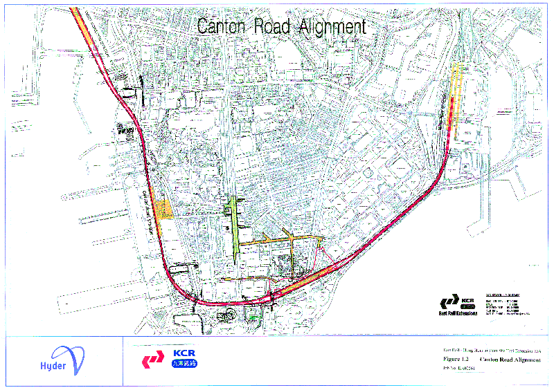
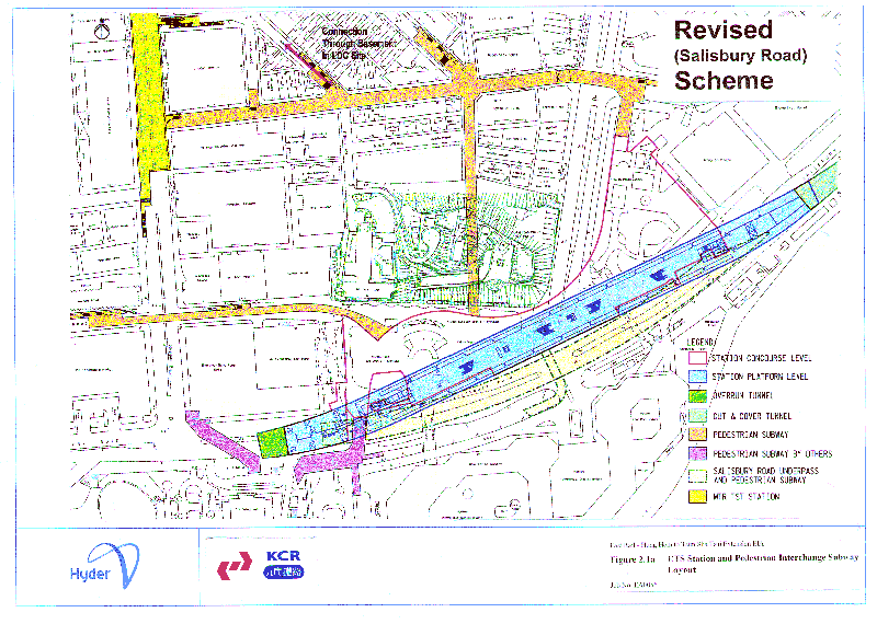
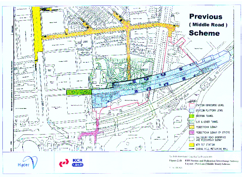
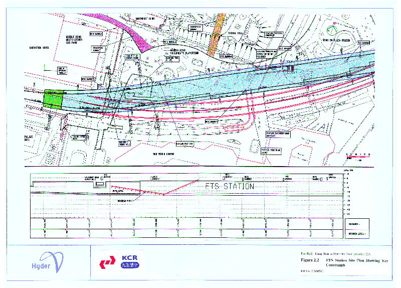
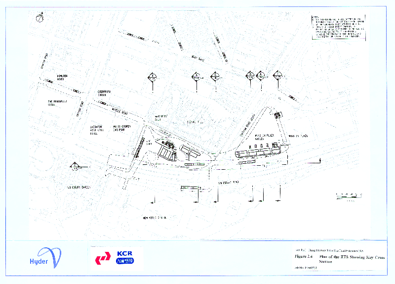
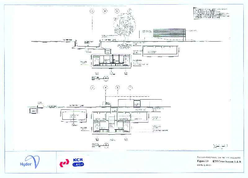
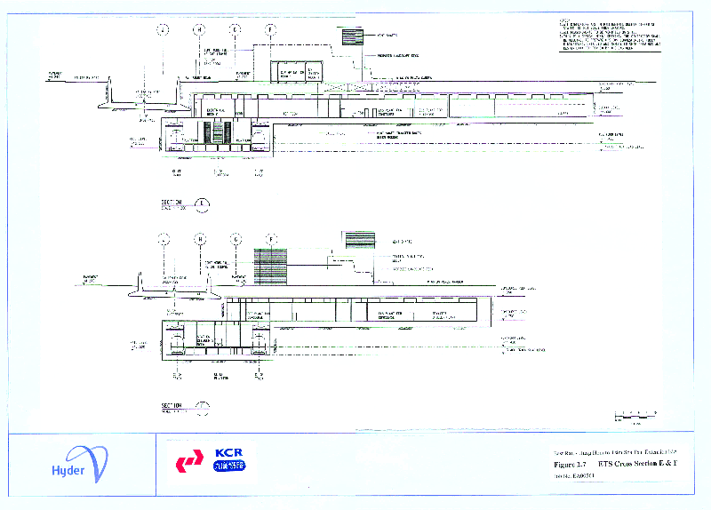
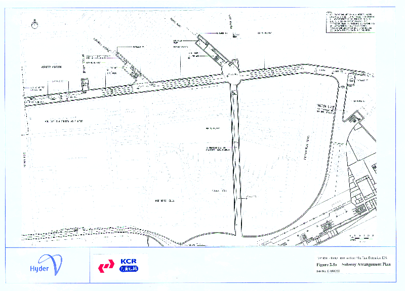
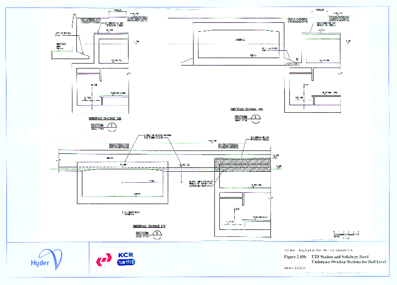
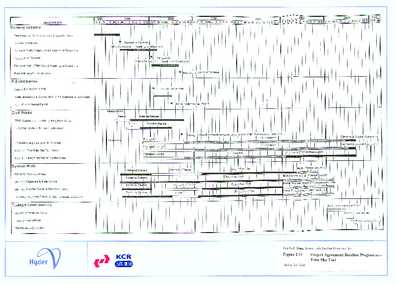
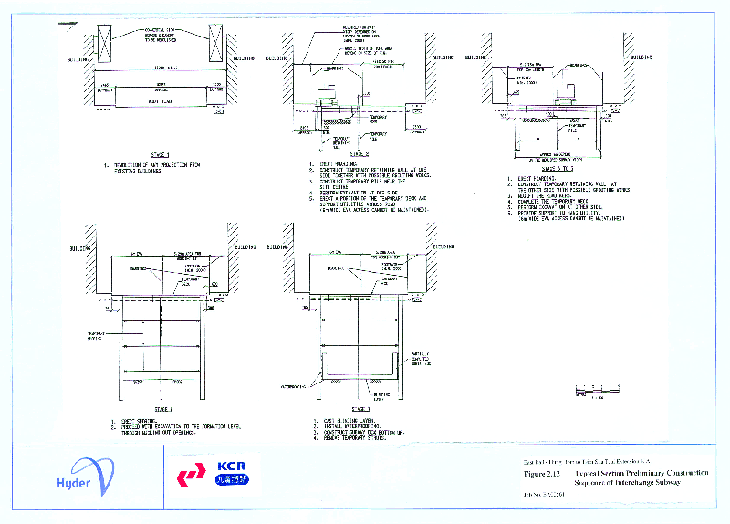
.gif)
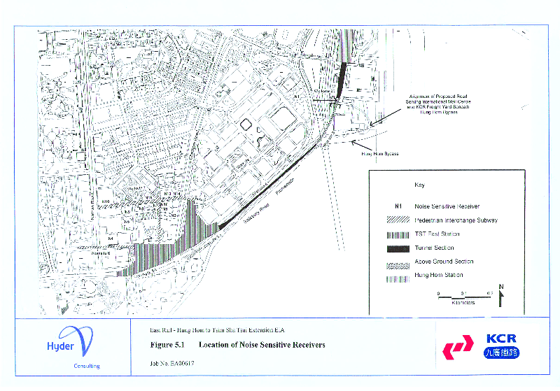
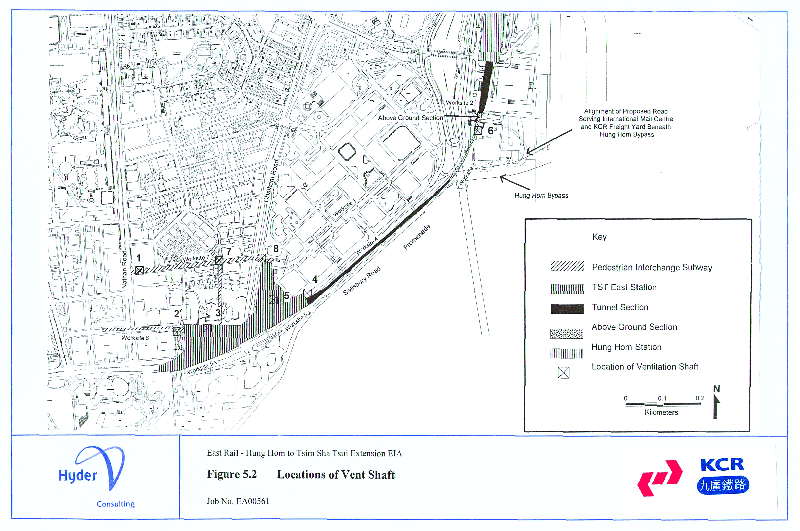
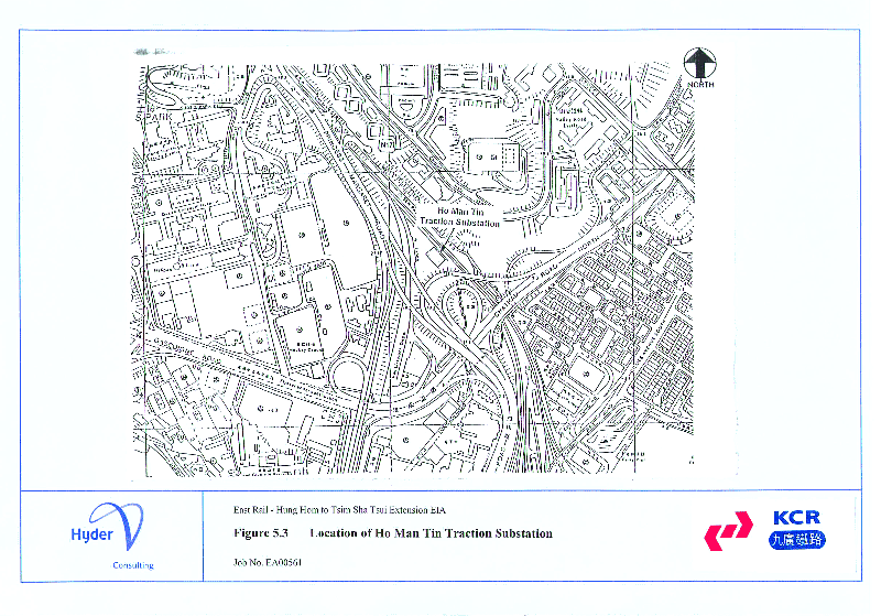
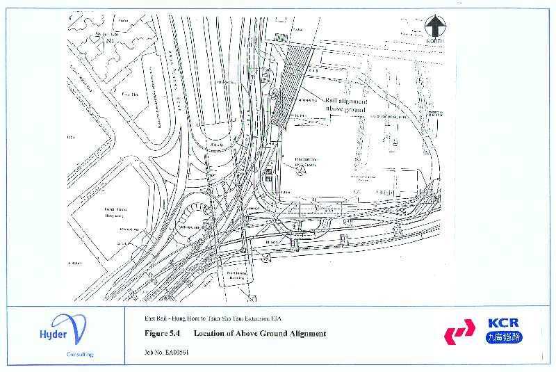
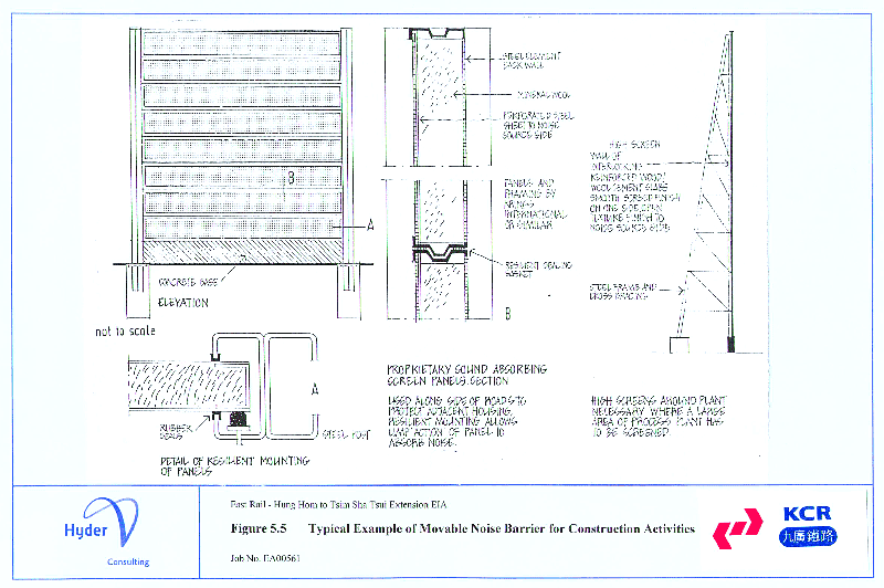
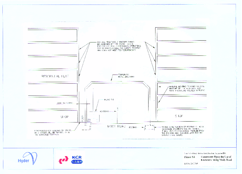
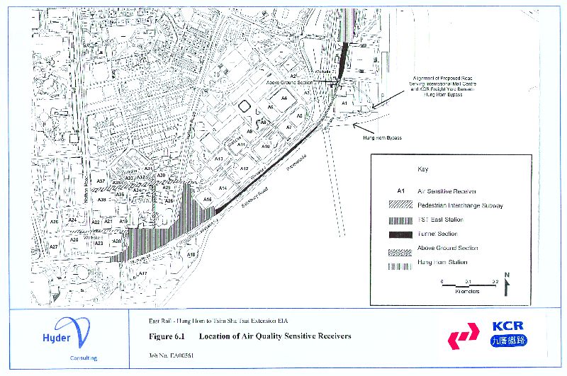
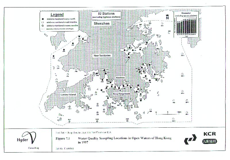
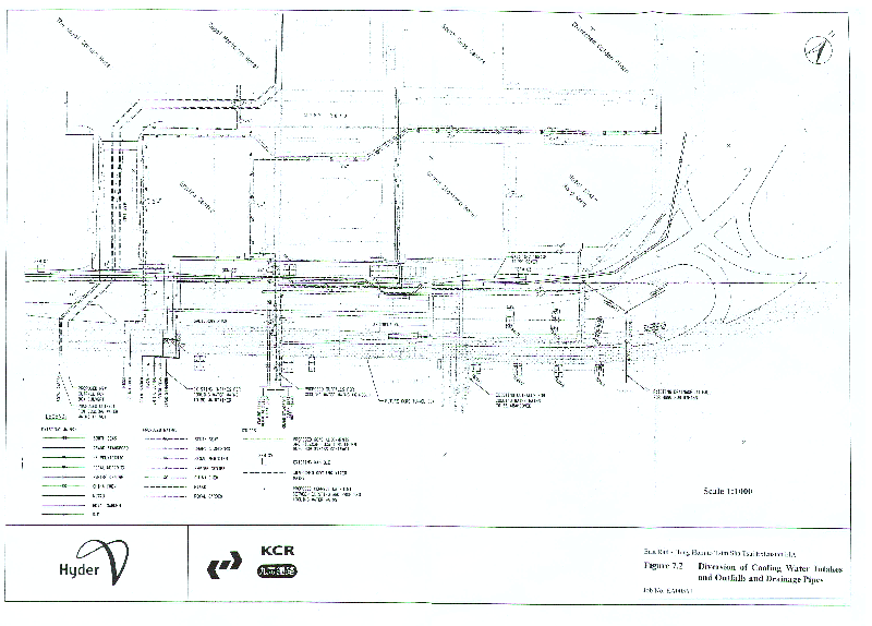
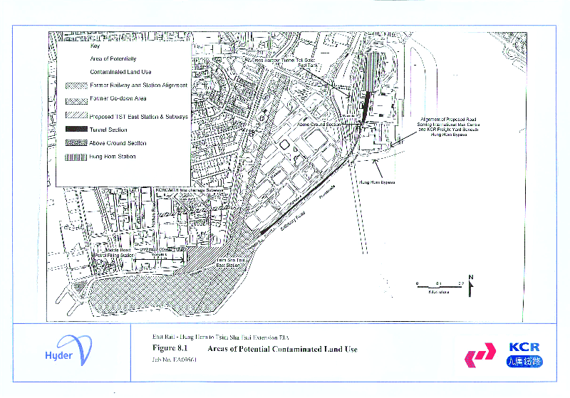
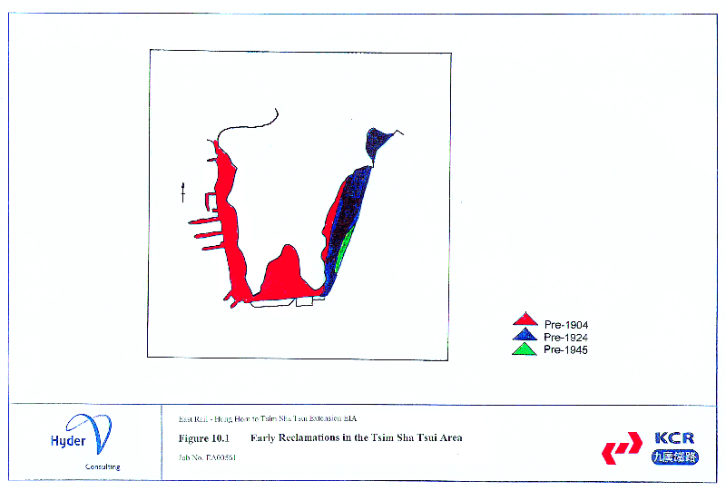
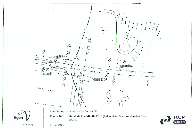
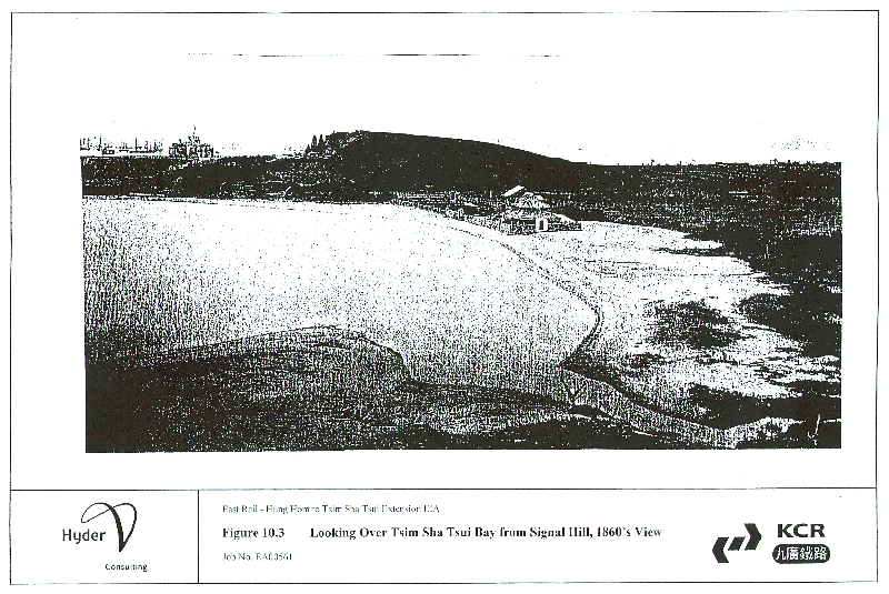
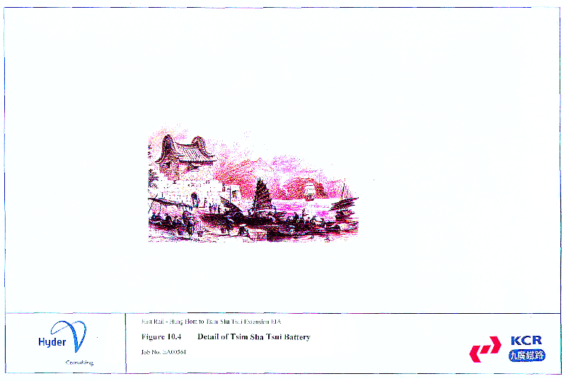
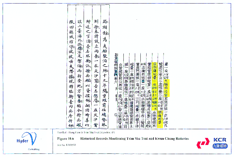
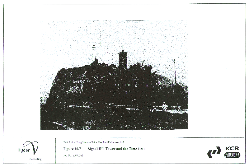
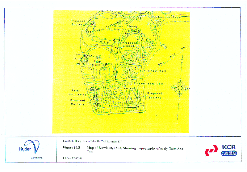
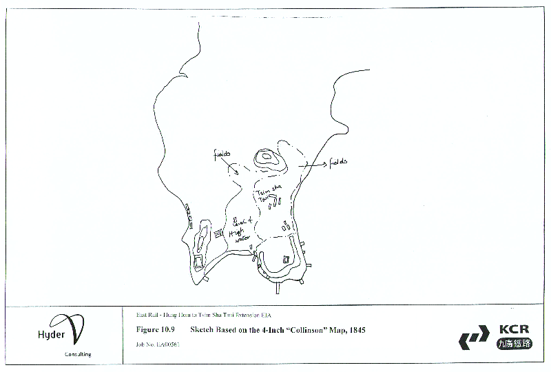
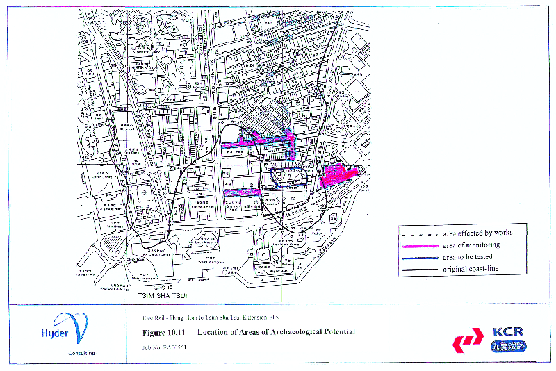
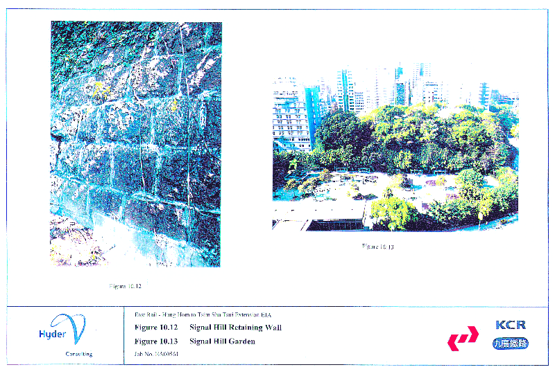
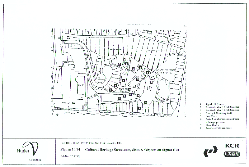
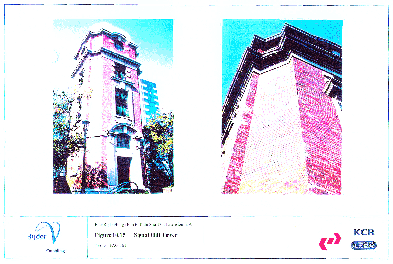
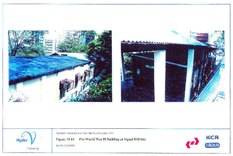
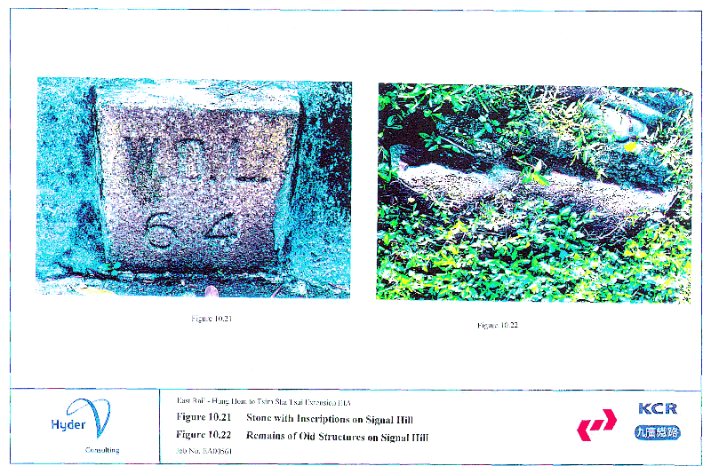
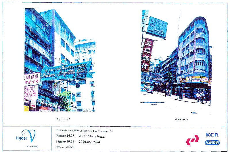
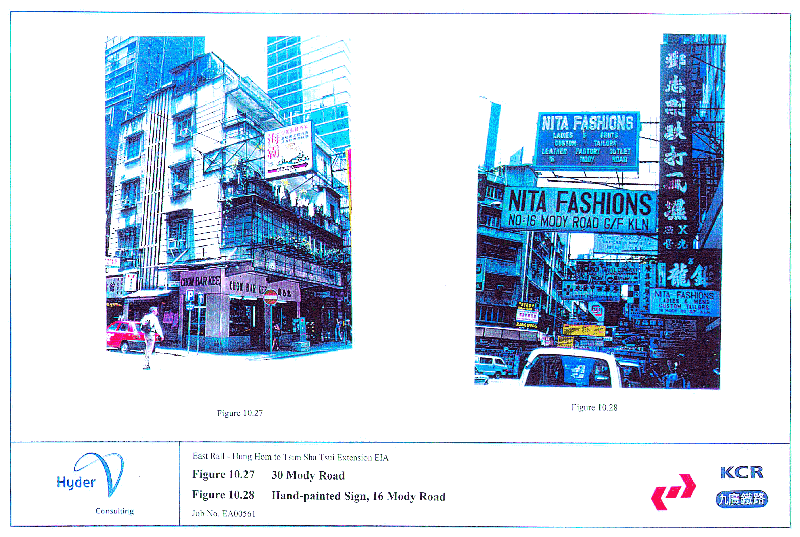
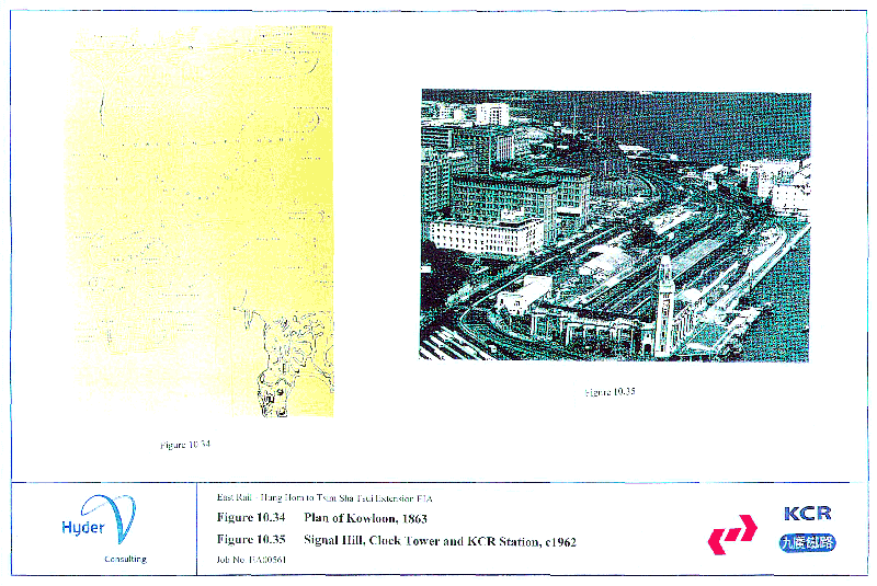
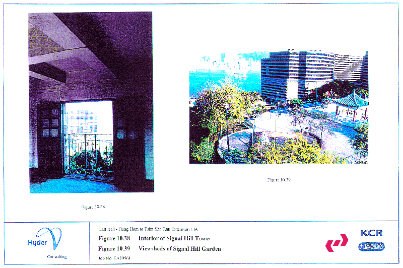
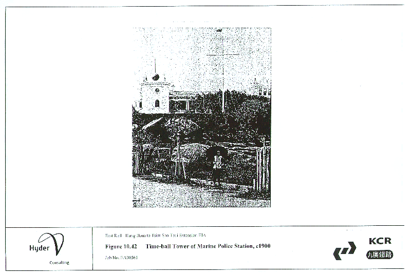
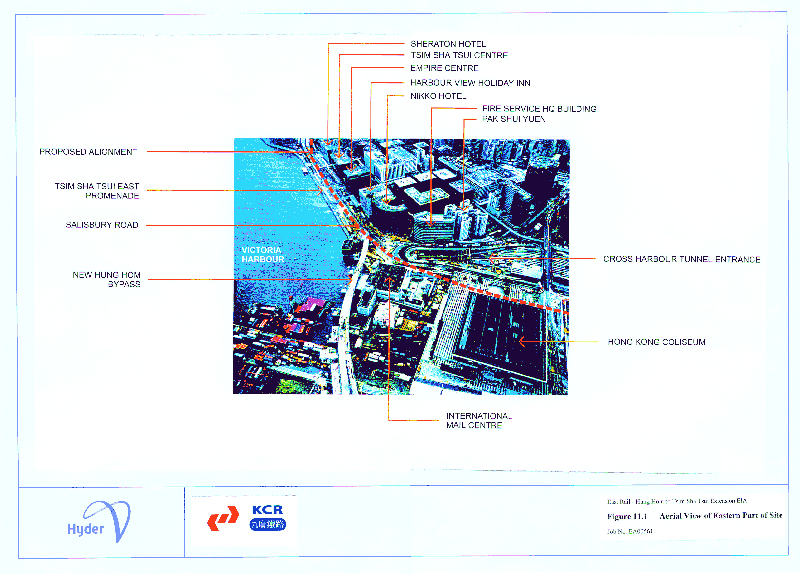
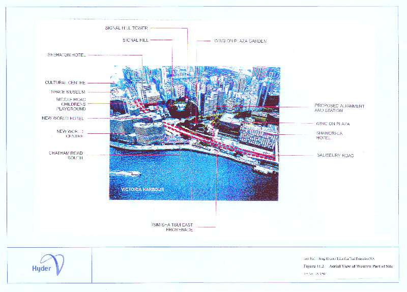
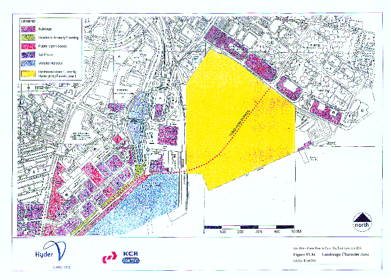
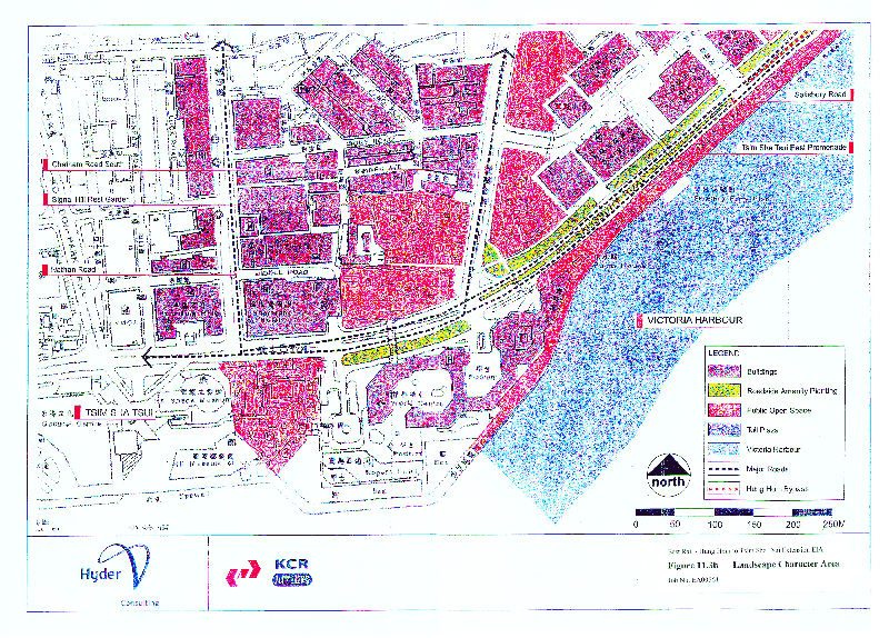
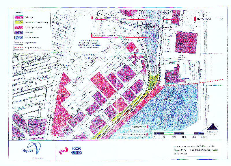
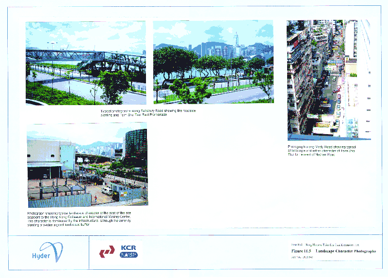
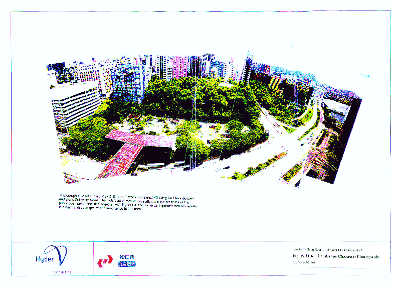
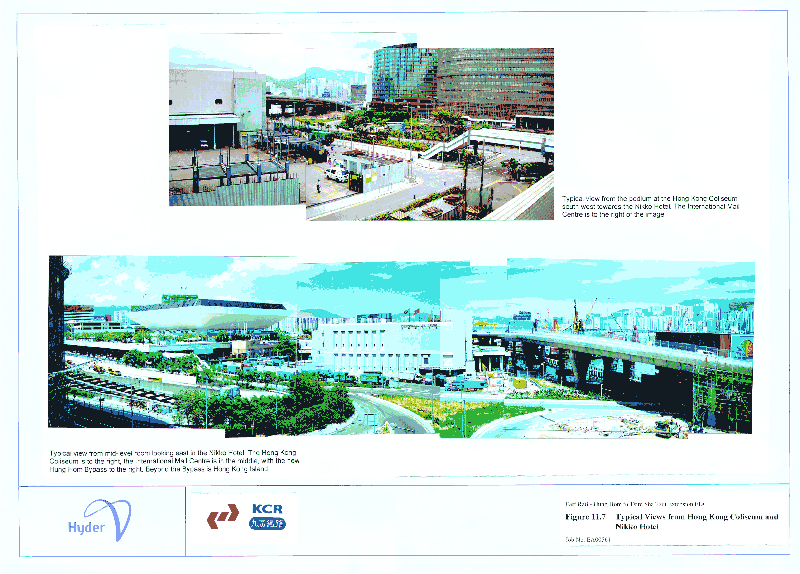
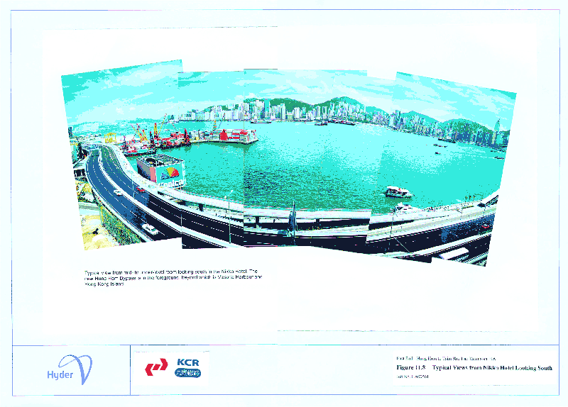
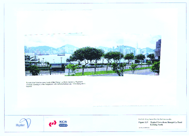
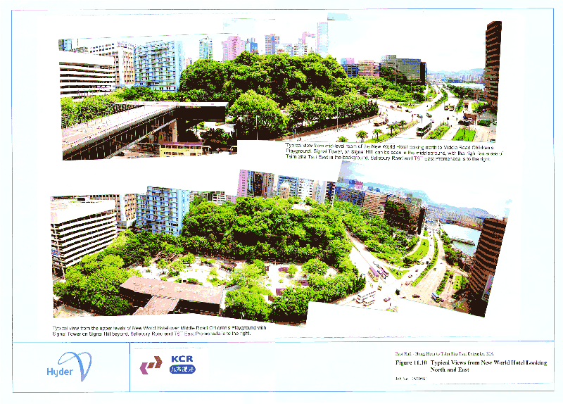
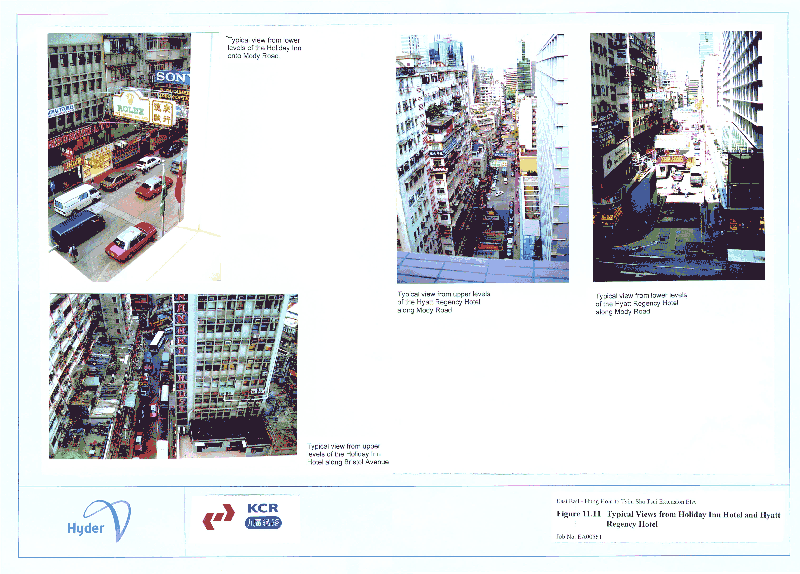
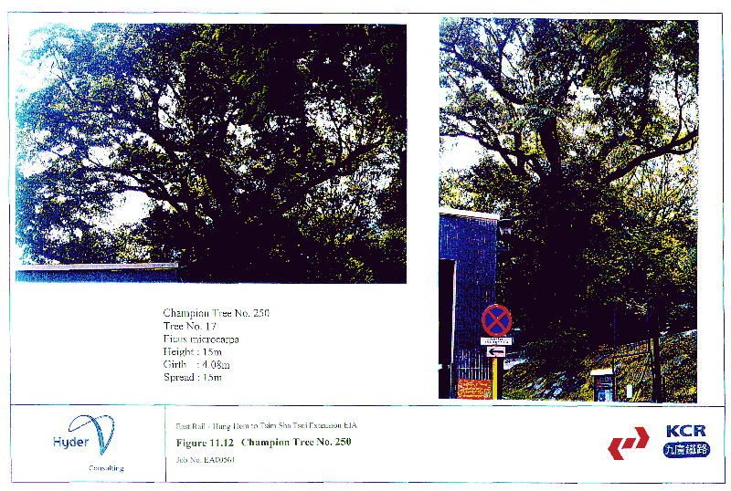
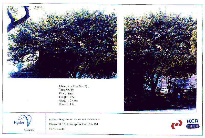
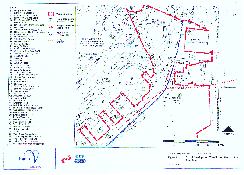
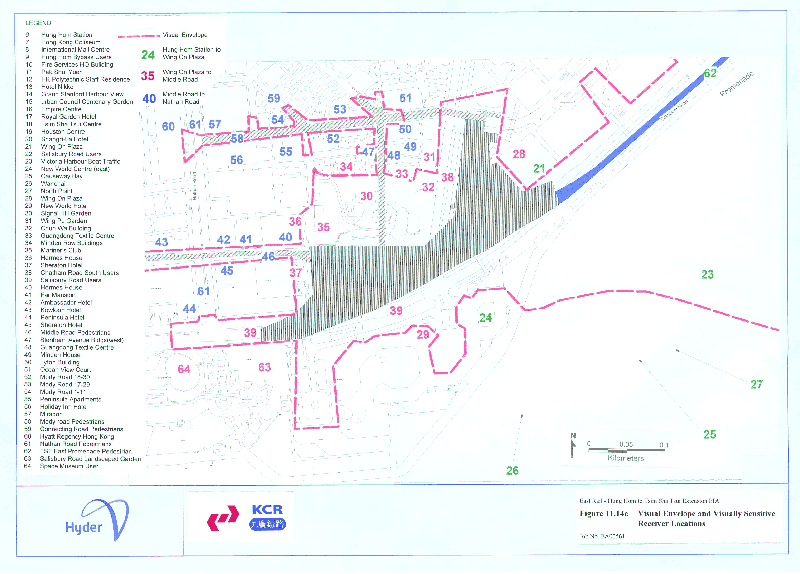
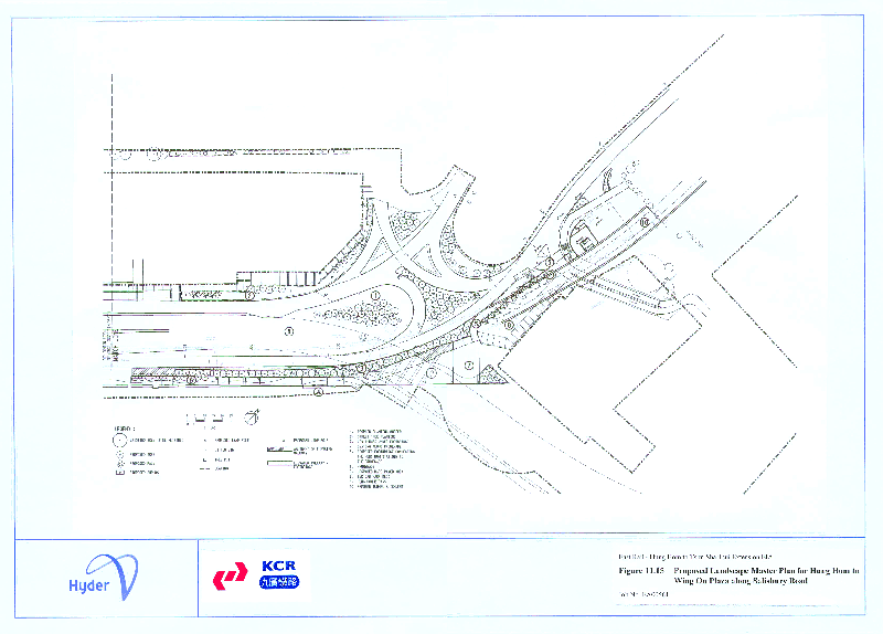
.gif)
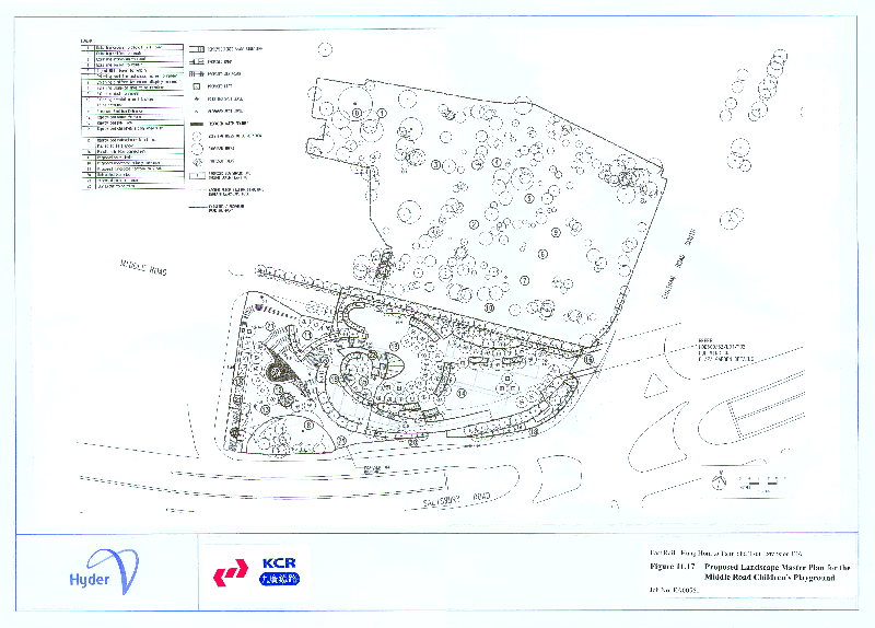
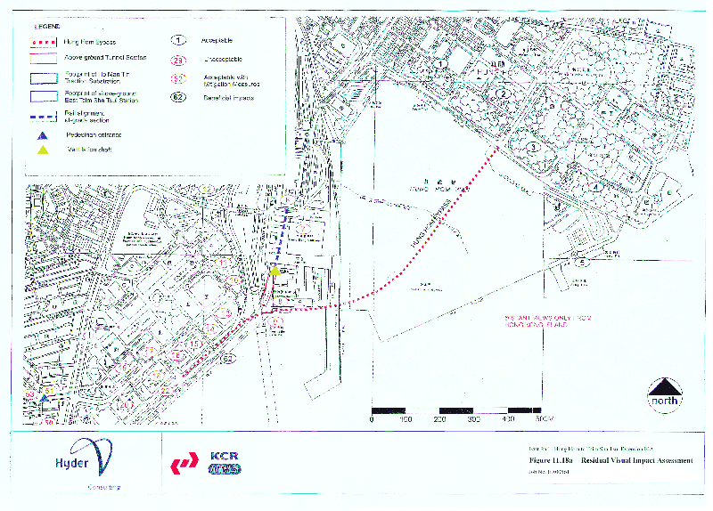
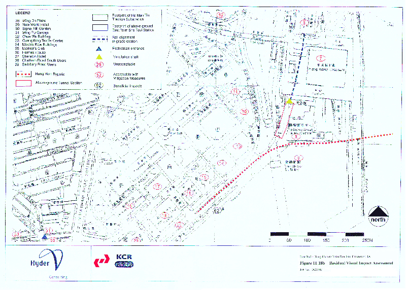
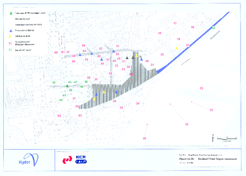
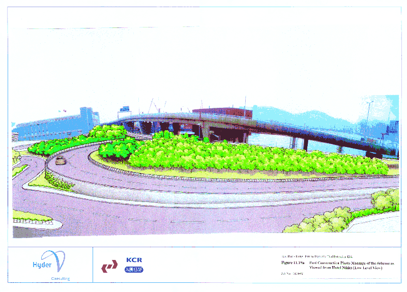
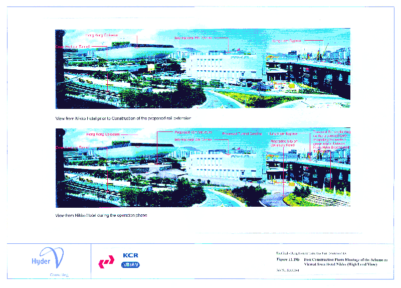
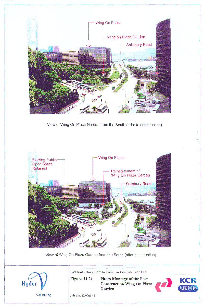
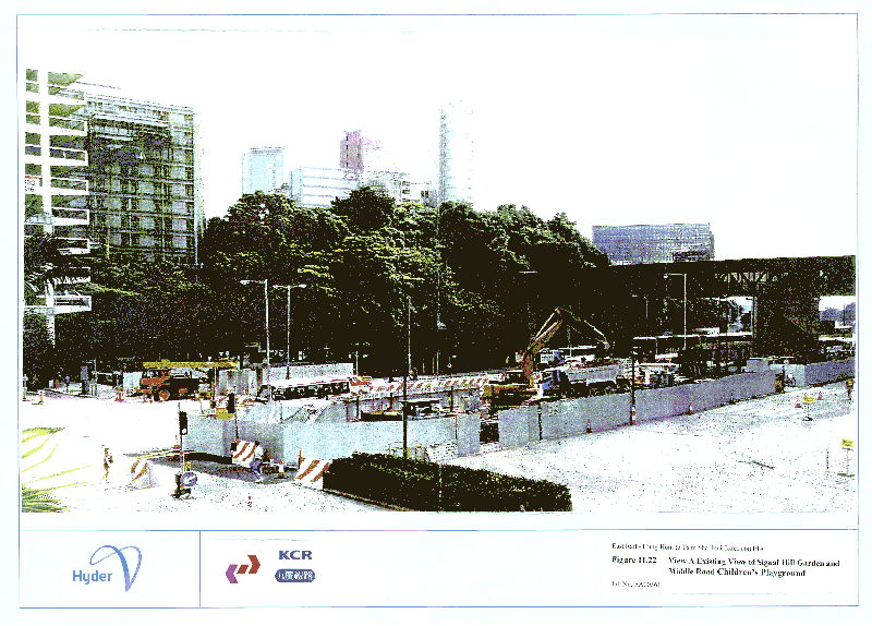
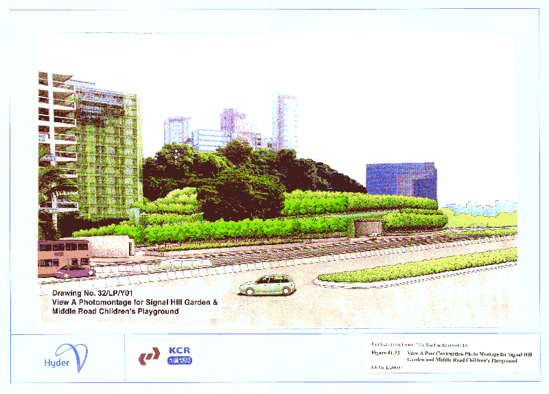
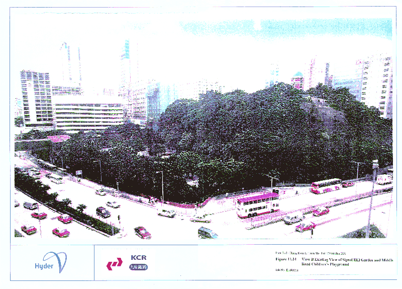
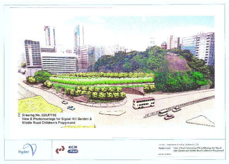
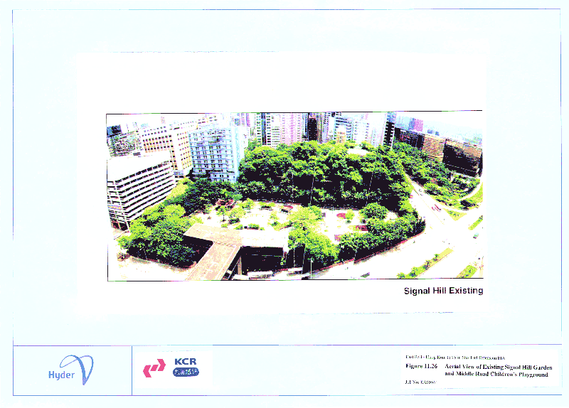
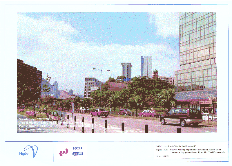
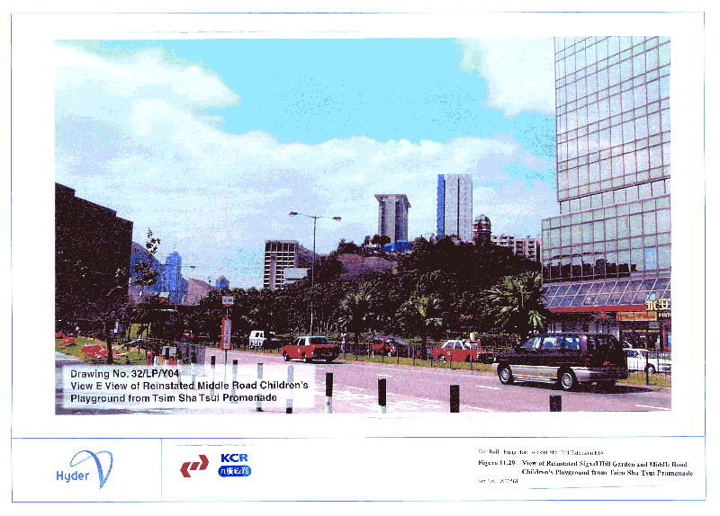
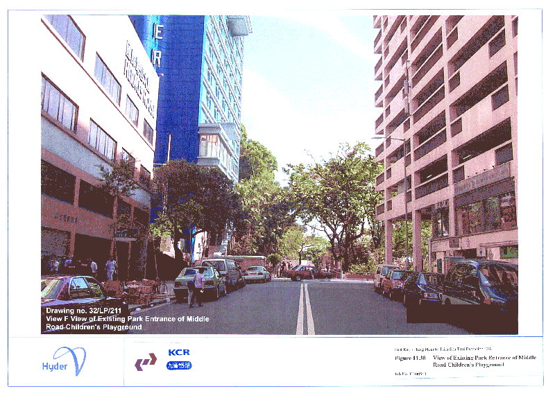