11.
CULTURAL HERITAGE IMPACT ASSESSMENT
11.1
Introduction
11.1.1
A CHIA
must be undertaken in order to identify the impact that any proposed
construction will have on the cultural heritage of the Study Area. The specific
objectives include the following:
• Identification and recording of all known, and as yet unidentified, historical and culturally significant buildings and structures;
• Collection of information concerning other cultural heritage resources such as local village and industrial histories and cultural landscapes;
• Identification of areas of original landscape which will be effected by the proposed rail development and assessment of its archaeological potential by means of a programme of field evaluation;
• Proposal of measures to preserve any heritage features as far as possible and to mitigate against adverse consequences wherever practical.
11.2
Outline of the CHIA Approach
11.2.1 In order to achieve these aims has a programme has been undertaken comprising 5 tasks:
Task
1 Baseline
Data Collection
This
task involved the collection of data regarding the geology and geomorphology of
the area including geological maps, bore hole data, early maps of the area and
aerial photographs. Information concerning the history of the Study Area has
also been collated from a number of sources including: library research,
collection of historical photographs and documents and through interviews with
local residents.
Task
2 Historical
Buildings and Structures Survey
A
systematic survey of the Study Area was performed in order to record all
buildings and structures (or parts thereof) which were constructed before the
year 1950 and/or otherwise qualified as having heritage value according to
Antiquities and Monuments Office (AMO) criteria. These cultural resources were
recorded on detailed recording forms, for both their architectural features and
cultural and historical associations. Photographs were taken and the resources
located on 1:1000 maps.
Task
3 Archaeological
Field Evaluation
A
programme of field evaluation was designed and implemented to assess the
archaeological potential within the Study Area. Testing was carried out in
areas identified as being original landforms which were not covered in concrete
or development. The methodology followed AMO requirements and comprised surface
evaluation, systematic auger testing and excavation of test pits.
Task
4 Assessment
of Impacts on Cultural Heritage Resources
Data
collected from the previous tasks has been examined in the light of previous
alterations to the original landscape and the impacts of planned engineering
works on the identified and potential heritage resources. The results of this
assessment are presented in the form of maps and tables presented below.
Task
5 Mitigation
recommendations
Recommendations for mitigation have been proposed for impacts to historical buildings and structures. A programme for mitigation of impacts to potential and identified archaeological resources is also presented.
11.3
The Study Area
11.3.1
The
Study Area extends westward from Sheung Shui station, running parallel to
Castle Peak Road, turning northward at San Tin to Lok Ma Chau and the border
north of Ha Wan Tsuen. For the purposes of the CHIA the Study Area is defined
as extending 500 m to either side of the proposed alignment.
11.4
Existing Impacts in the Study Area
11.4.1 There are a variety of existing land uses within the Study Area:
• Large areas devoted to fishponds west of Lok Ma Chau and north of San Tin;
• Relatively undeveloped traditional villages;
• Traditional villages in the process of ongoing development;
• Agricultural fields, abandoned and in use;
• Market and domestic gardens;
• Highly developed urban centres in the area of Sheung Shui;
• Channelled streams, rivers and drainage channels ;
• Major road access, i.e. Castle Peak Road, Fanling Highway, San Sham Road;
• Small village access roads;
• Abandoned grenade range near Chau Tau;
• Former military quarters at Dill’s Corner;
• Light industrial buildings, abandoned and in use in the vicinity of Tung Fong and Fung Kong;
• Pig Farms, near Chau Tau and Pak Shek Au
• Sewage Treatment Works;
• Military buildings and a correctional institute.
11.5 Impacts Associated with the Proposed Works
11.5.1 The following major impacts will be associated with the construction phase of the proposed works in the Study Area:
• Excavations for viaduct support columns across valley bottoms;
• Construction of embankment sections;
• Excavation of a cutting at Pak Shek Au;
• Associated haul and access roads during the construction phase.
•
Few if
any impacts on potential archaeological resources are predicted from operation
of the proposed rail extension. Operational phase impacts on historical
buildings and structures which will be dealt with in this assessment may
include aesthetic impacts and damage to fabric.
11.6
Geological and Topographical Background
11.6.1 The topography of the area consists of the valley of the Sheung Yue River (Beas River) in the east, broken in the north by the southern slopes of Tai Shek Mo. The flat valley conditions continue westward to Pak Shek Au where the slopes converge from the north and south to form a narrow pass. Valley conditions resume to the west at Chau Tau. The Study Area curves to the north here and is occupied primarily by ponds to the west of Lok Ma Chau Road.
11.6.2 The valley of the Sheung Yue River is filled with Pleistocene fluvial terraces and Holocene alluvial deposits reaching several tens of metres in places. A network of older, deep valleys which dissected the Pleistocene topography of the territory down to a lower elevation than the present sea level, filled in to create the present outlook (Geotechnical Control Office, 1988 a,17). The valley drains northward into the Lo Wu catchment basin and into the Shenzhen River .
11.6.3 The basic geology along the north of the Study Area comprises Lok Ma Chau Formation: metamorphosed sedimentary and volcanic rocks lying in a north-east trending belt of low relief from Tuen Mun. Thin colluvium deposits mantle the footslopes of most of the north-east trending hills. These deposits are widely distributed and entirely derived from the Lok Ma Chau Formation (Geological Map of Hong Kong Kowloon and the New Territories). The rocks of this formation generally weather to produce moderately deep (1-2m), uniform or gradational red to red-brown clayey metasediments (Geotechnical Control Office 1988a, 30).
11.6.4 The rock formation to the south of Pak Shek Au is volcanic of the Repulse Bay Formation: sedimentary rocks, acid lavas, coarse tuff, agglomerate, dominantly pyroclastic rocks with some lavas. This formation produces a thin (<1m) soil horizon, followed downwards, especially on lower slopes by yellowish brown sandy completely weathered material overlying less weathered locally strongly jointed rock below an average depth of 11 m. (Geotechnical Control Office 1988b, 28).
11.6.5 At the end of the last ice age, about 15,000 years ago, sea level was approx. 120 m. lower than present. The present area of Mai Po and San Tin was far inland and the underlying Lok Ma Chau formation rock was exposed, cut into a series of valleys which ran into the major river course along the line of present day Deep Bay. After the ice age, the sea level rose, reaching present levels about 6000 years ago. Deep Bay flooded to the line of Castle Peak Rd. with low rounded hills appearing as isolated islands in estuarine waters (dating of the lower part of marine mud in Chau Tau to 5093 +- 130 to 5475 +- 155 yr. BP). (Geotechnical Control Office, 1989, 116). This shallow sea slowly filled in as a result of sedimentation augmented by drainage and reclamation of the mangrove swamps to provide land for habitation and agricultural use, in particular for fish ponds. The use of the term Chau in local place names recalls the existence of such an environment in the not so distant past.
11.7
Modern Economic and Developmental Setting
11.7.1
The
Study Area covers a diversity of landscapes and settings as can be seen in the list
of existing developments in section 4.1. Sheung Shui is a highly developed
modern urban centre and the villages in the immediate area have all seen rapid
development. The villages to the north/west are less urban and developed, to
varying degrees. The area from Tsung Pak Long to Chau Tau consists mainly of
modern structures used for residential, light industrial, manufacturing and
agricultural purposes e.g. soya sauce manufacturing, metal recycling and pig
rearing. There are also a number of relatively traditional villages which are
undergoing development at varying rates, which, in some cases, unfortunately
includes the destruction of historic buildings, e.g. Chau Tau. Many of the
villages also contain a number of abandoned agricultural buildings especially
those associated with small-scale pig rearing. The agriculture practised by the
villagers at present consists of small-scale gardens containing vegetable crops
and fruit trees. There are larger market gardens around the village of Yin
Kong.
11.8
The Archaeological Setting of Hong Kong
11.8.1 This summary is provided to give a brief overview for those unfamiliar with Hong Kong’s archaeology; it is divided into "prehistoric" and "historical" archaeology for clarity.
The
Prehistory of Hong Kong
11.8.2 In the Hong Kong context "prehistory" refers to the period pre-dating the arrival of the Han Chinese, in approximately 221 BC. The prehistoric period is divided into the Middle Neolithic Period (4000 - 2500 BC), the Late Neolithic Period (2500 - 1500 BC) and the Bronze Age (1500 - 221 BC). Sites are found in sandbars and on the lower hill slopes within sheltered bays throughout the territory. Sites have also been found on the tops of promontories and the edges of coastal marshes. The main finds from the prehistoric period include ceramic vessels, chipped and polished stone implements, shell, bone and bronze objects and occasional habitation remains in the form of fires and postholes.
The
Historical Period of Hong Kong
11.8.3 The early historic periods (221 BC - 220 AD) are not well represented in Hong Kong: little has been found from the Qin Dynasty and Southern Yue Kingdom; Han Dynasty material is present in the form of isolated finds, several sites and, most notably, in the form of the Lei Cheng Uk Han Tomb in Kowloon. Similarly, few artefacts have been recovered dated to the Six Dynasties and Sui Dynasty (222 - 618 AD). It is with the arrival of the Tang dynasty (618 - 907 AD) that evidence appears of rapid growth in the local economy. The sea route to Guangzhou passed through the territory and a garrison was positioned at Tuen Mun to protect the maritime trade. Many sites have been found dating to this period, particularly lime kilns in coastal areas. In the Song dynasty (960 -1279 AD) immigration from China brought the main clans into the rural areas of the New Territories. A very limited number of archaeological sites of the Song dynasty have been found; several burials, sherds and coin caches and evidence of a customs post and lime production. In the Yuan dynasty (1271 - 1368 AD) the economy relied on salt production and pearl harvesting in Tolo Harbour and Deep Bay; both government controlled. Only one site has been found, at Ha Lo Wan on Chep Lap Kok with iron refining kilns. During the Ming dynasty (1368 - 1644 AD) the local economy continued to prosper with salt production, incense tree plantations and pearl harvesting. Archaeological evidence includes a pottery kiln site at Wan Yiu in Tai Po and trade ceramic deposits at Penny's Bay, Lantau. The Qing dynasty (1644 - 1911 AD) brought the disruption of the Evacuation Order (1662 - 1669 AD). After repeal, the Hakka arrived to add to the depleted population, occupying less fertile lands. Pearl, salt and incense production declined and the economy shifted to more fishing and farming, and the growth of market towns, such as those at Tai Po, Yuen Long and Sheung Shui. Archaeological remains have been found of forts and batteries built in the Qing dynasty to strengthen coastal defences against pirates. Remains have also been excavated of farmsteads and fields. To date, archaeological evidence has been found primarily in less developed parts of Hong Kong, where survey and excavation are more easily conducted. This evidence shows that archaeological sites are widely distributed across the territory, particularly in coastal areas. This fact would suggest that there is also considerable potential for such sites within the urban areas.
11.9
Archaeological Field Evaluation and Impact Assessment
11.9.1 In this section the background, methodology and findings of the archaeological component of the CHIA are presented. They are followed by an assessment of the impacts which will result from the proposed project on any archaeological resources in the Study Area and recommendations for mitigation of these impacts.
Potential for Prehistoric Archaeology in
the Study Area
11.9.2 There are no recorded prehistoric archaeological sites within the Study Area. As discussed above, in prehistoric times areas which are presently occupied by fishponds and river flood plains were shallow seas fringed with marshland and mangrove (Irving and Morton 1988). Within this environment present hillocks formed islands and islets; therefore the lower hill slopes and former shorelines of these islands may have potential for prehistoric deposits. These include hillocks south-east of Ha Wan Tsuen; west of Lok Ma Chau Rd.; west of Pun Uk Tsuen; at Pak Shek Au; and just to the north-west of Pak Shek Au.
11.9.3 Prehistoric archaeological material has been found on lower hill slopes in the interior of the territory including Bronze Age (1500–221 BC) sites at Ngau Tam Mei, Yuen Long (Au 1998); Tong Min Tsuen, Lam Tsuen (Tang pers.comm) ; Wai Tau, Tai Po (Peacock and Nixon 1986) and Ho Pui, Kam Tin (ERM-Hong Kong 1999). Earlier material from the Late Neolithic (2500-1500 BC) – Bronze Age (1500-221BC) has been reported from Sheung Shui Wa Shan, Sheung Shui (Lovelace 1978) and Hung Leng, Fanling (Peacock and Nixon 1986). As a result of these findings, unaltered lower hill slopes within the Study Area were viewed as areas of archaeological interest.
Potential
for Historical Archaeology in the Study Area
11.9.4 The alluvial plains within the Study Area have been formed within the last millennium (Irving and Morton 1988) and have been occupied and farmed since at least the 12th c. by Chinese immigrants. The Study Area was settled by immigrants from the beginning of the Song Dynasty (960-1279 AD) down to the Ming Dynasty. Historical studies of the lineage of the local residents reveal that there were 4 major clans among these early settlers in the Sheung Shui to San Tin area (Lim 1997, Bard 1988, Hayes 1983):
1. the Hau clan who arrived in the 12th c.; their original village of Ho Sheung Heung remains the clan centre;
2. the Pang who arrived in the late Song (1120-1280) at Fanling, and spread little beyond;
3. the Liu family who settled in Sheung Shui during the Yuan dynasty in the 14th c.;
4. the Man who were last to arrive, between the mid 14th and the beginning of the 15th c. when the shortage of good land forced them to settle in San Tin, at that time on the edge of poorly drained marshland. They settled on the edge of mangrove swamps and established the village of San Tin –which translates to New Fields- in 1279 (Irving and Morton 1988).
11.9.5 During the reign of Qianlong (1736-96) the Pun, the other main clan residing in the Study Area, settled in Pun Uk Tsuen.
11.9.6 The potential therefore exists for archaeological deposits from the historical periods of clan immigration, particularly from the Song (960-1279), Yuan (1271-1368), Ming (1368-1644) and Qing Dynasties (1644-1911). Earlier material from the Tang dynasty (618-907) was recorded on alluvial terraces at Kai Leng to the south of Sheung Shui and at a number of sites in the northern end of the Tuen Mun Valley (AMO pers. comm.).
11.9.7 Traditionally, the cultivation of rice was the dominant subsistence/economic activity of the indigenous people in the Study Area (Ho Wei Yue 1962). During the 1960’s, the influx of migrants from Mainland China introduced the cultivation of mixed vegetable crops. These crops eventually replaced rice cultivation, as they were more profitable. An example of this process can be seen in the village of Yin Kong, where the alluvial plain to the north of the village still supports small-scale commercial agricultural plots that once were paddy fields (local informant).
11.9.8 In the 1930’s fish pond farming expanded from the Yuen Long area across Deep Bay to Lok Ma Chau, for a while taking over the importance of paddy fields in the west of the Study Area. (Fung Chi Ming 1995, Irving and Morton 1988).
11.9.9 The present land use pattern of large commercial pig farms, e.g. those located to the east of Chau Tau, evolved approximately 40 years ago (local informant). Previously, pigs were kept within and on the outskirts of villages, such as Chau Tau, where their former enclosures can still be seen.
11.9.10 Along with agricultural activities, light industrial endeavours are also characteristic of the Study Area. For example, in the vicinity of Kwu Tong, there are several soy sauce factories which have been established there for many years. These factories, whilst housed in modern structures, e.g. around thirty years in age, still maintain traditional manufacturing methods (Baker 1980, local informant). Other examples of traditional industries include a rattan factory, grass mat making and joss stick manufacture.
11.9.11 Archaeological material could include the remains of villages and farms, historical field systems and agricultural features, early fishpond bunds and structures associated with early light industry.
Selection of Evaluation Units
11.9.12 In order to evaluate the archaeological potential of a study area of this size it was necessary to implement a sampling strategy. Areas were identified which were accessible to testing methods. ie. not covered by concrete or structures or heavily modified due to landscaping or digging of ponds. From these areas evaluation units were selected in an attempt to sample all the landforms found within the Study Area. Two units selected at the preliminary desk-based stage were later eliminated from the evaluation. They were found upon further investigation to be completely altered, and substitute units were selected. The cancelled units were:
Unit 4 an alluvial area within the alignment to the north-east of Dill’s Corner which was found to be covered by a lorry park, container storage and car repair workshops;
Unit 9 an alluvial area between Lok Ma Chau Road and San Sham Road which has been artificially filled and levelled to create car and lorry parking.
Evaluation
Units
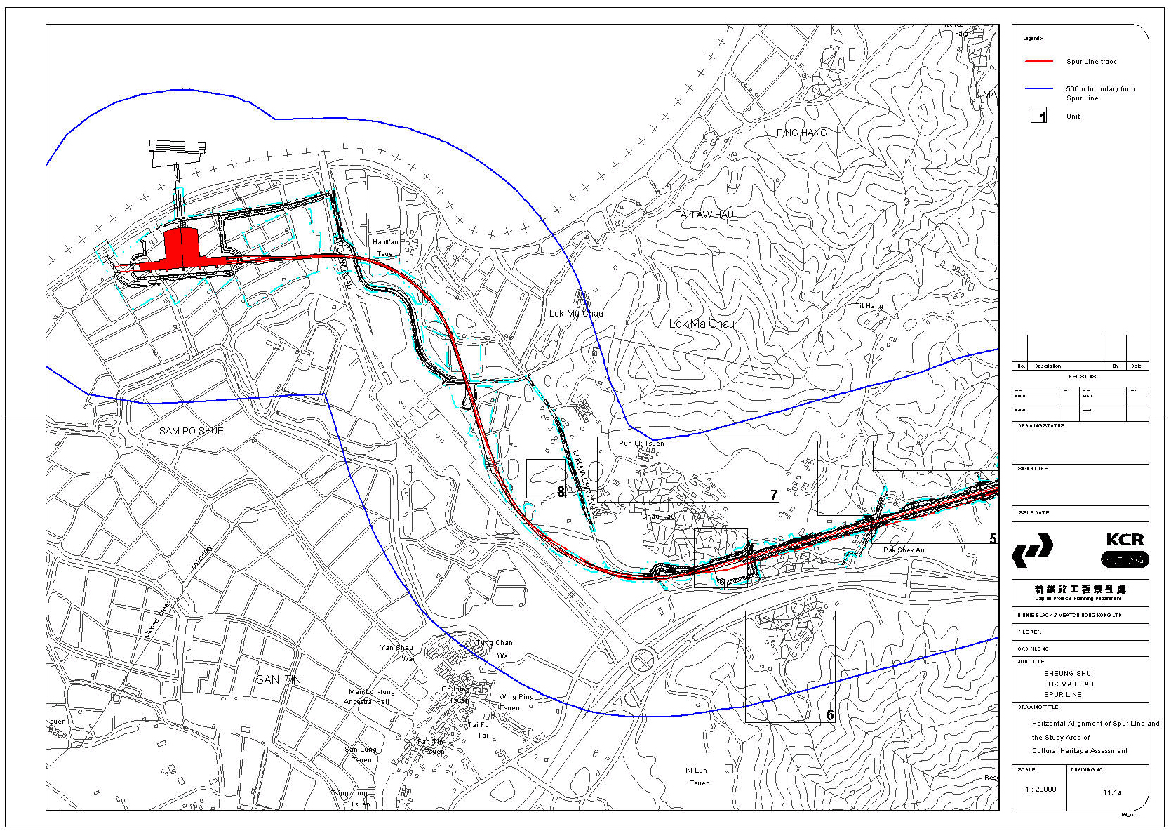
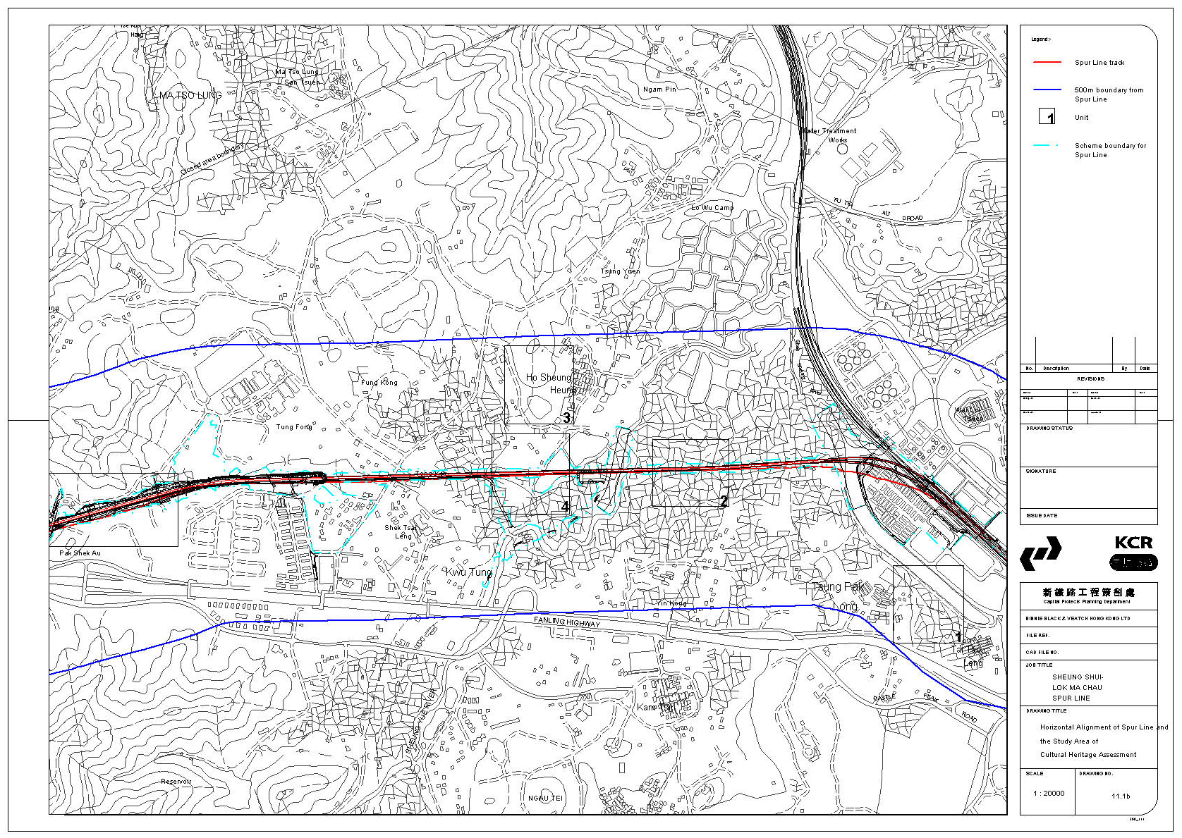
11.9.13 The following Units were evaluated (Figure 11.1a b):
Unit 1 West
of Tai Tau Leng
Between Tai Tau Leng and Tsung Pak Long to the west; just north of Castle Peak Road [ ca. .25 km2 ]. This is an area of alluvial terraces occupied by in use and abandoned fields. The area is relatively low-lying between 3.8 and 4.1 meters PD.
Unit 2 North
of Yin Kong; in the alignment
On
the alignment in the middle of the river flood plain; north of Yin Kong
[ ca. .25 km. long ]. This is an area positioned in the centre of the
alluvial terraces. The area is low-lying between 3.0 and 5.3 meters PD and
comprises agricultural land dissected by irrigation and drainage channels and
ponds.
Unit 3 Ho
Sheung Heung
The unit samples the lower hill slopes to the west of Ho Sheung Heung [ ca. .5km N-S x .25 km E-W ]. The village of Ho Sheung Heung is situated to the east of the hillock, but the unit includes relatively undisturbed wooded areas at elevations up to 27 m. PD.
Unit 4
South of Ho Sheung Heung; valley area in alignment
This unit is situated in the valley area within the proposed alignment [ .5 km N-S x .25 km. E-W ]. It lies at 5.2 to 7.9 m PD at the base of the hills of Ho Sheung Heung (Unit 3) and is occupied by abandoned fields, several structures and light industry.
Unit 5 Pak
Shek Au
North
of Pak Shek Au. [ about .75 km long ]; the unit is positioned to test the lower
hill slopes with elevations from 12 to 24 m PD. The areas at the transition
between the hill slopes and the valley floor are covered with small-scale pig
farms, minor industries and container storage. Part of the lower foot hills
have been impacted by the constructions of roads and graves.
Unit 6 South
of Castle Peak Road
South
of the highway [ slightly larger than .25 km2 ]; situated to sample
the lower hill slopes in this area of volcanic rock and the rear of the valley
at elevations from 14 – 24m PD . The area is filled with nurseries and houses, while
portions of the lower foot hills are occupied by graves.
Unit 7 Pun
Uk Tsuen
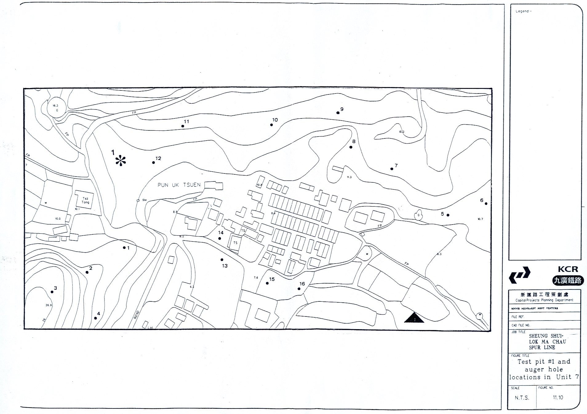
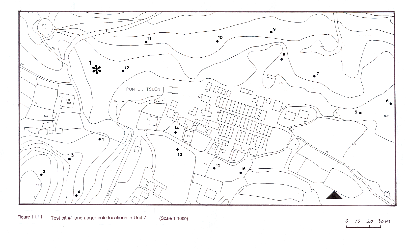
This unit is situated behind the village of Pun Uk Tsuen and comprises the wooded lower slopes of the small hill to the south-west and the valley bottom adjacent [ about .5 km long ]. The unit lies from approx. 7 to 27 m PD.
Unit 8 Hill
to west of Lok Ma Chau Rd.
This
unit comprises the northern slopes and bottom of the hillock
[ ca. .25 km long ] of colluvium and Lok Ma Chau formation. This
hillock would have formed an island in former times; at present a large
concrete road has been constructed and it contains many graves. Elevations
examined extend from 9 to 20 m PD.
Unit 9 East
of Chau Tau; in the alignment
This
unit lies in the valley bottom in a low and marshy area (3.4 –
5.7 m PD) of fields, ponds and structures. It measures approx. .2 km
long and .1 km wide.
Field
Evaluation Methodology
11.9.14 In each of the Evaluation Units the same field methodology was applied, in accordance with AMO requirements. This included the following:
• Surface scanning for archaeological evidence was carried out, wherever possible.
• Systematic auger testing was carried out in each unit, with the number and spacing of tests depending on the size of the area and the degree of disturbance
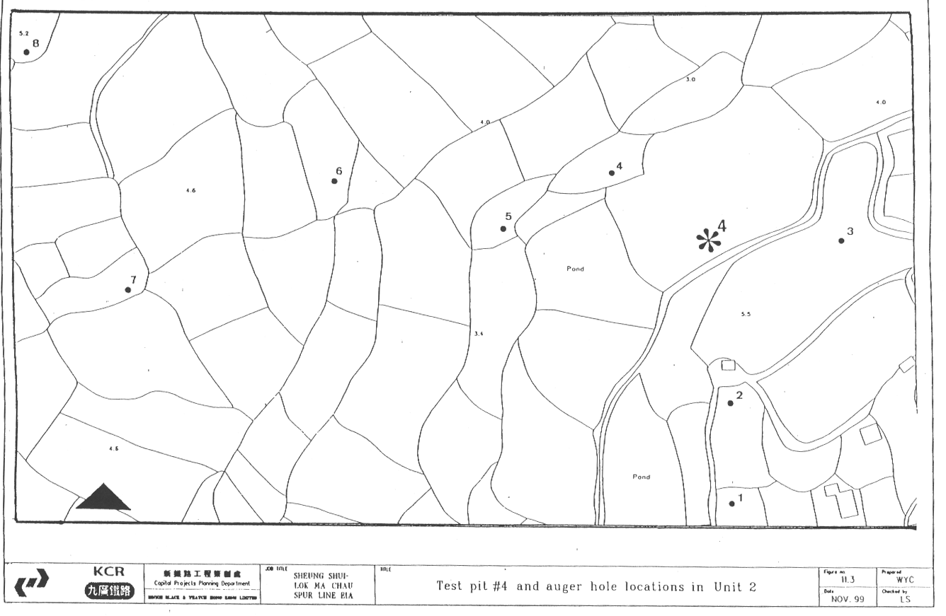
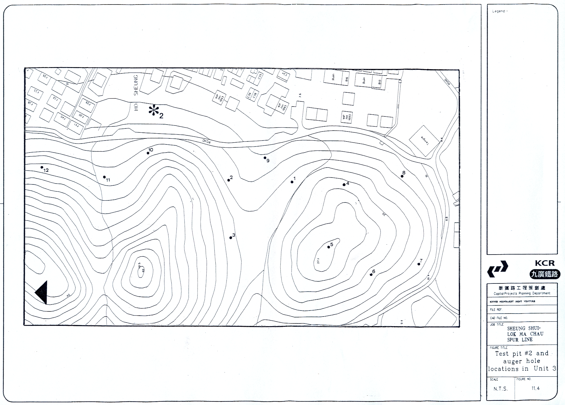
• A total of 5 test pits were excavated; one in both units 3 and 7 based on data gathered during the desk-based stage. Three additional test pits were excavated in locations selected on the basis of the auger testing results. The test pits were positioned to maximise stratigraphical information.
11.10
Summary of the Findings of the Archaeological Field Evaluation
11.10.1 This section presents a summary of the findings of the field evaluation; detailed data can be found in Appendices I and II. These appendices have been submitted as part of a separate document to the Client and Antiquities and Monuments Office as part of the full CHIA submission.
Summary
of the Surface Field Scan
11.10.2 Most of the surface of the Study Area was covered in dense vegetation and/or structures. However, a field scan was carried out, wherever possible with particular attention to agricultural fields and cuts, such as abandoned graves, streambeds and natural cuts on hill slopes. No archaeological material was recovered during these field scans.
Summary of the Auger Testing Programme
Unit 1 West
of Tai Tau Leng (Figure 11.3)
Eight auger holes were executed on this valley floor area near the Shek Sheung River. The data indicates wet agricultural activities for the upper strata, while alluvium forms the lower sequence. No archaeological artefacts or deposits were located.
Unit 2 Area
north of Yin Kong (Figure 11.4)
Eight auger holes were carried out in this valley floor area. The upper strata of the soils show agricultural activities, while the lower indicate alluvium to weathered alluvium. No archaeological artefacts were recovered by these auger tests.
Unit 3 Ho
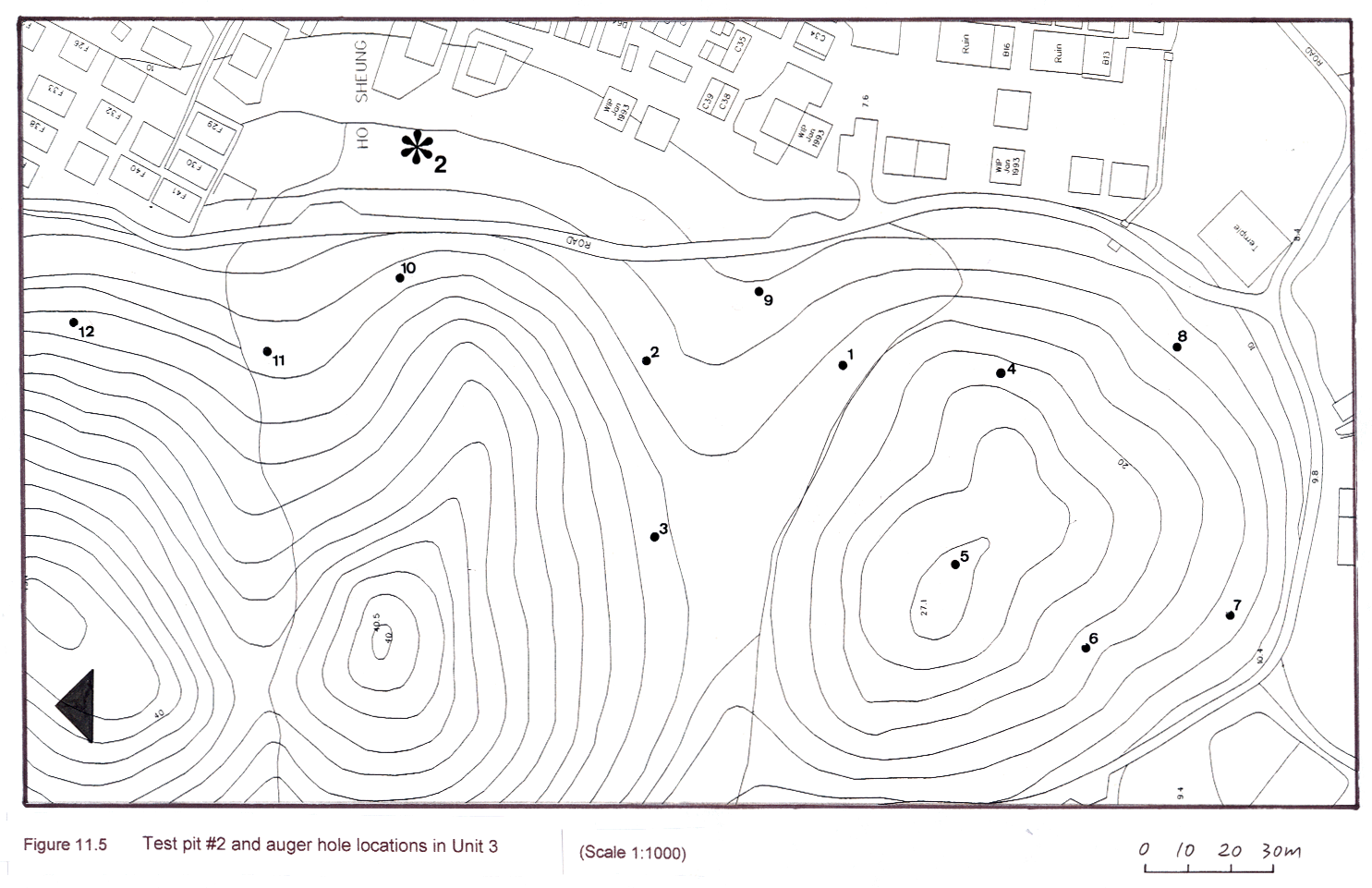
Sheung Heung (Figure 11.5)
Twelve auger holes were executed on the low-lying hill and lower hill slopes of Ho Sheung Heung. The auger hole data indicates in situ deeply weathered bedrock on top of the hill and weathered bedrock and sterile colluvium on the hill slopes. No archaeological deposits were established.
Unit 4
Area to the south of Ho Sheung Heung, in the alignment (Figure 11.6)
Seven
auger holes were conducted in the flat alluvial area to the south of Ho Sheung
Heung. Sterile alluvium can be established in each auger hole, some covered by
fill. No archaeological material was found by these auger tests.
Unit 5 Pak
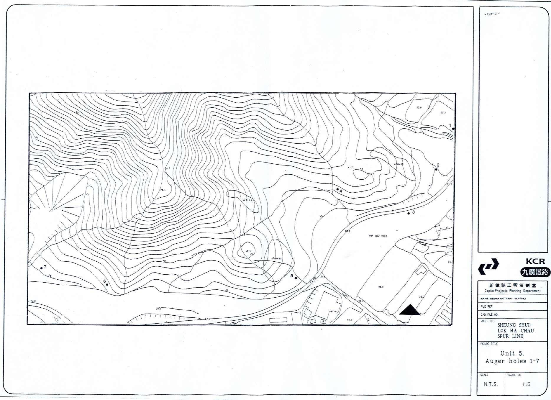
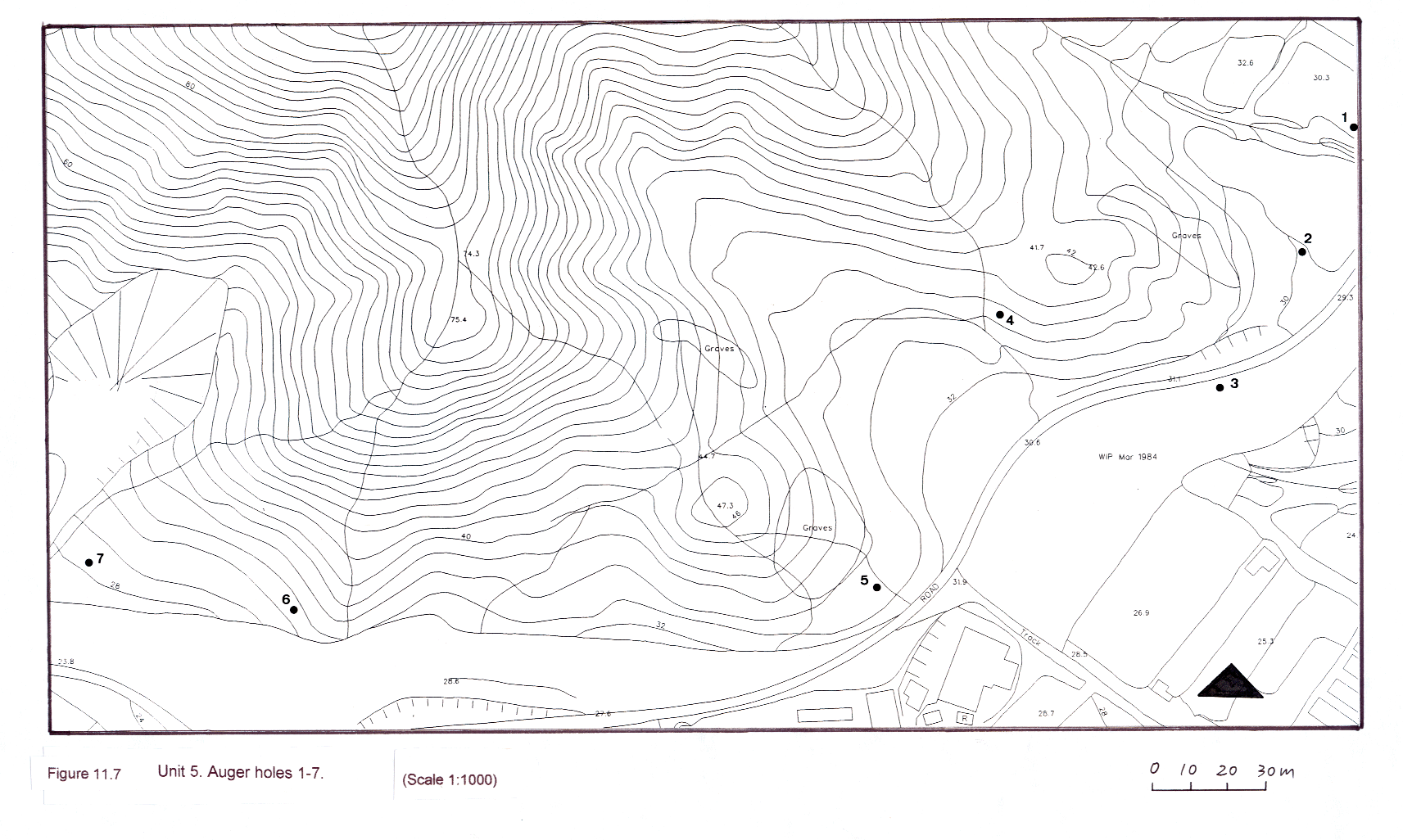
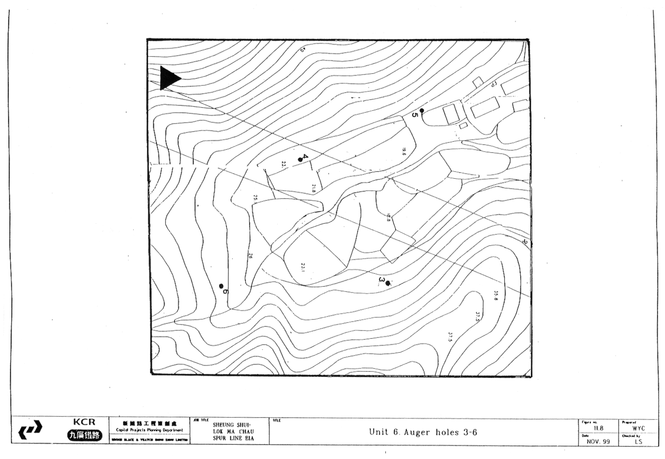
Shek Au (Figure 11.7 and 11.8)
Fourteen auger holes were executed on the lower hill slopes at Pak Shek Au. The auger hole test results indicate a very thin cover (<1 m) of sterile soil on top of weathered bedrock. No soil strata suggested archaeological potential.
Unit 6 South
of Castle Peak Road (Figures 11.9 and 11.10)
A total of 8 auger holes were carried out. Two auger tests were conducted on the hillock to the east of the valley, which is largely occupied by a nursery and a large concrete platform. Four tests were executed on the lower hill slopes at the rear of the valley. This area supported a thin soil cover over rocky colluvium or bedrock. Finally two auger holes were positioned on a raised terrace to the east of the river; these auger holes too were unsuccessful due to rocks. No archaeological material was recovered.
Unit 7 Pun
Uk Tsuen (Figure 11.11)
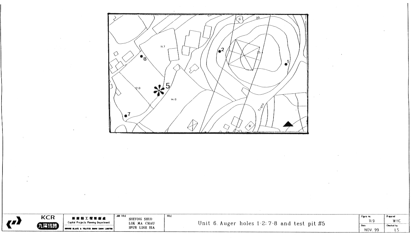
A total of 16 auger holes were conducted in Pun Uk Tsuen. The hillock on the western end of Pun Uk Tsuen has a thin soil cover on deeply weathered bedrock, whilst the lower hill slopes behind the village were less uniform. Some areas although densely vegetated were covered in rubbish and/ or modified. Other areas had a thin subsoil cover over weathered bedrock or colluvium. Tests carried out in the alluvial area in front of the village, indicate sterile alluvium. Modern village ware shreds were recovered from auger holes 6, 10 and 12.
Unit 8 Hill
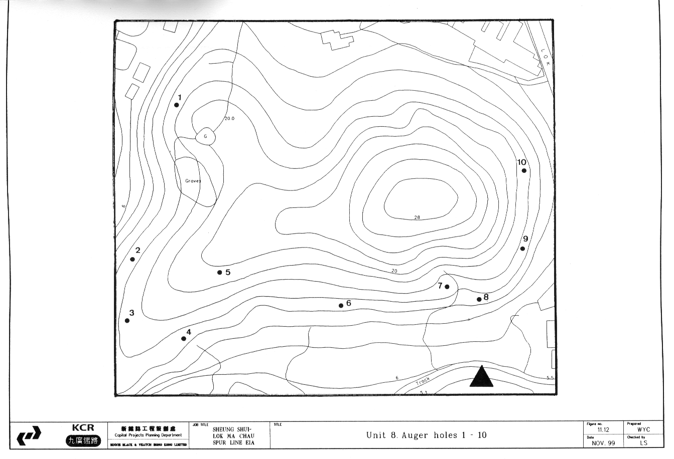
west of Pun Uk Tsuen (Figure 11.12)
10
Auger holes were carried out on the hillock. The strata of the hillock proved to
be a shallow soil cover on bedrock, in some places decomposing. This could be
verified in the sections of the open pits of relocated graves. No
archaeological deposits were located in this unit.
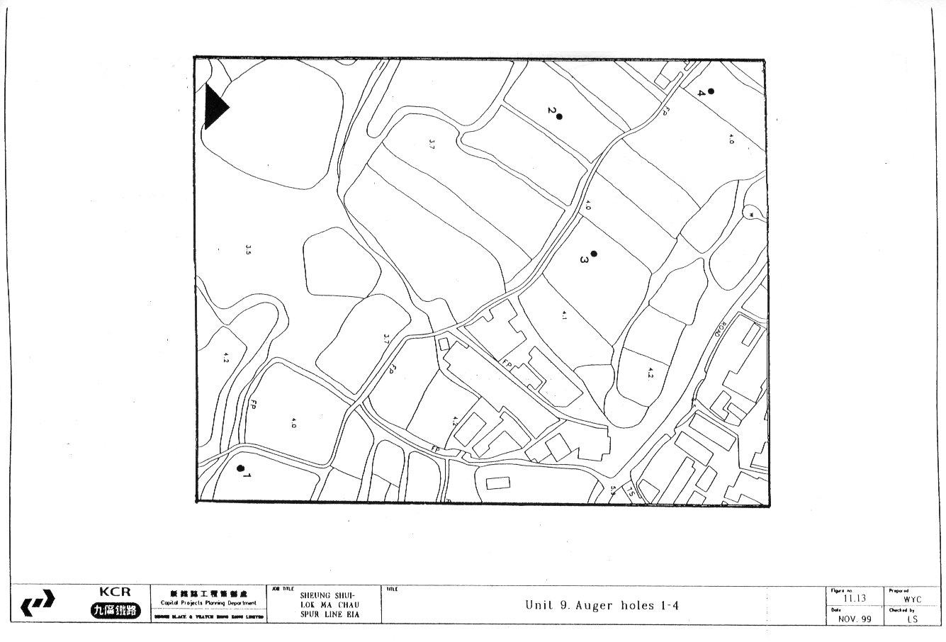
Unit 9 Area
East of Chau Tau (Figure 11.13)
A
total of 4 auger holes were conducted in this area. The area is waterlogged and
water table was reached at approximately 80 cm. The strata indicate a wet
alluvial sequence.
Summary of the Test Pit Results
11.10.3 Five test pits were excavated, measuring 1.5 x 1.5 m, except at Pun Uk Tsuen were topography allowed for a 1.5 x 2 m and south of Castle Peak Road (1 x 1 m) where the size was decided by the land owner. Test pits 1 and 2 were carried out on the basis of the data collected through desk top research. Test pits 3, 4 and 5 were positioned on the basis of information gained from the auger survey and with a view to assessing the valley plains as well as lower hill slopes. A summary of the findings is given below. The full details of the test pits are recorded in Appendix II, submitted separately to AMO.
Test Pit 1
11.10.4 Test pit 1 was located on the lower hill slope behind the village of Pun Uk Tsuen, near auger hole 12, which revealed a modern village ware sherd at 48 cm. It was excavated to a depth of 74 cm and contained top- and sub- soils over decomposing rock. The first three contexts to a depth of approximately 20 cm revealed tile fragments, roots and modern village ware. Contexts below were sterile.
Test Pit 2
11.10.5
Test
pit 2 was located on the lower hill slope behind the village of Ho Sheung
Heung. It was excavated to a depth of approximately 70 cm. A thin topsoil seals
a fill layer, which lies on colluvium and finally weathered bedrock or concreted
colluvium. No finds were recorded in contexts 3 and 4.
Test Pit 3
11.10.6
Test
pit 3 was situated on the alluvial plain approximately 80m to the south of Ho
Sheung Heung hill. The test pit was excavated to a depth of 105 cm and an auger
hole was carried out to verify lower-lying strata. The upper contexts represent
fill, followed by alluvium and weathered alluvium, until the testing was
stopped by rock. Throughout contexts 1 to 5 village ware and tile fragments
were recovered; at the depth of 66 cm (context 6) below surface a fragment of a
Song bowl was found. This vessel dates to the 12th c.; unfortunately the
associated material was too fragmentary and undiagnostic to say whether the
finds represent a Sung deposit or an out of situ find (Peter Lam pers. comm.).
Test Pit 4
11.10.7 This test pit was located in the valley plain to the north of Yin Kong in a disused agricultural field. The test pit was excavated to a depth of approximately 95 cm after which further testing was conducted with the auger. The upper two contexts to a depth of ca. 25 cm represent recent wet agricultural activities, followed by a deep sequence of alluvial strata. No archaeological artefacts or deposits were found.
Test Pit 5
11.10.8
The test
pit was located on a pleistocene river terrace. It was excavated to a depth of
approximately 70 cm. The stratigraphy existed of topsoil covering subsoil and
colluvium on top of weathered debris flow deposit (Hong Kong Geological
Map, 2). No archaeological features or material was recovered.
11.11
Archaeological Impact Assessment
11.11.1 The archaeological field evaluation was designed to sample the limited portions of the Study Area which have not been altered by recent development. This evaluation in conjunction with desk-based study revealed the following (Table 11.1):
• There is no in situ or displaced evidence of prehistoric occupation within the Study Area as a whole or specifically within the areas to be directly impacted by the proposed alignment.
• The lower hill slopes to the north and south have been heavily modified and eroded and reveal no evidence of historical archaeology or soil deposits with potential to contain such deposits. Evaluation has shown this to be the case north of Pak Shek Au, the only hill slope section which will be directly impacted by construction.
• Valley bottom areas in the north-west and east of the Study Area are wet, marshy or used as ponds. Evaluation of available dry areas revealed deep sterile alluvial deposits only. However, some potential exists for historical archaeological material as exhibited by the finding of a Song sherd in Unit 4. This potential is highest in areas adjacent to traditional historical villages such as Ho Sheung Heung.
Table 11.1 Summary of the archaeological findings in
each evaluation unit
|
|
Unit 1 |
Unit 2 |
Unit 3 |
Unit 4 |
Unit 5 |
Unit 6 |
Unit 7 |
Unit 8 |
Unit 9 |
|
No cultural material of any
period |
4 |
4 |
4 |
- |
- |
4 |
- |
4 |
4 |
|
Modern material and debris
found |
- |
- |
- |
4 |
4 |
- |
4 |
- |
- |
|
Material of archaeological
interest found |
- |
- |
- |
4 |
- |
- |
- |
- |
- |
11.12
Recommendations for Mitigation
11.12.1
The
proposed alignment will not directly impact any areas identified as having
archaeological potential within the Study Area. However, it will indirectly impact
the area to the south of Ho Sheung Heung where archaeological material was
found. The alignment will pass approx. 80 m to the south of the area tested.
The sparseness of these finds in an alluvial layer in Test Pit 4 and the lack of any other associated
diagnostic Sung
Song material or related features suggest that
the material does not represent an in situ deposit. However, it is recommended
that the area be monitored during the excavations associated with the viaduct support
columns. Monitoring should consist of a watching brief to note and recover any
archaeological material which may be revealed during this phase of the works.
11.12.2
The basic aim of archaeological
monitoring is to identify and record any archaeological
deposits that will be impacted upon by
construction or engineering works, the presence and nature of which could not
be established or established with sufficient accuracy in advance.
Upon identification of an
archaeological deposit, a determination must be made as to whether the material
can be recorded and retrieved immediately or if a temporary cessation in works
will be required. The latter would only be necessary in rare instances, such as
the uncovering of in situ architectural remains or a deposit of material which
was suspected to be part of a much larger important deposit. The specific
procedures for monitoring are discussed in further detail below:
·
When
an archaeological feature or object is identified, its nature and extent will
be recorded in detail to AMO
standards.
·
In
addition a daily record of the monitoring results will be kept, this will
include both areas containing archaeological deposits as well as areas that
contain no archaeological material. The record of the latter will be confined
to location description and a
statement that no archaeological material was encountered.
·
Once
the material has been identified and recorded in the field, it must be
determined whether an object is to be removed immediately or if more detailed
investigation will be required. This decision is based on the nature of the
deposit or find and its archaeological relevance.
11.12.3
In
the event of the discovery of an in situ archaeological deposit, determined
to be of a nature requiring rescue excavation as opposed to immediate retrieval,
construction work in the area must cease and the AMO be informed of the situation.
11.13
Historical buildings and structures survey and assessment
11.13.1 In this section the background, methodology and findings of the historical buildings and structures component of the CHIA are presented. They are followed by an assessment of the impacts which will result from the proposed project on any above-ground historical resources in the Study Area and recommendations for mitigation of these impacts.
Historical Potential within the Study Area
11.13.2 This area has been occupied and farmed since the 12th c. by Chinese immigrants. Thus, within many of the villages there are a number of historical buildings, such as temples and ancestral halls with well documented and extended histories. From a preliminary viewing of the villages, it was obvious that many contained numerous historical buildings. The Antiquities and Monuments Office has listed a number of known historical buildings, both within the Study Area and in its vicinity. These include ancestral halls, temples, police stations, a mansion, a nunnery and a walled village, i.e. Hakka Wai.
Village Background
11.13.3 A total of 296 structures were recorded during the survey, of which 282 were undocumented structures and 14 were Antiquities and Monuments Office highlighted structures. The villages were all easily accessible and this allowed for relatively straightforward identification of the historical/ cultural resources. The Survey was undertaken to augment previous reports and to systematically record any additional heritage resources within the Study Area in greater detail. The completed recording forms are presented in Appendix III. It should be noted that the sequence of the structures in the catalogue is geographical rather than numerical. Synopses of the buildings and location maps are presented in the full CHIA report submitted to AMO.
11.13.4 The occupation patterns, types and condition of the historic resources varied throughout the Study Area. A brief description of these details for each village will be presented below, in order to highlight the different settings and backgrounds of the historical resources.
Pun Uk Tsuen: The majority of the historical buildings were residential structures, either abandoned or being used for storage. The renovations were minimal in many cases. Several structures retained original decorative features, i.e. canopies and friezes, ranging from poor to moderate condition. There was no ancestral hall or temple. Three shrines were recorded. To the west of the village there were the ruins of a nunnery, abandoned approximately thirty years ago. There were numerous scatterings of cut stone, removed from renovated or demolished buildings, in the village.
Chau Tau: This village contained a number of abandoned residential structures, many slated for demolition and redevelopment. A large number contained original decorative features, i.e. canopies and friezes in moderate condition. A small number of the historical structures were occupied and renovated. There were also a small number of agricultural structures, mainly to do with pig rearing, the practice of which was moved out of the villages and to the surrounding countryside approximately thirty years ago. The Tse Tong was a modern reconstruction.
Yin Kong: The majority of the historical structures in this village were inhabited domestic structures. They had often undergone modernisations, such as façade additions with parapets, tiling on interior walls and the installation of air conditioners. A few structures did retain original decorative features, such as canopies, friezes and mouldings, though they were almost all in poor condition. There was no temple or Tse Tong in the village. There was a large shrine to the north of the village and an inscribed stone with a Buddhist blessing at the corner of the road leading to the village and Castle Peak road. There were a number of instances of reuse of architectural stone slabs, e.g. lintels, door frames and corner stones, for items such as benches and stands. Fragments of the original village wall were also identified and recorded.
Tai Tau Leng: Almost all of the historical buildings within this village had been demolished and replaced by modern structures. There was only one traditional village house remaining. Fragments of the original village wall, a renovated gatehouse and a well were also recorded. A small amount of stone slabs from demolished historical buildings were identified.
Tsung Pak Long: This village contained a number of occupied historical residences, ranging in degree of renovation. A number of decorative features, such as canopies, friezes and mouldings were retained on the structures, ranging from moderate to poor condition There was also a row of ancestral halls representing the five clans of the village, ranging from relatively unrenovated to completely modernised. There was a walled compound of buildings belonging to the Chan clan in the village, in an unrenovated state. There were also shrines and a well. There were examples of abandoned and reused cut stone slabs in the village, one being used as a shrine.
Kwu Tong: An area predominated by light industrial buildings and modern residential structures. The only recorded historic features were a house built in 1936, two grave/shrines associated with it and a cut stone lined channel, approximately thirty to forty years old, but traditional in style.
Ho Sheung Heung: This village contained a temple, nunnery and ancestral hall, all of which were moderately unrenovated. A number of the residential structures contained traditional canopies and friezes in moderate to poor condition. There were also a series of ruins and abandoned residential structures throughout the village.
Mun Hau Tsuen: This village contained a large ancestral hall which has been renovated. The majority of historical structures were residential, occupied and renovated to varying degrees. There were several shrines in the village. A number of the residential buildings retained decorative features, such as canopies and friezes, which ranged from moderate to poor in condition.
Tai Yuen Tsuen: There were a small number of historical buildings in this village, mainly residential. Only one terrace row retained traditional decorative canopies and friezes. They were in moderate condition. The structures were for the most part occupied and renovated to various degrees. There was also an ancestral hall and abandoned study hall in the village.
Hing Yan Tsuen: The only historical buildings in this village were a pair of green brick structures that were being used as a storage area and a house. The gate was of modern construction and was situated on the site of a former study hall.
Po Sheung Tsuen: This village contained a number of historical residences, a somewhat equal number of abandoned and inhabited structures. There were also varying degrees of renovation to the structures. In unrenovated structures the decorative features, i.e. canopies, friezes and mouldings, of the buildings were generally in poor condition. There were also several wells and shrines in the village.
Wai Loi Tsuen: The South end of the village contained an elaborate gate structure with a red sandstone arch. The majority of historical buildings were residential and inhabited. They were relatively unrenovated and any remaining decorative features were in poor condition. There were instances of reuse of stone slabs from demolished or renovated historical buildings.
Yan Shau Wai: This is another walled village with sections of original walls remaining. The area within the walls was all residential and most of the structures were houses. The village was partially abandoned and many of the structures were derelict or ruinous
11.14
Historical Buildings and Structures Survey Methodology
11.14.1 The survey consisted of a field evaluation incorporating the collection of photographic, oral and written information, on the architecture and history of the structures, all of which was recorded on specially designed forms, which collectively have been used to create a catalogue of all historical resources in the Study Area. A synopsis of each structure (including a photograph) and its location on a 1:1000 scale map are included in this report. The Field survey recording forms were designed to provide a complete documentation of all identifiable pre-1950 structures, as well as any more recent structures of cultural significance. The documentation incorporates both the architectural features and historical attributes of the structures, such as previous uses, structural modifications and past associations with local families or prominent personages. The forms were based on AMO and ICOMOS (International Charter for the Conservation and Restoration of Monuments and Sites) standards for the recording of historical structures with modifications to suit the styles and situations of historic structures encountered in Hong Kong. The recording forms include general information about the structure, such as location, building type, usage and ownership, all of which is presented on the first page of the form. An architectural description of the structure, both exterior and interior where possible, including all visible features as well as alterations to the original structure make up the bulk of the recording form. Cultural and historical details of the building are also noted, where applicable. Finally, evaluation recommendations for the individual building or structure are supplied and any additional remarks are provided.
11.14.2 In the field, the historic structures were identified through a systematic visual inspection and interviews with the local residents. The structures were then located on 1:1000 scale maps and their locations highlighted. Once identified and marked on the map, the physical features of the structure both external and internal (with the permission of the occupant) were recorded and photographs of relevant features taken. The occupants were then asked about the history of the structure as well as any other related historical or cultural information, including estimated age of the building, previous uses and local family associations. The information gathered from the survey and desk based research was used to prepare assessments of the recorded structures’ historical and cultural significance and formulate mitigation recommendations.
Survey Focal Areas
11.14.3 The size of the Study Area and the density of historical resources within it necessitated a stratified approach to the assessment of potential impacts. The resources have thus been classified as falling into three discrete categories for purposes of recording and assessment and for the preparation of mitigation recommendations:
• Resources which will be directly impacted by the engineering works and will be threatened with either total or partial destruction. Due to the critical nature of these impacts, a preliminary field assessment was carried out of any structures that would be directly affected by the proposed alignment, the results of which were presented in the Preliminary CHIA report. The results were that no historic structures would be directly impacted by the proposed alignment.
• Resources which fall inside the Study Area but will experience only indirect impact, e.g. aesthetic. This category encompassed the majority of surveyed structures. The resources within this category were recorded in detail and catalogued. All structures were assessed as to impacts to both the individual buildings and to village groupings as a whole.
• Resources which fall outside the defined Study Area but which have been highlighted by the AMO as being of special concern. These structures have been recorded and photographed in the same manner as the historic resources within the Study Area. Any possible impacts were assessed and any necessary mitigation measures proposed.
11.15
AMO Documented Heritage Buildings
11.15.1 A full list of known historical resources, which have been highlighted in the study brief by the AMO as having particular heritage value and requiring assessment of potential impacts, are described in detail in the full CHIA report submitted to AMO.
11.16
Impact Assessment and Mitigation Recommendations
11.16.1 It was determined that no historical structures or villages would be directly impacted by the proposed alignment. A number of the villages will be within visual distance of the alignment and thus be indirectly impacted, though none will be closer than approximately 150 metres. The factors upon which the impact assessment will be based are presented in Table 11.2. These factors are applicable to villages as a whole and the specific historical buildings identified within them:
Table 11.2 Distance, orientation and existing landscapes between the villages and the proposed alignment
|
Village |
Approximate
Minimum Distance to Alignment |
Orientation of
Village to Alignment |
Existing Landscape
Between Village and Alignment |
|
Pun Uk Tsuen |
400 metres |
Towards |
Agricultural
Fields, Link Road |
|
Chau Tau |
200 metres |
Towards |
Agricultural
Fields, Link Road |
|
Yin Kong |
350 metres |
Towards |
Agricultural
Fields |
|
Tai Tau Leng |
250 metres |
Towards |
Multi-storey
development |
|
Tsung Pak Long |
350 metres |
Towards |
Multi-storey
development |
|
Ho Sheung Heung |
150 metres |
Towards |
Agricultural
Fields |
|
Kwu Tong |
250 metres |
Away From |
Developed,
Buffer Zone |
|
Man Hau Tsuen |
200 metres |
Towards |
Developed,
Buffer Zone |
|
Wai Yuen Tsuen |
200 metres |
Towards |
Developed,
Buffer Zone |
|
Hing Yan Tsuen |
200 metres |
Towards |
Developed,
Buffer Zone |
|
Po Sheung Tsuen |
200 metres |
Towards |
Developed, Buffer
Zone |
|
Wai Loi Tsuen |
250 metres |
Away from |
Developed,
Buffer Zone |
|
Tung Chan Wai |
450 metres |
Mixed |
Agricultural
Fields, San Sham Road |
|
Yan Shau Wai |
450 metres |
Mixed |
Agricultural
Fields, San Sham Road |
11.16.2 The following points should be noted:
• Settings of most of the villages in the Study Area have already been compromised by previous development in the form of major roads, village, commercial and industrial construction. For example, villages such as Tai Tau Leng and Tsung Pak Long, although moderately close to the alignment, have already had their vista effected by the building of a large commercial complex and associated roads between themselves and the proposed alignment.
• The group of villages making up Sheung Shui Wai are a specific case. They have been enclosed in a buffer zone consisting of green belt, public buildings, access roads and noise barriers as mitigation of impacts associated with previous development. This will serve to protect them from any additional indirect impacts arising from the proposed rail project.
• The villages of Yan Shau Wai and Tung Chan Wai at the northern end of San Tin are almost half a kilometre from the alignment and are not oriented in its direction. The rail alignment will be positioned behind existing alterations to the environment including San Sham Road.
• As the table illustrates several villages will have a view of the alignment as it crosses the valley at elevation, however most are either sufficiently distant and / or are already effected by existing impacts in the form of roads and structures. The village of Ho Sheung Heung will be the most impacted esthetically.
11.16.3 Table 11.3 presents the same information for the buildings and structures identified by the AMO as having heritage value.
Table 11.3 Distance, orientation and development between AMO listed historical buildings and the proposed alignment
|
AMO Building |
Approximate Minimum distance
to alignment |
Orientation to alignment |
Existing landscape between
building and the alignment |
|
Liu Man Shek Tong Ancestral
Hall |
200 metres |
Towards |
Development, Buffer zone,
roads, sewage works |
|
Sheung Shui Old Police
Station |
200 metres |
Away from |
Village development, Buffer
Zone,roads, rural development |
|
Man Lun Fung Ancestral Hall |
400 metres |
Away from |
Village development,
fields, San Sham Road |
|
Tai Fu Tai |
500 metres |
Away from |
Village development, fields,
San Sham Road |
|
Man Shui Yeh Ancestral Hall |
400 metres |
Away from |
Village development,
fields, San Sham Road |
|
Ming Yuen Tong Ancestral
Hall |
400 metres |
Away from |
Village development,
fields, road |
|
Ming Tak Tong Ancestral
Hall |
400 metres |
Away from |
Village development,
fields, road |
|
Hau Kui Shek Ancestral Hall |
250 metres |
Towards |
Fields |
|
Sin Wai Nunnery |
150 metres |
Towards |
Fields, ponds |
|
Hung Shing Pui Fung Temple |
150 metres |
Towards |
Fields, ponds |
|
Lady Ho Tung Welfare Centre |
500 metres |
Towards |
Castle Peak Rd. , Fanling
Highway, Dill’s Corner, village development |
|
Bok Man School |
350 metres |
Towards |
Fields, multi-storey
development, road |
|
Hakka Wai |
500 metres |
Towards |
Village, fields,
multi-storey development, road |
|
Lok Ma Chau Police Station |
400 metres |
Away from |
Hills slopes, development,
Lok Ma Chau Rd. |
11.16.4 The same considerations apply to these buildings highlighted by the AMO which stand mainly inside villages discussed above. The following should be noted:
• The Police Station is in a wooded environment at the top of a hill overlooking Pun Uk Tsuen and the hills to the east and Lok Ma Chau and the Shenzen River to the north. It is sufficiently distant and isolated from the proposed alignment that it will not experience direct or indirect impacts. The Lady Ho Tung Welfare Centre is also in a buffer zone of woodland and is a considerable distance from the alignment, with its aesthetic value already partly compromised by major development.
• The historical buildings in the village of Ho Sheung Heung will be impacted by the proposed alignment, particularly those in the south of the village including the Sin Wai Nunnery and the Hung Shing Pui Fung Temple. At present nothing exists in the area of the alignment except cultivated fields.
• The Antiquities and Monuments Office has requested an assessment of the impacts of the proposed rail alignment on the Fung Shui of the following heritage resources:
(1) Ho Sheung Heung Village
The village of Ho Sheung Heung lies at the foot of hills projecting southwards into the wide alluvial plain of the Sheung Yue River. These hills which act as tiger and dragon to the site, are covered with remnant Fung Shui woodland which continues to the south. The hills protect the village which is oriented in an easterly direction. The ponds which used to front the village have been filled over the years and are now the site of construction. The Fung Shui corridor of the village as a whole extends across the fields to the meandering line of the river. By the standards of villages in the New Territories, Ho Sheung Heung can be said to have a relatively intact ritual landscape. As shown in Figure 11.2, the Fung Shui outlook of the village will be indirectly impacted by the proposed rail alignment. Although the line will not cut directly in front of the village or sever the landscape features immediately in front of it, its harsh linear nature could be interpreted as bringing undesirable sha to the community. Therefore although the prime Fung Shui corridor is not effected, there is some potential secondary impact arising from the rail line.
(2) Hau Kui Shek Ancestral Hall, Ho Sheung Heung
This ancestral hall is one of the individual historical buildings within the village of Ho Sheung Heung about which AMO has expressed concern. The comments made regarding the village as a whole can be applied to this building. It is situated at the front of the northern end of the traditional village area and has the same but narrower Fung Shui corridor. It must be pointed out that the area immediately in front of the hall has already been occupied by unsympathetic structures including a refuse collection point and construction works; although the collection point is small in extent the construction works will add further buildings to compromise the visual corridor of the Ancestral Hall. The ritual landscape of the hall will be indirectly impacted by the rail line
(3) Hung Shing Pui Fung Temple, Ho Sheung Heung
The Hung Shing Pui Fung Temple lies at the southern end of Ho Sheung Heung village at the foot of the steep Fung Shui hills . It is oriented to the southeast, in a slightly different direction than the rest of the village. The temple’s Fung Shui corridor extends across ponds and fields to the river. This ritual outlook will be effected more directly than that of the village as a whole, with the alignment cutting across the visual and ritual corridor approximately 150 m. from the temple compound.
(4) Sin Wai Nunnery, Ho Sheung Heung
The Sin Wai Nunnery compound lies to the southwest of Ho Sheung Heung. Protective hillslopes are situated immediately behind the buildings, which face southward across a traditional landscape of ponds and fields. Potential damaging impacts on the Fung Shui corridor of the buildings are ameliorated by a thick Fung Shui wood which surrounds them on all sides. This protective feature could be enhanced through further planting and extended eastwards to help mitigate impacts on the Fung Shui of the nearby temple. The ability of the nunnery to provide the peaceful and contemplative environment necessary for such a retreat will be compromised by the noise of the nearby rail line.
(5) Liu Man Shek Tong, Sheung Shui
The Liu Man Shek Tong compound lies in Mun Hau Tsuen, Sheung Shui; it is oriented to the west towards the rail alignment. It is situated inside a traditional historic village which originally would have enjoyed a Fung Shui vista of ponds, river, fields and distant peaks. However, the area is now surrounded by traditional and recent residential development, roads and massive sewerage works which have compromised the ritual corridor and must have already resulted in ameliorative measures on the part of the community and its Fung Shui experts. It is presumed that the proposed alignment will not have any substantial impacts on the Fung Shui of the historical building,
Table 11.4
Summary of Potential impacts on Fung Shui
|
Heritage resource |
Extent of Potential Impacts |
|
1. Ho Sheung Heung village |
Indirect due to its orientation,
intervening structures and distance from the alignment. |
|
2. Hau Kui Shek Ancestral Hall |
Indirect due to its orientation and
intervening structures |
|
3. Hung Shing Pui Fung Temple |
Direct |
|
4. Sin Wai Nunnery |
Indirect due to the presence of existing
Fung Shui woods. |
|
5. Liu Man Shek Tong, Sheung Shui |
Minor due to the distance from the
alignment and density of intervening development. |
It is therefore recommended that the village of Ho Sheung Heung and those responsible for the Sin Wai Nunnery and the Hung Shing Pui Fung Temple be consulted and arrangements be made for a Fung Shui geomancer to advise on appropriate mitigation measures A budget should be set aside for this purpose and for implementation of any measures arise from the consultation.
11.17
Mitigation Recommendations
11.17.1 It is recommended that the following mitigation measure be carried out:
• An existing buffer zone exists along the southern side of the Sin Wai Nunnery in the form of woodland. It is suggested that this buffer be extended to the north-east by planting and landscaping which would also screen the Hung Shing Pui Fung Temple from the alignment. This would help to maintain the integrity of these buildings and the historical village as a whole.
11.18
Other Projects in the Study Areas
11.18.1 The recently publicized Kwu Tung SGA under the NENT Planning Study also has the potential to impact a number of sites of cultural heritage. The findings and recommendations of the Spur Line EIA should be taken into account in the EIA for the SGA, to minimize impacts on these resources.
11.19
Cultural Heritage Impact Assessment Summary and Conclusions
11.19.1 This report presents the results of the assessment of impacts which will result from the construction and operation of the proposed Sheung Shui to Lok Ma Chau Spur Line on potential archaeological deposits and historical buildings and structures within the Study Area.
11.19.2 The results can be summarised as follows:
• There is no in situ or displaced evidence of prehistoric occupation within the Study Area as a whole or specifically within the areas to be directly impacted by the proposed alignment.
• The lower hill slopes to the north and south have been heavily modified and eroded and reveal no evidence of historical archaeology or soil deposits with potential to contain such deposits.
• Some potential has been shown to exist for historical archaeological material in valley bottom areas. This potential is highest in areas adjacent to traditional historical villages such as Ho Sheung Heung.
• No cultural heritage resources will be directly impacted by the proposed alignment.
• Indirect impacts will be minimal for all villages containing cultural heritage resources, with the exception of Ho Sheung Heung where indirect impacts are predicted to require mitigation.
11.19.3 The recommendations for mitigation include the following:
•
It is recommended
that the area to the south of Ho Sheung Heung where Sung Song material was found during testing be
monitored, as detailed in Section 11.12.2 and
3, during the excavations associated with the viaduct support columns.
•
In the event of the discovery of a substantial
in-situ archaeological deposit, construction works will be interrupted
temporarily and the AMO contacted.
•
No
other mitigation is required for potential impacts on archaeological resources.
•
Mitigation
is recommended for the southern portion of Ho Seung Heung in the form of
retention and expansion of the existing woodland buffer zone.
REFERENCES
Antiquities and Monuments Office research files
Au Ka-fat, 1997. General Investigations of the Cultural Finds in Hong Kong: Area 1 (Yuen Long District). Report submitted to the Antiquities and Monuments Office, Hong Kong.
Baker, Hugh, 1980. More Ancestral Images. Hong Kong: South China Morning Post Ltd.
Bard, S.M., 1988. In Search of the Past: A Guide to the Antiquities of Hong Kong. Hong Kong: Urban Council.
ERM-Hong Kong, 1999. Field Evaluation of the Tai Lam Tunnel Portal Area. ERM-Hong Kong.
Fung Chi-ming, 1995. Yuen Long Historical Relics and Monuments. Hong Kong: Yuen Long District Board.
Ho Wei yue, Eva, 1962. Reports on the land-use survey of Sheung Shui, sub-division #3, Sheung
Shui Tsuen.
Geotechnical Control Office, 1988 a.Geotechnical Area Studies Programme Report V: North New Territories. Hong Kong :Civil Engineering Services Department.
Geotechnical Control Office, 1988 b .Geotechnical Area Studies Programme Report IV: North West New Territories. Hong Kong: Civil Engineering Services Department.
Geotechnical Control Office, 1989. Geology of the Western New Territories. Hong Kong:Civil Engineering Services Department.
Hayes, J., 1983. The Rural Communities of Hong Kong: Studies and Themes. Hong Kong: Nordica Press.
Ho Wei Yue, 1962. Reports on the land-use survey of Sheung Shui, sub-division #3, Sheung Shui Tsuen.
Irving, Richard and Brian Morton, 1988. A Geography of the Mai Po Marshes. Hong Kong: Hong Kong University Press.
Lim, Patricia 1997. Discovering Hong Kong's Cultural Heritage. Hong Kong: Oxford University Press.
Lovelace, G. 1978. Sheung Shui Wa Shan – A Late Prehistoric Riverine Site. Report submitted to the Antiquities and Monuments Office, Hong Kong.
Peacock, B.A.V. and T. Nixon, 1986. Report of the Hong Kong Archaeological Survey. Report submitted to the Antiquities and Monuments Office, Hong Kong.