2.
DESCRIPTION OF THE PROJECT
2.1
Key Project Requirements
2.1.1 The purpose of the Spur Line is to serve passenger needs while achieving safety and operational requirements. The purpose of the project and its compatibility with planned developments dictate to a certain extent the alignment of the Spur Line. The Spur Line is therefore designed based on the key project requirements as set down below. Various other constraints and requirements including engineering and environmental which are detailed in Section 2.9, have been considered to fine tune the design. These include:
(i) to locate the Lok Ma Chau Station to provide a cross boundary rail linkage with the mainland at the Huanggang and Futian areas;
(ii) to provide a convenient connection at Sheung Shui Station for interchanging passengers to and from the Lo Wu Line; and
(iii) to serve the proposed Kwu Tung Strategic Growth Area (SGA).
2.2
Site Location
and Site History
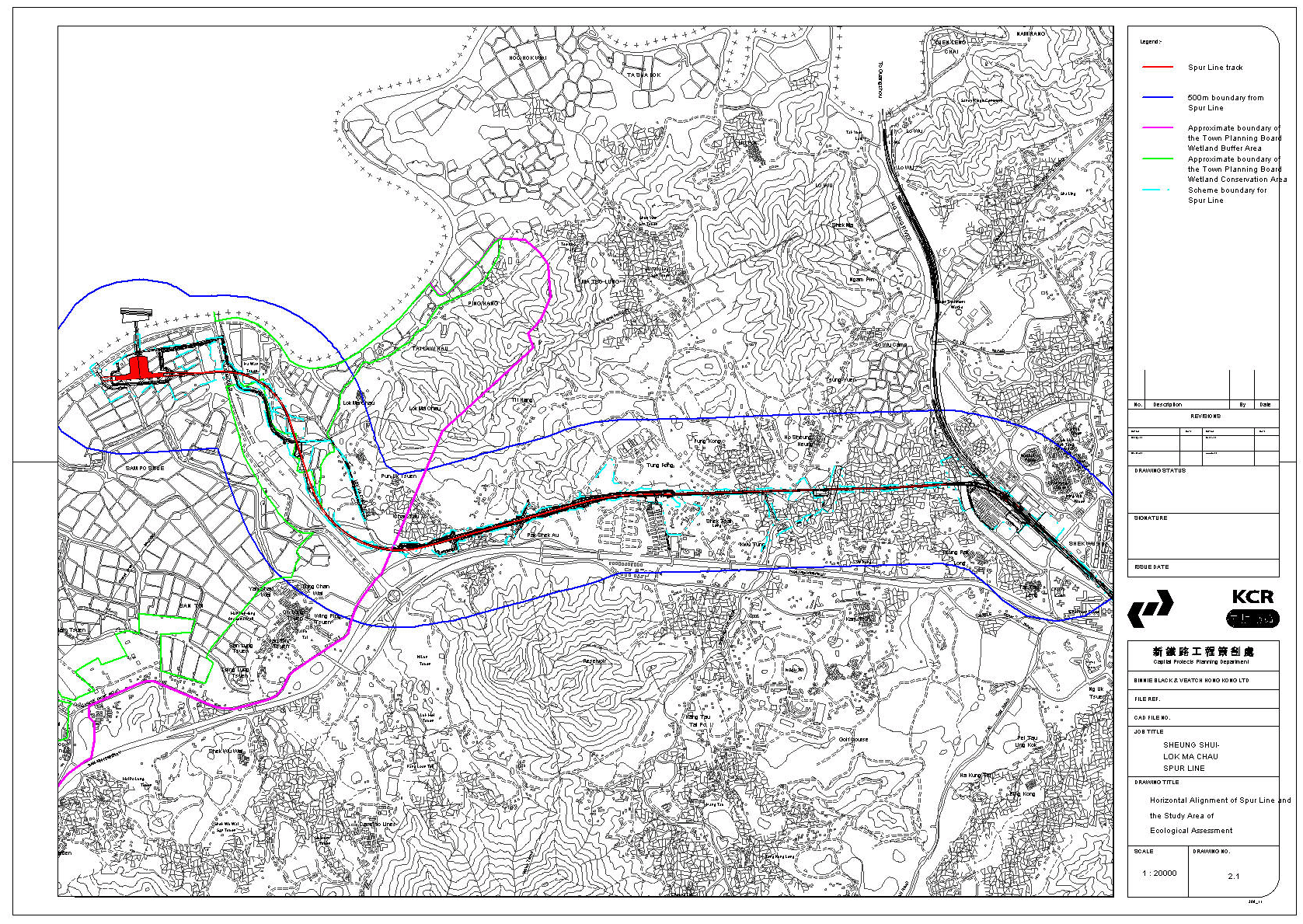
2.2.1
The Spur Line is an extension to the northern end of
the existing East Rail system. Figure 2.1 shows the
proposed horizontal alignment and the Study Area for the Environmental Impact
Assessment (EIA) Study. The outline of the proposed Lok Ma Chau Station is
also illustrated. Figure 2.2
presents the vertical alignment of the Spur Line.
2.2.2
The proposed vertical alignment will rise from the at
grade level at the existing Sheung Shui Station and below the existing Po Shek
Wu Road Bridge, onto viaduct across the existing East Rail. The up track
towards Lok Ma Chau will rise from approximately +5.00 m PD to a level of
+16.00 m PD over a distance of 566 m, supported by viaduct from Chainage (CH)
30+926 onwards. The down track has a much gentler slope, falling towards the
Sheung Shui Station dropping 12 m in vertical level over a distance of
900 m.
2.2.3
The two single-track viaducts converge into one twin
track viaduct at CH 31+300. The alignment will continue on a level of
+18.00 m PD westward until CH 33+057. As the topography changes from the
low-lying flood plain to hilly terrain, the alignment changes to at grade
section and continues on embankment and cutting. The deck structure containing
the track will change to ballasted track for the at grade section. From CH
34+657 onwards the railway will be constructed on viaduct until it reaches the
Lok Ma Chau Station.
2.2.4
The location of the proposed Spur Line route runs
through a series of different habitats, ranging from urban areas and container
storage sites to some highly valuable ecological sites. In particular the Lok Ma Chau fishpond
area, which is part of the Wetland Conservation Area (WCA) recommended by the
Study on the Ecological Value of the Fish Ponds in the Deep Bay (Fish Pond
Study) and adopted by the Town Planning Board (TPB PG-No 12B); and Long Valley,
which supports a large number of avifauna species.
2.2.5
The Lok Ma Chau fishponds are of particular importance
because of their proximity and ecological linkage to the Deep Bay Ramsar Site,
which supports many globally threatened species, species with high proportions
of their global or biogeographical population at the site and species that are
of regional or local conservation importance.
2.2.6
Long Valley comprises a mosaic of active and inactive
agricultural land, ponds and marsh, which support a diversity of bird species
and other fauna. Long Valley is the largest remaining area of wetland
agriculture in Hong Kong, and is a particularly important area for wetland bird
species and one of only two remaining breeding sites for Greater Painted-snipe
in the SAR. Details of these habitats and mitigation measures to minimize impacts
on ecologically important areas are discussed in the Ecology Assessment in
Chapter 4.
2.3
Nature, Scope
and Benefits of the Project
2.3.1
The main elements of the Project include the
construction and operation of a new railway that will connect from the existing
East Rail to a rail accessed passenger boundary crossing at Lok Ma Chau.
2.3.2 Only a passenger train service will be operated on the Spur Line. Upon opening in 2004, the train frequency will be 6 trains per hour in each direction. This will gradually increase to the ultimate train frequency of 12 trains per hour in each direction in 2016. When the Spur Line is completed, trains to Lo Wu and Lok Ma Chau will be operated as split service direct from the existing Hung Hom station. The speed limit for the Spur Line is 100 km/h. In planning the train service of the Spur Line, it is essential that the Lok Ma Chau Boundary Crossing Point will open from 0630 to 2330 hours, as occurs at the existing Lo Wu Boundary Crossing Point. To accommodate the Boundary Crossing Point opening hours, the daily train service of the Spur Line will be provided between 0600 and one hour following the close of the Crossing Point.
2.3.3
Major benefits of the Project to the East Rail service
include:
·
Relieve congestion at East Rail Lo Wu Station,
·
Increase the cross boundary rail capacity by establishing a second
cross boundary point,
·
Enhance linkage with the mainland at the Huanggang and Futian areas,
where it is planned to base the future commercial centre of Shenzhen, and
·
Facilitate future exchange with the proposed Shenzhen Metro System.
An additional
benefit of significant importance is the maintenance of KCRC's high safety
standards, which are currently under threat by the increasing pressure at Lo Wu
Station.
2.4
Size, Scale,
Shape and Design of the Project
2.4.1
The major components of the Project include the
construction and operation of a railway station at Lok Ma Chau and the section
of railway alignment from Sheung Shui Station to the future Lok Ma Chau
station. They are as follows:
·
Lok Ma Chau Station: Consists of an island platform, two tracks and two
concourse levels, one for arriving and one for departing passengers, KCRC
public facilities, staff facilities, and plant and support facilities.
·
Immigration and Customs Facilities for Lok Ma Chau station :
immigration halls for departing and arriving passengers, with facilitates for
tidal flow, non-public immigration facilities, immigration and custom staff
facilities, non-public custom facilities, security facilities, agricultural and
quarantine facilities and Department of Health facilities.
·
A permanent way of a total route length of 7.4 km between Lok Ma Chau
and Sheung Shui Stations, 5.0 km of which will be constructed on viaduct, and
1.6 km on cut and embankment. The remaining 0.8 km will be at grade. The
project includes construction of the viaducts, rock cutting and earth
embankment. The permanent way will be complete with traction power supply.
·
A two level footbridge linking Lok Ma Chau and Huanggang Stations.
·
Landscaping works and noise barriers where required. All other
mitigation works as recommended in the EIA.
·
The Dongjiang Raw Water Mains near the existing Sheung Shui Station
have to be diverted. Works need to be carried out during the Dongjiang supply
shut down in December 2001 and 2002 respectively.
2.5
Project
Timetable
2.5.1 This project is being progressed on a “fast track” basis because of the safety concerns related to overcrowding at Lo Wu station. The programme therefore dictates that all the detailed design works should be completed by the end of year 2000. The construction works will commence in early 2001 for completion in early 2004.
2.6
Means of
Implementation
2.6.1 The Spur Line will be constructed and operated by KCRC. The project will be implemented by means of detailed design contracts followed by construction contracts. The design of the project is underway and the work will be tendered out for construction following the completion of the detailed design works.
2.7
Related
Projects
2.7.1
At the time of this Environmental Impact Assessment
Report (EIA), two planning studies are in progress, one for North-West New
Territories (NWNT), one for North-East New Territories (NENT). There will be a
close interface between the Spur Line and the NENT Planning and Development
Study. The proposed Kwu Tung SGA has recently been publicized under the NENT
Planning Study, although the full details of the proposals (such as sensitive
receivers etc.) are not yet available.
2.7.2
The Spur Line is being designed to maximise noise
attenuation and therefore minimize constraints to developments along the
alignment. In the absence of full details of the Kwu Tung SGA, the present
assessment has indicated that development can take place with the SGA with no
impact from the Spur Line.
2.7.3
The proposed Lok Ma Chau Station will be connected to
the Shenzhen Metro’s Huanggang Station on the mainland side via a new
footbridge for rail passengers. The Shenzhen Metro is expected to be completed
by mid-2004. Close liaison with the
Mainland Authorities to ensure proper co-ordination between the Spur Line and
the Shenzhen Metro projects will be maintained.
2.8
Type, Scope,
Scale, Frequency and Duration of the Construction and Operational Activities
2.8.1 Construction activities which will be carried out in the implementation of Spur Line include:
· Excavation and earth movement in ground preparation for at grade, embankment, cutting and viaduct sections.
· Installations of viaduct supports, and of viaduct sections that may be pre-cast off-site, or cast at the concrete casting yard in the temporary works area.
· Rock cutting or blasting within the Pak Shek Au area.
· Dredging and filling of ponds for temporary works (along alignment) or permanently (at Lok Ma Chau station).
· Foundation works and infrastructure works at Lok Ma Chau station.
· Landscaping, habitat creation works, and reinstatement works at the end of the construction period.
2.8.2 As mentioned in Section 2.3, only a passenger train service will be operated on the Spur Line. Train frequency will be 6 trains per hour in each direction. This will gradually increase to the ultimate train frequency of 12 trains per hour in each direction in 2016.
This chapter describes the process of determining the vertical and horizontal alignment of the Spur Line. The project objectives, design criteria, constraints applicable and the assessment process to balance these requirements, leading to the identification of the optimum horizontal and vertical alignments are explained.
2.9.2.1 Planning of the Spur Line has taken place over a long period of some 10 years, in order to identify the most suitable route and method of construction. In determining the route, consideration was given to a great many factors including: environmental issues, cultural heritage issues, railway engineering design requirements, land use and planning requirements and physical constraints. All of these issues were addressed to ensure the provision of a safe and reliable operating railway. The initial proposal for the development of the Spur Line was presented in the final report of the Railway Development Study in May 1993. In November 1998 a Preliminary Project Feasibility Study (PPFS), which evaluated the engineering and environmental feasibility of the potential routes was completed by KCRC and presented to government.
2.9.2.2 In September 1999 KCRC consulted the EIA sub-committee of ACE on the likely ecological impacts arising from the PPFS alignment and the proposed measures to mitigate against such impacts. All comments and suggestions from that meeting have been heeded by KCRC.
2.9.2.3 The factors that guided the determination of the alignment are described in section 2.9.3 and the process of balancing the various competing requirements of the Spur Line leading to the choice of the alignment is explained in sections 2.9.4 and 2.9.5.
In planning and developing the alignment of the Spur Line the following were considered:
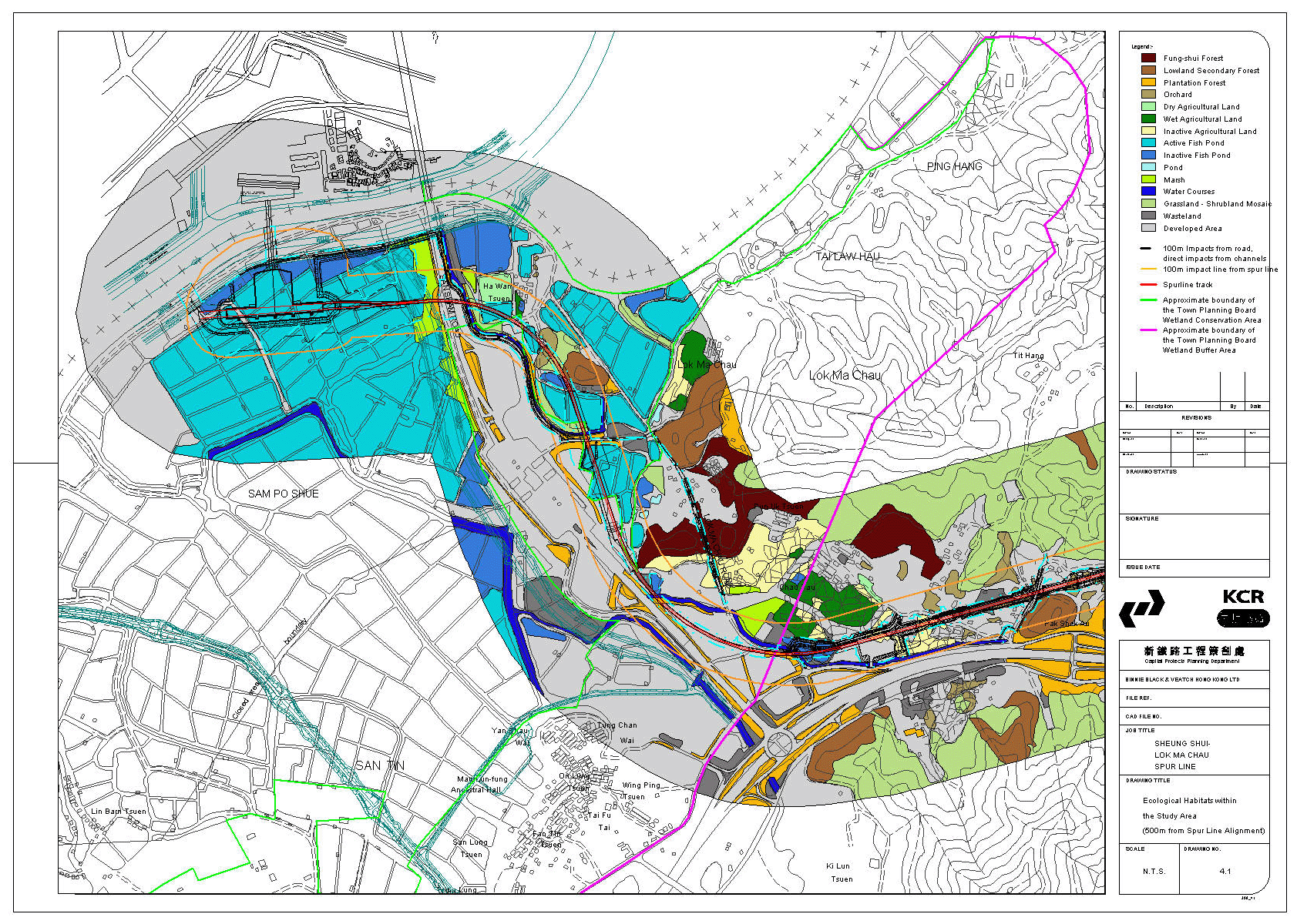
· Minimization of impacts on ecologically sensitive wetland along the proposed route. Areas that could be impacted include the alluvial plane of the River Beas (Sheung Yue Ho) and River Sutlej (Shek Sheung Ho), Long Valley, fishponds at Lok Ma Chau and other wet agricultural land within the Study Area. These areas are shown on the general habitat map in Figure 4.1 of the Ecology Chapter.
· Avoidance of disruption to any ecological corridors and important habitats.
· Avoidance of impacts on any existing communities, monuments, historical buildings, cultural heritage and archaeological resources. Known sites requiring conservation include:
¨ the historical
village of Ho Sheung Heung;
¨ an important
burial site at Kwu Tung;
¨ Chau Tau village;
¨ an important
burial plot west of Chau Tau;
¨ San Tin village
(which is one of the earliest inhabited villages in Hong Kong.
· Minimization of construction and operational noise arising from railway and station construction.
· Minimization of landscape and visual impacts on existing village zones by the careful location of the railway alignment.
The
chosen alignment took into account the following issues -
·
The potential development of a Strategic Growth Area centred on a new railway station in the area of Kwu
Tung:
·
Minimization of land resumption (by making use of Government land
rather than private land wherever possible):
·
Minimization of impacts to existing public utilities
·
Minimization of impacts on existing and planned development projects:
·
Allowance for future connection with West Rail Phase II.
· The point at which the Spur Line branches off must be located on a straight section of the existing East Rail to ensure safe railway operation.
· The southbound track of the Spur Line must pass over the top of East Rail for safety reasons and so as not to adversely affect the line capacity of East Rail.
· Maximum gradient constraints require the viaduct crossing over East Rail to begin its ascent 500m south of the crossing point.
·
Connection of the Spur Line to East Rail must be north of Sheung Shui
Station.
·
Spur Line must connect to Huanggang Station and the Shenzhen Metro.
· A double crossing must be located on the Spur Line at the nearest location possible to Sheung Shui station. This double crossing must be located on a straight section of track for safety reasons.
·
Maximum gradient should not exceed 2.5%
·
Minimum curve radius is 300 m.
2.9.3.5 Engineering Requirements
·
Disruption of drainage paths must be avoided, particularly in the flood
plain of the Beas and Sutlej Rivers to avoid flooding problems in the northern
New Territories.
· Sufficient vertical clearance must be provided to allow for the local roads at Kwu Tung and Lok Ma Chau that the railway must cross.
· Sufficient clearance is required between the CLP 400kV overhead lines East of Chau Tau and the railway.
· Provision must be made for the planned expansion of boundaries of the Lok Ma Chau Vehicle Boundary Crossing and to minimize the uptake of fishpond area around Lok Ma Chau.
· Sufficient overhead clearance must be provided above the two 2.2 m diameter water pipes of Water Services Department at Pak Shek Au.
· Sufficient overhead clearance is required below the railway in crossing San Sham Road.
· Sufficient overhead clearance is required between the railway and the proposed pump house and maintenance access road ancillary to the Eastern Main Drainage Channel.
· Private land resumption especially in built-up areas has to be avoided as far as practicable to minimize impact on occupants.
· The alignment should be located as remote as possible from village areas to minimize impact on residents.
2.9.4.1 Development of the Spur Line vertical alignment has taken into consideration the various problems and benefits related to underground, elevated and at grade forms of construction. These were compared within the context of the environmental and engineering requirements of the Spur Line described. (Tables 2.1 and 2.2)
Table 2.1
Comparison of Environmental Impacts Related to
Vertical Alignment Options
|
Environmental impact |
Underground |
At Grade |
Elevated |
|
Wetland Loss |
Possible
draw-down of water table may affect wetland. Significant Impacts if cut and
cover method of tunneling used. |
All wetland
along the 32 m wide corridor of the alignment would be impacted. |
Ground level
impact limited to column foundations. |
|
Ecological Impacts |
Major
disturbance during construction. |
Fragmentation of
existing ecological corridors, across Long Valley in particular. |
Retains existing
ecological corridors and minimize habitat loss. Minimal impact during
construction. |
|
Operational
Noise |
Minimal. |
Extensive at
source mitigation needed to
minimize impact |
Multi-plenum
design adopted to successfully minimize impacts. |
|
Construction
Noise |
Considerable
noise associated with piling for cut and cover construction. Long construction period. |
Extensive site
formation throughout the alignment. Long construction period. |
Viaduct decks
manufactured off-site, shipped
in by barge and transported by road. Impact limited and transient as only
occurs during column construction. |
|
Water Quality |
Construction
run-off minimal. Minimal operation phase impact. |
Potential
impacts on surrounding watercourses during the construction and operation. |
Limited
potential for impacts during viaduct column construction. |
|
Visual And
Landscape Impact |
Minimal. |
An at grade
railway can be adequately landscaped to minimize impacts. |
High visual
impact in rural and predominately flat landscape of Long Valley and Lok Ma
Chau. |
|
Fugitive Dust
During Construction |
Potentially
significant as cut and cover tunneling will require excavation of large
quantities of spoil. |
May be
significant during site formation. |
Minimal. |
|
Construction
Waste |
Significant.
Large quantify of soil is expected to be unsuitable for re-use on site.
Suitable site for dewatering and disposal needs to be found. |
Some soil may not
be suitable for reuse on site and has to be disposed. Quantity not as
significant as tunneling. |
Minimal. |
|
Cultural
Heritage And Historical Buildings |
Minimal, as long
as the foundations of the buildings are unaffected. |
May affect
burial plots at Pak Shek Au and Chau Tau. |
Minimal. |
Table 2.2
Comparison of Vertical Alignment Selection within
Engineering Constraints
|
Engineering Constraint |
Underground |
At Grade |
Elevated |
|
Drainage |
Tunneling cannot
be safely carried out in floodplain areas of Long Valley and Lok Ma Chau
because of risk of inundation during construction. |
Potential
restriction of drainage in low-lying areas. Potential flooding problems, posing a safety and
operational risk. |
Minimal
disruption of drainage. |
|
Impact on
existing railway operation |
Tunneling cannot
be carried out beneath the existing operating East Rail line at Sheung Shui. |
The railway
cannot be at grade as it crosses the existing East Rail line. |
A viaduct must
be used to cross the existing East Rail line. |
|
Clearance
requirements |
Bored tunneling
requires a minimum soffit to ground surface of 2 tunnel diameters. |
At grade is
required to clear Po Shek Wu Bridge at Sheung Shui. |
Viaduct must
provide adequate clearance to Lok Ma Chau Boundary Crossing, and the Eastern
Main Drainage Channel pump house. |
|
Gradient
limitation |
Tunneling would
only be possible for a short section given the requirement for viaduct across
the existing East Rail and at Lok Ma Chau to minimize wetland loss. |
Cutting is
required at Pak Shek Au to maintain consistent vertical alignment. |
Where viaduct is
required, the length is dictated by the gradient, before the rail can change
to at grade or tunnel. |
|
Safety issues |
Tunneling
requires ventilation and emergency accesses.. |
Safety access
can be readily achieved. |
Safety access
can be relatively easily achieved. |
2.9.4.2. Tables 2.1 and 2.2 illustrate that the environmental perspective is outweighed by the constraints posed by engineering, and in particular, safety and operational issues.
2.9.4.3 Constraints placed by the crossing of an operational railway at Sheung Shui, minimization of loss of wetland in the ecologically important Long Valley and the fishpond areas of Lok Ma Chau, are addressed by the viaduct as the preferred construction option along the majority of the alignment.
2.9.4.4 An at grade section must be constructed west of Tong Kok because of the topography but this section occurs where ecological resources are minimal.
2.9.4.5 The Spur Line vertical alignment was determined, through comprehensive assessment of engineering and environmental constraints. The preferred alignment resulted in the major length of the railway being on viaduct, while sections in non-ecologically valuable areas are at grade.
The horizontal alignment of the Spur Line was defined after thorough consideration of all the requirements described in section 2.9.3. Careful evaluation of various route options was made to ensure the choice of an optimum alignment.
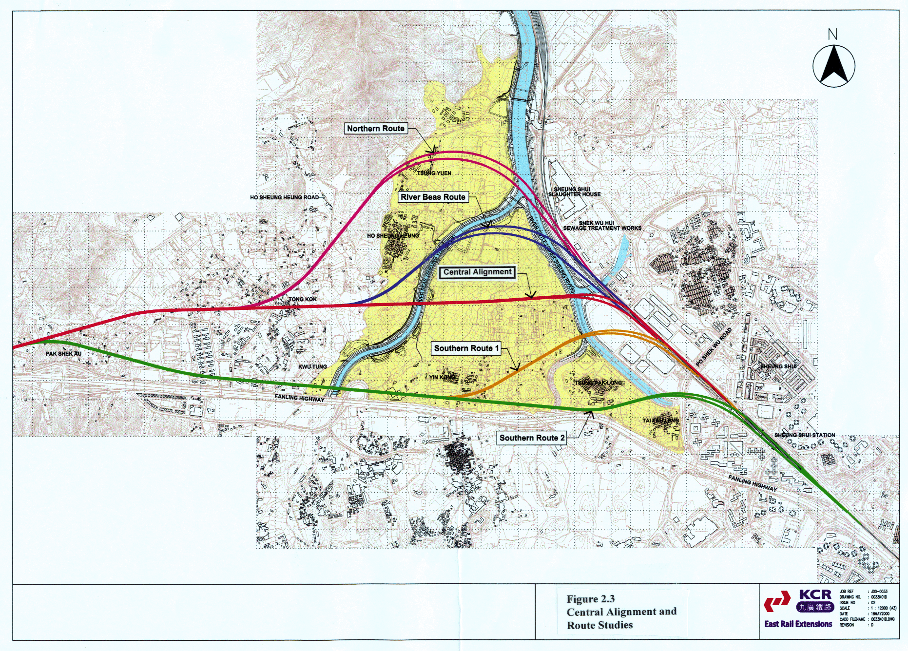
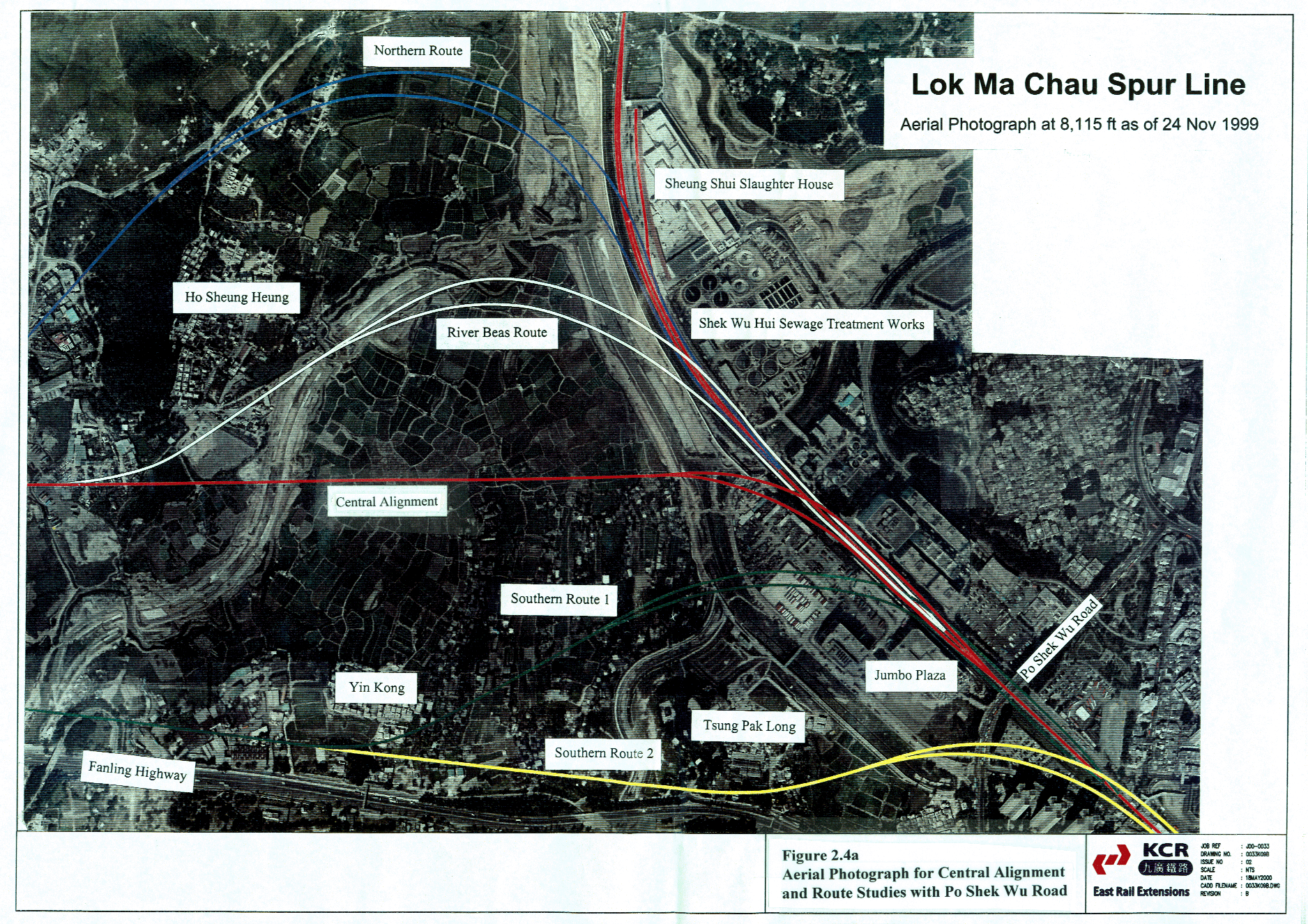
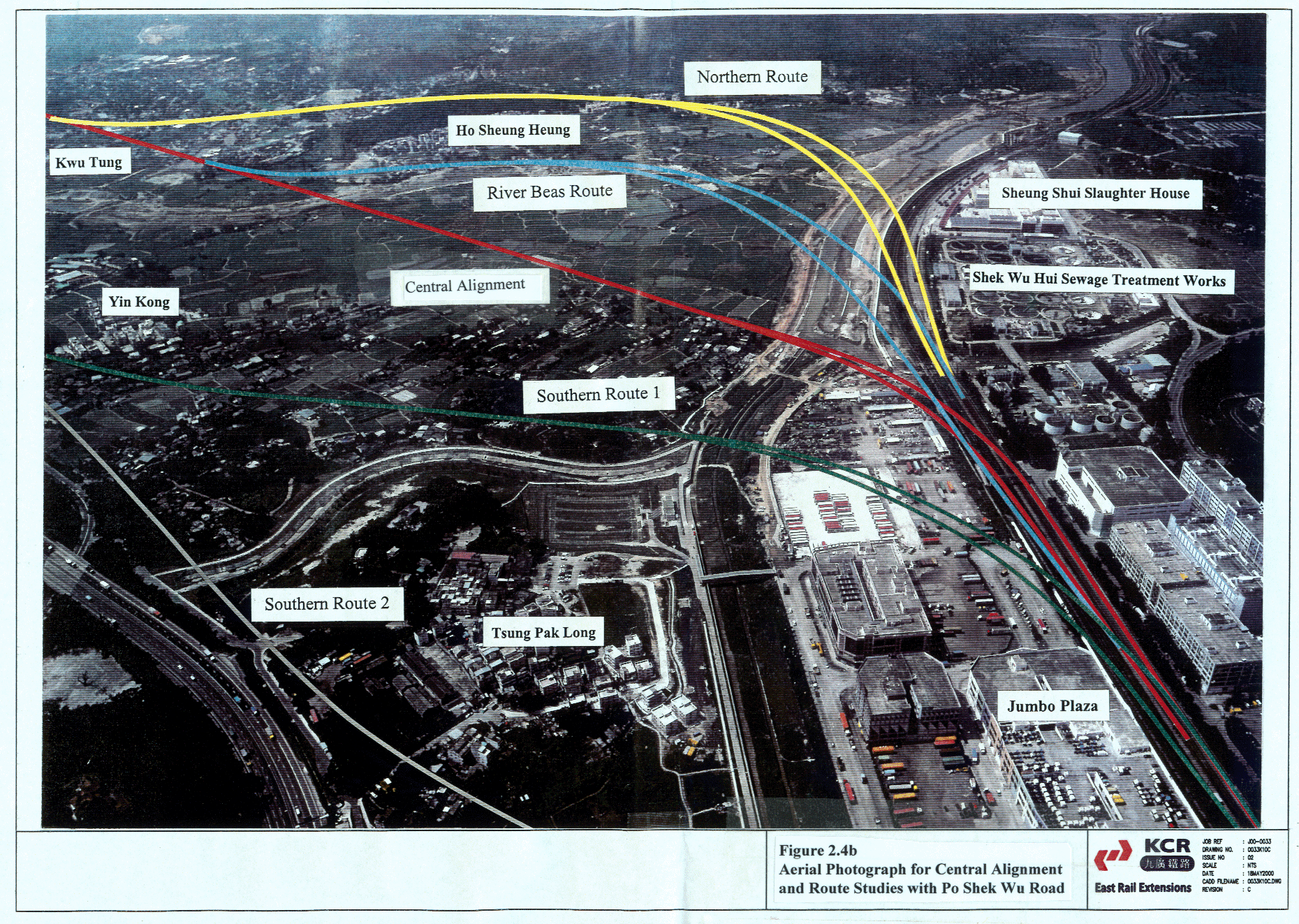
Recognizing the ecological importance of Long Valley, an area of about 34 ha, five alternative route options as shown in Figures 2.3, 2.4a and 2.4b were evaluated. The results are summarized in the following sections.
For this alignment the Spur Line begins immediately north of Sheung Shui Station and branches off from East Rail at a point 500 metres north of Po Shek Wu Road where it turns west to traverse Long Valley on viaduct. It follows a straight alignment towards Tong Kok in order to avoid the most northerly farms and village houses that predominate in the southern 12 ha of the valley. The alignment footprint takes up about 0.85 ha of agricultural land, all of which is in private ownership. Agricultural land in Long Valley is subject to the crop growing preferences of the various farmers, and the ecological importance of the area can therefore change on a temporal basis. With the railway the wetland created under the viaduct and its ecological value will become secure, even in the very long term.
The
CentralKCRC
aAlignment fully meets
the planning, land use, railway safety and operations and general engineering
requirements set down in sections 2.9.3.2 to 2.9.3.6. In particular the CentralKCRC aAlignment begins at a
straight section of East Rail, it also avoids the constraints arising from Shek
Wu Hui Sewage Treatment Works and the Sheung Shui Slaughter House which block
other routes. It does have an impact
on the ecology as outlined in Section 4, but constructing the railway on
viaduct enables the creation of 2.4 ha of wetland along its alignment,
additional to the enhancement to permanent wetland status of 1.4 ha of the
River Beas meanders, all of which will provide long term secure wetland. In total
3.8 ha of permanent wetland is created to mitigate ecological impacts on Long
Valley. During operation of the
railway, adoption of the multi-pleunum floating slab track for the viaduct
means that airborne noise and vibration at ground level is minimized and long term impacts are
considered to be acceptable.
Ecological impacts during the construction phase will be compensated through the provision of 3.2 ha of compensatory wetland habitat, which will be completed prior to construction works commencing in the particularly sensitive present marsh area. Access to the Long Valley by contractors will be severely limited, including the use of precasting, including viaduct deck segments, to minimize temporary works and the need to work from ground level.
2.9.5.1.2 Northern Route
For
this route the Spur Line branches off from East Rail at a point further north,
near to the Sheung Shui Sewage Treatment Works. Immediately after branching off it traverses a westward
curve and eventually turns southwest to join the KCRC Central Alignment west of
Tong Kok.
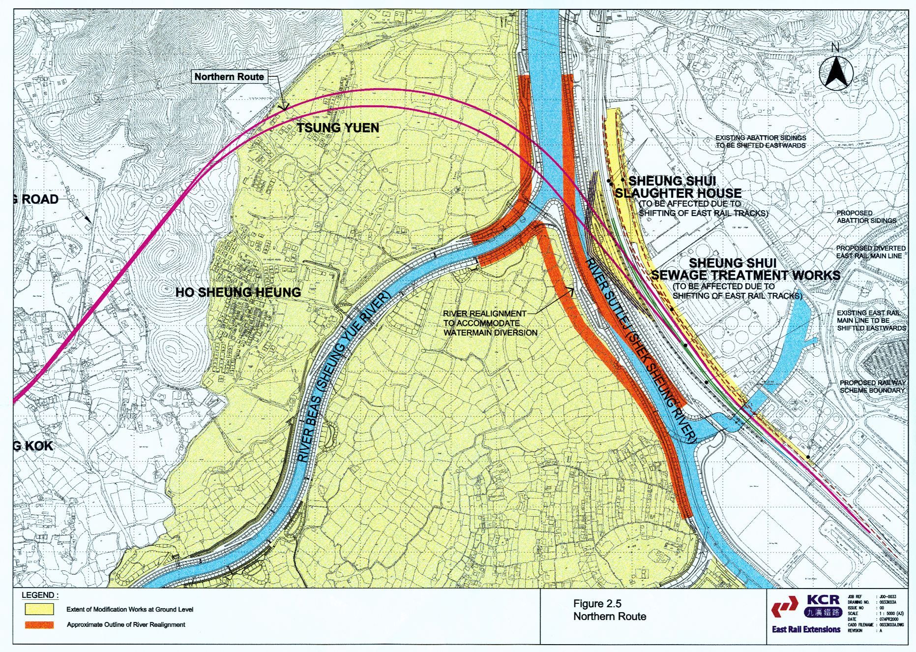
The proposed branching off point of this alignment is located on an existing 800 metre radius eastward curve on East Rail that is unacceptable on safety grounds. The curve has to be straightened to overcome the operational safety issue described in section 2.9.3.3. Figure 2.5 shows that to achieve this the existing East Rail tracks must be realigned such that they encroach into a substantial part of the Shek Wu Hui sewage treatment works and the recently completed Sheung Shui slaughterhouse.
Discussions with the Drainage Services Department with regard to the effects of this alignment on the sewage treatment works have indicated that the impacts would seriously compromise the operations of the facility. The Shek Wu Hui sewage treatment works is operating at its full capacity of 60,000 cubic metres of sewage per day. The sewage treatment works totally occupies its existing site.
If the treatment process is to be maintained, taking sections of the works out of commission is not feasible unless they can be re-provided in advance. Advance re-provisioning cannot be achieved, as there is no available land, the site being fully occupied with existing essential facilities.
Discussions with the operators of the slaughterhouse have indicated that this alignment would directly impact the unloading sidings to the west of the abattoir to where all the arriving animals are delivered. This area is essential for the normal operations of the slaughterhouse and cannot be made available to facilitate the construction of the viaduct that is needed for this route.
Construction of the railway viaduct in this location would effectively close down the slaughterhouse operations. This facility has only recently been opened at a cost of $2.0 Billion after a construction period of 4 years and a planning period of over 10 years. Given the long lead-time to develop such a facility, there is no possibility of it being re-located.
To overcome the conflict with the
slaughter house and sewage treatment works the alternative of elevating East
Rail to pass over the Spur Line was considered. It is concluded that this alternative is not feasible on both railway
safety and operational grounds. The principal reason is that as East Rail carries freight
traffic and therefore the maximum allowable gradient is 1.0%. This differs from
the Spur Line gradient criterion of 2.5% because Electric Multiple Units
(EMU)’s can accommodate more severe gradients than freight trains.
If the Spur Line were to join
East Rail at grade, by extending the straight section of East Rail northwards,
there is insufficient distance, from the Po Shek Wu Road bridge to the point at
which the East Rail up-track viaduct would cross the at-grade Spur Line, to
gain the required headroom. There is also insufficient distance to the north of the
crossing point for the upline to get down to the level of the Lo Wu Goodsyard.
In addition, it is not
possible for an at-grade railway to cross the five Dongjiang water mains and maintain the minimum clearance
required to ensure the pipes are not subjected to excessive loading. This is
because the crowns of the pipes are at approximately the same level as the
existing rails.
This
routeThe
Northern Route will necessitate substantially more private land
resumption and will require the demolition of approximately 20 village houses
as it traverses through the new village of Tsung Yuen. This social impact is
considered to be unacceptable.
The route also requires extensive cutting of the hills to the rear of Ho Sheung Heung which will create a severe visual impact, affect a large number of graves and generate a large quantity of surplus spoil.
Operationally journey time will be longer but more importantly, the requirement for a double cross-over close to Sheung Shui station will be impossible to achieve. The nearest location a straight section of track where it is safe to install the double cross-over could be located is over 2.3 km from Sheung Shui station. This deficiency renders this alignment unacceptable on operational grounds.
In summary, the Northern Route is not available for the railway, given the severe social impact on Tsung Yuen, and the blockages from existing essential infrastructure facilities. The latter arises from severe railway operational and safety constraints, associated with the need to re-lay 0.6 km of existing East Rail.
2.9.5.1.3 River Beas Route
For this route the Spur Line branches off from East Rail at a point
between that of the CentralKCRC
Alignment and the Northern Route and traverses through the northern section of
Long Valley. The route utilizes a continuous reverse curve to join to the KCRC AlignmentCentral Alignment east of
Tong Kok, passing close to the village of Ho Sheung Heung and the Hung Shing
Pui Fung Temple.
As with the Northern Route, there is no possibility of introducing the necessary length of straight track into this alignment near to Sheung Shui station, to permit the insertion of the double cross-over. The nearest location is some 1.7 km away, which is a serious departure from the fundamental operational requirements of the railway as stated in Section 2.9.3.
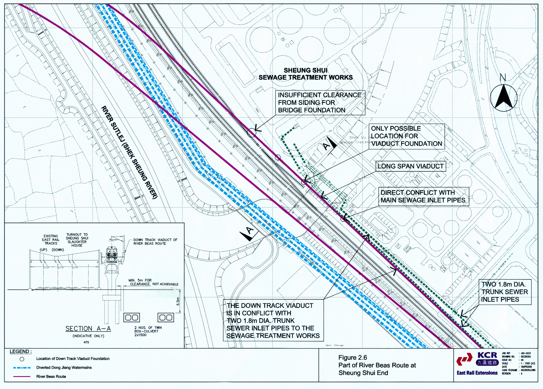
As illustrated in Figure 2.6. this River Beas route locates the down track viaduct (where it connects to East Rail) in between the existing railway and the sewage treatment works. Within this corridor, which is approximately 10 metres wide, are located two 1.8 metre diameter trunk sewer inlet pipes to the sewage treatment works together with a 250millimetre diameter leachate pipe from the North East New Territories Landfill.
There is a critical location on this corridor where the sewer inlet pipes pass under the River Sutlej tributary in a box culvert. At this location the delivery sidings to the Sheung Shui Slaughterhouse connect to East Rail. The combination of the underground pipelines and the siding turnout from East Rail effectively sterilizes the available space between the railway and the sewage treatment works making it impossible to construct the viaduct support column foundations. There is no potential to move the sewer inlet pipes as any alternative route would impact other essential sewage treatment works facilities.
If these major engineering constraints were solvable, there is a
further major constraint associated with this route. Because of the obtuse angle at which this route crosses East
Rail and the slaughterhouse delivery sidings, a bridge with a clear span of
approximately 250 metres would be needed, as there is no room between the East
Rail tracks to locate intervening support columns. The construction of such a
bridge over the existing operating railway may well be impractical, as well as
imposing unacceptable risk to the operating railway. The impact on the project
programme, given the complexity and severity of the construction problems, as
well as railway safety considerations, makes this route unacceptable. In
contrast, the CentralKCRC
Alignment is designed to cross East Rail at a more acute angle utilizing
conventional viaduct construction techniques. The River Beas Route is therefore not feasible due to the
these engineering constraints.
Although the River Beas route poses major engineering constraints,
the route has been reviewed in respect of the key environmental issues of
noise, ecology, visual impact and cultural heritage. The main environmental
impacts arising from the CentralKCRC
Alignment and the River Beas Route, are summarized in Table 2.34.
The detailed noise assessment on the nearest sensitive receiver in
the village of Ho Sheung Heung (contained in Appendix 1) indicates that by
adopting the same railway viaduct approach as for the CentralKCRC Alignment
neither construction nor operational noise will present problems. As with the
railway as a whole, adequate mitigation can be provided to contain potential
noise impacts.
The
detailed ecological assessment (contained in Appendix 1) concludes that the
1.85 ha of Long Valley (of which 0.45 ha is due to direct habitat loss and 1.4
ha due to indirect habitat loss between the viaducts) affected by the River
Beas Route has its own ecological problems. The Greater Painted-snipe can be
found in this wetland affected by the GazettedKCRC Alignment,
whilst the Chinese Pond Herons from the Ho Sheung Heung Egretry are found along
the River Beas Route. On balance it is considered that the impact on the
Greater Painted-snipe will be easier to mitigate by the pre-construction
creation of the 1.4 ha of marsh in the River Beas meanders. In contrast the
River Beas Route directly impacts these meanders making their enhancement for
Spur Line construction impact mitigation impossible. In the long term the permanent 3.8 ha of wetland/marsh
provided by the GazettedKCRC Alignment
makes this alignment preferable to the River Beas Route on ecological grounds.
The detailed
ecological assessment contained in Appendix 1 is summarised in Table 2.3 below.
AsIn summary, the ecological impacts of the Gazetted Central Alignment and the River Beas Route are almost the same.
However, as this table
states, whilst both alignments have some
adverse ecological impacts. , the key concern in the comparison is an
assessment of how the routes differ with respect to residual impacts during the
construction and, especially, the operational period. In this regard the
smaller residual impacts for the Gazetted Alignment (particularly with respect
to the provision of off-site mitigation areas) render this route slightly
preferable.Whilst
the River Beas Route causes less fragmentation and impact on species, on the
other hand, the Central Alignment
provides better opportunity for off-site mitigation, therefore both alignments
are equal after considering all ecological aspects.
Table
2.3 Ecological Impact
summary table (Key Impacts)
|
|
Central |
River Beas route |
Comments |
Preferred Option in respect of impact reviewed |
|
Construction
period |
||||
|
Impact on habitats
of ecological importance |
Major: freshwater
marsh severely affected, wetland agriculture areas affected |
Minor: some
wetland agriculture areas affected, but much of alignment already impacted by
River Beas channelisation, longer period of construction activity in area of
River Beas not considered critical (since no advance compensatory habitat
provision was required in respect of River Beas channelisation project
temporary loss of this habitat has already been judged not to be of critical
importance) |
|
River Beas
alignment less destructive in short term |
|
Impacts on Bird
Species of Conservation Importance if no mitigation |
Major: freshwater
marsh is principal refuge habitat for Greater Painted-snipe and several other
bird species; construction activities will create general disturbance in Long
Valley |
Medium: principal
impact predicted to be on flightline between Ho Sheung Heung egretry and Long
Valley; construction activities will create general disturbance in Long
Valley |
Disturbance
effects in Long Valley as a whole similar between options |
River Beas
alignment has less impact |
|
Mitigation
potential |
Major: temporary
wetland provision will create alternative marsh area for Greater
Painted-snipe and other species doing construction period |
Minor: no scope
for temporary habitat provision; limited scope for control of working
practices to minimise disturbance |
|
Impacts of Central |
|
Residual impacts |
Minor: temporary
habitat provision will mitigate for short term impacts on habitat |
Minor/Medium:
residual disturbance to egretry flightlines cannot be mitigated |
Response to
disturbance by egrets unpredictable |
Potential for
residual impacts greater for River Beas alignment |
|
Operational Period |
||||
|
Impact on habitats
of ecological importance if no mitigation |
Major: significant
fragmentation of Long Valley as route passes through core area; direct loss
of wetland habitat; impact on key marsh area; indirect loss due to
disturbance |
Major: some
fragmentation of Long Valley (though route avoids core area and there is
relatively little linkage between main area of Long Valley and portion north
of River Beas), direct loss of wetland habitat; indirect loss due to
disturbance |
|
Both alignments
have major adverse ecological effects if no mitigation but River Beas
alignment preferable due to less fragmentation of wetland |
|
Impacts on Bird
Species of Conservation Importance if no mitigation |
Major: potential
threat to Greater Painted-snipe population and significant adverse effects on
populations of many other wetland bird species including freshwater
specialists such as Pheasant-tailed Jacana and Watercock |
Major: significant
adverse effects on populations of many wetland bird species especially
Chinese Pond Heron but also some (albeit lesser than for |
Both alignments
have major adverse effects |
River Beas
alignment preferable because of lower impact on Greater Painted-snipe |
|
Mitigation
potential |
Area under
viaducts and River Beas meanders offer scope to mitigate for all habitat loss
(both direct and indirect) for all species |
Area under
viaducts (which includes River Beas meanders) offers scope to mitigate for
direct habitat loss for all species. No scope to mitigate for indirect
habitat loss as all mitigation areas will be subject to avoidance of viaduct
structure and noise impacts from railway operations |
No scope to
provide off-site mitigation for River Beas route |
|
|
Cumulative impacts
including cumulative effect of River Beas channelisation, Spur Line and new
road to north of River Beas |
Conversion of
River Beas meanders to permanent wetland will have a net overall benefit on
ecological function of these areas.
Long term fragmentation effects for core area of Long Valley greater
than for River Beas alignment as largest part of Long Valley will be situated
in a triangle bounded by road and railways. However the northern part of Long
Valley will be undisturbed once river channelisation is completed |
Conversion of
River Beas meanders to permanent wetland will have some benefit but this will
be partially negated by their being affected by disturbance impacts. No scope
for off-site mitigation of cumulative disturbance impacts to River Beas
available. Cumulative fragmentation effects of road and railway smaller for
core area of Long Valley, but a large area of northern Long Valley on either
side of the River Beas will be impacted |
River
channelisation not expected have significant long term fragmentation effects
whilst effects of road will be much greater than those of the railway |
Whilst
fragmentation effects of River Beas route are less this is achieved at the
price of sterilising a swathe of land on both sides of the River Beas. |
|
Residual impacts |
Significant habitat
fragmentation unavoidable, but all habitat loss and impacts on species fully
mitigated; significant long-term increase in permanent freshwater wetland
area managed for conservation purposes, part of this area free from
disturbance impacts |
Some habitat
fragmentation unavoidable, direct habitat loss fully mitigated but
significant indirect habitat loss for disturbance sensitive species;
significant long-term increase in permanent freshwater wetland area managed
for conservation purposes, but entire area (including mitigation areas
previously proposed for River Beas channelisation) affected by disturbance
impacts |
Key factors to be
evaluated are relative importance of permanent fragmentation impacts
vis-à-vis permanent indirect habitat loss for disturbance sensitive species |
As both alignments
have some adverse ecological impacts, they are equal after considering all
ecological aspects. |
This route places the railway 100 metres nearer to the village of Ho
Sheung Heung and the heritage site of the Hung Shing Pui Fung Temple. The
assessments (detailed in Appendix 1) indicate that the impacts will be greater
than those predicted for the CentralKCRC
Alignment. Exploratory discussions with the villagers of Ho Sheung Heung have
indicated that they would raise very strong objections to any proposal that
would locate the railway nearer to the village.
Overall the River Beas Route is inferior to the CentralKCRC Alignment,
given the ecological dis-benefits, coupled with serious social and
environmental consequences.
Table 2.34 summarizes the main
environmental impacts for the CentralKCRC
Alignment and the River Beas Route.
This summary represents a synthesis of the detailed comparisons for each
environmental discipline presented in Tables A1.1 to A1.4A1 to A5b in Volume 23, Appendix 1.
From an overall environmental perspective, the CentralKCRC Alignment has a
lesser impact and is preferable.
Summary of Environmental Impacts Comparison between CentralKCRC Alignment and
River Beas Route
|
|
Central |
River Beas Route
|
Comments |
Preferred Option |
|
Ecology |
|
|
|
|
|
|
Significant construction impact
on freshwater marsh |
No construction impact on
freshwater marsh |
Freshwater marsh habitat very
important but is not protected and can be re-created |
The Beas River Route is
preferred |
|
|
Significant impact on key
habitat for Greater Painted-snipe and other wetland species |
Significant impact on habitat
available to wetland dependant species especially those more sensitive to
disturbance such as Ardeids |
Mitigation for loss of marsh
habitat for Greater Painted-snipe feasible, mitigation for disturbance
impacts requires off-site areas |
River Beas route preferable
with respect to impact on freshwater marsh
|
|
|
All direct and indirect impacts
on wetland habitats and species of conservation importance can be mitigated
by temporary and permanent on-site and off-site compensation areas |
Direct impacts to wetland
habitats and species of conservation importance can be mitigated by permanent
on-site compensation areas. No off-site compensation areas available to
mitigate for disturbance impacts |
|
|
|
|
Residual
impacts can be limited to fragmentation effect on Long Valley ecosystem.
These cannot be entirely eliminated but can be reduced in the long term by
appropriate habitat management of the Long Valley ecosystem; off-site
compensation areas (River Beas meanders) permit elimination of residual
impacts with respect to habitat loss for disturbance-sensitive species |
Residual
impacts can be limited to some fragmentation and habitat loss for
disturbance-sensitive species. The small remaining wetland area north of the
River Beas will be of little value once linkage with the larger Long Valley
area is broken, whilst habitat loss for disturbance-sensitive species cannot
be made good by off-site mitigation since the only available areas for
compensation are impacted by this route |
Final
assessment of ecological merits of options hinges on evaluation of relative
importance of residual impacts |
Whilst
fragmentation and loss of linkage with the small area north of the River Beas
consequent on selecting the River Beas route is of less significance than the
fragmentation of the core Long Valley area caused by the |
|
Noise |
Noise levels
due to Central |
Noise levels
at selected NSRs in Ho Sheung Heung are greater than the ANL due to the
presence of points and crossings on River Beas Route alignment at this
location. Mitigation in the form
of a barrier or enclosure will be required. |
Noise
impacts from both alignments can be adequately mitigated |
|
|
Cultural |
Minimal
impacts on historical buildings (primarily in Ho Sheung Heung) arise due to
the Central |
The River
Beas Route lies very close to selected historical sites in Ho Sheung
Heung. Woodland that is affected
by the alignment must be replaced and a buffer woodland planted to provide a visual
barrier between the railway and the sites of cultural heritage. |
The
alignment must maintain a minimum distance of 50m from any cultural or
historical sites in Ho Sheung Heung.
River Beas Route may need to be slightly realigned to achieve this
requirement. |
|
|
Landscape and Visual |
The
impact of the The
|
Impacts on the Long Valley landscape character area would
be less significant than those predicted for the Visual
impacts would be more severe for this option despite being partially screened
by the existing woodland. This is largely due to the requirement for noise barriers or enclosures which would
increase the visual mass of the viaduct structure and reduce the
effectiveness of landscape mitigation measures such as woodland planting. However for visually sensitive receivers situated in the
south of the study area such
as those in Yin Kong and Tsung Pak Long the visual impacts arising from the
River Beas Route would be less significant.
|
The
|
The
River Beas Route would be preferable
in terms of the significance of adverse impacts on the landscape character of
Long Valley. The
Overall
considering the significance of the predicted landscape and visual impacts
there would be negligible difference between the two options. |
|
Other Issues |
Potential
impacts on water quality may occur where the viaduct crosses River Beas. As the distance across the channels
is short (relative to the distances for River Beas Route), the viaduct may be
constructed to span the channels. |
The alignment will cross a longer stretch
of the Rivers Beas and Sutlej than Central Spoil heaps to
the south of Ho Sheung Heung may create more waste than Central |
Differences
between the options are minimal in terms of air quality impacts. |
Central |
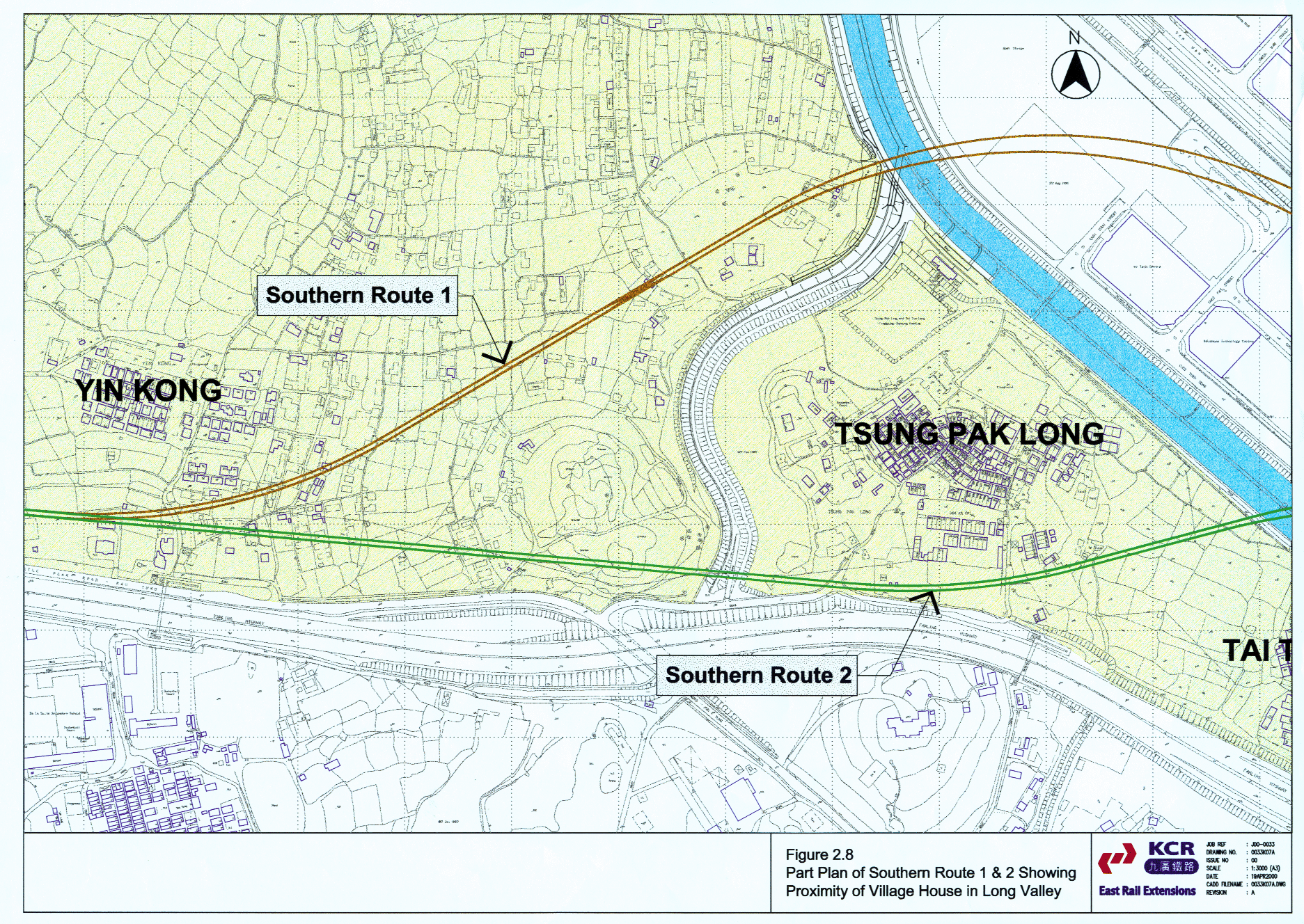
2.9.5.1.4 Southern Routes: 1
Southern routes have been studied which are closer to the head of
Long Valley than the CentralKCRC
Alignment. Route 1 branches off
between Sheung Shui Station and Po Shek Wu Road, and if feasible would not impact
on the ecologically sensitive marsh area but at the expense of impacting on
human habitat, including the village of Yin Kong.
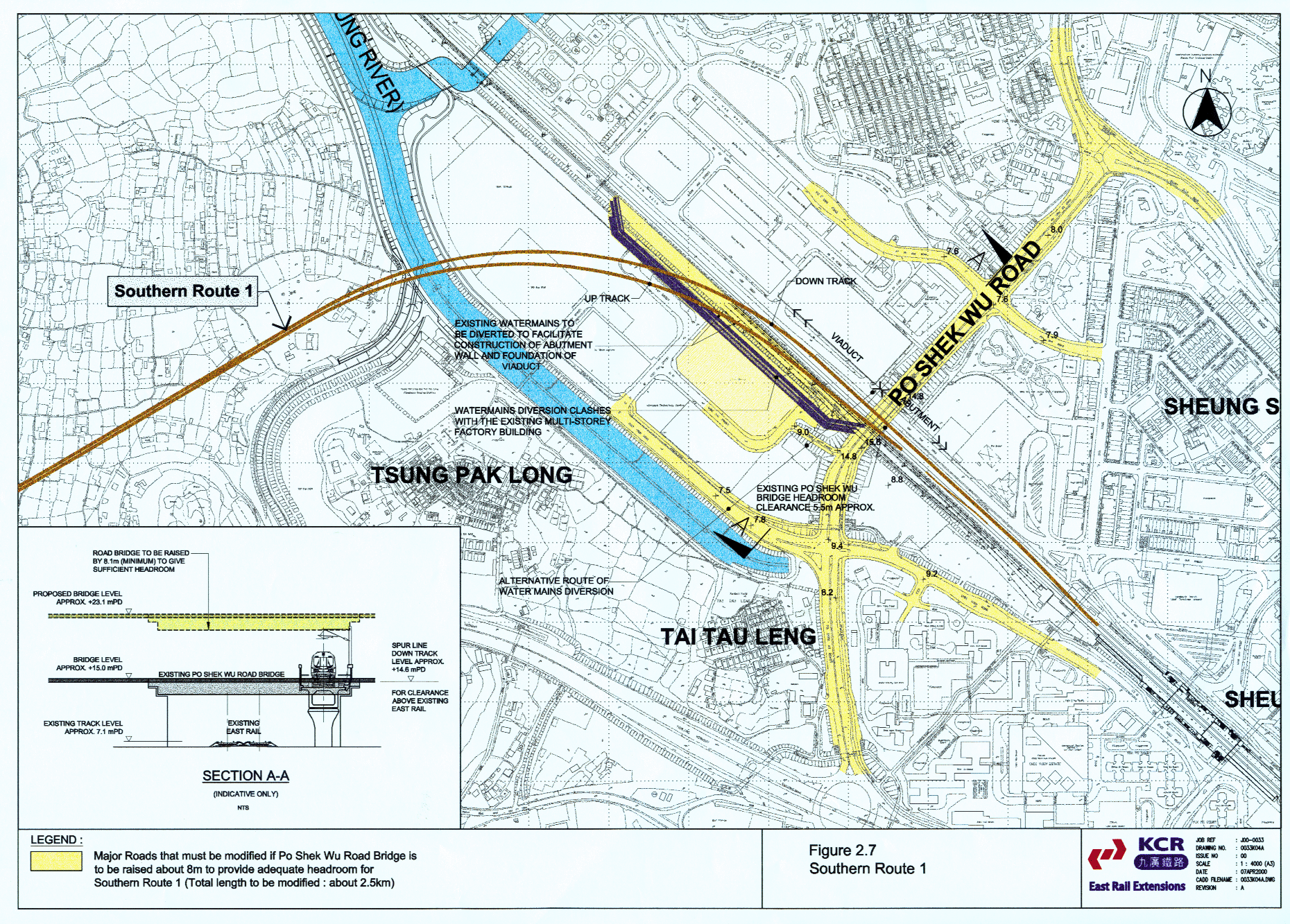
As shown in Figure 2.7, for Route 1 to work the Po Shek Wu road bridge would have to be demolished and rebuilt 8 metres higher, in order to accommodate the down line branch of the Spur Line which crosses East Rail on viaduct structure.
Highways and Transport Departments of government has confirmed that Po Shek Wu Road forms a critical part of the road network, connecting to the Man Kam To boundary crossing. Uplifting of the Po Shek Wu Road bridge would necessitate major reconstruction of approximately 2.5 km of roads in the area, as well as blocking access to numerous buildings and residences. The impact on Man Kam To that would arise in the event of demolition and re-construction of the bridge, would be totally unacceptable, given the importance of this boundary crossing route and the volume of heavy traffic that would seek to spill over into roads intended only for lighter traffic.
As presented in Figure 2.8, the village of Yin Kong would be impacted by this route, resulting in more private land resumption and increased visual impacts due to the close proximity of the railway.
From a planning and land use perspective, the Southern Routes are incompatible with the proposed Kwu Tung SGA development, requiring the SGA station to be located at the southern boundary of the development area instead of near its centroid. Reducing the accessibility of the station to SGA residents would be a serious departure to the SGA development concept, which is intended to ensure use of the railway to provide the major mode of transport to and from the SGA development area.
Resumption of Jumbo Plaza, an existing industrial building adjacent
to East Rail, would also be required for the diversion of the Dong Jiang water
mains. Given the judicial review experience of Government and the KCRC in
resuming Wah Kai Industrial Centre, an industrial building on West Rail,
resumption cannot necessarily be expected to succeed. Owners could argue that the alternative CentralKCRC Alignment makes
it unnecessary to resume their building, and thereby win their case.
In summary, whilst a Southern Route appears attractive on paper, Route 1 is not feasible because of the impact on Po Shek Road bridge and the obstruction arising from Jumbo Plaza. Any ecological benefit must also be weighed against the negative environmental impacts on Yin Kong village, and the future potential damage to sustainable environmental planning by reducing the attractiveness of rail transportation for the Kwu Tung SGA.
2.9.5.1.5 Southern Routes: 2
Route 2 avoids the conflict with Po Shek Wu road bridge and the Jumbo
Plaza industrial building, by branching off mid-way between Sheung Shui Station
and Fanling Station. This route however brings negative environmental impacts
on Tsung Pak Long as well as Yin Kong villages (see Figure
2.8), as well as the potential damage to sustainable environmental planning
of Kwu Tung SGA. Route 2 also
fails to meet the requirement of Sheung Shui passengers traveling directly
to Lok Ma Chau and vice versa, Route
2 also involves the demolition of a substantial part of Sheung Shui Station
which cannot be contemplated given railway operation and safety constraints. Accordingly the adoption of Route 2 is
not possible, and indeed there is no Southern route available which on balance
improves on the CentralKCRC
Alignment.
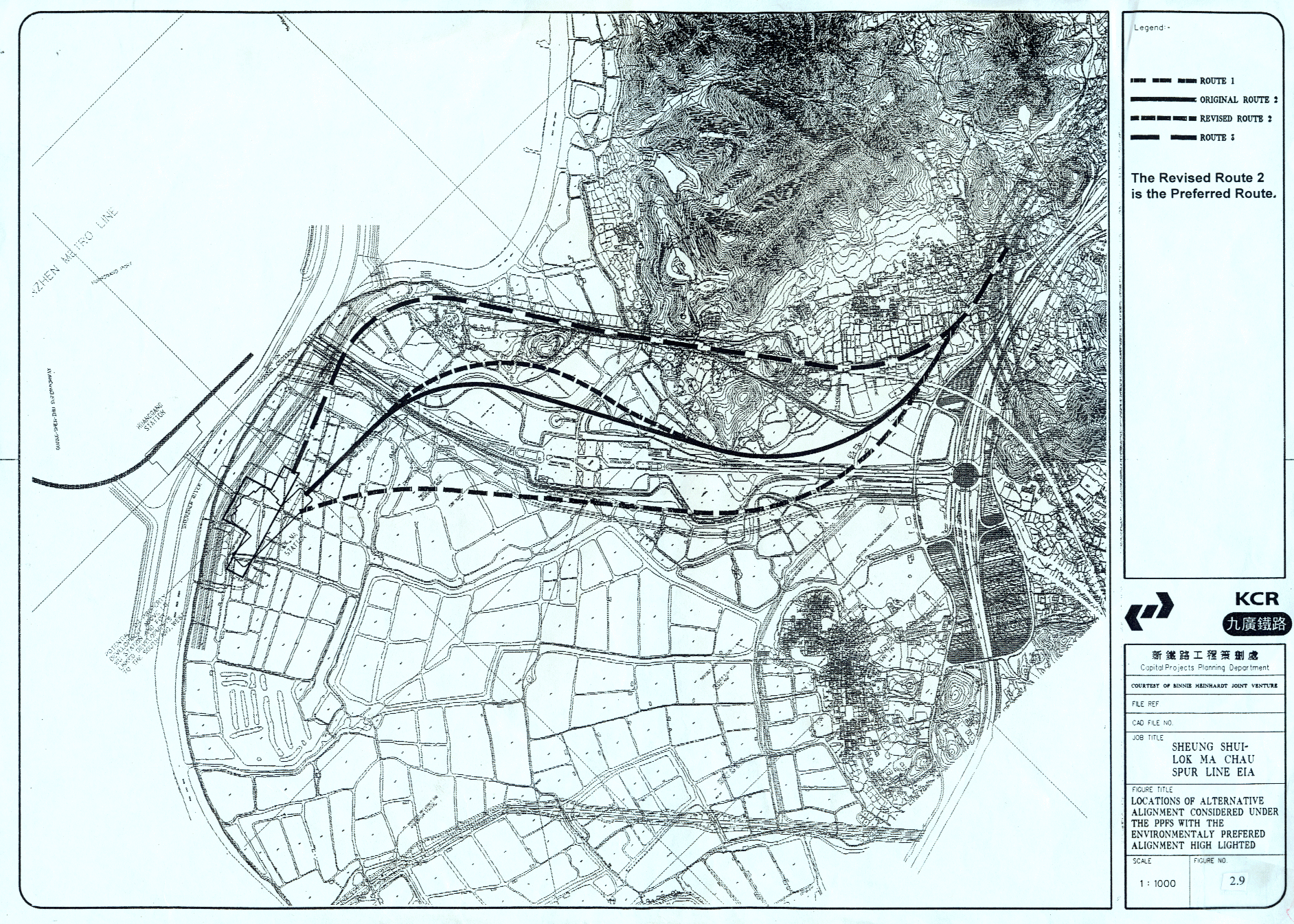
Three possible alignments were considered for the western end of the Spur Line (Chau Tau to Lok Ma Chau station) and are shown on Figure 2.9. The viability of each alignment was examined against a selection of criteria to assess the relative merits of each option, as shown in Table 2.3. Engineering constraints, including the presence of extreme alluvial deposits in the Lok Ma Chau area, which may affect construction works were a serious consideration. The selected alignment minimises this problem. After much discussion and consultation with KCRC, the revised Alignment 2 was the preferred option. Land issues have contributed to further localised revisions to this alignment that will require the temporary drainage of additional fishponds in the Sam Po Shue area. These fishponds, along with others disturbed by the project, will be reinstated upon completion of all works. The entire western end of the rail alignment will be elevated on viaduct.
2.10
Description of
Scenarios with or without the Project
2.10.1 The primary aim of the Spur Line is to relieve the increasing number of passengers at Lo Wu, which has been detailed in Section 1. In the event that the Spur Line Project could not be constructed, it would mean the congestion problem at Lo Wu Station could not be resolved. This would pose a serious safety concern to the existing cross boundary service provided by the East Rail, especially in light of the increasing cross boundary journeys. During the year 2000 Easter period, a new record was set at 335,000 crossings during a single day.
2.10.2 Railway transportation has been widely recognized as the most environmental friendly and efficient means of public transportation. Under the latest Government developmental programmes, railway transportation will become the backbone of some future “Green Towns”. According to the current Planning and Development Study for NENT, the Spur Line will be vital to satisfy the future transportation needs of the future Kwu Tung SGA. Without the Project, the transportation needs of the SGA could not be met.