4. ECOLOGICAL IMPACT ASSESSMENT
4.1 Introduction
4.1.1 The aim of this Ecological Impact Assessment Report (EcoIA) with respect to ecological impacts of the construction and operation of the Spur Line is to:
• Review the ecological resources within the area affected by the project and identify Valuable Ecological Components (VECs), including habitats and Species of Conservation Importance.
• Identify the potential impacts from the construction and operation of the Spur Line.
• Identify potential mitigation measures that may be used to reduce or overcome the potential impacts of the construction and operation of the Spur Line.
• Provide an assessment of the predicted residual impacts of the construction and operation of the Spur Line taking into account the proposed mitigation measures.
4.1.2 This assessment is based on guidelines given in Annex 8 (“Criteria for evaluating an ecological impact”) and Annex 16 (“Guidelines for ecological assessment”) of the Technical Memorandum on Environmental Impact Assessment Process (EPD).
4.2
Methodology
4.2.1 This EcoIA is primarily based on information collated during the production of a Preliminary Project Feasibility Study (PPFS) in 1998 (Binnie 1998) of the proposed Sheung Shui to Lok Ma Chau Spur Line and a recent detailed ecological review of the Spur Line corridor (ERM 1999b).
4.2.2 Following the requirements of Annex 16 of the Technical Memorandum to the EIA Ordinance, the defined Study Areas covered by the PFFS and ERM studies consisted of a one-kilometre corridor (500 m on either side of the proposed alignment). Ecological investigations were carried out by a literature review and a field survey to determine the types and extent of habitats present. A narrower corridor represented by 100 m either side of the alignment was subjected to more detailed survey to establish the importance of these habitats in the context of the study corridor; this 200 m corridor was considered to represent the area that is most likely to be subject to impacts from the construction and operation of the railway.
4.2.3 A preliminary habitat map was produced for the PPFS (Binnie 1998) which was then subsequently updated by the ERM 1999b study. In the ERM study, a 1:5,000 habitat map was prepared by making reference to the latest available aerial photographs taken by the Lands Department, HKSAR (see ERM 1999b Annex A reference list), during which the boundaries of different habitat types within the Study Area were mapped and delineated. Complementary reconnaissance ground-truthing were subsequently undertaken between March 1999 and May 1999 to field check and confirm the nature/latest status of those habitats identified.
4.2.4 It was noted, during the field surveys undertaken as part of the ERM study, (ERM 1999b), that construction activities associated with a range of projects (including the Main Drainage Channel for River Beas and River Sutlej and the kiosk expansion at Lok Ma Chau Boundary Crossing), as well as the management practices of the land owner or tenant of agricultural land, continue to alter the status of the habitats within the Study Area.
4.2.5 The Binnie PPFS and ERM ecological studies also reviewed a number of previous studies carried out in this geographical area, including the following documents:
• Sheung Shui and Fanling Main Drainage Channels EIA (CES 1997);
• West Rail Phases 1 and 2 EIAs (ERM 1998a);
• Sheung Shui to Lok Ma Chau Spur Line Preliminary Project Feasibility Study (Binnie 1998);
• San Tin Drainage Channel EIA (ERM 1999a);
• Lok Ma Chau Boundary Crossing Expansion EIA (Binnie 1999);
• Comprehensive Conservation Strategy and Management Plan for the Deep Bay Ramsar Site; (Aspinwall Clouston and Wetlands International - Asia Pacific (1997);
• various fishpond studies, e.g. Aspinwall & Company Hong Kong Limited (1997), Young (1997 & 1998) and Zhuang and Lau (1997); and
• other sources of information (such as the Annual Reports of the Hong Kong Bird Watching Society).
4.2.6 The ecological importance of habitats with respect to the occurrence of butterflies, dragonflies, fish, amphibians, reptiles, birds and mammals was investigated in the ERM study by a review of existing literature sources as these taxa groups have been relatively well studied in Hong Kong. The identification of Species of Conservation Importance (in accordance with the EPD Technical Memorandum) was therefore restricted in this EIA report to these groups.
4.2.7 The invertebrate groups, Lepidoptera (butterflies and moths) and Odonata (dragonflies and moths) have been relatively well studied in Hong Kong and there are a number of published and unpublished records which provide an indication of their habitat requirements and local status. Unfortunately, other invertebrate groups have been less well studied and, as a consequence, the data required to assess the ecological significance of individually observed specimens within the Study Area (i.e. species lists, spatial distribution, habitat requirements, relative abundance, etc.) are not available.
4.2.8 Therefore, in order to adequately assess the significance of the Study Area for invertebrates, the ERM (1999b) study used Lepidoptera and Odonata as representative invertebrate species and as indicators of the capacity of identified habitats to support invertebrate communities. Whilst the habitat requirements of the two groups would not reflect the specific needs of all invertebrate groups, the presence of the range of habitats required to support their larval and adult stages and overall species diversity is likely to reflect to some degree the relative 'health' of the populations of other, less well studied, groups. The use of butterflies as sensitive indicators of habitat diversity and of the impacts of anthropogenic changes to habitats is supported by Erhardt (1985), whilst Wilson (1995) cites dragonfly larvae as good indicators of both water quality and habitat diversity.
4.2.9 In the Section that follows the findings of a review of relevant field survey reports for Lepidoptera and Odonata are presented and the species of ecological or conservation value are highlighted.
4.2.10
The direct loss of habitats of
ecological importance from the Spur Line comprise the land destruction due to
column construction and the construction of the station complex at Lok Ma Chau.
This was measured by overlaying maps of the alignment onto the current ERM
habitat map for 1999. Habitat area calculations were made using GIS software.
Non-ecologically valuable habitats (such as urban/residential areas and
container storage areas) and areas where works are being carried out under
other projects (such as Fanling and Sheung Shui Main Drainage Channels (CES
1997); San Tin Drainage Channels (ERM 1999a) and Lok Ma Chau Border Crossing
Expansion (Binnie 1999)) were removed from the area evaluation equation.
4.3
Baseline Identification and Evaluation
of Valuable Ecological Components (VECS)
4.3.1 The first objective of an Ecological Impact Assessment (EcIA) should be to review the existing ecological resources and receivers that may be affected by the development and to identify those that are Valuable Ecological Components (VECs) (Treweek 1999). This has therefore been carried out, using the information sources described above, for habitats and then for individual Species of Conservation Importance following the guidelines for the evaluation of ecological importance of habitats and species given in the Technical Memorandum on Environmental Impact Assessment Process (EPD).
4.3.2
With respect to the vegetation
characteristics and other physical and environmental attributes, 15 different habitat types were categorised by
the ERM (1999b study), as follows:
• Fung-shui Forest - forest found around rural villages comprising native species or a mix of native species and fruit trees;
• Lowland Secondary Forest - forest dominated by native tree species and not located behind villages;
• Plantation Forest - landscaping or ornamental plantations mainly found along roads and on cut‑slopes;
• Orchard - patches of fruit trees mainly found scattered among rural village areas;
• Wet Agricultural Land - permanently or seasonally inundated agricultural land on which a range of food crops are cultivated;
• Dry Agricultural Land - agricultural land on which a range of food crops and flowers are cultivated;
• Inactive Agricultural Land - fallow or abandoned agricultural land which is un‑managed and has been invaded by herbaceous or shrubby vegetation;
• Fishponds ‑ fishponds managed for commercial aqua-culture production;
• Inactive Fishpond - fishpond where no management facilities were observed in the immediate vicinity of the pond and edge of the pond bund was found covered by emergent vegetation;
• Pond - water bodies rearing bloodworms for fish feeding;
• Marsh - flooded areas comprising a mix of water‑dependent plants;
• Water-courses - include all riverine habitats such as rivers, drainage channels, nullahs and ditches;
• Grassland-shrubland mosaic - undisturbed areas with grassland comprising 80% of cover;
• Wasteland - secondary vegetative colonisation (mainly grasses and ruderals) on areas opened by human activities (excluding those grown on inactive agricultural land); and
• Developed area ‑ areas highly developed with no
visible vegetation cover except road-side weeds.
4.3.3
The distribution of these 15 habitat
types within the Study Area is presented in Figure 4.1
and their respective coverage within the 200 m and 1
km corridor are shown in Table 4.1 below. This indicates that, excluding developed
areas, fishponds represent the most common habitat type within the 1 km study
corridor, followed by grassland-shrubland mosaics and inactive agricultural
land. Fishponds also represent the most common habitat within the 200 m corridor,
followed by inactive agricultural land and wet agricultural land.
Table 4.1
Coverage of Different
Habitat Types within the Study Corridor
|
Habitat |
Coverage within 500 m Zone |
Coverage within 100 m Zone |
||
|
|
ha |
% |
ha |
% |
|
Fung-shui Forest |
17.81 |
2.29 |
0.57 |
0.39 |
|
Lowland
Secondary Forest |
15.11 |
1.94 |
2.58 |
1.77 |
|
Plantation
Forest |
32.89 |
4.22 |
5.55 |
3.81 |
|
Orchard |
10.91 |
1.40 |
5.43 |
3.73 |
|
Wet Agricultural
Land |
28.31 |
3.63 |
7.52 |
5.16 |
|
Dry Agricultural
Land |
13.02 |
1.67 |
3.83 |
2.62 |
|
Inactive
Agricultural Land |
38.27 |
4.91 |
11.84 |
8.12 |
|
Fishpond |
73.74 |
9.45 |
21.04 |
14.39 |
|
Inactive
Fishpond |
12.04 |
1.55 |
2.93 |
2.01 |
|
Pond |
2.31 |
0.30 |
0.61 |
0.42 |
|
Marsh |
5.17 |
0.66 |
2.30 |
1.58 |
|
Grassland-shrubland
mosaic |
54.27 |
6.96 |
3.10 |
2.13 |
|
Water-courses |
8.05 |
1.03 |
2.18 |
1.50 |
|
Wasteland |
35.52 |
4.56 |
5.33 |
3.66 |
|
Developed Area |
432.03 |
55.43 |
70.95 |
48.67 |
|
TOTAL |
779.46 |
100 |
145.77 |
100 |
Note: Due
to rounding up, the percentage total may not equal 100.
4.3.4
A
description of the key habitat areas within the Study Area is provided in
Appendix F.
Sites
of conservation importance
4.3.5 The location of the proposed route of the railway in relation to existing protected areas of high ecological value is indicated in Figure 4.2. This indicates that the only protected area near to the study area is the Inner Deep Bay Ramsar site (a Wetland of International Importance under the Ramsar Convention) and SSSI. The Deep Bay area comprises natural and man-made wetlands (rivers, freshwater marshes, fish ponds, gei wais (tidal shrimp ponds), mangal, inter-tidal mudflats and the bay) which provide a wide range of habitats that support a high diversity of biota (plants, insects, reptiles, amphibians, birds and mammals).
4.3.6 The Ramsar site is particularly important for waterbirds, including a number of globally threatened species (Collar et al. 1994), species which regularly have high proportions of their global or biogeographical wintering or passage populations within the site and species that are of regional or local conservation importance (Aspinwall Clouston & Wetlands International - Asia Pacific, 1997). Many of these species have been recorded within the study area, or are likely to occur (Table 4.2).
4.3.7 The fish ponds in the San Tin / Lok Ma Chau area are close to and contiguous with the Deep Bay Ramsar site. Formerly included in the Deep Bay Buffer Zones, the importance of these fish ponds was demonstrated in the recent Fish Pond Study (Aspinwall & Co. 1999) and, following the completion of this study, they have been included in the redelineated Wetland Conservation Area (WCA) and Wetland Buffer Area (WBA) by the Town Planning Board (TPB PG-No 12B) (Figure 4.2).
4.3.8 The Town Planning Board has adopted a “precautionary approach” to development in the Deep Bay area in view of the known intrinsic value of fish ponds in ecological terms, and the complex response of birds to future landuse changes which has not been fully understood. The intention is to protect and conserve the existing ecological function of fish ponds in order to maintain the ecological integrity of the Deep Bay wetland ecosystem as a whole. This “precautionary approach” is formulated with the support of scientific surveys and analysis as provided in the Study on the Ecological Value of Fish Ponds in the Deep Bay Area.
4.3.9 In considering development proposals in the Deep Bay Area, the Board adopts the Fish Pond Study’s recommended principle of “no-net-loss in wetland” which provides for the conservation of continuous and adjoining fish ponds. The no-net-loss can refer to both loss in “area” and “function”.
4.3.10 The planning intention of the WCA is to conserve the ecological
value of the fish ponds which form an integral part of the wetland system ecosystem in the Deep Bay Area. It is noted that TPB
PG-No 12B states that new development within the WCA should not be allowed
unless it is required to support the conservation of the ecological value of
the area or if the development is an essential infrastructural project with
overriding public interest. In the latter case, an ecological assessment for any such development
is required to demonstrate that it will not result in a net loss of wetland
function or negative disturbance impacts. Wetland compensation is required for
any development requiring pond filling and mitigation measures against disturbance
are also required.
4.3.11 It is recognised that the Spur Line, and especially the Lok Ma Chau Station, is the first major intrusion into the Wetland Conservation Area which forms the core wetland area of Inner Deep Bay between Tin Shui Wai in the west and the Lok Ma Chau Boundary Crossing in the east. Therefore, the long-term impacts to ecology and a practical ecological scheme have been considered at the outset. However, it is not intended to set a precedent as ecological impacts and mitigation should consider the particular situation of individual projects. The Spur Line also encroaches into the Wetland Buffer Area (WBA) which requires an ecological assessment to ensure that negative impacts can be mitigated.
4.3.12
Following
guidance given in Annex 16 (Note 3) of the EPD's Technical Memorandum on Environmental Impact Assessment, species
have been identified that are considered to be Species of Conservation
Importance. These are defined as species that regularly occur in the Study
Area in significant numbers and are:
• Globally
threatened
(Groombridge 1993; Collar et al. 1994)
or threatened in South China (i.e. Collar et
al. 1994)
• Internationally
Protected Species,
i.e. protected by international conventions: (1) The Convention on the
Conservation of Migratory Species of Wild Animals (the Bonn Convention*), (2)
listed under an agreement between the Government of Australia and the
Government of the People’s Republic of China for the Protection of Migratory
Birds and their Environment, (3) listed under an agreement on the Protection of
Migratory Birds and their Habitats between the Government of Japan and the
Government of the People’s Republic of China.
Note that as all migratory birds are listed
on Annex 1 of the Bonn Convention only those that are also occur in
internationally or regionally important numbers (see below) are considered to
be of Species of Conservation Importance.
• Protected
by Chinese laws and regulations: (1) The Wildlife Protection Law of the PRC, (2) The Wildlife
Protection Implementation Regulation of the PRC, (3) The Guideline for Nature
Reserves and Wildlife Species in the PRC, (4) The Nature Reserve Regulations
(Provision 32), (5) The National Protection List of Important Wild Animals, (6)
The Management Measures for Forests of Guangdong Province, (7) Guangdong
Provincial Implementary Detailed Regulations for Nature Reserves of Forest and
Wildlife Species (Section 12).
• Protected
by Hong Kong legislation and guidelines: (1) The Forests and Countryside Ordinance (Cap
96), (2) The Forestry Regulations (subsidiary legislation of Cap 96), (3) The
Wild Animals Protection Ordinance (Cap 170), (4) The Animals and Plants
(Protection of Endangered Species) Ordinance (Cap 187), (5) The Fisheries
Protection Ordinance (Cap 171), (6) The Fisheries Protection Regulations
(subsidiary legislation of Cap 171).
Note:
All birds and bats are listed in the Wild Animals Protection Ordinance
primarily as protection from hunting, persecution and trade etc. Therefore, only
those that meet other criteria listed here or are Locally Important Species
according to the ERM (1999b) criteria listed below are considered here to be
Species of Conservation Importance.
• Endemic
to Hong Kong or south China; if they are rare in the territory or have special conservation
importance according to other scientific studies, e.g. for birds if they are of
international importance (i.e. >1% of the biogeographical population) or
regional importance (as listed in the Deep Bay Ramsar Conservation Strategy
(Aspinwall Clouston & Wetlands International - Asia Pacific, 1997).
Species that occur within the Study Area in
significant numbers according to the ERM study (1999b) that are also considered
to be Species of Conservation Importance are listed in Table 4.2. Birds have
also been divided into the following five categories of Species of Conservation
Importance
• Globally threatened species
• Regionally Important Species
• Restricted range species in Hong Kong, i.e. species (including non-breeding species) which are found at fewer than three sites in Hong Kong.
• Declining species in Hong Kong, i.e. species (including non-breeding and locally extinct species) for which there is certain or probable long-term decline in Hong Kong.
• Locally important species that occur regularly in the Study Area.
4.3.13 The assessment of the importance of populations is based on Rose and Scott's (1997) estimates of waterfowl populations world-wide and the 1% population levels for identifying wetlands of international importance under the Ramsar Convention criteria. Using this 1% threshold, Carey and Young (in prep.) have identified 32 species occurring within the Mai Po Marshes and Inner Deep Bay Ramsar Site that have wintering or passage populations that meet the Ramsar criteria for global or regional importance.
4.3.14 The latter three criteria relate to species that have locally important populations and are regularly found within the Study Area. These were identified as species for which the highest annual count was within the Study Area, in at least three years for either of the two five-year periods (1988-92 and 1993-7) under review. Although these species include some that are reasonably widespread in Hong Kong they are considered important in sustaining the long-term biodiversity of the territory.
Table 4.2
Species of Conservation Importance that are known or likely to occur in
significant numbers within 500 m of the proposed route between
Sheung Shui station and Lok Ma Chau station
|
Species |
Protection status |
Distribution |
Rarity and threat status |
|
Butterflies |
|
|
|
|
Halpo porus |
- |
- |
HK |
|
Baoris farri |
- |
- |
HK |
|
Horaga
albimacula |
- |
- |
HK |
|
Castalius
rosimon |
- |
- |
HK |
|
Taraka hamada |
- |
- |
HK |
|
Deudorix
epijarbas |
- |
- |
HK |
|
Vagrans egista |
- |
- |
HK |
|
Parnara ganga |
- |
- |
HK |
|
Caltoris bromus |
- |
- |
HK |
|
Catochrysops
strabo |
- |
- |
HK |
|
Horaga onyx |
- |
- |
HK |
|
Pachliopta
aristolochiae |
- |
- |
HK |
|
Parnara ganga |
- |
- |
HK |
|
Potanthus
trachala |
- |
- |
HK |
|
Euthalia
lubentina |
- |
- |
HK |
|
Amphibians |
|
|
|
|
Chinese Bull Frog Rana rugulosa |
- |
- |
HK |
|
Narrow-mouthed
Frog Kalophrynus interlineatus |
- |
R |
HK |
|
Reptiles |
|
|
|
|
Chinese Water Snake Enhydris chinensis |
- |
- |
HK |
|
Buff-striped Keelback Amphiesma stolata |
- |
- |
HK |
|
Burmese
Python Python molurus |
HK |
- |
HK? |
|
Chinese Soft-shelled Turtle Pelodiscus sinensis |
HK |
- |
HK |
|
Birds |
|
|
|
|
Globally Threatened Species |
|
|
|
|
Greater Spotted Eagle |
C, HK |
- |
G |
|
Imperial Eagle |
C, HK |
- |
G |
|
Japanese Yellow Bunting |
HK |
- |
G |
|
Red-billed Starling |
HK |
I/R? |
NT |
|
Schrenck's Bittern |
HK |
- |
NT |
|
Regionally
Important Species |
|
|
|
|
Black-winged Stilt |
HK |
- |
- |
|
Common Teal |
HK |
R |
- |
|
Eurasian Coot |
HK |
R |
- |
|
Great Cormorant |
HK |
I |
- |
|
Chinese Pond Heron |
HK |
I |
- |
|
Great Egret |
A,J,HK |
I |
- |
|
Grey Heron |
HK |
R |
- |
|
Little Egret |
HK |
I |
- |
|
Restricted Range In Hong
Kong |
|
|
|
|
Bonelli's Eagle |
|
- |
HK |
|
Eurasian Eagle Owl |
HK |
- |
HK |
|
Greater Painted-snipe |
HK |
- |
HK |
|
Northern Hobby |
HK |
- |
HK |
|
Declining in
Hong Kong |
|
|
|
|
Black-naped Oriole |
HK |
- |
HK |
|
Pheasant-tailed Jacana |
HK |
- |
HK |
|
Watercock |
HK |
- |
HK |
|
Locally
Important Species |
|
|
|
|
Bluethroat |
HK |
L |
- |
|
Chestnut Bittern |
HK |
L |
- |
|
Common Snipe |
HK |
L |
- |
|
Common Stonechat |
HK |
L |
- |
|
Japanese Quail |
HK |
L |
- |
|
Pallas's Grasshopper Warbler |
HK |
L |
- |
|
Pintail Snipe |
HK |
L |
- |
|
Richard's Pipit |
HK |
L |
- |
|
Swinhoe's Snipe |
HK |
L |
- |
|
Zitting Cisticola |
HK |
L |
- |
Protection Status: B = listed on Appendix II of the
Bonn Convention; A = listed under an agreement between the Government of Australia
and the Government of the People’s Republic of China for the Protection of
Migratory Birds and their Environment; J = listed under an agreement on the
Protection of Migratory Birds and their Habitats between the Government of
Japan and the Government of the People’s Republic of China; C = protected in
the People’s Republic of China; HK = protected in the Hong Kong SAR.
Distribution: E = endemic. For birds only: I = population of
international importance, i.e. more than 1% of the biogeographical population
occurs, at some point in their annual cycle, in Hong Kong (in the Deep Bay
area); R = Hong Kong population of regional conservation importance (i.e. south
China), (Source: Aspinwall Clouston & Wetlands International - Asia
Pacific, 1997); L = Study Area population of local importance.
Rarity (and threat status): G = Globally threatened species,
NT = Near Threatened globally (Source: Groombridge 1993; Collar et al. 1994); C = rare and threatened in
China (Birds to Watch 2: The World List of Threatened Birds); HK = threatened
in Hong Kong (e.g. uncommon and declining or rare).
4.3.15 The ERM (1999b) report found that although wetland habitats dominated the whole Study Area, only about 20% of the recorded Odonata in Hong Kong were reported and none of them could be considered to be rare or otherwise Species of Conservation Importance. This result suggested that valuable Odonata habitats such as high quality freshwater stream or undisturbed marshy area are absence within the Study Area.
4.3.16
Extensive
butterfly surveys have been undertaken in Long Valley, primarily by M. Bascombe
along Beas River at Ho Sheung Heung and at Tsung Pak Long. The total number of
species reported from these surveys were 48 from the Beas River, 73 from Ho
Sheung Heung and 83 at Tsung Pak Long (Maunsell, 1997). Among the 97 species
recorded as a whole from Long Valley, 5 very rare species and 10 rare species
can be considered to be Species of Conservation Importance (Table 4.2) and
their distribution among the three sites and the respective larval food plants
are shown in Table 4.3 below.
Table 4.3
The location, larval food plant and status in Hong
Kong
of butterfly Species of Conservation Importance
|
Species |
Location |
Larval Food Plant |
HK Status |
|
Halpo porus |
Tsung Pak Long |
Bambusa multiplex* |
very rare |
|
|
Ho Sheung Heung |
|
|
|
|
Tsung Pak Long |
|
|
|
Baoris farri |
Beas River |
Bambusa multiplex* |
very rare |
|
|
Ho Sheung Heung |
|
|
|
Horaga albimacula |
Ho Sheung Heung |
unknown |
very rare |
|
|
Tsung Pak Long |
|
|
|
Castalius rosimon |
Ho Sheung Heung |
Paliurus ramosissimus |
very rare |
|
|
Tsung Pak Long |
|
|
|
Taraka hamada |
Tsung Pak Long |
unknown |
very rare |
|
Deudorix epijarbas |
Beas River |
unknown |
rare |
|
|
Tsung Pak Long |
|
|
|
Vagrans egista |
Beas River |
Homalium cochinchinensis |
rare |
|
Parnara ganga |
Ho Sheung Heung |
Leersia hexandra* |
rare |
|
Caltoris bromus |
Ho Sheung Heung |
unknown |
rare |
|
|
Tsung Pak Long |
|
|
|
Catochrysops strabo |
Ho Sheung Heung |
Desmodium heterocarpon |
rare |
|
|
Tsung Pak Long |
Dunbaria villosa |
|
|
Horaga onyx |
Ho Sheung Heung |
unknown |
rare |
|
|
Tsung Pak Long |
|
|
|
Pachliopta aristolochiae |
Ho Sheung Heung |
Aristolochia tagala(*) |
rare |
|
Parnara ganga |
Ho Sheung Heung |
unknown |
rare |
|
Potanthus trachala |
Ho Sheung Heung |
unknown |
rare |
|
Euthalia lubentina |
Tsung Pak Long |
Elytranthe cochinchinensis |
rare |
|
|
|
Loranthus parasiticus |
|
4.3.17
A number of EIA studies have reported
on the butterfly fauna of the San Tin, Chau Tau and Lok Ma Chau areas and a summary of the information reported is provided in
ERM (1999b). In total, 20 butterfly species were reported and although 5 of
them (Common Jay Graphium doson, Graphium sarpedon, Purple Sapphire Heliophorus epicles, Junonia atlites and Common Redeye Matapa aria) are considered uncommon,
none can be considered to be Species of Conservation Importance.
4.3.18
As described above, the Study Area
contains extensive areas of fishponds and other open water wetland habitats
including watercourses and ponds. The fishponds are mostly used for
poly-culture of freshwater fish and contain high densities of various
commercially stocked species (see Chapter 10 for a detailed assessment).
4.3.19
Other aquatic habitats tend to be
grossly polluted, small in size, or isolated from any natural water courses of
good water quality and are therefore unlikely to be able to support a diverse
or abundant fish community. Consequently, the ERM (1999b) study found that only
thirteen species of fish have been recorded
within the Study Area and these are mainly commercially stocked species of
fishpond habitats. Although none of these are considered uncommon or rare in
Hong Kong (Chong & Dudgeon, 1992) and are consequently not Species of
Conservation Importance, some are important prey for piscivorous birds,
especially when the pond is drained as part of the management practice.
4.3.20
A
review of the importance of the Study Area for amphibians and reptiles was
carried out by ERM (1999b) through a literature review, which also included
unpublished personal records of local herpetologist, Dr Michael Lau. Although
there are significant herpetofaunal records for Long Valley, as the site is
frequently visited by local herpetologists, little is known about the
herpetofauna in Chau Tau and Lok Ma Chau and the sparse records indicate that
they have seldom been surveyed by herpetologists (Lau, pers. comm.).
4.3.21
This
analysis revealed that a
total of nine species of amphibian, four species of lizard, two species of
snake and one terrapin have been reported from Long Valley. Most of these are
common and widespread species typical of lowland areas in Hong Kong, such as
the Changeable Lizard Calotes versicolor
and Chinese Skink Eumeces chinensis.
However, two uncommon amphibians, the Chinese Bull Frog Rana rugulosa and the Narrow-mouthed Frog Kalophrynus interlineatus are present. These two uncommon frogs
breed in marshes within the Study Area and are also found in inactive or
abandoned agricultural fields and wet agricultural fields. The Narrow-mouthed
Frog was once considered to be rare
(Lai & Ng, 1972) and was recorded from a few localities only (Romer,
1979b). However, more recent studies indicate that this species is widely
distributed in the lowlands, valleys and hills of the north-western,
north-eastern and central New Territories (Lau, 1998). Rana rugulosa was once considered to be the most common amphibian in
Hong Kong (Boring, 1934) but has since declined considerably (Romer, 1979b;
Karsen et al., 1986).
4.3.22
The major
habitat in the San Tin, Lok Ma Chau and Chau Tau areas are fishponds and
agricultural land. Only a few published records of amphibians and reptiles are
available for these areas, probably due to the lack of field studies carried
out in the area. The amphibian and reptile community in these areas appears to
be less diverse than in Long Valley and the majority of recorded species are
widespread. However, three species are considered to be of Conservation
Importance. The Chinese Water snake, Enhydris
chinensis, is localised and uncommon in Hong Kong whilst the Buff-striped
Keelback Amphiesma stolata is a widespread but uncommon species because its optimum habitat
(rice fields) has been entirely replaced by vegetable cultivation (Karsen et al., 1998). The agricultural land located at Lok Ma Chau is considered to be a
nesting and foraging habitat and also serves as a movement corridor for this
reptile (Binnie, 1999). The Burmese
Python Python molurus is also listed
by ERM (1999b) as occurring in the San Tin, Lok Ma Chau and Chau Tau areas and,
although its status is uncertain, it is of Conservation Importance as it is
protected in Hong Kong and thought to be uncommon.
4.3.23
In
addition, although not specifically recorded from the Study Area, the
regionally uncommon and protected Chinese Soft-shelled Turtle Pelodiscus sinensis may well occur as
this is more or less restricted to fishponds (Lau 1995). Indeed, fish ponds in
the Deep Bay area may currently be the stronghold for this species in Hong Kong
(Aspinwall Clouston & Wetlands International - Asia Pacific, 1997).
4.3.24
Thus, in
conclusion, despite the paucity of information on amphibians and reptiles it is
apparent that wetland habitats along the Spur Line route are of ecological
importance for these species. In particular, the wide variety of lowland
wetland habitats in Long Valley supports a diverse lowland amphibian fauna
including two locally uncommon frog species. Due to rapid development in
lowland areas in Hong Kong, sizeable agricultural fields with a mixture of
cultivation (both active and abandoned) have become increasingly scarce. Hence,
the remaining habitats in Long Valley, albeit influenced by humans to a varying
extent, are still of ecological significance for amphibians and reptiles. The
herpetofauna in the remaining areas are less diverse, but include four Species
of Conservation Importance.
4.3.25 In total 227 species have been reported within the Study Area during the period 1988 to 1998 (see ERM 1999b Annex B for full details). This figure represents 50% of the species recorded in Hong Kong since 1958, when the Hong Kong Bird Watching Society (HKBWS) started collecting records, and probably reflects the high habitat diversity and quality of some of the habitat types present within the Study Area. Among the 227 species, 179 (79%) were found within the 100 m corridor of the alignment and this represents 40% of the species recorded in Hong Kong. In Long Valley alone, over 200 species have been recorded.
4.3.26 Of these 227 species, 30 that are regularly recorded in the Study Area can be considered to be Species of Conservation Importance, of which five are Globally Threatened Species (Table 4.2). It is these Species of Conservation Importance that are the focus of this study in terms of assessing the major ecological impacts of the project. It should be noted, in passing, that the Black-faced Spoonbill was listed as “known or likely to occur within 500 m of the proposed route the Sheung Shui to Lok Ma Chau Spurline PPFS” (Binnie 1999). However, the ERM (1999b) study found no records of this species within the Study Area. Although this species is known to forage in habitats similar to the fishponds in the San Tin area, the lack of field records implies that the Study Area does not provide resources that are exploited by the species.
4.3.27 Of the other Species of Conservation Importance eight are Regionally Important Species, four are Species with a Restricted Range in Hong Kong, three are species Declining in Abundance in Hong Kong, and ten are Locally Important species.
4.3.28 The distribution of Species of Conservation Importance within the
Study Area is indicated in Table 4.4. below.
Table 4.4
Species of Conservation
Importance occurring within 500 m of the Spur Line
and their distribution
within the study area (Source: adapted from ERM, 1999b).
|
Common name |
Long Valley |
Kwu Tong |
Chau Tau |
Lok Ma Chau |
San Tin |
No. of sites |
|
Globally Threatened Species |
|
|
|
|
|
|
|
Greater Spotted Eagle |
Ö |
|
|
Ö |
Ö |
3 |
|
Imperial Eagle |
Ö |
Ö |
|
Ö |
Ö |
4 |
|
Japanese Yellow Bunting |
Ö |
|
|
Ö |
|
2 |
|
Red-billed Starling |
Ö |
Ö |
|
Ö |
Ö |
4 |
|
Schrenck’s Bittern |
Ö |
|
|
|
|
1 |
|
Black-winged Stilt |
Ö |
|
|
|
Ö |
2 |
|
Common Teal |
Ö |
|
|
Ö |
Ö |
3 |
|
Eurasian Coot |
Ö |
|
|
|
Ö |
2 |
|
Great Cormorant |
Ö |
|
|
|
Ö |
2 |
|
Chinese Pond Heron |
Ö |
Ö |
Ö |
Ö |
Ö |
5 |
|
Great Egret |
Ö |
|
|
|
Ö |
2 |
|
Grey Heron |
Ö |
|
|
|
Ö |
2 |
|
Little Egret |
Ö |
Ö |
|
Ö |
Ö |
4 |
|
Bonelli’s Eagle |
Ö |
|
Ö |
|
|
2 |
|
Eurasian Eagle Owl |
|
|
Ö |
|
|
1 |
|
Greater Painted-snipe |
Ö |
|
|
Ö |
|
2 |
|
Northern Hobby |
Ö |
|
Ö |
Ö |
Ö |
3 |
|
Black-naped Oriole |
Ö |
|
|
Ö |
Ö |
3 |
|
Pheasant-tailed Jacana |
Ö |
|
|
Ö |
|
2 |
|
Watercock |
Ö |
|
|
|
|
1 |
|
Bluethroat |
Ö |
|
|
Ö |
|
2 |
|
Chestnut Bittern |
Ö |
|
|
|
|
1 |
|
Common Snipe |
Ö |
Ö |
|
Ö |
Ö |
4 |
|
Common Stonechat |
Ö |
Ö |
Ö |
Ö |
Ö |
5 |
|
Japanese Quail |
Ö |
|
|
Ö |
|
2 |
|
Pallas’s Grasshopper Warbler |
Ö |
|
|
Ö |
Ö |
3 |
|
Pintail Snipe |
Ö |
|
|
Ö |
Ö |
3 |
|
Richard’s Pipit |
Ö |
|
Ö |
Ö |
Ö |
4 |
|
Swinhoe’s Snipe |
Ö |
|
|
Ö |
|
2 |
|
Zitting Cisticola |
Ö |
Ö |
|
Ö |
Ö |
4 |
|
Total number of species recorded |
213 |
49 |
55 |
118 |
110 |
|
|
Total number of
Species of Conservation Importance regularly recorded |
29 |
7 |
7 |
20 |
18 |
|
Note: No Species of Conservation Importance were regularly recorded in the
Shueng Shui area.
4.3.29 Despite some biases from the use of bird records (which inevitably partly reflect the distribution and effort of observers), the results of the analysis of the distribution of birds clearly shows the high ecological importance of the Lok Ma Chau, San Tin and in particular, the Long Valley areas.
4.3.30 The reason for this is primarily because the habitats containing the highest number of species and particularly Species of Conservation Importance are fishponds, agricultural habitats and marshland (Table 4.5). The fish pond habitats are almost entirely restricted to the areas of Lok Ma Chau and San Tin whilst the small remaining areas of marshland and agricultural habitat are mostly restricted to the Long Valley area (Figure 4.1). The San Tin and Long Valley areas are also likely to be particularly valuable because of their large unfragmented area which has the capacity to support relatively large populations of many of the Species of Conservation Importance in question.
4.3.31 The fishponds in the San Tin / Lok Ma Chau area are of additional importance because these are close to and contiguous with the Deep Bay Ramsar Site and as described above are within the Wetland Conservation Areas (WCA) and Wetland Buffer Areas (WBA) adopted by the Town Planning Board (Figure 4.2). Counts carried out by the Hong Kong Bird Watching Society in the San Tin / Lok Ma Chau area of some waterbirds that are Species of Conservation Importance have shown that these ponds are frequently used by significant numbers of these birds (Appendix G).
4.3.32 It should be pointed out that the analysis of the use of the Study Area through a literature review does not reflect recent changes in habitats. In particular, the historical records suggest that the Lok Ma Chau area supported similar numbers of Species of Conservation Importance to the San Tin area. However, the Lok Ma Chau area has lost a large proportion of its wet agricultural land and its ecological importance (e.g. for Greater Painted-snipe) has declined over the period under review, and no longer breeds at this site. This decline in importance is illustrated by the annual waterfowl counts undertaken by the HKBWS. Consequently, although some areas of marshland and agricultural habitat remain in the Lok Ma Chau area these are now small and highly fragmented, and therefore probably now of only moderate ecological value.
4.3.33 In conclusion, the available data clearly show that Study Area is of international, regional and local importance in terms of the avian community it supports. Within the Study Area the large area of fishponds around San Tin and Lok Ma Chau and the extensive agricultural areas with remnant marshland habitats in Long Valley are of particular importance.
Table 4.5
Species of Conservation
Importance occurring within 500 m of the Spur Line and their distribution with
respect to habitat type (Source: adapted from ERM, 1999b).
|
Common name |
LSF |
G-S |
W |
WA |
DA |
IA |
M |
FP |
IFP |
WC |
P |
N |
|
Globally
Threatened Species |
||||||||||||
|
Greater Spotted Eagle |
|
Ö |
|
|
|
|
|
Ö |
Ö |
|
|
3 |
|
Imperial Eagle |
|
Ö |
|
|
|
|
|
Ö |
Ö |
|
|
3 |
|
Japanese Yellow Bunting |
|
|
|
Ö |
|
Ö |
Ö |
|
|
|
|
3 |
|
Red-billed Starling |
|
|
|
Ö |
Ö |
|
|
Ö |
Ö |
|
|
4 |
|
Schrenck’s Bittern |
|
|
|
|
|
Ö |
Ö |
|
|
|
|
2 |
|
Regionally
Important Species |
||||||||||||
|
Great Cormorant |
|
|
|
|
|
|
|
Ö |
Ö |
|
|
2 |
|
Chinese Pond Heron |
|
|
|
Ö |
Ö |
Ö |
Ö |
Ö |
Ö |
Ö |
Ö |
7 |
|
Great Egret |
|
|
|
Ö |
|
Ö |
|
Ö |
Ö |
Ö |
|
4 |
|
Little Egret |
|
|
|
Ö |
Ö |
Ö |
Ö |
Ö |
Ö |
Ö |
Ö |
7 |
|
Common Teal |
|
|
|
Ö |
|
|
Ö |
Ö |
Ö |
|
Ö |
5 |
|
Eurasian Coot |
|
|
|
|
|
|
|
Ö |
Ö |
|
|
2 |
|
Black-winged Stilt |
|
|
|
Ö |
|
|
|
Ö |
|
|
Ö |
3 |
|
Grey Heron |
|
|
|
|
|
|
|
Ö |
Ö |
|
|
2 |
|
Restricted
Range in Hong Kong |
||||||||||||
|
Bonelli’s Eagle |
|
Ö |
|
|
|
|
|
Ö |
|
|
|
2 |
|
Northern Hobby |
Ö |
|
|
Ö |
Ö |
Ö |
|
|
|
|
|
4 |
|
Greater Painted-snipe |
|
|
|
Ö |
Ö |
Ö |
Ö |
|
|
|
|
4 |
|
Eurasian Eagle Owl |
|
Ö |
|
|
|
|
|
|
|
|
|
1 |
|
Declining in
Hong Kong |
||||||||||||
|
Pheasant-tailed Jacana |
|
|
|
Ö |
|
Ö |
Ö |
|
|
|
|
3 |
|
Watercock |
|
|
|
|
|
Ö |
Ö |
|
|
|
Ö |
3 |
|
Black-naped Oriole |
Ö |
|
|
|
|
|
|
Ö |
|
|
|
2 |
|
Locally
Important Species |
||||||||||||
|
Japanese Quail |
|
|
Ö |
|
Ö |
Ö |
|
|
|
|
|
3 |
|
Common Snipe |
|
|
|
Ö |
Ö |
Ö |
Ö |
Ö |
Ö |
|
|
6 |
|
Pintail Snipe |
|
|
|
Ö |
Ö |
Ö |
Ö |
Ö |
Ö |
|
|
6 |
|
Swinhoe’s Snipe |
|
|
|
Ö |
Ö |
Ö |
Ö |
|
|
|
|
4 |
|
Richard’s Pipit |
|
Ö |
|
Ö |
Ö |
Ö |
|
Ö |
Ö |
|
|
6 |
|
Bluethroat |
|
|
|
Ö |
Ö |
Ö |
Ö |
|
|
|
|
4 |
|
Common Stonechat |
|
|
|
Ö |
Ö |
Ö |
|
Ö |
Ö |
|
|
5 |
|
Zitting Cisticola |
|
|
|
Ö |
Ö |
Ö |
Ö |
Ö |
Ö |
|
|
6 |
|
Chestnut Bittern |
|
|
|
|
|
Ö |
Ö |
|
|
|
|
2 |
|
Pallas’s
Grasshopper Warbler |
|
|
|
Ö |
|
Ö |
Ö |
|
Ö |
|
|
4 |
|
Total number of
species recorded |
45 |
40 |
12 |
89 |
66 |
92 |
40 |
89 |
84 |
6 |
23 |
|
|
Total number of Species of Conservation Importance regularly
recorded |
2 |
5 |
1 |
18 |
13 |
19 |
15 |
18 |
16 |
3 |
5 |
|
Habitat types: LSF – Lowland secondary forest; S-G –
Grassland-shrubland mosaic, W-Wasteland, WA – Wet agricultural land; DA – Dry
agricultural land; IA – Inactive agricultural land; M – Marsh; FP – active
fishpond; IAF – Inactive fishpond; WC- watercourses; P- pond.
Note: No Species of Conservation Importance occurred in fung-shui forest,
plantation forest, orchard or developed areas.
4.3.34
Being nocturnal and secretive the mammal
fauna of Hong Kong is poorly known and no detailed studies have been conducted
within the Study Area. However, sightings of mammal signs have been reported
and the probability of their presence has been discussed in a number of EIA
studies and these have been reviewed in the ERM (1999b) ecological study.
4.3.35
The ERM
(1999b) review concluded that although a range of mammal species can be
expected to occur within the common agricultural and fishpond habitats within
the Study Area, the presence of only a few species could be verified by
sightings or proxy records. However, based on the limited information
collected, the Study Area does appear to support a relatively rich mammal
fauna. In fact, wetland habitats such as fishponds and wet agricultural land
probably support large populations of bats due to the associated abundance of
flying insects. No species that are definitely known to occur within the Study
Area are Species of Conservation Importance. However, a number of species that
are likely to occur, given their habitat requirements and range in Hong Kong, would
be Species of Conservation Importance, including Chinese Otter Lutra lutra chinensis, Leopard Cat Prionailurus bengalensis, and
Crab-eating Mongoose Herpestes urva.
4.4.1
On the
basis of the information on habitats and species reviewed by ERM (1999b), as
summarised above, an evaluation of the overall ecological value of each of the
main habitat types was carried out by the ERM study. This is reported in full
with only minor editorial amendments below and summarised in Section 4.4.13.
The habitat review was carried out in accordance with the criteria listed in
Annex 8 of the EIA Ordinance Technical Memorandum.
4.4.2
Four
fung-shui forests have been identified within the Study Area - Ho Sheung Heung,
Tsung Pak Long, Chau Tau Village and Pun Uk Tsuen. Given the similarity in
habitat attributes between the latter two forests, these have been evaluated
together (Table 4.6). It is noted that part of the Pun Uk Tsuen fung-shui
forest is within the 200 m study corridor.
Table 4.6
Ecological Evaluation of
Fung-shui Forests within the Study Area
|
Criteria |
Ho Sheung Heung |
Tsung Pak Long |
Chau Tau/Pun Uk Tsuen |
|
Naturalness |
Natural habitat with very little modification |
Natural habitat but heavily modified by the
villagers |
Natural habitat but with some modification as
evidenced by the presence of fruit trees and graves |
|
Size |
Of moderate size – extending to~6 ha. |
Of relatively small size - extending to ~1.6 ha. |
Both are of moderate size – extending to over 4 ha. |
|
Diversity |
Structurally complex and species diverse |
Structurally simple and species poor |
Both are structurally complex with moderate species
diversity |
|
Rarity |
No rare species known of |
No rare species known of |
No rare species known of |
|
Re-creatability |
The habitat characteristics are difficult to
recreate |
The habitat characteristics are difficult to
recreate |
The habitat characteristics are difficult to
recreate |
|
Fragmentation |
Not fragmented |
Seriously fragmented in the under-storey |
The Chau Tau forest is not fragmented; while the Pun
Uk Tsuen forest is slightly fragmented |
|
Ecological Linkage |
Functionally linked with Long Valley, providing a
movement corridor and shelter for wildlife inhabiting or utilising the area |
No direct ecological linkage, although the large Ficus microcarpa could provide
foraging opportunities to insectivorous and frugivorousa animals inhabiting
the surrounding area |
Functionally linked with the agricultural habitat
around Chau Tau and Lok Ma Chau, providing shelter and a movement corridor
for wildlife utilising the adjacent habitats |
|
Potential Value |
Ecological potential is high if the forest remains
undisturbed |
Limited due to village development in the
surrounding area |
Ecological potential would be high if disturbance
factors are removed and succession is allowed to occur |
|
Nursery/breeding ground |
Not reported, but the sparse forest cover in the
surrounding area makes it likely that it is utilised by localised species of
birds and mammals |
Not reported and not expected |
Not reported, but the sparse forest cover in the
surrounding area makes it likely that it is utilised by localised species of
birds and mammals |
|
Age |
The size of the trees indicates an age of over 50
years |
The size of the trees indicates an age of over 50
years |
The size of the trees indicates an age of over 50
years |
|
Abundance/Richness of Wildlife |
High |
Low |
High |
|
Conclusion |
Moderate to High Ecological
Value |
Low to Moderate Ecological
Value |
Moderate Ecological Value |
4.4.3 The lowland secondary forests within the Study Area are highly fragmented and are mainly found in Lok Ma Chau, Pak Shek Au and the foothills of Ki Lun Shan. With the exception of those patches located in Pak Shek Au and near Ha Wan Tsuen in Lok Ma Chau, each forest area is located beyond the 200 m corridor of the proposed alignment. The ecological value of these forests is evaluated in Table 4.7. For the purposes of the evaluation the patches are combined into two groups according to their habitat characteristics.
Table 4.7
Ecological Evaluation of
Lowland Secondary Forest
|
Criteria |
Lok Ma Chau |
Pak Shek Au/Ki Lun Shan |
|
Naturalness |
Natural habitat, moderately modified by human
intervention |
Natural habitat, moderately modified by human
intervention |
|
Size |
The forest next to Ha Wan Tsuen is quite small (~1.2
ha) whereas the other is moderate in size (~4ha) |
All are about 2 ha in size and are considered small |
|
Diversity |
Both are considered moderate in habitat and species
diversity |
All of them are moderate in habitat and species
diversity |
|
Rarity |
Neither the habitat nor the species reported are
rare |
Neither the habitat nor the species reported are
rare |
|
Re-creatability |
Re-creatable because of the openness of the forest |
Easy to re-create due to the immaturity of the
forest |
|
Fragmentation |
Both forests are intact |
The forests on the foothill of Ki Lun Shan are
slightly fragmented; the remaining forest areas are intact |
|
Ecological Linkage |
Both are functionally linked with agricultural and
fishpond habitats around Chau Tau and Lok Ma Chau, providing shelter and a
movement corridor for wildlife utilising adjacent habitats |
None of the forest areas are functionally
linked to any high value habitat |
|
Potential Value |
The ecological potential would be high if
disturbance factors are removed and succession is allowed to occur |
The ecological potential would be high if
disturbance factors are removed and succession is allowed to occur |
|
Nursery/breeding ground |
Not reported, but the sparse forest cover in the
surrounding area makes it likely that it is utilised by species of birds and
mammals |
Not reported, but the sparse forest cover in the
surrounding area makes it likely that it is utilised by species of birds and
mammals |
|
Age |
Tree size indicates that both are relatively old
when compared with the other lowland secondary forest in Hong Kong |
The size and type of tree species present indicates
a relatively young age |
|
Abundance/Richness of Wildlife |
Moderate |
Moderate |
|
Conclusion |
Moderate Ecological Value |
Low to Moderate Ecological
value |
4.4.4 Plantation forests within the Study Area are small and fragmented, and are mainly found along roadsides or on cut-slopes; the only sizable area of this habitat is located in the Kwu Tung area, close to Pak Shek Au. The ecological value of this habitat type is evaluated in Table 4.8. For the purposes of the evaluation roadside and cut slope plantations are grouped together. It should be noted that only roadside plantation forests are within the 200m study corridor.
Table
4.8
Ecological
Evaluation of Plantation Forest
|
Criteria |
Roadside Plantations |
Kwu Tung/Pak Shek Au |
|
Naturalness |
Plantation |
Plantation - semi-natural due to the
establishment of native tree species |
|
Size |
They are all small in size |
Considered moderate in size (~2ha) |
|
Diversity |
Both habitat and species diversity are
poor |
Low in habitat diversity, moderate in
species diversity |
|
Rarity |
Neither the habitat nor assocaited
species are rare |
Neither the habitat nor associated
species are rare |
|
Re-creatability |
This habitat type is readily re-creatable |
This habitat type is readily re-creatable |
|
Fragmentation |
Heavily fragmented |
Not fragmented |
|
Ecological Linkage |
None |
May provide movement corridors for
wildlife |
|
Potential Value |
Negligible because of the type of species
planted and the dimension and location of the habitat |
With time it could develop into secondary
forest, of higher ecological value than present |
|
Nursery/breeding ground |
None |
No wildlife of conservation importance |
|
Age |
Young |
Young to moderate |
|
Abundance/Richness of Wildlife |
Poor |
Low to moderate |
|
Conclusion |
Low
Ecological Value |
Low
Ecological Value |
4.4.5 Orchards are a common feature in Kwu Tung and Pak Shek Au and are mostly small in size and highly fragmented. Table 4.9 evaluates the ecological value of this habitat type.
Table
4.9
Ecological
Evaluation of Orchard
|
Criteria |
Orchards |
|
Naturalness |
Man-made
habitats |
|
Size |
They
are small in size |
|
Diversity |
Both
the habitat diversity and species diversity are low |
|
Rarity |
Neither
the habitat nor the species found are rare |
|
Re-creatability |
This
habitat type is readily re-creatable |
|
Fragmentation |
Heavily
fragmented |
|
Ecological
Linkage |
May
provide movement corridor for wildlife using the surrounding area |
|
Potential
Value |
Poor
in potential value as they are close to settlements and subject to high
levels of disturbance |
|
Nursery/breeding
ground |
No
wildlife of conservation importance is expected |
|
Age |
Varies
from relatively recent plantings to mature fruit tree of considerable age |
|
Abundance/Richness
of Wildlife |
Low |
|
Conclusion |
Low Ecological Value |
4.4.6 Agricultural land is found mainly in Long Valley and around Chau Tau Village. For the purposes of this evaluation, agricultural land has been classified according to the type and status of current land management. Tables 4.10 - 4.12 evaluate the ecological value of each type of agricultural habitat. It is noted that two large patches of wet agricultural and inactive agricultural land are within the 200m study corridor in Long Valley.
Table 4.10
Ecological Evaluation of
Wet Agricultural Land
|
Criteria |
Long Valley |
Chau Tau |
Lok Ma Chau |
|
Naturalness |
Man-made habitat actively managed for
crop production |
Man-made habitat actively managed for
crop production |
Man-made habitat actively managed for
crop production |
|
Size |
Although individual units are small, the
overall area of wet agriculture is large |
Moderate |
Small |
|
Diversity |
Habitat diversity is low but diverse
invertebrate and vertebrate fauna are supported |
Habitat diversity is low but diverse
invertebrate and vertebrate fauna are supported |
Habitat diversity is low but diverse
invertebrate and vertebrate fauna are supported |
|
Rarity |
The habitat type is not rare in Hong
Kong, but is declining rapidly, with few large areas remaining. A number of
rare avifauna species utilise this habitat as feeding/roosting site,
including Japanese Yellow Bunting and Painted-Snipe |
The habitat type is not rare in Hong
Kong, but is declining rapidly, with few large areas remaining. A number of
rare avifauna species utilise this habitat as feeding/roosting site,
including Northern Hobby and Common Stonechat |
The habitat type is not rare in Hong
Kong, but is declining rapidly, with few large areas remaining . It may be
utilised by some rare/uncommon avifauna using the adjacent ponds as
feeding/roosting site, including Greater Painted-snipe and Bluethroat |
|
Re-creatability |
It is readily re-creatable provided that
land is available |
It is readily re-creatable provided that
land is available |
It is readily re-creatable provided that
land is available |
|
Fragmentation |
It is moderately fragmented |
It is slightly fragmented |
It is slightly fragmented |
|
Ecological Linkage |
It is part of a well-known site that
supports a number of local and international important avifauna |
Ecological linkage is low due to
surrounding development, but it could still provide habitats for a range of
wildlife |
Linked to adjacent fishponds and provides
feeding habitat for insectivorous animal |
|
Potential Value |
High potential if ecologically sensitive
management practices are retained or adopted |
High potential if ecologically sensitive
management practices are retained or adopted |
High potential if ecologically sensitive
management practices are retained or adopted |
|
Nursery/breeding ground |
A wide range of resident and migratory
wildlife and birds roost and/or feed in Long Valley, including ardeids from
the nearby egretry |
A wide range of resident and migratory
wildlife and birds are known to breed and/or feed in this habitat. |
Not confirmed, although the area is
likely to serve as a nursery ground for wildlife known to breed and/or feed
in the surrounding area |
|
Age |
No information is available and this
criteria is considered irrelevant to the ecological value of active wet
agricultural land |
No information is available and this
criteria is considered irrelevant to the ecological value of active wet
agricultural land |
No information is available and this
criteria is considered irrelevant to the ecological value of active wet
agricultural land |
|
Abundance/Richness of Wildlife |
High |
High |
High |
|
Conclusion |
High
Ecological Value |
Moderate
Ecological Value |
Low
to Moderate Ecological Value |
Table 4.11
Ecological Evaluation of
Dry Agricultural Land
|
Criteria |
Long
Valley |
|
Naturalness |
Man-made habitat actively management for crop
production |
|
Size |
Small |
|
Diversity |
Moderate in habitat diversity and species diversity
due to the diversity of food crops planted. |
|
Rarity |
The habitat type is not rare in Hong Kong, but a
number of rare avifauna species utilise this habitat as feeding and/or
roosting sites. |
|
Re-creatability |
Readily re-creatable provided that land is available
|
|
Fragmentation |
Heavily fragmented, but part of a large unfragmented
mosiac of habitats |
|
Ecological Linkage |
Functionally linked with the surrounding habitat,
providing movement corridors and foraging habitat, in particular when flooded
in the wet season serves similar functions as the surrounding wet
agricultural land |
|
Potential Value |
Dry agricultural land could be managed to promote
wildlife use by adopting some management practice to further enhance the
habitat heterogeneity; however, this may conflict with commercially driven
crop production |
|
Nursery/breeding ground |
A number of bird species are known to breed in the
surrounding areas and this habitat provides nursery grounds to those species,
including Greater Painted-snipe, which is known to breed and forage with
chicks in this habitat |
|
Age |
No information is available and this criteria is
considered irrelevant to the ecological value of active dry agricultural land |
|
Abundance/Richness of Wildlife |
Moderate |
|
Conclusion |
Low to Moderate Ecological
Value |
Table 4.12
Ecological Evaluation of
Inactive Agricultural Land
|
Criteria |
Long
Valley |
Chau
Tau Village |
|
Naturalness |
Man-made habitat |
Man-made habitat |
|
Size |
Large in size |
Moderate in size |
|
Diversity |
Habitat diversity is moderate but supports diverse species
|
Habitat diversity is moderate but supports diverse
species |
|
Rarity |
The habitat type is not rare in Hong Kong, but a
number of rare avifauna species have been reported from these areas |
The habitat type is not rare in Hong Kong, but a
number of rare avifauna species have been reported from these areas |
|
Re-creatability |
Readily re-creatable |
Readily re-creatable |
|
Fragmentation |
Heavily fragmented within the Long Valley |
Slightly fragmented |
|
Ecological Linkage |
Functionally linked with the surrounding habitats,
providing movement corridor, shelter and roosting sites and foraging habitat.
It’s significance in avifaunal terms indicate ecological linkages of
international significance |
Ecological linkage is lower than previous years
because of the surrounding development. Provides important reservoir habitat
for a range of wildlife that forage in the surrounding area |
|
Potential Value |
The potential ecological value of this habitat type
could be enhanced by active management as a wildlife habitat |
The potential ecological value of this habitat type
could be enhanced by active management as a wildlife habitat |
|
Nursery/breeding ground |
A wide array of wildlife including rare resident
birds utilise this area as a breeding and nursery habitat, including
Greater-Painted-snipe which has been noted breeding in this habitat |
A wide array of wildlife including rare resident or
migrant birds utilise this area as a breeding and nursery habitat |
|
Age |
Varies according to period of inactivity, however
areas that are abandoned in the long term will either dry out and revert to
grass or shrubland or remain wet and revert to marsh. |
Varies according to period of inactivity, however
areas that are abandoned in the long term will either dry out and revert to
grass or shrubland or remain wet and revert to marsh. |
|
Abundance/Richness of Wildlife |
High |
Moderate |
|
Conclusion |
High Ecological Value |
Moderate Ecological Value |
4.4.7 Fishpond and other pond habitats are mainly located in the areas surrounding San Tin, Lok Ma Chau and Ho Sheung Heung. For the purposes of this evaluation, these pond habitats have been categorised into three different types: active fishpond, inactive fishpond and ponds. Tables 4.13 - 4.15 provide an evaluation of these three habitat types; those located within the 200 m study corridor are primarily the active fishponds in San Tin and Lok Ma Chau, a few inactive fishponds in Chau Tau and Ho Sheung Heung, and a small pond in Ho Sheung Heung near Yin Kong.
Table 4.13
Ecological Evaluation of
Active Fishponds
|
Criteria |
San
Tin |
Lok
Ma Chau |
Ho
Sheung Heung |
|
Naturalness |
Man-made habitat, actively managed for fish
production |
Man-made habitat, actively managed for fish
production |
Man-made habitat, actively managed for fish
production |
|
Size |
Active fishponds cover an extensive area within the
Study Area |
The overall size of active fishpond in Lok Ma Chau
is moderate |
Small |
|
Diversity |
Low habitat diversity but very high in terms of the
diversity of wildlife supported |
Low habitat diversity but very high in terms of the diversity
of wildlife supported |
Low habitat diversity but high in terms of the
diversity of wildlife supported |
|
Rarity |
The habitat itself is not rare but some of the
species supported are rare locally or globally |
The habitat itself is not rare but some of the
species supported are rare locally or globally |
The habitat itself is not rare but some of the
species supported are rare locally or globally |
|
Re-creatability |
Readily re-creatable |
Readily re-creatable |
Readily re-creatable |
|
Fragmentation |
Not fragmented |
Not fragmented |
Not fragmented |
|
Ecological Linkage |
Part of the large contiguous area of fishpond
habitat in the Deep Bay area, serving a similar function to those at Mai Po
Nature Reserve |
Part of the large contiguous area of fishpond
habitat in the Deep Bay area, serving a similar function to those at Mai Po
Nature Reserve |
Linked to the habitats of Long Valley which is known
to support a diverse array of wildlife |
|
Potential Value |
High ecological potential if managed to enhance
wildlife use |
High ecological potential if managed to enhance
wildlife use |
High ecological potential if managed to enhance
wildlife use |
|
Nursery/breeding ground |
Highly productive systemthat is particularly
important for the high densities of important food resources provided for
birds during draw-down for harvest periods |
Highly productive systemthat is particularly
important for the high densities of important food resources provided for
birds during draw-down for harvest periods |
Highly productive system that is particularly
important for the high densities of important food resources provided for
birds during draw-down for harvest periods. But fairly isolated from similar
habitats |
|
Age |
No information is available and is considered
irrelevant to the ecological value of this habitat type |
No information is available and is considered
irrelevant to the ecological value of this habitat type |
No information is available and is considered
irrelevant to the ecological value of this habitat type |
|
Abundance/Richness of Wildlife |
High |
High |
High |
|
Conclusion |
High Ecological Value |
High Ecological Value |
High Ecological Value |
Table 4.14
Ecological Evaluation of
Inactive Fishponds
|
Criteria |
San
Tin |
Lok
Ma Chau |
Ho
Sheung Heung |
|
Naturalness |
Man-made habitat, currently subject to limited human
disturbance |
Man-made habitat, currently subject to limited human
disturbance |
Man-made habitat, currently subject to limited human
disturbance |
|
Size |
Small |
Small |
Small |
|
Diversity |
Low habitat diversity but high in terms of wildlife
recorded |
Low habitat diversity but high in terms of wildlife
recorded |
Moderate habitat diversity but high in terms of
wildlife recorded |
|
Rarity |
The habitat is not rare but some of the species
supported are rare locally or globally, notably some avifauna |
The habitat is not rare but some of the species
supported are rare locally or globally, notably some avifauna |
The habitat is not rare but some of the species
supported are rare locally or globally, notably some avifauna |
|
Re-creatability |
Readily-re-creatable |
Readily-re-creatable |
Readily-re-creatable |
|
Fragmentation |
Heavily fragmented |
Slightly fragmented |
Slightly fragmented |
|
Ecological Linkage |
Part of the wider fishpond habitat of the Deep Bay
area and serves similar function to those located at Mai Po Nature Reserve |
Part of the wider fishpond habitat of the Deep Bay
area and serves similar function to those located at Mai Po Nature Reserve |
Part of the Long Valley known to support a diverse
array of wildlife, notably avifauna |
|
Potential Value |
High ecological potential if managed properly to
enhance wildlife use |
High ecological potential if managed properly to
enhance wildlife use |
High ecological potential if managed properly to
enhance wildlife use |
|
Nursery/breeding ground |
Part of the wider Deep Bay fishponds habitats that
provide an important breeding/nursery ground for the prey of bird and other
mammals, notably the Tilipia and chironomids |
Part of the wider Deep Bay fishponds habitats that
provide an important breeding/nursery ground for the prey of bird and other
mammals, notably the Tilipia and chironomids |
Part of Long Valley providing an important nursery
ground for the prey of bird and other mammal, notably the Tilipia and
chironomids |
|
Age |
No information is available |
No information is available |
No information is available |
|
Abundance/Richness of Wildlife |
High |
High |
High |
|
Conclusion |
Moderate to High Ecological
Value |
Moderate to High Ecological
Value |
Moderate Ecological Value |
Table 4.15
Ecological Evaluation of
Ponds
|
Criteria |
Ho
Sheung Heung |
|
Naturalness |
Man-made habitat actively managed for aqua-culture
produce (bloodworms) |
|
Size |
Small in size |
|
Diversity |
Low habitat diversity but high in terms of wildlife
species supported |
|
Rarity |
The habitat is not rare but some of the species
found utilising this habitat are rare locally, notably some avifauna |
|
Re-creatability |
Readily-re-creatable |
|
Fragmentation |
Slightly fragmented |
|
Ecological Linkage |
Part of the wetland habitat in Long Valley and
provides important feeding and/or breeding habitat for a wide array of
wildlife |
|
Potential Value |
High ecological potential if managed to enhance
wildlife use |
|
Nursery/breeding ground |
Part of the wetland habitat of Long Valley and the
crop of invertebrate fauna (bloodworms and chironomid) provides an important
prey base for insectivorous animals, notably ardeids of the nearby egretries
as well as bat species. It also provides breeding sites for amphibian and
dragonflys. |
|
Age |
No information is available and considered
irrelevant |
|
Abundance/Richness of Wildlife |
High |
|
Conclusion |
Moderate to High Ecological
Value |
4.4.8 Marshland is mainly found in Long Valley/Ho Sheung Heung and San Tin. The ecological importance of the main areas of marsh is evaluated in Table 4.16. It should be noted that much of the marshland identified within the study area is within the 200 m study corridor.
Table 4.16
Ecological Evaluation of
Marsh
|
Criteria |
Ho
Sheung Heung |
San
Tin |
|
Naturalness |
The marshes are natural but may have originated from
inactive agricultural fields or ponds |
The marsh is natural but may have originated from
inactive agricultural fields or ponds |
|
Size |
Relatively small compared with similar habitat
elsewhere in Hong Kong |
Considered as moderate in size |
|
Diversity |
Both species and habitat diversity are considered
high |
Species and habitat diversity are considered moderate
and low respectively |
|
Rarity |
Not a rare habitat but the site is a known breeding
site for the locally rare Greater Painted-snipe |
Neither the habitat nor the species found are
considered rare |
|
Re-creatability |
This habitat is readily re-creatable provided land
and appropriate environmental condition is available |
This habitat is readily re-creatable provided land
is available |
|
Fragmentation |
Slightly fragmented |
Not fragmented |
|
Ecological Linkage |
Part of the wetland system within Long Valley which
supports a wide array of wildlife and serves as a shelter, roosting, breeding
and feeding site |
Part of the wetland systems of San Tin and the Deep
Bay area as a whole; invertebrate form an important prey base for
insectivorous animal |
|
Potential Value |
Moderate potential value - would be higher if
actively managed as wildlife habitat |
Moderate potential value - would be higher if
actively managed as wildlife habitat |
|
Nursery/breeding ground |
Part of the wetland system within Long Valley,
providing shelter, breeding and nursery sites for a diverse wildlife,
including the rare Painted-Snipe |
Part of the wetland habitat in the Deep Bay Area and
is very important in providing a nursery/breeding ground for the
invertebrates which serve as an important food item to avifauna that frequent
the Deep Bay area |
|
Age |
Evidence from land use divisions and aerial
photographs suggests an age of no more than 5-10 years |
No information is available, but species diversity
and plant age would suggest that this marsh is over 5 years old. |
|
Abundance/Richness of Wildlife |
High |
Moderate |
|
Conclusion |
High Ecological Value |
Moderate Ecological value |
4.4.9 Water courses found within the Study Area are categorised as river (including the nullah), drainage channels and ditches. Given that the physical conditions of the three rivers (River Beas, River Indus and Sutlej) are quite similar, they are discussed together in Table 4.17.
Table 4.17
Ecological Evaluation of
Water Course
|
Criteria |
Rivers |
Drainage
Channel |
Ditches |
|
Naturalness |
All rivers are natural with little modification |
Man-made habitat |
Man-made habitat |
|
Size |
Considered inapplicable but the rivers are long and
relatively narrow |
Considered inapplicable but the channels are long
and relatively wide |
Considered inapplicable but the ditches are long and
narrow |
|
Diversity |
Considered low in both habitat and species diversity |
Considered low in both habitat and species diversity |
Considered low in both habitat and species diversity |
|
Rarity |
Neither the habitat nor species found supported is
considered rare |
Neither the habitat nor species found supported is
considered rare |
Neither the habitat nor species found supported is
considered rare |
|
Re-creatability |
Readily re-creatable |
Readily re-creatable |
Readily re-creatable |
|
Fragmentation |
Not fragmented |
Not fragmented |
Not fragmented |
|
Ecological Linkage |
Ecological linkage to surrounding habitat
is considered low because of the poor condition of the water and the Main
Drainage Channel work. |
Ecological linkage to surrounding habitat
is considered low because of the poor condition of the water, but the grassy
riparian vegetation provides invertebrate prey for insectivorous birds in the
surrounding area |
Ecological linkage to surrounding habitat
is considered low because of the poor condition of the ditches, but the
grassy riparian vegetation provides invertebrate prey for insectivorous birds
in the surrounding area |
|
Potential Value |
The potential of the three rivers could
be higher if the water quality improved, but the naturalness of the rivers
will be altered by the construction of the MDC |
The potential of the channel could be
higher if the water quality improved, but the naturalness of the channel will
be altered by the construction of the MDC |
The potential of the ditches could be
higher if the water quality improved |
|
Nursery/breeding ground |
Not considered significant |
Not considered significant |
Not considered significant |
|
Age |
No information but considered irrelevant |
No information but considered irrelevant |
No information but considered irrelevant |
|
Abundance/Richness of Wildlife |
Poor |
Poor |
Poor |
|
Conclusion |
Low
Ecological Value |
Low
Ecological Value |
Low
Ecological Value |
4.4.10 This habitat type is found mainly on the hill-slopes behind Chau Tau, Pak Shek Au and on the foothills of Ki Lun Shan. Given the similarity of the habitat attributes of these areas, they are evaluated as a whole in Table 4.18.
Table
4.18
Grassland-Shrubland Mosaic
|
Criteria |
Grassland-Shrubland Mosaic |
|
Naturalness |
Natural habitat but subject to frequent
hill-fire |
|
Size |
Moderate to large in size compared to
other habitats within the Study Area |
|
Diversity |
Low habitat and species diversity is
found in this habitat |
|
Rarity |
Neither the habitat nor the species known
to be present are considered rare |
|
Re-creatability |
Readily re-creatability |
|
Fragmentation |
Not fragmented as a whole over the
hill-slope |
|
Ecological Linkage |
May function as a movement corridor to
wildlife foraging over the agricultural habitat within the Study Area, and
the fruit of some shrubby plants could provide food sources to fruitivorous
wildlife such as civet. |
|
Potential Value |
The potential is moderate provided that
hill-fire disturbance ceases and succession is allowed |
|
Nursery/breeding ground |
None |
|
Age |
In its present form this habitat is best
described as being either in the early stages of the succession gradient or
in a “pseudo-climax” imposed and maintained by hill-fires |
|
Abundance/Richness of Wildlife |
Poor |
|
Conclusion |
Low
Ecological value |
4.4.11 Wasteland is mostly associated with developed areas and is scatter over the Study Area. The ecological value of this habitat is evaluated in Table 4.19.
Table 4.19
Ecological Evaluation of
Wasteland
|
Criteria |
Wasteland |
|
Naturalness |
Heavily disturbed and disrupted by past and current
human activities |
|
Size |
Usually small in size |
|
Diversity |
Poor in both species and habitat diversity |
|
Rarity |
Neither the species present nor the habitat is rare |
|
Re-creatability |
Readily re-creatable |
|
Fragmentation |
Heavily fragmented within the Study Area |
|
Ecological Linkage |
Not functionally linked with any important habitat,
although may provide an opportunistic movement corridor for some species |
|
Potential Value |
Ecological potential would be moderate if
colonisation and succession were allowed to occur |
|
Nursery/breeding ground |
None recorded |
|
Age |
Usually young |
|
Abundance/Richness of Wildlife |
Poor |
|
Conclusion |
Low Ecological Value |
4.4.12 Developed Area includes densely populated areas, rural villages, open storage areas, construction sites and other light industrial areas. This habitat covers most of the Study Area in Sheung Shui, Kwu Tung, and part of San Tin, and is also the most common habitat type within the 200m study corridor. The ecological value of this habitat is evaluated in Table 4.20.
Table 4.20
Ecological Evaluation of
Developed Area
|
Criteria |
Developed
Area |
|
Naturalness |
Heavily disrupted and disturbed by human activities |
|
Size |
Largest habitat type within the Study Area |
|
Diversity |
Poor in both species and habitat diversity |
|
Rarity |
Neither the species nor the habitat is rare |
|
Re-creatability |
Readily re-creatable |
|
Fragmentation |
Heavily fragmented within the Study Area |
|
Ecological Linkage |
Not functionally linked with any important habitat |
|
Potential Value |
The ecological potential is moderate developed areas
pass into wasteland and succession is allowed to proceed |
|
Nursery/breeding ground |
None for Species of Conservation Importance |
|
Age |
No information and considered irrelevant |
|
Abundance/Richness of Wildlife |
Poor |
|
Conclusion |
Low Ecological Value |
4.4.13 Most of the habitats occurring within the Study Area are man-made or highly modified and relatively widespread and common in Hong Kong. Of these, plantation forest, orchard, watercourses, grassland / shrubland mosaics, wasteland and developed areas are of low overall ecological value (Table 4.21).
4.4.14 However, several other habitats are of moderate or high ecological value, primarily because they regularly support Species of Conservation Importance as listed in Table 4.2. Of these the low-lying wet agricultural habitats of Long Valley and the fishponds around San Tin / Lok Ma Chau are of particular ecological value because they support a diverse range of flora and fauna, including large numbers of Species of Conservation Importance.
4.4.15 The fishponds in the San Tin / Lok Ma Chau area are of major importance as this is a large area of habitat that is contiguous with the wetlands of the Deep Bay Ramsar site and because it holds substantial populations of many waterbirds that are Species of Conservation Importance. The conservation importance of the area has been recognised by the Town Planning Board through its designation as a Wetland Conservation Area.
4.4.16 The Long Valley area contains a diverse range of wetland habitats that also support a rich variety of fauna, including a significant number of butterflies, amphibians, reptiles and particularly birds that are Species of Conservation Importance. Such wetland habitats have declined rapidly in Hong Kong in recent years and are under continuing development pressure. Long Valley also contains remnant areas of freshwater marsh, which are now especially threatened in Hong Kong.
Table 4.21
Summary of habitat evaluations.
|
Habitat
/ location |
Overall
evaluation |
|
|
|
|
Fung-shui forest |
|
|
·
Ho Sheung Heung |
Moderate – High |
|
·
Tsung Pak Long |
Low – Moderate |
|
·
Chau Tau / Pun Uk Tsuen |
Moderate |
|
Lowland
secondary forest |
|
|
·
Lok Ma Chau |
Moderate |
|
·
Pak Shek Au
/ Ki Lun Shan |
Low – Moderate |
|
Plantation
forest |
|
|
·
Roadside plantations |
Low |
|
·
Kwu Tung /
Pak Shek Au |
Low |
|
Orchard |
Low |
|
Wet agricultural
land |
|
|
·
Long Valley |
High |
|
·
Chau Tau |
Moderate |
|
·
Lok Ma Chau |
Low
– Moderate |
|
Dry
agricultural land |
|
|
·
Long Valley |
Low – Moderate |
|
Inactive
agricultural land |
|
|
·
Long Valley |
High |
|
·
Chau Tau |
Moderate |
|
Active fishpond |
|
|
·
San Tin |
High |
|
·
Lok Ma Chau |
High |
|
·
Ho Sheung
Hung |
High |
|
Inactive
fishpond |
|
|
·
San Tin |
Moderate
– high |
|
·
Lok Ma Chau |
Moderate – high |
|
·
Ho Sheung
Hung |
Moderate |
|
Ponds |
Moderate – high |
|
Marsh |
|
|
·
Ho Shueng
Heung |
High |
|
·
San Tin |
Moderate |
|
Watercourses |
|
|
·
Rivers |
Low |
|
·
Drainage
channel |
Low |
|
·
Ditches |
Low |
|
Grassland-shrubland
mosaic |
Low |
|
Wasteland |
Low |
|
Developed area |
Low |
4.5
Identification of Potential Impacts
4.5.1
The main
operations involved in the construction of the railway, stations and associated
structures are described in Chapter 1 of this report. These are likely to have
the impacts described below on habitats and their associated species.
4.5.2
Direct
temporary on-site loss of habitats during the construction phase are likely to
have significant impacts on all habitats other than those which are already
highly degraded or artificial. Habitat loss will occur as a result of the land
used for the construction of the track, supporting structures, stations, access
roads and storage areas for materials and equipment etc. However, the actual
operation phase footprint (i.e. land directly and permanently altered by the
project) will be relatively small in most cases, limited to the width of the
rail track and the station footprint.
4.5.3 The greatest impact on the ecologically valuable habitats in the WCA around San Tin / Lok Ma Chau is the loss of fishponds, primarily as a result of the construction of the proposed station and border crossing and the impact from the presence of the viaduct across fishponds down to Chau Tau, the total impact in the Lok Ma Chau area amounting to the loss of 9.6 ha of fishponds (Table 4.22). A small, but important, amount (0.85 ha) of agricultural land (active and inactive areas) will be lost within the Long Valley area. Direct losses of other ecologically valuable habitats are negligible.
Table 4.22
Long-term estimated
direct habitat loss as a result of the construction of the Spur Line
|
Section |
Sheung Shui |
Long Valley |
Kwu |
Chau Tau |
Lok Ma Chau |
Total loss |
Total present within 500 m*1 |
% Loss within 500 m |
|
Fung
Shui wood |
0.00 |
0.00 |
0.00 |
0.00 |
0.01 |
0.01 |
17.81 |
0.0% |
|
Lowland
secondary forest |
0.00 |
0.00 |
0.07 |
0.00 |
0.00 |
0.07 |
15.11 |
0.5% |
|
Plant.
Forest |
0.60 |
0.00 |
0.07 |
0.01 |
0.01 |
0.69 |
32.89 |
2.1% |
|
Orchard |
0.00 |
0.00 |
2.46 |
0.00 |
0.00 |
2.46 |
10.91 |
22.5% |
|
Dry
Agric. land |
0.01 |
0.40 |
0.00 |
0.00 |
0.00 |
0.41 |
13.02 |
3.1% |
|
Wet
Agric. land |
0.00 |
0.83 |
0.00 |
0.02 |
0.00 |
0.85 |
28.31 |
0.2% |
|
Inactive
Agric. land |
0.00 |
0.00 |
0.03 |
0.58 |
0.00 |
0.61 |
38.27 |
4.3% |
|
Active
Fishpond |
0.00 |
0.01 |
0.00 |
0.00 |
9.5 |
9.5 |
73.74 |
12.9% |
|
Inactive
Fishpond |
0.00 |
0.00 |
0.00 |
0.62 |
0.04 |
0.66 |
12.04 |
5.5% |
|
Pond |
0.00 |
0.00 |
0.00 |
0.00 |
0.00 |
0 |
2.31 |
0.0% |
|
Marsh |
0.00 |
0.00 |
0.00 |
0.00 |
0.01 |
0.01 |
5.17 |
0.2% |
|
Water
courses |
0.00 |
0.00 |
0.00 |
0.01 |
0.00 |
0.01 |
8.05 |
0.1% |
|
Grass/shrub
mosaic |
0.00 |
0.00 |
0.06 |
0.00 |
0.01 |
0.07 |
54.27 |
0.1% |
|
Wasteland |
0.90 |
0.00 |
1.00 |
0.01 |
0.00 |
1.91 |
35.52 |
5.4% |
|
Developed
areas |
8.50 |
0.01 |
6.80 |
2.40 |
0.07 |
17.78 |
432.03 |
4.1% |
Note: All valves are in ha.
*1 See Table 4.1.
4.5.4 It is well known, though poorly documented and quantified, that animals may be hit and killed or injured by rapidly moving vehicles and may collide with stationary objects. Some studies in the Netherlands suggest that birds and mammals are the most susceptible to collisions (Van der Grift and Kuijsters, 1998). Such mortality may be substantial where roads or railways pass through areas of high population density or cut-across regular lines of movement e.g. to or from breeding sites for amphibians, and migration routes, roosting flight lines or foraging areas for birds.
4.5.5 The movement of trains along the railway is therefore likely to cause some mortality of animals. However, this is likely to be relatively small as the frequency of train movements is low compared to roads, much of the line is elevated and no areas of particular high animal abundance or regular movement lines are known to occur along the alignment. Nevertheless, some species are particularly susceptible to such hazards, such the Eagle Owl, which is a Species of Conservation Importance. This and other owls and raptors often feed along railway tracks where tall grass and other vegetation can provide suitable habitat for small mammals, reptiles, invertebrates and other prey species. For example, in the Netherlands it was found that collisions with railway traffic was the second most common cause of death for the Buzzard (Buteo buteo) and Kestrel (Falco tinnunculus) (Van den Tempel, 1993). For this study, the area where this is of most concern is along the at grade section of the alignment at Chau Tau. Avifauna such as Common Buzzard, Common Kestrel and Eurasion Eagle Owl can be deterred from feeding along the track by growing up close canopy shrubland, instead of grass, along the embankments.
4.5.6 The proposed cable stay footbridge across the Shenzhen River has a potential impact on larger waterbirds utilising the airspace above the river as a flyway; either directly if birds collide with the structure, or indirectly in causing avoidance. Avoidance impacts within the SAR are subsumed within the 100m impact zone from the station structure.
4.5.7 Collisions are most frequent where buildings or structures are transparent or reflective (i.e. glass) or otherwise difficult to see (e.g. wires). If such structures are avoided then collisions are likely to be infrequent and of minor ecological significance. This issue will be taken into consideration in the mitigation of landscape and visual impacts. As the footbridge will be designed and constructed by mainland engineers, it is not subject to the requirements of this EIA. However, it is proposed that detailed design of the station and footbridge will be required to take this mitigation measure on board.
4.5.8
Ecologically
valuable habitats surrounding the site may be fragmented by the direct effects
of habitat loss (e.g. where the track cuts through a block of habitat, such as
a woodland) and the physical barriers formed by the track and associated
structures (Van der Grift and Kuijsters, 1998). This can have detrimental
effects on the remaining habitats through vegetation composition and structural
changes at habitat edges, inhibition of dispersal of species and increased
susceptibility to disturbance and predation.
4.5.9
Fragmentation
impacts are likely to be most severe for woodland and wetlands as many
important species inhabiting these require large tracts of suitable habitat
(e.g. predatory mammals and birds).
4.5.10
The
physical structures of linear structures such as roads and railways can be
major barriers to dispersal and migration for many terrestrial species. This
can be particularly severe for small animals, such as amphibians, that may
return annually to specific traditional breeding sites. In Europe, observations
of the Common Toad (Bufo bufo) have
shown that railway lines may be an insurmountable barrier when there are no
openings between the rail and ballast (Ingelmann, 1994; Müller and Berthold,
1996). For mammals the degree to which railway lines form barriers is generally
considered to be inversely proportional to their body size and hence their
mobility (Bergers, 1997). However, some mammals that are sensitive to
disturbance and require large areas for foraging may also be affected.
4.5.11
At Lok
Ma Chau, a combination of direct habitat loss (to open storage/vehicle
parking), abandonment of wet agriculture, lowered water levels and vegetational
succession, compounded by the fragmentation of the remaining areas of suitable
habitat are considered the most likely reasons for the site being abandoned by
Greater Painted-snipe, which bred there in the past.
4.5.12
Of the
freshwater wetlands in Hong Kong that are of importance in terms of the avian
community they support, most are of considerable size (>20 ha), indicating
the intolerance of such communities to fragmentation
4.5.13 In addition to direct habitat loss, the Spur Line will cause disturbance impacts to Species of Conservation Importance in adjoining wetland areas, even though these will not be physically affected by development. These impacts include active disturbance (arising from noise or other human activities) and passive disturbance resulting from birds avoidance of structures (principally the station and the railway viaduct). However, for the purposes of the present impact assessment they do not include impacts from other existing sources which have already rendered habitats disturbed (for example the Lok Ma Chau Boundary Crossing) and the structures on the opposite side of the boundary. Therefore, the assessment will be on the conservative side.
4.5.14
The constructed wetlands
which will be constructed as compensation for wetland losses under the Main
Drainage Channel project for San Tin (ERM 1999a) and Lok Ma Chau Boundary
Crossing Expansion (Binnie 1999) are very close to the existing Lok Ma Chau
Boundary Crossing. It is considered that tThe additional potential impact on these constructed wetlands from
the railway
Spur Line involves loss of habitat and disturbance. This impact has been included on in the calculation of habitat loss and disturbance under Spur Line., although it will only occur
over a very short distance of the track, and can be mitigated though the
implementation of mitigation measures proposed for the Spur Line schemehas considered the impact on the
compensation wetland areas, and the impact from the viaduct piers has been
included in the calculation of habitat loss and disturbance. The implementation of mitigation
measures to be
provided under Spur Line include compensation for potential impacts on these
constructed wetlands. has therefore
provided for compensation of habitats which may be impacted in its
construction and operation.
4.5.15
General disturbance effects are widely recognized and have been documented in
the past (e.g. Hockin et al. 1992).
Such effects may include the complete avoidance of an area (which is therefore
comparable to habitat loss) and reduced densities (e.g. where only certain
less-sensitive or accustomed individuals use the area). Other less-obvious
disturbance effects may include reduced habitat quality through reduced feeding
efficiency (e.g. because of a need for increased vigilance), which may in turn
lower survival rates or breeding output. Noise may also interfere with breeding
behaviour, through for example obscuring bird song which may then reduce
breeding densities (Reijnen et al.
1995, 1996). Care must therefore be taken in interpreting the observation of a
species close to a disturbance source as being evidence that there is no
disturbance effect. On the other hand, the observation that there is a
disturbance effect, may not necessarily mean that this results in a population
impact, as animals may, for example, move to alternative areas if suitable
habitat is in excess (i.e. populations are not at carrying capacity).
4.5.16
Species
affected by disturbance are likely to be most birds and mammals, particularly the
larger species. Such species are likely to be disturbed by loud noises, moving
objects and the presence of people. Stationery objects such as buildings and
trees, are also sources of disturbance as these may obscure flight lines and
views of potentially approaching predators. Many species will therefore avoid
approaching such structures.
4.5.17
According
to Hill et al. (1997) the severity
and overall impact of disturbance (at least on birds) is likely to depend on
the following factors:
i) intensity
of disturbance;
ii) duration
and frequency of disturbance (continuous, infrequent, regular, variable);
iii) proximity
of source;
iv) seasonal
variation in sensitivity of affected species;
v) presence
of people associated with the source;
vi) whether
animals move away, but return after disturbance ceases;
vii) whether
important numbers are affected;
viii) whether
there are alternative habitats available nearby;
ix) whether
rare, scarce or especially shy species are affected.
4.5.18
In
particular, disturbance impacts are normally greatest when they are close and
frequent. Although, some species can adapt to regular disturbances from noise
and moving machinery, the close proximity of people is rarely adapted to. Thus,
species tend to show increasing responses across a gradient of severity, from
passive-low-level and continuous to active-high-level continuous (Hockin et al. 1992).
4.5.19 Although no information on the specific disturbance effects of railways is known to be available there are numerous international references documenting cases of impacts from road disturbance. Such impacts tend to be fairly low when compared to industrial, urban and residential sources where people are highly visible or where disturbance sources are unpredictable. In the case of the Spur Line, the low frequency of trains (compared with road traffic) and the noise mitigation measures which are included in the design, will reduce the disturbance impacts within the Long Valley area. In addition the design and alignment of the railway has specifically taken into account disturbance to wildlife and aimed to reduce ecological impacts, as described in Chapter 2 of this report.
4.5.20 Although there are no scientific studies of the impacts of railway disturbance in Hong Kong, anecdotal observations suggest that some wetland Species of Conservation Importance occurring along the Spur Line route are not highly susceptible to railway disturbance. Observations by team members of birds alongside the East Rail line south of Tai Po Market and at Lo Wu indicate that at least some egrets adapt to the presence of trains passing by. Breeding numbers at an egretry alongside the KCRC at Tai Po Market do not appear to be affected by normal operational use of the railway and station, and although this egretry was established after the station came into use, the effects of construction activity on an active egretery are unknown (Young and Cha 1995).
4.5.21 In spite of the anecdotal evidence presented above and the relatively few studies that have been carried out in Hong Kong, there is some evidence of disturbance impacts. The Town Planning Board Guidelines for Application for Developments within the Deep Bay Area (TPB PG-NO. 12B) acknowledges that, on the basis of confidential scientific studies undertaken during the Fish Pond Study, reduced bird usage occurs on fish ponds that are adjacent to or in the vicinity of open storage, industrial uses, dispersed village developments and roads. Consequently the Board recommends that mitigation for such disturbance impacts should be undertaken.
4.5.22 The use by birds of habitats close to major highways was also shown to be limited due to noise disturbance in the EIA for the Expansion of the Lok Ma Chau Boundary Crossing (Binnie 1999).
4.5.23 In conclusion, given the amount of circumstantial evidence it must be assumed that some degree of disturbance impacts will occur as a result of the operation of the railway. The main species groups that will be affected will be sensitive species, such as flock-feeding waterbirds, larger herons and egrets and birds of prey. These, are some of the most threatened and important species using the wetland habitats within the vicinity of the Spur Line (ERM 1999b). Mitigation to be implemented along the Spur Line (for noise reduction and ecological habitat compensation) will therefore be designed to minimize the disturbance impacts and provide suitable compensation habitat for sensitive species.
4.5.24 As described above, the sensitivity of different species to disturbance will vary. An assessment of the predicted impacts of disturbance on each of the bird Species of Conservation Importance that regularly occur in significant numbers has therefore been carried out. This assessment interprets the findings of the above literature review in relation to the context of the present Spur Line development by additionally taking account of:
• Observations by the ecological study team along Hong Kong's existing rail network,
• Disturbance impacts observed during the course of development projects within the Deep Bay area, in particular monitoring of the Shenzhen River Regulation Works between Lok Ma Chau and Mai Po, during construction,
• Disturbance impacts observed from the operation of the Lok Ma Chau (road) Border Crossing during ecological survey in connection with the proposed improvement of the Border Crossing Plaza, and during ecological surveys for the San Tin main Drainage Channel EIA
• Field experience of the ecological study team, who are highly familiar with the distribution of birds in the Deep Bay area and have undertaken studies of waterbird ecology in fishponds (including fieldwork for the Planning Department Fish Pond Study).
• Existing noise levels in the vicinity of the Spur Line and anticipated noise levels from the construction and operation of the Spur Line.
4.5.25 The Spur Line is designed to achieve noise levels of 50dB(A) at night-time in rural areas of Long Valley and Lok Ma Chau at the nearest sensitive receivers to the track (approximately 15m away). Permitted noise levels increase to 60dB(A) during the day-time. This noise level of 50 dB(A) is considerably lower than the noise levels expected at a similar distance from a major highway such as Fanling Highway. The potential impacts on wildlife in Long Valley depend on the relative distance from the future Spur Line and the existing highway.
4.5.26 Noise level measurements carried out as part of site surveys for the present study indicate that Leq (30 minute) levels range from 49.8 dB(A) at Tsung Pak Long (Southwest of NSR 14) to 64.9 dB(A) alongside the River Sutlej. The major source of noise at the River Sutlej was the equipment used for river training construction. Trains on the East Rail line also contributed to this noise level. Just north of the marsh area in the centre of Long Valley, a Leq (30 minute) of 52.1 dB(A) was measured. L90 levels which indicate the noise level of 90% of the time varied from 46.-dB(A) southwest of NSR 14, to 47.5dB(A) at the Long Valley marsh and 54.0dB(A) alongside the River Sutlej. The noise levels close to the Spur Line will clearly be influenced by the railway more than by the Fanling highway. However, comparing the required night-time Leq (30 minute) background levels for Spur Line of 50dB(A), with the measured background levels, the noise impact on wildlife is not expected to be great. The type of noise, its source, frequency and variation may have different effects on the wildlife of the area. For example, the presence of a human form has an impact on the behaviour of certain species, even though noise levels are negligible. Noise levels alone, therefore, can only give an incomplete indication of potential disturbance impacts.
4.5.27 In the Lok Ma Chau area, noise levels have been predicted during the construction and operation of the Lok Ma Chau Boundary Crossing. During construction, levels of 57 to 74dB(A) are expected at noise sensitive receivers (NSRs) (mainly residences in the area) from various construction plant. Mitigation measures are being implemented to reduce the level to 60dB(A) in accordance with Deep Bay Guidelines for the Special Measures Zone. During operation of the road, noise levels are predicted to be 60 to 70dB(A) at various sensitive receivers (Binnie 1999). These levels fall within the acceptable limits for traffic within the area.
4.5.28 During operation of the Spur Line noise levels will exceed Acceptable Noise Levels (ANLs) at some NSRs which are very close to the railway line, in the absence of mitigation measures. A variety of mitigation measures is being considered to reduce noise levels to ANLs, which are described in the Noise Chapter of this report.
4.5.29 Although the additional Hong Kong information is not truly quantitative or amenable to rigorous statistical analysis, or adequate for application in respect to other development proposals, it is sufficient to provide a basis for predictive assessment with respect to this particular development.
4.5.30 Thus, disturbance impacts have been calculated by defining distances from the edge of the disturbance source to the furthest point of:
• an avoidance zone, i.e. where a particular species is precluded from using the area; and
• a zone of reduced density, i.e. where the numbers of a species are lower than they would be in the absence of disturbance either because it occurs in lower numbers (more tolerant individuals) and/or for a shorter period of time (for example during periods of reduced human activity). In this analysis, it is assumed that the overall utilisation of the zone of reduced density is 50% of that in undisturbed areas (0% at the border with the avoidance zone and 100% of density at the border with the undisturbed areas).
4.5.31 These distances have been estimated for construction and operation phase impacts and for disturbance impacts in the fishpond area around San Tin / Lok Ma Chau (which take into account the predicted avoidance effects of the large station structure) and for the viaduct sections of track crossing Long Valley. An overall qualitative assessment of disturbance impacts has then been attributed to each species.
4.5.32 Disturbance impacts in other habitats are not considered because they are unlikely to be significant due to existing disturbance sources and the low ecological value of these habitats.
4.5.33 These predicted disturbance impacts have been calculated on the assumption that there will be minimal visual human disturbance from the station (i.e. people within the station will not be highly visible from outside) and take into account basic mitigation measures, including the creation of wetland habitats with reedbeds and the planting of trees and bamboo as screening.
4.5.34 The results of this assessment are presented in Table 4.23 below. Further information on the basis of each species’ assessment is provided in Appendix G.
Table 4.23
Predicted disturbance
impacts from the construction and operation of the railway and station on
regularly occurring
Species of Conservation Importance
|
Species |
Construction phase |
Operation phase |
Overall disturbance sensitivity |
||||
|
|
|
Lok
Ma Chau station complex and viaduct section |
Viaduct track sections only |
|
|||
|
|
Exclusion distance (m) |
Max distance of reduced density (m) |
Exclusion distance (m) |
Max distance of reduced density (m) |
Exclusion distance (m) |
Max distance of reduced density (m) |
|
|
Globally Threatened Species |
|
|
|
|
|
|
|
|
Greater
Spotted Eagle |
200 |
500 |
200 |
500 |
# |
# |
Very high |
|
Imperial
Eagle |
200 |
500 |
200 |
500 |
# |
# |
Very high |
|
Japanese
Yellow Bunting |
40 |
100 |
20 |
30 |
0 |
30 |
Low |
|
Schrenck's
Bittern |
50 |
100 |
20 |
20 |
50 |
75 |
Low |
|
Red-billed
Starling |
100 |
200 |
50 |
100 |
40 |
75 |
Moderate |
|
Regionally Important Species |
|
|
|
|
|
|
|
|
Great
Cormorant |
200 |
400 |
100 |
150 |
# |
# |
High |
|
Chinese
Pond Heron |
100 |
300 |
20 |
30 |
0 |
100 |
Moderate |
|
Great
Egret |
200 |
400 |
100 |
100 |
100 |
150 |
High |
|
Little
Egret |
100 |
400 |
20 |
100 |
30 |
100 |
Moderate - High |
|
Common
Teal |
100 |
300 |
50 |
100 |
50 |
100 |
Moderate - High |
|
Eurasian
Coot |
50 |
200 |
20 |
50 |
25 |
50 |
Moderate |
|
Black-winged
Stilt |
100 |
200 |
50 |
50 |
50 |
75 |
Moderate - High |
|
Grey
Heron |
200 |
400 |
100 |
200 |
100 |
150 |
High |
|
Restricted Range In Hong Kong |
|
|
|
|
|
|
|
|
Greater
Painted Snipe |
75 |
150 |
- |
- |
0 |
50 |
Moderate |
|
Northern
Hobby |
100 |
200 |
100 |
100 |
50 |
100 |
High |
|
Declining in Hong Kong |
|
|
|
|
|
|
|
|
Pheasant-tailed
Jacana |
100 |
200 |
30 |
50 |
50 |
75 |
Moderate - High |
|
Watercock |
50 |
100 |
30 |
50 |
30 |
75 |
Moderate |
|
Black-naped
Oriole |
50 |
100 |
50 |
50 |
- |
- |
Moderate |
|
Locally Important Species |
|
|
|
|
|
|
|
|
Chestnut
Bittern |
50 |
100 |
20 |
20 |
50 |
75 |
Low |
|
Common
Snipe* |
50 |
200 |
30 |
30 |
0 |
60 |
Moderate |
|
Pintail
Snipe* |
50 |
200 |
30 |
30 |
0 |
60 |
Moderate |
|
Swinhoe's
Snipe* |
50 |
200 |
30 |
30 |
0 |
60 |
Moderate |
|
Japanese
Quail |
40 |
75 |
- |
- |
20 |
75 |
Moderate |
|
Richard's
Pipit |
50 |
100 |
20 |
30 |
20 |
50 |
Low |
|
Bluethroat* |
50 |
100 |
20 |
30 |
0 |
50 |
Low |
|
Common
Stonechat* |
40 |
100 |
20 |
30 |
0 |
50 |
Low |
|
Zitting
Cisticola* |
40 |
60 |
20 |
30 |
0 |
50 |
Low |
|
Pallas's
Grasshopper Warbler* |
40 |
60 |
20 |
30 |
0 |
30 |
Very Low |
Notes. * The predicted impacts for these species are for the station site and
the at-grade section of the line. Since these species will also use freshwater
wetlands, there is no exclusion distance for the elevated sections of the line
where these species are expected to use the area under the line to some extent.
# Species not
predicted to be affected. - Species absent.
Predicted impacts
take into account basic mitigation measures, including the creation of wetland
habitats with reedbeds and the planting of trees and bamboo as screening.
4.5.35
Unmitigated
construction operations, if allowed to take place, would be likely to create
significant levels of dust, e.g. due to the use of haul
roads, and wind blown dust in works areas which
can be deposited on nearby habitats. This can cause vegetation damage, which
can, in turn, have secondary affects on associated fauna (such as insects and
birds). In severe cases dust deposition can also affect animals, such as
nesting birds directly. Impacts from dust deposition as a result of
construction operations are, however, likely to be temporary and reversible and
standard mitigation measures will be implemented which will negate harmful dust
emissions.
4.5.36 Dust and exposed earth from construction operations may also enter watercourses through run-off, particularly during heavy rainfall periods. This can lead to high turbidity from soil particles and eutrophication as a result of nutrient enrichment (as phosphates, which are normally the limiting nutrient in freshwater systems, are bound to soil particles). Aquatic macrophytes may be reduced or lost completely as a result of reduced light penetration due to the increased turbidity from soil particles and increased free-floating algae populations following eutrophication. Severe eutrophication can also lead to oxygen depletion and the impoverishment of aquatic animal communities and, in turn, other animals, such as waterbirds, that feed on them. In addition, construction of the footbridge across the Shenzhen River will lead to sediment in the river being disturbed during cofferdam construction for the bridge piers. Such disturbed sediment will have a similar effect to that of increasing turbidity in the river.
4.5.37
However,
as reported under the habitat evaluation section, the water quality in existing
watercourses is poor and their ecological quality is low. Ecological
degradation of these habitats may not, therefore, occur if pollutant levels in
site run-off are not significantly above those of the water-courses, or if the
run-off volume is relatively low. Additional sediment inputs including those
arising from construction in within the Shenzhen River, and potential
associated additional nutrients loads may, however, have off-site impacts on
the Deep Bay mudflats and coastal waters. Mitigation measures must be put in place to
prevent adverse impacts on the ecological resources of Deep Bay.
4.5.38
Mitigation
measures are designed to strive towards minimal pollution of water-courses from
the construction and ongoing operation of the railway, station and footbridge
across the Shenzhen River, following the precautionary principle. These issues
are dealt with in more detail in the Water Chapter of this report.
4.5.39 During construction, there is potential for some areas which are contaminated with chemicals and toxic pollutants from storage activities to be disturbed during excavation. It is essential that measures are taken to minimise run-off from these sites during construction and avoid contaminated material entering water courses.
4.5.40
Spills
and run-off from construction sites can contain high levels of toxic pollutants
(such as oil) which can cause direct mortality of plants and animals (in severe
cases), sublethal impacts (e.g. by reduced breeding success) or indirect
effects through impacts on food resources etc.
Watercourses and soils alongside or under the viaduct sections of the track may
therefore become contaminated. Where soils and sediments are contaminated
long-term effects may occur. For example, soil contamination under and adjacent
to the viaducts sections may inhibit vegetation reestablishment and planned
habitat compensation restoration and creation measures. Contamination of
watercourses may have off-site effects on ditches, rivers and the valuable
estuarine waters and mudflats of Deep Bay. During the construction of the Footbridge across
Shenzhen River, there is a potential for concrete workingswashings to enter the river, which would
have an adverse effect on ecology downstream. Measures which should be put in
place to prevent thisn impact are described in the underwWater Chapter of this report.
4.5.41
Bioaccumulation
may also occur where toxic substances are passed up the food chain in
increasing concentrations. As a result top level predators such as some reptiles, mammals and birds
of prey can be particularly susceptible.
4.5.42 During construction, areas of land will be cleared for use as Works Areas. During this period, areas of ground, which are currently undisturbed, will be compacted for use as storage areas, vehicle movement or other purposes. This is particularly important beneath the viaduct within Long Valley. Wetland areas into which rain quickly infiltrates, will becomes hardened and rainfall will wash off, taking sediment with it, to be deposited on land adjacent to the compacted site, or in watercourses. The wetland function of these area may therefore be lost temporarily. Although the impact is temporary, extensive compaction over a long period will make habitat restoration more difficult because of the need to re-establish the soil base for a wetland area.
4.5.43 Channelisation of several tributaries within the River Indus basin is being carried out for flood control of the Sheung Shui and Fanling Hinterland. Potential impacts resulting from this channelisation on the ecology of the Long Valley area have been studied by Maunsell (1997). Reduction in the frequency of flooding in Long Valley will change the wetland nature of the area, possibly leading to a decline in the numbers of wetland dependent birds in this area. Channelisation is also likely to lower the groundwater levels in the area, if not mitigated.
4.5.44 Mitigation measures to minimize impacts are focused on retention of the groundwater level through the incorporation of weirs along the channel length and creation of wetland areas in the meanders which will be cut off by the channelisation project. The frequency of flooding will be reduced from approximately every 2 years to approximately once in 50 years.
4.5.45 Hydrological impacts from the Spur Line will be minimal compared with the channelisation project. The presence of an impermeable structure will increase the run-off, however, the area would receive rainfall even without the railway present. The main effect will be a small increase in the height of the peak on the hydrograph for the area.
4.5.46
The potential impact from the preservepresence of piers for the footbridge areasacross Shenzhen River will be minimized through good
design of the pier footings. Reduction in sediment turbulence during intermediate storems will minimize effects on the Deep Bay mudflats downstream.
4.5.47
In conclusion, the reduction in the
frequency of flooding in the area may reduce the extent of wetlands in the area,
or change permanently flooded areas to become seasonally flooded. The design
of, and water source for, wetlands proposed as part of ecological compensation
for the Spur Line project should take these possible drainage changes into
account. Appropriate
footbridge design will result in minimal impacts on ecological resources downstream.
4.5.48
The severity of general impacts
described above will vary according to the habitats and species present and the actual operations taking place
in various locations along the railway line. An evaluation of the severity of
the predicted impacts is therefore
presented for each habitat type of moderate or high ecological value, firstly
with respect to construction phase impacts and then long-term impacts from the
operation of the railway and station. This evaluation is based on the “criteria
for evaluating ecological impacts” given in Annex 8 of the EPD “Technical
Memorandum on Environmental Impact Assessment Process”.
4.5.49 Along much of the alignment, current or future works (by others) will occur before the construction of the Spur Line. These include the expansion of the Lok Ma Chau Boundary Crossing and the construction of the Fanling, Sheung Shui and Hinterland Drainage Channels. The San Tin Drainage Channel construction will start during the construction of Spur Line. These will result in ecological impacts including habitat loss and degradation and disturbance to wildlife. Mitigation measures to address ecological impacts have been incorporated in the design of each of these projects. As the present ecological assessment is concerned with impacts under the Spur Line Project, changes to the existing value of the habitats and the presence of Species of Conservation Importance from these current and future works are taken into account in the baseline assessment. Cumulative impacts from these projects are therefore taken into account through their inclusion in the baseline ecological conditions for the Spur Line EIA.
4.5.50 A summary of the likely implementation programme for the works to be carried out in the area is shown below:
|
Project |
Period of Works |
|
Lok
Ma Chau Boundary Crossing |
May 1999 - 2003 |
|
San Tin Main Drainage Channel |
Construction Start Date 2002 - 2003 |
|
Fanling and Sheung Shui Main Drainage Channels (Long Valley area) |
June 1999 - May 2001 |
4.5.51 This indicates that there will be some overlap between the Spur Line and other projects. This will be primarily in the area of San Tin Drainage Channel, during construction works. Impacts should be minimised through adherence to good site management practices which will minimise disturbance impacts and other adverse ecological effects.
4.5.52
The
predicted short-term impacts of the construction phase of the Spur Line project
are likely to be:
• Permanent
and temporary habitat loss (i.e. for works access and storage areas)
• Habitat
fragmentation
• Disturbance
• Dust
deposition
• Increased
sediment load (including in
Shenzhen River and downstream in Deep Bay)
• Pollution
from the construction operations (e.g. oil leaks) concrete washings during construction, or
accidents involving toxic chemicals.
• Soil
compaction
• Hydrological
disruption
4.5.53 A preliminary evaluation of the severity of each predicted impact is presented for each habitat of moderate or high ecological value in Tables 4.24 – 4.27. More detailed assessments for individual bird Species of Conservation Importance are provided in Appendix H.
Table 4.24
Initial assessment of potential ecological impacts on forest habitats
from the construction of the Spur Line
|
Potential impact |
Location |
Type |
Evaluation of impact |
||||
|
|
|
|
Species of Conservation Importance |
Size / Abundance |
Duration |
Reversibility |
Magnitude |
|
Habitat loss from construction operations |
On-site |
Direct |
Few affected |
Not quantified but low |
Mostly temporary (track mainly on viaduct) |
Reversible but regrowth is very slow |
Considerable
ecological change |
|
Habitat fragmentation |
Off-site |
Indirect |
Few affected |
Not quantified but low |
Mostly temporary (track mainly on viaduct) |
Reversible but regrowth is very slow |
Considerable
ecological change |
|
Disturbance of wildlife by noise and visual movement |
Off-site |
Indirect |
Few affected |
Not quantified but very low |
Mostly temporary (track mainly on viaduct) |
Reversible |
Low impact |
|
Dust deposition on surrounding habitats |
Off-site |
Indirect |
None directly affected |
Potentially a large area could be affected |
Short and temporary |
Reversible |
Low impact |
|
Increased sediment load in watercourses |
Off-site |
Indirect |
None directly affected |
Potentially a large area could be affected |
Short and temporary |
Reversible |
Moderate impact |
|
Pollution from toxic chemicals |
On-site & Off-site |
Direct & indirect |
Few likely to be affected |
Potentially a large area could be affected |
Potentially long-lasting |
Dependent on chemicals involved |
Potentially high
impact |
|
Soil compaction |
On-site |
Direct |
None directly affected |
Not quantified but probably moderate |
Temporary |
Mostly reversible |
Low impact |
|
Hydrological disruption |
On-site |
Direct |
None directly affected |
Not quantified but probably low |
Mostly temporary |
Mostly reversible |
Low impact |
Table 4.25
Initial assessment of potential ecological impacts on agricultural
habitats
from the construction of the Spur Line
|
Potential impact |
Location |
Type |
Evaluation of impact |
||||
|
|
|
|
Species of Conservation Importance |
Size / Abundance |
Duration |
Reversibility |
Magnitude |
|
Habitat loss from construction operations |
On-site |
Direct |
Many wet and dry agricultural land species affected |
Not quantified but low |
Mostly temporary (track mainly on viaduct) |
Reversible |
Considerable ecological change |
|
Habitat fragmentation |
Off-site |
Indirect |
Many wet and dry agricultural land species affected |
Not quantified but low |
Mostly temporary (track mainly on viaduct) |
Reversible |
Considerable ecological change |
|
Disturbance of wildlife by noise and visual movement |
Off-site |
Indirect |
Many wet and dry agricultural land species affected |
Moderate area affected |
Mostly temporary (track mainly on viaduct) |
Reversible |
Moderate impacts |
|
Dust deposition on surrounding habitats |
Off-site |
Indirect |
Uncertain, amphibians and invertebrates most likely to
be affected |
Potentially a large area could be affected |
Short and temporary |
Reversible |
Low impact |
|
Increased sediment load in watercourses |
Off-site |
Indirect |
Uncertain, amphibians and invertebrates most likely to
be affected |
Potentially a large area could be affected |
Short and temporary |
Reversible |
Moderate impact |
|
Pollution from toxic chemicals |
On-site & Off-site |
Direct & indirect |
Potentially many species could be affected |
Potentially a large area could be affected |
Potentially long-lasting |
Dependent on chemicals involved |
Potentially high impact |
|
Soil compaction |
On-site |
Direct |
Many wet agricultural land species affected |
Not quantified but probably moderate |
Temporary |
Mostly reversible |
Moderate impact |
|
Hydrological disruption |
On-site & off-site |
Direct |
Many wet agricultural land species affected |
Not quantified but probably low |
Mostly temporary |
Mostly reversible |
Moderate impact |
Table 4.26
Initial assessment of potential ecological impacts on fishpond and pond
habitats
from the construction of the Spur Line
|
Potential impact |
Location |
Type |
Evaluation of impact |
||||
|
|
|
|
Species of Conservation Importance |
Size / Abundance |
Duration |
Reversibility |
Magnitude |
|
Habitat loss from construction operations |
On-site |
Direct |
Many wetland waterbirds affected |
High |
Mostly permanent due to station building |
Reversible |
Considerable ecological change |
|
Habitat fragmentation |
Off-site |
Indirect |
Many wetland waterbirds affected |
Moderate |
Mostly permanent due to station building |
Reversible |
Considerable ecological change |
|
Disturbance of wildlife by noise and visual movement |
Off-site |
Indirect |
Many wetland waterbirds affected |
Large area affected |
Mostly permanent due to station building |
Reversible |
High impacts |
|
Dust deposition on surrounding habitats |
Off-site |
Indirect |
None likely to be affected |
Potentially a large area could be affected |
Short and temporary |
Reversible |
Low impact |
|
Increased sediment load in watercourses |
Off-site |
Indirect |
None likely to be affected |
Potentially a large area could be affected |
Short and temporary |
Reversible |
Moderate impact |
|
Pollution from toxic chemicals |
On-site & Off-site |
Direct & indirect |
Potentially many species could be affected |
Potentially a large area could be affected |
Potentially long-lasting |
Dependent on chemicals involved |
Potentially high impact |
|
Soil compaction |
On-site |
Direct |
None likely to be affected |
Not quantified but probably moderate |
Temporary |
Mostly reversible |
Low impact |
|
Hydrological disruption |
On-site & off-site |
Direct |
None likely to be affected |
Not quantified but probably low |
Mostly temporary |
Mostly reversible |
Low impact |
Table 4.27
Initial assessment of potential ecological impacts on marsh habitats
from the construction of the Spur Line
|
Potential impact |
Location |
Type |
Evaluation of impact |
||||
|
|
|
|
Species of Conservation Importance |
Size / Abundance |
Duration |
Reversibility |
Magnitude |
|
Habitat loss from construction operations |
On-site |
Direct |
Many wetland species affected |
Not quantified but low |
Mostly temporary (track mainly on viaduct) |
Reversible |
Considerable ecological change |
|
Habitat fragmentation |
Off-site |
Indirect |
Many wetland species affected |
Not quantified but low |
Mostly temporary (track mainly on viaduct) |
Reversible |
Considerable ecological change |
|
Disturbance of wildlife by noise and visual movement |
Off-site |
Indirect |
Many wetland species affected |
Moderate area affected |
Mostly temporary (track mainly on viaduct) |
Reversible |
Moderate impacts |
|
Dust deposition on surrounding habitats |
Off-site |
Indirect |
Uncertain, amphibians and invertebrates may be affected |
Potentially a large area could be affected |
Short and temporary |
Reversible |
Low impact |
|
Increased sediment load in watercourses |
Off-site |
Indirect |
Uncertain, amphibians and invertebrates may be affected |
Potentially a large area could be affected |
Short and temporary |
Reversible |
Moderate impact |
|
Pollution from toxic chemicals |
On-site & Off-site |
Direct & indirect |
Potentially many species could be affected |
Potentially a large area could be affected |
Potentially long-lasting |
Dependent on chemicals involved |
Potentially high impact |
|
Soil compaction |
On-site |
Direct |
Many wet agricultural land species affected |
Not quantified but probably moderate |
Temporary |
Mostly reversible |
Moderate impact |
|
Hydrological disruption |
On-site & off-site |
Direct |
Many wet agricultural land species affected |
Not quantified but probably low |
Mostly temporary |
Mostly reversible |
Moderate impact |
4.5.54
The
predicted impacts of the ongoing operation of the railway line from Sheung Shui
station and Lok Ma Chau station are likely to be:
• Permanent
habitat loss (i.e. after completion of construction operations and re-creation
/ restoration of habitats)
• Habitat
fragmentation
• Direct
mortality from collisions with trains and associated railway buildings and
structures
• Disturbance
• Pollution
from the railway operations (e.g. oil leaks) or accidents involving toxic
chemicals.
• Hydrological
disruption
4.5.55
As with
the construction impacts, the severity of operation impacts will vary according
to the habitats and species present and the actual operations taking place
along the railway line. A preliminary evaluation of the severity of the
predicted impacts is therefore present for each section of the line in Tables
4.29 – 4.32.
4.6 Concurrent Projects with Potential for Cumulative Impacts
4.6.1 Table 4.28 lists major projects that will be conducted concurrently with the construction of the Spur Line. Each of these projects has the potential to impact the ecology within the Study Area. The locations of these projects in relation to the Spur Line Alignment are shown on Figure 6.1. Projects of particular significance, due to their proximity to the proposed Lok Ma Chau station, are: construction of the San Tin Eastern Main Drainage Channel, and expansion of the Lok Ma Chau Boundary Crossing. The NENT Study which includes the recently publicised Kwu Tung SGA may also have a considerable impact upon the ecological resources of the Long Valley area, primarily through direct habitat loss.
4.6.2
The San Tin Eastern mMain Drainage Channel which will be constructed to
the west of the Lok Ma Chau
Boundary Crossing road will be crossed by the elevated section of the Spur
Line. The section of the channel which will be impacted will have grasscrete
banks and will include an adjoining area of managed wetland to be provided in
mitigation for fish pond loss due to the channel’s construction. Direct impact due to the Spur Line
at its crossing point will be the formation of one or possibly two pillars for the
viaduct, resulting in direct loss of grasscrete bank and/or managed wetland of 25-50 square metres.
The habitat to be lost is stated in ERM (1999a) to be of moderate to high value
for wetland dependant bird species, though the targeted species are not
specified. Since this habitat is to be provided on approximately a 1:1 basis in
compensation for fish pond loss (ERM 1999a), this direct loss is catered for
within the requirement to mitigate for fish pond loss or disturbance described later
in paragraph 4.7.12 and in the wetland enhancement requirements specified
inparagraphs 4.7.15 to 4.7.18. In addition, the Spur Line will create disturbance impacts upon a short
section of the channel and constructed wetland area in the same fashion as it
will impact on surrounding fish ponds and othe rother wetlands. This impact is likewise
included within the land requirement calculated to mitigate for disturbance
impacts detailed in Paragraph 4.7.15 to 4.7.18 and Table 4.33.
4.6.3 Potential cumulative impacts of this project had been addressed as far as is possible through further enhancement of mitigation areas for the Fanling, Sheung Shui & Hinterland Main Drainage Channels.
4.6.4 Subsequent projects should avoid direct negative impacts on mitigation areas, temporary or permanent, that are already designated through this or any other project. Such negative impacts include direct loss, disturbance, or any lowering of the ecological value of such areas.
Table 4.28
Summary of Major
Projects Adjacent to the Spur Line
|
Project description and potential impacts |
Commencement
Date |
Completion Date |
|
Shenzhen River Training Phase
III involves the realignment of the Shenzhen River to improve drainage
efficiency and prevent flooding.
Impacts include direct habitat loss and construction phase disturbance |
Mid 2001 |
Late 2004 |
|
San Tin Eastern Main Drainage
Channels – drainage improvement works to alleviate flooding in the San Tin area
and provide flood storage ponds for Chau Tau and Pun Uk Tsuen. Impacts include direct habitat loss,
fragmentation, and construction phase disturbance |
Undecided |
Undecided |
|
Fanling, Sheung Shui &
Hinterland Main Drainage Channels – drainage improvement works
to alleviate flooding in the Fanling, Sheung Shui & Hinterland areas. Impacts include direct habitat loss,
fragmentation, construction disturbance, and possible indirect loss of
wetland habitat through lowering of water tables. |
1999 |
2001 |
|
|
After 2000 |
- |
|
|
After 2000 |
- |
|
Lok Ma Chau Control Point
Expansion Project – kiosk expansion and works to improve vehicle and
passenger throughput and circulation. Impacts
include direct habitat loss, construction phase disturbance |
Mid 1999 |
2003 |
Table 4.29
Initial assessment of
potential ecological impacts on forest habitats
from the operation of
the Spur Line
|
Potential impact |
Location |
Type |
Evaluation of
impact |
||||
|
|
|
|
Species of
Conservation Importance |
Size / Abundance |
Duration |
Reversibility |
Magnitude |
|
Habitat loss |
On-site |
Direct |
Few species affected |
Low |
Permanent |
Irreversible |
Considerable
ecological change |
|
Mortality from
collisions with trains, buildings and other structures |
On-site |
Direct |
Few species affected |
Whole alignment and
associated buildings potential hazard |
Permanent |
Irreversible |
Very low impact |
|
Habitat
fragmentation |
Off-site |
Indirect |
Few species affected |
Low |
Permanent |
Reversible |
Low impact |
|
Disturbance of
wildlife by noise and visual movement |
Off-site |
Indirect |
Few affected |
Not quantified but
very low |
Permanent |
Reversible |
Low impact |
|
Pollution from toxic
chemicals |
On-site &
Off-site |
Direct &
indirect |
Potentially many
species could be affected |
Potentially a large
area could be affected |
Potentially
long-lasting |
Dependent on
chemicals involved |
Potentially high
impact |
|
Hydrological
disruption |
On-site |
Direct |
None directly
affected |
Not quantified but
probably very low |
Permanent |
Mostly reversible |
Very low impact |
Table 4.30
Initial assessment of
potential ecological impacts on agricultural habitats
from the operation of
the Spur Line
|
Potential
impact |
Location |
Type |
Evaluation
of impact |
||||
|
|
|
|
Species
of Conservation Importance |
Size
/ Abundance |
Duration |
Reversibility |
Magnitude |
|
Habitat loss |
On-site |
Direct |
Many wet and dry
agricultural land species affected |
Low |
Permanent |
Irreversible |
Considerable
ecological change |
|
Mortality from
collisions with trains, buildings and other structures |
On-site |
Direct |
Potentially many
Species of Conservation Importance |
Whole alignment and
associated buildings |
Permanent |
Irreversible |
Very low impact |
|
Habitat
fragmentation |
Off-site |
Indirect |
Many wet and dry
agricultural land species affected |
Low |
Permanent |
Reversible |
Low impact (track on
viaduct) |
|
Disturbance of
wildlife by noise and visual movement |
Off-site |
Indirect |
Many wet and dry
agricultural land species affected |
Moderate |
Permanent |
Reversible |
Moderate impact |
|
Pollution from toxic
chemicals |
On-site &
Off-site |
Direct &
indirect |
Potentially many
species could be affected |
Potentially a large
area could be affected |
Potentially
long-lasting |
Dependent on chemicals
involved |
Potentially high
impact |
|
Hydrological
disruption |
On-site &
off-site |
Direct |
None directly
affected |
Not quantified but
probably very low |
Permanent |
Mostly reversible |
Very low impact |
Table 4.31
Initial assessment of
potential ecological impacts on fishpond and pond habitats
from the operation of
the Spur Line
|
Potential
impact |
Location |
Type |
Evaluation
of impact |
||||
|
|
|
|
Species
of Conservation Importance |
Size
/ Abundance |
Duration |
Reversibility |
Magnitude |
|
Habitat loss |
On-site |
Direct |
Many waterbird species
affected |
High (9.6 ha) |
Permanent |
Irreversible |
Considerable
ecological change |
|
Mortality from
collisions with trains, buildings and other structures |
On-site |
Direct |
Potentially many
Species of Conservation Importance |
Track and station
buildings potential hazard |
Permanent |
Irreversible |
Low impact |
|
Habitat
fragmentation |
Off-site |
Indirect |
Many waterbird
species affected |
Moderate |
Permanent |
Reversible |
Moderate impact |
|
Disturbance of
wildlife by noise and visual movement |
Off-site |
Indirect |
Many waterbird
species affected |
Large area affected |
Permanent |
Reversible |
High impact |
|
Pollution from toxic
chemicals |
On-site &
Off-site |
Direct &
indirect |
Potentially many
species could be affected |
Potentially a large
area could be affected |
Potentially
long-lasting |
Dependent on
chemicals involved |
Potentially high
impact |
|
Hydrological
disruption |
On-site &
off-site |
Direct |
None directly
affected |
Not quantified but
probably very low |
Permanent |
Mostly reversible |
Very low impact |
Table 4.32
Initial assessment of
potential ecological impacts on marsh habitats
from the operation of
the Spur Line
|
Potential
impact |
Location |
Type |
Evaluation
of impact |
||||
|
|
|
|
Species
of Conservation Importance |
Size
/ abundance |
Duration |
Reversibility |
Magnitude |
|
Habitat loss |
On-site |
Direct |
Many species
affected including species almost entirely dependent upon this habitat e.g.
Greater Painted-snipe |
Low |
Permanent |
Irreversible |
Considerable
ecological change |
|
Mortality from
collisions with trains, buildings and other structures |
On-site |
Direct |
Potentially many
Species of Conservation Importance |
Whole alignment and
associated buildings potential hazard |
Permanent |
Irreversible |
Very low impact |
|
Habitat
fragmentation |
Off-site |
Indirect |
Many marshland
species affected |
Low |
Permanent |
Reversible |
Low impact (track on
viaduct) |
|
Disturbance of
wildlife by noise and visual movement |
Off-site |
Indirect |
Many marshland
species affected |
Moderate |
Permanent |
Reversible |
Moderate impact |
|
Pollution from toxic
chemicals |
On-site &
Off-site |
Direct &
indirect |
Potentially many
species could be affected |
Potentially a large
area could be affected |
Potentially
long-lasting |
Dependent on
chemicals involved |
Potentially high
impact |
|
Hydrological
disruption |
On-site &
off-site |
Direct |
None directly
affected |
Not quantified but
probably very low |
Permanent |
Mostly reversible |
Very low impact |
4.7
Mitigation Measures
4.7.1
As
described previously, the impacts of disturbance, though to a lesser extent,
are analogous to habitat loss and therefore mitigation measures for these are
treated together here. As summarised earlier, the main area of ecological
importance that is subject to high levels of permanent habitat loss and
disturbance impacts are the fishponds around the station complex at San Tin /
Lok Ma Chau. The agricultural and marshland habitats of Long Valley are subject
to moderate levels of disturbance and low levels of permanent habitat loss.
Avoidance
4.7.2
The Spur
Line alignment has been selected based on engineering, operational safety and
environmental grounds. The basis for the avoidance of tunnelled sections and
the selection of a combination of at grade, viaduct, cutting and embankment
sections has been described in Chapter 2 of this report. Various options of the
alignment were examined in detail from the environmental point of view, in the
PPFS and the selected route minimises impacts on ecologically sensitive areas,
while remaining within the constraints of other engineering and planning
requirements.
Minimization
4.7.3
The
station building and footbridge linking it to Huanggang Station should be
designed in a manner that keeps disturbance of wildlife to an absolute minimum,
including both noise and visual disturbance. Large areas of reflective material
(including glass) should not be used on the outer surfaces of the building, as
this in known to result in aerial collisions from birds. In terms of
landscaping, little can be done to disguise the station from wildlife. The
station height has been minimised within the constraints of the required
function of the building.
4.7.4
The design of the prier footings of the footbridge
should be carried out so as to minimize additional turbulence which may
increase turbidity. Appropriate design will help prevent adverse impacts on the ecological resources of Deep Bay. Working practices
using concrete should minimize the release of concrete washings into waterbodies, to prevent
adverse impacts on downstream water quality and ecology.
4.7.5
The
noise reduction system which will be used on the Spur Line comprises an
advanced multi-plenum structure which will absorb noise generated from the
train and the track. A sophisticated viaduct design provides additional
mitigation in the reduction of noise from vibration. These measures are
described in Chapter 3. The mitigation measures proposed will enable the ANL of
55 dB(A) to be met in rural areas of Long Valley at locations close to the
viaduct. By incorporating such a noise reduction system for human protection,
the impacts from noise to wildlife should therefore also be minimised.
4.7.6
During
construction, a haul road will be established along the alignment to transport
materials and equipment for the Spur Line construction. Limiting the haul road
to the south side of the alignment and restricting access of the contracting
staff to the area immediately around the viaduct supports will minimize the
potential damage to the habitat, particularly in the Long Valley area. The
marsh area in the centre of Long Valley is of particular concern and must be
protected to the maximum possible extent by further limiting contractor access to
the area.
Habitat compensation
4.7.7
As
avoidance and minimisation measures are unable to fully mitigate for habitat
loss and disturbance impacts then it is necessary to offset potential residual
impacts through habitat compensation. The aim of habitat compensation will be
to replace habitats of intrinsic ecological value and ecological functions for
Species of Conservation Importance that will be lost or degraded. Compensation
may be carried out through the enhancement of existing habitats (i.e. by
raising the ecological value of the habitat and thereby its carrying capacity
for target species) or by restoration or creation. As the only significant
potential residual impacts will relate to habitat loss and disturbance in the
area of fishponds around the station complex at San Tin / Lok Ma Chau and the
agricultural and marshland habitats of Long Valley then compensation will be
targeted towards these locations and habitats and their associated Species of
Conservation Importance.
4.7.8
Due to
limitations on the potential for resuming land for ecological mitigation
purposes then most habitat compensation will be carried out through off-site
measures. This is, however, desirable as on-site compensation areas would be
subject to disturbance from the operation of the railway line. Nevertheless,
where there are opportunities for on-site compensation (such as alongside and
underneath the viaduct sections) these shall be used for creating habitats for
species that are not susceptible to disturbance impacts.
4.7.9
Sites
being used for off-site compensation will be either alongside areas subject to
habitat loss (such as the San Tin / Lok Ma Chau station area) or are within the
same contiguous wetland block (i.e. within Long Valley).
4.7.10
As
described in the Implementation Schedule (Chapter 12) it is important that
habitat mitigation measures are carried out as soon as possible. This is
necessary to allow vegetation communities and associated animal communities to
become established so that suitable habitat is available for displaced species
when works commence. In particular it is recommended that the construction
mitigation area, that is mainly for the compensation of the loss of habitat for
Greater Painted-snipe, is completed in advance of the start of works in the
Long Valley marsh area. The habitat mitigation measures
at Lok Ma Chau around the station site should be phased so that overall
carrying capacity for Species of Conservation Importance is maintained
throughout the construction period. The measures to enhance the ponds at the western
section of the proposed mitigation area should be concurrent with the start of
site formation for the station complex. Those ponds should be capable of
providing enhanced feeding opportunities either by the provision of the new
shallow margins or by the lowering and management of water levels. This western
portion is located more than 500m from the station works area so will be little
disturbed during the construction period. Complete mitigation should be in
place by the time the station becomes operational.
4.7.11
General
principles for habitat compensation and preliminary designs for each site are
outlined below. Final designs, establishment methods and long-term management
plans will be produced as part of the detailed design process for the
construction of the railway. These designs will take into account key factors
affecting the ecological value of wetland habitats and their suitability for
associated species, including:
·
Topography
·
Soil
types
·
Hydrology
(i.e. water budgets indicating anticipated direct rainfall, groundwater and
surface water inputs and losses, seasonal fluctuations and periodicity in
surface water levels and soil watertables, and the need for additional water
supplies, water courses and water level control structures)
·
Water
quality with respect to target vegetation and associated species
·
Establishment
and management of wetland plant communities and animals
·
Disturbance
4.7.12 Whilst there are some similarities between the Lok Ma Chau / San Tin and the Long Valley areas, their different ecological characteristics and wildlife communities, as well as different patterns of land use and the different design of the proposed Spur Line at the two sites, necessitates a different approach to mitigation. Accordingly, these areas are described separately below.
4.7.13 As indicated in Table 4.22 the direct loss of fishponds in Lok Ma Chau Station area amounts to 9.5 ha. In addition equivalent habitat loss will occur through impacts of disturbance (see Section 4.5). Whilst disturbance impacts affect all species, analysis of the susceptibility of Species of Conservation Importance to disturbance (as described above) demonstrates that the species most susceptible to disturbance are two species of large birds of prey, Imperial Eagle and Greater Spotted Eagle and three species of large waterbird, Great Cormorant, Grey Heron and Great Egret.
4.7.14 Of these species, the two large birds of prey range widely in the Deep Bay area and are known to exhibit marked avoidance of man-made structures. Calculation of disturbance impacts, and in particular areas of reduced density is, therefore, somewhat problematic. However, the extensive type range of these birds indicates that the loss of this fishpond habitat is therefore a small proportion of their overall range and impacts would consequently probably be small.
4.7.15 It is therefore more realistic to quantify the disturbance effects on the three large waterbirds, about which more information is available on their habitat requirements and behaviour. Furthermore, if the requirement to compensate for the disturbance to these species is met, full compensation for the impacts of direct habitat loss and disturbance to less-sensitive or unaffected Species of Conservation Importance is likely to be achieved.
4.7.16 Calculation of the overall land requirement to compensate for direct habitat loss and disturbance effects for the large waterbirds is derived as shown in Table 4.33. Disturbance from existing sources such as Lok Ma Chau Boundary Crossing were eliminated from the calculations. Estimates of required compensation factors for additional disturbance impacts are based on the individual species assessment of sensitivity to disturbance discussed earlier and takes into account areas that are already subject to existing disturbance within the station complex area, e.g. the Boundary Crossing (Figure 4.3)
Table
4.33
Land
requirement to compensate for habitat loss for large waterbirds
|
Species |
Land requirement to compensate for direct habitat
loss (ha) |
Additional compensation for habitat loss for
additional disturbance impacts |
Total land requirement (ha) |
|
Great
Cormorant |
8.5
(fish pond areas) |
c.
2 X direct habitat loss |
c.
25.5 ha |
|
Great
Egret |
9.5
(fish ponds and bunds) |
c.
1.5 X direct habitat loss |
c.
23.8 ha |
|
Grey
Heron |
9.5
(fish ponds and bunds) |
c.
2 X direct habitat loss |
c.
28.5 ha |
4.7.17 Accordingly, it is proposed that a compensatory wetland c. 28.5 ha in extent would provide full habitat compensation for these large waterbird species and all other Species of Conservation Importance except for Greater Spotted Eagle and Imperial Eagle. As discussed above, these last two species are wide ranging raptors, wintering in the Deep Bay area and occupying very extensive home ranges, but at low density. The impact resulting from loss of fishpond under this project will result in a relatively small direct loss of their habitat. It is therefore considered unlikely that this residual impact will affect the overall population of these species in Hong Kong.
4.7.18 The area of approximately 28.5 ha has been derived from a consideration of compensation requirements for the species shown in Table 4.33. Compensation requirements for other species of conservation importance will be more than compensated within this defined area in accordance with the precautionary principle quoted in TPB PG No. 12B (1999).
4.7.19 The compensation area of approximately 28.5 ha is based on the fact that the existing habitat is already of ecological value. This area was calculated based on a projected enhancement potential derived from a knowledge of the particular species concerned and previous experience of wetland enhancement in Hong Kong and elsewhere. It should also be noted that these wetlands are already impacted by disturbance from the Boundary Crossing. The potential for mitigation also takes into account further potential impacts under other projects (San Tin Main Drainage Channel (ERM 1999a) and expansion of the Lok Ma Chau Boundary Crossing (Binnie 1999)).
4.7.20 A range of options for wetland enhancement have been investigated and considered in respect of the following criteria:
• Technical feasibility for provision in the context of physical features of the area.
• Compatibility with existing land uses, especially maintenance of existing fish farming.
• Potential carrying capacity for target Species of Conservation Importance of different wetland habitat types.
• Potential scope for provision for other wetland Species of Conservation Importance.
• Compatibility with habitat creation requirements for other purposes (e.g. screening).
• Requirement to avoid areas adversely impacted by existing or proposed developments.
4.7.21 Based on these criteria, it is considered that the most appropriate design for compensatory provision is the enhancement of fish ponds. Currently the large biogeographically important populations of herons and egrets that use fishponds in the Deep Bay area primarily feed on the abundant small non-commercial fish and invertebrates (termed ‘trash fish’) that thrive as a by-product of the highly productive commercial fish-farming systems. These include Gambusia affinis (Mosquito Fish), Macrobrachium nipponense (a prawn) and Oreochromis mossambicus (a species of Tilapia).
4.7.22 However, these food resources are generally only readily available to birds when the ponds are drained down for fish harvesting during the winter. Furthermore, only a small proportion of fish ponds are drained at one time and only for short periods. The spatial distribution of birds feeding on ponds is therefore highly dynamic and variable as birds move between fish ponds as they are drained. When recently drained, such fish ponds may contain many hundreds of feeding egrets, herons and other waterbirds. Consequently, a large area of fish ponds is required to support the bird populations and avoid ‘feeding bottlenecks’.
4.7.23 When ponds are full, their use by birds is severely limited due to their relatively steep sides, deep water and their frequent lack of marginal vegetation. These characteristics also limit their biodiversity interest for other taxa groups. The main objective of enhancing fish ponds would therefore be to:
• Increase the value of fish ponds to herons and egrets outside harvesting periods (i.e. draw-down), by increasing food resources and food availability and by reducing disturbance effects. Enhancement of the value of fish ponds to such birds outside harvest periods could reduce the potential for ‘feeding bottlenecks’ thereby possibly reducing the area of fish ponds needed to support the population.
• Increase their overall biodiversity value and suitability for other non-bird Species of Conservation Importance, such as some mammals, amphibians and reptiles, whilst maintaining their current important functions for herons, egrets and other water birds.
• Maintain the commercial viability of fish farming.
4.7.24 Figure 4.5 indicates the location of the proposed area of enhanced fishponds. These would be placed away from the buildings to minimise disturbance impacts from the railway station and others sources such as the Lok Ma Chau border crossing. They would also be contiguous with the main area of fishponds in the WCA and Ramsar site as a whole. Maintaining a contiguous area for compensation which is linked with an existing area of recognised conservation importance is of significant ecological value. As indicated in Appendix G these ponds are also regularly used by waterbirds at present.
Design
proposals for enhanced fish pond habitats at San Tin / Lok Ma Chau
Habitat requirements of
target species
4.7.25 The key habitat requirements of target species of Conservation Importance that occur within the San Tin / Lok Ma Chau area are summarised in Table 4.34 below.
Table 4.34
Summary of habitat
requirements for target Species of Conservation Importance
Key: habitat important for F = Foraging; R = Roosting; B = Breeding.
|
Species |
Deep
water |
Shallow
water |
Muddy
vegetation free margins |
Reedbeds |
Other
emergent / marsh vegetation |
Bare
or sparsely vegetated bunds |
|
Amphibians |
|
F,B |
F,B |
F,B |
F,B |
|
|
Reptiles |
|
F |
F |
F |
F |
F,B |
|
Mammals |
F |
F |
F |
F |
F |
F |
|
Greater Spotted
Eagle |
F |
F |
|
|
F |
F |
|
Imperial Eagle |
F |
F |
|
|
F |
F |
|
Japanese Yellow
Bunting |
|
|
|
F,R |
F,R |
F |
|
Schrenck's
Bittern |
|
F |
|
|
F,R |
|
|
Red-billed
Starling |
|
|
F |
|
F |
F |
|
Great Cormorant |
F |
|
|
|
|
|
|
Chinese Pond
Heron |
|
F |
|
F,R |
F |
|
|
Great Egret |
|
F |
|
|
F,R |
|
|
Little Egret |
|
F |
|
|
F |
|
|
Common Teal |
F |
F |
|
F,R |
|
|
|
Eurasian Coot |
F |
F |
|
|
|
|
|
Black-winged
Stilt |
|
F |
F |
|
|
|
|
Grey Heron |
|
F |
|
|
F |
|
|
Northern Hobby |
|
|
|
|
|
|
|
Pheasant-tailed
Jacana |
|
F |
|
|
F |
|
|
Watercock |
|
F |
|
|
F |
|
|
Black-naped
Oriole |
|
|
|
|
|
|
|
Common Snipe |
|
|
F |
|
F,R |
|
|
Pintail Snipe |
|
|
F |
|
F,R |
|
|
Swinhoe's Snipe |
|
|
F |
|
F,R |
|
|
Richard's Pipit |
|
|
F |
|
|
F |
|
Bluethroat |
|
|
F |
F,R |
F,R |
|
|
Common Stonechat |
|
|
|
F,R |
F,R |
F |
|
Zitting
Cisticola |
|
|
|
F,R |
F,R |
|
|
Chestnut Bittern |
|
F |
|
|
F,R |
|
|
Pallas's
Grasshopper Warbler |
|
|
|
F,R |
F,R |
|
4.7.26 To provide these habitat requirements for target species and to meet the broad objectives for the enhancement of fish ponds it is proposed that main mitigation measures would be:
• Enlargement of small fish ponds to reduce enclosure effects (as small ponds are avoided by many birds)
• Re-profiling of fish pond bunds and bottoms to provide shallow sloping margins and a variable bottom topography that provides increased structural diversity. Shallow sloping margins will also increase feeding opportunities and the availability of fish and invertebrate prey to birds.
• Establishment of marginal emergent vegetation, including reedbeds and other species, to support and provide cover for invertebrates, amphibians, reptiles, passerine birds and mammals. Such vegetation may also provide screening of disturbance sources from feeding herons and egrets.
• Reductions in water depth during the winter, i.e. when deoxygenation problems are unlikely to occur, to increase the availability of fish and invertebrates to wading birds. This is considered to be a potentially very important enhancement. Observations of some fish ponds in the Deep Bay area by members of the study team have revealed that some abandoned shallow ponds are frequently used for feeding by various waders, herons and egrets, often including substantial numbers of the globally threatened Black-faced Spoonbill.
• Manipulation of the fish stocking and feeding / fertiliser regime to optimise the food availability for birds whilst maintaining commercially viable fish farming.
Construction works
4.7.27 As the area already consists of fish ponds it is envisaged that works would be restricted to the modification of existing ponds, rather than construction of new ponds. These modifications will consist of the joining of selected ponds to reduce enclosure effects (see above). Although the exact layout of ponds will be decided upon during the detailed design stage, after further baseline assessments of habitat conditions, it is suggested that the eventual pond layout may be as indicated in Figure 4.6.
4.7.28 Reprofiling of the selected bunds to provide shallow sloping margins within the range of annual water level variation will also be carried out, as indicated in Figure 4.7. If necessary, the bottoms of each pond will also be reprofiled to provide variations in depth during draw down periods for harvesting. This will be based on a simple ridge and furrow approach as indicated in Figure 4.7 appropriately adapted to the individual dimensions of each pond.
Hydrology
4.7.29 As described in Chapter 10 on fisheries, no large river systems with unpolluted water or large quantities of groundwater that may supply fish ponds with clean water exist in Hong Kong. Hence fishponds are dependent on rain water for filling and are effectively self-contained entities, which are not subjected to the dynamic water budgets of other open system wetland habitats. Water may be lost from the system due to evaporation, evapo-transpiration and filtration through the substrate. However, these losses are considered to be sufficiently low to maintain water levels in fish ponds within acceptable fluctuations, as such ponds are present in the area now and are currently being successfully farmed without water supply problems.
4.7.30 Saline intrusions are also not considered to be a problem. As a component of environmental monitoring undertaken for the Fish Pond Study, the potential of saline intrusion was investigated due to ponds close proximity to the coastal area of Inner Deep Bay. However, no saline intrusion was found (Aspinwall & Co, 1997).
4.7.31 The traditional system of using rainfall to fill ponds and transferring water between ponds during harvests is therefore considered to be adequate for the maintenance of this habitat. Although water levels will change with the season due to rainfall and variable evaporation /evapotranspiration rates these changes are considered to be sufficiently small to be advantageous, through the exposure of muddy margins as water levels slowly fall. Large changes that would be detrimental to wetland vegetation are unlikely to occur.
Vegetation establishment
4.7.32 As it is not intended that new bunds will be created between the ponds, the establishment of new vegetation communities will not be necessary. However, it is intended that the existing vegetation on the bunds will be examined during the baseline ecological surveys for the detailed design stage. Requirements for selective plantings of additional desirable species on the fish pond bunds will then be ascertained.
Management
4.7.33 It is proposed that the main management enhancement of the ponds would be to regulate and extend the period of draw-down for harvesting. Under current fish-farming practices harvesting is carried out in winter by reducing the water depth of the pond (by pumping water to another pond for storage) and the gradual netting of the stock over a couple of weeks (see Chapter 10). However, the precise dates of harvesting are dependent on market prices and this can result in food-resource ‘bottle-necks’ if no or few ponds are drained at any one time. The first benefit of regulating drain-down periods in the mitigation area is that it can be timed to allow for staggered food availability, particularly at times when there may be low food availability in other areas of Deep Bay (based on current knowledge).
4.7.34 The second benefit would be ensuring that draw-down periods are for a fixed time of provisionally 20 days. This is longer than normal and would thus further increase feeding opportunities thereby further reducing potential feeding bottle-necks. Although food resources would be depleted with time it will maximise the benefit of trash fish food availability in each pond. The ponds would then be refilled in time for the normal fish stocking period. It is therefore unlikely that any significant detrimental effects on fish production or financial viability of fish farming would occur.
4.7.35 It is also proposed that at any one time a couple of the larger ponds would be taken out of production (on a rotational basis) for two seasons. This would provide a number of more natural 'lake' like habitats thereby increasing habitat diversity within the area. Such habitats would be used by targets species such as herons and egrets, but would be particularly valuable habitats for ducks and non-bird taxa that are susceptible to the highly eutrophic conditions in managed fish ponds. Recent conversion of some fishponds to similar freshwater habitats within the Mai Po Nature Reserve have produced highly valuable habitats which hold large numbers of wintering waterfowl.
4.7.36 The optimal management of fish ponds for biodiversity is the subject of field trials being carried out under the current AFD Wetland Compensation Study. These trials include investigations of the biodiversity benefits and implications on fish farming of changing fish stocking levels, fertilizer and fish food inputs and the extension of winter draw-down periods for harvesting. These trials will be completed in the spring of 2001 and their results will be taken into account in the finalisation of the long-term management regime for the enhanced fish ponds within the mitigation area.
4.7.37 In addition to the management of the fish farming system, some management of the bund vegetation would also be undertaken. This would mainly involve the control of tall vegetation such as reeds. Although some patches of reed would be encouraged to develop for cover and screening purposes (see Figure 4.6) these would need to be controlled. Ponds that are enclosed by tall vegetation tend to be avoided by many of the larger herons and egrets. Management would also be carried out of undesirable invasive weeds if necessary.
Design
proposals for marshland habitats at San Tin / Lok Ma Chau
4.7.38
The fishpond enhancement measures
described above would be supported by the creation of some areas of reedbed
and marshland habitat alongside the station buildings (Figure
4.8). Reedbeds will be established alongside the station complex to function
as a barrier to disturbance and as shelter/cover for smaller herons, crakes,
passerines, amphibians, reptiles and mammals. Additional marshland habitat
would have a high carrying capacity for several such target Species of Conservation
Importance as well as providing habitat for some that at present occur in
the area only in small numbers (see Table 4.4 above).
4.7.39
An additional area of reedbed will
also be created alongside the station for water clean-up purposes (see Chapter
6). This habitat will provide additional habitat for reedbed species,
potentially including smaller herons, bitterns and various passerines.
Construction works
4.7.40 The reedbed and marsh area would principally consist of a shallow basin sloping gradually away from the station buildings, to produce a zoned wetland with drier terrestrial habitats on the upper slopes and permanent wet reeds beds and pools at the lower end (Figure 4.8). Construction works outside the station boundary would, therefore, be minimal and would primarily consist of re-profiling of adjoining fish pond bunds and the land in between. Superimposed on the slope would be a ridge and furrow profile perpendicular to the slope away from the station buildings. This would produce further structural diversity within the wetland leading to a scalloped edging to the vegetation zones. Some small depressions of 0.5 – 1.0 m greater depth than the adjoining substrate would also be made to provide additional permanent and temporary pools within the upper marsh / reedbed areas.
4.7.41 It is recommended that implementation of construction works for the compensation area more than 500 m from the station works area i.e. beyond the area of disturbance for most species, be carried out at the start of site formation for the station complex. Compensation could be carried out through formation of shallows by construction or management of water levels.
Hydrology
4.7.42 There is no watercourse with water that would be of a suitable quality for the maintenance of reedbed and marshland habitats for biodiversity purposes. Also ground water within the area is likely to be saline. Therefore it is envisaged that the reedbed / marshland habitats would need to be primarily maintained by rainfall. However, a preliminary water budget for the area suggests that direct rainfall would be insufficient to maintain areas of permanent wetland across most of the mitigation area (see Table 4.35). It is therefore proposed that additional rainfall would be obtained from intercepting some of the runoff from the station roofing area. This would provide sufficient additional water to maintain a reedbed and marshland with standing water with an average depth of 0.5 m when full (as controlled by a drop-gate weir) during the wet season. In addition, the reedbed area to the east of the station will be fed by the flow of treated sewage effluent from the sewage treatment plant in the Lok Ma Chau Station. It is not proposed to pass any of this effluent through the main marsh area, to avoid build up of pollutants in the marsh.
Table 4.35
Predicted water budget and
waterlevels for the marsh/reedbed wetland mitigation area at the San Tin / Lok
Ma Chau station
RA Area of roof supplying runoff water = 2.4
MA. Area of marsh vegetation (excluding water treatment
reedbed) within mitigation area (ha) = 3.5
ECF Correction factor for evapotranspiration of wetland
vegetation = 1.4
RC Runoff coefficient for station roof = 0.95
AWD Average water depth (mm) when full (weir level) at
end of wet season in August = 500 mm
Marshland requirements
|
A. |
B. |
C. |
D = C x ECF |
E = B - D |
|
|
Month |
Rainfall |
Evapo-transpiration |
Marsh evapo-trans |
Monthly balance |
|
|
|
mm/month |
mm/month |
mm/month |
mm/month |
|
|
Jan |
20.9 |
82.8 |
116 |
-95 |
|
|
Feb |
30.5 |
75.7 |
106 |
-76 |
|
|
March |
60.9 |
88.7 |
124 |
-63 |
|
|
April |
131.2 |
101.8 |
143 |
-11 |
|
|
May |
284.6 |
131.8 |
185 |
100 |
|
|
June |
232.0 |
133.4 |
187 |
45 |
|
|
July |
387.9 |
153.1 |
214 |
174 |
|
|
Aug |
313.3 |
148.1 |
207 |
106 |
|
|
Sept |
144.6 |
136.0 |
190 |
-46 |
|
|
Oct |
32.0 |
130.9 |
183 |
-151 |
|
|
Nov |
48.4 |
105.8 |
148 |
-100 |
|
|
Dec |
46.4 |
88.0 |
123 |
-77 |
|
|
Total |
1,733 |
1,376 |
1,927 |
|
|
|
Additional supply from
station roof |
Overall balance and change
in levels |
|||
|
A. |
B. |
J = B – RC |
M = E + (J*(RA/MA)) |
N = AWD(t-1)+M |
|
Month |
Rainfall |
Monthly balance |
Overall balance |
Average water depth |
|
|
mm/month |
mm/month |
mm / month |
mm |
|
Jan |
20.9 |
19.9 |
-81 |
173 |
|
Feb |
30.5 |
28.9 |
-56 |
118 |
|
March |
60.9 |
57.9 |
-24 |
94 |
|
April |
131.2 |
124.6 |
74 |
168 |
|
May |
284.6 |
270.4 |
286 |
454 |
|
June |
232.0 |
220.4 |
196 |
500 |
|
July |
387.9 |
368.5 |
426 |
500 |
|
Aug |
313.3 |
297.6 |
310 |
500 |
|
Sept |
144.6 |
137.4 |
48 |
500 |
|
Oct |
32.0 |
30.4 |
-130 |
370 |
|
Nov |
48.4 |
46.0 |
-68 |
301 |
|
Dec |
46.4 |
44.1 |
-47 |
255 |
|
Total |
1,733 |
1,646 |
|
|
4.7.43 Additional water from the station complex would be fed through culverts in the station boundary bund and then simply allowed to spill over onto the furrowed and sloping reedbed marshland site. Water would then flow with gravity and collect at the slope bottom alongside the perimeter bund. As the soils are considered to have very low hydraulic conductivities, as indicated by the presence of fish ponds within the area, it is anticipated that water losses to the ground will be minimal.
4.7.44 Water levels within the marsh will be controlled by drop-gate weirs with excess water draining into the water course to the west of the station (Figure 4.8).
4.7.45 This hydrological regime will produce a relatively diverse wetland with a hydrological gradient leading to a wetland zonation from dry non-wetland habitats adjoining the station to permanent wetland with standing water at the slope bottom.
Vegetation establishment
4.7.46 Reedbed will be the principal vegetation within the area, occurring in the zones of permanent standing water and high water table (Figure 4.9). This is a highly invasive and vigorous species in Hong Kong and can be easily established. As the development will lead to the destruction of some reed stands, it is considered that the most appropriate means of establishment will probably be by simply spreading top soils containing rhizomatose material. Some selective planting of seedlings may also be carried out to fill in if establishment is poor in some areas.
4.7.47 Upper areas of the marsh will grade from wetland plant communities, that rely on seasonal inundation, to those which only withstand high water tables, to non-wetland species. Appropriate wetland plants will be selected at the detailed design stage after further baseline studies of soil conditions and vegetation communities currently occurring within the vicinity have been undertaken. Establishment methods will probably be similar as for reeds, with topsoil used if materials from areas with appropriate wetland communities are available.
Management
4.7.48 One of the aims of the design of the wetland area will be to reduce management requirements to a minimum, through the creation of a natural sustainable wetland system. No water pumping or day to day water control will be necessary, with water regimes largely following seasonal cycles.
4.7.49 However, some management will be needed to avoid excessive vegetation growth as some open areas of habitat are important for many target Species of Conservation Importance (see Table 4.34 above). Also, with time, management will be needed to arrest succession processes and the loss of wetland habitats to terrestrial ecosystems. Ideally much vegetation control and the maintenance of valuable areas of open mud and water can be carried out by the use of carefully managed grazing animals, such as water buffalo or domestic cattle. This possibility will therefore be examined as part of the detailed design process. If this is not possible, vegetation will be controlled by selective cutting and removal.
4.7.50 Reedbeds will be cut in compartments on a rotational basis, at varying frequencies (to increase habitat diversity), to maintain condition and vigour of the vegetation. Reed encroachment on areas of open water will be controlled by selective spraying of low toxicity, non-persistent herbicides and occasional mechanical removal of rhizomatous material.
Overall
residual impacts from habitat loss and disturbance at San Tin/Lok Ma Chau
4.7.51 It is considered that by a combination of fish pond enhancement and the creation of a more intensively managed reedbed and marshland area it is realistic to expect an increase in the carrying capacity of the current fishpond habitat. The extent of this increase will depend on the existing state of the fishpond as an ecological habitat, and the target species being provided for. It is expected that approximately 28.5ha of existing ponds which will be provided can be significantly enhanced, so long as a significant portion of this area is not impacted by other developments.
4.7.52 The proposed areas and land uses of this proposed provision are shown in Table 4.36. This indicates that over most of the habitat compensation area it is intended that habitat management of the enhanced fishpond area will depend on the active continuation of fish farming, albeit constrained to some extent.
Table
4.36
Land
requirement for compensatory habitat provision
and
other creation of habitats of ecological value
|
Land use |
Land area (ha) |
Notes |
|
Enhanced fish ponds |
28.5 |
Subject
to management regime discussed above |
|
Marshland |
3.5 |
Wetland
area around station |
|
Total
compensation areas for habitat loss |
32.0 |
|
|
Reedbed |
2.0 |
Required
for wastewater polishing |
|
Bamboo / tree / shrub / reedbed /
planting |
1.0 |
Required
for screening of station complex |
|
Other habitat of ecological value |
3.0 |
Not
included in compensatory habitat provision |
4.7.53 The area of compensatory habitat provision of approximately 28.5 ha allows the creation of a coherent management unit of ponds to the west of the station site and ensures that the compensation area comprises entire ponds.
4.7.54 The reedbed area around the station will be used for screening and part of the area will be used for polishing of wastewater from the Lok Ma Chau station. In this context, it is recommended that the reedbed be established during the construction of the sewage treatment plant so that it is established before commissioning of the sewage treatment system.
4.7.55 The overall levels of compensation predicted from the above proposed compensation measures for Species of Conservation Importance that regularly occur or have the potential to regularly occur in the San Tin / Lok Ma Chau fishpond area are summarised in Table 4.37.
Table 4.37
The overall levels of
compensation predicted from compensation measures for Species of Conservation
Importance that regularly occur or have the potential to regularly occur in the
San Tin / Lok Ma Chau fishpond area.
|
Species |
Sensitivity
to disturbance |
Compensation
achieved |
|
Amphibians |
Nil |
Scope for
additional habitat provision |
|
Reptiles |
Low |
Scope for
additional habitat provision |
|
Mammals |
Moderate |
Fully
compensated |
|
Greater Spotted
Eagle |
Very large |
Residual impacts
expected to be small* |
|
Imperial Eagle |
Very large |
Residual impacts
expected to be small* |
|
Japanese Yellow
Bunting |
Small |
Fully
compensated |
|
Schrenck's
Bittern |
Small |
Scope for
additional habitat provision |
|
Red-billed
Starling |
Small-medium |
Fully
compensated |
|
Great Cormorant |
Large |
Fully compensated (Baseline species for compensation
proposals) |
|
Chinese Pond
Heron |
Medium |
Fully
compensated |
|
Great Egret |
Large |
Fully compensated (Baseline species for compensation
proposals) |
|
Little Egret |
Medium-large |
Fully
compensated |
|
Common Teal |
Medium-large |
Fully compensated |
|
Eurasian Coot |
Medium |
Fully
compensated |
|
Black-winged
Stilt |
Medium-large |
Fully
compensated |
|
Grey Heron |
Large |
Fully compensated (Baseline species for compensation
proposals) |
|
Northern Hobby |
Large |
Fully
compensated |
|
Pheasant-tailed
Jacana |
Medium-large |
Scope for
additional habitat provision |
|
Watercock |
Medium |
Scope for
additional habitat provision |
|
Black-naped
Oriole |
Medium |
Fully
compensated |
|
Common Snipe |
Medium |
Scope for
additional habitat provision |
|
Pintail Snipe |
Medium |
Scope for
additional habitat provision |
|
Swinhoe's Snipe |
Medium |
Scope for
additional habitat provision |
|
Richard's Pipit |
Small |
Fully
compensated |
|
Bluethroat |
Small |
Scope for
additional habitat provision |
|
Common Stonechat |
Small |
Fully
compensated |
|
Zitting
Cisticola |
Small |
Fully
compensated |
|
Chestnut Bittern |
Small |
Scope for
additional habitat provision |
|
Pallas's
Grasshopper Warbler |
Very small |
Fully
compensated |
Note: Those species for which scope for additional habitat provision is
indicated above, at present occur only in very small numbers or irregularly due
to absence of suitable habitat. Provision of appropriate wetland habitat would
significantly increase numbers of these Species of Conservation Importance at
this site.
* The level of
compensation would require further detailed studies of the habitat needs and
range of these species.
4.7.56
Compensation
for the loss and disturbance of agricultural and marshland habitats in Long
Valley should be targeted to a wide range of fauna, including butterflies,
amphibians, reptiles, birds and mammals that are Species of Conservation
Importance. Such measures should also aim to maintain and enhance the overall
biodiversity of the area, in particular through restoration of natural
marshland habitats. These measures should include:
• Creation
of marshland habitat in advance of commencement of the works as compensation
for areas which will be adversely affected.
It
is highly recommended that a temporary marshland compensation area be
established ahead of construction activities in the Long Valley marsh. This is
necessary to mitigate potentially adverse construction impacts within this
special habitat.
This
compensation area will provide refuge beyond construction disturbance.
• Marshland
habitat should be created to mitigate for the loss of wet agricultural land.
Provided
that enhancement management is undertaken to compensate for the loss of wet
agriculture, then creation of a more ‘natural’ marsh type habitat is a more
feasible and sustainable option than the formation of additional wet
agricultural areas. Created marshland areas can be designed to allow for an
increased carrying capacity for key species adversely affected by loss or
disturbance of areas that are currently wet agricultural land. Any such habitat
creation should be outside of the area to be affected by disturbance during the
construction and operational phases of the works.
• The
hydrological regime of the areas of wet agriculture and marshland must be
maintained during construction and during operation.
• All access roads, other ground level infrastructure, temporary
storage areas, etc. must avoid areas of marsh, and wet agriculture, and must
not affect the hydrology of these habitats.
4.7.57
Using
the same methodology described for calculation of impacted areas for Lok Ma
Chau station and rail viaduct, the direct loss of habitat beneath the viaduct
in Long Valley amounts to 0.85 ha for disturbance-sensitive species such as
Little Egret, Common Teal, Northern Hobby and Pheasant-tailed Jacana. These
species will also suffer disturbance impact losses of 0.85 ha, resulting in a
total impact of 1.7 ha (Table 4.38).
Table 4.38
Land requirement to compensate for habitat loss for
Long Valley species sensitive to disturbance
|
Species |
Land
requirement to compensate for divert habitat loss (ha) |
Additional
compensation for habitat loss for additional disturbance impacts (ha) |
Total land requirement (ha) |
|
Little Egret |
0.85 |
1 x direct habitat
loss |
1.7 |
|
Common Teal |
0.85 |
1 x direct habitat
loss |
1.7 |
|
Northern Hobby |
0.85 |
1 x direct habitat
loss |
1.7 |
|
Pheasant-tailed
Jacana |
0.85 |
1 x direct habitat
loss |
1.7 |
4.7.58
During
the construction period, disturbance impacts to all species will be mitigated
through temporary creation of suitable habitat in an area of fishponds to
the west of the River Beas (Figures 4.10 and 4.11).
4.7.59 Advance creation of marshland habitat is highly recommended to maintain the viability of the Greater Painted-snipe population in Long Valley. This population has recently been shown to be one of only two remaining in Hong Kong, the other being at Kam Tin (Leader 1999). The temporary occupation of this area to provide continuity of habitat for Greater Painted-snipe during the construction process is the only requirement for a Temporary Occupation Area (TOA) for purposes of ecological mitigation. After the completion of construction, this area will be handed back to its owner, reinstated to its original state. All other ecological mitigation is to be provided on land that will permanently be wetland.
4.7.60
Long-term
impacts of habitat loss for the majority of Species of Conservation Importance
will be compensated by the provision of an area of approximately 2 ha of
wetland occupying the strip of land beneath the viaduct and 10 m either side
(within the railway reserve).
4.7.61
Whilst, as is detailed in Table 4.39,
the mitigation area of 2.4ha to be provided within the railway reserve fulfills
the requirement to create an area of compensatory wetland of at least 1.7ha
(the requirement detailed in paragraph 4.7.55 and Table 4.38) it is acknowledged
that, for some species, the noise impact from trains and direct avoidance
of the viaduct structure is such that the habitat to be provided within the
railway reserve will not compensate in functional terms for the loss. Accordingly,
it is necessary to create an area of compensation wetland which is unaffected
by these disturbance impacts. Interpretation of the "public purpose"
by Justice Department does not, at the present time, permit acquisition of
private land under the Railways Ordinance for purposes of mitigation of adverse
environmental impacts. Thus, it is necessary to seek Government land for this
purpose. In this respect, three areas of land acquired by Government in connection
with the Main Drainage Channel Scheme for the River Beas and River Indus have
been identified (Figure 4.12). These areas comprise
Meanders 1 and 2 of the Beas River described in Main Drainage Channels for
Fanling, Sheung Shui and Hinterland EIA Final Report (CES 1997) together with an area originally proposed as a Temporary
Occupation Area (TOA) for this project, but actually resumed, also described
in this Report.
Table 4.39
Land requirement for compensatory habitat provision
and other creation of habitats of ecological value
|
Land use |
Land area (ha) |
Notes |
|
Temporary mitigation area for
construction disturbance to Long Valley marsh |
1.8 |
Two fishponds will be
temporarily changed to marsh to provide refuge areas for sensitive species
during construction stage in Long Valley marsh. |
|
Total temporary ecological
mitigation area |
1.8 |
|
|
Permanent wetland beneath
viaduct |
2.4 |
Compensation for loss of
habitat from presence of viaduct for non-sensitive species. |
|
Enhancement of meanders along
River Beas |
1.4 |
Compensation for loss of
habitat and disturbance impacts due to presence of viaduct, for disturbance
sensitive species. |
|
Total permanent ecological
mitigation area |
3.8 |
|
4.7.62 Meander 1 was proposed by CES (1997) to include a pool formed by the abandoned stream channel, with the entire land area to be planted with trees. This meander was listed as a "Type 2" meander. According to CES (1997) a Type 2 meander would have no tributary input (i.e. no permanent water source) and would be redesigned so as not to include retained river habitat. "Marshland" would be "recreated…wherever practicable." On reviewing the proposal for this meander it is apparent that, at best, a seasonal wetland might develop in this meander through rainwater accumulation. However, such a wetland, if formed at all, would be extremely vulnerable to successional change to shrubland at which point it would lose any minor wetland function.
4.7.63 Meander 2 is proposed by CES (1997) to be filled and landscaped with riparian tree cover. Hence it would have no wetland function.
4.7.64 The third area was proposed as TOA during the construction process (see Figure 2.2 of CES (1997)) but was subsequently resumed. It was then proposed to plant trees and shrubs in this area, once no longer required during the construction process. Accordingly, this area would also have no wetland function after the completion of the Main Drainage Channel Scheme.
4.7.65 Whilst tree and shrub planting may be beneficial in some circumstances, the provision of such non-wetland habitat within Long Valley makes little contribution to the area's value as freshwater wetland, and specifically for wetland bird species of conservation importance. Therefore, it is proposed to restore these areas as wetland under the current (Lok Ma Chau Spur Line) project, thus providing a net gain of 1.4ha of wetland in these locations (see Table 4.39) which, together with the area in the railway reserve, will compensate in full for disturbance impact to more sensitive species. [The area within the railway reserve will have a reduced value for these species equivalent to 0.8ha of undisturbed wetland; the total reprovision for these species will, therefore, amount to 0.8ha (within the railway reserve, calculated as 50% of the value of undisturbed wetland for the area within the reserve but not directly under the viaduct) plus 1.4ha through meanders enhancement, comprising a total of 2.2ha - thus fully mitigating for the loss of 1.7ha detailed in Table 4.38. In view of the uncertainties involved in estimating disturbance impacts the additional area of 0.5ha over and above the direct and indirect loss of 1.7ha is considered to be a prudent allowance for the possibility that disturbance impacts are slightly greater than predicted].
4.7.66 These restored wetland areas will be provided with a permanent independent source of fresh water (either piped or by wells) thus ensuring that their required function as permanent freshwater wetlands is not compromised by other operations.
4.7.67 By appropriate wetland design and management, the identified impacts on disturbance sensitive species can be minimised. The management of the compensation areas under the viaduct, the meanders alongside the River Beas Main Drainage Channel, and this created wetland will be co-ordinated to provide habitat for all Species of Conservation Importance which are of ecological importance in Long Valley and are affected by the Main Drainage Channel and Spur Line projects. The project proponent for the Main Drainage Channels will hand over the meanders to be enhanced as soon as they are available, so that KCRC can implement the required mitigation as early as possible.
Design
proposals for temporary marsh habitat to the west of the River Beas
4.7.68 One of the main objectives of the creation of temporary marsh habitat will be the maintenance of the viability of the Greater Painted-snipe population within the Long Valley area. Although the primary function will be to provide a refuge for this species, it is anticipated that other target species will also utilise the site, particularly species which select marsh, wet agriculture and abandoned agriculture habitats. These include gallinago snipe, amphibians, and dragonflies.
4.7.69 The habitat will consist of a shallow water marsh with dense aquatic vegetation, some areas of deeper, permanent open water and smaller shallow seasonal pools. The bottom profile will incorporate a ridge and furrow system, which will produce a greater diversity of water depths, and a scalloped vegetation zone (see Figure 4.11). The areas of deeper water will ensure that some water is retained even during exceptionally hot, dry periods, and will provide refugia for snakes and amphibians. The shallow seasonal pools provide particular good habitats for amphibians and some invertebrates, as these tend to have lower numbers of predators, such as fish and dragonfly larvae.
4.7.70 It is recommended that this temporary habitat be established (i.e. suitable for target species) prior to commencement of any works within the Long Valley marsh area. Consideration will need to be given to the wet season problems of heavy earth moving machinery in order to meet this deadline.
Habitat
requirements of target species
4.7.71 The following table shows the habitat requirements of species which may be affected by the construction of the viaduct across Long Valley. These are primarily species which use marsh, wet agricultural and inactive agricultural habitats.
Table 4.40
Summary of habitat
requirements for target Species of Conservation Importance
|
|
Shallow
water |
Deep
water |
Emergent
aquatic plants |
Permanent
open water |
|
Japanese Yellow
Bunting |
|
|
|
|
|
Schrenck's Bittern |
F |
|
f |
|
|
Red-billed
Starling |
|
|
|
|
|
Chinese Pond Heron |
F |
F |
f |
F |
|
Great Egret |
|
F |
|
|
|
Little Egret |
F |
F |
|
|
|
Black-winged Stilt |
|
|
|
|
|
Northern Hobby |
|
|
|
|
|
Greater
Painted-snipe |
F,r |
|
F,r,b |
|
|
Pheasant-tailed
Jacana |
F,r |
|
f.r |
|
|
Watercock |
F,r |
|
F,r |
|
|
Common Snipe |
F,r |
|
F,r |
|
|
Pintail Snipe |
F,r |
|
F,r |
|
|
Swinhoe's Snipe |
F,r |
|
F,r |
|
|
Bluethroat |
F |
|
F |
|
|
Common Stonechat |
|
|
F |
|
|
Zitting Cisticola |
|
|
F |
|
|
Chestnut Bittern |
F,r |
|
F,r |
|
|
Pallas's
Grasshopper Warbler |
F |
|
F |
|
F= foraging
R= Roosting
B= Breeding
4.7.72 Some of the species listed are not catered for within the temporary works area. These are species that although recorded infrequently in the marsh, wet agriculture and inactive agriculture, are not marsh specialists. Such species are not considered to require temporary mitigation, but are catered for in the permanent habitat mitigation.
Construction works
4.7.73 The temporary mitigation area is currently a commercial fishpond. To change it to a shallow water marsh will require the pond to be reprofiled to make it shallower and to provide a water outflow to keep water levels low. Reprofiling will also be required to incorporate the ridge and furrow bottom profile previously described for the marsh area around Lok Ma Chau Station. The ponds will be reinstated after construction of Spur Line is complete.
4.7.74 Given that the soils within the bottom of the fish pond will be severely compacted during the reprofiling works, the introduction of soils suitable to line the marsh will be required. Based on observations in Hong Kong, top soil from the Long Valley area will be suitable for translocation. These soils, which are usually used for agricultural purposes, appear able to support a marsh plant community within a relatively short period if they become abandoned and remain in a wet condition. If possible, such soils will be taken from areas to be affected by the works, or already abandoned areas within the Long Valley area. If a suitable abandoned area can be located, translocation of soil from such an area will help promote growth of marsh plant species through translocation of plants and seeds.
Hydrology
4.7.75
To ensure that this area does fulfil
its refuge function, the water levels must be maintained throughout the dry
season. To maximise the attractiveness of the marsh to target species,
especially Greater Painted-snipe, the water level will need to be maintained at
between 5 and 20 cm. Evaporation is expected to be high during the dry season,
with October being particularly critical, as shown in the water budget
(Table 4.41) and water levels will need to be monitored carefully at this
time. Water levels will be highest during the summer months, when some flooding
is likely. The drainage of the pond will need to allow for rapid disposal of
flood water. There is a drainage channel close to the pond which can receive
water from the pond in flood conditions, either by pumping or overflow.
Table 4.41
Water Budget for each Mitigation Area within Long Valley
|
|
Jan
|
Feb |
Mar |
Apr |
May |
Jun |
Jul |
Aug |
Sep |
Oct |
Nov |
Dec |
|
Mean Rainfall mm/month |
20.9 |
30.46 |
60.92 |
131.16 |
284.64 |
232.04 |
387.9 |
313.3 |
144.6 |
31.95 |
48.41 |
46.4 |
|
Mean Evapotranspiration
mm/month |
82.8 |
75.7 |
88.7 |
101.8 |
131.8 |
133.41 |
153.1 |
148.1 |
136 |
130.9 |
105.8 |
88 |
|
Marsh transpiration
mm/month |
115.92 |
105.98 |
124.18 |
142.52 |
184.52 |
186.76 |
214.34 |
207.34 |
190.4 |
183.26 |
148.12 |
123.2 |
|
Water balance mm/month |
-95.02 |
-75.52 |
-63.26 |
-11.36 |
100.12 |
45.28 |
173.56 |
105.96 |
-45.8 |
-151.31 |
-99.71 |
-76.8 |
|
Water deficit mm/month |
95.02 |
75.5 |
63.3 |
11.36 |
0 |
0 |
0 |
0 |
45.8 |
151 |
99.7 |
77 |
|
Water demand per ha l/day/ha |
31641.66 |
25141.5 |
21078.9 |
3782.88 |
0 |
0 |
0 |
0 |
15251.4 |
50283 |
33200.1 |
25641 |
|
|
|
|
|
|
|
|
|
|
|
|
|
|
|
Water demand l/sec area (ha) |
|
|
|
|
|
|
|
|
|
|
|
|
|
Meander 1 0.31 |
0.11 |
0.09 |
0.08 |
0.01 |
0 |
0 |
0 |
0 |
0.05 |
0.18 |
0.12 |
0.09 |
|
Meander 2A 0.71 |
0.26 |
0.21 |
0.17 |
0.03 |
0 |
0 |
0 |
0 |
0.13 |
0.41 |
0.27 |
0.21 |
|
Meander 3 0.13 |
0.05 |
0.04 |
0.03 |
0.01 |
0 |
0 |
0 |
0 |
0.02 |
0.08 |
0.05 |
0.04 |
|
Under Viaduct 2.41 |
0.88 |
0.70 |
0.59 |
0.11 |
0 |
0 |
0 |
0 |
0.43 |
1.40 |
0.93 |
0.72 |
|
Temporary Mitigation Area 1.76 |
0.64 |
0.51 |
0.43 |
0.08 |
0 |
0 |
0 |
0 |
0.31 |
1.02 |
0.68 |
0.52 |
|
|
|
|
|
|
|
|
|
|
|
|
|
|
|
Total
water demand l/sec 5.32 |
1.95 |
1.55 |
1.30 |
0.23 |
0 |
0 |
0 |
0 |
0.94 |
3.10 |
2.04 |
1.58 |
Vegetation
establishment
4.7.76 The plant species listed in Table 4.42 will be introduced into, or are expected to colonise the temporary mitigation area. Although all of the plant species listed are referred as “wetland species” because they can grow in water or soils and substrates that are periodically lacking in oxygen because of excessive water, the hydrological regime of the site plays an important role in determining the distribution and abundance of those species in the created wetland. Wetland plants are typically arranged in a series of concentric bands or zones determined by water depth. Plants that are able to tolerate similar depths of water grow in similar zone. This differing requirement in terms of water levels is allowed for in the ridge and furrow bottom profile of the marsh areas, which results in variable water depths, and will encourage a comparatively diverse plant community.
Table 4.42
Plant species to be used
for marshland habitat creation at the
temporary mitigation area
|
Kam Tin |
R.A. |
C.A. |
|
Alocasia
macrorrhiza |
Uc |
|
|
Alternanthera
sessilis |
C |
y |
|
Ammania
baccifera |
C |
|
|
Apluda mutica |
C |
|
|
Cardamine
flexuosa |
C |
|
|
Cyperus
malaccensis |
C |
y |
|
Cyperus pilosa |
Uc |
y |
|
Coix
lachyme-jobi |
R |
y |
|
Commelina
nudiflora |
Uc |
|
|
Cuscuta
chinensis |
Uc |
|
|
Echinochloa
crus-galli |
C |
|
|
Eichhornia
crassipes |
Uc |
y |
|
Eleusine indica |
Uc |
|
|
Elipta
prostrata |
Uc |
|
|
Floscopa
scandens |
Uc |
y |
|
Hedychium
coronarium |
Uc |
y |
|
Hygrophila
salicifolia |
C |
y |
|
Ipomoea reptens |
C |
|
|
Kyllinga
monocephala |
C |
|
|
Leptochloa
chinensis |
C |
|
|
Ludwigia
ascandens |
C |
y |
|
Ludwigia
octovalis |
C |
|
|
Ludwigia
perennis |
Uc |
|
|
Mikania
micrantha |
C |
|
|
Oenanthe
javanica |
C |
|
|
Panicum repens |
Vc |
y |
|
Paspalum
conjugatum |
Vc |
|
|
Paspalum
distichum |
Vc |
|
|
Pennisetum
alopecuriodes |
R |
|
|
Pennisetum
purpureum |
Uc |
|
|
Philydrum
lanuginosum |
R |
y |
|
Polygonum
hydropiper |
C |
|
|
Ranuncula
soleratus |
C |
|
|
Rotala indica |
C |
y |
|
Rumex maritimus |
Vc |
|
|
Sporobolus
fertilis |
Uc |
|
|
Wedelia
trilobata |
Uc |
|
|
Sesbania
cochinchinensis |
Uc |
|
R.A.
– Relative Abundance
C.A.
– Commercially available
* vc - very common
c
- common
uc
- uncommon
r
- rare
4.7.77 The proposed plants listed in Table 4.42 are based on the plant species composition of the preferred habitat for Greater Painted-snipe at Kam Tin. This area has a greater species richness than the Long Valley marsh which is attributed to the difference in management practice, as sources of disturbance in Kam Tin marsh (mainly human activities) have ceased. Vegetation has been allowed to colonize the area. Also, the marsh in Kam Tin is more heterogeneous in both water level and appearance than at Long Valley, and supports more species. As there will be control over the water levels and topography of the temporary mitigation area, it is anticipated that a higher plant species diversity can be achieved.
4.7.78 Of the species that are not commercially available, none are rare in Hong Kong, and are expected to colonise naturally. Those that are available will be introduced to provide plant cover as soon as possible. Translocation of top soils will be required to allow for soil compaction following reprofiling works. If possible, such soils should be taken from an area that already supports marsh plant species. Alternatively, pre-prepared areas of marsh could be translocated, in a manner similar to grass turfs. The advantages of the latter system is a greater level of success, and a speedier establishment of the vegetation.
Management
4.7.79 Wetlands are dynamic systems and therefore should ideally be restored and managed as such. However, in this situation, where the scale of mitigation is limited, this is not possible and management will be required to arrest natural ecological succession. Without such management, marshland habitats dominated by herbaceous communities will turn into mature non-wetland habitats dominated by shrubs and then trees.
4.7.80
Observations at Kam Tin and Long
Valley have shown that complete clearance of the vegetation from selected areas
results in rapid regrowth. It is considered that annual clearance of a selected
section of the temporary mitigation area, on an annual basis is the best
management option. No more than 25% of the total area should be cleared at one
go, and such works should not be undertaken during the summer months. Ideally
it should be undertaken in the late winter, prior to the start of the breeding
season. In order to reduce disturbance to wildlife, vegetation will be cleared
by hand. In view of the ability of Greater Painted-snipe to remain hidden,
despite the close proximity of people, clearance by machine or spraying of
herbicide are not consider appropriate measures. All invasive species such as
reeds, or climbers will be cleared during vegetation control.
4.7.81 The temporary mitigation area should be maintained as a marsh habitat until the construction works in Long Valley marsh area are complete and the original marsh has been returned to its original functional state for less sensitive species
Design
proposals for marsh habitats under the viaduct and meanders of the River Beas
4.7.82 The meanders will be designed to provide permanent marsh habitat primarily for Greater Painted-snipe, but also other marsh specialists, including gallinago snipe, amphibians and dragonflies. The two main sites are River Beas meanders number 1 and 2A, as identified in Figure 4.12. Together these will provide almost 1 ha of permanent marsh habitat. Meander 2A will be predominantly shallow water (5-20cm deep) with emergent aquatic vegetation, with two central areas of open water with a maximum water depth of 1m. The shallow areas will provide habitat for Greater Painted-snipe, and other target species, with the deeper water areas aimed at attracting longer legged bird species (Figures 4.15 and 4.16).
4.7.83 Meander No. 1 will be entirely shallow water with emergent aquatic vegetation. The smaller area of this site does not lend itself towards habitat provision for larger birds which are typically more readily disturbed (Figure 4.13).
4.7.84 An additional meander, No. 2 will be designed as temporary marsh habitat that is likely to dry out during the winter months (Figure 4.14).
4.7.85 The area below the viaducts will aim to provide habitat suitable for the smaller target bird species, which are less likely to be affected by the effects of disturbance from the adjacent railway and the physical viaduct structure. As such these areas will comprise a combination of reed beds and very dense emergent aquatic vegetation (Figure 4.17a b c).
Habitat requirements of
target species
4.7.86 All target species are freshwater specialists, or wetland specialists. Some of these have more specific habitat requirements, and although the design caters for such species (e.g. Greater Painted-snipe) the range of micro-habitats, water levels, and vegetation types will provide foraging or roosting habitat for all target species (see Table 4.43). Few of the target species require deep water, the exceptions being Great and Little Egret.
Table 4.43
Summary of habitat
requirements of target Species of Conservation Importance
|
|
Shallow
water |
Deep
water |
Emergent
aquatic plants |
Permanent
open water |
Reed beds
(under viaduct) |
Dense
aquatic vegetation (under viaduct |
|
Japanese Yellow Bunting |
|
|
|
|
F,r |
F,r |
|
Schrenck's Bittern |
F |
|
F |
|
|
|
|
Red-billed Starling |
|
|
|
|
|
F |
|
Chinese Pond Heron |
F |
F |
F |
F |
|
|
|
Great Egret |
|
F |
|
|
|
|
|
Little Egret |
F |
F |
|
|
|
|
|
Black-winged Stilt |
|
|
|
|
|
|
|
Northern Hobby |
|
|
|
|
|
|
|
Greater Painted-snipe |
F,r |
|
F,r,b |
|
|
|
|
Pheasant-tailed Jacana |
F,r |
|
f.r |
|
|
|
|
Watercock |
F,r |
|
F,r |
|
|
|
|
Common Snipe |
F,r |
|
F,r |
|
|
|
|
Pintail Snipe |
F,r |
|
F,r |
|
|
|
|
Swinhoe's Snipe |
F,r |
|
F,r |
|
|
|
|
Bluethroat |
F |
|
F |
|
F,r |
F,r |
|
Common Stonechat |
|
|
F |
|
F,r |
F,r |
|
Zitting Cisticola |
|
|
F |
|
F,r |
F,r |
|
Chestnut Bittern |
F,r |
|
F,r |
|
|
|
|
Pallas's Grasshopper Warbler |
F |
|
F |
|
F,r |
F,r |
F= foraging
R= Roosting
B= Breeding
Construction works
4.7.87
The meander areas will need to be
reprofiled to create shallow ponds that slope gently away from the water source
(Figure 4.16). Incorporated into the bottom profile
will be a ridge and furrow system, that will produce greater diversity of
water depths and a scalloped vegetation zone. Creation of bunds and ditches
will be required as these will be needed to delineate the compensation area
and for the distribution of water. However, edge bunds should be low, to allow
water from the surroundings to flow into the wetland as this contains the
flap valve through which water drains into the channel in flood conditions.
4.7.88
Water levels will be controlled by
small weirs in the viaduct area, to direct flow in the required direction
and maintain areas of deep and shallow water (Figure
4.17a b c). Translocation
of soils will be required due to the anticipated compaction of the base of
the meander during reprofiling. Compaction of soils beneath the viaduct may
also occur during construction, and regrading of the area is likely to be
required to form the wetland area.
Hydrology
4.7.89 Due to complications of water supply (including potential conflicts with farmers) and the need to keep the main mitigation areas permanently wet, the mitigation areas will require a permanent, independent water source. It is considered that the best way to achieve this is pump from the ground water into the mitigation areas. This will also ensure that water quality is reasonably good. Two such pumps will be required, one at one end of the area below the viaduct, and another to service meanders Nos. 1 and 2.
4.7.90 The viaduct pumping location will be at the east end of the wetland, and water will flow west through a series of ponds as shown in Figure 4.17a b c. Weirs will be constructed to maintain water levels and ensure a permanent water presence even in the dry season. At the western end of the viaduct wetland, overflow will discharge into the closest meander, in this case, Meander No. 4 in the River Beas Drainage Channel Report. This meander already has a water feed and a flap valve outlet to the channel, which allows discharge in summer flood events. This additional water flow will enhance the meander to retain a wetland status even during the dry season. The ability to control water levels in such a way is required to prevent the sites becoming dry during the winter months.
4.7.91 Meanders 1 and 2A will receive water from the ground through a pump, as described above, and will discharge via flap valves to the channel. A channel from meander 2A will feed water to meander 1 to retain its wetland status.
4.7.92
Meander No. 2 will rely on rainwater
and is expected to act as a seasonal marsh. This meander is only 0.13 ha, and
as such is too small allow for the rather fine control of water levels that are
required for the creation of permanently wet marsh. The meander also has a flap
valve for drainage.
4.7.93
The proposed use of pumped fresh water will have an
insignificant effect on existing drainage conditions as pumping will only be
undertaken in dry conditions in order to protect the integrity of wetland
habitat. Such pumping will, therefore, have no effect on flood risk as it will
only take place during the dry winter season when the flood risk is negligible.
4.7.94
Created wetland habitats may, in fact, have a
slight beneficial effect in reducing flood risk at
the beginning of the wet season as these areas will
not generally be operated at full water holding capacity during the dry winter months.
There will, therefore, be a slight buffering effect as the created wetland
habitats absorb some of the surplus run-off from heavy rainfall at the
beginning of the wet season before they reach their wet season water levels. The total amount of water involved will,
of course, be unchanged as the volume of rain and the run-off coefficient
within the system will be unchanged whether or not the wetland habitats are created. Details of discharges
to watercourses should be proposed to DSD at detailed design stage for the various project components.
Vegetation establishment
4.7.95 The vegetation establishment regime shall be the same as for the temporary mitigation areas, with the exception of the creation of reedbeds (phragmites spp,) in the area below the viaduct.
4.7.96
In some areas of the meanders, deeper
water will allow the growth of taller reeds and emergent vegetation. The types
of vegetation to be used in each meander are shown on Figures
4.13 4.14 4.15 4.16.
Management
4.7.97 Management of the vegetation of meanders 1, 2 and 2A will be as for the temporary mitigation areas. Occasional thinning of vegetation will be required to maintain a clear water flow. The area below the viaducts will require less intensive management, as denser cover may be allowed to become established in this area. The removal of larger, woody plants and some control of the reeds may be all that is required.
Overall residual impacts from habitat loss and disturbance in Long
Valley
The overall levels of compensation predicted from the above proposed compensation measures for Species of Conservation Importance that regularly occur or have the potential to regularly occur in Long Valley is summarised in Table 4.44.
Table 4.44
The overall levels of compensation
predicted from compensation measures for Species of Conservation Importance
that regularly occur or have the potential to regularly occur in the Long
Valley area.
|
Species |
Sensitivity
to disturbance |
Compensation
achieved |
|
Amphibians |
Nil |
Fully
compensated |
|
Reptiles |
Low |
Fully
compensated |
|
Mammals |
Moderate |
Scope for
additional habitat provision |
|
Japanese Yellow
Bunting |
Small |
Fully
compensated |
|
Schrenck's
Bittern |
Small |
Fully
compensated |
|
Red-billed
Starling |
Small-medium |
Scope for additional
habitat provision |
|
Chinese Pond
Heron |
Medium |
Scope for
additional habitat provision |
|
Great Egret |
Large |
Scope for
additional habitat provision |
|
Little Egret |
Medium-large |
Scope for
additional habitat provision |
|
Black-winged
Stilt |
Medium-large |
Scope for additional
habitat provision |
|
Greater
Painted-snipe |
Moderate |
Fully compensated (Baseline species for compensation
proposals) |
|
Northern Hobby |
Large |
Scope for
additional habitat provision |
|
Pheasant-tailed
Jacana |
Medium-large |
Fully
compensated |
|
Watercock |
Medium |
Fully
compensated |
|
Japanese Quail |
Medium-low |
Scope for
additional habitat provision |
|
Common Snipe |
Medium |
Fully
compensated |
|
Pintail Snipe |
Medium |
Fully
compensated |
|
Swinhoe's Snipe |
Medium |
Fully
compensated |
|
Richard's Pipit |
Small |
Scope for
additional habitat provision |
|
Bluethroat |
Small |
Fully
compensated |
|
Common Stonechat |
Small |
Fully
compensated |
|
Zitting
Cisticola |
Small |
Fully
compensated |
|
Chestnut Bittern |
Small |
Scope for
additional habitat provision |
|
Pallas's
Grasshopper Warbler |
Very small |
Fully
compensated |
4.7.98 Although fragmentation effects will be relatively low due to the elevation of the tracks through the most ecologically valuable habitats, residual impacts may occur indirectly through disturbance effects and avoidance of the railway structure. The following mitigation measures should be therefore taken to reduce the impacts of habitat fragmentation:
• Additional
areas of marshland habitat should be created to compensate for the adverse
effects of the high level of fragmentation of marshland and agricultural land
which will occur as a result of the works.
This
is considered essential due to the relative importance of this type of habitat
and its scarcity not just within the Study Area, but in the northwest New
Territories as a whole. This requirement is addressed in the compensation areas
in Long Valley described in the previous section. Marshland, rather than wet
agricultural land, creation is appropriate in order to permit habitat
management measures that will enhance the carrying capacity for key species.
• Continuity of wetland habitat should be maintained through the creation of wetland corridors.
The area under the viaduct will form a wetland corridor and where possible, will be linked with the meanders and wetland created alongside the Main Drainage Channels passing beneath the viaduct. See above account of habitat compensation at Long Valley.
• Landscape treatment should maximise views and openness of the area as well as habitat links both along and across the railway.
The use of landscape measures to mitigate for adverse visual impacts should not result in the creation of visual barriers that will inhibit use of the area by key species.
4.7.99 Dust creation should be minimised using standard procedures, including the damping down through water spraying during periods of dry weather. Details of mitigation measures to be used for minimising dust deposition are included in the Air Quality Impact Assessment.
4.7.100The potentially increased sediment load during construction will be controlled and minimised through implementation of good site management practices such as means for the sediment to settle before discharge of the clear supernatant. During operation, sediment load is likely to be minimal and any solids will settle in the oil interceptors and sediment traps that are incorporated in the drainage system. With good management and maintenance programmes, these measures should minimise potential impacts from this source.
4.7.101Good storage practices and handling of the chemicals used during the construction period will minimise the opportunity for impact on the terrestrial and aquatic environments. Spillage impacts can be minimised by storing chemicals in bunkers that contain the volume of the containers stored. During operation, there is a potential for oil and grease to be washed off parts of the train during storm events. This will be minimised through train design reducing exposed parts to wet weather, and provision of an oil interceptor within the drainage system. Oil and grease from the track maintenance operations is expected to be minimal because low levels of grease are used on the floating slab trackform. Regular maintenance of the interceptor will maximise its efficiency in trapping oil before release into the environment.
4.7.102The extent of the area to be compacted for works during construction should be minimised to reduce damage to habitats, particularly in Long Valley and Lok Ma Chau areas. Each area should be re-instated when the works on that area is complete, to re-establish an environment as similar as possible to the original habitat. This may require excavation, removal of compacted (and polluted) material, and replacement with suitable material for re-creation, particularly in the areas of wetland creation and directly alongside the track where wetland is impacted.
4.7.103During construction, a temporary drainage system will incorporate necessary sedimentation areas to minimise sediment lost in surface run-off. In the operational period, the drainage system will be designed to direct rainwater from the box girder section of the rail track, where flows will pass through an oil interceptor and onto a gravel area at ground level. The gravel serves to spread the flows and filter out excess solids, especially in storm flows when most of the flow will bypass the oil interceptor to prevent washout. Encouraging infiltration into the ground will minimise impacts on the hydrology of the area.
4.8
Implementation of Mitigation Measures
4.8.0
The ecological mitigation areas
proposed for the whole of Sheung Shui to Lok Ma Chau Spur Line totals
approximately 28.5 ha of fishpond habitat, 3.5 ha of reedbed around the
station, and 3.0 ha of bamboo planting as landscaping, and reedbed for effluent
polishing, within the Lok Ma Chau area. In Long Valley, ecological mitigation
areas total 5.6 ha, comprising marsh for temporary construction impacts,
2.4 ha reedbed/marsh beneath the viaduct, and 1.4 ha marsh in the River
Beas meanders to be enhanced under this project . The construction of the
ecological mitigation areas to compensate for impacts to habitats due to the
Spur Line will be undertaken by KCRC.
4.4.1
Management of the ecological
mitigation areas will be carried out through the establishment of a Wetland
Trust. Short-term and long term arrangements for the wetland management are
described below.
Short-term
Arrangements of the Wetland Trust
4.4.1
Before operation of the railway,
KCRC will be responsible for the design, construction and management of the
wetland compensation areas. In the event that the HKSAR Wetland Trust for
multi-projects could not be established on time (i.e. approximately May 2002),
a contractual agreement between KCRC and a specialist contractor will be
entered into where the contractor will take up the management responsibility
for the maintenance of the wetland areas. The contract would commence in
approximately May 2002 and operate until such time as the HKSAR Wetland Trust
is set-up, the target date of which is expected to be early 2004.
4.4.1
As the management agent, the
contractor will take over the Environmental Permit (EP) obligations with regard
to the Habitat Creation and Management Plan (HCMP) management and maintenance
requirements. Once the HKSAR Wetland Trust is in place, the KCRC would seek to
transfer the responsibilities for long-term management to the HKSAR Wetland
Trust.
4.4.1
Responsibility for the long-term
management of the habitat compensation areas will be handed over to the HKSAR
Wetland Trust, which is in the process of being established. The appointed
trustees of this Trust will oversee the disbursement of funds for the
management of wetland compensation areas associated with major development
projects, such as those proposed for the Spur Line within this EIA. This will
provide a mechanism to ensure that the long term management and maintenance
functions associated with the wetland areas are fulfilled. Implementation of
the defined responsibilities will be through a management agent appointed by
the Trust with experience in wetland management.
4.4.1
The long-term financial support
for the management of the ecological mitigation areas will be provided through
a donation by KCRC of a lump sum to the Wetland Trust. This lump sum will be
invested by the trustees in order to provide income to cover recurrent
management and maintenance costs.
4.4.1
The trustees will take over the
Environmental Permit (EP) obligations with regard to the Habitat Creation and
Management Plans (HCMP) long-term management requirements and will appoint
appropriately qualified management agents to manage and maintain the wetlands
according to the requirements of the EP and the HCMP.
Programme for
Setting up the Wetland Trust
4.4.1
KCRC envisage that the programme
for the construction of the Spur Line wetland areas envisages a start on the
enhancement of the off-site fishpond area at Lok Ma Chau in November 2000. The initial enhancement
work (outside the
500m disturbance zone)is programmed to take a total of
6 months and to be complete in May 2001. Enhancement of the Long Valley
ecological mitigation areas will commence 1st quarter 2001, and will be
completed before construction of the viaduct directly impacts the ecologically
sensitive areas.
4.4.1
KCRC envisage that the Wetland
Trust would be set up in early 2004 based on the assumption that it would take
about 30 months to set up the Trust after the Wetland Compensation Study report
is issued.
4.4.1
Land
resumed for the construction of the viaduct sections of the railway in Long
Valley will be used for the construction of wetland mitigation areas (as
described above) and then passed over to the Wetland Trust together with the
old River Beas meanders.
4.4.1
The land around the future
station in Lok Ma Chau, which is proposed for mitigation, is all owned by
Government. Implementation of the proposed marshland / reedbed mitigation
measures adjacent to the station will require formal clearing of the land
before mitigation measures can be put in place. The most efficient and
effective way of implementing the enhancement measures for fishpond habitats,
while minimizing disruption to the existing environment, would be through
continued commercial fishpond operations.
4.4.1
Operation
of fishponds would be carried out through contracts between the Wetland Trust
and a management agent experienced in wetland management. Contracts would
stipulate that operation of the ponds must be according to specified
environmental protocols documented as Standard
Operating Procedures.
4.8.1
The ecological mitigation areas proposed for the
whole of Sheung Shui to Lok Ma Chau Spur Line totals approximately 28.5 ha of
fishpond habitat, 3.5 ha of reedbed around the station, and 3.0 ha of bamboo
planting as landscaping, and reedbed for effluent polishing, within the Lok Ma
Chau area. In Long Valley, ecological mitigation areas total 5.6 ha, comprising
marsh for temporary construction impacts, 2.4 ha reedbed/marsh beneath the
viaduct, and 1.4 ha marsh in the River Beas meanders to be enhanced under this
project. The construction of the ecological mitigation areas to compensate for
impacts to habitats due to the Spur Line will be undertaken by KCRC.
4.8.2
Management of the ecological mitigation areas will bemay later be carried out through the
establishment of a HKSAR wetland management organization, which is envisaged to
be a non-profit making, territory wide wetland management body for overseeing
HKSAR wetland in the future. The concept of the HKSAR wetland management organsation is currently in the process of being establishedunder discussion. Short-term and long- term
arrangements for the wetland management are described below.
Short-term
and Long-term Management Arrangements of Wetland
4.8.3
Before operation of the railway, KCRC will be
responsible for the design, construction and management of the wetland
compensation areas. In the event that the HKSAR wetland management organisation
for multi-projects could not be established on
timeon
completion of the Spur Line Project (i.e. approximately late 2004), a contractual
agreement between KCRC and a specialist contractor will be entered into where
the contractor will take up the management responsibility for the maintenance
of the wetland areas. The contract would commence in approximately late 2004
and and operate until such time as the HKSAR wetland management organisation is
set-up and takes over
the management and maintenance of the wetland compensation areas.
4.8.4
As the management agent, the contractor will take
over the Environmental Permit (EP) obligations with regard to the Habitat
Creation and Management Plan (HCMP) management and maintenance requirements. Once the HKSAR wetland management organisation is
in place, the KCRC would seek to transfer the responsibilities for long-term
management to the HKSAR wetland management organisation.
4.8.5
KCRC envisage that the programme for the
construction of the Spur Line wetland areas envisages a start on the
enhancement of the off-site fishpond area at Lok Ma Chau in November 2000. The
initial enhancement work is programmed to take a total of 6 months and to be
complete in May 2001. The complete formation of the enhanced ponds will take
until 2004. Enhancement of the Long Valley ecological mitigation areas will
commence 1st quarter 2001, and will be completed before construction of the
viaduct directly impacts the ecologically sensitive areas.
4.8.6
The land around the future station in Lok Ma Chau,
which is proposed for mitigation, is all owned by Government. Implementation of
the proposed marshland / reedbed mitigation measures adjacent to the station
will require formal clearing of the land before mitigation measures can be put
in place. The most efficient and effective way of implementing the enhancement
ensures for fishpond habitats, while minimizing disruption to the existing
environment, would be through continued commercial fishpond operations.
4.8.7
Operation of fishponds would be carried out through
contracts between the wetland management organisation and a management agent
experienced in wetland management. Contracts would stipulate that operation of
the ponds must be according to specified environmental protocols documented as
Standard Operating Procedures.
4.8.8
Standard Operating procedures for fish
pond operators would be produced as part of the detailed design process and
will cover key factors affecting the
ecological value of the habitats, including:
·
the
physical structure of the fish ponds (including bund and bottom profiles);
·
timing
of draw-down periods for harvest;
·
frequency
of complete drainage and re-working of ponds;
·
frequency
of set-aside from operations (i.e. no stocking) for selected ponds;
·
fish
stock composition and densities;
·
the use
of fertilisers and food;
·
location
of buildings;
·
use of
pesticides and aquaculture chemicals, and
·
management
of bund vegetation.
4.8.9
The Wetland Trust wetland management organisation will be
responsible for monitoring and reviewing the ecological effectiveness of the
compensation measures.
4.8.10
Detailed requirements for the
long-term management of the mitigation areas will be identified as part of the
detailed design phase and documented through Habitat Creation and Management
Plans produced for the fishpond and reedbed / marsh mitigation areas at the Lok
Ma Chau / San Tin station and for the marsh mitigation in Long Valley. The aim
of these Management Plans should be to:
· Describe the sites by collating key physical and biological information on them.
· Clearly identify the management objectives and measurable targets for the site.
· To anticipate any conflicts between, and problems achieving, the objectives for the site and identify the best methods for resolving them.
· To identify and describe the practical management measures necessary to achieve the objectives for the site.
· To identify detailed monitoring requirements and methods for establishing if objectives are being meet and for measuring the effectiveness of management actions.
· To organise manpower and resources.
· To act as a guide to parties responsible for implementation.
· To facilitate communications with other interested parties.
4.8.11 The required contents and structure of the Management Plans will be identified as part of the detailed design process. It is important that the plans should provide detailed works programmes with clear indications of the timing and responsibilities for management actions.
4.8.12
A summary of the timing of the initial
stages of the implementation of habitat compensation measures and
responsibilities for these is provided in the implementation Schedule in
Chapter 12 of this report.
4.9
Estimate of Residual Impacts
4.9.1
An
estimate of residual impacts taking into account the feasible and proposed
avoidance, minimisation, and compensation mitigation measures described above
is presented in Table 4.45.
Table 4.45
Proposed mitigation
measures and predicated residual impacts
|
Potential
impact |
Potential
mitigation measures |
Predicted residual impact |
|||
|
Avoidance |
Minimizing |
Compensation |
|||
|
On-site |
Off-site |
||||
|
Habitat loss |
Slight realignment
of the track to minimise habitat loss and for compatible engineering reasons
has already been carried out and taken into account. Further re-routing is
not feasible |
All habitats of
conservation importance that are occupied or ecologically altered should be
restored |
Temporary lost
fishponds, agricultural and marshland habitats to be reinstated. An compensation area
will be provided around the Lok Ma Chau Station. On-site habitat
compensation feasible within Long Valley for direct habitat loss. Recommendation for
early commencement of Works on mitigation areas in Lok Ma Chau and Long
Valley to minimize construction impacts. |
Permanently lost and
disturbed fishponds, agricultural and marshland to be compensated on- or
off-site to avoid serious impacts to Species of Conservation Importance .It
is recommended that compensation of defined areas of the mitigation areas
begins before construction of Spur Line to avoid serious impacts. Fishpond
compensation may involve creation of shallows for enhanced feeding. |
Provision of
compensation areas will result in minimal impacts to Important Habitats (fish
ponds and seasonally inundated agricultural habitats) and associated wetland
Species of Conservation Importance during construction. Advance construction
is highly recommended to minimise impacts. No residual impacts
on most species if proposed fishpond compensation is implemented. No significant
residual impacts from direct habitat loss on other habitats |
|
Direct mortality |
Avoid use of
transparent and reflective materials on station and other structures |
Mark aerial cables
where feasible. Use tree plantings
to dissuade large raptors from foraging over railway lines |
Not applicable |
Not applicable |
Very low residual
impacts are unavoidable |
|
|
|
|
|
|
|
|
Habitat
fragmentation |
As above |
Where feasible,
tracks will be elevated and suitable habitats restored or maintained
underneath to allow passage of Species of Conservation Importance. Where
required tunnels should be placed through embanked sections or under cuttings
to allow passage of amphibians, reptiles and mammals |
Where feasible, new
ecological corridors could be constructed to link fragmented habitats. The
use of viaducts for most of the alignment will provide corridors, especially
in Long Valley. |
Not applicable |
Compensation of
habitat as described will minimise impacts to Important Habitats (fish ponds
agricultural habitats and marshland) and associated wetland Species of
Conservation Importance during construction. Early construction of
compensation areas is recommended. Low impacts are
likely during the operation phase. |
|
Disturbance of
wildlife by noise and visual movement |
Not feasible |
Artificial screening
and natural buffers (e.g. trees) should be used to reduce noise and the
visibility of people in sensitive areas (e.g. close to wetlands) |
A compensation area
will be provided around the Lok Ma Chau Station to mitigate disturbance
impacts. |
Necessary to avoid
serious impacts to disturbance sensitive Species of Conservation Importance. Compensation area
will be provided in Long Valley, management of which will be co-ordinated to
mitigate impacts on disturbance sensitive species. Early construction
of Long Valley construction mitigation and construction and/or management of
selected areas of Lok Ma Chau fishponds is recommended to avoid serious
impacts. |
Provision of compensation
areas will minimise impacts to wetland Species of Conservation Importance
during construction. Early construction of the compensation areas is
recommended. No residual impacts
on most species if proposed compensation is implemented. Minimal impacts in
Long Valley. |
|
|
|
|
|
|
|
|
|
|
|
|
|
|
|
|
|
|
|
|
|
|
Dust deposition on
surrounding habitats |
Not feasible |
Standard
construction mitigation measures should be used (e.g. watering of dry
surfaces to reduce dust) |
Not applicable |
Not applicable |
Overall ecological
impacts are likely to be minimal. |
|
Increased sediment
load and pollution of watercourses |
In the operation of
the railway, particularly in relation to the use of chemicals and oil and
grease application to tracks, all feasible steps should be taken to avoid
accidents. |
A suitable drainage
system should be established, including sedimentation and infiltration areas
in necessary positions to intercept construction site runoff. Contingency
measures should be planned for rail operations, in the anticipation of
accidents which may lead to potential water pollution impacts |
Not applicable |
Not applicable |
Minimal residual
impacts. |
|
Soil compaction |
Work in areas which
are not sensitive to soil compaction. |
Minimize areas of
soil compaction. |
Habitat creation
will include measures to minimize adverse impacts. |
Not applicable |
Minimal residual
impacts. |
|
Hydrological
disruption |
Direct flow away
from sensitive areas |
Suitable drainage
design to spread run-off as much as possible. |
Water management
regime will be incorporated into the habitat management plan for compensation
areas. |
Water management
regime will be incorporated into the habitat management plan for compensation
areas. |
No residual impacts. |
|
|
|
|
|
|
|
4.10
Ecological monitoring and audit requirements
4.10.1 The aim of monitoring of any implemented wetland mitigation scheme should be to establish that clearly defined end objectives are meet according to measurable performance criteria. Such objectives and performance criteria should be based on the broad objectives and targets as outlined here, but should be identified in detail as part of the production of a Management Plan (see above).
4.10.2 However, as overall objectives may take many years to be met, additional operational objectives that indicate a direction of desirable change should also be monitored (e.g. hydrological regimes and plant establishment required to produce certain habitats and wetland functions). Such information may also help to guide management activities as they proceed. In practice, the separation of 'means' and 'ends' objectives can be difficult as there can be overlap in some cases. For example, establishment of a particular vegetation community may be an 'end' objective in itself, but this may also be a 'means' objective for providing suitable habitat for the recolonisation of a target species, another 'end' objective.
4.10.3 A list of wetland attributes, some of which may be form an appropriate basis for measurable performance criteria is provided below. These should be measured according to clearly specified Standard Operating Procedures (including specifications on the timing and frequency of monitoring) developed as part of the Management Planning process.
Pedology
· Change in depth (i.e. topsoil/subsoil regime)
· Change in organic versus mineral content
· Change in nutrient composition
· Change in anaerobic/aerobic condition
· pH
Hydrology
· Water levels and storage capacity (seasonal fluctuations and flood attenuation capacity)
· Inflows (surface, ground, direct)
· Losses
· Surface water flow rates
· Hydraulic gradients
Water chemistry
· pH
· BOD
· dissolved oxygen
· ammonia
· total oxidised nitrogen
· orthophosphate
Ecology
· General habitat extent (e.g. habitat mapping and fixed point or aerial photography)
· Survival, growth and reproduction of key species (especially sown, planted or translocated species)
· Health of planted species e.g. pest or fungal attack.
· Plant species richness and diversity
· Plant community composition (individual species frequency and cover, and NVC community type) formation and zonation
· Vegetation structure
· Natural colonisation and succession
· Maintenance of natural ecological processes
· Presence and abundance of Species of Conservation Importance in relation to baseline levels and target population levels for specific habitat compensation mitigation measures (i.e. within the enhanced fish pond area and reedbed/marsh areas around the San Tin Station, the temporary construction mitigation area, the River Beas meander compensation areas and the Long Valley marshland areas to be created under the viaduct).
· Presence or abundance of selected ecological indicator species
4.10.4 In addition to these general monitoring requirements additional monitoring and research may be required to refine specific management actions required to meet particular objectives. In particular, the ecology and habitat requirements of Greater Painted-snipe are still not fully understood. One study at Kam Tin showed that there were significant differences in the diurnal and nocturnal distribution of this species. Given that this is a target Species of Conservation Importance for compensation at Long Valley it is recommended that baseline data be collected on diurnal and nocturnal habitat requirements prior to the commencement to the works through the use of radio telemetry. This will enable the monitoring of colonisation of the temporary mitigation area without causing excessive disturbance. This radio telemetry work should continue throughout the construction period as both the existing marsh at Long Valley and the temporary mitigation area will be directly affected by the works. The maintenance of a viable population of Greater Painted-snipe throughout the construction period is a primary aim of the mitigation design, and as such should be thoroughly monitored.
4.10.5 Another key area of monitoring and research should be aimed at establishing the impacts of the railway and station construction and operation on the two globally threatened species of eagle: Imperial Eagle and Greater Spotted Eagle. As described above, it is not expected that residual impacts on these species are likely to be significant. However, given there globally threatened status it is proposed that these species should be included as part of the monitoring and research should be carried out to enable enhancement of habitats for these species. Although primarily wetland species within Hong Kong, their specific habitat and particularly food requirements are not well known. Further information on these requirements would enable some refinements of the proposed habitat compensation areas to the benefit of these species. Such findings could also be applied to the management of other areas that are frequented by these wide-ranging species, such as the Mai Po Nature Reserve.
4.10.6 Detailed proposals for research into the ecology and habitat requirements of wintering Greater Spotted Eagle and Imperial Eagle should be developed during the detailed design process and included as part of the Environmental Support Services Contract.
4.10.7 After balancing the engineering, operation, safety, environmental and other considerations, the alignment of proposed Sheung Shui to Lok Ma Chau Spur Line has been determined along its present route. The railway will cross several ecologically valuable habitats. Of these, the low-lying wet agricultural habitats of Long Valley and the fishponds around San Tin / Lok Ma Chau are of most ecological interest because they support a diverse range of flora and fauna, including a number of globally, regionally and locally threatened bird Species of Conservation Importance as listed in Table 4.2. Such wetland habitats have declined rapidly in Hong Kong in recent years and are under continuing development pressure.
4.10.8 Other remnant habitats of ecological value include the small patches of wet agricultural and inactive fishpond, and the fung-shui forest in Chau Tau; as well as some fish ponds in Long Valley, but these habitats are small and fragmented and consequently now of lesser importance.
4.10.9 A review of the effects of the construction and operation of the Spur Line on these valuable ecological resources indicates that:
• Potentially
high impacts may occur as a result of disturbance and the loss of fishponds
(mainly resulting from the station complex) within the Wetland Conservation
Area near Lok Ma Chau.
• Moderate
impacts to habitats and high impacts to certain
freshwater wetland dependant bird species (in particular, Greater
painted-snipe) may occur from the
disturbance and some loss of agricultural habitats and marshlands in Long
Valley
• Other
potential sources of impacts are direct mortality, fragmentation, dust
deposition on vegetation, increased sediment load, toxic pollution from
accidental spills, soil compaction and hydrological disruption, but predicted
impacts from these are considered to be mostly low in habitats of ecological
importance.
4.10.10It is predicted that approximately 28.5 ha
of fishponds and 6.5 ha of reedbed and marsh (comprising 3.5 ha marsh, 2.0
ha reedbed for effluent polishing and 1.0 ha bamboo/reedbed for screening),
provided as habitat compensation measures (through the enhancement of fishponds
and creation of reedbeds and marshland) would eliminate residual impacts from
the Spur Line operation in the Lok Ma Chau station area for most Species of
Conservation Importance. It is recommended that construction impacts in Lok Ma
Chau area will be mitigated through early establishment of selected areas of
the fishpond compensation area outside the 500 m disturbance zone.
Mitigation will be through creation of shallow feeding habitats.
4.10.11It is predicted that 2.4 ha on-site (beneath the
viaduct) and co-ordination of ecological compensation with the Main Drainage
Channels mitigation areas off-site would provide compensation to eliminate all
residual impacts resulting from habitat loss and disturbance for all Species of
Conservation Importance in the Long Valley area. The mechanism of co-ordinating
the different ecological compensation areas from the Main Drainage Channels and
Spur Line to enable impacts to all species to be adequately mitigated, is in the process of being formulated.
The project proponents for the Main Drainage Channels will hand over the
meanders to be enhanced 1.4 ha as soon as they are available. Wetland establishment and management
details have been provided in this report. During the
construction period an area of land (approximately 2.0 ha) has been identified
for compensation, preferably in advance of construction, to allow creation of a
marshland refuge area which will be utilised by wetland dependent species,
especially the Greater Painted Snipe, whilst the construction process in the
Long Valley marsh area is underway. Water management regimes will be identified
for both on-site and off-site compensation areas. In addition, ecological impacts from construction will be minimized
through restriction of access in ecological important areas and noise and air
impact reduction measures as described in this report.
4.10.12Short-term management of the ecological
compensation areas will be arranged, through a contractual agreement between
KCRC and a specialist contractor. Responsibility for the long-term management
of the ecological habitat compensation areas will be handed over to the HKSAR Wetland Trust wetland management organisation,
which is in the process of being established. The trustees wetland management organisation will
assign a management agent with experience in wetland management, to fulfil the
management and maintenance requirements defined in the Habitat Creation and
Management Plan and the Environmental Permit. Financial support of the wetland
compensation area will be through a lump sum donation by KCRC, which the
trustees will invest to cover the recurrent costs of the wetland management.
4.10.13This approach of compensating both habitat loss
and disturbance impacts in the development of mitigation measures, and restriction
of contractor access within ecological sensitive areas, is unique in providing
protection for Hong Kong’s ecological resources. Such an approach allows
long-term management of Hong Kong’s environment.
4.10.14Standard avoidance and minimisation mitigation
measures are considered to be adequate to eliminate all other residual impacts
from other potential impacts sources.
Ades G & Reels, G. (1998). Mammals. Porcupine! 18:19-26.
Anon. (1995). Focus on fish ponds: VI. Porcupine! 13:21.
Anon. (1998). Special Features: Focus on Farmland. Porcupine! 18:19-26.
Aspinwall & Company
Hong Kong Limited (1997). Study on the
Ecological Value of fish Ponds in Deep Bay Area: Executive Summary.
Aspinwall Clouston & Wetlands
International - Asia Pacific (1997). Development
of a comprehensive conservation strategy and a management plan in relation to
the listing of Mai Po and Inner Deep Bay as a Wetland of International
Importance under the Ramsar Convention. Agreement No. CE 47/95.
Bergers, P.J.M. (1997). Versnippering door railinfrastructuur. Een verkennende studie. IBN-rapport 262. Instituut voor Bos-en Natuuronderzoek, Wageningen.
Binnie (1999). Lok Ma Chau Boundary Crossing Expansion EIA. For Architectural Services Department.
Binnie Black & Veatch (1998). Sheung Shui to Lok Ma Chau Spur Line PPFS. KCRC.
Binnie Black & Veatch
(1999). Expansion of Kiosks and Other
Facilities at Lok Ma Chau Boundary Crossing: Final Environmental Study Report.
Binnie-Meinhardt JV (1999). KCRC Sheung Shui to Lok Ma Chau Preliminary Project Feasibility Study - Final Report (Appendix J)
Boring, A.M. (1934). The Amphibia of Hong Kong (1). Hong Kong Naturalist 5: 8-22.
CES (1997). Main Drainage Channels for Fanling, Sheung Shui and Hinterland - Final
EIA Report. TDD, Hong Kong Govt.
Chalmers, M.L. (1986). Annotated
checklist of the birds of Hong Kong. Hong Kong Bird Watching Society, Hong
Kong.
Chong D. W. & Dudgeon, D. Hong Kong Stream Fishes: An Annotated Checklist with Remarks on Conservation Status. Memoirs of the Hong Kong Natural History Society, 19: 77-99.
Chu WH, unpublished. Conservation of Terrestrial Biodiversity in Hong Kong. M.Phil Thesis. The University of Hong Kong.
Chu, W.H. and Xing, F.W. (1997). A
checklist of vascular plants found in Fung Shui woods in Hong Kong. Memoirs of the Hong Kong Natural History
Society 21:151-158.
Collar, N.J., Crosby, M.J. and Stattersfield, A.J. (1994). Birds to Watch 2. The World List of Threatened Birds. BirdLife International, Cambridge.
Dahmer, T. and Felley, M. (1998). Black-faced Spoonbill (Platalea minor) census, January 1998. Unpub. MS.
del Hoyo, J., Elliott, A. and Sargatal, J. (eds). (1992). Handbook of the birds of the world. Lynx Edicions, Barcelona.
Diskin, D. and J. Pearse (1996). Birding
Hong Kong. D. Diskin, PO Box 952 Shatin Central P.O., NT, Hong Kong. 160pp.
Dudgeon D. & Corlett R. (1994). Hills and Steams - An Introduction to Hong Kong. Hong Kong University Press.
Dudgeon D., E. Chan & Reels, G. (1996) - unpublished. Ecological Study of Freshwater Wetland Habitats in Hong Kong.
EPD (1996). River Water Quality
in Hong Kong. Monitoring Section, Water Policy & Planning Group,
Environmental Protection Department, Hong Kong Government. 167pp.
Erhardt, A. (1985). - Diurnal
Lepidoptera: Sensitive indicators of cultivated and abandoned grassland. Journal
of Applied Ecology 22:849-861
ERM (1999b). KCRC East Rail Extensions – Sheung Shui to
Lok Ma Chau Spur Line Project : Ecological Study.
ERM (1998a) - unpublished. KCRC West Rail (Northern Section) - Initial Environmental Assessment Report.
ERM (1998b). Main Drainage Channels for San Tin - EIA. TDD 1998.
ERM (1998c). West Rail TS900 EIA Study
(West Kowloon to Tuen Mun Centre and Northern Section & West Rail Depot):
Final Assessment Report. KCRC.
ERM (1999a). Main Drainage Channels and Poldered Village
Protection Scheme for San Tin, NWNT: Environmental Impact Assessment Study -
Final Assessment Report.
Fasola, M. and Barbieri, F. (1978). Factors affecting the distribution
of heronries in northern Italy. Ibis
120:537-540.
Hafner, H., Dugan, P., and Boy, V. (1987). Herons and Wetlands in the Mediterranean: Development of indices for
quality assessment and management of Mediterranean Wetland Ecosystems. European
Economic Community. Tour du Valet.
Hill, D., Hockin, D, Price, D.,
Tucker, G., Morris, R., and Treweek, J. (1997). Bird disturbance: improving the
quality and utility of disturbance research. Journal of Applied Ecology 34: 275-288.
Hill, D.S. & Phillipps, K. (1981). A Colour Guide to Hong Kong
Animals. Government Printer, Hong Kong.
Hockin, D., Ounsted, M., Gorman, M.
Hill, D., Keller, V. and Barker, M. (1992). Examination of the effects of
disturbance on birds with reference to the role of environmental impact
assessments. Journal of Environmental Management
36: 253-286.
Ingelmann, E.(1994). Zum Einflußvon
Bahndämmen auf das Wanderverhalten von Erdkröten Bufo bufo L. In:
Zusammenfassungen, Jahrestagung der Deutschen Gesellschaft für Herpetologie und
Terrarienkunde, Frankfurt/Main.
Karsen, S.J., Lau, M.W.-N. & Bogadek, A. (1998). Hong Kong
Amphibians and Reptiles. Second Edition. Provisional Urban Council, Hong Kong.
Lai, Y.-L. & Ng, Y.-S. (1972). Hong Kong Amphibians. New Asia
College Academic Annual (Hong Kong) 14: 79-111.
Lau, M.W.N. (1998). Habitat Use by Hong Kong Amphibians, with Special
Reference to the Ecology and Conservation of Philautus romeri. Unpublished
Leader, P.J. (in prep.). The Status of Greater Painted-snipe in Hong Kong. Hong Kong Bird Report (1999).
Lopez, A. and Mundkur, T. (eds). The Asian Waterfowl Census 1994-1996. Results of the Coordinated Waterbird Census and an Overview of the Status of Wetlands in Asia. Wetlands International, Kuala Lumpur.
Maunsell Consultants Asia Ltd. (1997). Main Drainage Channels for Fanling, Sheung Shui and Hinterland: Final Assessment Report.
Maunsell Consultants Asia
Ltd. (1999). Planning and Development
Study on North East New Territories: Technical Paper 6 Environmental Assessment
- Draft Report.
Melville, D.S. (1990). Report on Bird Ringing in Hong Kong in 1989. Hong Kong Bird Report 1989: 65-76
Melville, D.S. (1991). Report on Bird Ringing in Hong Kong in 1990. Hong Kong Bird Report 1990: 86-99
Melville, D.S. and Galsworthy A.C. (1992). Report on Bird Ringing in
Hong Kong in 1991. Hong Kong Bird Report
1991: 87-103
Melville, D.S., Young L. and Leader, P.J. (1994). The Importance of Fish Ponds around Deep Bay to Wildlife especially
Waterbirds, together with a Review of Potential Impacts of Wetland Loss and
Mitigation Measures. World Wide Fund for Nature Hong Kong.
Moores, N. (1996). Baikal Teal in South Korea. Hong Kong Bird Report 1995:231-235.
Müller, S. and Berthold, G. (1996).
Fauna/traffic safety. Manual for civil engineers. Laboratoire des voies de
circulation (LAVOC), Ecole polytechnique fédérale de Lausanne.
Peking University (1995). Environmental Impact Assessment Study on
ShenZhen River Regulation Project. Final Report. Shenzhen River Regulation
Office of Municipal Government. Shenzhen, PRC.
Perennou. C., Mundkur, T. and Scott, D.A. (1994). The Asian Waterfowl Census 1987-91: distribution and status of Asian waterfowl. AWB Publication No. 86, IWRB Publication No. 24, Kuala Lumpur and Slimbridge.
Reels, G. (1996). Distribution of large mammals in Hong Kong. Porcupine! 15: 36-38.
Romer, J.D. (1970). Revised annotated checklist with keys to the snakes
of Hong Kong. Memoirs of the Hong Kong Natural History Society 8:1-22.
Romer, J.D. (1975). Annotated checklist with keys to the lizards of Hong
Kong. Memoirs of the Hong Kong Natural History Society 10:1-13.
Romer, J.D. (1979a). Second revised annotated checklist with keys to the
snakes of Hong Kong. Memoirs of the Hong Kong Natural History Society 14:1-23.
Romer, J.D. (1979b). Annotated checklist with keys to the adult amphibians of Hong Kong. Memoirs of the Hong Kong Natural History Society 15: 1-14.
Rose, P.M. and Scott, D.A. (1997). Waterfowl population estimates. (2nd ed.). Wetlands International Publication 44, Wageningen.
TPB PG-No.12B (1999) Town Planning Board Guidelines for
Application for Developments within the Deep Bay Area Under Section 16 of the
Town Planning Ordinance.
Treweek, J. (1999). Ecological Impact Assessment. Blackwell Science, Oxford UK.
Van den Tempel, M.W. (1993). Vogelslachtoffers door het wegverkeer. Techn. Rapport Vogelbesccherming Nederland 11. Vogelbescherming Nederland. Zeist.
Van der Grift, E.A and Kuijsters, R.M.J. (1998). Mitigation measures to reduce habitat fragmentation by railway lines in the Netherlands. ICOWET February 9-12: 166-170.
Viney, C., K. Phillipps, and C.Y. Lam.
(1994). Birds of Hong Kong and South
China. Government Printer, Hong Kong.
Wilson, K.D.P. (1995). Hong Kong
Dragonflies. Urban Council of Hong Kong, 211pp.
world. Vol. 3. Lynx Edicions, Barcelona.
Young, L. (1997). The significance of
drained fish ponds for wintering waterbirds at the Mai Po Marshes, Hong Kong. IBIS, 139 (4): 694-698.
Young, L. and Cha M.W. (1995). The History and Status of Egretries in
Hong Kong. Hong Kong Bird Report 1994:196-215.
Young, L.(1998). The importance to
ardeids of the Deep Bay fish ponds, Hong Kong. Biological Conservation, 84 (3): 293-300.
Zhuang, X. (1993). Forest succession in Hong Kong. Ph.D. Thesis. The University of Hong Kong.
Zhuang, X.Y. and Yau, M.L. (1998). The
Role plantations in restoring degraded lands in Hong Kong. In: Wong, M.H.(ed.),
Remediation and Management of Degraded
Lands. Ann Arbor Press, Chelsea, Michigan.
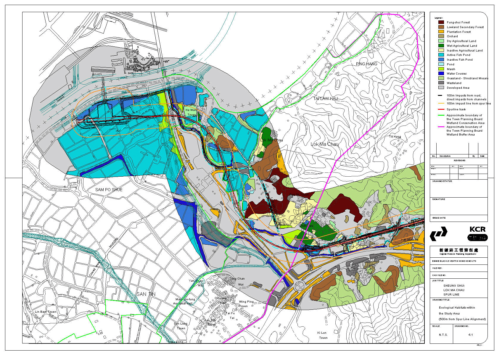
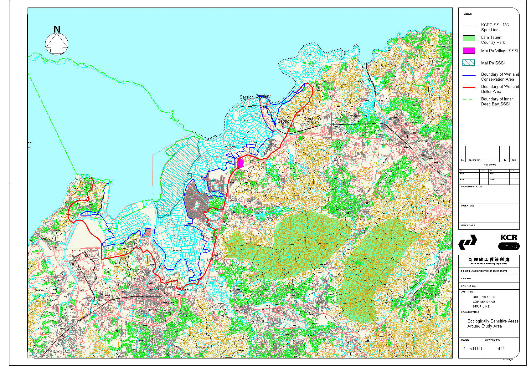
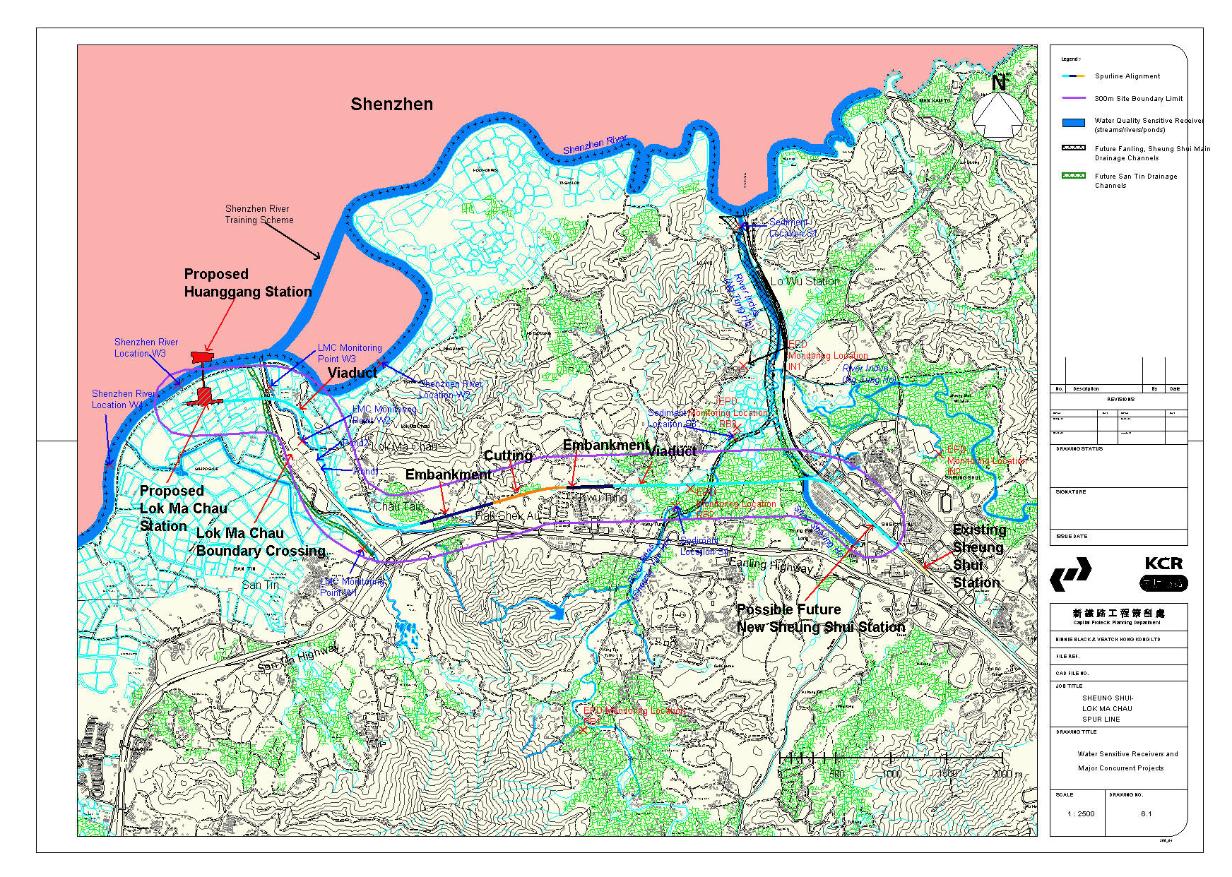
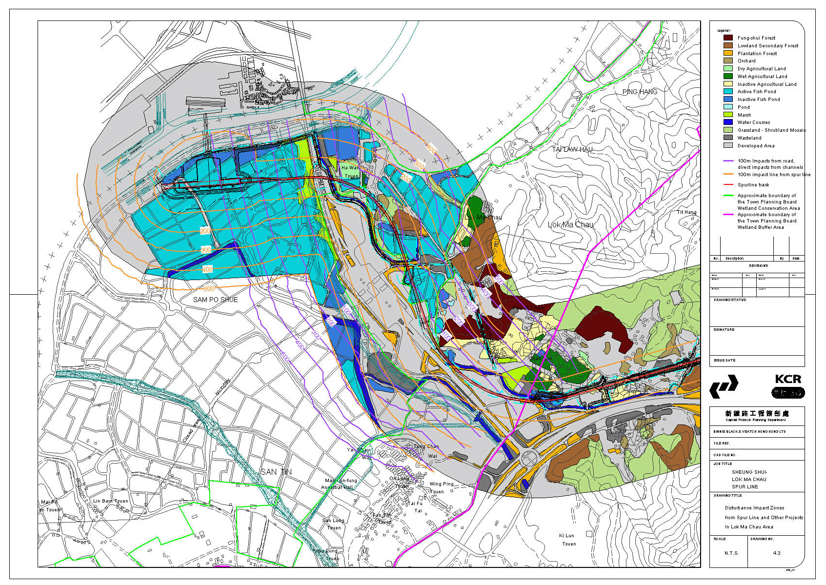
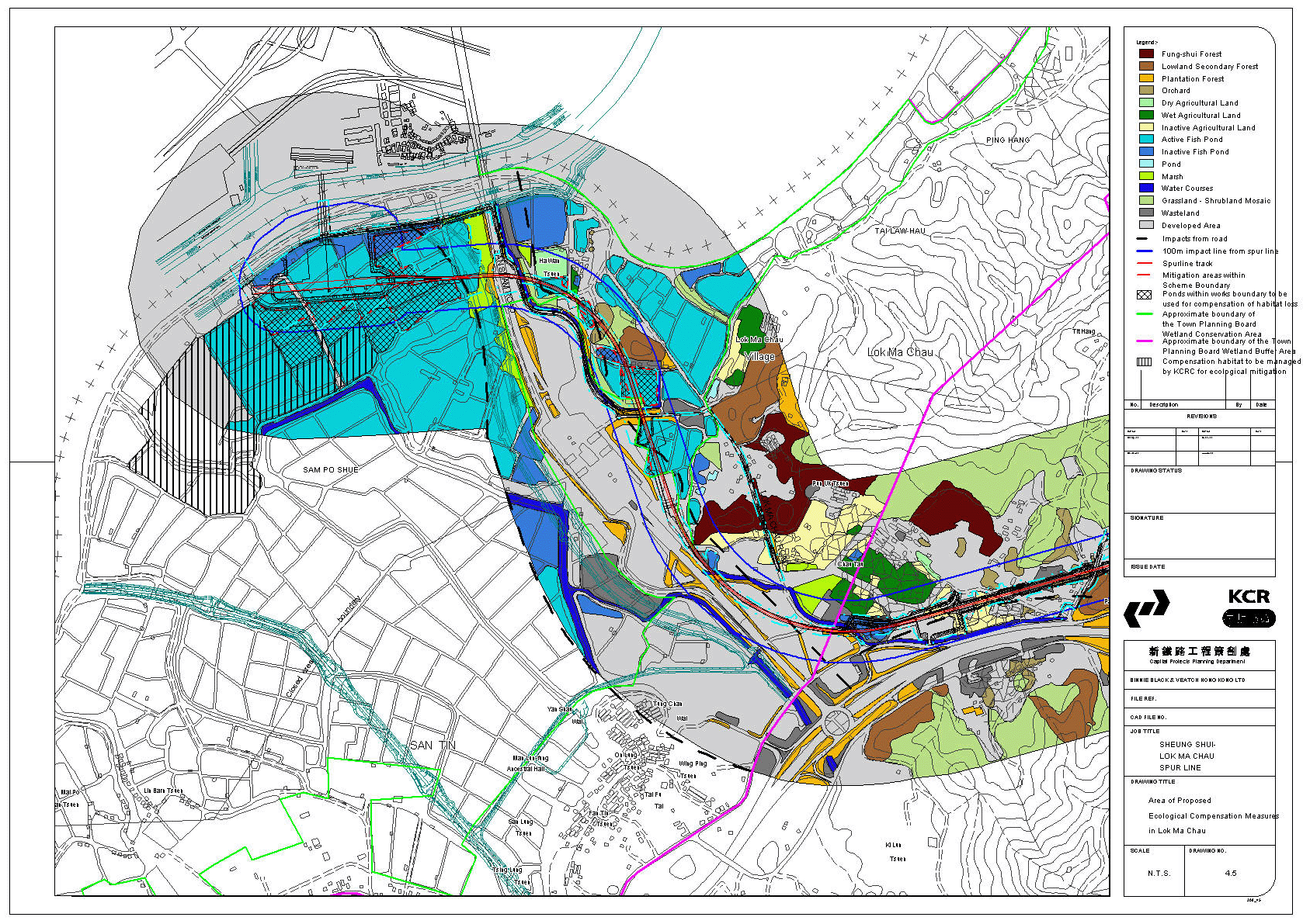
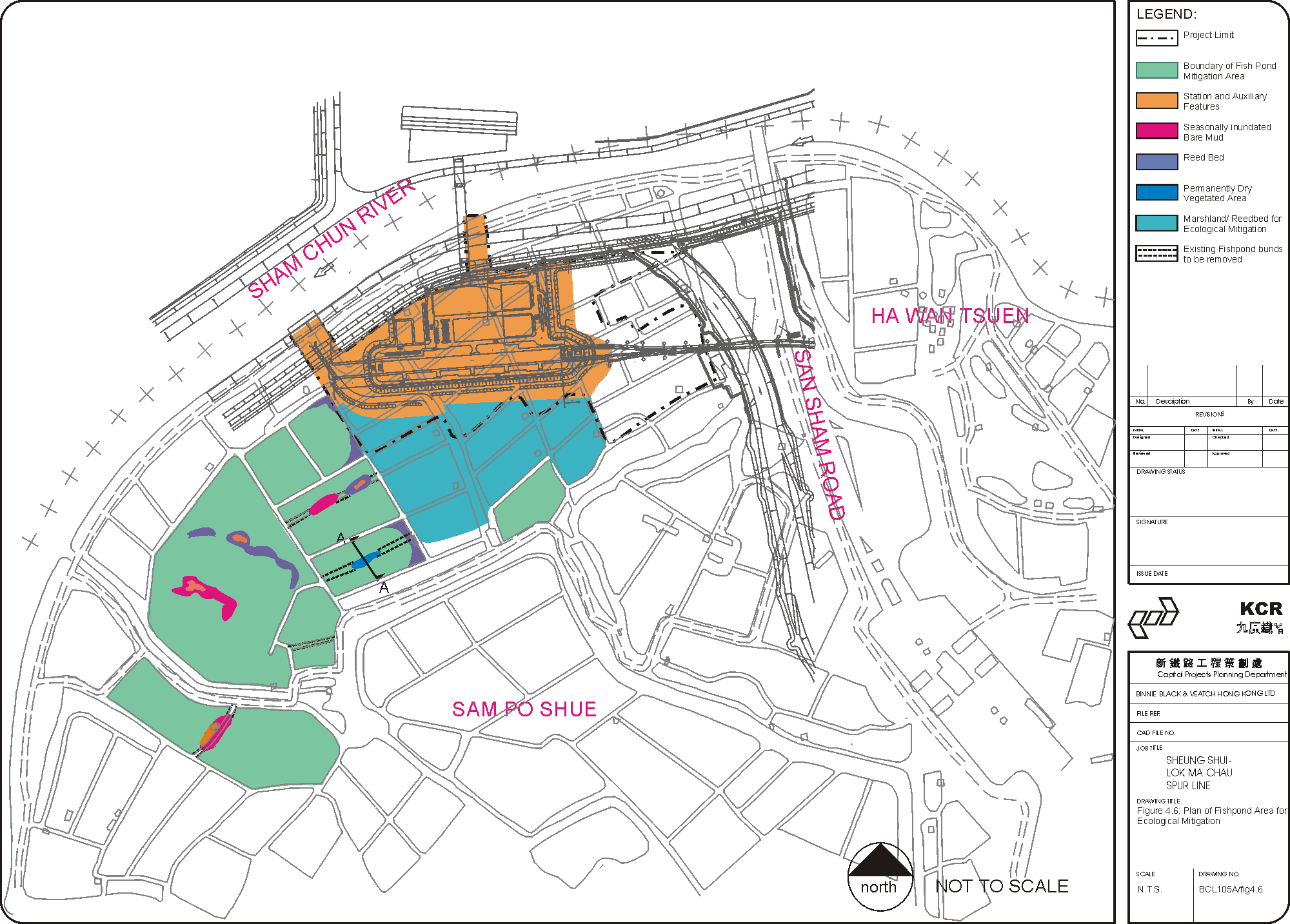
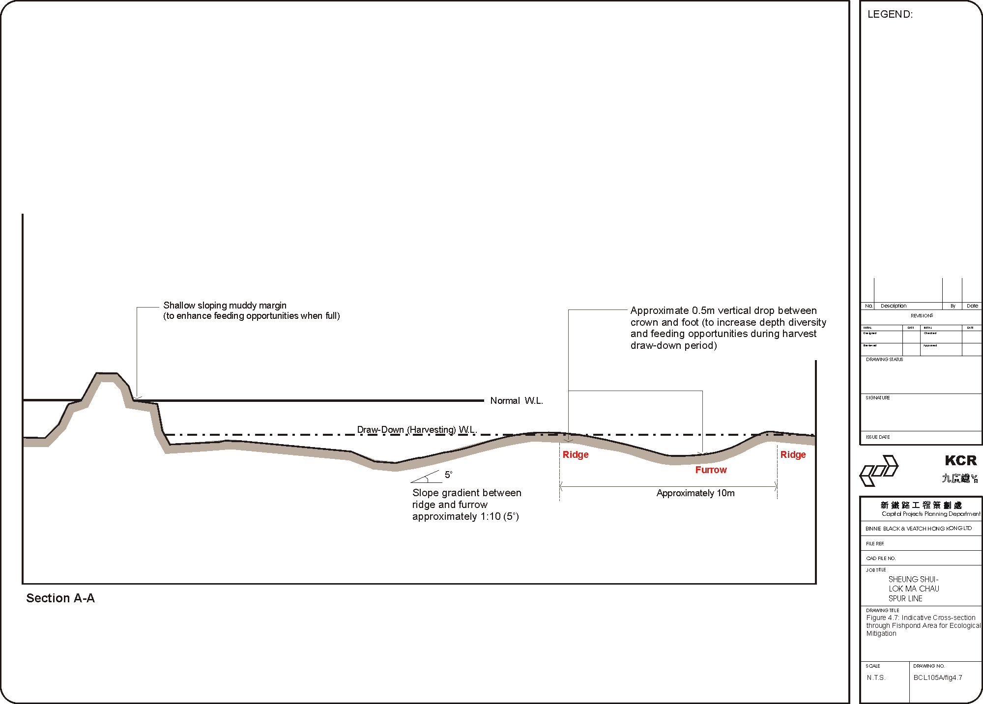
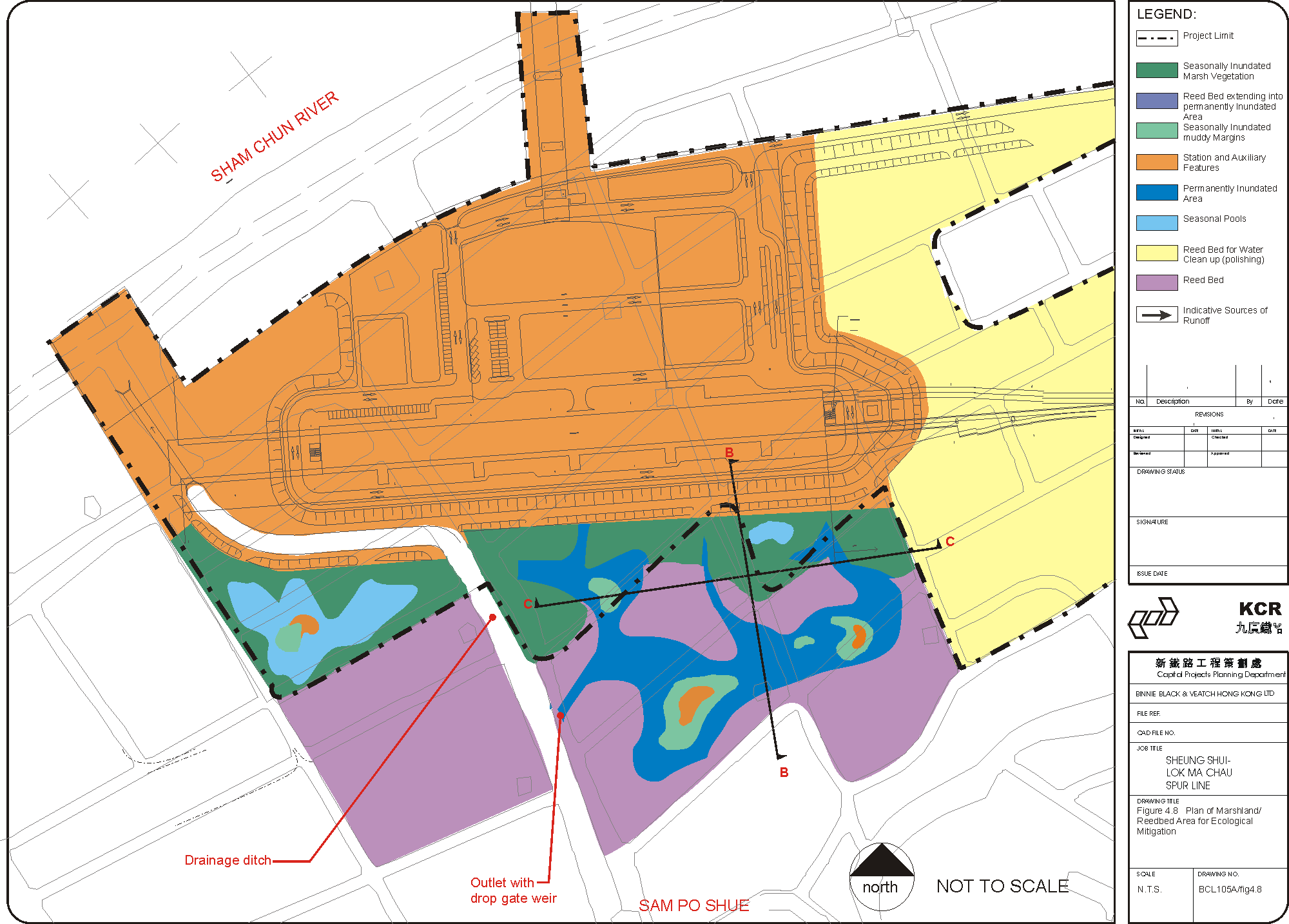
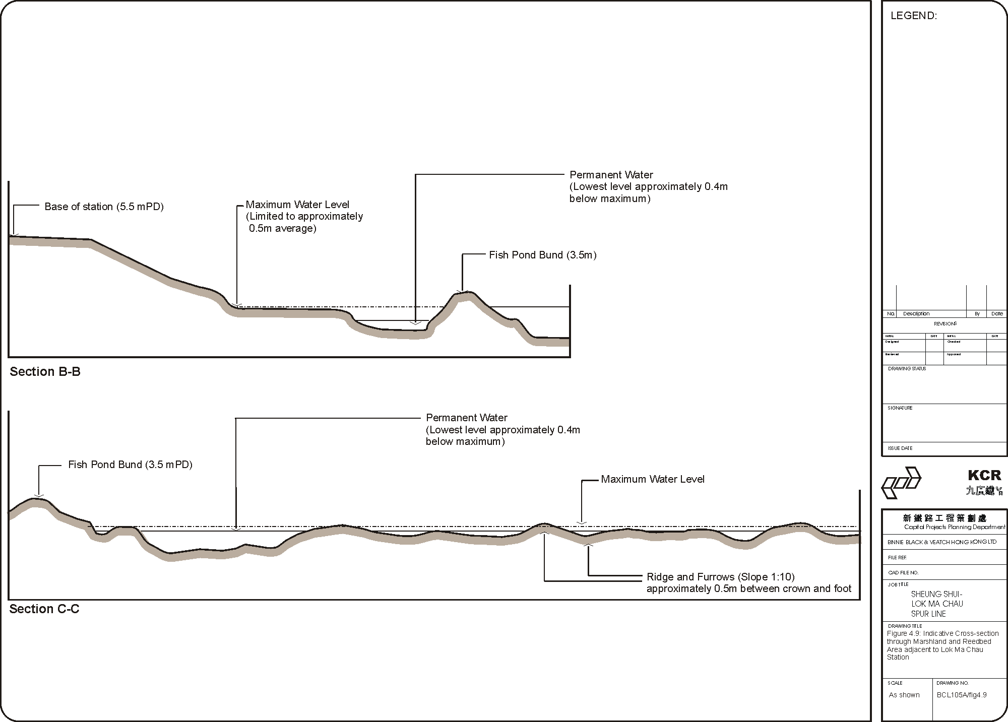
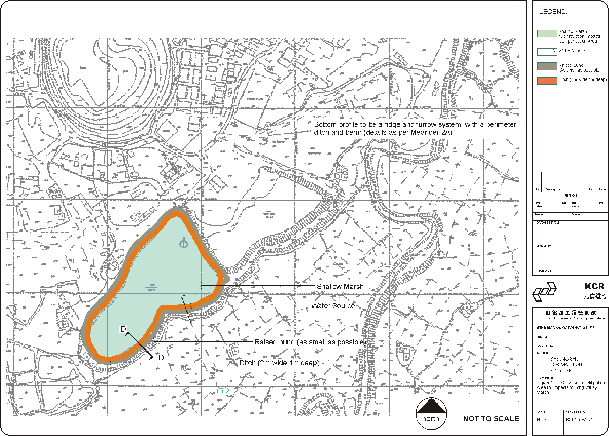
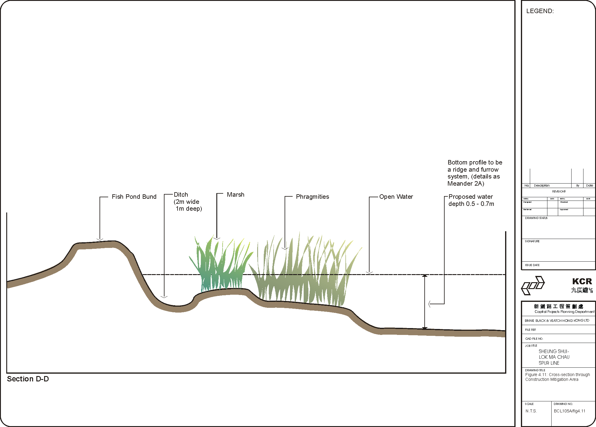
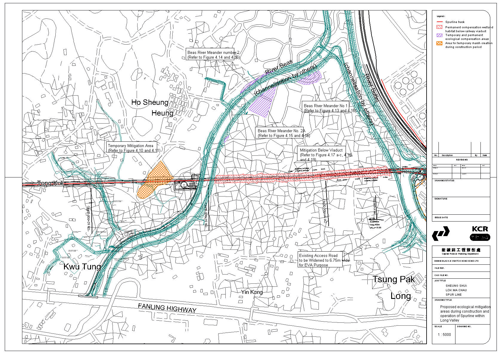
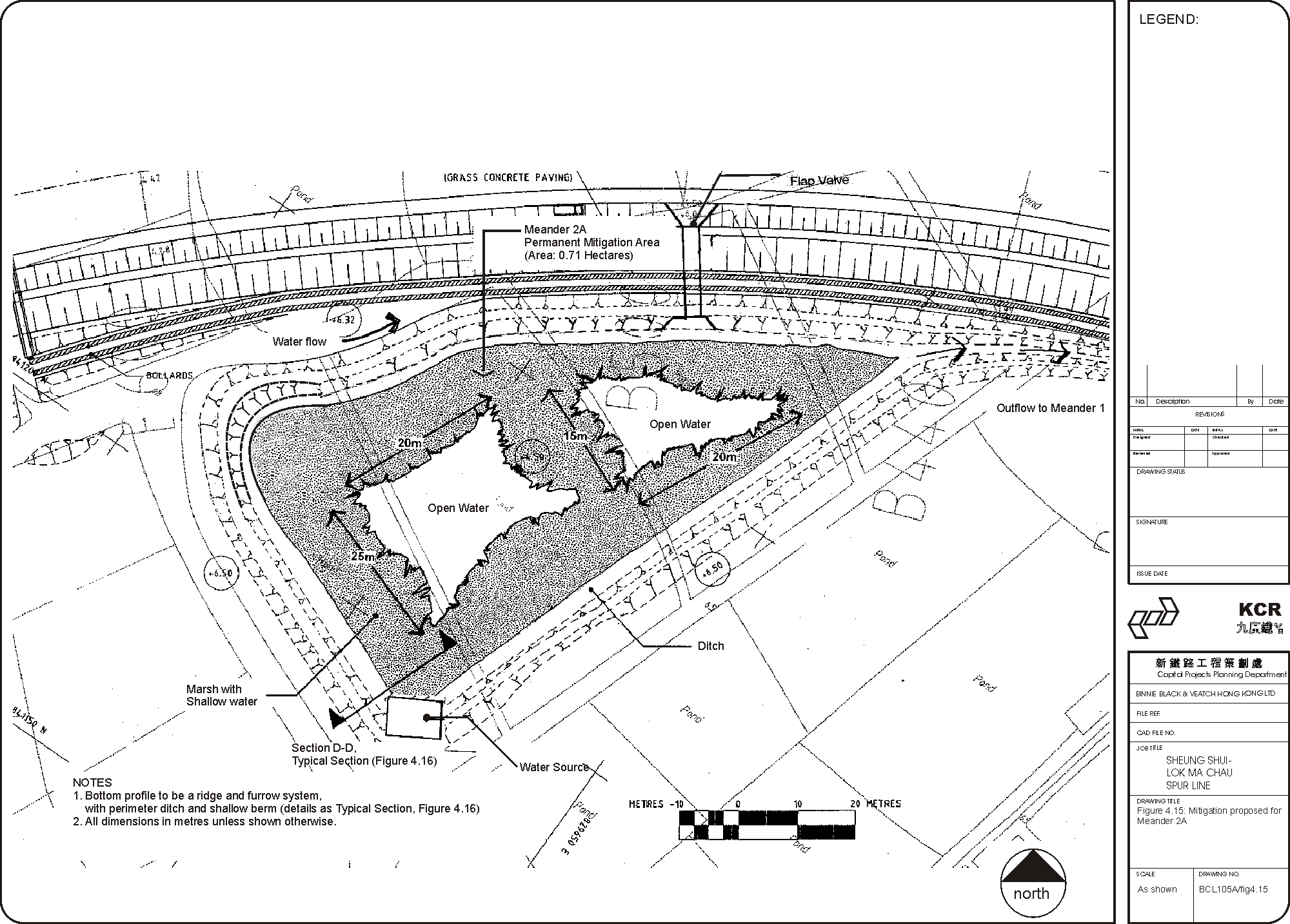
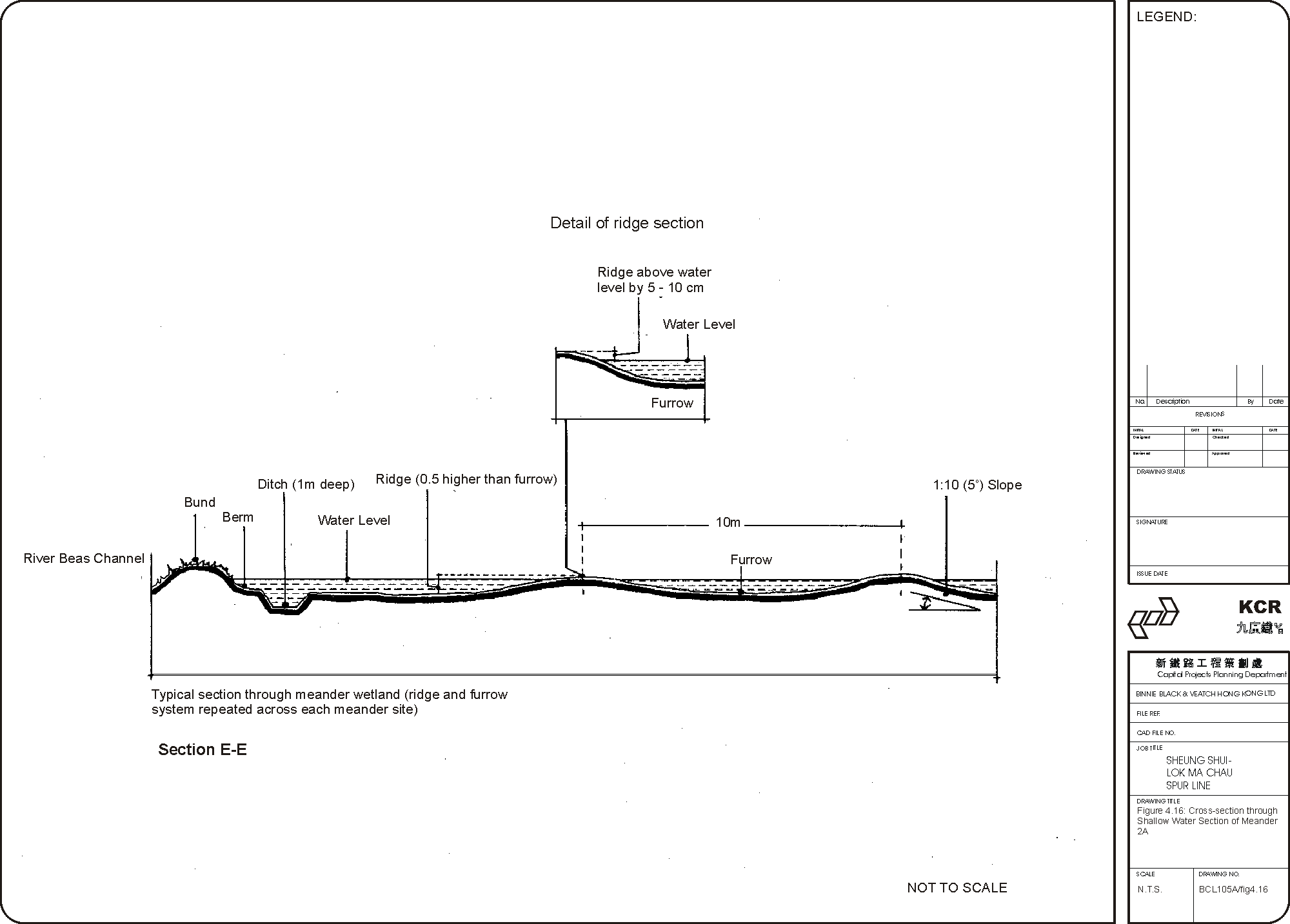
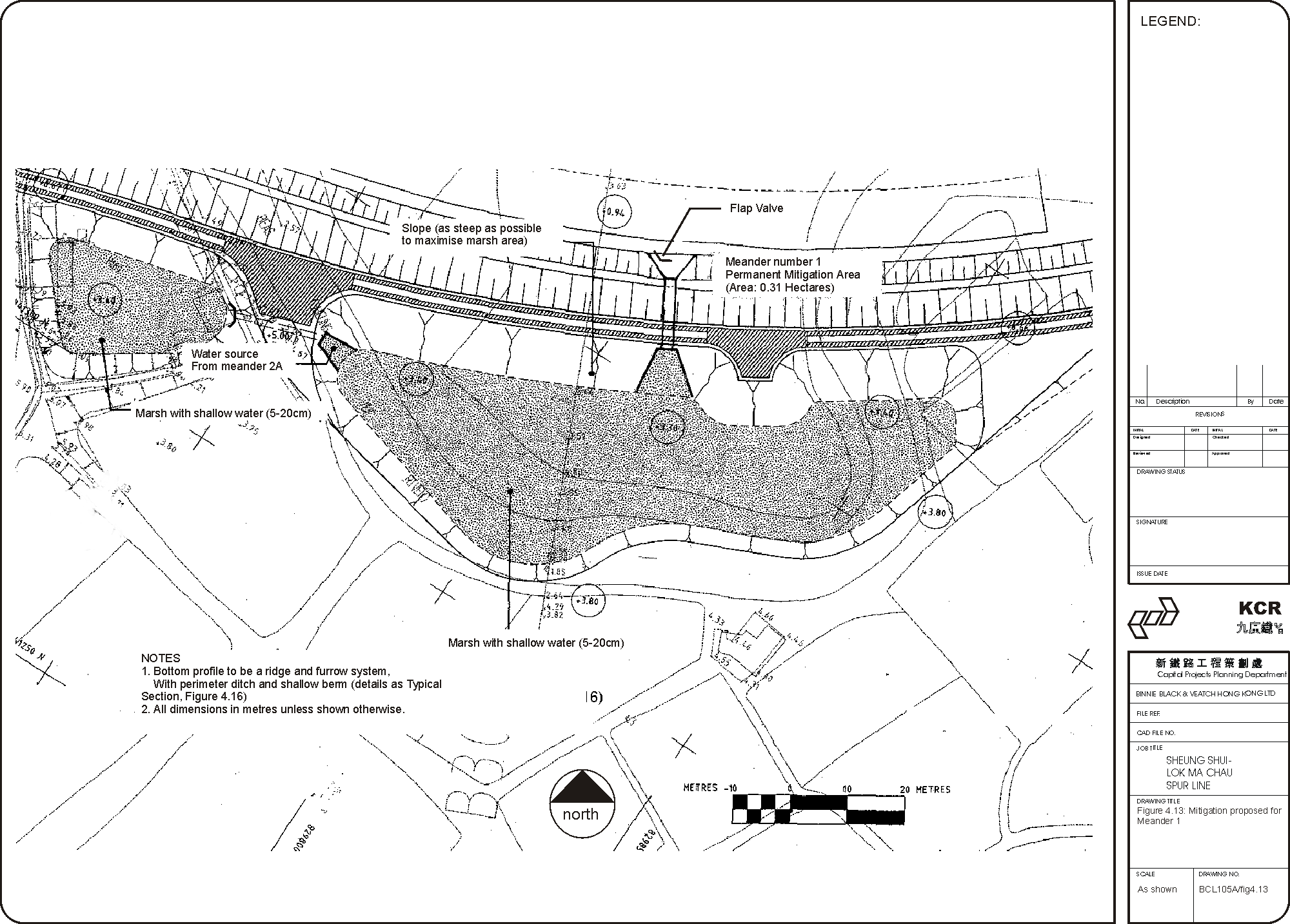
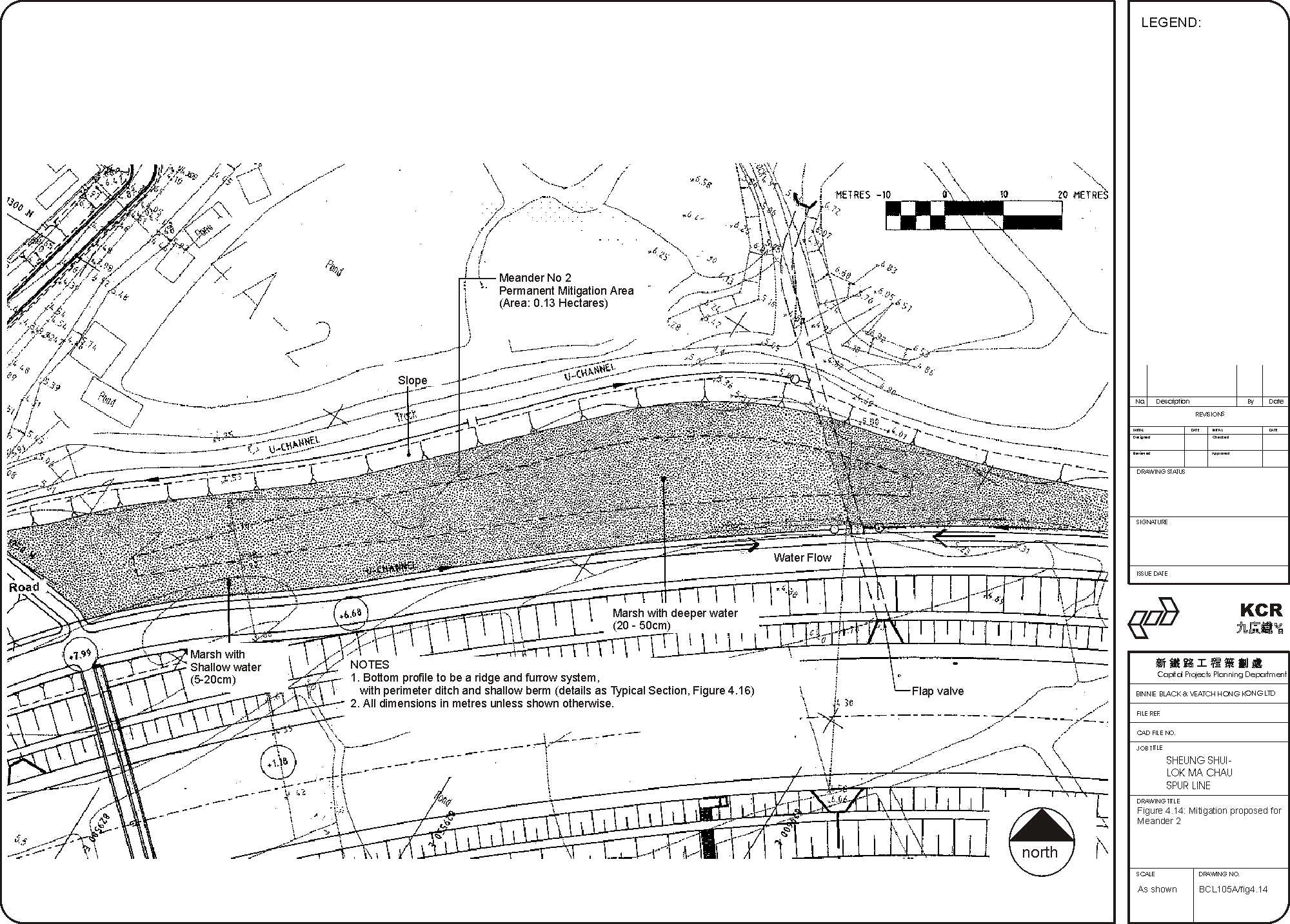
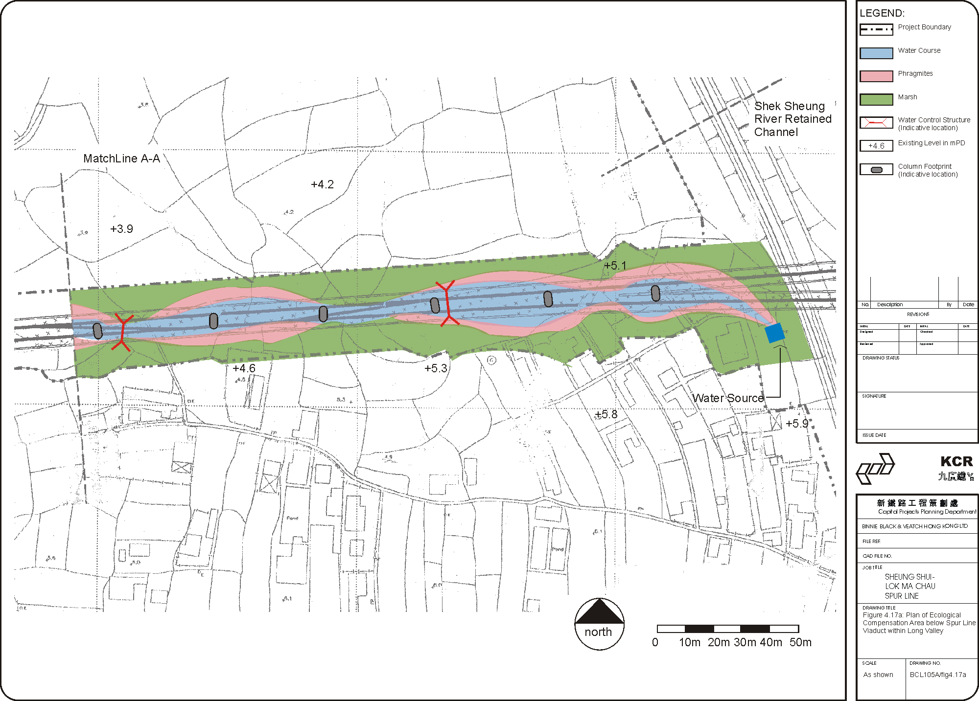
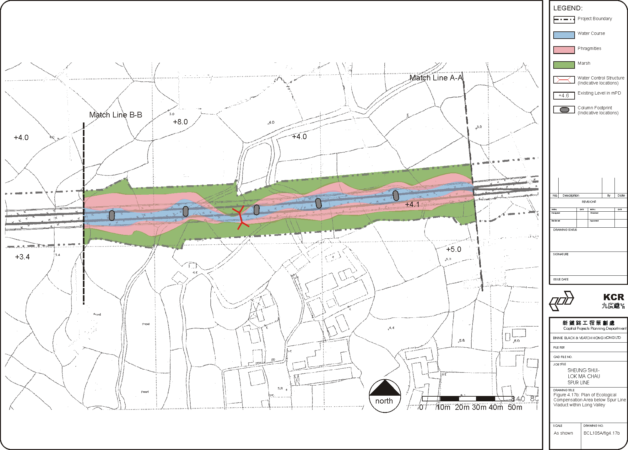
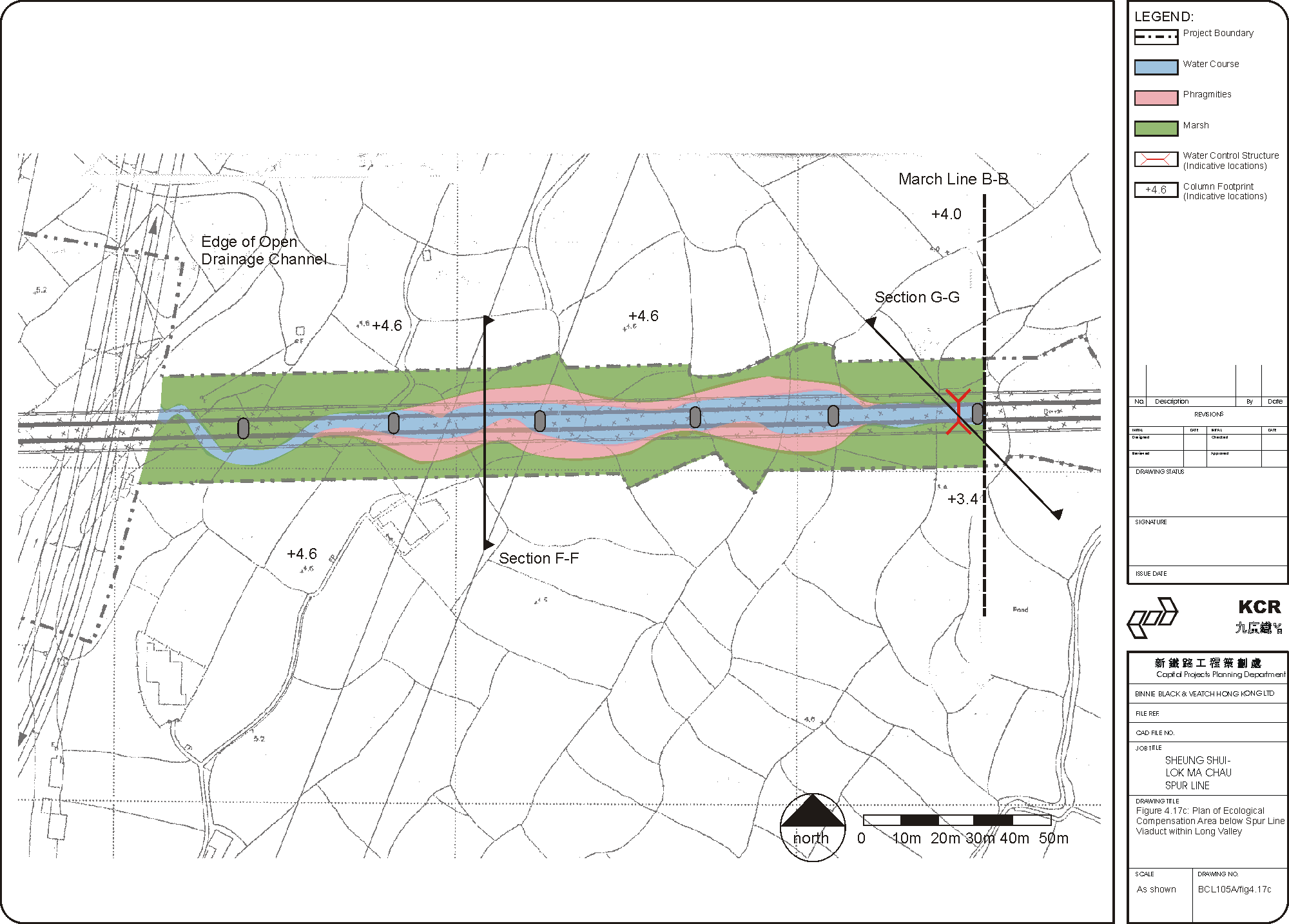