5
LANDSCAPE
AND VISUAL IMPACT ASSESSMENT
5.1 Introduction
5.1.1
The aim of this section of the report is to outline the
landscape baseline conditions, planning and development control framework, and
the Visually Sensitive Receivers (VSR’s). It identifies the impacts that would
occur during the construction of the KCR Spur Line between Sheung Shui and Lok
Ma Chau Project; and its operational phase, recommends mitigation measures and
identifies residual effects apparent after mitigation. This section also
outlines any cumulative impacts that could be attributed to the Project.
5.2
Standards
and Legislation
5.2.1
The methodology for undertaking the landscape and visual
impact assessment is in general accordance with Annex 18 of the Technical
Memorandum to the Environmental Impact Assessment Ordinance (EIAO). The main
elements of the assessment are given below.
5.2.2
The Landscape and Visual Impacts are considered as follows:
·
Landscape impact assessment shall assess the source and
magnitude of developmental effects on the existing landscape elements,
character and quality in the context of the site and its environs; and,
·
Visual impact assessment shall assess the source and
magnitude of effects caused by the proposed development on the existing views,
visual amenity, character and quality of the visually sensitive receivers
within the context of the site and its environs.
5.2.3
These are evaluated in accordance with Annex 10 of the
Technical Memorandum to the EIAO.
5.3
Landscape
Impact Assessment Methodology
5.3.1
The assessment of the potential impacts of a proposed
scheme on the existing landscape comprises two distinct sections:
·
baseline survey; and,
·
Potential landscape impacts assessment.
5.3.2
A baseline survey of the existing landscape character and
quality has been undertaken from site inspections and desktop surveys.
Landscape elements considered include:
·
local topography;
·
woodland extent and type;
·
other vegetation types;
·
built form;
·
patterns of settlement;
·
land use;
·
scenic spots;
·
details of local materials, styles, streetscapes, etc.;
·
prominent watercourses; and,
·
Cultural and religious identity.
5.3.3
Confirmed developments either within the study area or
adjacent to it are also considered. The baseline survey will form the basis of
the landscape context by describing broadly homogenous units of similar
character. The landscape character is rated into low, medium or high depending
not only on the quality of elements present but also their sensitivity to
change and local or regional importance. The quality of the landscape is not
only related to its visual amenity.
5.3.4
The assessment of the potential landscape impacts of the
proposals will result from:
·
identification of the sources of impact, and their
magnitude, that would be generated during construction and operation of the
scheme; and,
·
Identification of the principal landscape impacts,
primarily in consideration of the degree of change to the baseline conditions.
The impacts are considered systematically in terms of the landscape elements,
the site and its context.
5.3.5
The overall landscape impact is a product of the following
factors:
·
the landscape character and its quality;
·
source, nature and magnitude of potential impacts;
·
the degree of change caused by each of the impacts to the
existing landscape;
·
tolerance of the landscape to absorb the change;
·
significance of this change in consideration of the local
and regional areas and other developments;
·
cumulative effects on the landscape of this and
neighbouring proposals; and,
·
Identification of plant species of significant value which
should be conserved.
5.3.6
The impact is derived from the degree or magnitude of
change which the proposals will cause to the existing landscape context and
it's ability to tolerate the change, i.e. its quality and sensitivity. The
significance threshold is derived from the following matrix:
|
Magnitude of Change caused
by proposals |
High |
Moderate
Impact |
Moderate
/ Significant Impact |
Significant
Impact |
|
Moderate |
Slight
/ Moderate Impact |
Moderate
Impact |
Moderate
/ Significant Impact |
|
|
Low |
Slight
Impact |
Slight
/ Moderate Impact |
Moderate
Impact |
|
|
|
No change resulting in a Neutral Impact |
Low |
Moderate |
High |
|
|
Sensitivity
/ Quality of Landscape |
|||
5.3.7
The above matrix will apply in the assessment of the
majority of situations, however, in certain cases a deviation from this may
occur, e.g. the impact may be so major that a significant impact may occur to a
low quality element.
5.3.8
The degree of impact is considered as follows:
|
Negative / Beneficial Impacts |
|||
|
Significant:
adverse/beneficial impact where the proposal would cause significant
deterioration or improvement in existing landscape quality |
Moderate:
adverse/beneficial impact where the proposal would cause a noticeable
deterioration or improvement in existing landscape quality |
Slight:
adverse/beneficial impact where the proposal would cause a barely perceptible
deterioration or improvement in the existing landscape quality |
Neutral
impact: no discernible change in the existing landscape quality. |
Landscape
Planning Review
5.3.9
A review of the existing planning studies and documents
will be undertaken as part of the assessment to gain an insight into the
planned role of the site, its context and to help determine the projects fit
into the wider existing and future landscape context. The review is taken from
Sheung Shui to Lok Ma Chau. This review considered Outline Zoning Plan numbers
S/NE-KTN/3 – Kwu Tung South and S/YL-ST/2 – San Tin, and the Recommended
Outline Development Plan (RODP) for the Kwu Tung North SGA, June 1999 which
will replace the S/NE-KTN/3 – Kwu Tung North.
Tree
Survey Methodology
5.3.10
To minimise conflicts with existing vegetation a full tree
survey has been completed in accordance with WBTC 24/94. This will allow the
fine tuning of the proposed detail design for the proposed scheme and ensure
that any significant trees, will where possible, be protected during both the
design and construction periods. The methodology and scope including the
programme for the tree survey and felling application is subject to the
approval of the relevant authorities primarily LCSD and AFCD, and private
owners where appropriate.
Visual Impact Assessment Methodology
5.3.11
The assessment of the potential visual impact
of the scheme comprises two distinct parts:
·
Baseline survey; and,
·
Visual impact assessment.
5.3.12
The baseline survey of all views towards
the proposals is undertaken by identifying:
·
The visual envelope or visual zone within which the
proposed development may be contained either wholly or partially within views.
This must also include indirect effects such as offsite construction
activities; and,
·
The visually sensitive receivers (VSR's) within the visual
envelope whose views will be affected by the scheme. The potential receivers
are considered as three groups:
a)
Views from residences - the most sensitive of receivers due
to the high potential of intrusion on the visual amenity and quality of life,
b)
View from workplaces - less sensitive than above due to
visual amenity being less important within the work environment, and;
c)
Views from public areas - including all areas apart from
the above, e.g., public parks, recreation grounds, footpaths, roads, cultural
sites, etc. Sensitivity of this group depends on the transitory nature of the
receiver, e.g. sitting in a park or travelling on a highway. Also considered is
the degree of view or glimpsed views.
5.3.13
However the assessment of sensitivity has also been based
on the quality and extent of the existing view. Therefore a view from a
residential property which would normally be considered the most sensitive view
may be less so if for example it is degraded by existing development or
partially screened by intervening visual obstacles such as existing vegetation.
5.3.14
The location and direction of it’s view relative to the
scheme also influences the sensitivity of each group. Typical viewpoints from
within each of the visually sensitive groups are identified and their views
described. Both present and future visually sensitive receivers will be
considered.
5.3.15
The baseline survey will form the basis of the visual
character and quality of the site. The assessment of the potential visual
impacts will result from:
·
identification of the sources of visual impacts, and their
magnitude, that would be generated during construction and operation of the
scheme; and,
·
Identification of the principal visual impacts primarily in
consideration of the degree of change to the baseline conditions.
5.3.16
The impact assessment will relate to the typical viewpoints
within the visual receiver group, as identified previously, and their existing
and potential views subsequent to the scheme development. The visual impact
will result from consideration of the following:
·
character of existing view;
·
quality of existing view;
·
context and location of the visually sensitive receiver;
·
number of receivers at the visual receiver group;
·
visual receiver group sensitivity;
·
degree of change to existing views;
·
other views available to visual receiver group;
·
the cumulative effects on views of this and other
neighbouring developments, and;
·
the viewing distance between the visually sensitive
receiver and the visible part of the proposed scheme.
5.3.17
The degree of visual impact is rated in a similar fashion
to the landscape impact, i.e. substantial, moderate, slight and negligible. The
impacts may be beneficial or adverse.
5.3.18
The impact is derived from the degree or magnitude of
change which the proposals will cause to the existing landscape context and
it's ability to tolerate the change, i.e. its quality and sensitivity. The
significance threshold is derived from the following matrix:
|
Magnitude of
Change caused by proposals |
High |
Moderate
Impact |
Moderate
/ Significant Impact |
Significant
Impact |
|
Moderate |
Slight
/ Moderate Impact |
Moderate
Impact |
Moderate
/ Significant Impact |
|
|
Low |
Slight
Impact |
Slight
/ Moderate Impact |
Moderate
Impact |
|
|
|
No change resulting in a Neutral Impact |
Low |
Moderate |
High |
|
|
Sensitivity
/ Quality of The Existing View |
|||
5.3.19
The above matrix will apply in the assessment of the
majority of situations, however, in certain cases a deviation from this may
occur, e.g. the impact may be so major that a significant impact may occur to a
low quality element.
5.3.20
The degree of impact is considered as follows:
|
Negative / Beneficial Impacts |
|||
|
Significant:
adverse/beneficial impact where the proposal would cause significant
deterioration or improvement in existing landscape quality |
Moderate:
adverse/beneficial impact where the proposal would cause a noticeable
deterioration or improvement in existing landscape quality |
Slight:
adverse/beneficial impact where the proposal would cause a barely perceptible
deterioration or improvement in the existing landscape quality |
Neutral
impact: no discernible change in the existing landscape quality. |
The Residual Impacts
5.3.21
The Residual impacts are those, which remain after the
proposed mitigation measures, have been implemented. This has been assessed
both during the construction period and during the design year which is often
taken to be 10 to 15 years after the proposed scheme has been opened to normal
operation when the soft landscape mitigation measures are deemed to have
reached a level of maturity which allows them to perform their original design
objectives.
5.3.22
The level of impact is derived from the degree or magnitude
of change which the proposals will cause to the view which would have existed
during this period if the proposed scheme had not been constructed and its
ability to tolerate change, i.e. its quality and sensitivity taking into
account the beneficial effects of the proposed mitigation. The significance
threshold is derived from the following matrix:
|
Magnitude of
Change caused by proposals |
High |
Moderate
Impact |
Moderate
/ Significant Impact |
Significant
Impact |
|
Moderate |
Slight
/ Moderate Impact |
Moderate
Impact |
Moderate
/ Significant Impact |
|
|
Low |
Slight
Impact |
Slight
/ Moderate Impact |
Moderate
Impact |
|
|
|
No change resulting in a Neutral Impact |
Low |
Moderate |
High |
|
|
Sensitivity
/ Quality of Landscape or View which would have existed had the Scheme not
been constructed |
|||
5.3.23
The above matrix will apply in the assessment of the
majority of situations, however, in certain cases a deviation from this may
occur, e.g. the impact may be so major that a significant impact may occur to a
low quality element.
5.3.24
The degree of impact is considered as follows:
|
Negative
/ Beneficial Impacts |
|||
|
Significant:
adverse/beneficial impact where the proposal would cause significant
deterioration or improvement in existing landscape quality |
Moderate:
adverse/beneficial impact where the proposal would cause a noticeable
deterioration or improvement in existing landscape quality |
Slight:
adverse/beneficial impact where the proposal would cause a barely perceptible
deterioration or improvement in the existing landscape quality |
Neutral
impact: no discernible change in the existing landscape quality. |
5.3.25
An overall assessment is also made of the residual landscape
and visual impacts attributable to the proposed scheme. The degree of residual
impact is considered as follows:
|
Beneficial |
Acceptable |
Acceptable with mitigation |
Unacceptable |
Undetermined |
|
The project will complement the
landscape and visual character of its setting, will follow the relevant
planning objectives and will improve overall and visual quality. |
There will be no significant
effects on the landscape and no significant visual effects caused by the
appearance of the project, or no interference with key views. |
There some adverse effects, but
these can be eliminated, reduced or offset to a large extent by specific
measures. |
The adverse affects are
considered too excessive and are would not be reduced to an acceptable level
by mitigation. |
Significant adverse effects are
likely but the extent to which they may occur or may be mitigated cannot be
determined from the study. Further detailed study will be required for the
specific effects in question. |
5.4
Mitigation
Measures
5.4.1
The identification of the landscape and visual impacts will
highlight those sources of conflict requiring design solutions or modifications
to reduce the impacts, and, if possible, blend the development and associated
activities in with the surrounding landscape. These mitigation measures should
take into account factors including:
·
woodland, tree and shrub planting of new or disturbed
slopes, amenity strips and areas, central reservations and adjacent to any new
structures;
·
consideration of the contouring of new slopes in order to
blend them in with the existing topography;
·
earth mounding and screening, structural or vegetated;
·
highlighting unacceptable impacts and considering
alternative scheme proposals;
·
treatment of structural forms;
·
hard landscape, furniture and other landscape; and,
·
significant landscape elements.
5.4.2
This will result in the formation of landscape mitigation
proposals, which will alleviate the previously identified landscape and visual
impacts as far as possible.
5.5
Existing
Landscape Context and Landscape Impacts
Existing
Landscape Context
5.5.1
The proposed Spur Line alignment is located in the northern
New Territories of Hong Kong between the town of Sheung Shui and the border
crossing at Lok Ma Chau (refer to Figure 5.1). There
are several distinct landscape characters within the study area, the location
of these are shown on Figures 5.3a b
c. These include the high-rise urban areas of the
Sheung Shui conurbation, the low lying agricultural areas of the River Beas
plain including the Long Valley area, natural hilly areas, cottage developments,
villages and the fish pond areas adjacent to Lok Ma Chau.
5.5.2
The proposed Spur Line arises from the existing KCR East
Rail line north of Sheung Shui Station and south of Sheung Shui Sewage
Treatment Works. It runs west beyond Sheung Shui into the plains of the River
Beas, the Long Valley area. These plains primarily comprise agricultural
fields, which are generally active, although some areas are unused and have
reverted to rough grassland, together with several large fishponds. To the east
of this plain is the River Beas, which flows from south to north. This is
currently being improved under a separate study as part of the overall flood
prevention programme of the New Territories and will be constructed as a wide
concrete trapezoidal channel.
5.5.3
Beyond the River Beas the Spur Line would cross to the
south of Ho Sheung Heung village and through an extensive area of cottage
development including Tong Kok, Fung Kong and Tung Fong. Two temples are
located in the south of Ho Sheung Heung. This is an area characterised by
low-rise housing and light workshop/industrial activities interspersed with
tree groups. Within this area the spur line passes to the north of the Dill’s
Corner Camp, the former army base. Beyond the cottage areas to the south is the
dual-3 Fanling Highway that forms a distinctive landscape character running
east to west through the study area.
5.5.4
As the spur line proceeds through the cottage areas its
turns slightly south to avoid the natural lower slopes of the Tit Hang hills.
These hillsides are relatively undisturbed and comprise a mix of grass and
scrub vegetation. The Chau Tau Grenade Range is located on the upper slopes. As
it passes the hillside, the spur line runs through the cottage and agricultural
area of Chau Tau. Along this section the spur line runs parallel to Fanling
Highway, approximately 100m to the north.
5.5.5
Adjacent to the Fanling Highway / San Sham Road Interchange
the spur line turns to the north to run parallel to, and east of, San Sham Road
and the Lok Ma Chau Border Crossing facilities. This is an area comprising a
mix of fishponds, although several are unused, have been filled and are now
forming rough grassland. The border crossing to the west is a large area of
hard standing and includes the kiosks and low-rise administration buildings.
The crossing is currently undergoing extension to increase capacity requiring
the construction of additional kiosks and waiting areas.
5.5.6
To the north of the border crossing, the spur line turns
east, crossing San Sham Road and into an extensive area of fishponds south of
the Shenzhen River. The spur line terminates at this point with the proposed
Lok Ma Chau station. This will, it is proposed, be a four-storey building,
approximately 27m high and will also contain border-crossing facilities with a
double deck pedestrian bridge over the Shenzhen River to the Peoples Republic
of China. A second station complex, Huanggang Station, will be constructed on
the northern side of the river connected to the Lok Ma Chau Terminus by the
proposed pedestrian link or footbridge across the Shenzhen River. Beyond the
river is the large and visually prominent high-rise city of Shenzhen.
5.5.7
The existing landscape quality and sensitivity of the study
area, which varies along the proposed Spur Line alignment, is shown on Figures
5.3a b c. The local
hills of Tit Hang and Fung Kong Shan are of a high landscape quality and sensitivity
due to their undisturbed and natural character. The fishpond areas to the
west the Tit Hang hills are considered of high landscape quality, as they
are highly sensitive to construction works of this type. The agricultural
areas are of a medium to high quality due to their low level of disturbance
and relatively open nature and as a landscape resource, although the canalisation
of the River Beas will detract from the landscape quality of Long Valley.
Cottage and village areas are generally considered as being of a medium quality
due to the mixed level of disturbance presence of the local landscape features
such as the temples at Ho Sheung Heung and the extent of mature tree groups.
Areas of low quality landscape character include the conurbation of Sheung
Shui, the road corridor along the Fanling Highway due to the high levels of
disturbance and lack of landscape features, and the urban area north of the
Shenzhen River due to the level of built development. Tables 5.1 and 5.2 give
a brief description of the landscape resources and landscape character areas
found within the study area.
Impacts on
Landscape Character, Quality and Resources
5.5.8
The works include the construction of an elevated viaduct
across the agricultural River Beas plain / Long Valley area. This is succeeded
by an area of embankment, at grade and cutting through the central cottage
areas around Tung Fong and agricultural area at Chau Tau. Beyond this point the
spur line is on viaduct as it turns north and runs through the road corridor
and open storage areas adjacent to San Sham Road, before proceeding over the
fishponds at Lok Ma Chau. Past the border crossing it turns and passes over the
road before terminating at the proposed Lok Ma Chau station on the Sam Po Shue
fishponds. The pedestrian link across the Shenzhen River north of the station
complex, which provides a physical connection to the proposed Huanggang
Station, would have little perceivable impact on the landscape character and
quality of the study area.
5.5.9
The nature of the scheme results in impacts generally being
confined to areas adjacent to the alignment. Additionally, the overall
avoidance of the natural hills results in earthworks being generally confined
to the already disturbed cottage areas at Tung Fong. The most significant
impacts will occur to the agricultural areas in the River Beas Plain / Long
Valley area and Chau Tau, together with the fishpond areas at Lok Ma Chau and
Sam Shue Po, however, the direct impacts on specific landscape elements have
been minimised by the design of the viaduct alignment for the Spur Line. There
would be a small loss to the existing Fung Shui woodlands near Lok Ma Chau Road
(approximately 0.01 hectares), other woodlands within the study area would not
be subject to losses due to the selection of a route alignment, which avoids
contact with these culturally sensitive landscape resources. The location of
these Fung Shui woodlands is shown in the ecology section of this report.
Impacts on
Existing Landscape Resources
5.5.10
An important determinant of the landscape character within
a Study Area, which is largely rural, is the type and extent of its landscape
resources both natural and cultivated. These landscape resources are shown
on Figure 5.2 a b . For
the purposes of this assessment the landscape resources are represented by
the existing land cover. The condition of these landscape resources is also
important in determining the landscape quality of the Study Area and its sensitivity
to change. Therefore the preservation and enhancement of these landscape resources
is important to the successful integration of the proposals into the landscape
of the Study Area. Table 5.1 below describes the abundance of a landscape
resource within the Study Area, the loss of this resource due to the proposals
and the predicted impact of this loss on the resource and the landscape character
of the Study Area.
Impacts on Existing Trees Identified in the Tree Survey Report
Existing Trees
5.5.11
There are approximately 2922 trees within the Gazettal
Boundary for the proposed scheme.
These are mainly concentrated in the central and western sections of the
Study Area .
Tree Retention
5.5.12
Generally any trees or tree groups on the fringes of the
proposed track construction would be maintained where possible. The extensive construction of the
embankments and viaduct structures would involve in some cases partial removal
of tree groups. Where possible,
the proposed earthwork slopes both in cutting and on embankment would be
feathered at the edge of the slopes to allow trees to be retained. However, where it is not possible to
retain trees it is recommended that these trees be felled or transplanted.
5.5.13
Approximately 909 of the trees surveyed would be retained
under the current proposals, these include roadside trees not affected by the
proposed realignment.
Tree Transplantation Proposals
5.5.14
In terms of assessing the feasibility of transplanting the
trees, the following factors were taken into account:
·
Trees were to have above average form, health and amenity
value.
·
Trees assessed as having a high or at least medium amenity
value and predicted survival rate.
·
Trees should be native or rare species.
·
Ease of access - In some cases transplantation would be
difficult and dangerous due to the physical characteristics of the site and the
inaccessibility of their situations.
·
The physical characteristics of the specimen trees - For
example, the trees on steep slopes respond to the existing gradient with a
higher proportion of roots on the downhill side and the rootball usually forms
itself to the angle of slope. It is often difficult to find a similar location
that is suitable for the transplantation of these trees. In addition, these
trees often have an unbalanced crown that would make them unstable if
transplanted to another location.
·
Transplantation back onto a slope is often not practicable
due to the difficulty of gaining safe access due to a combination of the nature
of the slopes, the gradients involved and the stability of the machinery used.
·
The survival rate of trees would be improved if a permanent
location could be found immediately after being lifted as opposed to the use of
a temporary holding nursery.
5.5.15
Taking all these factors into account the tree survey
report recommends that approximately 119 trees could be transplanted. These are
mainly trees surveyed individually and are accessible to the road. The tree
survey report recommends that the trees identified as being appropriate for
transplantation are relocated in locations identified by LCSD, HyD and /or
AFCD. It is not recommended that the trees be transplanted to a temporary
holding nursery for the duration of the railway construction contracts due to
the potential damage that the trees will suffer if they are moved twice and the
likely costs involved in setting up a holding nursery.
Tree Felling Proposals
5.5.16
The Tree Survey Report concludes that it would not be
feasible to retain or transplant approximately 1894 of the existing trees for the following reasons:
·
In some locations the scope of the proposed works and site
formation precludes any opportunities to retain existing trees.
·
The slopes are too steep to enable machinery access to
transplant them.
·
The necessary excavation and cutting into slopes, means it
is technically unfeasible to retain the trees.
·
The trees are of poor quality in terms of form or health,
and approximately 45 trees were found to be dead.
·
The tree if retained in a solitary position would become
unstable and dangerous in windy conditions.
·
Trees that are too large or mature to be transplanted
successfully.
Table 5.1: Existing Landscape Resources and Predicted
Impacts (Refer to Figures 5.2a-b)
|
Landscape
Resource |
Total
Area of Landscape Resource in the Study Area (Ha) |
Total
Loss of Area (Ha) |
%
Loss within the Study Area (Ha) |
Landscape
Mitigation |
Impact
on Landscape Character resulting from the loss of the Existing Landscape
Resources of the Study Area. |
|
Fung Shui Woodland |
17.81 |
0.01 |
0.06 |
Compensatory planting has
not been proposed for this area due to the lack of available, limited by the
proximity of the existing fishponds. These fishponds will be restored
following the construction of the proposed viaduct. |
The main area of woodland
lost would result from the Lok Ma Chau Road widening required as part of the
Spur Line proposals. This loss would not have a significant adverse impact on
the landscape character of the Study Area as the existing Lok Ma Chau Road
already severs this area of woodland. Also the area lost forms a small
percentage of the total area of Feung Shui woodland. Therefore the Spur Line
proposals would have a slight adverse impact on this
resource within the Study Area. |
|
Woodland (including
secondary forest and plantation forest) |
48.00 |
0.76 |
1.6 |
Approximately 12.0 hectares of compensatory woodland planting is
proposed as part of the landscape and visual impact mitigation measures. |
These areas form an
important landscape and visual resource within the Study Area. However the
loss of 1.6% of the existing resource would not have a significant impact on
the landscape character of the Study Area particularly as a large proportion
of the area lost is in the central section of the route alignment which now
forms the site for the Kwu Tung North SGA. Therefore the Spur Line proposals
would have a slight adverse impact
on the existing resource however the implementation of the proposed landscape
mitigation measures would lead to an overall moderate beneficial impact.
|
|
Orchard |
10.91 |
2.46 |
22.5 |
Compensatory planting for
the loss of this resource would not be appropriate due to the future
landscape character of the Kwu Tung North SGA. Also the proposed planting
lining the track has been designed to screen low and medium level views of
the Spur Line proposals from the proposed SGA residential development. |
The loss of these areas of
orchard mainly situated in the central section of the proposed Spur Line
alignment would not have a significant adverse impact on the future landscape
character area which will be the site for the Kwu Tung North SGA. The
landscape character of the SGA will be very different to that which currently
exists. The landscape mitigation proposed for this area has been designed to
screen the Spur Line in low and medium level views whilst visually
integrating the form of the proposed earthworks and track in more elevated
views from the proposed high rise residential development associated with the
SGA. The Spur Line proposals would have a slight adverse to neutral impact
on this resource within the Study Area. |
|
Agricultural Land (Dry) |
13.02 |
0.41 |
3.1 |
Compensatory mitigation
measures would not be appropriate for this resource as the replacement of dry
agricultural land in another location would not have a beneficial effect on
the existing or future landscape of the Study Area. |
Although the landscape
character of Long Valley, where the majority of the usable agricultural land
would be lost, is defined by it’s low lying and intricate field system, the
proposed implementation of the ecological wetland mitigation measures would
not have a significant impact on this landscape resource. The project limit
for the wetland mitigation area would make use of the severed field network
and so its impact on the perceived character of the remaining area of this
landscape resource would not be of a significant level. The Spur Line
proposals would have a slight adverse to neutral impact
on this resource within the Study Area. |
|
Agricultural Land (Wet) |
28.31 |
0.85 |
0.2 |
Compensatory mitigation
measures would not be appropriate for this resource as the replacement of wet
agricultural land in another location would not have a beneficial effect on
the existing or future landscape of the Study Area. |
Although the landscape
character of Long Valley, where the majority of the usable agricultural land
would be lost, is defined by it’s low lying and intricate field system, the
proposed implementation of the ecological wetland mitigation measures would
not have a significant impact on this landscape resource. The project limit
for the wetland mitigation area would make use of the severed field network
and so its impact on the perceived character of the remaining area of this
landscape resource would not be of a significant level. Therefore the Spur
Line proposals would have a slight adverse impact on this
resource within the Study Area. |
|
Agricultural Land (not
currently cultivated) |
38.27 |
0.61 |
4.3 |
Compensatory mitigation
measures would not be appropriate for this resource as the replacement of
uncultivated agricultural land in another location would not have a
beneficial effect on the existing or future landscape of the Study Area. |
Although the landscape
character of Long Valley, where the majority of the usable agricultural land
would be lost, is defined by it’s low lying and intricate field system, the
proposed implementation of the ecological wetland mitigation measures would
not have a significant impact on this landscape resource. The project limit
for the wetland mitigation area would make use of the severed field network
and so its impact on the perceived character of the remaining area of this
landscape resource would not be of a significant level. Therefore the Spur
Line proposals would have a slight adverse to neutral impact
on this resource within the Study Area. |
|
Fishpond Areas |
85.78 |
10.16 |
11.8 |
The existing fishponds
within the Study Area affected by the Spur Line proposals would for a large
part be restored following the construction period. In total approximately 75
hectares of fishpond areas would be restored. |
The loss of approximately
12% of the fishponds in the study would not have a significant impact on the
overall resource in terms of landscape character. A large part of the fish
pond areas lost would be due to the proposed Lok Ma Chau Station complex, and
although the loss of this area would represent the erosion of a limited
resource in the HK SAR, the location of the area is contiguous with existing
development and so its loss would not significantly affect the landscape
character of this area. Therefore the Spur Line proposals would have a moderate
adverse impact on this resource within the Study Area. |
|
Marsh |
5.17 |
0.01 |
0.2 |
Although a relatively large
area of marsh land and reedbeds would be created as part of the ecological
mitigation for Lok Ma Chau Station it would not be necessary from landscape
impact perspective. |
The marshland found within
the Study Area does not represent a significant landscape resource in terms
of its shaping landscape character. The Spur Line proposals would have a slight
adverse impact on this resource within the Study Area. |
|
Watercourses |
8.05 |
0.01 |
0.1 |
Compensatory mitigation
measures for the modest loss of this resource should focus on the improvement
of the existing landscape character of the watercourses affected. |
Many of the larger existing
watercourses within the Study Area which influence its perceived landscape
character have been modified by man, these include the retrained river
channels to the east the River Beas, Shek Sheung River and Shenzhen River.
Therefore any further modifications made as a result of the Spur Line
proposals would have no significant impact on the existing resource. The Spur
Line proposals would have a slight adverse impact on this
resource within the Study Area. |
|
Grass / Shrub Mosaic |
54.27 |
0.07 |
0.1 |
Compensatory mitigation
measures for the modest loss of this resource were not thought appropriate as
the main area of loss would be adjacent to Tong Kok which forms part of the
future Kwu Tung North SGA. |
The main areas of this resource
are situated on the hill slopes of the mountains to the north of the Study
Area and would not be affected by the Spur Line proposals. The Spur Line
proposals would have a slight adverse to neutral impact
on this resource within the Study Area. |
Table 5.2: Existing Landscape Character
and Landscape Impacts (Refer to Figures 5.3a b
c)
It should be
noted that, with the exception of the area immediately north of the existing
Sheung Shui Station, noise barriers were not considered necessary for the
proposed scheme. The following table shows the predicted impact for the
proposed scheme during the construction phase when the proposed landscape
mitigation proposals have not been implemented and during the opening year of
the operational phase when the proposed soft landscape mitigation measures have
not reached a level of maturity by which they would perform their intended
design role.
|
Landscape Character Unit LCU |
Quality / Sensitivity |
Main Impacts
on Landscape Character Area |
Significance Threshold |
|
Major Urban
Development MUD 1: Sheung Shui Sheung Shui is located at the eastern end of the study
area and bounded by Fanling Highway to the south. The conurbation is
dominated by a mix of low, medium and high-rise buildings in dense clusters
separated by open space, amenity and unused areas. The southern areas are the
more modern developments of the new town areas comprising the high-rise
residential estates. Included within this unit is a former Temporary Housing
Area, which is now under redevelopment and the Sheung Shui Sewage Treatment
Works. The existing KCR line is a major feature of the area. The high level
of disturbance and lack of key landscape features result in a landscape value
of little significance. |
Low |
·
Relatively minor disturbance to vegetative buffer along
existing KCR line ·
Introduction of additional rail infrastructure within
urban areas and adjacent to new developments ·
Introduction of proposed noise enclosure and barriers. |
Significant adverse |
|
MUD 2: Shenzhen Strategic Economic Zone This urban area forms the visible boundary to the HK SAR
and the beginning of the Peoples Republic of China. The area is characterised
by high rise commercial and residential development constructed of modern and
brightly coloured materials such as steel and reflective glass. There is a
striking visual and physical contrast formed by the juxtaposition between the
flat fishpond areas to the south of the border and the brash high rise
development of this zone. The high level of disturbance and lack of key
landscape features has resulted in an area with a low level of perceived
landscape quality. |
Low |
·
Adverse construction impacts associated with the
temporary jetty on the southern bank of the Shenzhen River west of the Lok Ma
Chau Station Complex. ·
Construction of the proposed pedestrian link footbridge
to Huanggang Station. |
Slight adverse |
|
Lowland
Agricultural Areas L1 North of Sheung Shui A large area of active
agriculture to the east of the study area. Tree groups, primarily comprising
fruit species and concentrated around the sporadic housing. The occasional
fishpond is also present. The relatively low level of disturbance, together
with the area's intervisibility with surrounding landscape together with its
role as a buffer adjacent to Sheung Shui has imbued this area with a
relatively high sensitivity to change. |
Moderate to High |
·
Area remote from works resulting in no impact |
Neutral impact |
|
L2 River Beas Plain / Long Valley and Fung Kong This is a large area located to the east of the study
area in the lower lying areas adjacent to the River Beas and the villages of
Fung Kong and Tong Kok. The field pattern is complex and mature with most of
the fields being actively cultivated, although there are several areas, which
are unused and have reverted to rough grassland. Several fishponds are present to the west. Tree vegetation
is generally sparse and restricted to field boundaries, adjacent to local
houses and, together with bamboo clumps, along the banks of the River Beas.
The river is part of a separate strategy for flood alleviation in the New
Territories. The retrained river channel when complete will be approximately
20m, trapezoidal section concrete channel with planted external embankments.
This channel will detract from the overall character of the area. As part of
the mitigation for the project areas of wetland will be created in several of
the remnant meanders. The agricultural areas are of importance due to their
relatively low level of disturbance, their role as a landscape buffer to
Sheung Shui although the proposed channel detracts from the overall quality. |
High |
·
Disturbance to field patterns and vegetation including
trees ·
Introduction of the viaduct as a major element of the
local landscape ·
Introduction of the proposed emergency vehicle access / escape staircase / assembly area adjacent to
the River Beas retrained river channel. |
Significant adverse |
|
L3 North of Ki Lun Shan A small area to the south of Fanling Highway dominated by
agriculture although several areas are unused and are being developed
reducing their perceived landscape quality and sensitivity to further change. |
Moderate |
·
Area remote from works resulting in no impact |
Neutral Impact |
|
L4 Chau Tau This is a
smaller area located towards the west of the study area adjacent to the Fanling
/ San Sham Road Interchange. The area comprises fields, which are generally
still cultivated and have a complex and mature field pattern. They form an
important buffer between the local roads and the villages and are of
importance due to their relatively undisturbed nature and sensitivity to
change. |
Moderate to
high |
·
Disturbance to field patterns and vegetation including
trees ·
Extensive earthworks for rail cutting section ·
Introduction of the proposed emergency vehicle access /
escape staircase / assembly area
north of Castle Peak Road. |
Significant
adverse |
|
Natural
Upland Areas NUA 1 Tai Shek Mo and Tung Kong Shan These areas are located to the east of
the study area, north of the Spur Line and comprise of the natural slopes of
Tai Shek Mo and Tung Kong Shan. The lower slopes are vegetated with trees
with the upper levels dominated by scrub and grassland. The upland areas are
of high quality and a major natural resource locally providing a major buffer
to the sprawl around the villages of Tong Kok and Fong Kong. These areas also
have an important role in forming the landscape setting for the valley and
have a strong influence on the areas landscape character. Low levels of
disturbance resulting in high sensitivity. |
High |
·
Area remote from works resulting in no impact |
Neutral Impact |
|
NUA 2 Ki Lun Shan Located to the south of the spur line
and Fanling Highway, this is an extensive are of the natural Ki Lun Shan
hillside. Woodland belts fringe lower slopes with the upland areas dominated
by shrub and grassland. The hill provides containment and is a landscape
buffer to the Fanling Highway. Low levels of disturbance and natural
character result in high quality and sensitivity. |
High |
·
Area remote from works resulting in no impact |
Neutral Impact |
|
NUA 3 Lok Ma Chau Located to the north of the spur line
this area comprises the hillsides of Lok Ma Chau and a lower knoll to the
east. These are primarily natural slopes and important local landscape
features providing a buffer to the cottage sprawl to the south and forming
the landscape setting of this area. The lower slopes are vegetated with tree
groups with the upper levels being characterised by scrub and grassland. The
slopes are generally undisturbed and, despite the presence of the power
lines, are of high quality and sensitivity to further change. |
High |
·
Area unaffected by works resulting in no impact |
Neutral Impact |
|
Village Areas V1 Sheung Shui This cluster of villages is located at the eastern end of
the study area and comprise the following: Man Hang Tsuen; Po Sheung Tsuen; Wai Lai Tsuen; Heung Yat Tsuen; Tai Yue Tsuen; Cheung Sum Tsuen; Ha Pak Tsuen; and, Sheung Pak Tsuen. These villages are definable as separate in terms of
their landscape character and perceived landscape quality, although their proximity
results in a visual coalescence forming what is perceived as a single
settlement overall. The villages are low-rise and comprise generally modern
village houses in a regimented layout orientated to the southwest. Liu Man
Shek Tong (Ancestral Hall) is present to the north of the settlements. Tree
planting is present. |
Moderate |
·
Area largely remote from works resulting in no impact
with the exception of the areas contiguous with the existing track to Lo Wu
where there would be temporary adverse impacts from the relocation of
existing facilities such as footpaths, cycle park, track side roads and
footbridges crossing the proposed alignment. There would also be some
temporary adverse impacts from the proposed temporary works area east of
Cambridge Plaza. |
Neutral Impact |
|
V2 Tai Tau Leng A small village to the east of the study area comprising
low-rise houses. Trees are present, primarily on the outskirts. |
Moderate |
·
Area remote from works resulting in no impact |
Neutral Impact |
|
V3 Tsung Pak Long Located at the eastern end of the study area to the south
of the spur line. The village primarily comprises modern houses; however,
several traditional vernacular buildings and structures are present including
the original village wall, which encloses a section of the village to the
south. This results in a higher landscape quality and sensitivity. |
High |
·
Area remote from works resulting in no impact |
Neutral Impact |
|
V4 Ho Sheung Heung A medium sized village with a
more open layout located to the north of the spur line. In general, the
houses are modern although two temples are also present to the south,
together with several ruins of more traditional buildings and structures. The
presence of the temples and the village’s proximity to the open expanse of
Long Valley results in a high landscape quality and sensitivity to change.
However the existing storage areas to the south east of the village have lead
to erosion of both the landscape quality and its sensitivity to further
change. |
Moderate to High |
·
Area remote from works resulting in no impact |
Neutral Impact |
|
V5 Pun Uk Tsuen and Chau Tau Two small villages to the west of the study area
comprising low-rise housing with clusters of trees. |
Moderate |
·
Area remote from works resulting in no impact |
Neutral Impact |
|
Cottage Areas C1 Ho Heung Sheung This is located to the east of the Ho Heung Sheung
village and comprises a broad mix of land use and development including open
storage, sporadic agriculture, fish ponds, workshops and houses. Tree groups
of primarily native and fruit trees are present. The perceived landscape
quality and the areas sensitivity to further change would have been high due
to features such as the fishponds and areas of mature fruit trees has been
eroded by the presence of existing storage areas. Therefore this area has a
medium level of perceived landscape quality and sensitivity to further
change. |
Moderate |
·
Disturbance to the higher quality fishponds in the
southern part ·
Introduction of a viaduct as a major element in local
landscape |
Moderate adverse overall but
significant adverse locally due to disturbance to the higher quality features |
|
C2 Tung Fong This is a large area of cottage
development central to the study area and comprises a mix of development and
land uses including low-rise housing, open storage, workshops, small areas of
agriculture, warehousing, graves and Dill’s Corner Camp. Remnant tree groups
are present with species varying from native to fruit trees and with more
ornamental amenity species. There are also areas of high-disturbance and
platform formation reducing the overall landscape quality and the character
areas sensitivity to further change. |
Low |
·
Disturbance to the overall mixed development ·
Extensive earthworks to form cutting and embankment for
the spur line ·
Introduction of the rail line as a major element in the
landscape ·
Introduction of the proposed emergency vehicle access /
escape staircase / assembly area north of Po Lau Road. ·
Disturbance to several tree groups ·
Areas contiguous with the proposed alignment where there
would be temporary adverse impacts from the relocation of existing facilities
such as footpaths and some temporary adverse impacts from the proposed
temporary works areas. These would be located on the former military base at
Dills Corner Camp. |
Moderate
adverse |
|
C3 Chau Tau A large area adjacent to the villages of Chau Tau and Pun
Uk Tsuen and comprises a mix of houses, workshops, several fishponds and
small agricultural areas. Several areas also comprise orchards in the north.
The relatively low level of disturbance compared to other cottage areas
result in a medium quality |
Moderate |
·
Area largely unaffected by works with the exception of the widening of Lok Ma Chau
Road for emergency vehicle access and station access leading to the loss of
roadside trees. |
Slight adverse impact |
|
Road
Corridor and Linear Development RC1 Fanling Highway The road corridor, comprising
the Fanling Highway, runs east west through the southern part of the study
area. This is a dual-3 road and is generally vegetated along the roadside
with a mix of trees, shrubs and grass. Tree species present include Acacia
confusa and Melaleuca leucadendron. Adjacent to the road is local development
including open storage, some residential development and workshop areas. The
high level of disturbance and lack of features result in an overall low
landscape quality and sensitivity to further change although the roadside
planting are an important landscape element both from within and without the
character area. |
Low |
·
Area remote from works resulting in no impact |
Neutral Impact |
|
RC2 Lok Ma Chau Border Crossing This area is located to the west of the study area and
includes the border crossing and San Sham Road. This is a large area of hard
standing and includes the kiosks and low-rise administration buildings.
Several areas of young Casuarina equisetifolia planting is present which
screens the crossing from external views, together with some ornamental
planting within the kiosk area.
The crossing is currently undergoing extension to increase capacity
requiring additional kiosks and waiting areas. Areas of open storage are
adjacent to the road to the south. |
Low |
·
Disturbance to the low quality open storage areas and
local knoll ·
Existing vegetation will be disturbed by the ongoing
extension to the border crossing. |
Slight change with a neutral impact |
|
Fishponds F1 River Beas Plain Located to the north east of the study area and north of
the spur line adjacent to the River Beas. The ponds are generally in active
use although several areas are used for agriculture. Several isolated
low-rise buildings are also present. The low level of disturbance and
susceptibility to change result in a high landscape quality and sensitivity
to further change. |
High |
·
Area unaffected by works resulting in no impact |
Neutral Impact |
|
F2 Lok Ma Chau A smaller area of fishponds
between the Lok Ma Chau village and Shenzhen River, and also the border
crossing, generally in active use. Several isolated buildings are also
present. |
High |
·
Disturbance to the existing fishponds requiring temporary
filling during works, although this is localised to the alignment ·
Introduction of the proposed emergency vehicle access /
escape staircase / assembly area
north of Lok Ma Chau Control Point |
Significant
adverse localised to the alignment |
|
F3 Sam So Shue This is an extensive area of fishponds to the west of the
study area, which are generally in active use. Isolated buildings are also
present. The extent and sensitivity of the ponds results in a high level of
landscape quality and sensitivity to further change despite the proximity of
the Shenzhen Strategic Economic
Zone to the west of the border. |
High |
·
Disturbance to, and loss of the existing fishponds to the
north to construct the station |
Significant adverse localised to the
station area |
Summary
5.5.17
The existing landscape context of the study area is a
diverse range of landscape character from the high-rise urban areas of Sheung
Shui and the Shenzhen Strategic
Economic Zone to the natural uplands of the surrounding hillsides and
agriculture of the low-lying areas. The corresponding quality of these areas
also varies with a combination of high, medium and low landscape quality. The
sensitivity to change of these landscape character areas varies from a high
sensitivity in the River Beas plain / Long Valley areas and the Sam So Shue
fishpond areas, to the low sensitivity of the Sheung Shui, Shenzhen, Tung Fong
and Lok Ma Chau Border Crossing areas.
5.5.18
The nature of the project, and a construction method, which
would restrict the works to a working corridor close to the proposed route
alignment, would minimise the impacts and result in only localised impacts.
However, this would lead to impacts which were significant adverse in the areas
of higher quality, namely the fishpond and agricultural areas. Within the other
areas, primarily the cottage areas, the impacts would be reduced to moderate
adverse, as these areas would be less sensitivity to the proposed works.
5.5.19
The implementation of the Spur Line proposals would lead to
the loss of 0.01 hectares of Fung Shui woodland (0.06% of the total resource in
the Study Area), 0.76 hectares of woodland (1.6% of the total resource in the
Study Area), 2.46 hectares of orchard (22.5% of the total resource in the Study
Area), 0.41 hectares of dry agricultural land (3.1% of the total resource in
the Study Area), 0.85 hectares of wet agricultural land (0.2% of the total
resource in the Study Area), 0.61 hectares of agricultural land which is
currently uncultivated (4.3% of the total resource in the Study Area); 10.16
hectares of fishponds (11.8% of the total resources in the Study Area) , 0.01
hectares of marsh (0.2% of the total resource in the Study Area), and 0.01
hectares of watercourses (0.1% of the total resource in the Study Area) and
0.07 hectares of grass / shrub mosaic (0.1% of the total resource in the Study
Area).
5.5.20
With the exception of the existing orchard areas, the
fishpond areas and agricultural land these losses represent a small percentage
of the total area of the respective landscape resources within the study area,
typically less than one percent.. The most significant losses from a landscape
character perspective are those of the fishponds which represent a limited
resource in the context of the HKSAR. The impact on the landscape character of
these remaining fish pond areas has been minimised to an extent through the
location of the Lok Ma Chau station complex in a situation contiguous to
existing development such as the Lok Ma Chau Border Control Point. The loss of
orchard area will be less significant as most of these areas are situated in an
area which will eventually form part of the Kwu Tung North Strategic Growth Area.
5.5.21
A total of 3248 trees have been identified in the survey,
326 of which are outside the Gazettal Boundary. Of the total 2922 trees within
the Gazettal Boundary, 909 can be retained and 2013 will be affected by the
works. Of these 2013 affected trees, it is proposed that 119 are transplanted
and the remaining 1894 are felled, including some 45 dead trees.
5.5.22
The planned developments that will form the future
landscape context are identified in the Review of Planning and Development
Control Framework, section 5.6 below.
5.6
Review
of Planning and Development Control Framework
Existing Planning Context and Impacts
5.6.1
A review of the existing planning studies and documents was
undertaken to gain an insight into the planned role of the site, its context
and to help determine the projects fit into the wider existing and future
landscape context. This review considered both areas which were physically
affected by the proposals, that is where the implementation of the development
proposals would lead to the actual loss of an area, and the potential
degradation of the landscape setting of an area which might affect the viability
of it’s landscape planning designation but not result in a loss of land area. A
review of the existing planning and development control framework is shown in
Table 5.3 below.
.
Table 5.3: Review of Existing Planning and Development Control
Framework
The
information shown in this table and that shown on Figure
5.4a b c has been
obtained from Outline Zoning Plan numbers S/NE-KTN/3 – Kwu Tung South and
S/YL-ST/2 – San Tin. The Recommended Outline Development Plan (RODP) for the
Kwu Tung North SGA, June 1999 which will replace the S/NE-KTN/3 – Kwu Tung
North was also consulted to gauge the impact of the proposed Spur Line within
the planning context of this new urban development. The review is taken from
Sheung Shui to Lok Ma Chau.
Planning Designation / Location
|
Approx. Area physically Affected by the Proposals
|
Residual Impacts on the Existing and Planned Future Landscape
|
|||||
Kwu Tung North
Strategic Growth Area (SGA) Recommended Outline Development Plan (RODP)
June
1999. |
|||||||
|
1.
Sheung Shui to Lok Ma Chau Spur Line |
4.93Ha |
The proposed Spur Line alignment has been
safeguarded within these proposals; the track would bisect the proposed
residential development, physically separating the two areas. There would be
no loss of land to the areas identified under the RODP. The RODP allows for
an approximate 84 metre corridor for the proposed Spur Line to pass through.
The SGA has been designed to accommodate the proposed rail corridor, and the
design would consider the integration of the track and contribute to the
mitigation of the adverse impacts arising from it. Therefore based on the SGA proposals shown in
the RODP the proposed Spur Line would not affect the planning designation for
the SGA area. In fact the
construction of the proposed railway would facilitate the development of a
‘rail-based development’ for Kwu Tung North SGA one of the basic premises of
its sustainable planning principles. Therefore in terms of the future
landscape of the Study Area the proposals would have a significant beneficial impact. |
|||||
|
2. Agriculture (West of Sheung Shui and
north of Yin Kong) |
4.93Ha |
The planning intention of this designation is
to safeguard good quality agricultural land. This area of agricultural land
would be bisected by the proposed Spur Line alignment, although the use of a
viaduct structure in this area would reduce the potential adverse impact of
the proposed scheme and ensure that it remains largely a viable agricultural
area. There would also be a loss of former agricultural land to the west of
the River Beas retrained river channel however this area has been degraded by
the activity associated with the construction of the channel. In terms of the
future agricultural use of this area and the effect of any losses on the
landscape character of Long
Valley the proposals would have a moderate adverse impact. |
|||||
3. Government / Institution or Community (Area D8
north of the proposed Spur Line)
|
0.0Ha |
The planning intention of this designation is
to provide sites for Government, Institution or community facilities serving the
needs of the local as well as district population. The proposed alignment
would be on viaduct in this location with tree and shrub planting established
against the columns to break up the horizontal emphasis of the structure. The
proposals would have an adverse impact on potential users of this site
although the viability of the planning designation would not be significantly
affected by the proposals. Therefore the proposals would have an indirect slight
adverse impact on the future landscape of this area. |
|||||
4.
RS, D7Reidential site with a plot ratio of 6.5
|
0.0Ha |
The planning intention of this zone is to
provide low-density housing and so future residents would form VSR’s. The
proposed Spur Line alignment to the south of this site would be on viaduct, although
this area would be lined with District Open Space and so there would be an
opportunity for tree and shrub planting. This would serve to visually soften
the form of the viaduct, de-emphasis its horizontal structure, screen views of the railway track in
low level views and visually integrate the proposals into the proposed SGA
landscape framework in more elevated views. There would however be some
residual adverse visual impacts although these would be slight in
significance. In terms of landscape character railway lines form a manmade
feature in common with other features such as built development or road
infrastructure. These features are part of the fabric which is integral to
modern urban character and so from the perspective of effects on the future
landscape of this area the proposals would have an indirect slight
adverse impact. |
|||||
5. PSPS / HOS D4
|
0.0Ha |
The planning intention of this zone is to
provide housing and so
future residents would form VSR’s. The proposed Spur Line alignment to the south
of this site would be on embankment which would be planted with tree and
shrub planting. This would serve to visually soften the form of the
embankment, screen views of the railway track in low level views and visually
integrate the proposals into the proposed SGA landscape framework in more
elevated views. There would
however be some residual adverse visual impacts although these would be
slight in significance. In terms of landscape character railway lines
form a manmade feature in common
with other features such as built development or road infrastructure. These
features are part of the fabric
which is integral to modern urban character and so the presence of the
proposed rail alignment would have an indirect slight adverse impact
upon the perceived urban landscape character. |
|||||
6/7. District
Open Space D3/B6
|
0.0Ha |
The planning intention of this zone is to
designate existing and proposed open spaces so as to provide active and
passive recreational opportunities to serve the district population. The
proposed Spur Line alignment to the south of this site would be on
embankment which would be
planted with tree and shrub planting. This would serve to visually soften the
form of the embankment and screen views of the railway track in low level
views which would be available to pedestrians and visually integrate the
proposals into the proposed SGA landscape framework. The planting would also
form a green element within the landscape of the District Open Space which would serve to visually soften
the urban environment. There would however be some residual impacts although
these would be moderate to slight
adverse. In terms of landscape character railway lines
form a manmade feature in common
with other features such as built development or road infrastructure. These
features are part of the fabric
which is integral to modern urban character. |
|||||
8. RS / PSPS /
HOS B4 (Private Sector
Participation Scheme / Home Ownership Scheme Site with a plot ratio of 6.5)
|
0.0Ha |
The planning intention of this zone is to provide
low density housing. The proposed Spur Line alignment to the south of this
site would be on embankment which would be planted with tree and shrub
planting. This would serve to visually soften the form of the embankment,
screen views of the railway track in low level views and visually integrate
the proposals into the proposed SGA landscape framework in more elevated
views. There would however be a residual slight adverse impact . In terms
of landscape character, railway lines form a manmade feature in common with other features such as
built development or road infrastructure. These features are part of the
fabric which is integral to modern urban character.
|
|||||
9. RS B3 (Residential site with a plot ratio of
5.0)
|
0.0Ha |
The planning intention of this zone is to
provide housing. The proposed
Spur Line alignment to the north of this site would be on embankment which
would be planted with tree and shrub planting. This would serve to visually
soften the form of the embankment, screen views of the railway track in low
level views and visually integrate the proposals into the proposed SGA
landscape framework in more elevated views. There would however be some
residual adverse visual impacts although these would be slight in significance.
In terms of landscape character railway lines form a manmade feature in
common with other features such as built development or road infrastructure.
These features are part of the fabric
which is integral to modern urban character. The planning intention of
this zone is to provide housing. The proposed Spur Line alignment to the
south of this site would be in cutting the sides of which would be planted
with tree and shrub planting. This would serve to visually soften the form of
the cutting sides, and would combine with the cutting to screen the track in
low level views and visually integrate the proposals into the proposed SGA
landscape framework in more elevated views. In terms of landscape character
the proposed cutting would reduce the visual prominence of the scheme and the
track side planting would visually coalesce with the existing woodland in the
area so minimising its impact on the landscape character of the area Overall
there would however be residual slight adverse impact. |
|||||
10. R(2) F3 (Residential site with a plot ratio of 5.0)
|
0.0Ha |
The planning intention of this zone is to
provide housing. The proposed Spur Line alignment to the north of this site
would be on embankment which would be planted with tree and shrub planting.
This would serve to visually soften the form of the embankment, screen views
of the railway track in low level views and visually integrate the proposals
into the proposed SGA landscape framework in more elevated views. In terms of
landscape character the railway lines form a manmade feature in common with
other features such as built development or road infrastructure. These
features are part of the fabric which is integral to modern urban character.
Overall there would be a residual visual slight adverse impact.. |
|||||
11. R(1) F2 (Residential site with a plot ratio of 6.5)
|
0.0Ha |
As 10 above. |
|||||
12. R (1) F1 (Residential site with a plot ratio of
6.5)
|
0.0Ha |
As 10 above. |
|||||
13. R(2) F4 (Residential site with a plot ratio of 5.0)
|
0.0Ha |
The planning intention of this zone is to
provide housing. The proposed Spur Line alignment to the north of this site
would be in cutting the sides of which would be planted with tree and shrub
planting. This would serve to visually soften the form of the cutting sides,
and would combine with the cutting to screen the track in low level views and
visually integrate the proposals into the proposed SGA landscape framework in
more elevated views. In terms of landscape character the proposed cutting
would reduce the visual prominence of the scheme and the track side planting
would visually coalesce with the existing woodland on the lower hill slopes
of the Green Belt to the north of the alignment so minimising its impact on
the landscape character of the area. Overall the proposals would have a residual slight
adverse impact on the
future landscape of this area. |
|||||
14. G/IC E4 (Government / Institution or Community Uses; Fire
station)
|
0.0Ha |
The planning intention of this area is to
provide sites for Government, Institution or Community facilities serving the
needs of the local as well as district population. The proposed Spur Line
alignment to the north of this site would be in cutting the sides of which
would be planted with tree and shrub planting. This would serve to visually
soften the form of the cutting sides, would combine with the cutting to
screen the track in low level views and visually integrate the proposals into
the proposed SGA landscape framework in more elevated views. The proposed
cutting would reduce the visual prominence of the scheme and the trackside planting
would visually coalesce with the existing woodland in the area so minimising
its impact on the landscape character of the area. Overall the proposals
would cause a residual slight adverse impact on the
future landscape of this area. |
|||||
15. OU Business
Uses E3 (Other Specified Uses)
|
0.0Ha |
The planning intention of this designation is
to provide land for specific uses. This area is proposed as a business or
commercial park The proposed Spur Line alignment to the north of this site
would be in cutting the sides of which would be planted with tree and shrub
planting. This would serve to visually soften the form of the cutting sides,
would combine with the cutting to screen the track in low level views and
visually integrate the proposals into the proposed SGA landscape framework in
more elevated views. The proposed cutting would reduce the visual prominence
of the scheme and the trackside planting would visually coalesce with the
existing woodland in the area so minimising its impact on the landscape character
of the area. Overall there would be some residual visual impacts although
these would be slight adverse in significance. |
|||||
16.
Green Belt (East of Tit Hang)
|
2.58Ha |
The planning intention of this area is to
define the limits of urban development areas through the use of natural
features, to contain urban sprawl and provide passive recreational areas. The
proposed track alignment would sever the southern periphery of this area,
however the proposals would leave the important wooded hill slopes intact. The
area lost would largely be an existing cottage area which has little inherent
landscape character or landscape quality. Therefore the Spur Line proposals would not have a direct
adverse impact on the value of this area despite the loss of 2.58 hectares.
It would have some indirect impacts through the slight degradation visual
amenity of the small knoll to the south and the wooded hill slopes to the
north. However this impact would be largely mitigated by the level of
existing visual intrusion both in terms of built development and major
infrastructure projects, and future impacts on the landscape setting of this
area due to the Kwu Tung North Strategic Growth Area Proposals. Therefore
although this area is important to the existing landscape character, and will
be more so when the SGA proposals are implemented, the predicted residual
impacts would be slight adverse in significance. |
|||||
Outline
Zoning Plan S/YL- ST/2 – San Tin
|
|||||||
17. Green Belt (West of Tit Hang)
|
7.50Ha |
The planning intention of this area has been
described above. The proposed track alignment would pass through the southern
lowland part of this designated area. The eastern part of the alignment
within this Green Belt area is characterised by existing cottage areas with a
severely interrupted landscape character and an inherent low landscape
quality, therefore losses to this area would not affect the viability of the
Green Belt designation. The eastern section of the route traverses the
remnant agricultural field areas south of Chau Tau, this area currently
provides a landscape buffer between the village and the Open Storage areas
west of Lok Ma Chau Road. This is an important landscape resource for the
area and so the direct loss or indirect disturbance of a large part of this
section of the Green Belt would have a moderate adverse impact on the
landscape setting of the village. However in general terms the main landscape
resources for which this area is currently important and will be more so
during the future following the implementation of the Kwu Tung North SGA
proposals are the wooded hill slopes to the north of Pun Uk Tsuen. There would be no direct impacts on
these hill slopes however there may be some slight adverse impacts on the
visual amenity and the landscape character of the area. Although the
landscape setting of this area will be degraded further by the proposed Kwu
Tung North Strategic Growth Area. Overall the Spur Line proposals would have
a slight
to moderate adverse impact on this Green Belt area. |
|||||
18. Undetermined (Between
San Sham and Lok Ma Chau Roads)
|
6.37Ha |
This area is currently characterised by
container trailer parks, ware houses, agricultural land and some village
houses. It has been designated as ‘undetermined’ due to its existing land
uses and plans for the proposed Spur Line. An area to the north of Castle Peak Road would also be
utilised as a proposed emergency vehicle access / escape staircase and
assembly area. As such, this areas current designation would not be affected
by the proposed track alignment. The degraded landscape character of this
area and it’s inherent low level of quality would not be significantly
affected by the Spur Line proposals and so there would be a neutral
impact on the future landscape of this area. |
|||||
19. Government / Institution or
Community (Lok Ma Chau Control Point)
|
0.5Ha |
The planning intention of this area is to
provide sites for Government, Institution or Community facilities serving the
needs of the local as well as the district population. Its actual role is
that of a border control checkpoint and as such it is characterised by its
vehicular routes and waiting areas together with the security booths. This
area has a degraded level of landscape character and landscape quality.
Therefore the Spur Line proposals which are elevated on viaduct as they cross
border control point would have a slight adverse impact on the
existing and future landscape of this area. |
|||||
20.
Green Belt (South
of Lok Ma Chau lookout point)
|
0Ha |
The
planning intention of this area has been described in general terms above.
Although there is a general presumption against development in these areas
some limited development may be permitted where there are strong planning
grounds. This area covers the valley sides south of Tai Law Hau from Tit Hang
to Lok Ma Chau. It also forms the landscape setting for a number of small
settlements such as Pun Uk Tsuen and Chau Tau. The proposed route alignment,
which would be built on viaduct, would sever the southern section of the
Green Belt. This landscape is currently characterised by village areas,
agricultural fields and small fishpond areas. The proposed track would lead
to the loss of amenity in the area to the south and west of Chau Tau although the main landscape resources
for which the area is designated would remain intact and so this area would
remain viable as Green Belt. Therefore although the proposed rail alignment
would lead to the physical loss of part of this important landscape
designated area and the loss of some amenity the losses would result in a residual
slight
adverse impact. |
|
||||
21.
Conservation Area (San
Sham Road to Ping Hang)
|
11.00Ha |
The Conservation Area designation is intended
to protect the existing natural characteristics of the area, and has
particular importance for the Mai Po Nature Reserve. The section of the
conservation area through which the proposed route would pass is
characterised by small pond areas. During the construction phase
approximately 11 hectares of
this area would fall within the scheme boundary. However following the
completion of the construction period much of this area would be restored as
fish ponds. The proposed track alignment, which is built on viaduct, would
sever the western section of this fishpond area leaving much of the area to
the east intact. A comprehensive package of ecological mitigation measures
has been formulated to compensate for the potential degradation of this
ecological resource. These measures these are described in the ecological
impact assessment section of this report. The hills of Tai Law Hau and Ping
Hang, which also form part of the Conservation Area, would be unchanged by
the proposals. Therefore the main resources for which this area was
designated would remain largely intact and any potential losses would be
compensated for in the proposed mitigation strategy. The residual impacts on
this area resulting from the proposals would be slight adverse in significance. |
|
||||
22. Major Road (San Sham Road)
|
0Ha |
The Shan Sham Road is a major link between
Hong Kong and China. The proposed track alignment would traverse the road
section from Lok Ma Chau Control point to the Shenzhen Economic Zone. At this point the
proposed track alignment would be built on viaduct and so there would be no
permanent impact upon vehicular access. Therefore the planning designation
for this area would remain unchanged by the proposals leading to a neutral
residual impact from an existing and future landscape perspective. |
|
||||
23. Drainage
Reserve ( Parallel to San Sham
Road)
|
0Ha |
The proposed track alignment, which would be built
on viaduct in this location, would cross this area currently safeguarded for
future drainage improvement measures. This would have no direct impact upon
the designation of this area as there would be no loss of land. The Spur Line
proposals would have a neutral to slight adverse impact
on the perceived future landscape of an area which will be largely
characterised by it’s engineered form.
|
|
||||
24. Conservation Area (Sam Po Shue)
|
9.90Ha plus 17.0 Ha for the proposed
marshland / reedbed ecological mitigation area and a further 33.0 Ha for the
fish pond mitigation area. Total 59.90Ha |
The Conservation Area designation is intended
to protect the existing natural characteristics of the area, and has
particular importance for the Mai Po Nature Reserve which is situated
approximately 2500 metres to the west of the Lok Ma Chau Terminus proposals.
The section of the conservation area through which the proposed route would
pass is characterised by fishponds. The designation of part of this existing
fishpond area north of the existing village areas such as Yan Shau Wai and On
Lung Tsuen as container back-up uses would lead to degradation in the amenity
of this area. The proposed track alignment, which is built
on viaduct, would sever the north eastern section of this fishpond area
leaving much of the area to the west intact. A comprehensive package of
ecological mitigation measures has been formulated to compensate for the
potential degradation of this ecological resource. Therefore the main
resources for which this area was designated would remain largely intact and
any potential losses would be compensated for in the proposed mitigation
strategy. Therefore the main resources for which this
area was designated would remain largely intact and any potential losses
would be compensated for in the proposed mitigation strategy. However there
would be a residual slight to moderate adverse impact
on the existing and future landscape of the area. |
|
||||
|
Outline
Zoning Plan S/NE-KTN/3 – Kwu Tung South |
|||||||
24. Generally
|
0Ha |
The planning designations shown on this
Outline Zoning Plan would not be directly affected by the Spur Line proposals
as they are not crossed by the proposed alignment and so there would be
actual loss of land area. The planning designations shown on this Outline
Zoning Plan would not be directly affected by the Spur Line proposals as they
are not crossed by the proposed alignment and so there would be no actual
loss of land area. Also potential indirect impacts would be largely mitigated
by the level of landscape degradation caused by existing, intervening
development such as the Fanling Highway (NTCR) and built development such as
Dill’s Corner Camp. The future landscape of the area will be dominated by the
high rise development associated with the proposed Kwu Tung North SGA and so
the Spur Line proposals will have a residual neutral impact. |
|||||
Summary
5.6.2
The Spur Line proposals would generally result in a
negligible level of impact on the designated planning zones within the Study
Area. Most of the area affected would comprise agricultural land, although
there would be losses to areas of Conservation Area, and smaller losses to
areas designated as Industrial (Group D), Open storage and Open Space. The
potential losses to areas designated as Conservation Areas would be mitigated
through the use of the proposed ecological mitigation measures, refer to the
ecology section of this report. There would be a loss of approximately 10.08
hectares of the existing Green Belt to the east and west of Tit Hang, whilst there
would be no direct loss to the area of Green Belt adjacent to Lok Ma Chau look
out point. Whilst this is a significant area and despite the general
presumption against development in these Green Belt areas the presence of the
existing infrastructure projects and the level of existing development
including in the Lok Ma Chau Border Crossing has degraded the existing
landscape. The Spur Line proposals would leave the landscape framework of these
areas largely intact. With the exception of the field area to the south and
west of Chau Tau the overall residual adverse impact on the Green Belt resource
of the Study Area would range from slight to slight to moderate in
significance.
5.6.3
The proposed Spur Line would not have a direct impact upon
the proposed Kwu Tung North SGA in terms of the physical loss of land or the
impacts on the viability of the planning designations. The proposed alignment
is safeguarded within the proposals in the form of a rail corridor
approximately 84 metres in width, and its construction would facilitate some of
the planning principles central to the SGA such as the promotion of a ‘rail
based development’. There would however be some residual adverse impacts due to
the rail development although these would be slight adverse in significance.
This is largely due to the proposed mitigation measures, the scale of the
proposed scheme in relation to that of the built development proposed for the
SGA and availability of other views for future residents of the SGA. In terms of the landscape character of the future SGA the railway
would form a manmade feature in common with other features such as built
development or road infrastructure. These features are part of the fabric which forms an integral part of modern
urban character.
5.7
Existing
Visual Context and Visual Impacts
Visual
Envelope
5.7.1
The alignment would run through a landscape formed of lowlands,
uplands, urban and cottage areas resulting in a visual envelope which in some
sections open and others more enclosed. The extent of the visual envelope
is shown on Figures 5.5a b
c. To the north of the Spur Line the visual envelope
is generally confined by the ridgelines of hills at Lok Ma Chau, Tit Hang,
Fung Kong Shan and Tai Shek Mo. However, at both the eastern and western ends
the envelope extends further across the open fishpond and agricultural areas.
To the east the envelope is visually contained by the developments in north
Sheung Shui and to the west the built development associated with the Shenzhen
Special Economic Zone (SEZ).
5.7.2
South of the proposed Spur Line, the visual envelope varies
due to the differing levels of development. In the eastern parts it extends
over the open agricultural fields and is generally contained by the local
villages and roadside planting of the Fanling Highway. Centrally, the visual
envelope is contained at lower levels by the local buildings and planting
within the cottage areas, however, at upper levels the envelope extends to the
ridgeline of Ki Lun Shan. In the west the envelope extends over Sam Shue Po to
the villages at San Tin.
5.7.3
To the west the visual envelope extends a considerable
distance over the fishponds and wetlands of Mai Po, however, there are few
visually sensitive receivers in the area.
Existing
Visually Sensitive Receivers
5.7.4
In broad terms, there are three distinct characters to the
visual amenity along the study area, which largely coincide with the existing
landscape character designations. To the east of the study area, the visual
amenity is generally of a high quality with the open agricultural fields of
the River Beas Plain / Long Valley areas with the natural Tai Shek Mo and
Tung Kong Shan hillsides to the north and the tree planting along Fanling
Highway to the south. To the east, the high-rise conurbation of Sheung Shui
and Fanling dominates the views. The openness of the landscape and the extent
of the views, together with the low level of existing disturbance and high
degree of vegetation result in views in this area being of a high value. Many
low level views are subject to screening, and hence are less sensitive, due
to intermediate buildings and trees. The location of the VSR's identified
in this assessment are shown on Figures 5.6a b
c.
5.7.5
The cottage areas dominate the central section of the study
area, with views being dominated by the local mix of buildings, workshops, open
storage and mature tree groups with the upland areas of Tit Hang and Ki Lun
Shan in the background. In general, views are confined to areas adjacent to the
proposed Spur Line as the intermediate features screen many lower level views.
The former military facility at Dills Corner Camp would be utilised as a
temporary works area during the construction phase of the project. Also an area
of the existing light Industrial /cottage area, and some designated open space
to the north of the camp would be used for temporary works areas. The visual
quality is relatively low due to this mix of visual features although the
sensitivity is higher due to proximity of the VSR's.
5.7.6
For the purposes of this study the Strategic Growth Area (SGA) will be considered as
a committed development. The Kwu Tung North SGA would be characterised by a
core of high rise development which is graded towards the periphery of the SGA
where there would be areas of low rise, low density development. The proposed
railway corridor would be lined on the northern and southern sides by largely
high rise residential development. In general views for VSR’s facing the Spur
Line will be dominated by the opposing high rise development with the upland
areas beyond forming a green backdrop. The predicted visual impact of the Spur
Line will be assessed against a situation whereby the SGA is constructed in its
absence.
5.7.7
In the western section of the study area the visual amenity
varies. Views to the east comprise of the Lok Ma Chau Border Crossing, together
with the local cottage areas with the Lok Ma Chau natural hillside in the
background. The views to the west and south are open over the Sam So Shue
fishponds. To the north views are dominated by the high-rise urban developments
of Shenzhen and Huanggang. The western section of the Study Area is overlooked
by residential and commercial development of the Shenzhen SEZ, these views are
characterised by the Shenzhen River in the foreground, the fishpond areas of
Sam Po Shue and San Tin in the middle ground, and the natural hill slopes of Ki
Lun Shan in the background.
5.7.8
For simplicity, the VSR's are generally grouped by village
or development. The VSR's are shown on Figures 5.6a
b c and described in Table
5.4.
Visual
Impacts
5.7.9
The primary visual impacts arise from the construction of
the viaduct across the open low-lying areas at the east and west ends of the
alignment, which will introduce a major elevated linear element across the
landscape. In particular, the local villages within these areas will suffer the
most significant adverse visual impacts. The VSR's, their views and visual
impacts are summarised in Table 5.4.
5.7.10
The central section of the spur line is generally either
at-grade, in cutting or on embankment, however the alignment runs through what
area essentially cottage areas. The local buildings, structures and tree
planting screen many of the views from these areas, particularly where the
proposed scheme is at-grade or in cutting, however, those VSR's in close proximity
to the alignment would suffer significant adverse impacts, with those further
away being subject to lower levels of visual intrusion. The areas of embankment
would also allow trackside tree and shrub planing which reduce the perceived
level of visual impact.
5.7.11
The former military facility at Dills Corner Camp would be
utilised as a temporary works area during the construction phase of the
project. However this area is enclosed by high fences and mature tree planting
which would largely screen construction activity from adjacent VSR’s. The
temporary works area to the north of the camp is situated in a visually
enclosed landscape, which has been degraded by light industrial development.
Much of the predicted temporary adverse impact could be mitigated through the
use of temporary hoarding.
5.7.12
The proposed Kwu Tung North SGA will eventually absorb a
large proportion of this central section of the study area leading to
fundamental changes in the visual amenity of the area, and the range and number
of the potential VSR’s. As has been described above the visual amenity of these
new VSR’s will be largely characterised by high rise development with the
upland areas beyond forming a green backdrop. These VSR’s would be subject to
slight to moderate adverse impacts due to the proximity of the railway, which
would bisect the residential area. The character of these views would vary
according to the elevation of their source, at lower levels the track and its
associated structures would form a visual obstruction to views beyond and in
views from more elevated positions the form of the track alignment would
contrast with that of the urban development. However, the proposed landscape
mitigation measures for the Spur Line and those built into the Master Landscape
Plan for the SGA will serve to reduce the severity of the predicted visual
impacts arising from it’s operational phase.
Table 5.4: Visually Sensitive Receivers and Visual Impacts (refer to Figures 5.6a b c)
For the purposes
of this assessment low rise was taken as 0-4 floors, medium rise as 5-10 floors
and high rise as 11+ floors. It should be noted that, with the exception of the
area immediately north of the existing Sheung Shui Station, noise barriers were
not considered necessary for this scheme. The following table shows the
predicted impact for the proposed scheme during the construction phase when the
proposed landscape mitigation proposals have not been implemented and during
the opening year of the operational phase when the proposed soft landscape mitigation
measures have not reached a level of maturity by which they would perform their
intended design role.
|
Visually
Sensitive Receiver (VSR) Group) |
VSR Type |
Existing View |
Approx. Viewing Distance |
Quality / Sensitivity |
Impact |
Significance Threshold |
|
1. Choi
Po Court |
High-rise residential |
Views are open and northwest over a mix of the urban
areas of Sheung Shui, the local villages and the River Beas plain towards Tia
Mo Shek. Sensitivity reduced due to distance to site, over 1km. |
250m |
Moderate |
·
Views of construction works and exposure of soils,
traffic, etc ·
Disturbance to vegetated character of area ·
Introduction of viaduct as major linear element in rural
landscape ·
Impact reduced due to distance ·
Moderate adverse |
Moderate adverse |
|
2. Sheung
Shui Sewage Treatment Works |
Industrial |
Views are east towards the open agricultural areas of the
River Beas plain. Sensitivity reduced due to the partial screening by the
tree planting adjacent to the KCR line and the industrial nature of the VSR's |
200m |
Low |
·
Views of construction works and exposure of soils,
traffic, etc ·
Disturbance to vegetated character of area ·
Introduction of viaduct as major linear element in rural
landscape ·
Impact reduced to industrial nature of VSR's and partial
screening |
Slight Adverse |
|
3. Former
Sheung Shui THA |
Ongoing high-rise residential |
Views are north and west over the agricultural and
fishpond areas of the River Beas plain with the cottage areas of Fung Kong
and the hillsides of Tai Mo Shek and Tung Kong Shan in the background. The
view to the north also contains the KCR line and sewage treatment works.
Proximity and residential nature of VSR result in high sensitivity. |
20m |
High |
·
Views of construction works and exposure of soils,
traffic, etc ·
Disturbance to vegetated character of area ·
Introduction of viaduct as major linear element in rural
landscape |
Significant adverse |
|
4. Tsung
Pak Long |
Low-rise residential |
Views are north and west over the open agricultural areas
of the River Beas plain with Tai Mo Shek and the high-rise conurbation of
Shenzhen in the background. Several views are partially screened by
intermediate trees and vegetation. Sensitivity reduced due to screening and
distance, 500m. |
20m |
Moderate |
·
Views of construction works and exposure of soils,
traffic, etc ·
Disturbance to vegetated character of area ·
Introduction of viaduct as major linear element in rural
landscape |
Significant adverse |
|
5. Yin Kong |
Low-rise residential |
Views from the sporadic are north over the open
agricultural areas of the River Beas plain with Tai Mo Shek and the high-rise
conurbation of Shenzhen in the background. Several views are partially
screened by intermediate trees and vegetation. Sensitivity reduced due to
screening and distance, 500m. |
400m |
Moderate |
·
Views of construction works and exposure of soils, traffic,
etc ·
Disturbance to vegetated character of area ·
Introduction of viaduct as major linear element in rural
landscape |
Significant adverse |
|
6. Fanling Highway East |
Vehicular Passengers |
Views are north over the agricultural fields of the River
Beas plain with Tai Mo Shek and the high-rise conurbation of Shenzhen.
Sensitivity reduced due to distance, 500m, and screening by roadside
vegetation. |
500m |
Low |
·
Views of construction works and exposure of soils,
traffic, etc ·
Disturbance to vegetated character of area ·
Introduction of viaduct as major linear element in rural
landscape ·
Impact reduced due to VSR's and screening |
Slight adverse |
|
7. Ho Sheung Heung |
Low-rise residential |
Views are south over the agricultural fields of the River
Beas plain towards the villages and cottage areas to the south. Beyond this
views are contained by the roadside planting of Fanling Highway. The quality
of views is reduced by the presence and partial screening by the open storage
areas. Distance to site 250m. |
250m |
Moderate |
·
Views of construction works and exposure of soils,
traffic, etc ·
Disturbance to vegetated character of area ·
Introduction of viaduct as major linear element in rural
landscape |
Significant adverse |
|
8. Fung Kong |
Low-rise residential |
Views are south over the adjacent agricultural areas
towards the cottage areas of Tong Kok and the roadside vegetation of Fanling
Highway. Partial screening is given by local tree planting and intermediate
buildings reducing sensitivity. |
300m |
Moderate |
·
Views of construction works and exposure of soils,
traffic, etc ·
Disturbance to vegetated character of area ·
Spur line is at grade and will be partially screened by
local features. Views west will be more affected due to the viaduct |
Moderate adverse |
|
9. Tung Fong South |
Low-rise residential and
industrial |
Views are south through the cottage area towards the site
and comprise a mix of houses, workshops, and storage and tree groups with the
natural Ki Lun Shan in the background. Many views are partially screened by
the local features, reducing sensitivity. |
30m |
Moderate |
·
Views of construction works including the temporary works
area north of Dills Camp and exposure of soils, traffic, etc ·
Disturbance to vegetation and loss of tree groups as
visual buffer ·
Much of spur line in cutting so not visible from distance ·
Only VSR's adjacent to alignment will be affected by
introduction of rail line infrastructure |
Significant adverse for VSR'S
adjacent to alignment and the proposed works area. |
|
10. Tung Fong North |
Low-rise residential and industrial |
Views are south through the cottage area towards the site
and comprise a mix of houses, workshops, and storage and tree groups with the
natural Ki Lun Shan in the background. Views are primarily from industrial
buildings and partially screened by the local features, reducing sensitivity. |
300m |
Moderate |
·
Views of construction works including the temporary works
area north of Dills Camp and exposure of soils, traffic, etc ·
Disturbance to vegetation and loss of tree groups as
visual buffer ·
Much of spur line in cutting so not visible |
Slight adverse although there
may be more significant visual impacts for VSR’s adjacent to the proposed
works area north of Dills Corner Camp. |
|
11. Shek Tsai Leng |
Low-rise residential and
industrial |
Views are north through the cottage area including
houses, workshops and tree groups with the natural Tit Hang hillside in the
background. Views are partially screened by the local features reducing
sensitivity. |
150m |
Moderate |
·
Views of construction works and exposure of soils,
traffic, etc ·
Disturbance to vegetation and loss of tree groups as
visual buffer Much of spur line in cutting so not visible from distance ·
Only VSR’s adjacent to alignment will be affected by
introduction of rail line infrastructure |
Significant adverse for VSR’s
adjacent to alignment |
|
12. Dills
Corner Camp |
Low-rise residential |
Views are north through the cottage area including
houses, workshops and tree groups with Tit Hang hillsides in the background.
Views are partially screened by the local features reducing sensitivity. |
50m |
Moderate |
·
Views of construction works, temporary works area to the
north and exposure of soils, traffic, etc ·
Disturbance to vegetation and loss of tree groups as
visual buffer ·
Much of spur line in cutting so not visible from distance ·
Only VSR’s adjacent to alignment will be affected by
introduction of rail line infrastructure |
Significant adverse for VSR’s
adjacent to alignment |
|
13. Pak Shek Au East |
Low-rise residential and
industrial |
Views are north through the cottage area including
houses, workshops and tree groups with Tit Hang hillsides in the background.
Views are partially screened by the local features reducing sensitivity. |
20m |
Moderate |
·
Views of construction works and exposure of soils,
traffic, etc ·
The temporary works area to the west, which would utilise
the former Dills Corner Camp site, would be screened in views by the existing
boundary of high fences and mature tree planting. ·
Disturbance to vegetation and loss of tree groups as
visual buffer ·
Much of spur line in cutting so not visible from distance ·
Only VSR’s adjacent to alignment will be affected by
introduction of rail line infrastructure |
Significant adverse from VSR’s
adjacent to alignment |
|
14. Pak Shek Au West |
Low-rise residential and
industrial |
Views are south through the cottage area including
houses, workshops and tree groups with Ki Lun Shan hillsides in the
background. Views are partially screened by the local features reducing
sensitivity. |
20m |
Moderate |
·
Views of construction works and exposure of soils,
traffic, etc ·
Disturbance to vegetation and loss of tree groups as
visual buffer ·
Much of spur line in cutting so not visible from distance ·
Only VSR’s adjacent to alignment will be affected by
introduction of rail line infrastructure |
·
Significant adverse or VSR’s adjacent to alignment |
|
15. Footpath – Lok Ma Chau
East |
Walking Trail |
Views are elevated and south over the cottage area and
Fanling Highway corridor to the natural Ki Lun Shan. Although views are open,
they are of reduced quality due to the level of development in the valley. |
400m |
Moderate |
·
Views of construction works and exposure of soils,
traffic, etc ·
Disturbance to vegetation and loss of tree groups as
visual buffer ·
Spur line will be within context of development in valley |
Slight adverse |
|
16. Footpath
– Ki Lun Shan East |
Walking Trail |
Views are elevated and north over the cottage area and
Fanling Highway corridor to the natural Lok Ma Chau hillsides. Although views
are open, they are of reduced quality due to the level of development in the
valley. |
500m |
Moderate |
·
Views of construction works and exposure of soils,
traffic, etc ·
Disturbance to vegetation and loss of tree groups as
visual buffer ·
Spur line will be within context of development in valley |
Slight adverse |
|
17. Footpath – Lok Ma Chau
Central |
Walking Trail |
Views are elevated and south over the cottage areas, Chau
Tau village and Fanling Highway corridor and interchange to the natural Ki
Lun Shan. Although views are open, they are of reduced quality due to the
level of development in the valley. |
500m |
Moderate |
·
Views of construction works and exposure of soils,
traffic, etc ·
Disturbance to vegetation and loss of tree groups as
visual buffer ·
Spur line will be within context of development in valley |
Slight adverse |
|
18. Chau Tau East |
Low-rise residential and
industrial |
View is south through the local houses, workshops and
tree groups with Fanling Highway and Ki Lun Shan in the background.
Sensitivity and quality of views is reduced due to presence of and screening
by poor features. |
40m |
Moderate |
·
Views of construction works and exposure of soils,
traffic, etc ·
Disturbance to vegetation and loss of tree groups as
visual buffer ·
Much of spur line is at-grade so is screened by buildings ·
Only VSR’s adjacent to alignment will be affected by
introduction of rail line infrastructure |
Moderate adverse |
|
19. Chau
Tau West |
Low-rise residential |
Views are south and west. To the south they are across
the local agricultural fields, local open storage to the Fanling Highway
Interchange with Ki Lun Shan in the background. To the west views are similar
over the agricultural fields and open storage to San Sham Road. Quality and
sensitivity of views is reduced due to the presence of and partial screening
by the open storage and local tree groups. |
300m |
Moderate |
·
Views of construction works and exposure of soils,
traffic, etc ·
Disturbance to vegetation and loss of tree groups as
visual buffer ·
Introduction of viaduct as a major element of views |
Significant adverse |
|
20. Footpath – Ki Lun Shan West |
Walking Trail |
Views are north over the Fanling Highway and along San
Sham Road to Lok Ma Chau border crossing and ongoing construction works with
the high-rise conurbation in the background. To the east of the road are the
mixed areas of open storage and fishponds, to the west the views are open
over the local fishponds to Shenzhen. Quality and sensitivity are reduced due
to distance and the level of development in the low-lying areas. |
500m |
Moderate |
·
Views of construction works and exposure of soils,
traffic, etc ·
Disturbance to vegetation and loss of tree groups as
visual buffer ·
Introduction of viaduct in context with other parts of
views and San Sham Road ·
Impact reduced by distance |
Moderate adverse |
|
21. Fanling Highway West |
Vehicular passenger |
Views are north variously over the open stage areas and
fishponds at Sam Po Shue, along San Sham Road and the open storage and
cottage areas of Chau Tau and Pak Shek Au. Views are also partially screened
by the roadside vegetation. |
300m |
Low |
·
Views of construction works and exposure of soils,
traffic, etc ·
Disturbance to vegetation and loss of tree groups as
visual buffer ·
Introduction of viaduct in context with other parts of
views and San Sham Road ·
Impact reduced by VSR type and partial screening |
Slight adverse |
|
22. Tung Chan Wai and San Lung Tsuen |
Low-rise residential |
Views are north over the fishponds of Sam Po Shue towards
San Sham Road, the border crossing and the high-ride conurbation of Shenzhen.
Sensitivity of views to northwest reduced due to presence of the road and
border crossing. Sensitivity of views to northern part of site reduced due to
distance, 1.5km |
1600m |
Moderate |
·
Views of construction works and exposure of soils,
traffic, etc ·
Disturbance to vegetation and loss of tree groups as
visual buffer ·
Introduction of station in context with the urban
background of Shenzhen ·
Introduction of viaduct in context with other parts of
views and San Sham Road ·
Impact reduced by distance and visual context |
Moderate adverse |
|
23. Pun
Uk Tsuen |
Low-rise residential |
Views are south and west over the local agricultural
field’s open storage to San Sham Road with local tree groups. Sensitivity of
views is reduced due to the poor quality of the feature and partial screening by adjacent storage and
woodland strips. |
450m |
Moderate |
·
Views of construction works and exposure of soils,
traffic, etc ·
Disturbance to vegetation and loss of tree groups as
visual buffer ·
Introduction of viaduct as a major element of views |
Significant adverse |
|
24. Footpath and Viewpoint – Lok Ma Chau |
Viewpoint |
Views are east over the local cottage areas, fishpond and
border crossing and ongoing construction works, to the open areas of Sam Po
Shue to Mai Po. The viewpoint is a local feature, however, the level of
disturbance in views reduces sensitivity. |
500m |
Moderate |
·
Views of construction works and exposure of soils,
traffic, etc ·
Introduction of viaduct against backdrop of Lok Ma Chau
Border Crossing ·
Introduction of station against urban background of
Shenzhen |
Moderate adverse |
|
25. Lok Ma Chau |
Low-rise residential |
Views are east over the local fishponds and agricultural
fields towards the Lok Ma Chau Border Crossing and ongoing construction
works. Sensitivity reduced due to distance, 500m. |
600m |
Moderate |
·
Views of construction works and exposure of soils,
traffic, etc ·
Disturbance to fishponds, vegetation and loss of tree
groups as visual buffer ·
Introduction of viaduct as a major element of views |
Significant adverse |
|
26. Ha Wan Tsuen |
Low-rise residential |
Views are east and south over local fishponds to the
Border Crossing and ongoing construction works. |
200m |
Moderate |
·
Views of construction works and exposure of soils,
traffic, etc ·
Disturbance to fishponds, vegetation and loss of tree
groups as visual buffer ·
Introduction of viaduct as a dominant element of views |
Significant adverse |
|
27. San Sham Road and Lok Ma Chau Border Crossing |
Vehicular Passengers |
Views are to the east and west. To the east the views are
partially screened and over the local fishpond and open storage to Lok Ma
Chau hillsides. To the west the views are over the fishponds of Sam Po Shue
with Shenzhen in the background. |
200m |
Low |
·
Views of construction works and exposure of soils,
traffic, etc ·
Disturbance to vegetation and loss of tree groups as visual
buffer ·
Introduction of viaduct as a major element of views |
Moderate adverse |
|
28. KCR line to Lo Wu |
Train Passengers |
Views are west over the agricultural fields and fishponds
of the River Beas plain and along the valley with the local natural hillsides
to the north and south. |
20m |
Low |
·
Views of construction works and exposure of soils,
traffic, etc ·
Disturbance to vegetation and loss of tree groups as
visual buffer ·
Introduction of viaduct as a major element of views |
Slight adverse |
|
29. Europa Gardens |
Medium-rise residential |
Views to the north and east are characterised by the
existing Fanling Highway with the cottage areas extending to Long Valley
beyond it. The highway is lined with existing tree planting and there is a
framework of mature trees within the cottage areas to the north. Views extend
to the ridgeline extending east from Lok Ma Chau. |
500m |
Low |
·
Views of construction works and exposure of soils,
traffic, etc. restricted by existing vegetation, land form and development. ·
Disturbance to vegetation and loss of tree groups as
visual buffer ·
Introduction of the proposed viaduct in medium distance
views to the east. ·
Introduction of new cutting and embankment sections
although views would be partially obscured by existing development and vegetation. ·
Impact reduced by distance and visual context. |
Slight adverse to neutral |
|
30. Choi Ping House |
High-rise residential |
The upper storeys of this building enjoy commanding views
over the railway tracks although at lower levels the mature tree planting
lining Choi Yuen road screens much of the available views. Views to the north
east where available are characterised by the a landscape of high rise
residential property in the background, large commercial premises in the
middle ground and the existing railway tracks to Lo Wu with associated
structures in the foreground. The mature trees lining San Wan Road provide
further greenery in a view, which is otherwise of hard urban landscape. |
150m |
Low |
·
Views of construction works and exposure of soils, traffic,
etc. restricted by existing vegetation and development. ·
Introduction of 250 metre long noise enclosure across the
existing track to Lo Wu and a further 200 metres of 2 metre high vertical
noise barriers north of Sheung Shui Station. |
Moderate adverse |
|
31. 134 to 140 San Fung Road |
Medium-rise commercial |
Views to the south west are at an acute angle and
restricted by the existing mature trees lining San Wan Road although there
are filtered views of the existing KCR track to Lo Wu and of the high rise
development of Choi Yuen Estate beyond. |
100m |
Low |
·
Views of construction works and exposure of soils,
traffic, etc. restricted by existing vegetation and development. ·
Introduction of 250 metre long noise enclosure across the
existing track to Lo Wu and a further 200 metres of 2 metre high vertical
noise barriers north of Sheung Shui Station. |
Slight to moderate adverse |
|
32. High Rise Residential Development, Kwu Tung North SGA
(north of the Spur Line) |
High-rise residential |
Views to the south will be dominated by the proposed high
rise development associated with the SGA with the natural hill slopes of the
Kai Kung Leng forming a green backdrop. There will also be filtered views of
the New Territories Circular Road (Fanling Highway). |
30m |
Low / Moderate |
·
Elevated views of the proposed railway alignment. |
Slight to moderate adverse |
|
33. Low Rise Residential Development, Kwu Tung North SGA
(north of the Spur Line) |
Low and medium - rise
residential |
Views to the south will be dominated by the proposed high
rise development associated with the SGA with the natural hill slopes of the
Kai Kung Leng forming a green backdrop. Views of the New Territories Circular
Road will be screened by the proposed development. |
30m |
Low / Moderate |
·
Low level views of the proposed railway alignment. |
Slight to moderate adverse |
|
34. High Rise Residential Development, Kwu Tung North SGA
(south of the Spur Line) |
High-rise residential |
Views to the south will be dominated by the proposed high
rise development associated with the SGA with the natural hill slopes of the
Fung Kong Shan forming a green backdrop. |
30m |
Low / Moderate |
·
Elevated views of the proposed railway alignment. |
Slight to moderate adverse |
|
35. Low Rise Residential Development, Kwu Tung North SGA
(south of the Spur Line) |
Low and medium-rise residential |
Views to the north will be dominated by the proposed high
rise development associated with the SGA with the natural hill slopes of Fung
Kong Shan forming a green backdrop. |
30m |
Low / Moderate |
·
Low level views of the proposed railway alignment. |
Slight to moderate adverse |
|
36. Residential and Commercial
Development, Shenzhen Strategic
Economic Zone. |
Medium and High - rise
residential and commercial |
Views to the south will be characterised by the Shenzhen
River in the foreground, the fish pond areas of Sam Po Shue and San Tin in
the middle ground and the natural hill slopes of Ki Lun Shan in the back
ground. The development associated with the Lok Ma Chau Border Crossing forms
a visually detracting element in this view. |
200m |
Moderate |
·
Views of the construction works including the proposed
jetty located on the southern bank of the Shenzhen River adjacent to the
proposed Lok Ma Chau Terminus, exposure of soils, traffic, etc. restricted by
existing vegetation and development. |
Moderate adverse |
Note: The viewing
distance is measured from the façade of the building or location which forms
the Visually Sensitive Receiver to nearest visible part of the proposed scheme.
Summary
5.7.13
The existing visual amenity varies in character and quality
along the spur line alignment from the open agricultural and fishpond areas at
each end to the developed cottage areas in the middle. Although the
agricultural and fishpond areas have open views over low-lying areas, which
have a high level of landscape quality, they also contain several visually
detracting features such as open storage and infrastructure. These combined
with the partial screening of the views by existing buildings and vegetation,
and the viewing distances of VSR's would result in views, which have an overall
medium quality.
5.7.14
The central section of the Spur Line generally runs through
a developed cottage area resulting in views being obscured by existing built
development and tree groups, which also provide screening. Overall, these views
are of a medium quality being degraded by a number of visually detracting
features. However following the construction of the proposed Kwu Tung North SGA
there would be a large number of additional VSR’s . The view enjoyed by
residents of the proposed high rise development adjacent to the Spur Line
alignment would be characterised by other high rise development on the other
side of the track and the green backdrop of the hills beyond. However these
residents would be subject to a slight to moderate adverse level of visual
impact particularly from elevated viewing positions on the upper floors of the
proposed blocks, resulting from the proposed Spur Line.
5.7.15
The primary source of visual impact will be the
introduction of the viaduct across the low-lying agricultural and fishpond
areas, together with the disturbance to the vegetation, at the east and west
ends of the study area. This will cause significant adverse visual impacts to
the local, generally low-rise, VSR's in these areas. For the central section
those VSR's in close proximity to the alignment will be subject to the most
significant adverse impacts. Those further away benefit from the screening
provided by the intermediate buildings and tree groups, and as a result would
suffer minor impacts.
5.8
Opportunities
for Mitigation Measures
5.8.1
The landscape mitigation measures described in this report
are done so to a level of detail which both demonstrates their ability to
alleviate the potential landscape and visual impacts identified in the assessment
and also to allow the proposals to be carried forward during the detailed
design stage. More detailed landscape proposals will be developed during the
initial stages of the Design and Construction phase of this project following
the proposed detailed tree survey. Within this report the mitigation has been described for broad
areas of similarity cross referenced to the appropriate figures. Figures
5.7 a b c d
e f g
h i j
k l m
n o show the proposed
landscape mitigation measures. It is recommended that the Environmental, Monitoring
and Audit Requirements (EM&A) for landscape and visual resources described
in section 12.0 of this report is undertaken during both the construction
and operational phases of the project.
Construction
Phase
Preservation of Existing Vegetation
5.8.2
An important mitigation for both the landscape and visual
impacts is the retention of all existing planting, particularly trees. The
design of the project has considered the avoidance of disturbance to the
existing trees as far as is practicable.
5.8.3
A full tree survey has been undertaken and this will be
submitted for approval to the relevant government departments in accordance
with WBTC 24/94. Full details of the trees surveyed are given in the tree
survey report (Contract No. LFCC-001, Detailed Tree Survey Report, Sheung Shui
to Lok Ma Chau Line). This document also includes recommendations for, where
appropriate, their retention in situ, transplantation to a new location and
felling. The fundamental tenet of this study is that trees will be retained,
where possible, with particular regard given to the retention of tree groups.
Where it is not possible to retain trees due to the construction of the Spur
Line proposals the trees have been considered for their suitability for
transplanting. Trees identified for retention will be adequately protected
during the construction phase. Trees identified for retention within the
project limit would be protected during the works with these protection
measures being written into the contract documents. These measures for the
protection of existing trees are described in detail in the tree survey report
Appendix 1: Particular Specification for Tree Protection, Tree Pruning and Tree
Transplanting and includes the following provisions:
·
The use of sturdy protective fencing located at the edge of
the tree canopy (100mm outside the crown spread) and not around the trunk. The
fencing, which will be in accordance with the Highways Department’s standard
drawings numbered H6120, and will be erected prior to the commencement of the
construction phase operations;
·
prohibition of the storage of materials, the movement of
construction vehicles and the washing of equipment including concrete mixers
beneath the tree canopy;
·
the watering of existing vegetation particularly during
periods of excavation when the water table beneath the existing vegetation is
lowered;
·
the rectification and repair of damaged vegetation to it’s
original condition prior to the commencement of the works;
·
the specifications for the treatment of trees identified
for transplatation should include the following:
·
treatments prior to uplifting operations including crown
and root pruning;
·
treatments during uplifting operations where the
specification should include details of root cutting and root ball treatment;
·
the preparation of recipient sites;
·
the timing and methods of planting and aftercare of the
transplanted trees, and;
·
the preparation of photographic records for existing
retained and transplanted trees throughout the establishment period to monitor
their health.
5.8.4
The tree transplanting and planting works would be implemented by
approved Landscape Contractors and inspected and approved on site by a
qualified Landscape Architect or Aboriculturalist. A tree protection and transplanting specification based on
the provisions of the tree survey report will be included within the contract
documents. The extent of the works area will be regularly checked during the construction phase to avoid trespass onto
areas outside the works area and so minimise damage to existing trees and
woodland.
Temporary Works Areas
5.8.5
A number of locations have been identified for temporary works
areas (refer to Figure 5.7 a b
c), these include an area west of the intersection of San Wan Road and Po Shek
Wu Road in Sheung Shui, a section of the former military base Dill’s Corner
Camp and an area currently designated as Open Space northwest of the camp.
These sites are contiguous to the proposed track alignment. Construction site
controls would be enforced where possible to ensure that the landscape and
visual impacts arising from the construction phase activities are minimised,
these are as follows:
·
where feasible the works areas would be screened using
hoarding and existing vegetation would be retained;
·
the orderly storage of materials and the careful positioning
of construction plant;
·
the careful positioning and height restrictions for site
accommodation and offices
·
the careful design of site lighting to prevent light
spillage;
·
structures such as offices should be painted in muted and
recessive colours;
·
potential soil erosion in excavated or disturbed areas
would be controlled through the provision of protective cover (e.g. plastic
sheeting or grass cover established through hydroseeding), and;
·
temporary construction sites shall be restored to standards
as, or not better than the original condition.
Hoarding
5.8.6
A temporary hoarding would be erected along the edge of the
works to screen the construction operations from the local VSR’s. However, as
parts of the Spur Line are raised on embankment or elevated, a hoarding may not
be a practicable solution in all locations Those locations where hoarding would
be appropriate include the following:
·
the area north of Sheung Shui Station where hoarding would
screen the works area in low level views open to pedestrians and vehicular
travellers;
·
the boundary of the temporary works areas identified above;
·
the side of the existing track to Lo Wu where hoarding
would screen views of the construction activity in views available to train
passengers;
·
the central section of the route alignment between Tong Kok
and Chau Tau which is characterised by cottage areas and villages. The hoarding
would screening low-level views of the construction activity from the local
VSR’s. In this section the Spur Line proposals would involve a series of
earthworks; and ,
·
the project limit for the proposed widening of Lok Ma Chau
Road to screen low level views from adjacent residential development.
5.8.7
Further locations for hoarding will be identified during
the detailed design stage of the project when the detail of the construction
activity is known.
Topsoils
5.8.8
The works will result in disturbance to extensive areas of
topsoil. This topsoil, if following standard soil horticultural testing
techniques is found to be worthy of retention, should be stockpiled to a
maximum height of 2 metres. The stock piled topsoil should be either
temporarily vegetated with hydroseeded grass during the construction phase or,
turned over on a regular basis to avoid degradation of the organic material,
and reused after completion. Alternatively, if this is not practicable, it
should be considered for use elsewhere, including other projects. Excavated
material from the pond bunds should be used as topsoil, if suitable as a
growing medium, for the establishment or re-instatement of vegetation.
Protection
of Important Landscape Features
5.8.9
The landscape assessment has identified several key
cultural features such as the Temples at Ho Heung Sheung, Liu Man Shek Tong
(Ancestral Hall) at Sheung Shui village and the walled village at Tsung Pak
Long. These features are all remote from works; however, adequate protective
measures should be enforced to protect the landscape setting of these and any
other important landscape features. A detailed description of these features
and the impact of the proposed scheme subject to mitigation is given in section
11.0 Cultural Heritage Impact Assessment.
Operational
Phase (after construction)
Landscape Mitigation Measures including
Compensatory Planting Proposals
5.8.10
The compensatory planting proposals would be considered in
greater detail during the later stage of the project. At this stage the landscape mitigation measures for the
proposed scheme have been considered in four sections which are as follows:
North of Sheung Shui Station (refer to Figure 5.7a
b c d)
5.8.11
The limited area available due to the proximity of existing
development would restrict the scope for landscape mitigation beyond the
reprovision of paved areas and the treatment of the proposed noise enclosure
and barriers as described below.
Eastern Viaduct Section (refer to Figure 5.7d e)
5.8.12
As a consequence of the proposed ecological mitigation
requirements there would be a limited scope for implementing landscape
mitigation planting to improve the visual integration of the scheme into the
existing landscape framework. The use of landscape mitigation measures such as
the planting of trees and shrubs against the base of the columns which is
proposed for the western section of the proposed scheme would be incompatible
with the objectives of the ecological mitigation in this area. It would not
however be feasible to screen a development of this scale in an open area of
landscape such as that which exists in Long Valley. The viaduct form should be
designed to create a sinuous and visually light weight structure which would
minimise direct impacts on existing landscape elements through the minimal
requirement for land take. Offsite mitigation would not be a practicable or
desirable solution in this instance due to the nature of the impacts.
Central Section (refer to Figure 5.7e f
g h i
j)
5.8.13
The central sections would be constructed at grade, on
embankment or in cutting. This would result in the formation of new slopes,
which should be designed to have a soft finish and be capable of sustaining
tree and shrub planting. The loss of existing vegetation would be a primary
source of both the landscape and visual impacts. Where geotechnical
considerations allow new embankment slopes would have a gradient capable of
retaining topsoils to a depth of at least 1m, where this is not possible
alternative solutions would be required to provide a viable growing medium. The
cutting and embankments would be planted with a mix of tree and shrub planting.
The following principles would be considered during the design of these
planting areas:
·
A corridor would be identified separate from the utility
corridors which impedes landscape works;
·
Where appropriate, woodland planting would be established,
with species types reflecting those affected combined with species suitable for
screening the proposed scheme in views from future VSR’s particularly in views
from the proposed Kwu Tong North SGA. The long-term objective would be to
create native woodland. The immediate objective of the planting on the
disturbed areas would be to create a fast vegetative cover for quick visual
effect and for the stabilisation of the newly formed slopes, and to allow for
native species to become dominant in the long term;
·
A higher proportion of ornamental species would be
introduced into areas adjacent to residential developments or along some
sections of the alignment for visual effect;
·
In urban locations such as in areas adjacent to residential
development or on urban sections of the Spur Line the use of ornamental species
would where appropriate be used;
·
The planting would be designed to avoid emphasising the
engineered form and linearity of the proposed track alignment. This would be
achieved using a number of methods such as varying the type and height of
vegetation along the trackside. Another method would be to where possible,
allow the planted areas to extend further than the base of the embankment
creating a greater depth to the planting. This would soften the transition
between the engineered form of the earthworks and create an irregular or
organically shaped edge to the planting; and,
·
The proposed species choice for the landscape mitigation
planting would include those, which are indigenous to Hong Kong and are found
in similar locations in addition to a number of exotic nurse species. Therefore
the proposed roadside woodland planting would have some ecological value in
addition to its proposed landscape and visual amenity value. The nurse species
would be selectively felled following the successful establishment of the
target indigenous species.
Western Viaduct Section (refer to Figure
5.7j k l m
n)
5.8.14
In general this section would be viaduct over an existing
area of fishponds. These would be reinstated below the viaduct. Where planting
is required it would be concentrated on disturbed soil areas or areas adjacent
to the bases of the viaduct columns and would comprise woodland and shrub
planting, particularly adjacent to Chau Tau. Tree and shrub species selection
would include species native to Hong Kong and would provide aesthetic interest.
Emergency Vehicle Access and General Vehicular Access Road to the
Lok Ma Chau Station Complex (refer to Figure
5.7l m n o)
5.8.15
The eastern part of this Emergency Access Road (EVA) would
involve the widening of the existing single lane Lok Ma Chau Road resulting in
the loss of an existing row of mature trees which currently line the road. As
has been described above a full tree survey would be carried out in accordance
with WBTC 24/94. All of these
trees would be retained, where possible. However, where this is not possible
the suitability of these trees for transplantation would be considered. Trees
identified for retention will be adequately protected during the works as has
been described above, this will be detailed in the Tree Survey Report. The roadside trees would be replaced or
transplanted to reproduce and enhance the landscape character of the existing
roadside landscape. The western section of the EVA and general access road
would involve the widening of the existing carriageway into an area of fishponds.
These fishpond areas would be restored following the construction phase.
Roadside planting would include grass species to stabilise the embankment sides
and occasional specimen trees to mirror the existing landscape character of the
area through which the access road would pass.
Lok Ma Chau Station Complex (refer to Figure
5.7o)
5.8.16
The landscape associated with the station complex would
fall into two main categories, the first a landscape framework of woodland
planting which would form the landscape and visual context into which the built
development would fit, the second would compliment the building and provide a
signature landscape as a gateway to Hong Kong. Detailed proposals for the station complex would be
formulated during the detailed design stage of the project.
5.8.17
Woodland planting using native species would be established
on the boundary of the proposed station complex to soften the built form,
visually integrate the development into the landscape of this existing rural
setting and provide a buffer or transitional zone between the proposed
development and the proposed ecological mitigation areas. The character of this
landscape treatment would be one which provides a naturalistic, soft form which
is responsive to the attributes of the landscape of fishpond areas and small
clumps of trees. The ecological impact assessment has identified several areas
adjacent to the station as potential sites for wetland mitigation including
marsh and reedbed areas, refer to the ecological impact assessment section of
this report for details. A co-ordinated approach has been undertaken between
the ecology and landscape teams to produce a comprehensive package of
mitigation measures which fulfil both the ecological, and landscape and visual
imperatives.
5.8.18
The proposed tree and shrub planting design would be guided
by the principles described under the proposed soft landscape mitigation for
the central section of the proposed scheme.
5.8.19
The more formal landscape treatment of the areas
immediately adjacent to the station complex, largely visually contained by the
peripheral woodland planting, would be more contemporary in nature reflecting
the modernity of the proposed station complex. This concept would be realised through the contemporary
design and use of both hard and soft landscape elements providing a gateway for
travellers to the Hong Kong Special Administrative Region. The species
selection for the design of this area would perform a number of roles including
contributing to the passenger milieu in an aesthetic sense, the formation and
containment of space, the highlight and framing of the architectural features
or focal points of the main station buildings and the screening of ancillary
structures.
Tree Planting Strategy
5.8.20
The landscape mitigation described above would incorporate
the proposals described in Chapter 2 of the Tree Survey Report (Contract No.
LFCC-001, Compensatory Tree Planting Proposal Report, Sheung Shui to Lok Ma
Chau) which contains compensatory tree planting proposals for the overall Spur
Line scheme. These proposals are based on the findings of this report and those
of the Tree Survey Report. The strategy proposes that to compensate for the
large number of trees lost as a result of the railway construction, the
opportunities for tree planting should be maximised wherever possible. This dense woodland planting
would find a resonance in the existing visually enclosed and well vegetated
landscape of the central section of the Study Area. Also a dense corridor of woodland planting would as has been
described provide part of the interconnected landscape framework of the
proposed Kwu Tung North Strategic Growth Area.
5.8.21
The tree planting strategy also gives guidance on the
planting of trees in close proximity to structures such as the viaducts. It
proposes that two height bands are used, below 6 metres in height for locations
in close proximity to the viaducts and trees above 6 metres in height for other
locations. The proposals list
species appropriate for both bands including species with narrow crowns
suitable for planting in close proximity to the viaduct structures.
5.8.22
The tree planting proposals include some 4,300 new trees
which would be established within the Gazzetal Boundary. This compares
favourably with the reports assertion that some 2,013 trees would be felled or
transplanted due to the Spur Line proposals. Following the successful
establishment of newly planted trees and the transplantation of existing trees,
the project’s Gazettal Boundary will contain approximately 5,300 trees an 80%
increase over the existing tree population of 2,922.
Major Engineering Structures
5.8.23
Particular attention would be given to the design,
appearance and construction methods of the structures which form part of these
proposals, these would include the following:
·
the viaduct sections which would form the main visible
structures within the proposed scheme;
·
the emergency access / escape staircase located west of the
River Beas, north of Dill’s Corner Camp, north of Lok Ma Chau transport
interchange on Fanling Highway and north of the Lok Ma Chau Control point;
·
the retaining structures which would be located along the
proposed alignment particularly in the central section north of Pak Shek Au
where retaining structures would be used to reduce the need for visually intrusive
areas of cut to the existing landform, minimise the loss of existing landscape
resources and reduce the impact on cultural sites such as existing graves;
·
the footbridge north of Pak Shek Au, and;
·
the low-level railway bridge to the west of Pak Shek Au.
5.8.24
The landscape consultants are working with the engineers on
the aesthetic aspects of the structures and their relationship with the
landscape. The designs would consider several principles:
·
the structures would aim to “touch” the ground as lightly as
possible in order to minimise disturbance to the existing landscape and
vegetation below the structures. This would be achieved by designing slender,
rounded columns spaced the maximum distance apart. The viaducts would be
constructed using pre-cast methods and launched from columns rather than
scaffolding. The viaduct should be designed to achieve where appropriate a
graceful, curving alignment;
·
landform and vegetation in areas disturbed by construction
works would be reinstated to blend with the existing landscape patterns or as
discussed above;
·
wherever light levels, the water regime and the
requirements of the ecological mitigation measures permit, vegetation would be
reinstated below the structures. Irrigation may be required in some locations
and hard landscape solutions considered where the clearance is low. Planting
would be used wherever possible to minimise the apparent height of structures
and to soften their appearance in medium and long distance views;
·
the design of the proposed structures should avoid
unnecessary visual clutter, this would be achieved through the co-ordination of
the various engineering disciplines involved to arrive at innovative design
solutions;
·
fair faced concrete would not be used for parapets to
minimise glare from the structure and to avoid the visually detracting effect
of staining; and,
·
drainage structures would where possible be concealed
within the structure of the proposed viaducts.
Noise Mitigation Structures
5.8.25
Under the current proposals the requirement for noise
barriers and enclosures would be limited to an area in close proximity to
Sheung Shui station. An approximately 250 metre length of noise enclosure would
stretch from the existing station complex north followed by a further 200
metres of noise barrier some two metres in height. The design of these barriers
would be responsive to the landscape through which the track would pass which
is essentially an urban environment characterised by high-rise residential
property and commercial / warehouse premises. The barriers would also pick up
on existing design themes in the station complex to ensure that the new
structure would be visually compatible with existing ones.
5.8.26
The design criteria for the noise mitigation structures
installed over and along the trackside should not be limited to the functional
requirements of mitigating train noise. It should also include a requirement
that these structures make a positive contribution to the urban landscape
character of this area and by doing so improve the perceived landscape quality
of the area. These structures would be visible from some VSR’s identified in
the study.
5.8.27
These issues would need to be carefully addressed during
the detailed design stage. Recent experience of schemes in Holland would
suggest that memories of the adverse noise impacts caused by a major
infrastructure project adjacent to residential areas are soon surpassed by
concerns over the visual appearance of the noise mitigating structures.
Noise Enclosures
5.8.28
The proposed noise enclosure would give the existing track
alignment the appearance of a long linear building. Therefore an innovative
approach is required for the design of the outward appearance of these
structures which would either create an architectural highlight or visually
integrate the proposed structures into the existing urban landscape. The design
criteria should seek to:
·
Create a family of noise mitigation structures that have a
visual resonance with the existing urban landscape.
·
Promote the innovative use of materials, such as Plexiglas,
fibreglass, reinforced concrete etc, whilst remaining aware of the design life
span of each of the elements incorporated in the design
·
Reduce the apparent visual mass of the structure through
the use of form, materials, textures colours and tones.
·
Reflect the chromatic context of the surrounding urban
landscape.
·
Utilise materials, which are non-reflective avoiding glare
from incident sunlight.
Noise Barriers
5.8.29
The barrier design would be responsive to the landscape
through which the line passes; it would through the use of colour panels
extract the main colour elements from the landscape. The arrangement of the
coloured panels has been designed to provide an abstracted mirror image of this
landscape. The use of a combination of opaque, tinted and clear panels would
further reduce the visual impact caused by these structures and in some
locations allow train passengers a view of the surrounding urban landscape and
maintain existing views across the rail corridor. The proposed barriers would
be designed to avoid glare from incident sunlight. This would include the use
of tinted glass and non-reflective surfaces.
Slopes
5.8.30
The proposed alignment would require extensive earthworks
and the formation of new embankments and cut slopes. This would be considered without
compromising the existing landscape and without the creation of additional
impacts, e.g. by using already disturbed areas, works areas, contractor
compounds, etc. The principles promoted in WBTC 25/93, Control of Visual Impact
of Slopes, would form the basis for the design of slopes in order to minimise
visual impact. These include:
·
avoidance of large slopes where possible;
·
preservation where possible of existing vegetation, the
extent of the works, and therefore the slopes, would be minimised to avoid
excessive disturbance to the existing vegetation. This would include the
feathering of slope profiles to retain existing vegetation.
·
avoidance of hard landscape solutions where possible;
·
improve surface treatment of rock slopes, and;
·
improve detailing of associated features including surface
channels, stairways, catch pits and drainage channels. The opportunity would be
taken where possible to give the proposed earthworks a less engineered
appearance through for example designing slopes with a more naturalistic form.
5.8.31
Where possible and geotechnically feasible, slopes would be
designed which have a minimum one metre depth of topsoil to provide a viable
growing medium. Where this is not possible due to geotechnical considerations
the landscape team would work with the project engineers to create innovative
solutions to provide a growing medium for mitigation planting. These
alternative solutions may include the excavation of planting pits and back
filling with a suitable growing medium, the use of reinforced earth solutions
such as geo-grid layers or geotextile honeycombs and the construction of berm
planters. Hydro – seeding solutions may also be used in isolation or in
combination with one of the methods described above.
5.9
Mitigation
Measures and Operational (Residual) Impacts
5.9.1
The mitigation measures have been developed to alleviate the
identified landscape and visual impacts, these will eventually form the basis
for the landscape proposals. Table 5.5 below summarises the landscape impacts,
mitigation measures and residual impacts. Table 5.6 summarises the visual
impacts, mitigation and residual impacts. Figures 5.7
a b c d
e f g
h i j
k l m
n o shows the broad landscape
treatment proposed to mitigate the effects predicted during the EIA, whilst
Figures 5.8a b c
show how these mitigation measures would be implemented through the use of
a number of typical sections.
5.9.2
A series of computer generated images or photomontages are
shown on Figure 5.10 a b
c d e
f g h
i j k
l m n
o p q
r s t
u v w
x, the location of which are identified on Figure
5.9. The photomontages of the proposed scheme show the existing conditions,
unmitigated impacts, partially mitigated impacts during the opening year (Year
1) and those residual impacts which would exist in the design year during
the operational phase (Year 10-15).
5.9.3
Figures 5.10 a and b
show the existing view from Lok Ma Chau Lookout Point towards the proposed
Terminus Building. The post construction view as presented shows the proposed
viaduct crossing the pond area to the east of Lok Ma Chau Boundary Crossing
control point before crossing San Sham Road and joining the proposed Terminus
Building. The images show the proposed scheme integrated into a landscape
characterised by open storage areas, fishpond areas and the infrastructure
associated with the boundary crossing.
5.9.4
Figure 5.10 c, shows the existing
view from Chau Tau south towards Ki Lung Shan. Figures
5.10 c and d, Views show the post construction
view and with the proposed earth embankment screened in views by track side
tree and shrub planting. The image also shows the viaduct crossing Lok Ma
Chau Road and the existing open storage areas adjacent to it. It also demonstrates
that existing tree planting would be retained where possible and additional
planting established adjacent to the columns would reduce the horizontal visual
emphasis of the structure.
5.9.5
Figure 5.10 e shows the existing
view from Yan Shau Wai north towards a skyline dominated by the urban development
of the Shenzhen Special Economic
Zone. Figures 5.10 e and f
show the proposed Terminus Building at Lok Ma Chau in a post construction
view with the proposed screen planting around the station complex and the
proposed finishes to the building superstructure. The image also shows the
viaduct crossing Lok Ma Chau Road and joining the proposed terminus.
5.9.6
Figure 5.10 g shows the existing
view from Tong Kok south towards the Fanling Highway. Figure
5.10 g and h show the post construction view
with the proposed viaduct crossing the disturbed landscape to the south of
the village. The mass planting of bamboo adjacent to the viaduct piers would
serve to reduce the horizontal visual emphasis of the structure.
5.9.7
Figure 5.10 i shows the existing
view from the Temple at Ho Sheung Heung south east towards Long Valley. The
post construction views presented as Figures 5.10 i
and j show the proposed viaduct crossing Long Valley.
The image shows the relative visual permeability of the viaduct structure,
which would allow continued views of the Long Valley and the urban development
at its periphery. The proposed mitigation for this section of the route has
been limited by the ecological mitigation imperatives, which reflect the areas
ecological interest.
5.9.8
Figure 5.10 k shows the existing
view from Yin Kong north towards Long Valley. The post construction views
presented as Figures 5.10 k and l
show the proposed viaduct crossing Long Valley. The image shows the relative
visual permeability of the viaduct structure, which would allow continued
views of the mountains to the north. The proposed mitigation for this section
of the route has been limited by the ecological mitigation imperatives, which
reflect the areas ecological interest.
5.9.9
Figure 5.10 m shows the existing
view from Tsung Pak Long north towards Fung Kong Shan with Long Valley in
the foreground and middle ground. The post construction views presented as
figure 5.10 m and n
show the proposed viaduct crossing Long Valley. The image shows the relative
visual permeability of the viaduct structure, which would allow continued
views of the Long Valley stretching north to Ho Sheung Heung and the hill
slopes of Fung Kong Shan to the north. As with the figures
5.10 k and l the proposed mitigation for this
section of the alignment has been limited by the ecological mitigation imperatives,
which reflect the areas ecological interest.
5.9.10
Figure 5.10 o shows the existing
view from the pedestrian footbridge over the KCR line to Lo Wu looking north.
The post construction views presented as figures 5.10
o and p show the proposed construction of addition
tracks, the diversion of the existing water mains and the construction of
a new footbridge. The image shows that despite the proposed changes in this
section the landscape of the railway corridor is relatively ‘untouched’ by
the proposals.
5.9.11
Figure 5.10 q shows the existing
view the hill above the Europa Garden Phase 1 Development looking north towards
Dills Corner Camp and Fung Kong Shan. The post construction views presented
as figures 5.10 q and r
show the proposed viaduct crossing Long Valley. The image shows the relative
visual permeability of the viaduct structure, which would allow continued
views of the Long Valley stretching to Ho Sheung Heung and the hill slopes
of Fung Kong Shan to the north. It also demonstrates that the view for VSR’s
situated in Europa Gardens would be extremely limited being partially obscured
by existing vegetation and development in the Study Area and largely mitigated
by the viewing distances involved.
5.9.12
Figure 5.10 s shows the existing
view from Kwu Tung South Market north across the Fanling Highway (NTCR) towards
Dills Corner Camp. The Fanling Highway in the foreground visually detracts
from the existing view north. The post construction views presented as figures
5.10 s and t show the visible section of the
proposed Spur Line which following the establishment of the proposed mitigation
planting would be largely screened in views. This image also demonstrates
the screening effect of the existing vegetation and development of the area
north of the highway.
5.9.13
Figure 5.10 u shows the existing
view from the 14th floor of Choi Ping House looking north over Sheung Shui
Station and the existing KCR track. The post construction views presented
as figures 5.10 u and v
show the proposed noise enclosure extending north from Sheung Shui Station
and the proposed noise barrier to the north of the enclosure. The existing
tree and shrub planting would be retained where possible to break up the horizontal
emphasis of the structure and reduce its apparent visual mass.
5.9.14
Figure 5.10 w shows the existing
view from San Wan Road at the foot of the Po Shek Wu Road Bridge looking south
west. The post construction views presented as figures 5.10
w and x show the proposed noise enclosure extending
north from Sheung Shui Station. The image shows that the form and scale of
the proposed enclosure would not be visually intrusive in the context of this
urban environment.
Table
5.5: Summary of Operational (Residual) Impact on Landscape Resources and
Landscape Mitigation Measures
The design year is taken for the
purposes of this study as between 10 and 15 years after the schemes opening
when the proposed mitigation planting is deemed to have reached a level of
maturity, which is sufficient for it to perform the design objectives. It
should be noted that, with the exception of the area immediately north of the
existing Sheung Shui Station, noise barriers were not considered necessary for
this scheme.
Landscape Resource
|
Sources of Impact |
Magnitude of Change |
Landscape Resource Sensitivity To change |
Mitigation Measures |
Residual Impact after the Implementation of
the Mitigation Measures
|
||
|
|
Con
|
Oper
|
|
|
Con
|
Oper
|
|
|
Fung Shui Woodland |
·
Relatively minor disturbance to vegetative buffer along
existing KCR line (R & C) ·
Introduction of large noise enclosure and trackside
vertical noise barriers (C). ·
Introduction of additional rail infrastructure within
urban areas and adjacent to new developments (C) |
Moderate |
Low |
‘Low
sensitivity’ |
Reinstatement
of planting along trackside where lost. The design of
noise enclosures and barriers to be responsive to the existing landscape and
minimise impacts on the existing landscape character. |
‘Slight
adverse impact’ |
‘Slight
adverse impact’ |
|
Woodland (including secondary forest and plantation forest) |
·
Introduction of rail infrastructure and station complex
including the proposed pedestrian footbridge link across the Shenzhen River
to connect with the proposed Huannggang Station complex (C) |
Moderate |
Low |
‘Medium
sensitivity’ |
Reinstatement
of naturalistic planting adjacent to the periphery of the proposed station
complex and the more formal landscape treatment of the complex site. The
footbridge has been designed to be a visually light structure through the use
a large transparent sections. |
‘Moderate
to significant adverse impact’ |
‘Moderate
beneficial impact’ |
|
Orchard |
|||||||
|
Agricultural Land (Dry) |
·
Introduction of rail infrastructure and its associated
structures into a largely residential urban area (C) |
Moderate |
Low |
‘Low
to Medium sensitivity’ |
The proposed
railway embankments and cutting sides would be planted with woodland strips.
The species used in these areas would include native species and some
evergreen species to screen views of the proposed track in low level views.
These planted areas would also serve to reduce the strong horizontal emphasis
of the track and integrate it into the landscape of the proposed SGA. |
‘Moderate
adverse impact’ . |
‘Slight
to moderate adverse impact’ . |
|
Agricultural Land (Wet) |
·
Area remote from works resulting in no impact |
No Change |
No Change |
‘Medium
to high sensitivity’ |
None required. |
‘Neutral
impact’ |
‘Neutral
impact’ |
|
Agricultural Land (not currently cultivated) |
·
Disturbance to field patterns and vegetation including
trees (R & C) ·
Introduction of the viaduct as a major feature of the
local landscape (C) ·
Introduction of the proposed emergency vehicle access /
escape staircase / assembly area adjacent to the River Beas retrained river
channel. (C) |
High |
High |
‘Medium
to high sensitivity’ |
Provision
of wetland areas as ecological mitigation Provision
of tree planting elsewhere along scheme Design of
viaduct to integrate with rural character Screen planting
along the boundary of the proposed emergency area. |
‘Significant
adverse’ |
‘
Moderate adverse’ |
|
Fishpond Areas |
·
Area remote from works resulting in no impact ·
Loss of Landscape resources present in the Sheung Shui
Landscape Character Area |
Moderate |
Low |
‘Low
to medium sensitivity’ |
None required. |
‘Neutral
impact’ |
‘Neutral
impact’ |
|
Marsh |
·
Disturbance to field patterns and vegetation including
trees (R & C) ·
Extensive earthworks for rail cutting section (R & C)
|
Moderate |
Low |
‘Medium
to high sensitivity’ |
Compensatory
tree planting along slopes Minimisation of
slope cutting |
‘Slight
adverse impact’. |
‘Slight
adverse to neutral impact’. |
|
Watercourses |
·
Area remote from works resulting in no impact |
No Change |
No Change |
‘High
sensitivity’ |
None required |
‘Neutral
impact’. |
‘Neutral
impact’. |
|
Grass / Shrub Mosaic |
·
Area remote from works resulting in no impact |
No Change |
No Change |
‘High
sensitivity’ |
None required |
‘Neutral
impact’. |
‘Neutral
impact’. |
|
|
·
Area unaffected by works resulting in no impact |
No Change |
No Change |
‘High
sensitivity’ |
None required |
‘Neutral
impact’. |
‘Neutral
impact’. |
Key: Significance
Threshold: No
Change, Low, Moderate or High
Landscape
Sensitivity: Low,
Medium or High
Residual
Impacts: Refer
to matrix and table (section 5.4.10-11 above)
Con
– Construction Phase
Oper–Operational
Table 5.6: Summary of Landscape
Mitigation Measures and Operational (Residual) Impacts
The design year is taken for the
purposes of this study as between 10 and 15 years after the schemes opening
when the proposed mitigation planting is deemed to have reached a level of
maturity, which is sufficient for it to perform the design objectives. It
should be noted that, with the exception of the area immediately north of the
existing Sheung Shui Station, noise barriers were not considered necessary for
this scheme.
Landscape Character Unit
|
Sources of Impact |
Magnitude of
Change |
Landscape Sensitivity To change |
Mitigation Measures |
Residual Impact after the Implementation of the Mitigation
Measures
|
||
|
|
Con
|
Oper
|
|
|
Con
|
Oper
|
|
|
Major Urban
Development |
|||||||
|
MUD 1 Sheung
Shui |
·
Relatively minor disturbance to vegetative buffer along
existing KCR line (R & C) ·
Introduction of large noise enclosure and trackside
vertical noise barriers (C). ·
Introduction of additional rail infrastructure within
urban areas and adjacent to new developments (C) |
Moderate |
Low |
‘Low
sensitivity’ due to the proximity of and nature of the existing development. |
Reinstatement
of planting along trackside where lost. The design of
noise enclosures and barriers to be responsive to the existing landscape and
minimise impacts on the existing landscape character. |
‘Slight
adverse impact’ in areas adjacent to the proposed
track alignment. |
‘Slight
adverse impact’ in areas adjacent to the proposed
track alignment. |
|
MUD 2 Shenzhen
Special Economic Zone |
·
Introduction of rail infrastructure and station complex
including the proposed pedestrian footbridge link across the Shenzhen River
to connect with the proposed Huannggang Station complex (C) |
Moderate |
Low |
‘Medium
sensitivity’ due to the nature of the existing rural view and the presence of
visually detracting elements such as the built development associated with
the Lok Ma Chau Border Crossing and the Fanling Highway. |
·
Reinstatement of naturalistic planting adjacent to the
periphery of the proposed station complex and the more formal landscape
treatment of the complex site. The footbridge has been designed to be a
visually light structure through the use a large transparent sections. |
‘Slight
adverse impact’ in areas adjacent to the proposed
station complex and pedestrian link across the Shenzhen River. |
‘Slight
adverse impact’ in areas adjacent to the proposed
station complex and pedestrian link across the Shenzhen River. |
|
MUD 2 Kwu Tung
North Strategic Growth Area |
·
Introduction of rail infrastructure and its associated
structures into a largely residential urban area (C) |
Moderate |
Low |
‘Low to Medium
sensitivity’ due to the nature of the existing urban development and the
presence of the New Territories Circular Road (Fanling Highway) which would
form a visually detracting element. |
The proposed
railway embankments and cutting sides would be planted with woodland strips.
The species used in these areas would include native species and some
evergreen species to screen views of the proposed track in low level views.
These planted areas would also serve to reduce the strong horizontal emphasis
of the track and integrate it into the landscape of the proposed SGA. |
‘Neutral
impact’ as the Spur
Line proposals will be implemented prior to those of the SGA. |
‘Slight to
moderate adverse impact’ in areas adjacent to the proposed track alignment as
the proposed track with its associated earthworks would bisect the SGA
leading to a degradation of the integrity of the landscape structure. However
the proposed trackside planting and the landscape treatment proposed for the
SGA would do much to mitigate the predicted adverse landscape impacts arising
from the scheme. |
|
Lowland
Agricultural Areas |
|||||||
|
L1 North of
Sheung Shui |
·
Area remote from works resulting in no impact |
No Change |
No Change |
‘Medium
to high sensitivity’ due to the open nature of the landscape and the lack of
existing development. |
None required. |
‘Neutral
impact’ |
‘Neutral
impact’ |
|
L2 River Beas
Plain / Long Valley area and Fung Kong |
·
Disturbance to field patterns and vegetation including
trees (R & C) ·
Introduction of the viaduct as a major feature of the
local landscape (C) ·
Introduction of the proposed emergency vehicle access /
escape staircase / assembly area adjacent to the River Beas retrained river
channel. (C) |
High |
High |
‘Medium to high
sensitivity’ due to the open nature of the existing rural landscape and the
small scale of built development. |
Provision
of wetland areas as ecological mitigation Provision
of tree planting elsewhere along scheme Design of
viaduct to integrate with rural character Screen planting
along the boundary of the proposed emergency area. |
‘Significant
adverse’ |
‘Significant
adverse’ |
L3
North of Ki Lun Shan
|
·
Area remote from works resulting in no impact |
Moderate |
Low |
‘Low to medium
sensitivity’ due to the proximity of the existing Fanling Highway. |
None required. |
‘Neutral
impact’ |
‘Neutral
impact’ |
|
L4 Chau Tau |
·
Disturbance to field patterns and vegetation including
trees (R & C) ·
Extensive earthworks for rail cutting section (R & C)
|
Moderate |
Low |
‘Medium to high
sensitivity’ due to the open nature of the landscape and the traditional
agricultural land use. |
Compensatory
tree planting along slopes. Minimisation of
slope cutting. |
‘Moderate
adverse impact’. |
‘Slight
adverse to neutral impact’. |
|
Natural Upland
Areas |
|||||||
|
NUA 1 Tai Shek
Mo and Tung Kong Shan |
·
Area remote from works resulting in no impact |
No Change |
No Change |
‘High
sensitivity’ due to the existing woodland and the unspoilt nature of these
hill slopes. |
None required |
‘Neutral
impact’. |
‘Neutral
impact’. |
|
NUA 2 Ki Lun
Shan |
·
Area remote from works resulting in no impact |
No Change |
No Change |
‘High
sensitivity’ due to the intervisibilty of the hill slopes, the fragile nature
of the existing vegetation cover and the absence of existing development. |
None required |
‘Neutral
impact’. |
‘Neutral
impact’. |
|
NUA 3 Lok Ma
Chau |
·
Area unaffected by works resulting in no impact |
No Change |
No Change |
‘High
sensitivity’ due to the intervisibilty of the hill slopes, the fragile nature
of the existing vegetation cover and the absence of existing development. |
None required |
‘Neutral
impact’. |
‘Neutral
impact’. |
|
Village Areas |
|||||||
|
V1 Sheung Shui |
·
Area largely remote from works resulting in no impact
with the exception of the areas contiguous with the existing track to Lo Wu
where there would be temporary adverse impacts from the relocation of
existing facilities such as footpaths, cycle park, track side roads and footbridges
crossing the proposed alignment. There would also be some temporary adverse
impacts from the proposed temporary works area east of Cambridge Plaza. (C) |
No Change |
No Change |
‘Medium
sensitivity’ to change, this traditional village area has been degraded by
the existing built development and the proximity of the KCR track to Lo Wu. |
None required |
‘Neutral
impact’. |
‘Neutral
impact’. |
|
V2 Tai Tau Leng |
·
Area remote from works resulting in no impact |
No Change |
No Change |
‘Medium
sensitivity’ to change, this traditional village area has been degraded by
the existing built development and the proximity of the NTCR. |
None required |
‘Neutral
impact’. |
‘Neutral
impact’. |
|
V3 Tsung Pak
Long |
·
Area remote from works resulting in no impact |
No Change |
No Change |
‘High sensitivity’
this is a traditional village area screened from much of the adverse impacts
arising from the surrounding development. |
None required |
‘Neutral
impact’. |
‘Neutral
impact’. |
|
V4 Ho Sheung
Heung |
·
Area remote from works resulting in no impact |
No Change |
No Change |
‘High
sensitivity’ due to the traditional nature of the village and the existing
scale of development. |
None required |
‘Neutral
impact’. |
‘Neutral
impact’. |
|
V5 Pun Uk Tsuen
and Chau Tau |
·
Area remote from works resulting in no impact |
No Change |
No Change |
‘Medium
sensitivity’ due to the traditional nature of the village and the existing
scale of development. |
None required |
‘Neutral
impact’. |
‘Neutral
impact’. |
|
Cottage Areas |
|||||||
|
C1 Ho Heung
Sheung |
·
Disturbance to the higher quality fishponds in the
southern part (C) ·
Introduction of a viaduct as a major feature in local
landscape (C) |
Moderate |
Moderate |
‘Medium
sensitivity’ to the relatively open nature of the landscape degraded to an
extent through the siting of existing storage areas. |
Replacement of
fishponds below viaduct Design of
viaduct to integrate with rural character |
‘Moderate
adverse’ |
‘Moderate
adverse’ |
|
C2 Tung Fong |
·
Disturbance to the pattern of overall mixed development
(C) ·
Extensive earthworks to form cutting and embankment for
the spur line (R & C) ·
Introduction of the rail line as a major feature (C) ·
Introduction of the proposed emergency vehicle access /
escape staircase / assembly area north of Po Lau Road. (R & C) ·
Disturbance to several tree groups (R&C) |
Moderate |
Moderate |
‘Low
sensitivity’ due to the level of existing development including light
industrial, commercial and storage premises. |
Minimisation of
slope cutting and embankment Compensatory
tree and shrub planting along slopes and to integrate to local context Provision of
footpaths and bridges to avoid segregation of development |
‘Moderate
adverse’ |
‘Slight
adverse’ |
|
|
·
Areas contiguous with the proposed alignment where there
would be temporary adverse impacts from the relocation of existing facilities
such as footpaths and some temporary adverse impacts from the proposed
temporary works areas. These would be located on the former military base at
Dills Corner Camp. (R & C) |
|
|
|
|
|
|
|
C3 Chau Tau |
Area largely
unaffected by works with the exception of the widening of Lok Ma Chau Road
for emergency vehicle access and station access leading to the loss of
roadside trees. (C & R) |
Low |
Low |
‘Medium
sensitivity’ to the relatively open nature of the landscape degraded to an
extent through the siting of existing storage areas. |
The protection
of existing trees during the construction period and compensatory tree
planting to replace those trees lost. |
‘Neutral
impact’ |
‘Neutral
impact’. |
|
Road Corridor and Linear Development |
|||||||
RC1
Fanling Highway
|
·
Area remote from works resulting in no impact |
No Change |
No Change |
‘Low
sensitivity’ due to the intrusion caused by the existing highway and the
disturbance caused by the numbers of vehicles, although the roadside planting
is an important feature. |
None required |
‘Neutral
impact’ |
‘Neutral
impact’. |
|
RC 2 Lok Ma
Chau Border Crossing |
·
Disturbance to the low quality open storage areas (C) ·
Existing vegetation will be disturbed by the ongoing
extension to the border crossing. (R & C) |
Moderate |
Low |
‘Low
sensitivity’ due to the existing level of development and the disturbance
caused by the volume of traffic. |
Compensatory
tree and shrub planting Minimisation of
slope cutting and planting of new slope |
‘Slight
adverse’ |
‘Slight
adverse to neutral impact’. |
|
Fishponds |
|||||||
|
F1 River Beas
Plain / Long Valley |
Area
unaffected by works resulting in no impact |
No Change |
No Change |
‘High
sensitivity’ due to the open, undeveloped nature of the existing landscape. |
None required |
‘Neutral
impact’. |
‘Neutral
impact’. |
|
F2 Lok Ma Chau |
Disturbance
to the existing fishponds requiring temporary filling during works, although
this is localised to the alignment (C) Introduction
of the proposed emergency vehicle access / escape staircase / assembly area
north of Lok Ma Chau Control Point. (C) |
Moderate
to high |
Moderate |
‘High
sensitivity’ due to the open, undeveloped nature of the existing landscape. |
Replacement of
fishponds below viaduct Screen planting
along the boundary of the proposed emergency area. |
‘Significant
adverse’ |
‘Moderate adverse’
|
|
F3 Sam So Shue |
·
Disturbance to, and loss of the existing fishponds to the
north to construct the station (C) |
Moderate to
high |
Moderate |
‘High
sensitivity’ due to the open nature of the existing landscape, the relative
lack of existing development and traditional nature of the pond landscape
framework. |
Replacement of
wetland areas elsewhere on site |
‘Significant
adverse’ |
‘Significant adverse’ |
Key: Type
of Impacts R
– Impact on Landscape Resources
C
- Impact on Landscape Character
Significance
Threshold: No
Change, Low, Moderate or High
Landscape
Sensitivity: Low,
Medium or High
Residual
Impacts: Refer
to matrix and table (section 5.4.10-11 above)
Con
– Construction Phase
Oper
– Operational
Table 5.7:
Summary of Visual Mitigation Measures and Operational (Residual) Impacts
For the purposes of this assessment low rise was taken as
0-4 floors, medium rise as 5-10 floors and high rise as 11+ floors. It should
be noted that, with the exception of the area immediately north of the existing
Sheung Shui Station, noise barriers were not considered necessary for this
scheme. The assessment is made both during the construction period and during
the design year which is taken for the purposes of this study as between 10 and
15 years after the schemes opening when the proposed mitigation planting is
deemed to have reached a level of maturity, which is sufficient for it to
perform the design objectives.
|
Location of Visually Sensitive
Receivers (VSR) |
Type of VSR |
Approx. Viewing Distance |
Receiver Sensitivity to Change |
Primary source of Impact |
Magnitude of Change |
Mitigation Measures |
Residual Impact after Implementation
of Mitigation Measures |
|||
|
|
|
|
|
Con |
Oper |
Con |
Oper |
|
Con |
Oper |
|
5.
Choi
Po Court |
High-rise Residential |
250m |
‘Medium sensitivity’
from elevated views on the north and western sides of the development. |
Disturbance to landscape
particularly vegetated character of area |
Introduction of proposed noise
enclosure and barriers adjacent to Sheung Shui station as major linear
elements in the urban landscape. Introduction of the viaduct as major linear
element in the rural landscapes including the movement of trains. |
Moderate |
Low to Moderate |
Design of the noise enclosure
and noise barriers to minimise visual impacts and integrate with the urban
context of high rise residential development and large commercial / storage
ware houses. Design of viaduct crossing Long
Valley reduce the visual impact of the proposals and integrate within the
rural context |
‘Moderate to slight adverse’ |
‘Slight adverse’ |
|
6.
Sheung
Shui Sewage Treatment Works |
Industrial |
200m |
‘Low sensitivity’ due
to the poor quality of the existing views. |
Disturbance to the landscape
particularly the vegetated character of area |
Introduction of viaduct as major
linear element in rural landscape including the movement of trains |
Moderate |
Moderate |
Design of viaduct crossing Long
Valley reduce the visual impact of the proposals and integrate within the
rural context |
‘Moderate to slight adverse’ |
‘Slight adverse’ |
|
7.
Former
Sheung Shui THA |
Ongoing high-rise development |
20m |
‘Low sensitivity’ due
to the poor quality of the existing views. |
Disturbance to the landscape
particularly the vegetated character of area |
Introduction of viaduct as major
linear element in rural landscape including the movement of trains |
Moderate |
Moderate |
Design of viaduct crossing Long
Valley reduce the visual impact of the proposals and integrate within the
rural context |
‘Moderate to slight adverse’ |
‘Slight adverse’ |
|
8.
Tsung
Pak Long |
Low-rise development |
20m |
‘Medium sensitivity’ but
limited to views from the northern and eastern peripheries of the settlement.
|
Disturbance to the landscape
particularly the vegetated character of area |
Introduction of viaduct as major
linear element in rural landscape including the movement of trains |
High |
High |
Design of viaduct form to
integrate with rural context |
‘Substantial to moderate adverse’ |
‘Moderate adverse’ |
|
9.
Yin
Kong |
Low-rise development |
400m |
‘Medium sensitivity’ but
limited to views from the northern periphery of the settlement. |
Disturbance to the landscape
particularly the vegetated character of area |
Introduction of viaduct as major
linear element in rural landscape including the movement of trains |
High |
High |
Design of viaduct form to
integrate with rural context |
‘Substantial to moderate adverse’ |
‘Moderate adverse’ |
|
10.
Fanling
Highway East |
Vehicle travellers |
500m |
‘Low sensitivity’ due
to the intrusion caused by the existing highway and the disturbance caused by
the numbers of vehicles, although the roadside planting is an important
feature. |
Disturbance to the landscape
particularly the vegetated character of area |
Introduction of viaduct as major
linear element in rural landscape including the movement of trains |
Low |
Low |
Design
of viaduct form to integrate with rural context |
‘Slight adverse impact’ |
‘Slight adverse to neutral impact’ |
|
7.
Ho Sheung Heung |
Low-rise residential |
250m |
‘Medium sensitivity’ due
to the traditional nature of the village and the existing scale of
development. |
Disturbance to the landscape
particularly the vegetated character of area |
Introduction of viaduct as major
linear element in rural landscape including the movement of trains |
High |
High |
Design
of viaduct form to integrate with rural context |
‘Moderate adverse’ |
‘Moderate adverse’ |
|
8.
Fung Kong |
Low-rise residential |
300m |
‘Medium sensitivity’
limited to partially and totally obscured views from the southern periphery
of the settlement. |
Spur line is at grade and will
be partially screened by local features. Views west will be more affected due
to the viaduct |
Spur line is at grade and will
be partially screened by local features. Views west will be more affected due
to the viaduct |
Moderate |
Low |
Compensatory
planting including bamboo as visual buffer adjacent to and below viaduct and
to break linear form Design of viaduct form to
integrate with rural context |
‘Moderate adverse’ |
‘Slight adverse’ |
|
9.
Tung Fong South |
Low-rise residential and
industrial |
30m |
‘Medium sensitivity’ limited
to partially and totally obscured views from the southern periphery of the
settlement. |
Disturbance to vegetation and loss
of tree groups as visual buffer |
Introduction of spur line as an
element within the landscape although generally screened in views. |
High |
High |
Compensatory
tree and shrub planting on slopes as visual screen Design
of noise barriers to integrate with surrounding context and to avoid
screening views |
‘Moderate adverse’’ |
‘Moderate adverse’ |
|
10.
Tung Fong North |
Low-rise residential and
industrial |
300m |
‘Low sensitivity’ due to the
level of existing commercial, light industrial and storage developments, and
the quality of existing views. |
Disturbance to vegetation and
loss of tree groups as visual buffer |
Introduction of spur line as an
element within the landscape although generally screened in views. |
Low |
Low |
Compensatory
tree and shrub planting on slopes as visual screen Design
of noise barriers to integrate with surrounding context and to avoid
screening views |
‘ Slight adverse’ |
‘Neutral to Slight adverse’. |
|
11.
Shek Tsai Leng |
Low-rise residential and
industrial |
150m |
‘Medium sensitivity’ but
limited to partially and totally obscured views from adjacent locations
within the settlement. |
Disturbance to vegetation, loss
of tree groups as visual buffer and the utilisation of the northern section
of the camp as a temporary works area. The temporary works area would be
largely screened in views from this location by the existing high fences and
mature tree planting. |
Introduction of spur line as an
element within the landscape although generally screened in views. |
High |
Moderate / High |
Compensatory
tree and shrub planting on slopes as visual screen. Restoration
of temporary works area. |
‘Moderate adverse’ |
‘Moderate adverse’ |
|
11.
Dill’s
Corner Camp |
Low-rise residential |
50m |
‘Medium sensitivity’ due
to the quality of the existing view but
limited to partially and totally obscured views from the southern
periphery of the settlement. |
Disturbance to vegetation, loss
of tree groups as visual buffer and the utilisation of the northern section
of the camp as a temporary works area. |
Introduction of spur line as an
element within the landscape although generally screened in views. |
High |
Moderate / High |
Compensatory
tree and shrub planting on slopes as visual screen. Restoration of temporary
works area. |
‘Moderate adverse’ |
‘Moderate adverse’ |
|
12.
Pak
Shek Au East |
Low-rise residential and
industrial |
20m |
‘Medium sensitivity’ due
to the quality of the existing view but
limited to partially and totally obscured views from the southern
periphery of the settlement. |
Disturbance to vegetation and
loss of tree groups as visual buffer |
Introduction of spur line as an
element within the landscape although generally screened in views. |
High |
Moderate / High |
Compensatory
tree and shrub planting on slopes as visual screen |
‘Moderate adverse’ |
‘Moderate adverse’ |
|
13.
Pak
Shek Au West |
Low-rise residential and
industrial |
20m |
‘Low to medium sensitivity’ due to the quality of
the existing view but limited to
partially and totally obscured views from the southern periphery of the
settlement. |
Disturbance to vegetation and
loss of tree groups as visual buffer |
Introduction of spur line as an
element within the landscape although generally screened in views. |
Moderate / High |
Moderate / High |
Compensatory
tree and shrub planting on slopes as visual screen |
‘Moderate adverse’ |
‘Moderate adverse’ |
|
14.
Footpath
– Lok Ma Chau East |
Walking trial |
400m |
‘Medium sensitivity’ due to the
quality of the existing view tempered by the level of the existing
development including storage areas and the viewing distance s involved. |
Disturbance to vegetation and
loss of tree groups as visual buffer |
Introduction of rail corridor,
however in keeping with local visual context. Alternative views available. |
Low to Moderate |
Low |
Compensatory tree and shrub
planting along the proposed track alignment where feasible as a visual buffer |
‘Slight adverse’ |
‘Slight adverse’ |
|
15.
Footpath
– Ki Lun Shan East |
Walking trial |
500m |
‘Medium sensitivity’ due
to the quality of the existing view tempered by the level of the existing
development including storage areas and the viewing distance s involved. |
Disturbance to vegetation and
loss of tree groups as visual buffer |
Introduction of rail corridor,
however in keeping with local visual context. Alternative views available. |
Low to Moderate |
Low |
Compensatory tree and shrub
planting along the proposed track alignment where feasible as a visual buffer |
‘Slight adverse’ |
‘Slight adverse’ |
|
16.
Footpath
– Lok Ma Chau Central |
Walking trial |
500m |
‘Medium sensitivity’ due
to the quality of the existing view tempered by the level of the existing
development including storage areas and the viewing distance s involved. |
Disturbance to vegetation and
loss of tree groups as visual buffer |
Design
of noise barrier to integrate with existing context Introduction of rail corridor,
however, in keeping with local visual context. Alternate views available. |
Low to Moderate |
Low |
Compensatory tree and shrub
planting along the proposed track alignment where feasible as a visual buffer |
‘Slight adverse’ |
‘Slight adverse’ |
|
17.
Chau
Tau East |
Low-rise residential and
industrial |
40m |
‘Medium sensitivity’ due
to the quality of the existing view which has been degraded by the level of
existing development including
the storage areas and the existing Lok Ma Chau Border crossing. |
Disturbance to vegetation and
loss of tree groups as visual buffer |
Introduction of rail corridor,
however, in keeping with local visual context |
High to Moderate |
Medium |
Compensatory tree and shrub
planting along the proposed track alignment where feasible as a visual buffer |
‘Slight adverse’ |
‘Slight adverse’ |
|
19.
Chau Tau West |
Low–rise residential |
300m |
‘Medium sensitivity’ due
to the quality of the existing view across traditional agricultural fields
which has been degraded by the level of the existing development including
storage areas and the existing Lok Ma Chau Border crossing. |
Disturbance
to vegetation and loss of tree groups as visual buffer |
Introduction of viaduct as a
major feature of views |
High to Moderate |
Moderate |
Compensatory
tree planting as screen and visual buffer Design
of viaduct to integrate with rural setting |
‘Slight adverse’ |
‘Slight adverse’ |
|
20.
Footpath – Ki Lun Shan West |
Walking trial |
500m |
‘Medium sensitivity’ due
to the quality of the existing view tempered by the level of the existing development
including storage areas and the viewing distance s involved. |
Disturbance
to vegetation and loss of tree groups as visual buffer |
Introduction
of viaduct in context with other parts of views and San Sham Road Impact
reduced by viewing distance |
Moderate |
Low |
Compensatory tree and shrub
planting along slopes as visual buffer |
‘Slight adverse’ |
‘Slight adverse’ |
|
21.
Fanling Highway West |
Vehicle travellers |
300m |
‘Low sensitivity’ due
to the intrusion caused by the existing highway and the disturbance caused by
the numbers of vehicles, although the roadside planting is an important
feature. |
Disturbance to vegetation and
loss of tree groups as visual buffer |
Introduction of viaduct in
context with other parts of views and San Sham Road |
Low |
Low |
Compensatory
tree and shrub planting along slopes as visual buffer Design of viaduct to integrate
with setting |
‘Slight adverse to neutral impact’’ |
‘Slight adverse to neutral impact’ |
|
22. Tung Chan
Wai and San Lung Tsuen |
Low-rise residential |
1600m |
‘Medium sensitivity’ due
to the quality of the existing view tempered by the level of the existing
development including storage areas and Shenzhen SEZ which forms the backdrop
to views, and the viewing distance s involved. |
Disturbance to vegetation and
loss of tree groups as visual buffer |
Introduction of station in
context with the urban background of Shenzhen |
Moderate |
Moderate |
Compensatory
tree planting to soften built form and as visual buffer Use of non-reflective material
on station building to avoid glare |
‘Slight adverse’ |
‘Moderate adverse’ |
|
23.
Pun Uk Tsuen |
Low-rise residential |
450m |
‘Medium sensitivity’ due
to the quality of the existing view across traditional agricultural fields
which has been degraded by the level of the existing development including
storage areas and the existing Lok Ma Chau Border crossing. Views would be
limited to locations on the south western periphery of the settlement. |
Disturbance to vegetation and
loss of tree groups as visual buffer |
Introduction of viaduct as a
major element in the landscape and visual context of the Study Area. |
High |
Moderate to High |
Compensatory
tree planting as screen and visual buffer Design
of viaduct to integrate with rural setting |
‘Significant adverse’ |
‘Moderate to significant adverse’ |
|
24. Footpath and Viewpoint – Lok Ma Chau |
Viewpoint |
500m |
‘Medium sensitivity’ due
to the quality of the existing view tempered by the level of the existing
development including storage areas, the Lok Ma Chau Border Crossing and the
Shenzhen SEZ, and the viewing distance s involved. |
Disturbance to vegetation and
loss of tree groups as visual buffer |
Introduction of viaduct against
backdrop of Lok Ma Chau Border Crossing Introduction of station against
urban background of Shenzhen |
High |
Moderate |
Compensatory
tree planting to soften built form and as visual buffer Use of non-reflective material
on station building to avoid glare Design
of viaduct to integrate with rural setting |
‘Significant adverse’ |
‘Moderate to significant adverse’ |
|
25.
Lok Ma Chau |
Low-rise residential |
600m |
‘Medium sensitivity’ due
to the quality of the existing view which is often enclosed by existing
vegetation and degraded by the level of the existing development including
storage areas and the existing Lok Ma Chau Border crossing. |
Disturbance to fishponds,
vegetation and loss of tree groups as visual buffer |
Introduction of viaduct as a
major feature of views Alternative views available |
Low |
Low |
Re-instatement of wetlands
elsewhere on site |
‘Slight adverse impact’ |
‘Slight adverse impact’ |
|
26.
Ha Wan Tsuen |
Low-rise residential |
200m |
‘Medium sensitivity’ due
to the quality of the existing view which is often enclosed by existing
vegetation and degraded by the level of the existing development including
storage areas and the existing Lok Ma Chau Border crossing. |
Disturbance to fishponds,
vegetation and loss of tree groups as visual buffer |
Introduction of viaduct as a
major feature of views. Alternative views available. |
High |
High |
Re-instatement
of planting below viaduct where appropriate Design of viaduct to integrate
with rural context |
‘Significant adverse’ |
‘Moderate to significant adverse’ |
|
18.
San
Sham Road and Lok Ma Chau Border Crossing |
Vehicle travellers |
200m |
‘Low sensitivity’ due
to the intrusion caused by the existing highway, the holding areas and
waiting areas, the disturbance caused by the numbers of vehicles, the
roadside planting is a feature. |
Disturbance to vegetation
and loss of tree groups as visual buffer |
Introduction of viaduct as a
major element within the landscape and visual context of the Study Area. |
Low |
Low |
Compensatory
planting to soften viaduct form Design
of viaduct to integrate with rural context |
‘Slight adverse impact’ |
‘Slight adverse impact’ |
|
28.
KCR line to Lo Wu |
Train passengers |
20m |
‘Low sensitivity’ due
to the level of existing development lining the KCR track to Lo Wu which has
lead to a degradation in the quality of views and the limited extent of
existing views. |
Disturbance
to vegetation and loss of tree groups as visual buffer |
Introduction of viaduct as a
major element within the landscape and visual context of the Study Area. |
Low |
Low |
Compensatory
planting to soften viaduct form Design
of viaduct to integrate with rural context |
‘Slight adverse impact’ |
‘Slight adverse impact’ |
|
29.
Europa Gardens |
Medium–rise residential |
500m |
‘Low sensitivity’ due
to the intrusion caused by Fanling Highway in the foreground with areas of
residential / light industrial to the north of the road corridor. Some
restricted and partially obscured views exist of the Fung Kong Shan and Long
Valley areas but these are long distance views available to higher floors in
properties facing the proposed alignment and at acute viewing angles. |
Disturbance
to vegetation and loss of tree groups as visual buffer. |
Introduction of embankment and
cutting to the north, and viaduct as major linear element in rural landscape
including the movement of trains to the east. |
Low |
Low |
Compensatory
planting to soften the engineered form of the proposed earthworks and screen
the movement of trains. |
‘Slight adverse’ |
‘Slight adverse to neutral impact’ |
|
30.
Choi ping House |
High – rise residential |
150m |
‘Low to medium sensitivity’ due
to the intrusion caused by KCR tracks to Lo Wu and the level of commercial
and residential development to the north. Views from the lower floors of the
building are obscured and partially obscured by the existing mature tree
planting lining Choi Yuen Road. |
Construction
activity associated with the noise enclosure and noise barriers. |
Introduction of proposed noise
enclosure as a major linear element in within the urban landscape. |
Moderate |
Moderate |
Reinstatement of planting along
trackside where lost and as additional landscape buffer. The design of noise enclosures
and barriers to be responsive to the existing landscape and minimise impacts
on the existing landscape character. |
‘Moderate adverse impact’’ |
‘Moderate adverse impact’ |
|
31.
134 to 140 San Fung Road |
Medium – rise commercial |
100m |
‘Low to medium sensitivity’ due
to the intrusion caused by KCR tracks to Lo Wu and the level of commercial
and residential development to the south. Views from an acute angle and
partially obscured by the existing trees lining San Wan Road. |
Construction
activity associated with the noise enclosure and noise barriers. |
Introduction of proposed noise
enclosure as a major linear element in within the urban landscape. |
Moderate |
Low to Moderate |
Reinstatement of planting along
trackside where lost and as additional landscape buffer. The design of noise enclosures
and barriers to be responsive to the existing landscape and minimise impacts
on the existing landscape character. |
‘Slight adverse to Moderate adverse
impact’ |
‘Slight adverse to Moderate adverse
impact’ |
|
32.
High Rise Residential Development, Kwu Tung North SGA (north of the Spur
Line) |
High-rise residential |
30m |
‘Low to medium sensitivity’ due
to the visual intrusion caused by the proposed high rise residential
development associated with the SGA and the existing visual intrusion caused
by the New Territories Circular Road (Fanling Highway). |
Construction
activity associated with the track alignment including the proposed
earthworks both cutting and embankment. |
Introduction of proposed rail
track as a major linear element in within the urban landscape of the SGA. |
Moderate |
Low to Moderate |
Establishment of woodland
planting along the proposed cutting and embankment sides to screen the
proposed track alignment in low level views and visually integrate this
linear feature into the landscape of the SGA when viewed from more elevated
positions. |
‘Moderate adverse impact’. |
‘Slight adverse impact’. |
|
33.
Low Rise Residential Development, Kwu Tung North SGA (north of the Spur Line)
|
Low and medium-rise residential |
30m |
‘Low to medium sensitivity’ due
to the visual intrusion caused by the proposed high rise residential
development associated with the SGA. |
Construction
activity associated with the track alignment including the proposed
earthworks both cutting and embankment. |
Introduction of proposed rail
track as a major linear element in within the urban landscape of the SGA
causing visual obstruction to views to the south. |
Moderate |
Low to Moderate |
Establishment of woodland
planting along the proposed cutting and embankment sides to screen the
proposed track alignment in low level views and where possible integrate the
proposed track alignment into the landscape framework of the SGA. |
‘Moderate adverse impact’. |
‘Slight adverse impact’ |
|
34.
High Rise Residential Development, Kwu Tung North SGA (south of the Spur
Line) |
High-rise residential |
30m |
‘Low to medium sensitivity’ due
to the visual intrusion caused by the proposed high rise residential
development associated with the SGA. |
Construction
activity associated with the track alignment including the proposed
earthworks both cutting and embankment. |
Introduction of proposed rail
track as a major linear element in within the urban landscape of the SGA. |
Moderate |
Low to Moderate |
Establishment of woodland
planting along the proposed cutting and embankment sides to screen the
proposed track alignment in low level views and visually integrate this
linear feature into the landscape of the SGA when viewed from more elevated
positions. |
‘Moderate adverse impact’. |
‘Slight adverse impact’. |
|
35.
Low Rise Residential Development, Kwu Tung North SGA (south of the Spur Line)
|
Low-rise residential |
30m |
‘Low to medium sensitivity’ due
to the visual intrusion caused by the proposed high rise residential
development associated with the SGA. |
Construction
activity associated with the track alignment including the proposed
earthworks both cutting and embankment. |
Introduction of proposed rail
track as a major linear element in within the urban landscape of the SGA
causing visual obstruction to views to the south. |
Moderate |
Low to Moderate |
Establishment of woodland
planting along the proposed cutting and embankment sides to screen the
proposed track alignment in low level views and where possible integrate the
proposed track alignment into the landscape framework of the SGA. |
‘Moderate adverse impact’. |
‘Slight adverse impact’. |
|
36.
Residential and Commercial Development, Shenzhen Special Economic Zone. |
Medium and High – rise
residential and commercial |
200m |
‘Medium sensitivity’ due
to the nature of the existing view characterised by the Shenzhen River in the
foreground, the fishponds of Sam Po Shue and San Tin in the middle ground and
the natural hill slopes of Ki Lun Shan in the background. The sensitivity of
this view has been degraded to an extent by the presence of the New
Territories Circular Road, the Lok Ma Chau Border Crossing and open storage
areas. |
Construction
activity associated with the proposed Lok Ma Chau Terminus and the Pedestrian
footbridge link crossing the Shenzhen River to the proposed Huanggang
terminus north of the border. The proposed temporary jetty on the southern
bank of the Shenzhen River with its unloading plant would also be a visually
detracting element during this period. |
Introduction of the proposed Lok
Ma Chau Terminus and the pedestrian link across the Shenzhen River viewed
against a backdrop of the existing fishponds of Sam Shue Po and San Tin, and
the landscape of the Shenzhen River. The proposed pedestrian link to
Huannggang Station would be situated in close proximity to the existing road
bridge for the Lok Ma Chau Border Crossing and in the context of a large
urban area, which would reduce the sensitivity of views to further change. |
Moderate |
Low to Moderate |
Reinstatement of naturalistic
planting adjacent to the periphery of the proposed station complex and the
more formal landscape treatment of the complex site. The proposed pedestrian
link to Huannggang Station would be mitigated to an extent through the design
of its structure, which is visually permeable and would not form a
significant visual obstruction. |
‘Moderate adverse impact’ |
‘Slight adverse impact’. |
Key: Landscape
Sensitivity: Low,
Medium or High
Magnitude
of Change: No
Change, Low, Moderate or High
Residual
Impacts: Refer
to matrix and table (section 5.4.10-11 above)
Con
– Construction Phase
Oper–Operational
Phase
The
viewing distance is measured from the façade of the building or location which
forms the Visually Sensitive Receiver to nearest visible part of the proposed
scheme.
5.10
Programme
for Landscape Works
5.10.1
The landscape works will closely follow the completion of
the civil engineering contracts, as is shown in Table 5.8 below. The Design
Year is for the purposes of this study taken as approximately 10 – 15 years
after the scheme opening when the proposed soft landscape mitigation is deemed
to have reached a level of maturity commensurate with the performance of the
proposed mitigation objectives.
|
Section of the
Proposed Scheme |
Approximate Time
Scale |
||
|
|
Completion of
the General Civil Engineering Works |
Implementation
of Landscape Works |
Design Year |
|
Track from Sheung Shui Station to Lok Ma Chau Border Control
Point |
July 2004 |
July 2004 to July 2005 |
2020 |
|
Track from Lok Ma Chau Border Control Point up to and including
the proposed Lok Ma Chau Station |
July 2004 |
July 2004 to July 2005 |
2020 |
5.10.2
For the purposes of this report the above programme has
been simplified to give an indication of the proposed design year for the soft
landscape mitigation measures. At this stage the programme is preliminary and
subject to finalisation during the detail design stages of the project. At the
very latest the implementation of the landscape works should be undertaken in
the planting season immediately following the sectional completion of the
engineering works. Hydroseeding should however be undertaken by the main
contractor immediately following the completion of the engineering works and
slope formation. The landscape maintenance for soft works are expected to
include:
·
Regular maintenance, including irrigation, pruning, etc.
for ornamental trees and shrubs. All ornamental areas would be accessible to
maintenance vehicles;
·
Informal maintenance for woodland planting. The proposed
woodland planting would be designed to be low maintenance. However during the
initial establishment period and the following period until the stand reaches
maturity the wooded areas would require an active management and maintenance
regime. This would include the selective thinning of the woodland to remove the
nurse species and achieve the optimal distance between the trunks to allow the
healthy growth of the individual trees. Beyond these considerations the
woodland areas would require little maintenance inputs, an important
considerations particularly where access is difficult for example in track side
locations and on steep slopes. In these situations maintenance would be on an
on-call basis only.
·
Regular clearance of refuse and debris accumulation within
the project limit.
5.11
Implementation,
Management and Maintenance of the Landscape Works
5.11.1
The objective of the management and maintenance regime for
the mitigation measures described above will be to ensure that the landscape
fulfils its role in mitigating the predicted adverse landscape and visual
impacts arising from the proposed scheme. Table 5.9 outlines the
implementation, management and maintenance responsibilities for the landscape
works and items associated with this project both during the construction and
operational phases of the scheme.
Table
5.9 Implementation, Management and Maintenance of the Landscape Works
|
Landscape Item |
Proposed Implementation |
Management Department |
Maintenance Department |
|
All landscape works within KCRC Reserve |
KCRC |
KCRC |
KCRC |
|
Roadside
planting (within 5m of a roadside)* |
KCRC |
LCSD |
LCSD |
|
Amenity Areas Noise Enclosures and Barriers |
KCRC KCRC |
LCSD KCRC |
LCSD / ASD KCRC |
*Note: The
management / maintenance area of 5m falling within the responsibility of LCSD
is measured from the kerbside.
5.11.2
This has been based on the WBTC 18/94, Management and
Maintenance of Natural Vegetation and Landscape Works. The detail landscape
design for the project will be submitted to the relevant Government Departments
for their approval during the detail design stage of the Design and
Construction phase of this project. This will also delineate the final
boundaries for responsibility.
5.12
Summary
5.12.1
The landscape and visual impact assessment has identified
the existing landscape and visual character of the site and study area. It
varies from the open and low lying agricultural and fishpond areas at the
western and eastern ends of the alignment to the more developed cottage areas
and road corridor in the valley between the Tit Hang and Ki Lun Shan hills.
This is reflected in the visual context with views at the ends being open and
rural in character, and the views in the central section being more enclosed
and screened.
5.12.2
The primary landscape impacts would result from the
disturbance to vegetation, agricultural areas and fishponds, together with the
introduction of a major infrastructure element into the landscape. Table 5.10
below summarises the predicted loss of landscape resources resulting from the
Spur Line proposals and indicates the significance of these losses to the
landscape character of the Study Area. It also provides figures for the
compensatory planting measures designed to mitigate these impacts. These
proposed mitigation measures have been designed to integrate the proposals into
the existing landscape of fishponds, agricultural land, open storage and
cottage areas, and the future landscape represented by the Kwu Tung North SGA.
In order to achieve this landscape ‘fit’ into the future SGA landscape the
planting of woodland was considered a more practicable mitigation solution than
the reprovisioning of other landscape resources which would no longer be
characteristic of the rail corridor.
Table 5.10: Summary of Impact on Existing Landscape Resources
|
Landscape
Resource |
Total
Area of Landscape Resource in the Study Area (Ha) |
Total
Loss of Area (Ha) |
%
Loss within the Study Area (Ha) |
Area
of Proposed Landscape Mitigation (Ha) |
Residual
Impact |
|
Fung Shui Woodland |
17.81 |
0.01 |
0.0006 |
0 |
Slight adverse impact |
|
Woodland (including
secondary forest and plantation forest) |
48.00 |
0.76 |
1.6 |
12.00 |
‘Moderate
beneficial impact’ |
|
Orchard |
10.91 |
2,46 |
22.5 |
0 |
Slight adverse to neutral
impact |
|
Agricultural Land (Dry) |
13.02 |
0.41 |
3.1 |
0 |
Slight adverse to neutral
impact |
|
Agricultural Land (Wet) |
28.31 |
0.85 |
0.2 |
0 |
Slight adverse to neutral
impact |
|
Agricultural Land (not
currently cultivated) |
38.27 |
0.61 |
4.3 |
0 |
Slight adverse to neutral
impact |
|
Fishpond Areas |
85.78 |
10.16 |
11.8 |
75ha |
Moderate to slight
adverse impact |
|
Marsh |
5.17 |
0.01 |
0.2 |
0ha* |
Slight adverse impact |
|
Watercourses |
8.05 |
0.01 |
0.1 |
0ha* |
Slight adverse impact |
|
Grass / Shrub Mosaic |
54.27 |
0.07 |
0.1 |
0ha* |
Slight adverse to neutral
impact |
*Note:
The provision of
mitigation measures for Marsh, Watercourses, and Grass / Shrub Mosaic forms
part of the wetland compensation proposals and is therefore quantified under
the ecological impact assessment section of the report.
5.12.3
Most of the impacts would not have a significant effect on
the landscape resources found in the Study Area. Although a small area of the
culturally important Fung Shui forest north of Lok Ma Chau Control Point would
be lost, approximately 100 square metres, this would not have a significant
impact on either the existing resource or the character of the area from a
landscape perspective. The proposals would lead to the loss of some 1894 trees
within the project limit and a further 119 would be transplanted. The proposed
planting of some 12 hectares of woodland within the project limit for the Spur
Line would compensate for any loss of woodland resulting from the scheme. This
equates to approximately 4300 trees in the proposed mitigation planting areas.
5.12.4
The most significant of the losses would that of the
existing fishponds, which form an increasing scarce landscape resource within
the HKSAR. However the majority of these losses would occur on the Lok Ma Chau
Station site where the proximity of the scheme to the existing Shezhen River
channel and the Lok Ma Chau Control Point, and the proposed landscape
mitigation measures would largely mitigate the schemes impact on the existing
landscape character.
5.12.5
The landscape character of the study area would not be
significantly affected by the Spur Line proposals, the predicted impacts are
summarised in Table 5.11 below.
Table
5.11: Summary of Impact on Landscape Character
|
Landscape Character Area |
Residual Impact |
|
L1 North of Sheung Shui L3 North of Ki Lun Shan NUA 1 Tai Shek Mo and Tung Kong Shan NUA 2 Ki Lun Shan NUA 3 Lok Ma Chau V1 Sheung Shui V2 Tai Tau Leng V3 Tsung Pak Long V4 Ho Sheung
Heung V5 Pun Uk Tsuen and Chau Tau C3 Chau Tau RC1 Fanling Highway F1 River Beas Plain / Long Valley |
Neutral impact |
|
L4 Chau Tau RC 2 Lok Ma Chau Border Crossing |
Neutral to slight adverse impact |
|
MUD 1 Sheung Shui MUD 2 Shenzhen Special
Economic Zone C2 Tung Fong |
Slight adverse impact |
|
MUD 2 Kwu Tung North Strategic Growth Area |
Slight to moderate adverse impact |
|
C1 Ho Heung Sheung F2 Lok Ma Chau |
Moderate adverse impact |
|
L2 River Beas Plain / Long Valley area and Fung Kong F3 Sam So Shue |
Significant adverse impact |
5.12.6
The loss of approximately 2.5 hectares of the existing
agricultural areas in Long Valley would not significantly affect the existing
landscape character of this area despite the being defined by it’s low lying
and intricate field system. The project limit for the wetland mitigation area
would make use of the severed field network and so its impact on the perceived
character of the remaining area of this landscape resource would be minimised.
5.12.7
The proposed viaducts would form a new large scale element
in the landscape. The main thrust of the proposed mitigation proposals has been
to design a visually light weight structure, which exhibits a graceful curving
alignment. The absence of noise barriers on the proposed viaduct also serves to
reduce its apparent visual mass. The alignment has where possible been selected
to avoid high quality landscapes, however the proposed scheme would bisect the
Long Valley area. The proposals in this location seek to change the existing
landscape characteristics as little as possible. The proposed viaduct would
allow views beneath the structure and so minimise the sense that this valley
area has been truncated by the development. Screen planting has not been
proposed for this area due to the effect this would have on the existing
landscape character of the area and for the ecological mitigation which
requires a clear flight path for wildfowl. Please refer to the ecology section
of this report for an explanation of the principles behind these mitigation
proposals. The western section of the proposed alignment traverses an area
largely characterised by enclosed landscapes where the main impacts of the
proposed scheme would be limited to its immediate vicinity.
5.12.8
The proposed noise enclosure and associated barriers at
Sheung Shui Station would also form a significant element in the landscape
although the enclosure would serve to reduce the landscape impacts arising from
the existing railway track and its associated structures. In addition to this
the enclosure would be constructed in an area characterised by large scale
buildings such as the station complex, high rise residential development and
large warehouse type commercial premises, and so the scale of the development
would be in keeping with the existing landscape context. The detailed design of
this enclosure would be carefully considered to minimise potential landscape
impacts. The existing tree planting lining San Wan Road and Choi Yuen Road
would also aid the structure's integration into the existing landscape
framework. In general terms, the implementation of mitigation measures such as
compensatory planting, re-instatement of fishpond areas and design of the
viaduct and noise enclosure to where possible integrate with the local
landscape character would result in residual impacts, which are ‘acceptable with mitigation’.
5.12.9
The landscape of the Kwu Tung North SGA proposals would not
be significantly affected by the Spur Line alignment as the proposals are have
been designed into the Recommended Outline Development Plan and so there would
be no loss of land to any of the adjoining areas. Within the SGA the scheme is
currently limited to two tracks on either viaduct, embankment or in cutting,
the sides of which would be planted with a woodland mix of native tree species
including evergreen species to visually screen and integrate them into the
proposed landscape framework of the Kwu Tung North SGA. The predicted adverse
impacts would be minimised through a combination of the proposed level of
development associated with the SGA and the proposed landscape framework of ,
and the physical extent of the track proposals relative to the scale of the SGA
development and the landscape mitigation measures proposed for the Spur Line.
In essence the railway corridor for this scheme would form part of the urban
fabric of the SGA. The residual landscape impacts on the landscape character of
the proposed SGA would be ‘acceptable
with mitigation’.
5.12.10
The landscape character of the area to the north of the
Shenzhen River and its perceived landscape quality would not be significantly
adversely affected by the proposed Lok Ma Chau Terminus or the proposed
pedestrian link to Huanggang Station. This is largely due to the existing level
of built development in this area and the proximity of the Lok Ma Chau border
Crossing with its bridged vehicular crossing of the Shenzhen River. The
residual landscape impacts on the landscape character of this area would be ‘acceptable with mitigation’.
5.12.11
The Spur Line proposals would result in a negligible level
of impact on designated planning zones within the Study Area. Table 5.12 below
summarises the predicted impacts on the existing and future landscape planning
framework of the Study Area.
Table 5.12: Summary of Impact on Existing and
Future Landscape Planning Framework
|
Landscape
Planning Designation |
Residual
Impact |
|
1.Sheung Shui to Lok Ma
Chau Spur Line |
Significant
beneficial impact |
|
18.
Undetermined (Between San Sham
and Lok Ma Chau Roads) 22.
Major Road (San Sham Road) 24. Outline Zoning Plan S/NE-KTN/3 – Kwu Tung South |
Neutral
impact |
|
23.
Drainage Reserve ( Parallel to San Sham Road) |
Neutral
to slight adverse impact |
|
3.
Government / Institution or Community (Area D8 north of the proposed Spur
Line) 4.
RS, D7Reidential site with a plot ratio of 6.5 5.
PSPS / HOS D4 8.
RS / PSPS / HOS B4 (Private Sector Participation Scheme / Home Ownership
Scheme Site with a plot ratio of 6.5) 9.
RS B3 (Residential site with a plot ratio of 5.0) 10.
R(2) F3 (Residential site with a
plot ratio of 5.0)
11.
R(1) F2 (Residential site with a
plot ratio of 6.5)
12.
R (1) F1 (Residential site with a plot ratio of 6.5)
13.
R(2) F4 (Residential site with a
plot ratio of 5.0)
14.
G/IC E4 (Government /
Institution or Community Uses; Fire station)
15. OU Business Uses E3 (Other Specified Uses) 16.
Green Belt (East of Tit Hang) 17.
Green Belt (West of Tit Hang) 19. Government / Institution or
Community (Lok Ma Chau Control Point)
20.
Green Belt (North of Lok Ma Chau lookout point) 21. Conservation Area (San Sham Road to
Ping Hang) |
Slight
adverse impact |
|
6/7.
District Open Space D3/B6 24.
Conservation Area (Sam Po Shue) |
Slight
to moderate adverse impact |
|
2.
Agriculture (West of Sheung Shui and north of Yin Kong) |
Moderate
adverse impact |
5.12.12
Most of the area effected would comprise agricultural land,
although there would be losses to areas of Conservation Area, and smaller losses
to areas designated as Industrial (Group D), Open storage and Open Space. The
potential losses to areas designated as Conservation Areas would be mitigated
through the use of the proposed ecological mitigation measures described in the
ecological impact assessment section of this report. There would be
approximately 10.08 hectares of the existing Green Belt at the western end of
the proposed alignment and some limited indirect impacts on the Green Belt
adjacent to Lok Ma Chau lookout point. Although these impacts are not
insignificant in terms of the area affected, the landscape character of these
areas has been degraded by existing landuses. The proposals would leave the
largely pristine hill slopes intact and so it would not affect the landscape setting
of the valley and the future SGA, or the viability of these areas as Green
Belt.
5.12.13
The proposed Spur Line would not have a direct impact upon
the proposed Kwu Tung North SGA, the proposed alignment is safeguarded within
the proposals and its construction would facilitate some of the planning
principles central to the SGA such as the promotion of a ‘rail based development’. The proposed 84 metre wide rail corridor
would allow extensive additional landscape mitigation measures to be
implemented for the proposed Spur Line, screening it in low level views from
the proposed residential development to the north and south.
5.12.14
The main visual impacts would arise from the disturbance to
the existing vegetation, the introduction of the viaduct in the low lying areas,
in the introduction of the proposed noise enclosure and noise barriers adjacent
to Sheung Shui station, and the new cut slopes and embankments. The mitigation
measures proposed for the scheme have been outlined above. The predicted visual
impacts are summarised in Table 5.13 below.
Table 5.13: Summary of Impact on
Visually Sensitive Receivers
|
Visually
Sensitive Receivers (VSR’s) |
Residual
Impact |
|
6.
Fanling Highway East 10.
Tung Fong North 21.
Fanling Highway West 29. Europa Gardens |
Neutral to slight adverse
impact |
|
1. Choi Po Court 2. Sheung
Shui Sewage Treatment Works 3. Former
Sheung Shui THA 8. Fung Kong 15. Footpath – Lok Ma Chau East 16. Footpath – Ki Lun Shan East 17. Footpath – Lok Ma Chau Central 18. Chau Tau East 19. Chau Tau West 20. Footpath – Ki Lun Shan
West 25. Lok Ma Chau 27. San Sham Road and Lok Ma Chau
Border Crossing 28.
KCR line to Lo Wu 32. High Rise Residential
Development, Kwu Tung North SGA (north of the Spur Line) 33. Low Rise Residential
Development, Kwu Tung North SGA (north of the Spur Line) 34. High Rise Residential
Development, Kwu Tung North SGA (south of the Spur Line) 35. Low Rise Residential
Development, Kwu Tung North SGA (south of the Spur Line) 36. Residential and
Commercial Development, Shenzhen Special Economic Zone. |
Slight adverse impact |
|
31. 134 to 140 San Fung
Road |
Slight to moderate adverse
impact |
|
4. Tsung Pak
Long 5. Yin Kong 7. Ho Sheung Heung 9. Tung Fong
South 11. Shek Tsai
Leng 12. Dill’s
Corner Camp 13. Pak Shek Au
East 14. Pak Shek Au West 22. Tung Chan Wai
and San Lung Tsuen 26. Ha Wan Tsuen 30. Choi ping
House |
Moderate adverse
impact |
|
23. Pun Uk Tsuen 24. Footpath and Viewpoint – Lok Ma Chau |
Moderate to significant
adverse impact |
5.12.15
The visual impacts associated with the proposed noise
enclosure and barriers situated to the north of Sheung Shui station would not
be significant as these structures would be located in an urban context
characterised by large buildings many of which have a warehouse type design. The proposed colour and tonal treatment
of these structures would also serve to minimise these predicted visual
impacts.
5.12.16
Mitigation measures along the viaduct in the Long Valley
would be limited due to the requirement of ecological wetland mitigation in
this area, which requires that the area around the base of the viaduct be kept
clear visual obstructions. As with the landscape character of the proposed Kwu
Tung North SGA , the visual impacts arising from the proposed Spur Line would
not cause a significant adverse visual impact to the future VSR’s of the SGA.
This would be largely due to a combination of the proposed level of development
associated with the SGA, its proposed landscape framework, the physical extent
of the track proposals relative to the scale of the SGA development and the proposed
landscape mitigation measures. In essence the railway corridor for this scheme
would form part of the urban fabric of the SGA and the residual visual impacts
landscape impacts would be ‘acceptable
with mitigation’.
5.12.17
The visual impacts experienced by the VSR’s located to the
north of the Shenzhen River would not be significantly adversely affected by
the proposed Lok Ma Chau Terminus or the proposed pedestrian link to Huanggang
Station. This is largely due to the viewing distances involved; the existing
level of built development in this area and the proximity of the existing
visually detracting elements such as the Lok Ma Chau border crossing with its
bridged vehicular crossing of the Shenzhen River. The residual visual impacts
on the visual amenity enjoyed by these VSR’s would be ‘acceptable with mitigation’.
5.12.18
At the western end there would be limited opportunity for
screen planting, with exception of Chau Tau, as the fishponds would be
reinstated below the viaduct in order to maintain the areas landscape
character. The viaduct would be in general context of the infrastructure
developments such as the existing Fanling Highway (NTCR) and the Lok Ma Chau
Control Point with its associated access roads and proposed vehicle holding
areas.
5.12.19
The proposed station complex at Lok Ma Chau would be viewed
against the high-rise urban backdrop of Shenzhen and so the existing level of
visual intrusion caused by this development would mitigate much of the
resulting visual impact from the proposed scheme. The proposed mitigation tree
and shrub planting around the station complex and the avoidance of finishes
causing glare would also reduce the potential for visual impact. In general the
implementation of the mitigation measures described above would reduce the visual
impacts to an overall level of ‘acceptable
with mitigation’.
5.12.20
Overall the proposed Lok Ma Chau Spur Line proposals would
in terms of residual landscape and visual impact be ‘acceptable with mitigation’ that is to say ‘there would be some adverse effects, but these can be eliminated,
reduced or offset to a large extent by specific measures’.
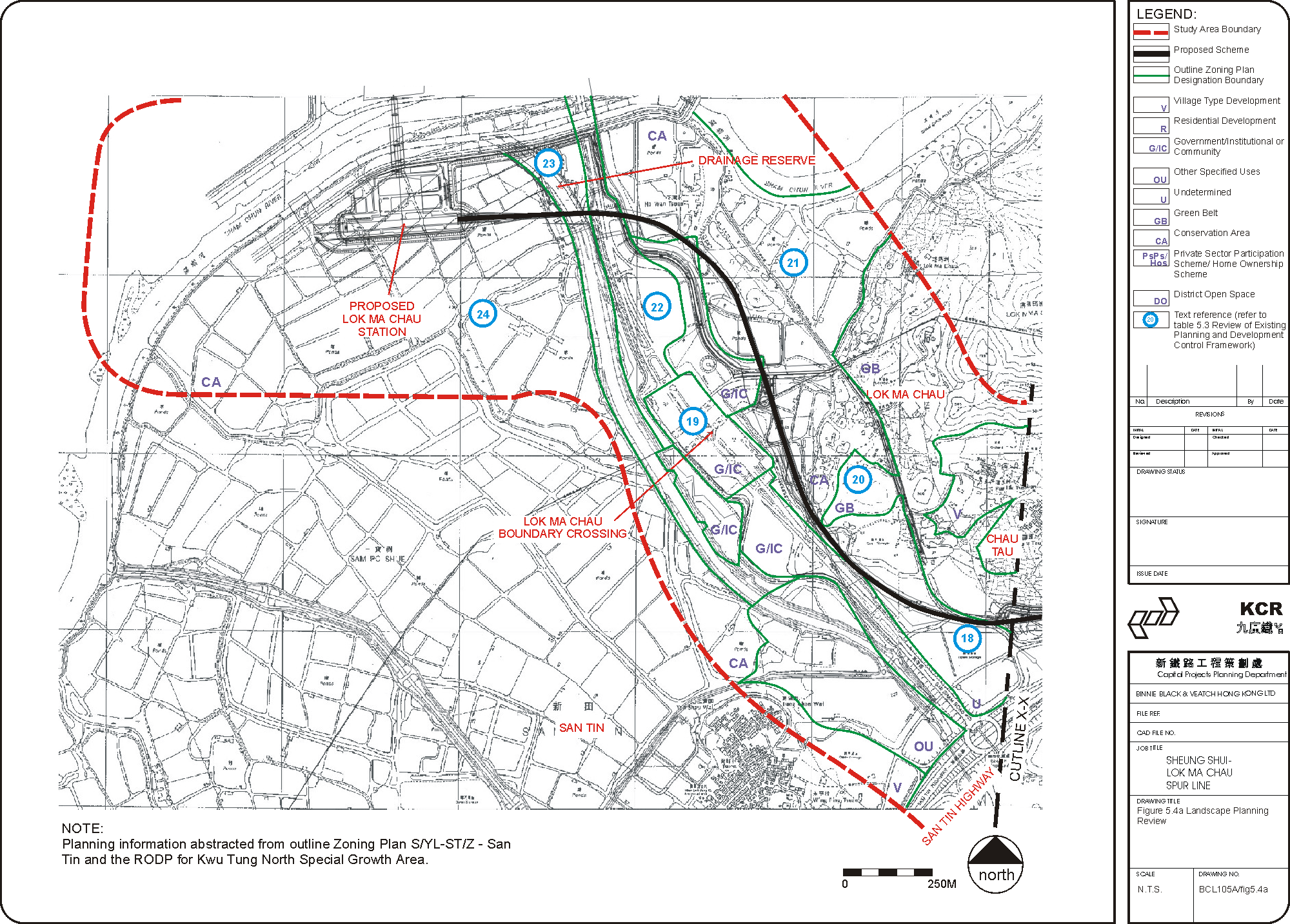
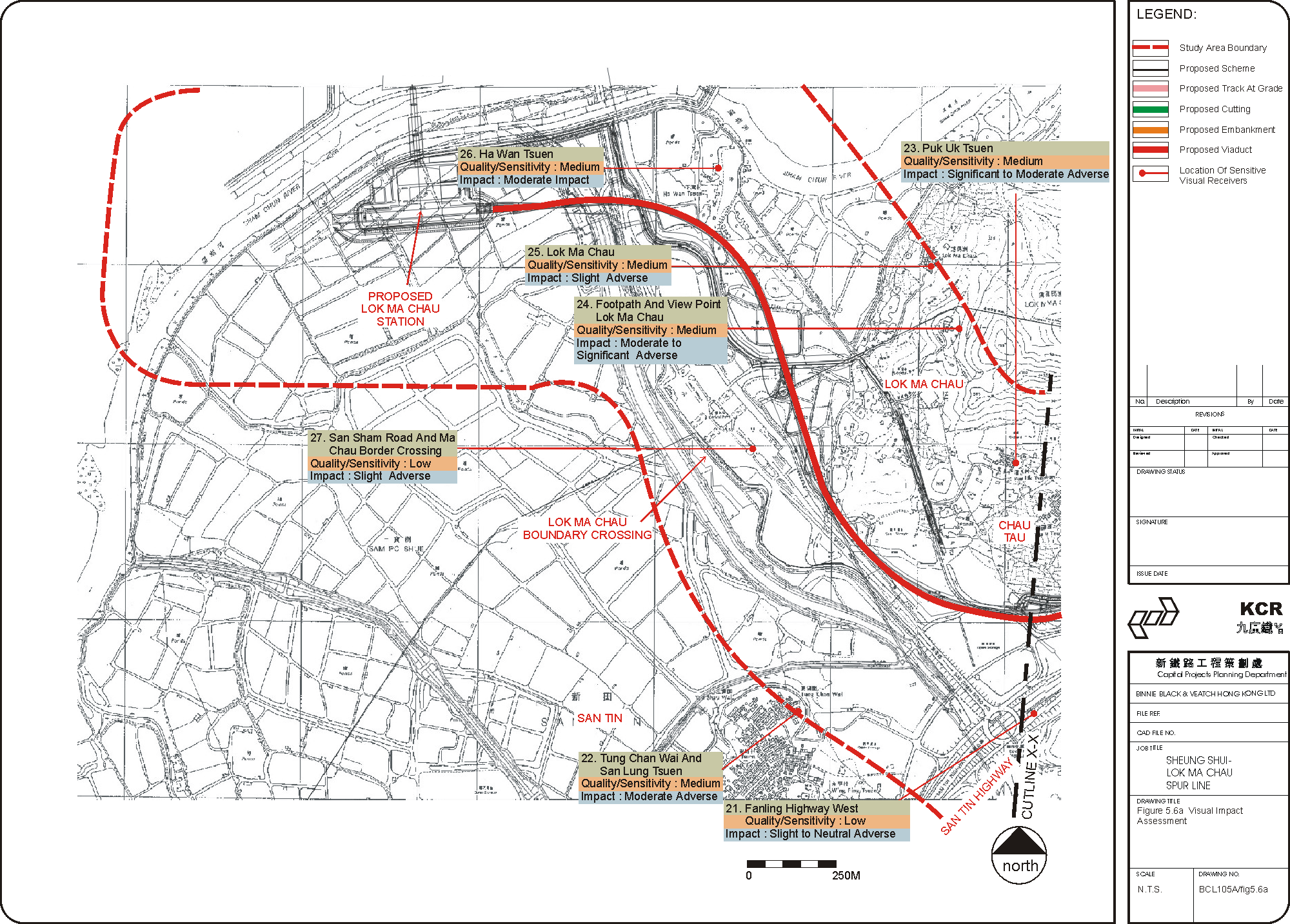
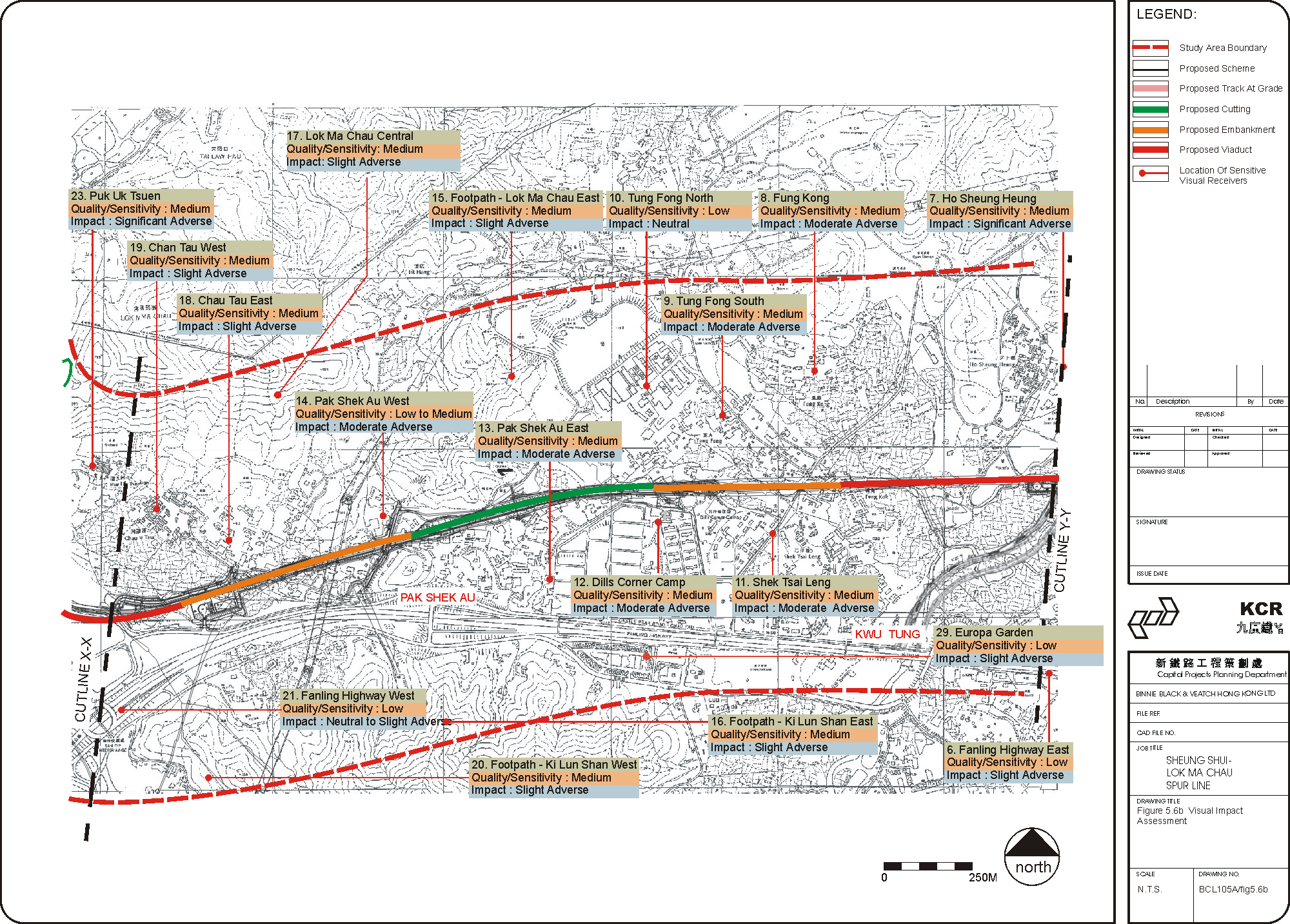
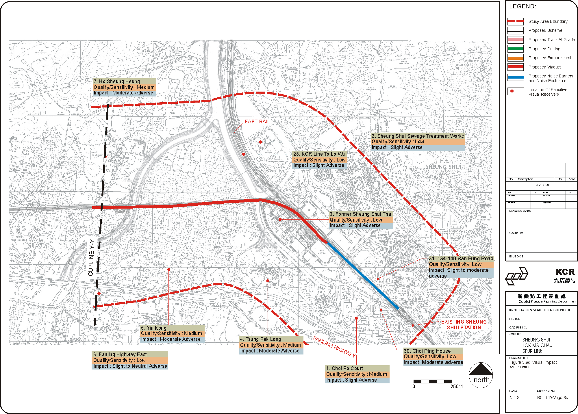
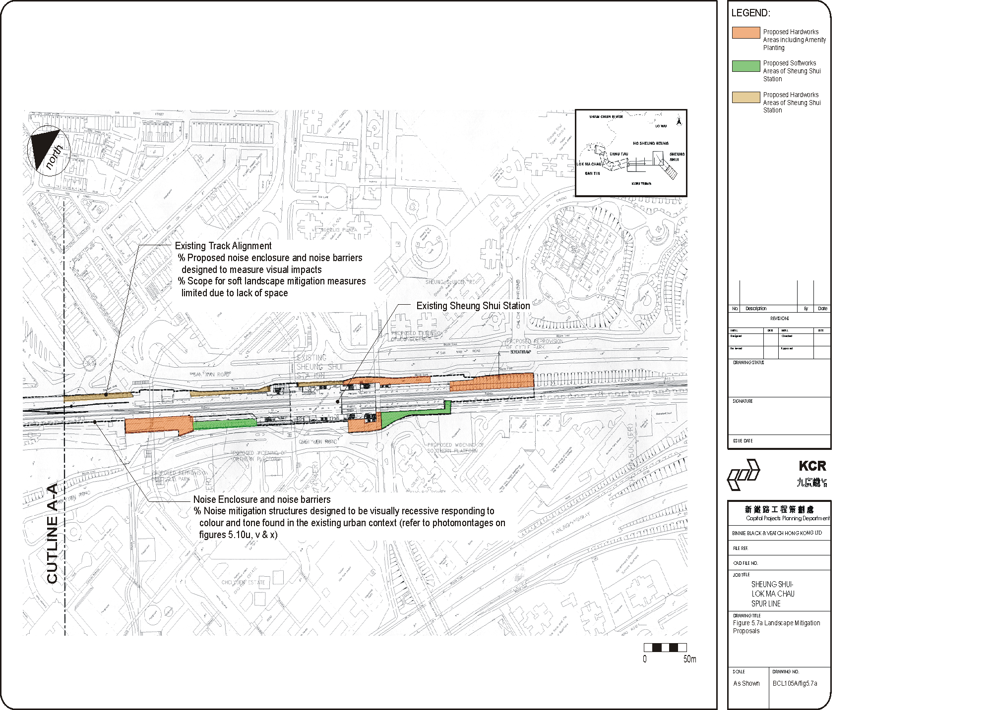
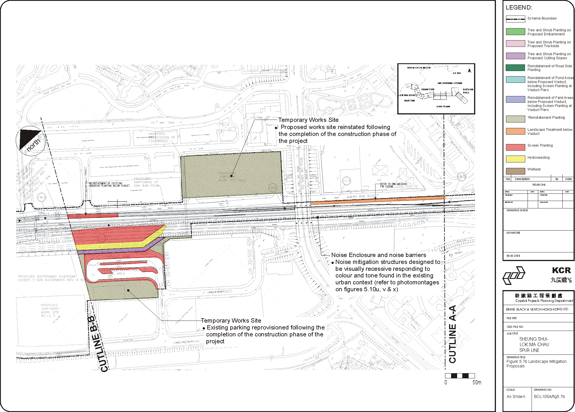
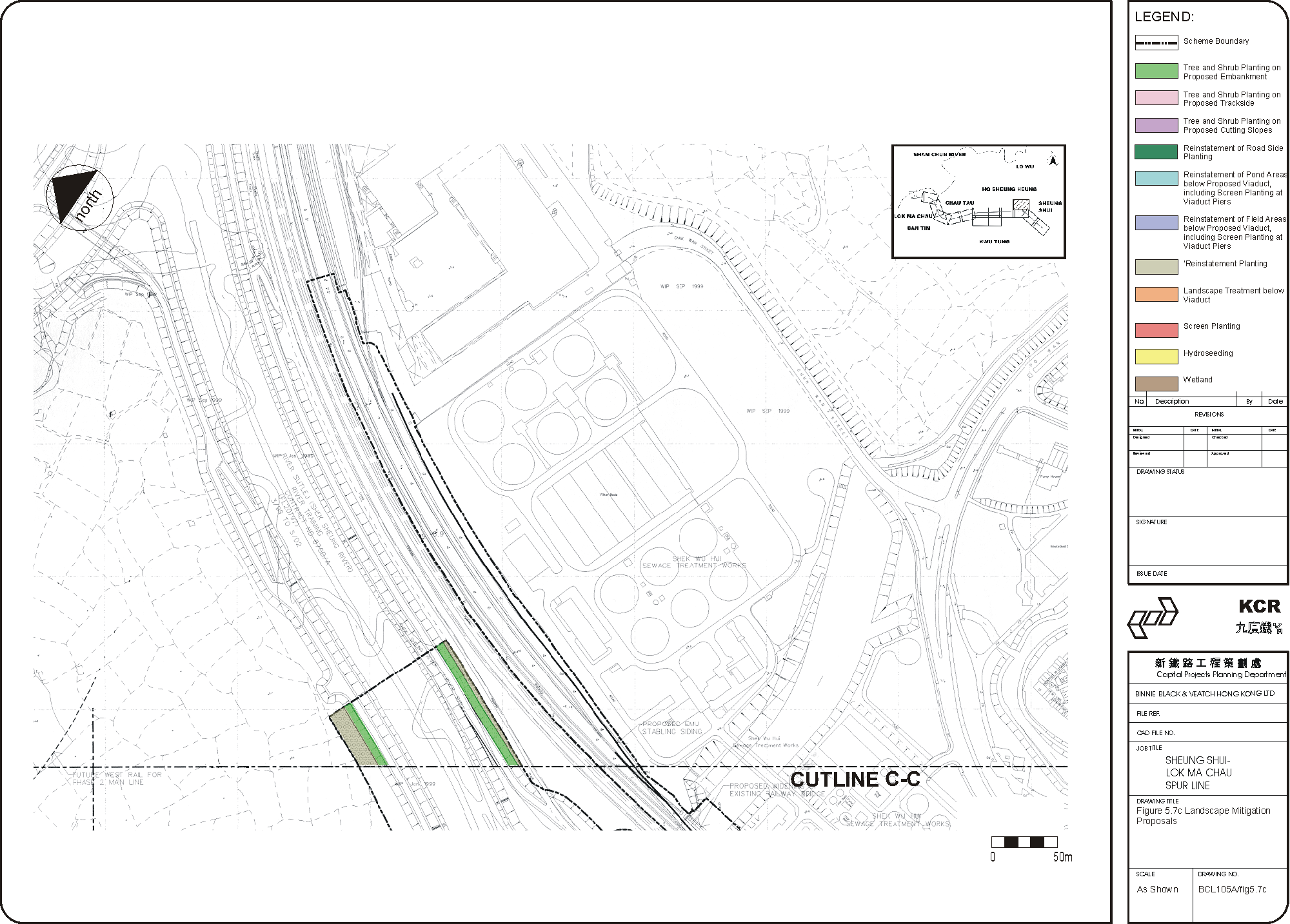
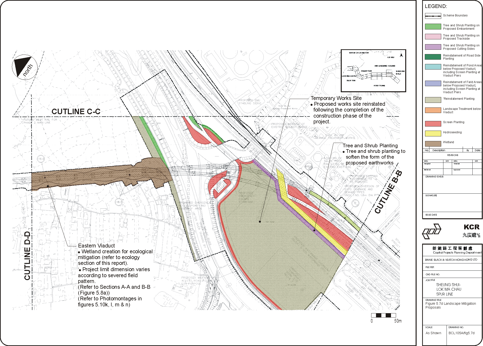
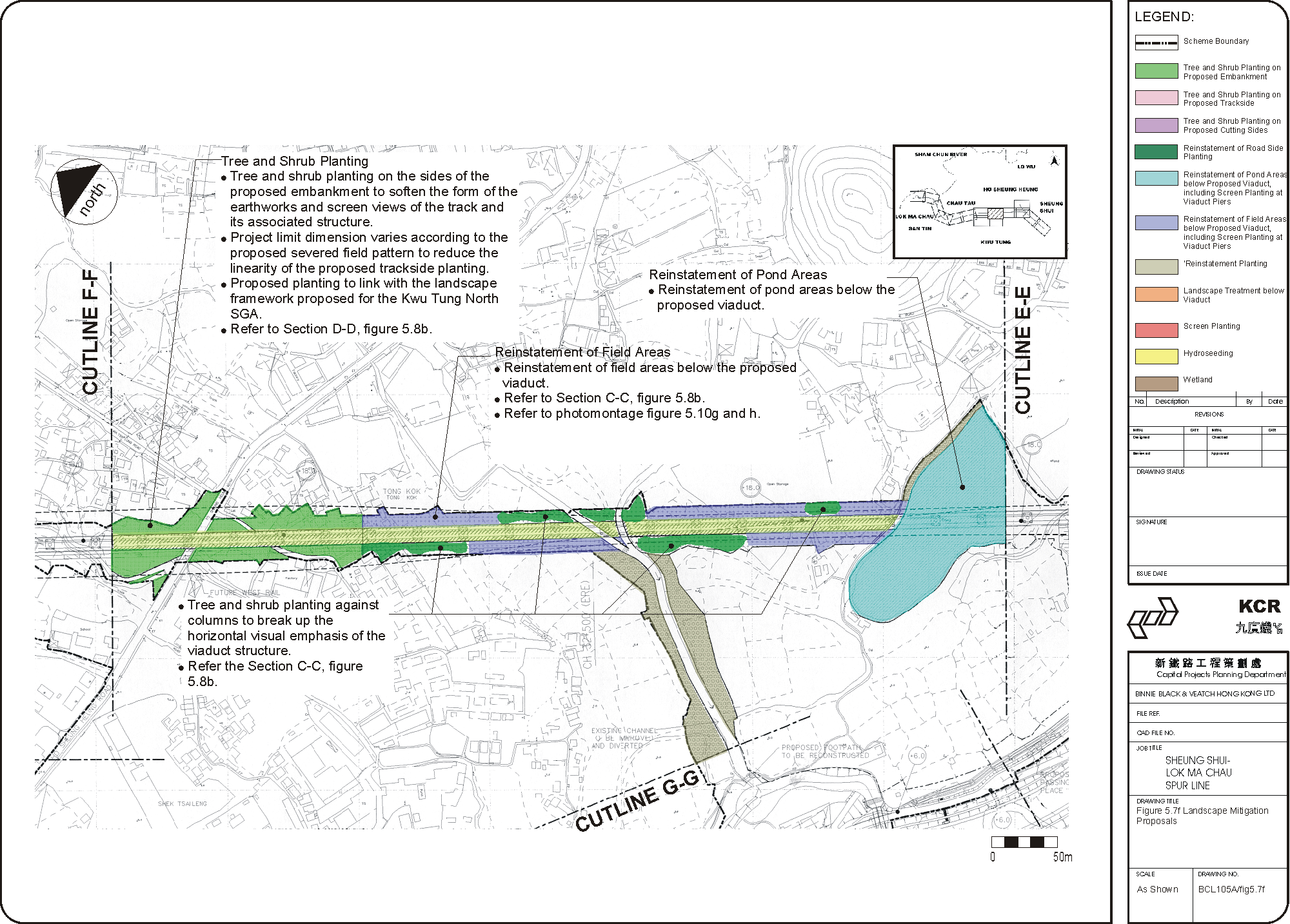
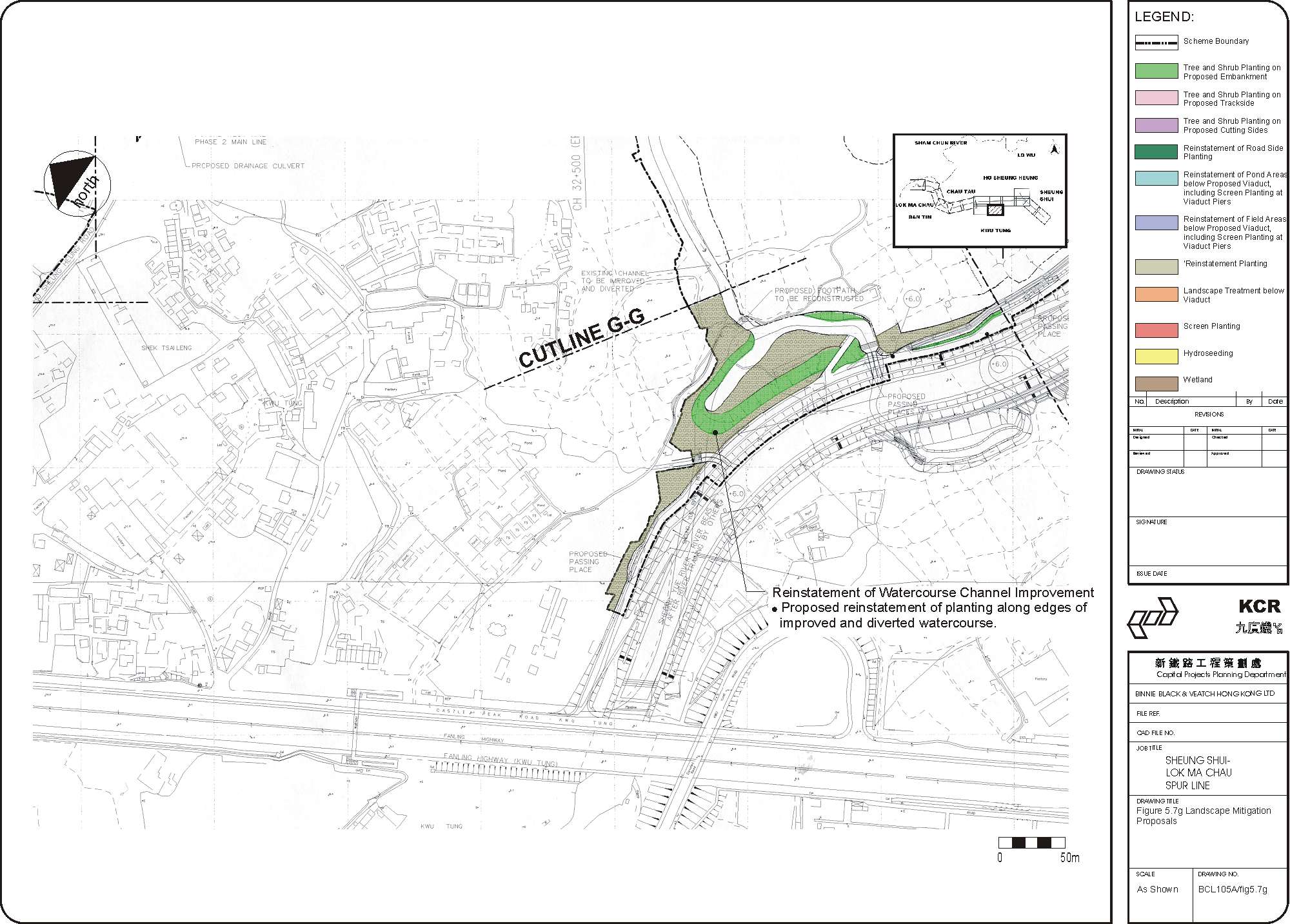
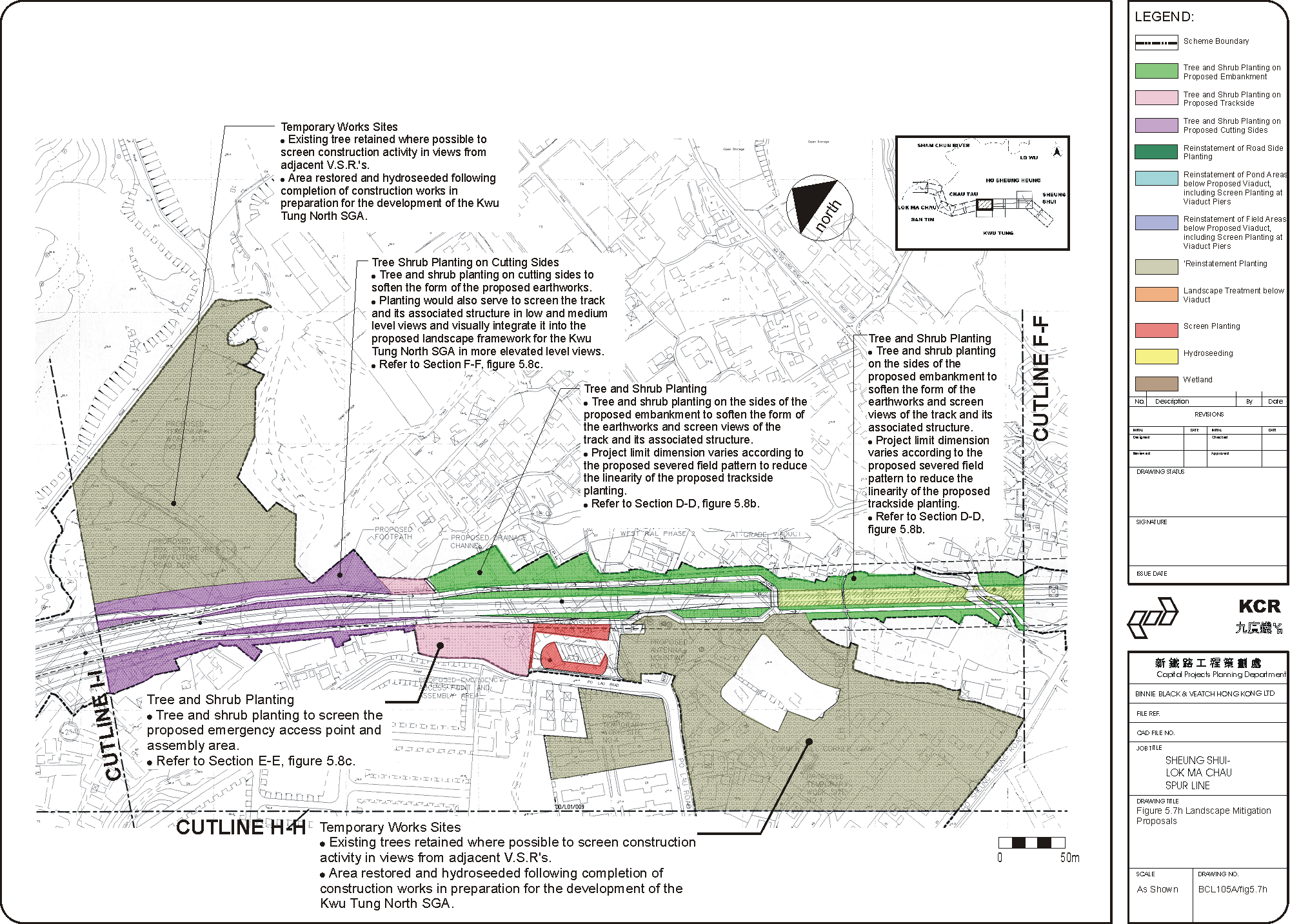
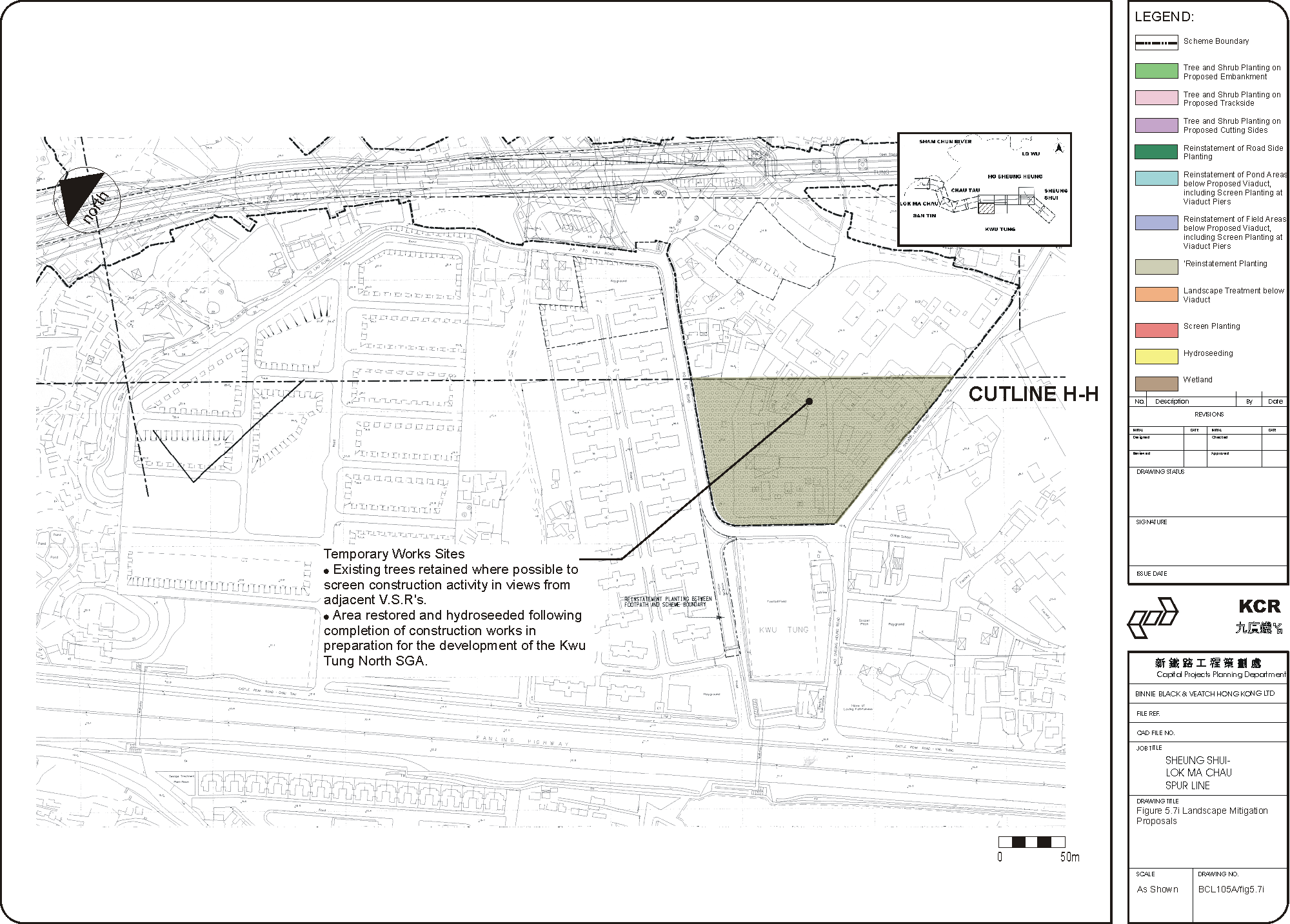
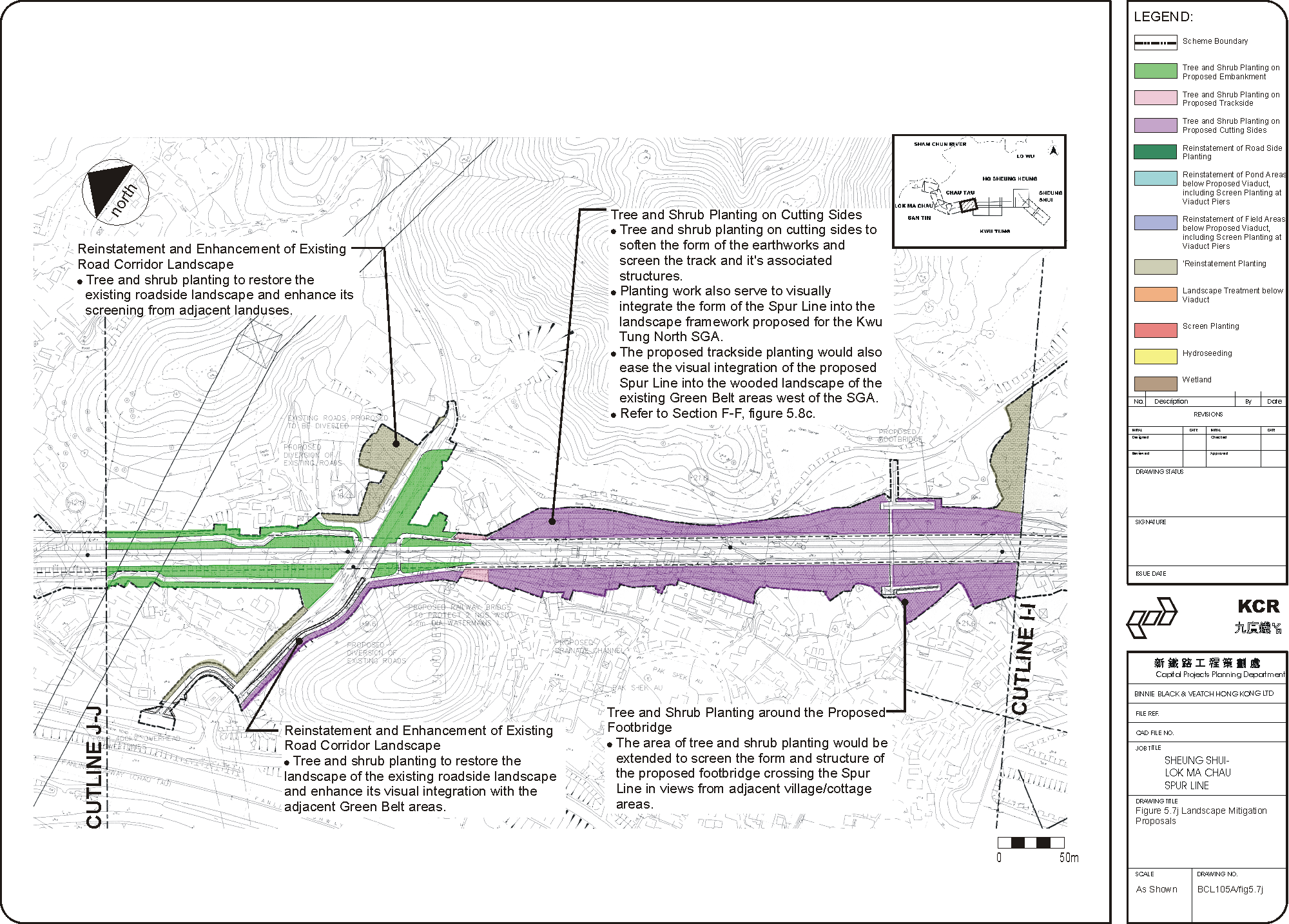
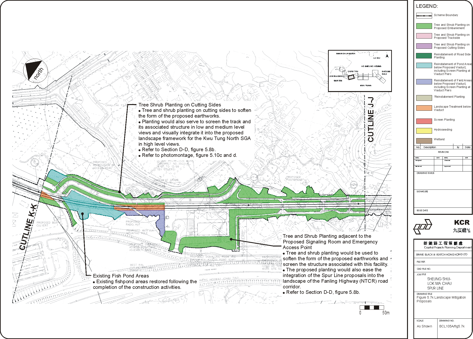
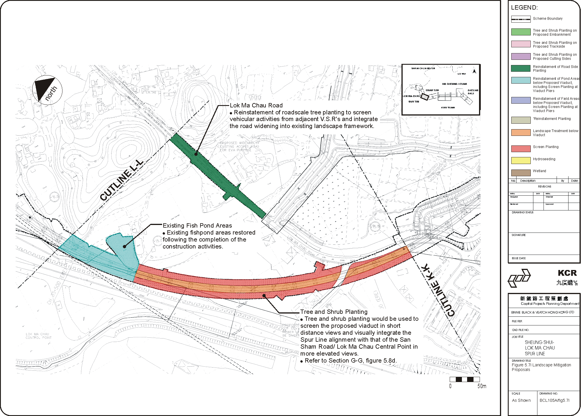
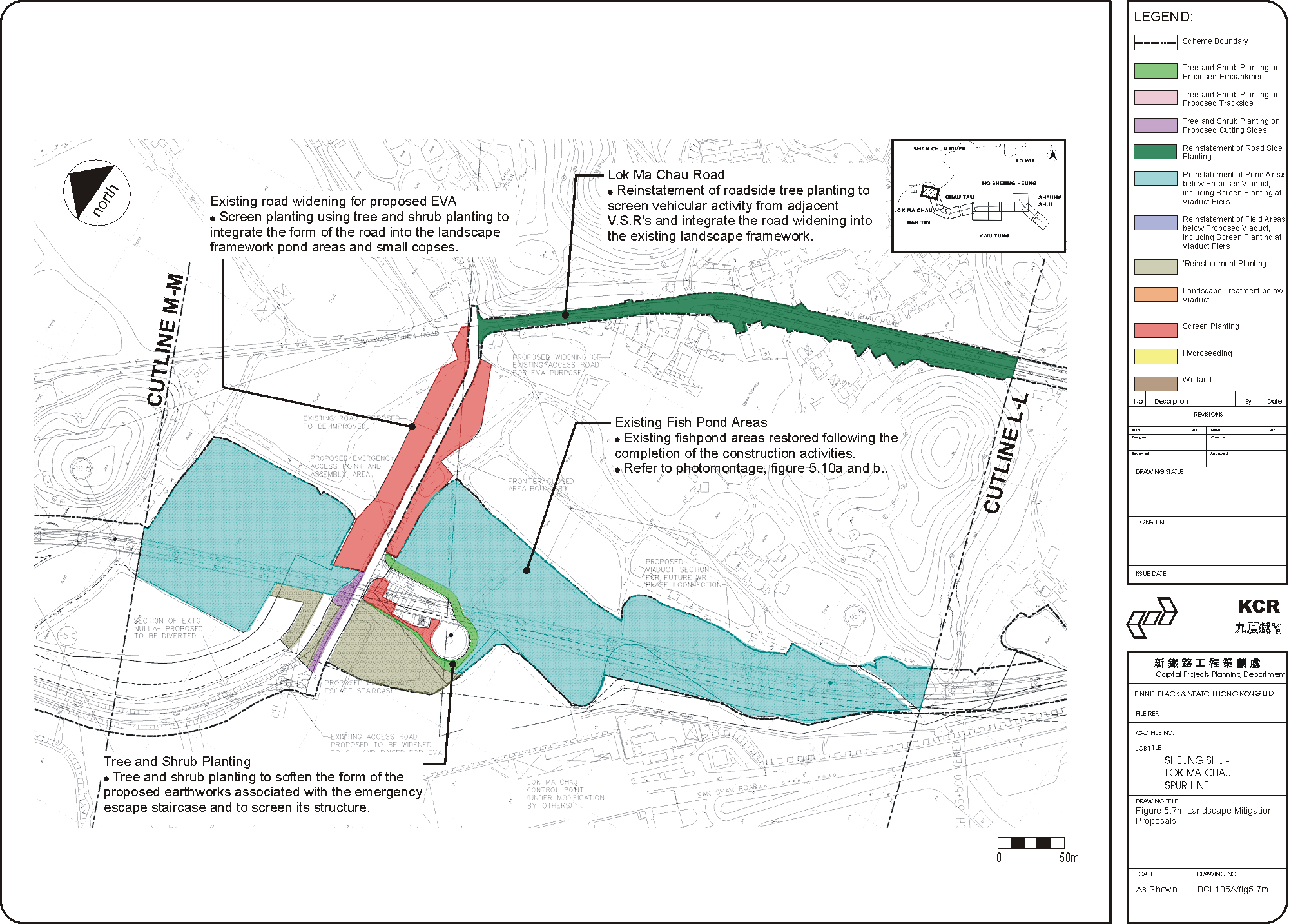
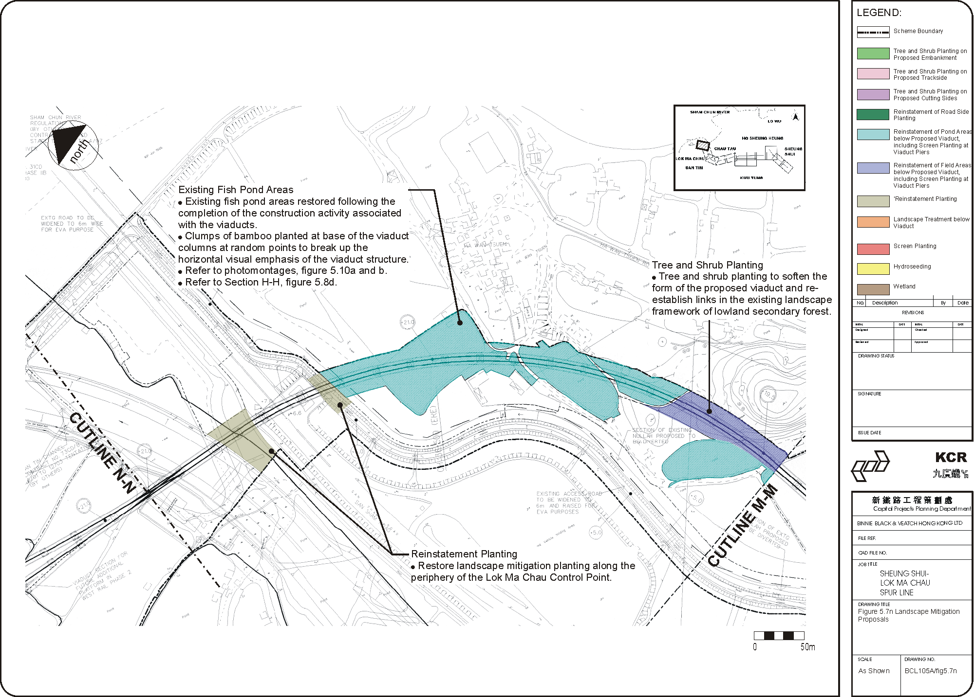
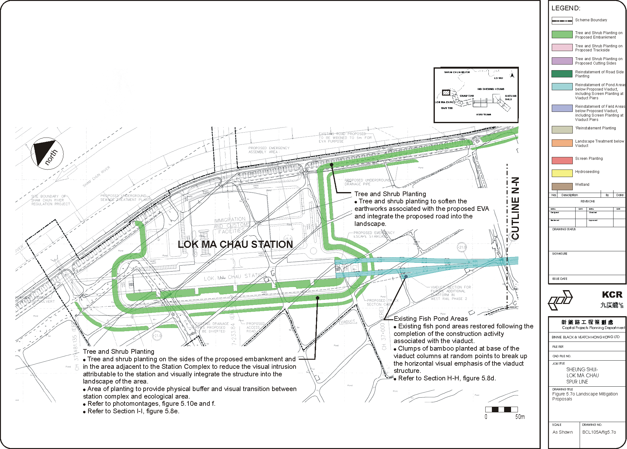
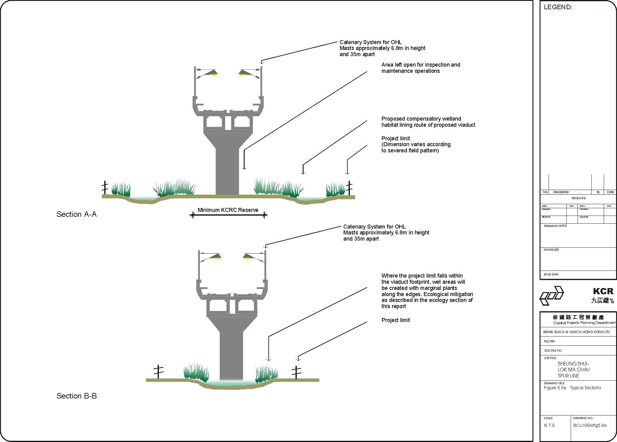
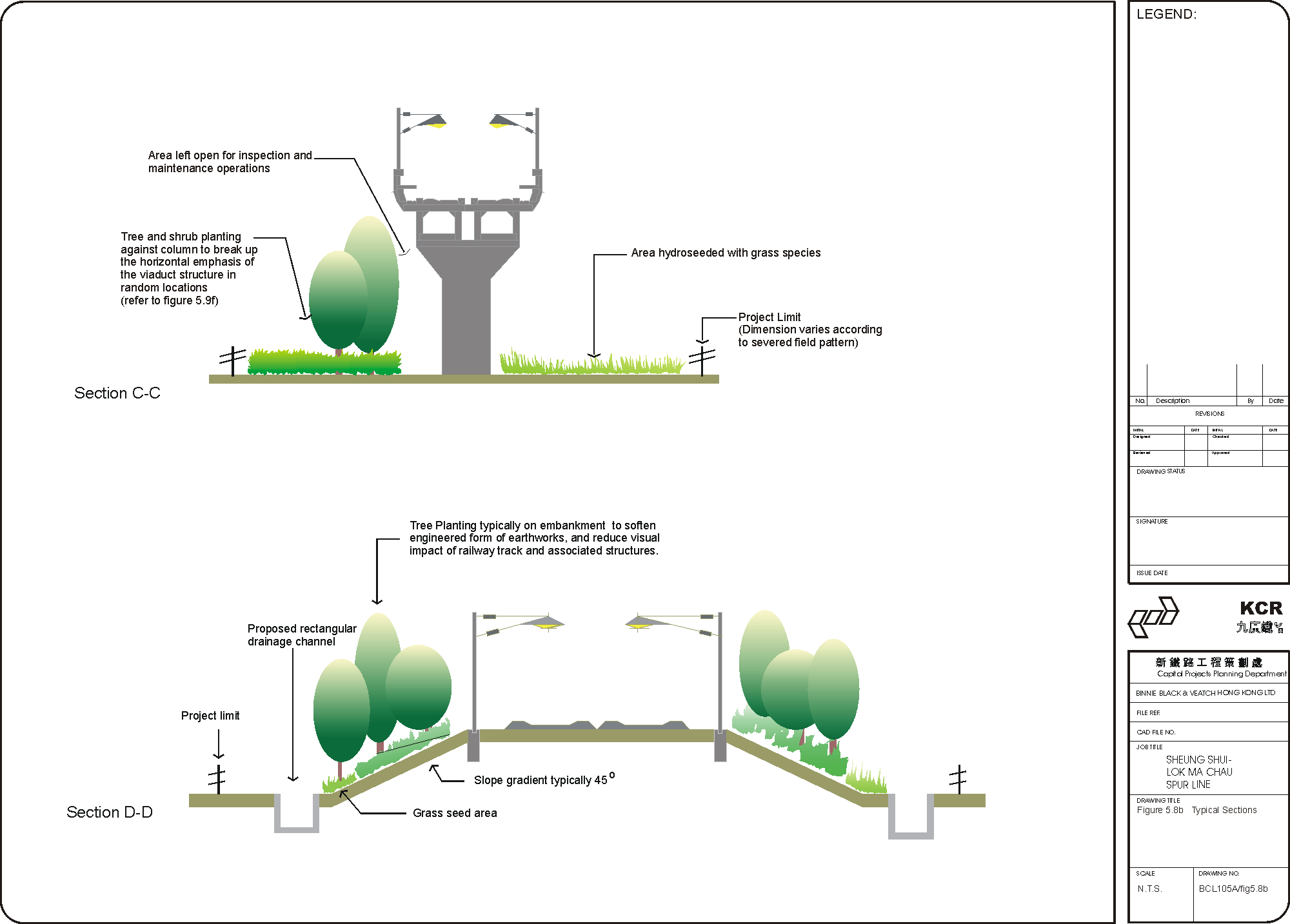
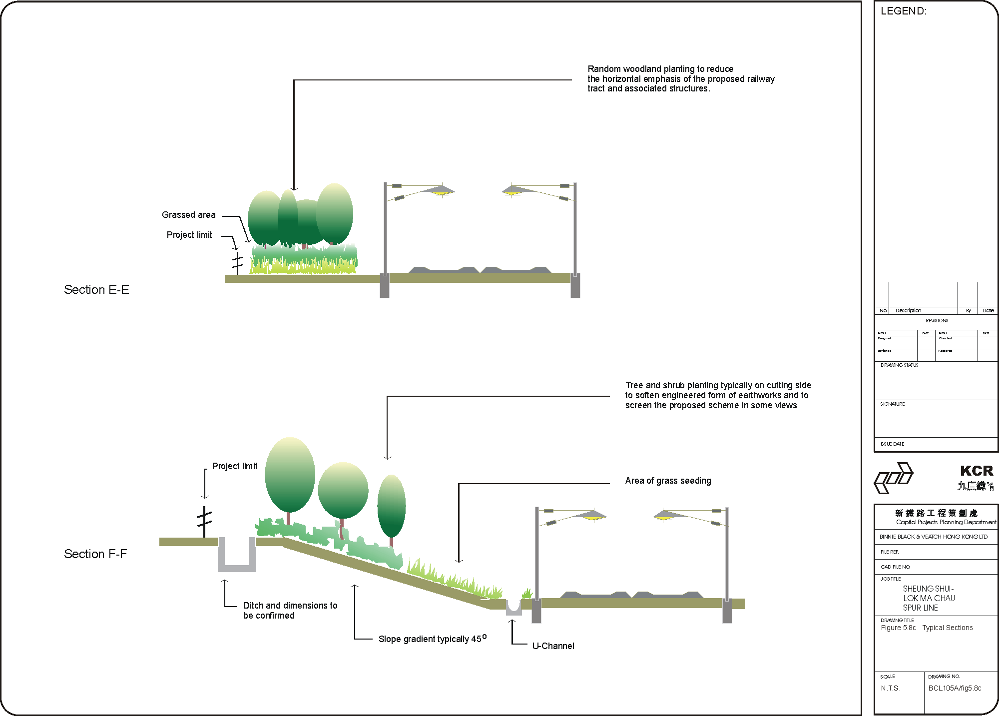
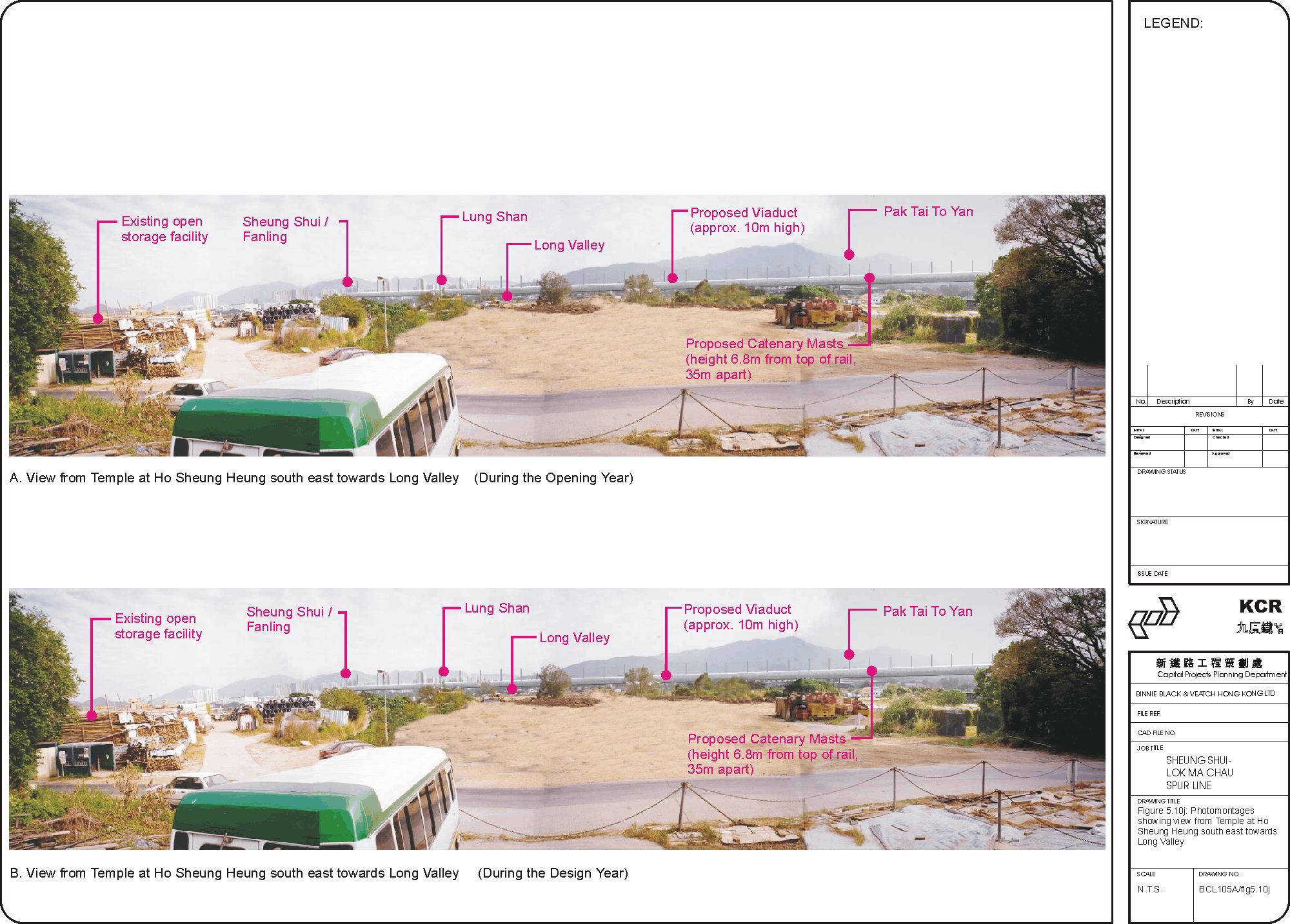
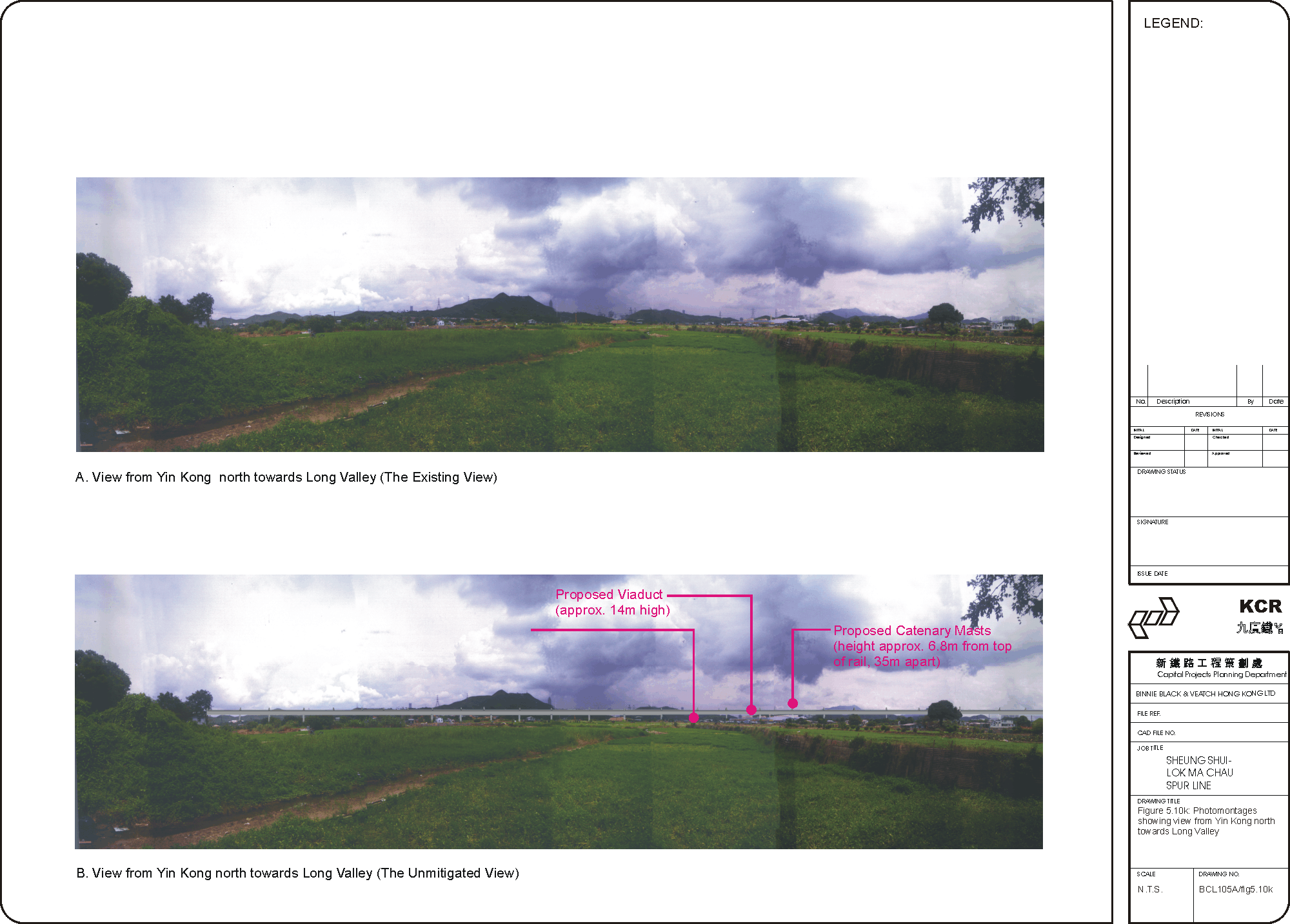
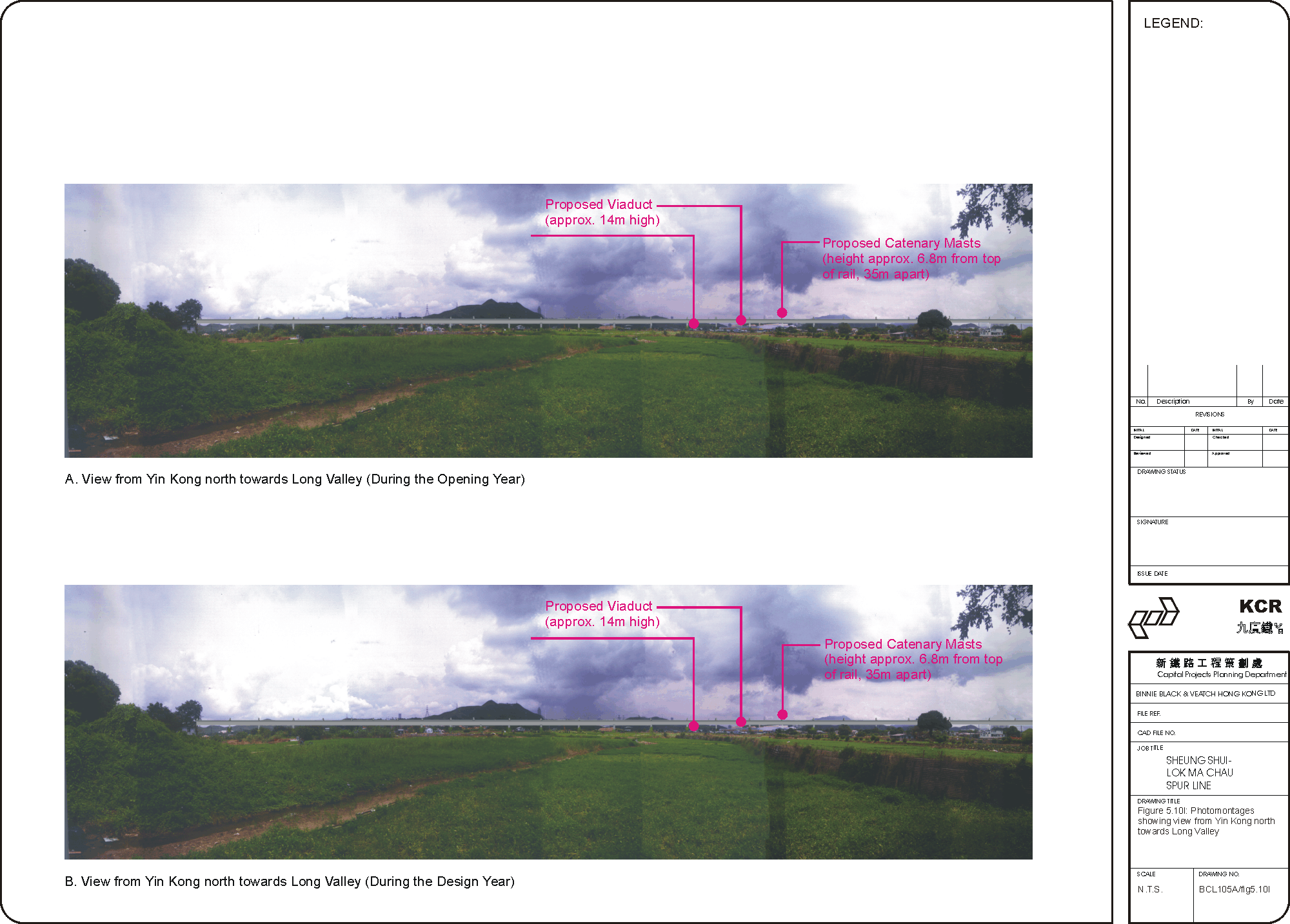
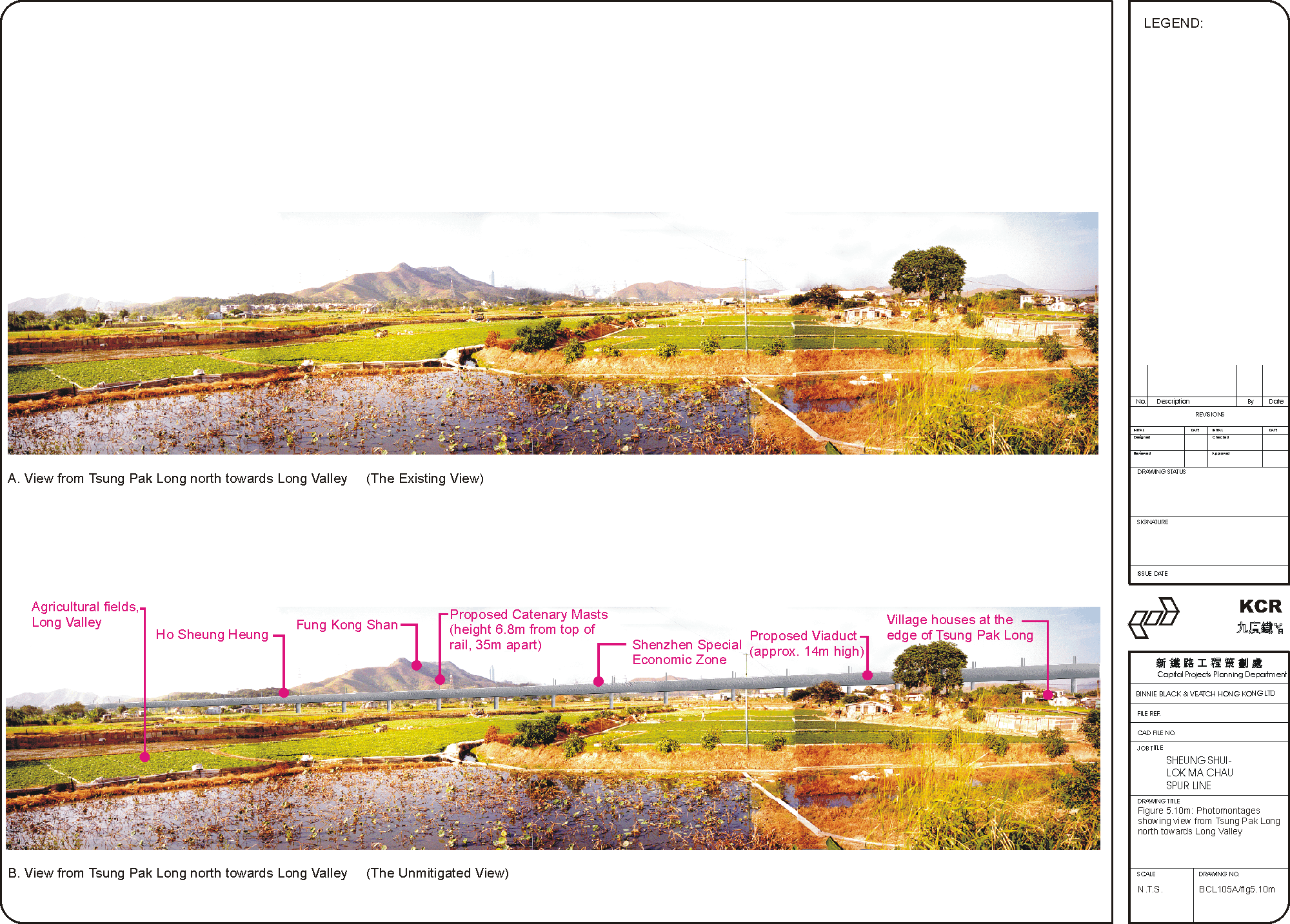
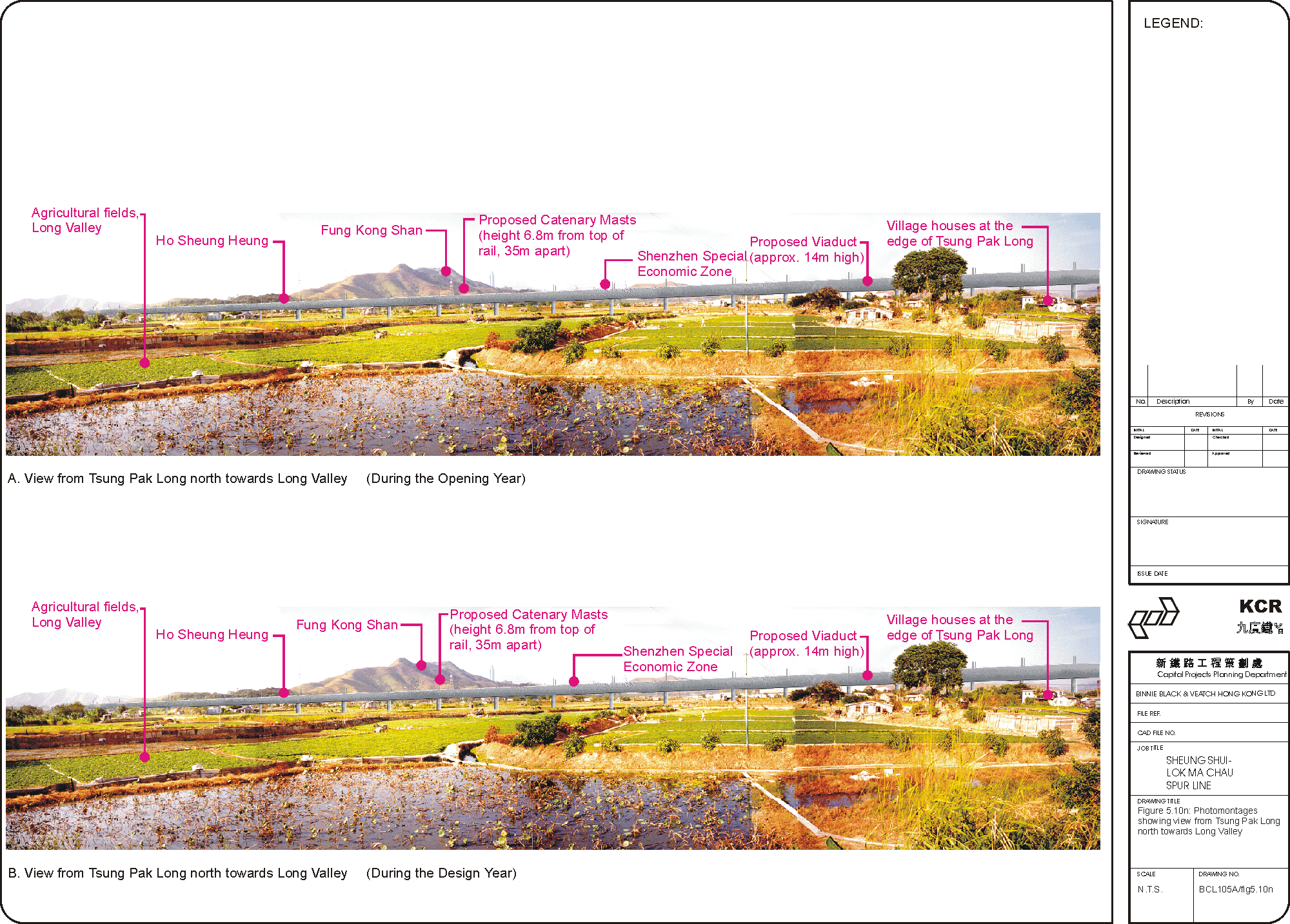
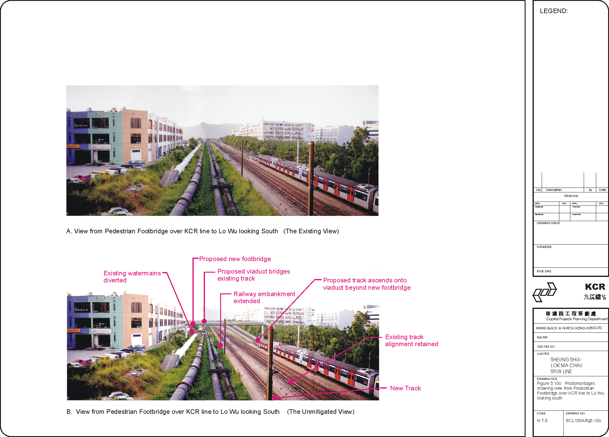
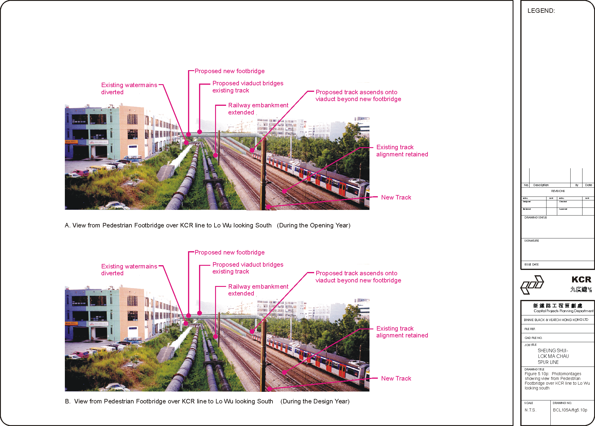
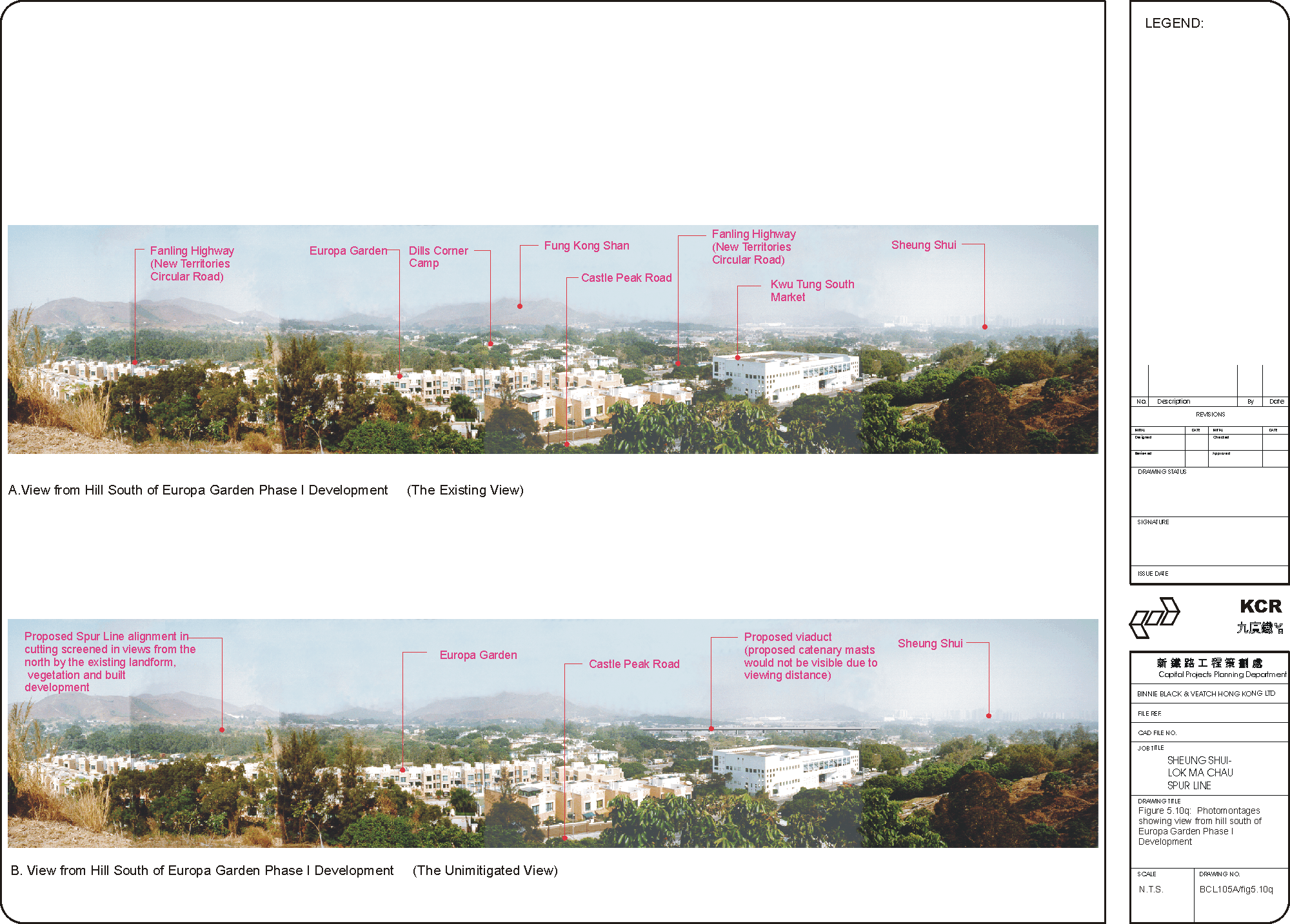
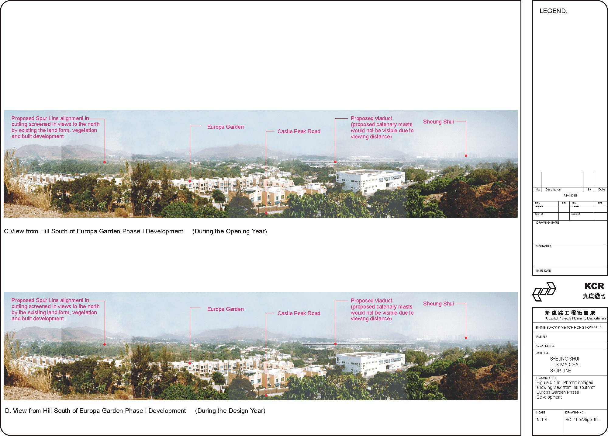
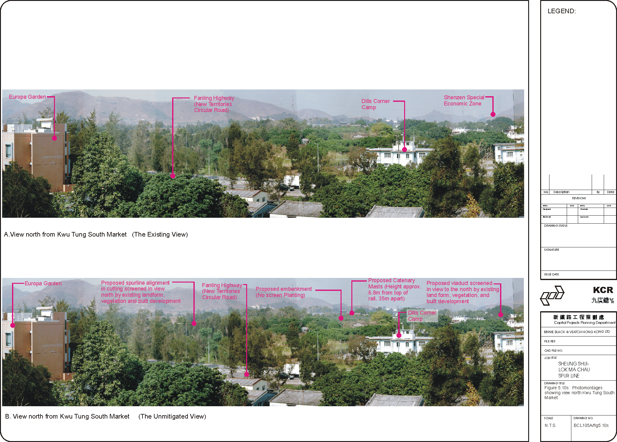
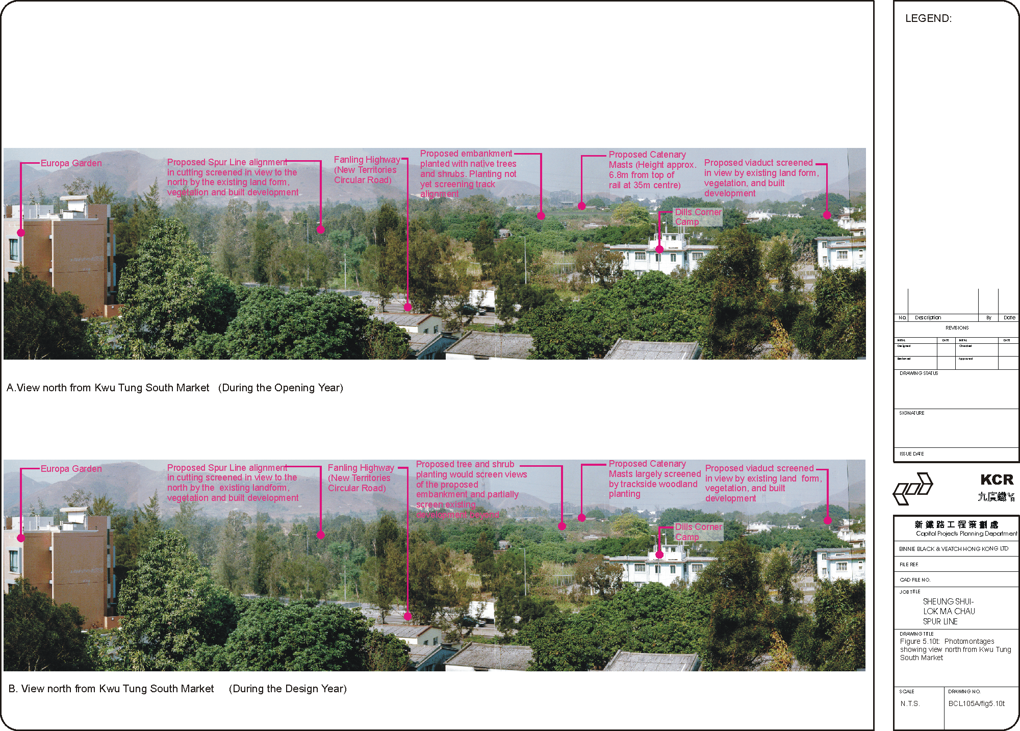
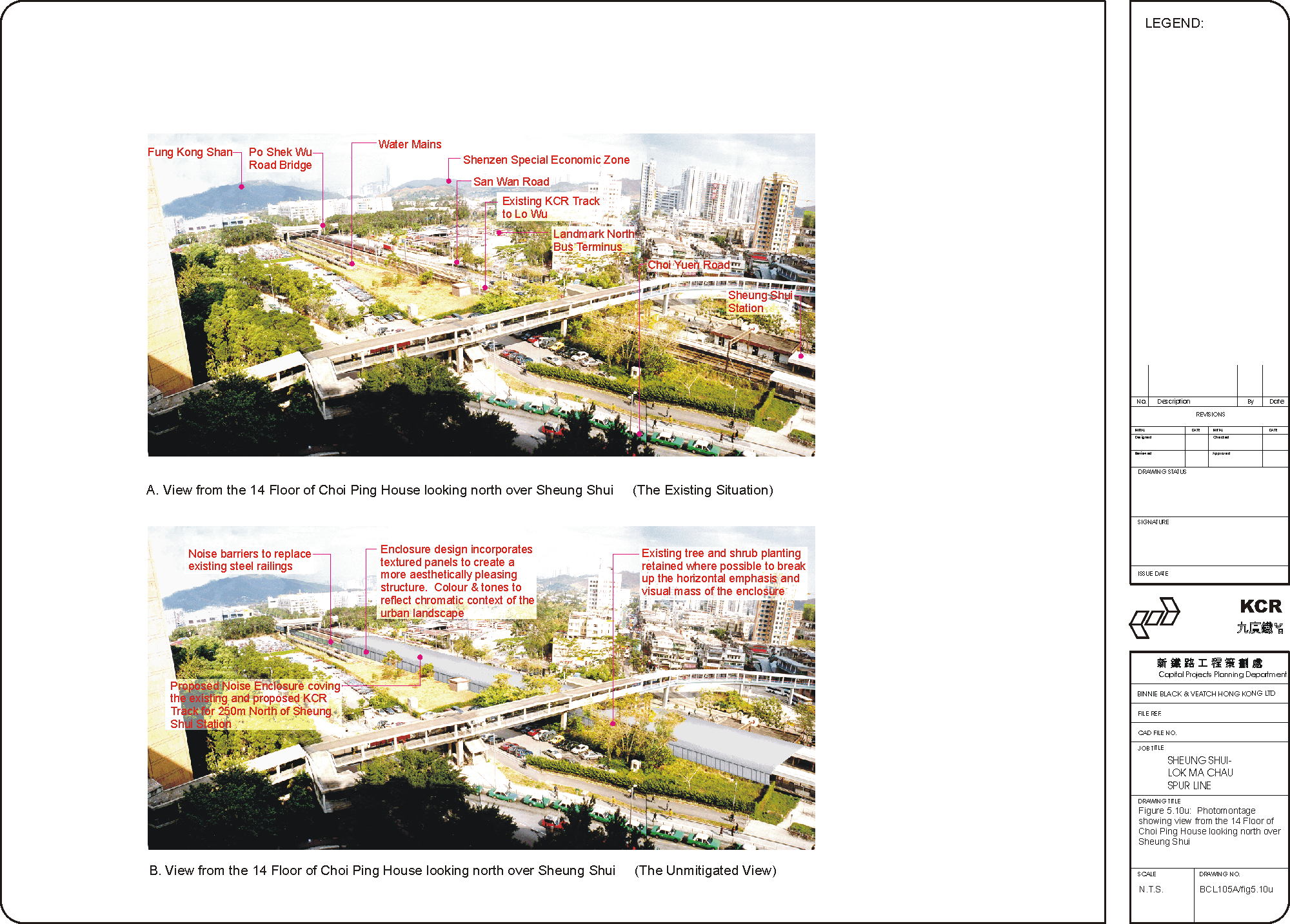
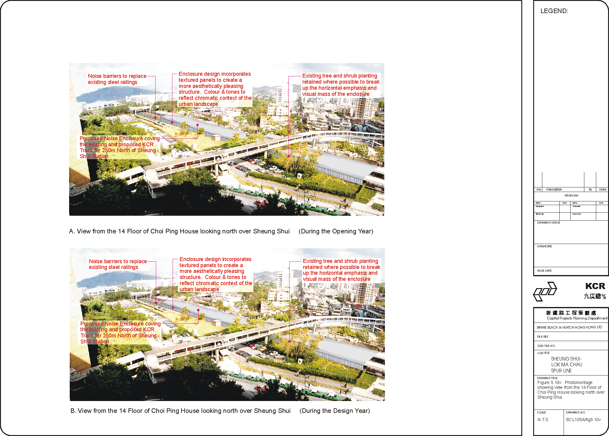
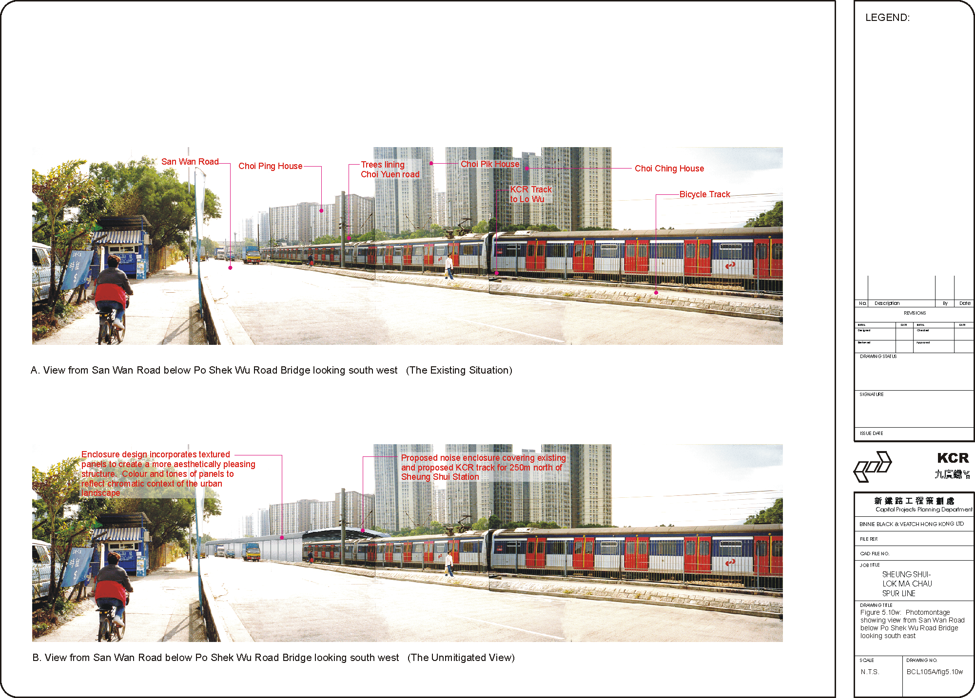
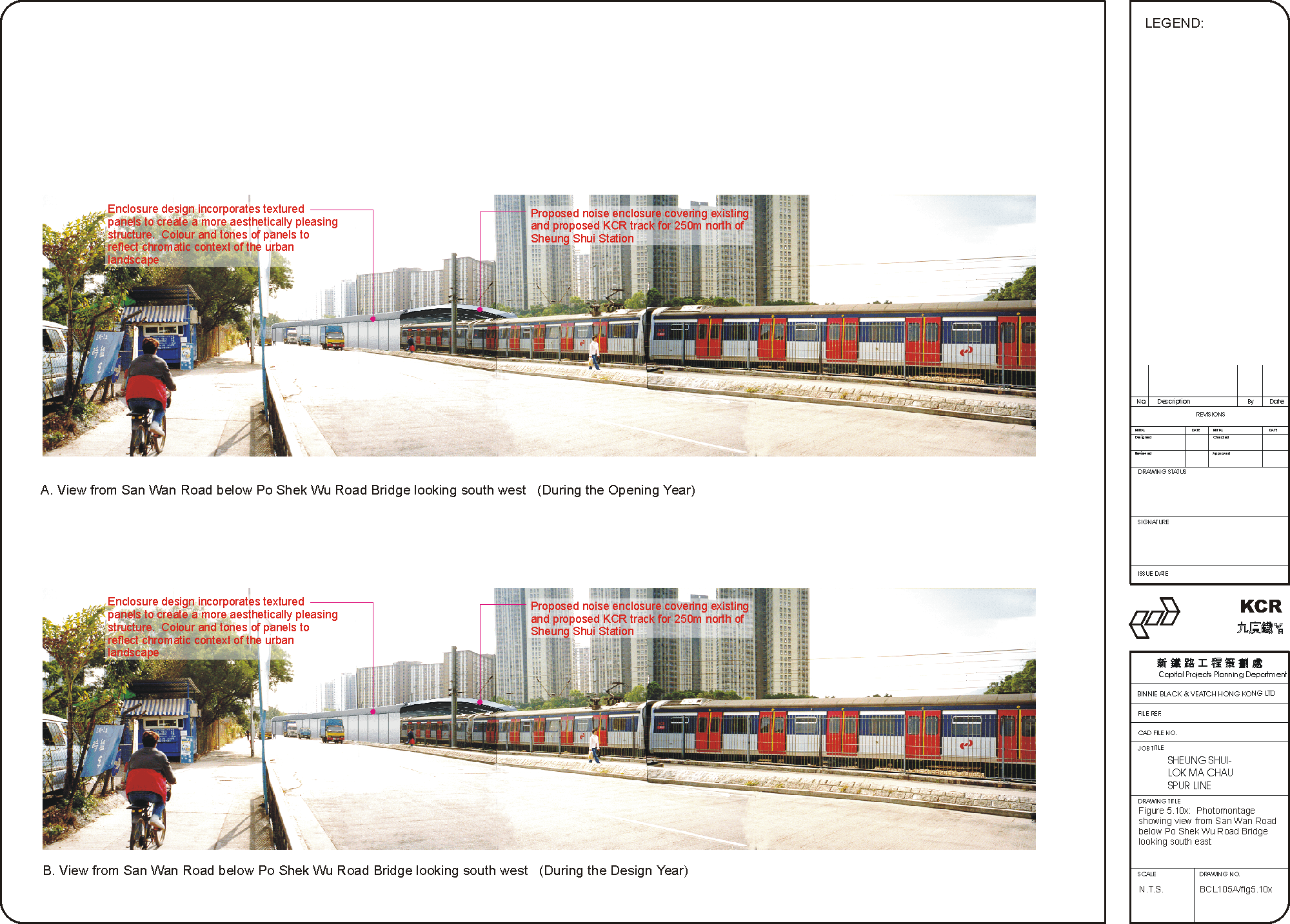
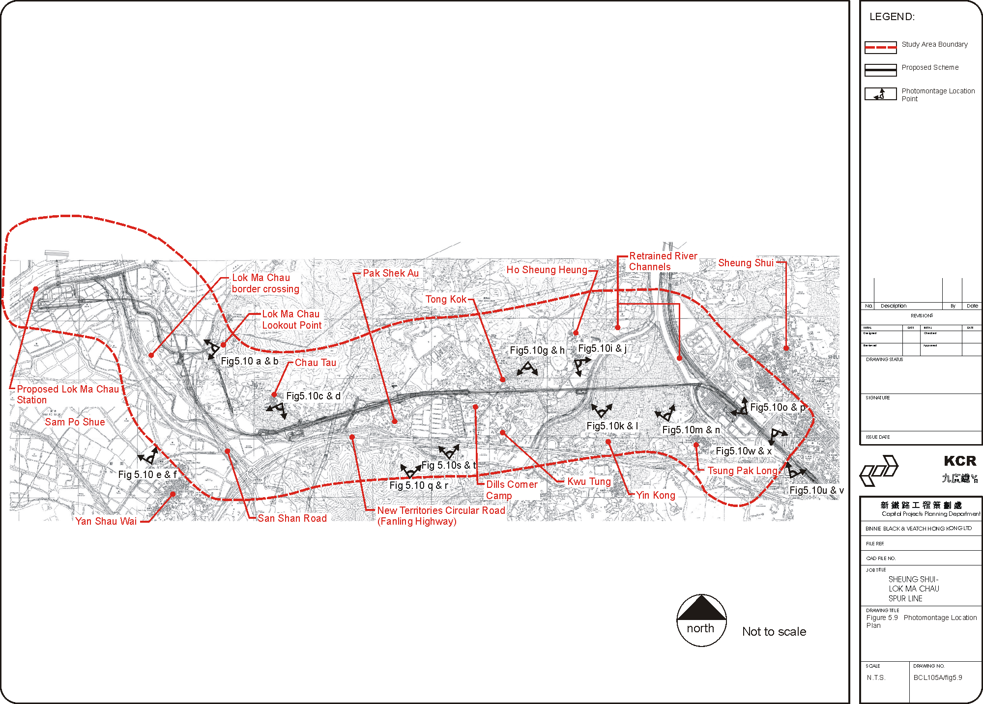