Appendices
Appendices are included in a separate volume -
Volume 2
Appendix A Project History
Appendix B Review of Reclamation Methodology for
CRIII Minimum Option
Appendix C Detailed Construction Programme
Appendix D Sample Output File for Road Traffic
Noise Assessment / Confirmation Letter from Transport Department on CRIII Road
Speeds
Appendix E Powered Mechanical Equipment (PME) for
Different Construction Tasks during Normal Daytime Working Hours
Appendix F Detailed Calculations and Results of
Cumulative Construction Noise Impacts during Normal Working Hours
Appendix G Powered Mechanical Equipment (PME) for
Different Construction Tasks during Restricted Working Hours
Appendix H Detailed Calculations and Results of
Cumulative Construction Noise Impacts during Restricted Working Hours
Appendix I Sample CALINE Air Quality Model Output
Appendix J Sample ISCST3 Air Quality Model Output
Appendix K Calculation of Dust Emission Factors
Appendix L Sample Computer Output from FDM used in
Construction Air Quality Assessments
Appendix M Dust Levels from Different Construction
Scenarios (Unmitigated)
Appendix N Dust Levels from Different Construction
Scenarios (Mitigated)
Appendix O Hydraulic and Water Quality Modelling
Results
Appendix P Information Abstracted from Previous
Sediment Quality Report for the Project Site as applicable to the CRIII Minimum
Option Layout
Appendix Q Cumulative Water Quality Assessments for
CRIII and WDII projects undertaken as part of the WDII EIA Study
Appendix R SedPlume Modelling Scenarios and results
from Previous Studies for the Project Site
Appendix S EMSD Cooling Water Systems Data
Appendix T Baseline Study - Description of the
Environment
Appendix U Planning and Development Control
Framework
Appendix V Landscape & Visual Impact Assessment
for Redesign of the Airport Railway Extended Overrun Tunnel
Appendix W Built Heritage Impact Assessment
FIGURES
Figure 1.1 Extent
of Full and Streamlined Reclamations 1.1.gif
Figure 1.2 Study
Area and Proposed Layout 1.2.gif
Figure 2.1 Air /
Noise Sensitive Receivers and Noise Prediction Points 2.1.gif
Figure 2.2 Water
Quality Sensitive Receivers along the CRIII Waterfront 2.2.gif
Figure 2.3 Water
Quality Sensitive Receivers outside CRIII site but considered in study 2.3.gif
Figure 2.4 Extent
of Usage of Different Reclamatin Fill Materials 2.4.gif
Figure 4.1 Envisaged
Construction Sequence – Stages 1 to 4 4.1.gif
Figure 4.2 Envisaged
Construction Sequence – Stages 5 to 8 4.2.gif
Figure 5.1a 2027 AM
Peak Hour Forecast Traffic Flow 5.1a.gif
Figure 5.1b 2027 AM
Peak Hour Forecast Traffic Flow 5.1b.gif
Figure 5.1c 2027 AM
Peak Hour Forecast Traffic Flow 5.1c.gif
Figure 5.1d 2027 AM
Peak Hour Forecast Traffic Flow 5.1d.gif
Figure 5.2 Predicted
Noise Levels at Sensitive Receivers 5.2.gif
Figure 6.1 Location
of Fixed Noise Sources 6.1.gif
Figure 8.1 Location
of Portals and Ventilation Buildings 8.1.gif
Figure 8.2a Contours
of Predicated Cumulative Maximum 1-Hour Average NO2 Concentrations
in mg/m3
at 1.5m Above Ground Level 8.2a.gif
Figure 8.2b Contours
of Predicated Cumulative Maximum 1-Hour Average NO2 Concentrations
in mg/m3
at 10m Above Ground Level 8.2b.gif
Figure 8.2c Contours
of Predicated Cumulative Maximum 1-Hour Average NO2 Concentrations
in mg/m3
at 20m Above Ground Level 8.2c.gif
Figure 8.2d Contours
of Predicated Cumulative Maximum 1-Hour Average NO2 Concentrations
in mg/m3
at 30m Above Ground Level 8.2d.gif
Figure 8.2e Contours
of Predicated Cumulative Maximum 1-Hour Average NO2 Concentrations
in mg/m3
at 70m Above Ground Level 8.2e.gif
Figure 8.2f Contours
of Predicated Cumulative Maximum 1-Hour Average NO2 Concentrations
in mg/m3
at 110m Above Ground Level 8.2f.gif
Figure 8.3 Contours
of Predicated Cumulative Maximum 24-Hour Average NO2 Concentrations
in mg/m3
at 1.5m Above Ground Level 8.3.gif
Figure 8.4 Contours
of Predicated Cumulative Maximum 24-Hour Average RSP Concentrations
in mg/m3
at 1.5m Above Ground Level 8.4.gif
Figure 8.5 Contours
of Predicated Cumulative Maximum 1-Hour Average CO Concentrations in
mg/m3
at 1.5m Above Ground Level 8.5.gif
Figure 9.1 Summary
of Major Dust Generating Activities 9.1.gif
Figure 9.2 Contours
of Cumulative Maximum 1-Hour Average TSP Concentrations in mg/m3
at 1.5m Above Ground Level (Mitigated) 9.2.gif
Figure 9.3 Contours
of Cumulative Maximum 24-Hour Average TSP Concentrations in mg/m3
at 1.5m Above Ground Level (Mitigated) 9.3.gif
Figure 10.1a Suspended
Sediment Plume Scenario 1 sources in the Central area 10.1a.gif
Figure 10.1b Suspended
Sediment Plume Scenario 2 sources in the Central area 10.1b.gif
Figure 10.2 Suspended
Sediment Plume Scenarios 1 and 2 sources for concurrent project 10.2.gif
Figure 10.3 Suspended
Sediment Plume Scenario 1 sensitive receivers in the Central area 10.3.gif
Figure 10.4 Suspended
Sediment Plume Scenario 2 sensitive receivers in the Central area 10.4.gif
Figure 10.5 Scenario
1 suspended mud concentrations at peak flood, dry season neap tide 10.5.gif
Figure 10.6 Scenario
1 suspended mud concentrations at peak ebb, dry season neap tide 10.6.gif
Figure 10.7 Scenario
1 suspended mud concentrations at the sensitive receivers, dry season neap tide
10.7.gif
Figure 10.8 Scenario 1
suspended mud concentrations at the sensitive receivers, dry season neap tide 10.8.gif
Figure 10.9 Scenario 1 suspended mud concentrations at
the sensitive receivers, dry season neap tide 10.9.gif
Figure 10.10 Scenario
1 suspended mud concentrations at the sensitive receivers, dry season neap tide
10.10.gif
Figure 10.11 Scenario
1 suspended mud concentrations at the sensitive receivers, dry season neap tide
10.11.gif
Figure 10.12 Scenario
1 tide-and depth – averaged suspended mud concentrations, dry season neap tide 10.12.gif
Figure 10.13 Scenario
1 net deposition over one day, dry season neap tide 10.13.gif
Figure 10.14 Scenario
2 suspended mud concentrations at peak flood, wet season neap tide 10.14.gif
Figure 10.15 Scenario
2 suspended mud concentrations at peak ebb, wet season neap tide 10.15.gif
Figure 10.16 Scenario
2 suspended mud concentrations at the sensitive receivers, wet season neap tide
10.16.gif
Figure 10.17 Scenario
2 suspended mud concentrations at the sensitive receivers, wet season neap tide
10.17.gif
Figure 10.18 Scenario
2 suspended mud concentrations at the sensitive receivers, wet season neap tide
10.18.gif
Figure 10.19 Scenario
2 suspended mud concentrations at the sensitive receivers, wet season neap tide
10.19.gif
Figure 10.20 Scenario
2 suspended mud concentrations at the sensitive receivers, wet season neap tide
10.20.gif
Figure 10.21 Scenario
2 tide-and depth – averaged suspended mud concentrations, wet season neap tide 10.21.gif
Figure 10.22 Scenario
2 net deposition over one day, wet season neap tide 10.22.gif
Figure 10.23 Sensitive
Receivers and Stormwater Outfalls – Initial Reclamation Layout 10.23.gif
Figure 10.24 Locations
of Sections for Discharge Comparisons 10.24.gif
Figure 10.25
Sensitive Receivers and Stormwater Outfalls – Final Layout 10.25.gif
Figure 10.26 Locations
of Cooling Water Pumping Station Outfalls at the Completion of CRIII Works 10.26.gif
Figure 14.1 Baseline
Landscape and Visual Character Areas 14.1.gif
Figure 14.2 Baseline
Visual Envelope and Photo View Point Locations 14.2.gif
Figure 14.3 Landscape
and Visual Characteristics – Photograph Views A and B 14.3.gif
Figure 14.4 Landscape
and Visual Characteristics – Photograph View C 14.4.gif
Figure 14.5 Landscape
and Visual Characteristics – Photograph Views D and E 14.5.gif
Figure 14.6 Landscape
and Visual Characteristics – Photograph View F 14.6.gif
Figure 14.7 Aerial
View of the Study Area from the West (1997) Photograph View G 14.7.gif
Figure 14.8 Aerial
View of the Study Area from the East (1997) Photograph View H 14.8.gif
Figure 14.9 Designated
Project 1 - Reclamation Layout Plan and Section 14.9.gif
Figure 14.10 Designated
Project 2 - Primary and District Distributor Roads Layout Plan and Section 14.10.gif
Figure 14.10a Designated
Project 2 - Primary and District Distributor Roads Landscape & Visual
Mitigation Measures 14.10a.gif
FIGURES (CONT’D)
Figure 14.11 Designated
Project 3 - Central Wan Chai Bypass Tunnel Layout Plan and Section 14.11.gif
Figure 14.12 Designated
Project 4 - North Island Line Protection Works Layout Plan and Section 14.12.gif
Figure 14.13 Landscape
Concept Plan 14.13.gif
Figure 14.14 Conceptual
Landscape Master Plan 14.14.gif
Figure 14.15 Waterfront
Promenade Typical Section 14.15.gif
Figure 14.16 Statue
Square Open Space Corridor Typical Section 14.16.gif
Figure 14.17 Typical
Streetscape Sections 14.17.gif
Figure 14.18 Section
Through Reclamation Indicating Overall Location of Designated Projects and
Implementation Programme 14.18.gif
Figure 14.19 Primary
Visual Receivers and Proposed Development Heights 14.19.gif
Figure 14.20 View
from Star Ferry, Kowloon Visual Impact of CRIII upon Existing and Committed
Development and Ridge Line 14.20.gif
Figure 14.21 Photomontage
View Point Locations (Refer to Figure 14.22 – 14.27) 14.21.gif
Figure 14.22a Photomontage
No. 1 – CRIII Viewed form the Peak Tower Existing View 14.22a.gif
Figure 14.22b Photomontage
No. 1 – CRIII Viewed from the Peak Tower View at Year 10 14.22b.gif
Figure 14.23a Photomontage
No. 2 – CRIII Viewed from North of “Star” Ferry Pier (Aerial View) Existing
View 14.23a.gif
Figure 14.23b Photomontage
No. 2 – CRIII Viewed from North of “Star” Ferry Pier (Aerial View) View at Day
One without Mitigation 14.23b.gif
Figure 14.23c Photomontage
No. 2 – CRIII Viewed from North of “Star” Ferry Pier (Aerial View) View at Year
10 14.23c.gif
Figure 14.24a Photomontage
No. 3 – CRIII Viewed from the 24th Floor of the Admiralty Centre
Existing View 14.24a.gif
Figure 14.24b Photomontage
No. 3 – CRIII Viewed from the 24th Floor of the Admiralty Centre
View at Day 1 without Mitigation 14.24b.gif
Figure 14.24c Photomontage
No. 3 – CRIII Viewed from the 24th Floor of the Admiralty Centre
View at Year 10 14.24c.gif
Figure 14.25a Photomontage
No. 4 – CRIII Viewed from Expo Drive Existing View 14.25a.gif
Figure 14.25b Photomontage
No. 4 - CRIII Viewed from Expo Drive View at Day One without Mitigation 14.25b.gif
Figure 14.25c Photomontage
No. 4 – CRIII Viewed from Expo Drive View at Year 10 14.25c.gif
Figure 14.26a Photomontage
No. 5 – CRIII Viewed from North East of HKCEC (Aerial View) Existing View 14.26a.gif
Figure 14.26b Photomontage
No. 5 – CRIII Viewed from North East of HKCEC (Aerial View) View at Day One
without Mitigation 14.26b.gif
Figure 14.26c Photomontage
No. 5 – CRIII Viewed from North East of HKCEC (Aerial View) View at Year 10 14.26c.gif
Figure 14.27a Photomontage
No. 6 – CRIII Viewed from “Star” Ferry Pier, TST Existing View 14.27a.gif
Figure 14.27b Photomontage
No. 6 – CRIII Viewed from “Star” Ferry Pier, TST View at Year 10 14.27b.gif
|
Abbreviations
& Acronyms
|
|
ANL
|
Acceptable
Noise Levels
|
|
APCO
|
Air Pollution Control Ordinance
|
|
AQOs
|
Air Quality Objectives
|
|
ASRs
|
Air Sensitive Receivers
|
|
ATRT
|
Advance Trunk Road Tunnel
|
|
BOD
|
Biological Oxygen Demand
|
|
CRI
|
Central Reclamation Phase I
|
|
CRIII
|
Central Reclamation Phase III
|
|
CRIII-FR
|
Central Reclamation Phase III, Full Reclamation
|
|
CRIII-SO
|
Central Reclamation Phase III, Streamlined
Reclamation
|
|
CRIII-MO
|
Central Reclamation Phase III, Minimum Option
|
|
CRTN
|
Calculation of Road Traffic Noise
|
|
CWB
|
Central-Wan Chai Bypass
|
|
CWTC
|
Chemical Waste Treatment Centre
|
|
DO
|
Dissolved Oxygen
|
|
DP
|
Designated Project
|
|
DSD
|
Drainage Services Department
|
|
EIA
|
Environmental Impact Assessment
|
|
EIAO
|
Environmental Impact Assessment Ordinance
|
|
EIAOTM
|
Technical Memorandum on Environmental Impact
Assessment Process
|
|
EM&A
|
Environmental Monitoring and Audit
|
|
EM&A
|
Environmental Monitoring and Audit
|
|
EOT
|
Hong Kong Station Extended Overrun Tunnel
|
|
EP
|
Environmental Permit
|
|
EPD
|
Environmental Protection Department
|
|
FDM
|
Fugitive Dust Model
|
|
FEIASO
|
Final EIA Report for the Streamlined Option
|
|
FMC
|
Fill Management Committee
|
|
GID
|
Green Island Development
|
|
GPO
|
General Post Office
|
|
HAB
|
Home Affairs Bureau
|
|
HKAPA
|
Hong Kong Academy for Performing Arts
|
|
IEC
|
Island East Corridor
|
|
IFC
|
International
Finance Centre
|
|
ISCST3
|
Industrial Source Complex Short Term (Version 3)
|
|
LCSD
|
Leisure and Cultural Services Department
|
|
MTRC
|
Mass Transit Railway Corporation
|
|
NCO
|
Noise Control Ordinance
|
|
NH3
|
Ammonia
|
|
NIL
|
North Island Line
|
|
NO2
|
Nitrogen Dioxide
|
|
NSR
|
Noise Sensitive Receiver
|
|
PGGE
|
Principal Government Geotechnical Engineer
|
|
RSP
|
Respirable Suspended Particulates
|
|
SO2
|
Sulphur Dioxide
|
|
SS
|
Suspended Solids
|
|
SSDS
|
Strategic Sewage Disposal Scheme
|
|
SSSI
|
Site of Special Scientific Interest
|
|
TDD
|
Territory Development Department
|
|
TIA
|
Traffic Impact Assessment
|
|
TIN
|
Total Inorganic Nitrogen
|
|
TM
|
Technical Memorandum
|
|
TSP
|
Total Suspended Particulates
|
|
VSR
|
Visually Sensitive Receiver
|
|
WBTC
|
Works Branch Technical Circular
|
|
WCZs
|
Water Control Zones
|
|
WPCO
|
Water Pollution Control Ordinance
|
REFERENCES
1. Green Island Development – Studies on
Ecological, Water Quality and Marine Traffic Impacts. Agreement No CE 31/96. 3D
TELEMAC (Dry Season Spring Tide) Flow Calibration Report. Babtie BMT (Hong
Kong) Ltd, February 1998.
2. Green Island Development – Studies on
Ecological, Water Quality and Marine Traffic Impacts. Agreement No CE 31/96. 3D
TELEMAC (Dry Season Neap Tide) Flow Calibration Report. Babtie BMT (Hong Kong)
Ltd, February 1998.
3. Green Island Development – Studies on
Ecological, Water Quality and Marine Traffic Impacts. Agreement No CE 31/96. 3D
TELEMAC (Wet Season Spring Tide) Flow Calibration Report. Babtie BMT (Hong
Kong) Ltd, March 1998.
4. Green Island Development – Studies on
Ecological, Water Quality and Marine Traffic Impacts. Agreement No CE 31/96. 3D
TELEMAC (Wet Season Neap Tide) Flow Calibration Report. Babtie BMT (Hong Kong)
Ltd, March 1998.
5. Green Island Development – Studies on
Ecological, Water Quality and Marine Traffic Impacts. Agreement No CE 31/96. 3D
Dry Season Water Quality Calibration Report. Babtie BMT Harris & Sutherland
(Hong Kong) Ltd, May 1998.
6. Green Island Development – Studies on
Ecological, Water Quality and Marine Traffic Impacts. Agreement No CE 31/96. 3D
Wet Season Water Quality Calibration Report. Babtie BMT Harris & Sutherland
(Hong Kong) Ltd, June 1998.
1.
Central Reclamation Phase III, Marine
Site Investigations, Swath Survey. Contract No. HK 5/95.
Final Report. Gammon
Construction Ltd & Electronic and Geophysical Services Ltd, November 1995.
2.
Strategic Sewage Disposal Scheme Environmental
Impact Assessment Study. Agreement No.
CE 52/95. Technical Note 1; Wastewater
Flows and Loads and Effluent Characteristics, Montgomery Watson, April 1997.
3.
ERL (Asia) Ltd, 1988, Deep Bay Integrated
Environmental management, Vol 2, The Impacts of Development, August 1998.
4.
Zhao Huantung, 1983, Hydrological
characteristics of the Zhujiang (Pearl) River Delta. Tropical Oceanology Vol 2, No. 2, May 1983.
5.
HR Wallingford, 1988, Hydraulic and water
quality studies in Victoria Harbour, Mathematical modelling report –
calibration of seasonal water movement and water quality models, Report EX
1690, May 1988.
6.
HR Wallingford, 1993, Strategic Sewage
Disposal Scheme, Hong Kong, Extended Seasonal Mathematical Model of Water
Movement and Water Quality, Report EX 2864, August 1993.
7.
Huang Xinhe, 1988, Water quality of
the Zhujiang River (Guanghou River reach) in the early 1980’s Pollution of the
Urban Environment, Polmet 88, Edit P Hills et al. Vincent. Blue Copy Co
Ltd. 1988.
8.
Wan Chai Development Phase II,
Comprehensive Feasibility Study, Environmental Impact Assessment Report (June
2001).
1.1.1
In March 1992 a report titled
"Development Options for Central and Tamar Reclamation" was presented
to the Development Progress Committee (DPC). This report was endorsed and
included a number of recommendations, in particular that Central Reclamation
Phase III (CRIII) would meet the requirement for an overrun tunnel extension
for the airport railway. A preliminary Feasibility Study was subsequently
commissioned in 1994 to define the precise scope of the CRIII works, identify
land requirements, make cost estimates, develop an implementation programme and
identify resource requirements. A Preliminary Environmental Review was
undertaken which concluded that the envisaged construction sequence may result
in adverse water quality impacts due to the creation of embayed bodies of water
between different parts of the reclamation. Without the full implementation of
the Strategic Sewage Disposal Scheme (SSDS) to collect and transfer sewage for
treatment and disposal, discharge of sewage and other pollutants, there was the
potential to cause significant water pollution in the embayed area to the east
of the reclamation.
1.1.2
In February 1995, Atkins China Ltd
(formerly Atkins Haswell) was commissioned by the Government of Hong Kong,
Territory Development Department (TDD), Hong Kong Island and Islands
Development Office to undertake the studies, site investigation, design and
construction for the Central Reclamation Phase III Project (Agreement No. CE
15/94). The studies were subsequently
reviewed due to the enactment of the "Protection of the Harbour
Ordinance" (in June 1997), the consequences of which are described in
Section 1.2 below.
1.2.1
The following sub-sections describe
the history of the CRIII project, for the various reclamation options
considered, from the initiation of the project to present day
requirements. These sections should be
read in conjunction with Figure 1.1 (a,b, c and d), which indicate the change
in extent of the reclamation from the full reclamation option through to the
current accepted minimum reclamation scheme.
1.2.2
The Full Reclamation Option: In 1987 the Central and Wan Chai Reclamation Feasibility Study
commenced in order to investigate a new reclamation along the foreshore of
Central and Wan Chai. This study
concluded that a reclamation of 108 hectares could be constructed for the
purpose of providing a new foreshore, a trunk road (linking the future Route 7
with the Island Eastern Corridor) and an extension to the existing Central
Business District.
Subsequent to this study, a number
of reclamation projects have already been completed. These are namely:
·
Central Reclamation Phase I - At the site of
the new Airport Railway Development and Outlying Island Ferry Piers;
·
Central Reclamation Phase II - At the site of
the old HMS Tamar Basin; and
·
Wan Chai Reclamation Phase I - At the site of
the new extension to the Hong Kong Convention and Exhibition Centre.
The two remaining reclamation projects are
Central Reclamation Phase III and Wan Chai Development Phase II. In 1994, a study into the feasibility of the
CRIII commenced, which was referred to as the "Full Reclamation
Option" (CRIII-FR) and concluded
that a reclamation of 32 hectares would be required for the necessary proposed
infrastructure works.
1.2.3
The Steamlined Reclamation
Option: Following the enactment of the
"Protection of the Harbour Ordinance" in June 1997, the Government
carried out a critical review of the scope of the Central and Wan Chai
Reclamation, including the Central Reclamation Phase III project, in order to
formulate a scheme which would comply with the Ordinance and at the same time
provide enough land to serve the long term needs of the territory. At the
conclusion of the review, a Streamlined Option was proposed which comprised of
the original scope of Central Reclamation Phase III but with a streamlined shoreline
commensurate with meeting transport infrastructure requirements. This was
referred to as the CRIII-SO and had a reclamation area of 31 hectares.
The Central District (Extension) Outline
Zoning Plan for the CRIII-SO was gazetted under the Town Planning Ordinance (in
May 1998) and received a number of objections. The proposals were also reviewed
during a LegCo Motion Debate (in July 1998) with LegCo members objecting
unanimously to the proposed reclamation. In response, the Government undertook
a process of reviewing the reclamation in order to minimise its extent but at
the same time still provide sufficient land to meet the transport infrastructure requirements.
1.2.4
The Minimum Reclamation
Option: The revised layout developed for
Central Reclamation Phase III, referred to as the “Minimum Option”,(CRIII-MO)
has involved significant changes to the CRIII-FR configuration in that the
previous reclamation, proposed on the seaward side of the Central - Wan Chai
Bypass, is omitted except for the promenade and the Central-Wan Chai Bypass and
North Island Line alignments have been moved southwards. The revisions made
resulted in a large reduction of reclamation area from 31 hectares to
approximately 18 hectares. In January 1999, Atkins China Ltd was instructed to
carry out an Engineering Study and Planning Review for the Minimum Option of
Central Reclamation Phase III. It is
based on this CRIII-MO scheme that this EIA report has been produced.
1.2.5
A history of the key dates and
planning context of the CRIII project has also been provided in Appendix A for
the readers information. Furthermore,
there are a number of EIA reports covering the study area, including the
immediate environs, which are registered with EPD under the EIAO and can be
examined should the reader wish. These are:
·
Central and Wanchai Reclamation Development -
Central Reclamation Phase 1, Focussed EIA Study (EIA-025/BC)
·
Central and Wanchai Reclamation Development
Focussed Study for the Proposed extension to the Hong Kong Convention and
Exhibition Centre - Stage 2, Final Report Volume 2 - Environment (EIA-030/BC)
·
Central and Wanchai Reclamation Development -
Central Reclamation Phase 2, Contract No. HK4/94 EIA Final Report Volume 1 and
2 (EIA-040/BC)
·
Strategic Sewage Disposal Scheme Stage 1
Principal Collection and Treatment System - Supplementary EIA (EIA-090/BC)
·
Strategic Sewage Disposal Scheme Stage 1
Principal Collection and Treatment System EIA Volume 1 and 2 - Appendices
(EIA/092/BC)
1.3.1.1
The EIA undertaken for the CRIII-FR
was submitted in February 1997, but the report was not registered in accordance
with the Ordinance procedures. The Final EIA Report for the CRIII-SO, (FEIASO)
was issued in January 1999. Although the CRIII-MO is likely to have less impact
than the CRIII-FR or the CRIII-SO, it is necessary to undertake a full EIA and
proceed through the full EIAO procedure to register the EIA Report and
ultimately obtain an Environmental Permit.
1.3.2
EIAO Designated Elements
1.3.2.1
Under the EIAO TM Schedule 3,
Engineering Feasibility Studies with a Study Area >20 Ha require an EIA, but
do not require Environmental Permits.
This condition applies to the CRIII - MO Feasibility Study. In addition to having to comply with the
requirements of the EIAO - TM, the CRIII - MO EIA Study is also required to
comply with the Study Brief currently deposited in the EIAO Register.
1.3.2.2
Under the EIAO TM Schedule 2, the
following elements require both an EIA and Environmental Permits prior to
commencement of construction.
·
The reclamation (Clause C.1) - The layout of
which is shown on Figure 14.9 (refer to Chapter 14). The size of the reclamation is 18 ha.
·
Primary and Distributor Roads (Clause A.1) -
The road network of which is shown on Figure 14.10 (refer to Chapter 14).
·
Central and Wanchai Bypass (CWB) (Clause A.7)
- The extent of which is shown on Figure 14.11 (refer to Chapter 14).
·
The North Island Line (NIL) Protection Works
within CRIII (Clause A.7) (the NIL
Protection Works belong to the Mass Transit Railway Corporation and it is proposed
that their construction be entrusted to CRIII to enable them to be constructed
along with the CRIII works) - The extent of which is shown on Figure 14.12
(refer to Chapter 14).
1.3.2.3
In the case of the latter two
designated projects, the CRIII EIA only covers the construction phase of the
sections of works which will be entrusted as part of the CRIII project. The need to include the NIL Protection Works
within CRIII is justified on the basis that failure to construct the works at
the same time as the CRIII works would result in major disruption to newly
completed roads and infrastructure constructed as part of the CRIII
project. The inclusion of the
protection works within CRIII will, however, not pre-empt the NIL Alignment. All other aspects of the operation and
construction of CWB and NIL will be conducted by others.
1.3.2.4
The Hong Kong Station Extended Overrun
Tunnels (EOT), the structure of which will be constructed as part of CRIII, are
considered to be an integral part of the Lantau and Airport Railway (LAR) as
the EOT are essentially for train reversal and safety operation of the
LAR. The EOT is an exempted project
under the EIAO because the LAR is an exented project under the EIAO and the EOT
can only be constructed after the CRIII project has been cleared to proceed.
1.3.3.1
The objectives of the EIA are as
follows:
·
to identify and describe the elements of the
community and environment likely to cause adverse impacts on the proposed
development and/or likely to be affected by the proposed development including
both the natural and man-made environment;
·
to identify and quantify emission sources and
determine the significance of impacts on sensitive receivers and potential
affected uses;
·
to identify existing landscape features and
visual quality in the study area so as to evaluate the landscape and visual
impacts of the proposed development;
·
to identify and quantify the potential losses
or damage to flora, fauna and natural habitats;
·
to propose the provision of infrastructure or
mitigation measures so as to minimise pollution, environmental disturbances and
nuisances arising from the proposed development;
·
to identify and establish methods, measures
and standards for inclusion into the design, which are necessary to mitigate
environmental impacts to acceptable levels;
·
to identify constraints associated with the
mitigation measures recommended in the study;
·
to work out the optimum conceptual layout
which, as far as is reasonably practical, mitigates environmental impacts in
line with the planning requirements; and
·
to confirm the acceptability, in
environmental terms, of the preferred development in line with the preferred
development parameters.
1.3.3.2
This report describes the existing
environment within the study area, including background water and sediment quality,
water movement and circulation, air quality and noise conditions. It provides an assessment of environmental
impacts and cumulative effects, in sufficient detail to identify those issues
of key concern arising from the construction and operation phases of the
project, which require mitigation and monitoring and audit. The detailed design
for CRIII has recently commenced and the EIA has been based on a nominated
fixed design. The EIA is based on practical and cost‑effective mitigation
measures, necessary to minimise potential adverse environmental impacts arising
from the project.
1.3.3.3
Additionally, the EIA identifies any
insurmountable residual (that is, after mitigation) environmental impacts, and
outlines possible mitigation measures and environmental monitoring and audit
(EM&A) procedures.
1.4.1
The study area encompasses the area of
Victoria Harbour to the southeast of the new Outlying Islands Ferry Piers and
north of Edinburgh Place and Lung Wui Road. The area extends eastward to
Fenwick Pier Street and the Fleet Arcade, and includes the existing GPO, Star
Ferry Piers, Queens Pier, City Hall, PLA Headquarters, Hong Kong Red Cross
Headquarters building and the Tamar Site. For the purposes of the Environmental
Assessment, the assessment area has been extended to include potential
sensitive receivers immediately south of Connaught Road Central and Harcourt
Road. The study area and proposed layout is shown in Figure 1.2. Elements
within a 300m radius of the site are described later in this report. This EIA also includes impacts from the
Central-Wan Chai Bypass and Wan Chai Development Phase II projects to take
account of cumulative impacts.
1.5.1
The key elements of the project are
described as follows:
·
reclamation and seawalls, roads and
associated services, North Island Line Protection Works and Advance Trunk Road
Tunnel (ATRT) for the CWB;
·
reprovisioning of Star Ferry Pier, public
landing steps, wallah wallah moorings, and motor boat/launch operators' kiosks;
·
external cooling water systems which consist
of the cooling water pumping shells for future developments, and the
reprovisioning of existing cooling water pumping stations and associated
pipework systems and E&M works;
·
reprovisioning of existing Leisure and
Cultural Services Department (LCSD)'s facilities;
·
provision of a flood relief path, stormwater
culvert extensions, upgrading of hinterland stormwater drainage resulting from
the reclamation, demolition of the existing waterfront structures and necessary
landscaping;
·
the Hong Kong Station Extended Overrun Tunnel
(EOT) and associated ventilation structures entrusted for construction within
the CRIII works;
·
reprovisioning of the Government Heliport at
the Wan Chai PCWA and reprovisioning of the Wan Chai PCWA at Chai Wan Basin.
1.5.2
Environmental Assessments for the
works which will be undertaken distant from the main CRIII area i.e. the
reprovided Government Heliport and PCWA are not required for the following
reasons :
Government Heliport : Under Schedule 2, Section
B.2, the reprovisioned heliport is more than 300 m from any existing or planned
residential development. The heliport
is also planned to be relocated from the site during the WDII project so is
only a temporary use.
PCWA : Under
Schedule 2, Section B.4, the reprovisioned cargo area is less than 1,000 m in
length and is greater than 50 m from existing or planned sensitive uses. The area is also currently zoned as OU
(Cargo Working Area) on the relevant OZP.
1.6.1
The key objectives of the CRIII are to
provide land for the Central and Wanchai Bypass, the Hong Kong Station Extended
Overrun Tunnel and the North Island Line Railway. Without reclamation, these
strategic transport structures cannot be provided. Redesign, realignment and
delays to strategic transport infrastructure would be inevitable.
1.6.2
Also, the reclamation will be
predominantly used for open space, with the opportunity to provide a high
quality waterfront promenade.
1.7.1.1
This Environmental Impact Assessment
(EIA) Report highlights and assesses key issues identified in accordance with
the Technical Memorandum (TM) of the EIA Ordinance. It documents the key issues
for the EIA, the methodologies and results of the EIA Study, the extent of
environmental impacts, and the mitigation measures necessary to reduce such
impacts to an acceptable level. The
following sub-sections describes in brief the layout and structure of this EIA
Report.
1.7.1.2
Section 1 provides an introduction to
the Project and Environmental Assessment Report.
1.7.1.3
Section 2 provides an overview of the
key issues associated with the project.
1.7.1.4
Section 3 outlines the relevant
legislation and guidelines that govern the various types of environmental
impacts that can be expected from the CRIII project.
1.7.1.5
Section 4 describes the construction
sequence and interfacing projects.
1.7.1.6
Section 5 describes the nature and
extent of traffic noise impacts.
1.7.1.7
Section 6 describes the nature and
extent of noise impacts from fixed noise sources.
1.7.1.8
Section 7 describes the nature and
extent of construction noise impacts.
1.7.1.9
Section 8 describes the nature and
extent of operational air quality impacts.
1.7.1.10
Section 9 describes the nature and
extent of construction air quality impacts.
1.7.1.11
Section 10 describes the nature and
extent of water quality impacts, with particular emphasis on marine water
quality impacts of dredging.
1.7.1.12
Section 11 describes the potential
ecological impacts of the project.
1.7.1.13
Section 12 describes the nature and
extent of land contamination impacts for the project.
1.7.1.14
Section 13 describes the potential
waste generation and disposal impacts for the project.
1.7.1.15
Section 14 summarises the landscape
and visual assessment (undertaken as a separate study).
1.7.1.16
Section 15 provides an outline for an
Environmental Monitoring and Audit (EM&A) programme for the project.
1.7.1.17
Section 16 summarises the report.
1.8.1
The built heritage impact assessment
of the CRIII project has been conduced separately. The report on this assessment is included in Appendix W for
reference.
2.1.1
The EIA study provides a review of the
key aspects and activities arising from the proposed CRIII based on the latest
engineering design proposal. The key issues and concerns considered are
highlighted in this chapter and are discussed in more detail in subsequent
chapters of the report.
2.2.1
Noise
2.2.1.1
Based on the defined sensitive
receivers under Section 3 of Annex 13 of the EIAO TM, there is a library (at
the City Hall), staff quarters (Central Barracks), performing arts centre
(HKAPA) and an amphitheatre (at the HKAPA).
With the exception of the amphitheatre, the other receivers do not rely
on openable windows for ventilation, therefore the noise standards given in
Table 1A, Annex 5 of the EIAOTM are used as reference guidelines in the
assessments in Chapters 5 - 7 of this EIA Report. The only potential noise sensitive receiver (NSR) is the HKAPA
amphitheatre. Section 3 of Annex 13 of
the EIAO TM does not specifically define hotels as noise sensitive
receivers. However, a standard is
provided in Annex 5 for hotels, but this would apply to hotels without a
ventilation system.
2.2.1.2
Although the main part of the HKAPA
building is centrally ventilated, the outside performance venue is considered a
sensitive facility. It should be noted that this outside venue is only used
very infrequently for performances. Also due to the nature of the venue, the
performance area is set at the lowest level with tiered seating for the
audience. Above this seating and
surrounding the venue are 2.75m high barriers to provide shielding from
external noise sources.
2.2.1.3
The location of the HKAPA NSR and
other noise prediction locations are indicated on Figure 2.1.
2.2.2
Air
2.2.2.1
Commercial and office buildings and a
number of hotels dominate the urban area surrounding the CRIII site. These
buildings are centrally ventilated and air-conditioned but it is important that
the additional CRIII road traffic does not generate air pollutant levels which
will result in an exceedance of the Air Quality Objectives at the building air
intake locations. In accordance with Annex 12 of the Technical Memorandum on
Environmental Impact Assessment Process (EIAO TM) representative existing air
sensitive receivers (ASRs) in the area are as listed in Table 2.1 and are shown
in Figure 2.1. The ASR reference
numbers presented are consistent with those used for the WDII and CWB EIA
Studies.
Table 2.1 : Existing Air Sensitive Receivers (ASRs)
|
ASR
|
Description
|
ASR
|
Description
|
|
A6
|
Crocodile Building
|
A20
|
Central Barracks
|
|
A7
|
Hang Seng Bank Headquarters
|
A21
|
Central Barracks
|
|
A8
|
Exchange Square III
|
A22
|
Far East Financial Centre
|
|
A9
|
Exchange Square I & II
|
A23
|
Admiralty Centre
|
|
A10
|
Exchange Square I & II
|
A24
|
Harcourt Garden
|
|
A11
|
Jardine House
|
A25
|
Police Headquarters
|
|
A12
|
Jardine House
|
A26
|
HK Academy for Performing Arts
|
|
A13
|
Statue Square
|
A27
|
Arts Centre
|
|
A14
|
Hong Kong Club Building
|
A28
|
Citic Tower
|
|
A15
|
City Hall
|
A29
|
Servicemen's Guides Association
|
|
A16
|
City Hall
|
A30
|
HK Academy for Performing Arts
|
|
A17
|
Furama Hotel
|
A31
|
Shui On Centre
|
|
A18
|
Hutchison House
|
A33
|
Pedestrian Plaza
|
|
A19
|
Bank of America Tower
|
A34
|
HKCEC Extension
|
2.2.2.2
The General Post Office will be
demolished and relocated to another site and will, therefore, not be considered
as an ASR in this assessment. The new
development on this site is considered as a future ASR (ASR69) in paragraph
2.2.2.3 below. The HK Red Cross
Headquarters and City Hall will be redeveloped on the same or adjacent sites.
2.2.2.3
Additional future air sensitive
receivers are also shown in Figure 2.1 and are listed in Table 2.2. The ASR reference numbers presented are
consistent with those used for the WDII and CWB EIA Studies.
Table 2.2 : Additional Future Air Sensitive Receivers (ASRs)
|
ASR
|
Description
|
|
A67
|
Comprehensive
Development Area Site
|
|
A68
|
Airport Railway Hong
Kong Station
|
|
A69
|
Future Commercial
Buildings and Landscaped Deck east of new Outlying Islands Ferry Piers (CDA
site)
|
|
A70
|
Proposed Central
Government Complex
|
|
A71
|
New G/IC site south
and east of Citic Tower (to include the redeveloped HK Red Cross
Headquarters)
|
|
A72
|
New G/IC site north
of Citic Tower
|
|
A73
|
Waterfront related
commercial and leisure uses
|
|
A74
|
Open space promenade
along new reclamation edge
|
|
A75
|
Festival Market
|
|
A76
|
Waterfront related
commercial and leisure uses
|
|
A77
|
Waterfront related
commercial and leisure uses
|
|
A78
|
Grade A Office
|
2.2.3
Water
2.2.3.1
There are no biological water
sensitive receivers in the vicinity of the CRIII site and there are no
particular areas of conservation value, ecological importance or mariculture
activities in the vicinity. There are, however, several seawater pumping
stations providing cooling water for air-conditioning systems in some of the
nearby major buildings. There are also flushing water intakes further to the
east of the site at Wanchai and North Point providing flushing water to the
urban area. The water quality at the cooling water inlets does not come under
any statutory environmental legislation but, in accordance with Annex 14 of the
EIAO TM, water abstraction for cooling or flushing purposes is classified as a
beneficial use that is sensitive to water pollution. The reclamation process
should, therefore, not cause major deviations from the design intentions of the
cooling water systems. The locations of the directly affected sea water intakes
along the CRIII waterfront are shown in Figure 2.2. Other sea water intakes
which are water quality sensitive receivers are: Kennedy Town, Wan Chai, Quarry
Bay, Sai Wan Ho, Cha Kwo Ling, Yau Tong, Tai Wan, Yau Ma Tei and Cheung Sha
Wan. These are illustrated in Figure 2.3 along with the position of the nearest
WSD salt water intake located near the Wan Chai Public Cargo Working Area.
2.3.1
Noise impacts will include
construction noise impacts from dredging and reclamation formation and traffic
noise impacts from CRIII roads. As there are limited numbers of receivers, it
is likely that overall noise impacts will not be significant.
2.3.2
The seawater pumping stations will be
fixed noise sources. Given that they will be largely below ground and buffered
from potential receivers by open space areas, they are not likely to create a
highly significant impact. There may be a noise impact from the fans associated
with the ventilation system for the CWB Tunnel which are proposed to be located
to both the west and east of the CRIII area.
2.4.1
Air quality impacts will include both
construction dust impacts and operational road traffic exhaust related air
pollution. The sources of the road traffic air emissions will be both from
traffic travelling on proposed open road sections as well as from the
ventilation shafts associated with the Central - Wanchai Bypass (CWB) Tunnel.
There are a number of air sensitive receivers (refer to section 2.2.2),
including hotels and office buildings in the study area which may be adversely
affected by construction and operation air quality impacts.
2.5.1
Introduction
Key issues associated with Water Quality may be
considered under two categories :
·
Construction Stage Issues; and
·
Operation Stage Issues
These are described further in the following
paragraphs.
2.5.2
Construction Stage Issues
2.5.2.1
Marine Sediment Dredging and Disposal
and Reclamation Filling
2.5.2.1.1
As part of the Detailed Design for the
Minimum Option, a review of reclamation methods and settlement issues was
conducted. This review considered both
the environmental and engineering requirements associated with reclamation
works. The key findings of this
review are presented in Appendix B. The review recommended that a fully dredged
reclamation method should be adopted for the CRIII project. The Secretary of
the Marine Fill Committee has confirmed that he has no objection to the
proposal to remove 580,000m3 (i.e. total removal) of soft seabed
marine mud and spoil from below the CRIII site.
2.5.2.1.2
As part of the Detailed Design for the
Minimum Option, and in accordance with the requirements of WBTC No. 4/98, a
review of whether public fill material could be utilised in the reclamation
platform construction was undertaken.
The findings of the review were submitted to the Public Fill Committee
in early 2001 to request a partial exemption from the use of public fill for
reclamation platform construction.
After a period of further review and discussion, the PFC confirmed that
the CRIII reclamation platform could be formed using a combination of public
fill in the form of surplus soft fill material from land formation projects and
marine sand fill (largely placed below water level).
2.5.2.1.3
The estimated volume of dredged marine
sediment and fill materials (surplus soft fill, marine sand and rock fill) for
the CRIII project are:
·
Dredged Material : 580,000m3
·
Surplus Soft Fill : 1,212,705m3
·
Marine Sand Fill : 1,805,650m3
·
Rock Fill : 650,000 m3
The
areas where marine sand and surplus soft fill materials will be used is shown
in Figure 2.4. The seawall foundations
are currently envisaged to be constructed using rockfill materials. A site specific plan for the reclamation
area using public fill should be submitted to EPD for final agreement before commencement of construction works.
2.5.2.1.4
Based upon the currently proposed
reclamation approach, it is estimated that dredging acti vities for the project
would generate approximately 580,000 m3 of marine mud and
spoil. In accordance with EPD Technical
Circular 1/1/92, it is estimated that 2% of the marine mud and spoil would be
moderately contaminated (Class B) and 63% seriously contaminated (Class C),
thus requiring special handling and disposal.
2.5.2.1.5
The potential impacts to water quality
from dredging and disposal of marine mud and bulk filling activities will vary
according to the quantities and level of contamination, as well as the
sensitive receivers at the dredging, filling and disposal sites. These impacts may include :
·
suspension of solids in the water column
during dredging and filling activities and marine sediment dumping activities,
with the likely consequence of reduced DO levels and increased nutrient levels.
·
release of previously bound organic and
inorganic constituents such as heavy metals, PAHs, PCBs, ammonia, sulphides and
nutrients into the water column, either via suspension or by disturbance from
turbulent flow or mud waves as a result of dredging activities, disposal of
muds, or depositing fill materials;
·
release of contaminants from pore water and
leachate forced out of sediments as a result of compaction or settlement during
site formation;
·
release of the same contaminants due to
leakages and spillages as a result of poor handling and overflow from barges
during dredging and transport; and
2.5.2.1.6
All of the above can result in
deterioration in the receiving marine water quality and may have adverse
effects on marine sensitive receivers.
2.5.2.2
Physical Effects of Dredging and
Reclamation Filling
2.5.2.2.1
Water quality impacts resulting from
marine dredging and filling activities are directly related to resuspension of
sediment that results in the increase in SS level in the water column. Increased amounts of SS in the water column
will increase the turbidity of sea water and will lead to a reduction of light
penetration and an increase in heat retention.
The extent of physical impacts will depend on the amount of SS
generated, the increase in temperature, and velocities of currents that
disperse SS.
2.5.2.2.2
Physical impacts to sensitive
receivers such as cooling water intakes and pump inlets which occur because of
increased sediment levels and siltation, include blockage of filters, fouling
of pipes, and increased pump wear.
Increases in solid waste and sediment as a result of the dredging and
filling programme and general construction activities can also result in an
increase in temperature in the water column, which in turn can be detrimental
to cooling water systems and intakes.
2.5.2.2.3
These physical impacts can be
minimised by careful dredging and filling operations , transportation and
dumping of spoil.
2.5.2.3
Chemical and Biochemical Effects of
Dredging
2.5.2.3.1
High oxygen demands associated with
the suspension of sediment may be exacerbated by elevated temperatures and the
increased oxygen demand reduce light penetration may lead to diminished
photosynthesis in the lower water column, and thus reducing the rate of oxygen
produced. Under extreme conditions this
can lead to eutrophication, as algae blooms in the surface layer die exerting
additional BOD in the lower water layer leading to anoxia.
2.5.2.3.2
The extent of those chemical effects
listed above, associated with the project, will depend on the contaminant
levels of the marine sediments, nutrient content of the disturbed material, and
the oxygen demand of the disposed material.
2.5.2.3.3
Sediment consolidation rates and
sediment entrainment from the natural seabed after disturbance, which effect
the SS concentrations present, will depend largely on the construction method
employed.
2.5.2.3.4
The dredging of any sediment is likely
to be undertaken via mechanical dredger with closed-form grabs, due to the
sediment contamination. The extent to
which suspended sediment is dispersed during the construction period will also
vary with tidal and storm conditions.
2.5.2.4
Impacts within the Reclamation Area
2.5.2.4.1
During construction, a water body will
be temporarily confined by Initial Reclamation Areas (refer to Chapter 4) and
the existing Central Coastline, and may be impacted by the accumulation of
polluted discharges, cooling water discharges and stormwater discharges.
2.5.2.4.2
While this temporary water body is
present, several cooling water inlets will draw water from inside it, and
subsequently discharge back into it.
The initial reclamation may reduce the tidal flows and flushing within
the study area. This may cause these
heated ‘thermal’ discharges from cooling water systems to remain localised and
could raise the water temperature within this temporary water body. Increases in ambient temperature may result
in impacts upon water quality, including reductions in dissolved oxygen and
under a worst case could result in anoxic conditions in the bottom layer of the
water column. In addition, temperature
elevations could impact upon the efficiency of the cooling water systems in
extracting water.
2.5.2.4.3
Several stormwater culverts also
discharge into the study area, and some of the dry weather flows contain
organic material. The pollution loading
from existing storm drains and sewage outfalls has been estimated. The temporary water body, when formed will
receive all the existing discharges form stormwater culverts. This may result in impacts associated with
increases in oxygen demand such as reductions in dissolved oxygen
concentrations. Increases in nutrients
may promote algal growth in the surface layer of the water column, leading to
potential eutrophication.
2.5.3
Operation Stage Issues
2.5.3.1
Water Movement
2.5.3.1.1
The layout of the CRIII reclamation
may have the potential to alter tidal flows and current speeds within the study
area, and Victoria Harbour as a whole.
If the currents resulting from the new coastal configuration lead to
accumulation of floating refuse and debris along the coastline, this could
result in impacts upon cooling water intakes, including blocked filters and
reduced efficacy.
2.5.3.2
Water Quality
2.5.3.2.1
Any changes in tidal flow may result
in impacts upon water quality. In
particular, if the new coastal configuration leads to the accumulation of
floating refuse and debris, this will reduce the aesthetic water quality in the
area.
2.5.3.3
Cooling Water Intakes and Discharges
2.5.3.4
Floating Refuse and Debris
2.5.3.4.1
Reduced tidal flushing in the
embayment between CRIII and HKCEC extension reclamation prior to the completion
of the planned Wan Chai Development Phase II project may lead to an increase in
the amount of floating refuse collection and accumulation at the slack corner
formed by the reclamation and the existing coastline. This would lead to decreases in aesthetic quality in a highly
public area, and may also result in a deterioration of water quality. However, even if the levels increased as a
result of decreased tidal flushing, it is considered that this would not result
in insurmountable impacts.
2.6.1
The marine ecology of the study area
is already severely degraded. No further significant impact on marine ecology
is expected. The areas around the study area are primarily dense, urban and
commercial in nature, so adverse impacts on the terrestrial ecology are not
expected.
2.7.1
The primary waste disposal issue will
be associated with the disposal of contaminated sediments from dredging. The
Sediment Quality Report for CRIII, prepared in 1996 indicated that seabed
deposits are generally seriously contaminated. As indicated in paragraph
2.5.2.1.1, the recommended reclamation method will require 580,000 m3
of dredged material to be disposed of, of which it is estimated that 375,000 m3
will be contaminated. In view of the relatively small scale of the land-based
construction works, other construction waste arisings are expected to be
minimal.
2.7.2
Biogas may be generated under
anaerobic conditions from existing highly organic sediments and, if any of the
sediments are left in place, there could be a potential risk of methane to
subsequent developments on the reclamation.
Within the CRIII area, the sediments have a high organic content (as
indicated in the Sediment Quality Study Final Report issued in April 1996 for
the study area). With the full removal of marine mud and spoil, however,
organic sediments will be removed, thus avoiding the risk of any impact from
methane.
2.8.1
Introduction
2.8.1.1
Key landscape and visual issues
associated with the CRIII development will be the landscape and visual impacts
at the construction stage and operation stage and how these impacts can be
successfully mitigated. The following
key impacts are predicted:
2.8.2
Landscape Impacts
2.8.2.1
Construction Stage
The key landscape impacts at the construction stage
will include:
·
impacts upon the existing landscape resource
of Victoria Harbour through reclamation;
·
impacts upon the existing waterfront resource
due to reclamation and use of waterfront for construction accesses and staging
areas;
·
impacts upon streetscape and sitting out
areas within the study area due to demolition and construction operations;
·
impacts upon landscape resources due to the
loss of amenity facilities, including the “Star” Ferry Pier pedestrian plaza
(which will be reprovisioned with a new pier prior to demolition), City Hall
Memorial Garden and two temporary parks; and
·
impacts upon the landscape character of the
waterfront.
2.8.2.2
Operation Stage
The key landscape impacts at the operation stage
will include:
·
impacts upon landscape resources due to the
loss of 18Ha of Victoria Harbour through reclamation;
·
impacts upon landscape character and
resources due to the implementation of the new Waterfront Park;
·
impacts upon landscape character and
resources due to the implementation of the landscaping works within the Statue
Square Open Space Corridor, Historic Corridor, Civil Corridor and Arts &
Entertainment Corridor;
·
impacts upon landscape character and
resources due to the implementation of new Streetscape landscaping works;
·
impacts upon landscape character and
resources due to the implementation of Landscape Decks;
·
impacts upon landscape character and
resources due to the implementation of Supplementary Landscape Spaces;
·
impacts upon landscape character and
resources due to the upgrading of streetscape and sitting out areas within the
study area; and
·
impacts upon landscape character and
resources due to the implementation of roads and built development.
2.8.3
Visual Impacts
2.8.3.1
Construction Stage
The key visual impacts at the construction stage
will include:
·
views of barges carrying fill, floating cranes
and dredging equipment;
·
loss of views to Victoria Harbour from
Visually Sensitive Receivers (VSRs) located to the east, south and west of the
study area;
·
loss of visual relationship between
Central-Wan Chai waterfront and Victoria Harbour;
·
views of reclamation activity including pipe,
cable, sewer and drainage works;
·
visual glare from welding and site
illumination;
·
rotational site traffic, deliveries and
cranes;
·
scaffolding and emergent structures; and
·
increased heavy vehicular traffic within the
Central-Wan Chai Districts.
2.8.3.2
Operation Stage
The key visual impacts at the operation stage will
include:
·
interference of, or obstruction to, views of
Victoria Harbour from north and east facing VSRs within Jardine House and
Exchange Square I and II;
·
interference of, or obstruction to, views of
Victoria Harbour from north facing VSRs within the Hong Kong Club Building,
Ritz Carlton Hotel and Furama Hotel;
·
interference of, or obstruction to, views of
Victoria Harbour from north facing VSRs within the Far East Finance Centre and
Admiralty Centre Towers I and II;
·
interference of views to Victoria Harbour
from north facing VSRs within lower residential blocks of Central Barracks
(e.g. Blake Block and Amethyst Block);
·
interference of or obstruction to views of
Victoria Harbour from north facing VSRs within Citic Tower;
·
interference of, or obstruction to, views of
Victoria Harbour from north west facing VSRs within the Hong Kong Police
Headquarters at May House; and
·
new views over the proposed Marine Basin and
Waterfront Promenade from north facing VSRs of the Grand Hyatt Hotel, Shui On Centre, Telecom House, Hong Kong Arts
Centre, and Harbour View International House.
3.1.1
CRIII is proceeding under the statutory
provisions of the EIAO. It will be necessary to have a registered EIA Report,
and obtain the necessary environmental permits before construction of the CRIII
can commence.
3.2.1
The statutory instrument for noise
control is the Noise Control Ordinance (NCO) (Cap. 400) and its associated
regulations and Technical Memoranda. Acceptable noise criteria for various
sources are provided in the EIA-TM for various NSRs and are reproduced in Table
3.1.
Table 3.1 : Summary of Noise
Standards
|
|
Noise Source
|
|
Uses
|
Aircraft Noise
(NEF)* Chek Lap Kok Airport
|
Helicopter
Noise Lmax dB(A)
|
Road Traffic
Noise L10
(1 hour) dB(A)
|
Rail
Traffic Noise
|
Fixed
Noise Source
|
|
|
|
|
All domestic premises including temporary housing
accommodation
|
25
|
85
|
70
|
(a) (See
Note 3) The appropriate Acceptable Noise Levels shown in Table 3 of the
Technical Memorandum for the Assessment of Noise from Places Other than
Domestic Premises, Public Places or construction sites and
(b) Lmax
(2300 – 0700) = 85 dB(A)
|
(a) 5dB(A)
below the appropriate Acceptable Noise Levels (ANLs) shown in Table 3 of the
Technical Memorandum for the Assessment of noise from Places Other than
Domestic Premises, Public Places or Construction Sites or
|
|
Hotels and hostels
|
25
|
85
|
70
|
|
(b) the
prevailing background noise level
|
|
Offices
|
30
|
90
|
70
|
|
|
|
Educational institutions including kindergartens,
nurseries and all others where unaided voice communication is required
|
25
|
85
|
65
|
|
(For quiet areas With level 5 dB(A) below the ANL)
|
|
Places of public worship and courts of law
|
25
|
85
|
65
|
|
|
|
Hospitals, clinics, convalescences and homes for the
aged diagnostic rooms wards
|
25
|
85
|
55
|
|
|
Notes: * - NEF = Noise Exposure Forecast
1) The above standards apply to uses which rely
on opened windows for ventilation
2) The above standards should be viewed as the
maximum permissible noise levels assessed at 1m from the external façade.
3) Rail noise is under the control of the Noise
Control Ordinance and shall comply with the acceptable Noise Levels laid down
in the TM for the Assessment of Noise from Places other than Domestic Premises,
Public Places or Construction Sites.
3.3.1
The basic noise levels are dependent
on the type of area containing the NSR and are detailed below in Tables 3.2 and
3.3.
Table 3.2 :
Basic Noise Levels in dB(A) (BNLs)
|
Time Period
|
ASR “A”
|
ASR “B”
|
ASR “C”
|
|
All days during the evening (19:00-23:00) and general holidays (and
Sundays) during the days and evening (07:00-23:00)
|
60
|
65
|
70
|
|
All days during the night time (23:00-07:00)
|
45
|
50
|
55
|
Note: ASR
= Area Sensitivity Rating
Table 3.3 :
Area Sensitivity Ratings
|
Area Type
|
Not Affected
|
Indirectly Affected
|
Directly Affected
|
|
Rural area, including country parks or village type developments
|
A
|
B
|
B
|
|
Low density residential area consisting of low rise or isolated high
rise development
|
A
|
B
|
C
|
|
Urban area
|
B
|
C
|
C
|
|
Area other than those above
|
B
|
B
|
C
|
3.3.2
In addition to the above, there are
controls on works in designated areas as defined in the Technical Memorandum on
Noise from Construction Work in Designated Areas. This defines Specified
Powered Mechanical Equipment (hand held breakers, bulldozer, concrete mixer
lorry, dump truck, hand held concrete poker) and Prescribed Construction Work
(erection or dismantling of form work or scaffolding, loading or handling of
rubble, wooden boards, steel bars, wood or scaffolding material, and
hammering). The limits are given in
Table 3.4.
Table 3.4 :
Basic Noise Levels in dB(A) (BNLs) for Designated Areas
|
Time Period
|
ASR “A”
|
ASR “B”
|
ASR “C”
|
|
All days during the evening (19:00-23:00) and general holidays (and
Sundays) during the days and evening (07:00:23:00)
|
45
|
50
|
55
|
|
All days during the night time (23:00-07:00)
|
30
|
35
|
40
|
3.3.3
The TM on EIAO provides evaluation
criteria of 75 dB(A) at residential receivers, 70 dB(A) at schools/colleges and
65 dB(A) at schools/colleges during examination periods. These are daytime
standards. It has become standard practice to include these limits in contract
documentation.
The Technical Memorandum for the
Assessment of Noise from Places other then Domestic Premises, Public Places or
Construction Sites, specifies the maximum permissible noise levels from fixed
sources. These are given in Table 3.5.
Table 3.5 : Environmental Standards
for Fixed Noise Sources dB(A)
|
Time Period
|
ASR A
|
ASR B
|
ASR C
|
|
Day (0700 – 1900)
|
60
|
65
|
70
|
|
Evening (1900 – 2300)
|
60
|
65
|
70
|
|
Night (2300 – 0700)
|
50
|
55
|
60
|
3.5.1
The Air Pollution Control Ordinance
(APCO) is the principal legislative tool to manage the air quality over Hong
Kong. Under the APCO, Air Quality
Objectives (AQOs) for seven major air pollutants were established in 1987 and
apply to the whole territory. In addition, a non-statutory 1-hour average
criteria for Total Suspended Particulates (TSP) of 500 mgm-3 is
applied to construction dust (as specified in the EIAO TM). Major component air
pollutants from traffic and construction work include NO2 and
particulates. The Hong Kong AQOs are given in Table 3.6.
Table 3.6 :
Air Quality Objectives
|
Concentration
in mg/m3 (a)
|
|
Pollutant
|
Averaging
Time
|
|
|
1 hour (b)
|
8 hours (c)
|
24 hours (c)
|
3 months (d)
|
1 year (d)
|
|
SO2
|
800
|
|
350
|
|
80
|
|
TSP
|
500 (g)
|
|
260
|
|
80
|
|
RSP (e)
|
|
|
180
|
|
55
|
|
NO2
|
300
|
|
150
|
|
80
|
|
CO
|
30,000
|
10,000
|
|
|
|
|
O3 (f)
|
240
|
|
|
|
|
|
Pb
|
|
|
|
1.5
|
|
Note : (a) Measured at 298K (25oC) and 101.325
kPa (one atmosphere).
(b) Not to be exceeded more than three times per
year.
(c) Not to be exceeded more than once per year.
(d) Arithmetic means.
(e) Respirable suspended particulates means
suspended particulates in air with a nominal aerodynamic diameter of 10
micrometers or smaller.
(f) Photochemical oxidants are determined by
measurement of ozone only.
(g) Limit for construction dust assessment given
in the EIAO TM
3.6.1
The Water Pollution Control Ordinance
(WPCO)(Cap. 358) provides the statutory framework to set up Water Control Zones
(WCZs) in which effluent discharges are regulated. The study area is located within the catchment area for Victoria
Harbour (Phase II) WCZ.
3.6.2
The TM on Standards for Effluents
Discharged into Drainage and Sewerage Systems, Inland and Coastal Waters
specifies effluent qualities that apply to different receiving water bodies
under each WCZ. All discharges are
subject to licensing control except domestic sewage discharged to public foul
sewers and unpolluted water into stormwater drains, river courses and water
bodies.
3.6.3
Effluents discharged into the waters
of the Victoria Harbour WCZ from the study area during both construction and
operational phases of the project should meet the effluent discharge standards
as shown in Tables 3.7 and 3.8 and Water Quality Objectives as shown in Tables 3.9
and 3.10. The EIAO TM (Annex 6) specifies the
assessment criteria for evaluating water pollution.
Table 3.7 : Standards for effluents
discharged into the Marine Waters of Victoria Harbour Water Control Zone (All
units in mg/l; all figures are upper
limits unless otherwise indicated)
|
Flow rate
(m3/day)
Determinant
|
£10
|
>10 and £200
|
>200 and £400
|
>400 and £600
|
>600 and £800
|
>800 and £1000
|
>1000 and £1500
|
>1500 and £2000
|
>2000 and £3000
|
>3000 and £4000
|
>4000 and £5000
|
>5000 and £6000
|
|
pH (pH units)
|
6-10
|
6-10
|
6-10
|
6-10
|
6-10
|
6-10
|
6-10
|
6-10
|
6-10
|
6-10
|
6-10
|
6-10
|
|
Temperature (co)
|
45
|
45
|
45
|
45
|
45
|
45
|
45
|
45
|
45
|
45
|
45
|
45
|
|
Colour
|
4
|
1
|
1
|
1
|
1
|
1
|
1
|
1
|
1
|
1
|
1
|
1
|
|
Suspended solids
|
700
|
600
|
600
|
500
|
375
|
300
|
200
|
150
|
100
|
75
|
60
|
40
|
|
BOD
|
700
|
600
|
600
|
500
|
375
|
300
|
200
|
150
|
100
|
75
|
60
|
40
|
|
COD
|
1500
|
1200
|
1200
|
1000
|
700
|
600
|
400
|
300
|
200
|
100
|
100
|
85
|
|
Oil & Grease
|
50
|
50
|
50
|
30
|
25
|
20
|
20
|
20
|
20
|
20
|
20
|
20
|
|
Iron
|
20
|
15
|
13
|
10
|
7.5
|
6
|
4
|
3
|
2
|
1.5
|
1.2
|
1
|
|
Boron
|
6
|
5
|
4
|
3.5
|
2.5
|
2
|
1.5
|
1
|
0.7
|
0.5
|
0.4
|
0.3
|
|
Barium
|
6
|
5
|
4
|
3.5
|
2.5
|
2
|
1.5
|
1
|
0.7
|
0.5
|
0.4
|
0.3
|
|
Mercury
|
0.1
|
0.1
|
0.05
|
0.001
|
0.001
|
0.001
|
0.001
|
0.001
|
0.001
|
0.001
|
0.001
|
0.001
|
|
Cadmium
|
0.1
|
0.1
|
0.05
|
0.001
|
0.001
|
0.001
|
0.001
|
0.001
|
0.001
|
0.001
|
0.001
|
0.001
|
|
Other toxic metals
|
2
|
1.5
|
1
|
0.8
|
0.6
|
0.5
|
0.32
|
0.24
|
0.16
|
0.12
|
0.1
|
0.1
|
|
Total toxic metals
|
4
|
3
|
2
|
1.6
|
1.2
|
1
|
0.64
|
0.48
|
0.32
|
0.24
|
0.2
|
0.14
|
|
Cyanide
|
1
|
0.5
|
0.5
|
0.5
|
0.4
|
0.3
|
0.2
|
0.1
|
0.1
|
0.08
|
0.06
|
0.04
|
|
Phenols
|
0.5
|
0.5
|
0.5
|
0.3
|
0.3
|
0.2
|
0.1
|
0.1
|
0.1
|
0.1
|
0.1
|
0.1
|
|
Sulphide
|
5
|
5
|
5
|
5
|
5
|
5
|
2.5
|
2.5
|
1.5
|
1
|
1
|
0.5
|
|
Total residual
chlorine
|
1
|
1
|
1
|
1
|
1
|
1
|
1
|
1
|
1
|
1
|
1
|
1
|
|
Total nitrogen
|
100
|
100
|
100
|
100
|
100
|
100
|
100
|
100
|
100
|
100
|
100
|
50
|
|
Total phosphorus
|
10
|
10
|
10
|
10
|
10
|
10
|
10
|
10
|
10
|
10
|
10
|
5
|
|
Surfactants (total)
|
30
|
20
|
20
|
20
|
15
|
15
|
15
|
15
|
15
|
15
|
15
|
15
|
|
E.coli (count/100ml)
|
5000
|
5000
|
5000
|
5000
|
5000
|
5000
|
5000
|
5000
|
5000
|
5000
|
5000
|
5000
|
Table 3.8 : Standards for effluents
discharged into the Inshore waters of Victoria Harbour Water Control Zone
(All units in mg/L; all figures are upper limits unless otherwise indicated)
|
Flow rate
(m3/day)
Determinant
|
£10
|
>10 and £200
|
>200 and £400
|
>400 and £600
|
>600 and £800
|
>800 and £1000
|
>1000 and £1500
|
>1500 and £2000
|
>2000 and £3000
|
>3000 and £4000
|
>4000 and £5000
|
>5000 and £6000
|
|
pH (pH units)
|
6-9
|
6-9
|
6-9
|
6-9
|
6-9
|
6-9
|
6-9
|
6-9
|
6-9
|
6-9
|
6-9
|
6-9
|
|
Temperature (co)
|
40
|
40
|
40
|
40
|
40
|
40
|
40
|
40
|
40
|
40
|
40
|
40
|
|
Colour
|
1
|
1
|
1
|
1
|
1
|
1
|
1
|
1
|
1
|
1
|
1
|
1
|
|
Suspended solids
|
50
|
30
|
30
|
30
|
30
|
30
|
30
|
30
|
30
|
30
|
30
|
30
|
|
BOD
|
50
|
20
|
20
|
20
|
20
|
20
|
20
|
20
|
20
|
20
|
20
|
20
|
|
COD
|
100
|
80
|
80
|
80
|
80
|
80
|
80
|
80
|
80
|
80
|
80
|
80
|
|
Oil & Grease
|
30
|
20
|
20
|
20
|
20
|
20
|
20
|
20
|
20
|
20
|
20
|
20
|
|
Iron
|
15
|
10
|
10
|
7
|
5
|
4
|
2.7
|
2
|
1.3
|
1
|
1.8
|
0.6
|
|
Boron
|
5
|
4
|
3
|
2.7
|
2
|
1.6
|
1.1
|
0.8
|
0.5
|
0.4
|
0.3
|
0.2
|
|
Barium
|
5
|
4
|
3
|
2.7
|
2
|
1.6
|
1.1
|
0.8
|
0.5
|
0.4
|
0.3
|
0.2
|
|
Mercury
|
0.1
|
0.1
|
0.05
|
0.001
|
0.001
|
0.001
|
0.001
|
0.001
|
0.001
|
0.001
|
0.001
|
0.001
|
|
Cadmium
|
0.1
|
0.1
|
0.05
|
0.001
|
0.001
|
0.001
|
0.001
|
0.001
|
0.001
|
0.001
|
0.001
|
0.001
|
|
Other toxic metals
individually
|
1
|
1
|
0.8
|
0.7
|
0.5
|
0.4
|
0.25
|
0.2
|
0.15
|
0.1
|
0.1
|
0.1
|
|
Total toxic metals
|
2
|
2
|
1.6
|
1.4
|
1
|
0.8
|
0.5
|
0.4
|
0.3
|
0.2
|
0.14
|
0.1
|
|
Cyanide
|
0.2
|
0.1
|
0.1
|
0.1
|
0.1
|
0.1
|
0.05
|
0.05
|
0.03
|
0.02
|
0.02
|
0.01
|
|
Phenols
|
0.5
|
0.5
|
0.5
|
0.3
|
0.25
|
0.2
|
0.13
|
0.1
|
0.1
|
0.1
|
0.1
|
0.1
|
|
Sulphide
|
5
|
5
|
5
|
5
|
5
|
5
|
2.5
|
2.5
|
1.5
|
1
|
1
|
0.5
|
|
Total residual
chlorine
|
1
|
1
|
1
|
1
|
1
|
1
|
1
|
1
|
1
|
1
|
1
|
1
|
|
Total nitrogen
|
100
|
100
|
100
|
100
|
100
|
100
|
80
|
80
|
50
|
50
|
50
|
50
|
|
Total phosphorus
|
10
|
10
|
10
|
10
|
10
|
10
|
8
|
8
|
5
|
5
|
5
|
5
|
|
Surfactants (total)
|
20
|
15
|
15
|
15
|
15
|
15
|
10
|
10
|
10
|
10
|
10
|
10
|
|
E.coli (count/100ml)
|
5000
|
5000
|
5000
|
5000
|
5000
|
5000
|
5000
|
5000
|
5000
|
5000
|
5000
|
5000
|
Table 3.9 :
Water Quality Objectives (WQOs) (All Phases) for Victoria Harbour
|
Water Quality Objective
|
Part or Parts of Zone
|
|
A. AESTHETIC
APPEARANCE
|
|
|
There should
be no objectionable odours of discolouration of the water.
|
Whole
zone
|
|
Tarry
residues, floating wood, articles made of glass, plastic, rubber or of any
other substances should be absent.
|
Whole
zone
|
|
Mineral oil
should not be visible on the surface.
Surfactants should not give rise to a lasting foam.
|
Whole
zone
|
|
There should
be no recognisable sewage-derived debris.
|
Whole
zone
|
|
Floating,
submerged and semi-submerged objects of a size likely to interfere with the
free movement of vessels, or cause damage to vessels, should be absent.
|
Whole
zone
|
|
The water
should not contain substances which settle to form objectionable deposits.
|
Whole
zone
|
|
B. BACTERIA
|
|
|
The level of
Escherichia coli should not exceed 1 000 per 100 mL, calculated as the
geometric mean of the most recent 5 consecutive samples taken at intervals of
between 7 and 21 days.
|
Inland
waters
|
|
C. COLOUR
|
|
|
Human activity
should not cause the colour of water to exceed 50 Hazen units.
|
Inland
waters
|
|
D. DISSOLVED
OXYGEN
|
|
|
a) The level of dissolved oxygen should not
fall below 4 mg per litre for 90% of the sampling occasions during the whole
year; values should be calculated as the annual water column average (see
Note). In addition, the concentration
of dissolved oxygen should not be less than 2 mg per litre within 2 m of the
seabed for 90% of the sampling occasions during the whole year.
b) The level of dissolved oxygen should not
be less than 4 mg per litre.
|
Marine waters
Inland waters
|
|
E. pH
|
|
|
a) The pH of the water should be within the
range of 6.5-8.5 units. In addition,
human activity should not cause the natural pH range to be extended by more
than 0.2 unit.
|
Marine waters
|
|
b) Human activity should not cause the pH of
the water to exceed the range of 6.0-9.0 units.
|
Inland waters
|
|
F. TEMPERATURE
|
|
|
Human activity should not cause the daily temperature range to change
by more than 2.0 oC.
|
Whole zone
|
|
G. SALINITY
|
|
|
Human activity should not cause the salinity
level to change by more than 10%.
|
Whole zone
|
Table 3.9
: Water Quality Objectives
(WQOs) (All Phases) for Victoria Harbour (Cont’d)
|
Water Quality Objective
|
Part or Parts of Zone
|
|
H. SUSPENDED
SOLIDS
|
|
|
a) Human activity should neither cause the
suspended solids concentration to be raised more than 30% nor give rise to
accumulation of suspended solids which may adversely affect aquatic
communities.
|
Marine waters
|
|
b) Human activity should not cause the annual
median of suspended solids to exceed 25 mg per litre.
|
Inland waters
|
|
I. AMMONIA
|
|
|
The un-ionized ammoniacal nitrogen level
should not be more than 0.021 mg per litre, calculated as the annual average
(arithmetic mean).
|
Whole zone
|
|
J. NUTRIENTS
|
|
|
a) Nutrients should not be present in
quantities sufficient to cause excessive or nuisance growth of algae or other
aquatic plants.
|
Marine waters
|
|
b) Without limiting the generally of
objective (a) above, the level of inorganic nitrogen should not exceed 0.4 mg
per litre, expressed as annual water column average (see Note).
|
Marine waters
|
|
K. 5-DAY
BIOCHEMICAL OXYGEN DEMAND
|
|
|
The 5-day biochemical oxygen demand should
exceed 5 mg per litre.
|
Inland waters
|
|
L. CHEMICAL
OXYGEN DEMAND
|
|
|
The
chemical oxygen demand should not exceed 30 mg per litre.
|
Inland waters
|
|
M. TOXIC
SUBSTANCES
|
|
|
a) Toxic substances in the water should not
attain such levels as to produce significant toxic, carcinogenic, mutagenic
or teratogenic effects in humans, fish or any other aquatic organisms, with
due regard to biologically cumulative effects in food chains and to
interactions of toxic substances with each other.
|
Whole zone
|
|
b) Human activity should not cause a risk to
any beneficial use of the aquatic environment.
|
Whole zone
|
|
Note: Expressed normally as the arithmetic mean
of at least 3 measurements at 1 m below surface, mid depth and 1 m above the
seabed. However in water of a depth
of 5 m or less the mean shall be that of 2 measurements (1m below surface and
1m above seabed), and in water of less than 3 m the 1 m below surface sample
only shall apply.
|
Table 3.10 : Water Quality Objectives for Flushing
Purposes
|
|
Water Quality Objectives of sea water at
intake point of salt water pumping stations for flushing
|
|
Colour (H.U.)
|
<20
|
|
Turbidity (N.T.U.)
|
<10
|
|
Threshold Odour No.
|
<100
|
|
Ammoniacal Nitrogen
|
<1
|
|
Suspended Solids
|
<10
|
|
Dissolved Oxygen
|
>2
|
|
Biochemical Oxygen Demand (5 days)
|
<10
|
|
Synthetic Detergents
|
<5
|
|
E. Coli / 100mL
|
<20,000
|
Chemical data expressed in mg/L
3.6.5
The water quality objectives
applicable to fish culture zones are that the SS level should not exceed 50
mg/l or a 100% elevation above the maximum value recorded over the past five
years whichever is the lower.
3.7.1
The EIAO TM (Annex 8 and Annex 16)
provides the criteria and guidelines for evaluating the ecological significance
of a habitat or a site and the subsequent significance of the ecological impact
on that site.
3.7.2
The following are considered important
habitats in Hong Kong:
·
mature native woodland greater than 1 ha;
·
undisturbed natural coastal area larger than
1 ha or longer than 500 m in linear measurement;
·
inter-tidal mudflats larger than 1 ha;
·
established mangrove stands of any size;
·
brackish or freshwater marshes larger than
0.5 ha;
·
established seagrass bed of any size;
·
natural stream courses or rivers longer than
1,000 m;
·
established coral communities of any size;
and
·
other habitats found to have special
conservation importance by documented scientific studies.
3.7.3
Sites of habitat are evaluated on the
basis of the following criteria:
·
naturalness (unmodified by man);
·
size;
·
diversity;
·
rarity (habitats and species);
·
re-creatability;
·
fragmentation;
·
ecological linkage;
·
potential value (through natural improvement
or improved management);
·
nursery/breeding ground;
·
age; and
·
abundance/richness of wildlife.
3.7.4
Ecological impacts are then evaluated
on the basis of the following criteria:
·
habitat quality (evaluated on the basis of
the criteria above);
·
presence of ecologically important species;
·
size/abundance of habitat or organisms;
·
duration of impact;
·
reversibility of impact; and
·
magnitude of impact.
3.7.5
The Wild Animals Protection Ordinance
(Cap.170) states that no person shall take, remove, injure, destroy, or
wilfully disturb a nest or egg of any protected wild animal.
3.8.1
The EIAO TM (Annex 7 and Annex 15)
provides criteria and guidelines for evaluating waste management implications
arising from the project.
3.8.2
The following legislation is relevant
to waste disposal in the study area:
·
Waste Disposal Ordinance (Cap 354);
·
Waste Disposal (Chemical Waste)(General)
Regulation (Cap 354); and
·
Land Ordinance (Cap 28).
3.8.3
The Waste Disposal
Ordinance prohibits the illegal disposal of wastes, including trade waste,
which is described as waste from any trade, manufacturer, business, or waste
building as well as civil engineering materials. This definition is understood
to include construction waste.
3.8.4
The Waste Disposal (Chemical Waste)
(General) Regulations define chemical wastes as substances or chemicals that
occur in a form or quantity so as to cause a danger to public health or
pollution to the environment.
3.8.5
The Land Ordinance requires licenses
be obtained by anyone transporting inert construction wastes to public fill
(typically a reclamation area). Such inert material should be free from marine
mud, household waste, plastic, metal, chemical or industrial wastes, and animal
and vegetable matter.
3.8.6
Marine Sediment Disposal
3.8.6.1
During reclamation works, dredging of
harbour sediments will be required. At
the time of initial preparation of this report, sediments were classified
according to their level of contamination by toxic metals as stipulated in the
Environmental Protection Department Technical Circular No. 1-1-92,
Classification of Dredged Sediments for Marine Disposal (refer also to
paragraph 3.8.6.4 below). The contamination levels presented in the Technical
Circular serve as criteria for determining the disposal requirements of the
dredged sediments. Definition of the
classification is as detailed below and classification of sediments by metal
content is shown in Table 3.11.
·
Class A: Uncontaminated material, for which
no special dredging, transport or disposal methods are required beyond those
which would normally be applied for the purpose of ensuring compliance with
EPD's Water Quality Objectives, or for protection of sensitive receptors near
the dredging or disposal areas.
·
Class B: Moderately contaminated material,
which requires special care during dredging and transport, and which must be
disposed of in a manner which minimises the loss of pollutants either into
solution or by re-suspension.
·
Class C: Seriously contaminated material,
which must be dredged and transported with great care, which cannot be dumped in
the gazetted marine disposal grounds and which must be effectively isolated
from the environment upon final disposal.
Table 3.11 : Classification of Sediments by Metal Content
(mg/kg dry weight) According to EPD TC No. 1-1-92
|
Class
|
Cd
|
Cr
|
Cu
|
Hg
|
Ni
|
Pb
|
Zn
|
|
A
|
0.0-0.9
|
0-49
|
0-54
|
0.0-0.7
|
0-34
|
0-64
|
0-140
|
|
B
|
1.0-1.4
|
50-79
|
55-64
|
0.8-0.9
|
35-39
|
65-74
|
150-190
|
|
C
|
1.5 or more
|
80 or more
|
65 or more
|
1.0 or more
|
40 or more
|
75 or more
|
200 or more
|
3.8.6.2
Following any dredging works, fill
material will be deposited. Since the proposed
fill material to be used in the reclamation works i.e. marine sand will meet
Hong Kong Environmental Protection Department (EPD) criteria for uncontaminated
(Class A) material, impacts associated with fill operations will be limited to
those associated with the release of suspended solids into the water column.
3.8.6.3
Disposal of dredged mud should be
undertaken in accordance with the procedures outlined in the recently issued
Works Branch Technical Circular Nos. 3/2000 and 12/2000.
3.8.6.4
A new sediment management framework,
defined in WBTC 3/2000, has recently been introducted and provides new
mandatory criteria for sediment classification and disposal. The EIA Study Brief of the CRIII
Comprehensive Feasibility Study was ,however, drafted prior to this new WBTC.
In order to complete this CRIII EIA study under its current Brief, the EIA has been completed on the basis that the
older management framework would apply, particularly as the new framework had
not been issued at the time of undertaking of the EIA Study work. However, a
review of the Sediment Quality Study completed in 1996 was in progress at the
time of writing the report, in order to respond to the new Sediment Quality
Management Framework. A limited
assessment of contamination levels based upon the new classification criteria
set out in WBTC 3/2000 has also be included in this EIA Report. As such the criteria for sediment
classificaiton set out in WBTC 3/2000 are provided in paragraph 3.8.6.5 below.
3.8.6.5
Under WBTC 3/2000 dredged sediments
destined for marine disposal are classified according to their level of
contamination by 13 contaminants as set out in Table 3.12.
Table 3.12 : Sediment
Quality Criteria for the Classification of Sediment
According to WBTC 3/2000
|
Contaminants
|
LCEL
|
UCEL
|
|
Heavy Meat (mg/kg dry weight)
|
|
Cadmium (Cd)
|
1.5
|
4
|
|
Chromium (Cr)
|
80
|
160
|
|
Copper (Cu)
|
65
|
110
|
|
Mercury (Hg)
|
0.5
|
1
|
|
Nickel (Ni)
|
40
|
40
|
|
Lead (Pb)
|
75
|
110
|
|
Silver (Ag)
|
1
|
2
|
|
Zinc (Zn)
|
200
|
270
|
|
Metalloid (mg/kg dry weight)
|
|
Arsenic
|
12
|
42
|
|
Organic-PAHs (mg/kg
dry weight)
|
|
PAHs (Low Molecular Weight)
|
550
|
3160
|
|
PAHs (High Molecular Weight)
|
1700
|
9600
|
|
Organic-non-PAHs (mg/kg
dry weight)
|
|
Total PCBs
|
23
|
180
|
|
Organometallics (mg-TBT
L-1 in interstital water)
|
|
Tributyltin
|
0.15
|
0.15
|
Source: Appendix A of WBTC 3/2000
Note: LCEL
- Lower Chemical Exceedance Level
UCEL
- Upper Chemical Exceedance Level
Sediments
are categorised with reference to the LCEL and UCEL, as follows:
Category
L Sediment with all contaminant
levels not exceeding the LCEL. The
material must be dredged, transported and disposed of in a manner that
minimises the loss of contaminants either into solution or by suspension.
Category
M Sediment with any one or more
contaminant levels exceeding the LCEL and none exceeding the UCEL. The material must be dredged and transported
with care, and must be effectively isolated from the environment upon final
disposal unless appropriate biological tests demonstrate that the material will
not adversely affect the marine environment.
Category
H Sediment with any one or more
contaminant levels exceeding the UCEL.
The material must be dredged and transported with great care, and must
be effectively isolated from the environment upon final disposal.
3.9.1
The following design standards and
guidelines are applicable to landscape and visual impact assessment:
·
WBTC 25/92 Allocation of Space for Urban
Trees;
·
WBTC 18/94 Management and Maintenance of both
Natural Vegetation and Landscape Works;
·
Hong Kong Planning Standards and Guidelines;
·
WBTC 24/94 and PELBTC 3/94 “Tree Preservation”;
and
·
HyDTC 6/98 - Visibility of Directional Signs.
4.1.1
The construction of the reclamation
for Central Reclamation Phase III is constrained by a number of factors largely
associated with maintaining existing facilities and operations prior to the
completion of associated reprovisioned facilities. Critical issues and constraints which affect the reclamation
sequence are :
·
Private vessel and ferry operations from the
existing Queen’s Pier, “Star” Ferry Piers and Tsim Sha Tsui East temporary
ferry pontoon must be maintained until completion and opening of the
reprovisioned ferry pier (Ferry Pier 8), public landing steps and refurbishment
of the existing Ferry Pier 7 is completed.
In addition to maintaining safe marine access during this period,
adequate land access will have to be maintained for pedestrians, public
transport and private vehicles. During
earlier studies, it was established that the existing public landing steps to
the immediate north of the Central Barracks at Tamar would need to be closed
prior to commencing the CRIII construction works. Marine Department have confirmed that these arrangements would
still apply to the Minimum Option works with the exception that the westernmost
set of landing steps within the existing seawall could be retained until the
reprovisioned public landing steps are completed and opened for use.
·
The flows from stormwater drainage culverts
F, J and K must be maintained at all times throughout the project works. Temporary diversions can be utilised subject
to satisfying the DSD that the flow capacity of the temporary diversions will
not cause any increased risk of upstream flooding in the existing hinterland
areas.
·
The operations of the existing cooling water
facilities located along the Central waterfront affected by the works must be
maintained until completion, commissioning and opening of the reprovisioned
facilities. This requirement involves
maintaining intake and outfall flows, maintaining water quality at the intakes
to acceptable levels and maintaining adequate maintenance access to the cooling
water facilities.
·
The provision of sufficient land at as early
a time as possible to permit construction of the following key infrastructure
works :
- The
Central - Wanchai Bypass Tunnel; and
- The
Hong Kong Station Extended Overrun Tunnel.
·
The existing Government Heliport located to
the north of Lung Wui Road is planned to be reprovisioned to the Wan Chai PCWA
as soon as possible after the start of the CRIII works. The timing of the relocation will be
dependent upon the timing of relocation of the Wan Chai PCWA to Chai Wan Basin.
4.1.2
Additional sewage generated by the
development on CRIII will be directed to the CW3 Trunk Sewer and from there to
the Wan Chai East screening plant and, until the SSDS is completed, discharged
to the Harbour. This method of dealing
with the sewage has been accepted by DSD and EPD. The additional sewage will be generated by the occupants of the
new Central Government Complex, proposed commercial buildings and increases
brought about by the redevelopment of some of the existing buildings.
4.1.3
With the exception of the new seawall
formed using wave absorbing caisson units or cooling water pumping station
structures incorporating wave absorbing chambers, a number of marine (coastal)
facilities will be constructed during the CRIII works. These facilities include :
· a military
berth for the PLA; and
· reprovisioned
ferry pier (Ferry Pier 8)and public landing steps.
4.1.4
It is currently proposed that the PLA
berth consist of a series of fender and bollard buttresses projected from the
seawall caissons to create a berth for the berthing of vessels. The fenders and bollard buttresses would
essentially be an integral part of the seawall and would not affect the flow
regime in the vicinity of the berth.
The final arrangement and detailing of the berth is, however, still
subject to agreement with the PLA Garisson.
4.1.5
The arrangement of the reprovisioned
ferry pier (Ferry Pier 8) and public landing steps is still subject to
finalisation within Government and completion of consultation with the ferry
companies and other concerned parties.
The currently proposed arrangement is based upon constructing the ferry
pier and public landing steps as piled deck structures at the north west corner
of the CRIII area. The structures
proposed would not affect the flow regime in their vicinity.
4.2.1
Taking account of the issues and
constraints as outlined in section 4.1, a proposed construction sequence has
been developed which is described below. The sequence is broadly similar to
that proposed for the CRIII-FR, but adapted to take account of the reduction in
reclamation area. The sequence is
illustrated in Figures 4.1 and 4.2.
4.3.1
A construction programme for Central
Reclamation Phase III works has been prepared based upon the construction
sequence illustrated in Figures 4.1 and 4.2.
The construction tasks for each contraction stage shown on these figures
are provided in Table 4.1. The
construction programme is presented in a summary form for the EIA in Table 4.2.
A detailed programme is also included in Appendix C.
At the
completion of the CRIII works i.e. March 2007, based upon the current
construction programme, land would be available for commencement of development
of the promenade, open space areas and landscaped decks within future
developments. Advancement of certain
works may be possible and will be considered during the detailed design phase of
the project.
Table 4.1 : Summary of Construction Tasks and Stages
for CRIII
|
Stage
|
Construction Period
|
Site Area
|
Main Construction Elements
|
|
1
|
End Aug 2002 to End March 2003
|
Initial Reclamation Area West
|
·
Dredging
·
Seawall
Construction
·
Sand
Filling
·
Civil
Works for Cooling Water Pumping Stations
·
Piling
for Ferry Pier 8
|
|
|
|
Hinterland Areas
|
·
Public
Transport Facilities Behind Piers 4 - 6
·
Piling
for EOT Vent Building
|
|
2
|
Start April 2003 to End Nov 2003
|
Initial Reclamation Area West
|
·
Sand
Filling and Vibrocompaction
·
Civil
Works for Cooling Water Pumping Stations
·
Superstructure
for Ferry Pier 8
·
Piling
for Public Landing Steps (Stage 1)
·
Superstructure
for Public Landing Steps (Stage 1)
|
|
|
|
Initial Reclamation Area East
|
·
Dredging
·
Temporary
Diversion of Culvert J
|
|
|
|
Hinterland Areas
|
·
Public
Transport Facilities Behind Piers 6 - 7
·
Sheet
Piling for EOT Vent Building
·
Superstructure
for EOT Vent Building
·
NIL
Protection Works, Stages 1& 2
|
|
3
|
Start Dec 2003 to End July 2004
|
Initial Reclamation Area West
|
·
Pipework for Cooling Water Pumping Stations
·
E&M and Finishing Works for Cooling Water Pumping
Stations
·
Substations for Cooling Water Systems
|
Table 4.1 : Summary of Construction Tasks and Stages
for CRIII (Cont'd)
|
Stage
|
Construction Period
|
Site Area
|
Main Construction Elements
|
|
3
|
|
Initial Reclamation Area East
|
·
Seawall Construction
·
Sand Filling and Vibrocompaction
·
Civil Works for Cooling Water Pumping Stations
·
Pipework for Cooling Water Pumping Stations
·
Substations for Cooling Water Systems
·
E&M and Finishing Works for Cooling Water Pumping
Stations
·
Culvert J Construction
·
Central-Wan Chai Bypass Construction
·
NIL Protection Works, Stage 3
|
|
|
|
Hinterland Areas
|
·
EOT
Vent Building Completion
·
NIL
Protection Works, Stages 1 & 2
·
Drainage
Improvement Works at Connaught Place
|
|
4
|
August 2004
|
Initial Reclamation Area East
|
·
Central-Wan
Chai Bypass Construction
|
|
|
|
Final Reclamation Area West
|
·
Demolition
of Piers
|
|
|
|
Hinterland Areas
|
·
Piling for EOT Vent Shafts
·
Drainage Improvement Works at Connaught Place
|
|
5
|
Start Sept 2004 to End April 2005
|
Initial Reclamation Area East
|
·
Central-Wan
Chai Bypass Construction
|
|
|
|
Final Reclamation Area West
|
·
Dredging
·
Seawall Construction
·
Sand Filling
·
Surplus Soft Filling
·
Vibrocompaction
·
Temporary Diversion of Culvert F
·
Civil Works for Cooling Water Pumping Stations
·
Sheet Piling for EOT
|
Table 4.1 : Summary of Construction Tasks and Stages
for CRIII (Cont'd)
|
Stage
|
Construction Period
|
Site Area
|
Main Construction Elements
|
|
|
|
Final Reclamation Area East
|
·
Dredging
·
Seawall Construction
|
|
|
|
Hinterland Areas
|
·
EOT Vent Shaft Construction
·
Drainage Improvement Works at Connaught Place
|
|
6
|
Start May 2005 to End Dec 2005
|
Final Reclamation Area West
|
·
Surplus Soft Filling and Vibrocompaction
·
Temporary Diversion of Culvert F
·
Foundations for Culvert F
·
Central Wan-Chai Bypass Construction
·
Sheet Piling for EOT
·
EOT Tunnel Construction
·
Piling and Superstructure for Public Landing Steps
(Stage 2)
·
PLA Berth Construction
|
|
|
|
Final Reclamation Area East
|
·
Sand Filling and Vibrocompaction
·
Civil Works for Cooling Water Pumping Stations
·
Culvert K Construction
·
NIL Protection Works, Stage 4
·
Central-Wan Chai Bypass Construction
·
Road P2 Underpass
|
|
7
|
Start Jan 2006 to End Oct 2006
|
Final Reclamation Area West
|
·
Culvert F Construction
·
Central-Wan Chai Bypass Construction
·
EOT Tunnel Construction
·
Foundations to Man Yiu Street Footbridge
|
|
|
|
Final Reclamation Area East
|
·
Central-Wan Chai Bypass Construction
·
Road P2 Underpass
|
|
|
|
All Areas
|
·
Drainage & Utility Works
·
At Grade Roads & Landscaping (Except Roads D5, D6
& P1)
|
Table 4.1 : Summary of Construction Tasks and Stages
for CRIII (Cont'd)
|
Stage
|
Construction Period
|
Site Area
|
Main Construction Elements
|
|
8
|
Start Nov 2006 to End Mar 2007
|
Final Reclamation Area West
|
·
Man Yiu Street Footbridge Construction
·
Drainage & Utilities to Roads D5, D6 & P1
·
PTI Construction
·
At Grade Roads & Landscaping to Roads D5, D6
& P1
|
Note:
1. Seawall Construction includes completion of
seawall foundations using rockfill materials.
2. Sand Filling relates to bulk reclamation
filling to above water level.
Table 4.2 :
Summary of Construction Programme
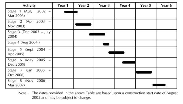
Project Interfaces
4.3.2
A number of current and proposed
projects have been identified which will have an interface with the Central
Reclamation Phase III project. These
projects are listed below and the construction and programme interface issues
associated with them are described in this chapter. The information presented in this chapter, particularly related
to programme interface issues, is based upon the best information currently
available and will be subject to change as further details particularly of proposed projects are developed further.
4.3.3
Projects which interface with the
Central Reclamation Phase III project are:
·
Central – Wan Chai Bypass Project;
- The
structural works for the Central – Wan Chai Bypass tunnel located within the
CRIII site will be constructed as entrusted works to the CRIII project, no
programme interface issues are present. Potential impacts from the construction
of the tunnel structural works are included in this EIA assessment.
·
Central Government Complex Project;
- The
programme for construction of the Central Government Complex is not fixed as
advised by the Architectural Services Department. In addition, there are no construction details available for this
project to enable cumulative impacts, if any, to be incorporated into this EIA
Study.
·
Redevelopment of Police Headquarters (Phase
III) Project;
- The
Police Headquarters redevelopment construction period overlaps slightly with
the CRIII construction project with a target date for opening in early 2003.
The location on Arsenal Street is sufficiently distant that cumulative impacts
would not be anticipated.
·
Hong Kong Station Extended Overrun Tunnel
Project;
- Environmental
Impacts arising from this project are included in this EIA assessment.
·
Central, Western and Wan Chai West Sewerage
Project;
- The
Central, Western and Wan Chai West Sewerage Project(CW3) comprises of
reconstruction of interceptors and reticulation sewer system, two trunk sewers
(between Smithfield and Pottinger Street and between Ice House Street and Wan
Chai East Screening Plant), two pumping stations (Central Pumping Station and
Wan Chai East Pumping Station) and an extension to the Wan Chai East
Screening Plant facilities. The CW3
works which will directly interface with the CRIII construction works will have
been completed before the start of the CRIII works. There will not, therefore,
be any overlap with the sewerage system works.
·
Justice Drive Extension Project;
- The
Justice Drive Extension (JDE) Project comprises of the construction of an
extension to the existing flyover across Queensway onto the CRIII site and an
extension from Supreme Court Road to Kennedy Road (known as the Queen’s Lines
Link). The Justice Drive Extension
Project is needed to enhance north-south connectivity between the north shore
and the hinterland areas of Hong Kong Island. The JDE is only about 450m long
and consists of prestressed cast in-situ bridge deck.
- The
northern most section of the proposed Justice Drive Extension (JDE) is located
within the CRIII construction works area (from Harcourt Road to the new primary
distributor road P2). This section of
JDE is largely elevated carriageway but at its extreme northern end it ramps down to connect with Road
P2 at an at-grade junction. There would
therefore only be minor construction interfaces between the JDE and CRIII
projects.
-
The programme for the Justice Drive
Extension Project is currently under review by Transport Department.
-
The Kennedy Road Improvements and
Queen’s Lines Link works have recently been degazetted. The need and scope of the Justice Drive
Extension, Kennedy Road Improvements and Queen’s Lines Link projects are,
however, still being reviewed by Transport Department.
·
North Hong Kong Island Drainage Master Plan
Study;
-
The currently proposed works are
outside the limit of the CRIII study area.
The tentative programme for construction works as provided by DSD is as
follows :
§
Lower Catchment Improvement Works Dec 2004 – July 2012
§
HK West Drainage Tunnel Works Sept 2006 – March 2011
Based upon the currently available information, no programme
interface issues are anticipated from this project.
·
Wan Chai Development Phase II Project;
The scope of the Wan
Chai Development Phase (WDII) project comprises:
§
Land formation for key transport
infrastructure and facilities including the Central-Wan Chai Bypass, the Island
Eastern Corridor Link, the North Island Line, ground level road connections to
facilitate through traffic from Central to Wan Chai, a possible fourth harbour
cross rail link, a Government Heliport, and a waterfront promenade with
associated / supporting facilities;
§
Reprovisioning / protection of
existing facilities and structures affected by the land formation; and
§
Extension, modification,
reprovisioning or protection of existing stormwater drainage outfalls, sewerage
outfalls, Wan Chai East Screening Plant and watermains affected by the land
formation.
The
WDII project provides essential land for the construction of major road and
rail infrastructure required to relieve congestion on strategic east-west
routes through Central, Wan Chai and Causeway Bay. The WDII Project also provides the opportunity to create an
attractive waterfront that can be used for a wide range of recreational and
tourism related uses and functions.
The
WDII works are currently planned to commence in early 2004 with completion of
the project by early 2010. Works would
commence in the Wan Chai and Causeway Bay areas in early 2004, with the works
adjacent to the CRIII area i.e. from Lung King Street up to the eastern side of
the Hong Kong Convention and Exhibition Centre commencing in early 2006.
·
North Island Line Railway Project;
The
North Island Line (NIL) comprises of the construction of a new underground
railway for the northern shore of Hong Kong Island. The railway will link the Airport Railway Hong Kong Station with
Fortress Hill Station with intermediate stations at Tamar and Exhibition.
Preliminary
design works for the NIL project commenced in late 2000. At present there is no fixed programme for
the construction of the NIL but it is proposed that some station protection
works for the NIL be constructed as part of the CRIII project. These are included in this CRIII assessment.
·
Refurbishment of Ferry Piers 4 – 6 Project.
- In
order to enhance the quality of the existing Ferry Piers 4 - 6 constructed as
part of the Central Reclamation Phase I project, the Government is to award a
contract to carry out refurbishment works to the piers. The refurbishment works are expected to
include provision of external glazing/cladding to the piers and replacement /
upgrading of existing facilities as required.
- It
is understood that the extent of the works has yet to be finalised and as such a programme for implementation of the works is not available.
4.3.4
Table 4.3 shows the timings of
interfacing projects.
Table 4.3
: Timings of Interfacing
Projects
5.
Traffic Noise
5.2.1
The Central Reclamation Phase III road
network will ultimately form part of an overall road network including the
Central Wan Chai Bypass and the road network constructed as part of the Wan
Chai Development Phase II Project. A
cumulative assessment has therefore been conducted to assess the noise impacts
associated with road traffic noise for the ultimate road network (ie. all roads
within 300m of the assessment locations were considered).
5.2.2
For the assessment traffic noise was
predicted using the methodology provided in the UK Department of Transport
Calculation of Road Traffic Noise (CRTN) 1988.
In accordance with this method, the assessment should be based on
projected peak hour flows for the worst year within 15 years after opening of
the roads. The roads proposed under the
CRIII project are scheduled to open in 2007.
Therefore, the traffic data for the year 2022 should be adopted for the
assessment. However, as the assessment
is a cumulative assessment, it has adopted the "latest" design year
for the ultimate road network of the CRIII, WDII and CWB projects - this being
2027. The adoption of this date
produces a conservative assessment for the CRIII road traffic noise.
5.2.3
As the traffic flows at the major roads
during the morning peak hour are generally higher than in the afternoon peak
hour, the morning peak hour traffic flows were used for modelling. The projected 2027 AM traffic flows as
provided by the WDII traffic consultant and endorsed by the Transport Department
are presented in Figure 5.1.
5.2.4
Traffic speeds for new CRIII roads
used in the assessment are summarised as follows:
Road Speed
Used in Assessment
Roads P1 and P2 70
km per hour
All other roads 50
km per hour
The speed for roads P1 and
P2, within the CRIII area, used in the assessment is the design speed for these
roads as advised by the Transport Department.
It should be noted, however, that the Transport Department have also
confirmed that all at-grade roads within CRIII will be subject to a speed limit
of 50km per hour (refer to Transport Department letter included in Appendix D
of this EIA Report).
5.2.5
For the cumulative assessment, the
road network, proposed building layout and all other features that could have
noise screening or reflective effects, were digitised into the road traffic
noise model. The roads were divided
into segments, each of which was assigned a road layout number. The road layout defined the road width,
opposing traffic lane separation, road surface type and traffic mix, flow and
road design speed. Hard ground as
defined in CRTN was assumed throughout the study area.
5.2.6
Representative noise prediction points
were set to determine the characteristics of traffic noise from the surrounding
roads. NR1-NR3 represented the assumed
quarters at the Central Barracks.
NR4-NR7 represented locations on the new ceremonial area to the north of
the proposed Central Government Complex and NSR8 represented the open air
theatre at the HKAPA. Noise prediction
points were also set for the City Hall (NR9) and HKAPA (NR10) as they are
classified as sensitive receivers by EPD despite the fact that they are
provided with air conditioning and hence do not rely on openable windows for
ventilation. The locations of the noise
prediction points are shown on Figure 2.1 (refer to Chapter 2). Where noise from the "new roads"
exceeds 70dB(A) and with its contribution to the overall noise level more than
1dB(A), mitigation measures would be considered in accordance with the
EIAO-TM. "New roads" in CRIII
include Roads P1, P2, D6, D8, D9 and D11.
5.2.7
A sample of the modelling listing file
for the cumulative assessment is included in Appendix D.
5.3.1
The modelling results for the
cumulative assessment as they apply to the CRIII noise prediction points are
summarised in Table 5.1.
Table 5.1 :
Predicted Cumulative Traffic Noise Levels for Year 2027
|
Location
|
Floor
|
Existing Road Contribution dB(A)
|
New Road Contribution dB(A)
|
Total dB(A)
|
|
NR11
|
1
|
71.1
|
69.1
|
73.2
|
|
|
7
|
71.1
|
69.1
|
73.3
|
|
|
13
|
70.9
|
68.6
|
72.9
|
|
|
19
|
70.5
|
68.2
|
72.5
|
|
|
25
|
70.0
|
67.6
|
72.0
|
|
|
31
|
69.6
|
67.0
|
71.5
|
|
NR22
|
1
|
56.0
|
77.6
|
77.7
|
|
|
3
|
56.0
|
76.7
|
76.8
|
|
|
5
|
56.2
|
75.6
|
75.6
|
|
NR33
|
1
|
51.1
|
76.8
|
76.8
|
|
|
3
|
51.5
|
76.5
|
76.6
|
|
|
5
|
52.5
|
76.2
|
76.2
|
|
|
7
|
53.7
|
75.8
|
75.8
|
|
NR4
|
GL
|
53.2
|
55.0
|
57.2
|
|
NR5
|
GL
|
55.4
|
54.3
|
57.9
|
|
NR6
|
GL
|
53.2
|
55.8
|
57.7
|
|
NR7
|
GL
|
57.6
|
52.1
|
58.7
|
|
NSR8
|
GL
|
64.7
|
55.7
|
65.2
|
|
NR9
|
1
|
60.3
|
70.2
|
70.6
|
|
|
3
|
60.2
|
70.2
|
70.6
|
|
|
5
|
60.2
|
70.1
|
70.5
|
|
|
7
|
60.1
|
70.0
|
70.4
|
|
|
9
|
60.1
|
69.8
|
70.3
|
|
NR10
|
1
|
78.1
|
67.6
|
78.5
|
|
|
3
|
78.1
|
68.0
|
78.5
|
|
|
5
|
77.5
|
68.5
|
78.1
|
|
|
7
|
77.1
|
68.6
|
77.6
|
|
|
9
|
76.5
|
68.6
|
77.2
|
Notes: 1: Only
1st to 3rd and 16th to 28th floors are for
residential use.
2: Only
Ground to 4th floors are for residential use.
3: Only
Ground to 6th floors are for residential use.
4: New
Roads to be constructed under CRIII works are illustrated on Figure 14.10
(refer to Chapter 14).
5.3.2
The modelling results showed that
there may be exceedance of the 70 dB(A) criteria at the Central Barracks facing
Road P2. The maximum predicted noise level is 77.7 dB(A) for the first floor of
Blake Block (NR2). However, the
Secretary for Security has indicated that all rooms at the affected facades are
provided with air conditioning and hence do not rely on open windows for
ventilation.
5.3.3
The predicted noise level at the HKAPA
open-air arena (NSR8) is low, due to the fact that the arena is depressed and
also has barriers of 2.75m in height around the top (refer also to paragraph
2.2.1.2). The ceremonial space has extensive screening by the buildings to the
south. Road P2 will also be depressed to run below the ceremonial area.
Predicated noise levels indicate that impacts should be acceptable for the
proposed site usage.
5.3.4
Noise levels were also calculated at
the City Hall (NR9) and the HKAPA (NR10).
These buildings are provided with air conditioning and hence do not rely
on openable windows for ventilation.
Noise levels at the HKAPA were calculated to be approximately
78 dB(A). The dominant source was
the existing Lung Wui Road. The
contribution Road P2 was not significant because of the distance (over 150
m). At the City Hall (façade facing
Road P2) noise levels were predicted to be 70-71 dB(A). As these two buildings are provided with air
conditioning and mechancial ventilation systems, it is expected that the indoor
noise environment would not be adversely affected.
5.4.1
In view of the predicted noise levels
at the HKAPA outdoor arena and ceremonial space within the Central Government
Complex, no specific noise mitigation measures are required for these sites.
5.4.2
Noise levels are predicted to exceed
the 70 dB(A) criteria at the Central Barracks. Direct mitigation measures in
the form of noise barriers are, however, not practicable at this location due
to the need to maintain sightline requirements at the Central Barracks main
entrance gate and the junctions of the adjacent Tim Wan Avenue/ Road P2 and
Edinburgh Place/ Road P2. Other direct
mitigation measures listed in Section 6.1, Annex 13 of the EIAO-TM are also
considered not practical. It should be
noted, however, that the affected facades are all provided with air
conditioning so internal noise levels are unlikely to be affected.
5.5.1
Potential road traffic noise impacts
have been assessed as part of a cumulative assessment considering both the CWB
and WDII projects as well as the CRIII project.
5.5.2
Predicted noise levels at the HKAPA
outdoor arena and ceremonial space to the north of the Central Government
Complex were found to be low due to their physical location relative to the
road network. As such no specific
mitigation measures are required for these sites.
5.5.3
Predicted noise levels at the City
Hall, HKAPA and Central Barracks were found to exceed the EIAO-TM noise
criteria. Direct mitigation measures
were found to be not practical.
However, these buildings are all equipped with air-conditioning systems
and do not rely on openable windows for ventilation. As such, the indoor noise environment of these buildings is not
expected to be adversely affected by traffic noise and no additional mitigation
measures are required for them.
6.1.1
Three ventilation buildings are
proposed for the CWB to maintain the tunnel air quality to within the EPD air
quality guidelines. The ventilation buildings will, however, be a source of
fixed noise from fresh air supply/extraction fans and their associated vent
shafts. The seawater pumping stations will also be fixed noise sources. Given
that they are below ground and buffered from potential receivers by open space
areas, they are not likely to have a significant impact. The ventilation
structure for the Hong Kong Station Extended Overrun Tunnel (EOT) will also be
a fixed noise source.
6.2.1
There will be
ventilation buildings for the CWB located on WDII and Central Reclamation Phase
1. There will be a ventilation building for the EOT within CRIII, 30m from
Amythyst Block of the Central Barracks.
The seawater pumping stations will be to the
north of the reclamation. The
ventilation structures and pumping stations will have the potential to impact
on the users of the promenade.
6.3.1
The noise from the ventilation
structures and pumping stations are subject to statutory control, hence the
designs will have to ensure that the required criteria are met at the potential
NSR of HKAPA. As the sensitive receiver
is located in the urban area and is directly affected by the influencing
factors of Harcourt, Gloucester Roads and Fenwick Pier Street, the area
sensitive rating is assumed to be “C” for the purpose of assessment in the EIA
(based on the definitions in the ‘TM for the Assessment of Noise Places other
than Domestic Premises, Public Places or Construction Sites’ of the Noise
Control Ordinance). According to Table 1A Noise Standards for Planning
Purposes, EIAO TM, the predicted maximum noise level should be 5 dB(A)
below the appropriate Acceptable Noise Levels (ANL) shown in Table 3 of the TM for the Assessment of
Noise from places Other than Domestic Premises, Public Places. In any event, the Area Sensitivity Rating
assumed in this report is for indicative assessment only given that : details
of plant and equipment to be located within these facilities are not available;
and the building layouts are only provisional.
It should be noted that fixed noise sources are controlled under section
13 of the NCO. At the time of
investigation, the Noise Control Authority shall determine noise impact from
concerned fixed noise sources on the basis of prevailing legislation and
practices being in force, and taking account of contemporary conditions/situations
of adjoining land uses. Nothing in this
EIA shall bind the Noise Control Authority in the context of law enforcement
against all the fixed noise sources being assessed.
6.3.2
The distance between the Central
Barracks and the EOT ventilation shafts is 65 metres. Although the design of the ventilation shafts will have to
satisfy the criteria set out in the Noise Control Ordinance, an assessment of
the potential noise impact on the Central Barracks has been undertaken. For the assessment the Central Barracks was
assumed to have a conservative Area Sensitivity Rating of “B”. The Acceptable Noise Level (ANL) for an ASR
of “B” under the IND-TM is 55dB(A) at nighttime. However, as the EIAO-TM recommends that the noise standard for
fixed noise source is 5dB(A) below the appropriate ANL, a noise criteria of
50dB(A) at the Central Barracks was adopted for the assessment. Given the relative separation of the
ventilation shafts and the Central Barracks, a maximum Sound Power Level of
90dB(A) could be accepted in order to satisfy the noise criteria of
50dB(A). The MTRC, who will be
responsible for the design of the ventilation shafts have confirmed that it
will be practicable to limit the sound power level at the shafts to
90dB(A). It should, however, be noted
that nothing in the EIA Report should bind the Noise Control Authority in the
context of law enforcement against all fixed noise sources being assessed
(refer also to paragraph 6.3.1).
6.3.3
Noise impact from the CWB ventilation
buildings on existing sensitive receivers falls outside the scope of the CRIII
project. The landuses proposed within the CRIII project will not be sensitive
to noise from the CWB ventilation buildings.
6.3.4
It is unlikely that noise levels
generated by the pumping stations will adversely impact the HKAPA due to their
position underground and the distance between the sound source and the
receiver.
6.4.1
The design of the EOT ventilation
buldings and ventilation shafts will be rquired to meet the requirements of the
NCO.
7.
Construction Noise
7.1.1
The construction phase of CRIII has
the potential to produce impacts from noise.
Although transient in nature, these can cause disturbance to work,
leisure and sleep. However, because of the nature of the sources there is usually
scope for mitigating the impacts.
7.2.1
There are no residential developments
or other noise-sensitive uses within 300m of the works area which rely on
opened windows for ventilation. The quarters at the Central Barracks may be
considered noise sensitive, although all residential rooms have air
conditioning and do not, therefore rely on openable windows for ventilation.
The only other potential noise sensitive receiver is the Hong Kong Academy for
Performing Arts. The building is, however, centrally ventilated and
air-conditioned and the only sensitive use is the outside open air arena. This
venue is rarely used, however, and is at a lower level than the surroundings.
There are also 2.75m barriers around the top of the arena (refer also to
paragraph 2.2.1.2).
7.3.1
Introduction
7.3.1.1
Under the NCO, construction noise
permits would be required for work during restricted hours (1900 to 0700 hours,
all day Sundays and public holidays). This is the main method for controlling
construction noise during restricted hours. The daytime criteria for
construction noise are included in Chapter 3 of this report. In addition,
recent revisions to the Technical Memorandum on Noise from Percussive Piling
create more stringent controls. Alternative methods of piling (such as bored or
vibratory piles) are, however, likely to be used during the construction of the
new public landing steps and culverts.
Despite any description or assessment made in this EIA on construction
noise aspects, there is no guarantee that a Construction Noise Permit (CNP)
will be issued for the project construction.
The Noise Control Authority will consider a well-justified CNP
application, once filed, for construction works within restricted hours as
guided by the relevant Technical Memorandum issued under the Noise Control
Ordinance. The Noise Control Authority
will take account of contemporary conditions/ situations of adjoining land uses
and any previous complaints against construction activities at the site before
making his decision on granting a CNP.
Nothing in this EIA shall bind the Noise Control Authority in making his
decision. If a CNP is to be issued, the
Noise Control Authority shall include in it any condition he thinks fit. Failure to comply with any such conditions
will lead to cancellation of the CNP and prosecution action under the NCO.
7.3.1.2
Potential noise impacts from the
development of the CRIII may arise from the following activities and operations
:
·
demolition of existing water front structures;
·
dredging work and seawall construction;
·
piling and construction work for pumping
stations, PLA Berth, public landing steps, reprovisioned ferry pier, culverts
and associated services;
·
reclamation in-filling including noise from
filling and compaction activities;
·
haulage vehicles (although minimum in number
since transportation of spoil removed and reclamation materials will be by
barge);
·
infrastructure construction (e.g. utilities,
CWB tunnel, Hong Kong Station Extended Overrun Tunnel, North Island Line protection works, Road P2
Underpass and surface road network); and
·
hinterland drainage improvement works.
7.3.2
Construction Phasing
7.3.2.1
The construction of CRIII can be
broadly set out in 8 stages covering a 55 month work programme. The main
elements of each stage are detailed in section 4.2 and are illustrated in
Figures 4.1 and 4.2 (refer to Chapter 4). In brief, the construction phasing is
as follows: the construction work begins at the western end of the reclamation,
including the construction of a reprovisioned ferry pier (Ferry Pier 8) and
public landing steps; work then starts on the central section and the existing
pier structures (Star Ferry Piers and Queen’s Pier) are demolished; the area
between the western and central parts is then completed; and the eastern
portion is also filled in.
7.4.1
There is some overlap between the
Central Reclamation Phase III construction programme and those of the Wan Chai
Development Phase II and Central-Wan Chai Bypass projects. A cumulative assessment has therefore been
conducted to assess the construction noise impacts arising from the works of
the three projects, considering works from these other projects which fall
within 500m of the receiver locations.
The Justice Drive Extension and Central Government Complex projects may
have the potential to add to the impacts on CRIII NSRs. However, the programme for both projects are
unknown at this time and therefore it was not possible to include construction
activities from these projects into the cumulative assessment.
7.4.2
The cumulative construction noise
assessment was carried out on a monthly basis from the CRIII project
commencement in August 2002. The
construction tasks of the three projects that take place concurrently within 500m
of a given NSR were considered to contribute to the cumulative impact at that
NSR.
7.4.3
In accordance with the EIAO, the
methodology outlined in the GW-TM was used for the cumulative assessment of
construction noise (excluding percussive piling). Sound Power Levels (SWLs) of the equipment were taken from Table
3 of this TM. Where no SWL is present
in the TM, reference was made to BS5228, previous similar studies or from
measurements taken at other sites in Hong Kong.
7.4.4
In the cumulative assessment, it was
assumed that all PME items required for a particular construction activity are
located at the notional or probable source position of the segment where the
activity is performed. The assessment
was based on the cumulative SWL of PME likely to be used for each location,
taking into account the construction period in the vicinity of the receiver
location. To predict the noise level,
the PME was divided into groups required for each discrete construction
task. The objective was to identify the
worst case scenario representing those items of PME that would be in use
concurrently at any given time. The
sound pressure level of each construction task was calculated, depending on the
number of plants, their frequency of operation, and their distance from
receivers. The noise levels at NSRs were
then predicted by adding up the SWLs of all concurrently construction tasks.
7.4.5
A positive 3 dB(A) façade correction
was added to the predicted noise levels in order to account for the façade
effect at each NSR.
7.4.6
Dredging, seawall and reclamation
filling works has been assumed to be conducted for 16 hours per day on weekdays
i.e. from 0700 to 2300 hours. Other
construction activities are expected to
be undertaken during normal daytime working hours i.e. from 0700 to 1900 hours
on any day not being a Sunday or Public Holiday. Assessment was therefore undertaken for both normal day time and
restricted hours periods. It should
also be noted that other essential works may need to be conducted during
restricted hours due to limitations on road closures, shut down of building air
conditioning systems for transfer of supply etc. These works which may include utility and pipeline connection
works, drainage improvement works at Connaught Place etc. would, however, be
subject to the issue of a CNP (refer to paragraph 7.3.1.1).
7.4.7
Percussive piling may be required for
marine pier foundation works. A CNP is
required for the carrying out of percussive piling between 0700 and 1900 hours
on any day not being a general holiday. Percussive piling is prohibited outside
these hours. PP-TM sets out the
requirements for working and determination of the permitted hours of
operation. The permitted hours of
operation for carrying out of percussive piling work, subject to the issuance
of a CNP, are listed below.
|
Amount by which Corrected Noise Level
(CNL) exceeds Acceptable Noise Level (ANL), CNL-ANL
|
Permitted hours of operation on any day
not being a general holiday
|
|
10 dB(A) <
CNL-ANL
|
0800 to 0900 and
1230 to 1330 and 1700 to 1800
|
|
0 dB(A) <
CNL-ANL £
10 dB(A)
|
0800 to 0930 and 1200
to 1400 and 1630 to 1800
|
|
CNL - ANL £ 0
dB(A)
|
0700 to 1900
|
7.4.8
The plant inventory list for the CRIII
works confirmed by the Engineer as
being practical and practicable for completing the works within the scheduled
timeframe, along with those of the concurrent WDII and CWB projects are listed
in Appendix E for normal working hours and in Appendix G for restricted
hours. It should be noted, however,
that the plant inventory list has been derived for an assumed construction
method and sequence based upon best available information at the time of
preparing this report. The construction
activities considered in the cumulative assessment, as they apply to the CRIII
project, during each quarter for each CRIII NSR and the cumulative construction
noise levels for the same NSRs are presented in Appendices F and H for normal
working hours and restricted working hours respectively.
7.5.1
Without mitigation and shielding,
there is potential to exceed the 75 dB(A)
cirteria at all locations. Tables 7.1 and 7.2 show the range of noise
levels experienced at the representative noise sensitive receiver and noise
prediction loctions without mitigation.
Table 7.1: Summary of
Unmitigated Construction Noise Levels Duirng Normal Working Hours
|
NR/NSR (refer to Figure 2.1)
|
Minimum dB(A)
|
Maximum dB(A)
|
|
NR1
|
62
|
87
|
|
NR2
|
63
|
93
|
|
NR3
|
64
|
94
|
|
NSR8
|
56
|
81
|
|
NR9
|
65
|
93
|
Table 7.2: Summary of
Unmitigated Construction Noise Levels Duirng Restricted Hours
|
Activity
|
Prediction Point
|
Minimum dB(A)
|
Maximum dB(A)
|
|
Dredging and Filling
Works (1900 - 2300 hours)
|
Mandarin Hotel
|
58
|
69
|
|
Drainage Improvement
Works in Connaught Place
|
Mandarin Hotel
|
76
|
76
|
7.6.1
In order to reduce the noise levels
indicated in Tables 7.1 and 7.2, direct noise mitigation measures such as
adopting quiet plant, errection temporary noise barriers and inclusion of
existing screening barriers have been considered in a further noise assessment. In this assessment, the recommended quiet
PMEs have been taken from BS 5228 : Part 1 : 1997 and are known is be available
in Hong Kong. As confirmed by the
Engineer, the quiet PMEs adopted for this assessment are considered practicable
in completing the CRIII works within the scheduled timeframe (refer also to
paragraph 7.4.8). The quiet PMEs used
in this assessment are :
|
Equipment Type
|
BS Ref
|
SWL, dB(A)
|
|
Air compressor
|
Table C7/16
|
96
|
|
Paver
|
Table C8/24
|
101
|
|
Hand-held breaker
|
Table C2/10
|
110
|
|
Breaker, excavator mounted
|
Table C8/13
|
110
|
|
Bulldozer
|
Table C3/27
|
109
|
|
Concrete lorry mixer
|
Table C6/35
|
100
|
|
Concrete pump
|
Table C6/36
|
106
|
|
Crane
|
Table C7/114
|
101
|
|
Dump truck
|
Table C9/27
|
105
|
|
Excavator / loader
|
Table C3/97
|
105
|
|
Grader
|
Table C9/11
|
110
|
|
Lorry
|
Table C9/27
|
105
|
|
Poker
|
Table C6/32
|
100
|
|
Road roller
|
Table C8/27
|
104
|
|
Vibratory roller
|
Table C3/116
|
106
|
With
the use of quiet PMEs the noise levels at NSR/ NRs are reduced. The predicted noise levels for this
assessment (mitigated) are summarised in Tables 7.3 and 7.4. Full details of the noise levels for this
assessment are provided in Appendices F and H.
Table 7.3 :
Summary of Mitigated Construction Noise Levels During Normal Working Hours
|
NR/NSR
(refer to Figure 2.1)
|
Minimum dB(A)
|
Maximum dB(A)
|
|
NR1
|
61
|
79
|
|
NR2
|
62
|
84
|
|
NR3
|
63
|
84
|
|
NSR8
|
55
|
73
|
|
NR9
|
64
|
83
|
Table 7.4 : Summary of Mitigated Construction Noise
Levels During Restricted Hours
|
Activity
|
Receiver
|
Minimum dB(A)
|
Maximum dB(A)
|
|
Dredging and Filling
Works (1900 – 2300 hours)
|
Mandarin Hotel
|
58
|
69
|
|
Drainage Improvement
Works in Connaught Place
|
Mandarin Hotel
|
66
|
66
|
7.6.2
The predicted noise levels at the
Central Barracks (NR1, NR2, NR3) exceed the 75dB(A) guideline, in particular
during the periods when the Extended Overrun Tunnel (EOT), North Island Line
Protection Works (NIL) and road/drainage works are in progress at the northern
boundary of the Central Barracks. In
order to reduce the construction noise levels at the Central Barracks during
these periods, noise barriers (in the form of purpose built site hoarding
between 3 - 5 m height with surface density of at least 7 kgm-3 and
cranked top) placed as close as possible to the works should be adopted for the
EOT, NIL and road/drainage works immediately to the north of the Central
Barracks. These would reduce noise
levels by at least 5dB(A). The exact
details of these noise barriers, including final dimensions, will be determined
during detailed design when exact construction activities are more clearly
defined. It should, however, be noted
that the buildings within the Central Barracks are already provided with air
conditioning and therefore the noise levels predicted after the adoption of
quiet PMEs and movable noise barriers (for EOT, NIL and road/drainage works to
the immedate north of the Central Barracks) would not result in adverse noise
impacts to the buildings.
7.6.3
The predicted noise levels at the City
Hall (NR9) also exceed the 75dB(A) guideline, in particular during the period
when Culvert F piling works are in progress to the immediate north of the City
Hall. In order to reduce the
construction noise levels at the City Hall during this period, noise barriers
(in the form of purpose built site hoarding between 3-5 in height with surface
density of at least 7 kgm-2 and cranked top) placed as closed as possible
to the works should be adopted for Culvert F piling works immediately to the
north of the City Hall. These would
reduce noise levels by at least 5dB(A). The exact details of these noise
barriers, including final dimensions, will be determined during detailed design
when exact construction activities are more clearly defined. It should, however, be noted that the City
Hall has central air conditioning and therefore the nosie levels predicted
after the adoption of quiet PMEs and movable noise barriers (for Culvert F
piling works to the immedate north of the City Hall) would not result in
adverse noise impacts to the City Hall.
7.6.4
The noise levels at the HKAPA open air
arena as presented in Table 7.3, from CRIII works only, are predicted not to
exceed the 75dB(A) guideline. The
75dB(A) guideline is appropriate as the HKAPA have confirmed that the facility
does not rely on unaided voice communication and is not used for educational
purposes. The cumulative assessment of
both CRIII and WDII works (presented in Appendix F) indicates that the maximum
noise level at the HKAPA open air arena will be 75 dB(A). Whilst this level is equivalent to the
guideline level, the screening effect of the existing barriers at the top of
the arena will reduce the predicted noise levels by up to 5 dB(A) and ensure no
exceedance of the guideline.
7.6.5
For construction works during
restricted hours, the predicted noise levels at the Mandarin Hotel from
Stormwater Drainage Im provement Works at Connaught Place is 66 dB(A) in the
worst case (see Table 7.4). These works
have to be conducting during restricted hours due to limitations on road
closure of this busy road in the Central District. However, the location and orientation of Jardine House
effectively shields the Mandarin Hotel from noise generated by these
works. No direct mitigation measures
would therefore be required to satisfy nighttime noise guidelines for the
Mandarin Hotel.
7.6.6
Dredging, seawall and reclamation
filling works have been assumed to be conducted for 16 hours per day i.e. up to
11pm. A Construction Noise Permit (CNP)
will be required, with the application for the CNP and responsibility for
maintaining the noise limits to rest with the Contractor. The assessment indicates that noise levels
would be up to 69 dB(A) at the Mandarin Hotel.
On the assumption that the ASR will be "C" due to the
proximity of Connaught Road, the Contractor should be able to obtain a CNP for
construction works up to 11pm. However,
there are some factors affecting the assessment results of a CNP appication,
such as the assigning of Area Sensitivity Rating, Acceptable Noise Levels
etc. The Noise Control Authority would
decide these at the time of assessment of such an application based on the
contemporary situations/ conditions. It
should be noted that the situations/ conditions around the site may change from
time to time. The Authority may make
correction for multiple permit situations if in the opinion of the Authority
the NSR will be materially affected by noise from construction work associated
with more than one CNP. The Authority
may make such corrections to the relevant noise levels as it considers
appropriate having regard to standard acoustical principlies and practices. The
Area Sensitivity Ratings assumed in this EIA Report are for indicative
assessment only (refer also to paragrah 7.3.1.1).
7.6.7
Connections to cooling water pipes and
utilities may also require to be carried out duirng restricted hours, as road
closures will be necessary. The
Contractor should approach the Noise Control Authority to apply for a
Construction Noise Permit before the works commence. In applying for a Construction Noise Permit, the applicant (i.e.
the Contractor) shall be required to demonstrate to the satisfaction of the
Noise Control Authority that the Sound Power Level of the quiet PMEs and/or the
noise reduction effect of other mitigation measures to be adotped, otherwise,
values in the GW-TM would be used in assessing the application.
7.6.8
In addition to the mitigation
measures, detailed earlier in this section, the good site practices listed
below should also be adopted by the Contractor to further ameliorate the noise
impacts. Although the noise mitigating
effects are not easily quantifiable and the benefits are specific to this site
and operating conditions, good site practices are easy to implement and do not
impact upon the works schedule.
·
Only well-maintained plant should be operated
on-site and plant should be serviced regularly during the construction
programme.
·
Silencers or mufflers on construction
equipment shoud be utilised and should be properly maintained during the
construction programme.
·
Mobile plant, if any, should be sited as far
away from noise sensitive facilities as possible.
·
Machines and plant (such as trucks) that may
be in intermittent use should be shut down between works periods or should be
throttled down to a minimum.
·
Plant known to emit noise strongly in one
direction should, wherever possible, be orientated so that the noise is
directed away from nearby noise sensitive facilities.
·
Material stockpiles and other structures
shoud be effectively utilised, wherever practicable, in screening noise from
on-site construction activites.
7.7.1
The provision of noise mitigation
measures in the form of limiting equipment sound power levels (i.e. use of
quiet equipment) and movable noise barriers (in the form of purpose built site
hoarding) will effectively mitigate against high noise levels, particularly at
the Central Barracks and City Hall. Although
noise levels after mitigation slightly exceed this 75dB(A) guideline, all
affected buildings are, however, provided with air-conditioning and therefore
adverse noise impact is not expected at the indoor areas of these buildings.
7.7.2
CNPs will be required for construction
works to be carried out during restricted hours i.e. 7pm to 7am on any day not
being a general holiday and at any time on a general holiday, including Sunday.
8.
operational AIR QUALITY
8.1.1
During the operational phase,
vehicular emissions from the proposed primary distributor and the associated road network will be the major sources of air
pollutants. There will also be emissions from the CWB ventilation
buildings. As advised by the MTRC the
ventilation shafts associated with the Hong Kong Station Extended Overrun Tunnel
(EOT) will, under normal operating conditions, only emit clean, unpolluted air
and will, therefore, not affect air quality in the area. Only in the event of a
fire would smoke be emitted but this would only be a short-term incident under
emergency conditions and, due to its low probability of occurrence, is not
considered to be a major impact.
8.2.1
The background air quality conditions
are dominated by the influence of traffic exhaust emission pollutants. There
are no major existing or proposed industrial activities in the study area and
the urban area consists mainly of commercial premises, hotels and other uses
such as City Hall, Ferry Piers, Post Office, Police Headquarters and Central
Barracks. The nearest EPD fixed air quality monitoring station is the Central /
Western station. Concentrations of TSP and NO2 are monitored at the
station. Annual averages of the pollutants for the year 1999 were employed as
the background of the study area. Table 8.1 gives the measured concentrations.
Table 8.1
: Measured Annual Average
Pollutant Levels µg/m3
at Central/Western Station (1999)
|
Pollutant
|
Average (µgm-3)
|
|
Nitrogen Dioxide (NO2)
|
56
|
|
Carbon Monoxide (CO)
|
1,179
|
|
Total Suspended Particulates (TSP)
|
81
|
|
Respirable Suspended Particulates (RSP)
|
53
|
8.3.1
Air Quality Objectives (AQOs) are
defined as ambient standards, therefore, all buildings (or fresh air intakes)
in the adjacent area will be considered sensitive. There are no residential
developments in the study area but any proposed active recreational uses are
considered sensitive to air quality. Representative air sensitive receivers
(ASRs) have been identified in Section 2.2.2.
8.4.1
Introduction
8.4.1.1
Potential air quality impacts during
the operational phase of the CRIII project include the following pollutant
sources :
·
Background pollutant levels within and
adjacent to the CRIII reclamation area;
·
Vehicle emissions from open sections of
existing and planned road networks;
·
Tunnel portal and ventilation building
emissions from the CWB; and
·
Portal emissions from the existing
underpasses, the planned Road P2 underpass and the planned deckovers along Road
P1, Road P2 and Connaught Road Central.
8.4.2
Vehicle Emissions from Open Sections
of Existing and Planned Road Networks
8.4.2.1
The Central Reclamation Phase III road
network will ultimately form part of an overall road network including the
Central Wan Chai Bypass and the road network constructed as part of the Wan
Chai Development Phase II project. A
cumulative assessment has therefore been conducted to address the air quality
impacts associated with the ultimate road network.
8.4.2.2
The CALINE4 dispersion model was used
for calculation of the 1-hour NO2, 24 hour NO2, 24-hour
RSP and 1-hour CO concentrations. Open
sections of existing and planned road networks within 500 m from the boundary
of the CRIII reclamation area were considered in the model and are listed as
follows :
·
New roads in CRIII;
·
New roads in WDII;
·
The CWB; and
·
The existing roads (including Gloucester
Road, Harcourt Road, Connaught Road Central, Queensway, and Des Veoux Road
Central).
8.4.2.3
For the worst case scenario, the
morning peak hour traffic flow and vehicle mix predicted by the WDII traffic
consultant, for the ultimate road network in 2027, was used for the cumulative
assessment. Figure 5.1 shows the
projected 2027 morning peak hour traffic flows and vehicle composition (refer
to Chapter 5).
8.4.2.4
The most up-to-date vehicular emission
factors (Fleet Average Emission Factors – EURO3 Model) available from the EPD
are for the year 2011 and these were adopted for the cumulative
assessment. It is, however, believed
that the 2027 emission rates will be lower than those of 2011, as more vehicle
will be fitted with advanced emission control system in the future. The predicted results are therefore
conservative.
8.4.2.5
The composite emission factors for the
road links were calculated as the weighted average of the emission factors of
different types of vehicles. Four
vehicle categories were adopted. As a
worst-case scenario, maximum emission factors within the same category were
used for the assessment. The vehicular
emissions for different vehicle categories are listed in Table 8.2.
Table
8.2 : Emission Factors for Year 2011
for Different Vehicle Categories (EURO3)
|
Pollutant
|
Emission Factors for 2011 (EURO3), g/km - veh
|
|
PV (1)
|
LGV (2)
|
HGV (3)
|
PT (4)
|
|
NOx
|
0.73
|
1.53
|
3.84
|
6.8
|
|
RSP
|
0.03
|
0.16
|
0.53
|
0.69
|
|
CO
|
1.87
|
2.25
|
6.45
|
7.38
|
Notes: (1) Private Vehicles (PV) include taxi and
private car.
(2)
Light Goods
Vehicles (LGV) include passenger van and light goods vehicle.
(3)
HGV stands
for Heavy Goods Vehicles.
(4)
Public
Transport (PT) includes all types of buses.
8.4.2.6
Peak hour traffic flow within and
adjacent to the CRIII development area will occur during daytime. The night time traffic flow will be low
(about 10% of peak flow) and the worst case scenario will therefore not be
encountered during night time.
8.4.2.7
In order to calculate the cumulative
pollutant concentrations from different models (CALINE4 and ISCST3) in the
later part of the assessment, the dispersion modelling was undertaken using 360
predefined separate meteorological conditions and the highest predicted
pollutant concentration amongst the 360 wind directions were identified. The following summarises the meteorological
conditions adopted in the air quality modelling using the CALINE4 model :
·
Wind speed : 1 m s-1
·
Wind direction : 360
wind directions
·
Resolution : 1°
·
Wind variability : 24°
·
Stability class : D
·
Surface roughness : 1
m
·
Mixing height : 500 m
8.4.2.8
The CALINE4 model calculates hourly
concentrations only. The 24-hour
average concentrations were calculated by multiplying the peak 1-hour
concentration by a factor of 0.4.
8.4.2.9
Sample Computer Output from the CALINE
4 model used for the cumulative vehicle emission impact assessment are included
in Appendix I.
8.4.3
Portal and Ventilation Building
Emissions
8.4.3.1
The Industrial Source Complex Short
Term (ISCST3) dispersion model was used to predict portal and ventilation
building emissions that would affect the three project sites of CRIII, WDII and
CWB (as part of the cumulative air quality modelling assessment).
8.4.3.2
Tunnel portal and ventilation building
emissions that may affect the CRIII ASRs are :
·
Tunnel portal and ventilation building
emissions from the tunnel section of the CWB;
·
Portal emissions from the planned Road P2
underpass;
·
Portal emissions from the existing
underpasses along Connaught Road Central; and
·
Portal emissions from the planned deckovers
along Road P1, Road P2 and Connaught Road Central.
It
should be noted that the air quality inside the planned Road P2 underpass and
deckovers along Road P1, Road P2 and Connaught Road Central will need to meet
the air quality guidelines stipulated in the Practice Note on Control of Air
Pollution in Vehicle Tunnel.
8.4.3.3
For the CWB, three ventilation
buildings have been proposed to discharge the tunnel vitiated air :
·
West Ventilation Building (WVB) : for
extracting vitiated tunnel air from Trunk Road Westbound;
·
Central Ventilation Building (CVB) : for
extracting vitiated tunnel air from Slip Road F and Wanchai Bypass Westbound;
·
Eastern Ventilation Building (EVB) : for
extracting vitiated tunnel air from Trunk Road Eastbound and Wanchai Bypass
Eastbound.
8.4.3.4
The locations of the portals and
ventilation building that may affect the CRIII ASRs are shown on Figure 8.1.
8.4.3.5
The portal and ventilation building
emissions as provided by the ventilation design engineer are summarised in
Table 8.3
Table 8.3 : Portal and
Ventilation Building Emissions
|
Type
|
Emission Rate (g s-1)
|
|
NO2*
|
CO
|
RSP
|
|
Portal Emission
|
|
Trunk Road Eastbound
|
0
|
0
|
0
|
|
Wanchai Bypass Eastbound
|
0.02050
|
0.90250
|
0.00725
|
|
Slip Road F
|
0
|
0
|
0
|
|
Wanchai Bypass Westbound
|
0.09225
|
4.47750
|
0.02602
|
|
Trunk Road Westbound
|
0.11750
|
4.60500
|
0.03819
|
|
Ventilation Building Emission
|
|
EVB – Trunk Road Eastbound
|
0.84271
|
18.14583
|
0.26674
|
|
EVB – Wanchai Bypass Eastbound
|
0.05668
|
2.49515
|
0.02176
|
|
CVB - Slip Road F
|
0.12222
|
2.35556
|
0.01092
|
|
CVB – Wanchai Bypass Westbound
|
0.04884
|
2.37044
|
0.00867
|
|
WVB – Trunk Road Westbound
|
0.38364
|
14.23364
|
0.11457
|
Note: * Based on 20% NO2/NOx conversion
in ambient condition.
8.4.3.6
The preliminary design of the
ventilation buildings (including minimum discharge heights, exhaust directions,
handling capacity of ventilation buildings and exit velocity) is summarised in
Table 8.4. For the cumulative air
quality assessment, the minimum height of stack was used as a worse case
scenario in modelling.
Table 8.4 : Design of
Ventilation Buildings
|
|
Maximum capacity
(m3 s-1)
|
Exit velocity
(m s-1)
|
Minimum discharge height
(meters above ground)
|
Exhaust direction
|
|
EVB – Trunk Road Eastbound
|
570
|
8
|
25
|
Vertical
|
|
EVB – Wanchai Bypass Eastbound
|
200
|
8
|
25
|
Vertical
|
|
CVB – Slip Road F
|
180
|
8
|
15
|
Vertical
|
|
CVB – Wanchai Bypass Westbound
|
100
|
8
|
15
|
Vertical
|
|
WVB – Trunk Road Westbound
|
420
|
8
|
15
|
Vertical
|
8.4.3.7
The portal emissions (NO2,
RSP and CO) for the existing underpasses along Connaught Road Central, the
planned underpass at Road P2 and the planned deckovers of Road P1, Road P2 and
Connaught Road Central were calculated based on the vehicle emissions (EURO3)
and the vehicle flow rate in 2027 as provided by the WDII traffic consultant.
8.4.3.8
Portal emissions were modelled in
accordance with the Permanent International Association of Road Congress Report
(PIARC, 1991). The volume of pollutants
was assumed to eject from the portal as a portal jet such that 2/3 of the total
emissions were dispersed within the first 50 m of the portal and 1/3 of the
total emissions within the second 50 m of the portal.
8.4.3.9
As indicated in Section 8.4.2.7, 360
predefined separate meterologoical conditions were used in the cumulative
assessment. The following summarises
the meteorological conditions adopted in the air quality modelling using the
ISCST3 model :
·
Wind speed : 1 m s-1
·
Wind direction : 360
wind directions
·
Resolution : 1°
·
Stability class : D
·
Mixing height : 500 m
·
Emission temperature : 7°
above ambient
8.4.3.10
A sample of computer output from the
ISCST3 modelling is provided in Appendix J.
8.4.4
Combined Impact of Road Traffic and
Portal / Ventilation Building Emissions
8.4.4.1
As indicated in Section 8.4.1, the
emissions from open sections of existing and planned roads will combine with
emissions from tunnel portal and ventilation buildings for the CWB and new and
proposed road underpasses and deckovers to affect the air quality at the CRIII
ASRs. The pollutant concentrations at
the CRIII ASRs, at different wind directions (1 degree resolution) have
therefore been predicted by combining the data from both the CALINE 4 and ISCST
3 models, where
·
The CALINE 4 model was used to predict the
open road emissions from the existing and planned road networks of CRIII, WDII
and CWB; and
·
The ISCST3 model was used to predict road
portal and ventilation shaft emissions.
8.4.4.2
The combined pollutant concentrations
at each CRIII ASR, at each specific wind direction, were calculated by summing
the results from the two models. The
highest pollutant concentrations at each CRIII ASR, amongst the 360 wind
directions, was identified as the worst predicted combined pollutant concentration.
8.5.1
Taking into
account the vehicle emissions from open road networks, portal and ventilation
building emissions from the CWB, existing and planned underpasses and deckovers
and the background pollutant concentrations, the cumulative 1-hour NO2,
24-hour NO2, 24-hour RSP and 1 hour CO concentrations at 360 wind
directions were predicted and the highest pollutant concentration at each
existing and future CRIII ASRs (refer to Tables 2.1 and 2.2 in Chapter 2) under
the worst wind direction were calculated.
8.5.2
In order to have a full picture of the
vertical dispersion, pollutant concentrations at various levels (1.5m to 150m
above ground) were calculated. From
those results it was found that the maximum predicted pollutant concentrations
were at 1.5m above ground. Table 8.5
summaries the predicted cumulative 1-hour NO2, 24-hour NO2,
24-hour RSP and 1-hour CO concentrations at 1.5m above ground.
Table 8.5 : Predicted Cumulative 1-hour Average NO2
, 24-hour Average NO2,
24-hour Average RSP and 1-hour Average CO concentrations at the CRIII Existing
and Future ASRs at 1.5m above ground level
|
|
|
Predicted
Concentration (mgm- 3 )*
|
|
ASR
No.
|
ASR
Description
|
1-Hour
NO2
|
24-Hour
NO2
|
24-Hour
RSP
|
1
Hour CO
|
|
A6
|
Crocodile Building
|
212
|
118
|
80
|
2718
|
|
A7
|
Hang Seng Bank Headquarters
|
237
|
128
|
84
|
2998
|
|
A8
|
Exchange Square III
|
264
|
139
|
89
|
3076
|
|
A9
|
Exchange Square I & II
|
153
|
95
|
71
|
2004
|
|
A10
|
Exchange Square I & II
|
192
|
110
|
77
|
2324
|
|
A11
|
Jardine House
|
144
|
91
|
69
|
1902
|
|
A12
|
Jardine House
|
196
|
112
|
76
|
2401
|
|
A13
|
Statue Square
|
234
|
127
|
82
|
2892
|
|
A14
|
Hong Kong Club
Building
|
278
|
145
|
90
|
3234
|
|
A15
|
City Hall
|
126
|
84
|
64
|
1989
|
|
A16
|
City Hall
|
254
|
135
|
86
|
2943
|
|
A17
|
Furama Hotel
|
277
|
144
|
90
|
3235
|
|
A18
|
Hutchison House
|
241
|
130
|
83
|
3025
|
|
A19
|
Bank of America Tower
|
264
|
139
|
87
|
3090
|
|
A20
|
Central Barracks
|
127
|
84
|
64
|
2020
|
|
A21
|
Central Barracks
|
205
|
116
|
77
|
2520
|
|
A22
|
Far
East Financial Centre
|
246
|
132
|
84
|
3014
|
|
A23
|
Admiralty
Centre
|
272
|
142
|
88
|
3293
|
|
A24
|
Harcourt
Garden
|
248
|
133
|
85
|
2997
|
|
A25
|
Police
Headquarters
|
245
|
131
|
85
|
2914
|
|
A26
|
HK
Academy for Performing Arts
|
153
|
95
|
69
|
2162
|
|
A27
|
Arts
Centre
|
179
|
105
|
72
|
2386
|
|
A28
|
Citic
Tower
|
138
|
89
|
65
|
2225
|
|
A29
|
Servicemen's Guides Association
|
134
|
87
|
65
|
2091
|
|
A30
|
HK
Academy for Performing Arts
|
138
|
89
|
66
|
2457
|
|
A31
|
Shui On Centre
|
143
|
91
|
67
|
2620
|
|
A33
|
Pedestrian
Plaza
|
131
|
86
|
64
|
3053
|
|
A34
|
HKCEC Extension
|
129
|
85
|
63
|
3089
|
|
A67
|
Comprehensive
Development Area Site
|
147
|
92
|
67
|
3386
|
|
A68
|
Airport Railway Hong
Kong Station
|
225
|
124
|
77
|
6621
|
|
A69
|
Future Commercial
Buildings and Landscaped Deck east of new Outlying Islands Ferry Piers (CDA
site)
|
136
|
88
|
68
|
2399
|
|
A70
|
Proposed Central
Government Complex
|
135
|
88
|
65
|
2049
|
|
A71
|
New G/IC site south
and east of Citic Tower (to include the redeveloped HK Red Cross
Headquarters)
|
166
|
100
|
71
|
2196
|
|
A72
|
New G/IC site north
of Citic Tower
|
158
|
97
|
69
|
2407
|
|
A73
|
Waterfront related
commercial and leisure uses
|
147
|
92
|
67
|
2186
|
|
A74
|
Open space promenade
along new reclamation edge
|
131
|
86
|
64
|
1939
|
|
A75
|
Festival Market
|
125
|
83
|
64
|
1820
|
|
A76
|
Waterfront related
commercial and leisure uses
|
141
|
90
|
67
|
2435
|
|
A77
|
Waterfront related
commercial and leisure uses
|
167
|
100
|
70
|
3022
|
|
A78
|
Grade A Office
|
137
|
89
|
66
|
2500
|
|
* Background Concentrations are included
|
8.5.3
The predicted cumulative maximum
1-hour NO2 concentrations at 1.5m, 10m, 20m, 30m, 70m and 110m above
ground level are shown in Figures 8.2a -8.2f.
The maximum predicted cumulative 24-hour NO2, 24-hour RSP and
1-hour CO concentration contour plots at 1.5m above ground level are shown in
Figures 8.3 - 8.5.
8.6.1
Compliance with the 1-hour NO2,
24-hour NO2 and 24-hour RSP is predicted at CRIII. Mitigation measures are
therefore not required. Cumulative impacts on existing ASRs in the Central area
will also comply with AQOs, the results of the cumulative impacts assessment
are presented in Table 8.5.
8.6.2
The Hong Kong Planning Standards and
Guidelines, however, recommend that a 20 metre buffer distance be provided from
trunk roads and primary distributors to areas of both active and passive
recreational use. This recommendation should be applied to the waterfront
promenade area.
8.7.1
Modelling results indicate compliance
with Air Quality Objectives within the CRIII area.
9.
Construction Air Quality
9.1.1
The APCO places statutory limits (Air
Quality Objectives (AQOs)) on typical air pollutants and the maximum allowable
concentrations which should not be exceeded. In addition, a TSP criteria of 500
mgm-3 (1-hour average) is included in the TM of the EIAO for
assessment purposes. These standards are given in Section 3.
9.2.1
The major dust generating activities
for the CRIII project will be :
·
Dredging and Reclamation activities: For the reclamation method to be used, the
reclamation fill material would be either surplus soft fill material from land
formation projects or marine sand fill, delivered by barge and generally bottom
dumped. As the reclamation fill
material will generally be bottom dumped, potential for dust generation is
minimised.
·
Wind Erosion: Wind erosion of open site areas
will have potential for dust generation, dependent on the wind speed.
·
Vehicles Movements Over the Site and Haul
Roads: Vehicles movements over unpaved areas of the site will have potential
for dust generation.
·
Entrusted works (MTRC Hong Kong Station
Extended Overrun Tunnel, North Island
Line Protection Works and the Central and Wanchai Bypass): These activities
will involve provision of diaphragm walls (or sheet piles) in the new
reclamation, excavation and concreting activities.
·
Infrastructure construction: Construction of
the roads and provision of services will require limited site clearance,
excavations and materials movement.
9.3.2
In accordance with the USEPA AP-42,
nine particle size classes were used in the construction dust assessment for
CRIII. Their averaged diameters are 0 –
1 mm, 1 – 2 mm, 2 – 2.5 mm, 2.5 – 3 mm, 3 – 4 mm, 4 – 5 mm, 5 – 6 mm, 6 – 10 mm and 10 – 30 mm, and the
percentage in each class was estimated to be 4%, 7%, 4%, 3%, 7%, 5%, 4%, 17%
and 49%, respectively.
9.3.3
The Fugitive Dust Model (FDM) was used
to predict the TSP concentration levels.
The emission rates for different construction activities were based upon
the USEPA Compilation of Air Pollutant Emission Factors (AP-42), 5th
edition. Table 9.1 shows the emission factors used in this
assessment.
Table 9.1
: Emission Factors for Construction Activities
|
Construction Activities
|
Emission Factor, AP-42, 5th edition
|
|
Road Construction, Building
Construction and Material Handling (as Heavy Construction)
|
S.13.2.3.3
|
|
Material Handling (Excavation and
Backfilling)
|
S.13.2.4
|
|
Truck Haulage
|
S.13.2.2
|
|
Wind Erosion
|
S.11.9.4
|
9.3.4
The 1997 meteorological data from the
Hong Kong Observatory (Central Station) was used in the FDM to predict the
1-hour and 24-hour average TSP concentrations.
The data includes hourly averaged wind speed, wind direction, stability
class, ambient temperature and mixing height.
9.3.5
In addition to the CRIII works, dust
will be generated from WDII and CWB works constructed at the same time as the
CRIII works. A summary of the major
dust generating activities for the CRIII project and for WDII and CWB projects
that will be conducted at the same time as the CRIII works are presented in
Figure 9.1. This figure also
illustrates the periods when dust generating activities from the these projects
will occur concurrently. Based upon the
information contained in Figure 9.1, eight worst case dust generation scenarios
were identified for the entire CRIII construction period. These worst case scenarios are detailed in
Table 9.2.
Table 9.2
: Different Major Dust Generating Activities in the Worst Case Scenarios
during the construction of CRIII
|
Period
|
2002 - 2003
|
2004
|
2005
|
2006 - 2007
|
|
Worst month
|
March 2003
|
August 2003
|
March 2004
|
October 2004
|
February 2005
|
May 2005
|
August 2005
|
July 2006
|
|
Activities
|
Scenario 1
|
Scenario 2
|
Scenario 3
|
Scenario 4
|
Scenario 5
|
Scenario 6
|
Scenario 7
|
Scenario 8
|
|
1
|
Backfilling - IRAW
|
Ferry Pier 8 Construction
|
Backfilling - IRAE
|
Culvert J Extension
|
CWB in IRAE
|
CWB in IRAE
|
Culvert F Temporary
Extension
|
Culvert F Extension
|
|
2
|
EOT in IRAE
|
Public Landing Steps
|
Preliminary for Cooling
Water Systems in IRAE
|
EOT in IRAE
|
Backfilling - FRAW
|
Backfilling - FRAW
|
EOT in FRAW
|
Drainage & Utilities
|
|
3
|
North Island Line
Protection Works
|
EOT in IRAE
|
Culvert J Extension
|
CWB in IRAE
|
Culvert F Temporary
Extension
|
Culvert F Temporary
Extension
|
CWB in FRAW
|
Roads
|
|
4
|
Public Transport
Facilities behind Piers 4 - 7
|
North Island Line
Protection Works
|
EOT in IRAE
|
Hinterland Drainage at
Connaught Place
|
EOT in FRAW
|
EOT in FRAW
|
Culvert K Extension
|
Man Yiu Street Footbridge
|
|
5
|
|
|
CWB in IRAE
|
WDII Works Scenario 1
|
WDII Works Scenario 2
|
Backfilling - FRAE
|
CWB in FRAE
|
WDII Works Scenario 5
|
|
6
|
|
|
North Island Line
Protection Works
|
|
|
WDII Works Scenario 3
|
Road P2 Underpass
|
CWB Works - Central
|
|
7
|
|
|
Hinterland Drainage at
Connaught Place
|
|
|
|
WDII Works Scenario 4
|
|
Note:
9.3.6
The working hours of all land
construction sites were assumed to be 12 hours. Truck speeds within the project sites were limited to 10 km per
hour.
9.3.7
Daily TSP concentrations were
calculated as follows :
Daily TSP concentration = 12/24* (1-hour
average maximum TSP concentration during working hours) +12/24* (1-hour average
maximum TSP concentration during non-working hours) + Background.
9.3.8
The calculation of dust emission
factors for CRIII construction activities are included in Appendix K. The calculation of dust emission factors for
WDII and CWB activities that will overlap with the CRIII works are included in
Reference 8. Sample computer output
from the FDM used for the construction dust impact assessment is provided in Appendix
L.
9.3.9
For daytime assessments, wind erosion
has not been included as its contribution relative to other construction
activities is insignificant. For
nighttime assessments, wind erosion has been included as its contribution will
be significant due to the fact that other major construction activities will
not be in progress.
9.4.1
As the majority of construction
activities will be undertaken at ground level, the cumulative dust impacts for
the CRIII, WDII and CWB works were modelled for a height of 1.5 m above ground
level at ASRs. Detailed breakdowns, of
the dust impacts from the various construction scenarios considered are
provided in Appendix M.
9.4.2
The cumulative 1-hour TSP and 24-hour
TSP concentrations for the CRIII and WDII and CWB construction activities, as
appropriate, are given in Tables 9.3 and 9.4.
Table 9.3 : Predicted Cumulative 1-hour Average TSP Concentrations for
Scenarios 1 to 8 (Unmitigated)
|
ASRS
|
Predicted Concentration (mg m -3) under different scenarios
|
|
|
Scen. 1
|
Scen. 2
|
Scen. 3
|
Scen. 4
|
Scen. 5
|
Scen. 6
|
Scen. 7
|
Scen. 8
|
Max.
|
|
A6
|
131.2
|
133.2
|
175.6
|
182.3
|
532.4
|
591.1
|
238.1
|
445.6
|
591.1
|
|
|
A7
|
136.3
|
138.4
|
192.0
|
195.1
|
568.3
|
636.6
|
254.7
|
448.2
|
636.6
|
|
|
A8
|
147.1
|
149.7
|
221.7
|
220.5
|
649.3
|
727.6
|
284.0
|
501.3
|
727.6
|
|
|
A9
|
188.8
|
193.0
|
520.7
|
578.4
|
922.4
|
1006.5
|
424.4
|
623.8
|
1006.5
|
|
|
A10
|
180.5
|
184.6
|
576.8
|
628.8
|
722.3
|
780.0
|
345.5
|
510.8
|
780.0
|
|
|
A11
|
208.9
|
214.3
|
233.5
|
289.3
|
845.5
|
906.3
|
385.3
|
605.4
|
906.3
|
|
|
A12
|
201.2
|
206.3
|
228.3
|
290.5
|
762.9
|
807.1
|
340.3
|
537.1
|
807.1
|
|
|
A13
|
245.5
|
251.5
|
261.3
|
241.7
|
789.5
|
882.7
|
332.9
|
496.7
|
882.7
|
|
|
A14
|
294.6
|
303.4
|
308.9
|
264.7
|
932.2
|
1039.7
|
360.8
|
594.3
|
1039.7
|
|
|
A15
|
653.8
|
685.1
|
517.6
|
354.7
|
2582.3
|
2667.9
|
851.3
|
1310.7
|
2667.9
|
|
|
A16
|
329.7
|
339.0
|
332.2
|
276.4
|
1046.2
|
1153.7
|
401.4
|
696.6
|
1153.7
|
|
|
A17
|
319.6
|
331.7
|
357.5
|
292.3
|
1123.9
|
1250.8
|
383.0
|
608.2
|
1250.8
|
|
|
A18
|
300.7
|
315.6
|
380.3
|
326.5
|
1318.1
|
1456.9
|
390.0
|
556.4
|
1456.9
|
|
|
A19
|
283.4
|
292.6
|
374.1
|
336.8
|
1382.2
|
1501.0
|
395.5
|
540.0
|
1501.0
|
|
|
A20
|
1043.4
|
1045.5
|
1267.4
|
556.2
|
2134.1
|
2306.9
|
585.5
|
999.1
|
2306.9
|
|
|
A21
|
409.6
|
426.5
|
484.8
|
350.1
|
1914.7
|
2056.4
|
443.7
|
729.5
|
2056.4
|
|
|
A22
|
224.8
|
236.7
|
298.3
|
324.0
|
974.8
|
1185.6
|
375.2
|
517.8
|
1185.6
|
|
|
A23
|
201.0
|
220.1
|
271.0
|
296.2
|
762.1
|
930.4
|
326.7
|
452.2
|
930.4
|
|
|
A24
|
197.9
|
213.5
|
267.5
|
325.6
|
577.6
|
824.5
|
337.5
|
515.9
|
824.5
|
|
|
A25
|
198.2
|
203.0
|
309.7
|
365.0
|
549.8
|
979.8
|
398.3
|
526.0
|
979.8
|
|
|
A26
|
226.2
|
229.8
|
456.9
|
435.7
|
578.1
|
1296.1
|
494.4
|
648.1
|
1296.1
|
|
|
A27
|
166.8
|
169.3
|
261.2
|
390.9
|
607.4
|
1337.9
|
515.9
|
808.7
|
1337.9
|
|
|
A28
|
307.6
|
312.0
|
518.5
|
506.1
|
731.2
|
1337.6
|
478.7
|
701.1
|
1337.6
|
|
|
A29
|
257.4
|
262.3
|
469.5
|
594.6
|
711.9
|
1802.1
|
638.8
|
822.4
|
1802.1
|
|
|
A30
|
183.5
|
187.6
|
295.6
|
405.5
|
615.7
|
1731.7
|
628.6
|
813.4
|
1731.7
|
|
|
A31
|
154.3
|
157.0
|
223.8
|
390.4
|
623.2
|
1384.2
|
533.8
|
904.4
|
1384.2
|
|
|
A33
|
147.5
|
150.3
|
205.6
|
392.6
|
677.3
|
2513.1
|
879.7
|
1033.2
|
2513.1
|
|
|
A34
|
101.0
|
102.0
|
120.1
|
337.4
|
548.4
|
1593.2
|
721.1
|
1679.9
|
1679.9
|
|
|
|
|
|
|
|
|
|
|
|
|
|
|
|
|
|
|
|
|
|
|
* Background concentrations
are included.
Table 9.4 : Predicted Cumulative 24-hour Average TSP Concentration for
Scenarios 1 to 8 (Unmitigated)
|
ASRS
|
Predicted Concentration (mg m –3)
under different scenarios
|
|
|
Scen. 1
|
Scen. 2
|
Scen. 3
|
Scen. 4
|
Scen. 5
|
Scen. 6
|
Scen. 7
|
Scen. 8
|
Max.
|
|
A6
|
109.1
|
108.3
|
133.1
|
132.7
|
312.9
|
343.6
|
162.0
|
268.0
|
343.6
|
|
|
A7
|
111.7
|
111.0
|
141.6
|
139.2
|
331.1
|
366.2
|
170.5
|
269.2
|
366.2
|
|
|
A8
|
117.7
|
116.8
|
157.2
|
151.9
|
372.7
|
412.3
|
185.8
|
296.3
|
412.3
|
|
|
A9
|
139.5
|
139.4
|
309.1
|
331.2
|
513.4
|
554.7
|
257.6
|
360.7
|
554.7
|
|
|
A10
|
134.5
|
135.0
|
336.7
|
356.5
|
410.9
|
438.8
|
216.4
|
302.2
|
438.8
|
|
|
A11
|
148.9
|
150.6
|
166.6
|
187.0
|
473.5
|
502.9
|
236.8
|
349.7
|
502.9
|
|
|
A12
|
144.8
|
146.4
|
163.6
|
187.6
|
431.2
|
452.2
|
213.9
|
314.9
|
452.2
|
|
|
A13
|
166.8
|
170.0
|
181.5
|
163.5
|
443.2
|
489.5
|
210.0
|
295.1
|
489.5
|
|
|
A14
|
191.4
|
197.0
|
206.8
|
175.3
|
515.8
|
569.2
|
224.2
|
345.0
|
569.2
|
|
|
A15
|
372.7
|
396.2
|
323.0
|
220.8
|
1347.5
|
1388.6
|
472.7
|
706.1
|
1388.6
|
|
|
A16
|
209.3
|
215.6
|
219.8
|
181.1
|
573.8
|
626.1
|
244.8
|
397.3
|
626.1
|
|
|
A17
|
203.9
|
211.8
|
232.1
|
189.4
|
612.4
|
676.2
|
235.6
|
351.9
|
676.2
|
|
|
A18
|
194.2
|
203.4
|
244.3
|
206.9
|
709.5
|
780.8
|
239.1
|
325.3
|
780.8
|
|
|
A19
|
185.4
|
191.4
|
241.0
|
212.0
|
741.4
|
803.9
|
242.0
|
316.6
|
803.9
|
|
|
A20
|
566.7
|
584.5
|
719.3
|
322.7
|
1124.8
|
1212.5
|
339.4
|
547.2
|
1212.5
|
|
|
A21
|
249.3
|
261.4
|
300.2
|
218.6
|
1009.4
|
1081.4
|
266.6
|
412.5
|
1081.4
|
|
|
A22
|
155.4
|
162.3
|
201.1
|
206.2
|
536.7
|
646.1
|
231.6
|
304.5
|
646.1
|
|
|
A23
|
143.2
|
153.6
|
187.1
|
192.1
|
429.5
|
517.6
|
207.4
|
271.5
|
517.6
|
|
|
A24
|
141.3
|
150.1
|
185.5
|
207.2
|
336.8
|
465.9
|
213.0
|
303.6
|
465.9
|
|
|
A25
|
141.3
|
144.7
|
209.0
|
228.1
|
323.7
|
544.4
|
244.3
|
308.6
|
544.4
|
|
|
A26
|
155.5
|
158.6
|
289.0
|
267.9
|
342.5
|
712.8
|
293.9
|
371.4
|
712.8
|
|
|
A27
|
125.3
|
127.1
|
182.6
|
244.7
|
355.3
|
729.3
|
304.9
|
451.5
|
729.3
|
|
|
A28
|
196.6
|
201.5
|
327.6
|
300.8
|
418.2
|
734.8
|
284.9
|
396.8
|
734.8
|
|
|
A29
|
171.3
|
175.8
|
298.2
|
352.5
|
414.7
|
984.0
|
366.9
|
458.6
|
984.0
|
|
|
A30
|
133.9
|
136.8
|
202.7
|
255.2
|
363.0
|
933.4
|
363.0
|
454.6
|
933.4
|
|
|
A31
|
119.0
|
120.7
|
162.2
|
244.0
|
362.6
|
751.7
|
314.3
|
500.4
|
751.7
|
|
|
A33
|
115.7
|
117.6
|
154.7
|
255.5
|
400.1
|
1323.9
|
494.1
|
566.4
|
1323.9
|
|
|
A34
|
92.4
|
93.0
|
109.3
|
234.1
|
341.6
|
856.6
|
411.6
|
892.0
|
892.0
|
|
|
|
|
|
|
|
|
|
|
|
|
|
|
|
|
|
|
|
|
|
|
* Background concentrations
are included.
9.4.3
The modelling results showed that
without dust mitigation, exceedances of the 500mg/m3 1-hour and 260mg/m3 24-hour
average TSP standards were found at most of the sensitive receivers. Highest levels were predicted at A15 (City
Hall). Since exceedance of both TSP
guidelines and AQOs are predicted at sensitive receivers, mitigation measures
will be required.
9.5.1
The predictions included in Tables 9.3
and 9.4 indicate that the construction dust impacts would be significant. Therefore in order to comply with the 1-hour
average TSP guideline level and the 24-hour average TSP AQO, the following
mitigation measures are proposed for the CRIII project:
·
strictly limit the truck speed on site to
below 10 km per hour and water spraying to keep the haul roads in wet
condition;
·
twice daily watering of the work site with
active operations when the weather and the work site are dry;
·
watering during excavation and material
handling;
·
provision of vehicle wheel and body washing
facilities at the exit points of the site, combined with cleaning of public
roads where necessary; and
·
tarpaulin covering of all dusty vehicle loads
transported to, from and between site locations.
9.5.2
In addition, the following mitigation
measures proposed in WDII and CWB projects are assumed to be implemented by the
corresponding parties:
WDII (CWB entrusted work) and WDII
(non-CWB entrusted work), managed by TDD
· Strictly limit
the truck speed on site to below 10km per hour and water spraying to keep the
haul roads in wet condition. This will
reduce the dust generation by about 90%, in accordance with Control Techniques
for Particulate Emissions from Stationary Sources, Volume 2, US Environmental
Protection Agency 1982.
· Twice daily
watering of the work site with active operations when the weather and the work
site are dry. Through the
implementation of this mitigation measure, dust emissions from materials
handling can be reduced by 50%, according to USEPA AP-42;
· Waterspraying
during excavation and material handling; this can reduce the emission by 85%;
· Provision of
vehicle wheel and body washing facilities at the exit points of the site,
combined with cleaning of public roads where necessary; and
· Tarpaulin
covering of all dusty vehicle loads transported to, from and between site
locations.
CWB
project managed by HyD
· Strictly limit
the truck speed on site to below 10 km per hour and waterspraying to keep the
haul roads in wet condition;
· Twice daily
watering of the work site with active operations when the weather and the work
site are dry;
· Watering during
excavation and material handling;
· Provision of
vehicle wheel and body washing facilities at the exit points of the site,
combined with cleaning of public roads where necessary; and
· Tarpaulin
covering of all dusty vehicle loads transported to, from and between site
locations.
9.5.3
With the above mitigation measures,
the predicted cumulative 1-hour and 24-hour TSP concentrations are shown in
Tables 9.5 and 9.6. The maximum
predicted cumulative 1-hour and 24-hour TSP concentrations within the whole
construction period with the above mitigation measures in place at 1.5m above
ground level are shown in Figures 9.2 and 9.3.
Detailed breakdown of the dust impacts from different construction
activities with mitigation measures in place is shown in Appendix N.
Table 9.5 : Predicted Cumulative 1-hour Average TSP
Concentration for Scenarios 1 to 8 (Mitigated)
|
ASRS
|
Predicted Concentration (mg m -3) under different scenarios
|
|
|
Scen. 1
|
Scen. 2
|
Scen. 3
|
Scen. 4
|
Scen. 5
|
Scen. 6
|
Scen. 7
|
Scen. 8
|
Max.
|
|
A6
|
89.2
|
88.8
|
93.8
|
93.2
|
130.2
|
135.5
|
99.1
|
167.1
|
167.1
|
|
|
A7
|
90.0
|
89.6
|
96.2
|
95.2
|
134.4
|
140.5
|
100.8
|
163.4
|
163.4
|
|
|
A8
|
91.7
|
91.3
|
100.4
|
98.4
|
143.7
|
150.7
|
103.9
|
176.0
|
176.0
|
|
|
A9
|
97.2
|
97.8
|
146.9
|
153.7
|
173.0
|
181.0
|
118.7
|
185.0
|
185.0
|
|
|
A10
|
95.9
|
96.5
|
155.4
|
161.4
|
150.4
|
155.3
|
110.2
|
161.6
|
161.6
|
|
|
A11
|
100.2
|
101.0
|
103.9
|
110.5
|
163.0
|
168.0
|
114.1
|
180.0
|
180.0
|
|
|
A12
|
99.0
|
99.8
|
103.1
|
110.8
|
154.3
|
157.4
|
109.6
|
167.8
|
167.8
|
|
|
A13
|
105.7
|
106.6
|
105.4
|
99.3
|
156.5
|
164.8
|
109.1
|
162.4
|
164.8
|
|
|
A14
|
113.0
|
114.4
|
112.3
|
101.8
|
171.2
|
180.5
|
112.2
|
170.6
|
180.5
|
|
|
A15
|
166.9
|
171.6
|
140.3
|
111.2
|
341.1
|
347.7
|
160.5
|
257.4
|
347.7
|
|
|
A16
|
118.3
|
119.7
|
115.3
|
102.9
|
183.3
|
192.7
|
116.1
|
187.8
|
192.7
|
|
|
A17
|
116.8
|
118.6
|
119.3
|
104.4
|
190.8
|
202.0
|
114.7
|
174.8
|
202.0
|
|
|
A18
|
113.9
|
116.2
|
122.8
|
108.7
|
210.7
|
222.6
|
116.4
|
158.8
|
222.6
|
|
|
A19
|
111.4
|
112.7
|
121.8
|
110.1
|
217.6
|
227.0
|
117.3
|
153.2
|
227.0
|
|
|
A20
|
225.4
|
225.7
|
251.3
|
132.1
|
295.8
|
310.9
|
135.2
|
209.2
|
310.9
|
|
|
A21
|
130.3
|
132.8
|
137.2
|
110.9
|
271.1
|
283.4
|
122.1
|
180.3
|
283.4
|
|
|
A22
|
102.6
|
104.4
|
110.4
|
107.5
|
175.0
|
195.7
|
114.7
|
149.3
|
195.7
|
|
|
A23
|
99.0
|
101.9
|
106.4
|
103.7
|
152.1
|
169.3
|
108.9
|
141.0
|
169.3
|
|
|
A24
|
98.4
|
100.9
|
105.2
|
106.5
|
133.4
|
158.8
|
110.3
|
142.8
|
158.8
|
|
|
A25
|
98.4
|
99.3
|
108.7
|
110.4
|
130.8
|
175.4
|
120.0
|
141.5
|
175.4
|
|
|
A26
|
102.7
|
103.3
|
125.9
|
117.6
|
133.9
|
207.4
|
132.4
|
156.7
|
207.4
|
|
|
A27
|
93.8
|
94.2
|
103.6
|
113.6
|
137.1
|
211.8
|
132.8
|
174.5
|
211.8
|
|
|
A28
|
114.7
|
115.6
|
132.8
|
126.6
|
151.9
|
211.2
|
130.7
|
165.1
|
211.2
|
|
|
A29
|
107.4
|
108.2
|
129.0
|
135.5
|
149.6
|
259.5
|
150.4
|
179.2
|
259.5
|
|
|
A30
|
97.3
|
97.0
|
108.2
|
114.7
|
137.5
|
253.0
|
150.9
|
176.0
|
253.0
|
|
|
A31
|
92.8
|
92.4
|
99.0
|
113.7
|
138.6
|
217.3
|
135.4
|
184.1
|
217.3
|
|
|
A33
|
93.1
|
91.4
|
96.8
|
117.2
|
144.5
|
335.9
|
184.8
|
195.0
|
335.9
|
|
|
A34
|
83.9
|
84.2
|
86.1
|
114.3
|
131.6
|
240.0
|
155.3
|
262.5
|
262.5
|
|
|
|
|
|
|
|
|
|
|
|
|
|
|
|
|
|
|
|
|
|
|
* Background concentrations are included.
Table 9.6 : Predicted Cumulative 24-hour Average TSP
Concentration for Scenarios 1 to 8 (Mitigated)
|
ASRS
|
Predicted Concentration (mg m -3) under different scenarios
|
|
|
Scen. 1
|
Scen. 2
|
Scen. 3
|
Scen. 4
|
Scen. 5
|
Scen. 6
|
Scen. 7
|
Scen. 8
|
Max.
|
|
A6
|
86.6
|
85.5
|
89.8
|
87.6
|
108.7
|
112.1
|
91.3
|
126.4
|
126.4
|
|
|
A7
|
87.0
|
85.9
|
91.1
|
88.7
|
110.9
|
114.5
|
92.2
|
124.5
|
124.5
|
|
|
A8
|
88.2
|
86.9
|
93.6
|
90.3
|
116.1
|
119.9
|
94.1
|
131.1
|
131.1
|
|
|
A9
|
91.4
|
90.6
|
118.1
|
118.1
|
132.9
|
136.4
|
102.3
|
137.1
|
137.1
|
|
|
A10
|
90.3
|
89.9
|
122.1
|
122.0
|
120.3
|
122.3
|
97.2
|
124.4
|
124.4
|
|
|
A11
|
92.6
|
92.5
|
97.1
|
96.7
|
127.1
|
129.1
|
99.3
|
133.7
|
133.7
|
|
|
A12
|
91.8
|
91.8
|
96.5
|
96.9
|
122.3
|
123.3
|
96.9
|
127.4
|
127.4
|
|
|
A13
|
95.1
|
95.7
|
98.4
|
91.2
|
123.2
|
126.7
|
96.6
|
124.8
|
126.7
|
|
|
A14
|
98.8
|
100.1
|
102.6
|
92.6
|
130.7
|
135.1
|
98.2
|
129.4
|
135.1
|
|
|
A15
|
126.6
|
132.9
|
122.5
|
97.6
|
219.0
|
221.4
|
124.0
|
174.3
|
221.4
|
|
|
A16
|
101.6
|
103.2
|
104.8
|
93.2
|
137.2
|
141.2
|
100.4
|
138.7
|
141.2
|
|
|
A17
|
100.7
|
102.5
|
106.6
|
94.1
|
140.9
|
146.6
|
99.6
|
131.5
|
146.6
|
|
|
A18
|
99.2
|
101.1
|
108.7
|
96.4
|
150.8
|
157.7
|
100.5
|
123.2
|
157.7
|
|
|
A19
|
97.8
|
99.2
|
108.1
|
97.1
|
154.2
|
160.4
|
101.0
|
120.2
|
160.4
|
|
|
A20
|
155.4
|
164.0
|
188.7
|
108.6
|
197.0
|
205.2
|
111.1
|
148.6
|
205.2
|
|
|
A21
|
107.6
|
110.7
|
117.8
|
97.5
|
181.8
|
188.5
|
103.7
|
134.3
|
188.5
|
|
|
A22
|
93.0
|
94.4
|
101.4
|
96.1
|
132.4
|
144.7
|
99.6
|
117.7
|
144.7
|
|
|
A23
|
91.1
|
93.0
|
99.2
|
94.1
|
120.5
|
131.1
|
96.7
|
113.4
|
131.1
|
|
|
A24
|
90.6
|
92.4
|
98.7
|
95.7
|
111.0
|
126.5
|
97.5
|
114.5
|
126.5
|
|
|
A25
|
90.5
|
91.5
|
101.7
|
98.3
|
110.1
|
135.2
|
102.8
|
113.8
|
135.2
|
|
|
A26
|
92.8
|
93.8
|
113.5
|
104.1
|
113.9
|
156.3
|
109.8
|
122.3
|
156.3
|
|
|
A27
|
88.1
|
88.6
|
98.0
|
101.7
|
114.6
|
156.3
|
110.1
|
131.1
|
156.3
|
|
|
A28
|
99.0
|
100.8
|
120.8
|
107.4
|
122.5
|
158.8
|
108.4
|
125.9
|
158.8
|
|
|
A29
|
95.2
|
96.7
|
116.5
|
115.6
|
124.4
|
191.3
|
119.2
|
133.6
|
191.3
|
|
|
A30
|
90.0
|
90.2
|
101.8
|
103.8
|
116.6
|
180.5
|
120.1
|
132.2
|
180.5
|
|
|
A31
|
87.6
|
87.5
|
94.9
|
101.5
|
115.1
|
158.7
|
111.6
|
136.4
|
158.7
|
|
|
A32
|
87.8
|
87.2
|
94.6
|
108.4
|
123.2
|
221.9
|
139.8
|
142.7
|
221.9
|
|
|
A33
|
83.2
|
83.3
|
87.9
|
110.1
|
119.7
|
170.3
|
123.4
|
177.5
|
177.5
|
|
|
|
|
|
|
|
|
|
|
|
|
|
|
|
|
|
|
|
|
|
|
* Background concentrations are included.
9.5.4
From the above results, under the
intensive mitigation measures applied in each project, the predicted dust
levels at all air sensitive receivers will comply with the 1-hour and 24-hour
TSP criteria.
9.5.5
To further ensure compliance with the
AQOs at the ASRs at all time, requirements of the Air Pollution Control
(Construction Dust) Regulation shall be adhered to during the construction
period. In addition, good site
practices and a comprehensive dust monitoring and audit programme are
recommended to minimise cumulative dust impacts.
9.6.1
The FEIASO concluded that the
locations of the temporary formed water bodies would vary with the reclamation
programme, and would, in general be located at least 250m from sensitive
receivers. The expedient connection survey undertaken by Atkins Haswell in 1995
indicated that discharges were not heavily polluted, and that due to the
distance from receivers, water movement and flushing of the area, that odour
strength would be kept to a minimum and odour impact would be limited. The
method of reclamation is not significantly different for the Minimum Option, so
the conclusion of the FEIASO would be unchanged.
9.7.1
The FEIASO concluded that an Asbestos
Investigation Report should be produced for the structures which will be
demolished (notably the Star Ferry Terminal and Queen's Pier, in accordance
with the requirements of the Air Pollution Control Ordinance. This conclusion
is still valid.
9.7.2
The only likely source of asbestos is
electrical switch boxes, which are not particularly difficult to dispose of
safely. Further detailed asbestos survey work is outside the remit of the EIA.
9.8.1
The major potential air quality impact
during the construction phase of CRIII will result from dust arising from
various construction activities including excavation works, handling and
stockpiling of excavated spoil, vehicle movements on unpaved haul roads, and
other general construction works.
9.8.2
The modelling results showed that with
the implementation of practicable mitigation measures, dust levels at sensitive
receivers would comply with the 1-hour average total suspended particulates
(TSP) guideline and 24-hour average AQOs.
10.
Water Quality
10.1.1
This chapter presents an environmental
assessment of the potential water and sediment quality impacts associated with
the construction phase of the CRIII. The assessment addresses the key issues
relating to water quality including the impacts of marine mud dredging and
reclamation filling, the discharges of domestic and commercial effluents and
cooling waters, and the accumulation of floating debris. The assessment has
focused on impacts at the CRIII dredging and filling sites in Victoria Harbour
as the environmental impacts associated with marine fill extraction and marine
sediment disposal have already been assessed by Civil Engineering Department
environmental impact assessment studies.
10.1.2
As described in Chapter 4 a number of
marine (coastal) facilities will be constructed during CRIII including
reprovisioned pier (Ferry Pier 8) and public landing steps and a berth for the
PLA. The reprovisioned pier and public
landing steps will be “piled deck” structures, while the berth will be an
integral part of the seawall. As such these facilities will not influence
the movement of water and have therefore not been included in the coastline
configurations for modelling.
10.1.3
Additional sewage generated by the
development on CRIII (approximately 489 l/s) will be collected in a local
sewage gravity pipework system, directed to the CW3 Trunk Sewer and from there
to the Wan Chai East screening plant for treatment. This method of dealing with the flows has been accepted by the
DSD and EPD. DSD have confirmed that
sufficient capacity is available within the CW3 Trunk Sewer to cope with the
flows from CRIII. The additional flows
will be generated by the occupants of the new Central Government Complex and
the proposed commercial buildings as well as the increases brought about by the
redevelopment of some of the existing buildings. The method for dealing with sewage flows described above will not
result in any water quality impacts within the CRIII area. Any impacts will have been assessed under
other dedicated Government studies relating to the CW3 Trunk Sewer.
10.2.1
In order to evaluate the water quality
impacts during the construction phase, the proximity of Water Sensitive
Receivers (WSRs) to the work sites must be considered. These have been
specified in accordance with the Hong Kong Planning Standards and Guidelines
(HKPSG), which provides guidelines for identifying environmental factors
influencing development planning.
10.2.2
Victoria Harbour is ecologically
degraded. There are no major biological sensitive receivers such as mariculture
zones, commercial fisheries, or shell fisheries in the vicinity of the study area. Within the study area and the
nearby area of Central Reclamation Phase 1 (CRI), there are a number of
seawater pumping stations and associated cooling water intakes which supply
cooling seawater to the air conditioning systems of a number of commercial
buildings in Central. Used cooling water is discharged directly, or, through
the stormwater drainage system, into Victoria Harbour. These cooling water
intakes and the discharge flows are listed in Table 10.1 and indicated in Figure 2.2 (refer
to Chapter 2).
Table 10.1
: Water Sensitive Receivers (Sea Water
Cooling Systems Intakes and Discharges)
|
Building
|
Intake number (Refer to Figure 2.2 in
Chapter 2)
|
Discharge
|
|
Buildings Directly Affected by CRIII:
|
|
|
|
Prince's Building Group: Prince's Building, Alexandra House, Swire
House (Also flushing water to Bank of China Building, Hang Chong Building,
Holland House and Standard Chartered Bank)*
|
1
|
Culvert F
|
|
Mandarin Hotel
|
1
|
Culvert F
|
|
Hongkong and Shanghai Bank
|
5,6
|
Culvert H
|
|
Murray Road Car Park Group: Murray Road Car Park, Hutchison House and
Bank of America Tower
|
8, 10
|
Culvert J1
|
|
Furama Hotel
|
11
|
Culvert J3
|
|
Central Government Office: City Hall, LegCo, Murray Building and
Central Govt Offices
|
8, 10
|
Culvert J1
|
|
Central Barracks
|
12
|
Culvert J2
|
|
Pacific Place
|
17
|
Culvert K2
|
|
Queensway Government Offices and Supreme Court Building
|
18
|
Culvert K1
|
|
MTRC South Intake Structure
|
21
|
Outfall "MTRC"
|
|
Police Headquarters
|
18
|
Culvert L
|
|
HKAPA
|
Not Applicable
|
22
|
* The
building owner has confirmed that water quality requirements for the intake
cover all required uses for the water.
10.2.3
In addition EPD has requested that
additional seawater intakes are considered as water quality sensitive receivers
in the assessment. These intakes are as follows:
·
Kennedy Town;
·
Quarry Bay;
·
Sai Wan Ho;
·
Cha Kwo Ling;
·
Yau Tong;
·
Tai Wan
·
Yau Ma Tei; and
·
Cheung Sha Wan.
10.2.4
There are no water quality objectives
for the cooling water intakes specified by Government. Questionnaires were sent
to request information regarding the operating condition and criteria of the
existing cooling water systems within the CRIII area. The replies received indicated that there was no particular
absolute requirements for intake water quality. Hence, the sensitive receivers
within the study area do not have specifications for the quality of the cooling
water, although the threshold criteria of SS specified by users of several
cooling water intakes (for example, Queen Mary Hospital Intake and Wah Fu
Estate Intake) is 140 mgl-1. This level should only be treated as
recommended threshold level and could vary according to the requirements of
different cooling water users. For the salt water used for flushing, WSD has an
SS standard of 10 mgl-1 (with an upper tolerance level of 20 mgl-1).
Other WSD standards are ammoniacal nitrogen <1 mgl-1 , DO > 2mgl-1, BOD5
<10 mgl-1, E. Coli < 20,000 /100ml, Colour (H.U.) <20,
Turbitity (N.T.U.) <10, Threshold Odour Number <100 and Synthetic
Detergents <5 mgl-1.
10.3.1.1
The features of water quality in the
study area are largely dominated by tidal currents and flows from the Pearl
River Delta. These result in predictable seasonal mixing of this water body.
During the wet season, large volumes of fresh water are introduced producing
salinity and temperature gradients whereas during the dry season the water
column is relatively well mixed and stable as oceanic waters flow in the
opposite direction. Maximum water velocities within the Harbour are recorded at
0.7ms-1 while within the study area this is reduced to a minimal 0.1
ms-1.
10.3.1.2
Water quality measurements are taken
and recorded by the EPD. Recent data were reported in Marine Water Quality in Hong Kong 1997. A summary of water
quality in the Victoria Harbour Water Control Zone is provided below. Tables
10.2 - 10.5 provide the water quality statistics for 1995 - 1998.
10.3.1.3
Water quality at monitoring stations
closer to the sewage outfalls was found to the generally more turbid, richer in
inorganic nutrients (total nitrogen and phosphorus) and higher in E, Coli and
faecal coliforms.
10.3.1.4
Similar to other WCZs, an increase in
total Kjeldahl nitrogen and total nitrogen (0.4-0.7 mgl-1)
corresponding to a doubling of the 1996 values was observed in 1997 at all 11
stations in Victoria Harbour. An average increase of 0.02 mgl-1
(0.01 - 0-05 mgl-1) in ammoniacal nitrogen and an increase of
0.06 mgl-1 (0.01-0.07 mgl-1) in total
inorganic nitrogen were found at all monitoring stations except those in the
Rambler Channel. The values in 1998
are, however, very similar to the values measured in 1997.
10.3.1.5
In 1997, there was an average increase
in silica level by around 0.04 mgl-1 (40% rise). Total
phosphorus was found to decline by an average of 0.04 mgl-1
(30% reduction) at all stations. While Chlorophyll-a which indicates algal
biomass was found to fall in 1997 , it was observed to increase significantly in
1998.
10.3.1.6
In 1997 there was a substantial
increase in the E.coli level at VM6 to almost double the 1996 value but the
value was found to reduce to its 1996 level in the 1998 measurements.
10.3.1.7
There was some improvement in
dissolved oxygen (DO) in 1997 with full compliance with the WQO (>=2
mgl-1 in 90% of the bottom DO samples and >=4 mgl-1
in 90% of the depth averaged samples) at all stations except VM6. This was the
highest compliance rate for the last 10 years.
The improvement was also found to continue in 1998.
10.3.1.8
There was a decrease in the compliance
with the inorganic nitrogen objective (<=0.4 mgl-1) during
1997. Only 4 out of the 11 stations met the inorganic nitrogen objective. All
stations complied with the unionised ammonia WQO (<=0.021 mgl-1)
in 1997,although there was some elevation observed at the majority of
locations. These trends were also
repeated in the 1998 measurements. There was a significant long-term increase
in temperature of 1.5oC over the past 10 years.
10.3.1.9
It is the long term aim of the HKSAR
Government to reduce the level of pollutants within the Harbour. The Strategic
Sewage Disposal Scheme (SSDS) initiated in 1989 reflects this commitment. The original scheme aims to divert output
from sewage screening plants around Victoria Harbour and in South West Hong
Kong Island and discharge treated sewage to the west of the Harbour in the
interim but to the southern waters of the SAR in the long term. The SSDS aims
to reduce sewage entering the Harbour with the SSDS Stage 1 currently due for
completion in 2001. Under the Review of
SSDS, the International Review Panel in November 2000 has recommended four
options for the remaining stages, i.e. Stage II and III / IV, of SSDS with
higher level of treatment and different discharge location in the harbour. The way forward for the remaining stages is
currently under consideration by the Administration. Consequently it is predicted that in the long term current
pollutant loads will fall and future baseline water quality will improve.
Table 10.2 : Summary Statistics of 1998 Water Quality –
Victoria Harbour Central
|
|
Victoria Harbour
Central
|
|
Determinant
|
VM4
|
VM5
|
VM6
|
|
Temperature (°C)
|
23.7
(17.2 - 32.4)
|
23.3
(17.1 - 27.8)
|
23.3
(17.1 - 27.6)
|
|
Salinity (ppt)
|
30.9
(28.1 - 33.5)
|
30.8
(27.3 - 33.2)
|
30.6
(26.8 - 33.1)
|
|
DO (mg/l)
Surface
Bottom
|
4.8
(3.1 – 6.5)
4.4
(2.7 – 6.3)
|
4.8
(3.0 – 6.5)
4.2
(2.8 - 6.4)
|
4.9
(2.9 – 6.8)
4.2
(2.0 – 6.0)
|
|
DO (% satn.)
Surface
bottom
|
69
(49 – 93)
64
(43 – 80)
|
68
(45 - 97)
59
(41 - 80)
|
70
(46 - 99)
59
(29 – 75)
|
|
pH value
|
7.9
(7.4 – 8.2)
|
7.5
(6.6 - 8.1)
|
7.8
(7.2 – 8.2)
|
|
Secchi Disc (m)
|
2.5
(1.8 – 3.5)
|
2.2
(1.7 – 3.0)
|
2.2
(1.0 – 3.0)
|
|
Turbidity (NTU)
|
4.3
(2.9 – 6.7)
|
4.5
(3.1 – 5.9)
|
4.4
(2.8 – 6.1)
|
|
Suspended Solids (mg/l)
|
4.6
(2.6 – 10.5)
|
4.6
(2.2 – 8.0)
|
4.7
(1.9 – 7.6)
|
|
BOD5 (mg/l)
|
1.0
(0.7 – 1.4)
|
1.2
(0.5 – 2.3)
|
1.2
(0.5 – 1.8)
|
|
Total Inorganic N (mg/l)
|
0.43
(0.23 – 0.72)
|
0.45
(0.21 - 0.72)
|
0.44
(0.24 – 0.67)
|
|
Total N (mg/l)
|
1.23
(0.96 – 1.54)
|
1.22
(0.98 - 1.58)
|
1.21
(0.93 – 1.52)
|
|
PO4 -P (mg/l)
|
0.05
(0.02 – 0.08)
|
0.05
(0.01 - 0.08)
|
0.05
(0.02 – 0.07)
|
|
Total P (mg/l)
|
0.09
(0.07 – 0.11)
|
0.09
(0.06 - 0.12)
|
0.09
(0.07 – 0.11)
|
|
Chlorophyll-a (µg/l)
|
4.8
(0.9 – 19.1)
|
4.7
(0.6 – 21.7)
|
4.9
(0.6 – 24.0)
|
|
E. coli (cfu./100ml)
|
8400
(910 - 82000)
|
7200
(570 – 33000)
|
5100
(1400 - 12000)
|
Table 10.3
: Summary Statistics of 1997 Water
Quality – Victoria Harbour Central
|
|
Victoria Harbour
Central
|
|
Determinant
|
VM4
|
VM5
|
VM6
|
|
Temperature (°C)
|
23.1
(16.6 – 27.6)
|
23.1
(16.7 - 27.6)
|
23.1
(16.8 – 27.5)
|
|
Salinity (ppt)
|
30.6
(27.1 – 32.8)
|
30.5
(26.1 - 32.7)
|
30.4
(25.1- 32.7)
|
|
DO (mg/l)
Surface
Bottom
|
4.7
(3.6 – 6.4)
4.4
(3.2 – 6.7)
|
4.7
(3.6 – 5.4)
4.2
(3.0 - 5.6)
|
4.7
(3.8 – 6.0)
4.3
(2.3 – 5.9)
|
|
DO (% satn.)
Surface
bottom
|
66
(54 – 85)
61
(48 – 88)
|
66
(52 - 78)
58
(42 - 73)
|
66
(53 - 88)
60
(32 – 77)
|
|
pH value
|
8.0
(7.5 – 8.2)
|
7.6
(6.7 - 8.1)
|
7.8
(7.1 – 8.1)
|
|
Secchi Disc (m)
|
2.5
(1.2 – 4.5)
|
2.2
(1.5 – 4.0)
|
2.2
(1.0 – 4.0)
|
|
Turbidity (NTU)
|
4.0
(1.9 – 8.8)
|
4.3
(1.5 – 7.2)
|
4.1
(1.7 – 7.2)
|
|
Suspended Solids (mg/l)
|
5.7
(2.0 – 19.7)
|
6.4
(1.6 – 13.3)
|
6.6
(1.8 – 14.3)
|
|
BOD5 (mg/l)
|
0.8
(0.4 – 1.7)
|
0.8
(0.4 – 1.6)
|
0.8
(0.4 – 2.0)
|
|
Total Inorganic N (mg/l)
|
0.40
(0.24 – 0.57)
|
0.40
(0.25 - 0.53)
|
0.42
(0.253 – 0.551)
|
|
Total N (mg/l)
|
1.23
(0.36 – 1.64)
|
1.20
(0.51 - 1.64)
|
1.22
(0.52 – 1.60)
|
|
PO4 -P (mg/l)
|
0.05
(0.03 – 0.08)
|
0.05
(0.02 - 0.08)
|
0.05
(0.03 – 0.09)
|
|
Total P (mg/l)
|
0.10
(0.06 – 0.18)
|
0.11
(0.06 - 0.22)
|
0.11
(0.06 – 0.20)
|
|
Chlorophyll a (µg/l)
|
1.8
(0.7 – 5.6)
|
1.4
(0.4 – 4.2)
|
1.3
(0.5 – 3.1)
|
|
E. coli (cfu./100ml)
|
8159
(3567 – 19000)
|
7494
(2400 – 22733)
|
10600
(3333 - 45333)
|
Table 10.4
: Summary Statistics of 1996 Water
Quality – Victoria Harbour Central
|
|
Victoria Harbour Central
|
|
Determinant
|
VM4
|
VM5
|
VM6
|
|
Temperature(°C) Surface Bottom
|
23.3
(18.9 – 27.8)
22.8
(18.8 – 27.8)
|
23.6
(19.1 – 28.3)
23.3
(18.9 – 29.0)
|
23.3
(18.9 – 28.0)
22.9
(18.9 – 27.7)
|
|
Salinity (ppt) Surface Bottom
|
31.8
(27.0 – 34.0)
32.8
(30.5 – 34.2)
|
31.4
(26.6 – 33.9)
32.1
(30.0 – 34.2)
|
31.6
(26.4 – 34.0)
32.4
(30.1 – 34.1)
|
|
DO (% satn.) Surface Bottom
|
69.1
(46.9 – 108.0)
60.4
(30.3 – 73.0)
|
69.4
(50.3 – 104.0)
64.2
(47.9 – 90.6)
|
76.1
(45.2 – 111.9)
62.3
(38.8 – 86.9)
|
|
DO (mg/l) Surface Bottom
|
4.9
(3.5 – 7.3)
4.3
(2.1 – 5.4)
|
4.9
(3.8 – 7.0)
4.5
(3.3 – 6.1)
|
5.4
(3.4 – 7.7)
4.4
(2.7 – 5.9)
|
|
pH value
|
7.9
(7.7 – 8.1)
|
7.9
(7.7 – 8.1)
|
7.9
(7.7 – 8.1)
|
|
Secchi Disc (m)
|
2.0
(1.2 – 2.7)
|
1.9
(1.2 – 2.8)
|
1.8
(1.2 – 3.0)
|
|
Turbidity (NTU)
|
3.9
(1.8 – 8.6)
|
4.1
(2.1 – 7.8)
|
4.2
(2.2 – 7.8)
|
|
Suspended Solids
(mg/l)
|
7.5
(3.8 – 16.7)
|
8.3
(3.5 – 15.3)
|
8.9
(3.1 – 15.7)
|
|
BOD5 (mg/l)
|
0.8
(0.5 – 1.4)
|
0.9
(0.6 – 1.4)
|
0.8
(0.5 – 1.3)
|
|
Total Inorganic N
(mg/l)
|
0.33
(0.17 – 0.49)
|
0.36
(0.17 – 0.57)
|
0.36
(0.14 – 0.54)
|
|
Total N (mg/l)
|
0.62
(0.34 – 0.92)
|
0.65
(0.37 – 0.93)
|
0.67
(0.38 – 0.93)
|
|
PO4 -P
(mg/l)
|
0.05
(0.02 – 0.06)
|
0.05
(0.02 – 0.08)
|
0.05
(0.02 – 0.08)
|
|
Total P (mg/l)
|
0.18
(0.09 – 0.41)
|
0.16
(0.10 – 0.25)
|
0.16
(0.07 – 0.26)
|
|
Chlorophyll a (µg/l)
|
1.92
(0.53 – 6.13)
|
1.97
(0.50 – 7.07)
|
1.80
(0.53 – 7.17)
|
|
E. coli (cfu./100ml)
|
7785
(2133 – 18333)
|
11373
(4753 – 23667)
|
5698
(773 – 14667)
|
|
|
Table 10.5 : Summary Statistics of
1995 Water Quality – Victoria Harbour Central
|
|
Victoria
Harbour Central
|
|
Determinant
|
VM4
|
VM5
|
VM6
|
|
Temperature(°C) Surface Bottom
|
22.8
(15.7 – 29.0)
22.2
(15.6 – 28.4)
|
22.8
(15.7 – 29.0)
22.1
(15.7 – 28.4)
|
2.8
(15.8 – 29.1)
22.2
(15.7 – 28.4)
|
|
Salinity (ppt) Surface Bottom
|
30.5
(19.6 – 33.3)
32.2
(29.4 – 33.8)
|
30.3
(19.4 – 33.2)
32.2
(29.6 – 33.7)
|
30.2
(19.1 – 33.2)
32.2
(29.4 – 33.5)
|
|
DO (% satn.) Surface Bottom
|
73.0
(46.7 – 111.2)
60.9
(31.1 – 86.6)
|
76.6
(52.6 – 111.7)
62.1
(35.1 – 78.7)
|
72.6
(39.7 – 103.4)
60.1
(35.9 – 79.5)
|
|
DO (mg/l) Surface Bottom
|
5.2
(3.5 – 7.5)
4.4
(2.3 – 6.5)
|
5.5
(3.9 – 7.5)
4.5
(2.6 – 6.3)
|
5.2
(3.0 – 7.1)
44
(2.5 – 6.1)
|
|
pH value
|
8.0
(7.8 – 8.2)
|
8.0
(7.8 – 8.1)
|
8.0
(7.8 – 8.1)
|
|
Secchi Disc (m)
|
1.6
(1.0 – 2.2)
|
1.6
(0.9 – 2.1)
|
1.5
(1.0 – 2.0)
|
|
Turbidity (NTU)
|
4.5
(2.2 – 7.3)
|
5.3
(2.8 – 11.3)
|
5.5
(2.8 – 12.8)
|
|
Suspended Solids
(mg/l)
|
10.7
(4.4 – 23.7)
|
12.1
(5.5 – 30.0)
|
12.4
(6.0 – 22.3)
|
|
BOD5 (mg/l)
|
0.8
(0.5 – 1.7)
|
0.8
(0.5 – 1.4)
|
0.9
(0.4 – 1.7)
|
|
Total Inorganic N
(mg/l)
|
0.39
(0.16 – 0.60)
|
0.40
(0.25 – 0.61)
|
0.42
(0.23 – 0.62)
|
|
Total N (mg/l)
|
0.66
(0.27 – 0.83)
|
0.68
(0.45 – 0.98)
|
0.71
(0.45 – 0.99)
|
|
PO4 -P
(mg/l)
|
0.05
(0.03 – 0.09)
|
0.06
(0.04 – 0.09)
|
0.05
(0.02 – 0.08)
|
|
Total P (mg/l)
|
0.13
(0.07 – 0.42)
|
0.13
(0.07 – 0.37)
|
0.12
(0.05 – 0.37)
|
|
Chlorophyll a (µg/l)
|
2.49
(0.40 – 15.77)
|
2.18
(0.23 – 12.87)
|
3.21
(0.37 – 23.67)
|
|
E. coli (cfu./100ml)
|
8033
(2967 – 25800)
|
6670
(1600 – 14567)
|
7444
(2633 - 16667)
|
|
Notes: 1. Except
as specified, data presented are depth-average data.
2. Data
presented are annual arithmetic means except for E. coli data which are
annual geometric means.
3. Data
enclosed in brackets indicate the ranges.
Source: Marine Water Quality in Hong Kong
1995/6/7
|
10.3.2.1
The hydrodynamic characteristics of
the study area are determined to a large extent by the influence of tidal
currents and flows from the Pearl River Delta. During the ebb tide water flows
down through the Urmston Road and into Victoria Harbour. This flow pattern
reverses during the flood tides. These circulation patterns cause predictable
seasonal patterns in water mixing as indicated in Figure 4.1 in
Appendix O. During the wet summer season a large influx of freshwater, from the
Pearl River catchment and freshwater discharges in the study area, results in
salinity and temperature gradients within the water column. The warmer brackish
water is located above cooler more saline waters. During the dry winter months
the water column is well mixed as oceanic waters move northwards into the Pearl
River estuary. Within the study area the water velocities are generally low (of
the order of 0.1 ms-1), shorewards of the proposed reclamation
limit, although water velocities in the main harbour channel can reach 0.6-0.7
ms-1.
10.4.1.1
Baseline modelling was undertaken to
determine the conditions against which the impacts of construction and
operation of the CRIII could be evaluated and is described in this section.
10.4.2.1.1
TELEMAC-3D is a finite element
hydrodynamic modelling system for simulating physical processes associated with
rivers, estuaries and coastal waters. TELEMAC-3D is based on a horizontal mesh
of triangles with sigma-based, vertically spaced nodes. At each node of the finite element mesh, the
water depth, horizontal and vertical velocity components, temperature and
salinity are computed by a first order solution of the equations for conservation
of water mass, momentum and tracers.
10.4.2.1.2
For Hong Kong coastal waters, the
three-dimensional solution has five nodes, equally spaced in the vertical
direction: at the bed, the surface and
three intermediate levels. The
triangular finite element mesh was fitted to the projected coastline using a minimum
element size of about 20m. The density
of the mesh varied continuously within the model area, from a coarse grid in
the outer areas, to a fine grid in the areas where the bathymetry, reclamation,
hydrodynamics and water quality needed to be resolved most accurately.
10.4.2.1.3
Boundary conditions for the Hong Kong
coastal waters model consist of tidal conditions along the offshore boundary
and discharges from the Pearl River.
10.4.2.2.1
TELEMAC-3D-WQ is an
advection/dispersion based finite element water quality model, which simulates
multiple constituents and interactions.
It is run in parallel with the TELEMAC-3D hydrodynamic model, and is
based on the same finite element mesh. Water quality variables used in the Hong
Kong coastal waters model are:
·
Fast and slow dissolved BOD
·
Fast and slow particulate BOD
·
Fast and slow organic nitrogen
·
Ammoniacal
nitrogen1
·
Nitrite
·
Nitrate
·
Orthophosphate
·
Dissolved oxygen
·
Suspended sediment
·
Algal carbon and Chlorophyll-a
·
Detrital carbon
·
Coliforms
Calculation of unionised ammonia from
ammoniacal nitrogen follows the methodology in "Rates, constants and
kinetics formulation in surface water modelling", Report EPA/600/3-85/040,
USEPA, Jun 1985.
10.4.2.2.2
All constituents were solved at the
nodes of the three dimensional finite element mesh. Additional variables representing particulate BOD, sediments,
algal carbon and detrital carbon on the sea bed are also included.
10.4.2.2.3
Concentrations of water quality
constituents are set at appropriate nodes to represent internal loads, such as
outfalls and nullahs, and at boundary nodes to represent oceanic conditions or
river inflows. Advection and diffusion
of the water quality constituents is driven by the hydrodynamic solution, which
moves constituent concentrations between nodes. Water quality interactions between variables are calculated at
each node of the domain.
10.4.2.2.4
The decay of organic materials and the
nitrification of ammoniacal nitrogen are expressed by first order kinetics,
whereby the rate of change of a substance due to decay is given by dC/dt = K.C,
where K is the reaction rate constant.
The reaction rate constants are functions of temperature.
10.4.2.3.1
SEDPLUME-RW(3D) is a three-dimensional
suspended mud dispersal model for simulating the transport, dispersion,
settling, deposition and re-suspension of mud grains released into the water
column during dredging. Suspended mud
advection by mean tidal currents is based on flows simulated by TELEMAC-3D, and
turbulent dispersion is represented using a well-established random walk
(Lagrangian) technique.
10.4.2.3.2
Suspended mud released into the water
column is represented by regularly released discrete particles, with each
particle representing a defined quantity of sediment. Particles move under the influence of prevailing mean flows,
turbulent dispersion and gravitational settling. Settling rates are computed using settling velocities, which can
be derived from the calculated suspended mud concentrations. When model particles impact on the sea bed, they
remain stationary at their point of impact if the prevailing bed shear stress
associated with the mean flow is sufficiently low for mud deposition to
occur. If the stress increases
subsequently to the point where it exceeds the erosional shear strength of the
mud deposits, then particles may re-enter the flow field, at rates depending on
the excess shear stress and an erosion constant.
10.4.2.3.3
Suspended mud concentrations are
computed in SEDPLUME-RW(3D) at regular intervals through a simulation. Concentrations are calculated on a
structured mesh of square elements, an element dimension of 40m was chosen for
the EIA Study in order to resolve the main features of relatively narrow
suspended mud plumes and the coastline in the Central area. Vertically, the model is divided into
layers, separated by the planes of the TELEMAC-3D model. When calculating concentrations, the mud
represented by all the suspended particles in each layer of each element of the
SEDPLUME-RW(3D) mesh is summed, and divided by the element volume to derive a
layer-averaged suspended mud concentration.
10.4.2.3.4
Mud deposits are calculated in a
similar way to suspended mud concentrations.
The mud represented by all the model particles on the sea bed in each
element of the output mesh is summed, and divided by the cell area to provide a
deposits distribution (kg.m-2).
10.4.2.4.1
Calibration of the hydrodynamic model
was carried out during a previous study, as four exercises representing spring
and neap tide conditions in both the dry and wet seasons. The water quality model was calibrated for
spring-neap cycles in both seasons.
10.4.2.4.2
Calibration of the hydrodynamic model
was achieved using water level, current and salinity measurements made in 1990
at stations throughout the inner regions of the Hong Kong coastal waters. The
calibration included a measurement point in Victoria Harbour (E5), around 3km
east of the planned Central reclamations.
10.4.2.4.3
The hydrodynamic model was calibrated
by adjusting the bed friction, eddy viscosity, turbulent diffusion coefficient
and Pearl River discharges. Agreement
between the model and observations was optimised at all stations in terms of
pre-defined criteria relating to: tidal
elevation, phase difference of tidal elevations, current speed deviation,
current speed phase difference, current direction and salinity values. The target accuracies used are summarised
in Table 10.6
Table 10.6
: Target Accuracies Used for the
Calibration of the Hydrodynamic Model
|
Hydrodynamic variable
|
Target accuracy
|
|
Tidal elevation
|
Within 8%
|
|
Tidal phase
|
Within 20 minutes
|
|
Current speed
|
Within 30% for speeds greater than 0.3m/s
|
|
Current phase
|
Within 20 minutes
|
10.4.2.4.4
The dry season simulations gave
extremely good representations of the tidal levels and tidal propagation over
the area of the measurements. The
representation of tidal propagation further into the Pearl River estuary was
unclear due to lack of data. Modelled
currents were particularly good at the Central measurement sites, whilst
agreement between the model results and data was somewhat poorer in the western
waters, but maintained a high numerical "goodness" of fit.
10.4.2.4.5
The wet season simulations also gave
good representations of the tidal levels and propagation. The stratification, density driven flow and multi-layered
flow caused by the greater volume of fresh water from the Pearl River combine
to make calibration more difficult. As
expected, there was generally less agreement between modelled and observed
currents than for the dry season.
Nevertheless, the model reproduced most of the features of the complex
3D flow well, including differences in surface and bed flood and ebb currents
and salinity profiles.
10.4.2.4.6
In general, the hydrodynamic model
results at Station E5, in Victoria Harbour, were within or near the calibration
targets. Some current speed differences
at specific depths in the water column did not meet the 30% target, but all of
the depth-averaged values complied. This
was also the case for the current phases.
Simulated flow directions at E5 also did not comply with the calibration
targets at some depths. In the wet
season, however, the depth-averaged flow directions met the calibration
targets, and non-compliance was only marginal for the depth-averaged dry season
values.
10.4.2.4.7
The aim of the water quality
calibration was to reproduce with the model results any identifiable trends and
variations in water quality, whilst also being able to qualitatively explain
all simulated water quality predictions.
No strict numerical criteria were imposed for calibration of the water
quality model, although desired accuracies of pollutant concentrations
simulated within a factor of two, and dissolved oxygen within 15% of saturation
were set.
10.4.2.4.8
Receiving water quality measurements
for calibration were available from three sources:
·
in-situ depth profiles of temperature,
dissolved oxygen, salinity and turbidity at selected monitoring stations for
the same periods as the hydrodynamic data collection;
·
laboratory determined water quality values
obtained from hourly samples compounded over five hour periods at the same
monitoring stations; and
·
EPD data collected as spot samples at three
depths at several locations over Hong Kong waters (not simultaneous with the
other data).
10.4.2.4.9
Calibration of the water quality model
was difficult with the limited amount of information available to define
pollutant loads, boundary data and the observed water quality. The calibration was based on values adopted
in the earlier extended WAHMO study, and on sensitivity tests carried out using
a two-dimensional model. The final
values adopted for the model parameters are summarised in Table 10.7.
Table 10.7
: Values of the water quality
parameters in the calibration
|
Model parameter
|
Value
|
|
Fast BOD decay rate (d-1)
|
0.23
|
|
Fast organic nitrogen reaction rate (d-1)
|
0.23
|
|
Nitrification rate (d-1)
|
0.26
|
|
Denitrification rate (d-1)
|
0.20
|
|
Nitrite oxidation rate (d-1)
|
0.90
|
|
Detrital carbon reaction rate (d-1)
|
0.046
|
|
Reaeration rate (m.h-1)
|
0.2
|
|
Erosion rate (kg.N-1.s-1)
|
0.0005
|
|
Slow to fast BOD reaction rate ratio
|
0.2
|
|
Slow to fast organic nitrogen reaction rate ratio
|
0.2
|
|
Nitrate to carbon ratio in algae
|
0.16
|
|
Phosphorus to carbon ratio in algae
|
0.024
|
|
Silicon to carbon ratio in algae
|
0.0
|
|
Chlorophyll to carbon ratio in algae
|
0.02
|
|
Deaeration ratio
|
0.5
|
|
Algae light extinction coefficient
|
1.70
|
|
Maximum respiration rate (d-1)
|
0.02
|
|
Half saturation constant for nitrate ( mgl-1)
|
0.1
|
|
Half saturation constant for phosphate ( mgl-1)
|
0.014
|
|
Half saturation constant for silica ( mgl-1)
|
0.0
|
|
Mortality rate for algae (d-1)
|
0.35
|
|
T90 for coliforms (h)
|
12
|
|
Critical stress for deposition (N.m-2)
|
0.1
|
|
Critical stress for erosion (N.m-2)
|
0.3
|
|
Mud settling velocity (m.s-1)
|
0.001
|
|
Algae settling velocity (m.s-1)
|
0.00001
|
|
Detritus settling velocity (m.s-1)
|
0.001
|
10.4.2.4.10
Generally, acceptable results were
achieved for all the main water quality parameters, in terms of reproduction of
observed trends and the ability to explain model predictions. Some 65% of the comparisons made between the
model and observations at Station E5 met the desired level of accuracy.
Differences between the model and observations at this station were considered
to be acceptable, given the uncertainties in pollutant loads and water quality
measurements.
10.4.2.4.11
The hydrodynamic and water quality
model calibrations were accepted by EPD for the parts of Hong Kong coastal
waters considered for the previous studies.
The calibrated models were applied in the present study, without further
changes to the model parameters.
10.4.3.1
In order to establish baseline
conditions for flow and water quality, against which predicted conditions
during and following the CRIII works could be judged, the model was run to
simulate pre-construction conditions. During previous studies, model meshes had
been established for projected coastlines in 2001, 2006 and 2011. The Baseline reclamation at Central were
included in the 2006 coastline, and the model was run for both dry and wet
season conditions.
10.4.3.2
Previously, the Hong Kong coastal
waters model included minimum element dimensions of around 40m near Green
Island, but used coarser resolution elsewhere, including Victoria Harbour. For the CRIII study, it was necessary to use
element dimensions of around 20m near Central, in order to resolve the details
of the planned reclamation. When the model was re-gridded to
include smaller elements around the Central reclamation, the sizes of the
elements in the Green Island area were increased, in order to provide the
required resolution at Central whilst maintaining reasonably practical model
run times. The model mesh in the
study area employed for the Baseline simulations is illustrated in Figure 1.1
in Appendix O. The mesh refinement was
designed so that, when proceeding from the Baseline to the later layouts, it
was only necessary to alter the model mesh in the immediate vicinity of the
reclamations added in each case.
10.4.3.3
The Hong Kong coastal waters model is
based on a bathymetric data set on a 100m square grid, set up during previous
modelling, and has been enhanced with detailed bathymetric data around planned
developments near Green Island. For the
present study, a contoured gridded sounding plan of the Central area, on a 10m
square grid (Reference 1) was provided.
These data were incorporated in the model’s bathymetric data set,
together with sea bed depths throughout the remainder of Victoria Harbour from
Admiralty Chart 3279 (June 1998 edition).
10.4.3.4
Boundary conditions for the CRIII
study consisted of water surface level variations at the seaward boundaries of
the model and freshwater discharges from the Pearl River. The discharges were the same as those used
in the model for previous Hong Kong studies, with separate values for the dry
and wet seasons. Water levels were also
applied as in previous studies, with the synthesis used to derive the
previously-applied levels for parts of single spring-neap cycles being extended
into the two subsequent spring-neap cycles in each season, as described in more
detail below.
10.4.3.5
Previously, the flow and water quality
models had been run for approximately 10.4 days in the dry season and 13.3 days
in the wet season; these being the periods required to cover an initial
five-day run-in period, a spring tide and a neap tide, including the part of
the spring-neap cycle between the spring and neap tides. The runs were terminated on completion of
the neap tide, and the analyses were based on the representative spring and
neap tides. For the CRIII study, the simulations
were effectively given longer run-in periods than the previous simulations, by
taking initial conditions from the ends of the appropriate simulations during
the earlier studies, interpolated onto the new CRIII mesh. The adopted run procedure provided a smooth continuation; that is, the
tidal sequences of the previous runs were continued into the new
simulations. Details of the runs are
given in Table 10.8, which
demonstrates that the CRIII simulations end on spring tides. Spring and neap
tides were selected for analysis from the spring-neap cycles which began
approximately 25 days and 27 days after the start of the previous simulations
in the dry and wet seasons respectively.
Table 10.8
: Timing of analysis tides within tidal
sequences
|
Season
|
Tide
|
Tide start time (days from start of
simulation)
|
|
Previous studies
|
CRIII - From start of previous studies
|
From start of CRIII
|
|
Dry
|
Spring
|
5.00
|
30.79
|
20.37
|
|
Neap
|
9.38
|
24.92
|
14.50
|
|
Wet
|
Spring
|
5.00
|
32.88
|
19.63
|
|
Neap
|
12.21
|
27.00
|
13.75
|
10.4.4.1
Figures 1.2a and 1.2b in Appendix O
show the simulated surface flow patterns in the study area for spring and neap
tides in the wet season. Contour plots
of simulated maximum speeds for the same tides at the sea surface and sea bed
are shown in Figures 1.3a and 1.3b in Appendix O. Equivalent results for the dry season are shown in Figures 1.4a –
1.4b and 1.5a – 1.5b in Appendix O. The
Figures demonstrate that the highest current speeds in the study area occur
between the Hong Kong Convention and Exhibition Centre (HKCEC) and the Kowloon
peninsula. Some flow occurs through the
partial embayment formed by the Central Phase I reclamation and the HKCEC
Extension, due to the presence of the channel between the HKCEC Extension and
Hong Kong Island, but current speeds are low in this area.
10.4.4.2
In some
areas, current speeds on neap tides can exceed those on spring tides, because
the spatial distributions of the flows are different for the different tide
types, and current speeds are not simply related to tidal ranges. This is evident from the processed current
speed data at Station E5 (Victoria Harbour).
The observed current speed maximum are consistently similar on spring
and neap tides in each season, despite the larger tidal range on the spring
tide.
10.4.5.1.1
The major contributors to the water
quality in Hong Kong waters are pollution loads and the Pearl River. The majority of the pollution load data for
2006, used in the Baseline simulations, has been obtained from estimates made
in a Draft Technical Note, published by Montgomery Watson on behalf of the
Environmental Protection Department (Reference 2). The loads into the Pearl Estuary were taken from an earlier ERL
report (Reference 3). There are three
types of discharges :
·
Deep outfalls;
·
Rivers and nullahs; and
·
Storm drains.
The pollution loads of the
deep outfalls, storm drains, rivers and nullahs are listed in Table 10.9. Near Central, the more detailed distribution
of loadings shown in Tables 10.10 and 10.11 was used.
10.4.5.1.2
The estimates of the loads are subject
to uncertainties. The total estimated
BOD load into the southern waters of Hong Kong (excluding Deep Bay, Tolo
Harbour and Pearl loads) is equivalent of approximately seven million people,
based on an average load of 60g/d per person, and may be over-estimated. No information was given on the proportion
of particulate to dissolved BOD or the oxidisation rates of the BOD fractions.
10.4.5.1.3
The discharge of freshwater and flux
of pollutants into the head of the Pearl Estuary were defined on the basis of
sparse historical data (Reference 4) and experience in calibrating the 3DSL
seasonal salinity and water quality models, which included the Pearl Estuary,
for the 1988 WAHMO study (Reference 5) and for the 1992 Extended WAHMO study
(Reference 6). The 3DSL model showed
that there was a good correlation between the antecedent monthly freshwater
flow into the Pearl Estuary and the observed surface salinity north of
Lantau. The first estimate of the
pollutant load of the Pearl River in the 1992 model study (Reference 6) was
based on sparse reports on the water quality of the Pearl River at Guangzhou
(Reference 7). The Pearl River
pollution loads were adjusted to calibrate the 1990 TELEMAC-3D water quality
model by reference to observed water quality at site W3 high up in the Pearl
Estuary (Reference 6). The prescribed
flows and pollution concentrations and loads from the Pearl River in 1990 used
in the TELEMAC-3D model were as summarised in Table 10.9.
10.4.5.1.4
The existing Wan Chai East and Wan
Chai West Sewage Screening Plants each have their own submarine outfall. According to the original SMP programme, the
sewerage flow from the Wan Chai West Sewage Screening Plant will have been
diverted to the Wan Chai East Sewage Screening Plant by 2006 – the year used for
determination of pollution load data. Therefore, according to the best available information at the time
of water quality modelling, the outfall at the Wan Chai East Sewage Screening
Plant will be discharging the combined flows from the two screening plants. Since the time of modelling, Government has
confirmed that the Wan Chai West Screening Plant will be de-commissioned in
2003.
Table 10.9
: Discharges and pollutant loads of the
outfalls and stormdrains assumed in the modelling, excluding pollutant sources
near CRIII
|
Location
name
|
Volume
m3/day
|
SS
kg/day
|
BOD5
kg/day
|
TKN
kg/day
|
NH3-N
kg/day
|
Nitrate
Kg/day
|
DO
kg/
day
|
Ecoli
counts/
day
|
Ortho-P
kg/day
|
TP
kg/
day
|
|
Outfalls
|
Central
|
136633
|
27190.0
|
34294.9
|
4918.8
|
2732.7
|
0.0
|
0.0
|
2.17E+16
|
382.6
|
683.2
|
|
Cheung Chau
|
3753
|
341.5
|
563.0
|
78.8
|
75.1
|
0.0
|
0.0
|
1.69E+14
|
3.8
|
6.8
|
|
Eastern
|
71304
|
14617.3
|
16613.8
|
2852.2
|
1640.0
|
0.0
|
0.0
|
1.35E+16
|
199.7
|
356.5
|
|
Lamma_PS
STW
|
216
|
3.5
|
0.6
|
0.1
|
0.1
|
0.0
|
0.0
|
6.91E+06
|
0.0
|
0.0
|
|
Pillar
Point
|
129652
|
14132.1
|
22689.1
|
5471.3
|
3422.8
|
0.0
|
0.0
|
1.27E+16
|
132.2
|
236.0
|
|
Sai
Kung
|
7580
|
333.5
|
174.3
|
153.1
|
40.2
|
53.1
|
0.0
|
7.58E+10
|
12.3
|
21.8
|
|
Sha
Tau Kok
|
2577
|
118.5
|
64.4
|
52.3
|
13.4
|
38.7
|
0.0
|
2.58E+10
|
4.2
|
7.4
|
|
Sham
Tseng
|
7230
|
173.5
|
621.8
|
240.8
|
144.6
|
0.0
|
0.0
|
7.23E+07
|
11.6
|
20.8
|
|
Shek
O
|
1868
|
358.7
|
381.1
|
74.5
|
43.7
|
0.0
|
0.0
|
3.75E+14
|
5.0
|
9.0
|
|
Shek
Wu Hui
|
97717
|
4690.4
|
2540.6
|
2032.5
|
195.4
|
684.0
|
0.0
|
9.77E+11
|
158.3
|
281.4
|
|
Siu
Ho Wan
|
113843
|
11270.5
|
19011.8
|
4360.2
|
2732.2
|
0.0
|
0.0
|
1.02E+16
|
113.8
|
207.2
|
|
Sok
Kwu Wan
|
116
|
3.5
|
2.3
|
0.2
|
0.1
|
1.6
|
0.0
|
1.16E+09
|
0.2
|
0.3
|
|
Southern
|
52000
|
14196.0
|
15288.0
|
2756.0
|
1508.0
|
0.0
|
0.0
|
1.26E+16
|
145.6
|
260.0
|
|
SSDS
Stage 1
|
1123600
|
58427.2
|
128090.4
|
39326.0
|
24719.2
|
0.0
|
0.0
|
1.09E+17
|
1258.4
|
2247.2
|
|
Stanley
|
2522
|
95.8
|
50.4
|
45.1
|
11.9
|
20.2
|
0.0
|
2.52E+10
|
4.0
|
7.3
|
|
Tai
Po Sha Tin
|
177410
|
5322.3
|
3548.2
|
354.8
|
443.5
|
1596.7
|
0.0
|
8.87E+12
|
283.9
|
510.9
|
|
Urmston
Road
|
160976
|
11751.2
|
19317.1
|
4684.4
|
2962.0
|
0.0
|
0.0
|
1.12E+16
|
164.2
|
293.0
|
|
Wanchai
|
109500
|
22557.0
|
27484.5
|
4161.0
|
2299.5
|
0.0
|
0.0
|
1.91E+16
|
306.6
|
547.5
|
|
Yung
Shue Wan
|
801
|
24.0
|
16.0
|
1.6
|
0.8
|
11.2
|
0.0
|
1.48E+13
|
1.3
|
2.3
|
|
Rivers and Stormdrains
|
Angler
River
|
2330
|
0.9
|
0.7
|
0.2
|
0.0
|
8.6
|
18.6
|
5.13E+10
|
0.6
|
1.1
|
|
Central
& Western
|
31758
|
6319.8
|
7971.3
|
1143.3
|
635.2
|
0.0
|
158.8
|
5.05E+15
|
88.9
|
158.8
|
|
Cheung Chau
|
938
|
205.4
|
219.5
|
41.8
|
24.5
|
0.0
|
4.7
|
2.09E+14
|
1.7
|
3.0
|
|
Eastern
(CW SKW)
|
9708
|
2135.8
|
2359.0
|
416.5
|
235.9
|
0.0
|
48.5
|
1.95E+15
|
17.5
|
31.1
|
|
Eastern
(N.Point Q.Bay)
|
17826
|
3654.3
|
4153.5
|
713.0
|
410.0
|
0.0
|
89.1
|
3.39E+15
|
49.9
|
89.1
|
|
Fanling
Shek Wu Hui
|
20572
|
4916.7
|
5307.6
|
946.3
|
534.9
|
0.0
|
102.9
|
4.42E+15
|
37.0
|
53.5
|
|
Kowloon
City
|
17776
|
3946.3
|
4426.2
|
746.6
|
417.7
|
0.0
|
88.9
|
3.41E+15
|
32.0
|
56.9
|
|
Kwai
Chung
|
10173
|
3001.0
|
3275.7
|
518.8
|
262.5
|
0.0
|
50.9
|
1.91E+15
|
18.3
|
32.6
|
|
Kwun
Tong
|
21909
|
5543.0
|
6156.4
|
1014.4
|
545.5
|
0.0
|
109.5
|
4.27E+15
|
39.4
|
70.1
|
|
Mong
Kok
|
7497
|
1596.9
|
1911.7
|
284.9
|
154.4
|
0.0
|
37.5
|
1.21E+15
|
13.5
|
24.0
|
|
Mui
Wo River
|
8550
|
77.0
|
14.5
|
3.4
|
0.9
|
2.6
|
68.4
|
2.75E+11
|
0.7
|
1.2
|
|
Sai
Kung
|
798
|
174.8
|
184.3
|
35.9
|
20.7
|
0.0
|
4.0
|
1.79E+14
|
1.4
|
2.1
|
|
Sha
Tau Kok
|
332
|
76.0
|
82.7
|
14.9
|
8.6
|
0.0
|
1.7
|
7.17E+13
|
0.6
|
0.9
|
Table
10.9: Discharges and pollutant loads of
the outfalls and stormdrains assumed in the modelling, excluding pollutant
sources near CRIII (Cont’d)
|
Location
name
|
Volume
m3/day
|
SS
kg/day
|
BOD5
kg/day
|
TKN
kg/day
|
NH3-N
kg/day
|
Nitrate
Kg/day
|
DO
kg/
day
|
Ecoli
counts/
day
|
Ortho-P
kg/day
|
TP
kg/
day
|
|
|
Sham Shui Po
|
13661
|
3524.5
|
3907.0
|
633.9
|
336.1
|
0.0
|
68.3
|
2.60E+15
|
24.6
|
43.7
|
|
Sham
Tseng
|
1320
|
158.4
|
283.8
|
51.7
|
29.3
|
0.0
|
6.6
|
4.32E+07
|
2.4
|
4.2
|
|
Shek
O
|
467
|
89.7
|
95.3
|
18.6
|
10.9
|
0.0
|
2.3
|
9.39E+13
|
0.8
|
1.5
|
|
Siu
Ho Wan
|
3595
|
794.5
|
884.4
|
153.1
|
86.3
|
0.0
|
18.0
|
7.12E+14
|
6.5
|
11.5
|
|
Sok
Kwu Wan
|
12
|
2.6
|
2.8
|
0.5
|
0.3
|
0.0
|
0.1
|
2.68E+12
|
0.0
|
0.0
|
|
Southern
|
13001
|
3549.3
|
3822.3
|
689.1
|
377.0
|
0.0
|
65.0
|
3.15E+15
|
36.4
|
65.0
|
|
Stanley
|
630
|
121.0
|
128.5
|
25.1
|
14.7
|
0.0
|
3.2
|
1.27E+14
|
1.1
|
2.0
|
|
Stanley
Stream
|
2450
|
291.6
|
1.0
|
0.0
|
0.0
|
4.7
|
19.6
|
7.89E+10
|
0.1
|
0.3
|
|
Tai Po Sha Tin
|
28141
|
6416.1
|
6922.7
|
1246.6
|
700.7
|
0.0
|
140.7
|
5.80E+15
|
50.7
|
90.1
|
|
Tseung
Kwan O + SENT
|
13882
|
2818.0
|
2997.1
|
567.8
|
327.6
|
0.0
|
69.4
|
2.78E+15
|
25.0
|
44.4
|
|
Tsing
Yi
|
4012
|
1043.1
|
1119.3
|
203.8
|
114.7
|
0.0
|
20.1
|
9.43E+14
|
7.2
|
12.8
|
|
Tsuen
Wan
|
9336
|
2184.6
|
2455.4
|
397.7
|
214.7
|
0.0
|
46.7
|
1.69E+15
|
16.8
|
29.9
|
|
Tuen Mun Mullah
|
13648
|
3316.5
|
3521.2
|
641.5
|
354.8
|
0.0
|
68.2
|
2.96E+15
|
24.6
|
22.5
|
|
Urmston
Road
|
33721
|
5496.5
|
5968.6
|
1092.6
|
623.8
|
0.0
|
168.6
|
5.23E+15
|
60.7
|
55.6
|
|
Wan
Chai
|
12850
|
2647.1
|
3225.4
|
488.3
|
269.9
|
0.0
|
64.3
|
2.24E+15
|
36.0
|
64.3
|
|
Wong
Tai Sin
|
11783
|
2592.3
|
2827.9
|
498.4
|
275.7
|
0.0
|
58.9
|
2.13E+15
|
21.2
|
37.7
|
|
Yau
Ma Tei
|
8112
|
1687.3
|
2117.2
|
303.4
|
169.5
|
0.0
|
40.6
|
1.31E+15
|
14.6
|
26.0
|
|
Yung Shue Wan
|
84
|
18.4
|
19.7
|
3.7
|
2.2
|
0.0
|
0.4
|
1.87E+13
|
0.2
|
0.3
|
* Loadings have been adopted for all
modelling scenarios.
Note: Discharge and Pollutant Load below relate
to the Pearl River Delta
|
Property
|
Unit
|
Value
|
|
Dry season
|
Wet season
|
|
Discharge
|
m3s-1
|
1,700
|
10,000
|
|
Slow dissolved BOD5
|
Ppm
tonnes/day
|
7
Approx. 1,000
|
1.2
Approx. 1,000
|
|
Ammoniacal nitrogen
|
ppm
tonnes/day
|
1
Approx. 150
|
0.3
Approx. 250
|
|
Nitrate
|
ppm
tonnes/day
|
5
Approx. 700
|
2
Approx. 1,700
|
|
Phosphorous
|
ppm
tonnes/day
|
0.1
Approx. 10
|
0.01
Approx. 10
|
|
Suspended solids
|
ppm
tonnes/day
|
30
Approx. 4,000
|
100
Approx. 85,000
|
|
DO
|
ppm
|
8
|
8
|
Table 10.10
: Discharges and Pollutant Loads of the
Outfalls and Stormdrains near Central Assumed in the Modelling
|
Location Name
|
Easting
|
Northing
|
Volume
m3/day
|
|
Stormwater outfall K
|
835280
|
815815
|
1,521
|
|
Stormwater outfall I
|
834640
|
816025
|
2,143
|
|
Stormwater outfall J2
|
835015
|
815980
|
2,255
|
|
Stormwater outfall L
|
835440
|
815845
|
1,166
|
|
Stormwater outfall J1
|
834780
|
815990
|
7,430
|
|
Stormwater outfall F
|
834494
|
816168
|
2,400
|
Table 10.11 : Water
quality variable loads for the stormwater outfalls near Central
|
Location Name
|
BOD5
kg/day
|
TKN
kg/day
|
NH3-N
kg/day
|
E-coli
counts/day
|
|
Stormwater outfall K
|
28.9
|
4.4
|
4.4
|
6.16E+13
|
|
Stormwater outfall I
|
30.0
|
1.5
|
1.5
|
3.49E+13
|
|
Stormwater outfall J2
|
7.9
|
29
|
2.9
|
7.67E+12
|
|
Stormwater outfall L
|
304.3
|
17.5
|
17.5
|
7.93E+14
|
|
Stormwater outfall J1
|
2500.2
|
410.1
|
289.8
|
2.67E+15
|
|
Stormwater outfall F
|
600.0
|
150.0
|
60.0
|
4.80E+14
|
10.4.5.1.5
Due to the unstratified conditions in
the dry season, and the limited stratification in the general study area during
the wet season, all pollutant loads were assumed to rise to the surface. During previous Hong Kong studies, it was
determined by near field assessment that a simple function of the release
thickness of the plumes against local current speed could be used for both
seasons, and this function was also applied in the CRIII study. Current speeds lower than 0.23ms-1
resulted in plumes being spread over the upper 38% of the water column. Current speeds between 0.23ms-1
and 0.34ms-1 resulted in plumes being spread over the upper 63% of
the water column, whilst speeds greater than 0.34ms-1 gave plumes
spread over the upper 88% of the water column.
10.4.5.2.1
For each combination of reclamation
layout and seasonal condition simulated, the water quality model results are
presented as contour plots of tide-averaged water quality parameters in the
surface and bed layers of the model for the spring tide and the neap tide. The parameters presented in this way are DO,
BOD, unionised ammoniacal nitrogen, total inorganic nitrogen and
coliforms. DO, unionised ammoniacal
nitrogen and total inorganic nitrogen are also presented as values averaged
over both the tide and the water depth for the spring tide and the neap
tide. The method of contouring leaves
areas white where values fall outside the range illustrated in the key.
Therefore values are within the range of the key wherever non-white colours
appear on the plots.
Wet Season
10.4.5.2.3
The results of the wet season Baseline
water quality simulations are presented in Figures 1.6a – 1.9b in Appendix O.
10.4.5.2.4
In the study area, tide-averaged DO
concentrations (Figures 1.6a and 1.6b in Appendix O) are between 5.5 mgl-1
and 7.1 mgl-1 in the surface layer, and between 4.7 mgl-1
and 6.3 mgl-1 in the bed layer. The higher values at shallower depths result from reaeration at
the sea surface. Depth-averaged DO
concentrations (Figure 1.6c in Appendix O) are between 5.9 mgl-1
and 6.7 mgl-1 on spring tides and between 5.1 mgl-1
and 5.9 mgl-1 on neap tides; the higher concentrations on
spring tides probably resulting from increased flushing of Victoria
Harbour. DO concentrations are
generally lower at the sensitive receivers in Victoria Harbour than in other
areas of the model.
10.4.5.2.5
Tide-averaged BOD5
concentrations in the model surface layer are between 0.5 mgl-1
and 6.0 mgl-1 in the study area (Figures 1.7a and 1.7b in
Appendix O). In general, concentrations
are higher near the southern side of the Harbour than near the northern side,
reflecting the presence of larger pollutant sources on the north shore of Hong
Kong Island. The highest BOD5
concentrations at the sea surface occur around the stormwater culverts between
the Central Phase I reclamation and the HKCEC Extension at the Wan Chai
outfall, (located to the North East of the HKCEC). Due to the release of pollutants in the upper parts of the water
column, BOD5 concentrations are generally lower near the sea bed
than at the sea surface, and simulated wet season values at the bed range
between 0.1 mgl-1 and 2 mgl-1 in the study
area. Simulated BOD5
concentrations at the sensitive receivers are generally higher in Victoria
Harbour than in other parts of Hong Kong coastal waters, with maximum
concentrations of between 2.1 mgl-1 and 2.5 mgl-1
at the sea surface at the Central and Wan Chai Intakes and the Central Water
Front.
10.4.5.2.6
Qualitatively, the tide-averaged
unionised ammoniacal nitrogen concentration distributions simulated for the wet
season (Figures 1.8a and 1.8b in Appendix O) are similar to those of BOD5. In the surface layer, values in the study
area are between 0.001 mgl-1 and 0.1 mgl-1,
whilst bed layer values vary between 0.001 mgl-1 and
0.01 mgl-1.
Depth-averaged values are between 0.001 mgl-1 and
0.04 mgl-1 (Figure 1.8c in Appendix O). At the sensitive receivers, the highest
unionised ammoniacal nitrogen concentrations occur at the sea surface at the
Central, Wan Chai, Yau Ma Tei WSD and Western (East) Intakes, Central Water
Front and Quarry Bay, where maximum instantaneous values range between
0.021 mgl-1 and 0.023 mgl‑1.
10.4.5.2.7
The simulated tide-averaged total
inorganic nitrogen concentration distributions (Figures 1.8d and 1.8e in
Appendix O) are qualitatively similar to those of ammoniacal nitrogen. In the surface layer, values are in the
range 0.1 mgl-1 to 0.8 mgl-1, and in the bed
layer, values range from 0.1 mgl-1 to 0.3 mgl-1. Depth-averaged values are in the range
0.1 mgl-1 to 0.5 mgl-1 on the spring tide and
0.2 mgl-1 to 0.5 mgl-1 on the neap tide (Figure
1.8f in Appendix O).
10.4.5.2.8
The simulated tide-averaged E. coli
concentration distributions are also qualitatively similar to those of the
other pollutants (Figures 1.9a and 1.9b in Appendix O). Values simulated at the sea surface are
between 103/100ml and 106/100ml in the study area, whilst
values near the sea bed are between 103/100ml and 105/100ml. The highest E. coli concentration maxim at
the sensitive receivers in Victoria Harbour occur at the sea surface at the
Central, Wan Chai and Western (East) Intakes, and Central Water Front, where
values are in the range 6-11x104/100ml.
10.4.5.2.9
Simulated suspended solids
concentrations at the sensitive receivers are in the range 0-2mg/l. The suspended solids load of the Pearl River
was included in the modelling, as were the processes of deposition and
re-suspension at the sea bed. The
suspended solids measurements in Victoria Harbour made for the calibration of
the original WAHMO mathematical models indicate concentrations in the
approximate range 1-13mg/l in the wet season, and show little variation through
the tidal cycle, whilst concentrations in the dry season were consistently less
than 10mg/l. The simulated suspended
solids concentrations in the CRIII study are, therefore, towards the lower end
of the range of observed values. However,
given the uncertainties involved in suspended sediment transport modelling,
which result in model/observed concentration comparisons being considered good
if they agree within a factor of about two, the present set of model results
are considered to be reasonably consistent with observations.
Dry Season
10.4.5.2.10
The results of the dry season Baseline
water quality simulations are presented in Figures 1.10a to 1.13b in Appendix
O.
10.4.5.2.11
The simulated tide-averaged dissolved
oxygen concentrations in the study area are generally higher in the dry season
(Figures 1.10a and 1.10b in Appendix O) than in the wet season (Figures 1.6a
and 1.6b in Appendix O), due to the lower ambient water temperature in the dry
season, which leads to increased saturated DO values. In the surface layer, dry season values in the study area are in
the range 6.7 mgl-1 to 7.5 mgl-1, whilst bed
layer values are between 6.3 mgl-1 and 7.1 mgl-1. Depth-averaged values are in the range
6.3 mgl-1 to 7.1 mgl-1 on both spring and neap
tides.
10.4.5.2.12
The qualitative tide-averaged
pollutant concentration distributions simulated for the dry season, and ranges
of values in the study area, are similar to the wet season. Pollutant concentrations are generally
higher in Victoria Harbour than in other areas of the model. The highest instantaneous BOD5
concentrations at sensitive receivers occur at the sea surface at the Central
and Western (East) Intakes and Central Water Front, where values are in the
range 2.1 mgl-1 to 2.4 mgl-1. These are also the sensitive receivers,
together with Quarry Bay and Yau Ma Tei WSD Intake, with the highest
instantaneous unionised ammoniacal nitrogen concentrations, in the range
0.020 mgl-1 to 0.023 mgl-1. At these points, simulated maximum E. coli
concentrations at the sea surface are between 3x10⁴/100ml and 11x104/100ml.
10.5
Sediment
Conditions
10.5.1
In order to accurately determine
sediment contamination levels, profiles and characteristics, site-specific
sediment testing survey was undertaken by Gammon Construction. A Sediment
Quality Study Report was prepared and copies submitted to the Principal
Environmental Protection Officer of the Solid Waste Control Group of EPD
(PEPOISWC) and the Fill Management Committee (FMC) Secretary of the Civil
Engineering Department in April 1996 to fulfil the requirements of Marine
Disposal of Dredged Mud existing at that time as set out in WBTC No. 22/92. The
study included vibrocore fieldwork, laboratory analysis, and data
interpretation.
10.5.2.1
The vibrocore fieldwork comprised
sampling the marine deposits over the reclamation area for the earlier CRIII
Full Reclamation Layout using 3 m long, 75mm diameter rigid plastic (PVC)
sample tubes. Thirty seven samples were collected. Of these thirty seven samples, twenty five are applicable to the
CRIII Minimum Option Reclamation Layout.
The locations of these vibrocore stations applicable to the CRIII
Minimum Option Layout are included in Appendix P. The material encountered in the vibrocores applicable to the
CRIII Minimum Option Layout had a typical profile comprising:
·
A thin layer (approx. 1m) of recent marine
deposit - very soft, black silt/clay with shell fragments and organic matter;
·
A layer of Marine Deposit (from approximately
1m to 4m below the seabed. In some areas, marine deposits were found to be
thicker than 4m below the seabed)- soft, dark greenish grey, sandy silty clay
with occasional shell fragments; and
·
A layer of alluvium (below 4m depth) -
brownish yellow, clayey/silty fine to coarse sand with occasional subangular
fine to medium gravel.
Further
extracts from the Sediment Quality Report which indicate the types and results
of tests conducted on the samples removed that are applicable to the CRIII
Minimum Option Layout are included on the following pages for reference. Detailed information, as appropriate, is
provided in Appendix P.
10.5.3.1
Three types of laboratory tests were
carried out during the Sediment Quality Study in 1996 namely:
·
Test type 1 comprised:
- Analysis
for Chromium (Cr), Cadmium (Cd), Copper (Cu), Mercury (Hg), Nickel (Ni), Zinc
(Zn) and Lead (Pb);
- Analysis
for dry weight;
- Analysis
for total organic carbon content (TOC);
- Analysis
for chemical oxygen demand; and
- Analysis
for electrochemical potential and conductivity.
·
Test type 2 comprised elutriate tests; and
·
Test type 3 comprised pore water tests.
10.5.3.2
Of the 25 vibrocore samples applicable
to the CRIII Minimum Option Layout, 15 samples underwent laboratory
analysis. All of these samples were
subject to Type 1 analysis, 3 samples were subject to Type 2 analysis, and 7
samples were subject to Type 3 analysis.
Details of the test types conducted on each sample are provided in
Appendix P.
10.5.4.1
Classification Criteria
10.5.4.1.1
For the Sediment Quality Study
conducted in 1996, sediments were classified according to their level of
contamination by toxic metals as stipulated in the Environmental Protection
Department Technical Circular No. 1-1-92, Classified of Dredged Sediments for
Marine Disposal (Ref.3). The
contamination levels presented in the Technical Circular serve as criteria for
determining the disposal requirements for the dredged sediments. Definition of the classification is as
follows:
·
Class A : Uncontaminated material, for which
no special dredging, transport or disposal methods are required beyond those
which would normally be applied for the purpose of ensuring compliance with
EPD's Water Quality Objectives, or for protection of sensitive receptors near
the dredging or disposal areas.
·
Class B : Moderately contaminated material,
which requires special care during dredging and transport, and which must be
disposed of in a manner which minimises the loss of pollutants either into
solution or by re-suspension.
·
Class C : Seriously contaminated material,
which must be dredged and transported with great care, which cannot be dumped
in the gazetted marine disposal grounds and which must be effectively isolated
from the environment upon final disposal.
10.5.4.1.2
The Technical Circular No. 1-1-92
contamination criteria for marine sediments are summarised in Table 10.12. It should be noted that it is necessary for
the concentration of only one metallic element to be exceeded for sediments to
be identified as falling within a particular class.
Table 10.12 : Classification of Sediments by Metal Contents (mg/kg dry weight)
(EPD Technical Circular No. (TC) No. 1-1-92)
|
Class *
|
Cd
|
Cr
|
Cu
|
Ni
|
Pb
|
Zn
|
Hg
|
|
A
|
0.0-0.9
|
0-49
|
0-54
|
0-34
|
0-64
|
0-140
|
0.0-0.7
|
|
B
|
1.0-1.4
|
50-79
|
55-64
|
35-39
|
65-74
|
150-190
|
0.8-0.9
|
|
C
|
1.5 or more
|
80 or more
|
65 or more
|
40 or more
|
75 or more
|
200 or more
|
1.0 or more
|
* Class A - Uncontaminated;
Class B - Moderately Contaminated;
Class C - Seriously contaminated.
10.5.4.2
Sediment Classification
10.5.4.2.1
The results of the sediment
classification for the vibrocore samples showed that throughout the CRIII
Minimum Option Layout area, there were high levels of heavy metals in the
bottom sediments which exceeded the Class C criteria particularly for copper,
zinc and chromium. Generally the surface layer of the sediments (from seabed to
approximately 1m, but at some locations as deep as 3m) is Class C (seriously
contaminated). The contamination level of the mud reduces from 2m below the
seabed, and generally reaches Class A levels at 3m. Detailed results of the sediment classification are provided in
Appendix P.
10.5.5.1
The electrochemical potential (Eh) of
the sediment is a measure of its oxidative or reductive state. Positive values
indicate an aerobic environment and negative values indicate an anaerobic
situation. Higher negative values indicate more anaerobic situations. The Eh
values of the sediments in the CRIII Minimum Option Layout area are, (after the
correction (-199 mV at 25 'C) for the difference in potential between silver:
silver chloride and the standard hydrogen electrode), negative with a range
from -132 to -4 mV indicating that bottom sediments in the CRIII Minimum Option
Layout area are all anaerobic. Detailed
results for the electrical potential as obtained form the Sediment Quality
Study conducted in 1996 are provided in Appendix P.
10.5.6.1
The total organic carbon (TOC) content
of sediment indicates the total amount of organic matter present in the
sediment which will exert oxygen demand on the sediment as well as on the water
column when it undergoes decomposition. The TOC content in the bottom sediment
within the CRIII Minimum Option Layout area is generally high (up to 9.1% of
dry weight) and unsatisfactory.
Detailed results for the TOC content as obtained from the Sediment
Quality Study conducted in 1996 are provided in Appendix P.
10.5.7.1
Elutriate tests are used to assess the
potential of release of contaminants from marine mud sediment to the water when
disturbed during dredging. Heavy
metals, ammoniacal nitrogen, PAHs, PCBs and tributyltin (TBT) were measured in
the elutriate tests conducted as part of the Sediment Quality Study conducted
in 1996. The elutriate tests were
carried out in accordance with Section 10.1.2.1 of the “Evaluation of Dredged
Material Proposed for Ocean Disposal (Testing Manual)” prepared by the EPA /
Office of Marine and Easturine Protection, Washington DC) and DOTA (United
States Army Corps of Engineers, Washington DC) prepared under EPA Contract No.
68-C8-0105. This publication is a
recognised international document for consideration of environmental impacts
associated with marine dredging works.
The detailed results of the elutriate tests applicable to the CRIII
Minimum Option Layout for heavy metals, ammoniacal nitrogen and TBT are
included in Appendix P. The results for
PAHs and PCBs are not included as the reporting limit for these parameters in
the Sediment Quality Study are significantly higher than the equivalent United
Kingdom Standards for them. Further
information on PCBs and PAHs within the dry sediment at the seabed of the CRIII
Minimum Option Layout has, however, be obtained during further sediment quality
studies conducted in late 2000. These
results are also included in Appendix P to enable them to be used to assess
whether there would be any adverse impacts from PAHs or PCBs release during
dredging operations.
10.5.7.2
Assessment of the results form the
Sediment Quality Study works conducted in 1996
is based upon comparing the values obtained with applicable marine Water
Quality Criteria (WQC). No quantitative
Water Quality Criteria are, however, available for the contaminants tested in
the marine waters of Hong Kong. In the
absence of such criteria the standards used by the United Kingdom and provided
in published reference manuals have been used (refer to Appendix P). These show that at the point of dredging
(the elutriate test simulates the effects at the location where the material is
released into the water column), the levels of metals and TBT were below the
limits of detection of the tests (and in general below the reference
standards). Whilst the results for
copper and zinc do not prove conclusively that the reference standards can be
satisfied differences between detection limits and the reference standards are
small. Nonetheless an additional
assessment of the leaching potential of these contaminants has been carried out
and is presented below.
10.5.7.3
As indicated in paragraphs 10.5.7.1 -
10.5.7.2 above, the results of the earlier elutriate tests do not permit them
to be conclusively used in assessing the potential for PAH, PCB, copper and
zinc release during the dredging works. An approach based upon the use of the
following equation, which represents the partitioning of pollutants between the
absorbed and desorbed phases (this approach has been used on other EIA Studies
in Hong Kong), has therefore been used to estimate the leaching potential of
contaminants:
Ct = Cs + (Cs x Kd x SS)
where Cs = concentration of contaminant in water
(desorbed)
Kd = partitioning coefficient
SS = suspended sediment
concentration
Ct = SS x Csed
Csed = concentration of contaminant
in sediment
The values of the partitioning
coefficients for PAHs, PCBs, copper and zinc were derived from previous studies
which assessed the environmental impacts of the disposal of contaminated mud at
East Sha Chau and dredging of an area of Kellet Bank for reprovisioning of six
Government Mooring Bouys. The partitioining
coefficients used in these studies were:
Partitioning Coefficient for Total PAHs 0.075 Lg-1
Partitioning
Coefficient for Total PCBs 1,000
Lg-1
Partitioning
Coefficient for Copper 122
Lg-1
Partitioning
Coefficient for Zinc 100
Lg-1
These partitioning coefficients are
considered applicable to the CRIII dredging site as the muds to be dredged from
the CRIII site have similar chemical and sediment properties to the sediments
for which the coefficients were derived in the earlier studies.
The concentation of PAHs, PCBs, copper and zinc in the sediment was
derived from the sediment quality data collected in late 2000 and presented in
Appendix P. Maximum values included in
the footnotes to Table P3 (in Appendix P) were used in the assessment.
The maximum predicted suspended sediment concentration used in the
assessment is the maximum value pedicted for the CRII sensitive receivers
considered in the Sedplume assessments (refer to Section 10.6 of this EIA
Report). The value adopted is 68.32mgL-1
as taken from Table 10.22. The
resulting desorbed concentration of PAHs, PCBs, copper and zinc in the marine
waters will be:
PAHs :  = 0.115µgL-1
PCBs :  = 0.0001µgL-1
Copper :  = 1.77µgL-1
Zinc :  = 3.14µgL-1
The UK Standards that apply to PAHs, PCBs, copper and zinc are 5µgL-1
, 0.014µgL-1, 5µgL-1
and 40µgL-1 respectively.
It can therefore be concluded that there will be no adverse impacts to
the water column from the release of the pollutants.
10.5.7.4
Both the results of previous elutriate tests conducted in 1995/1996 and
further assessments using sediment quality data obtained in 2000 confirm that
no adverse impacts will result from potential contaminant release i.e. leaching
during dredging works. An assessment of
the leaching potential of PAHs, PCBs, copper and zinc using a partitioning
coefficient approach shows comfortable compliance with the assessment
criteria. Although it is recognised
that elutriate tests would be preferable, in the absence of sufficient
elutriation data, the partitioning coefficient assessment approach is
considered adequate for this study.
10.5.8.1
In areas where marine sediments are left in place, pore water may be
forced out of the sediment matrix during compaction and consolidation resulting
in the release of contaminants. The results of the pore water tests conducted
in the Sediment Quality Study indicate that pore water contains relatively
lower concentrations of heavy metals than marine mud (based on a depth interval
of 0.0 m and 0.9 m). The total organic carbon content was very high, ranging
from 90 to 1850 mgl-1.
Detailed results of the pore water tests from the Sediment Quality Study
conducted in 1996 applicable to the CRIII Minimum Option Layout are provided in
Appendix P.
The Secretary of the Marine Fill Committee has confirmed that he has
no objection to the proposal to remove 580,000m3 (i.e. total
removal) of all soft seabed deposits from below the CRIII site. Nonetheless, an assessment has been
conducted to determine the potential for contaminant release associated with
any small amounts of muds left in place.
In this situation contaminants contained in pore water could be forced out during subsequent reclamation
works. However, in view of the very low
levels of contaminant present in the pore water from the tests conducted in the
Sediment Quality Study and the dilution effect due to the receiving waters
(refer also to section 10.5.7.1), it is considered that the impact on the
receiving waters would be minimal.
Heavy metals such as mercury, cadmium and copper are relatively strongly
bound to the clay fraction and organic material in the sediments and thus do
not readily enter the sediment pore water.
The recorded TOC contents of 0.2% - 9.1% represent a high amount of organic
matter in the bottom sediment of Victoria Harbour. This organic matter plays an important role in binding of trace
metals and organic micro-pollutants through sorption and / or complexation. Thus the high recorded TOC content would
indicate that pollutants in the sampled bottom sediments are likely to be less
available to enter the sediment pore water.
Thus, it is considered that expelled pore water contamination would not
be a concern for only small amounts of muds left in place.
10.6.1.1
This section presents a detailed
environmental assessment of the potential water and sediment quality impacts
associated with the construction and operation of the proposed reclamation of
CRIII-MO. The assessment which was originally conducted for the CRIII-FR and
CRIII-SO has been updated to account for the revised proposals for the CRIII-MO
design and construction.
10.6.1.2
It should be noted that the impacts on
the water quality, within the CRIII EIA report, have not included the impacts
associated with the Wan Chai Development Phase II (WDII) reclamation
works. The CRIII water quality
modelling was undertaken in this manner due to a lack information on the WDII
works at the time the CRIII water quality modelling was undertaken. However, details of the later cumulative
water quality modelling undertaken by the WDII Consultant are included in
Section 10.6.4.6 Appendix Q of this report.
This appendix shows the overall cumulative impacts of both the CRIII and
WDII projects in respect to the construction and operational phases for water
quality within the Victoria Harbour.
10.6.1.3
The key issues identified in terms of
water quality relate to the presence of a temporary embayment in the study area
during the construction phase. The embayment could lead to a decline in water
circulation and flushing. Potential impacts to water quality include increases
in temperature and elevation of biological oxygen demand (BOD), suspended
solids (SS), and nutrients concentrations which may lead to decreases in
dissolved oxygen (DO) concentration, and subsequent impacts upon sensitive
receivers. Sensitive receivers include cooling water intakes in the vicinity of
the study area, which serve a number of commercially important buildings in the
Central Business District of Hong Kong.
10.6.1.4
The water quality near the study area
has been subjected to serious pollution from human activities. In addition, the
unmitigated disturbance of contaminated marine sediments within the study area
may impact on water quality. The reclamation
method to be adopted for the CRIII Minimum Option involves the full removal of
soft seabed deposits - full dredging (refer also to Chapter 2). This
reclamation method would remove any biogas emissions which have been identified
by Government as a concern when seabed sediments are left in place.
10.6.1.5
The placement of fill in the
reclamation platform construction may lead to water quality impacts resulting
from increases in SS, declines in DO, and impacts to cooling water intakes in
the vicinity of the works area. The reclamation method to be adopted for the
CRIII Minimum Option generally involves the use of marine sand for
filling. Some surplus soft fill
material from land formation projects will be used for the reclamation platform
below water. This fill material will,
however, be placed in fully enclosed areas of the reclamation and will
therefore not be released to the waters of Victoria Harbour (refer also to
Chapter 13). As the filling will be
conducted behind completed seawalls and within enclsoed areas there will be no
adverse impact to the marine water quality of Victoria Harbour. Potential impacts of both dredging and
filling have been further investigated using mathematical water quality and
hydraulic modelling. The modelling included investigation of potential
mitigation measures.
10.6.1.6
In order to evaluate the water quality
impacts during the construction phase, the proximity of Water Sensitive
Receivers (WSRs) to the work sites must be considered. These have been
specified in accordance with the Hong Kong Planning Standards and Guidelines
(HKPSG), which provides guidelines for identifying environmental factors
influencing development planning.
10.6.2.1.1
The SEDPLUME-RW(3D) fine suspended
sediment dispersal model was run to simulate the dispersal of sediment released
into the water column during dredging and fill placement, using the flows
simulated by TELEMAC-3D as input data.
Two simulations were carried out and, in each case, the flows for the relevant
tide sequence were extracted from the TELEMAC-3D results file for the
appropriate spring-neap cycle, and used repetitively in suspended mud dispersal
simulations run over three consecutive diurnal cycles.
10.6.2.1.2
Suspended mud dispersal was simulated
using the same values for the physical parameters as previous Hong Kong
dredging studies carried out using the same model, (refer to Table 10.13), and
suspended mud concentrations and mud deposit distributions were calculated on a
40m square grid. This grid dimension
was chosen to resolve relatively narrow suspended sediment plumes, and the
channels and embayments around the CRIII reclamation.
Table 10.13
: Physical parameter values used for
the suspended sediment plume simulations
|
Parameter
|
Value/Equation
|
|
Settling velocity (m.s-1)
|
Maximum(Bcn,wsmin)
(c = suspended mud concentration,
kg.m-3)
|
|
Minimum settling velocity, wsmin
(m.s-1)
|
0.001
|
|
Settling velocity factor, B
|
0.01
|
|
Settling velocity power, n
|
1.0
|
|
Critical shear stress for deposition
(N.m-2)
|
0.10
|
|
Critical shear stress for erosion
(N.m-2)
|
0.11
|
|
Erosion constant (kg.N-1.s-1)
|
0.0007
|
10.6.2.2.1
Table 10.14 summarises the
information on the total volumes of material to be dredged/filled during the
construction of the reclamation for CRIII.
10.6.2.2.2
In order to provide conservative
results, all the dredging/filling rates used in the modelling were based on the
factored volumes given in Table 10.14,
which have been derived by multiplying the volumes by 1.5. This factor of safety has been applied to
produce conservative dredging and filling rates that might be specified in the
Environmental Permit issued by EPD. The
filling rates specified are total reclamation volumes and therefore include
fill material that will be placed above normal water level.
Table 10.14 : Dredging and Filling
Schedules
|
ITem
|
Description
|
Total
volume (TV)
(m3)
|
Factored
Volume
(TV*1.5)m3
|
Number of
weeks
|
Hourly
rate(1)/
daily rate (2)
|
Plant
|
|
1
|
Dredge
Initial West
|
100,000
|
150,000
|
16
|
98(1)
|
1 x 8m3
grab dredger
|
|
2
|
Fill Initial
West
|
250,000
|
375,000
|
14
|
4,464(2)
|
1x750m3
split hopper barge
|
|
3
|
Dredge
Initial East
|
180,000
|
270,000
|
16
|
176(1)
|
2x8m3
grab dredgers
|
|
4
|
Fill Initial
East
|
780,000
|
1,170,000
|
16
|
12,188(2)
|
1x1,000m3
split hopper barge
|
|
5
|
Dredge Final
West
|
200,000
|
300,000
|
17
|
184(1)
|
2x8m3
grab dredgers
|
|
6
|
Fill Final
West
(above EOT/Road P2) (3)
|
425,000
|
637,500
|
7
|
15,179(2)
|
1x1,000m3
split hopper barge
|
|
7
|
Dredge Final
East
|
100,000
|
150,000
|
16
|
98(1)
|
1x8m3
grab dredger
|
|
8
|
Fill Final East
|
780,000
|
1,170,000
|
11
|
17,727(2)
|
1x1,000m3
split hopper barge
|
Notes (1) Hourly rate for dredging (m3/hour)
(2) Daily rates for filling (m3/day)
(3) Surplus
soft fill in Final Reclamation Area West will be placed behind completed
seawalls in an enclosed area and therefore has not been considered in this
water quality assessment.
10.6.2.2.3
The hourly and daily dredging rates
for dredging and filling operations given in Table 10.14 were calculated by
assuming a 16-hour working day and a 6-day working week. The plant requirements are also given in
Table 10.14.
10.6.2.2.4
In order to assess the cumulative
impact of the CRIII reclamation dredging and filling works with other
reclamation operations which are planned to be in operation at the same time,
information was obtained from Government, in the early part of 1999, on
reclamation projects with committed programmes which had a possible overlap
with CRIII and would result in cumulative impacts. The projects identified were
:
·
Yau Tong Bay Reclamation April 2001 – September 2004
·
TKO Additional Reclamation April 2004 – June 2004
At that
time, no information was available in respect of the Wan Chai Development Phase
II (WDII) project. The Feasibility
Study for that project only commenced in mid 1999. Cumulative assessments for the combined reclamation activities
for the CRIII and WDII projects may be found in the EIA Study Report for the
WDII project but are also reproduced in Appendix Q for reference.
It
should be noted that at the time the information was obtained the construction
programme for CRIII was December 2000 – December 2004. The consultants for the projects listed
above were consulted and their reclamation programmes assessed to determine if
concurrent reclamation works would occur.
This work revealed that only the Yau Tong Bay project would have
concurrent reclamation construction activities. Information on the dredging for the reclamation in Yau Tong Bay
was taken from the Draft EIA Report for the Reclamation at Yau Tong Bay (YTB),
extracts from which were provided by Maunsell Environmental Management
Consultants Ltd. The YTB reclamation
will take place between August 2001 and September 2004. Only the filling activity for the Phase 1
reclamation was modelled for this study.
In order to provide conservative results, it was assumed that filling
will take place before the YTB sea wall has been constructed. In practice, the seawall will be constructed
with a 50m gap, with barges bulk filling by bottom dumping behind the
near-complete seawall. The dry density
of the filling sand for the YTB reclamation was taken to be 1,835kg.m-3.
10.6.2.2.5
Two sediment plume modelling scenarios
were simulated. Table 10.15
gives details of the dredging/filling activities for CRIII and Yau Tong
assessed in each scenario, which were chosen in consultation with EPD. Scenario 1 included filling of the Initial
West and Initial East areas at CRIII, whilst Scenario 2 included dredging and
filling of the Final East area of CRIII.
Whilst these activities would not be ongoing concurrently in the
programme included in Appendix C of this report, it was considered that they
presented a worst case scenario and would take account of any possible
adjustments to the programme. Figures
10.1a and 10.1b show the locations of the dredgers/barges at CRIII specified
for Scenarios 1 and 2 respectively.
Figure 10.2 shows the location sediment sources for the Yau Tong Bay
Reclamation (concurrent project) considered in the assessment.
Table 10.15 :
Sediment release for the two scenarios
|
Scenario
|
Description
|
Hourly
Rate(1)/
daily rate
(2)
|
Plant
|
Dump
Interval
(hours)
|
Fines
Release rate
|
Maximum
fines
release rate
(kg.s-1)
|
|
1
|
Fill Initial East
|
12,200(2)
|
1x1,000m3
split hopper barge
|
1.3
|
13.33(3)
|
23.33
|
|
Fill Initial West
|
4,500(2)
|
1x750m3
split hopper barge
|
2.7
|
10.00(3)
|
|
Yau Tong
|
--
|
--
|
-
|
18.86
|
18.86
|
|
2
|
Dredge Final East
|
100(1)
|
1x8m3
grab dredger
|
-
|
1.86
|
15.19
|
|
Fill Final East
|
17,800(2)
|
1 x 1,000m3
split hopper barge
|
0.9
|
13.33(3)
|
|
Yau Tong
|
--
|
--
|
-
|
18.86
|
18.86
|
Notes (1) Hourly rate for dredging (m3/hour)
(2) Daily
rates for filling (m3/day)
(3) Calculated
by assuming that the barge containing the fill releases its load over a period
of 5 minutes. 5% of the sand fill is
composed of fines and 5% of these fines are lost to the entire water column. The dry density of the sand fill is
1,600kg/m3.
10.6.2.2.6
For the dredging operation, a dry
density of 1,340kg.m-3 has been assumed for the dredged material in
deriving the figures. This figure has
been obtained by reference to data collected during the Site Investigation for
the CRIII project. The sediment release
rates (kg.s-1) were calculated by assuming that 5% of the dredged
material is lost to the entire water column, and that this loss is continuous.
10.6.2.2.7
During the planned filling operations
for CRIII, barges will bottom dump marine sand fill. In the modelling, it was assumed that fines released during this
activity will be lost to the entire water column, as occurs when sea water is
entrained into a descending column of sediment.
10.6.2.2.8
The dry density of the marine sand
fill material is 1,600kg.m-3, of which 5% were assumed to be fines,
and 5% of the fines were assumed to be lost to the water column during
filling. The value for the dry density
was obtained through consultation with contractors currently engaged on other
reclamation projects within Hong Kong.
It was assumed that the barges discharge their loads over periods of 5
minutes, generating intermittent sediment release sources.
10.6.2.2.9
In selecting the tide types to be used
for the two scenarios under consideration, use was made of the findings of
previous studies conducted for the project site and the findings of the Wan
Chai Development Phase II water quality modelling works.
Detailed sediment dispersion modelling
works conducted as part of these studies examined both “far field” impacts on
sensitive receivers outside Victoria Harbour using tides with larger tidal
excursions and “near field” impacts (particularly at the numerous seawater
intakes located in the Central and Wan Chai Districts of Hong Kong Island)
using tides with smaller tidal excursions. The key findings of both study works
were essentially the same and may be summarised as below.
Far
field Impacts:
Sediment plumes generated by dredging and filling activities distant
from the existing shoreline (in areas of water flow with significant magnitude)
can extend some distance from the site both to the east and west. The magnitudes of SS elevations, however,
decrease rapidly with distance from the site and only negligible SS elevations
only are predicted outside the confines of the inner Victoria Harbour.
In previous water quality model studies
for the project site conducted in 1996/1997, the sediment plume model,
SedPlume, which formed part of the WAHMO suite of coastal hydraulic and water
quality models was used to simulate various dredging and filling scenarios. Two scenarios modelled considered dredging
and filling activities at the extreme boundaries of the CRIII Minimum
Option project site and thus in areas
of strong current flows. These two
modelled scenarios used the dry season spring tide as it was assessed that this
tide, which has the largest tidal excursion, would give the largest area
impacted by elevated suspended sediment concentrations. Full details of the two scenarios modelled
and results are provided in Appendix R of this report.
The results show that for the scenarios modelled with spring tides
(maximising far field impacts), sediment plumes can extend some distance from
the project site. The plumes, however,
remain within the confines of the inner Victoria Harbour and do not extend as
far as Green Island to the west where the ecological conditions are not as
degraded as for the remainder of the inner harbour.
In the Wan Chai Development Phase II water
quality modelling works, the furthest sensitive receivers from the site were at
Kennedy Town (to the west) and Siu Sai Wan (to the east). The maximum suspended solids levels
(unmitigated) predicted at Kennedy Town and Siu Sai Wan in the dry season were
11.3mgl-1 and 8.3mgl-1 respectively. These values compare
to the maximum values predicted at sensitive receivers along the Wan Chai
waterfront of 255.3mgl-1.
Similar phenoma are predicted for the wet season with maximum suspended
solids levels of 6.6mgl-1 and 13.8mgl-1 predicted at
Kennedy Town and Siu Sai Wan respectively compared to 262.8mgl-1
along the Wan Chai waterfront. The
magnitudes of these SS elevations distant from the site are expected to be able
to meet the respective intake criteron after mitigation. The most significant SS elevations are found
close to the site potentially affecting the numerous seawater intakes located
in the Central and Wan Chai Districts of Hong Kong Island.
Near
Field Impacts : Sediment plumes generated by
dredging and filling activities near to the existing shoreline (in areas of
water flow of low magnitude) can also extend some distance from the site
particularly to the west on the flood tide.
The sediment plumes, which were produced under more conservative fines
loss rates, generally remain within the confines of the inner Victoria
Harbour. The magnitudes of these SS elevations
are found to be similar to those predicted for the “far field” impact
simulations.
As would be expected, the “near field”
impact simulations predict maximum SS elevations close to site. The magnitudes of the SS elevations are,
however, larger than for the “far field” impact simulations principally due to
the following reasons :
·
The sediment sources are located much closer
to the shoreline (and seawater intakes); and
·
The sediment sources are located in areas of
water flow with low magnitude.
Such
high SS elevations will affect the numerous seawater intakes located in the
Central and Wan Chai Districts of Hong Kong.
10.6.2.2.10
The extent and limits of the
reclamation for the Minimum Option layout are substantially reduced from those
considered in the previous studies for the project site and in keeping with the
Wan Chai Development Phase II studies, dredging and filling activities will be
conducted is close proximity to the existing shoreline (intermediate
reclamation areas) or in close proximity the shoreline formed by the initial
reclamation areas as illustrated in Figures 4.1 and 4.2 of the EIA Report
(refer to Chapter 4).
The sequence of dredging and filling works
for the Minimum Option reclamation will also be carried out largely behind
completed seawalls due to the configuration of the completed reclamation. The sequence of the reclamation will require
that the reclamation platform be formed from a number of small reclamations
(refer to Figures 4.1 and 4.2 in Chapter 4 of this EIA Report). As a consequence, the majority of dredging
and filling works will be carried out in areas of water flow of low magnitude
(refer to Baseline plots in Appendix O).
Even the dredging and filling works at the limits of the reclamation
will be in areas of relatively low water flow with the most exposed area being
close to the existing Ferry Pier 7 at the north west corner of the reclamation.
Taking account of the findings of previous
studies for the project site (refer to Appendix R), the Wan Chai Development
Phase II water quality modelling works (refer to paragraph 10.6.2.2.9) and the
manner in which the reclamation will be constructed, it was determined that
priority should be given to considering the impacts on seawater intakes located
within the site and the areas immediately adjacent to the site where SS
elevations would be maximum. Tide types
which would be associated with short tidal excursions were therefore adopted.
10.6.2.3.1
In addition to the sensitive receivers
described in Section 10.2, further sensitive receivers were used in the Central
area for the suspended sediment results, as shown in Figures 10.3 and 10.4 for
Scenarios 1 and 2 respectively. At the
sensitive receivers, suspended mud concentrations are presented as time-series for
each model layer and as a depth-average for the final 25-hour period of each
75-hour simulation. The maximum and
mean values of these time-series are also tabulated.
Scenario 1 (Filling)
10.6.2.3.2
Figures 10.5-10.6 show suspended
sediment concentrations in the surface and bed layers of the model at peak
flood and peak ebb for Scenario 1.
Time-series plots for this scenario are presented in Figures 10.7-10.11.
10.6.2.3.3
The highest suspended mud
concentrations simulated in Scenario 1 result directly from the filling at YTB.
This activity is the cause of the relatively high concentrations (20-40mg.l-1)
simulated at the Cha Kwo Ling and Yau Tong sensitive receivers (Figure 10.10),
and at the Yau Ma Tei WSD Intake where WSD criteria in respect of SS criteria
may be exceeded. Whilst the simulations
assess concurrent reclamations CRIII and YTB, the elevations at Yau Ma Tei WSD
intake could not be attributable to CRIII works as illustrated in Figure 10.12
which demonstrate the elevation in SS levels associated with CRIII reclamation
works remain localised to the Hong Kong island shoreline. This issue of SS levels at the Yau Ma Tei
WSD intake should have been addressed in the EIA Study for Yau Tong
Reclamation.
10.6.2.3.4
A plume with elevated SS
concentrations extends from the CRIII filling site along the Central
Reclamation Phase I to Sheung Wan in the upper layer. Maximum elevated concentrations are immediately adjacent to the
filling site with a maximum value of around 40 mgl-1 at the Central
Barracks intake (Figure 10.11). No
significant increases in sediment are present to the east of the site.
10.6.2.3.5
On the ebb tide, plumes are limited to
close to the site of filling. Elsewhere
on the ebb tide in the surface layer suspended sediment concentrations are less
than 10 mgl-1. In the lower
layer, the pattern of suspended sediment concentrations is similar to that in
the upper layer but with higher concentrations further away form the dredging
site.
10.6.2.3.6
The predicted impacts described above
would violate the WQO’s standard for SS (which only allows an increase of 30%
of ambient (“background”) in SS concentration). For the CRIII area the ambient concentrations have been
determined using data collected at the EPD monitoring station VM5. Ambient SS levels (90th
percentile) of 7.3 mgl-1 and 7.1 mgl-1 have been adopted
for the CRIII area for the wet and dry seasons respectively. Figure 10.12 indicates the extent of the
mixing zone around the suspended sediment sources, in which the model predicts
30% of ambient i.e. 2.2mgl-1 to be exceeded. It should be noted, however, that the
predicted concentrations are much lower than the recommended maximum value for
cooling water intakes as indicated in Chapter 3 of this EIA Report.
10.6.2.3.7
Net deposition in Scenario 1 (refer to
Figure 10.13) occurs mainly in the vicinity of the dredging/filling for the
Central reclamation and at YTB, and along the margins of Victoria Harbour. The highest net deposition rates simulated
in Scenario 1 result directly from the filling at YTB. Near the CRIII site, typical net deposition
rates are in the range 0.1kg.m-2 to 0.5kg-2 per day.
10.6.2.3.8
The contour plots also show that
elevations of SS at the WSD Wanchai and North Point flushing water intakes are
negligible and when combined with the ambient concentrations (refer to
paragraph 10.6.2.3.6) will not exceed the specified WSD criteria.
10.6.2.4
Scenario 2 (Dredging & Filling)
10.6.2.4.1
Suspended sediment concentrations in
the surface and bed layers of the model at peak flood and peak ebb are shown
for Scenario 2 in Figures 10.14 and 10.15.
Time-series plots for this scenario are presented in Figures 10.16 -
10.20.
10.6.2.4.2
As in Scenario 1, the highest
concentrations at the sensitive receivers outside the CRIII area are at Cha Kwo
Ling (Figure 10.19), where values peak at around 70mg.l-1resulting
directly from filling operations at YTB.
10.6.2.4.3
For the flood tide in both the upper
and lower layers the highest elevated concentrations of sediment, directly
associated with the CRIII works, are confined to the immediate area of the
filling east of the Initial Area East.
The main plume is shown to extend around Initial Area East and along the
face of the CRI. On the ebb tide very
little sediment associated with the CRIII works is shown to be transported away
from the CRIII site in either the upper or lower layers. The highest elevated concentrations, are
again shown in the immediate vicinity of the filling operation east of Initial
Area East with the highest concentration at the relocated intake of the
Queensway Government Offices (Figure 10.20).
Suspended solids concentrations at intakes along the CRI are shown to
reach maximum increase of less than 10 mgl-1.
10.6.2.4.4
The predicted impacts described above
would violate the WQO’s standard for SS (which only allows an increase of 30%
of ambient (“background”) in SS concentration). For the CRIII area the ambient concentration have been determined
using data collected at the EPD monitoring station VM5). Ambient SS levels (90th
percentile) of 7.3mgl-1 and 7.1 mgl-1 have been adopted
for the CRIII area for the wet and dry seasons respectively. Figure 10.21 indicates the extent of the
mixing zone around the suspended sediment sources, in which the model predicts
30% of ambient i.e. 2.2mgl-1 to be exceeded, It should be noted, however, that the
predicted concentrations are lower than the recommended maximum value for
cooling water intakes as indicated in Chapter 3 of this EIA Report.
10.6.2.4.5
Net deposition in Scenario 2 (refer to
Figure 10.22) is qualitatively similar to that in Scenario 1. The maximum deposition rates near the CRIII
area are in the immediate vicinity of the sediment sources there, and are up to
20kgm-2 per day, although values only exceed 5kgm-2 per
day within a zone of diameter approximately 100m around the sources.
10.6.2.4.6
The contour plots also show that
elevations of SS at Wanchai and North Point WSD flushing water intakes are
negligible and when combined with the ambient concentrations (refer to
paragraph 10.6.2.4.4) will not exceed the specified WSD criteria.
The predicted maximum SS levels at
sensitive receivers (both cooling water intakes and WSD intakes) are observed
to be, in both modelled cases, substantially below the specified Water Quality
Objectives (refer to section 3.6).
Given that the modelling input utilised dredging and filling rates based
upon the construction programme
presented in Appendix C, it is worth noting that significant increases in these
rates would produce SS levels at all sensitive receivers that still comply with
the WQOs. This observation was
obviously only possible upon completion of modelling at which time the input
data could not be amended. It is,
however, particularly relevant to the preparation of the Environmental Permit
for the project.
Dissolved Oxygen Depletion
10.6.2.4.7
An assessment of the impacts of
suspended solids concentrations has been carried out for both modelled
scenarios. Dissolved oxygen depletion
(mgl-1) associated with dredging and filling activity can be
estimated using the equation.
DOdep = C x COD x 0.001
where
DOdep = reduction in dissolved oxygen level in
mgl-1
C = tidal average suspended sediment
concentration in kg m-3
COD = chemical oxygen demand in mg-O kg-1
sediment
The value of COD is taken from Table D16
of Appendix D of the publication - “Marine Water Quality in Hong Kong in 1997”
as no site specific data is available.
The value adopted is that for station VS5 (the closest station to the
CRIII site) and is the maximum recorded value of 25,000 mg kg-1.
Tables 10.16 – 10.20 and Tables 10.21 –
10.25 for Scenarios 1 and 2 respectively indicate that the maximum tide –
averaged suspended mud concentration at any of the relevant sensitive receivers
(cooling water intakes are not relevant sensitive receivers) resulting from the
simulated dredging / filling from the CRIII works is 0.09 mgl-1 (at
the WSD Wan Chai Intake in Scenario 2).
The values quoted in these tables are elevations above ambient
(“background”) and do not include the ambient concentration. Consequently the maximum dissolved oxygen
depletion associated with the reclamation works for CRIII can be estimated to
be 0.00225 mgl-1. This
decrease of the dissolved oxygen is small when compared to the Baseline valves
(refer to paragraph 10.4.5.2.4 and therefore will not impact the dissolved
oxygen concentration of the water column when compared to the WQO for DO as
defined in Table 3.8 and the WSD's DO
objective as defined in Table 3.10 (refer to Chapter 3).
Micropollutants
10.6.2.4.8
The only information available on
micropollutant levels in sediments and porewater within the CRIII area is that
collected in the Sediment Quality Study in 1996 (refer to section 10.5). This Sediment Quality Study concluded, based
upon elutriate test results, that no detectable micropolutants were found in
the elutriates obtained from the sediments in the CRIII area. Therefore based upon these results
contamination by the release of these micropollutents during reclamation works
will not to be a concern for the CRIII reclamation.
Nutrients
10.6.2.4.9
Nutrient concentration elevations
associated with dredging and filling activity can be estimated approximately
using a similar procedure to that described for DO depletion above. This assumes that all nutrients associated
with the sediment are lost to suspension, and are transported and diluted at
the same rates as the sediment in suspension.
The values of sediment nitrogen concentration are taken from Table D16
of Appendix D of the publication – “Marine Water Quality in Hong Kong in 1997
“as no site specific data is available.
The values adopted are the total Kjeldahl Nitrogen and Ammonical
Nitrogen for station VS5 (the closest station to the CRIII site). The maximum
recorded valves of these parameters are 620mg kg-1 and 1.2 mg kg-1
respectively. Use of these values
with the 7.68mg/l-1 maximum sensitive receiver suspended mud
concentration (refer to Table 10.22) associated with dredging gives a maximum
possible inorganic nitrogen elevation estimate of 0.0050 mg/l and a maximum
possible ammonical nitrogen elevation of 0.01µg/l. These elevations are very small and will not impact the overall nitrogen
or ammonia concentrations within the water column when compared to the water
quality objective for nutrients as defined in Table 3.8 and the WSD’s objective
for Ammonical Nitrogen as defind in Table 3.10 (refer also to Chapter 3).
Table 10.16 : Simulated
depth-averaged suspended mud concentrations given as elevation above ambient –
Scenario 1
|
Location
|
Concentrations
(mg l-1)
|
|
Average
|
Maximum
|
|
Central Intakes
|
0.30
|
0.84
|
|
Central Water
Front
|
0.87
|
6.28
|
|
Cha Kwo Ling
|
2.70
|
14.97
|
|
Cheung Sha Wan
WSD Intake
|
0.00
|
0.00
|
|
Green Island East
|
0.00
|
0.00
|
|
Green Island
North
|
0.00
|
0.19
|
|
Green Island
South
|
0.00
|
0.11
|
|
Green Island West
|
0.02
|
0.30
|
|
Hotel Furama
Intakes
|
0.41
|
1.92
|
|
HSBC Intake
|
0.47
|
2.16
|
|
Kau Yi Chau
Fishery
|
0.00
|
0.00
|
|
Kennedy Town WSD
intake
|
0.00
|
0.00
|
|
MTRC Intake
|
0.00
|
0.00
|
|
MTRC South Intake
|
0.21
|
4.69
|
|
Central Barracks
Intake
|
4.95
|
32.56
|
|
Prince's Building
Group
|
0.78
|
3.64
|
|
Quarry Bay
|
0.04
|
0.56
|
|
Queen Mary
Hospital Intake
|
0.00
|
0.00
|
|
Queen's Piers 6
& 7
|
0.93
|
4.30
|
|
Queensway
Government Offices
|
0.64
|
5.25
|
|
Sai Wai Ho
|
0.01
|
0.32
|
|
Stage 1 Phase 1
Intake
|
0.00
|
0.00
|
|
Tai Wan
|
0.00
|
0.00
|
|
Wah Fu Estate
Intake
|
0.00
|
0.00
|
|
Wan Chai Intakes
|
0.34
|
2.57
|
|
Wan Chai WSD
Intake
|
0.01
|
0.16
|
|
Western Intake
(Central)
|
0.60
|
2.72
|
|
Western Intake
(East)
|
0.41
|
1.39
|
|
Western Intake
(West)
|
0.00
|
0.00
|
|
Yau Ma Tei WSD Intake
|
0.35
|
3.47
|
|
Yau Tong
|
1.21
|
9.01
|
Table 10.17 : Simulated
suspended mud concentrations given as elevation above ambient in the bed layer
– Scenario 1
|
Location
|
Concentrations
(mg l-1)
|
|
Average
|
Maximum
|
|
Central Intakes
|
0.77
|
2.81
|
|
Central Water Front
|
1.50
|
15.65
|
|
Cha Kwo Ling
|
5.21
|
31.74
|
|
Cheung Sha Wan WSD Intake
|
0.00
|
0.00
|
|
Green Island East
|
0.00
|
0.00
|
|
Green Island North
|
0.01
|
0.75
|
|
Green Island South
|
0.02
|
0.44
|
|
Green Island West
|
0.06
|
1.18
|
|
Hotel Furama Intakes
|
1.13
|
6.93
|
|
HSBC Intake
|
0.98
|
4.52
|
|
Kau Yi Chau Fishery
|
0.00
|
0.00
|
|
Kennedy Town WSD intake
|
0.00
|
0.00
|
|
MTRC Intake
|
0.00
|
0.00
|
|
MTRC South Intake
|
0.40
|
5.64
|
|
Central Barracks Intake
|
6.80
|
37.66
|
|
Prince's Building Group
|
1.00
|
6.74
|
|
Quarry Bay
|
0.12
|
2.23
|
|
Queen Mary Hospital Intake
|
0.00
|
0.00
|
|
Queen's Piers 6 & 7
|
1.54
|
6.95
|
|
Queensway Government Offices
|
1.07
|
13.91
|
|
Sai Wai Ho
|
0.03
|
0.59
|
|
Stage 1 Phase 1 Intake
|
0.00
|
0.00
|
|
Tai Wan
|
0.00
|
0.00
|
|
Wah Fu Estate Intake
|
0.00
|
0.00
|
|
Wan Chai Intakes
|
0.58
|
9.11
|
|
Wan Chai WSD Intake
|
0.04
|
0.66
|
|
Western Intake (Central)
|
1.72
|
7.43
|
|
Western Intake (East)
|
0.78
|
3.61
|
|
Western Intake (West)
|
0.00
|
0.00
|
|
Yau Ma Tei WSD Intake
|
1.11
|
13.89
|
|
Yau Tong
|
2.84
|
23.95
|
Table 10.18 : Simulated
suspended mud concentrations given as elevation above ambient below mid-depth :
Scenario 1
|
Location
|
Concentrations
(mg l-1)
|
|
Average
|
Maximum
|
|
Central Intakes
|
0.29
|
1.73
|
|
Central Water Front
|
0.98
|
11.85
|
|
Cha Kwo Ling
|
4.08
|
37.04
|
|
Cheung Sha Wan WSD Intake
|
0.00
|
0.00
|
|
Green Island East
|
0.00
|
0.00
|
|
Green Island North
|
0.00
|
0.00
|
|
Green Island South
|
0.00
|
0.00
|
|
Green Island West
|
0.01
|
0.40
|
|
Hotel Furama Intakes
|
0.47
|
2.18
|
|
HSBC Intake
|
0.65
|
4.85
|
|
Kau Yi Chau Fishery
|
0.00
|
0.00
|
|
Kennedy Town WSD intake
|
0.00
|
0.00
|
|
MTRC Intake
|
0.00
|
0.00
|
|
MTRC South Intake
|
0.39
|
14.13
|
|
Central Barracks Intake
|
6.02
|
43.26
|
|
Prince's Building Group
|
1.03
|
5.89
|
|
Quarry Bay
|
0.02
|
0.54
|
|
Queen Mary Hospital Intake
|
0.00
|
0.00
|
|
Queen's Piers 6 & 7
|
0.77
|
2.76
|
|
Queensway Government Offices
|
0.93
|
15.99
|
|
Sai Wai Ho
|
0.02
|
0.59
|
|
Stage 1 Phase 1 Intake
|
0.00
|
0.00
|
|
Tai Wan
|
0.00
|
0.00
|
|
Wah Fu Estate Intake
|
0.00
|
0.00
|
|
Wan Chai Intakes
|
0.42
|
6.92
|
|
Wan Chai WSD Intake
|
0.01
|
0.39
|
|
Western Intake (Central)
|
0.60
|
4.32
|
|
Western Intake (East)
|
0.45
|
2.79
|
|
Western Intake (West)
|
0.00
|
0.00
|
|
Yau Ma Tei WSD Intake
|
0.23
|
3.41
|
|
Yau Tong
|
1.81
|
18.26
|
Table 10.19 : Simulated
suspended mud concentrations given as elevation above ambient above mid-depth :
Scenario 1
|
Location
|
Concentrations
(mg l-1)
|
|
Average
|
Maximum
|
|
Central Intakes
|
0.07
|
0.90
|
|
Central Water Front
|
0.89
|
11.46
|
|
Cha Kwo Ling
|
1.45
|
14.54
|
|
Cheung Sha Wan WSD Intake
|
0.00
|
0.00
|
|
Green Island East
|
0.00
|
0.00
|
|
Green Island North
|
0.00
|
0.00
|
|
Green Island South
|
0.00
|
0.00
|
|
Green Island West
|
0.00
|
0.00
|
|
Hotel Furama Intakes
|
0.05
|
1.70
|
|
HSBC Intake
|
0.24
|
4.30
|
|
Kau Yi Chau Fishery
|
0.00
|
0.00
|
|
Kennedy Town WSD intake
|
0.00
|
0.00
|
|
MTRC Intake
|
0.00
|
0.00
|
|
MTRC South Intake
|
0.06
|
2.39
|
|
Central Barracks Intake
|
4.90
|
39.87
|
|
Prince's Building Group
|
0.88
|
6.82
|
|
Quarry Bay
|
0.02
|
0.55
|
|
Queen Mary Hospital Intake
|
0.00
|
0.00
|
|
Queen's Piers 6 & 7
|
0.82
|
10.61
|
|
Queensway Government Offices
|
0.57
|
10.73
|
|
Sai Wai Ho
|
0.01
|
0.59
|
|
Stage 1 Phase 1 Intake
|
0.00
|
0.00
|
|
Tai Wan
|
0.00
|
0.00
|
|
Wah Fu Estate Intake
|
0.00
|
0.00
|
|
Wan Chai Intakes
|
0.35
|
4.12
|
|
Wan Chai WSD Intake
|
0.01
|
0.41
|
|
Western Intake (Central)
|
0.09
|
1.54
|
|
Western Intake (East)
|
0.29
|
2.99
|
|
Western Intake (West)
|
0.00
|
0.00
|
|
Yau Ma Tei WSD Intake
|
0.04
|
1.75
|
|
Yau Tong
|
0.17
|
1.88
|
Table 10.20 : Simulated
suspended mud concentrations given as elevation above ambient in the surface
layer, Scenario 1
|
Location
|
Concentrations
(mg l-1)
|
|
Average
|
Maximum
|
|
Central Intakes
|
0.05
|
1.72
|
|
Central Water Front
|
0.11
|
1.37
|
|
Cha Kwo Ling
|
0.06
|
0.40
|
|
Cheung Sha Wan WSD Intake
|
0.00
|
0.00
|
|
Green Island East
|
0.00
|
0.00
|
|
Green Island North
|
0.00
|
0.00
|
|
Green Island South
|
0.00
|
0.00
|
|
Green Island West
|
0.00
|
0.00
|
|
Hotel Furama Intakes
|
0.00
|
0.00
|
|
HSBC Intake
|
0.00
|
0.15
|
|
Kau Yi Chau Fishery
|
0.00
|
0.00
|
|
Kennedy Town WSD intake
|
0.00
|
0.00
|
|
MTRC Intake
|
0.00
|
0.00
|
|
MTRC South Intake
|
0.00
|
0.00
|
|
Central Barracks Intake
|
2.07
|
33.68
|
|
Prince's Building Group
|
0.19
|
1.88
|
|
Quarry Bay
|
0.00
|
0.00
|
|
Queen Mary Hospital Intake
|
0.00
|
0.00
|
|
Queen's Piers 6 & 7
|
0.60
|
3.95
|
|
Queensway Government Offices
|
0.00
|
0.14
|
|
Sai Wai Ho
|
0.00
|
0.00
|
|
Stage 1 Phase 1 Intake
|
0.00
|
0.00
|
|
Tai Wan
|
0.00
|
0.00
|
|
Wah Fu Estate Intake
|
0.00
|
0.00
|
|
Wan Chai Intakes
|
0.00
|
0.20
|
|
Wan Chai WSD Intake
|
0.00
|
0.00
|
|
Western Intake (Central)
|
0.00
|
0.00
|
|
Western Intake (East)
|
0.10
|
1.58
|
|
Western Intake (West)
|
0.00
|
0.00
|
|
Yau Ma Tei WSD Intake
|
0.00
|
0.00
|
|
Yau Tong
|
0.00
|
0.00
|
Table 10.21 : Simulated
depth-averaged suspended mud concentrations given as elevation above ambient -
Scenario 2
|
Location
|
Concentrations (mg l-1)
|
|
Average
|
Maximum
|
|
Central Intakes
|
0.13
|
0.68
|
|
Central Water Front
|
0.93
|
7.21
|
|
Cha Kwo Ling
|
2.57
|
32.77
|
|
Cheung Sha Wan WSD Intake
|
0.00
|
0.00
|
|
Green Island East
|
0.00
|
0.00
|
|
Green Island North
|
0.00
|
0.00
|
|
Green Island South
|
0.00
|
0.00
|
|
Green Island West
|
0.00
|
0.00
|
|
HSBC/Hotel Furama Intake
|
4.10
|
30.93
|
|
Kau Yi Chau Fishery
|
0.00
|
0.00
|
|
Kennedy Town WSD intake
|
0.00
|
0.00
|
|
MTRC Intake
|
0.00
|
0.00
|
|
MTRC South Intake
|
3.91
|
30.39
|
|
Prince's Building Group
|
1.35
|
9.11
|
|
Quarry Bay
|
0.56
|
3.04
|
|
Queen Mary Hospital Intake
|
0.00
|
0.00
|
|
Queen's Piers 6 & 7
|
1.11
|
9.11
|
|
Queensway Government Offices
|
5.34
|
41.24
|
|
Sai Wai Ho
|
0.48
|
5.32
|
|
Stage 1 Phase 1 Intake
|
0.00
|
0.00
|
|
Tai Wan
|
0.00
|
0.00
|
|
Wah Fu Estate Intake
|
0.00
|
0.00
|
|
Wan Chai Intakes
|
1.41
|
15.13
|
|
Wan Chai WSD Intake
|
0.06
|
0.66
|
|
Western Intake (Central)
|
0.24
|
1.84
|
|
Western Intake (East)
|
0.22
|
1.73
|
|
Western Intake (West)
|
0.00
|
0.00
|
|
Yau Ma Tei WSD
Intake
|
0.18
|
3.29
|
|
Yau Tong
|
0.49
|
5.47
|
Table 10.22 : Simulated suspended mud
concentrations given as elevation above ambient in the bed layer - Scenario 2
|
Location
|
Concentrations (mg l-1)
|
|
Average
|
Maximum
|
|
Central
Intakes
|
0.39
|
2.72
|
|
Central
Water Front
|
1.31
|
13.02
|
|
Cha
Kwo Ling
|
6.02
|
66.66
|
|
Cheung
Sha Wan WSD Intake
|
0.00
|
0.00
|
|
Green
Island East
|
0.00
|
0.00
|
|
Green
Island North
|
0.00
|
0.00
|
|
Green
Island South
|
0.00
|
0.00
|
|
Green
Island West
|
0.00
|
0.00
|
|
HSBC/Hotel
Furama Intake
|
3.91
|
40.10
|
|
Kau Yi
Chau Fishery
|
0.00
|
0.00
|
|
Kennedy
Town WSD intake
|
0.00
|
0.00
|
|
MTRC
Intake
|
0.00
|
0.00
|
|
MTRC
South Intake
|
7.68
|
51.19
|
|
Prince's
Building Group
|
3.00
|
21.50
|
|
Quarry
Bay
|
2.22
|
12.17
|
|
Queen
Mary Hospital Intake
|
0.00
|
0.00
|
|
Queen's
Piers 6 & 7
|
2.48
|
14.39
|
|
Queensway
Government Offices
|
4.99
|
68.32
|
|
Sai
Wai Ho
|
1.80
|
20.11
|
|
Stage
1 Phase 1 Intake
|
0.00
|
0.00
|
|
Tai
Wan
|
0.00
|
0.00
|
|
Wah Fu
Estate Intake
|
0.00
|
0.00
|
|
Wan
Chai Intakes
|
2.20
|
13.63
|
|
Wan
Chai WSD Intake
|
0.05
|
0.95
|
|
Western
Intake (Central)
|
0.57
|
6.69
|
|
Western
Intake (East)
|
0.43
|
5.18
|
|
Western
Intake (West)
|
0.00
|
0.00
|
|
Yau Ma Tei WSD Intake
|
0.72
|
13.15
|
|
Yau
Tong
|
1.01
|
11.75
|
Table 10.23 : Simulated suspended mud
concentrations given as elevation above ambient below mid-depth - Scenario 2
|
Location
|
Concentrations (mg l-1)
|
|
Average
|
Maximum
|
|
Central
Intakes
|
0.07
|
1.97
|
|
Central Water Front
|
0.87
|
8.36
|
|
Cha Kwo Ling
|
3.45
|
51.88
|
|
Cheung Sha Wan WSD Intake
|
0.00
|
0.00
|
|
Green Island East
|
0.00
|
0.00
|
|
Green Island North
|
0.00
|
0.00
|
|
Green Island South
|
0.00
|
0.00
|
|
Green Island West
|
0.00
|
0.00
|
|
HSBC/Hotel Furama Intake
|
5.84
|
42.70
|
|
Kau Yi Chau Fishery
|
0.00
|
0.00
|
|
Kennedy Town WSD intake
|
0.00
|
0.00
|
|
MTRC Intake
|
0.00
|
0.00
|
|
MTRC South Intake
|
6.33
|
50.52
|
|
Prince's Building Group
|
0.64
|
8.67
|
|
Quarry Bay
|
0.03
|
0.54
|
|
Queen Mary Hospital Intake
|
0.00
|
0.00
|
|
Queen's Piers 6 & 7
|
0.38
|
7.90
|
|
Queensway Government Offices
|
6.27
|
63.57
|
|
Sai Wai Ho
|
0.12
|
1.23
|
|
Stage 1 Phase 1 Intake
|
0.00
|
0.00
|
|
Tai Wan
|
0.00
|
0.00
|
|
Wah Fu Estate Intake
|
0.00
|
0.00
|
|
Wan Chai Intakes
|
0.50
|
7.01
|
|
Wan Chai WSD Intake
|
0.08
|
2.07
|
|
Western Intake (Central)
|
0.39
|
3.99
|
|
Western Intake (East)
|
0.19
|
4.47
|
|
Western Intake (West)
|
0.00
|
0.00
|
|
Yau Ma Tei WSD
Intake
|
0.00
|
0.00
|
|
Yau Tong
|
0.89
|
15.21
|
Table 10.24 : Simulated suspended mud
concentrations given as elevation above ambient above mid-depth - Scenario 2
|
Location
|
Concentrations (mg l-1)
|
|
Average
|
Maximum
|
|
Central Intakes
|
0.01
|
0.32
|
|
Central Water Front
|
1.38
|
11.77
|
|
Cha Kwo Ling
|
0.76
|
12.54
|
|
Cheung Sha Wan WSD Intake
|
0.00
|
0.00
|
|
Green Island East
|
0.00
|
0.00
|
|
Green Island North
|
0.00
|
0.00
|
|
Green Island South
|
0.00
|
0.00
|
|
Green Island West
|
0.00
|
0.00
|
|
HSBC/Hotel Furama Intake
|
5.53
|
43.99
|
|
Kau Yi Chau Fishery
|
0.00
|
0.00
|
|
Kennedy Town WSD intake
|
0.00
|
0.00
|
|
MTRC Intake
|
0.00
|
0.00
|
|
MTRC South Intake
|
1.60
|
19.86
|
|
Prince's Building Group
|
1.22
|
9.40
|
|
Quarry Bay
|
0.00
|
0.00
|
|
Queen Mary Hospital Intake
|
0.00
|
0.00
|
|
Queen's Piers 6 & 7
|
0.96
|
11.21
|
|
Queensway Government Offices
|
7.48
|
48.80
|
|
Sai Wai Ho
|
0.00
|
0.00
|
|
Stage 1 Phase 1 Intake
|
0.00
|
0.00
|
|
Tai Wan
|
0.00
|
0.00
|
|
Wah Fu Estate Intake
|
0.00
|
0.00
|
|
Wan Chai Intakes
|
1.85
|
35.05
|
|
Wan Chai WSD Intake
|
0.09
|
1.50
|
|
Western Intake (Central)
|
0.00
|
0.00
|
|
Western Intake (East)
|
0.25
|
3.20
|
|
Western Intake (West)
|
0.00
|
0.00
|
|
Yau Ma Tei WSD
Intake
|
0.00
|
0.00
|
|
Yau Tong
|
0.08
|
3.11
|
Table 10.25 : Simulated suspended mud
concentrations given as elevation above ambient in the surface layer - Scenario
2
|
Location
|
Concentrations (mg l-1)
|
|
Average
|
Maximum
|
|
Central Intakes
|
0.07
|
2.19
|
|
Central Water Front
|
0.16
|
3.03
|
|
Cha Kwo Ling
|
0.04
|
0.50
|
|
Cheung Sha Wan WSD Intake
|
0.00
|
0.00
|
|
Green Island East
|
0.00
|
0.00
|
|
Green Island North
|
0.00
|
0.00
|
|
Green Island South
|
0.00
|
0.00
|
|
Green Island West
|
0.00
|
0.00
|
|
HSBC/Hotel Furama Intake
|
1.14
|
11.71
|
|
Kau Yi Chau Fishery
|
0.00
|
0.00
|
|
Kennedy Town WSD intake
|
0.00
|
0.00
|
|
MTRC Intake
|
0.00
|
0.00
|
|
MTRC South Intake
|
0.01
|
0.76
|
|
Prince's Building Group
|
0.54
|
7.08
|
|
Quarry Bay
|
0.00
|
0.00
|
|
Queen Mary Hospital Intake
|
0.00
|
0.00
|
|
Queen's Piers 6 & 7
|
0.64
|
11.45
|
|
Queensway Government Offices
|
2.61
|
24.37
|
|
Sai Wai Ho
|
0.00
|
0.00
|
|
Stage 1 Phase 1 Intake
|
0.00
|
0.00
|
|
Tai Wan
|
0.00
|
0.00
|
|
Wah Fu Estate Intake
|
0.00
|
0.00
|
|
Wan Chai Intakes
|
1.10
|
25.45
|
|
Wan Chai WSD Intake
|
0.03
|
1.32
|
|
Western Intake (Central)
|
0.00
|
0.00
|
|
Western Intake (East)
|
0.00
|
0.00
|
|
Western Intake (West)
|
0.00
|
0.00
|
|
Yau Ma Tei WSD
Intake
|
0.00
|
0.00
|
|
Yau Tong
|
0.00
|
0.00
|
10.6.3
Water Quality Modelling of the
Intermediate Layout
10.6.3.1.1
The reclamation layout at an
intermediate stage of CRIII construction only was included in the model mesh,
and the hydrodynamic and water quality models were run for wet season
conditions, using the same boundary and initial conditions as the Baseline wet
season simulation. No other changes to
the coastline configuration were made.
At the time of modelling no information was available in respect of the
Wan Chai Development Phase II project.
The Feasibility Study for that project only commenced in mid 1999. The wet season was selected for modelling
for the Intermediate Layout after a review of the Baseline and Final Layout
modelling results. The mesh used for
this Intermediate Scenario is illustrated in Figure 2.1 in Appendix O. In areas outside the reclamation, sea bed depths were unchanged
from the Baseline.
10.6.3.1.2
The modelling output for the
Intermediate Layout is presented both in graphical and tabular format in
Appendix O. The extent of the
geographical area presented in the graphical output was carefully selected to
provide maximum detail for the regions where changes were found to occur when
compared to the Baseline Layout output.
At the boundaries of the graphical plots it can be seen that only very
minor differences, if any, are present between Intermediate and Baseline
Layouts. The quantitative magnitude of
these changes for sensitive receivers outside the extent of the graphical plots
is confirmed by the information contained in the tables.
10.6.3.2.1
Figures 2.2a and 2.2b in Appendix O
show the simulated surface flow patterns in the study area for spring and neap
tides in the wet season. Contour plots
of simulated maximum speeds for the same tides at the sea surface and sea bed
are shown in Figures 2.3a and 2.3b in Appendix O.
10.6.3.2.2
The current speed distributions are
very similar to the equivalent wet season Baseline results (Figures 1.3a and
1.3b in Appendix O). The effects of the
partial construction can be seen just east of the main reclamation as a slight
expansion of the area within the 0-0.25ms-1 contour band at the
surface on the neap tide, but there are no other noticeable changes.
10.6.3.3.1
Loadings of water quality parameters
used for the Intermediate Scenario were the same as those used for the
Baseline, except for relocations of some culverts necessitated by the presence
of the reclamation. Where multiple culverts in the Baseline
simulations were relocated to a single location for the construction phase, the
loads of the contributing sources were summed.
Details of the stormwater culverts used in the Intermediate Scenario are
summarised in Tables 10.26 and 10.27 and illustrated on Figure 10.23.
Table 10.26 : Locations and
discharges of the stormwater outfalls near Central during the construction
phase
|
Location
Name
|
Easting
|
Northing
|
Volume
m3/day
|
|
Stormwater outfall K
|
835280
|
815815
|
1,521
|
|
Stormwater outfall I
|
834640
|
816025
|
2,143
|
|
Stormwater outfall J
|
835076
|
816077
|
9,685
|
|
Stormwater outfall L
|
835440
|
815845
|
1,166
|
|
Stormwater outfall F
|
834494
|
816168
|
2,400
|
Table 10.27 : Water quality variable loads for the
stormwater outfalls near Central during the construction phase
|
Location Name
|
BOD5
kg/day
|
TKN
kg/day
|
NH3-N
kg/day
|
E-coli
Counts/day
|
|
Stormwater outfall K
|
28.9
|
4.4
|
4.4
|
6.16E+13
|
|
Stormwater outfall I
|
30.0
|
1.5
|
1.5
|
3.49E+13
|
|
Stormwater outfall J
|
2508.1
|
413.0
|
292.7
|
2.68E+15
|
|
Stormwater outfall L
|
304.3
|
17.5
|
17.5
|
7.93E+14
|
|
Stormwater outfall F
|
600.0
|
150.0
|
60.0
|
4.80E+14
|
10.6.3.4.1
The results of the wet season
intermediate water quality simulations are presented in Figures 2.4a to 2.7b in
Appendix O.
10.6.3.4.2
The DO concentrations simulated for
the Intermediate Layout (Figures 2.4a and 2.4b in Appendix O) are very similar
to those simulated for equivalent Baseline conditions (Figures 1.6a and 1.6b in
Appendix O). The most noticeable
difference is a small reduction in bed layer DO values to below
5.5 mgl-1 on the spring tide adjacent to the Central
Phase I reclamation, in the corner created by the eastward extension of this
reclamation. This is believed to result
from increased deposition of suspended solids in the slack area created by the
works, and associated enhanced sediment oxygen demand.
10.6.3.4.3
The relocation of the Outfall J1
discharge to Outfall J, which has the largest BOD5 load of the
stormwater outfalls in the Central area, in the Intermediate Layout, results in
reduced BOD5 concentrations in the embayment to the east of the
Central Phase I reclamation (Figures 1.7a – 1.7b and 2.5a - 2.5b in Appendix
O). Due to the higher current speeds at
the relocated site of this outfall (Outfall J), on the seaward face of the main
reclamation, the outfall has a reduced effect on BOD5 concentrations
relative to its Baseline location.
Elsewhere, BOD5 concentration distributions are similar for
the Baseline and Intermediate Layouts.
10.6.3.4.4
Changes in unionised ammoniacal
nitrogen and total inorganic nitrogen concentrations between the Baseline and
Intermediate Layouts (Figures 1.8a – 1.8f and 2.6a – 2.6f in Appendix O) are
qualitatively similar to changes in BOD5 concentrations, with the
water quality improvement associated with the relocation of Outfall J1 to
Outfall J dominating over any deterioration associated with the creation of the
embayment. It is considered that most of the ammoniacal nitrogen is discharged
from sewage outfalls of the Victoria Harbour and that the reclamation
activities and the intermediate layout of the proposed reclamation would not be
the main factor of the local elevation of ammoniacal nitrogen.
10.6.3.4.5
Changes in E. coli concentrations
between the Baseline and Intermediate Layouts (Figures 1.9a – 1.9b and 2.7a –
2.7b in Appendix O) are qualitatively similar to changes in BOD5
concentrations, with the water quality improvement associated with the
relocation of Outfall J1 to Outfall J
dominating over any deterioration associated with the creation of the
embayment. As the main source of E.
coli will be from sewage effluent, it is considered that the construction
activities and the intermediate layout of the proposed reclamation will not be
the main factor of the local elevation of E. coli.
10.6.3.4.6
Overall, under wet season conditions,
water quality for the Intermediate Layout generally shows little change
compared Baseline conditions with no serious deterioration in any temporary
water bodies created. It indicates that
in the context of high levels of pollution in Victoria Harbour, pollution
caused by the construction of the proposed reclamation will be negligible. It is also noted that relocation of Outfall
J1 to Outfall J at this phase of the works results in significant improvements
to water quality.
Simulation
10.6.3.5.1
Simulations of floating rubbish were
carried out to determine whether the intermediate layout of the proposed reclamation
would cause floating rubbish to be trapped, particularly in the water body
formed between the Initial Area East, the Initial Area West and the existing
coastline.
10.6.3.5.2
The likelihood of accumulations of
floating rubbish occurring in the embayment created by the Intermediate Layout
reclamation was assessed using the TELEMAC-3D results. The embayment was seeded with an even
distribution of floating particles, and the trajectories of the particles were
simulated over the 25-hour wet season neap tide sequence, to provide
indications of the flushing of the embayment for the tide type on which
flushing is likely to be least.
Simulations were carried out for initial particle distributions at HW
and LW slack.
Impacts
10.6.3.5.3
The distributions of floating
particles in the embayment at various times through the tidal sequence are
shown in Figures 2.9a and 2.9b in Appendix O for the simulations starting at LW
and HW. The numbers of particles within
the embayment decrease gradually throughout the simulations but, after 25 hours,
24% and 28% of the particles remain within the embayment for the simulations
initiated at LW and HW respectively.
This indicates that, for the tide type simulated, there would be a
tendency for some quantities of floating rubbish to be retained within the
embayment for periods of the order of several days. Mitigation measures are suggested in section 10.6.4.4 to minimise
the impact of floating debris.
10.6.4.1.1
The water quality impact during the
construction phase was assessed on the basis of the reclamation design layout
proposed at the time when the water quality modelling was conducted. The
reclamation, which includes the construction of the western arm (Initial
Reclamation Area West) and the eastern land projection (Initial Reclamation
Area East) , has been revised (from the CRIII Preliminary Project Feasibility
Study (PPFS) design) to avoid the formation of a temporary embayed area and
enhance water movement and seawater flushing of the temporarily formed water body.
The design is also aimed at minimising the impact of SS on the cooling/flushing
water intakes at the existing Central coastline, with the culverts and water intakes reprovisioned before the
beginning of the near-shore reclamation near the existing facilities.
10.6.4.2.1
Although the predicted SS increase
generated from dredging would be acceptable at the cooling water and flushing
water intakes, the contractor should introduce practical mitigation measures to
minimise the local and far-field impact of SS. These mitigation measures
include:
·
the use of closed clamshell (water-tight)
grab dredgers to remove seriously contaminated material such that the amount of
SS and other pollutants released from the marine mud and pore water can be
minimised;
·
the prohibition of stockpiling of any
moderately or seriously contaminated marine sediment, and careful control of
stockpiling of any uncontaminated sediment to prevent runoff, resuspension and
odour nuisances; and
·
the control of dredging and bulk reclamation
filling rates within acceptable limits.
Based upon the construction sequence developed for this study the
maximum dredging and filling rates adopted for Final Reclamation Area East were
:
Maximum
Dredging Rate : 184 m2/hour
Maximum Daily Filling Rate : 17,727 m3/day
(for bulk reclamation filling)
For
details of working rates assumed for other reclamation areas, that are
considered to be less critical, refer to Table 10.14.
These
rates could be included as a mitigation measure on the provision that they are
accompanied by a statement to indicate that they are based upon an assumed
construction method. Should this method
be varied for any reason, re-assessment may be necessary to confirm compliance
with WQOs.
10.6.4.2.2
Carefully designed silt curtains can
be an effective means of preventing dispersion of suspended sediment from
dredging operations. However, previous
experience has shown that in general the use of silt curtains around dredging
sites jeopardise the navigation of ships and ferries along the ferry channels.
Given the considerable amount of marine traffic in and around the CRIII area,
the use of silt curtains to contain silt plumes from CRIII dredging would be
difficult but not impossible to implement.
It is, however, considered that framed geotextile fabric silt screens
that are installed at the opening of the intakes (and have been used in CRI)
could be deployed to protect cooling water intakes and reduce the impact of
dredging works. The use of silt
screens would also be ground practice given the nature of the intakes in the
surrounding areas. This local
protection measure deployed for CRI works, has been shown to be an effective
local mitigation measure. The maintenance of the silt screens, if used, would
need to be carried out frequently (at least once a day) to remove the rubbish
and any large substances that block the screen and also check the integrity of
the silt screens. The maintenance work of the silt screens installed at the
intakes may be carried out by a maintenance vessel in the evening to avoid
interruption of the busy daytime ferry traffic.
10.6.4.2.3
Wind surging effect on currents are
very considerable under strong monsoon winds, severe convective or frontal
storms, or typhoons. No dredging should therefore take place under very bad
weather conditions.
10.6.4.3.1
The following measures have been
identified to minimise potential impacts on water quality arising during marine
transportation of the dredged material and marine sand filling:
·
all vessels should be sized such that
adequate clearance is maintained between vessels and the sea bed at all states
of the tide to ensure that undue turbidity is not generated by turbulence from
vessel movement or propeller wash;
·
all hopper barges and dredgers should be
fitted with tight fitting seals to their bottom openings to prevent leakage of
material;
·
loading of hopper barges should be controlled
to prevent splashing of dredged or filling material to the surrounding water,
and barges or hoppers should not be filled to a level which will cause the
overflow of materials or polluted water during loading or transportation;
·
the works should cause no visible foam, oil,
grease, scum, litter or other objectionable matter to be present on the water
within the site or dumping grounds;
·
bulk filling should be carried out, where
feasible, behind completed seawall to above high water mark. In general and where physically practical,
filling should not be carried out without the seawall having been substantially
completed for a distance of 100m – 200m ahead of filling; and
·
fill materials should comply with technical
specification requirements and be taken from approved sources only. The maximum fines content of marine sand
should be limited to 5% as assumed in the water quality assessments.
10.6.4.3.2
In order to complete this study under,
its current Brief, the EIA has been completed on the basis that the New
Sediment Quality Management Framewok would not apply, but that an earlier
Sediment Quality Study for the site conducted in 1996 would be utilised (refer
also to Section 3.8.6.4). Additional
provisions will be required where dredged sediments are contaminated. The
locations and depths of any areas of contaminated sediments should be indicated
in the construction contract. The
Contractor should be required to ensure that contaminated sediments are
dredged, transported and placed in approved special dumping grounds in
accordance with the newly issued WBTC 3/2000 and WBTC No. 12/2000 and the
earlier WBTC No. 6/92 and in accordance with dumping permit conditions provided
by EPD/MFC. Typical mitigation measures to minimise the loss of contaminated
material to the water column are listed below. Most of them are also applicable
to the transportation of filling material.
·
transport of contaminated mud (or filling
material) to the marine disposal site (or works site) should, wherever
possible, be by split barge of not less than 750 m3 capacity, well
maintained and capable of rapid opening and discharge at the disposal site;
·
the dredged material should be disposed in
the pit by bottom dumping, at a location within the pit specified by the MFC;
·
discharge should be undertaken rapidly and
the hoppers should then immediately be closed. Material adhering to the sides
of the hopper should not be washed out of the hopper and the hopper should
remain closed until the barge next return to the disposal site;
·
the dumping vessel is not required to station
but will be guided by the site staff managing the disposal facility. The vessel crew should be familiar with such
operational procedures;
·
monitoring of the barge loading to ensure
that loss of material does not take place during transportation; and
·
transport barges or vessels shall be equipped
with automatic self-monitoring devices.
10.6.4.4.1
The result of the floating debris
simulation has shown that the intermediate layout of the proposed reclamation
has potential to trap floating rubbish. Monitoring and control of the
construction activities should be taken to prevent the release of construction
waste and rubbish from the construction site. Collection of floating debris
should be carried out at least once every day by the CRIII Contractor, and more
frequently (two or three times per day) at the water body south of the Initial
Reclamation Area West and near the cooling water intakes where large substances
could block the screens and filter pipes of the intakes and reduce their
efficiency. Debris should be collected and taken to landfill sites for
disposal.
10.6.4.5.1
The excavated material dredged during
reclamation and seawall construction will be dumped off-site. The total amount
of excavated material will be approximately 580 000 m3, with
estimated maximum rates of about 1,035 m3 per day of Class A
uncontaminated mud, about 60 m3 per day of Class B moderately
contaminated mud and about 1,850 m3 per day of Class C highly
contaminated mud. Based on the EPDTC No,. 1-1-92 disposal should be as follows
·
Uncontaminated (Class A) and contaminated
(Class B) mud disposal sites include the open sea disposal areas at South
Cheung Chau and East Ninepins, and empty marine borrow pits (for example, North
of Lantau, South Tsing Yi and East Tung Lung Chau)
·
Contaminated (Class C) mud disposal facility
is located at East Sha Chau
·
Hopper barges will be used to transport the
dredged marine sediment to the designated dumping area.
It is
noted that the newly issued WBTC 3/2000 has somewhat modified the permitted
disposal sites for dredged materials.
An assessment of the requirements for the new WBTC has been carried out
using the test data collected for the
Sediment Quality Study conducted in 1996 and concluded that the above disposal
sites would still apply. This
assessment will, however, be confirmed by the ongoing Sediment Quality Studies
for the CRIII Minimum Option (refer also to paragraph 3.8.6.4).
10.6.4.5.2
In all cases, EPD will advise on the
most appropriate disposal method for the material. Any environmental conditions
to be imposed with the dumping licence and special disposal arrangements will
be specified at this time. The MFC will finalise and stipulate the disposal
allocation of any volume of contaminated sediment. Any further conditions
relating to the management of the disposal area will also be specified at this
time.
10.6.4.5.3
For seriously contaminated sediments,
special disposal arrangements comprising contained disposal in designated
marine pits will be necessary. The only disposal site at present designated for
the disposal of contaminated muds comprises the East Sha Chau CMPS. The
Contractor should ensure that all dredging and disposal methods are in
compliance with the environmental conditions imposed under the terms and
conditions of EPD's marine dumping permit. Specific dredging procedures, which
are required to minimise any potential water quality impacts, should be
included in the contract documents.
10.6.4.6
Cumulative Assessment of Central
Reclamation Phase III and Wan Chai Development Phase II Construction Works
10.6.4.6.1
At the time the CRIII water quality
modelling was undertaken, the combined effects of the CRIII and WDII works were
not considered due to a lack of information on the WDII works. The WDII water quality modelling has,
however, considered the combined effects of the CRIII and WDII works in
addition to the Yau Tong works all of which would be in progress at the same
time.
10.6.4.6.2
The predicted mitigated cumulative SS
levels for the three project construction works are presented in Table 10.28
below. More detailed information on the
modelling works undertaken to produce these results are provided in Appendix Q
of this report and also in Reference 8.
Table 10.28 : Predicted SS
Levels for Cumulative Scenario at the Seawater Intakes after the Implementation
of Mitigation Measures
|
Sensitive Receiver
|
SS concentration (absolute value) in surface layer (mg L-1)
|
|
|
|
Dry season
|
Wet season
|
|
|
Criterion
|
Maximum (1)
|
Maximum (1)
|
|
Cooling Water Intakes
|
|
|
|
|
Windsor House
|
-
|
5.3
|
25.4
|
|
Excelsior Hotel & World Trade Centre
|
-
|
4.3
|
7.3
|
|
Sun Hung Kai Centre
|
-
|
11.6
|
10.3
|
|
Great Eagle Centre / China Resources Building
|
-
|
8.7
|
8.0
|
|
Wan Chai Tower / Revenue Tower / Immigration Tower
|
-
|
8.7
|
8.0
|
|
Hong Kong Convention and Exhibition Centre Phase I
|
-
|
28.3
|
7.1
|
|
Hong Kong Convention and Exhibition Centre
Extension
|
-
|
6.2
|
6.6
|
|
Telecom House / HK Academy for Performing Arts / Shun On Centre
|
-
|
15.1
|
9.5
|
|
MTRC South Intake
|
< 40
|
15.1
|
9.5
|
|
Prince's Building Group at CRIII
|
-
|
6.7
|
4.9
|
|
Queensway Government Offices at CRIII
|
-
|
20.1
|
28.0
|
|
Admiralty Centre at CRIII
|
< 40
|
20.1
|
28.0
|
|
HSBC & Hotel Furama at CRIII
|
-
|
5.0
|
15.8
|
|
WSD Saltwater Intakes
|
|
|
|
|
Wan Chai
|
< 10
|
6.1
|
4.9
|
|
Central Water Front
|
< 10
|
4.3
|
7.0
|
|
Sheung Wan
|
< 10
|
4.5
|
6.0
|
|
Quarry Bay (2)
|
< 10
|
4.3
|
7.0
|
|
Kennedy Town
|
< 10
|
3.7
|
2.4
|
|
Sai Wan Ho
|
< 10
|
3.6
|
8.1
|
Notes:
(1) Absolute value of SS includes the ambient SS level (7.5 mg L-1
for dry season and 5.8 mg L-1 for wet season) in the surface layer
of water column.
(2) As the invert level of the intake is located at the second top
layer of the water column, the SS levels at the second top layer are quoted.
10.6.4.6.3
The mitigation measures applied to the
CRIII works to produce the SS levels presented in Table 10.28 were:
·
deployment of silt curtains around the
dredging and fill release points to contain SS within the construction site
during dredging and filling;
·
deployment of silt screens at the cooling
water intakes and WSD salt water intakes to further minimise the intake of SS
within the sea water.
It is
therefore concluded that should the CRIII and WDII dredging and filling works
be occuring simultaneously that these measures should be applied by the CRIII
contractor.
10.6.5
Construction Water Quality Impacts
from Site Runoff
10.6.5.1
Introduction
10.6.5.1.1
The impacts of construction activities
on water quality will result mainly from sediment loaded site runoff and
drainage (including groundwater from tunnel works) and sewage from on-site
construction workforce. During the construction phase, the site effluents will
be discharged to the marine waters of Victoria Harbour.
10.6.5.1.2
All such activities will be controlled
by the Water Pollution Control Ordinance (WPCO) in as much as they may give
rise to effluents. Discharge of liquid
runoff from the site will need to comply with the requirements in the relevant
Technical Memorandum for the Water Control Zone. Sewage arising will need to be directed to the nearest sewer and
comply with the Standards for Effluents Discharged to Drainage and Sewerage
Systems, Inland and Coastal Waters.
10.6.5.2
Construction Run-off and Drainage
10.6.5.2.1
Construction site run-off during the
phased reclamation may contain increased concentrations of suspended solids
(SS), increased sediment loads and other site contaminants. Potential sources
of pollution include:
·
run-off and erosion from site surfaces,
drainage channels, earthworks or stockpiles;
·
bentonite slurries and other grouting
materials;
·
concrete production washout and drainage from
dust suppression sprays; and
·
fuel, oil and lubricants from construction
equipment.
10.6.5.2.2
The presence of increased SS in the
water column as a result of site run-off will reduce light intensity and depth
of penetration, reducing photosynthesis and further reducing DO content in
lower water level.
10.6.5.2.3
Run-off containing significant
quantities of concrete and cement derived materials, bentonite slurry and
grouting material may have a chemical impact upon local coastal waters. Local
increases in turbidity, discoloration and pH may occur. These may result in
secondary impacts including toxic effects to marine organisms as a result of
increased pH, reduced decay rates of faecal micro organisms due to reduced
light penetration, and an increase in the local levels of un-ionized ammonia.
10.6.5.3
General Construction Activities
10.6.5.3.1
Site activities have the potential to
cause water pollution as a result of improper disposal and site practices. Site
waste materials such as packaging, used materials and general waste, as well as
spillage of oil, diesel or solvent will have either a negative aesthetic or
chemical impact upon water quality.
10.6.5.4
Sewage Effluent
10.6.5.4.1
Suitable facilities will need to be
provided for the disposal of worker generated sewerage. The scale of the works
is such that the use of chemical toilets should be adequate.
10.6.5.5
Specific Water Quality Impacts
10.6.5.5.1
The extent of water quality impact
will depend largely on the selected construction method and distance from
sensitive receivers.
The potential impacts of
the different construction methods are discussed below:
·
Cut and Cover Tunnels (CWB, EOT and NIL
Protection Works)
This
construction method requires an open site for the majority of the construction
period. During this period, run-off containing high levels of silt or SS may be
generated by heavy rainfall, and may also be contaminated by grout. As
described above, these inputs into marine waters or drainage facilities would
have a detrimental effect upon water quality and would consequently require the
implementation of suitable mitigation measures. The construction of diaphragm
walls will require the use of bentonite. It is strongly recommended that
construction uses a method whereby the
spoil is cut from the wall excavation and pumped to the surface. The spoil/bentonite
mixture is then separated in a sealed system with the bentonite being
re-circulated and the spoil loaded on to trucks for disposal. The alternative
option of using a grab could lead to bentonite reaching the drainage system.
·
Excavation and Demolition Material Storage
and Handling
Construction
will generate a large quantity of material, some of which may be stored on site
prior to use as backfilling material. The cut and cover method has the
potential to cause the greatest impact. Appropriate measures are therefore
required to ensure that run-off from any stockpiling activity is reduced to
acceptable levels.
·
Ventilation Shaft Construction
The
construction of ventilation shaft facilities may require the use of grout,
which as described above, has the potential to affect marine water quality.
Suitable mitigation measures would reduce this impact to a negligible level.
10.6.5.6
Construction Stage Mitigation Measures
ProPECC PN 1/94 recommends various
site practices which should be followed, where applicable, to mitigate against
water quality deterioration. Relevant measures are summarised below:
·
Control of Site Surface Runoff:
- Surface
run-off from construction sites should be discharged into storm drains via
adequately designed sand/silt removal facilities such as sand traps, silt traps
and sediment basins. Channels or earth bunds or sand bag barriers should be
provided on site to properly direct stormwater to such silt removal facilities.
Perimeter channels at site boundaries should be provided where necessary.
Catchpits and perimeter channels should be constructed in advance of site
formation works and earthworks.
- Silt
removal facilities, channels and manholes should be maintained.
- Construction
works should be programmed to minimise soil excavation works in rainy seasons
(April to September). If excavation in soil cannot be avoided, temporarily
exposed slope surfaces should be covered and temporary access roads should be
protected by crushed stone or gravel, as excavation proceeds. Intercepting
channels should be provided.
- Earthworks
final surfaces should be well compacted and the subsequent permanent work or
surface protection should be carried out immediately after the final surfaces
are formed to prevent erosion caused by rainstorms. Appropriate drainage such
as intercepting channels should be provided where necessary.
- Measures
should be taken to minimise the ingress of rainwater into trenches. If
excavation of trenches in wet seasons is necessary, they should be dug and
backfilled in short sections. Rainwater pumped out from trenches or foundation
excavations should be discharged into storm drains via silt removal facilities.
- Open
stockpiles of construction materials should be covered.
- Manholes
should be adequately covered and temporarily sealed.
·
Groundwater
- Groundwater
pumped out of tunnels or caverns should be discharged into storm drains after
the removal of silt.
·
Boring and Drilling Water
- Water
used in ground boring and drilling for site investigation or rock/soil
anchoring should as far as practicable be recirculated after sedimentation.
Wastewater should be discharged into storm drains via silt removal facilities.
·
Wastewater from Concrete Batching and Precast
Concrete Casting
- Wastewater
generated from the washing down of mixer trucks and drum mixers and similar
equipment should wherever practicable be recycled. The discharge of wastewater
should be kept to a minimum.
- To
prevent pollution from wastewater overflow, the pump sump of any water
recycling system should be provided with an on-line standby pump of adequate
capacity and with automatic alternating devices.
- Under
normal circumstances, surplus wastewater may be discharged into foul sewers
after treatment in silt removal and pH adjustment facilities (to within the pH
range of 6 to 10). Disposal of wastewater into storm drains will require more
elaborate treatment. Surface run-off should be segregated from the concrete
mixing and casting yard area as much as possible, and diverted to the
stormwater drainage system. Surface run-off contaminated by materials in a
concrete mixing area or casting yard should be adequately treated before
disposal into stormwater drains.
·
Wheel Washing Water
- All
vehicles and plant should be cleaned before they leave the construction site. A
wheel washing bay should be provided at every site exit if practicable and
wash-water should have sand and silt settled out or removed before discharging
into storm drains. The section of construction road between the wheel washing
bay and the public road should be paved with backfall to reduce vehicle tracking
of soil and to prevent site run-off from entering public road drains.
·
Bentonite Slurries
- Bentonite
slurries should be reconditioned and reused wherever practicable. If the
disposal of a certain residual quantity cannot be avoided, the used slurry may
be disposed of at the marine spoil site subject to obtaining a marine dumping
licence from EPD (on a case-by-case basis).
- If
the used bentonite slurry is intended to be disposed of through the public
drainage system, it should be treated to the respective effluent standards
applicable to foul sewers, storm drains or the receiving waters as set out in
the WPCO Technical Memorandum on Effluent Standards.
·
Wastewater from Building Construction
- Before
commencing any demolition works, all sewer and drainage connections should be
sealed to prevent building debris, soil, sand etc. from entering public
sewers/drains.
- Wastewater generated from building
construction activities including concreting, plastering, internal decoration,
cleaning of works and similar activities should not be discharged into the
stormwater drainage system. If the wastewater is to be discharged into foul
sewers, it should undergo the removal of settleable solids in a silt removal
facility, and pH adjustment as necessary.
·
Wastewater from Site Facilities
- Sewage
from toilets, kitchens and similar facilities should be discharged into a foul
sewer. Chemical toilets may used as an alternative.
- Wastewater
collected from canteen kitchens, including that from basins, sinks and floor
drains, should be discharged into foul sewers via grease traps capable of
providing at least 20 minutes retention during peak flow.
- Drainage
serving an open oil filling point should be connected to storm drains via a
petrol interceptor with peak storm bypass.
- Vehicle
and plant servicing areas, vehicle wash bays and lubrication bays should as far
as possible be located within roofed areas. The drainage in these covered areas
should be connected to foul sewers via a petrol interceptor. Oil leakage or
spillage should be contained and cleaned up immediately. Waste oil should be
collected and stored for recycling or disposal in accordance with the Waste
Disposal Ordinance.
·
Licensing of Construction Site Discharges
within Water Control Zones
- All
discharges into any drainage or sewerage systems, or inland or coastal waters,
or into the ground (e.g. from septic tanks) within a Water Control Zone are
controlled under the Water Pollution control Ordinance (WPCO), except the
discharge of domestic sewage into foul sewers or the discharge of unpolluted
water into storm drains or into the waters of Hong Kong. Construction site
discharges are controlled under the WPCO.
- Discharges
controlled under the WPCO must comply with the terms and conditions of a valid
WPCO licence.
10.6.6.1
Based on the above assessments of the
water quality impact, an environmental monitoring and audit (EM&A)
programme is considered necessary to obtain a robust, defensible database of
baseline information of water quality before the construction, and thereafter,
to monitor any variation of water quality from the baseline conditions during
construction. This is particularly the case during the period when dredging and
filling are carried out simultaneously. The EM&A Manual for the CRIII works
will be produced as a separate stand-alone document.
10.7.1.1
The impacts on the water quality,
within the CRIII EIA report, has not included the impacts associated with the
Wan Chai Development Phase II (WDII) reclamation works. The CRIII water quality modelling was
undertaken in this manner due to lack information on the WDII works at the time
of the CRIII water quality modelling.
However, water quality modelling has now been completed by the WDII
Consultant and cumulative assessments as applicable to the CRIII and WDII
projects provided by the WDII Consultant are included in Section 10.7.7 and
Appendix Q of this EIA Report.
10.7.1.2
The completion of CRIII may result in
changes to water quality impacts as a result of changes to water movement
patterns and tidal flushing rates. The
temporary slack water to the east of CRIII will be removed by WDII when the
coastline of the water basin will be smoothened and the extension of culvert L
will be treated as a matter of urgency.
10.7.1.3
The reclamation layout following CRIII
construction only was included in the model mesh, and the hydrodynamic and
water quality models were run for dry and wet season conditions, using the same
boundary and initial conditions as the equivalent Baseline and Intermediate
simulations. No other changes to the
coastline configuration were made. At
the time of modelling no information was available in respect of the Wan Chai
Development Phase II project. The
Feasibility Study for that project only commenced in mid 1999. The mesh used for this Final Scenario is
illustrated in Figure 3.1 in Appendix O.
In areas outside the reclamation,
sea bed depths were unchanged from the Baseline and Intermediate Scenarios.
10.7.1.4
The modelling output for the
Operational Layout is presented both in graphical and tabular format in
Appendix O. The extent of the
geographical area presented in the graphical output was carefully selected to
provide maximum detail for the region where changes were found to occur when
compared to the Baseline Layout output.
At the boundaries of the graphical plots it can be seen that only very
minor differences, if any, are present between Operational and Baseline
Layouts. The quantitative magnitudes of
these changes for sensitive receivers outside the extent of the graphical plots
is confirmed by the information contained in the tables.
10.7.2.1
After gazettal of the Victoria Harbour
WPCO in April 1996, all effluent discharges are subject to statutory control.
In addition to this, the implementation of the SSDS will mean that in future
there should be an improvement in the water quality of Victoria Harbour when
compared to the existing conditions.
10.7.3.1
Figures 3.2a and 3.2b in Appendix O
show the simulated surface flow patterns in the study area for spring and neap
tides in the wet season. Contour plots
of simulated maximum speeds for the same tides at the sea surface and sea bed
are shown in Figures 3.3a and 3.3b in Appendix O. Equivalent results for the dry season are shown in Figures 3.4a –
3.4b and 3.5a – 3.5b in Appendix O.
10.7.3.2
Comparison with the equivalent figures
for the Baseline simulations (Figures 1.2a to 1.5b in Appendix O) indicates
that the reclamation causes little change in the prevailing currents and,
outside the immediate vicinity of the works, the flows through Victoria Harbour
are virtually unaffected by the reclamation. Within the reclaimed area, a slight
reduction in current speeds is evident between the east face of the reclamation and the HKCEC, as
expected given the restricting effect of the works, but this change is
localised.
10.7.3.3
In order to assess the impact of the
CRIII reclamation works on the overall flushing capability of the harbour and
Hong Kong Waters, a quantitative comparison of the changes of discharge rates
at a section to the east and a section to the west of the CRIII area has been
undertaken. The locations of these
sections are presented in Figure 10.24 and the results included in Table 10.29.
Table
10.29 : Comparison of discharge rates
at Sections to the East & West
of the CRIII Area
|
Dry season spring tide
|
|
|
|
Maximum Discharge
% change from Baseline
|
Average Discharge
% change from Baseline
|
|
Inter-mediate
|
Final
|
Inter-mediate
|
Final
|
|
Section 1 (Refer to Figure
10.24)
|
Flood
|
-
|
0.3
|
-
|
0.4
|
|
Ebb
|
-
|
0.3
|
-
|
0.3
|
|
Section 2 (Refer to Figure
10.24)
|
Flood
|
-
|
0.2
|
-
|
0.2
|
|
Ebb
|
-
|
0.1
|
-
|
0.0
|
|
Dry season neap tide
|
|
Section 1 (Refer to Figure
10.24)
|
Flood
|
-
|
0.1
|
-
|
0.2
|
|
Ebb
|
-
|
0.3
|
-
|
0.2
|
|
Section 2 (Refer to Figure
10.24)
|
Flood
|
-
|
0.0
|
-
|
0.1
|
|
Ebb
|
-
|
0.0
|
-
|
-0.1
|
|
Wet season spring tide
|
|
Section 1 (Refer to Figure
10.24)
|
Flood
|
0.1
|
0.2
|
0.0
|
0.3
|
|
Ebb
|
0.2
|
0.4
|
0.1
|
0.3
|
|
Section 2 (Refer to Figure
10.24)
|
Flood
|
0.1
|
0.2
|
-0.1
|
-0.1
|
|
Ebb
|
0.2
|
0.1
|
0.1
|
0.1
|
|
Wet season neap tide
|
|
Section 1 (Refer to Figure
10.24)
|
Flood
|
0.0
|
0.2
|
0.0
|
0.2
|
|
Ebb
|
0.3
|
0.5
|
0.2
|
0.4
|
|
Section 2 (Refer to Figure
10.24)
|
Flood
|
0.0
|
0.1
|
0.0
|
0.0
|
|
Ebb
|
0.2
|
0.3
|
0.1
|
0.1
|
10.7.3.4
Table 10.29 shows the percentage
change in the maximum and average flood and ebb tide discharges through the two
sections shown in Figure 10.24 for each combination of season, tide type and
reclamation layout tested when compared to the baseline conditions. The average
discharge is the mean of all the discharges simulated in the relevant direction
of flow, over the approximately diurnal cycles used for analysis of each tide
type.
10.7.3.5
All of the discharge changes predicted
to result from the Central Reclamation Phase III development are extremely
small; being less than 0.5% of the discharges in the Baseline Scenario. This indicates that net flows through
Victoria Harbour are unlikely to be changed significantly by the CRIII
reclamation, and that flow changes elsewhere in Hong Kong waters will be
negligible.
10.7.3.6
In general, the simulated discharges
are increased marginally during and after the construction, with changes from
the Baseline being larger after construction than during construction. With such small effects, it is difficult to
attribute changes to specific causes, but it is likely that the increases are
due to the flow through Victoria Harbour being diverted into deeper areas, on
average, by the presence of the reclamation; consequently being subject to less
friction at the sea bed. It is not
clear why marginal reductions in average discharge are simulated for two
conditions (dry season neap tide ebb flow and wet season spring tide flood
flow), but these may be due to slight adjustments in the phases of currents
across parts of the sections.
10.7.4
Water Quality
10.7.4.1.1
Loadings of water quality parameters
used for the Final Scenario were similar to those used for the Intermediate
Scenario, except for further relocations of some culverts necessitated by the
presence of the reclamation and scaling up of some culvert flows as now
described. Stormwater outfall I is
connected into stormwater Culvert F in the new reclamation area and hence its
flow is directed through stormwater outfall F.
For the operational phase the flow through the stormwater culverts, (and
outfalls) have been increased from the baseline flows to account for additional
run off from the new reclamation area.
The increase in flows are 10% for Culverts J and K and 50% for Culvert F
and are based upon stromwater drainage modelling output from the Comprehensive
Feasibility Study for Minimum Option.
It was anticipated that the relocation of most of the stormwater
culverts into areas of increased current speeds would enhance pollutant
dispersion. Details of the stormwater
culverts used in the Final Scenario are summarised in Tables 10.30
and 10.31 and illustrated on Figure 10.25.
Table 10.30 :
Locations and discharges of the stormwater outfalls near Central during
the operational phase
|
Location Name
|
Easting
|
Northing
|
Volume
m3/day
|
|
Stormwater outfall K
|
835450
|
816014
|
1,673
|
|
Stormwater outfall F
|
834905
|
816150
|
6,815
|
|
Stormwater outfall J
|
835076
|
816077
|
10,654
|
|
Stormwater outfall L
|
835440
|
815845
|
1,166
|
Table 10.31 : Water quality variable
loads for the stormwater outfalls near Central during the operational phase
|
Location Name
|
BOD5
kg/day
|
TKN
kg/day
|
NH3-N
kg/day
|
E-coli
counts/day
|
|
Stormwater outfall K
|
31.8
|
4.8
|
4.8
|
6.78E+13
|
|
Stormwater outfall F
|
945.0
|
227.3
|
92.3
|
7.72E+14
|
|
Stormwater outfall J
|
2758.9
|
454.3
|
322.0
|
2.95E+15
|
|
Stormwater outfall L
|
304.3
|
17.5
|
17.5
|
7.93E+14
|
10.7.4.2
Impacts
Wet Season Results
10.7.4.2.1
The results of the wet season Final
Layout water quality simulations are presented in Figures 3.6a to 3.9b in
Appendix O.
10.7.4.2.2
The overall distributions of DO
(Figures 3.6a to 3.6c in Appendix O) are largely unchanged from the Baseline
simulation (Figures 1.6 a to 1.6c in Appendix O). At the surface during the spring tide, DO values were below
6.7mgl-1 in the Baseline (Figure 1.6a in Appendix O) in the
embayment to the east of the Central Phase I reclamation, but the presence of
the CRIII reclamation restricts values in this range to a localised zone near
the relocated outfall F (Figures 3.6a in Appendix O). This is largely due to the relocation of the outfall into a zone
of higher current speeds and, therefore, increased dispersion. There is no indication that the reclamation
will create any poorly flushed areas with reduced dissolved oxygen
concentrations.
10.7.4.2.3
The distributions of BOD5
are little changed by the presence of CRIII when compared to the baseline
conditions. (Figures 1.7a and 1.7b and 3.7a and 3.7b in Appendix O). Whereas BOD5 concentrations
greater than 2.0 mgl-1 occurred near outfalls F, I and J1 in
the Baseline simulations (Figures 1.7a and 1.7b in Appendix O), concentrations
in this range are restricted to localised zones near the relocated outfalls
(Figures 3.7a and 3.7b in Appendix O).
Sewerage improvement works planned by DSD as part of the CW3 Trunk Sewer
Contract will reduce pollution loads from culverts F and J1. The extent and nature of these works was
determined following field surveys to identify locations where pollutant
loadings enter the stormwater system.
The works will therefore result in large reductions to the pollutant
loads discharging from Culverts F and J1.
The presence of the reclamation creates a zone of relatively slack water
around outfall L, in the corner between the east face of CRIII and the existing
coastline, but elevated BOD5 concentrations (>2 mgl-1)
are localised in the vicinity of this outfall.
Although the predicted levels of BOD5 around outfalls are
higher than the range of the BOD5 concentration measured by the
EPD’s VM5 water quality monitoring station, it is likely that the future water
quality conditions in the Victoria Harbour will improve due to the progressive
implementation of various Government pollution abatement measures including
Stage 1 (and subsequent stages) of SSDS, Central Western and Wanchai West
Sewerage Scheme and the gazettal of the final phase of Victoria Harbour
WCZ. Any local elevation of BOD5
concentration due to the proposed reclamation should not be worse than the
model predicted BOD5 levels.
10.7.4.2.4
Changes in unionised ammoniacal
nitrogen and total inorganic nitrogen concentrations associated with CRIII when
compared to the Baseline conditions (Figures 1.8a – 1.8f and 3.8a to 3.8f in
Appendix O) are qualitatively similar to changes in BOD5
concentrations. It is considered that the Wanchai sewage outfalls would be the
main sources of ammoniacal nitrogen over the study area and the final layout of
the proposed reclamation should not cause any accumulation of ammoniacal
nitrogen near the reclamation.
10.7.4.2.5
Changes in E. coli concentrations
associated with CRIII when compared to the Baseline conditions (Figures 1.9a –
1.9b and 3.9a - 3.9b in Appendix O) are qualitatively similar to changes in BOD5
concentrations. The creation of the
zone of relatively slack water around outfall L is evident in the E. coli
concentration fields as an expansion of the area with concentrations in excess
of 1x10⁵counts/100ml at the sea surface, but this area remains
localised. Cooling water pumping
station intakes located near to culvert L outfall do not have any criteria for
E.coli levels and therefore will not be adversely affected by the local
increases. It should be noted that the
Wanchai sewage outfalls would be the major source of E.coli in the general area
and the final layout of the proposed reclamation should not cause any local
elevation of the bacterial level with the exception of a local area around
Culvert L outfall. The embayment will
last for some 20 months from the construction of the CRIII seawall in May 2005
until the reclamation of the adjacent area under the WDII project in January
2007. The delay in filling of this
embayment arises due to the restriction of piling, dredging and reclamation
works in the vicinity of the existing cross harbour water mains, which must be
diverted first before any disturbance of the seabed in this area can take
place. As a mitigation measure, to
avoid the accumulation of water borne pollutants within this embayment, an
impermeable barrier, suspended from a floating boom on the water surface and
extending down to the seabed, will be erected by the CRIII Contractor on
completion of the CRIII eastern seawall. The barrier will channel the
stormwater discharge flows from Culvert L to the outside of the embayment. The CRIII Contractor will maintain this
barrier until the WDII Contractor takes possession of this site, whereupon the
WDII Contractor will takeover the maintenance of this barrier until the
reclamation works in this area are carried out and the new Culvert L extension
is constructed.
Dry Season Results
10.7.4.2.6
The results of the dry season Final
Layout water quality simulations are presented in Figures 3.10a to 3.13b in
Appendix O.
10.7.4.2.7
The changes associated with the Final
Layout relative to the Baseline (Figures 1.10a to 1.13b in Appendix O) are
qualitatively similar to those indicated by the wet season simulations, that
is, the areas of the zones of elevated pollutants concentrations around
outfalls F, I and J1 in the Baseline have been significantly reduced by the
relocations of the outfalls into area of relatively high dispersion, and by the
removal of the embayment where these discharges were situated previously. This pattern of change is reversed at
outfall L, where the slack water zone created by the reclamation results in an
expanded area of elevated pollutant concentrations. However, the effects of the outfall remain localised. Cooling
water pumping station intakes located near to culvert L outfall do not have any
criteria for E.coli levels and therefore will not be adversely affected by the
local increases. At this location it is
also noted that the existing Wanchai sewage outfalls would be the main source
of pollutants in the general area and the final layout of the proposed
reclamation should not cause any local elevation of pollutants near the
reclamation with the exception of a local area around Culvert L outfall. The proposed mitigation measure for dealing
with potential accumulations of water borne pollutants within this area is
described in paragraph 10.7.4.2.5 above.
10.7.5.1.1
The likelihood of accumulations of
floating rubbish occurring in the partial embayment created between the Final
Layout reclamation and the HKCEC (assuming that the further proposed
reclamation to the east (associated with the WDII project) had not been
completed at that time) was assessed using the TELEMAC-3D results. The embayment was seeded with an even
distribution of floating particles, and the trajectories of the particles were
simulated over the 25-hour wet and dry season neap tide sequences, to provide
indications of the flushing of the embayment for the tide types on which
flushing is likely to be least.
Simulations were carried out for initial particle distributions at HW
and LW slack for both tide types.
10.7.5.2.1
The distributions of floating
particles around the reclamation limit
at various times through the tidal sequences are shown in Figures 3.16a
- 3.17b in Appendix O for the wet and dry seasons. The number of floating particles around the reclamation decreases
rapidly in the four simulations and, after 25 hours, less than 0.5% of the
released particles remain in all cases.
This indicates that accumulations of floating rubbish are unlikely to
persist in this area following the construction of the reclamation. Mitigation measures are, however, proposed
in Section 10.7.8 to deal with any trapped debris which may accumulate
particularly in the area between the HKCEC and the eastern limit of the
reclamation until the completion the WDII works in this area.
10.7.6
Operational Water Quality Impacts from
Runoff
10.7.6.1
Surface run-off from roads can contain
materials such oils, tyre rubber, grit and metals. The ‘first-flush’ run-off from a storm may have potential to
cause impacts, particularly after a dry period. After the first-flush, the run-off will become diluted. There is little research data available on
this subject in Hong Kong.
International research undertaken by the OEDC (1994), ‘Environmental
Impact Assessment of Roads, 1994’, highlights that there is no practical way to
predict road runoff contamination as this is dependent on storm characteristics
(duration, intensity, periods between storms), and in addition, the
characteristics of the vehicles using the road. The research concluded that the ‘observed [pollutant]
concentrations at any site can be treated as random variables having a
lognormal probability distribution’.
10.7.6.2
Within the framework of the CRIII
project, it is not possible to conclude that the runoff should be treated. However, consideration will need to be given
to locating discharge points away from any sensitive locations identified in
the future and the provision of grit traps.
Tunnel discharges should be fitted with oil traps / petrol interceptors.
10.7.7.1
The model studies indicate that the
effects of CRIII on flows and water quality in Victoria Harbour will be
localised. Overall, the distributions
of water quality parameters are predicted to be little changed by the
reclamation.
10.7.7.2
At the commencement of the study, a
cause of concern was that the temporary and permanent embayments created by the
reclamation may result in significant deterioration of the prevailing water
quality. The embayment created during
the construction phase, adjacent to the Central Phase I reclamation, is
predicted to cause small reductions in dissolved oxygen levels, but the
impounding effect of the embayment on water quality should be offset, to a
large extent, by the relocation of stormwater Outfall J1. However, accumulations of floating rubbish
could occur within this embayment. On
completion of the works, a partial embayment may be created between CRIII and
the HKCEC depending on the status of construction works on the adjacent WDII
project. Studies, however, indicate
that floating rubbish will not tend to accumulate at this location.
10.7.7.3
This study has considered the CRIII
works in isolation of other reclamation and pollutant source relocation in
Victoria Harbour. The Wan Chai
Development Phase II project EIA Study operation phase scenario ( in year 2012)
considers the water quality impact of CRIII cumulatively with all other
developments planned to take place in Victoria Harbour by 2012. The details of this cumulative assessment
are presented in Appendix Q. The key
conclusions of the assessment were:
·
The wet season ebb tide flow speeds in the
Victoria Harbour are higher than that in the dry season. For the flood tide simulations, the flow
speeds are more comparable between the two seasons.
·
The flow speed distributions within the
Victoria Harbour before and after the implementation of the projects up to 2012
are very similar. The reclamation will
only cause slight change in the prevailing currents in the harbour.
·
The predicted mean discharges across the
Victoria Harbour East (Lei Yue Mun) and Victoria Harbour West (Yau Ma Tei -
Western District) will be decreased by less than 5% and 2%, respectively,
during the wet season after the completion of WDII reclamation, as well as othe
rreclamations within the Victoria Harbour, including the CRIII, Kowloon Point
Development, the South East Kowloon Development, the Yau Tong Bay Development
and the Western Coast Road reclamation.
·
The predicted mean discharges across the
Victoria Harbour East (Lei Yue Mun) and Victoria Harbour West (Yau Ma Tei -
Western District) will be decreased by about 4% and less than 1.5%,
respectively during the dry season after the completion of WDII reclamation, as
well as other reclamations within the Victoria Harbour, including the CRIII,
Kowloon Point Development, the South East Kowloon Development, the Yau Tong Bay
Development and the Western Coast Road reclamation.
Therefore,
it is concluded that the projects planned will have minimal impact on the
hydrodynamic regime of the harbour.
The
report further stated that a comparison between the baseline and operational
water quality modelling results suggested that the levels of pollutant near Wan
Chai and the neighbouring areas are similar under both baseline and operational
scenarios. No unacceptable impact
associated with the operation of the projects upon the water quality in the
Victoria Harbour is envisaged. Based
upon the modelling results, operational phase mitigation means are not
considered necessary. Operational water
quality monitoring and audit is therefore not considered necessary.
10.7.8.1
Culvert L Outfall
10.7.8.1.1
The creation of a zone of relatively
slack water around culvert outfall L results in locatised elevations in E.coli.
The embayment will last for some 20 months from the construction of the CRIII
seawall in May 2005 until the reclamation of the adjacent area under the WDII
project in January 2007. As a
mitigation measure, to avoid the accumulation of water borne pollutants within
this embayment, an impermeable barrier, suspended from a floating boom on the
water surface and extending down to the seabed, will be erected by the CRIII
Contractor on completion of the CRIII eastern seawall. The barrier will channel
the stormwater discharge flows from Culvert L to the outside of the
embayment. The CRIII Contractor will
maintain this barrier until the WDII Contractor takes possession of this site,
where upon the WDII Contractor will takeover the maintenance of this barrier
until the reclamation works in this area are carried out and the new Culvert L
extension is constructed.
10.7.8.2.1
The result of the floating debris
simulation showed that the proposed reclamation does not have a high potential
to trap floating rubbish. However, collection of floating debris should be
carried out at least once per day to the east of the CRIII site until
completion of the WDII works in this area.
Debris should be collected and disposed of to landfill.
10.8.1
Introduction
10.8.1.1
A number of existing seawater cooling
water pumping stations are located within the CRIII area. Spent cooling water from these cooling water
systems discharges through culverts / outfalls into the harbour at locations
shown in Figure 2.2 (refer to Chapter 2).
The flows through these discharge points in the CRIII area average
between 1,600 m3/day and 483,300 m3/day. Questionnaires sent to the owners/operators
of the pumping stations to request information regarding the operating
conditions and criteria of the existing cooling water systems included questions
related to the temperature elevation of the spent cooling water discharge when
compared to the ambient temperature of the harbour. The replies received from the Electrical and Mechanical Services
Department (EMSD) relating to cooling water pumping stations servicing
Government Buildings stated that the maximum temperature elevations are in the
order of 5°C (refer also to Appendix S).
The replies received from private owners indicated temperature
elevations of a similar order. It
should be noted, however, that field measurements taken within the CRIII area
(as part of the Marine Site Investigation Contract for CRIII) adjacent to the
discharge points indicated maximum temperature elevations of less than 2°C.
10.8.2
Reprovisioning Arrangements for
Cooling Water Pumping Stations
10.8.2.1
The Brief for CRIII states that the
reprovisioning of the cooling water pumping stations affected by the CRIII
works will be on a “like for like” basis.
The currently proposed locations of the reprovisioned cooling water
pumping stations and their associated discharge outfalls are indicated on
Figure 10.26. In terms of environmental
input to engineering design, cooling water intakes and outfalls for
reprovisioned cooling water pumping stations have been located on the formed
reclamation in locations designed to maximise geographic separation (within the
imposed land use planning and engineering constraints) in order to minimise the
potential for any adverse impacts from outfalls on the operation of the
reprovisioned cooling water intakes.
Additionally, environmental input into the design has provided vertical
separation with the reprovisioned cooling water intakes located 5 m to 6 m
deeper than the reprovisioned outfall locations. It should be noted that the MTRC and Hong Kong Academy for
Performing Arts cooling water pumping stations and associated discharges
located to the east of the CRIII area will not be reprovided during the CRIII
works but will be reprovided during the WDII works. Information obtained from the WDII consultant indicates these
reprovisioned cooling water pumping stations would be positioned close to the
northern edge of the existing HKCEC island as indicated on Figure 10.26. The WDII Consultant has further advised that
the reprovisioned cooling water pumping stations would be constructed in the
early part of the WDII works to permit reclamation to the north of the existing
pumping stations to proceed.
10.8.3
Operation of Reprovisioned Cooling
Water Pumping Stations
10.8.3.1
As the pumping stations reprovided as
part of the CRIII works will be reprovided on a “like for like” basis, it is
reasonable to conclude that the operation of the new pumping stations will not
be affected by their relocation to the new waterfront. In addition it can be concluded that the
elevation of discharge outfall temperatures above the ambient temperature of
the harbour will not be affected by the relocation of the pumping
stations. In any event, it should be
noted that the proponent for the CRIII works has no influence over the existing
operators but is simply reprovisioning their facilities to permit the
reclamation to be constructed. The
existing owners are currently, and after CRIII will continue to be, regulated
under the Water Pollution Control Ordinance to ensure that their discharges are
of an acceptable temperature to protect the receiving water of the harbour.
10.8.4
Future Development within CRIII Area
10.8.4.1
In recognition of the fact that the
public will only condone reclamation where it would contribute to the material
enhancement of the waterfront to the mutual benefit of both tourists and
residents, the land uses proposed for the new CRIII reclamation are
predominantly Government/Institution/Community and Open Space uses. The need for additional cooling water is
therefore expected not to be significant and limited largely to systems under
the control of EMSD. Therefore is
anticipated that there will be no significant increase in thermal discharges
from the CRIII area when compared to the existing situation.
10.8.5
Assessment of Thermal Discharges
10.8.5.1
For the CRIII Minimum Reclamation
Option, the cooling water pumping stations will be reprovisioned into areas of
significantly greater water movement than their existing Central shoreline
locations in which there is presently little water movement (refer to surface flow
patterns for Baseline and Final Layouts in Appendix O). The pumping stations will also be located
proximal to the main channel water flow in Victoria Harbour which will ensure
that warmer water associated with the cooling water discharge outfalls will be
effectively diluted and dispersed by the relatively strong flow within the main
harbour channel.
10.8.5.2
As indicated in Chapter 4 of this
report, in order to maintain the operation of the existing cooling water
pumping stations until the reprovisioned pumping stations are completed and
commissioned, two small sections of advance reclamation need to be carried out
(refer to Figure 4.1 in Chapter 4). The
size and location of these advance
sections of reclamation relative to the existing cooling water pumping station
intakes / outfalls are such that the extent and pattern of temperature
increases associated with the existing cooling water systems are not expected
to change from the present day situation.
The advance sections of reclamation have also been designed so that they
are as small as possible and have the maximum physical separation possible from
existing cooling water facilitates so as to ensure that the existing facilities
are not adversely affected by the reclamation works.
10.8.5.3
The assessments included above were
prepared at a time when no information was available on the Wan Chai
Development Phase II project. Any
further impacts of the WDII works on the thermal discharges from CRIII, if any,
have been addressed as part of the EIA Study for that project (Reference 8).
10.8.6
Summary
10.8.6.1
An assessment of the effects of the
CRIII works on existing thermal discharges associated with cooling water
facilities located along the Central Waterfront has concluded the following :
·
There will be no significant increase in
thermal discharge produced from CRIII when compared to the existing situation
(refer to paragraphs 10.8.2 and 10.8.4);
·
At the completion of CRIII, the reprovisioned
and new cooling water discharge points will be located at well flushed water,
significantly improving the location of the existing discharge points prior to
CRIII (refer to paragraphs 10.8.2 and 10.8.5); and
·
There will be no significant change in flow
across the major flow channels in the harbour (refer to paragraph 10.7.3).
10.9.1
For cooling water systems which use
seawater, it is common practice to use selected chemicals also known as
“biocides” to control the growth of fouling organisms particularly within the
supply and discharge pipework.
10.9.2
Questionnaires sent to the owners
operators of the pumping stations requesting information regarding the
operating conditions and criteria of the existing cooling water systems
included questions related to chemical treatment of the seawater. The replies received from the Electrical and
Mechanical Services Department (EMSD) relating to cooling water pumping
stations servicing Government Buildings stated that no chemical treatment was
used at pumping stations under their control (refer also to Appendix S). The replies received from private owners did,
however, indicate that chemical treatments were used but that details of these
had been submitted to EPD and accepted by them.
10.9.3
The locations of exiting cooling water
pumping station outfalls (both those under the control of EMSD and private
owners) where residual biocides will be discharged to the harbour are indicated
on Figure 2.2 (refer to Chapter 2).
During the course of the CRIII works, all of these outfalls with the
exception of the MTRC, Hong Kong Academy for Performing Arts and Culvert L
Stormwater outfalls will be extended with the reclamation to discharge at the
new waterfront. The location of the
outfalls at the completion of CRIII are indicated on Figure 10.26.
10.9.4
The Brief for CRIII states that the
reprovisioning of the cooling water pumping stations affected by CRIII works
will be on a “like for like” basis.
This being the case, it is reasonable to conclude that the operation of
the new pumping stations will not be affected by their relocation to the new
waterfront. In addition, it can be concluded
that the systems used by existing owners, where applicable, to control the
growth of fouling organisms will not be affected by the relocation of the
pumping stations.
10.9.5
Whilst it has been concluded in
paragraph 10.9.4 that the existing owners will continue to utilise the same
chemical treatments on completion of CRIII, as applicable, which they utilise
at present, it should also be noted that the proponent for the CRIII works has
no influence over the existing operators but is simply reprovisioning their
facilities to permit the reclamation to be constructed. The existing owners are currently, and after
CRIII will continue to be, regulated under the Water Pollution Control
Ordinance to ensure that their discharges are of acceptable quality to protect
the receiving water of the harbour.
10.9.6
In recognition of the fact that the
public will only condone reclamation where it would contribute to the material
enhancement of the waterfront to the mutual benefit of both tourists and
residents, the land uses proposed for the new CRIII reclamation are
predominantly Government/Institution/Community and Open Space uses. The need for additional cooling water is
therefore expected not to be significant and limited largely to systems under
the control of EMSD. As noted in
paragraph 10.9.2, existing cooling water facilities controlled by EMSD do not
used chemical treatment and therefore it is reasonable to conclude that this
would also apply to future systems under their control. Therefore, it is anticipated that there will
be no significant additional residual biocide loads entering the harbour as a
result of the CRIII project.
10.9.7
The reprovisioned cooling water
pumping stations will be located into areas of significantly greater water
movement than their existing Central shoreline locations in which there is
presently little water movement. They
will also be relocated proximal to the main channel water flow in Victoria
Harbour which will ensure that residual biocide discharges will be effectively
diluted and dispersed by the relatively strong flow within the main harbour
channel.
10.9.8
Information provided by existing
owners (refer to paragraph 10.9.2) indicates that individual discharges contain
very low levels of residual biocides in order to satisfy EPD requirements. These low concentrations in association with
the improved discharge locations at the completion of CRIII as described in
paragraph 10.9.7 mean that concerns over increased biocide levels would relate
more to an overall cumulative effect rather than specific local inshore plumes
directly related to the CRIII area.
10.9.9
An assessment of the effects of the
CRIII works on residual bicoide discharges associated with cooling water
facilities located along the Central Waterfront has concluded the following :
·
Information obtained indicates that the
existing users will continue to operate their systems as at present (refer to
paragraphs 10.9.2 and 10.9.4);
·
The CRIII project proponent has no influence
over existing pumping station owners who in any case are regulated under the
WPCO to ensure that their discharges are of acceptable quality to protect the
receiving marine water (refer to paragraphs 10.9.2 and 10.9.5);
·
There will be no significant increase in the
use of cooling water for the new reclamation and therefore no significant
additional residual bicoide loads entering Victoria Harbour (refer to paragraph
10.9.6); and
·
The residual biocides upon completion of
CRIII will discharge into well mixed waters of Victoria Harbour where they will
be effectively diluted and dispersed by the strong flow within the main harbour
channel (refer to paragraphs 10.9.7 and 10.9.8).
The
assessments included above were prepared at a time when no information was
available on the Wan Chai Development Phase II project. Any further impacts of the WDII works on the
biocide discharges from CRIII, if any, have been addressed as part of the EIA
Study for that project (Reference 8).
10.10.1
Construction Phase
10.10.1.1
Results of the sediment quality
analysis in the study area indicate that the marine sediment which may be
disturbed during construction contain about 2% heavy metal moderately
contaminated and about 63% seriously contaminated marine mud.
10.10.1.2
A review of the reclamation method for
the CRIII Minimum Option recommended that all mud be dredged. The Secretary of the Marine Fill Committee
has confirmed that he has no objection to the proposal to remove 580,000m3
(i.e. total removal) of soft seabed deposits from below the CRIII site. For plume modelling of SS, two scenarios of
dredging and filling activities at different times of the construction schedule
have been simulated to assess the impact of suspended solids and dissolved
oxygen. The results indicated significant increase in SS at the construction
site and near areas of dredging and filling. Mitigation measures including the
use of closed clamshell grab-dredging and prohibition of stockpiling of dredged
material on site are recommended. The use of silt screens at cooling/flushing
water intakes would also assist in ensuring that no disruption occurs as a
result of CRIII works.
10.10.1.3
Marine disposal of dredged mud should
follow the procedures of Works Branch Technical Circular Nos. 3/2000 and
12/2000 as applicable for dumping permit application. The Sediment Quality
Study Final Report prepared in 1996 showed that the surface layer of the marine
sediment is essentially Class C contaminated mud. Further sediment quality studies are in progress to re-confirm
the sediment classification in accordance with the recently issued WBTC
3/2000. It is, however, required that
the MFC will need to finalise the disposal allocation and contingent
conditions. The permit holder should take the responsibility to ensure that the
permit conditions fully satisfy the Director of Environmental Protection. Mitigation measures properly implemented
will minimise the environmental impact during transportation and marine
disposal of dredged material to acceptable levels.
10.10.1.4
For the simulation of water quality
impact during construction, the intermediate layout of the proposed reclamation
was simulated under wet season tide conditions. The wet season was selected for modelling for the Intermediate
Layout after review of the Baseline and Final Layout results.
10.10.1.5
The model results indicated that for
all the water quality parameters simulated, there was no obvious deterioration
in water quality in any local area of the proposed reclamation. It is therefore concluded that the
intermediate layout of the proposed reclamation would not result in any
significant deterioration in water quality compared to present day conditions.
Model results also predicted that current expedient connections would not
generate water quality problems in relation to the proposed reclamation.
10.10.1.6
No information was available for the
Wan Chai Development Phase II (WDII) project at the time modelling works were
conducted for this study. An assessment
of the combined CRIII and WDII reclamation as undertaken during the WDII EIA
Study is, however, included in Appendix Q.
It should be noted, however, that according to the latest programme
information available for the WDII Study, at the time of writing this report,
that in mid 2004 works would only have commenced in the Causeway Bay and Wan
Chai areas (to the east of the Hong Kong Convention and Exhibition Centre) and
should not affect the assessments presented for the CRIII Intermediate Layout.
10.10.1.7
The simulations of floating debris
show that the intermediate layout of the proposed reclamation has potential to
trap floating rubbish. To avoid accumulation of floating debris, appropriate collection
and removal facilities will need to be deployed to the site. Collection should
be carried out on an as needed basis. Monitoring and control of the
construction activities should also be undertaken to control the release of
construction waste and rubbish from the construction site.
10.10.1.8
Based on the assessment of the water
quality impact, an environmental monitoring and audit (EM&A) programme is
considered necessary to obtain a robust, defensible database of baseline
information of water quality before the construction, and thereafter, monitor
any variation of water quality from the baseline conditions during the
construction.
10.10.2
Operation Phase
10.10.2.1
For the simulation of the proposed
reclamation layout, it was assumed that the Stonecutters Island outfall would be
commissioned and that no sewage discharges would originate from Kowloon within
the modelled area.
10.10.2.2
After the reclamation is completed,
surface flow paterns at the boundary of the reclamation, except in the water
body between the CRIII and HKCEC Extension reclamation, will return to those
close to the original coastline prior to reclamation. This water body is, however, likely to be a temporary feature and
will be removed during the planned Wan Chai Development Phase II project.
10.10.2.3
The modelling indicates that the
completed reclamation will not result in any adverse impact on the large scale
water quality in the modelled area.
10.10.2.4
The simulation of floating debris
showed that the proposed reclamation would not have a high potential to trap
floating debris. To avoid accumulation
of any floating debris, however, appropriate collection and removal at least
one per day should be employed unit the removal of this area as part of the
WDII works.
10.10.2.5
Mitigation measures are recommended to
control the accumulation of the floating debris at the potential “slack
corners” of the CRIII reclamation. The
EM&A programme will include site inspection to monitor the efficiency of
these mitigation measures.
10.10.2.6
No information was available for the
Wan Chai Development Phase II Project at the time modelling works were
conducted for this study. A cumulative
assessment of the combined CRIII and WDII reclamation and other planned
reclamations in Victoria Harbour up to 2012 is, however, included in the EIA
Study Report for the WDII Project. For
the readers reference and information, this cumulative assessment from the WDII
EIA report is included in Appendix Q of this report.
11.
ECOLOGY
11.1.1
The study area has no Sites of Special
Scientific Interest (SSSIs), Country Parks, Fish Culture Zones, Marine Parks or
Reserves, or other areas of recognised ecological or conservation interest.
Water quality in Victoria Harbour is considered poor due to high organic loads,
and is characterised by low levels of dissolved oxygen (particularly deeper in
the water column) and high suspended solids and turbidity. As a result, much of
the Harbour is ecologically degraded, and will only support pollution tolerant
benthic species and fouling organisms.
This was confirmed in the EPD Water Quality Report for Hong Kong (1994).
11.2.1
The existing marine environment is
composed of two habitat types:
·
natural seabed (mud, silts, shell fragments
and stone); and
·
the man-made coastline consisting of
concrete/stone block seawall and reclamation walls, with some wooden piles.
11.2.2
Water quality within Victoria Harbour
is low, and the quality of seafloor sediment reflects a high organic
environment, with heavy metal contamination and anaerobic conditions.
11.2.3
Terrestrial habitat is primarily urban
or reclamation fill. There are no existing areas of terrestrial ecology that
are considered important in the immediate vicinity of CRIII.
11.3.1
Soft Bottom Benthos
11.3.1.1
Few recent studies of soft bottom
benthic resources have been undertaken in Victoria Harbour. Benthic sampling undertaken in 1976 and 1979
indicated that pollution had only a limited influence on the benthos of
Victoria Harbour, due predominantly to the existence of high flushing
rates. The influence of pollution on
the benthic assemblage is anticipated to have increased since these surveys
were undertaken. It is envisaged that
if not azoic (without life), then the soft-bottom benthic community in central
Victoria Harbour would be expected to consist of a small number of pollution-tolerant
species such as some polychaetes, eg Capitella
capitata and oligochaetes.
11.3.1.2
More recent field sampling has been
conducted as part of the EPD Study, SSDS Stage I Baseline Monitoring and
Performance Verification. A sampling
station for this monitoring work was located within Victoria Harbour on the
Sheung Wan side of Central Reclamation Phase 1. Grab samples collected during a 12 months period (July 1996 – May
1997) were composed mainly of polychaetes (47% of all individuals, main species
were Cirratulus filiformis, Minuspio cirrifera and Ophiodromus angustifroms), molluscs (36%
- Tapes philippinarum) and crustacean
(15% mainly composed of amhipods). The
occurrence of the Philippine clam (Tapes
philippinarum) in the grab samples is of interest at this commercially
important bivalve is more commonly associated with intertidal mud flats and not
subtidal sediments. The average number
of individuals collected per grab was 27.75 which is low compared to values
recorded from other studies in Hong Kong.
11.3.1.3
Samples collected as part of CEDs Seabed
Ecology Studies showed much variation between sites with the average number of
individuals per grab (recalculated to be comparable to the SSDS data) ranging
from 11.4 – 149. The value for the
harbour obtained for the SSDS was similar to values at capped pits at East Sha
Chau but much lower than values obtained in old borrow areas such as Tathong
Channel and Sokos.
11.3.1.4
Other field work conducted within
Victoria Harbour as part of the Kowloon Point Development involved using REMOTS
(Remote Ecological Monitoring Of The Seafloor) technology to examine the
sediment profile for signs of infaunal activity (feeding void, burrows etc) and
geophysical characteristics. The REMOTS
investigation revealed that sediments in the harbour are dominated by fine
grained particle sizes and are largely anoxic due to high organic pollution
inputs. Despite the apparently poor
conditions, the presence of poloychaete tubes and feeding voids in some images
indicated the presence of some infauna.
11.3.2
Field Survey of Soft Bottom Benthic Organisms
11.3.2.1
Due to the lack of site-specific
information and the recent deterioration in harbour conditions, it was decided
that a limited field survey was necessary to verify the results of the
literature review. The survey was
conducted in 1996.
11.3.2.2
Three sampling locations were selected
within the proposed reclamation area.
Geotechnical samples were extracted at these locations using a
vibrocore. The upper 30 cm was removed
for ecological analysis for benthic invertebrates. The samples were sieved through a 500 mm mesh to remove the sediment, and any remaining material stored in
70% ethanol to be later sorted and identified.
Samples were examined under a dissecting microscope to identify species
present.
11.3.3
Results of Field Survey
11.3.3.1
The sediment samples were malodorous,
anoxic and highly sulphurous with the top layer being almost fluid, possibly
due to a combination of the sediment characteristics and the extraction
method. No live benthic invertebrates
(>500 mm) were collected at any of the stations. The sediment at the first sampling location was highly malodorous
and was composed exclusively of silt.
Sediment at the second sampling location consisted of a large number of
empty bivalve and gastropod shells, shell fragments, clay and silt. At the third sampling location, there were
few shell fragments with predominantly silt and clay sediment. It is possible that some small invertebrates
(e.g. small oligochaetes) passed through the 500 mm mesh, however, it is was decided that given logistical and health
and safety constraints this was the most efficient method that could be
employed in these specific circumstances.
11.3.3.2
Although the sampling was limited, the
results of this field survey indicate that the soft bottom marine environment
in the proposed reclamation area is polluted and lacks a macroinvertebrate
community.
11.3.4
Hard Surface Organisms
11.3.4.1
Various species of algae,
coelenterates, ascidians, polyzoans, sponges, crustaca, molluscs and
polychaetes (listed in Table 11.1) are observed on wharf piles embankments,
grognes and other marine structures throughout Hong Kong as detailed in Morton
and Morton (1983).
11.3.4.2
Other studies of particular fouling
organisms have indicated, however, that the species assemblage of a location
may be determined by their tolerance to the physical conditions at that
site. For example, Huang et al (199)
examined the bryozoan fouling community in Hong Kong and identified 37 species,
of which 5 occurred in more that 15% of the samples and were gravimetrically
dominant (Table 11.1). A total of 7 species
were found on fixed concrete piles in Central.
There were distinct preferences for 3 defined hydrographic zones; the
estuarine western waters, the central transition zone (in which the Study Area
is located), and the oceanic eastern waters.
Liu et al (1990) carried out a similar study on cirripede foulers
(barnacles) and found 23 species in total of which 11 were restricted to the
central, transitional water (Table 11.1).
Wang and Huang (1993) report that 70 species of fouling polychaetes were
recorded from the Territory, of which 3 species were dominant namely Serpula vermicularis, Hydroides elegans
and Pomatoleios kraussii. Fifteen species, including 2 of the 3
dominant species, occurred on a pier in Central and distributions with physical
factors such as salinity and tidal action were observed. The dominant specials occurring at Central
were Hydroides elegans and Pomatoleios kraussii.
11.3.4.3
Some other species which are more
typically found on a rocky shore may also occur on the seawall, including limpets,
chitons, other gastropods and crabs.
Table 11.1 : Organisms
Potentially Present within the Study Area
|
|
Species
|
|
Algae
|
Ulva
congoblata
|
|
|
Enteromorpha
prolifera
|
|
|
Rhizoclonium
riparium
|
|
|
Codium
cyclindricum
|
|
|
Colpomenia
sinuosa
|
|
Hydrozoa
|
Haliplanella luciae
|
|
Ascidiacae
|
Botrylloides
persipicuum
|
|
|
Botryllus
schlosseri
|
|
|
Ascidia sydneiensis
|
|
|
Ciona intestinalis
|
|
|
Styela plicata
|
|
|
S. canopus
|
|
|
Herdmania
momus
|
|
Bryozoan
|
Bugula
neritina
|
|
|
Schizoporella
unicornis
|
|
|
Sinupetraliella
umbonatoidea
|
|
|
Membranipora amoyensis
|
|
|
Conopeum
reticulum
|
|
Barnacle
|
Balanus
reticulatus
|
|
|
B. trigonus
|
|
|
B. amphitrite
amphitrite
|
|
|
B. cirratus
|
|
|
B.
albicostatus
|
|
|
Ilba cumingi
|
|
|
Capitulum
mitella
|
|
|
Euraphia
withersi
|
|
|
Chinochthalamus scutelliformis
|
|
|
Tetraclita squamosa
|
|
|
Chirona amaryllis
|
|
Mollusc
|
Perna viridis
|
|
|
Septifer bilocularus
|
|
|
Saccostrea cucullata
|
|
|
Martesia striata
|
|
|
Teredo furcifura
|
|
|
T. navalis
|
|
Annelida
|
Cirriformia capensis
|
|
|
Eulalia viridis
|
|
|
Halosdyna brevisetosa
|
|
|
Nereis multignatha
|
|
|
Perinereis cultrifera
|
|
|
Marphysa sanguinea
|
|
|
Palola siciliensis
|
|
|
Lumbrinereis sp.
|
|
|
Dorvillea cf pseudorubrovittata
|
|
|
Pherusa parmata
|
|
|
Demonax japonicus
|
|
|
Potamilla torelli
|
|
|
Loimia medusa
|
|
|
Serpula vermicularis
|
|
|
Hydroides dirampha
|
|
|
H. elegans
|
* for sources of
information refer to Section 11.3.4.
11.3.5
Others
11.3.5.1
Harbour waters provide habitat for
some species of fish, although little is known of their species composition and
ecology. A study of inshore fish at the
north coast of Lantau revealed an assemblage dominated by the small, non-resident
Ambassis gymnocephalus and the resident Leiognathus
brevirostrus. Details of the study
were published in “Inshore Fish Community Structure in a Subtropical Estuary”
by Richards J and B.S.S Wu (1985). The same assemblage is unlikely to occur in
Victoria Harbour, given the poor water quality, lack of natural coastline and
disturbances from marine traffic.
11.3.5.2
At least one dozen marine mammal
species occur in Hong Kong waters, however, only the Chinese White Dolphin (Sousa chinensis) in western waters and
the finless porpoise (neophocaena
phocenoides) in the east are considered to be permanent residents. Over the last 5 years research has been
conducted on Sousa chinensis but
information regarding other cetaceans is sparse. No sightings of Sousa
chinensis have been reported east of Green Island and, therefore, the CRIII
cannot be regarded as of importance to this dolphin.
11.3.5.3
The local biology of the finless
porpoise is less well known and is currently the subject of an ongoing study
for AFCD. Sightings of the porpoise
have been made across the breadth of the southern waters south of the SAR and
well into Mirs Bay to the east. No
sightings have been recorded either in Victoria Harbour or N Lantau and the
study area is thus unlikely to be of any significance for porpoise.
11.3.5.4
Some migratory and resident birds are
recorded as using Victoria Harbour (Vinney and Phillips, 1989). The ubiquitous Black-eared Kite (Milvus lineatus) is Hong Kong’s most
common raptor and is often seen scavenging in Victoria Harbour. The Black-headed Gull (Larus ridibundus), Herring Gull (Larus argentatus) and Little Egret (Egretta garzetta) often make an appearance in the harbour and there
have been several records of Red-necked Phalarope (Phalaropus lobatus) during spring migration. Increased reclamation and harbour traffic
may deter these species from using it as a migration stopover now and in the
future. During the ecological survey,
undertaken as described in Section 11.3.2, several (<10) Black-headed Gulls
were observed perching on a buoy and scavenging for food within the CRIII
area. Other than this there is no
evidence that the CRIII area is of particular significance for these species.
11.3.6
Commercial Fisheries
11.3.6.1
The two fishing areas, O152 (Central)
and O153 (Wanchai) overlapping the CRIII area are mostly used by purse seine,
cage trap and gill net operators. The
vessels operate exclusively out of Yau Ma Tei home port (0032), which is home
for 29 commercial fishing vessels including 18 mixed operation vessels, 8
shrimp trawlers, 2 P4 and 1 purse seine.
These vessels operate approximately 10% of their time in the areas 0152
and 0153 and their catches are mainly composed of rabbitfish (Siganus canaliculatus) and species of
scad (Caranx sp).
11.4.1
Based on the field surveys and
discussion presented in Section 11.3 above, the current ecological assessment
shows that the marine ecological resources present within the CRIII area are
considered of low ecological value.
This has been determined on the basis of the following considerations,
in accordance with the EIAO-TM Annex 8 Table 2 criteria :
·
Naturalness : Intertidal habitats are
man-made areas and subtidal habitats have been subject to extensive disturbance
through high pollution loads.
·
Size : (not applicable as only meaningful if
the habitats are of some value)
·
Diversity : The faunal diversity in the
intertidal habitats is reported as very low.
Diversity in the subtidal habitats was extremely low.
·
Rarity : No rare species found.
·
Fragmentation : The man-made shore is
surrounded by shores of a similar nature.
·
Ecological Linkage : The present habitats are
not functionally linked to any highly valued habitat in close proximity.
·
Potential Value : Low potential as
significant management efforts or long natural processes would be required for
the site to become an area with conservation interest.
·
Nursery / breeding Ground : No records of
significant nursery / breeding ground within the CRIII Study Area.
·
Age : Young artificial habitats.
·
Abundance / Richness of Wildlife : Both the
intertidal and subtidal shores possibly support few species in very low
abundances.
11.5.1
Construction Phase Impacts
11.5.1.1
Direct Impacts : As a result of
reclamation activities an area of the natural seabed (18 hectares) will be
lost. The subtidal part of the seawalls
constructed after the reclamation has been completed will offer potential
surfaces for colonisation by benthic organisms.
11.5.1.2
Indirect Impacts : During the
construction phase, the subtidal assemblage of the unreclaimed CRIII area could
potentially be affected as a result of changes in water quality. Suspended sediment generated during the
dredging and filling stage will cause an increase in turbidity in the water
column and higher rates of deposition on the seafloor. Such elevated suspended sediment
concentrations may cause smothering of filter feeders such as bivalves and
clogging of gill filaments in fish and other organisms. Another potential indirect impact involves
reduction in dissolved oxygen concentration caused by elevated concentrations
of suspended sediments. An increase in
solids in the water column will result in the following effects on dissolved
oxygen :
·
Reduced sunlight penetration, lowered rate of
photosynthesis of phytoplankton (primary productivity) and thus lower rate of
oxygen production in the water column.
11.5.2
Operational Phase Impacts
11.5.2.1
Impacts during the operational phase
of the reclamation are most likely to occur through changes to the tidal flow
and hydrographic regime of the harbour.
Increases or decreases in movement of water through the harbour could
potentially affect subtidal assemblages through increased scouring of sediments
(a result of flow increase) or increased sedimentation / depletion of DO as a
result of flow decreases. Impacts to
water quality discussed in Chapter 10 have discussed this issue and concluded
that flows will return to levels similar to the original coastline prior to
reclamation. The CRIII coastline brings
the benefit of reducing the areas in the harbour that currently experience
reduced flows and consequent depletions in DO.
Urban development within the Central area
resulting from recent reclamations has reduced the number of natural shore-line
perching site for birds. The natural
habitat for birds are also being continually disturbed by marine traffic. The reclamation area is therefore not
considered an important habitat for birds.
Existing cooling water pumping stations
will be reprovisioned to the new waterfront as a result of the CRIII
works. The impacts of the relocation of
these facilities including the impacts of biocide usage for keeping cooling
water systems clear of fouling organisations is discussed in Chapter 10. The discussion in Chapter 10 indicates that
it is expected that there would be minimal, if any, ecological impact arising
from these discharges for the relocated cooling water pumping stations.
11.6.1
Based upon the discussion in Sections
11.3 – 11.5 above , the ecological impact associated with the construction
phase (both direct and indirect impacts) and operational phase of CRIII is
considered low as evaluated in accordance with Annex 8 of the EIAO – TM in the
following section.
·
Habitat Quality : Low quality artificial
habitats.
·
Species : No species of conservation interest
present.
·
Size / Abundance : The reclamation area is 18
hectares but the seabed to be reclaimed has very low ecological value and the
poor intertidal assemblages are likely to recolonise the seawalls post
reclamation.
·
Duration : CR3 reclaimed area will be long
term.
·
Reversibility : Impacts to the seabed are
permanent and irreversible, impacts to the intertidal shore are reversible.
·
Magnitude : Developed into terrestrial and
more urban environment.
11.7.1
It is anticipated that no specific
mitigation measures will be needed to preserve ecological resources in the
study area. It should be noted,
however, that measures for mitigating water quality impacts will also serve to
minimise the impacts on marine ecology especially for areas outside the reclamation
area.
11.8.1
No unacceptable ecological impact is
anticipated. The proposed seafront promenade and landscaped deck to the west of
the site will be landscaped and vegetated, thus providing an improved
terrestrial environment compared to the existing seaboard. The new seawall
structure will again provide habitats for fouling (epifaunal) organisms to
colonise.
12.1.1
Since CRIII involves land reclamation,
there is no historical or existing land which is considered to be contaminated
land according to the potentially contaminating land uses listed in Annex 19,
Section 3 of the EIAO TM. Only the dredged contaminated marine mud will require
special consideration. There are, therefore, no contaminated land issues
associated with the formation of CRIII.
13.1.1
At the commencement of the detailed
design for the CRIII Minimum Option, a review of reclamation methods was
conducted. The key findings of this
review are presented in Appendix B. The
review recommended that a fully dredged reclamation method should be adopted
for the CRIII project. A Discussion Paper, prepared as part of the review,
providing the rational for mud removal was submitted to the Secretary of the
Marine Fill Committee. In response to
this submission the Security of the Marine Fill Committee confirmed that he had
no objection to the proposal to remove 580,000m3 (i.e. total
removal) of soft seabed deposits from below the site.
13.1.2
Based upon currently available site
investigation information, it is estimated that approximately 375,000 m3 of the material to be dredged
will be seriously contaminated. Demolition of the existing piers and associated
buildings will contribute to waste arisings. In view of the relatively small
scale of the land-based construction works, other construction waste arisings
are expected to be minimal.
13.2.1.1
The evaluation criteria for
classifying the level of contamination of marine sediments by their heavy metal
content and the relevant Technical Circular were discussed in Chapter 3. New procedures have recently been introduced
for sampling and testing for projects commencing after have 31 December
2001. The current construction
programme for CRIII indicates works will start in August 2002, hence the new
procedures will apply. For the purposes of this study the assessment, however,
is based upon the previous evaluation criteria as additional sediment quality
assessment works to comply with the new procedures are still in progress at the
time of writing this report.
13.2.1.2
The results of EPD routine sediment
sampling indicate that the marine sediments within the centre of Victoria
Harbour are Category H in accordance with WBTC 3/2000. As shown in Table 13.1, the concentrations
of copper, nickel, and lead measured in sediment samples between 1993 to 1997
at the sampling station near the study area (VS5) contribute to the
clarification. At the sediment sampling
location to the west of the study area (VS6), the concentrations measured of chromium,
copper, mercury, lead and zinc contribute to the Category H clarification.
Table 13.1 :
Heavy Metal Parameters at EPD Stations VS5 and VS6 in Central Victoria
Harbour(mg/kg weight)
|
Station
|
Cd
|
Cr
|
Cu
|
Hg
|
Ni
|
Pb
|
Zn
|
Sediment*
Classification
|
|
VS5
|
0.1-0.5
|
13-42
|
159-170
|
0.1-0.4
|
6-46
|
19-87
|
45-120
|
H
|
|
VS6
|
0.2-1.0
|
36-92
|
130-360
|
0.3-1.6
|
16-35
|
50-130
|
130-240
|
H
|
|
* Classification according
to "Works Bureau Technical Circular No. 3/2000 - Management of Dredged /
Excavated Sediment"
|
13.2.2
A sediment sampling exercise was
conducted for the CRIII Full Reclamation area (refer to Figure 1.1 in Chapter
1) to more accurately determine the contamination levels of sediments that
would be removed during the reclamation. The findings of the study were
detailed in Central Reclamation, Phase
III - Studies, Site investigation, Design and Construction - Sediment Quality
Study Final Report (Atkins Haswell, 30 April 1996). The findings of the
study have formed the basis of the assessment of sediment quality for the CRIII
Minimum Option, although they will be reviewed in accordance with the new
sediment quality assessment procedures when ongoing sediment quality study
works are completed. The heavy metal
analysis results from the previous Sediment Quality Study showed serious contamination
of sediments to depths of up to 3 metres, but more typically in approximately
the first 1 metre below the sea-bed. Particularly high levels of copper, zinc
and chromium were encountered. The results also showed strongly anaerobic
conditions within the sediments and high total organic carbon content (up to 6%
of dry weight) which has a high oxygen demand.
As part of the previous Sediment Quality Study elutriate tests were also
conducted to examine what micro-pollutants would be released when the marine
mud was disturbed. These tests showed that impacts would be within acceptable
criteria. Pore water analysis tests
also conducted as part of the Sediment Quality Study showed relatively lower
concentrations of heavy metals compared to the marine mud analysis. The total
organic carbon content, however, was very high, ranging from 90 to 1,850mg/L.
13.3
Future Conditions
13.3.1
Once the connections from Hong Kong
Island to the Stonecutters Sewage Treatment Works are completed, it is
anticipated that the discharge of high organic loading into the Harbour will be
reduced. As a result, it is anticipated that any further deterioration in
sediment quality will be prevented.
13.4.1
The construction activities will
result in the generation of a variety of wastes which can be divided into
distinct categories based on their nature and ultimate method of disposal. The types of waste include:
·
marine sediments;
·
demolition waste;
·
construction waste;
·
excavated and inert material suitable for
reclamation and fill;
·
chemical waste; and
·
general refuse.
13.5.1
The basic requirements and procedures
for dredged mud disposal are specified under the recently issued WBTC
3/2000. The management of the dredging,
use and disposal of marine mud is monitored by the Marine Fill Committee (MFC),
while the licensing of marine dumping is the responsibility of the Director of
Environmental Protection (DEP).
13.5.2
Under the terms of WBTC 3/2000, the rational for the removal
of any volume of contaminated marine sediment must be directed to the Secretary
of the Marine Fill Committee, former title Principal Government Geotechnical
Engineer (PGGE) who acts as advisor to the MFC on this matter. The rational for full removal of marine sediment
from below the CRIII Minimum Option site was submitted to the Secretary of the
MFC in late 2000. The Secretary of the
MFC has reviewed the submissions and advised that he has no objection to the
removal of 580,000m3 of marine muds from below the CRIII site (i.e.
total removal of soft marine muds).
13.5.3
The dredged marine sediments removed
from the CRIII site will be loaded onto barges and transported to designated
sites depending on their level of contamination. As discussed in Section 10.5 of this report, a Sediment Quality
Study for the proposed site was conducted in 1996. This study assessed the contamination level of the sediments in
accordance with EPD Technical Circular No. 1-1-92 and concluded that generally
the surface layer of the sediments (from seabed to approximately 1m, but at
some locations as deep as 3m) was seriously contaminated (Class C). The contamination level of the marine
sediment reduces form 2m below the seabed and generally reaches uncontaminated
(Class A) levels at 3m below seabed.
Full details of the Sediment Quality Study test results are provided in
Appendix P. As the CRIII dredging works
will commence after the start of 2002, marine sediment disposal requirements
will be determined by the recently issued WBTC 3/2000. Whilst a new Sediment Quality Study is in
progress, for the purposes of this EIA Study, the information contained in
Appendix P has been used to assess the contamination levels and hence disposal
requirements in accordance with WBTC 3/2000.
This assessment has revealed that the marine sediment below the CRIII
site would either be Class L or Class H.
The Class H material has contamination levels which do not exceed ten
times the Lower Chemical Exceedence Limit (LCEL). In accordance with WBTC 3/2000, this contaminated material must
be dredged and transported with great care, and the mitigation measures
recommended in paragraph 10.6.4 of this EIA Report should be strictly
followed. Furthermore this contaminated
sediment must be effectively isolated from the environment upon final disposal and shall be disposed off at East
Sha Chau Contaminated Mud Pits, that is designated for the disposal of
contaminated mud in Hong Kong.
13.5.4
It will be the responsibility of the
Contractor to satisfy the appropriate authorities that the contamination levels
of the marine sediment to be dredged have been analysed and recorded. According to the WBTC No. 3/2000, this will
involve the submission of a formal Sediment Quality Report to the DEP by the
project proponent, at least 3 months prior to the dredging contract being
tendered.
13.6.1
Construction and Demolition (C&D)
material will comprise unwanted materials generated during construction
activities and may include:
·
Wood from formwork and falsework;
·
Material packaging and equipment wrappings;
·
Unusable / surplus concrete / grouting mixes;
·
Damaged or contaminated surplus construction
materials; and
·
Excavated materials.
13.6.2
C&D waste will be generated from
the demoilition and removal of the Star Ferry and Queen's Piers and other
existing minor waterfront features.
Based upon the Construction Programme included in Appendix C of this EIA
Report, the C&D waste of the existing ferry piers would take place in
August 2004. The estimated volume of
C&D waste from the removal of the Star Ferry and Queen's Piers is
approximately 12,000m3.
13.6.3
The amount of C&D material
expected to be generated will be quantified in the site Waste Management Plan
to be prepared by the Contractor. Since
the construction activities will be located near the waterfront, improper
management of C&D materials or spillage of slurry / grouting mixes may
introduce debris and pollutants to the harbour waters, and mitigation measures
will be required (refer to paragraph 13.11).
13.6.4
Construction and Demolition material
generated from the demolition works will be sorted on-site into public fill
(which should be re-used on-site as far as possible) and C&D waste for
disposal at landfill sites). All
suitable C&D material will be
re-used as public fill material in the CRIII reclamation (for filling from +2.5mPD
up to formation level), provided that the material is of a suitable size and
grading. By reducing the quantity of
C&D material requiring off-site disposal, the potential for environmental
impacts from the transportation of material by road will be reduced. It is , however, recommended that C&D
material should be transported from the site by barge to reduce impacts from
road transportation.
13.6.5
Excavated materials will mainly arise
from the excavation works for the Central-Wan Chai Bypass and Hong Kong Station
Extended Overrun Tunnel tunnels. This
material will be generated through bulk execution after completion of the
tunnel permanent and/or temporary walls.
The excavated material will comprise mainly of reclamation fill material
placed during the CRIII project or the earlier CRII project. These materials will be re-used on-site as
fill material for other areas, except for material excavated from the final
stages of the tunnel excavation that would require off-site disposal. Considering the inert nature of the fill
material, re-use on site will not result in any unacceptable environmental
impact.
13.6.6
The excavated material from the
excavation for the tunnel construction (both the Central-Wan Chai Bypass and
Hong Kong Station EOT) and to a lesser extent for box culverts on the reclaimed
land will either be marine sand or surplus soft fill from other land formation
projects. The quantity of surplus
excavated material (largely from the void casted by the tunnels) is estimated
to be approximately 439,000m3 for the Central Wan Chai Bypass and
177,000m3 for the Hong Kong Station EOT. As a section of the Hong Kong Station Extended Overrun Tunnel
will be located in part on existing land formed under the CRII project,
approximately 67,000m3 of existing fill material will also
be excavated. The estimated volume of
surplus excavated material likely to require off-site disposal, from the final
stages of tunnel excavation and diaphragm wall / barette foundations, is
approximately 50,000m3 (based upon the current construction
sequencing it is expected that most, if not all of this material, would be
marine sand fill). The reminder of the
excavated material will be re-used in the reclamation platform. It should be noted, however, that it is
planned that the WDII project will still be in progress at the time this
material will need to be disposed off-site.
As such it is possible that the surplus material identified as needing
off-site disposal could be used as fill material in that project.
13.6.7
Based upon available information for
the C&D material, excluding excavated material, arising from the CRIII
works, it is estimated that:
·
The quantity of C&D material generated
will be : 12,000m3
·
The quantity of C&D material that can be
re-used on site as public fill will be : 8,000m3;
·
The quantity of C&D material to be
re-used in public filling areas off-site will be : None; and
·
The quantity of C&D material to be
disposed of at landfills (putrescible materials e.g. wood) will be : 4,000m3.
The
estimated quantities of C&D materials, in the form of excavated materials,
that will be generated, re-used on site or in WDII or in public filling areas
are provided in paragraph 13.6.6 above.
13.7.1
Chemical waste as defined under the
Waste Disposal (Chemical Waste) (General) Regulation includes any substance
being scrap material, or unwanted substances specified under Schedule 1 of the
Waste Disposal Ordinance (Cap. 354). A
complete list of such substances is provided under the Ordinance, however
substances likely to be generated by construction activities will for the most part arise from the maintenance of
equipment. These may include, but need
not be limited to, routine replacement of oil during equipment maintenance, and
equipment cleaning activities producing spent solvents/solutions which may be
halogenated.
13.7.2
Chemical wastes arising during the
construction phase may pose serious environmental, health and safety hazards if
not stored and disposed of in an appropriate manner as outlined in the Chemical
Waste Regulations. These hazards
include:
·
toxic effects to workers;
·
adverse impacts on water quality from spills
and associated adverse impacts on water sensitive receivers; and
·
fire hazards.
13.7.3
Chemical waste will arise principally
as a result of maintenance activities. It is not possible to quantify the
amount of chemical waste which will arise from the construction activities
since it will be highly dependent on the Contractor's on-site maintenance
requirements and the amount of plant utilised.
13.7.4
The Chemical Waste Treatment Centre
(CWTC) located at Tsing Yi was commissioned in June 1993 and is the point of
disposal for chemical wastes in the Territory. Disposal of chemical wastes at
the CWTC will ensure that environmental, health and safety risks are reduced to
a minimum, provided that correct storage procedures are instigated on the site
and marine vessels.
13.7.5
The Contractor will be required to
register with the EPD as a Chemical Waste Producer and must follow the
guidelines stated in the Code of Practice on the Packaging, Handling and Storage
of Chemical Wastes. The Contractor must also use a licensed collector to
transport and dispose of the chemical wastes generated.
13.8.1
General refuse may include food wastes
and packaging, waste paper, etc. and has the potential to cause impacts on
water quality. Release of general refuse into marine waters must not be
permitted as introduction of these wastes is likely to have detrimental effects
on water sensitive receivers in the area.
13.8.2
The amount of general refuse which is
likely to arise cannot be quantified at this time as it will be largely
dependent on the size of the workforce employed by the Contractor and the
implementation of practices on-site and on board the works vessels.
13.8.3
General refuse generated should be
stored and collected separately from other construction and chemical
wastes. The Contractor will be
responsible for the removal of waste generated and may commission a private
waste contractor to remove any general refuse.
It is important that defined waste management practices be employed to
ensure that refuse arising during the construction works do not enter
surrounding waters, in order to minimise adverse impacts on marine water
quality.
13.9.1
The potential environmental impacts
associated with waste arisings from the construction of the proposed CRIII and
the recommended handling, transportation and disposal options have been
detailed in the previous sections. The next sections outline appropriate
mitigation measures to minimise any impact from these construction waste
arisings. It should also be noted that
under Works Branch Technical Circular, WBTC No. 29/2000, a waste management
plan is required by the contractor.
13.10.1
The water quality assessment concluded
that the proposed reclamation will involve the dredging of some seriously
contaminated marine sediment. It is therefore important that appropriate
measures are undertaken to ensure that impacts can be kept to a minimum. The recommended mitigation measures should
be strictly followed to minimise any potential adverse impacts of the dredging
works and to protect short term, local water quality.
13.11.1
In order to ensure that all waste is
disposed of in an appropriate manner, waste should be separated by category
on-site by the Contractor. It is recommended that the waste be segregated into
the following previously defined categories:
·
excavated material, demolition waste (inert)
and construction waste (inert) suitable for re-use on-site and offsite (public
fill site);
·
demolition and construction waste (non inert)
for landfill;
·
chemical waste; and
·
general refuse (separated and recycled where
possible).
13.11.2
It is recommended that the segregated
wastes should then be disposed of as follows:
·
inert demolition/construction waste material
when deemed suitable for reclamation or land formation should be re-used
on-site;
·
non-inert demolition / construction waste
material should be disposed of at landfills;
·
chemical waste as defined by Schedule 1 of
the Waste Disposal (Chemical Waste) (General) Regulation, should be stored in
accordance with approved methods defined in the Regulation and Code of Practice
and the chemical waste disposed of at the Chemical Waste Treatment Facility
located at Tsing Yi or an approved recycler;
·
general refuse should be recycled where
possible or disposed of at public landfill.
13.12.1
Reputable waste hauliers should be
used to collect and transport the wastes to the appropriate disposal points.
The necessary measures to minimise adverse impacts on water quality during the
storage, handling and transportation of these wastes should also be
instigated.
13.12.2
It is recommended that:
·
wastes should be handled and stored in a
manner which ensures that they are held securely without loss or leakage
thereby minimising the potential for pollution. Release of these potential
pollutants into marine waters during storage, handling or barge transportation
should not be permitted as introduction of polluted waters is likely to have
detrimental effects on water quality and water sensitive receivers;
·
only reputable waste hauliers authorised to
collect the specific category of waste concerned should be employed;
·
appropriate measures should be employed to
minimise windblown litter and dust during transportation by using enclosed
bins, covering trucks or transporting wastes in enclosed containers;
·
the necessary waste disposal permits and
registrations should be obtained from the appropriate authorities, if they are
required, in accordance with the Waste Disposal Ordinance (Cap 354), Waste
Disposal (Chemical Waste) (General) Regulation (Cap 354) and the Crown Land
Ordinance;
·
collection of general refuse should be
carried out frequently, preferably daily;
·
waste should only be disposed of at licensed
sites and the civil engineering contractor should develop procedures to ensure
that illegal disposal of wastes does not occur;
·
waste storage areas should be well maintained
and cleaned regularly;
·
records should be maintained of the
quantities of wastes generated, recycled and disposed, determined by weighing
each load or other method; and
·
A “trip ticket” system should be implemented,
if required by Government.
13.13
Biogas Assessment
13.13.1
Biogas may be generated under
anaerobic conditions from existing highly organic sediments and, if any
sediments are left in place, there could be a potential risk of methane to
subsequent developments on the reclamation.
Within the CRIII area, the sediments have a high organic content (refer
to paragraph 10.5 of this EIA Report).
With the ‘fully-dredged’ method to be used for the CRIII project,
however, organic sediments will be removed, thus avoiding the risk of any
impact from methane.
13.14.1
Review of available sediment quality
data indicates that the marine sediments in the proposed CRIII area are likely
to be seriously contaminated and as such will require special disposal
provisions. The dredged material will therefore not be suitable for
conventional disposal at a gazetted marine disposal ground. The future
Contractor will finalise the required disposal allocation with the MFC. The
mitigation measures recommended in Section 10 of this EIA Report and the Works
Branch Technical Circular Nos. 3/2000 and 12/2000 should be strictly followed
to minimise any potential adverse impacts of the dredging works and associated
sediment disposal, and to protect short term, local water quality.
13.14.2
Provided that demolition and
construction waste arisings are handled, transported and disposed of using
approved methods as described previously, and that no solid or liquid wastes
enter surrounding marine waters, no significant adverse environmental impacts
are envisaged. Thus, it is anticipated
that no insurmountable waste management impacts will arise during the construction
period.
14.1.1
General
14.1.1.1
As stated in Section 1.3.2 of this EIA
Report (refer to Chapter 1), under the EIAO TM Schedule 3, Engineering
Feasibility Studies with a Study Area >20 Ha require an EIA but do not
require Environmental Permits. The Central Reclamation Phase III Comprehensive
Feasibility Study is therefore a Schedule 3 Project (the extent of the study
area is illustrated in its entirety by the Conceptual Landscape Master Plan -
Figure 14.14 included later in this chapter).
14.1.1.2
The Central Reclamation Phase III
project, however, will involve the construction of a number of infrastructure
works which are described in detail in Section 1.5 of this EIA Report and
illustrated in Figure 1.2 (refer to Chapter 1). Under the EIAO TM Schedule 2, the following works constructed as
part of the CRIII project require an EIA and require Environmental Permits
prior to construction:
·
The Reclamation;
·
Primary and Distributor Roads;
·
Central and Wan Chai Bypass ; and
·
North Island Line Protection Works within
CRIII.
It should be noted that the structural
construction works for the Central and Wan Chai Bypass and North Island Line
Protection Works are entrusted works to the CRIII project. All other aspects of the operation and remaining
construction of these projects will be conducted by others who will be
responsible for separate EIA reports for these works.
14.1.1.3
The assessment of landscape and visual
impacts is controlled through the requirement to address issues as part of the
environment review and assessment process.
The requirement for, and approach to, environmental impact assessment
generally is regulated by the Environmental Impact Assessment Ordinance (Cap.
499). The prescribed approach to landscape and visual impact assessment is laid
down in Annex 10 and 18 of the Technical Memorandum, published as a statutory
instrument under Section 16 of the Act.
The landscape and visual impact assessment
covers the following:
·
a definition of the scope and contents of the
study;
·
a baseline study describing the existing
landscape and visual character (included as an Appendix to the EIA Study
Report);
·
a review of the relevant planning and
development control framework (included as an Appendix to the EIA Study
Report);
·
impact studies to identify the potential
landscape and visual impacts and predict their magnitude and potential
significance; and
·
recommendations on mitigation measures.
The manner in which the assessments are
conducted takes full account of the special nature of the works and the fact
that four elements of the works will require Environmental Permits (refer also
to paragraph 14.1.1 above).
14.1.3.1
The limits of the study area are
indicated in Figure 14.1 which also illustrates the Baseline Landscape and
Visual Character Areas. The subject
site is physically enclosed and visually characterised by the following
elements:
·
Northern Boundary - views to the north are
dominated by Victoria Harbour and the Kowloon Peninsula. The harbour resource lends the site an open
character which varies according to climate and visibility;
·
Eastern Boundary - the Hong Kong Convention
and Exhibition Centre provides an articulated, generally horizontal, visual
backdrop which contrasts with the vertical linear facades of the Grand Hyatt
Hotel and Central Plaza;
·
Southern Boundary - an ‘urban wall’ of high
rise development along the southern edge of Harcourt Road and Connaught Road
Central provides a robust and multifaceted backdrop to the site. Whilst relatively dense, it still allows
visual permeability to the mountainous backdrop of Victoria Peak; and
·
Western Boundary - the absence of high rise
development north of Jardine House and Exchange Square allows open views across
the CRIII to the Macau Ferry Terminal.
The visual character of this area will change dramatically following
construction of the proposed No. 2 International Finance Centre (IFC) adjacent
to the MTR Hong Kong Station. This
feature will become a dominating element in the district.
For the purposes of discussion, figures
and photomontages included in this Chapter, the assumption is made that the Wan
Chai Development Phase II Project will be implemented.
14.1.4.1
The key elements of the CRIII project
are listed in Section 1.5 of this EIA Report and illustrated in Figure
1.2(refer to Chapter 1). As part of the
Comprehensive Feasibility Study for Minimum Option for CRIII a planning and urban design study has been
conducted to prepare an Outline Development
Plan (ODP) for the CRIII area and part of the adjacent WDII area. This ODP recommends land uses for the CRIII
area but none of the development will
be undertaken as part of the CRIII project excepting those works detailed in
Section 1.5 of this EIA Report and illustrated in Figure 1.2 (refer to Chapter
1). Reference, however, is made to the
proposed land uses as required for the landscape and visual impact assessments
presented in this chapter. The ODP is
presented in the Planning, Urban Design, Landscape & Visual Impact, Final
Study Report.
14.1.5.1
The landscape and visual impact
assessment identifies the impacts of the CRIII works upon the resources that
make up the landscape, upon the character of that landscape and upon the visual
amenity of that area. A clear
distinction is drawn between landscape
impacts and visual impacts.
14.1.5.2
Key issues relating to the landscape
impact of the CRIII works will include:
·
physical impacts upon Victoria Harbour;
·
loss of temporary parks and vegetation;
·
impacts upon the landscape character of the
waterfront; and
·
impacts upon ‘landmark’ elements (e.g. “Star”
ferry pier and clock tower).
14.1.5.3
Key issues relating to the visual
impact of the CRIII works will include:
·
loss of views to Victoria Harbour from
development to the east, south and west of the proposed reclamation;
·
loss of southern views to Victoria Peak and
the natural green backdrop from Victoria Harbour and Kowloon Peninsula; and
·
loss of visual relationship between Central-Wanchai
waterfront and Victoria Harbour.
14.1.6.1
Six principal photomontage view points
have been identified and agreed with Government to indicate both the existing
and the proposed views before and after implementation of the CRIII works. The locations of the photomontage view
points are indicated in Figure 14.2.
Photographic views at the time of preparation of this EIA Report are
indicated in Figures 14.3-14.8 and are taken from the following locations:
·
View north from the Peak Tower (at grade);
·
View south to Hong Kong Bank from Victoria
Harbour (aerial);
·
View north across Tamar site from Admiralty
Centre;
·
View south west from Expo Drive (at grade)
taken at existing, day 1, and year 10;
·
View south west from Victoria Harbour
(aerial); and
·
View south from “Star” ferry pier Tsim Sha
Tsui (at grade).
14.1.7.1
Landscape impacts can be positive or
negative. They are assessed at two
levels:
·
impacts upon individual landscape features
and resources; and
·
impacts upon landscape character.
14.1.7.2
Landscape impacts are assessed as a
function of the magnitude of change and the sensitivity of the landscape
resource or landscape character.
Landscape sensitivity is assessed as high, medium or low. Magnitude of change is assessed as high,
moderate or low. Landscape impacts are assessed subsequent to the
implementation of prescribed mitigation measures at both construction and
operational stages and are termed residual impacts.
14.1.7.3
Landscape sensitivity is the ability
of the landscape or character to accommodate change without prejudice to the
quality of that resource. Therefore, for example, delicate plant ecosystems
will be sensitive to changes in landscape resources whilst landscapes with a
diversity of elements will tend to be less sensitive to changes in landscape
character. Additional factors affecting
the sensitivity of landscape resources and character, such as the quality and
maturity of the landscape resource and character, are also noted when
undertaking an assessment.
14.1.7.4
Impacts are assessed as very substantial, substantial, moderate,
slight or very slight (positive
or negative). Insignificant impacts are termed negligible. A matrix is used to assess landscape impacts and is
shown in Table 14.1 below.
Table 14.1 :
Landscape Impact Characteristic (Positive or Negative)
|
|
Sensitivity of Landscape Resource / Character
|
|
Magnitude of Change
|
High
|
Medium
|
Low
|
Negligible
|
|
High
|
Very Substantial to Substantial
|
Substantial to Moderate
|
Moderate to Slight
|
Negligible
|
|
Moderate
|
Substantial to Moderate
|
Moderate to Slight
|
Slight to Very Slight
|
Negligible
|
|
Low
|
Moderate to Slight
|
Slight to Very Slight
|
Very Slight to Negligible
|
Negligible
|
|
Negligible
|
Negligible
|
Negligible
|
Negligible
|
Negligible
|
14.1.7.6
The assessment of visual impacts is
structured by receiver sensitivity. Visually Sensitive Receivers (VSRs) are
identified through the definition of the development’s zone of visual influence or ZVI. (i.e. the area within which views
of the development are possible). For the purpose of this study, receivers have
been grouped into the following categories:
|
Residential
|
-
|
Those people who would
view the scheme from their home
|
|
Occupational
|
-
|
Those people who would
view the scheme from their workplace
|
|
Travellers
|
-
|
Those people who would
view the scheme from their vehicles or on foot
|
|
Recreational
|
-
|
Those people who would
view the scheme whilst engaging in recreational activities
|
14.1.7.7
The sensitivity of receivers to visual
impacts is influenced by the immediate context of the viewer, the activity in
which they are engaged and the value that they attach to this location in
particular. Additional factors affecting the sensitivity of VSRs, such as size
of population in the VSR group to be affected and existing view quality of the
VSR, availability and amenity of alternative views, are taken into
account. Receivers are categorised as
being of high, medium or low sensitivity to visual impacts.
14.1.7.8
Those who view the scheme from their
homes are considered to be highly sensitive to any visual intrusion. This is
because the attractiveness, or otherwise, of the view would have a notable
effect on a resident’s general quality of life and acceptability of their home
environment.
14.1.7.9
Those people who view the scheme from
their workplace are considered relatively less sensitive to visual intrusion.
This is because they are employed in activities where visual outlook plays a
less important role in the perception of the quality of the working
environment. They are classified as a low sensitivity group.
14.1.7.10
For those who view the scheme whilst
engaging in outdoor leisure pursuits, visual sensitivity varies depending on
the type of recreational activity. Those taking a stroll in a park, for
example, would be classified as a high sensitivity group compared to football
players who would have a low sensitivity rating.
14.1.7.11
For those people who view the scheme
from public thoroughfares, the degree of visual intrusion experienced depends
on the speed of travel and whether views are continuous or only occasional.
Generally, the slower the speed of travel and the more continuous the viewing
experience, then the greater the degree of sensitivity.
14.1.7.12
The criteria used to determine the
magnitude of change to a view are given below:
·
duration of change;
·
degree of change of views; and
·
proximity of receivers.
14.1.7.13
Impacts are assessed as very substantial, substantial, moderate,
slight or very slight..
Insubstantial impacts are termed negligible.
A matrix is used to assess visual impacts and is shown in Table 14.2 below.
Table 14.2 : Visual
Impact Characteristic (Positive or Negative)
|
|
Sensitivity of Receiver Group
|
|
Magnitude of Change
|
High
|
Medium
|
Low
|
Negligible
|
|
High
|
Very Substantial to Substantial
|
Substantial to Moderate
|
Moderate to Slight
|
Negligible
|
|
Moderate
|
Substantial to Moderate
|
Moderate to Slight
|
Slight to Very Slight
|
Negligible
|
|
Low
|
Moderate to Slight
|
Slight to Very Slight
|
Very Slight to Negligible
|
Negligible
|
|
Negligible
|
Negligible
|
Negligible
|
Negligible
|
Negligible
|
14.2.1
Baseline Study
14.2.1.1
A baseline study focusing on the
existing landscape and visual characteristics of the CRIII works area is
presented in Appendix T. This baseline
study concluded that the existing CRIII works area is highly fragmented and
comprises components which are transitional in nature. There is a lack of physical and visual
integration between the open underdeveloped eastern character zones and the
older western areas. Streetscape is
generally of a low quality and suffers from a lack of mature landscape
planting. Public access to the harbour
edge is generally lacking and the two temporary parks are poorly executed and
maintained. Due to physical obstructions
along the sea walls, views within the site are generally internalised and are
more focused upon urban development to the south than upon the harbour
resource. There remains visual
permeability within the Central - Wan Chai skyline especially through Statue
Square and Harcourt Garden to Wan Chai Gap.
Generally, however, the study area comprises a series of unrelated
architectural elements fragmented with numerous physically prominent utility
features and temporary civil works.
Little or no coherence is derived from the surrounding urban environment
nor is advantage taken of the few positive aspects of the site
14.3.1
Planning and Development Control
Framework
A review of the various statutory and non
statutory controls (including previous Government Studies) pertinent to the
CRIII works area which affect landscape and visual impacts is provided in
Appendix U.
This review includes information on:
·
Metroplan (October 1999);
·
Central & Wan Chai Reclamation
Development: Development of Urban Design Parameters (DUDPs) – (October 1993);
·
Hong Kong Island West Development Statement;
and
·
The Draft Outline Zoning Plan (No. S/H24/3).
Whilst a small area of Public Transport
Facilities will be constructed behind Piers 4 - 7 as aprt of the CRIII works
(within the area of the Outline Zoning Plan No. S/H4/9, the facilities
essentially and modification of exisitng facilities. The review of this
Outline Zoning Plan has essentially not been included in Appnedix U.
14.3.2
Impacts upon the Draft Outline Zoning
Plan (No. S/H 24/3)
According to layouts discussed in the later
Sections 14.4 and 14.5 of this chapter, the Designated Projects (DP1-4) conform
to the planned use on the relevant OZP and therefore no further action under
the Town Planning Ordinance is required.
14.4.1
Introduction
This Landscape Impact Assessment is
concerned with impacts attributable to the 4no. individual Schedule 2 Projects
in addition to the Schedule 3 Project.
Readers of this Landscape Impact Assessment should familiarise themselves
with the Baseline Study – Description of the Environment within the CRIII Works
Area – presented in Appendix T.
An assessment of landscape impacts
attributable to the overall development, as a Schedule 3 project, is thereafter
presented in paragraph14.4.6.
14.4.2
Designated Project 1 – Reclamation
14.4.2.1
Introduction
This Landscape Impact Assessment will
include assessment of impacts attributable to the reclamation, new sea walls,
cooling water pumping stations, ferry piers and public landing steps, as all
these items form an integral part of the “reclamation”. The Layout Plan and Section of Designated
Project 1 is shown on Figure 14.9.
14.4.2.1.1
Sources of Landscape Impacts for
Reclamation – Construction Stage
The sources of construction stage impacts
upon landscape character and landscape resources, attributable to the
reclamation, will include:
·
the physical process of reclaiming 18ha of
new land in the harbour through importing fill material by barge;
·
the demolition of the existing
"Star" Ferry Pier;
·
the demolition of existing public open space
and landscaped area adjacent to the "Star" Ferry Pier;
·
the construction of temporary and permanent
sea walls and drainage channels;
·
the construction of cooling water pumping
stations;
·
the construction of “Star” ferry piers and
public landing steps. These structures
will comprise 2no. piers per development with the “Star” ferry piers located at
the end of the Statue Square Open Space Corridor and the Public Landing Steps
located at the end of the Historic Corridor. Neither development is indicated
in figures included in this Chapter due to their layout being unconfirmed at
the time of study;
·
temporary site areas for storage, plant,
cabins and associated site equipment; and
·
temporary construction arrangements that affect access to adjacent areas.
14.4.2.2
Sources of Landscape Impacts for
Reclamation – Operation Stage
14.4.2.2.1
The sources of operational stage
landscape impacts will include :
·
existence of 18ha of new land in the harbour;
·
existence of new sea walls and cooling water
pumping stations (submerged); and
·
existence of new “Star” ferry piers and
public landing steps.
14.4.2.2.2
Landscape Mitigation Measures for
Reclamation – Construction Stage
Construction
stage landscape mitigation measures should include:
·
minimising contractors accesses and working
areas as far as possible;
·
sensitively designed site hoarding to reduce
impacts upon landscape character from dredging, filling and the construction of
sea walls;
·
temporary screen planting of shrubs and trees
on mounded land to the periphery of the reclamation where practicable;
·
protection and retention of existing
vegetation where possible in accordance with the Hong Kong Government ‘A Guide
to Tree Planting and Maintenance in Urban Hong Kong, Section 5 ‘Care of Trees
on Development Sites’ and the Country Parks Ordinance;
·
transplanting of trees where appropriate;
·
advance planting;
·
conservation of top soil,if present; and
·
design of the temporary works areas so as to
optimise eventual use as promenade and public open space.
14.4.2.2.3 Landscape
Mitigation Measures for Reclamation - Operation Stage
Operation stage landscape
mitigation measures should include:
·
temporary screen planting of shrubs and trees
on mounded land to the periphery of the reclamation where practicable and not
implemented during the Construction Stage;
·
sensitive seawall design to enhance the
recreational value of the future promenade;
·
removal of all debris from reclamation and
maintaining that surfaces are even; and
·
hydroseeding of reclamation, as appropriate,
at formed sites awaiting development or areas likely to be unused for a long
period. These areas would be subject to
ongoing irrigation and maintenance to ensure that vegetation cover is
complete. For land pending for
development / construction for more than nine months, hydroseeding should
include a mixture of perennial flowers.
14.4.2.2.4
Prediction and Evaluation of Landscape
Impacts for Reclamation
Residual
landscape impacts (i.e. impacts which remain after mitigation measures have
been implemented) at construction and operation stages for reclamation are
indicated in Table 14.3. Conclusions
and recommendations for landscape and visual impacts associated with
reclamation are indicated in paragraph 14.5.2.9.
Table 14.3 : Residual Landscape Impacts from Reclamation
|
Landscape Character Zone (1-17)
|
Source of Impact
|
Type of Impact
|
Magnitude of Change at Main Project Stages
|
Landscape Sensitivity
|
Residual Impact Characteristic during Construction Phase after
Implementation of Mitigation Measures
|
Residual Impact Characteristic during Operation Phase after
Implementation of Mitigation Measures
|
|
|
|
|
Construction
|
Operation
|
|
|
|
|
The Servicemen’s
Guides Association (1)
|
Reclamation
|
R,C
|
High
|
High
|
Low
|
Moderate to Slight Negative
|
Moderate to Slight Negative
|
|
Citic Tower (2)
|
Reclamation
|
C
|
High
|
Moderate
|
Medium
|
Substantial to Moderate Negative
|
Moderate to Slight Negative
|
|
Lung Wui Road (3)
|
Reclamation
|
C
|
High
|
High
|
Low
|
Moderate to Slight Negative
|
Moderate to Slight Negative
|
|
Tim Mei Avenue and
Tim Wa Avenue (4)
|
Reclamation
|
C
|
High
|
Moderate
|
Low
|
Moderate to Slight Negative
|
Slight to Very Slight Negative
|
|
Formar Tamar Basin
(5)
|
Reclamation
|
C
|
High
|
Moderate
|
Low
|
Moderate to Slight Negative
|
Slight to Very Slight Negative
|
|
Connaught Road
Central/ Harcourt Road (6)
|
Reclamation
|
C
|
Moderate
|
Low
|
Low
|
Slight to Very Slight Negative
|
Very Slight to Negligible
Negative
|
|
Heliport (7) (to be
relocated prior to completion of reclamation)
|
Reclamation
|
R,C
|
High
|
N/A
|
Low
|
Moderate to Slight Negative
|
N/A
|
|
Temporary Park
(adjacent to Central Barracks (8) (to be relocated prior to completion of
reclamation)
|
Reclamation
|
R,C
|
High
|
N/A
|
Medium
|
Substantial to Moderate Negative
|
N/A
|
|
Central
Barracks (9)
|
Reclamation
|
C
|
Moderate
|
Low
|
Medium
|
Moderate to Slight Negative
|
Slight to Very Slight Negative
|
|
Queen’s Pier/
Edinburgh Place (10) (to be relocated prior to completion of reclamation)
|
Reclamation & Demolition
|
R,C
|
High
|
N/A
|
Low
|
Moderate to Slight Negative
|
N/A
|
|
City Hall and garden
(11)
|
Reclamation & Demolition
|
C
|
High
|
Moderate
|
Medium
|
Substantial to Moderate Negative
|
Moderate to Slight Negative
|
|
Northern Areas of
Statue Square adjacent to Connaught Rd (12)
|
Reclamation & Demolition
|
C
|
Low
|
Negligible
|
High
|
Moderate to Slight Negligible
|
Negligible
|
|
“Star” Ferry Car Park (13)
|
Reclamation & Demolition
|
C
|
High
|
Moderate
|
Low
|
Moderate to Slight Negative
|
Slight to Very Slight Negative
|
|
Star Ferry Pier
(14) (to be relocated prior to completion
of reclamation)
|
Reclamation & Demolition
|
R, C
|
High
|
N/A
|
Medium
|
Substantial to Moderate Negative
|
N/A
|
|
General Post Office
(15)
|
Reclamation & Demolition
|
C
|
High
|
Moderate
|
Low
|
Moderate to Slight Negative
|
Slight to Very Slight Negative
|
|
Eastern Edge of Central
Reclamation Phase I (Man Yiu Street) (16)
|
Reclamation & Demolition
|
R,C
|
High
|
High
|
Low
|
Moderate to Slight Negative
|
Moderate to Slight Negative
|
|
18Ha of Victoria
Harbour between Central Reclamation Phase I and the Hong Kong Convention and
Exhibition Centre (17)
|
Reclamation
|
R
|
High
|
High
|
High
|
Very Substantial to Substantial Negative
|
Very Substantial to Substantial negative
|
|
18Ha of Victoria
Harbour between Central Reclamation Phase I and the Hong Kong Convention and
Exhibition Centre (17)
|
Reclamation
|
C
|
High
|
High
|
High
|
Very Substantial to Substantial Negative
|
Substantial to Moderate Negative
|
Key : Type of Impact = R – Impact on Landscape Resources
= C – Impact on Landscape Character
Magnitude
of Impact = Negligible, Low, Moderate or High
Landscape
Sensitivity = Low, Medium or High
Impact
Characteristic = Negligible, Very Slight, Slight,
Moderate, Substantial or Very Substantial (Positive or Negative)
14.4.3.1
Introduction
The assessment for primary
and district distributor roads will include assessment of impacts attributable
to the roads, drainage, utilities and other services associated with the road
reserves. The Layout Plan and Section
of Designated Project 2 is shown on Figure 14.10.
14.4.3.1.1 Sources
of Landscape Impacts from Primary & District Distributor Roads –
Construction Stage
The
sources of construction stage landscape impacts will include:
·
road construction on existing and proposed
reclamation;
·
temporary construction arrangements which will
affect access to adjacent areas; and
·
designation of temporary site areas for
storage, plant, cabins, and associated site equipment.
14.4.3.1.2 Sources
of Landscape Impacts for Primary & District Distributor Roads – Operation
Stage (Note that no noise barriers will be required).
The sources of operation
stage landscape impacts will include:
·
existence of Primary, Distributor, and
District Distributor Roads, and their associated landscape framework; and
·
the road corridors as a physical edge, which
separates the waterfront from the hinterland.
14.4.3.1.3 Landscape
Mitigation Measures for Primary & District Distributor Roads – Construction
Stage
14.4.3.1.4
Construction stage landscape
mitigation measures should include:
·
minimising contractors accesses and working
areas as far as possible;
·
sensitively designed site hoarding to reduce
impacts upon landscape character from the construction works of Primary,
Distributor and District Distributor Roads, and associated drainage and
construction works;
·
protection and retention of existing
vegetation where possible in accordance with the Hong Kong Government ‘A Guide
to Tree Planting and Maintenance in Urban Hong Kong, Section 5 ‘Care of Trees
on Development Sites’ and the Country Parks Ordinance;
·
transplanting of trees where appropriate;
·
advance planting; and
·
conservation of top soil, if present.
14.4.3.1.5 Landscape
Mitigation Measures for Primary & District Distributor Roads – Operation
Stage
Operation
stage landscape mitigation measures should include:
·
new roads to incorporate suitable streetscape
amenity and landscape planting, where practical, to minimise visual and environmental impacts. It is proposed that the street hierarchy be
reinforced via the selection of different tree species for different
roads. It is, however, suggested that
the street tree palette be limited to three species used to distinguish roads
of similar character;
·
existing roads upgraded, where practical, to
‘marry’ with the proposed landscape framework; and
·
provision of a landscape deck to improve
pedestrian circulation between waterfront and hinterland.
14.4.3.1.6
Prediction and Evaluation of Landscape
Impacts for Primary & District Distributor Roads
Residual
landscape impacts (i.e. impacts which remain after mitigation measures have
been implemented) at construction and operation stages for Primary and District
Distributor Roads are indicated in Table 14.4.
Conclusions and recommendations for landscape and visual impacts
associated with Primary and District Distributor Roads are indicated in
paragraph 14.5.3.7.
Table
14.4 : Residual Landscape Impacts from
Primary and Distributor Roads
|
Landscape Character Zone (1-17)
(Refer to Figure 14.10a)
|
Source of Impact
|
Type of Impact
|
Magnitude of Change at Main Project Stages
|
Landscape Sensitivity
|
Residual Impact Characteristic during
Construction Phase after Implementation of Mitigation Measures
|
Residual Impact Characteristic during Operation
Phase after Implementation of Mitigation Measures
|
|
|
|
|
Construction
|
Operation
|
|
|
|
|
Existing Character Zone
|
|
|
|
|
|
|
|
|
The Servicemen’s Guides
Association (1)
|
Road Construction & Operation
|
C
|
Low
|
Low
|
Low
|
Very Slight to Negligible
Negative
|
Very Slight to Negligible
Negative
|
|
Citic Tower (2)
|
Road Construction & Operation
|
C
|
High
|
Moderate
|
Medium
|
Substantial to Moderate Negative
|
Moderate to Slight Negative
|
|
Lung Wui Road (3)
|
Road Construction & Operation
|
R,C
|
Low
|
Low
|
Low
|
Very Slight to Negligible
Negative
|
Very Slight to Negligible
Negative
|
|
Tim Mei Avenue and Tim Wa
Avenue (4)
|
Road Construction & Operation
|
R,C
|
Low
|
Low
|
Low
|
Very Slight to Negligible
Negative
|
Very Slight to Negligible
Negative
|
|
Formar Tamar Basin (5)
|
Road Construction & Operation
|
C
|
High
|
Moderate
|
Low
|
Moderate to Slight Negative
|
Slight to Very Slight Negative
|
|
Connaught Road Central/
Harcourt Road (6)
|
Road Construction & Operation
|
C
|
Moderate
|
Low
|
Low
|
Slight to Very Slight Negative
|
Very Slight to Negligible
Negative
|
|
Heliport (7) (to be
relocated prior to completion of reclamation)
|
N/A
|
N/A
|
N/A
|
N/A
|
Low
|
N/A
|
N/A
|
|
Temporary Park (adjacent
to Central Barracks (8) (to be
relocated prior to completion of reclamation)
|
Road Construction & Operation
|
N/A
|
N/A
|
N/A
|
Medium
|
N/A
|
N/A
|
|
Central Barracks (9)
|
Road Construction & Operation
|
C
|
Moderate
|
Low
|
Medium
|
Moderate to Slight Negative
|
Slight to Very Slight Negative
|
|
Queen’s Pier/ Edinburgh
Place (10) (to be relocated prior to completion of reclamation)
|
N/A
|
N/A
|
Low
|
N/A
|
Low
|
N/A
|
N/A
|
|
City Hall and garden (11)
|
Road Construction & Operation
|
C
|
High
|
Moderate
|
Medium
|
Substantial to Moderate Negative
|
Moderate to Slight Negative
|
|
Northern Areas of Statue
Square adjacent to Connaught Rd (12)
|
Road Construction & Operation
|
C
|
Moderate
|
Low
|
High
|
Substantial to Moderate
Negative
|
Moderate to Slight Negative
|
|
“Star” Ferry Car Park (13)
|
Road Construction & Operation
|
C
|
High
|
Moderate
|
Low
|
Moderate to Slight Negative
|
Slight to Very Slight Negative
|
|
Star Ferry Pier (14) (to be relocated prior to the completion
of reclamation)
|
N/A
|
N/A
|
N/A
|
N/A
|
Medium
|
N/A
|
N/A
|
|
General Post Office (15)
|
Road Construction & Operation
|
C
|
High
|
Moderate
|
Low
|
Moderate to Slight Negative
|
Slight to Very Slight Negative
|
|
Eastern Edge of Central
Reclamation Phase I (16)
|
Road Construction & Operation
|
C
|
Low
|
Low
|
Low
|
Very Slight to Negligible
Negative
|
Very Slight to Negligible
Negative
|
|
18Ha of Victoria Harbour
between Central Reclamation Phase I and the Hong Kong Convention and
Exhibition Centre (17)
|
Road Construction & Operation
|
R
|
Negligible
|
Negligible
|
Low
|
Negligible
|
Negligible
|
|
18Ha of Victoria Harbour
between Central Reclamation Phase I and the Hong Kong Convention and
Exhibition Centre (17)
|
Road Construction & Operation
|
C
|
Negligible
|
Negligible
|
Low
|
Negligible
|
Negligible
|
|
Proposed Character Zone
|
|
|
|
|
|
|
|
|
Waterfront Promenade (G)
|
Road Operation
|
C
|
N/A
|
Negligible
|
High
|
N/A
|
Negligible
|
|
Promenade Park (M)
|
Road Operation
|
C
|
N/A
|
Negligible
|
High
|
N/A
|
Negligible
|
|
Statue Square Open Spasce Corridor (C)
|
Road Operation
|
C
|
N/A
|
Negligible
|
High
|
N/A
|
Negligible
|
|
The Historic Corridor (D)
|
Road Operation
|
C
|
N/A
|
Moderate
|
Medium
|
N/A
|
Moderate to Slight Negative
|
|
City Hall Memorial
Garden (E)
|
Road Operation
|
C
|
N/A
|
Low
|
High
|
N/A
|
Moderate to Slight Negative
|
|
Festival Market (F)
|
Road Operation
|
C
|
N/A
|
Negligible
|
High
|
N/A
|
Negligible
|
|
Marine Basin (K)
|
Road Operation
|
C
|
N/A
|
Negligible
|
High
|
N/A
|
Negligible
|
|
The Arts &
Entertainment Corridor (L)
|
Road Operation
|
C
|
N/A
|
Low
|
High
|
N/A
|
Moderate to Slight Negative
|
Key : Type
of impact =
R - Impact on Landscape
Resources
= C – Impact on Landscape Character
Magnitude of Change at Main Project Stages = Negligible, Low, Moderate or High
Landscape Sensitivity = Low, Medium or High
Impact Characteristic = Negligible, Very Slight, Slight,
Moderate, Substantial or Very Substantial (Positive or Negative)
14.4.4
Designated Project 3 – Central-Wan
Chai Bypass Tunnel
14.4.4.1
Introduction
Only the construction phase
impacts for this designated project will be considered as only the construction
works are entrusted to the CRIII project. The operation phase impacts are being
assessed by HyD/MWO under a separate EIA Study. The Layout Plan and Section of Designated Project 3 is shown on
Figure 14.11.
14.4.4.1.1 Sources
of Landscape Impacts for Central-Wan Chai Bypass Tunnel – Construction Stage
The sources of construction
stage landscape impacts will include:
·
construction of cut and cover tunnel;
·
designation of temporary site areas for
storage, plant, cabins and associated site equipment; and
·
temporary construction arrangements that
effect access to adjacent areas.
14.4.4.1.2 Landscape
Mitigation Measures for Central-Wan Chai Bypass Tunnel – Construction Stage
Construction stage landscape mitigation measures should include:
·
minimising contractors accesses and working
areas as far as possible;
·
sensitively designed site hoarding to reduce
impacts upon landscape character from the excavation of the cut and cover
tunnel;
·
advance planting; and
·
design of the temporary works areas so as to
optimise eventual uses.
14.4.4.1.3 Prediction
and Evaluation of Landscape Impacts for Central-Wan Chai Bypass Tunnel
Residual
landscape impacts (i.e. impacts which remain after mitigation measures have
been implemented) at the construction stage for Central-Wan Chai Bypass Tunnel
are indicated in Table 14.5. Conclusions
and recommendations for landscape and visual associated with the Central-Wan
Chai Bypass are indicated in paragraph 14.5.4.7.
Table
14.5 : Residual Landscape Impacts from
Central-Wan Chai Bypass Tunnel
|
Landscape Character Zone (1-17)
|
Source of Impact
|
Type of Impact
|
Magnitude of Change at Main Project Stages
|
Landscape Sensitivity
|
Residual Impact Characteristic during
Construction Phase after Implementation of Mitigation Measures
|
Residual Impact Characteristic during Operation
Phase after Implementation of Mitigation Measures
|
|
|
|
|
Construction
|
Operation
|
|
|
|
|
The Servicemen’s Guides
Association (1)
|
Tunnel Construction
|
C
|
Low
|
N/A
|
Low
|
Very Slight to Negligible
Negative
|
N/A
|
|
Citic Tower (2)
|
Tunnel Construction
|
C
|
Low
|
N/A
|
Medium
|
Slight to Very Slight Negative
|
N/A
|
|
Lung Wui Road (3)
|
Tunnel Construction
|
C
|
Low
|
N/A
|
Low
|
Very Slight to Negligible
Negative
|
N/A
|
|
Tim Mei Avenue and Tim Wa
Avenue (4)
|
Tunnel Construction
|
C
|
Low
|
N/A
|
Low
|
Very Slight to Negligible
Negative
|
N/A
|
|
Formar Tamar Basin (5)
|
Tunnel Construction
|
C
|
High
|
N/A
|
Low
|
Moderate to Slight Negative
|
N/A
|
|
Connaught Road Central/
Harcourt Road (6)
|
Tunnel Construction
|
C
|
Low
|
N/A
|
Low
|
Very Slight to Negligible Negative
|
N/A
|
|
Heliport (7) (to be relocated prior to completion of
reclamation)
|
N/A
|
N/A
|
N/A
|
N/A
|
Low
|
N/A
|
N/A
|
|
Temporary Park (adjacent
to Central Barracks (8) (to be
relocated prior to completion of reclamation)
|
N/A
|
N/A
|
N/A
|
N/A
|
Medium
|
N/A
|
N/A
|
|
Central Barracks (9)
|
Tunnel Construction
|
C
|
Moderate
|
N/A
|
Medium
|
Moderate to Slight Negative
|
N/A
|
|
Queen’s Pier/ Edinburgh
Place (10) (to be relocated prior to completion of reclamation)
|
N/A
|
N/A
|
N/A
|
N/A
|
Low
|
N/A
|
N/A
|
|
City Hall (11)
|
Tunnel Construction
|
C
|
Moderate
|
N/A
|
Medium
|
Moderate to Slight Negative
|
N/A
|
|
Northern Areas of Statue
Square adjacent to Connaught Rd (12)
|
Tunnel Construction
|
C
|
Ngeligible
|
N/A
|
High
|
Negligible
|
N/A
|
|
“Star” Ferry Car Park (13)
|
Tunnel Construction
|
C
|
Low
|
N/A
|
Low
|
Very Slight to Negligible
Negative
|
N/A
|
|
"Star" Ferry
Pier (14) (to be relocated prior to
completion of reclamation)
|
N/A
|
N/A
|
N/A
|
N/A
|
Medium
|
N/A
|
N/A
|
|
General Post Office (15)
|
Tunnel Construction
|
C
|
High
|
N/A
|
Low
|
Moderate to Slight Negative
|
N/A
|
|
Eastern Edge of Central
Reclamation Phase I (16)
|
Tunnel Construction
|
C
|
Low
|
N/A
|
Low
|
Very Slight to Negligible
Negative
|
N/A
|
|
18Ha of Victoria Harbour between
Central Reclamation Phase I and the Hong Kong Convention and Exhibition
Centre (17)
|
Tunnel Construction
|
R
|
Negligible
|
N/A
|
Low
|
Negligible
|
N/A
|
|
18Ha of Victoria Harbour
between Central Reclamation Phase I and the Hong Kong Convention and
Exhibition Centre (17)
|
Tunnel Construction
|
C
|
Negligible
|
N/A
|
Low
|
Negligible
|
N/A
|
Key : Type of Impact = R – Impact on Landscape Resources
= C – Impact on Landscape Character
Magnitude
of Impact = Negligible, Low, Moderate or High
Landscape
Sensitivity = Low, Medium or High
Impact
Characteristic = Negligible, Very Slight, Slight,
Moderate, Substantial or Very Substantial (Positive or Negative)
14.4.5
Designated Project 4 – North Island
Line Protection Works within CRIII
14.4.5.1
Introduction
Only the construction phase impacts for
the designated project will be considered as only the construction works are
entrusted to the CRIII project. The
operation phase impacts has, however, been assessed as negligible as the works
are totally below ground. These impacts
for the North Island line are being undertaken by the MTRC under a
separate EIA Study. The Layout Plan and
Section of Designated Project 4 is shown on Figure 14.12.
14.4.5.2
Sources of Landscape Impacts for North
Island Line Protection Works within CRIII – Construction Stage
The sources of construction stage
landscape impacts will include:
·
construction of cut and cover tunnel and
railway station structural envelope;
·
designation of temporary site areas for
storage, plant, cabins and associated site equipment; and
·
temporary construction arrangements that
effect access to adjacent areas.
14.4.5.3
Landscape Mitigation Measures for
North Island Line Protection Works within CRIII – Construction Stage
Construction stage landscape mitigation
measures should include:
·
minimising contractors accesses and working
areas as far as possible;
·
sensitively designed site hoarding to reduce
impacts upon landscape character from the excavation of the cut and cover
tunnel;
·
advance planting; and
·
design of the temporary works areas so as to
optimise eventual uses, such as promenade and public open spaces.
14.4.5.1
Prediction and Evaluation of Landscape
Impacts for North Island Line Protection Works within CRIII
Residual
landscape impacts (i.e. impacts which remain after mitigation measures have
been implemented) at the construction stage for the North Island Line
Protection Works within CRIII are indicated in Table 14.6. Conclusions and recommendations for
landscape and visual impacts associated with the North Island Line Protection Works
within CRIII are indicated in paragraph 14.5.5.7.
Table 14.6 : Residual Landscape Impacts from North Island
Line Protection Works within CRIII
|
Landscape Character Zone (1-17)
|
Source of Impact
|
Type of Impact
|
Magnitude of Change at Main Project Stages
|
Landscape Sensitivity
|
Residual Impact Characteristic during Construction Phase after
Implementation of Mitigation Measures
|
Residual Impact Characteristic during Operation Phase after
Implementation of Mitigation Measures
|
|
|
|
|
|
Construction
|
Operation
|
|
|
|
|
|
The Servicemen’s Guides Association (1)
|
Railway Station
Structural Envelope & Tunnel Construction
|
C
|
High
|
N/A
|
Low
|
Moderate to Slight
Negative
|
N/A
|
|
|
Citic Tower (2)
|
Railway Station
Structural Envelope & Tunnel Construction
|
C
|
Low
|
N/A
|
Medium
|
Slight to Very
Slight Negative
|
N/A
|
|
|
Lung Wui Road (3)
|
Railway Station
Structural Envelope & Tunnel Construction
|
C
|
High
|
N/A
|
Low
|
Moderate to Slight
Negative
|
N/A
|
|
|
Tim Mei Avenue and Tim Wa Avenue (4)
|
Railway Station
Structural Envelope & Tunnel Construction
|
C
|
Low
|
N/A
|
Low
|
Very Slight to
Negligible Negative
|
N/A
|
|
|
Formar Tamar Basin (5)
|
Railway Station
Structural Envelope & Tunnel Construction
|
C
|
Low
|
N/A
|
Low
|
Very Slight to
Negligible Negative
|
N/A
|
|
|
Connaught Road Central/ Harcourt Road (6)
|
Railway Station
Structural Envelope & Tunnel Construction
|
C
|
Low
|
N/A
|
Low
|
Very Slight to
Negligible Negative
|
N/A
|
|
|
Heliport (7) (to be relocated prior to completion of
reclamation)
|
N/A
|
N/A
|
N/A
|
N/A
|
Low
|
N/A
|
N/A
|
|
|
Temporary Park (adjacent to Central Barracks (8) (to
be relocated prior to completion of reclamation)
|
N/A
|
N/A
|
N/A
|
N/A
|
Medium
|
N/A
|
N/A
|
|
|
Central Barracks
(9)
|
Railway Station
Structural Envelope & Tunnel Construction
|
C
|
Low
|
N/A
|
Medium
|
Slight to Very
Slight
Negative
|
N/A
|
|
|
Queen’s Pier/ Edinburgh Place (10) (to be relocated
prior to completion of reclamation)
|
N/A
|
N/A
|
N/A
|
N/A
|
Low
|
N/A
|
N/A
|
|
|
City Hall (11)
|
Railway Station
Structural Envelope & Tunnel Construction
|
C
|
Moderate
|
N/A
|
Medium
|
Moderate to Slight
Negative
|
N/A
|
|
Northern Areas of Statue Square adjacent to
Connaught Rd (12)
|
Railway Station
Structural Envelope & Tunnel Construction
|
C
|
Low
|
N/A
|
High
|
Very Slight to
Negligible Negative
|
N/A
|
|
|
“Star” Ferry Car
Park (13)
|
Railway Station
Structural Envelope & Tunnel Construction
|
C
|
Low
|
N/A
|
Low
|
Very Slight to
Negligible Negative
|
N/A
|
|
|
"Star" Ferry Pier (14) (to be relocated prior to completion of
reclamation)
|
N/A
|
N/A
|
N/A
|
N/A
|
Medium
|
N/A
|
N/A
|
|
|
General Post Office (15)
|
Railway Station
Structural Envelope & Tunnel Construction
|
C
|
Low
|
N/A
|
Low
|
Very Slight to
Negligible Negative
|
N/A
|
|
|
Eastern Edge of Central Reclamation Phase I (16)
|
Railway Station
Structural Envelope & Tunnel Construction
|
C
|
Low
|
N/A
|
Low
|
Very Slight to
Negligible Negative
|
N/A
|
|
|
18Ha of Victoria Harbour between Central Reclamation
Phase I and the Hong Kong Convention and Exhibition Centre (17)
|
Railway Station
Structural Envelope & Tunnel Construction
|
R
|
Negligible
|
N/A
|
Low
|
Negligible
|
N/A
|
|
|
18Ha of Victoria Harbour between Central Reclamation
Phase I and the Hong Kong Convention and Exhibition Centre (17)
|
Railway Station
Structural Envelope & Tunnel Construction
|
C
|
Negligible
|
N/A
|
Low
|
Negligible
|
N/A
|
|
|
|
|
|
|
|
|
|
|
|
|
|
|
|
|
|
|
Key : Type of Impact = R – Impact on Landscape Resources
= C – Impact on Landscape Character
Magnitude of Impact = Negligible, Low, Moderate or High
Landscape
Sensitivity = Low, Medium or High
Impact
Characteristic = Negligible, Very Slight, Slight,
Moderate, Substantial or Very Substantial (Positive or Negative)
14.4.6
Schedule 3 Project – Engineering
Feasibility Study for CRIII and Future Development on CRIII Site.
14.4.6.1.1 The
assessment seeks to address potential landscape impacts which may be caused by
CRIII. Sources of impact will initially
be construction-based. Long term
impacts will result from permanent changes to the landscape character of the
study area. Landscape impacts are
indicated in Table 14.7.
14.4.6.1.2 Reclamation
will be the cause of both landscape impacts and opportunities for landscape
mitigation. Reclamation is associated
with negative landscape impacts, primarily the loss of 18ha of Victoria
Harbour. The areas of reclamation will,
however, also create opportunities for mitigation through landscape planting
and provision of amenity space.
14.4.6.1.3
A separate Landscape Assessment for
the ventilation shafts which will be constructed as part of the Hong Kong
Station Extend Overrun Tunnel construction, is included as Appendix V. Direct reference to these structures is
therefore not included in this section.
It should be noted that this report is included for information only to
allow the reader a complete understanding on the overall scope of the works
within the CRIII reclamation site.
Construction
Stage
14.4.6.2.1 The
sources of construction stage landscape impacts will include:
·
the physical process of site clearance of key
developments, namely City Hall (High Block only), General Post Office, Star
Ferry Pier and Queens Pier;
·
the construction works of principal
infrastructure development, namely reclamation, Primary, Distributor and
District Distributor Roads, the Central-Wan Chai Bypass Tunnel, the Hong Kong
Station Overrun Tunnel and North Island Line Protection Works;
·
designation of temporary site areas for
storage, plant, cabins and associated site equipment;
·
temporary construction arrangements that
affect access to adjacent areas; and
·
the construction works of key developments,
namely CDA Groundscraper, Festival Market, Central Government Complex, parks,
plazas, marine basin, and open space corridors.
Operational
Stage
14.4.6.2.2
The sources of operational stage
landscape impacts will include all the various components of the proposed
reclamation development. These will, by
their varying nature, tend to act as sources of both negative and positive
impacts and will include:
·
existence of 18ha of new land in the harbour;
·
existence of Primary, Distributor, and
District Distributor Roads, the Central-Wan Chai Bypass Tunnel, the Hong Kong
Station Overrun Tunnel and the North Island Line Station and Tunnels;
·
new building developments including the CDA
Groundscraper, Festival Market, and Central Government Complex;
·
establishment of a network of open spaces
providing for a range of functions including pedestrian circulation and as a
venue for civic and community events;
·
the creation of major landscape spaces
forming pedestrian arteries linking the waterfront with existing open spaces
and other areas of the city;
·
the establishment of an integrated, pedestrian
oriented streetscape which will enhance pedestrian movement, integrate the
proposed and existing developments within an overall landscape framework and
generally improve the quality of the
public environment;
·
the provision of buffer areas to mitigate negative
environmental conditions; and
·
the creation of a high quality, international
standard waterfront park which will provide a unifying edge to the city
ultimately stretching between the Hong Kong Convention Centre in the east to
the Hong Kong Station Express Terminal in the west. The landscape design of the park will:
- integrate
public gathering spaces for festivals and celebrations;
- provide
a sanctuary from the bustling city environment;
- give
to the city and its citizens an unrivalled passive recreational open space with
spectacular views across the ever-changing harbour;
- provide
a prestigious address to existing developments in the surrounding urban areas;
- provide
an appropriate setting for Hong Kong’s new Civic and Cultural Buildings; and
- provide
major new pedestrian arteries in the form of ‘green’ land bridges spanning
local and arterial roadways, between urban spaces within the existing urban
area and the new reclamation waterfront park.
Construction
Stage
14.4.6.3.1
The landscape impacts in the
construction stage will include impacts upon landscape resources and landscape
character. The impacts include:
·
very substantial to substantial negative
impacts upon the existing landscape resource and character of Victoria Harbour
through 18ha reclamation;
·
moderate to negligible negative impacts upon
the existing landscape character of the study area by the construction of
Primary, Distributor and District Distributor Roads,
·
moderate to negligible negative impacts upon
the existing landscape character of the study area by the construction of the
Central-Wan Chai Bypass Tunnel;
·
moderate to negligible negative impacts upon
the existing landscape character of the study area by the construction of the
North Island Line Protection Works;
·
substantial negative impacts upon the
existing landscape character of the study area by construction works of key
developments, namely CDA Groundscraper, Festival Market, Central Government
Complex, parks, plazas, marine basin, and1 open space corridors;
·
substantial negative impacts upon the
existing waterfront resource and character due to reclamation and use of
waterfront for construction accesses and staging areas;
·
substantial negative impacts upon streetscape
and sitting out areas within the study area due to demolition and construction
operations. Two sitting out areas
(combined approximate size 0.75 ha) and 300 No. trees approximately will be
affected. It should be noted that the
vast majority of the trees will be transplanted.
·
substantial negative impacts upon landscape
resources due to the loss of amenity facilities, including the “Star” Ferry
Pier pedestrian plaza (which will be reprovisioned with a new pier prior to
demolition), City Hall Memorial Garden and two temporary parks (located on the
northern boundary of the Central Barracks and on the eastern edge of the New
Ferry Piers reclamation).
Operational
Stage
14.4.6.3.2 The
landscape impacts in the operational stage will include impacts upon landscape
resources and landscape character. The
impacts include:
·
very substantial negative impacts upon
landscape character and resources due to the implementation of 18ha of new land
in the harbour;
·
very substantial negative impacts upon
landscape character and resources due to the loss of 18ha of Victoria Harbour
through reclamation
·
substantial negative impacts upon landscape
character due to existence of Primary, Distributor, and District Distributor
Roads, the Central-Wan Chai Bypass Tunnel, the Hong Kong Station Overrun Tunnel
and the North Island Line Station and Tunnels;
·
moderate negative impacts upon landscape
character due to new building developments including the CDA Groundscraper,
Festival Market, and Central Government Complex;
·
very substantial positive impacts upon
landscape character and resources due to the implementation of the Waterfront
Park, which will include, but not be limited to, the following elements:
- a
waterfront promenade ultimately stretching from the HKCEC to the Hong Kong
Station Express Terminal;
- a
major plaza (Clock Tower Plaza);
- a
festival market forecourt;
- two
smaller parks and a smaller plaza; and
- international
standard quality of hardworks, softworks, street furniture and lighting.
·
very substantial positive impacts upon
landscape character and resources due to the implementation of the Statue
Square Open Space Corridor, which will include, but not be limited to, the
following elements:
- an
elevated deck acting as a major pedestrian artery comprising feature tree and
shrub planting;
- sunken
plazas and transition points;
- co-ordinated
integration with commercial developments along the western edge; and
- dramatic
water feature and sculptural elements.
·
very substantial positive impacts upon
landscape character and resources due to the implementation of the Historic
Corridor, which will include, but not be limited to, the following elements:
- a
tree-lined boulevard with wide footpaths linking the LegCo Building with the
new waterfront;
- reconfigured
Memorial Garden at City Hall; and
- unified
and consistent themes in hard materials and planting design.
·
very substantial positive impacts upon
landscape character and resources due to the implementation of the Civic
Corridor, which will include, but not be limited to, the following elements:
- a
large civic plaza defined by formal canopy trees and bold paving patterns;
- dramatic
water features; and
- co-ordinated
design with proposed civic buildings to reinforce the nodal civic importance of
the area.
·
very substantial positive impacts upon
landscape character and resources due to the implementation of the Arts and
Entertainment Corridor, which will include, but not be limited to, the
following elements:
- a
unique basin area providing the focus of existing and proposed cultural
facilities integrating with the Waterfront Park promenade;
·
very substantial positive impacts upon
landscape character and resources due to the implementation of a Streetscape
Network, which will include, but not be limited to, the following elements:
- unification
and integration of the area through consistent use of simple paving materials,
street tree planting and shaded promenades;
- co-ordinated
set of street furniture items, including seating, lighting, bollards, barriers
and litter bins;
- reinforcement
of street hierarchy by use of different tree species on different roads,
limited to an overall street tree palette of three species.
·
very substantial positive impacts upon
landscape character and resources due to the implementation of Landscape Decks,
which will include, but not be limited to, the following elements:
- pedestrian
connectivity to the waterfront spanning Road P2;
- landscape
elements, including paving patterns and planting, to extend across the
landscape decks thereby visually softening the structures and providing further
amenity.
·
very substantial positive impacts upon
landscape character and resources due to the implementation of Supplementary
Landscape Spaces, which will include, but not be limited to, the following
elements:
- additional
landscaped areas within adjoining development sites incorporating consistent
design themes which maintain the overall character of the area without
compromising the identity of individual developments.
·
very substantial positive impacts upon
landscape character and resources due to the upgrading of streetscape and
sitting out areas within the study area; and
·
very substantial positive impacts upon the
landscape character of Victoria Harbour due to 18ha of reclamation and the
subsequent development of an international style Waterfront Park.
14.4.6.4.1 Generally,
the landscape mitigation measures seek to minimise potential impacts of
development, to reinstate vegetation that would be lost, to blend the edges of
the new development into the landscape pattern of the surrounding area, and
provide compensation in the form of environmental improvements such as
road-side and reclamation planting to off-set the adverse effects of the
project.
14.4.6.4.2 The Landscape Concept Plan and Conceptual
Landscape Master Plan are indicated in Figures 14.13 and 14.14
respectively. The plans aim to provide
the maximum level of landscape and visual mitigation for the study area and, in
so doing, result in predominantly positive landscape and visual impacts at the
operational stage. Typical sections through
the Waterfront Promenade, Statue Square Open Space Corridor and general
streetscape, indicating mitigation through design principles, are illustrated
in Figures 14.15 -14.17.
14.4.6.4.3 The
design and implementation of CRIII aims to upgrade the existing baseline
conditions of the study area and provide a major regional and territorial
landscape resource, implemented to an international standard.
Construction Stage
14.4.6.4.4 Construction
stage landscape mitigation measures should include:
·
minimising contractors accesses and working
areas as far as possible;
·
sensitive design of civil engineering works
to note the design requirement of landscape mitigation measures and help
facilitate their successful implementation;
·
sensitively designed site hoarding to reduce
impacts upon landscape character from the construction works of principal
infrastructure development, namely reclamation, Primary, Distributor and
District Distributor Roads, the Central-Wan Chai Bypass Tunnel, the Hong Kong
Station Overrun Tunnel and the North Island Line Protection Works;
·
temporary screen planting of shrubs and trees
on mounded land to the periphery of the reclamation where practicable;
·
protection and retention of existing
vegetation where possible in accordance with the Hong Kong Government ‘A Guide
to Tree Planting and Maintenance in Urban Hong Kong, Section 5 ‘Care of Trees
on Development Sites’ and the Country Parks Ordinance;
·
transplanting of trees where appropriate;
·
advance planting;
·
conservation of top soil; and
·
design of the temporary works areas so as to
optimise eventual use as promenade and public open space.
Operation
Stage
14.4.6.4.5 Operation
stage landscape mitigation measures should include:
·
implementation of all proposed open spaces
including the Waterfront Promenade, Statue Square Corridor, Historic Corridor,
Civic Corridor, Streetscape Network, Landscape Decks, and Supplementary
Landscape Spaces (refer to Figures 14.15 - 14.17 and photomontages included in
paragraph 14.5.6.6.2 of this report);
·
provision of a legible, integrated pedestrian
circulation system linking major activity nodes, reinforcing links with
adjoining areas, and providing an international quality hard and soft landscape
treatment;
·
provision of a grade separated pedestrian
system to minimise vehicular/ pedestrian conflict;
·
provision of an integrated network of local
and regional open spaces for passive and active recreation;
·
overall enhancement of the landscape resource
and character of Victoria Harbour;
·
preservation of selected architectural
features, such as the “Star” Ferry Pier clock;
·
preservation of existing significant
vegetation, principally the two Banyan Trees flanking the Tamar Site;
·
new roads to incorporate suitable streetscape
amenity and landscape planting to minimise visual and environmental impacts;
and
·
existing roads upgraded to ‘marry’ with the
proposed landscape framework.
14.4.6.5.1 A
residual landscape impact is defined as a negative impact which cannot be
mitigated after all practical methods of mitigation have been implemented. The loss of 18 ha of Victoria Harbour will
remain as a residual landscape impact, as a similar volume and area of water
has not been reinstated as part of the landscape proposals. The provision of an
international quality harbour edge and public promenade in its place cannot
therefore physically mitigate the loss of harbour, which will remain as a very
substantial residual impact.
Table 14.7 : Residual
Landscape Impacts from CRIII (Schedule 3 Project)
|
Landscape Character Zone (1-17)
|
Source of Impact
|
Type of Impact
|
Magnitude of Change at Main Project Stages
|
Landscape Sensitivity
|
Residual Impact Characteristic during Construction Phase after
Implementation of Mitigation Measures
|
Residual Impact Characteristic during Operation Phase after
Implementation of Mitigation Measures
|
|
|
|
|
Construction
|
Operation
|
|
|
|
|
The Servicemen’s
Guides Association (1)
|
Reclamation & Redevelopment
|
R,C
|
High
|
High
|
Low
|
Moderate to Slight Negative
|
Moderate to Slight Positive
|
|
Citic Tower (2)
|
Redevelopment of Adjacent Areas
|
C
|
High
|
High
|
Moderate
|
Substantial to Moderate Negative
|
Substantial to Moderate Positive
|
|
Lung Wui Road (3)
|
Reclamation Redevelopment
|
R,C
|
High
|
High
|
Low
|
Moderate to Slight Negative
|
Moderate to Slight Positive
|
|
Tim Mei Avenue and
Tim Wa Avenue (4)
|
Redevelopment of Adjacent Areas
|
C
|
High
|
High
|
Low
|
Moderate to Slight Negative
|
Moderate to Slight Positive
|
|
Formar Tamar Basin
(5)
|
Redevelopment
|
R,C
|
High
|
High
|
Low
|
Moderate to Slight Negative
|
Moderate to Slight Positive
|
|
Connaught Road
Central/ Harcourt Road (6)
|
Redevelopment of Adjacent Areas
|
C
|
Moderate
|
Moderate
|
Low
|
Slight to Very Slight Negative
|
Slight to Very Slight Positive
|
|
Heliport (7) (to be relocated prior to the completion
of reclamation)
|
Reclamation Redevelopment
|
R,C
|
High
|
N/A
|
Low
|
Moderate to Slight Negative
|
N/A
|
|
Temporary Park
(adjacent to Central Barracks (8) (to be relocated prior to the completion of
reclamation)
|
Reclamation Redevelopment
|
R,C
|
High
|
N/A
|
Moderate
|
Substantial to Moderate Negative
|
N/A
|
|
Central
Barracks (9)
|
Redevelopment of Adjacent Areas
|
C
|
Moderate
|
Moderate
|
Moderate
|
Moderate to Slight Negative
|
Moderate to Slight Positive
|
|
Queen’s Pier/
Edinburgh Place (10) (to be relocated prior to the completion of reclamation)
|
Reclamation Redevelopment
|
R,C
|
High
|
N/A
|
Low
|
Moderate to Slight Negative
|
N/A
|
|
City Hall (11)
|
Partial Redevelopment
|
R,C
|
High
|
High
|
Moderate
|
Substantial to Moderate Negative
|
Substantial to Moderate Positive
|
|
Northern Areas of
Statue Square adjacent to Connaught Rd (12)
|
Redevelopment
|
R,C
|
High
|
High
|
High
|
Very Substantial to Substantial Negative
|
Very Substantial to Substantial Positive
|
|
“Star” Ferry Car Park (13)
|
Reclamation & Redevelopment
|
R,C
|
High
|
High
|
Low
|
Moderate to Slight Negative
|
Moderate to Slight Positive
|
|
"Star"
Ferry Pier (14) (to be relocated prior to the completion of reclamation)
|
Reclamation & Redevelopment
|
R,C
|
High
|
N/A
|
Moderate
|
Substantial to Moderate Negative
|
N/A
|
|
General Post Office
(15)
|
Reclamation & Redevelopment
|
R,C
|
High
|
High
|
Low
|
Moderate to Slight Negative
|
Moderate to Slight Positive
|
|
Eastern Edge of
Central Reclamation Phase I (16)
|
Reclamation & Redevelopment of Adjacent Areas
|
R,C
|
High
|
High
|
Low
|
Moderate to Slight Negative
|
Moderate to Slight Positive
|
|
18Ha of Victoria
Harbour between Central Reclamation Phase I and the Hong Kong Convention and
Exhibition Centre (17)
|
Reclamation & Redevelopment
|
R
|
High
|
High
|
High
|
Very Substantial to Substantial Negative
|
Very Substantial to Substantial Negative
|
|
18Ha of Victoria
Harbour between Central Reclamation Phase I and the Hong Kong Convention and
Exhibition Centre (17)
|
Reclamation and Redevelopment
|
C
|
High
|
High
|
High
|
Very Substantial to Substantial Negative
|
Very Substantial to Substantial Positive
|
Key : Type of Impact = R – Impact on Landscape Resources
= C – Impact on Landscape Character
Magnitude
of Impact = None, Low, Moderate or High
Landscape
Sensitivity = Low, Medium or High
Impact
Characteristic = Negligible, Very Slight, Slight,
Moderate, Substantial or Very Substantial (Positive or Negative)
This Visual Impact Assessment is concerned
with visual impacts attributable to the 4no. individual Schedule 2 Projects in
addition to the Schedule 3 Project.
Readers of this Visual Impact Assessment should familiarise themselves
with the Baseline Study – Description of the Environment within the CRIII Works
Area – presented in Appendix T.
Comparative layout plans and completion dates for each designated
project are indicated in Figure 14.18.
It should be noted that, unlike existing
reclamation areas in Western Kowloon and Hung Hom, the CRIII reclamation upon
completion will not remain undeveloped for a great length of time. Upon completion of the reclamation
activities construction will begin as soon as practicable on the remaining
designated projects. Similarly, upon
completion of major infrastructure, construction will begin on developments
upon the reclamation such as the new Central Government Offices, Festival
Market and Groundscraper. In this
respect CRIII can be likened to CRI at the outlying islands ferry piers to the
west.
An assessment of visual impacts attributable
to the overall development, as a Schedule 3 project, is thereafter presented in
para 14.5.6.
A separate Visual Impact Assessment for
the ventilation shafts which will be constructed as part of the Hong Kong
Station Extended Overrun Tunnel construction is included as Appendix V. Direct reference to these structures is
therefore not included in this section.
14.5.2
Designated Project I (DP1) –
Reclamation
14.5.2.1
Introduction
The
construction and operation stage visual impact assessment for reclamation will
include assessment of impacts attributable to the reclamation seawalls, cooling
water pumping stations, ferry piers, public landing steps and other marine
facilities as all these items form an integral part of the “reclamation”. A layout plan and cross section for
Designated Project 1 is indicated in
the previous Figure 14.9.
14.5.2.2
Zone of Visual Influence for
Reclamation
The Zone of Visual Influence (ZVI) is the
zone within which a development can be viewed without obstruction. The edge of the ZVI is termed the Visual
Envelope. A Baseline Visual Envelope
and photo viewpoint locations is indicated in the previous Figure 14.2. It is calculated that the reclamation will
be clearly visible within a zone that encompasses the southern tip of Tsim Sha
Tsui to the north and Hong Kong Park to the south. The reclamation will be clearly visible within an area of
Victoria Harbour approximately 2km wide from a centreline drawn between the
Tamar site in Admiralty and the Cultural Centre in Tsim Sha Tsui.
It should be noted that the ZVI is
approximate and that views of the reclamation are likely to be available from
additional locations. This assessment
is concerned with likely visual impacts to key visually sensitive receivers
(ZVIs) within the primary ZVI. Long
distance views of the reclamation are likely to be possible from more distant
locations such as elevated land and developments between Victoria Peak and
Mount Cameron but it is considered that impacts upon VSRs in these locations
will be of a much slighter magnitude.
14.5.2.3
Key Visually Sensitive Receivers
(VSRs) for Reclamation
14.5.2.3.1 Direct
views of the study area will be available from VSRs in the following locations
which are indicated on Figure 14.19 and included in Table 14.8:
·
Development within the study area - Citic
Tower and Central Barracks;
·
development to the east of the study area
including the Grand Hyatt Hotel and the Hong Kong Convention and Exhibition
Centre;
·
development to the south of the study area
including Connaught Road Central/Harcourt
Road and Queensway Road corridors;
·
development to the west of the study area
including Exchange Square, One International Finance Centre and the proposed
No. 2 IFC;
·
development located on the southern tip of
the Kowloon Peninsula including the Regent Hotel, Sheraton Hotel, New World
Centre and Star House.
·
promenade areas adjacent to clock tower, Star
Ferry Pier, HK Cultural Centre and HK Museum of Art at Tsim Sha Tsui
waterfront;
·
Star Ferries travelling to/from Central to
Tsim Sha Tsui;
·
Star Ferries travelling to/from Wan Chai to
Tsim Sha Tsui; and
·
additional marine traffic within Victoria
Harbour including pleasure craft.
14.5.2.4
Sources of Visual Impact for
Reclamation – Construction Stage
The
sources of construction stage visual impacts attributable to the reclamation
will include:
·
the physical process of reclaiming 18ha of
new land in the harbour through importing fill material by barge;
·
the construction of temporary and permanent
sea walls and drainage channels;
·
the construction of cooling water pumping
stations;
·
demolition of existing Queen’s Pier and
“Star” Ferry Piers;
·
the construction of reprovisioned “Star”
ferry piers and public landing steps.
These structures will comprise 2no. piers per development with the
“star” ferry piers located at the end of the Statue Square Open Space Corridor
and the Public Landing Steps located at the end of the Historic Corridor.
Neither development is indicated in figures within this Chapter due to their
layout being unconfirmed at the time of study;
·
temporary site areas for storage, plant,
cabins and associated site equipment; and
·
construction traffic;
·
temporary site access areas, site cabins and
heavy machinery; and
·
after dark lighting and welding.
14.5.2.5
Sources of Visual Impact for
Reclamation –Operation Stage
The sources
of operation stage visual impacts attributable to the reclamation will include:
·
18ha of new land in the harbour;
·
permanent sea walls;
·
cooling water pumping stations; and
·
“Star” ferry piers and public landing steps.
14.5.2.6
Visual Mitigation Measures for Reclamation
– Construction Stage
14.5.2.6.1
Construction stage visual mitigation
measures should include:
·
sensitively designed site hoarding to help
screen views to the demolition works of existing Queen’s Pier and “Star” Ferry
Piers;
·
sensitively designed site hoarding to help
screen views to the construction of new Public Landing Steps and “Star” Ferry
Piers;
·
sensitively designed site hoarding to help
screen views to the reclamation works and construction of new sea walls and
drainage channels;
·
temporary screen planting of shrubs and trees
on mounded land to the periphery of the reclamation;
·
advanced planting of trees and shrubs where
practicable;
·
hydroseeding with perennial flower mix to
areas of land which become unused for long periods during the construction
period; and
·
operational time restrictions to limit
after-dark welding and lighting.
14.5.2.7
Visual Mitigation Measures for
Reclamation – Operation Stage
14.5.2.7.1
Operation stage visual mitigation
measures should include:
·
sensitive contemporary form and finishes to
new “Star” Ferry Piers and Public Landing Steps;
·
temporary screen planting of shrubs and trees
on mounded land to the periphery of the reclamation where practicable and not
implemented during the Construction Stage;
·
removal of all debris from reclamation and
maintaining that surfaces are even; and
·
hydroseeding of reclamation, as appropriate,
at formed sites awaiting development or areas likely to be unused for a long
period. These areas would be subject to
ongoing irrigation and maintenance to ensure that vegetation cover is
complete. For land pending for
development / construction for more than nine months, hydroseeding should
include a mixture of perennial flowers.
14.5.2.8
Prediction and Evaluation of Visual
Impacts For Reclamation
Residual
visual impacts (i.e. impacts which remain after
mitigation measures have been implemented) at construction and operation stages
for reclamation are indicated in Table 14.8.
Table 14.8 : Residual
Visual Impacts from Designated Project 1 - Reclamation
|
Location of Key Visually
Sensitive Receivers (VSRs)
|
Type of VSR/ ID no. (Refer
to Figure 14.19)
|
Primary Source of Impact
|
Min. Distance between VSR
and DP1
|
Magnitude of Change
|
Receiver Sensitivity
|
Impact Characteristic
during Construction Phase after Implementation of Mitigation Measures
|
Impact Characteristic
during Operation Phase
After Implementation of
Mitigation Measures
|
|
Primary
VSRs (Development)
|
|
|
|
Construction
|
Operation
|
|
|
|
|
Hong Kong Convention
and Exhibition Centre
|
GI/C/1
|
Reclamation
|
250m
|
High
|
Moderate
|
Medium
|
Substantial to Moderate Negative
|
Moderate to Slight Negative
|
|
Grand Hyatt Hotel
|
H/2
|
Reclamation
|
300m
|
Moderate
|
Low
|
High
|
Substantial to Moderate Negative
|
Moderate to Slight Negative
|
|
Wan Chai Tower
|
G/IC/3
|
Reclamation
|
400m
|
Moderate
|
Low
|
Medium
|
Moderate to Slight Negative
|
Slight to Very Slight Negative
|
|
Revenue Tower
|
G/IC/4
|
Reclamation
|
350m
|
Low
|
Negligible
|
Low
|
Very Slight to Negligible Negative
|
Negligible
|
|
Shui On Centre
|
C/5
|
Reclamation
|
300m
|
Moderate
|
Low
|
Medium
|
Moderate to Slight Negative
|
Slight to Very Slight Negative
|
|
Telecom House
Hong Kong Arts
Centre
Harbour View
International House
|
C &
G/IC/6
|
Reclamation
|
280m
|
Moderate
|
Low
|
Medium
|
Moderate to Slight Negative
|
Slight to Very Slight Negative
|
|
Fleet House
Harcourt House
|
C/7
|
Reclamation
|
320m
|
Moderate
|
Low
|
Medium
|
Moderate to Slight Negative
|
Slight to Very Slight Negative
|
|
Chung Nam Building
|
C/8
|
Reclamation
|
400m
|
Low
|
Negligible
|
Medium
|
Slight to Very Slight Negative
|
Negligible
|
|
Asian House
|
C/9
|
Reclamation
|
450m
|
Low
|
Negligible
|
Low
|
Very Slight to Negligible Negative
|
Negligible
|
|
Hong Kong Police Force
Headquarters
|
G/IC/10
|
Reclamation
|
380m
|
Moderate
|
Low
|
Medium
|
Moderate to Slight Negative
|
Slight to Very Slight Negative
|
|
Citic Tower
|
C/11
|
Reclamation
|
130m
|
High
|
Moderate
|
Medium
|
Substantial to Moderate Negative
|
Moderate to Slight Negative
|
|
Paget House
|
C/12
|
Reclamation
|
550m
|
Low
|
Negligible
|
Medium
|
Slight to Very Slight Negative
|
Negligible
|
|
Marriott Hotel
|
H/13
|
Reclamation
|
500m
|
Moderate
|
Low
|
High
|
Substantial to Moderate Negative
|
Moderate to Slight Negative
|
|
Conrad Hotel
|
H/14
|
Reclamation
|
600m
|
Low
|
Negligible
|
High
|
Moderate to Slight Negative
|
Negligible
|
|
One Pacific Place
|
C/15
|
Reclamation
|
500m
|
Moderate
|
Low
|
Medium
|
Moderate to Slight Negative
|
Slight to Very Slight Negative
|
|
Two Pacific Place/Island Shangri-La Hotel
|
C/H/16
|
Reclamation
|
580m
|
Low
|
Negligible
|
Medium
|
Slight to very Slight Negative
|
Negligible
|
|
United Centre
|
C/17
|
Reclamation
|
400m
|
Moderate
|
Low
|
Medium
|
Moderate to Slight Negative
|
Slight to Very Slight Negative
|
|
Queensway Government
Offices
|
G/IC/18
|
Reclamation
|
500m
|
Low
|
Negligible
|
Low
|
Very Slight to Negligible Negative
|
Negligible
|
|
The Supreme Court
|
G/IC/19
|
Reclamation
|
460m
|
Low
|
Negligible
|
Low
|
Very Slight to Negligible Negative
|
Negligible
|
|
Admiralty Centre
|
C/20
|
Reclamation
|
350m
|
Moderate
|
Low
|
Medium
|
Moderate to Slight Negative
|
Slight to Very Slight Negative
|
|
Far East Finance
Centre
|
C/21
|
Reclamation
|
280m
|
Moderate
|
Low
|
Medium
|
Moderate to Slight Negative
|
Slight to Very Slight Negative
|
|
Lippo Centre
|
C/22
|
Reclamation
|
340m
|
Moderate
|
Low
|
Medium
|
Moderate to Slight Negative
|
Slight to Very Slight Negative
|
|
Citibank Plaza
|
C/23
|
Reclamation
|
480m
|
Low
|
Negligible
|
Medium
|
Slight to Very Slight Negative
|
Negligible
|
|
Bank of China Tower
|
C/24
|
Reclamation
|
420m
|
Moderate
|
Low
|
Medium
|
Moderate to Slight Negative
|
Slight to Very Slight Negative
|
|
Fairmont House
|
C/25
|
Reclamation
|
340m
|
Low
|
Negligible
|
Medium
|
Slight to Very Slight Negative
|
Negligible
|
|
Bank of America Tower
|
C/26
|
Reclamation
|
220m
|
Moderate
|
Low
|
Medium
|
Moderate to Slight Negative
|
Slight to Very Slight Negative
|
|
Hutchison House
|
C/27
|
Reclamation
|
180m
|
Moderate
|
Low
|
Medium
|
Moderate to Slight Negative
|
Slight to Very Slight Negative
|
|
Cheung Kong Centre
|
C/28
|
Reclamation
|
420m
|
Moderate
|
Low
|
Medium
|
Moderate to Slight Negative
|
Slight to Very Slight Negative
|
|
PLA Forces Hong Kong Building
|
G/IC/29
|
Reclamation
|
70m
|
High
|
Moderate
|
Medium
|
Substantial to Moderate Negative
|
Moderate to Slight Negative
|
|
Furama Hotel
|
H/31
|
Reclamation, Demolition*
|
180m
|
Moderate
|
Low
|
High
|
Substantial to Moderate Negative
|
Moderate to Slight Negative
|
|
Ritz Carlton Hotel
|
H/32
|
Reclamation, Demolition
|
180m
|
Moderate
|
Low
|
High
|
Substantial to Moderate Negative
|
Moderate to Slight Negative
|
|
Hong Kong Club
Building
|
C/33
|
Reclamation, Demolition
|
180m
|
Moderate
|
Low
|
Medium
|
Moderate to Slight Negative
|
Slight to Very Slight Negative
|
|
Old Bank of China
Building
|
C/34
|
Reclamation, Demolition
|
360m
|
Low
|
Negligible
|
Medium
|
Slight to Very Slight Negative
|
Negligible
|
|
Hong Kong and
Shanghai Bank
|
C/35
|
Reclamation, Demolition
|
340m
|
Moderate
|
Low
|
Medium
|
Moderate to Slight Negative
|
Slight to Very Slight Negative
|
|
Standard Chartered
Bank
|
C/36
|
Reclamation, Demolition
|
350m
|
Moderate
|
Low
|
Medium
|
Moderate to Slight Negative
|
Slight to Very Slight Negative
|
|
Prince’s Building
|
C/37
|
Reclamation, Demolition
|
280m
|
Moderate
|
Low
|
Medium
|
Moderate to Slight Negative
|
Slight to Very Slight Negative
|
|
Mandarin Hotel
|
H/38
|
Reclamation, Demolition
|
200m
|
Moderate
|
Low
|
High
|
Substantial to Moderate Negative
|
Moderate to Slight Negative
|
|
St George’s Building
|
C/39
|
Reclamation, Demolition
|
220m
|
Low
|
Negligible
|
Medium
|
Slight to Very Slight Negative
|
Negligible
|
|
Swire House
|
C/40
|
Reclamation, Demolition
|
240m
|
Low
|
Negligible
|
Medium
|
Slight to Very Slight Negative
|
Negligible
|
|
Jardine House
|
C/41
|
Reclamation, Demolition
|
120m
|
High
|
Moderate
|
Medium
|
Substantial to Moderate Negative
|
Moderate to Slight Negative
|
|
World Wide House
|
C/42
|
Reclamation, Demolition
|
230m
|
Low
|
Negligible
|
Medium
|
Slight to Very Slight Negative
|
Negligible
|
|
Exchange Square I and II
|
C/43
|
Reclamation, Demolition
|
60m
|
High
|
Moderate
|
Medium
|
Substantial to Moderate Negative
|
Moderate to Slight Positive
|
|
Exchange Square III
|
C/44
|
Reclamation, Demolition
|
260m
|
Moderate
|
Low
|
Medium
|
Moderate to Slight Negative
|
Slight to Very Slight Negative
|
|
One International
Finance Centre
|
C/45
|
Reclamation, Demolition
|
280m
|
Moderate
|
Low
|
Medium
|
Moderate to Slight Negative
|
Slight to Very Slight Negative
|
|
Mega Tower (approved
proposal)
|
C/46
|
N/A
|
60m
|
N/A
|
N/A
|
Medium
|
N/A
|
N/A
|
|
City Hall and Garden
|
G/IC47
|
Reclamation, Demoltion
|
40m
|
High
|
Moderate
|
High
|
Very Substantial to Substantial Negative
|
Substantial to Moderte Negative
|
|
Primary VSRs – Transport Corridors
|
|
Expo Drive
|
T1
|
Reclamation
|
250m
|
High
|
Moderate
|
Medium
|
Substantial to Moderate Negative
|
Moderate to Slight Negative
|
|
Convention Avenue
|
T2
|
Reclamation
|
250m
|
Moderate
|
Low
|
Medium
|
Moderate to Slight Negative
|
Slight to Very Slight Negative
|
|
Fenwick Pier Street
|
T3
|
Reclamation
|
140m
|
High
|
Moderate
|
Medium
|
Substantial to Moderate Negative
|
Moderate to Slight Negative
|
|
Fenwick Pier Street
flyover and pedestrian footbridge
|
T4
|
Reclamation
|
200m
|
High
|
Moderate
|
Medium
|
Substantial to Moderate Negative
|
Moderate to Slight Negative
|
|
Lung Wui Road
|
T5
|
Reclamation
|
30m
|
High
|
Moderate
|
Medium
|
Substantial to Moderate Negative
|
Moderate to Slight Negative
|
|
Tim Mei Avenue
|
T6
|
Reclamation
|
50m
|
High
|
Moderate
|
Medium
|
Substantial to Moderate Negative
|
Moderate to Slight Negative
|
|
Tim Wa Avenue
|
T7
|
Reclamation
|
50m
|
High
|
Moderate
|
Medium
|
Substantial to Moderate Negative
|
Moderate to Slight Negative
|
|
Connaught Road/
Harcourt Road
|
T8
|
Reclamation
|
160m
|
High
|
Moderate
|
Medium
|
Substantial to Moderate Negative
|
Moderate to Slight Negative
|
|
Edinburgh Place
|
T9
|
Reclamation, Demolition
|
40m
|
High
|
Moderate
|
Medium
|
Substantial to Moderate Negative
|
Moderate to Slight Negative
|
|
Connaught Place
|
T10
|
Reclamation, Demolition
|
80m
|
Low
|
Negligible
|
Medium
|
Slight to Very Slight Negative
|
Negligible
|
|
New Ferry Piers
access road and pedestrian promenade (Man Yiu Street)
|
T11
|
Reclamation, Demolition
|
20m
|
High
|
Moderate
|
Medium
|
Substantial to Moderate Negative
|
Moderate to Slight Negative
|
|
Primary VSRs – Harbour/Open Space
|
|
Harcourt Garden
|
O1
|
Reclamation
|
360m
|
Moderate
|
Low
|
High
|
Substantial to Moderate Negative
|
Moderate to Slight Negative
|
|
Statue Square
|
O2
|
Reclamation, Demolition
|
150m
|
Moderate
|
Low
|
High
|
Substantial to Moderate Negative
|
Moderate to Slight Negative
|
|
Victoria Harbour
|
M1
|
Reclamation, Demolition
|
0M
|
High
|
Moderate
|
High
|
Very Substantial to Substantial Negative
|
Substantial to Moderate Negative
|
|
Secondary VSRs and Kowloon Peninsula
|
|
TST promenade areas adjacent to clock tower, Star Ferry Pier, HK
Cultural Centre, and HK Museum of Art
|
|
Reclamation
|
2KM
|
Low
|
Negligible
|
High
|
Moderate to Slight Negative
|
Negligible
|
|
Regent Hotel,
Sheraton Hotel, New World Centre, and Star House
|
|
Reclamation
|
2KM
|
Low
|
Negligible
|
High
|
Moderate to Slight Negative
|
Negligible
|
|
Star Ferries
travelling to/from Central to Tsim Sha Tsui
|
M1
|
Reclamation
|
0-2KM
|
Moderate
|
Low
|
Medium
|
Moderate to Slight Negative
|
Slight to Very Slight Positive
|
|
Star Ferries
travelling to/from Wan Chai to Tsim Sha Tsui
|
M1
|
Reclamation
|
1-2KM
|
Low
|
Negligible
|
Medium
|
Slight to Very Slight Negative
|
Negligible
|
|
Additional marine
traffic within Victoria Harbour including pleasure craft
|
M1
|
Reclamation
|
0-2KM
|
Moderate
|
Low
|
Medium
|
Moderate to Slight Negative
|
Slight to Very Slight Positive
|
|
Victoria Peak/Mount Austin Road
|
R/2
|
Reclamation
|
3.5KM
|
Low
|
Low
|
High
|
Moderate to Slight Negative
|
Moderate to Slight Negative
|
|
The Peak Tower
|
C/3
|
Reclamation
|
3KM
|
Low
|
Low
|
High
|
Moderate to Slight Negative
|
Moderate to Slight Negative
|
|
Mount Gough
|
R/4
|
Reclamation
|
1.7KM
|
Low
|
Low
|
High
|
Moderate to Slight Negative
|
Moderate to Slight Negative
|
|
Magazine Gap Road
|
R/5
|
Reclamation
|
1.5KM
|
Low
|
Low
|
High
|
Moderate to Slight Negative
|
Moderate to Slight Negative
|
|
Robinson Road/ Bowen
Road corridor
|
R/6
|
Reclamation
|
1KM
|
Low
|
Low
|
High
|
Moderate to Slight Negative
|
Moderate to Slight Negative
|
|
Hopewell Centre
|
C/7
|
Reclamation
|
0.7KM
|
Low
|
Low
|
Medium
|
Slight to Very Slight Negative
|
Slight to Very Slight Positive
|
|
Hong Kong Park
|
O/8
|
Reclamation
|
0.3KM
|
Low
|
Low
|
High
|
Moderate to Slight Negative
|
Moderate to Slight Negative
|
Key : Magnitude of Impact = Negligible, Low, Moderate or
High
Receiver Sensitivity = Low, Medium or High
Impact Significance Thresholds = Negligible, Very Slight, Moderate,
Substantial or Very Substantial (Positive or Negative)
Types of Key Visually Sensitive Receivers (VSRs) = R – Residential
T – Transport Related
C – Commercial
O
– Open Space
M
– Marine Traffice
G/IC
– Government, Institution, Community
* Demolition refers to the resumption of Queen’s Pier and
“Star” Ferry Piers
There follows conclusions
and recommendations for landscape and visual impacts associated with
reclamation (Designated Project 1)
Landscape Impacts
Residual landscape impacts
for reclamation are indicated in Table 14.3.
18ha of reclamation will be implemented in areas of existing harbour
resource, which is considered highly sensitive to change. The landscape character of surrounding areas
is often associated with its proximity to the harbour edge. Generally, however,
the study area comprises a series of unrelated architectural elements
fragmented with numerous physically prominent utility features and temporary
civil works. Little or no coherence is
derived from the surrounding urban environment nor is advantage taken of the
few positive aspects of the site.
As a result of the baseline
landscape conditions, the landscape sensitivity is lower in some character
zones than might otherwise be expected.
This in turn has lowered the magnitude of impact associated with
reclamation upon some character zones.
The assessment has concluded that in general the residual operation
stage landscape impacts will range from moderate to very slight. However, in the following area residual
operation stage landscape impacts are likely to be very substantial to
moderate:
·
Victoria Harbour.
Visual Impacts
Residual visual impacts for
reclamation are indicated in Table 14.8.
The sensitivity of VSRs to the reclamation is generally reduced by the
poorly articulated waterfront. Whilst
construction stage impacts are considered to be generally high, the operation
stage impacts are substantially reduced by mitigation measures such as
hyroseeding. In this way many more distant
VSRs will perceive their views of the study area to have changed by the
addition of a green edge to the harbour.
In this context, residual
operation stage visual impact characteristics are predicted to be generally
moderate to negligible (negative). The
highest visual impacts, considered substantial to moderate in this assessment,
will be felt by VSRs in the following locations:
·
City Hall and garden; and
·
Victoria Harbour.
Conclusion
It is
considered that residual landscape and visual impacts attributable to
Designated Project 1 are acceptable with mitigation measures as described in
category (c) of Annex 10 of the Technical Memorandum Environmental Impact
Assessment Process. There will be some
adverse effects, but these can be eliminated, reduced or offset to a large
extent by specific measures.
14.5.3
Designated Project 2 (DP2) – Primary
and District Distributor Roads
14.5.3.1
Introduction
The visual impact
assessment for primary and district distributor roads will include assessment
of impacts attributable to the roads, drainage, utilities and other services
associated with the road reserves. A
layout plan and cross section for Designated Project 2 is indicated in the
previous Figure 14.10. Proposed typical
streetscape sections are indicated in the previous Figure 14.17.
Visual impacts associated
with this project at both the construction and operation stage will be assessed
within the context of the existing reclamation and the likely scenario that
surrounding areas will be temporarily hydroseeded or under use as construction
sites. Thus the magnitude of change to existing views will be lower. This may serve to reduce the magnitude of
the impacts attributable to the roads.
Zones of Visual Influence
for Primary & District Distributor Roads
14.5.3.1.1 Zones
of Visual Influence (ZVIs) for the Schedule 3 project as a whole are indicated
in the previous Figure 14.2. The
Primary and Distributor Roads which form Designated Project 2 will be located
at grade in areas of reclamation and will connect to infrastructure at the
following locations:
·
Fenwick Pier Street;
·
Tim Mei Avenue;
·
Tim Wa Avenue;
·
Man Yiu Street; and
·
Outlying Islands Ferry Piers (4-7).
Key Visually Sensitive Receivers (VSRs) for Primary & District
Distributor Roads
14.5.3.1.2 Key
VSRs for the Schedule 3 Project as a whole are indicated in the previous Figure
14.19. It is considered that VSRs in
the following locations will be most sensitive to the construction and
operation of the Primary and Distributor Roads:
·
Exchange Square I and II;
·
Man Yiu Street;
·
Jardine House;
·
Citic Tower;
·
PLA Forces Hong Kong Building;
·
Fenwick Pier Street;
·
Lung Wui Avenue;
·
Tim Mei Avenue;
·
Tim Wa Avenue;
·
Edinburgh Place; and
·
Victoria Harbour.
14.5.3.2
Sources of Visual Impact for Primary
& District Distributor Roads – Construction Stage
The sources of construction
stage visual impacts attributable to the Primary and District Distributor Roads
will include:
·
temporary site areas for storage, plant,
cabins and associated site equipment;
·
construction traffic;
·
temporary site access areas, site cabins and
heavy machinery; and
·
after dark lighting and welding.
14.5.3.3
Sources of Visual Impact for Primary
& District Distributor Roads – Operation Stage
The
sources of operation stage visual impacts attributable to the Primary and
District Distributor Roads will include:
·
the physical presence of an road system on
the reclamation;
·
after dark street lighting;
·
vehicular traffic; and
·
tree and shrub planting to road corridor.
14.5.3.4
Visual Mitigation Measures for Primary
and District Distributor Roads – Construction Stage
14.5.3.4.1
Construction stage visual mitigation
measures should include:
·
sensitively designed site hoarding to help
screen views to the road construction works;
·
designated service corridors beneath
footpaths to prevent potential impacts upon vegetation during services
maintenance;
·
advanced planting of trees and shrubs where
practicable; and
·
operational time restrictions to limit
after-dark welding and lighting.
14.5.3.5
Visual Mitigation Measures for Primary
and District Distributor Roads – Operation Stage
14.5.3.5.1
Operation stage visual mitigation
measures should include:
·
tree and shrub planting to all road
corridors. The vegetation matrix should
adopt robust themes repeated throughout the reclamation development to
reinforce the international image of
CRIII;
·
where practical, implementation of a road
design hierarchy illustrated by streetscape sections in the previous Figure
14.21. Where the width of footpath permits continuous amenity planting strips
should be provided;
·
sensitively designed colour themes to
footpath paving areas; and
·
sensitively design of road structures and
light fittings.
14.5.3.6
Prediction and Evaluation of Visual
Impacts For Primary and District Distributor Roads
Residual visual impacts
(i.e. impacts which remain after
mitigation measures have been implemented) at construction and operation stages
for Primary and District Distributor Roads are indicated in Table 14.9.
Table
14.9 : Residual Visual Impacts from
Designated Project 2 – Primary and District Distributor Roads
|
Location of Key Visually Sensitive
Receivers (VSRs)
|
Type of VSR/ ID
no. (Refer to Figure 14.19)
|
Primary Source
of Impact
|
Min. Distance
between VSR and DP2
|
Magnitude of
Change
|
Receiver
Sensitivity
|
Impact
Characteristic during Construction Phase after Implementation of Mitigation
Measures
|
Impact
Characteristic during Operation Phase
After
Implementation of Mitigation Measures
|
|
Primary VSRs
(Development)
|
|
|
|
Construction
|
Operation
|
|
|
|
|
Hong Kong Convention and
Exhibition Centre
|
GI/C/1
|
Roads
|
350m
|
Moderate
|
Low
|
Medium
|
Moderate to Slight Negative
|
Slight to Very Slight Negative
|
|
Grand Hyatt Hotel
|
H/2
|
Roads
|
350m
|
Low
|
Negligible
|
High
|
Moderate to Slight Negative
|
Negligible
|
|
Wan Chai Tower
|
G/IC/3
|
Roads
|
410m
|
Low
|
Negligible
|
Medium
|
Slight to Very Slight Negative
|
Negligible
|
|
Revenue Tower
|
G/IC/4
|
Roads
|
360m
|
Low
|
Negligible
|
Medium
|
Slight to Very Slight Negative
|
Negligible
|
|
Shui On Centre
|
C/5
|
Roads
|
330m
|
Low
|
Negligible
|
Medium
|
Slight to Very Slight Negative
|
Negligible
|
|
Telecom House
Hong Kong Arts Centre
Harbour View International
House
|
C &
G/IC/6
|
Roads
|
300m
|
Low
|
Negligible
|
Medium
|
Slight to Very Slight Negative
|
Negligible
|
|
Fleet House
Harcourt House
|
C/7
|
Roads
|
220m
|
Low
|
Negligible
|
Medium
|
Slight to Very Slight Negative
|
Negligible
|
|
Chung Nam Building
|
C/8
|
Roads
|
300m
|
Low
|
Negligible
|
Medium
|
Slight to Very Slight Negative
|
Negligible
|
|
Asian House
|
C/9
|
Roads
|
320m
|
Low
|
Negligible
|
Medium
|
Slight to Very Slight Negative
|
Negligible
|
|
Hong Kong Police Force
Headquarters
|
G/IC/10
|
Roads
|
220m
|
Low
|
Negligible
|
Medium
|
Slight to Very Slight Negative
|
Negligible
|
|
Citic Tower
|
C/11
|
Roads
|
30m
|
High
|
Low
|
Medium
|
Substantial to Moderate Negative
|
Slight to Very Slight Negative
|
|
Paget House
|
C/12
|
Roads
|
440m
|
Low
|
Negligible
|
Medium
|
Slight to Very Slight
Negative
|
Negligible
|
|
Marriott Hotel
|
H/13
|
Roads
|
400m
|
Low
|
Negligible
|
High
|
Moderate to Slight Negative
|
Negligible
|
|
Conrad Hotel
|
H/14
|
Roads
|
450m
|
Low
|
Negligible
|
High
|
Moderate to Slight Negative
|
Negligible
|
|
One Pacific Place
|
C/15
|
Roads
|
360m
|
Low
|
Negligible
|
Medium
|
Slight to Very Slight
Negative
|
Negligible
|
|
Two Pacific Place/Island
Shangri-La Hotel
|
C/H/16
|
Roads
|
450m
|
Low
|
Negligible
|
Medium
|
Slight to Very Slight
Negative
|
Negligible
|
|
United Centre
|
C/17
|
Roads
|
250m
|
Low
|
Negligible
|
Medium
|
Slight to Very Slight
Negative
|
Negligible
|
|
Queensway Government
Offices
|
G/IC/18
|
Roads
|
420m
|
Low
|
Negligible
|
Medium
|
Slight to Very Slight
Negative
|
Negligible
|
|
The Supreme Court
|
G/IC/19
|
Roads
|
430m
|
Low
|
Negligible
|
Medium
|
Slight to Very Slight
Negative
|
Negligible
|
|
Admiralty Centre
|
C/20
|
Roads
|
220m
|
Low
|
Negligible
|
Medium
|
Slight to Very Slight
Negative
|
Negligible
|
|
Far East Finance Centre
|
C/21
|
Roads
|
220m
|
Low
|
Negligible
|
Medium
|
Slight to Very Slight
Negative
|
Negligible
|
|
Lippo Centre
|
C/22
|
Roads
|
300m
|
Low
|
Negligible
|
Medium
|
Slight to Very Slight
Negative
|
Negligible
|
|
Citibank Plaza
|
C/23
|
Roads
|
520m
|
Low
|
Negligible
|
Medium
|
Slight to Very Slight
Negative
|
Negligible
|
|
Bank of China Tower
|
C/24
|
Roads
|
420m
|
Moderate
|
Low
|
Medium
|
Moderate to Slight Negative
|
Slight to Very Slight Negative
|
|
Fairmont House
|
C/25
|
Roads
|
340m
|
Low
|
Negligible
|
Medium
|
Slight to Very Slight Negative
|
Negligible
|
|
Bank of America Tower
|
C/26
|
Roads
|
250m
|
Low
|
Negligible
|
Medium
|
Slight to Very Slight
Negative
|
Negligible
|
|
Hutchison House
|
C/27
|
Roads
|
220m
|
Low
|
Negligible
|
Medium
|
Slight to Very Slight
Negative
|
Negligible
|
|
Cheung Kong Centre
|
C/28
|
Roads
|
450m
|
Low
|
Negligible
|
Medium
|
Slight to Very Slight Negative
|
Negligible
|
|
PLA Forces Hong Kong Building
|
G/IC/29
|
Roads
|
70m
|
High
|
Low
|
Medium
|
Substantial to Moderate
Negative
|
Slight to Very Slight Negative
|
|
Furama Hotel
|
H/31
|
Roads
|
220m
|
Moderate
|
Low
|
High
|
Substantial to Moderate Negative
|
Moderate to Slight Negative
|
|
Ritz Carlton Hotel
|
H/32
|
Roads
|
220m
|
Moderate
|
Low
|
High
|
Substantial to Moderate Negative
|
Moderate to Slight Negative
|
|
Hong Kong Club Building
|
C/33
|
Roads
|
220m
|
Moderate
|
Low
|
Medium
|
Moderate to Slight Negative
|
Slight to Very Slight Negative
|
|
Old Bank of China Building
|
C/34
|
Roads
|
410m
|
Low
|
Negligible
|
Medium
|
Slight to Very Slight Negative
|
Negligible
|
|
Hong Kong and Shanghai
Bank
|
C/35
|
Roads
|
400m
|
Low
|
Negligible
|
Medium
|
Slight to Very Slight Negative
|
Negligible
|
|
Standard Chartered Bank
|
C/36
|
Roads
|
400m
|
Low
|
Negligible
|
Medium
|
Slight to Very Slight Negative
|
Negligible
|
|
Prince’s Building
|
C/37
|
Roads
|
300m
|
Low
|
Negligible
|
Medium
|
Slight to Very Slight Negative
|
Negligible
|
|
Mandarin Hotel
|
H/38
|
Roads
|
250m
|
Moderate
|
Low
|
High
|
Substantial to Moderate Negative
|
Moderate to Slight
Negative
|
|
St George’s Building
|
C/39
|
Roads
|
220m
|
Low
|
Negligible
|
Medium
|
Slight to Very Slight Negative
|
Negligible
|
|
Swire House
|
C/40
|
Roads
|
260m
|
Low
|
Negligible
|
Medium
|
Slight to Very Slight Negative
|
Negligible
|
|
Jardine House
|
C/41
|
Roads
|
150m
|
High
|
Low
|
Medium
|
Substantial to Moderate Negative
|
Slight to Very Slight Negative
|
|
World Wide House
|
C/42
|
Roads
|
270m
|
Low
|
Negligible
|
Medium
|
Slight to Very Slight Negative
|
Negligible
|
|
Exchange Square I and II
|
C/43
|
Roads
|
130m
|
High
|
Low
|
Medium
|
Substantial to Moderate
Negative
|
Slight to Very Slight Negative
|
|
Exchange Square III
|
C/44
|
Roads
|
260m
|
Moderate
|
Low
|
Medium
|
Moderate to Slight Negative
|
Slight to Very Slight Negative
|
|
One International Finance
Centre
|
C/45
|
Roads
|
300m
|
Moderate
|
Low
|
Medium
|
Moderate to Slight Negative
|
Slight to Very Slight Negative
|
|
Mega Tower (approved
proposal)
|
C/46
|
Roads
|
40m
|
N/A
|
Low
|
Medium
|
N/A
|
Slight to Very Slight negative
|
|
City Hall and Garden
|
G/IC47
|
Roads
|
30m
|
High
|
Moderate
|
High
|
Very Substantial to Substantial Negative
|
Substantial to Moderate Negative
|
|
Primary VSRs – Transport Corridors
|
|
Expo Drive
|
T1
|
Roads
|
350m
|
Low
|
Negligible
|
High
|
Moderate to Slight Negative
|
Negligible
|
|
Convention Avenue
|
T2
|
Roads
|
280m
|
Low
|
Negligible
|
High
|
Moderate to Slight Negative
|
Negligible
|
|
Fenwick Pier Street
|
T3
|
Roads
|
0m
|
High
|
Low
|
High
|
Very Substantial to Substantial Negative
|
Moderate to Slight Negative
|
|
Fenwick Pier Street
flyover and pedestrian footbridge
|
T4
|
Roads
|
20M
|
Moderate
|
Low
|
High
|
Substantial to Moderate Negative
|
Moderate to Slight Negative
|
|
Lung Wui Road
|
T5
|
Roads
|
0M
|
High
|
Low
|
High
|
Very Substantial to
Substantial Negative
|
Moderate to Slight Negative
|
|
Tim Mei Avenue
|
T6
|
Roads
|
0M
|
High
|
Low
|
High
|
Very Substantial to Substantial Negative
|
Moderate to Slight Negative
|
|
Tim Wa Avenue
|
T7
|
Roads
|
0M
|
High
|
Low
|
High
|
Very Substantial to Substantial Negative
|
Moderate to Slight Negative
|
|
Connaught Road/ Harcourt
Road
|
T8
|
Roads
|
200m
|
Low
|
Negligible
|
High
|
Moderate to Slight Negative
|
Negligible
|
|
Edinburgh Place
|
T9
|
Roads
|
0M
|
High
|
Moderate
|
High
|
Very Substantial to
Substantial Negative
|
Substantial to Moderate
Negative
|
|
Connaught Place
|
T10
|
Roads
|
0M
|
Low
|
Negligible
|
High
|
Moderate to Slight
Negative
|
Negligible
|
|
New Ferry Piers access
road and pedestrian promenade (Man Yiu Street)
|
T11
|
Roads
|
0M
|
High
|
Low
|
High
|
Very Substantial to Substantial Negative
|
Moderate to Slight Negative
|
|
Primary VSRs – Harbour/Open Space
|
|
Harcourt Garden
|
O1
|
Roads
|
150m
|
Low
|
Negligible
|
High
|
Moderate to Slight Negative
|
Negligible
|
|
Statue Square
|
O2
|
Roads
|
200m
|
Low
|
Negligible
|
High
|
Moderate to Slight Negative
|
Negligible
|
|
Victoria Harbour
|
M1
|
Roads
|
120m
|
High
|
Negligible
|
High
|
Very Substantial to Substantial Negative
|
Negligible
|
|
Secondary VSRs and Kowloon
Peninsula
|
|
TST promenade areas adjacent to clock tower, Star Ferry Pier, HK
Cultural Centre, and HK Museum of Art
|
|
Roads
|
2KM
|
Low
|
Negligible
|
High
|
Moderate to Slight
Negative
|
Negligible
|
|
Regent Hotel, Sheraton
Hotel, New World Centre, and Star House
|
|
Roads
|
2KM
|
Low
|
Negligible
|
High
|
Moderate to Slight Negative
|
Negligible
|
|
Star Ferries travelling
to/from Central to Tsim Sha Tsui
|
M1
|
Roads
|
0-2KM
|
Moderate
|
Negligible
|
Medium
|
Moderate to Slight Negative
|
Negligible
|
|
Star Ferries travelling
to/from Wan Chai to Tsim Sha Tsui
|
M1
|
Roads
|
1-2KM
|
Low
|
Negligible
|
Medium
|
Slight to Very Slight Negative
|
Negligible
|
|
Additional marine traffic
within Victoria Harbour including pleasure craft
|
M1
|
Roads
|
0-2KM
|
Moderate
|
Negligible
|
Medium
|
Moderate to Slight Negative
|
Negligible
|
|
Victoria Peak/Mount Austin Road
|
R/2
|
Roads
|
3.5KM
|
Low
|
Negligible
|
High
|
Moderate to Slight
Negative
|
Negligible
|
|
The Peak Tower
|
C/3
|
Roads
|
3KM
|
Low
|
Negligible
|
High
|
Moderate to Slight Negative
|
Negligible
|
|
Mount Gough
|
R/4
|
Roads
|
1.7KM
|
Low
|
Negligible
|
High
|
Moderate to Slight Negative
|
Negligible
|
|
Magazine Gap Road
|
R/5
|
Roads
|
1.5KM
|
Low
|
Negligible
|
High
|
Moderate to Slight Negative
|
Negligible
|
|
Robinson Road/ Bowen Road
corridor
|
R/6
|
Roads
|
1KM
|
Low
|
Negligible
|
High
|
Moderate to Slight Negative
|
Negligible
|
|
Hopewell Centre
|
C/7
|
Roads
|
0.7KM
|
Low
|
Negligible
|
Medium
|
Slight to Very Slight Negative
|
Negligible
|
|
Hong Kong Park
|
O/8
|
Roads
|
0.3KM
|
Low
|
Negligible
|
High
|
Moderate to Slight Negative
|
Negligible
|
|
Location of Proposed Visually Sensitive Receivers (VSRs proposed) (Refer to Figure 14.14)
|
|
|
|
|
|
|
|
|
|
Waterfront Promenade
|
OG
|
Roads
|
100m
|
N/A
|
Negligible
|
High
|
N/A
|
Negligible
|
|
Promenade Park
|
OM
|
Roads
|
30m
|
N/A
|
Low
|
High
|
N/A
|
Moderate to Slight Negative
|
|
Civic Plaza
|
OH
|
Roads
|
10m
|
N/A
|
Low
|
High
|
N/A
|
Moderate to Slight Negative
|
|
Historic Corridor
|
OD
|
Roads
|
0m
|
N/A
|
Moderate
|
High
|
N/A
|
Substantial to Moderate Negative
|
|
Marine Basin
|
OK
|
Roads
|
40m
|
N/A
|
Negligible
|
High
|
N/A
|
Negligible
|
|
Arts &
Entertainment Corridor
|
OL
|
Roads
|
15m
|
N/A
|
Low
|
High
|
N/A
|
Moderate to Slight Negative
|
|
Groundscraper
|
C
|
Roads
|
0m
|
N/A
|
Low
|
Medium
|
N/A
|
Slight to Very Slight Negative
|
|
Central Government Offices
|
G/IC
|
Roads
|
120m
|
N/A
|
Low
|
Medium
|
N/A
|
Slight to Very Slight Negative
|
|
Festival Market
|
C
|
Roads
|
10m
|
N/A
|
Low
|
Medium
|
N/A
|
Slight to Very Slight Negative
|
|
Statue Square Open Space
Corridor
|
OC
|
Roads
|
0m
|
N/A
|
Negligible
|
High
|
N/A
|
Negligible
|
|
City Hall Memorial Garden
|
OE
|
Roads
|
10m
|
N/A
|
Low
|
High
|
N/A
|
Moderate to Slight Negative
|
Key : Magnitude of
Impact = Negligible, Low, Moderate or High
Receiver
Sensitivity = Low, Medium or High
Impact
Significance Thresholds = Negligible, Very Slight, Slight, Moderate,
Substantial or Very Substantial (Positive or Negative)
Types of Key
Visually Sensitive Receivers (VSRs = R – Residential
T - Transport Related
C – Commercial
O - Open Space
M - Marine Traffic
G/IC - Government, Institution,
Community
14.5.3.7
Conclusion and Recommendations
These follow conclusions
and recommendations for residual landscape and visual impacts associated with
Primary and District Distributor Roads (Designated Project 2)
Landscape Impacts
Residual landscape impacts
for Primary and District Distributor Roads are indicated in Table 14.4. Construction stage impacts will be
associated with the implementation of roads located within reclamation
(Designated Project 1). The landscape
sensitivity of adjacent areas is lowered by its proximity to the
reclamation. Within this context,
landscape impact characteristics are considered slight to very slight negative
in the operation stage.
Visual Impacts
Residual visual impacts for
Primary and District Distributor Roads are indicated in Table 14.9. The sensitivity of VSRs to the development
is reduced by their proximity to the reclamation upon which the roads are
located. In this context, visual impact
characteristics are considered generally moderate to negligible
(negative). The greatest visual
impacts, considered substantial to moderate in this assessment, will be felt by
VSRs in the following locations:
·
Edinburgh Place;
·
Historic Corridor; and
·
City Hall and garden.
Conclusion
It is considered that
residual landscape and visual impacts attributable to Designated Project 2 are
acceptable with mitigation measures as described in category (c) of Annex 10 of
the Technical Memorandum Environmental Impact Assessment Process. There will be some adverse effects, but
these can be eliminated, reduced or offset to a large extent by specific
measures.
14.5.4
Designated Project 3 – Central-Wan
Chai Bypass Tunnel
14.5.4.1
Introduction
Only the construction phase
impacts for this designated project will be considered as only the construction
works are entrusted to the CRIII project.
The operation phase impacts are being assessed by HyD/MWO under a
separate EIA Study. A layout plan and cross section for Designated Project 3 is
indicated in the previous Figure 14.11.
It should be noted that the
tunnel is scheduled for completion at the same time as the reclamation. It is predicted, therefore, that the tunnel
construction works will be viewed within the context of the reclamation
construction works. Thus the magnitude
of change to existing views will be lower.
This may serve to reduce the magnitude of the impacts attributable to
the tunnel.
14.5.4.2
Zones of Visual Influence for the
Central-Wan Chai Bypass Tunnel
Zones of Visual Influence
(ZVIs) for the Schedule 3 project as a whole are indicated in the previous
Figure 14.2. The Central-Wan Chai
Bypass Tunnel which forms Designated Project 3 will be located in cut and cover
tunnel in areas of reclamation and will interface with existing reclamation at
CRI beneath Man Yiu Street.
14.5.4.3
Key Visually Sensitive Receivers
(VSRs) for the Central-Wan Chai Bypass Tunnel
Key VSRs for the Schedule 3
project as a whole are indicated in the previous Figure 14.19. It is considered that VSRs in the following
locations will be most sensitive to the construction of the Central-Wan Chai
Bypass Tunnel:
·
Citic Tower;
·
PLA Forces Hong Kong Building;
·
Lung Wui Avenue; and
·
Victoria Harbour.
14.5.4.4
Sources of Visual Impact for the
Central-Wan Chai Bypass Tunnel – Construction Stage
The sources of construction
stage visual impacts attributable to the Central-Wan Chai Bypass Tunnel will
include:
·
temporary site areas for storage, plant,
cabins and associated site equipment;
·
construction traffic;
·
temporary site access areas, site cabins and
heavy machinery; and
·
after dark lighting and welding.
14.5.4.5
Visual Mitigation Measures for
Central-Wan Chai Bypass Tunnel – Construction Stage
Construction stage visual
mitigation measures should include:
·
sensitively designed site hoarding to help
screen views to the tunnel construction works;
·
advanced planting of trees and shrubs where
practicable;
·
operational time restrictions to limit
after-dark welding and lighting;
·
temporary screen planting of shrubs and trees
on mounded land to the periphery of the reclamation; and
·
hydroseeding to areas of land which become
unused for long periiods during the construction period.
14.5.4.6
Prediction and Evaluation of Visual
Impacts for Central-Wan Chai Bypass Tunnel –Construction Stage
Residual visual impacts
(i.e. impacts which remain after mitigation measures have been implemented) at
the construction stage for Central-Wan Chai Bypass Tunnel are indicated in
Table 14.10.
Table
14.10 : Residual Visual Impacts from
Designated Project 3 – Central-Wan Chai Bypass Tunnel
|
Locatin of Key
Visually Sensitive Receivers (VSRs)
|
Type of VSR/ ID
no. (Refer to Figure 14.19)
|
Primary Source
of Impact
|
Min. Distance
between VSR and DP3
|
Magnitude of
Change
|
Receiver
Sensitivity
|
Impact
Characteristic during Construction Phase after Implementation of Mitigation
Measures
|
Impact
Characteristic during Operation Phase
After
Implementation of Mitigation Measures
|
|
Primary VSRs
(Development)
|
|
|
|
Construction
|
Operation
|
|
|
|
|
Hong Kong Convention and
Exhibition Centre
|
GI/C/1
|
Tunnel Construction
|
300m
|
Moderate
|
N/A
|
Medium
|
Moderate to Slight Negative
|
N/A
|
|
Grand Hyatt Hotel
|
H/2
|
Tunnel Construction
|
300m
|
Low
|
N/A
|
High
|
Moderate to Slight Negative
|
N/A
|
|
Wan Chai Tower
|
G/IC/3
|
Tunnel Construction
|
400m
|
Low
|
N/A
|
Medium
|
Slight to Very Slight Negative
|
N/A
|
|
Revenue Tower
|
G/IC/4
|
Tunnel Construction
|
400m
|
Low
|
N/A
|
Medium
|
Slight to Very Slight Negative
|
N/A
|
|
Shui On Centre
|
C/5
|
Tunnel Construction
|
330m
|
Low
|
N/A
|
Medium
|
Slight to Very Slight Negative
|
N/A
|
|
Telecom House
Hong Kong Arts Centre
Harbour View International
House
|
C &
G/IC/6
|
Tunnel Construction
|
300m
|
Low
|
N/A
|
Medium
|
Slight to Very Slight Negative
|
N/A
|
|
Fleet House
Harcourt House
|
C/7
|
Tunnel Construction
|
380m
|
Low
|
N/A
|
Medium
|
Slight to Very Slight Negative
|
N/A
|
|
Chung Nam Building
|
C/8
|
Tunnel Construction
|
420m
|
Low
|
N/A
|
Medium
|
Slight to Very Slight Negative
|
N/A
|
|
Asian House
|
C/9
|
Tunnel Construction
|
500m
|
Low
|
N/A
|
Medium
|
Slight to Very Slight Negative
|
N/A
|
|
Hong Kong Police Force
Headquarters
|
G/IC/10
|
Tunnel Construction
|
400m
|
Low
|
N/A
|
Medium
|
Slight to Very Slight Negative
|
N/A
|
|
Citic Tower
|
C/11
|
Tunnel Construction
|
220m
|
High
|
N/A
|
Medium
|
Substantial to Moderate Negative
|
N/A
|
|
Paget House
|
C/12
|
Tunnel Construction
|
650m
|
Low
|
N/A
|
Medium
|
Slight to Very Slight
Negative
|
N/A
|
|
Marriott Hotel
|
H/13
|
Tunnel Construction
|
580m
|
Low
|
N/A
|
High
|
Moderate to Slight Negative
|
N/A
|
|
Conrad Hotel
|
H/14
|
Tunnel Construction
|
670m
|
Low
|
N/A
|
High
|
Moderate to Slight Negative
|
N/A
|
|
One Pacific Place
|
C/15
|
Tunnel Construction
|
580m
|
Low
|
N/A
|
Medium
|
Slight to Very Slight
Negative
|
N/A
|
|
Two Pacific Place/Island
Shangri-La Hotel
|
C/H/16
|
Tunnel Construction
|
650m
|
Low
|
N/A
|
Medium
|
Slight to Very Slight
Negative
|
N/A
|
|
United Centre
|
C/17
|
Tunnel Construction
|
480m
|
Low
|
N/A
|
Medium
|
Slight to Very Slight
Negative
|
N/A
|
|
Queensway Government
Offices
|
G/IC/18
|
Tunnel Construction
|
600m
|
Low
|
N/A
|
Medium
|
Slight to Very Slight
Negative
|
N/A
|
|
The Supreme Court
|
G/IC/19
|
Tunnel Construction
|
550m
|
Low
|
N/A
|
Medium
|
Slight to Very Slight
Negative
|
N/A
|
|
Admiralty Centre
|
C/20
|
Tunnel Construction
|
420m
|
Low
|
N/A
|
Medium
|
Slight to Very Slight
Negative
|
N/A
|
|
Far East Finance Centre
|
C/21
|
Tunnel Construction
|
360m
|
Low
|
N/A
|
Medium
|
Slight to Very Slight
Negative
|
N/A
|
|
Lippo Centre
|
C/22
|
Tunnel Construction
|
460m
|
Low
|
N/A
|
Medium
|
Slight to Very Slight
Negative
|
N/A
|
|
Citibank Plaza
|
C/23
|
Tunnel Construction
|
680m
|
Low
|
N/A
|
Medium
|
Slight to Very Slight
Negative
|
N/A
|
|
Bank of China Tower
|
C/24
|
Tunnel Construction
|
550m
|
Moderate
|
N/A
|
Medium
|
Moderate to Slight Negative
|
N/A
|
|
Fairmont House
|
C/25
|
Tunnel Construction
|
460m
|
Low
|
N/A
|
Medium
|
Slight to Very Slight Negative
|
N/A
|
|
Bank of America Tower
|
C/26
|
Tunnel Construction
|
340m
|
Low
|
N/A
|
Medium
|
Slight to Very Slight
Negative
|
N/A
|
|
Hutchison House
|
C/27
|
Tunnel Construction
|
330m
|
Low
|
N/A
|
Medium
|
Slight to Very Slight
Negative
|
N/A
|
|
Cheung Kong Centre
|
C/28
|
Tunnel Construction
|
570m
|
Low
|
N/A
|
Medium
|
Slight to Very Slight Negative
|
N/A
|
|
PLA Forces Hong Kong Building
|
G/IC/29
|
Tunnel Construction
|
160m
|
High
|
N/A
|
Medium
|
Substantial to Moderate
Negative
|
N/A
|
|
Furama Hotel
|
H/31
|
Tunnel Construction
|
320m
|
Moderate
|
N/A
|
High
|
Substantial to Moderate Negative
|
N/A
|
|
Ritz Carlton Hotel
|
H/32
|
Tunnel Construction
|
320m
|
Moderate
|
N/A
|
High
|
Substantial to Moderate Negative
|
N/A
|
|
Hong Kong Club Building
|
C/33
|
Tunnel Construction
|
320m
|
Moderate
|
N/A
|
Medium
|
Moderate to Slight Negative
|
N/A
|
|
Old Bank of China Building
|
C/34
|
Tunnel Construction
|
530m
|
Low
|
N/A
|
Medium
|
Slight to Very Slight Negative
|
N/A
|
|
Hong Kong and Shanghai
Bank
|
C/35
|
Tunnel Construction
|
550m
|
Low
|
N/A
|
Medium
|
Slight to Very Slight Negative
|
N/A
|
|
Standard Chartered Bank
|
C/36
|
Tunnel Construction
|
570m
|
Low
|
N/A
|
Medium
|
Slight to Very Slight Negative
|
N/A
|
|
Prince’s Building
|
C/37
|
Tunnel Construction
|
480m
|
Low
|
N/A
|
Medium
|
Slight to Very Slight Negative
|
N/A
|
|
Mandarin Hotel
|
H/38
|
Tunnel Construction
|
400m
|
Moderate
|
N/A
|
High
|
Substantial to Moderate Negative
|
N/A
|
|
St George’s Building
|
C/39
|
Tunnel Construction
|
410m
|
Low
|
N/A
|
Medium
|
Slight to Very Slight Negative
|
N/A
|
|
Swire House
|
C/40
|
Tunnel Construction
|
430m
|
Low
|
N/A
|
Medium
|
Slight to Very Slight Negative
|
N/A
|
|
Jardine House
|
C/41
|
Tunnel Construction
|
320m
|
High
|
N/A
|
Medium
|
Substantial to Moderate Negative
|
N/A
|
|
World Wide House
|
C/42
|
Tunnel Construction
|
450m
|
Low
|
N/A
|
Medium
|
Slight to Very Slight Negative
|
N/A
|
|
Exchange Square I and II
|
C/43
|
Tunnel Construction
|
300m
|
High
|
N/A
|
Medium
|
Substantial to Moderate Negative
|
N/A
|
|
Exchange Square III
|
C/44
|
Tunnel Construction
|
340m
|
Moderate
|
N/A
|
Medium
|
Moderate to Slight Negative
|
N/A
|
|
One International Finance
Centre
|
C/45
|
Tunnel Construction
|
360m
|
Moderate
|
N/A
|
Medium
|
Moderate to Slight Negative
|
N/A
|
|
Mega Tower (approved
proposal)
|
C/46
|
Tunnel Construction
|
100m
|
N/A
|
N/A
|
Medium
|
N/A
|
N/A
|
|
City Hall and Garden
|
G/IC47
|
Tunnel Construction
|
200m
|
Moderate
|
N/A
|
High
|
Substantial to Moderate Negative
|
N/A
|
|
Primary VSRs- Transport
Corridors
|
|
Expo Drive
|
T1
|
Tunnel Construction
|
250m
|
Moderate
|
N/A
|
Medium
|
Moderate to Slight
Negative
|
N/A
|
|
Convention Avenue
|
T2
|
Tunnel Construction
|
250m
|
Moderate
|
N/A
|
Medium
|
Moderate to Slight Negative
|
N/A
|
|
Fenwick Pier Street
|
T3
|
Tunnel Construction
|
220m
|
High
|
N/A
|
Medium
|
Substantial to Moderate Negative
|
N/A
|
|
Fenwick Pier Street
flyover and pedestrian footbridge
|
T4
|
Tunnel Construction
|
330m
|
High
|
N/A
|
Medium
|
Substantial to Moderate
Negative
|
N/A
|
|
Lung Wui Road
|
T5
|
Tunnel Construction
|
140m
|
High
|
N/A
|
Medium
|
Substantial to Moderate
Negative
|
N/A
|
|
Tim Mei Avenue
|
T6
|
Tunnel Construction
|
140m
|
High
|
N/A
|
Medium
|
Substantial to Moderate
Negative
|
N/A
|
|
Tim Wa Avenue
|
T7
|
Tunnel Construction
|
140m
|
High
|
N/A
|
Medium
|
Substantial to Moderate
Negative
|
N/A
|
|
Connaught Road/ Harcourt
Road
|
T8
|
Tunnel Construction
|
300m
|
Moderate
|
N/A
|
Medium
|
Moderate to Slight
Negative
|
N/A
|
|
Edinburgh Place
|
T9
|
Tunnel Construction
|
220m
|
High
|
N/A
|
Medium
|
Substantial to Moderate
Negative
|
N/A
|
|
Connaught Place
|
T10
|
Tunnel Construction
|
250m
|
Low
|
N/A
|
Medium
|
Slight to Very Slight Negative
|
N/A
|
|
New Ferry Piers access
road and pedestrian promenade (Man Yiu Street)
|
T11
|
Tunnel Construction
|
40m
|
High
|
N/A
|
Medium
|
Substantial to Moderate
Negative
|
N/A
|
|
|
|
Harcourt Garden
|
O1
|
Tunnel Construction
|
430m
|
Low
|
N/A
|
High
|
Moderate to Slight
Negative
|
N/A
|
|
Statue Square
|
O2
|
Tunnel Construction
|
360m
|
Low
|
N/A
|
High
|
Moderate to Slight
Negative
|
N/A
|
|
Victoria Harbour
|
M1
|
Tunnel Construction
|
30m
|
High
|
N/A
|
High
|
Very Substantial to
Substantical
|
N/A
|
|
Secondary VSRs and Kowloon
Peninsula
|
|
TST promenade areas adjacent to clock tower, Star Ferry Pier, HK
Cultural Centre, and HK Museum of Art
|
|
Tunnel Construction
|
2KM
|
Low
|
N/A
|
High
|
Moderate to Slight
Negative
|
N/A
|
|
Regent Hotel, Sheraton
Hotel, New World Centre, and Star House
|
|
Tunnel Construction
|
2KM
|
Low
|
N/A
|
High
|
Moderate to Slight
Negative
|
N/A
|
|
Star Ferries travelling
to/from Central to Tsim Sha Tsui
|
M1
|
Tunnel Construction
|
0-2KM
|
Moderate
|
N/A
|
Medium
|
Moderate to Slight
Negative
|
N/A
|
|
Star Ferries travelling to/from
Wan Chai to Tsim Sha Tsui
|
M1
|
Tunnel Construction
|
1-2KM
|
Low
|
N/A
|
Medium
|
Slight to Very Slight Negative
|
N/A
|
|
Additional marine traffic
within Victoria Harbour including pleasure craft
|
M1
|
Tunnel Construction
|
0-2KM
|
Moderate
|
N/A
|
Medium
|
Moderate to Slight Negative
|
N/A
|
|
Victoria Peak/Mount Austin Road
|
R/2
|
Tunnel Construction
|
3.5KM
|
Low
|
N/A
|
High
|
Moderate to Slight
Negative
|
N/A
|
|
The Peak Tower
|
C/3
|
Tunnel Construction
|
3KM
|
Low
|
N/A
|
High
|
Moderate to Slight
Negative
|
N/A
|
|
Mount Gough
|
R/4
|
Tunnel Construction
|
1.7KM
|
Low
|
N/A
|
High
|
Moderate to Slight
Negative
|
N/A
|
|
Magazine Gap Road
|
R/5
|
Tunnel Construction
|
1.5KM
|
Low
|
N/A
|
High
|
Moderate to Slight
Negative
|
N/A
|
|
Robinson Road/ Bowen Road
corridor
|
R/6
|
Tunnel Construction
|
1KM
|
Low
|
N/A
|
High
|
Moderate to Slight
Negative
|
N/A
|
|
Hopewell Centre
|
C/7
|
Tunnel Construction
|
0.7KM
|
Low
|
N/A
|
Medium
|
Slight to Very Slight Negative
|
N/A
|
|
Hong Kong Park
|
O/8
|
Tunnel Construction
|
0.3KM
|
Low
|
N/A
|
High
|
Moderate to Slight
Negative
|
N/A
|
Key : Magnitude of
Impact = Negligible, Low, Moderate or High
Receiver Sensitivity = Low, Medium or High
Impact
Significance Thresholds = Negligible, Very Slight, Slight, Moderate,
Substantial or Very Substantial (Positive or Negative)
Types of Key
Visually Sensitive Receivers (VSRs = R – Residential
T - Transport Related
C – Commercial
O - Open Space
M -
Marine Traffic
G/IC
- Government, Institution, Community
14.5.4.7
Conclusion and Recommendations
These follow conclusions
and recommendations for residual landscape and visual impacts associated with
the Central-Wan Chai Bypass Tunnel (Designated Project 3):
Landscape Impacts
Residual landscape impacts
for Central Wan Chai Bypass Tunnel are indicated in Table 14.5. Construction stage impacts will be
associated with the implementation of a cut and cover tunnel located within
partially or wholly completed reclamation (Designated Project 1). The landscape sensitivity of adjacent areas
is lowered by its proximity to the reclamation works. Within this context, landscape impact characteristics are
considered moderate to slight negative in the construction stage.
The operation stage
landscape impact assessment of the Central Wan Chai Bypass Tunnel is not
undertaken by this study. The project
proponent for the Central-Wan Chai Bypass Project has, however, advised that no
above ground structures will be needed for the project within the CRIII Study
Area. Operation Stage landscape impacts
are therefore considered to be negligible.
Visual Impacts
Residual visual impacts for
Central Wan Chai Bypass Tunnel are indicated in Table 14.10. The sensitivity of VSRs to the development
is reduced by their proximity to the reclamation works within which the tunnel
is located. In this context, visual
impact characteristics are considered generally moderate to very slight
negative. There will, however, be VSRs
who are deemed more sensitive due to their close proximity to the construction
works and the unobstructed views to the development which this affords. Higher construction stage impacts, of a
substantial to moderate negative nature, will be associated with VSRs in the
following locations:
·
PLA Forces Hong Kong Building;
·
Edinburgh Place;
·
Mandarin Hotel;
·
City Hall and garden;
·
Citic Tower;
·
Lung Wui Road;
·
Victoria Harbour; and
·
Man Yiu Street.
The operation stage visual
impact assessment of the Central Wan Chai Bypass Tunnel is not undertaken by
this study. The project proponent for the Central-Wan Chai Bypass Project has,
however, advised that no above ground structures will be needed for the project
within the CRIII Study Area. Operation
Stage visual impacts are therefore considered to be negligible.
Conclusion
In concluding the
assessment of landscape and visual impacts for the Central-Wan Chai Bypass
Tunnel, it is necessary to balance the findings of the construction stage
impact assessment with the knowledge that, during the operation stage as
advised by the project proponent for the project, no landscape and visual
impacts within the CRIII area will be associated with this development. It is considered, therefore, that residual
landscape and visual impacts attributable to Designated Project 3 are
acceptable with mitigation measures as described in category (c) of Annex 10 of
the Technical Memorandum Environmental Impact Assessment Process. There will be some adverse effects, but
these can be eliminated, reduced or offset to a large extent by specific
measures.
14.5.5
Designated Project 4 – North Island
Line Protection Works within CRIII
14.5.5.1
Introduction
Only the construction phase
impacts for this designated project will be considered as only the construction
works are entrusted to the CRIII project.
The operation phase impacts for the protection works are assessed as
insignificant as the works are totally below ground. These impacts for the NIL are being undertaken by MTRC under a
separate EIA Study. A layout plan and
cross section for Designated Project 4 is indicated in the previous Figure
14.12.
It should be noted that the
works are scheduled for completion just after the reclamation. It is predicted, therefore, that the
construction works will be viewed within the context of the reclamation
construction works. Thus the magnitude
of change to existing views will be lower.
This may serve to reduce the magnitude of the impacts attributable to
the protection works.
14.5.5.2
Zones of Visual Influence for North
Island Line Protection Works within CRIII
14.5.5.2.1
Zones of Visual Influence (ZVIs) for
the Schedule 3 project as a whole are indicated in the previous Figure
14.2. The North Island Line Protection
Works within CRIII which forms Designated Project 4 will be located in the
advance station structural envelope works cut and cover tunnel areas of
reclamation and will interface with existing reclamation at CRII to the north
of Tamar.
14.5.5.3
Key Visually Sensitive Receivers
(VSRs) for North Island Line Protection Works within CRIII
Key VSRs for the Schedule 3 project as a whole are indicated in the
previous Figure 14.19. It is considered
that VSRs in the following locations will be most sensitive to the construction
of the North Island Line Protection Works within CRIII:
·
Citic Tower;
·
PLA Forces Hong Kong Building;
·
Lung Wui Avenue; and
·
Victoria Harbour.
14.5.5.4
Sources of Visual Impact for the North
Island Line Protection Works within CRIII – Construction Stage
The sources of construction
stage visual impacts attributable to the North Island Line Protection Works
within CRIII will include:
·
temporary site areas for storage, plant,
cabins and associated site equipment;
·
construction traffic;
·
temporary site access areas, site cabins and
heavy machinery; and
·
after dark lighting and welding.
14.5.5.5
Visual Mitigation Measures for the
North Island Line Protection Works with CRIII – Construction Stage
Visual mitigation measures
should include:
·
sensitively designed site hoarding to help
screen views to the tunnel construction works;
·
advanced planting of trees and shrubs where
practicable;
·
operational time restrictions to limit
after-dark welding and lighting;
·
temporary screen planting of shrubs and trees
on mounded land to the periphery of the reclamation; and
·
hydroseeding to areas of land which become
unused for long periods during the construction period.
14.5.5.6
Prediction and Evaluation of Visual
Impacts for the North Island Line Protection Works with CRIII –Construction
Stage
Residual visual impacts
(i.e. impacts which remain after mitigation measures have been implemented) at
the construction stage for North Island Line Protection Works within CRIII are
indicated in Table 14.11.
Table
14.11 : Residual Visual Impacts
from Designated Project 4 - North Island Line Protection Works within CRIII
|
Location of Key
Visually Sensitive Receivers (VSRs)
|
Type of VSR/ ID
no. (Refer to Figure 14.19)
|
Primary Source
of Impact
|
Min. Distance
between VSR and Study Area
|
Magnitude of
Change
|
Receiver
Sensitivity
|
Impact
Characteristic during Construction Phase after Implementation of Mitigation
Measures
|
Impact
Characteristic during Operation Phase
After
Implementation of Mitigation Measures
|
|
Primary VSRs
(Development)
|
|
|
|
Construction
|
Operation
|
|
|
|
|
Hong Kong Convention and
Exhibition Centre
|
GI/C/1
|
Railway Station Structural Envelope
& Tunnel Construction
|
380m
|
Moderate
|
N/A
|
Medium
|
Moderate to Slight Negative
|
N/A
|
|
Grand Hyatt Hotel
|
H/2
|
Railway Station Structural Envelope
& Tunnel Construction
|
380m
|
Low
|
N/A
|
High
|
Moderate to Slight Negative
|
N/A
|
|
Wan Chai Tower
|
G/IC/3
|
Railway Station Structural Envelope
& Tunnel Construction
|
430m
|
Low
|
N/A
|
Medium
|
Slight to Very Slight Negative
|
N/A
|
|
Revenue Tower
|
G/IC/4
|
Railway Station Structural Envelope
& Tunnel Construction
|
400m
|
Low
|
N/A
|
Medium
|
Slight to Very Slight Negative
|
N/A
|
|
Shui On Centre
|
C/5
|
Railway Station Structural Envelope
& Tunnel Construction
|
350m
|
Low
|
N/A
|
Medium
|
Slight to Very Slight Negative
|
N/A
|
|
Telecom House
Hong Kong Arts Centre
Harbour View International
House
|
C &
G/IC/6
|
Railway Station Structural Envelope
& Tunnel Construction
|
330m
|
Low
|
N/A
|
Medium
|
Slight to Very Slight Negative
|
N/A
|
|
Fleet House
Harcourt House
|
C/7
|
Railway Station Structural Envelope
& Tunnel Construction
|
360m
|
Low
|
N/A
|
Medium
|
Slight to Very Slight Negative
|
N/A
|
|
Chung Nam Building
|
C/8
|
Railway Station Structural Envelope
& Tunnel Construction
|
400m
|
Low
|
N/A
|
Medium
|
Slight to Very Slight Negative
|
N/A
|
|
Asian House
|
C/9
|
Railway Station Structural Envelope
& Tunnel Construction
|
420m
|
Low
|
N/A
|
Medium
|
Slight to Very Slight Negative
|
N/A
|
|
Hong Kong Police Force
Headquarters
|
G/IC/10
|
Railway Station Structural Envelope
& Tunnel Construction
|
350m
|
Low
|
N/A
|
Medium
|
Slight to Very Slight Negative
|
N/A
|
|
Citic Tower
|
C/11
|
Railway Station Structural Envelope
& Tunnel Construction
|
190m
|
High
|
N/A
|
Medium
|
Substantial to Moderate Negative
|
N/A
|
|
Paget House
|
C/12
|
Railway Station Structural Envelope
& Tunnel Construction
|
580m
|
Low
|
N/A
|
Medium
|
Slight to Very Slight
Negative
|
N/A
|
|
Marriott Hotel
|
H/13
|
Railway Station Structural Envelope
& Tunnel Construction
|
560m
|
Low
|
N/A
|
High
|
Moderate to Slight Negative
|
N/A
|
|
Conrad Hotel
|
H/14
|
Railway Station Structural Envelope
& Tunnel Construction
|
650m
|
Low
|
N/A
|
High
|
Moderate to Slight Negative
|
N/A
|
|
One Pacific Place
|
C/15
|
Railway Station Structural Envelope
& Tunnel Construction
|
550m
|
Low
|
N/A
|
Medium
|
Slight to Very Slight
Negative
|
N/A
|
|
Two Pacific Place/Island
Shangri-La Hotel
|
C/H/16
|
Railway Station Structural Envelope
& Tunnel Construction
|
630m
|
Low
|
N/A
|
Medium
|
Slight to Very Slight
Negative
|
N/A
|
|
United Centre
|
C/17
|
Railway Station Structural Envelope
& Tunnel Construction
|
450m
|
Low
|
N/A
|
Medium
|
Slight to Very Slight
Negative
|
N/A
|
|
Queensway Government
Offices
|
G/IC/18
|
Railway Station Structural Envelope
& Tunnel Construction
|
580m
|
Low
|
N/A
|
Medium
|
Slight to Very Slight
Negative
|
N/A
|
|
The Supreme Court
|
G/IC/19
|
Railway Station Structural Envelope
& Tunnel Construction
|
500m
|
Low
|
N/A
|
Medium
|
Slight to Very Slight
Negative
|
N/A
|
|
Admiralty Centre
|
C/20
|
Railway Station Structural Envelope
& Tunnel Construction
|
350m
|
Low
|
N/A
|
Medium
|
Slight to Very Slight
Negative
|
N/A
|
|
Far East Finance Centre
|
C/21
|
Railway Station Structural Envelope
& Tunnel Construction
|
300m
|
Low
|
N/A
|
Medium
|
Slight to Very Slight
Negative
|
N/A
|
|
Lippo Centre
|
C/22
|
Railway Station Structural Envelope
& Tunnel Construction
|
370m
|
Low
|
N/A
|
Medium
|
Slight to Very Slight Negative
|
N/A
|
|
Citibank Plaza
|
C/23
|
Railway Station Structural
Envelope & Tunnel Construction
|
650m
|
Low
|
N/A
|
Medium
|
Slight to Very Slight
Negative
|
N/A
|
|
Bank of China Tower
|
C/24
|
Railway Station Structural Envelope
& Tunnel Construction
|
500m
|
Moderate
|
N/A
|
Medium
|
Moderate to Slight Negative
|
N/A
|
|
Fairmont House
|
C/25
|
Railway Station Structural Envelope
& Tunnel Construction
|
380m
|
Low
|
N/A
|
Medium
|
Slight to Very Slight Negative
|
N/A
|
|
Bank of America Tower
|
C/26
|
Railway Station Structural Envelope
& Tunnel Construction
|
270m
|
Low
|
N/A
|
Medium
|
Slight to Very Slight
Negative
|
N/A
|
|
Hutchison House
|
C/27
|
Railway Station Structural Envelope
& Tunnel Construction
|
280m
|
Low
|
N/A
|
Medium
|
Slight to Very Slight
Negative
|
N/A
|
|
Cheung Kong Centre
|
C/28
|
Railway Station Structural Envelope
& Tunnel Construction
|
570m
|
Low
|
N/A
|
Medium
|
Slight to Very Slight Negative
|
N/A
|
|
PLA Forces Hong Kong Building
|
G/IC/29
|
Railway Station Structural Envelope
& Tunnel Construction
|
90m
|
Moderate
|
N/A
|
Medium
|
Moderate to Slight
Negative
|
N/A
|
|
Furama Hotel
|
H/31
|
Railway Station Structural Envelope
& Tunnel Construction
|
260m
|
Moderate
|
N/A
|
High
|
Substantial to Moderate Negative
|
N/A
|
|
Ritz Carlton Hotel
|
H/32
|
Railway Station Structural Envelope
& Tunnel Construction
|
300m
|
Low
|
N/A
|
High
|
Moderate to Slight Negative
|
N/A
|
|
Hong Kong Club Building
|
C/33
|
Railway Station Structural Envelope
& Tunnel Construction
|
350m
|
Low
|
N/A
|
Medium
|
Slight to Very Slight Negative
|
N/A
|
|
Old Bank of China Building
|
C/34
|
Railway Station Structural Envelope
& Tunnel Construction
|
550m
|
Low
|
N/A
|
Medium
|
Slight to Very Slight Negative
|
N/A
|
|
Hong Kong and Shanghai
Bank
|
C/35
|
Railway Station Structural Envelope
& Tunnel Construction
|
580m
|
Low
|
N/A
|
Medium
|
Slight to Very Slight Negative
|
N/A
|
|
Standard Chartered Bank
|
C/36
|
Railway Station Structural
Envelope & Tunnel Construction
|
610m
|
Low
|
N/A
|
Medium
|
Slight to Very Slight
Negative
|
N/A
|
|
Prince’s Building
|
C/37
|
Railway Station Structural Envelope
& Tunnel Construction
|
550m
|
Low
|
N/A
|
Medium
|
Slight to Very Slight Negative
|
N/A
|
|
Mandarin Hotel
|
H/38
|
Railway Station Structural Envelope
& Tunnel Construction
|
500m
|
Low
|
N/A
|
High
|
Moderate to Slight Negative
|
N/A
|
|
St George’s Building
|
C/39
|
Railway Station Structural Envelope
& Tunnel Construction
|
560m
|
Low
|
N/A
|
Medium
|
Slight to Very Slight Negative
|
N/A
|
|
Swire House
|
C/40
|
Railway Station Structural Envelope
& Tunnel Construction
|
600m
|
Low
|
N/A
|
Medium
|
Slight to Very Slight Negative
|
N/A
|
|
Jardine House
|
C/41
|
Railway Station Structural Envelope
& Tunnel Construction
|
520m
|
Low
|
N/A
|
Medium
|
Slight to Very Slight Negative
|
N/A
|
|
World Wide House
|
C/42
|
Railway Station Structural Envelope
& Tunnel Construction
|
700m
|
Low
|
N/A
|
Medium
|
Slight to Very Slight Negative
|
N/A
|
|
Exchange Square I and II
|
C/43
|
Railway Station Structural Envelope
& Tunnel Construction
|
600m
|
Low
|
N/A
|
Medium
|
Slight to Very Slight
Negative
|
N/A
|
|
Exchange Square III
|
C/44
|
Railway Station Structural Envelope
& Tunnel Construction
|
750m
|
Low
|
N/A
|
Medium
|
Slight to Very Slight Negative
|
N/A
|
|
One International Finance
Centre
|
C/45
|
Railway Station Structural Envelope
& Tunnel Construction
|
800m
|
Low
|
N/A
|
Medium
|
Slight to Very Slight Negative
|
N/A
|
|
Mega Tower (approved
proposal)
|
C/46
|
Railway Station Structural Envelope
& Tunnel Construction
|
580m
|
N/A
|
N/A
|
Medium
|
N/A
|
N/A
|
|
City Hall and Garden
|
G/ IC47
|
Railway Station Structural Envelope
& Tunnel Construction
|
200m
|
moderate
|
N/A
|
high
|
Substantial to Moderate Negative
|
N/A
|
|
Primary VSRs – Transport
Corridors
|
|
Expo Drive
|
T1
|
Railway Station Structural Envelope
& Tunnel Construction
|
300m
|
Moderate
|
N/A
|
Medium
|
Moderate to Slight
Negative
|
N/A
|
|
Convention Avenue
|
T2
|
Railway Station Structural Envelope
& Tunnel Construction
|
300m
|
Moderate
|
N/A
|
Medium
|
Moderate to Slight
Negative
|
N/A
|
|
Fenwick Pier Street
|
T3
|
Railway Station Structural Envelope
& Tunnel Construction
|
150m
|
Moderate
|
N/A
|
Medium
|
Moderate to Slight Negative
|
N/A
|
|
Fenwick Pier Street
flyover and pedestrian footbridge
|
T4
|
Railway Station Structural Envelope
& Tunnel Construction
|
240m
|
Moderate
|
N/A
|
Medium
|
Moderate to Slight
Negative
|
N/A
|
|
Lung Wui Road
|
T5
|
Railway Station Structural Envelope
& Tunnel Construction
|
0m
|
High
|
N/A
|
Medium
|
Substantial to Moderate
Negative
|
N/A
|
|
Tim Mei Avenue
|
T6
|
Railway Station Structural Envelope
& Tunnel Construction
|
0m
|
High
|
N/A
|
Medium
|
Substantial to Moderate
Negative
|
N/A
|
|
Tim Wa Avenue
|
T7
|
Railway Station Structural Envelope
& Tunnel Construction
|
0m
|
High
|
N/A
|
Medium
|
Substantial to Moderate
Negative
|
N/A
|
|
Connaught Road/ Harcourt
Road
|
T8
|
Railway Station Structural Envelope
& Tunnel Construction
|
170m
|
Low
|
N/A
|
Medium
|
Slight to Very Slight
Negative
|
N/A
|
|
Edinburgh Place
|
T9
|
Railway Station Structural Envelope
& Tunnel Construction
|
200m
|
Low
|
N/A
|
Medium
|
Slight to Very Slight
Negative
|
N/A
|
|
Connaught Place
|
T10
|
Railway Station Structural Envelope
& Tunnel Construction
|
500m
|
Low
|
N/A
|
Medium
|
Slight to Very Slight
Negative
|
N/A
|
|
New Ferry Piers access road
and pedestrian promenade (Man Yiu Street)
|
T11
|
Railway Station Structural Envelope
& Tunnel Construction
|
560m
|
Low
|
N/A
|
Medium
|
Slight to Very Slight
Negative
|
N/A
|
|
|
|
Harcourt Garden
|
O1
|
Railway Station Structural
Envelope & Tunnel Construction
|
350m
|
Low
|
N/A
|
High
|
Moderate to Slight
Negative
|
N/A
|
|
Statue Square
|
O2
|
Railway Station Structural Envelope
& Tunnel Construction
|
460m
|
Low
|
N/A
|
High
|
Moderate to Slight Negative
|
N/A
|
|
Victoria Harbour
|
M1
|
Railway Station Structural Envelope
& Tunnel Construction
|
120m
|
High
|
N/A
|
High
|
Very Substantial to
Substantial Negative
|
N/A
|
|
Secondary VSRs and Kowloon
Peninsula
|
|
TST promenade areas adjacent to clock tower, Star Ferry Pier, HK
Cultural Centre, and HK Museum of Art
|
|
Railway Station Structural Envelope
& Tunnel Construction
|
2KM
|
Low
|
N/A
|
High
|
Moderate to Slight
Negative
|
N/A
|
|
Regent Hotel, Sheraton
Hotel, New World Centre, and Star House
|
|
Railway Station Structural Envelope
& Tunnel Construction
|
2KM
|
Low
|
N/A
|
High
|
Moderate to Slight Negative
|
N/A
|
|
Star Ferries travelling
to/from Central to Tsim Sha Tsui
|
M1
|
Railway Station Structural Envelope
& Tunnel Construction
|
0-2KM
|
Moderate
|
N/A
|
Medium
|
Moderate to Slight Negative
|
N/A
|
|
Star Ferries travelling
to/from Wan Chai to Tsim Sha Tsui
|
M1
|
Railway Station Structural Envelope
& Tunnel Construction
|
1-2KM
|
Low
|
N/A
|
Medium
|
Slight to Very Slight Negative
|
N/A
|
|
Additional marine traffic
within Victoria Harbour including pleasure craft
|
M1
|
Railway Station Structural Envelope
& Tunnel Construction
|
0-2KM
|
Moderate
|
N/A
|
Medium
|
Moderate to Slight Negative
|
N/A
|
|
Victoria Peak/Mount Austin Road
|
R/2
|
Railway Station Structural Envelope
& Tunnel Construction
|
3.5KM
|
Low
|
N/A
|
High
|
Moderate to Slight
Negative
|
N/A
|
|
The Peak Tower
|
C/3
|
Railway Station Structural Envelope
& Tunnel Construction
|
3KM
|
Low
|
N/A
|
High
|
Moderate to Slight Negative
|
N/A
|
|
Mount Gough
|
R/4
|
Railway Station Structural Envelope
& Tunnel Construction
|
1.7KM
|
Low
|
N/A
|
High
|
Moderate to Slight Negative
|
N/A
|
|
Magazine Gap Road
|
R/5
|
Railway Station Structural Envelope
& Tunnel Construction
|
1.5KM
|
Low
|
N/A
|
High
|
Moderate to Slight Negative
|
N/A
|
|
Robinson Road/ Bowen Road
corridor
|
R/6
|
Railway Station Structural Envelope
& Tunnel Construction
|
1KM
|
Low
|
N/A
|
High
|
Moderate to Slight Negative
|
N/A
|
|
Hopewell Centre
|
C/7
|
Railway Station Structural Envelope
& Tunnel Construction
|
0.7KM
|
Low
|
N/A
|
Medium
|
Slight to Very Slight Negative
|
N/A
|
|
Hong Kong Park
|
O/8
|
Railway Station Structural Envelope
& Tunnel Construction
|
0.3KM
|
Low
|
N/A
|
High
|
Moderate to Slight Negative
|
N/A
|
Key : Magnitude of
Impact = Negligible, Low, Moderate or High
Receiver
Sensitivity = Low, Medium or High
Impact
Significance Thresholds = Negligible, Very Slight, Slight, Moderate,
Substantial or Very Substantial (Positive or Negative)
Types of Key
Visually Sensitive Receivers (VSRs = R – Residential
T - Transport Related
C – Commercial
O - Open Space
M -
Marine Traffic
G/IC
- Government, Institution, Community
14.5.5.7
Conclusion and Recommendations
These follow conclusions and
recommendations for residual landscape and visual impacts associated with the
North Island Line Protection Works within CRIII (Designated Project 4):
Landscape Impacts
Residual landscape impacts from the North
Island Line Protection Works within CRIII are indicated in Table 14.6. Construction stage impacts will be
associated with the implementation of the advanced station structural envelope
works and the cut and cover tunnel located within partially or wholly completed
reclamation (Designated Project 1). The
landscape sensitivity of adjacent areas is lowered by its proximity to the
reclamation works. Within this context,
landscape impact characteristics are considered moderate to slight negative in
the construction stage.
Although the operation stage landscape
impact assessment of the North Island Line Protection Works within CRIII is not
undertaken by this study, the impacts are considered insignificant as the NIL
works are situated totally below ground.
Visual Impacts
Residual visual impacts from the North
Island Line Protection Works within CRIII are indicated in Table 14.11. The sensitivity of VSRs to the development
is reduced by their proximity to the reclamation works within which the works
are located. In this context, visual
impact characteristics are considered generally moderate to very slight
negative. There will, however, be VSRs
who are deemed more sensitive due to their close proximity to the construction
works and the unobstructed views to the development which this affords. Higher construction stage impacts, of a
substantial to moderate negative nature, will be associated with VSRs in the following
locations:
·
Furama Hotel;
·
City Hall and garden;
·
Citic Tower;
·
Tim Wa Avenue;
·
Lung Wui Road;
·
Tim Mei Avenue; and
·
Victoria Harbour.
Although the operation stage visual impact
assessment of the North Island Line Protection Works within CRIII is currently
being undertaken by MTRC, the impacts are considered insignificant as the NIL
works are situated totally below ground.
Conclusion
In concluding the assessment of landscape
and visual impacts for the North Island Line Protection Works within CRIII, it
is necessary to balance the findings of this construction stage landscape and
visual impact assessment with the operation stage assessment being undertaken
by MTRC. The latter assessment is
presently unavailable, however, as indicated above, for both the landscape and
visual impacts, the effects of the NIL protection works on the surrounding
areas are considered insignificant as the tunnel works are located below ground
level.
14.5.6
Schedule 3 Project – Engineering
Feasibility Study for CRIII and Future Development on CRIII Site
14.5.6.1
Introduction
14.5.6.1.1
The Visual Impact Study seeks to
address potential visual impacts which may be caused by CRIII as a Schedule 3
Project. Sources of impact will be
based upon the reclamation and construction programme and subsequently upon the
design and disposition of the development itself. In reviewing the visual impacts upon existing baseline character
zones, the following assumptions have been made:
·
building heights are stepped to preserve a
20% building-free area to protect the Victoria Peak ridgeline as recommended in
the Metroplan;
·
maximum building heights will decrease from
the inland towards the waterfront in a north-south alignment;
·
building height contours will decrease from a
maximum 180mPD at the former Tamar Basin to 8mPD (plant rooms, etc.) for
waterfront development;
·
a maximum building height at 30mPD will be
maintained at sites flanking the northern section of the open space corridors;
·
a stepped east-west height principle will
achieve a distinctive profile allowing flexibility for an interesting built
form;
·
comprehensive urban design parameters will be
adopted to achieve a visually coherent palette of paving materials, colours,
street furniture, signage and planting; and
·
generally, any new development will contain
finishes and fixtures of a higher quality than exist in the current
environment.
14.5.6.2.1
The Zones of Visual Influence (ZVIs)
are indicated on the previous Figure 14.2.
Primary Visually Sensitive Receivers (VSRs), the proposed CRIII layout
and development heights are indicated on the previous Figure 14.19. The VSRs indicated are not intended to be
exhaustive and it is likely that some adjacent developments will also view the
study area. Distant views of the study
area will be possible from the following locations which are indicated on the
previous Figure 14.2:
·
Tsim Sha Tsui Cultural Centre / Star Ferry
Pier;
·
Victoria Peak;
·
The Peak Tower;
·
Mount Gough;
·
Magazine Gap Road; and
·
Robinson Road/ Bowen Road.
14.5.6.3.1 Direct
views of the study area will be available from VSRs in the following locations
which are indicated on the previous Figure 14.19 and included in Table 14.12:
·
development within the study area - Citic
Tower and Central Barracks;
·
development to the east of the study area
including the Grand Hyatt Hotel and the Hong Kong Convention and Exhibition
Centre;
·
development to the south of the study area
including Connaught Road
Central/Harcourt Road and Queensway Road corridors;
·
development to the west of the study area
including Exchange Square, One International Finance Centre and the proposed
No. 2 IFC;
·
development located on the southern tip of
the Kowloon Peninsula including the Regent Hotel, Sheraton Hotel, New World
Centre and Star House.
·
promenade areas adjacent to clock tower, Star
Ferry Pier, HK Cultural Centre and HK Museum of Art at Tsim Sha Tsui
waterfront;
·
Star Ferries travelling to/from Central to
Tsim Sha Tsui;
·
Star Ferries travelling to/from Wan Chai to
Tsim Sha Tsui; and
·
additional marine traffic within Victoria
Harbour including pleasure craft.
14.5.6.4.1
The primary source of visual impacts
will be loss of views to Victoria Harbour caused by the new development. Table 14.12
provides a review of the likely magnitude of construction and operational stage
visual impacts upon Primary and Secondary VSRs. The previous Figure 14.19 indicates the layout and building
heights of the proposed development.
Construction
Stage
14.5.6.4.2
The sources of visual impacts during
the construction stage will include the following:
·
the physical process of site clearance and
demolition of key developments, namely City Hall (High Block only), General
Post Office, Star Ferry Pier and Queens Pier,
·
the construction works of principal
infrastructure development, namely reclamation, Primary, Distributor and
District Distributor Roads, the Central-Wan Chai Bypass Tunnel, the Hong Kong
Station Overrun Tunnel and the North Island Line Protection Works within CRIII;
·
the construction works of key developments,
namely CDA Groundscraper, Festival Market, Central Government Complex, parks,
plazas, marine basin, and open space corridors.
·
construction traffic;
·
temporary site access areas, site cabins and heavy
machinery;
·
construction site traffic on the reclamation;
and
·
after dark lighting and welding.
Operational Stage
14.5.6.4.3 The
sources of visual impacts during the operational stage will include the
following:
·
the proposed reclamation itself;
·
new transport infrastructure;
·
new low, medium and high-rise development;
and
·
extensive landscaped pedestrian spaces.
Construction
Stage
14.5.6.5.1 Visual
impacts during the Construction Stage are assessed in Table 14.12 and
will include the following:
·
views of site clearance and demolition of key
developments, namely City Hall (High Block only), General Post Office, Star
Ferry Pier and Queens Pier,
·
views of the construction works of principal
infrastructure development, namely reclamation, Primary, Distributor and
District Distributor Roads, the Central-Wan Chai Bypass Tunnel, the Hong Kong
Station Overrun Tunnel and the North Island Line Protection Works within CRIII;
·
the construction works of key developments,
namely CDA Groundscraper, Festival Market, Central Government Complex, parks,
plazas, marine basin, and open space corridors.
·
views of barges carrying fill, floating
cranes and dredging equipment;
·
loss of views to Victoria Harbour from VSRs
located to the east, south and west of the study area;
·
loss of visual relationship between
Central-Wan Chai waterfront and Victoria Harbour;
·
views of reclamation activity including pipe,
cable, sewer and drainage works;
·
visual glare from welding and site illumination;
·
rotational site traffic, deliveries and
cranes;
·
scaffolding and emergent structures; and
·
increased heavy vehicular traffic within the
Central-Wan Chai Districts.
14.5.6.5.2 It
is considered that VSRs located within developments close to the construction works
will receive the most substantial negative visual impacts. On this basis, VSRs in the following
developments would be worst affected during the CRIII construction programme,
initially by reclamation works and, subsequently, by the demolition and construction
of major developments:
·
Jardine House – demolition of General Post
Office and construction of Groundscraper (50mPD);
·
Exchange Square I and II - demolition of
General Post Office and construction of Groundscraper (50mPD);
·
Furama Hotel – demolition of City Hall and
construction of replacement development (50mPD);
·
Ritz Carlton Hotel – demolition of City Hall
and construction of replacement development (50mPD);
·
Hong Kong Club – demolition of City Hall and construction of replacement
development (50mPD);
·
PLA Forces Hong Kong Building – reclamation
and Festival Market (25mPD);
·
Far East Finance Centre – construction of
Central Government Offices (180mPD);
·
Admiralty Centre – construction of Central
Government Complex (CGC) (180mPD);
·
Citic Tower – reclamation and construction of
CGC, Red Cross Headquarters Development and additional development to the north
(80-180mPD);
·
Hong Kong Police Force, May House –
construction of CGC and additional development (80-180mPD);
·
Telecom House, Hong Kong Arts Centre, Harbour
View International House – reclamation and construction of waterside
development (15-25mPD);
·
Grand Hyatt Hotel – reclamation and
construction of waterside development (15-25mPD); and
·
Hong Kong Convention and Exhibition Centre
(HKCEC) – reclamation and construction of waterside development (15-25mPD).
14.5.6.5.3 Additionally
there will be negative visual impacts, of a lesser magnitude, associated with
the construction of the Statue Square Open Space Corridor and the Historic
Corridor, which would run in parallel.
These impacts will be primarily associated with tree felling, road
works, traffic management schemes, resurfacing and replanting operations. VSRs receiving the greatest visual impacts
from the construction of open space corridors are likely to be located in the
following developments:
·
Mandarin Oriental Hotel;
·
Hong Kong and Shanghai Bank;
·
Legislative Council Building; and
·
Hong Kong Club Building.
14.5.6.5.4 Substantial
negative visual impacts will be felt by VSRs, especially pedestrians, located
at street level. The following streets
will be located adjacent to major construction works and will face varying
degrees of disruption, which will be associated with substantial negative
visual impacts:
·
Harcourt Road;
·
Tim Mei Avenue;
·
Tim Wa Avenue;
·
Lung Wui Road;
·
Edinburgh Place;
·
Connaught Place;
·
Man Yiu Street;
·
Chater Road; and
·
Jackson Road.
14.5.6.5.5 Slight
to moderate negative visual impacts will be felt by VSRs located in the
following locations in Tsim Sha Tsui and Victoria Harbour:
·
development located on the southern tip of
the Kowloon Peninsula including the Regent Hotel, Sheraton Hotel, New World
Centre and Star House.
·
promenade areas adjacent to clock tower, Star
Ferry Pier, HK Cultural Centre and HK Museum of Art at Tsim Sha Tsui
waterfront;
·
Star Ferries travelling to/from Central to
Tsim Sha Tsui;
·
Star Ferries travelling to/from Wan Chai to
Tsim Sha Tsui; and
·
additional marine traffic within Victoria
Harbour including pleasure craft.
Operational
Stage
14.5.6.5.6 Visual
impacts during the Operational Stage are indicated in Table 14.12.
Proposed development layout and building heights are indicated in the previous
Figure 14.19. Existing VSRs illustrated
in relation to proposed development are also indicated in Figure 14.19. Primary visual impacts will be loss of views
to Victoria Harbour. However, due to
the nature of the CRIII proposals, there are expected to be many positive
visual impacts associated with the development. Visual impacts, both negative and positive, are assessed in Table
14.12
and will include the following:
·
loss of or obstruction of views of Victoria
Harbour from north and east facing VSRs within lower 16 floors of Jardine House
and Exchange Square I and II due to 50mPD height ‘Groundscraper’
development. Existing general post
office height is 15mPD. Views of the Harbour will therefore be lost to an
additional 12 floors of VSRs in Jardine House and Exchange Square I and II,
resulting in negative visual impacts;
·
loss of or obstruction to views of Victoria
Harbour from north facing VSRs within lower 13 floors of the Hong Kong Club
Building, Ritz Carlton Hotel and Furama Hotel due to 50mPD height redevelopment
of the City Hall. Existing City Hall
height is 12mPD (39mPD tower is located north of Cenotaph). Views of the Harbour will therefore be lost
to an additional 8 floors of VSRs in the Hong Kong Club, Ritz Carlton Hotel and
Furama Hotel, resulting in negative visual impacts;
·
loss of or obstruction to views of Victoria
Harbour from north facing VSRs within all floors of Far East Finance Centre and
Admiralty Centre Towers I and II due to the 180mPD high Central Government
Complex, resulting in negative visual impacts.
Existing views are unobstructed by the undeveloped Tamar site. Some VSRs will retain views to Victoria
Harbour subject to the proposed CGC layout design;
·
loss of views to Victoria Harbour from north
facing VSRs within all floors of lower residential blocks of Central Barracks
(e.g. Blake Block and Amethyst Block) due to 25mPD height Festival Market
development, resulting in negative visual impacts. Views are currently unobstructed. Views of Victoria Harbour from VSRs within the main Prince of
Wales Building will be unobstructed and positive visual impacts will be associated
with the new Waterfront Promenade and Civic Plaza;
·
loss of or obstruction to views of Victoria
Harbour from north facing VSRs within lower 20 floors of Citic Tower due to
80mPD height development to the north, resulting in negative visual
impacts. Views to Victoria Harbour are
currently unobstructed;
·
loss of or obstruction to views of Victoria
Harbour from north west facing VSRs within all floors of Hong Kong Police Headquarters at May House
due to 80-130mPD height development to the east, resulting in negative visual
impacts. Views north from the Police HQ
will remain largely unchanged, though improvements will be associated with the
landscape treatment to the Waterfront Promenade and Marine Basin, resulting in
positive visual impacts (subject to the final Wanchai Development Phase II
project); and
·
improved quality of views over the proposed
Marine Basin and Waterfront Promenade from north facing VSRs within all floors
of the Grand Hyatt Hotel, Shui On
Centre, Telecom House, Hong Kong Arts Centre, and Harbour View International
House, resulting in positive visual impacts.
Low level development along the new waterfront is not expected to
obstruct Harbour views from these developments.
14.5.6.5.7
Additionally there will be positive
visual impacts associated with the Statue Square Open Space Corridor and the
Historic Corridor, which would run in parallel. These impacts will be primarily associated with avenue tree
planting, upgraded streetscape and landscape, pedestrian plazas, and use of
high quality materials and finishes.
VSRs benefiting from the greatest visual impacts are likely to be
located in the following developments:
·
Mandarin Oriental Hotel;
·
Hong Kong and Shanghai Bank;
·
Legislative Council Building; and
·
Hong Kong Club Building.
14.5.6.5.8 Substantial
positive visual impacts will be felt by VSRs, especially pedestrians, located
at street level. The following streets
will be located adjacent to, or within, improved streetscape and will be
associated with substantial positive visual impacts:
·
Harcourt Road;
·
Tim Mei Avenue;
·
Tim Wa Avenue;
·
Lung Wui Road;
·
Edinburgh Place;
·
Connaught Place;
·
Man Yiu Street; and
·
Chater Road;
14.5.6.5.9 Negligible
to moderate positive impacts will be felt by VSRs located in the following
locations in Tsim Sha Tsui and Victoria Harbour:
·
development located on the southern tip of
the Kowloon Peninsula including the Regent Hotel, Sheraton Hotel, New World
Centre and Star House.
·
promenade areas adjacent to clock tower, Star
Ferry Pier, HK Cultural Centre and HK Museum of Art at Tsim Sha Tsui waterfront;
·
Star Ferries travelling to/from Central to
Tsim Sha Tsui;
·
Star Ferries travelling to/from Wan Chai to
Tsim Sha Tsui; and
·
additional marine traffic within Victoria
Harbour including pleasure craft.
Construction Stage
14.5.6.6.1 Construction
stage visual mitigation measures should include:
·
sensitively designed site hoarding to help
screen views to the construction works of principal infrastructure development,
namely reclamation, Primary, Distributor and District Distributor Roads, the
Central-Wan Chai Bypass Tunnel, the Hong Kong Station Overrun Tunnel and the
North Island Line Protection Works within CRIII;
·
temporary screen planting of shrubs and trees
on mounded land to the periphery of the reclamation where practicable; and
·
operational time restrictions to limit
after-dark welding and lighting.
Operational
Stage
14.5.6.6.2 Operational
stage visual mitigation measures should include:
·
building heights will be stepped where
practicable to preserve a 20% building-free backdrop to protect the Victoria
Peak ridgeline as recommended in the Metroplan (refer to Figure 14.20);
·
maximum building heights will decrease from
the inland towards the waterfront in a north-south alignment (refer to Figure
14.20);
·
building height contours will decrease from a
maximum 180mPD at the former Tamar Basin to 8mPD (plant rooms, etc.) for
waterfront development ensuring that the proposed CGC development does not
compromise the Peak Ridgeline Guidelines(refer to Figure 14.20);
·
a maximum building height at 30mPD will be maintained
at sites flanking the northern section of the open space corridors(refer to
Figure 14.20);
·
a stepped east-west height principle will
achieve a wave-like profile allowing flexibility for an interesting built form;
·
comprehensive urban design parameters will be
adopted to achieve a visually coherent palette of paving materials, colours,
street furniture, signage and planting;
·
generally, any new development will contain
finishes and fixtures of a higher quality than exist in the current
environment;
·
implementation of the Waterfront Promenade,
Statue Square Corridor, Historic Corridor, Civic Corridor, Arts and
Entertainment Corridor (under WDII), Streetscape Network, Landscape Decks, and
Supplementary Landscape Spaces. These
are illustrated through the photomontages presented as Figure 14.21 - 14.27.
·
provision of a legible, integrated pedestrian
circulation system linking major activity nodes, reinforcing links with
adjoining areas, and providing an international quality hard and soft landscape
treatment;
·
provision of an integrated network of local
and regional open spaces for passive and active recreation;
·
overall enhancement of the visual amenity and
character of Victoria Harbour;
·
preservation of selected architectural
features, such as the “Star” Ferry Pier clock;
·
preservation of existing significant
vegetation, principally the two Banyan Trees flanking the Tamar Site;
·
ensuring that the City Hall Complex and
Memorial Garden maintain a visual ‘presence’ in the landscape framework;
·
semi-mature avenue tree planting to road
boundaries and planting to elevated structures;
·
an international quality of hard and soft
landscape finishes;
·
sensitive design and profile of the seawall
to minimise visual impacts associated with the reclamation; and
·
international quality of site furniture
including lighting, seating, litter bins and balustrades, which adhere to an
overall CRIII development palette.
14.5.6.7.1 A
residual visual impact is defined as the impact remaining after all practical methods
of mitigation have been implemented.
Residual visual impacts are indicated in Table 14.12 and will include the
following:
·
loss of or obstruction to views of Victoria Harbour
from north and east facing VSRs within lower 16 floors of Jardine House and
Exchange Square I and II due to 65mPD height ‘Groundscraper’ development.
·
loss of or obstruction to views of Victoria
Harbour from north facing VSRs within lower 13 floors of the Hong Kong Club
Building, Ritz Carlton Hotel and Furama Hotel due to 50mPD height redevelopment
of City Hall.
·
loss of or obstruction to views of Victoria
Harbour from north facing VSRs within all floors of Far East Finance Centre and
Admiralty Centre Towers I and II due to 180mPD height CGC development;
·
loss of views to Victoria Harbour from north
facing VSRs within all floors of lower residential blocks of Central Barracks
(e.g. Blake Block and Amethyst Block) due to 25mPD height Festival Market development;
·
loss of or obstruction to views of Victoria
Harbour from north facing VSRs within lower 20 floors of Citic Tower due to
80mPD height development to the north;
·
loss of or obstruction to views of Victoria
Harbour from north west facing VSRs within all floors of Hong Kong Police Headquarters at May House
due to 80-130mPD height development to the east;
·
improved quality of views over the proposed
Marine Basin and Waterfront Promenade from north facing VSRs within all floors
of the Grand Hyatt Hotel, Shui On
Centre, Telecom House, Hong Kong Arts Centre, and Harbour View International
House, resulting in positive visual impacts.
Low level development along the new waterfront is not expected to
obstruct Harbour views from these developments.
14.5.6.7.2
Additionally there will be positive
visual impacts associated with the Statue Square Open Space Corridor and the
Historic Corridor, which would run in parallel. These impacts will be primarily associated with avenue tree planting,
upgraded streetscape and landscape, pedestrian plazas, and use of high quality
materials and finishes. VSRs benefiting
from the greatest visual impacts (very substantial to substantial) are likely
to be located in the following developments:
·
Mandarin Oriental Hotel;
·
Grand Hyatt Hotel;
·
Statue Square; and
·
Victoria Harbour.
14.5.6.7.3
Substantial to moderate positive
visual impacts will be felt (but not limited to) pedestrians, located at street
level. The following streets will be
located adjacent to, or within, improved streetscape and will be associated
with substantial positive visual impacts:
·
Harcourt Road;
·
Tim Mei Avenue;
·
Tim Wa Avenue;
·
Lung Wui Road;
·
Edinburgh Place;
·
Connaught Place;
·
Man Yiu Street; and
·
Chater Road;
14.5.6.7.4
Moderate to negligible positive
impacts will be felt by (but not limited to) VSRs located in the following
locations in Tsim Sha Tsui and Victoria Harbour:
·
development located on the southern tip of
the Kowloon Peninsula including the Regent Hotel, Sheraton Hotel, New World
Centre and Star House.
·
promenade areas adjacent to clock tower, Star
Ferry Pier, HK Cultural Centre and HK Museum of Art at Tsim Sha Tsui
waterfront;
·
Star Ferries travelling to/from Central to
Tsim Sha Tsui;
·
Star Ferries travelling to/from Wan Chai to
Tsim Sha Tsui; and
·
Additional
marine traffic within Victoria Harbour including pleasure craft.
Table 14.12 : Residual
Visual Impacts from CRIII (Schedule 3 Project)
|
Key Visually
Sensitive Receivers (VSRs)
|
Type of VSR/ ID
no. (Refer to Figure 14.19)
|
Primary Source
of Impact
|
Min. Distance
between VSR and Study Area
|
Magnitude of
Change
|
Receiver
Sensitivity
|
Impact
Characteristic during Construction Phase after Implementation of Mitigation
Measures
|
Impact
Characteristic during Operation Phase
After
Implementation of Mitigation Measures
|
|
Primary VSRs
(Development)
|
|
|
|
Construction
|
Operation
|
|
|
|
|
Hong Kong Convention
and Exhibition Centre
|
GI/C/1
|
Reclamation, Proposed Development
|
30M
|
High
|
High
|
Medium
|
Substantial to Moderate Negative
|
Substantial to Moderate Positive
|
|
Grand Hyatt Hotel
|
H/2
|
Reclamation, Proposed Development
|
80M
|
Moderate
|
High
|
High
|
Substantial to Moderate Negative
|
Very Substantial to Substantial Positive
|
|
Wan Chai Tower
|
G/IC/3
|
Proposed Development
|
180M
|
Moderate
|
High
|
Medium
|
Moderate to Slight Negative
|
Substantial to Moderate Positive
|
|
Revenue Tower
|
G/IC/4
|
Proposed Development
|
210M
|
Moderate
|
High
|
Medium
|
Moderate to Slight Negative
|
Substantial to Moderate Positive
|
|
Shui On Centre
|
C/5
|
Proposed Development
|
150M
|
Moderate
|
High
|
Medium
|
Moderate to Slight Negative
|
Substantial to Moderate Positive
|
|
Telecom House
Hong Kong Arts
Centre
Harbour View International
House
|
C &
G/IC/6
|
Proposed Development
|
150M
|
Moderate
|
High
|
Medium
|
Moderate to Slight Negative
|
Substantial to Moderate Positive
|
|
Fleet House
Harcourt House
|
C/7
|
Proposed Development
|
180M
|
Moderate
|
Moderate
|
Medium
|
Moderate to Slight Negative
|
Moderate to Slight Positive
|
|
Chung Nam Building
|
C/8
|
Proposed Development
|
230M
|
Low
|
Low
|
Medium
|
Slight to Very Slight Negative
|
Slight to Very Slight Positive
|
|
Asian House
|
C/9
|
Proposed Development
|
280M
|
Low
|
Low
|
Medium
|
Slight to Very Slight Negative
|
Slight to Very Slight Positive
|
|
Hong Kong Police
Force Headquarters
|
G/IC/10
|
Proposed Development
|
80M
|
High
|
Moderate
|
Medium
|
Substantial to Moderate Negative
|
Moderate to Slight Negative
|
|
Citic Tower
|
C/11
|
Reclamation, Proposed Development
|
0M
|
High
|
Low
|
Medium
|
Substantial to Moderate Negative
|
Slight to Very Slight Negative
|
|
Paget House
|
C/12
|
Proposed Development
|
260M
|
Moderate
|
Low
|
Medium
|
Moderate to Slight Negative
|
Slight to Very Slight Negative
|
|
Marriott Hotel
|
H/13
|
Proposed Development
|
210M
|
Moderate
|
Low
|
High
|
Substantial to Moderate Negative
|
Moderate to Slight Negative
|
|
Conrad Hotel
|
H/14
|
Proposed Development
|
300M
|
Moderate
|
Low
|
High
|
Substantial to Moderate Negative
|
Moderate to Slight Negative
|
|
One Pacific Place
|
C/15
|
Proposed Development
|
180M
|
Moderate
|
Low
|
Medium
|
Moderate to Slight Negative
|
Slight to Very Slight Negative
|
|
Two Pacific
Place/Island Shangri-La Hotel
|
C/H/16
|
Proposed Development
|
260M
|
Moderate
|
Low
|
Medium
|
Moderate to Slight Negative
|
Slight to Very Slight Negative
|
|
United Centre
|
C/17
|
Proposed Development
|
90M
|
Moderate
|
Low
|
Medium
|
Moderate to Slight Negative
|
Slight to Very Slight Negative
|
|
Queensway Government
Offices
|
G/IC/18
|
Proposed Development
|
220M
|
Moderate
|
Low
|
Medium
|
Moderate to Slight Negative
|
Slight to Very Slight Negative
|
|
The Supreme Court
|
G/IC/19
|
Proposed Development
|
220M
|
Moderate
|
Low
|
Medium
|
Moderate to Slight Negative
|
Slight to Very Slight Negative
|
|
Admiralty Centre
|
C/20
|
Reclamation, Proposed Development
|
30M
|
High
|
Moderate
|
Medium
|
Substantial to Moderate Negative
|
Moderate to Slight Negative
|
|
Far East Finance
Centre
|
C/21
|
Reclamation, Proposed Development
|
30M
|
High
|
Moderate
|
Medium
|
Substantial to Moderate Negative
|
Moderate to Slight Negative
|
|
Lippo Centre
|
C/22
|
Proposed Development
|
120M
|
Moderate
|
Low
|
Medium
|
Moderate to Slight Negative
|
Slight to Very Slight Negative
|
|
Citibank Plaza
|
C/23
|
Proposed Development
|
330M
|
Moderate
|
Low
|
Medium
|
Moderate to Slight Negative
|
Slight to Very Slight Negative
|
|
Bank of China Tower
|
C/24
|
Proposed Development
|
230M
|
Moderate
|
Low
|
Medium
|
Moderate to Slight Negative
|
Slight to Very Slight Negative
|
|
Fairmont House
|
C/25
|
Proposed Development
|
120M
|
Moderate
|
Low
|
Medium
|
Moderate to Slight Negative
|
Slight to Very Slight Negative
|
|
Bank of America Tower
|
C/26
|
Reclamation, Proposed Development
|
20M
|
High
|
Low
|
Medium
|
Substantial to Moderate Negative
|
Slight to Very Slight Positive
|
|
Hutchison House
|
C/27
|
Reclamation, Proposed Development
|
20M
|
High
|
Low
|
Medium
|
Substantial to Moderate Negative
|
Slight to Very Slight Positive
|
|
Cheung Kong Centre
|
C/28
|
Proposed Development
|
250M
|
Moderate
|
Low
|
Medium
|
Moderate to Slight Negative
|
Slight to Very Slight Positive
|
|
PLA Forces Hong Kong Building
|
G/IC/29
|
Reclamation, Proposed Development
|
0M
|
High
|
High
|
Medium
|
Substantial to Moderate Negative
|
Substantial to Moderate Positive
|
|
Furama Hotel
|
H/31
|
City Hall Demolition, Proposed Development
|
20M
|
High
|
Low
|
High
|
Very Substantial to Substantial Negative
|
Moderate to Slight Positive
|
|
Ritz Carlton Hotel
|
H/32
|
City Hall Demolition, Proposed Development
|
20M
|
High
|
Moderate
|
High
|
Very Substantial to Substantial Negative
|
Substantial to Moderate Positive
|
|
Hong Kong Club
Building
|
C/33
|
City Hall Demolition, Proposed Development
|
20M
|
High
|
High
|
Medium
|
Substantial to Moderate Negative
|
Substantial to Moderate Positive
|
|
Bank of China
Building
|
C/34
|
Proposed Development
|
180M
|
Low
|
Low
|
Medium
|
Slight to Very Slight Negative
|
Slight to Very Slight Positive
|
|
Hong Kong and
Shanghai Bank
|
C/35
|
Proposed Development
|
160M
|
High
|
High
|
Medium
|
Substantial to Moderate Negative
|
Substantial to Moderate Positive
|
|
Standard Chartered
Bank
|
C/36
|
Proposed Development
|
170M
|
Moderate
|
Moderate
|
Medium
|
Moderate to Slight Negative
|
Moderate to Slight Positive
|
|
Prince’s Building
|
C/37
|
Proposed Development
|
60M
|
High
|
High
|
Medium
|
Substantial to Moderate Negative
|
Substantial to Moderate Positive
|
|
Mandarin Hotel
|
H/38
|
Proposed Development
|
20M
|
High
|
High
|
High
|
Very Substantial to Substantial Negative
|
Very Substantial to Substantial Positive
|
|
St George’s Building
|
C/39
|
Proposed Development
|
70M
|
Low
|
Low
|
Medium
|
Slight to Very Slight Negative
|
Slight to Very Slight Positive
|
|
Swire House
|
C/40
|
Proposed Development
|
140M
|
Low
|
Low
|
Medium
|
Slight to Very Slight Negative
|
Slight to Very Slight Positive
|
|
Jardine House
|
C/41
|
Post Office Demolition, Proposed Development
|
30M
|
High
|
High
|
Medium
|
Substantial to Moderate Negative
|
Substantial to Moderate Positive
|
|
World Wide House
|
C/42
|
Proposed Development
|
150M
|
Low
|
Low
|
Medium
|
Slight to Very Slight Negative
|
Slight to Very Slight Positive
|
|
Exchange Square I and II
|
C/43
|
Post Office Demolition, Proposed Development
|
20M
|
High
|
Moderate
|
Medium
|
Substantial to Moderate Negative
|
Moderate to Slight Positive
|
|
Exchange Square III
|
C/44
|
Proposed Development
|
180M
|
High
|
Moderate
|
Medium
|
Substantial to Moderate Negative
|
Moderate to Slight Positive
|
|
One International Finance
Centre
|
C/45
|
Post Office Demolition, Proposed Development
|
250M
|
High
|
Moderate
|
Medium
|
Substantial to Moderate Negative
|
Moderate to Slight Positive
|
|
Mega Tower (approved
proposal)
|
C/46
|
Proposed Development
|
20M
|
High
|
High
|
Medium
|
Substantial to Moderate Negative
|
Substantial to Moderate Positive
|
|
Primary VSRs – Transport Corridors
|
|
Expo Drive
|
T1
|
Reclamation
|
0M
|
High
|
High
|
Medium
|
Substantial to Moderate Negative
|
Substantial to Moderate Positive
|
|
Convention Avenue
|
T2
|
Reclamation
|
10M
|
High
|
High
|
Medium
|
Substantial to Moderate Negative
|
Substantial to Moderate Positive
|
|
Fenwick Pier Street
|
T3
|
Reclamation
|
0M
|
High
|
High
|
Medium
|
Substantial to Moderate Negative
|
Substantial to Moderate Positive
|
|
Fenwick Pier Street
flyover and pedestrian footbridge
|
T4
|
Reclamation, Proposed Development
|
20M
|
High
|
High
|
Medium
|
Substantial to Moderate Negative
|
Substantial to Moderate Positive
|
|
Lung Wui Road
|
T5
|
Reclamation, Proposed Development
|
0M
|
High
|
High
|
Medium
|
Substantial to Moderate Negative
|
Substantial to Moderate Positive
|
|
Tim Mei Avenue
|
T6
|
Reclamation, Proposed Development
|
0M
|
High
|
High
|
Medium
|
Substantial to Moderate Negative
|
Substantial to Moderate Positive
|
|
Tim Wa Avenue
|
T7
|
Reclamation, Proposed Development
|
0M
|
High
|
High
|
Medium
|
Substantial to Moderate Negative
|
Substantial to Moderate Positive
|
|
Connaught Road/
Harcourt Road
|
T8
|
Proposed Development
|
0M
|
High
|
High
|
Medium
|
Substantial to Moderate Negative
|
Substantial to Moderate Positive
|
|
Edinburgh Place
|
T9
|
City Hall Demolition, Proposed Development
|
0M
|
High
|
High
|
Medium
|
Substantial to Moderate Negative
|
Substantial to Moderate Positive
|
|
Connaught Place
|
T10
|
Post Office Demolition, Proposed Development
|
0M
|
High
|
High
|
Medium
|
Substantial to Moderate Negative
|
Substantial to Moderate Positive
|
|
New Ferry Piers access
road and pedestrian promenade
|
T11
|
Reclamation, Proposed Development
|
0M
|
High
|
High
|
Medium
|
Substantial to Moderate Negative
|
Substantial to Moderate Positive
|
|
Primary VSRs – Harbour/Open Space
|
|
Harcourt Garden
|
O1
|
Proposed Development
|
30M
|
Medium
|
Moderate
|
High
|
Substantial to Moderate Negative
|
Moderate to Slight Positive
|
|
Statue Square
|
O2
|
Proposed Development
|
0M
|
High
|
High
|
High
|
Very Substantial to Substantial Negative
|
Very Substantial to Substantial Positive
|
|
Victoria Harbour
|
M1
|
Reclamation, Proposed Development
|
0M
|
High
|
High
|
High
|
Very Substantial to Substantial Negative
|
Very Substantial to Substantial Positive
|
|
Secondary VSRs and Kowloon Peninsula
|
|
TST promenade areas adjacent to clock tower, Star Ferry Pier, HK
Cultural Centre, and HK Museum of Art
|
|
Reclamation, Proposed Development
|
2KM
|
Low
|
Negligible
|
High
|
Moderate to Slight Negative
|
Negligible
|
|
Regent Hotel,
Sheraton Hotel, New World Centre, and Star House
|
|
Reclamation, Proposed Development
|
2KM
|
Low
|
Negligible
|
High
|
Moderate to Slight Negative
|
Negligible
|
|
Star Ferries
travelling to/from Central to Tsim Sha Tsui
|
M1
|
Reclamation, Proposed Development
|
0-2KM
|
Moderate
|
Low
|
Medium
|
Moderate to Slight Negative
|
Slight to Very Slight Positive
|
|
Star Ferries
travelling to/from Wan Chai to Tsim Sha Tsui
|
M1
|
Reclamation, Proposed Development
|
1-2KM
|
Low
|
Low
|
Medium
|
Slight to Very Slight Negative
|
Slight to Very Slight Positive
|
|
Additional marine
traffic within Victoria Harbour including pleasure craft
|
M1
|
Reclamation, Proposed Development
|
0-2KM
|
Moderate
|
Low
|
Medium
|
Moderate to Slight Negative
|
Slight to Very Slight Positive
|
|
Victoria Peak/Mount Austin Road
|
R/2
|
Proposed Development
|
3.5KM
|
Low
|
Negligible
|
High
|
Moderate to Slight Negative
|
Negligible
|
|
The Peak Tower
|
C/3
|
Proposed Development
|
3KM
|
Low
|
Negligible
|
High
|
Moderate to Slight Negative
|
Negligible
|
|
Mount Gough
|
R/4
|
Proposed Development
|
1.7KM
|
Low
|
Negligible
|
High
|
Moderate to Slight Negative
|
Negligible
|
|
Magazine Gap Road
|
R/5
|
Proposed Development
|
1.5KM
|
Low
|
Negligible
|
Medium
|
Slight to Very Slight Negative
|
Negligible
|
|
Robinson Road/ Bowen
Road corridor
|
R/6
|
Proposed Development
|
1KM
|
Low
|
Negligible
|
Medium
|
Slight to Very Slight Negative
|
Negligible
|
|
Hopewell Centre
|
C/7
|
Proposed Development
|
0.7KM
|
Low
|
Low
|
Medium
|
Slight to Very Slight Negative
|
Slight to Very Slight Positive
|
|
Hong Kong Park
|
O/8
|
Proposed Development
|
0.3KM
|
Low
|
Low
|
High
|
Moderate to Slight Negative
|
Moderate to Slight Positive
|
Key : Magnitude of
Impact = Negligible, Low, Moderate or High
Receiver
Sensitivity = Low, Medium or High
Impact
Significance Thresholds = Negligible, Very Slight, Slight, Moderate,
Substantial or Very Substantial (Positive or Negative)
Types of Key
Visually Sensitive Receivers (VSRs = R – Residential
T - Transport Related
C – Commercial
O - Open Space
M -
Marine Traffic
G/IC
- Government, Institution, Community
14.6.1
Environmental monitoring and audit
requirements are described in the stand alone EM&A Manual.
14.7.1.1
Table
14.13
indicates the proposed network of agencies involved in the implementation,
management and maintenance process of the landscape framework.
Table 14.13 :
Landscape Framework - Implementation, Management and Maintenance Agents
- Schedule of Responsibilities
|
Landscape Element
|
Implementation &
Funding
|
Management Agent
|
Maintenance Agent
|
|
Parks
|
|
Promenade (hard and soft landscape)
|
To be determined by PLB
|
To be determined by PLB
|
To be determined by PLB
|
|
DOS (hard landscape)
|
LCSD
|
LCSD
|
ArchSD (PSB)
|
|
DOS (soft landscape)
|
LCSD
|
LCSD
|
LCSD
|
|
LOS (hard landscape)
|
LCSD
|
LCSD
|
ArchSD (PSB)
|
|
LOS (soft landscape)
|
LCSD
|
LCSD
|
LCSD
|
|
Civic Square
|
|
Hard Landscape
|
To be determined by PLB
|
To be determined by PLB
|
To be determined by PLB
|
|
Soft Landscape
|
To be determined by PLB
|
To be determined by PLB
|
To be determined by PLB
|
|
Festival Market (hard and soft landscape)
|
Private Developer
|
Private Developer
|
Private Developer
|
|
Amenity Areas (soft landscape
only)
|
|
Adjoining Roads
|
TDD
|
In accordance with WBTC 18/94
|
In accordance with WBTC 18/94
|
|
Seawall and Marine Structures
|
TDD
|
CED
|
CED
|
|
Highway Landscape within 5m of Outer Kerb: - (i.e. pavement, central medians,
traffic islands, land between junctions not suitable for other use)
|
TDD
|
In accordance with WBTC 18/94
|
In accordance with WBTC 18/94
|
|
|
|
|
|
Notes: Soft
landscape works include – verge and amenity strip planting including grasses;
central median planting; trees in paving; planting in planter beds, tubs and
pots, and existing conserved vegetation.
Maintenance
by ArchSD (PSB) of general areas is subject to funding by Home Affairs Bureau
(HAB).
14.8.1.1
The primary landscape impact will be
the loss of 18Ha of Victoria Harbour.
The provision of an international quality landscape promenade, connected
to open space corridors and plazas, as part of a larger provision for District
and Regional Open Space, would reduce this negative landscape impact from very
substantial in the construction stage to very slight in the operational
stage. Whilst the loss of harbour will
remain as a very slight residual impact, it is considered an acceptable impact
without which the numerous positive landscape impacts would not be achievable.
14.8.2.1
The primary visual impact will be the
loss of views to Victoria Harbour from VSRs in existing developments along the
southern boundary of CRIII. The majority
of visual obstruction will be caused by the new CGC development on the existing
Tamar site, which will reach a 180mPD height.
Moderate negative impacts are likely to be caused to VSRs in the
Admiralty Centre, Far East Finance Centre and HK Police Force HQ. However, due to stepped building heights and
the generally open and low rise nature of development, set within a landscaped
open space framework, the majority of visual impacts are expected to be
positive.
14.8.3.1
It is considered that both the
landscape and visual impacts associated with CRIII development are acceptable
with mitigation measures as described in category (c) of Annex 10 of the
EIA-TM. There will be some adverse
effects, but these can be eliminated, reduced or offset to a large extent by
specific measures.
15.1.1
A full Environmental Monitoring and
Audit (EM&A) Manual has been produced as a separate deliverable as part of
the CRIII project for inclusion in contract documentation. EM&A will,
therefore, only be discussed in general terms in this section. The EM&A
process ensures that proactive mitigation measures are adopted to avoid the
occurrence of adverse environmental impacts.
15.1.2
Monitoring can be most concisely
defined as the systematic collection of data through a series of repetitive
measurements. It involves the measurement of environmental parameters before
project initiation to establish a baseline against which impacts can be
measured, followed by impact monitoring during project construction and the
early period of operation. Environmental audit provides the verification of
practice and certification of data and is the process of:
·
verifying that all selected levels of the
parameters measured by the environmental monitoring programme are within the
agreed limits or levels during project construction;
·
determining and recommending any necessary
remedial measures, for which environmental monitoring forms the basis; and
·
organising and interpreting the environmental
monitoring data to establish the record of change associated with a project.
15.1.3
Limit Level is a reference value which
indicates that deterioration in environmental quality is significant and that
urgent corrective action is required.
15.1.4
Action Level is a reference value to
be used as an early warning of a deterioration in environmental quality. Attainment of the Action Level shall
stimulate the increase in frequency of monitoring and the undertaking of
investigation of the cause and possibly remedial action if appropriate.
15.1.5
The EM&A Programme will consist of
a schedule of monitoring and auditing of designated environmental parameters in
the vicinity of the CRIII in order:
·
to provide a baseline database of
"ambient", or prevailing background conditions immediately prior to
the commencement of the project. This
is normally conducted over a 2 week period prior to commencement of
construction;
·
to monitor and interpret any perturbations of
prevailing background conditions with respect to acceptance criteria during
construction and initial operation in order to provide an early indication that
any of the environmental control measures or construction practices are failing
to achieve the required standards;
·
to provide data to determine the
effectiveness of any mitigation or control measures implemented through changes
in working practice undertaken if acceptance criteria are exceeded;
·
to provide a database of conditions after
construction for the assessment of the extended effects of construction and for
the post-project audit;
·
to provide an early indication if any of the
environmental control measures or environmental design assumptions might fail
to achieve their objectives during operation;
·
to assess compliance with contractual and
legislative environmental standards;
·
to assess the validity of the action and
limit levels (AL levels) set for the event/ action plans; and
·
to ensure that only acceptable environmental
impacts impinge upon nearby sensitive uses and receivers with the aim of
minimising adverse impact upon the surrounding environs.
15.2
Dust
15.2.1
A system of dust monitoring and
auditing of the reclamation development will be established to ensure that
construction takes place with a minimum of adverse impact on nearby sensitive
receivers and in compliance with the Air Quality Objectives for Hong Kong.
Locations for monitoring should be representative of air quality conditions
experienced at the identified air sensitive receivers and will be presented in
the EM&A Manual.
15.2.2
Table 15.1 details the AL Levels
which should be applied to the CRIII dust monitoring programme.
Table 15.1 : AL
Levels for Total Suspended Particulate (TSP)
|
Parameter
|
24-hour Average TSP
|
1-hour Average TSP
|
|
Action Level
|
Baseline+30%
|
Baseline +30%
|
|
Limit Level
|
260 *
|
500 *
|
Note *
Hong Kong Air Quality Objectives and
Contractual Standard
15.2.3
An analysis and summary would be
completed for exceedances of AL levels. Reasons for exceedances, a description
of actions taken in the event of exceedances and any follow-up procedures
related to earlier non-compliance would be included. Event/action plans
implemented in the event of non-compliance with the AL level would be devised
in accordance with the recommendations provided by EPD.
15.3.1.1
A system of noise monitoring and
auditing of the CRIII project may be established to ensure that construction
takes place with a minimum of adverse impact on the nearby potential NSR of the
HKAPA and in compliance with the Noise Control Ordinance. Construction Noise
Permits may be required for some works. The monitoring location will be
representative of the noise levels experienced at the NSR and will be presented
in the EM&A Manual.
15.3.1.2
Noise monitoring will be undertaken
before the commencement of the works to determine essential background and
control data for the purposes of defining Action Levels. Additional objectives
of noise monitoring and audit include the following:
·
to collect sufficient data to ensure that
predicted impacts and environmental standards are not exceeded;
·
to evaluate and report on the noise levels
measured and their significance;
·
to identify any measures necessary to
mitigate unacceptable effects;
·
to provide data to determine the
effectiveness of any mitigation measures which may be sought through changes in
working practice, plant and equipment, location of plant and equipment,
acoustic screens and barriers etc.; and
·
to protect the nearby NSR from unacceptable
noise impact.
15.3.2
Indicative AL levels are shown in
Table 15.2.
These may be further reviewed following the baseline study.
Table 15.2 : AL Levels for Noise Measured at NSR during
Construction
|
Period
|
Weekdays
0700 to 1900 Hours
Aeq (30 min)
|
Evenings
1900 to 2300 Hours
Sundays and General Holidays
Aeq (5 min)
|
Night-time
2300 to 0700 Hours
Aeq (5 min)
|
|
Action Level
|
When one documented complaint is received
|
|
Limit Level
|
75 dB(A)
|
70* dB(A)
|
60* dB(A)
|
|
|
|
|
|
Note: * selected
based on area sensitivity rating ‘C’
15.3.3
All data recorded in each period would
be presented in both tabular and graphical format for presentation on a regular
basis. An analysis and summary would be completed for exceedances of AL levels,
reasons for exceedances, a description of actions taken in the event of
exceedances and any follow-up procedures related to earlier non-compliance.
Event/action plans implemented in the event of non-compliance with AL levels
would be dictated by recommendations from EPD.
15.4
Water Quality
15.4.1
A system of water quality monitoring
and auditing will be established to ensure that the project causes minimum
adverse impact on water quality.
15.4.2
Monitoring locations will be based on
the discharge points of the works areas, indicative locations within the
Harbour, and seawater intakes, as necessary. The exact locations will be
determined prior to the commencement of the works.
15.4.3
The EM&A programme will be carried
out:
·
to determine the essential environmental
background water quality;
·
to collect all data necessary to monitor
significant impacts;
·
to evaluate the quality and the significance
of the data;
·
to identify any measures necessary to
mitigate unacceptable effects;
·
to determine any extra monitoring necessary
to assess the effectiveness of the mitigation measures;
·
to ensure that construction is undertaken in
the most environmentally acceptable way and in such a manner as to cause as
little impact as possible to the Harbour water quality;
·
to provide an early indication if any of the
environmental controls, measures or environmental design assumptions might fail
to achieve their objectives during operation;
·
to access compliance with the Environmental
and Pollution Control Requirements; and
·
to issue reports on the above procedures on a
regular basis.
15.4.4
All data recorded for each period
would be presented in tabular format for presentation on a regular basis. An analysis of the data would be provided
including a summary of exceedances of AL levels, reasons for exceedances, a
description of actions taken in the event of exceedances and any follow-up
procedures related to earlier non-compliance. Event/action plans implemented in
the event of non-compliance with AL level would be based on the recommendations
in the EPD generic EM&A Manual.
15.4.5
The monitoring programme will involve
collection of samples each week from each discharge point or Harbour monitoring
location for analysis of suspended solids, turbidity, dissolved oxygen and
pH. The number and frequency of samples
will be included in the EM&A Manual.
16.1.1.1
Water Quality and Sediment Transport
Impacts and Key Issues
16.1.1.2
Key issues in terms of water quality
will be those resulting from the presence of the temporary embayment in the study
area during the construction phase and the dredging of the bottom sediment.
This could lead to a decline in water circulation and flushing, and
accumulation of thermal and pollutant discharges. Changes of particular concern
include increases in temperature, BOD, SS, and nutrients present within the
organic discharges, resulting decreases in DO, and the subsequent impacts upon
seawater intakes which serve a number of commercially important buildings in
the Central Business District of Hong Kong and the WSD flushing water intake
located near the Wan Chai Public Cargo Working Area. Modelling results, however, indicate that for all the water
quality parameters simulated, there was no obvious deterioration in water quality
in any local area of the proposed reclamation.
It is therefore concluded that the intermediate layout of the proposed
reclamation would not result in any significant deterioration in water quality
compared to present day conditions. Model results also predict that current
expedient connections would not generate water quality problems in relation to
the proposed reclamation.
16.1.1.3
In addition, it is considered that the
unmitigated disturbance of contaminated marine sediments within the study area
could lead to unacceptable impacts upon water quality. With the implementation of the recommended
mitigation measures (for example, strict dredging and handling techniques),
however, the amount of contamination released from marine sediments during
dredging should be minimal and not result any adverse impacts to the surrunding
waters.
16.1.1.4
The placement of fill may lead to
water quality impacts resulting from increases in SS, declines in DO, and
impacts upon cooling water intakes in the vicinity. Modelling of dredging and
filling works indicate that increases in SS levels will occur at the
reclamation site. However, mitigations
measures including the use of closed clamshell grab-dredging and prohibition of
stockpiling of dredged material on site are recommended. The use of silt screens at cooling / flushing
water intakes would also assist in ensuring that no disruption occurs as a
result of CRIII works.
16.1.1.5
No unacceptable impacts upon water
movement are anticipated as a result of the completed reclamation layout. It is
considered that the new coastline will eliminate embayed and slack water areas,
so reinstating the original flow experienced prior to reclamation, apart from
in the area between CRIII and HKCEC Extension. A small embayment created at
this area will last for some 20 months from the construction of the CRIII
seawall in May 2005 until the reclamation of the adjacent area under the WDII
project in January 2007. As a
mitigation measure, to avoid the accumulationof water borne pollutants within
this embayment, an impermeable barrier, suspended from a floating boom on the
water surface and extending down to the seabed will be erected by the CRIII
Contractor on completion of the CRIII eastern seawall. The barrier will channel
the stormwater discharge flows from Culvert L to the outside of the embayment. The CRIII Contractor will maintain this
barrier until the WDII Contractor takes possession of this site, where upon the
WDII Contractor will takeover the maintenance of this barrier until the
reclamation works in this area are carried out and the new Culvert L extension
is constructed. At the time water
quality modelling works were carried out no information was available for the
Wan Chai Development Phase II Project and therefore the WDII works were not
considered in the CRIII assessment. A
cumulative assessment of the CRIII and WDII reclamation work has, however, been
conducted by the WDII Consultant and is included in Appendix Q of the EIA
Report for reference.
16.1.1.6
Additional sewage generated by the
development on CRIII (approximately 489 l/s) will be collected in a local
sewage gravity pipework system, directed to the CW3 Trunk Sewer and from there
to the Wan Chai East screening plant for treatment. This method of dealing with the flows has been accepted by the
DSD and EPD. DSD have confirmed that
sufficient capacity is available within the CW3 Trunk Sewer to cope with the
flows from CRIII.
16.1.1.7
This assessment, therefore, concludes
that no insurmountable water quality impacts are anticipated during
construction of the reclamation project. However, a wide range of mitigation
measures and working method controls will be necessary to ensure this.
16.1.2
Noise Pollution and Key Issues
16.1.2.1
The only potential NSR which may be
affected by noise from CRIII is the outside performance area associated with
the Hong Kong Academy of Performing Arts (HKAPA). Other commercial buildings,
hotels, the Central Barracks and Government buildings are ventilated and do not
rely on openable windows for ventilation. They are not, therefore, considered
to be noise-sensitive uses. Construction phase noise mitigation measures have
been recommended. EM&A of construction noise is also recommended to check
the compliance of the noise criteria, and details are be presented in the
EM&A Manual.
16.1.2.2
The proposed buildings on the
reclamation are also likely to be centrally ventilated and are not
noise-sensitive. Indicative traffic noise levels (predicted for the year 2027
by Road P2 will be a maximum of 77.7dB(A) at the Central Barracks. As these are
not specifically defined as sensitive uses under the EIAO TM (ie. not domestic
premises and not relying on openable windows for ventilation), additional
mitigation for the road is not proposed. Noise levels at the ceremonial space
and HKAPA outdoor arena are a maximum of 65.2 db(A).
16.1.2.3
Setback is recommended from the
primary distributor along the landscaped recreation area to ensure that traffic
noise is not intrusive to users of the promenade.
16.1.2.4
Noise will also be generated by the
fixed noise sources of ventilation building and shafts for the EOT and noise
from the seawater pumping stations. Noise limits for the noise sources have
been recommended to ensure that the NCO noise limits are met at noise sensitive
receivers. The pumping stations will be located underground and have sufficient
separation from the HKAPA not to have a significant noise impact. The
helicopter landing pad will be relocated away from CRIII and will not therefore
impact the study area. Since there is only one potentially noise sensitive
receiver in the study area, overall noise impacts are not anticipated to be
significant. It is considered that no insurmountable residual impacts will
arise from the post-project CRIII.
16.1.3
Air Pollution and Key Issues
16.1.3.1
Demolition, dredging, reclamation and
infrastructure construction have been identified as the major dust generating
activities during the construction phase of the project. The air sensitive
receivers for CRIII are the air intakes for the surrounding buildings and,
potentially, the outside performance area of the HKAPA. The initial assessment
has indicated that, with the implementation of recommended air pollution
control measures, the dust levels can be controlled to within the statutory
(260 mgm-3 24 hour average TSP) and recommended (500 mgm-3 hourly TSP)
dust limits.
16.1.3.2
An asbestos survey is recommended for
the structures due to be demolished to investigate the presence of any asbestos
containing materials. If asbestos is found to be present, an asbestos abatement
plan will be required and a registered asbestos contractor should carry out
asbestos removal, if required.
16.1.3.3
The initial operational assessment of
emissions from the open sections of road and portal and ventilation buildings
indicates that the air quality at the ASRs is predicted to comply with the
HKAQO for NO2 (as the critical air pollutant from vehicular exhaust
emissions).
16.1.4
Ecological and Land Contamination
Impacts and Key Issues
16.1.4.1
There are no ecologically sensitive
areas in the vicinity of CRIII. The water quality in Victoria Harbour is
considered poor due to high organic loads, and is characterised by low levels
of dissolved oxygen (particularly deeper in the water column) and high
suspended solids and turbidity. As a result, much of the harbour is
ecologically degraded and will only support pollution tolerant benthic species
and fouling organisms. The impact on these organisms is not considered to be
significant, given that the ecosystem is already considerably degraded. The
terrestrial environment will be improved with the provision of the landscaped
waterfront promenade area. Overall adverse ecological impacts will not be
significant.
16.1.4.2
Since the reclamation will involve the
generation of new land by the use of uncontaminated marine sands, contaminated
land will not be an issue for CRIII.
16.1.5
Solid Waste Impacts and Key Issues
16.1.5.1
Review of available sediment quality
data and previously conducted sediment analyses indicates that the marine
sediments in the proposed CRIII area are likely to be seriously contaminated
and as such will require special disposal provisions. The dredged material will
therefore not be suitable for conventional disposal at a gazetted marine
disposal ground. Consultation with the
MFC will be necessary to finalise the disposal allocation of contaminated
sediment.
16.1.5.2
The mitigation measures recommended in
this report should be strictly followed to minimise any potential adverse
impacts of the dredging works and associated sediment disposal, and to protect
short term, local water quality. The Contractor will be required to conduct
further detailed sediment analysis to confirm the sediment contamination level
and finalise the required disposal allocation.
16.1.5.3
Provided that construction waste
arisings are handled, transported and disposed of using approved methods, and that no solid or liquid wastes
enter surrounding marine waters, no significant adverse environmental impacts
are envisaged. Thus, it is anticipated
that no insurmountable waste management impacts will arise during the
construction period.
16.1.6
Landscape and visual impact
16.1.6.1
Due to the urban nature of the surroundings
and the provision of the landscaped promenade, adverse impacts on the local
surroundings should be minimal.
16.1.7
Environmental Monitoring and Audit
16.1.7.1
An outline environmental monitoring
and audit programme has been developed to ensure that construction phase
mitigation measures are being implemented and the residual impacts are within
acceptable limits. The EM&A Manual is issued as a separate document.
Table 16.1 : Schedule of Impacts and Mitigation Measures
|
No.
|
Activity
|
Mitigation/EIA
Recommendations
|
Responsibility
for Implementation
|
Location
Duration completion
of measures
|
Implementation
Stage
C : Construction
D : Design
|
Permit
Conditions apply to
|
Relevant
Guidelines Legislation
|
|
1
|
Operational Traffic Noise*
|
The openings of ventilation buildings or ventilation
shafts should be placed carefully and ideally should be such that they are
not facing directly onto any NSR.
|
Various
|
Area Wide,
Proposals at design stage for Implementation during construction
|
D/C
|
N/A
|
--
|
|
2
|
Operational Air Quality
|
Air intakes for commercial/G/IC buildings should be
placed such that they are at locations where contours indicate AQOs are met.
|
ArchSD/Private
sector +
|
CRIII
During development
of sites
Completion of
CRIII
|
Development of
CRIII
|
Carry forward to
design stage
|
6
|
|
3
|
Operational Water Quality
|
Provision of grit traps for surface drainage
|
TDD’s Contractor
|
New roads and
paved areas
During
construction
End of
construction
|
C
|
P, R, A, C
|
7
|
|
4
|
Operational
Landscape and Visual
|
Operational stage landscape and visual mitigation
measures should include +
|
|
|
|
|
|
|
|
|
·
Implementation of the
Waterfront Promenade, Statue Square Corridor, Historic Corridor, Civic
Corridor, Arts and Entertainment Corridor, Streetscape Network, Landscape
Decks, and Supplementary Landscape Spaces;
|
Various
|
Area wide,
proposals at design stage for implementation during construction
|
D/C
|
P
|
--
|
|
|
|
·
provision of a
legible, integrated pedestrian circulation system linking major activity
nodes, reinforcing links with adjoining areas, and providing an international
quality hard and soft landscape treatment;
|
|
|
|
|
|
|
|
|
·
provision of a
grade separated pedestrian system to minimise vehicular/ pedestrian conflict;
|
|
|
|
|
|
|
|
|
·
provision of an
integrated network of local and regional open spaces for passive and active
recreation;
|
|
|
|
|
|
|
|
|
·
preservation of
selected architectural features;
|
|
|
|
|
|
|
|
|
·
preservation
insitu of existing significant vegetation, principally the two Banyan Trees
flanking the Tamar Site;
|
|
|
|
|
|
|
|
|
·
new roads to incorporate
suitable streetscape amenity and landscape planting to minimise visual and
environmental impacts;
|
|
|
|
|
|
|
|
|
·
existing roads
upgraded to ‘marry’ with the proposed landscape framework;
·
Hydroseeding of reclamation if there is no immediate
use of the site, periphery of the reclamation;
·
Designated service
corridors beneath footpaths to prevent potential impacts upon vegetation
during services maintenance;
|
|
|
|
|
|
|
|
|
·
Sensitively designed
colour themes to footpath paving areas; and
·
Sensitively
designed seawall to enhance the recreational value of the future promenade
can be included.
|
Various
|
Area wide,
proposals at design stage for implementation during construction
|
D/C
|
P
|
--
|
|
5
|
Construction Noise Control Requirements
|
Use of the following quiet mechanical equipment for
construction
works :
|
TDD’s Contractor
|
Works Area
During construction
End of construction
|
C
|
P, R, A, C
|
-
|
|
|
|
·
air compressor;
|
|
|
|
|
|
|
|
·
paver;
|
|
|
|
|
|
|
|
|
·
hand held breaker;
|
|
|
|
|
|
|
|
|
·
breaker, excavator
mounted;
|
|
|
|
|
|
|
|
|
·
bulldozer;
|
|
|
|
|
|
|
|
|
·
concrete lorry
mixer;
|
|
|
|
|
|
|
|
|
·
concrete pump;
|
|
|
|
|
|
|
|
|
·
crane;
|
|
|
|
|
|
|
|
|
·
dump truck;
|
|
|
|
|
|
|
|
|
·
excavator/ loader;
|
|
|
|
|
|
|
|
|
·
grader;
|
|
|
|
|
|
|
|
|
·
lorry ;
|
|
|
|
|
|
|
|
|
·
poker;
|
|
|
|
|
|
|
|
|
·
road roller;
|
|
|
|
|
|
|
|
|
·
vibratory roller;
|
|
|
|
|
|
|
|
|
Use of noise barriers (in the form if purpose built
site hoarding of 3 - 5 m height and surface density of at least 7 kgm2 with
cranked top) for the following works:
·
Hong Kong Station Extended
Overrun Tunnels to north of Central Barracks.
·
North Island Line
Protection Works to north of Central Barracks;
·
Road/Drainage
Works to north of Central Barracks;
·
Culvert F Piling
Works to north of City Hall.
|
TDD’s Contractor
|
Work Sites as stated
Start of activity stated
End of activity stated
|
C
|
P, A
|
|
|
|
|
·
Only
well-maintained plant should be operated on-site and plant should be serviced
regularly during the construction programme.
|
TDD’s Contractor
|
Works Area
During construction
End of construction
|
C
|
P,R,A,C
|
4
|
|
|
|
·
Silencers or
mufflers on construction equipment shoud be utilised and should be properly
maintained during the construction programme.
|
TDD’s Contractor
|
Works Area
During construction
End of construction
|
C
|
P,R,A,C
|
4
|
|
|
|
·
Mobile plant, if
any, should be sited as far away from noise sensitive facilities as possible.
|
TDD’s Contractor
|
Works Area
During construction
End of construction
|
C
|
P,R,A,C
|
4
|
|
|
|
·
Machines and plant
(such as trucks) that may be in intermittent use should be shut down between
works periods or should be throttled down to a minimum.
|
TDD’s Contractor
|
Works Area
During construction
End of construction
|
C
|
P,R,A,C
|
4
|
|
|
|
·
Plant known to emit
noise strongly in one direction should, wherever possible, be orientated so
that the noise is directed away from nearby noise sensitive facilities.
|
TDD’s Contractor
|
Works Area
During
construction
End of
construction
|
C
|
P,R,A,C
|
4
|
|
|
|
·
Material
stockpiles and other structures should be effectively utilised, wherever
practicable, in screening noise from on-site construction activites.
|
TDD’s Contractor
|
Works Area
During
construction
End of
construction
|
C
|
P,R,A,C
|
4
|
|
6
|
Construction Air
Quality Control Requirements
|
·
Strictly limit
truck speed on site to below 10 km per hour and water spraying to keep the
haul roads in wet condition.
|
TDD’s Contractor
|
Works Area
During construction
End of construction
|
C
|
P,R,A,C
|
6,7
|
|
|
|
·
Twice daily
watering of the site with active operations when the weather and the work
site are dry.
|
TDD’s Contractor
|
Works Area
During
construction
End of
construction
|
C
|
P,R,A,C
|
6,7
|
|
|
|
·
Watering during excavation
and material handling.
|
TDD’s Contractor
|
Works Area
During
construction
End of construction
|
C
|
P,R,A,C
|
6,7
|
|
|
|
·
Provision of
vehicle wheel and body washing facilities at the exit points of the site, combined
with cleaning of public roads where necessary.
|
TDD’s Contractor
|
Works Area
During
construction
End of construction
|
C
|
P,R,A,C
|
6,7
|
|
|
|
·
Tarpaulin covering
of all dusty vehicle loads transported to, from and between site locations.
|
TDD’s Contractor
|
Works Area
During
construction
End of
construction
|
C
|
P,R,A,C
|
6,7
|
|
|
|
·
Covers for dusty
stockpiles
|
TDD’s Contractor
|
Works Area
During
construction
End of
construction
|
C
|
P,R,A,C
|
6
|
|
|
|
·
All plant shall be
maintained ot prevent any undue air emmissions
|
TDD’s Contractor
|
Works Area
During
construction
End of
construction
|
C
|
P,R,A,C
|
6
|
|
7
|
Construction Water Quality Control Requirements
|
Specific Meaures
Associated with Dredging Works
|
|
|
|
|
|
|
|
·
the use of closed
clamshell (water-tight) grab dredgers to remove seriously contaminated
material such that the amount of SS and other pollutants released from the
marine mud and pore water can be minimised;
|
TDD’s Contractor
|
Whole reclamation area
During reclamation works
End of reclamation works
|
C
|
R
|
7
|
|
|
|
·
the prohibition of
stockpiling of any moderately or seriously contaminated marine sediment, and careful
control of stockpiling of any uncontaminated sediment to prevent runoff,
resuspension and odour nuisances; and
|
|
|
|
|
|
|
|
·
the control of
dredging and bulk reclamation filling rates within acceptable limits. Based upon the construction sequence
developed for this study the maximum dredging and filling rates adopted for
Final Reclamation Area East were :
Maximum Dredging Rate :
184 m2/hour
Maximum Daily Filling
Rate : 17,727 m3/day
(for bulk reclamation filling)
Maximum dredging and filling rates for other reclamation sites should take
account of information contained in Table 10.14 and the envisaged
construction sequence.
|
|
|
|
|
|
|
|
|
·
No dredging should
take place under very bad weather conditions.
·
Silt curtain
around dredging sites to be provided as necessary.
|
|
|
|
|
|
|
|
|
Specific Measure for Marine Disposal of Dredged
Materials and Maine Sand Filling Works
|
TDD’s Contractor
|
Whole reclamation
area
During reclamation
works
End of reclamation
works
|
C
|
R
|
7
|
|
|
|
·
all vessels should
be sized such that adequate clearance is maintained between vessels and the
sea bed at all states of the tide to ensure that undue turbidity is not generated
by turbulence from vessel movement or propeller wash;
|
|
|
|
|
|
|
|
·
all hopper barges
and dredgers should be fitted with tight fitting seals to their bottom
openings to prevent leakage of material;
|
|
|
|
|
|
|
|
|
·
loading of hopper
barges should be controlled to prevent splashing of dredged or filling
material to the surrounding water, and barges or hoppers should not be filled
to a level which will cause the overflow of materials or polluted water
during loading or transportation;
|
|
|
|
|
|
|
|
|
·
the works should
cause no visible foam, oil, grease, scum, litter or other objectionable
matter to be present on the water within the site or dumping grounds;
|
TDD’s Contractor
|
Whole reclamation
area
During reclamation
works
End of reclamation
works
|
C
|
R
|
7
|
|
|
|
·
bulk filling
should be carried out, where feasible, behind completed seawall to above high
water mark. In general and where physically
practical, filling should not be carried out without the seawall having been
substantially completed for a distance of 100m – 200m ahead of filling; and
|
|
|
|
|
|
|
|
|
·
fill materials should
comply with technical specification requirements and be taken from approved
sources only. The maximum fines
content of marine sand should be limited to 5% as assumed in the water
quality assessments.
|
|
|
|
|
|
|
|
|
·
transport of contaminated mud (or filling material) to the marine
disposal site (or works site) should, wherever possible, be by split barge of
not less than 750 m3 capacity, well maintained and capable of
rapid opening and discharge at the disposal site;
·
the dredged material should be disposed in the pit by bottom dumping,
at a location within the pit specified by the MFC;
·
discharge should be undertaken rapidly and the hoppers should then
immediately be closed. Material adhering to the sides of the hopper should
not be washed out of the hopper and the hopper should remain closed until the
barge next return to the disposal site;
·
the dumping vessel is not required to station but will be guided by
the site staff managing the disposal facility. The vessel crew should be familiar with such operational
procedures;
·
monitoring of the barge loading to ensure that loss of material does
not take place during transportation; and
|
|
|
|
|
|
|
|
|
·
Transport barges or vessels shall be equipped with automatic self-monitoring
devices.
|
|
|
|
|
|
|
|
|
Specific Measures
Associated with Dredging and Filling Works when CRIII Dredging and Filling
Works are being constructed concurrently with WDII Dredging and Filling Works
|
|
|
|
|
|
|
|
|
·
deployment of silt
curtains around the dredging and fill release points to contain SS within the
construction site during dredging and filling;
·
deployment of silt
screens at the cooling water intakes and WSD salt water intakes to further
minimise the intake of SS within the sea water.
|
TDD’s Contractor
|
Reclamation Areas as appropriate
When CRIII and WDII - Dredging and Filling Works occur concurrently
End of Concurrent Works
|
C
|
R
|
-
|
|
|
|
Specific Measures Associated with Floating Debris
The result of the floating debris simulation has
shown that the intermediate layout of the proposed reclamation has potential
to trap floating rubbish. Monitoring and control of the construction
activities should be taken to prevent the release of construction waste and
rubbish from the construction site. Collection of floating debris should be
carried out at least once every day by the CRIII Contractor, and more
frequently (two or three times per day) at the water body south of the
Initial Reclamation Area West and near the cooling water intakes where large
substances could block the screens and filter pipes of the intakes and reduce
their efficiency. Debris should be collected and taken to landfill sites for
disposal.
|
TDD’s Contractor
|
Whole reclamation
area
During
construction
At end of
construction
|
C
|
R
|
-
|
|
|
|
Specific Measures for Dealing with Culvert L Outfall
at Completion of CRIII Eastern Seawall
|
|
|
|
|
|
|
|
|
As a mitigation measure, to avoid the accumulation of
water borne pollutants within a temporary embayment to
the east of CRIII, an impermeable barrier, suspended from a floating boom on
the water surface and extending down to the seabed, will be erected by the
CRIII Contractor on completion of the CRIII eastern seawall. The barrier will
channel the stormwater discharge flows from Culvert L to the outside of the
embayment. The CRIII Contractor will
maintain this barrier until the WDII Contractor takes possession of this
site, whereupon the WDII Contractor will takeover the maintenance of this
barrier until the reclamation works in this area are carried out and the new
Culvert L extension is constructed.
|
TDD's Consultant
|
Culvert L Outfall
During Construction
To handover to WDII Contractor
|
C
|
R
|
--
|
|
|
|
Construction Run-off and Drainage
|
|
|
|
|
|
|
|
|
·
Control of Site
Surface Runoff:
-
Surface run-off
from construction sites should be discharged into storm drains via adequately
designed sand/silt removal facilities such as sand traps, silt traps and
sediment basins. Channels or earth bunds or sand bag barriers should be
provided on site to properly direct stormwater to such silt removal
facilities. Perimeter channels at site boundaries should be provided where
necessary. Catchpits and perimeter channels should be constructed in advance
of site formation works and earthworks.
-
Silt removal
facilities, channels and manholes should be maintained.
|
TDD’s Contractor
|
Works Area
During construction
End of
construction
|
C
|
P,R,A,C
|
7
|
|
|
|
- Construction works should be programmed to
minimise soil excavation works in rainy seasons (April to September). If
excavation in soil cannot be avoided, temporarily exposed slope surfaces should
be covered and temporary access roads should be protected by crushed stone or
gravel, as excavation proceeds. Intercepting channels should be provided.
- Earthworks final surfaces should be well
compacted and the subsequent permanent work or surface protection should be
carried out immediately after the final surfaces are formed to prevent
erosion caused by rainstorms. Appropriate drainage such as intercepting
channels should be provided where necessary.
- Measures should be taken to minimise the ingress
of rainwater into trenches. If excavation of trenches in wet seasons is
necessary, they should be dug and backfilled in short sections. Rainwater
pumped out from trenches or foundation excavations should be discharged into
storm drains via silt removal facilities.
- Open stockpiles of construction materials
should be covered.
- Manholes should be adequately covered and
temporarily sealed.
|
|
|
|
|
|
|
|
|
·
Groundwater
- Groundwater pumped out of tunnels or caverns
should be discharged into storm drains after the removal of silt.
|
|
|
|
|
|
|
|
|
·
Boring and
Drilling Water
- Water used
in ground boring and drilling for site investigation or rock/soil anchoring should
as far as practicable be recirculated after sedimentation. Wastewater should
be discharged into storm drains via silt removal facilities.
|
TDD’s Contractor
|
Work Area
During
construction
End of
construction
|
C
|
P,R,A,C
|
7
|
|
|
|
·
Wastewater from
Concrete Batching and Precast Concrete Casting
- Wastewater generated from the washing down
of mixer trucks and drum mixers and similar equipment should wherever
practicable be recycled. The discharge of wastewater should be kept to a
minimum.
- To prevent pollution from wastewater
overflow, the pump sump of any water recycling system should be provided with
an on-line standby pump of adequate capacity and with automatic alternating
devices.
- Under normal circumstances, surplus
wastewater may be discharged into foul sewers after treatment in silt removal
and pH adjustment facilities (to within the pH range of 6 to 10). Disposal of
wastewater into storm drains will require more elaborate treatment. Surface
run-off should be segregated from the concrete mixing and casting yard area
as much as possible, and diverted to the stormwater drainage system. Surface
run-off contaminated by materials in a concrete mixing area or casting yard
should be adequately treated before disposal into stormwater drains.
|
|
|
|
|
|
|
|
|
·
Wheel Washing
Water
- All vehicles
and plant should be cleaned before they leave the construction site. A wheel
washing bay should be provided at every site exit if practicable and wash-water
should have sand and silt settled out or removed before discharging into
storm drains. The section of construction road between the wheel washing bay
and the public road should be paved with backfall to reduce vehicle tracking
of soil and to prevent site run-off from entering public road drains.
|
TDD’s Contractor
|
Work Area
During construction
End of construction
|
C
|
P,R,A,C
|
7
|
|
|
|
·
Bentonite Slurries
- Bentonite
slurries should be reconditioned and reused wherever practicable. If the disposal
of a certain residual quantity cannot be avoided, the used slurry may be
disposed of at the marine spoil site subject to obtaining a marine dumping
licence from EPD (on a case-by-case basis).
- If the used
bentonite slurry is intended to be disposed of through the public drainage
system, it should be treated to the respective effluent standards applicable
to foul sewers, storm drains or the receiving waters as set out in the WPCO
Technical Memorandum on Effluent Standards.
|
|
|
|
|
|
|
|
|
·
Wastewater from
Building Construction
- Before commencing any demolition works, all
sewer and drainage connections should be sealed to prevent building debris,
soil, sand etc. from entering public sewers/drains.
- Wastewater generated from building construction
activities including concreting, plastering, internal decoration, cleaning of
works and similar activities should not be discharged into the stormwater
drainage system. If the wastewater is to be discharged into foul sewers, it
should undergo the removal of settleable solids in a silt removal facility,
and pH adjustment as necessary.
|
|
|
|
|
|
|
|
|
·
Licensing of
Construction Site Discharges within Water Control Zones
- All
discharges into any drainage or sewerage systems, or inland or coastal waters,
or into the ground (e.g. from septic tanks) within a Water Control Zone are
controlled under the Water Pollution control Ordinance (WPCO), except the
discharge of domestic sewage into foul sewers or the discharge of unpolluted
water into storm drains or into the waters of Hong Kong. Construction site
discharges are controlled under the WPCO.
- Discharges
controlled under the WPCO must comply with the terms and conditions of a
valid WPCO licence.
|
|
|
|
|
|
|
8.
|
Construction Waste Control Requirements
|
Specific Measures Associated with Marine sediments
|
|
|
|
|
|
|
|
|
In accordance with the WBTC No. 3/2000, the
seriously contaminated material must be dredged and transported with great
care. Mitigation measures,
includeding the use of close-grab dredgers, shall be incorporated.
The dredged contaminated sediment must be
effectively isolated from the environment upon final disposal and shall be
disposed of at the East Sha Chau Contaminated Mud Pits.
|
TDD's Contractor
|
Whole Reclamation
Area
During Reclamation Works
End of Reclamation Work
|
C
|
R
|
7
|
|
|
|
Segregation and Disposal of Wastes
|
|
|
|
|
|
|
|
|
·
inert demolition/construction waste material when deemed suitable for
reclamation or land formation should be re-used on-site;
·
non-inert demolition / construction waste material should be disposed
of at landfills;
·
chemical waste as defined by Schedule 1 of the Waste Disposal (Chemical
Waste) (General) Regulation, should be stored in accordance with approved
methods defined in the Regulation and Code of Practice and the chemical waste
disposed of at the Chemical Waste Treatment Facility located at Tsing Yi or
an approved recycler;
·
general refuse should be recycled where possible or disposed of at
public landfill.
|
TDD's Contractor
|
Works Areas
During Construction
End of Construction
|
C
|
P, R, A, C
|
1,8, 9
|
|
|
|
Storage,
Collection and Transport of Waste
·
wastes should be handled and stored in a manner which ensures that
they are held securely without loss or leakage thereby minimising the
potential for pollution. Release of these potential pollutants into marine
waters during storage, handling or barge transportation should not be
permitted as introduction of polluted waters is likely to have detrimental
effects on water quality and water sensitive receivers;
·
only reputable waste hauliers authorised to collect the specific
category of waste concerned should be employed;
·
appropriate measures should be employed to minimise windblown litter
and dust during transportation by using enclosed bins, covering trucks or
transporting wastes in enclosed containers;
·
the necessary waste disposal permits and registrations should be
obtained from the appropriate authorities, if they are required, in
accordance with the Waste Disposal Ordinance (Cap 354), Waste Disposal
(Chemical Waste) (General) Regulation (Cap 354) and the Crown Land Ordinance;
·
collection of general refuse should be carried out frequently,
preferably daily;
·
waste should only be disposed of at licensed sites and the civil
engineering contractor should develop procedures to ensure that illegal
disposal of wastes does not occur;
·
waste storage areas should be well maintained and cleaned regularly;
·
records should be maintained of the quantities of wastes generated,
recycled and disposed, determined by weighing each load or other method; and
·
A “trip ticket” system should be implemented, if required by
Government.
|
TDD's Contractor
|
Works Areas
During Construction
End of Construction
|
C
|
P, R, A, C
|
1, 8, 9
|
|
No.
|
Activity
|
Mitigation/EIA
Recommendations
|
Responsibility for
Implementation
|
Location
Duration completion
of measures
|
Implementation
Stage
C : Construction
D : Design
|
Permit
Conditions apply to
|
Relevant
Guidelines Legislation
|
|
9
|
Construction Landscape and Visual Control
Requirements
|
Construction stage landscape and visual mitigation
measures should include :
·
Minimising
contractors accesses and working areas as far as possible;
·
Protection and
retention of existing vegetation where possible in accordance with the Hong
Kong Government "A Guide to Tree Planting and Maintenance in Urban Hong
Kong, Section 5" Care of Trees on Development Sites' and the Country
Parks Ordinance
·
Transplanting of
trees where appropriate;
·
Advance planting
and visual screening;
·
Conservation of
top soil;
·
Design of the
temporary works areas so as to optimise eventual use as promenade and public
open space; and
·
Sensitively
designed site hoarding.
|
TDD's design consultant
|
Area wide during design
and contract preparation
|
D
|
P, R, A, C
|
11, 12, 13,14
|
|
10
|
Monitoring and Audit
|
To be carried out in accordance with the Schedule in
the EM and A Manual
|
TDD*/Contractor/RSS
|
Works areas
During construction
End of construction and
within one year of operational phase
|
C/O
|
P, R, A, C
|
1
|
|
|
|
|
TDD’s design consultant
|
Area wide during design and contract preparation
|
D
|
P, R, A, C
|
11,12,13,14
|
1. Environmental Impact
Assessment Ordinance Technical Memorandum (EIAO)
2. HKPSG
3. ExCo Criteria for ITR
4. Noise Control Ordinance
5. The ProPECC Note PN2/93 (Construction Noise daytime limits)
6. Air Pollution Control Ordinance (APCO)
7. Water Pollution Control Ordinance
(WPCO)(Cap. 358)
8. Waste Disposal Ordinance (Cap 354)
9. Waste Disposal (Chemical
Waste)(General) Regulation (Cap 354)
10. Land Ordinance (Cap 28)
11. WBTC 25/92 Allocation of Space for Urban
Trees
12. WBTC 25/93 Control of Visual Impact of
Slopes
13. WBTC 18/94 Management and Maintenance of
both Natural Vegetation and Landscape Works
14. WBTC 24/94 and PELBTC 3/94 “Tree
Preservation”
15.
Antiquities and Monuments Ordinance (Cap 53)
P Primary
and District Distributor Roads
R Reclamation
A North
Island Line Protection Works
C Central
and Wanchai Bypass
+ These
items should be excluded from any Environmental Permit conditions as these
refer to future development of the area (which is not designated under the
EIAO), and are not related to reclamation and dredging activities which are
designated, and can hence be controlled through EP conditions.
* Normally
undertaken by a specialist monitoring team employed directly by the proponent
and audited by the Environmental Works Checker.
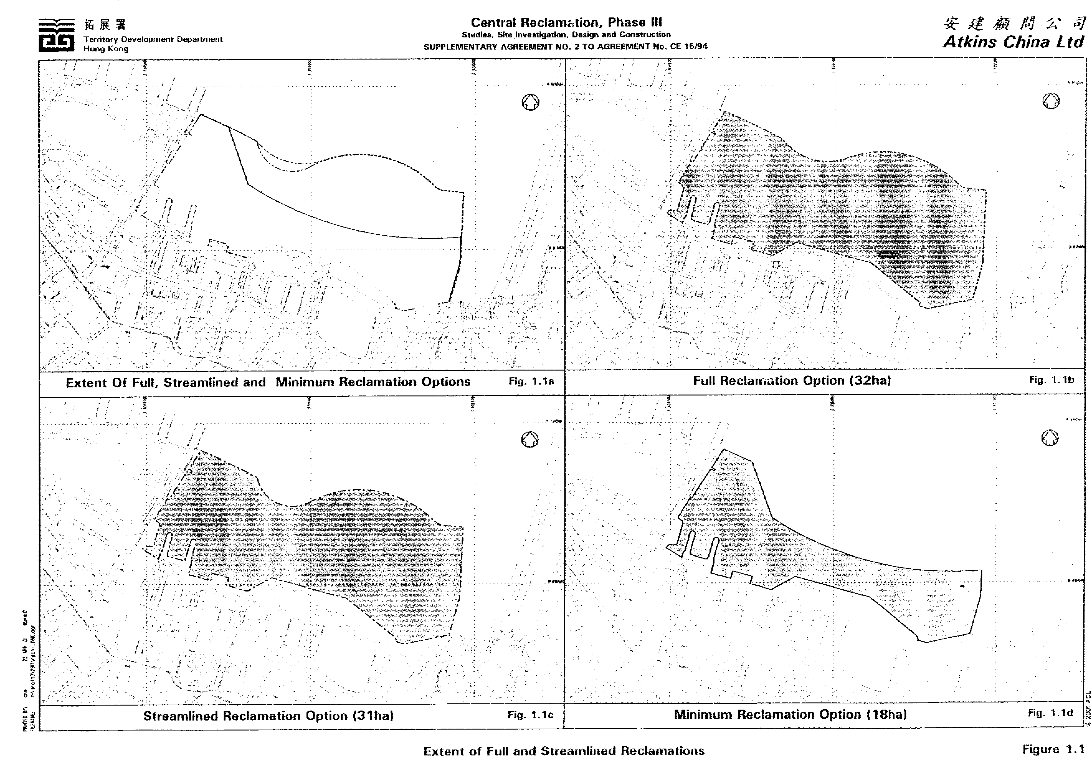
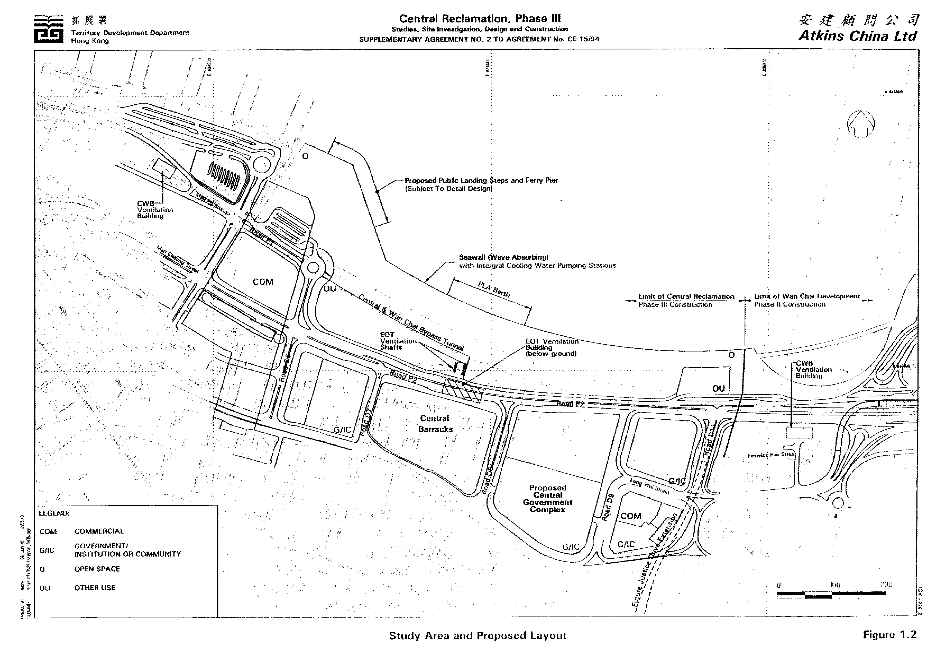
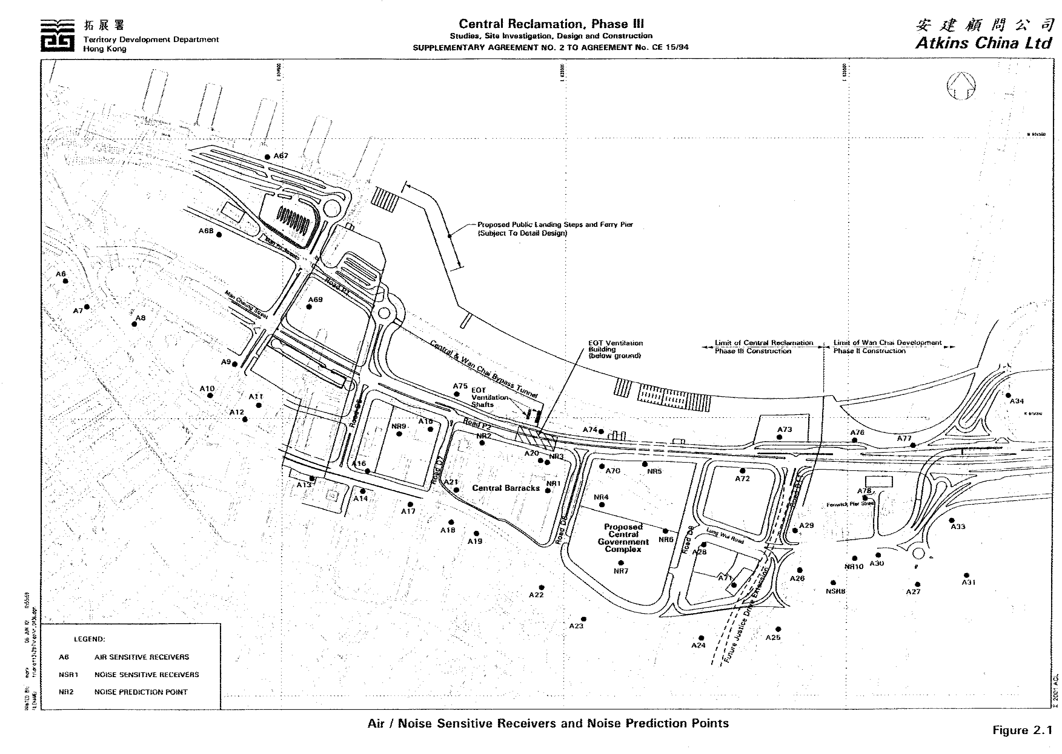
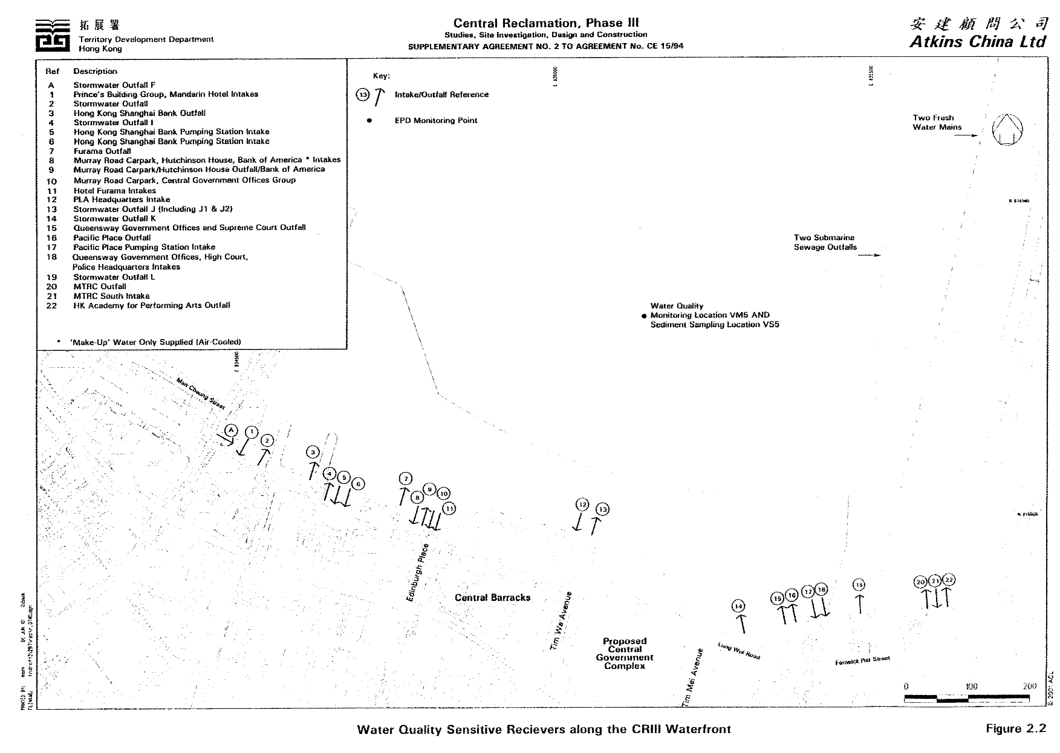
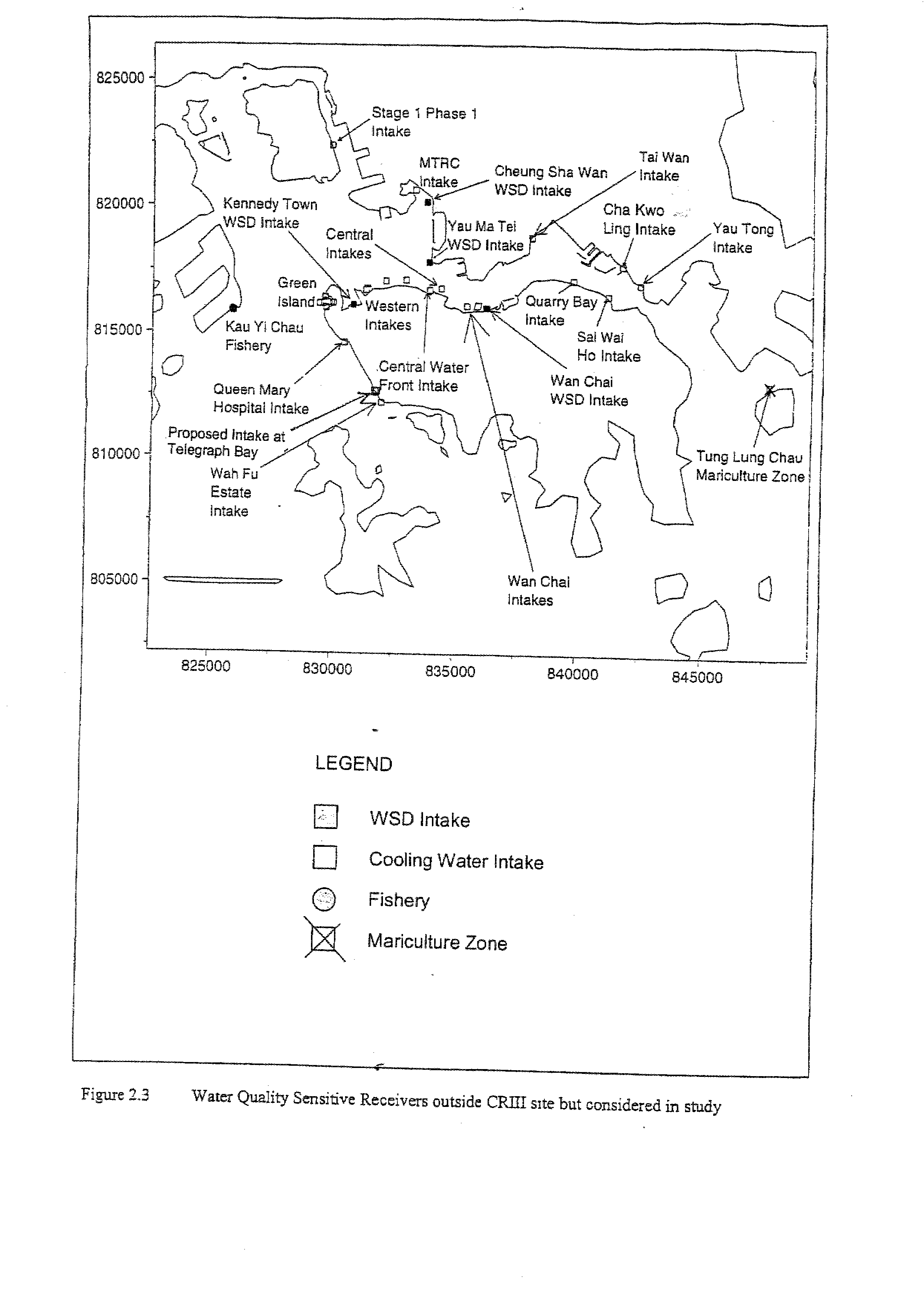
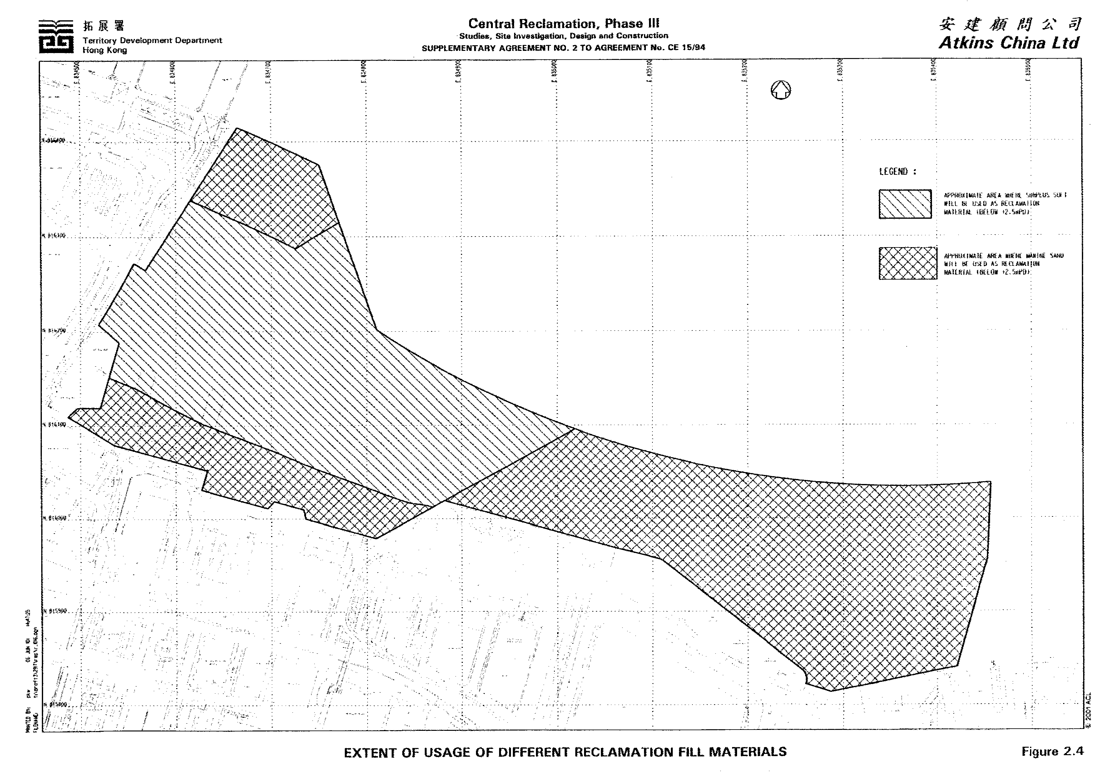
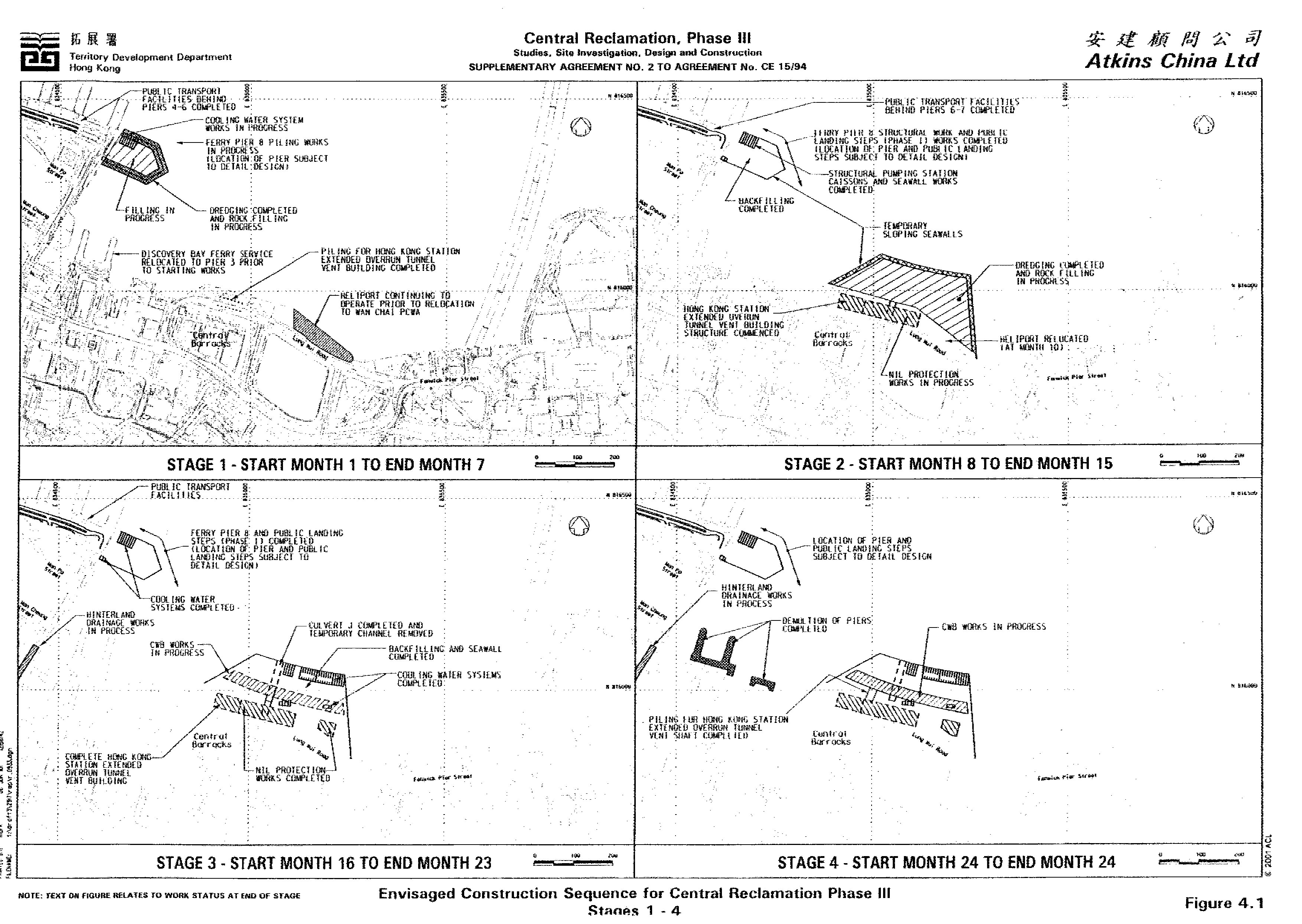
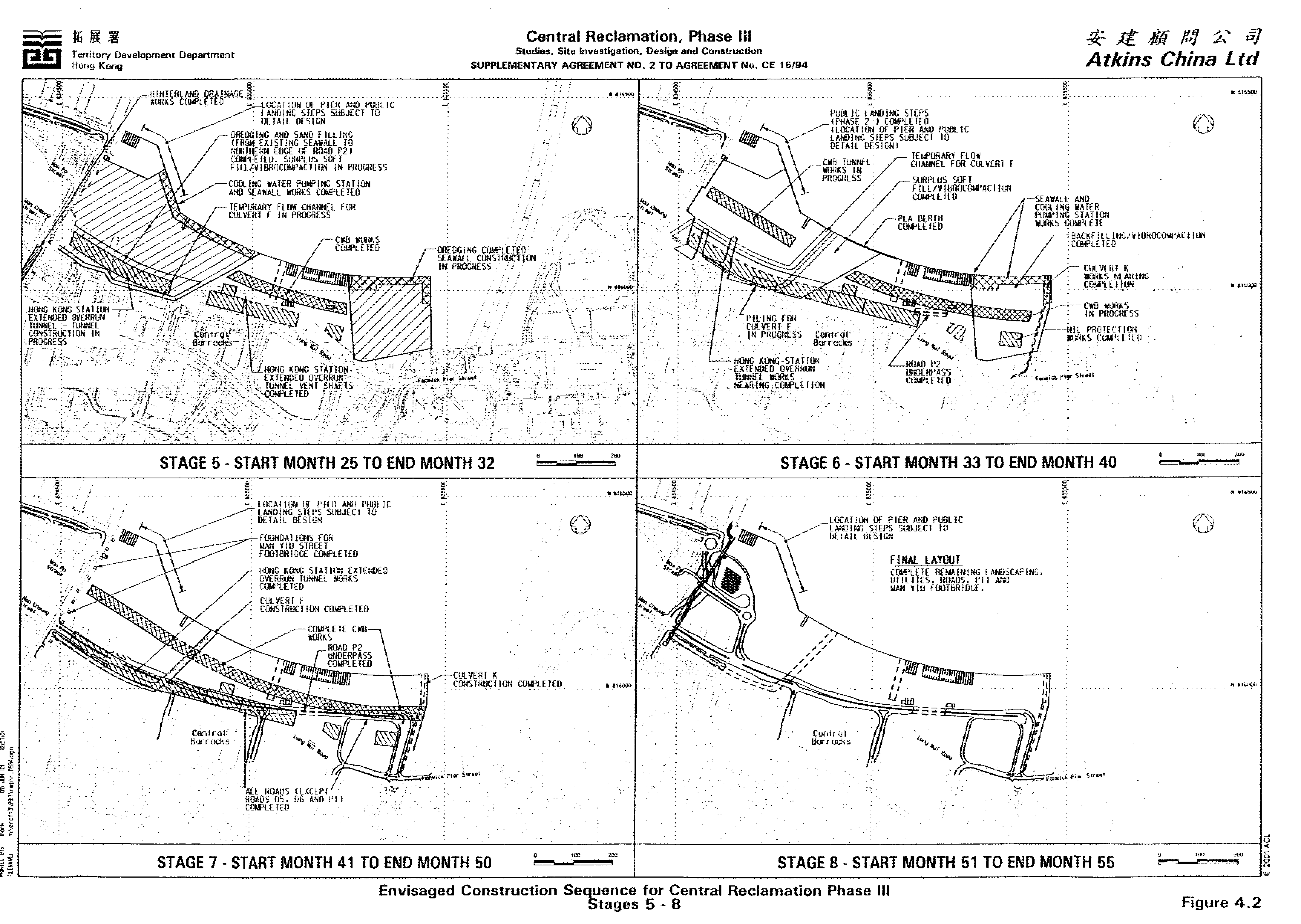
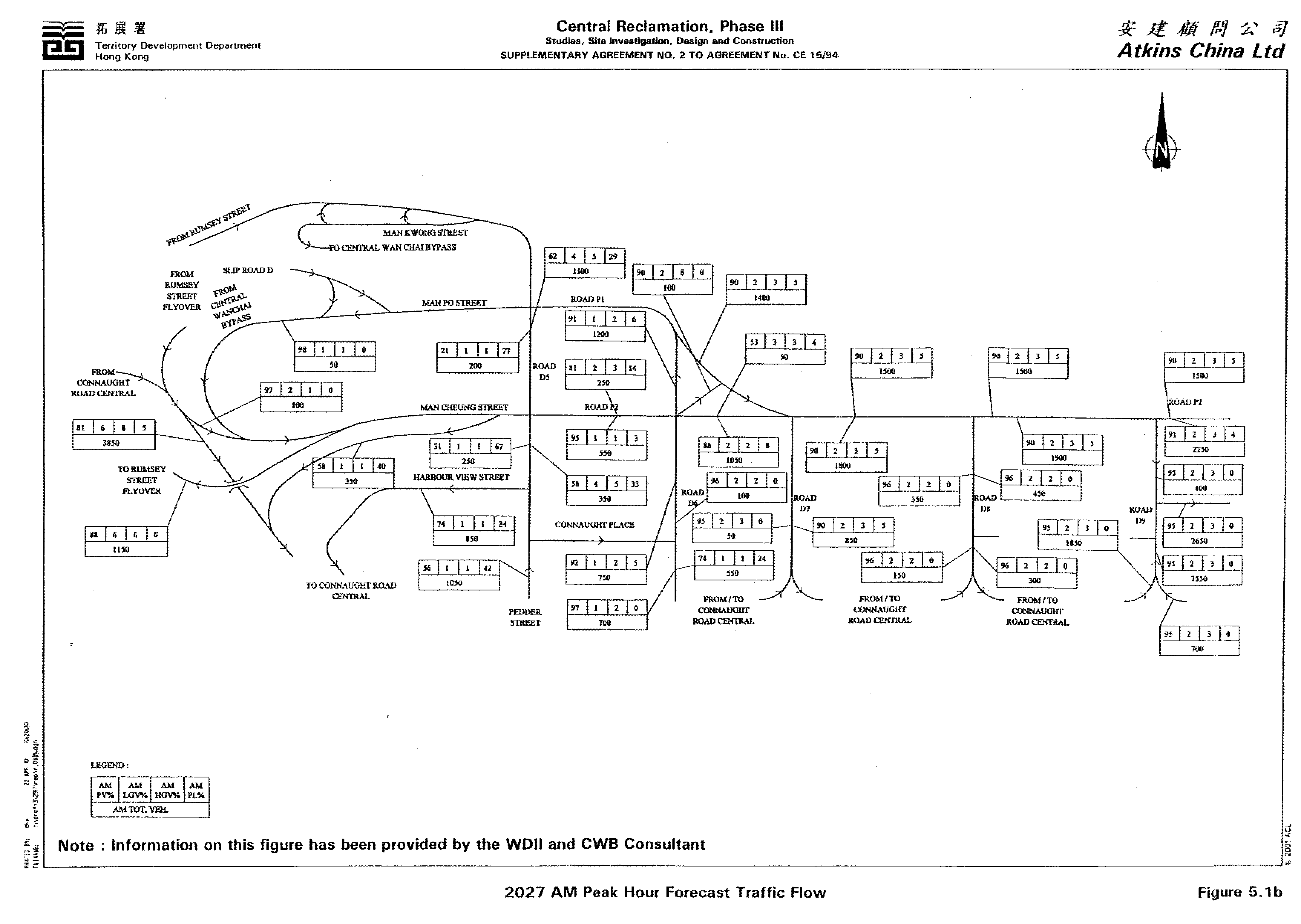
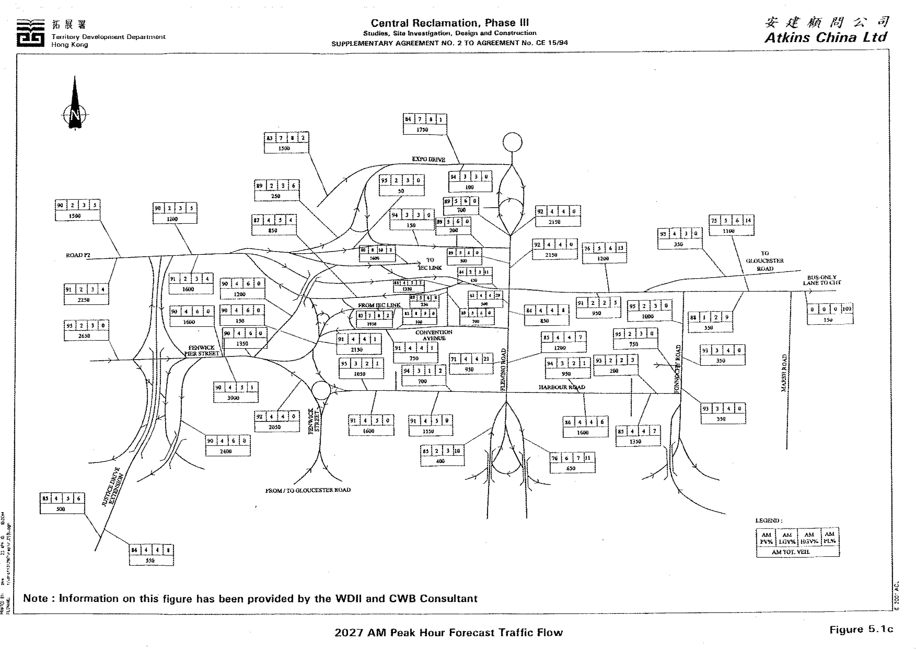
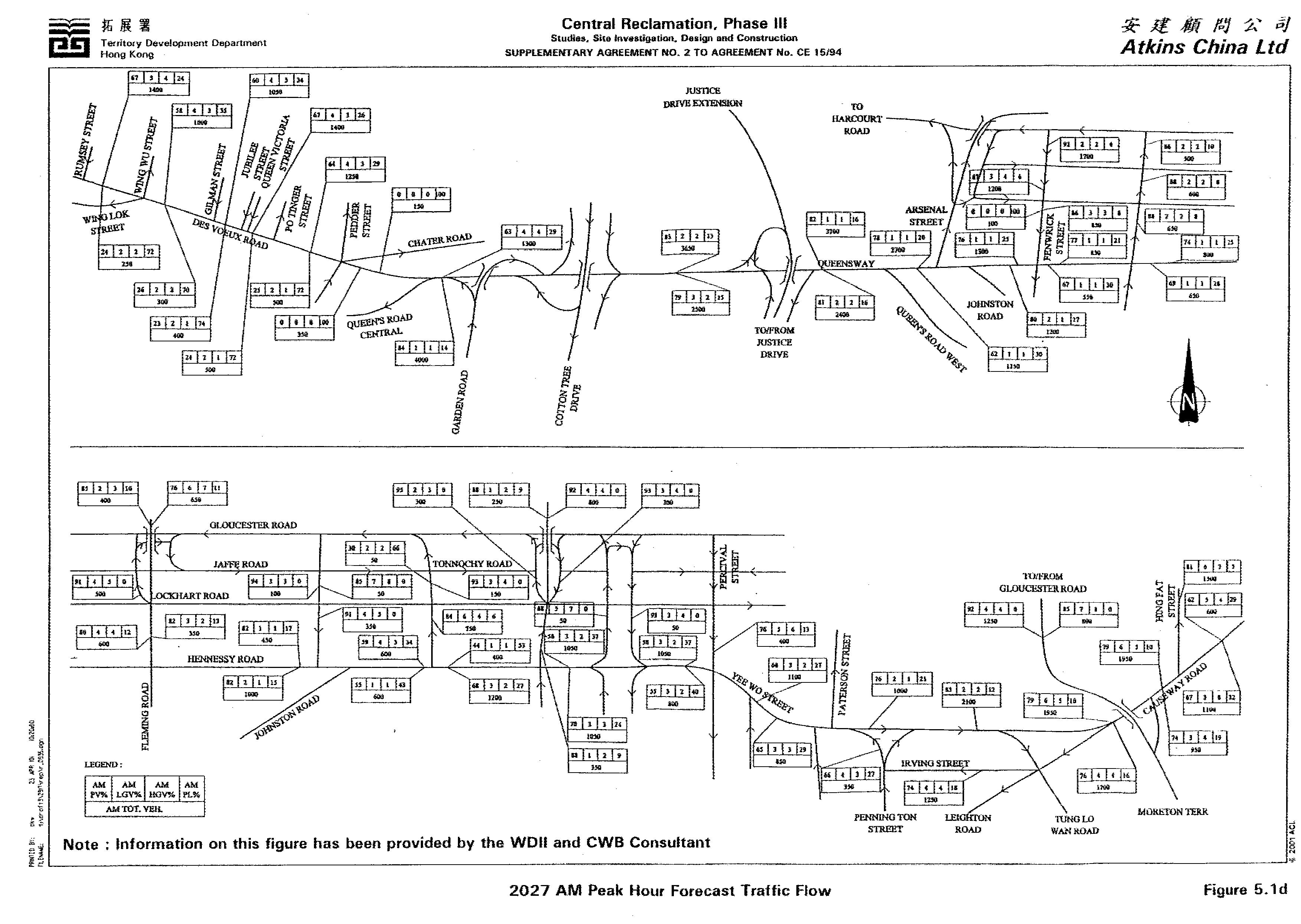
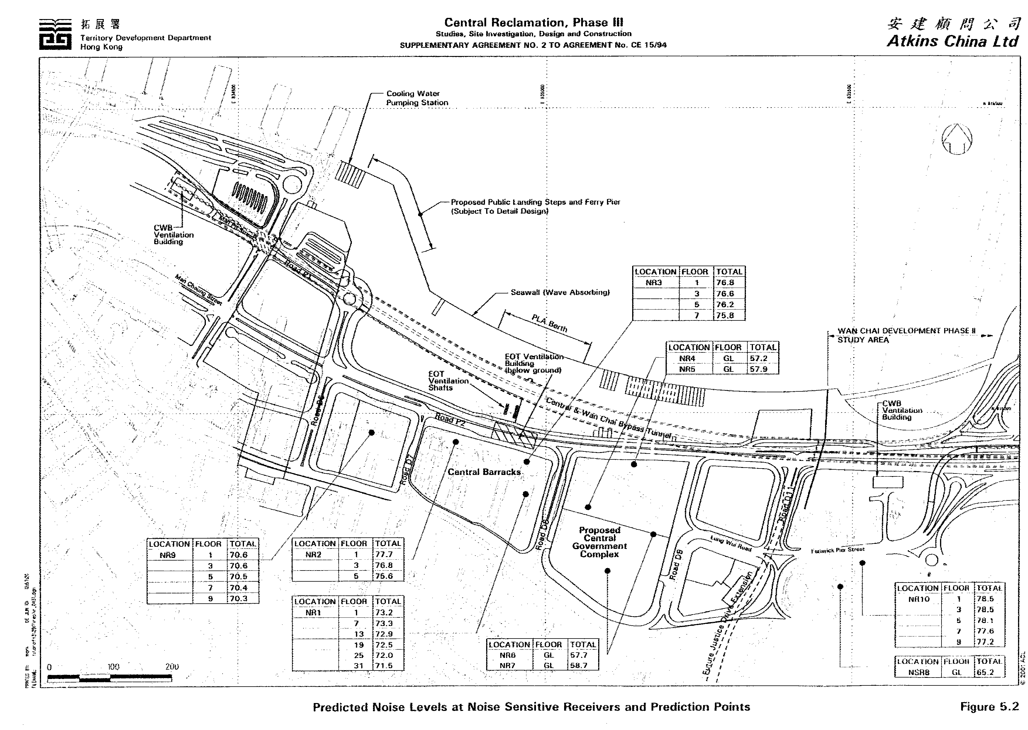
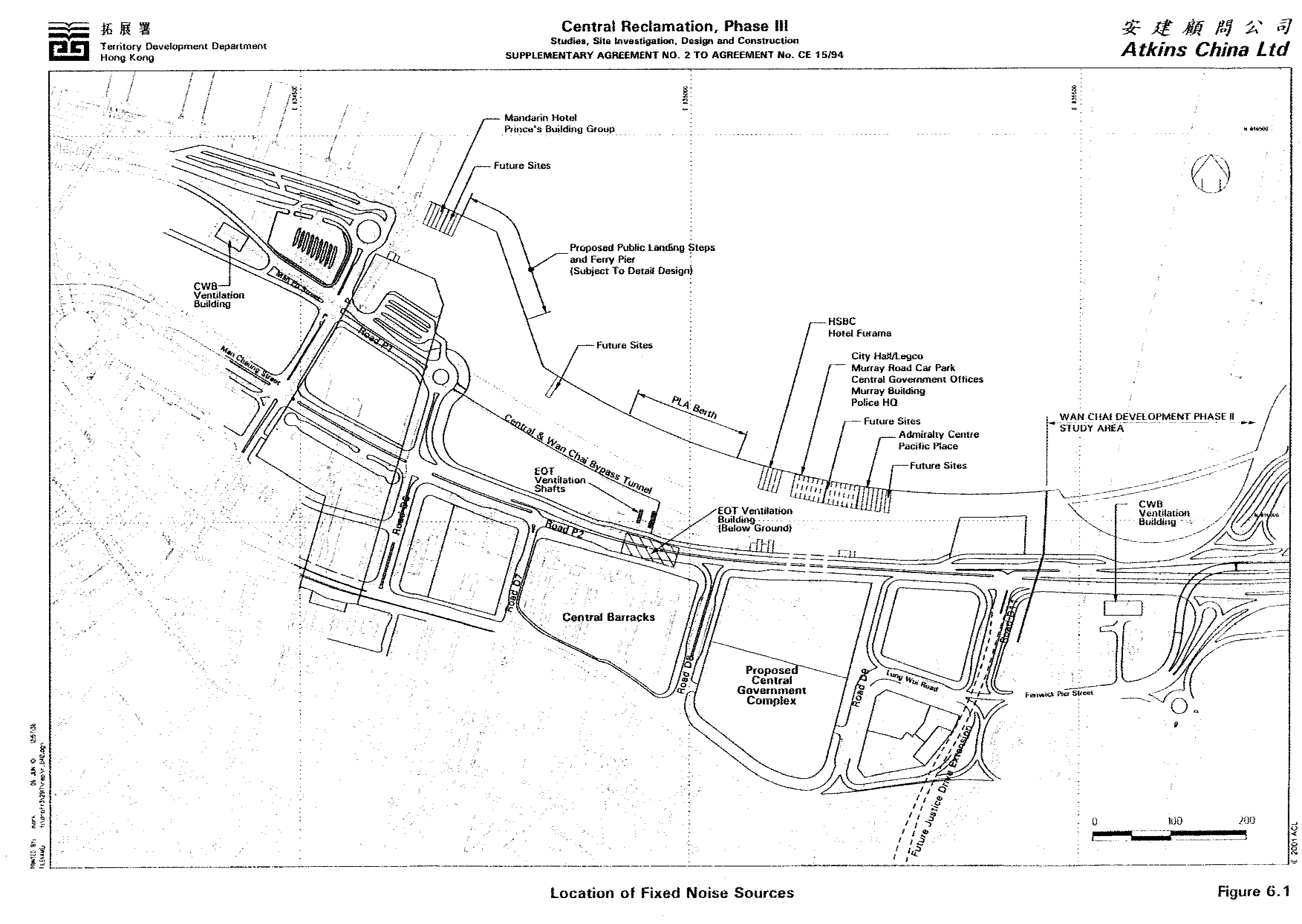
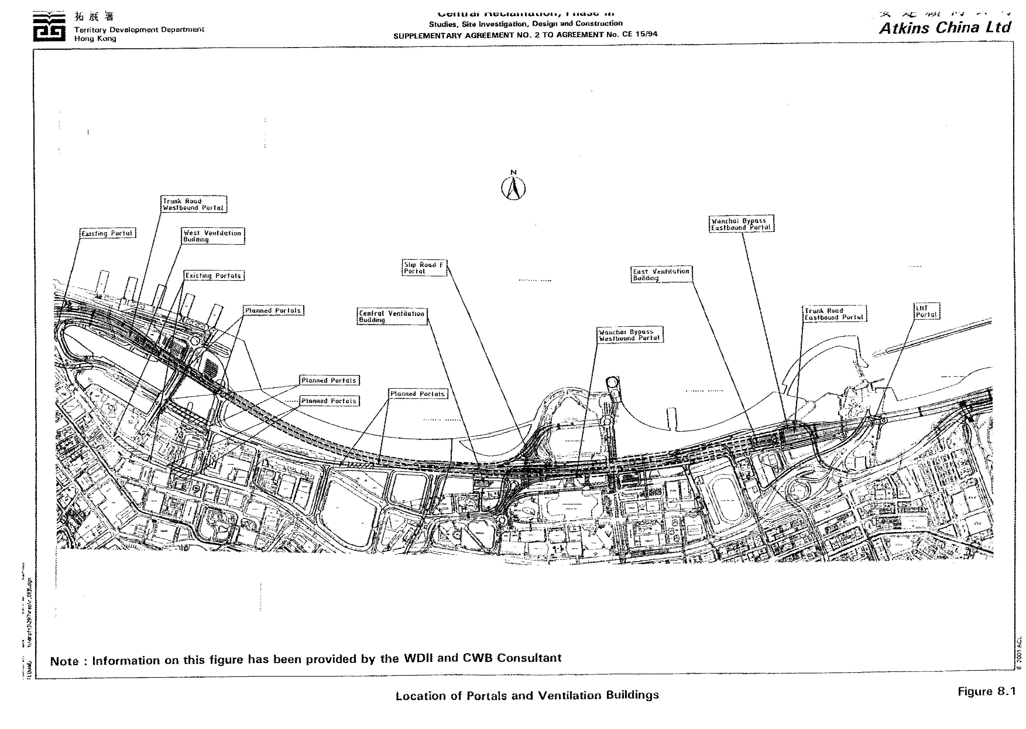
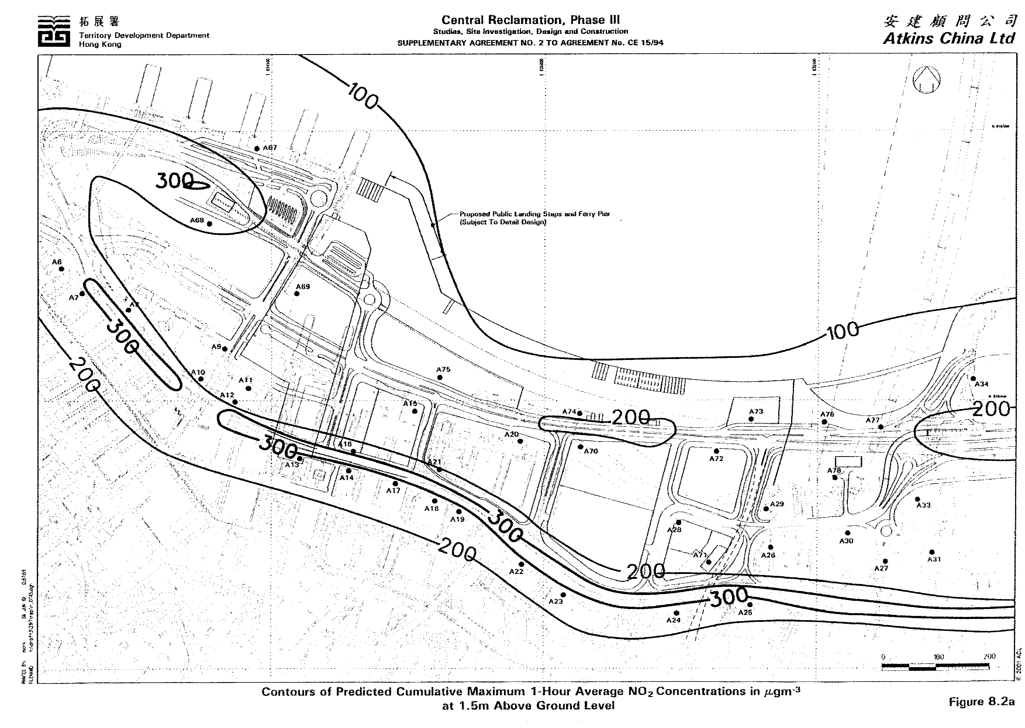
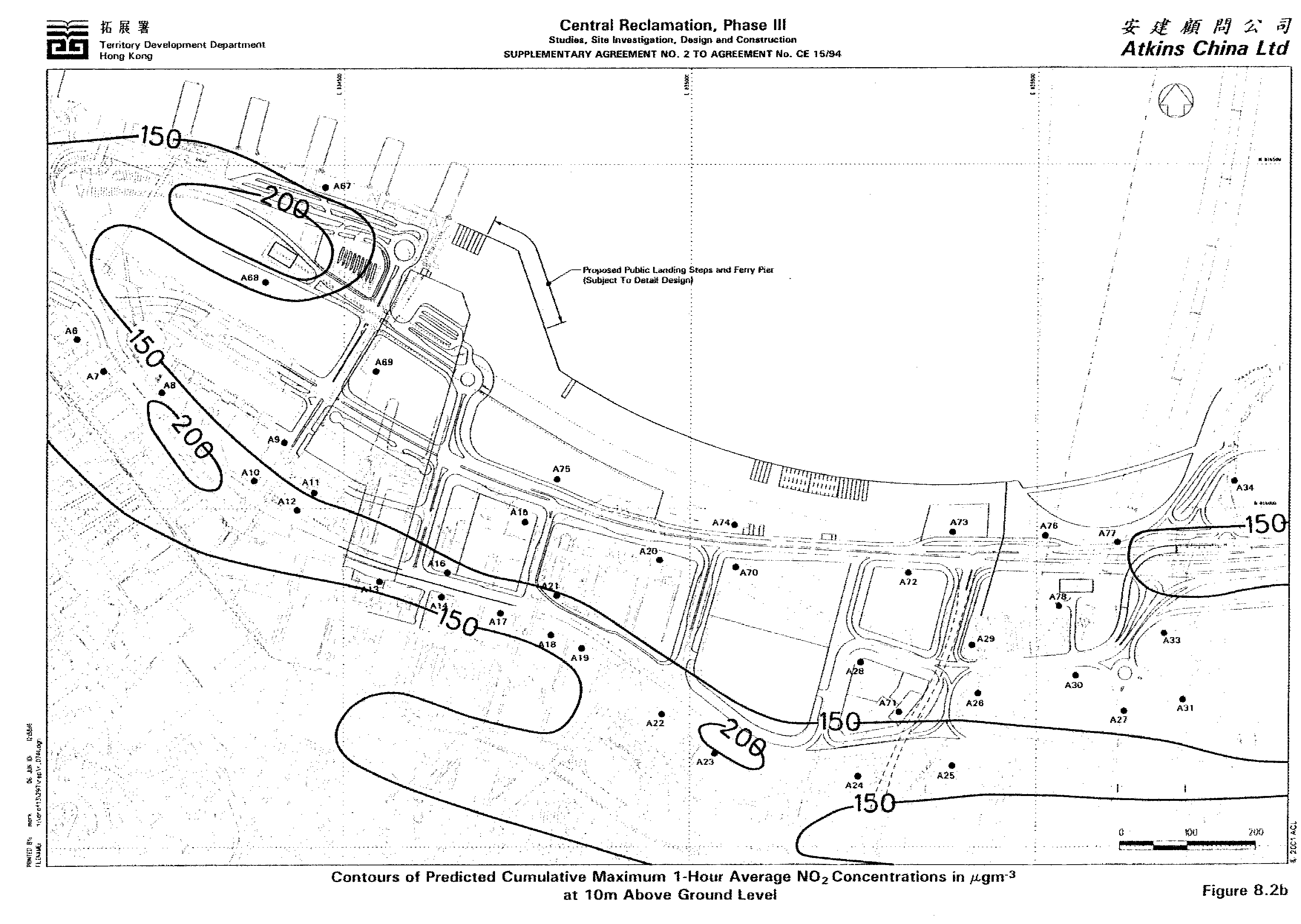
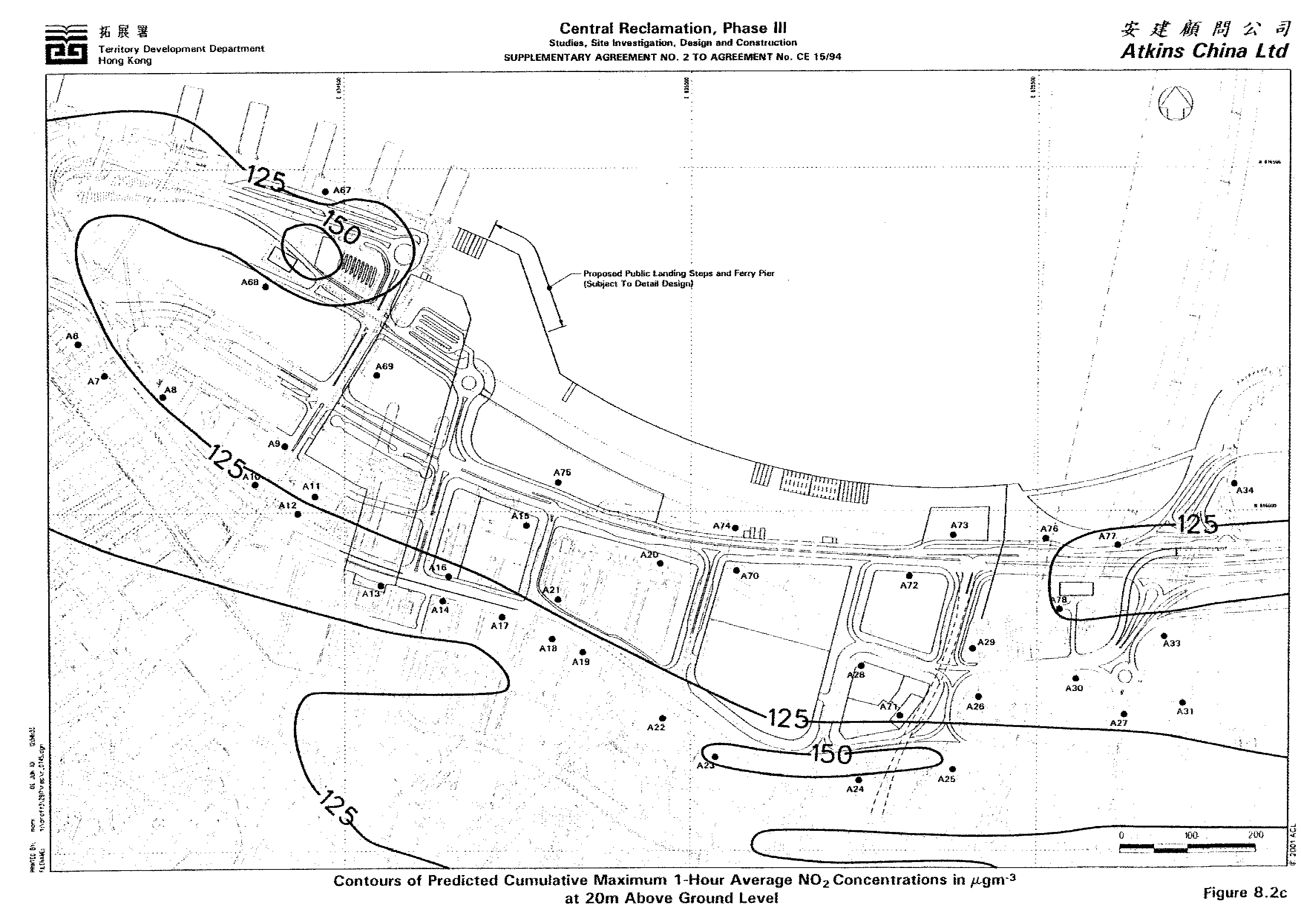
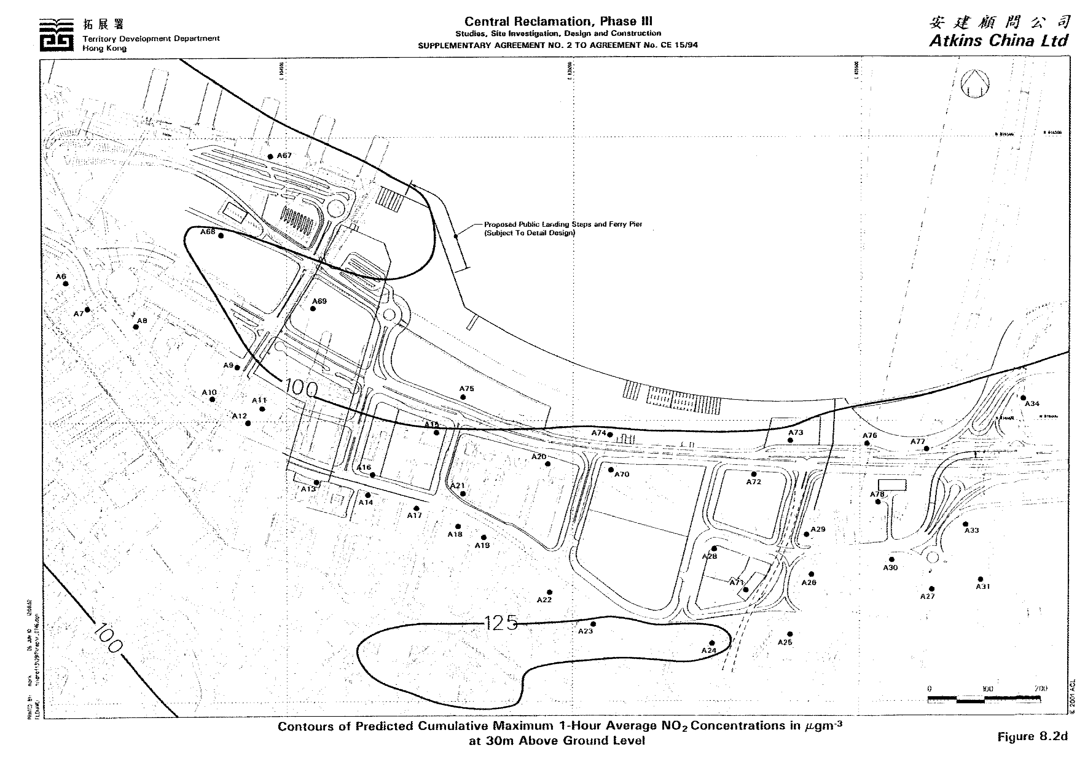
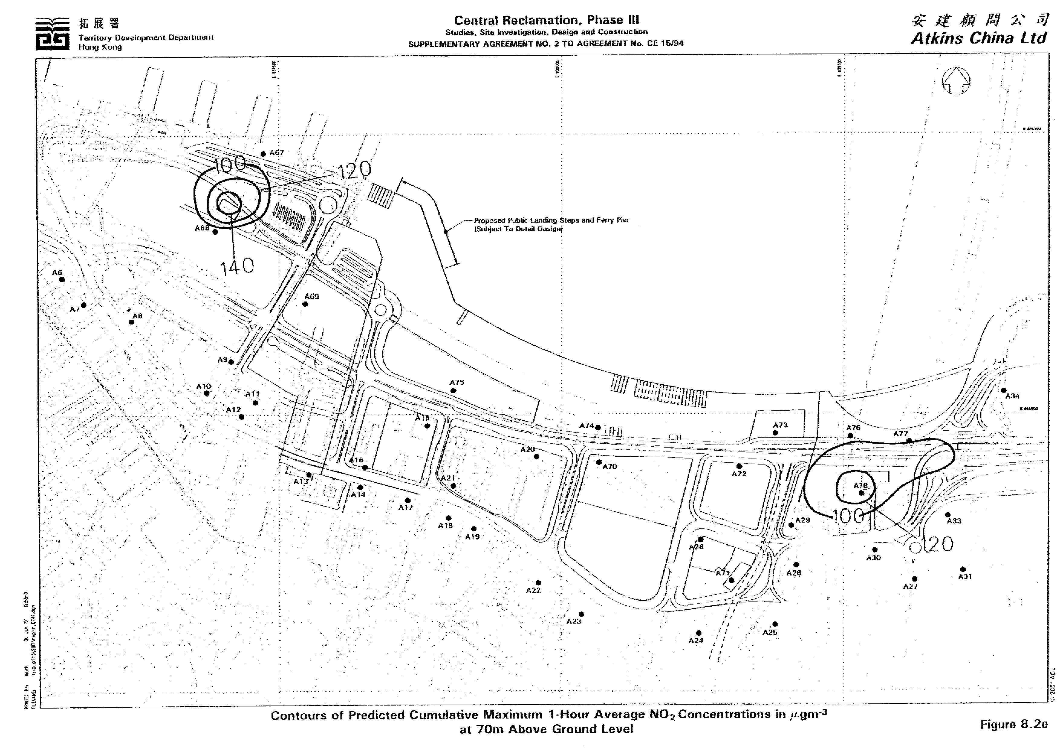
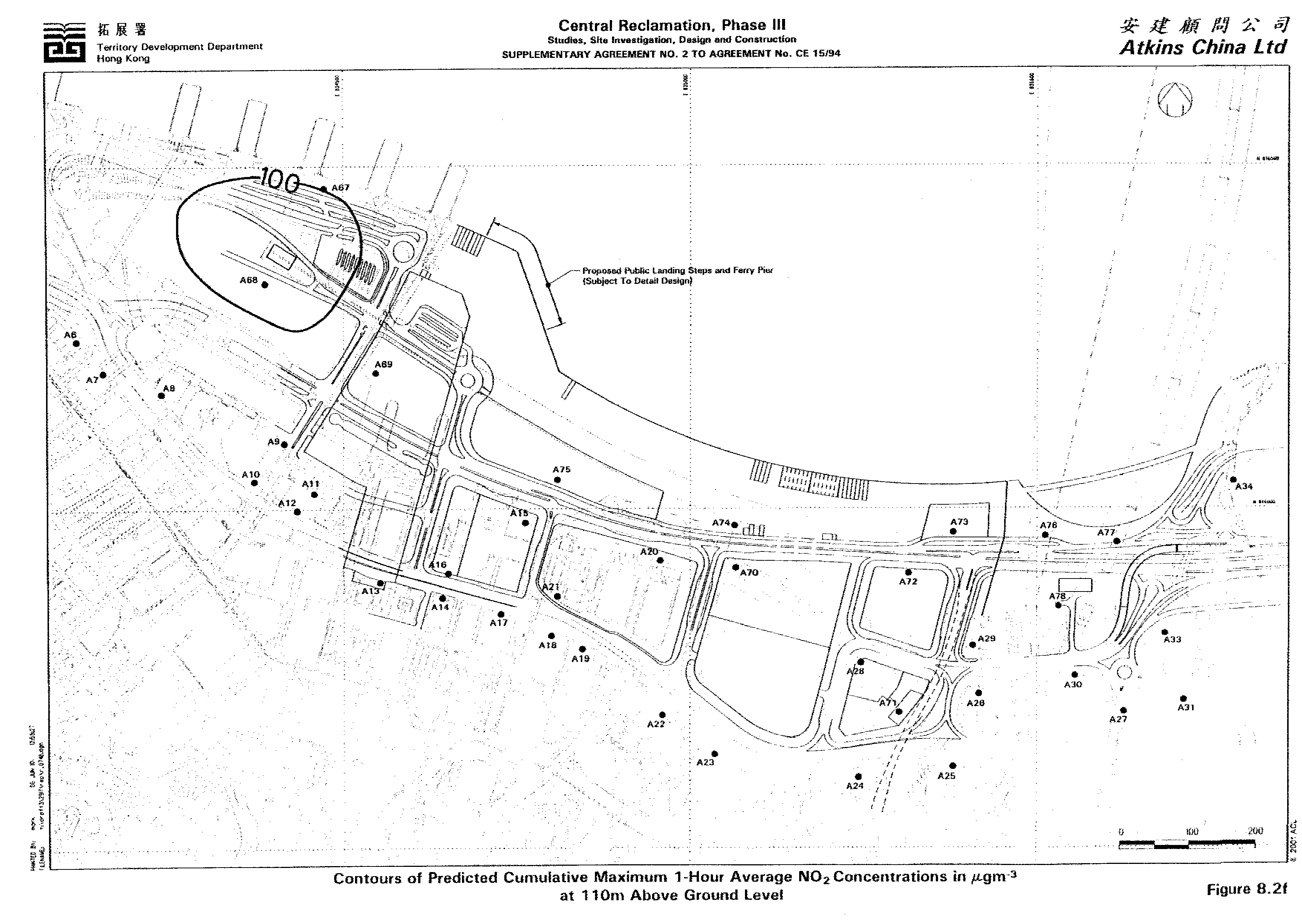
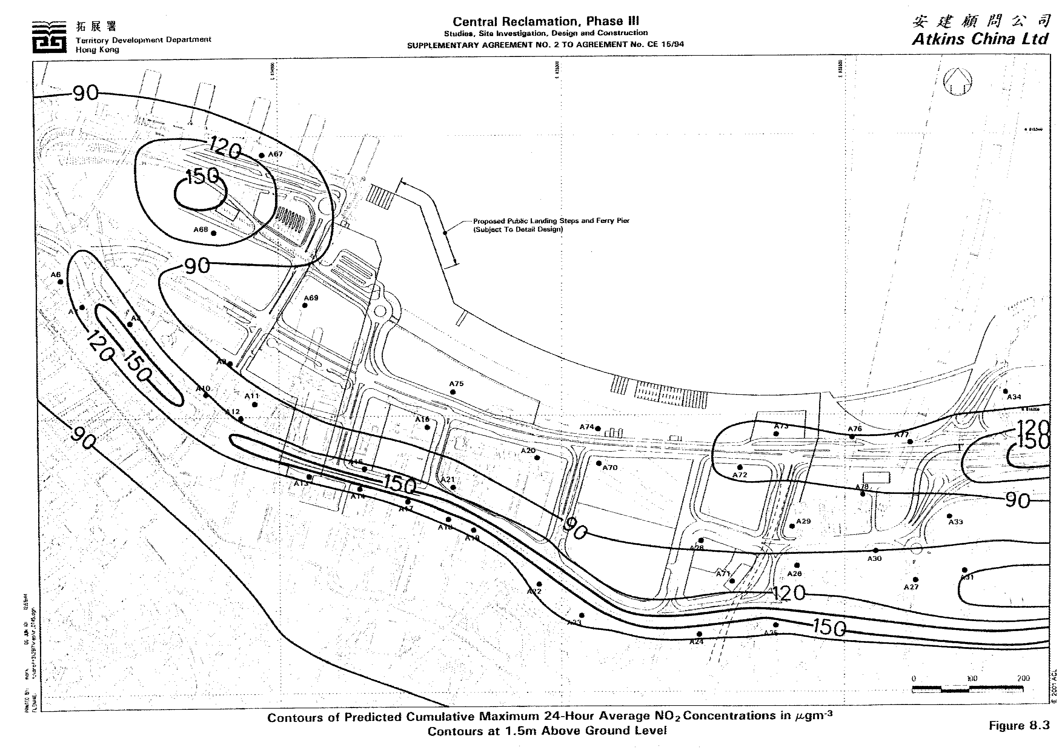
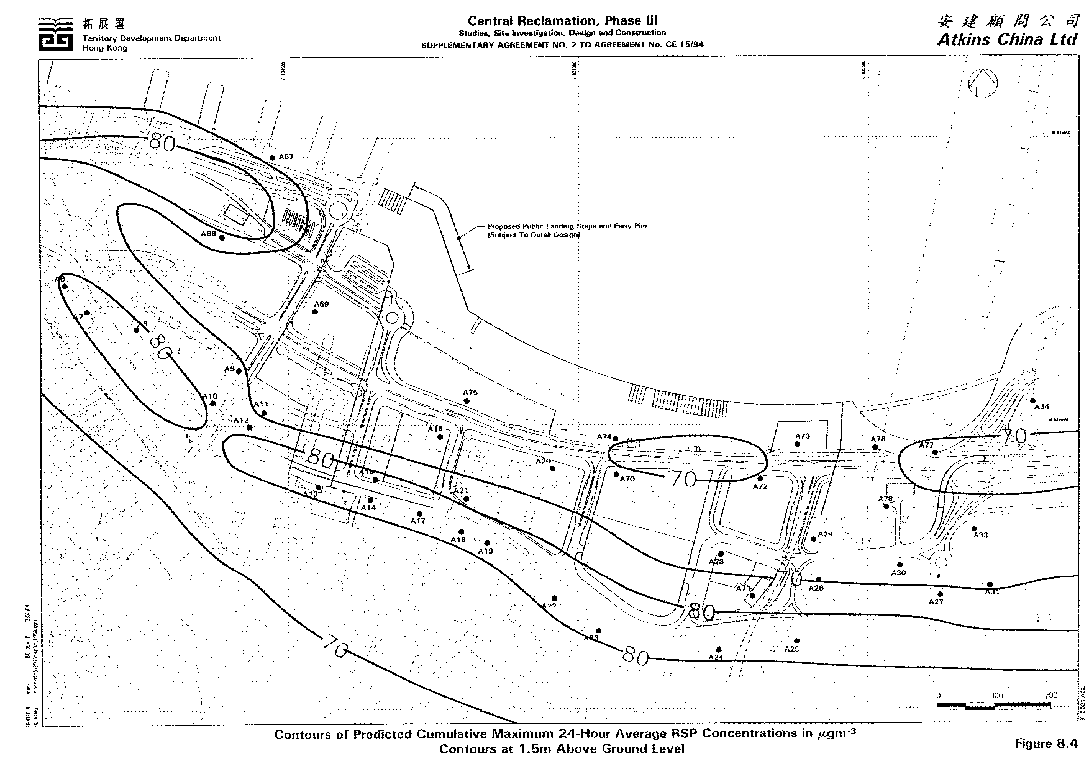
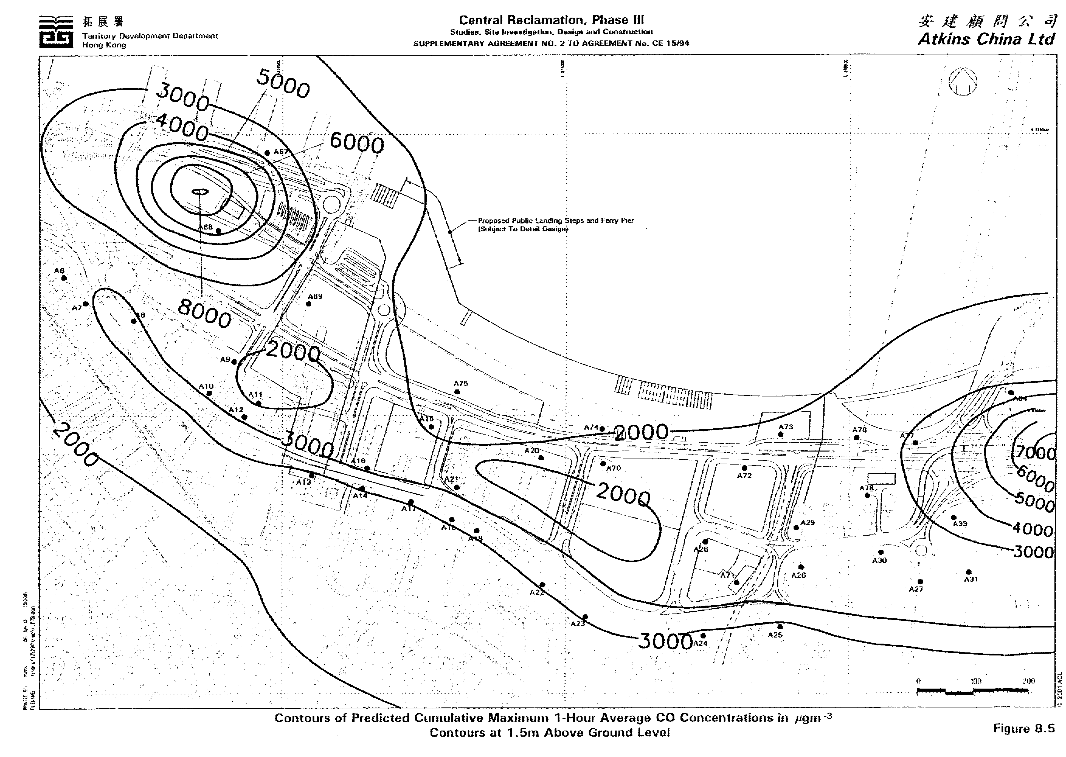
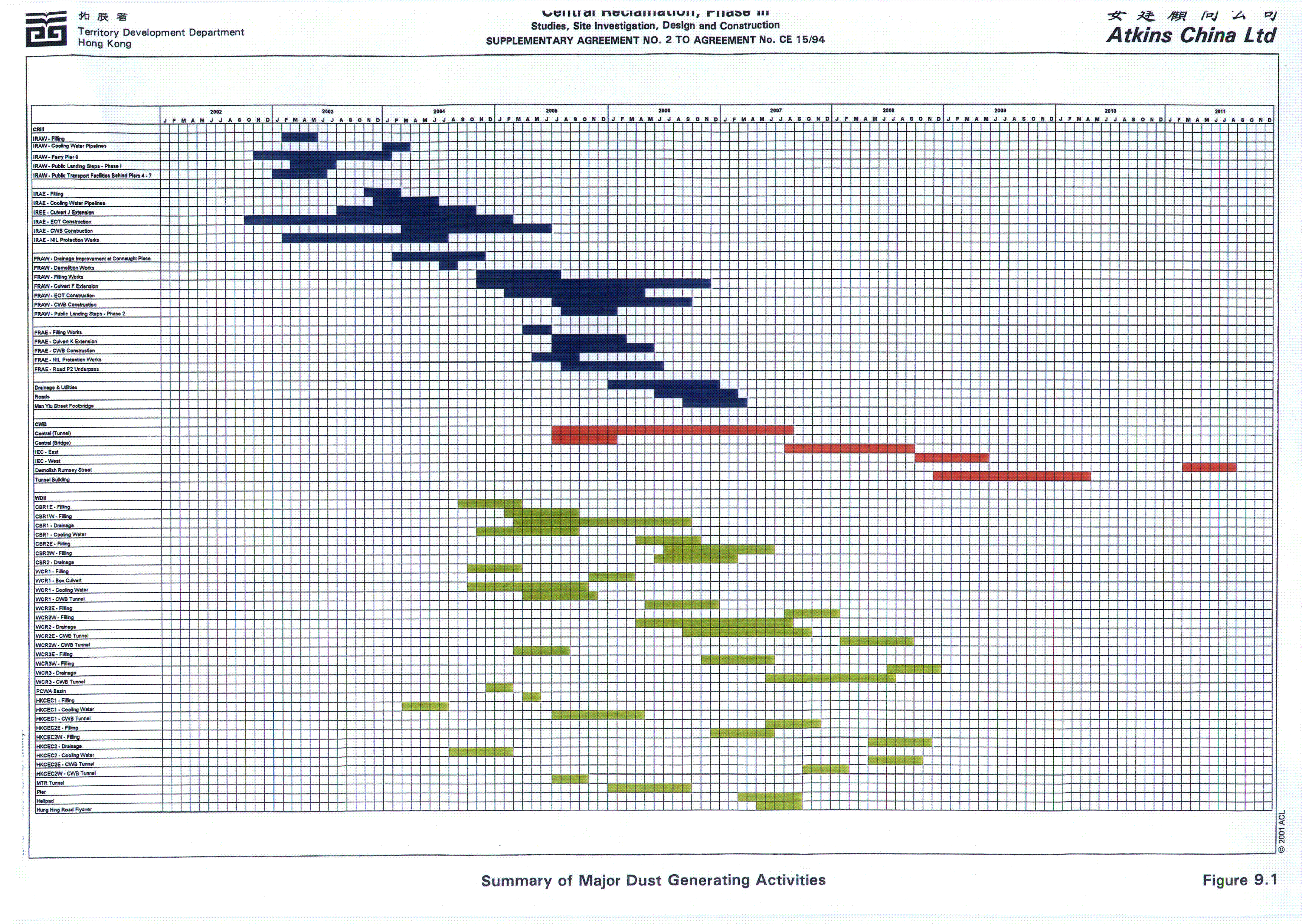
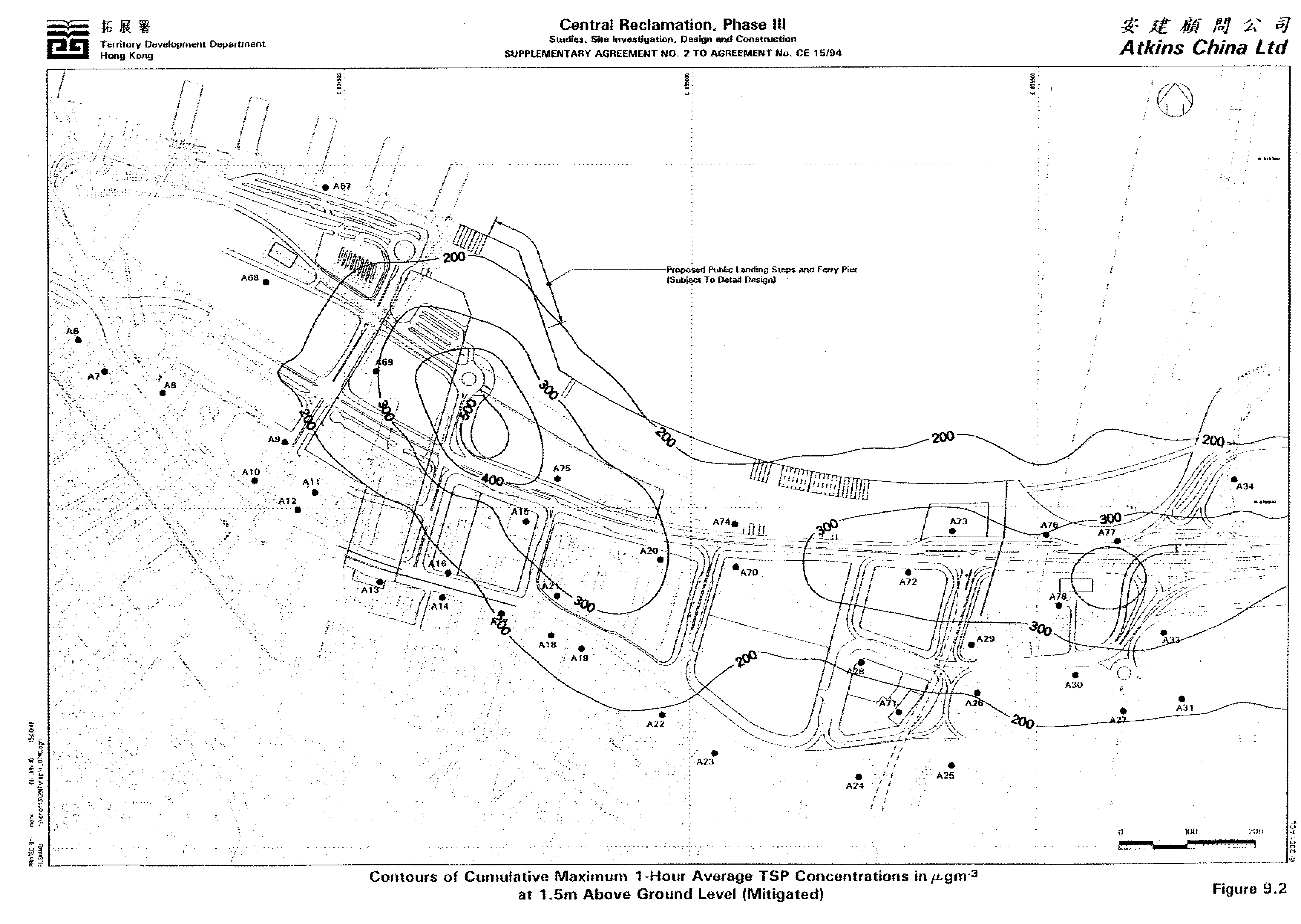
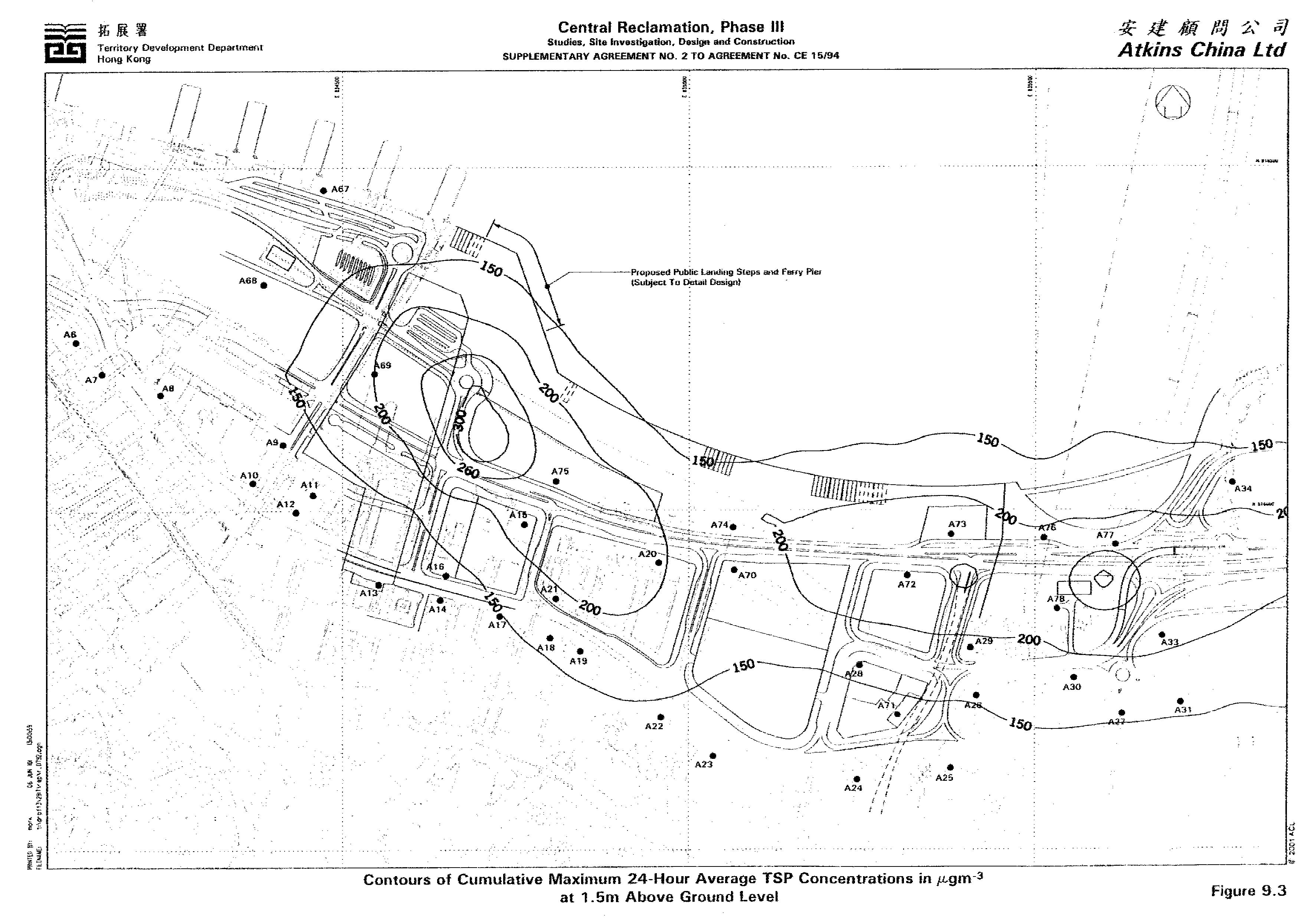
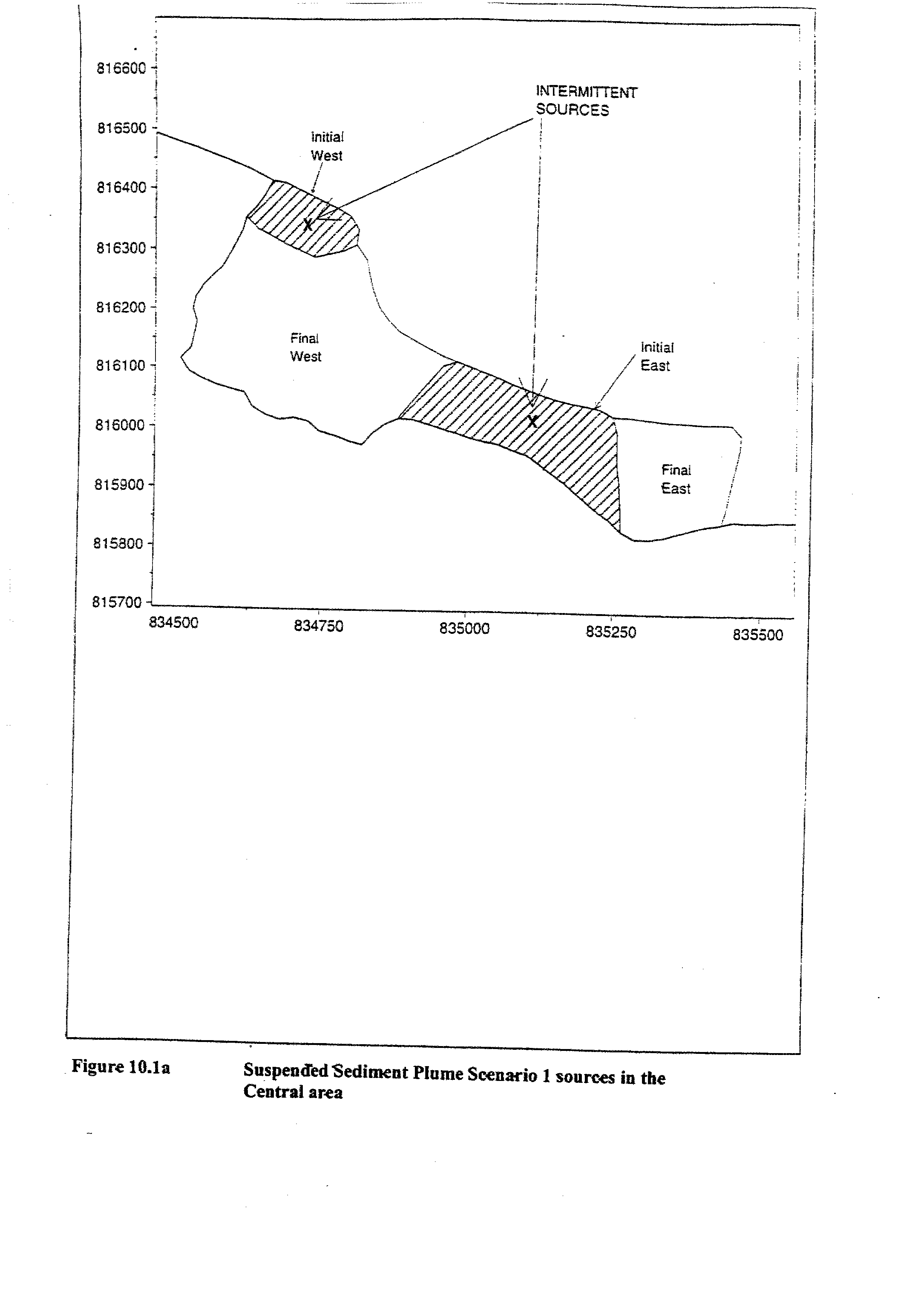
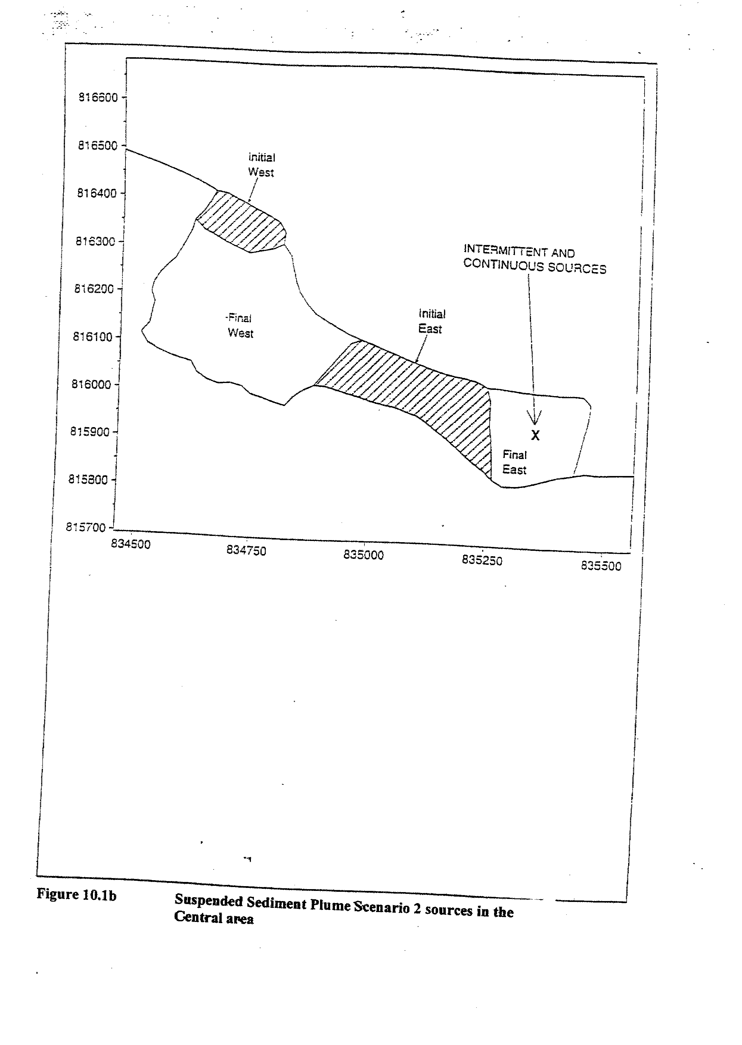
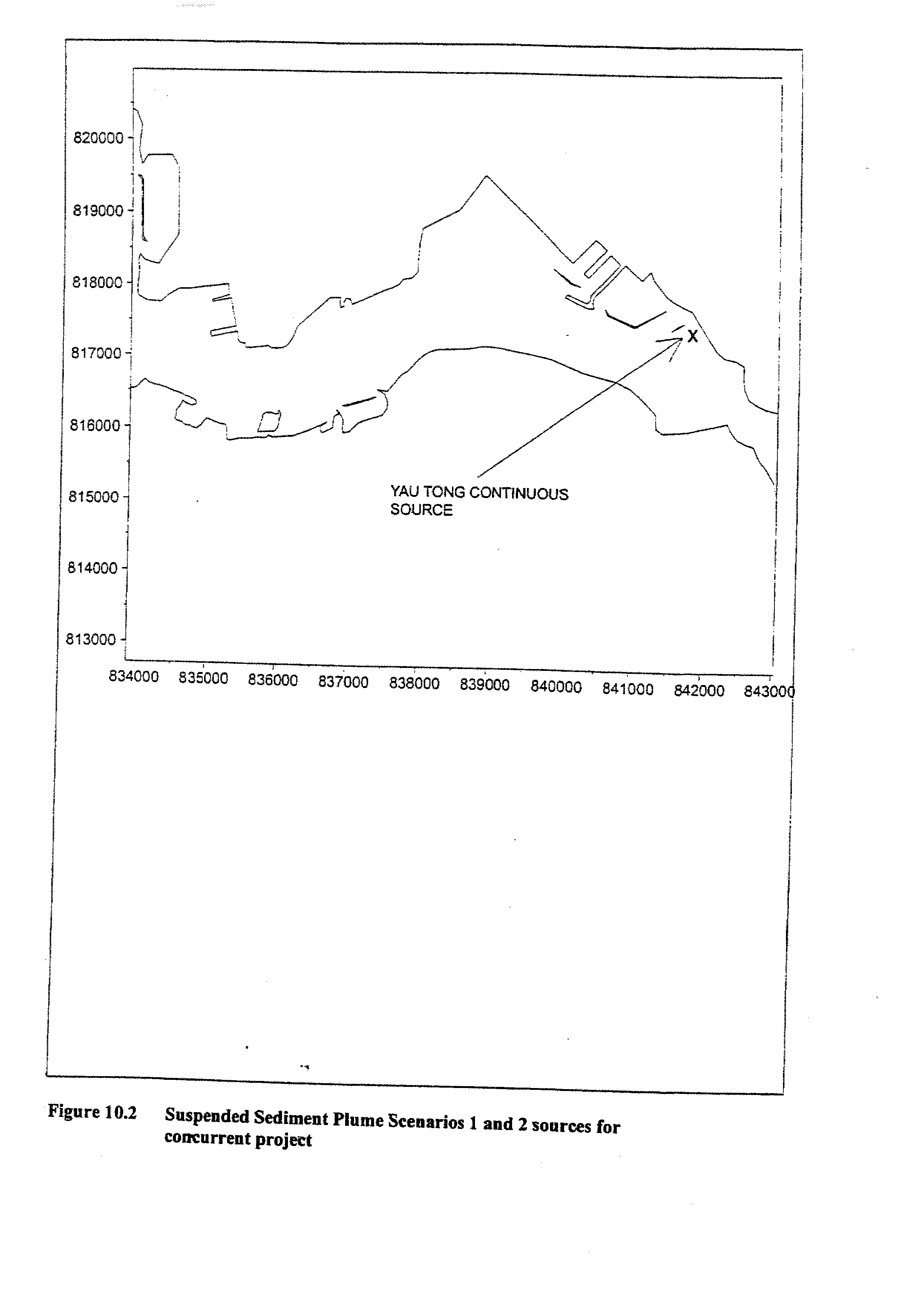
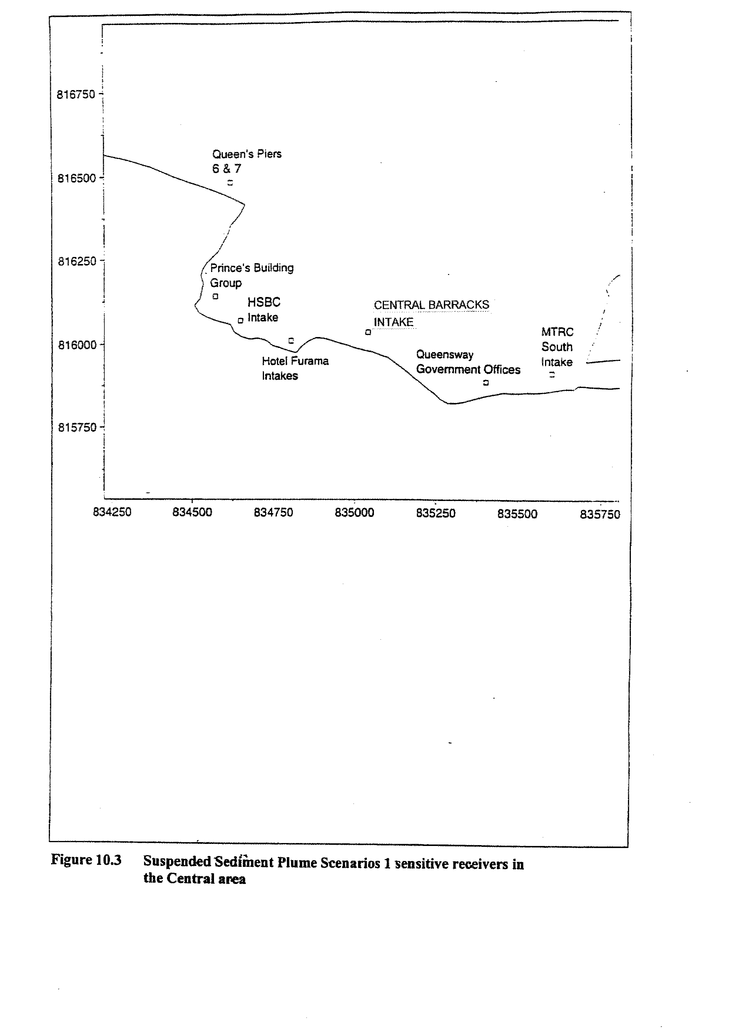
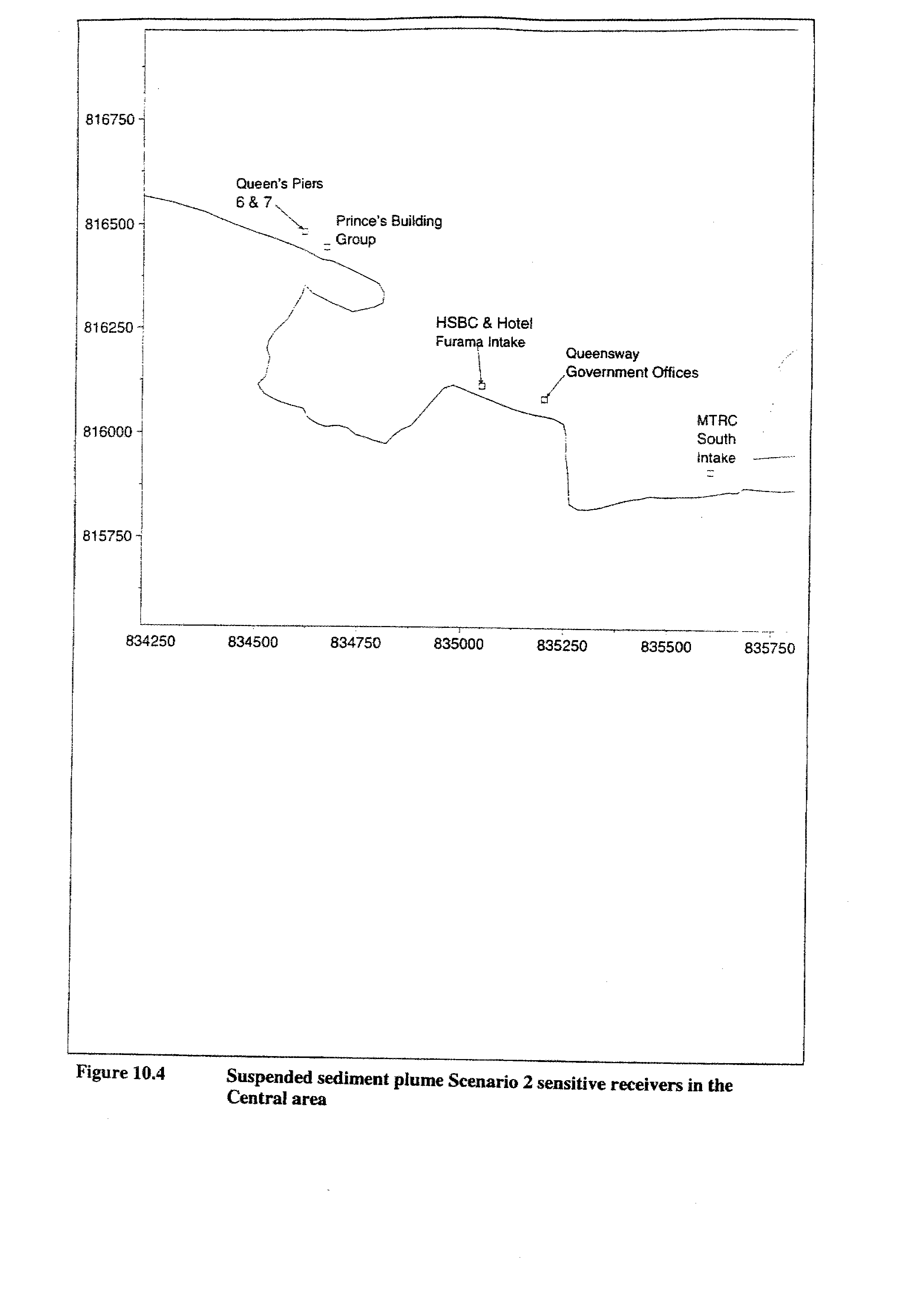
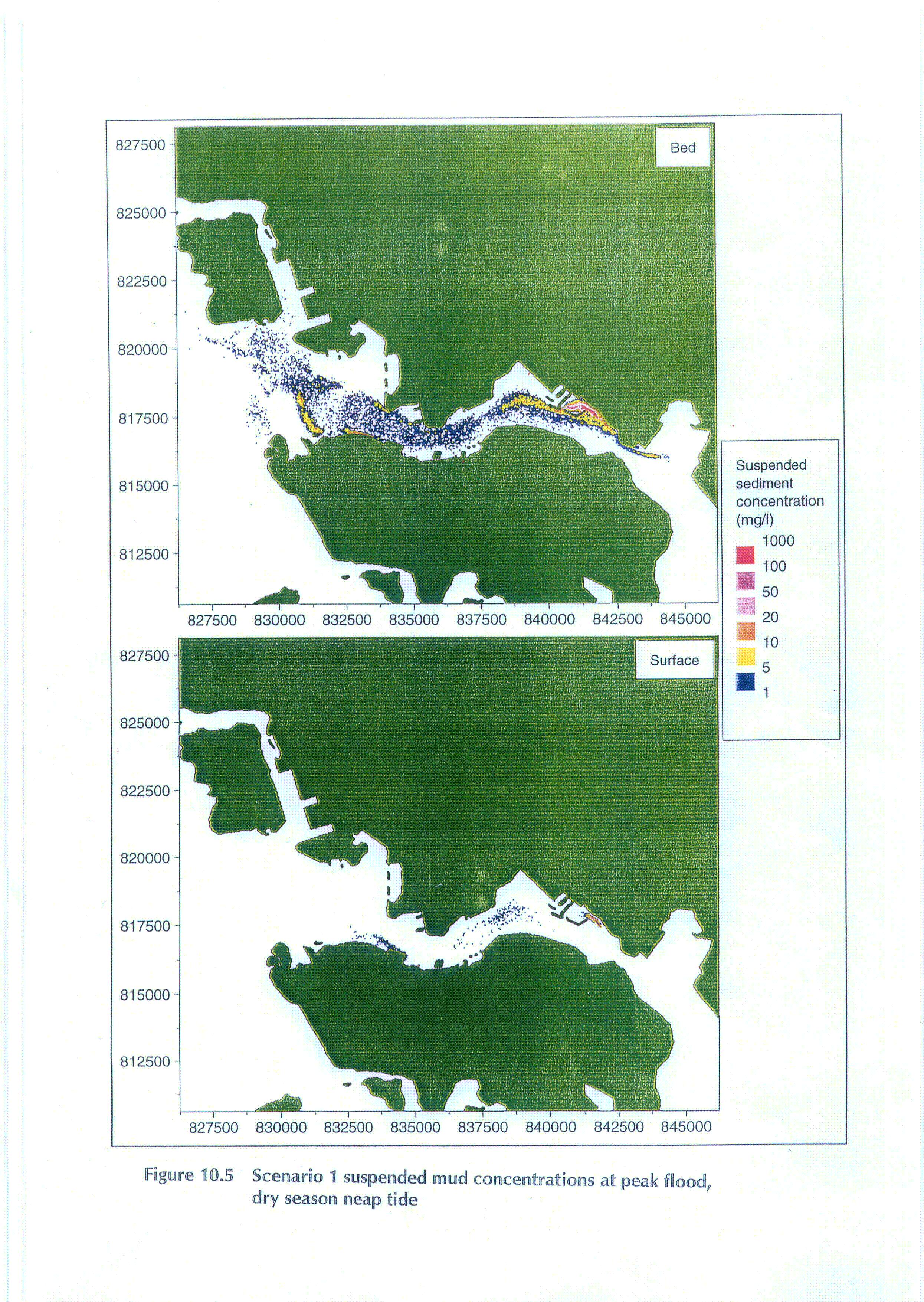
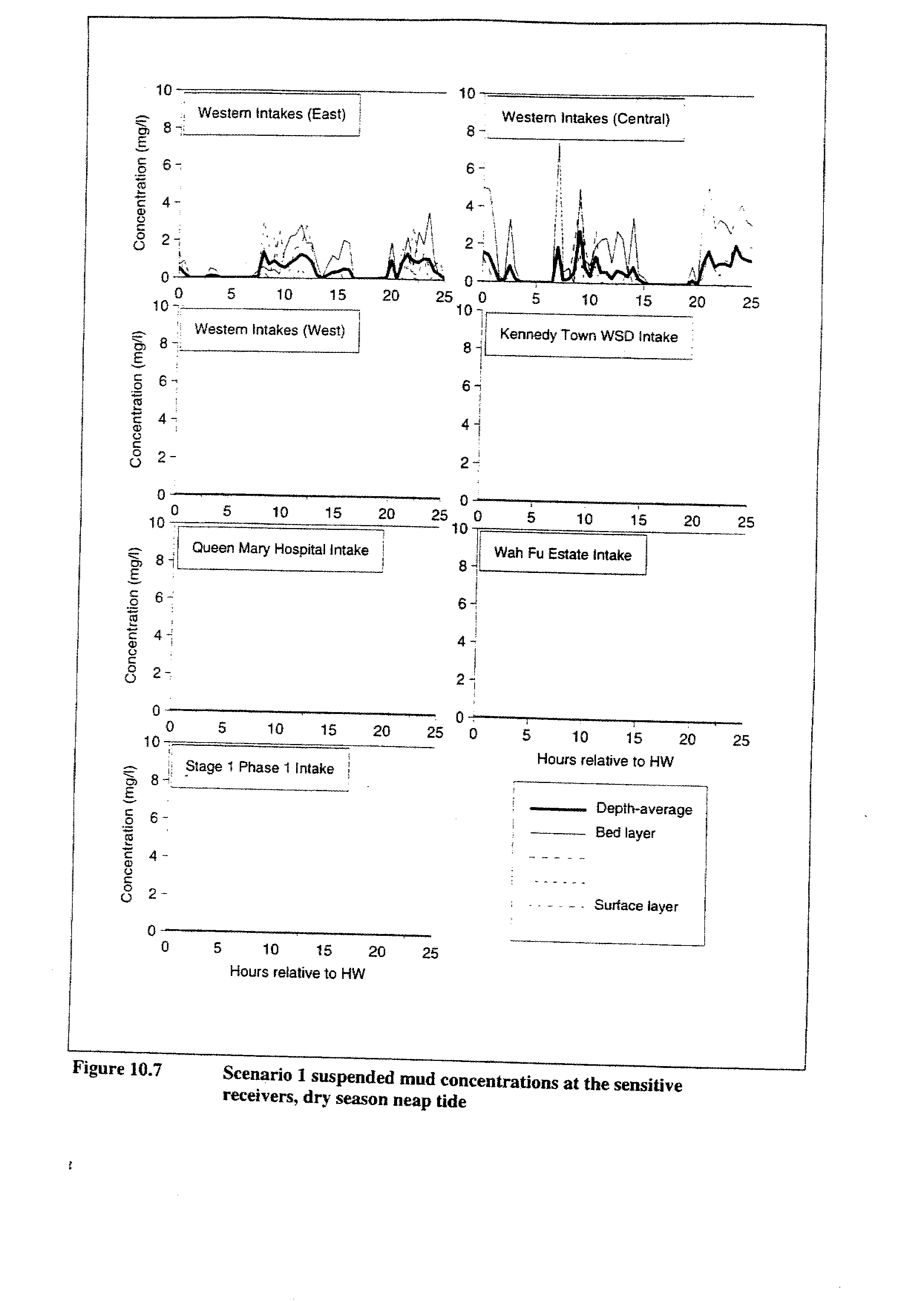
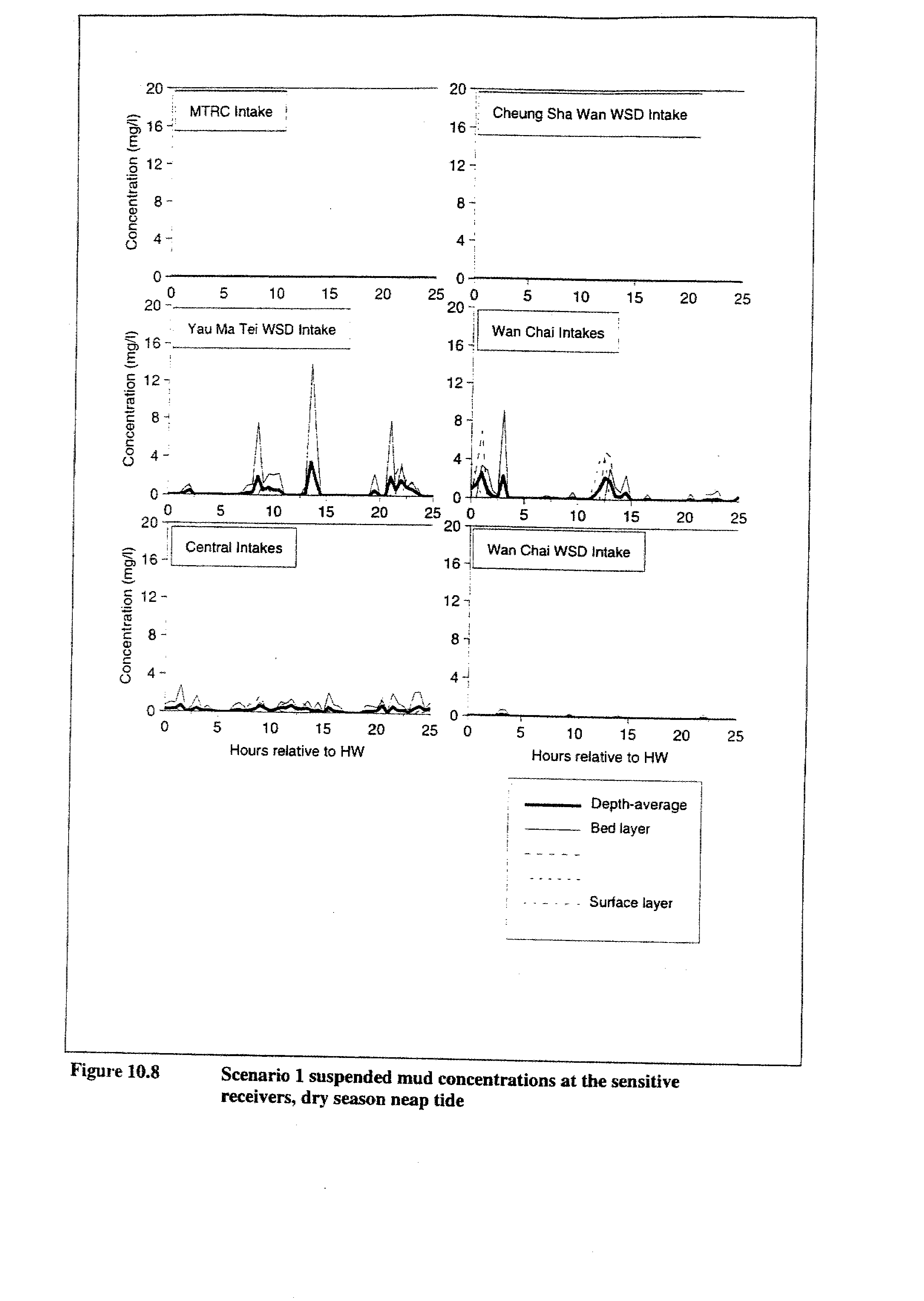
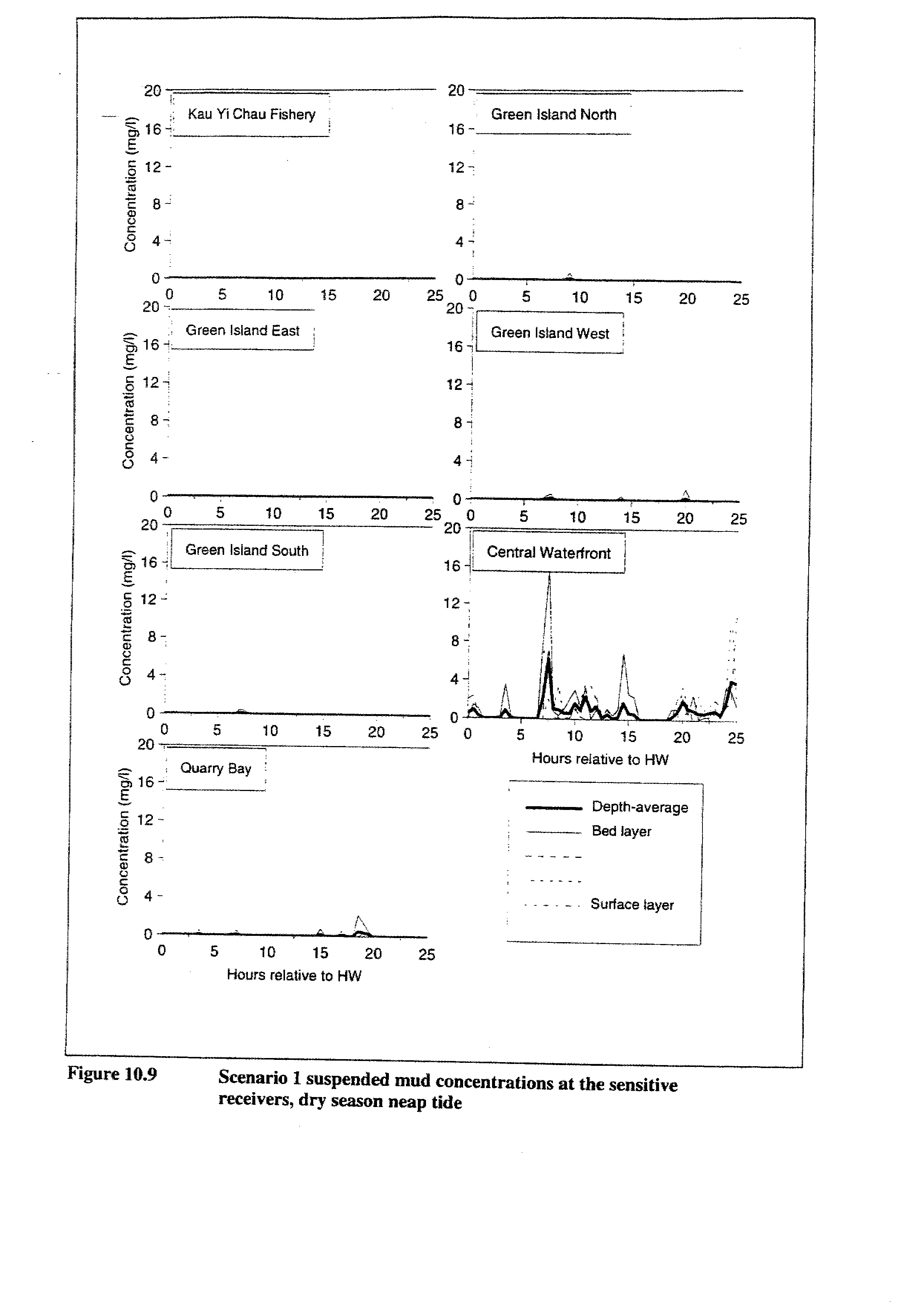
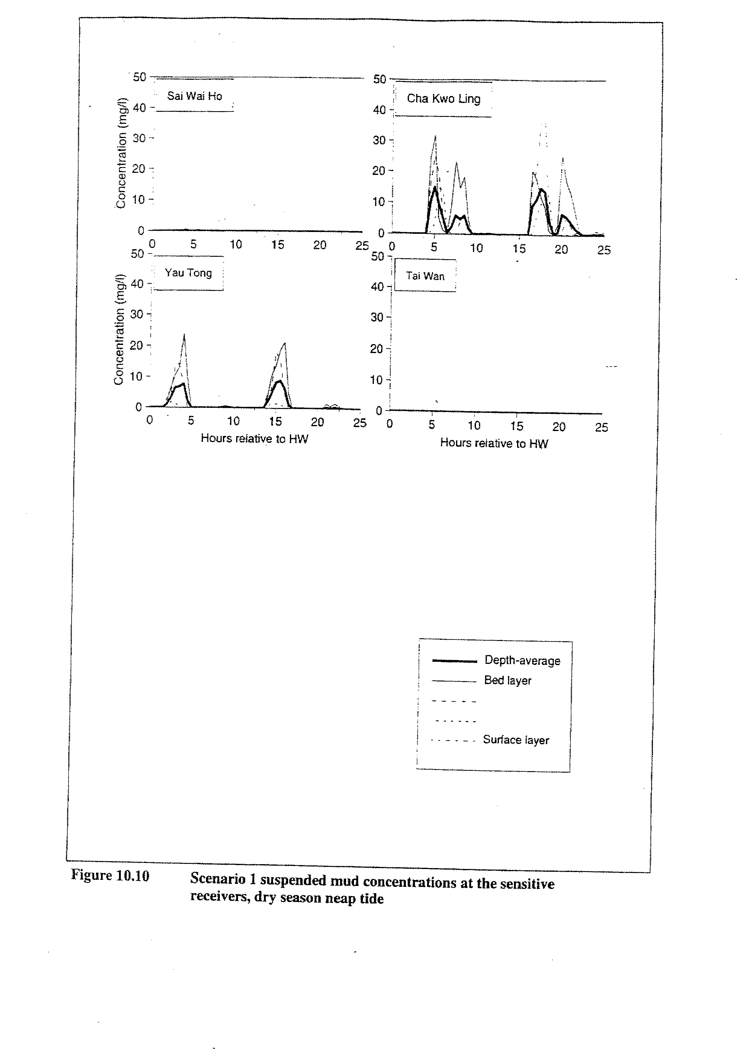
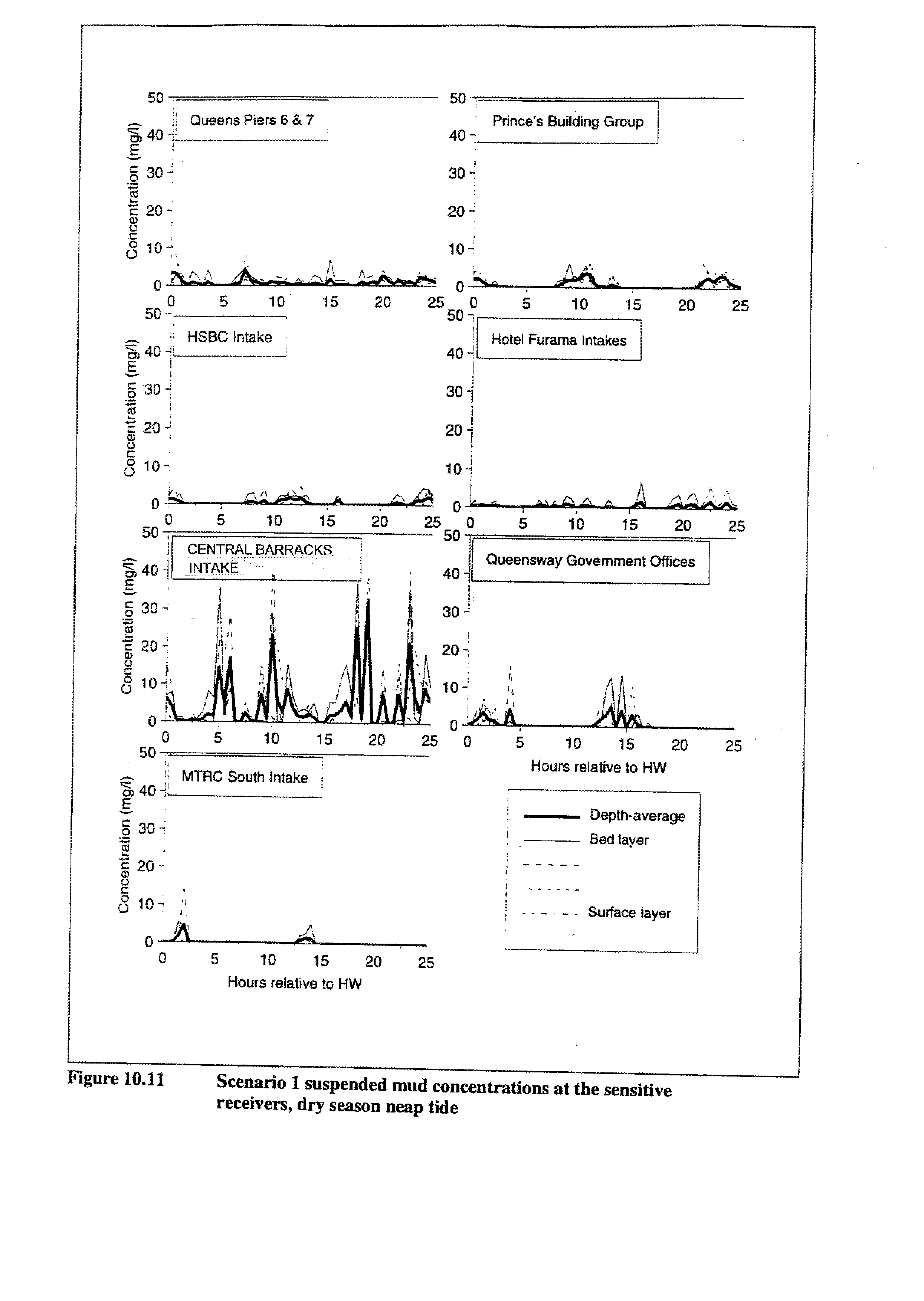
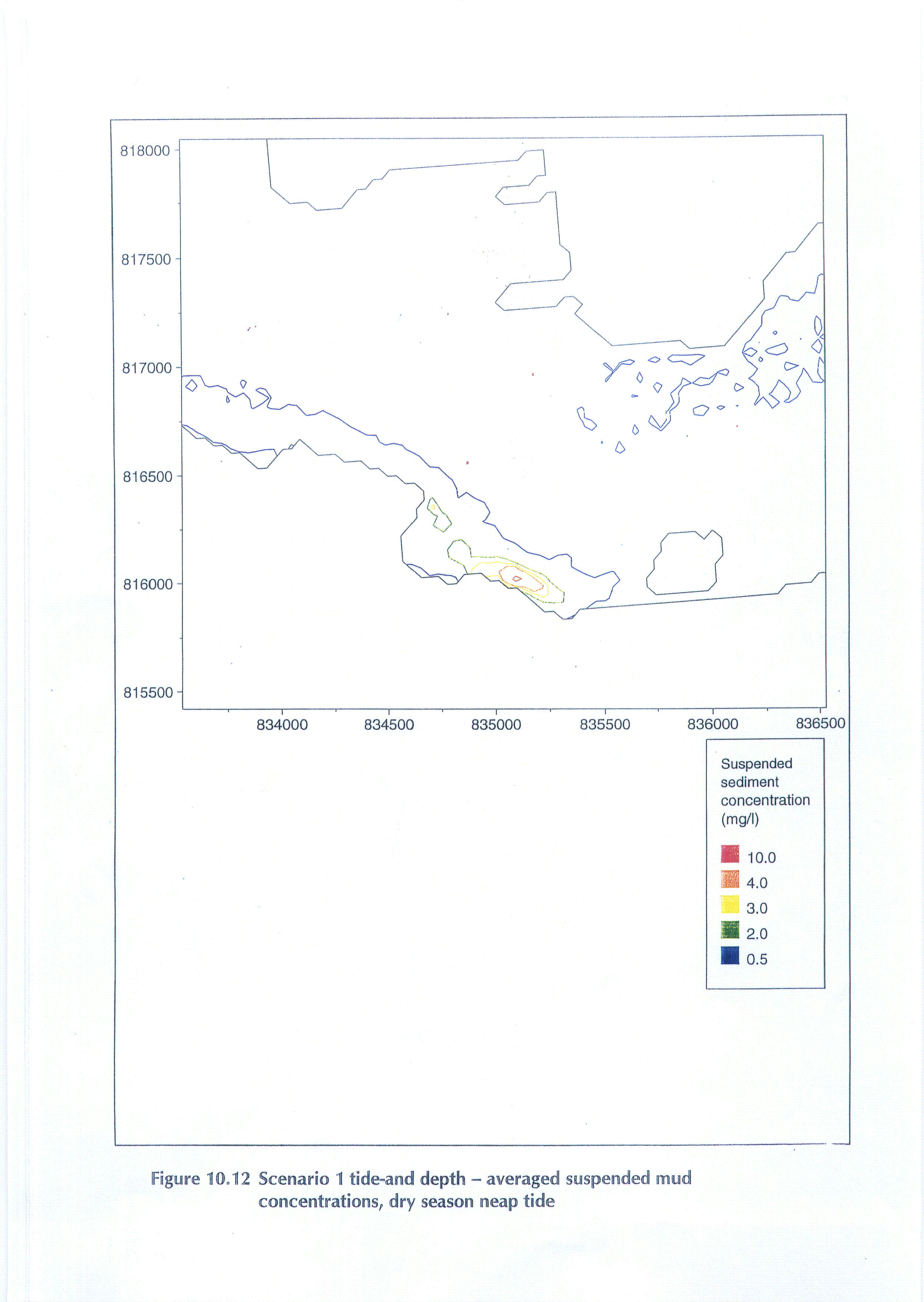
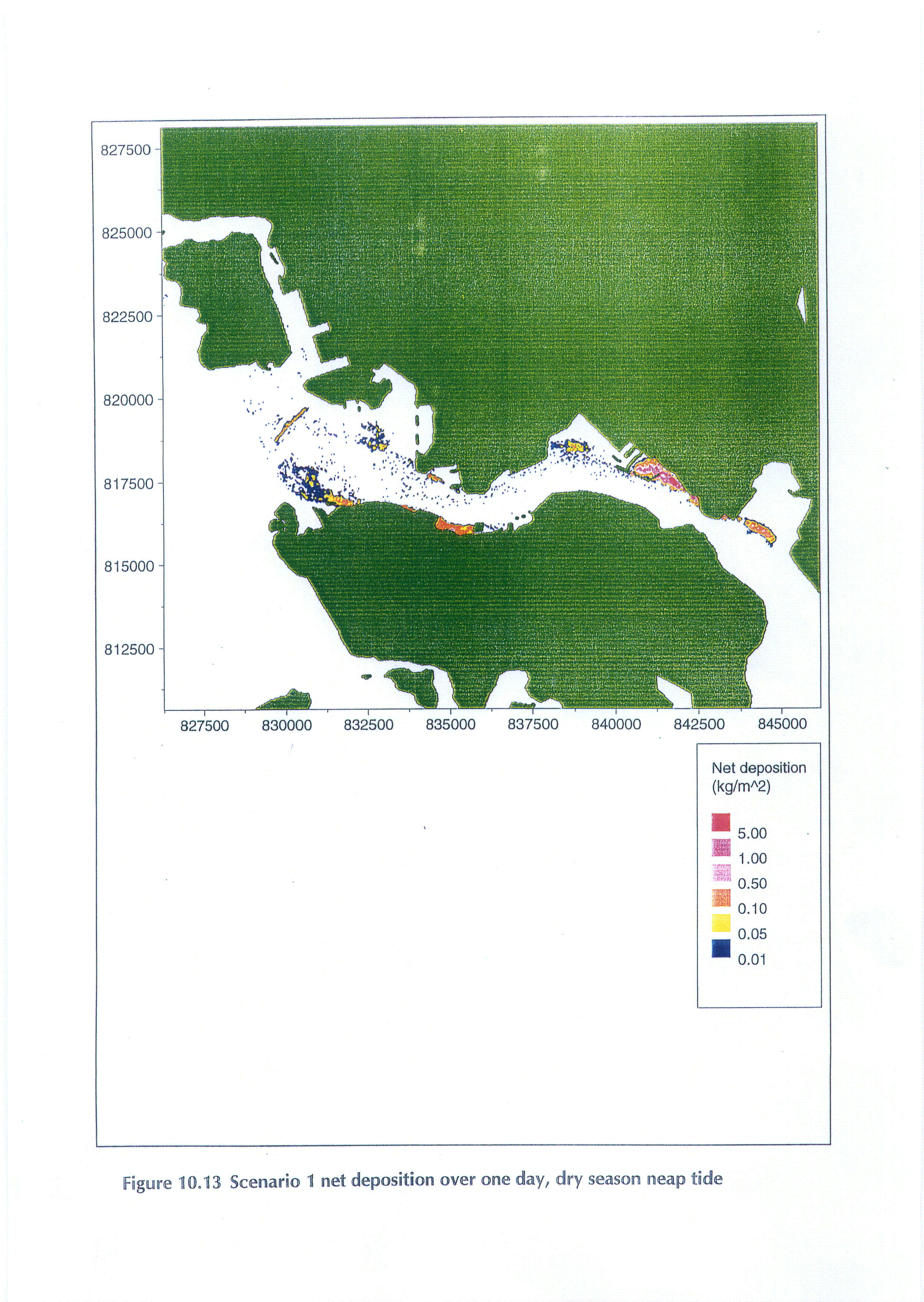
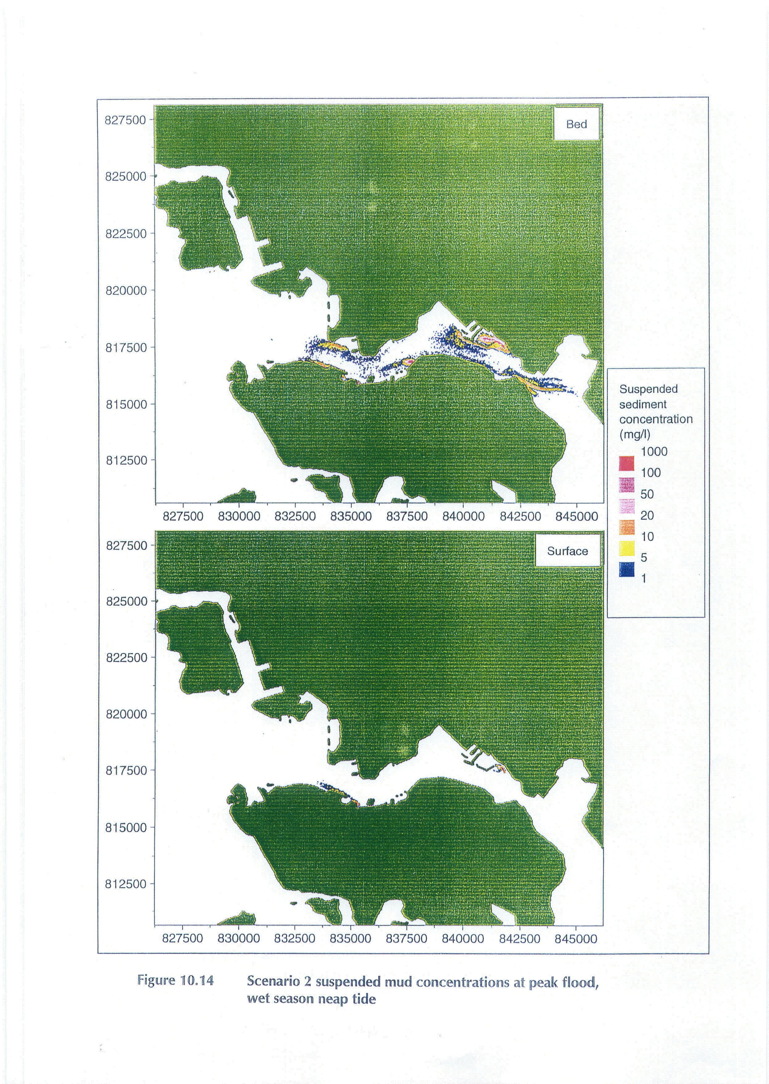
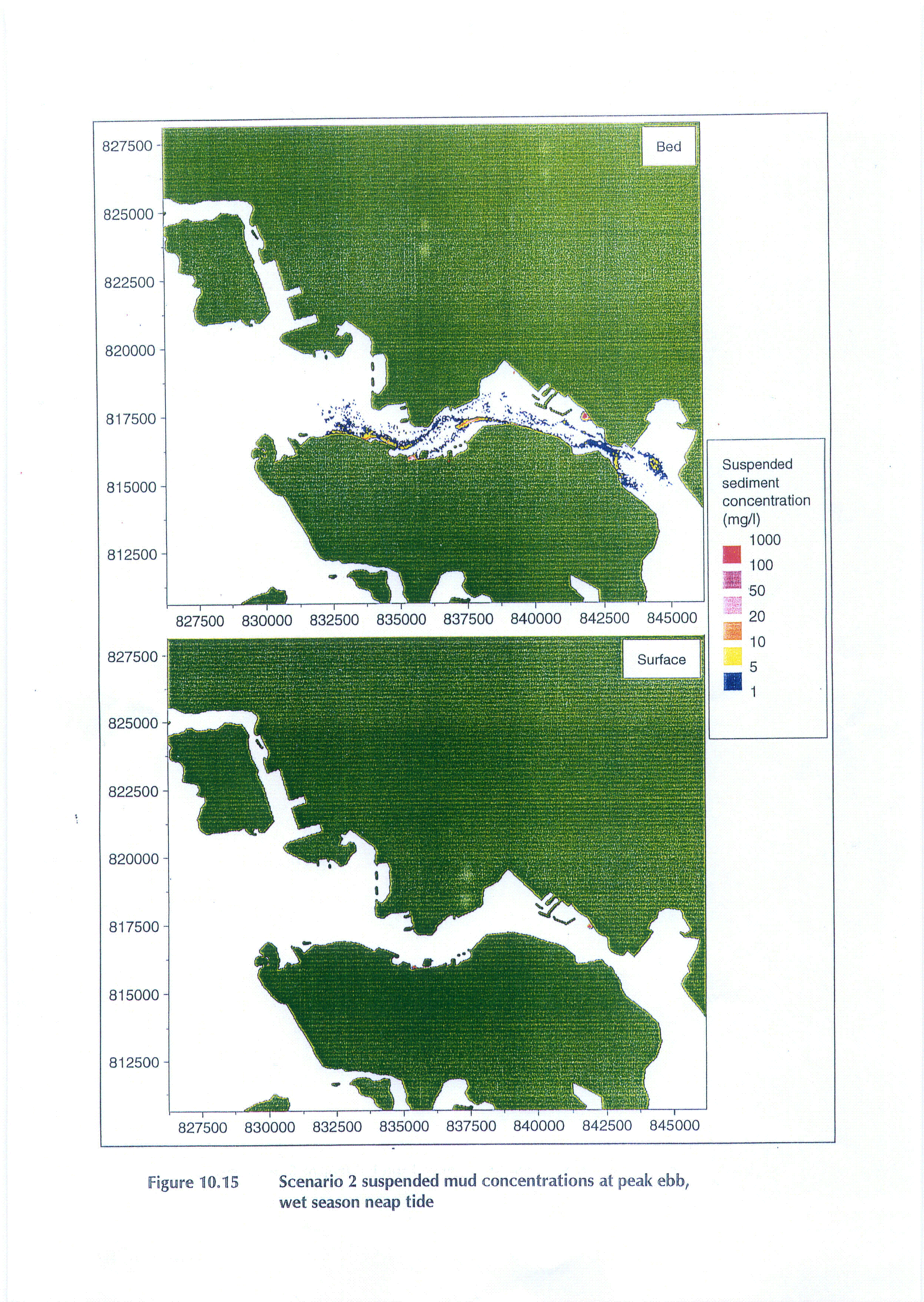
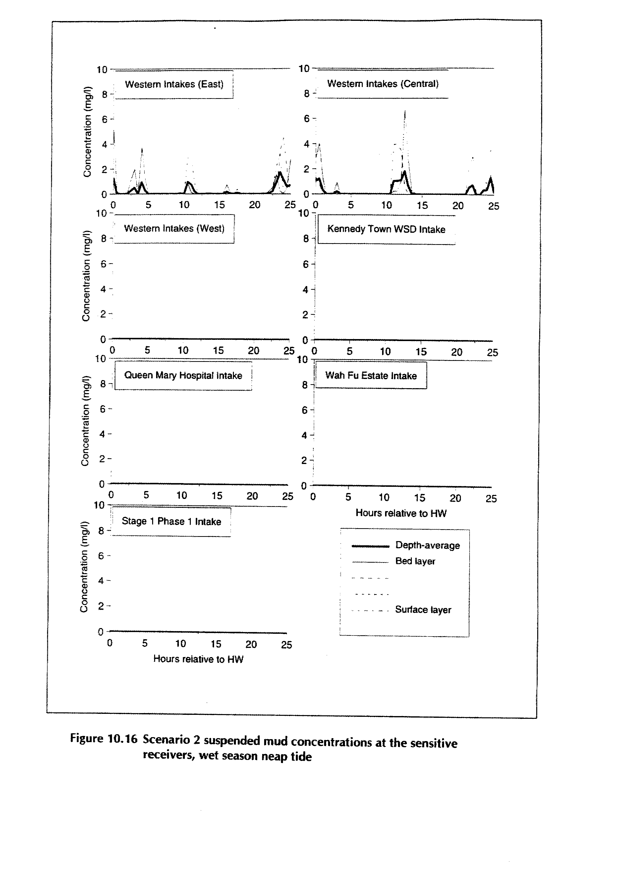
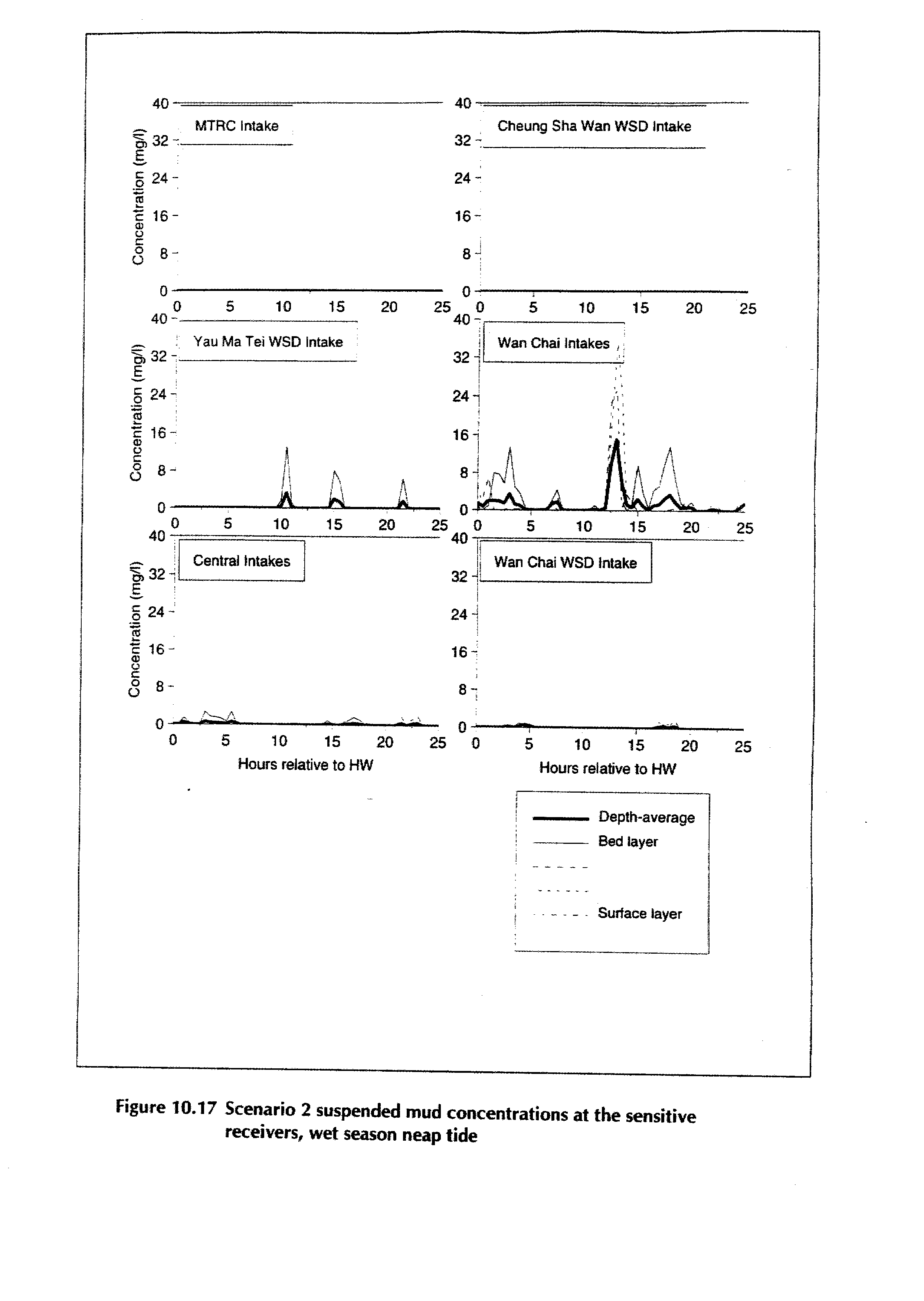
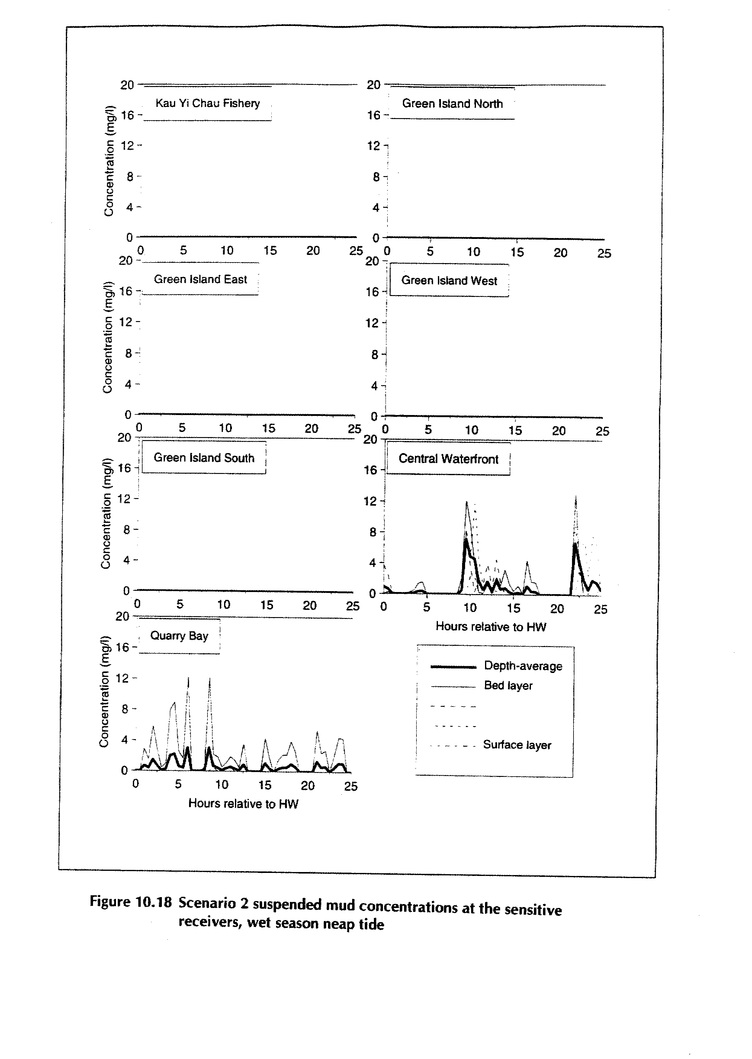
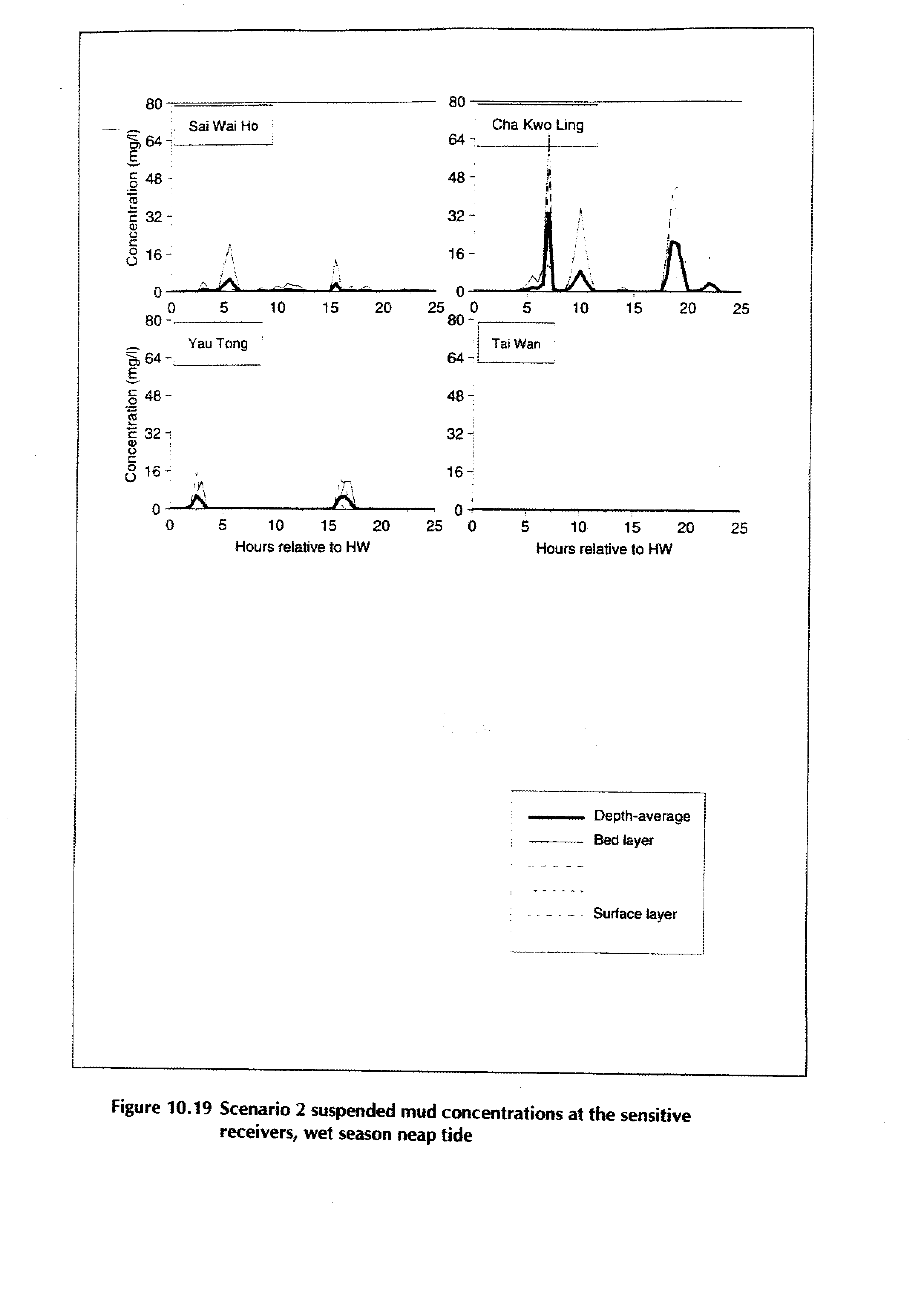
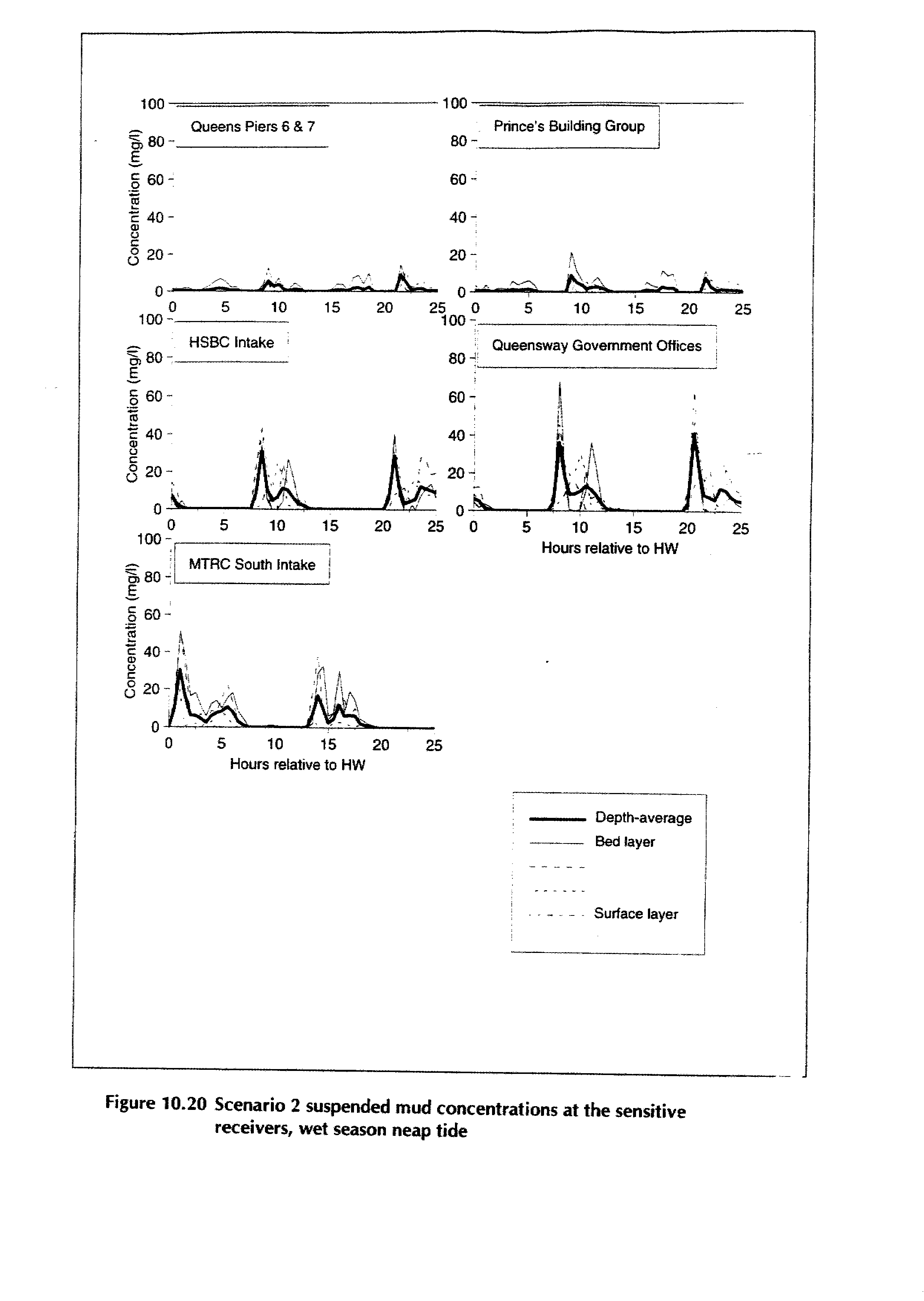
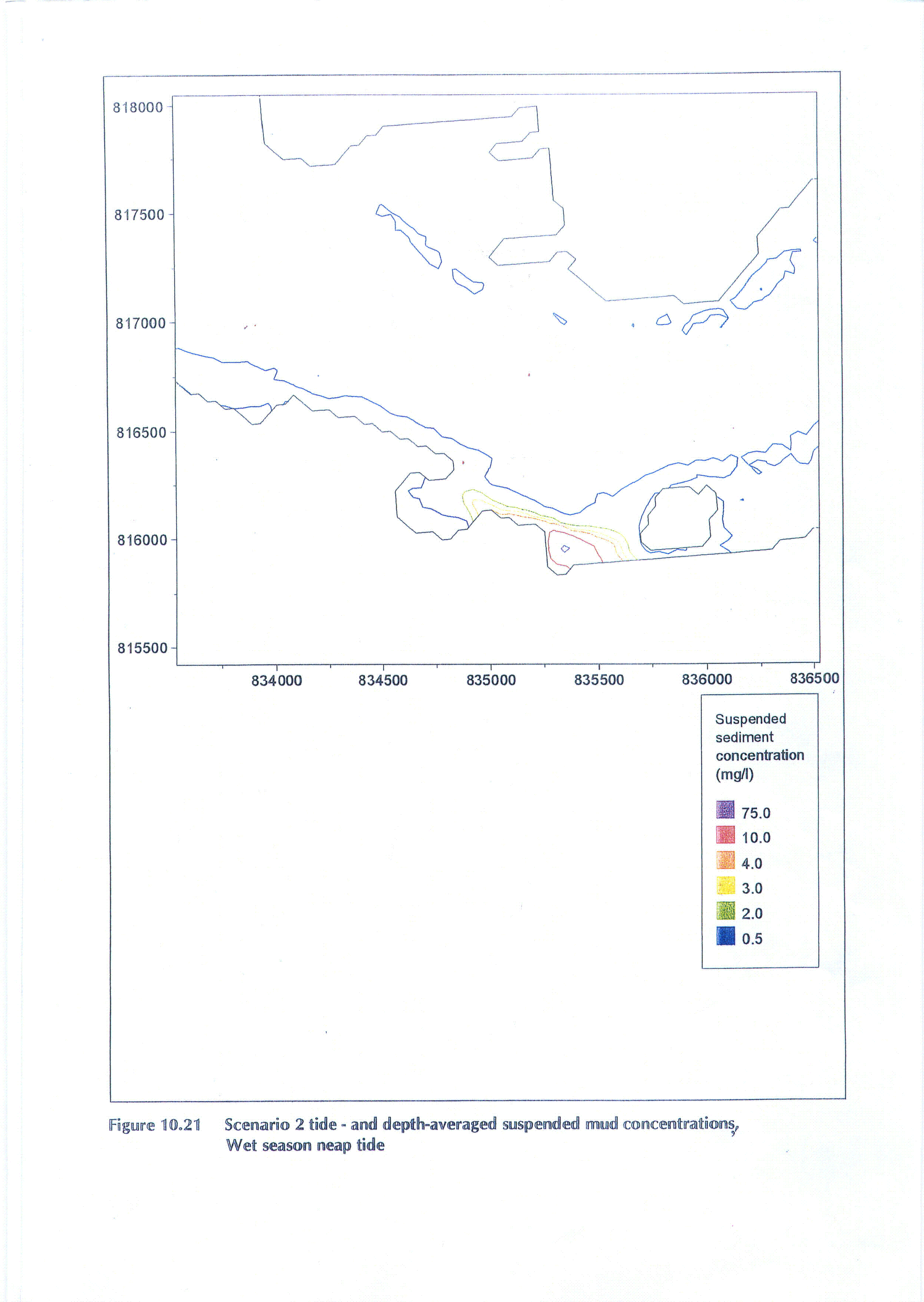
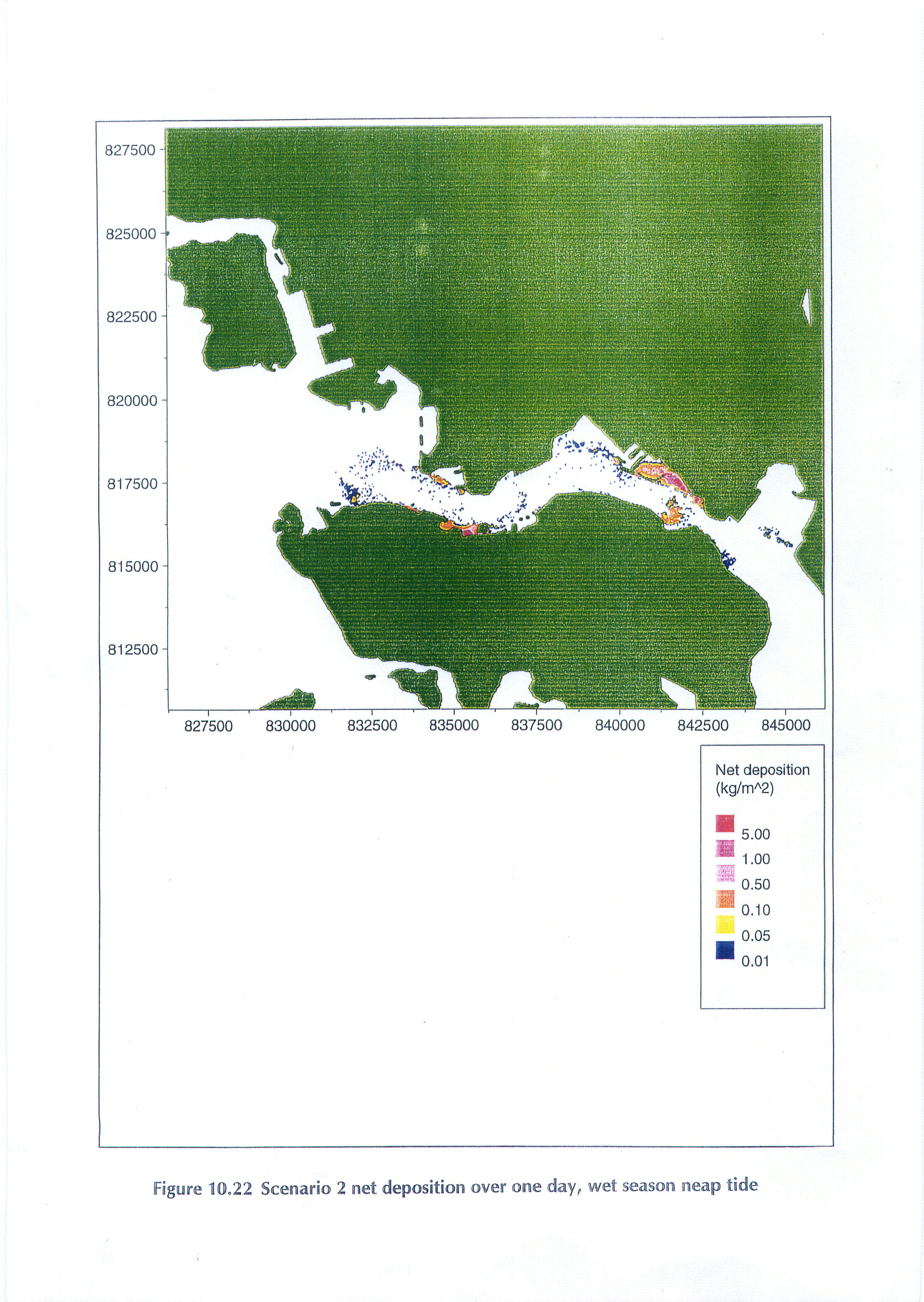
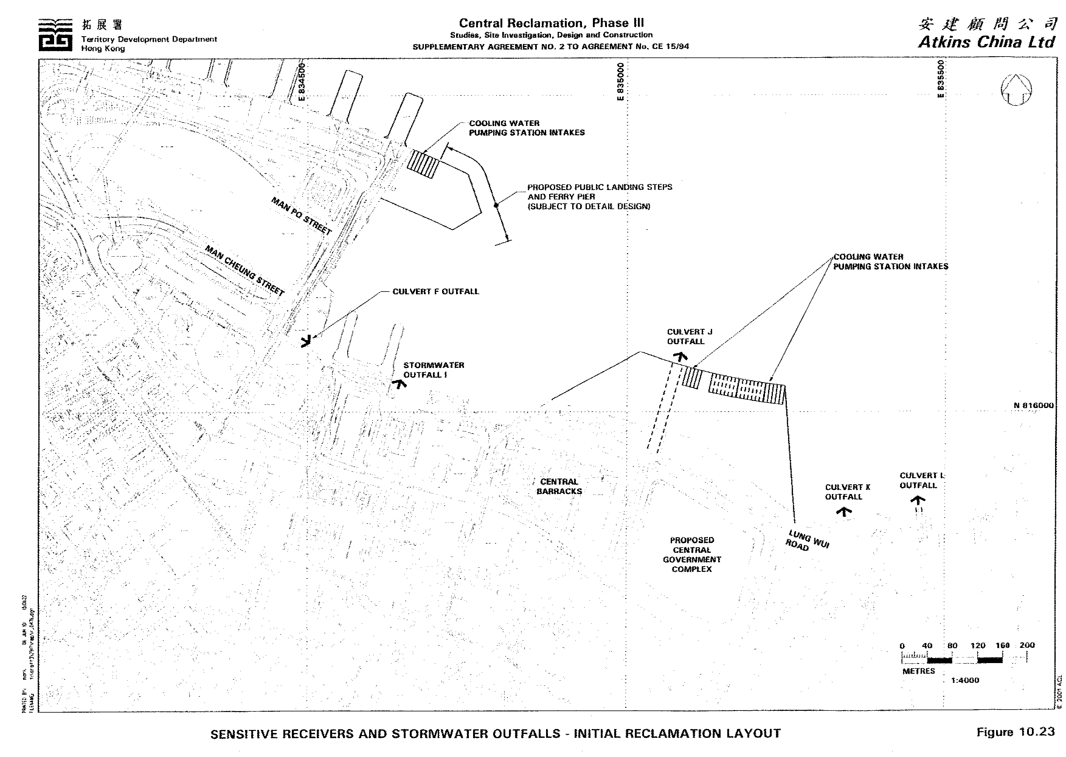
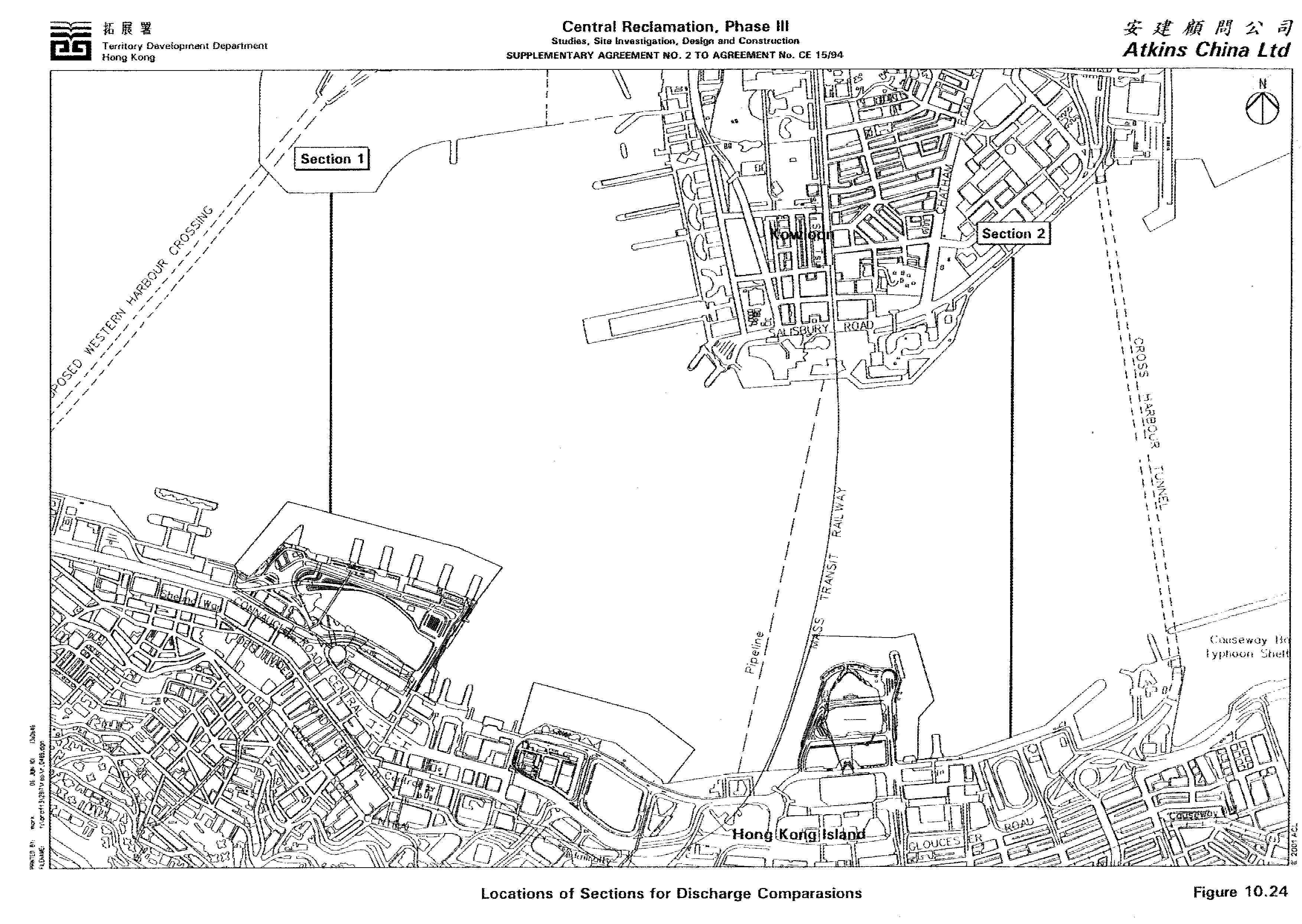
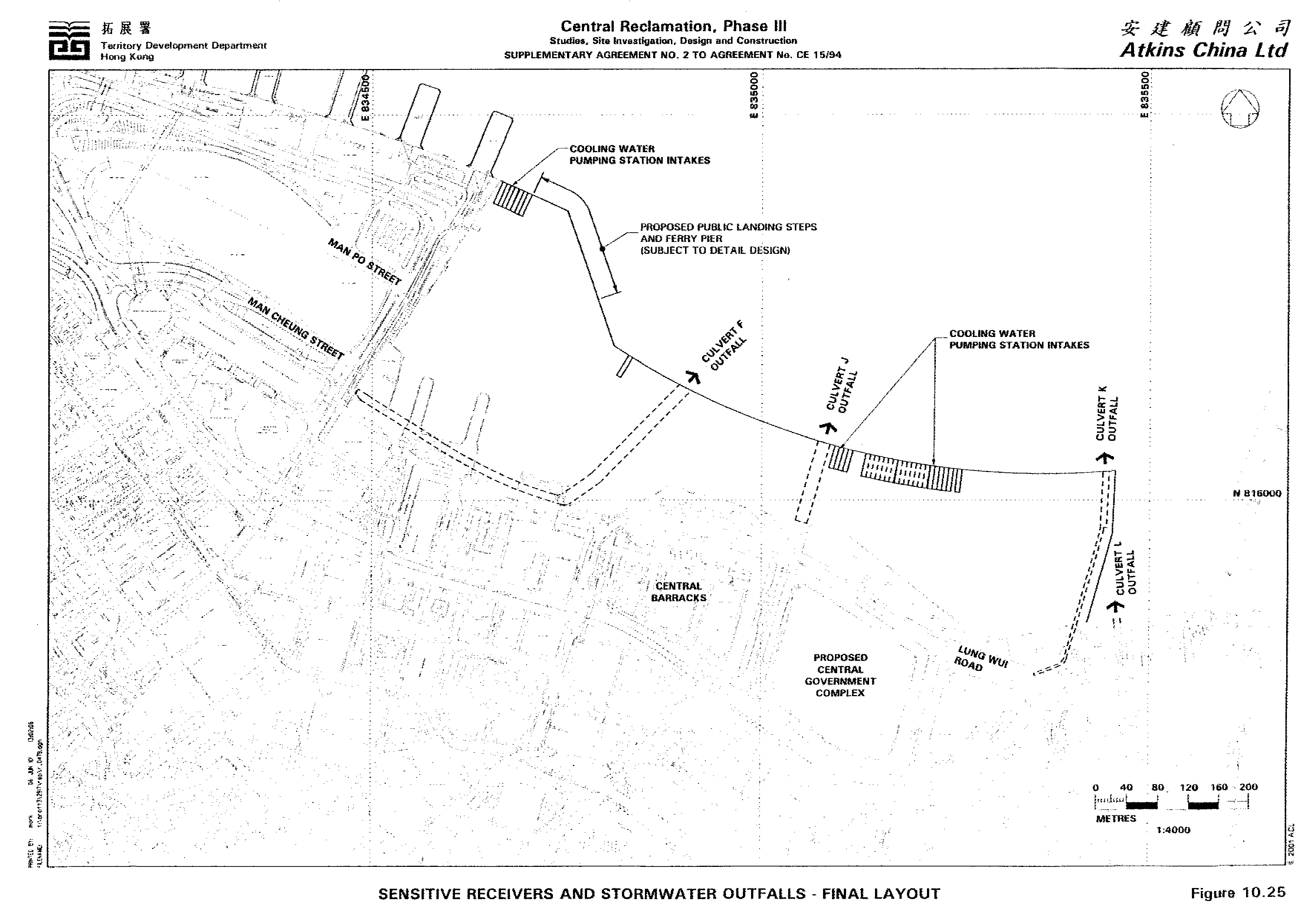
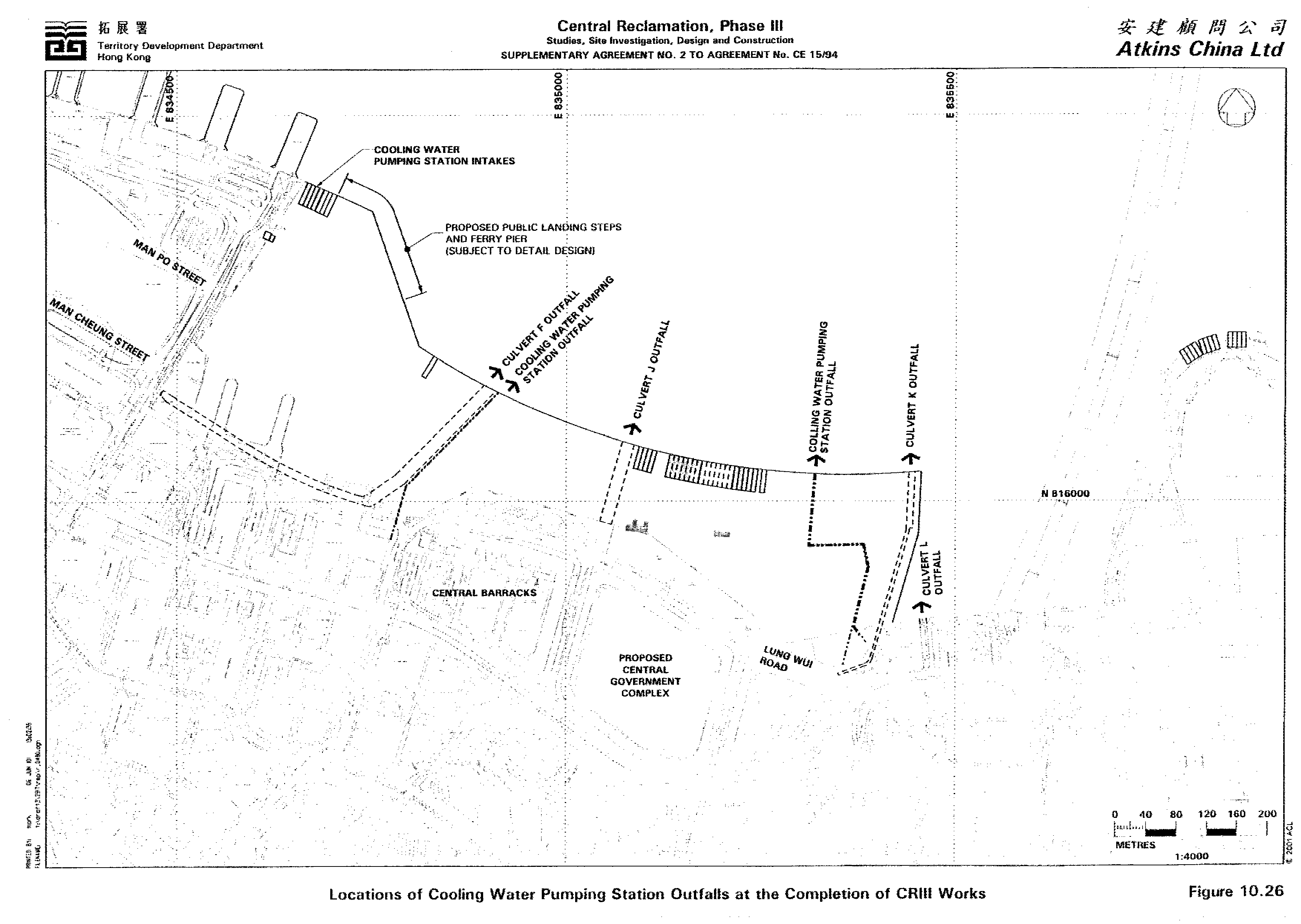
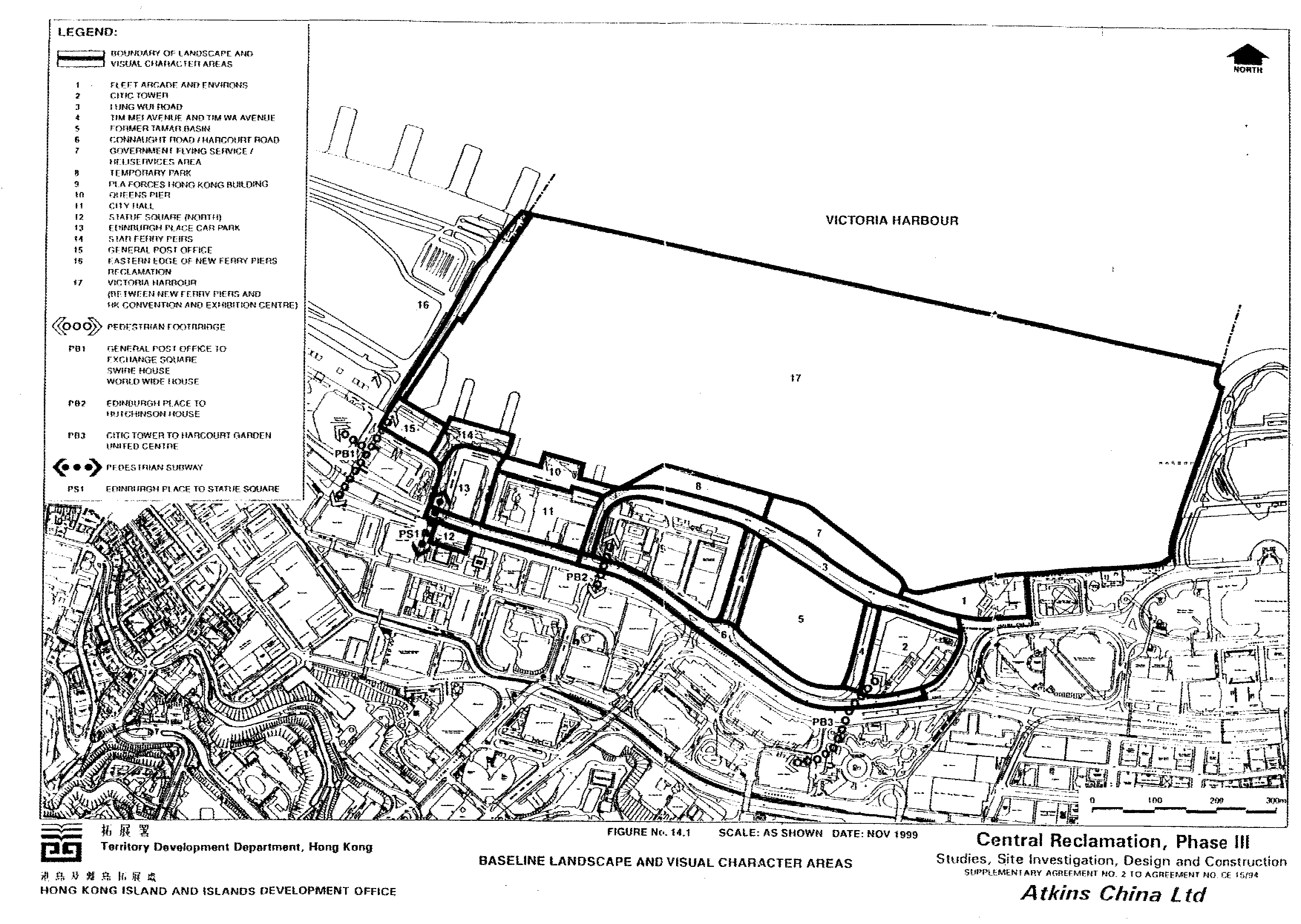
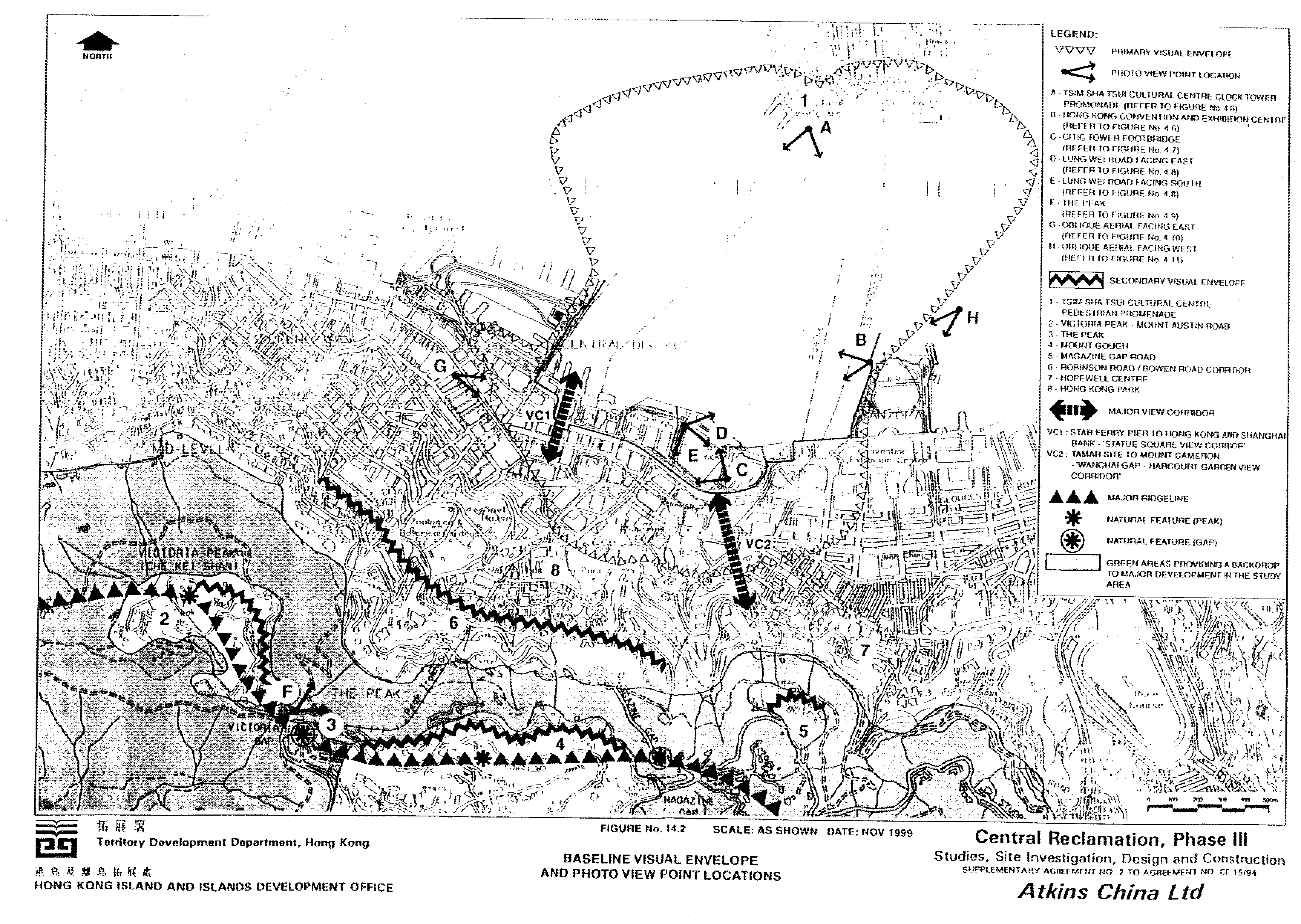
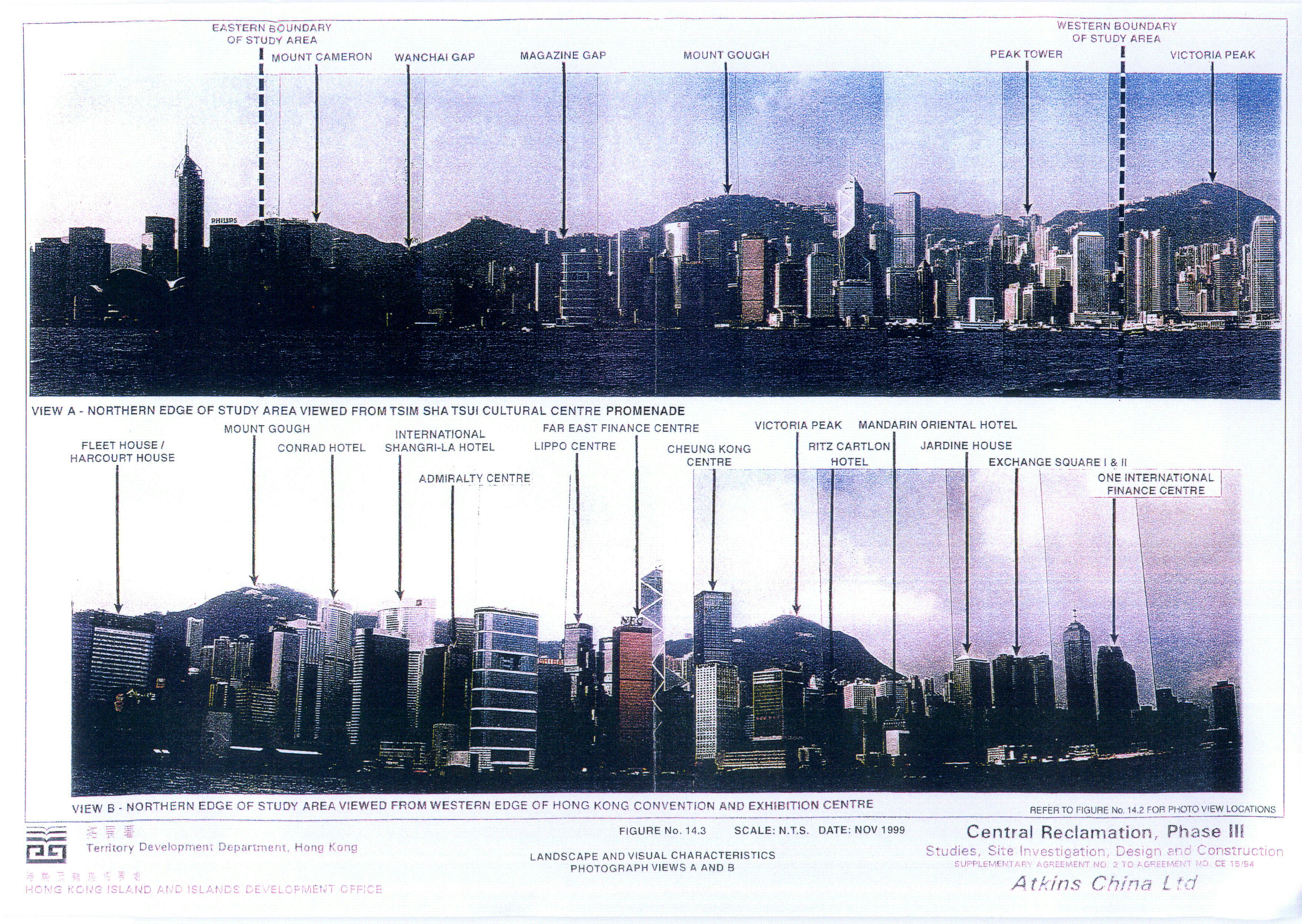
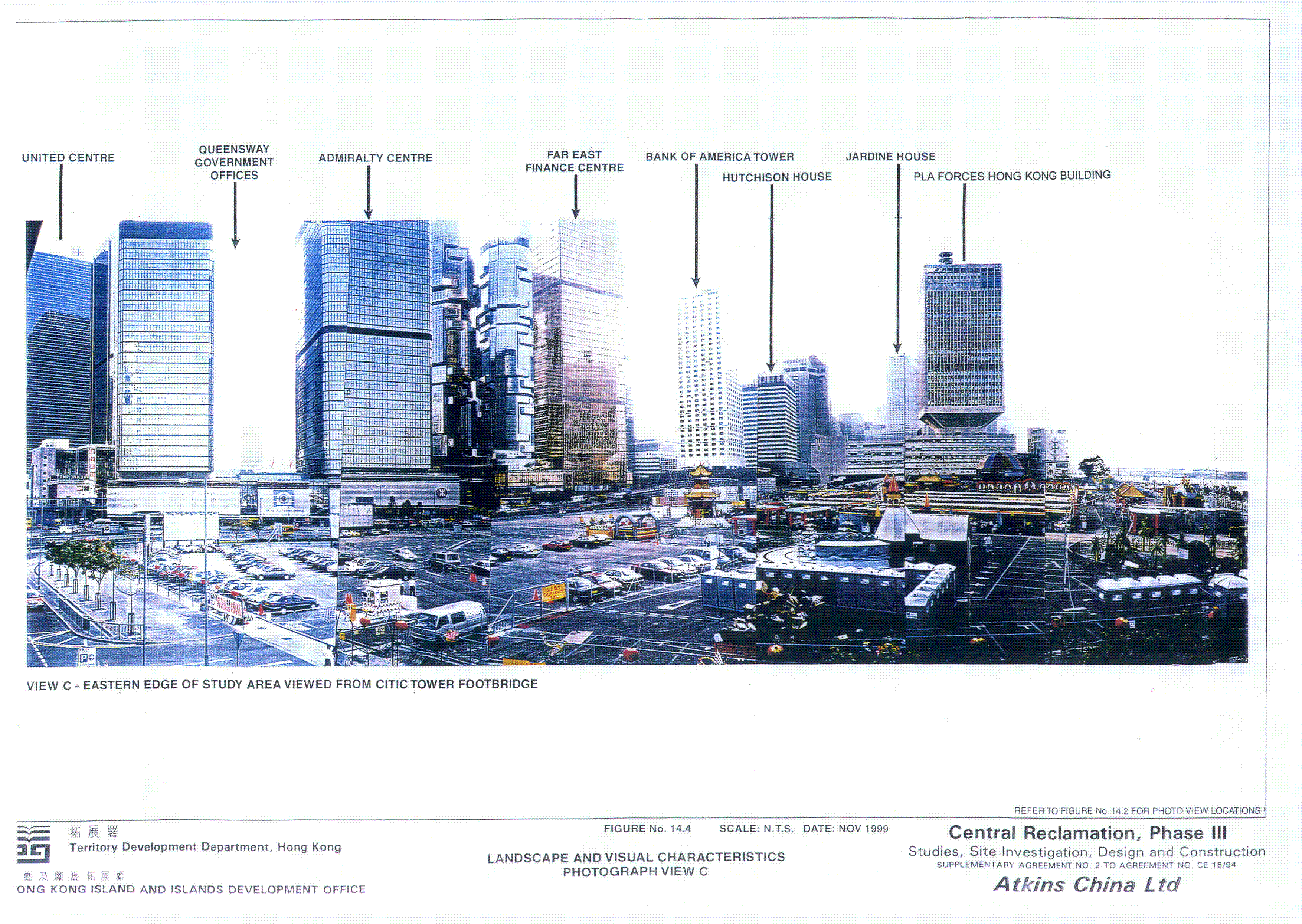
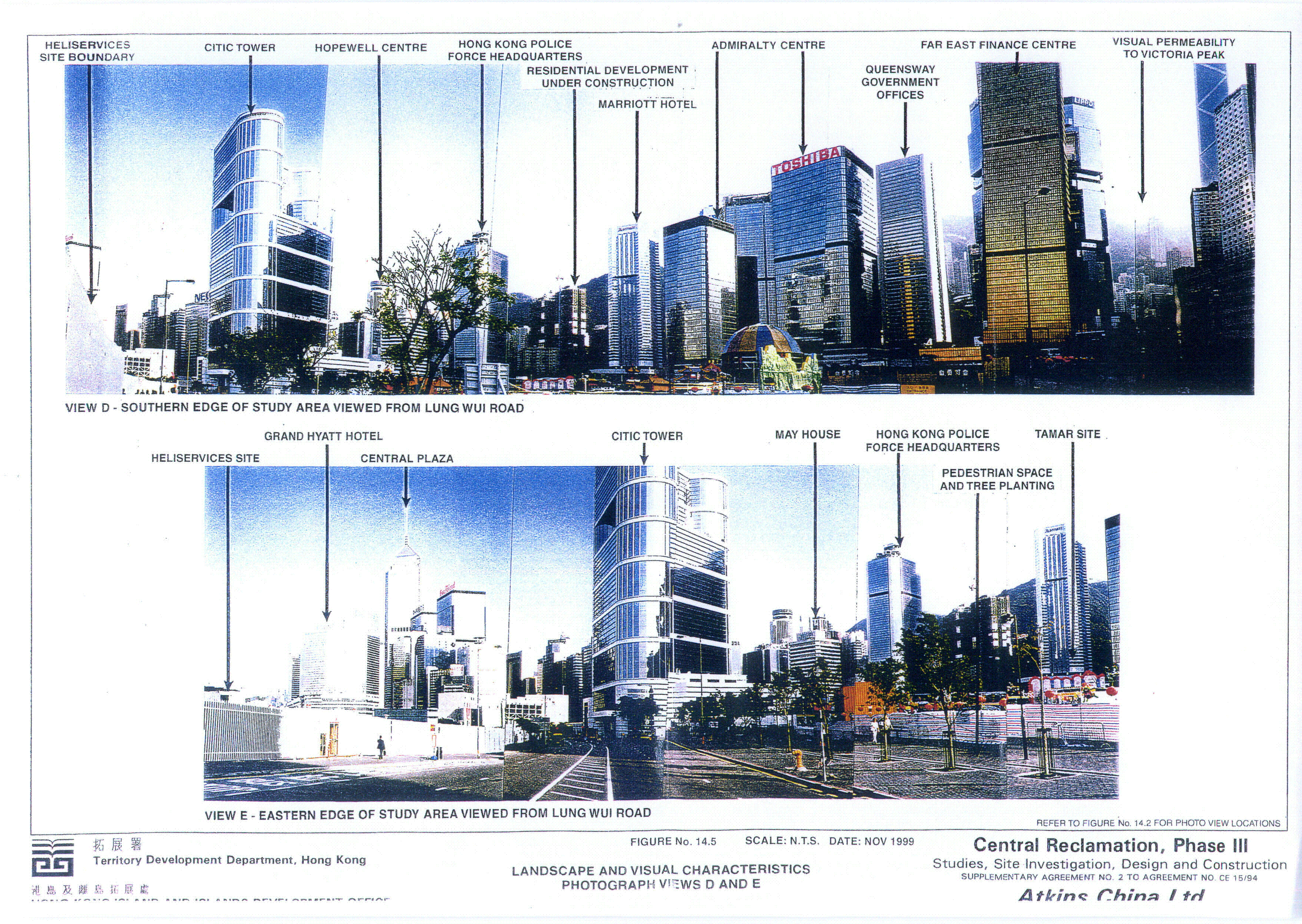
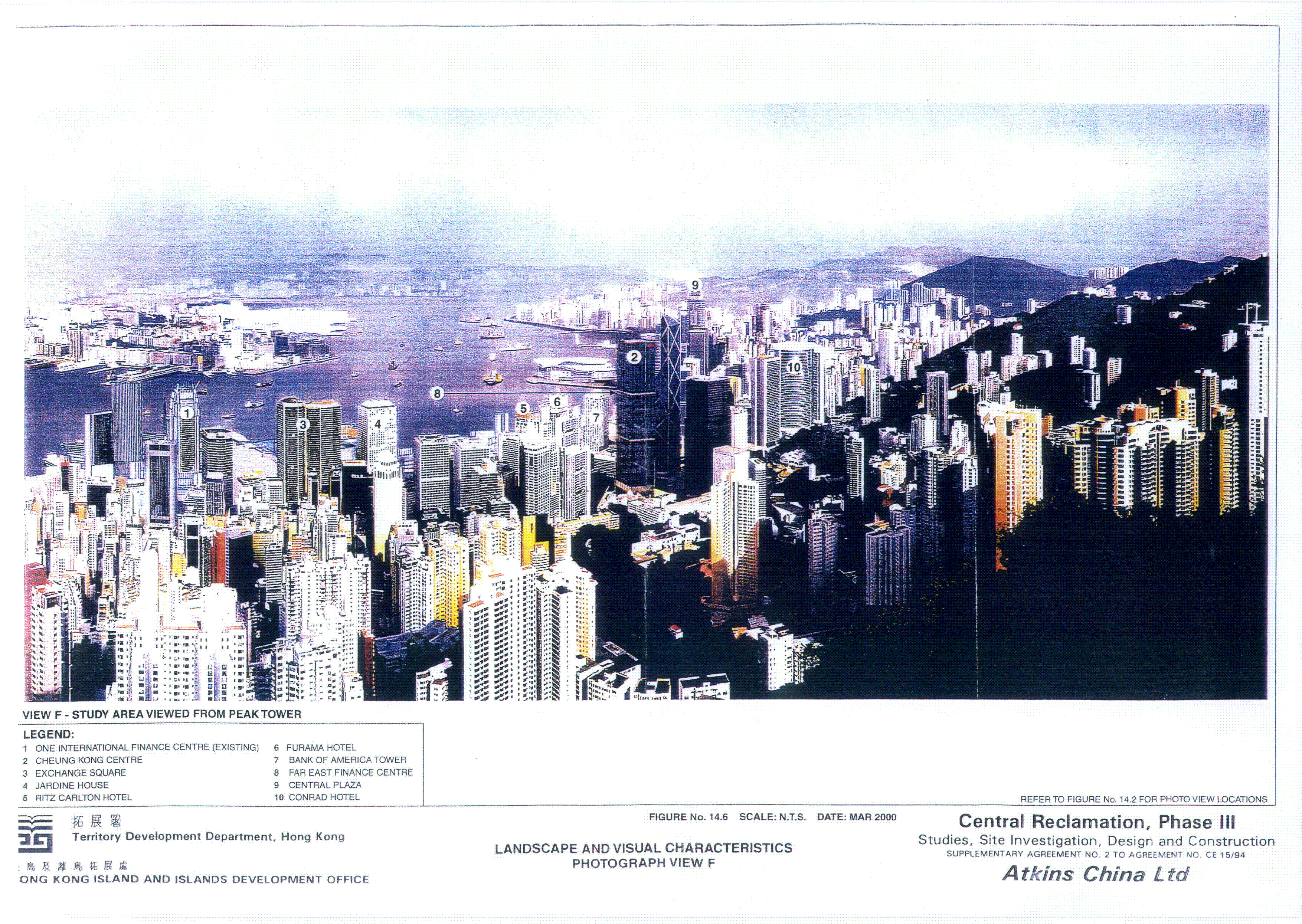
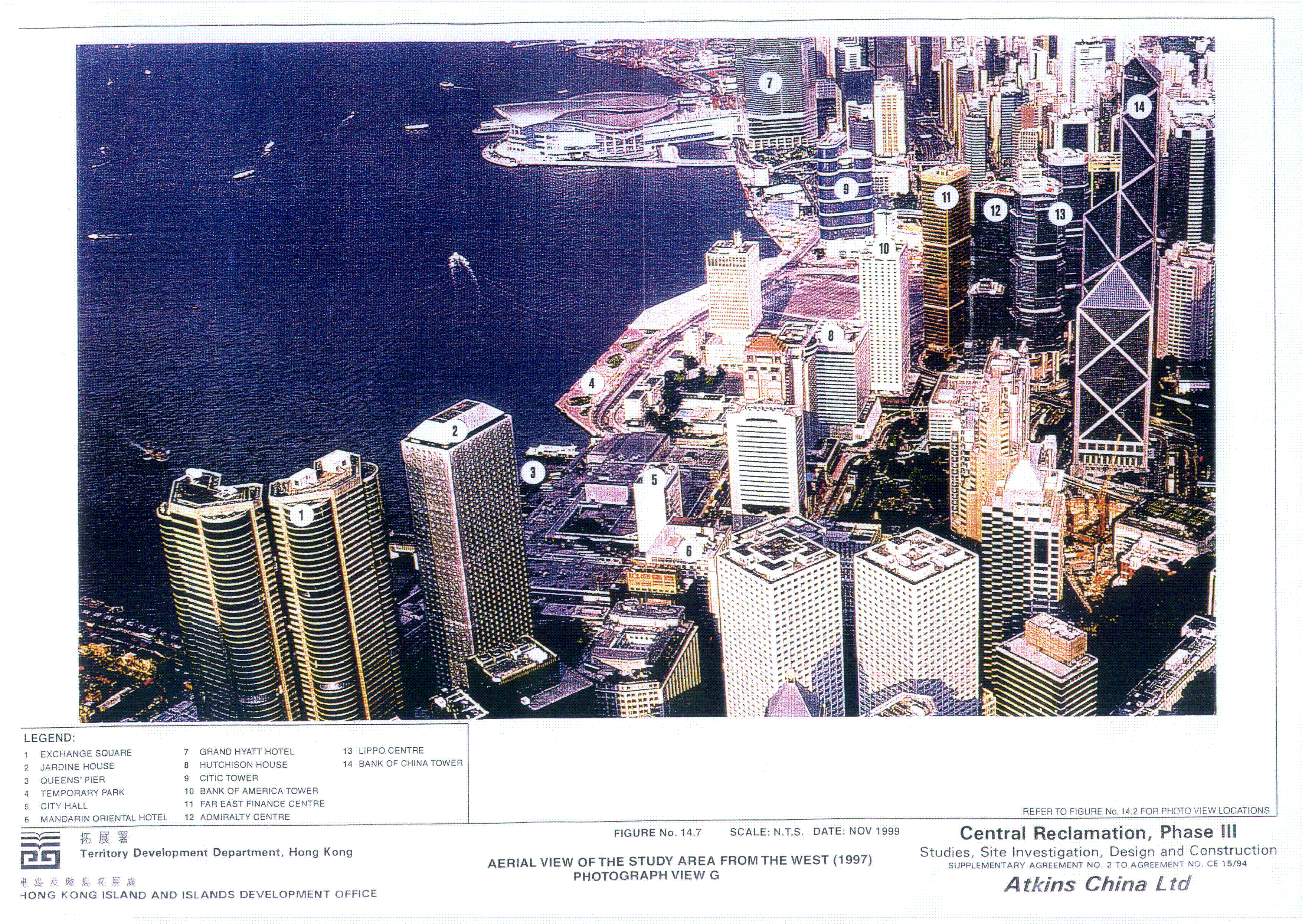
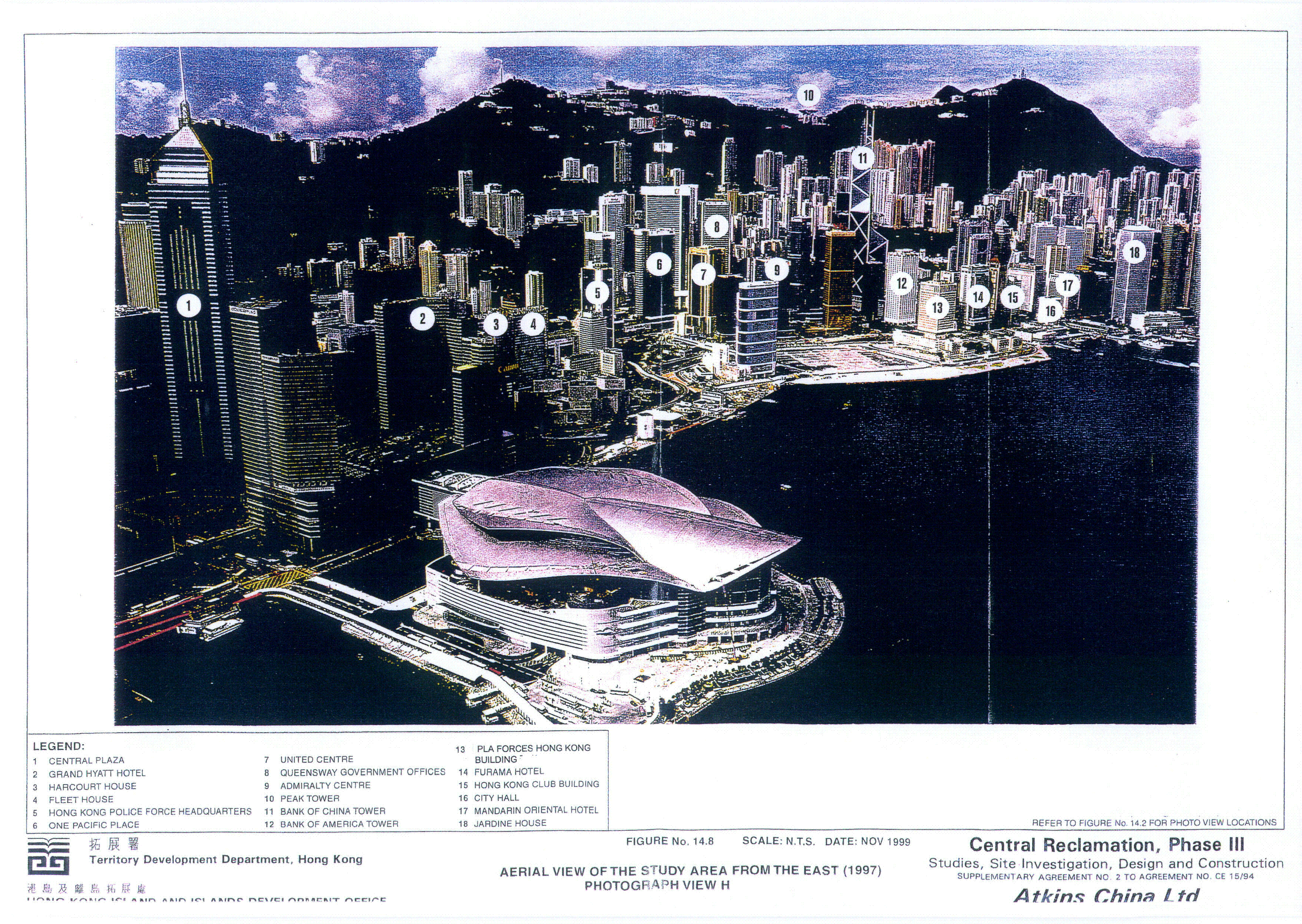
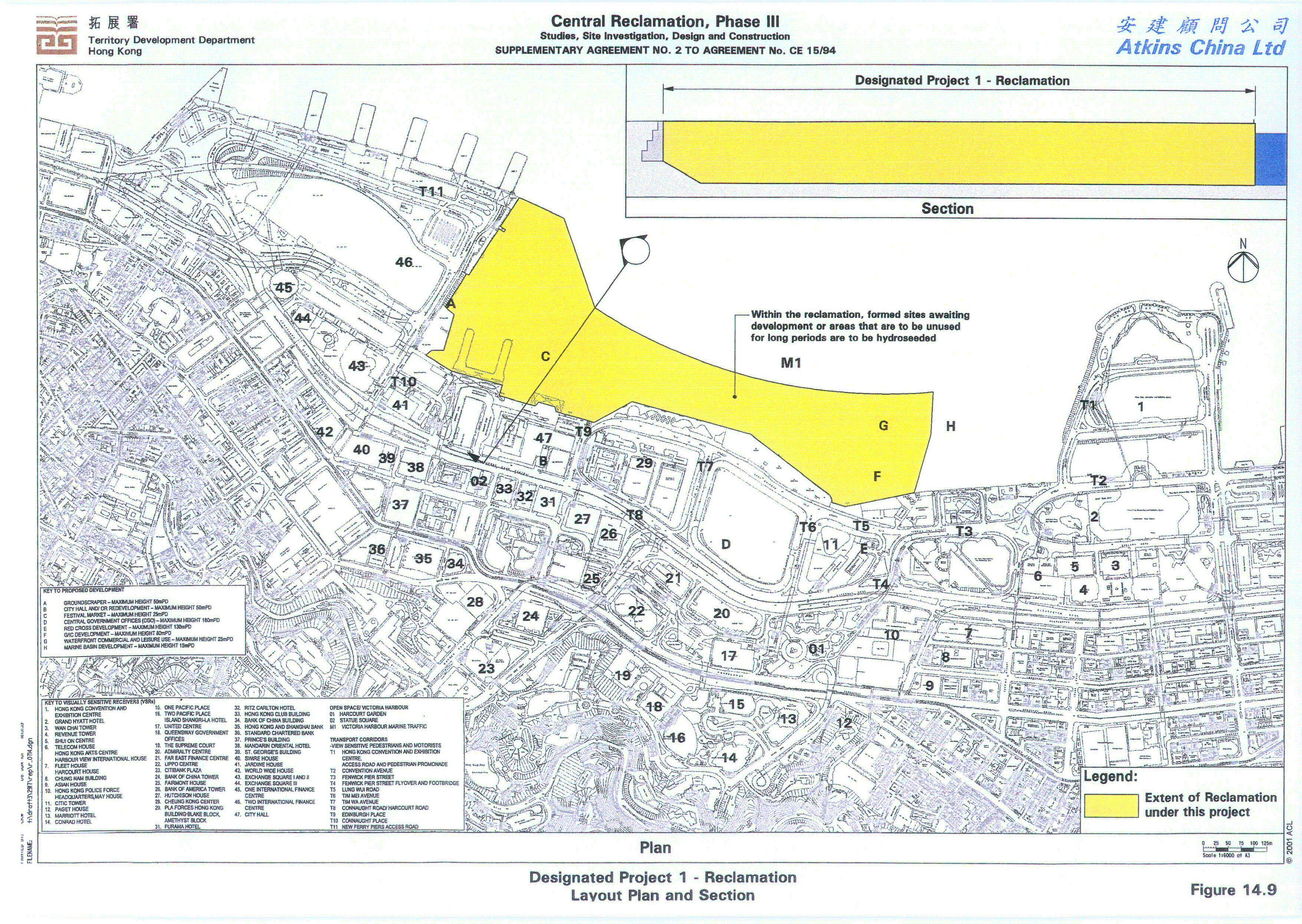
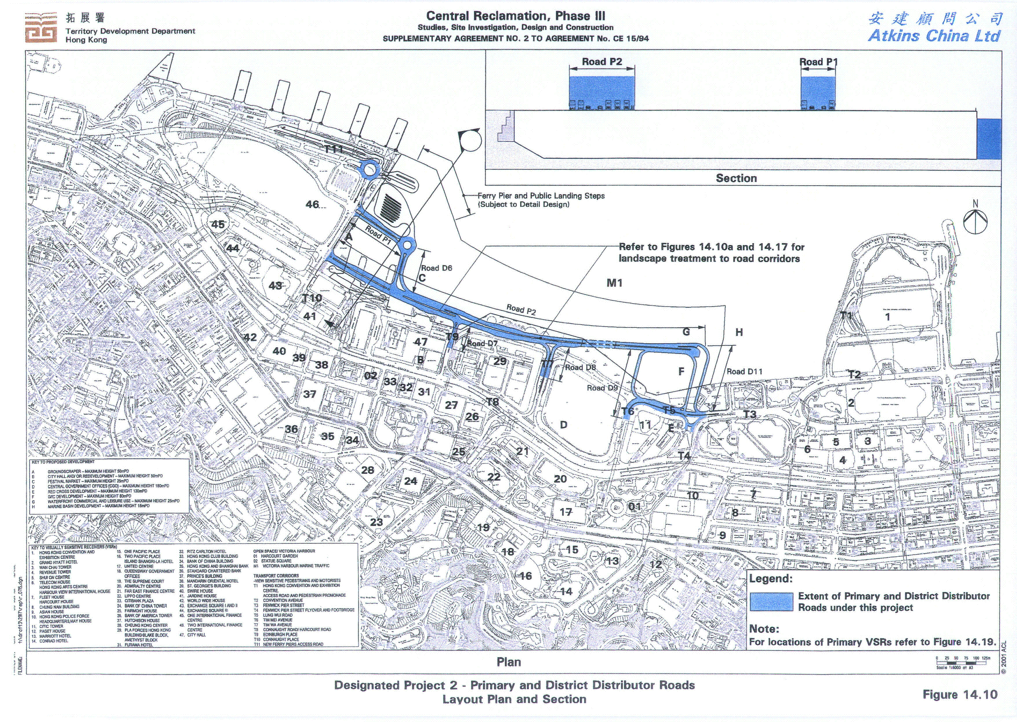
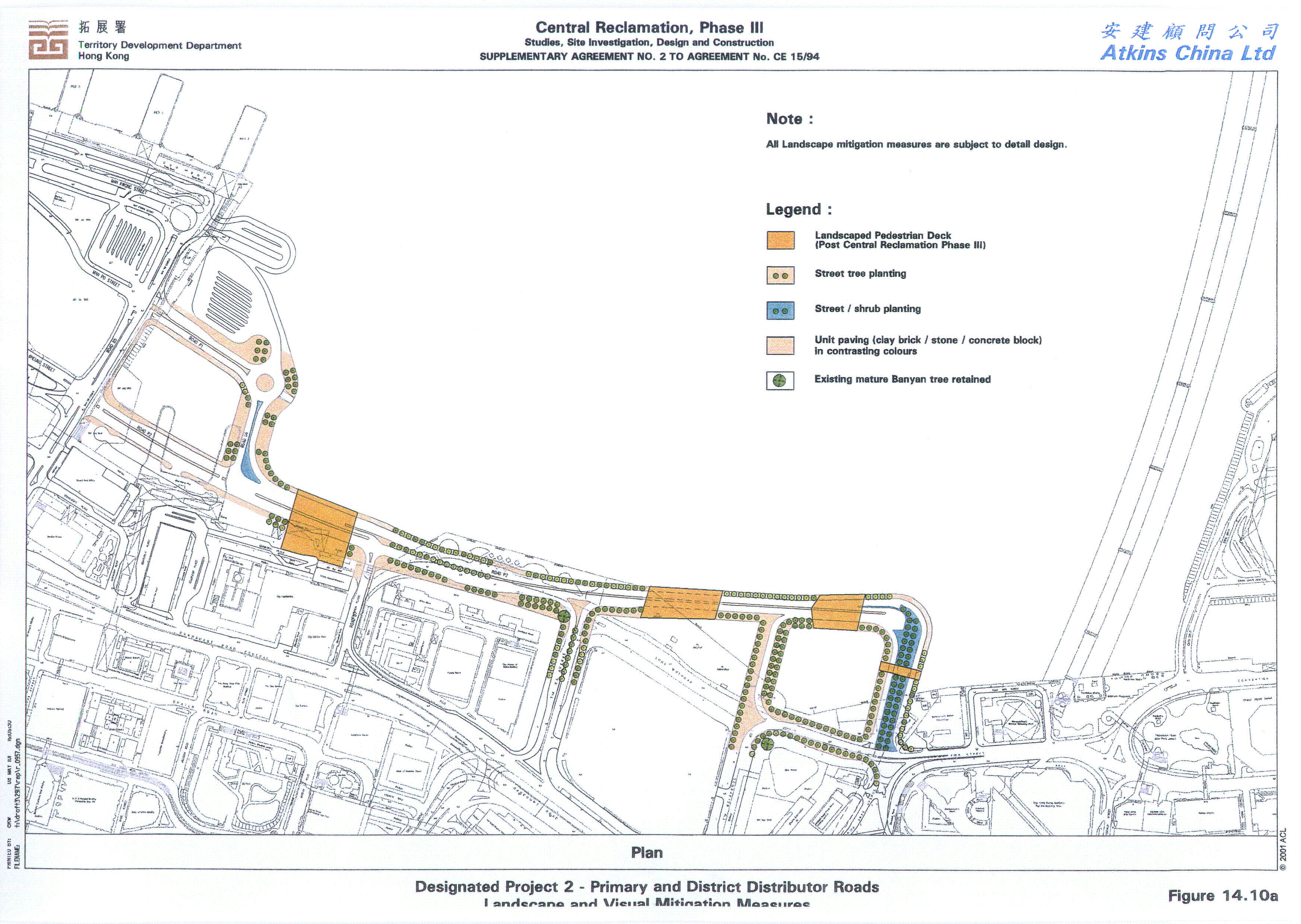
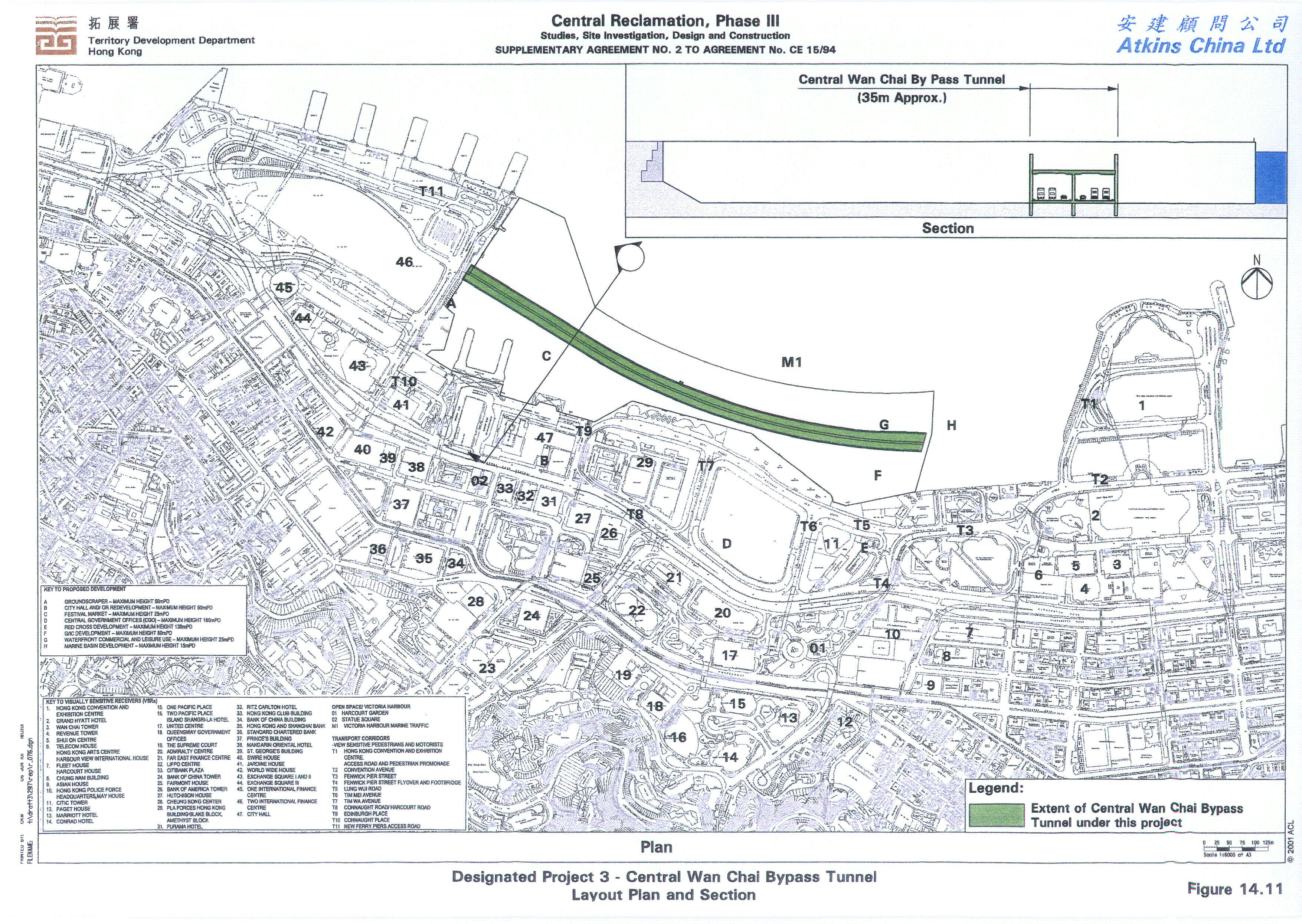
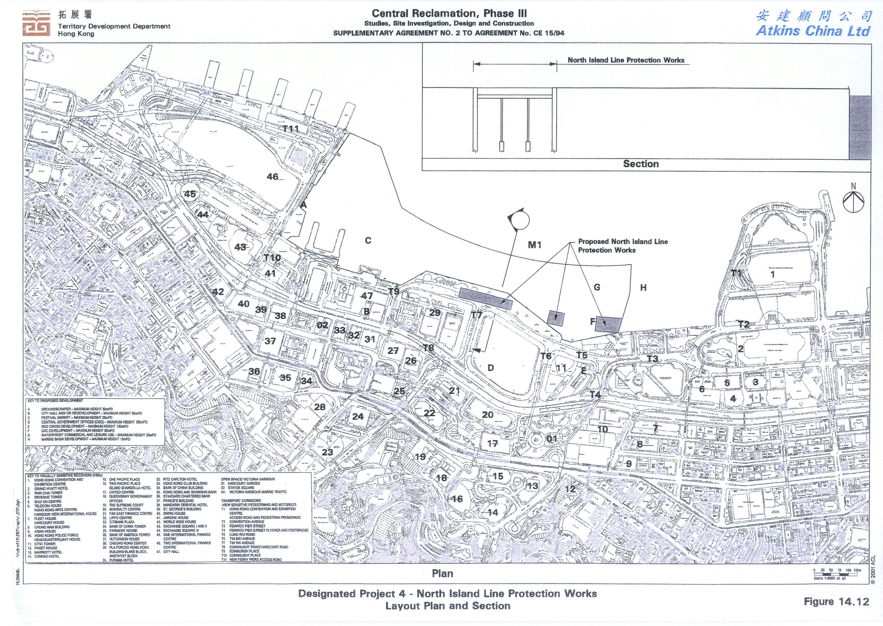
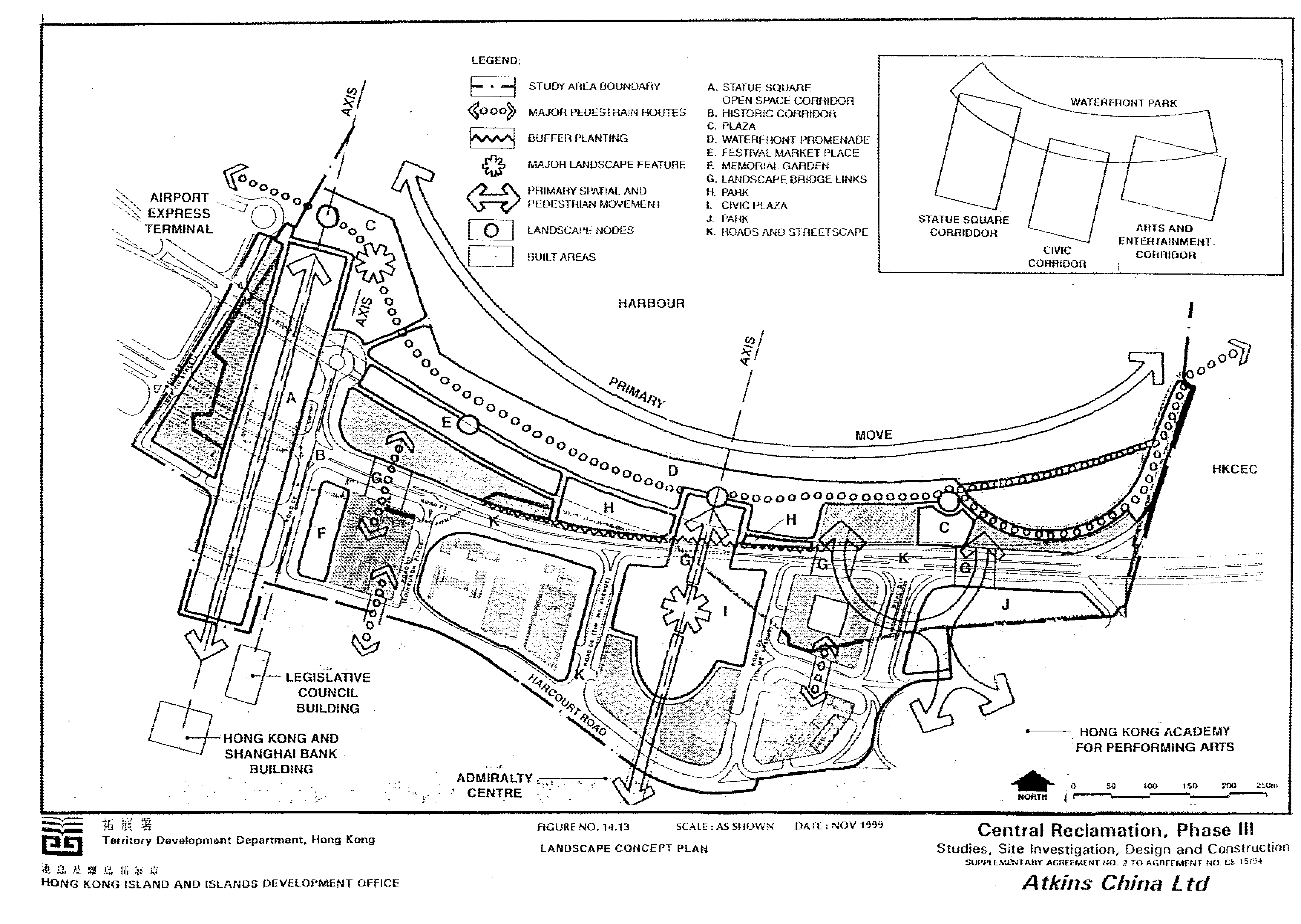
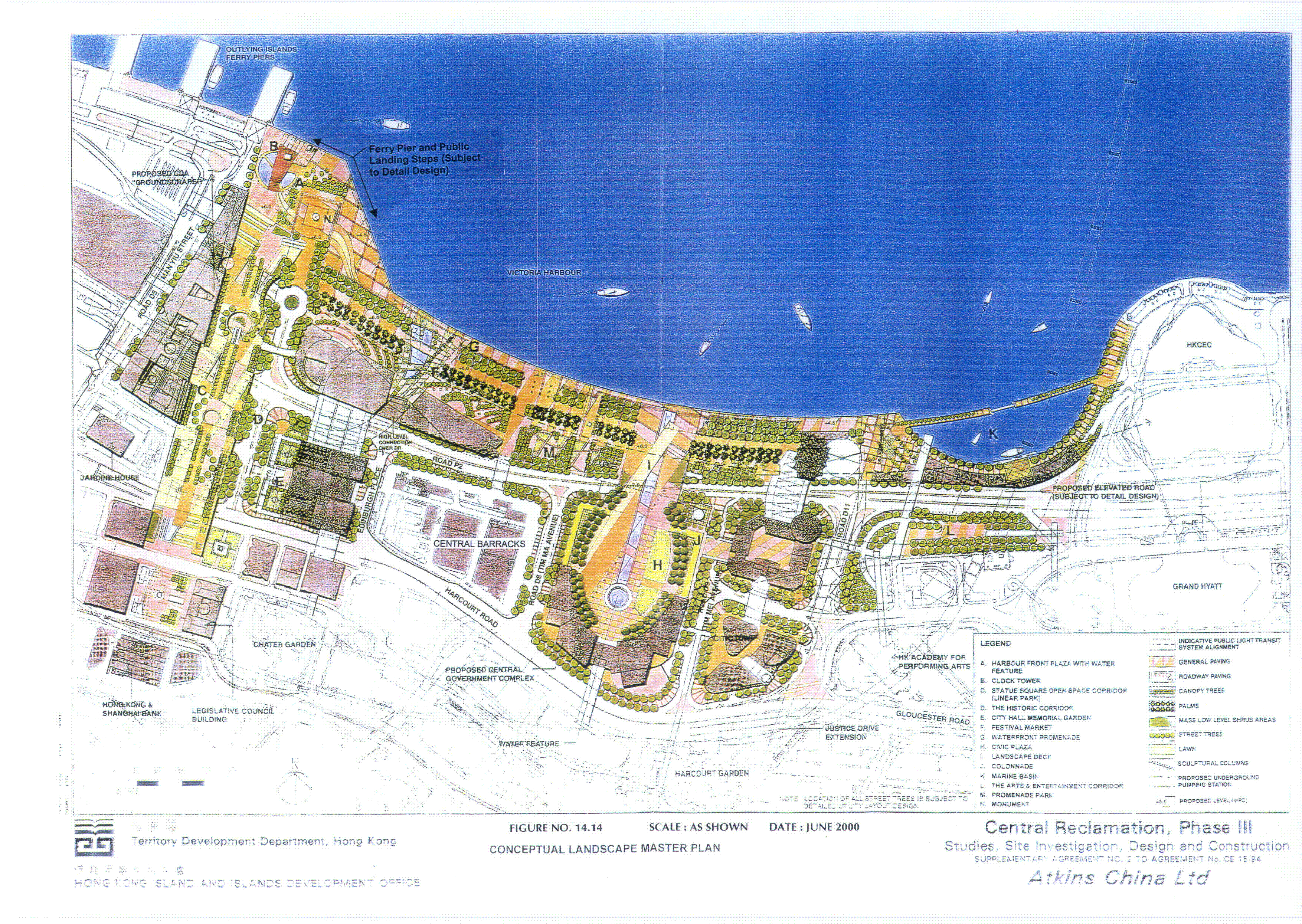
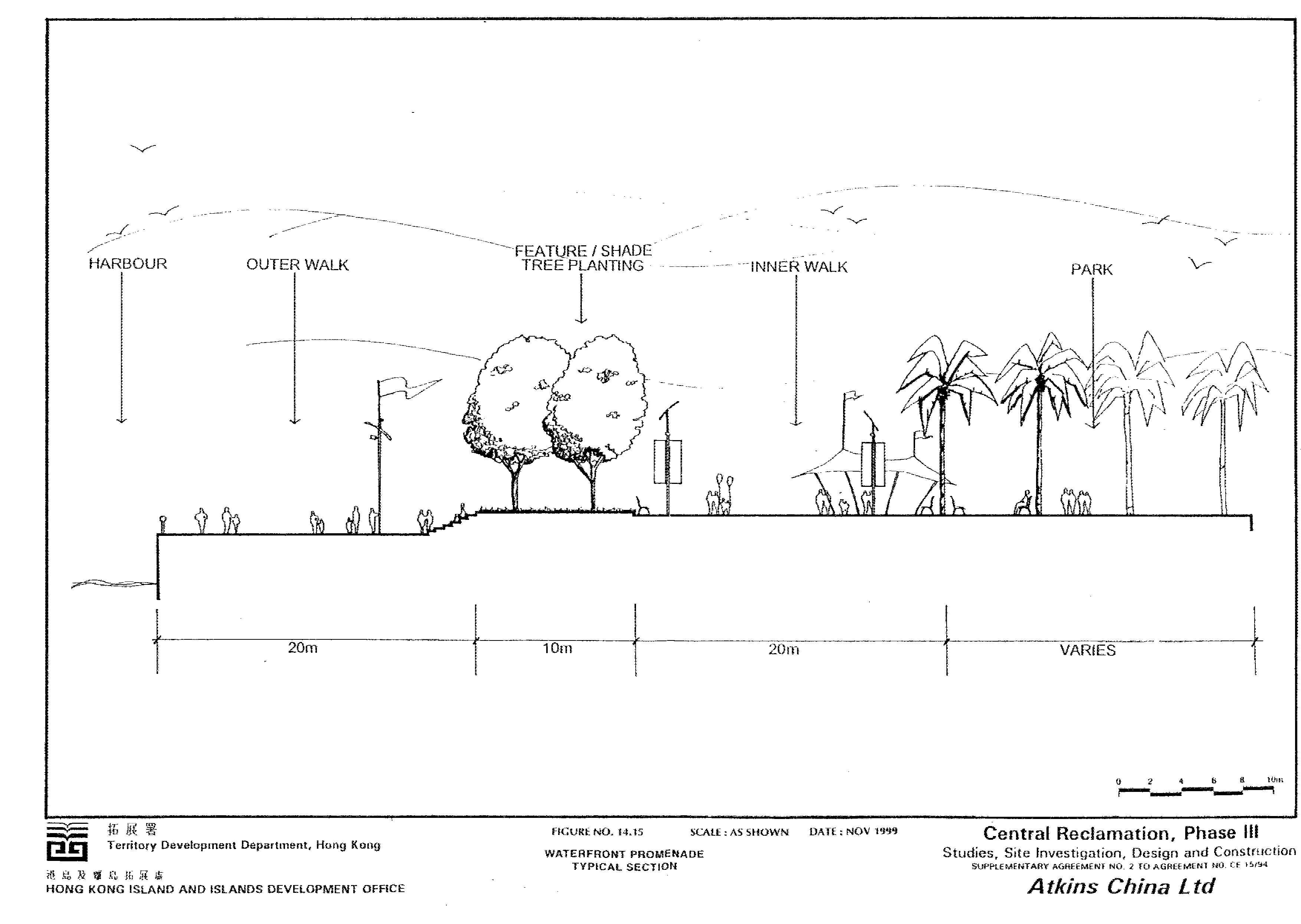
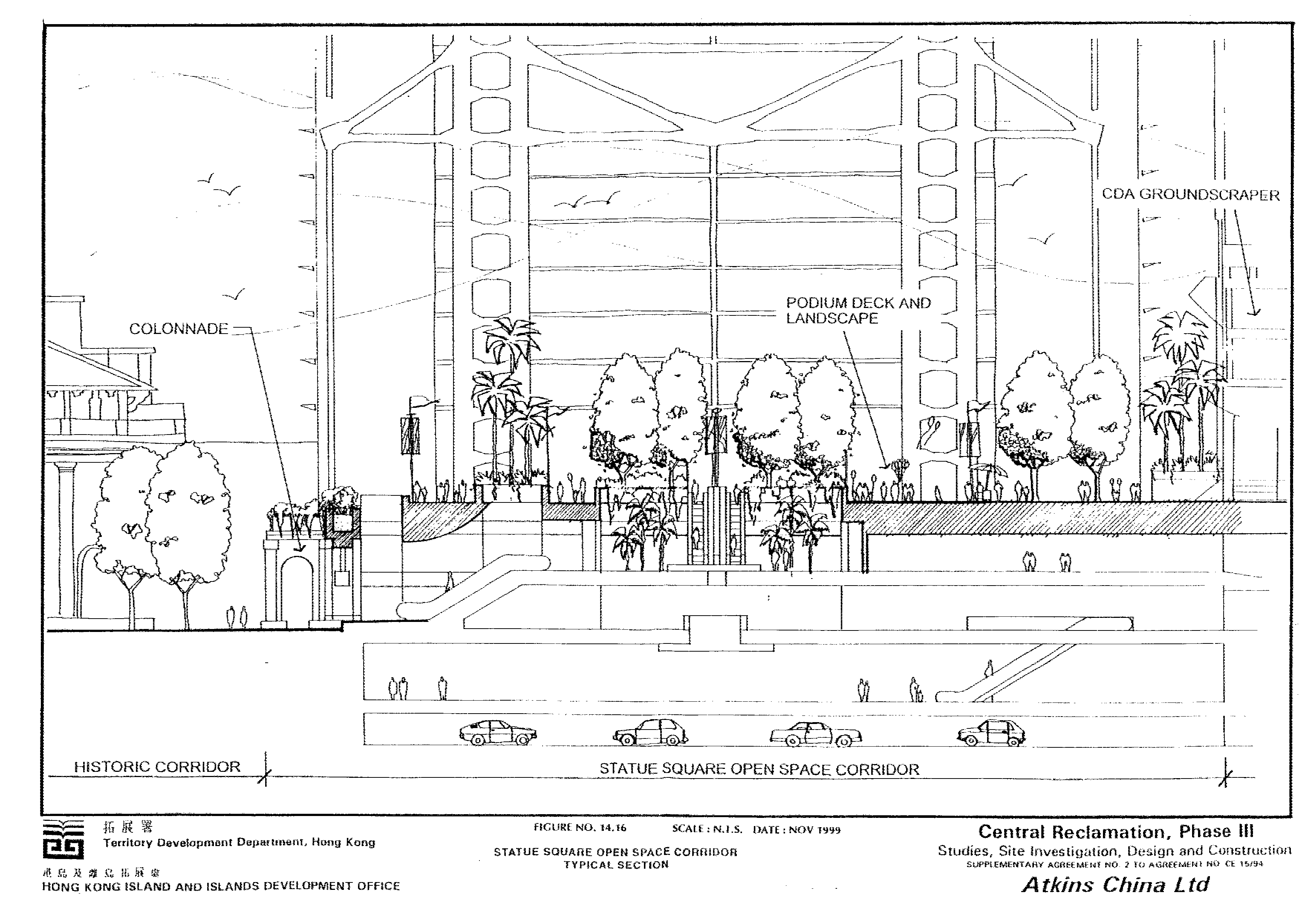
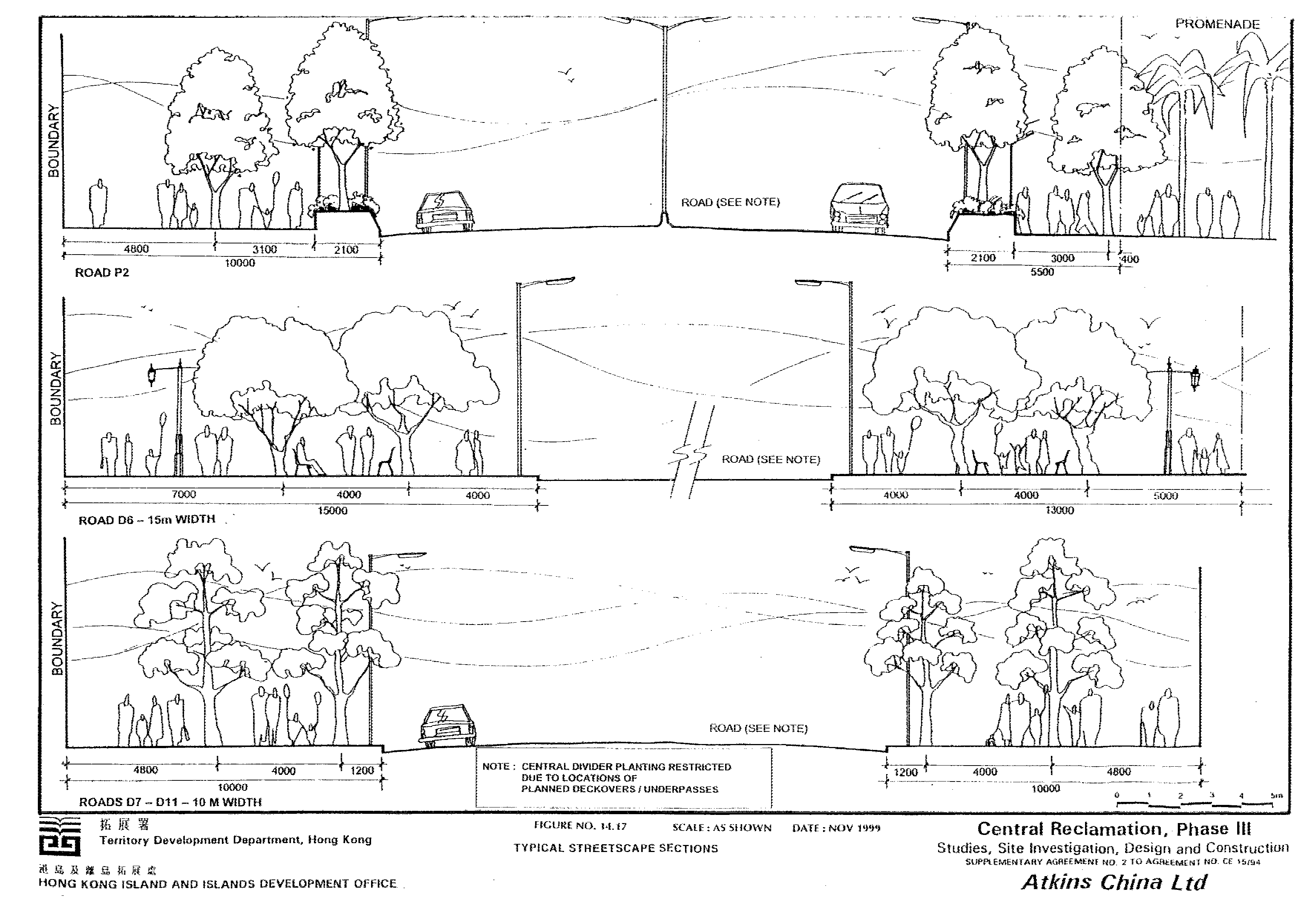
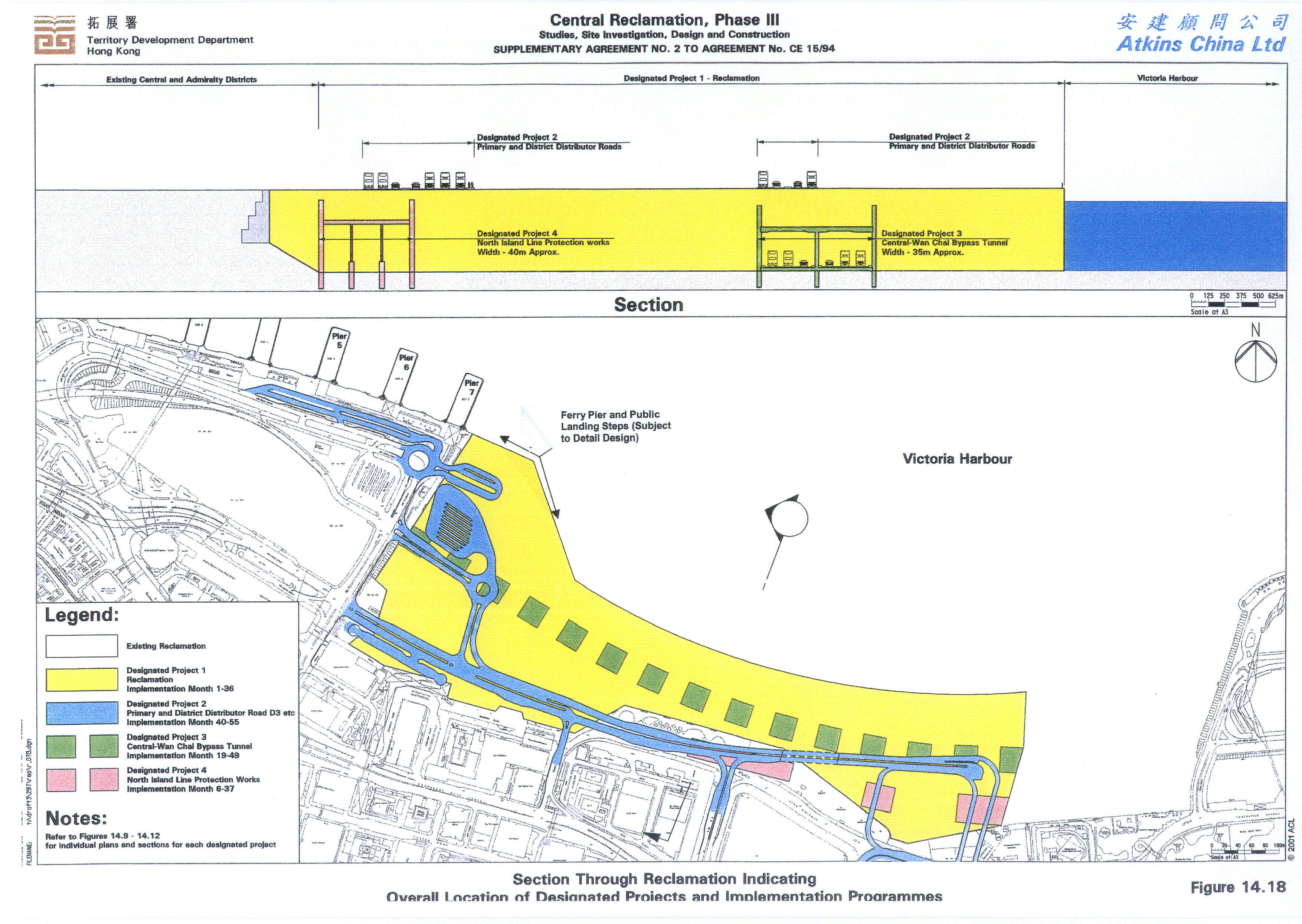
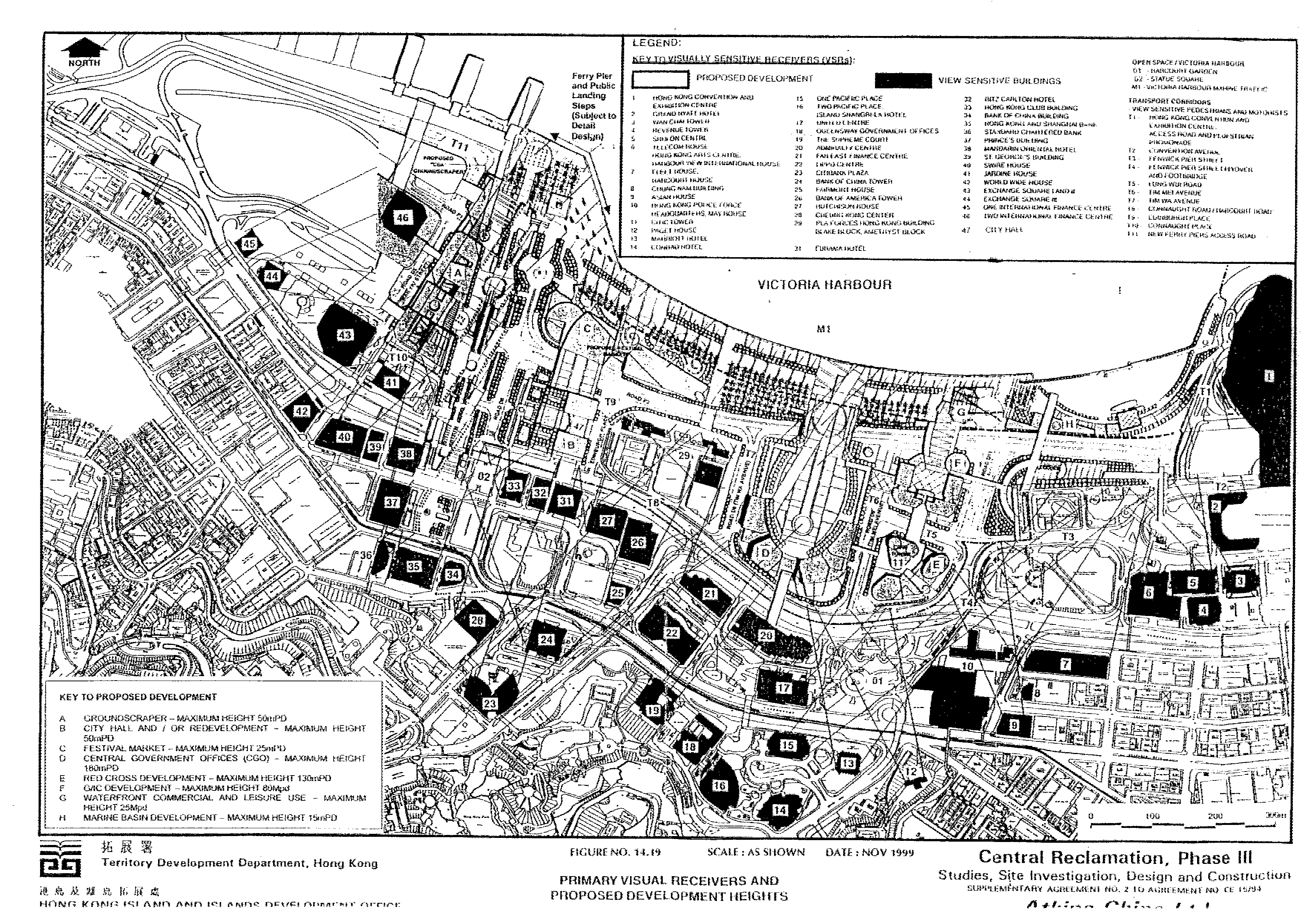
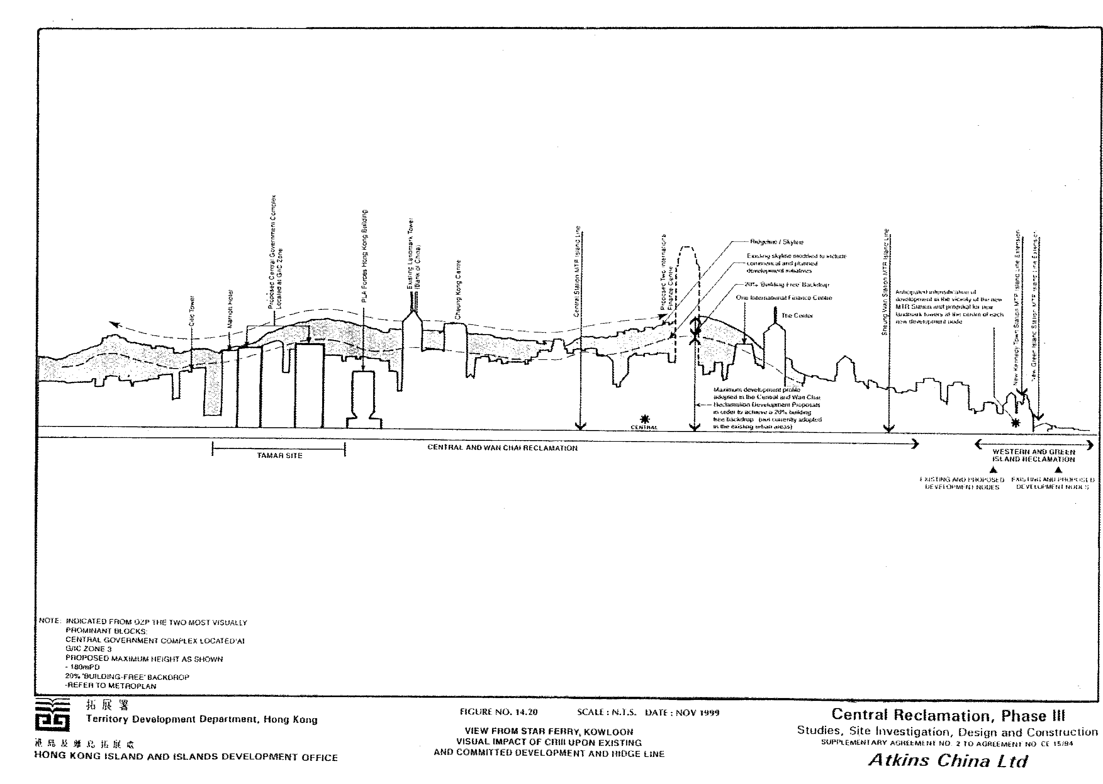
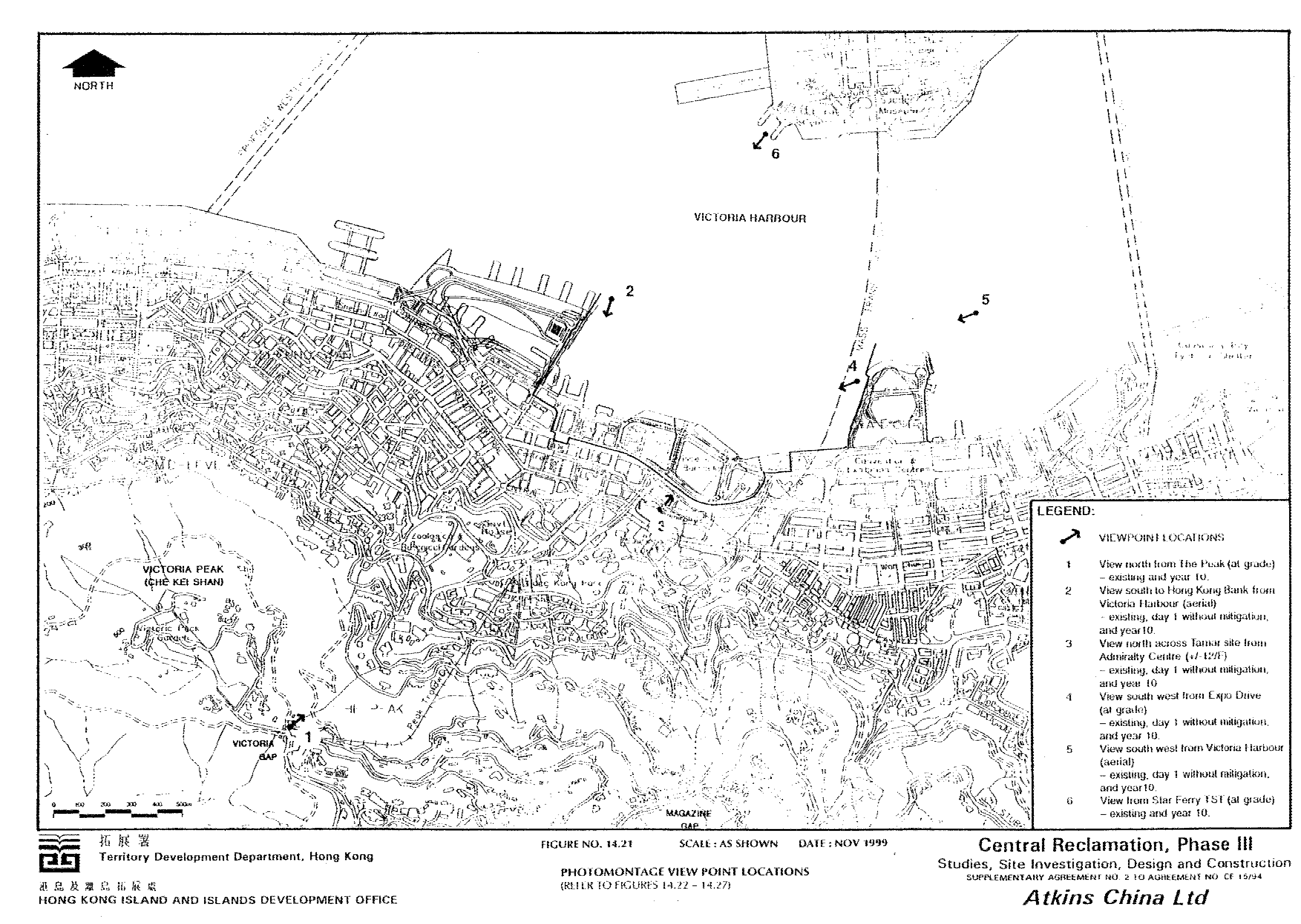
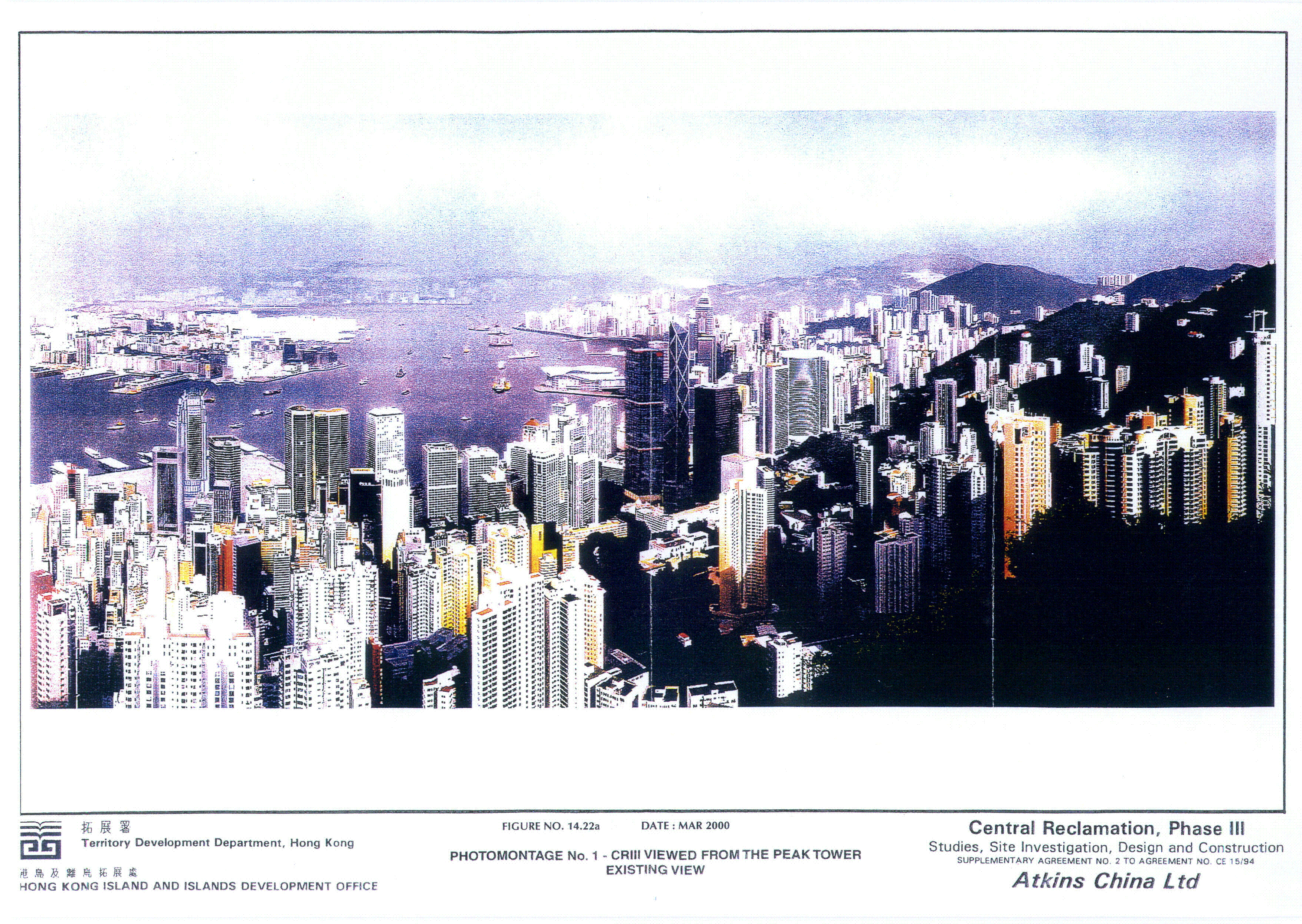
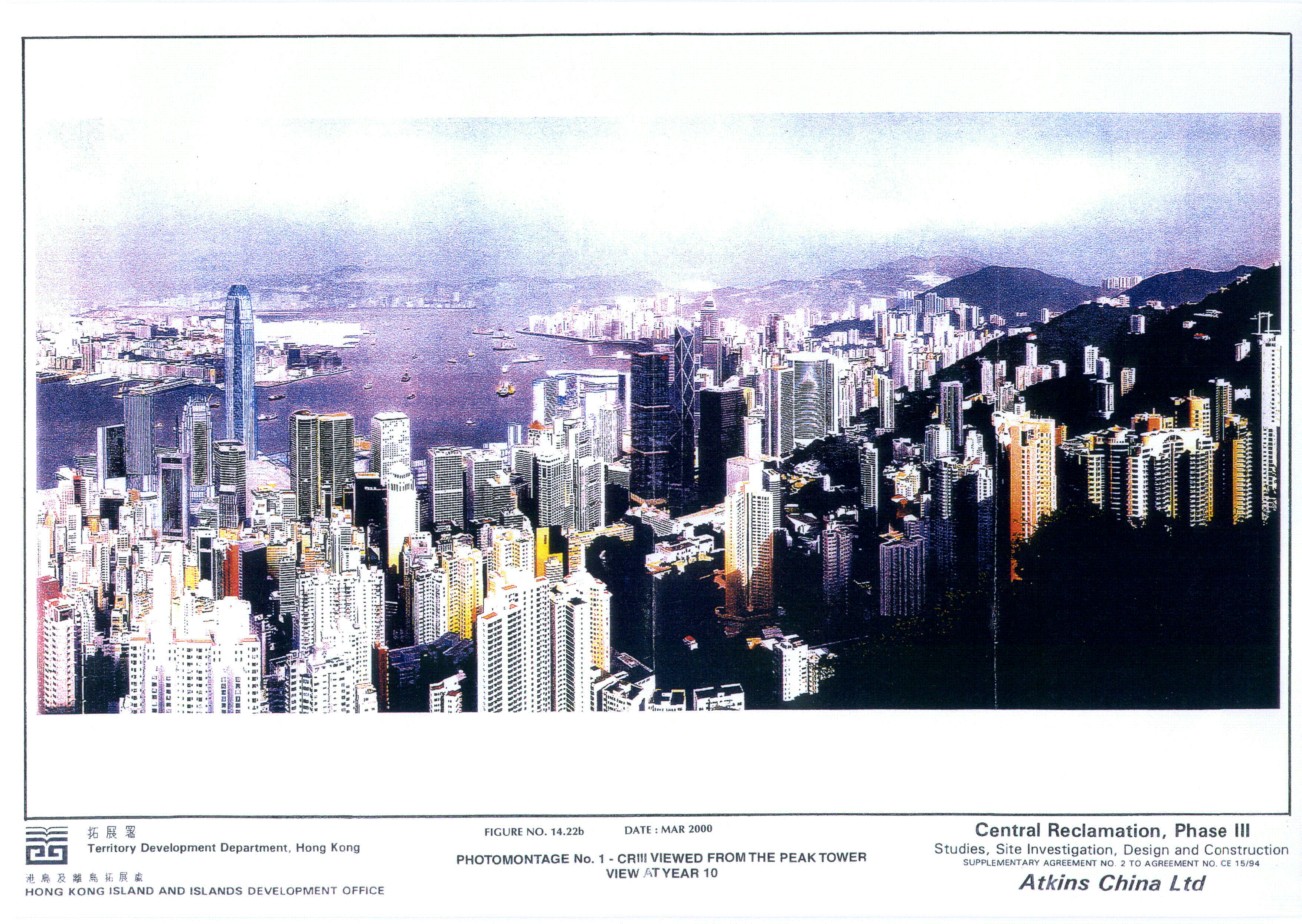
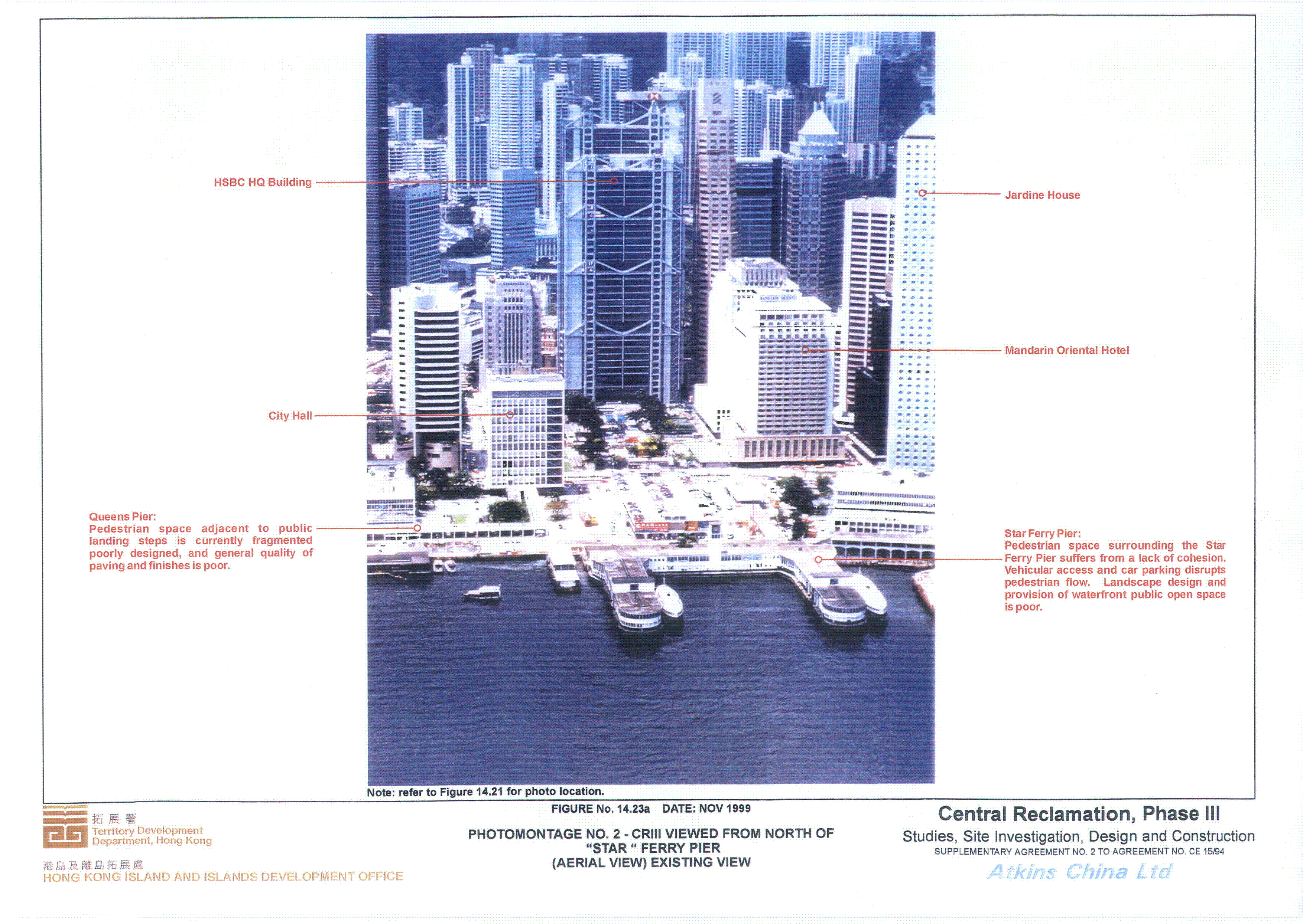
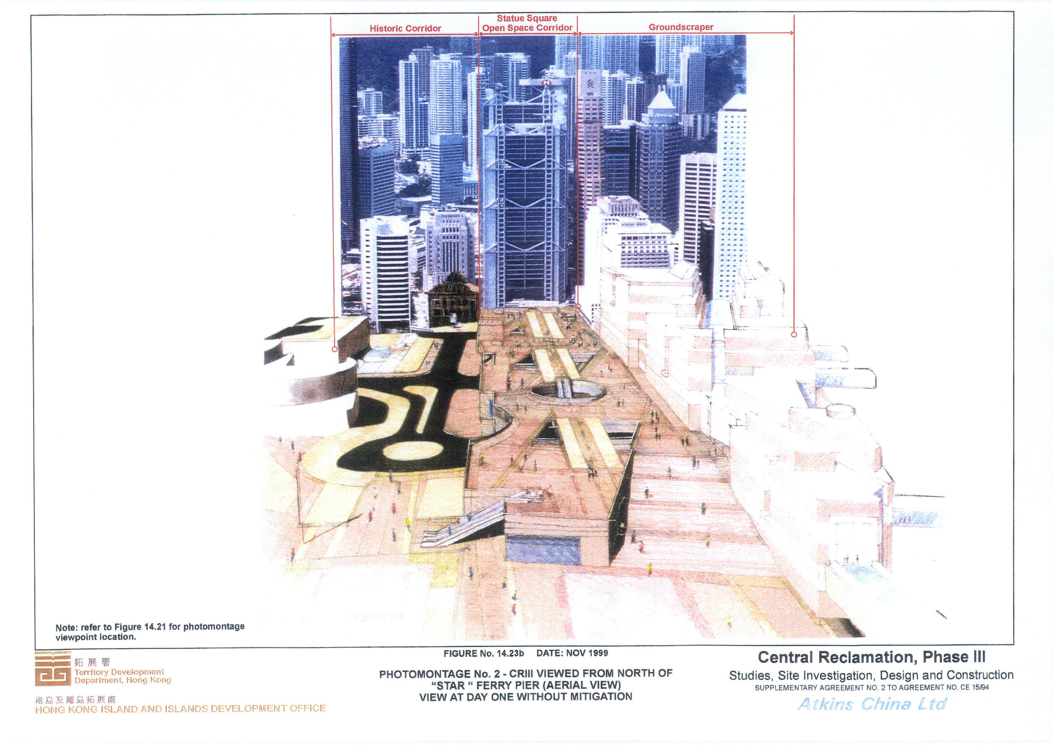
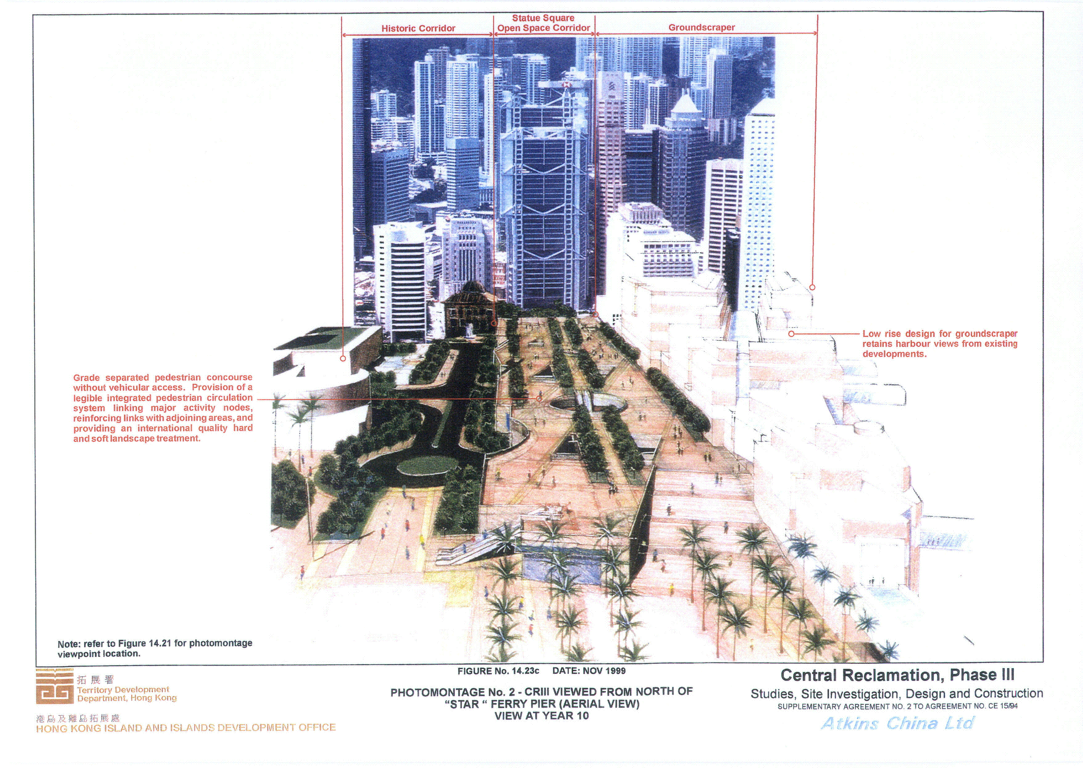
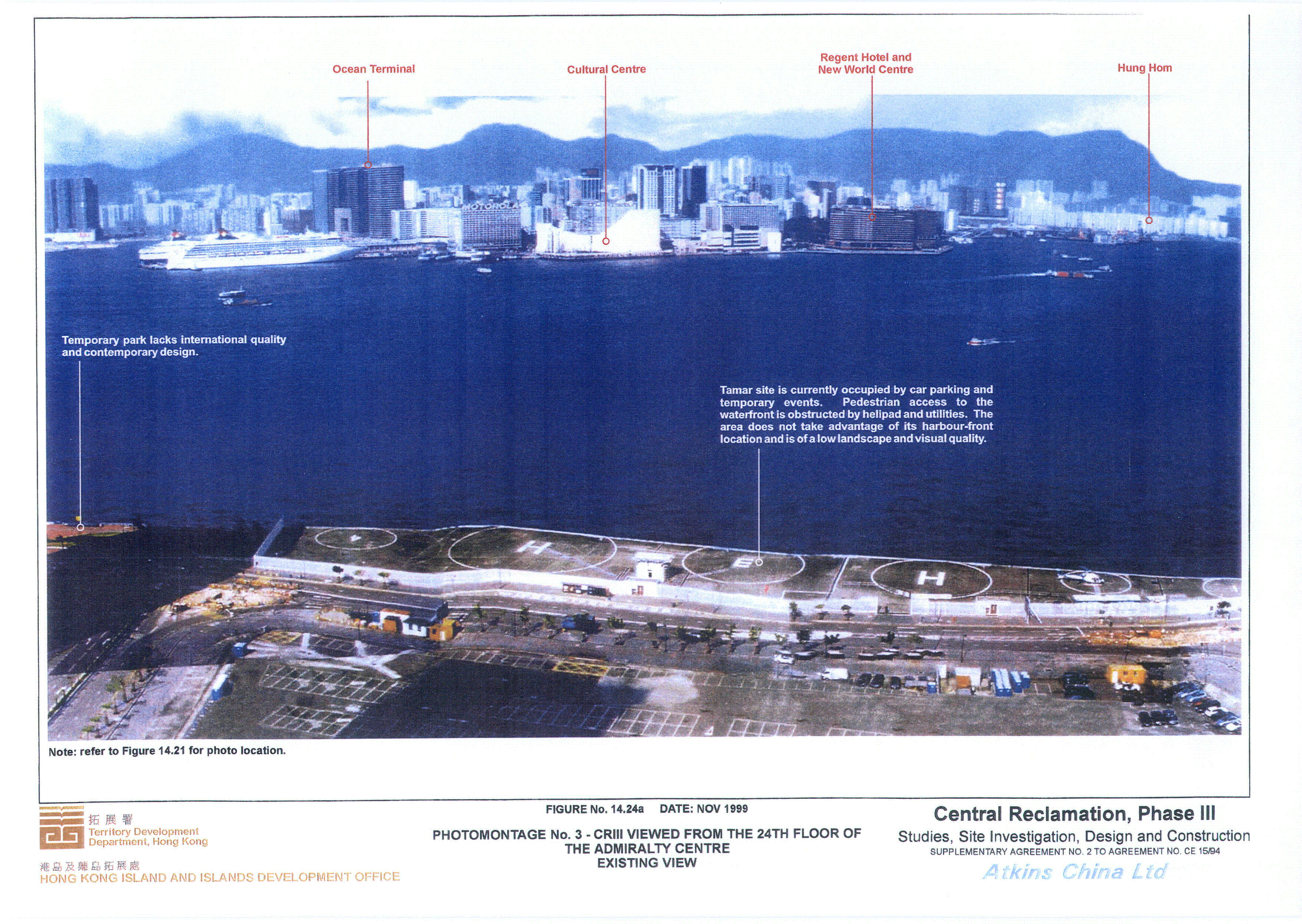
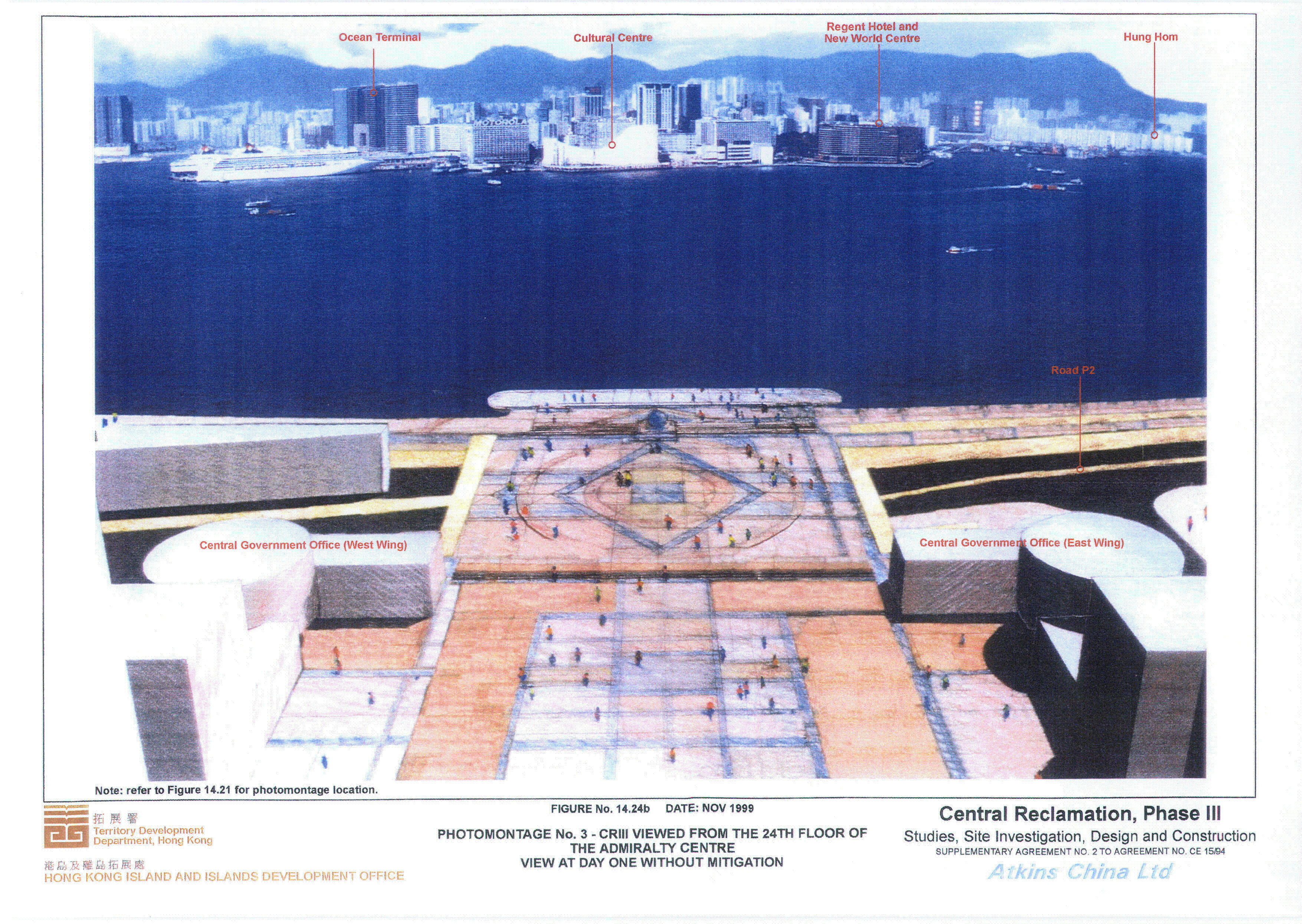
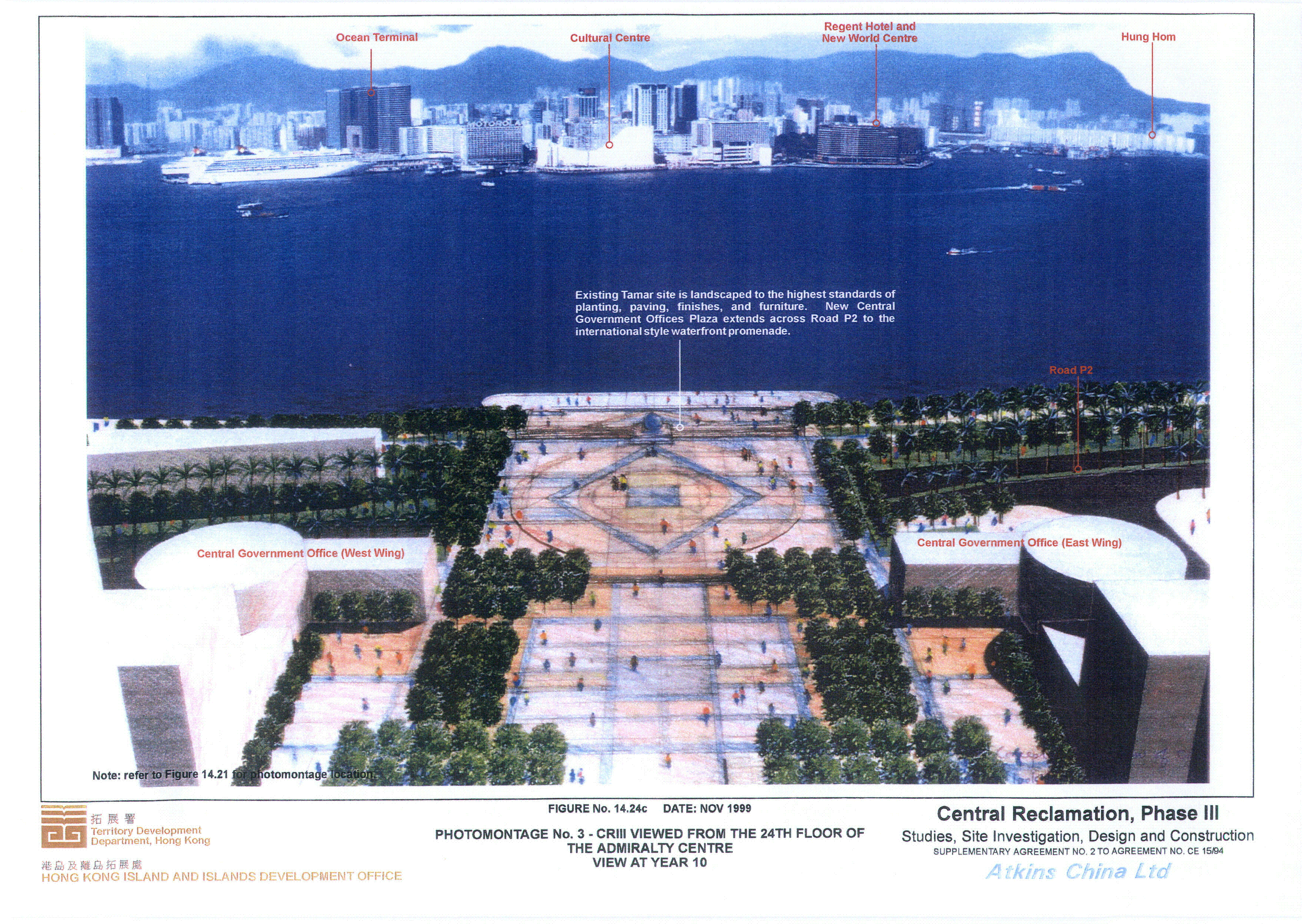
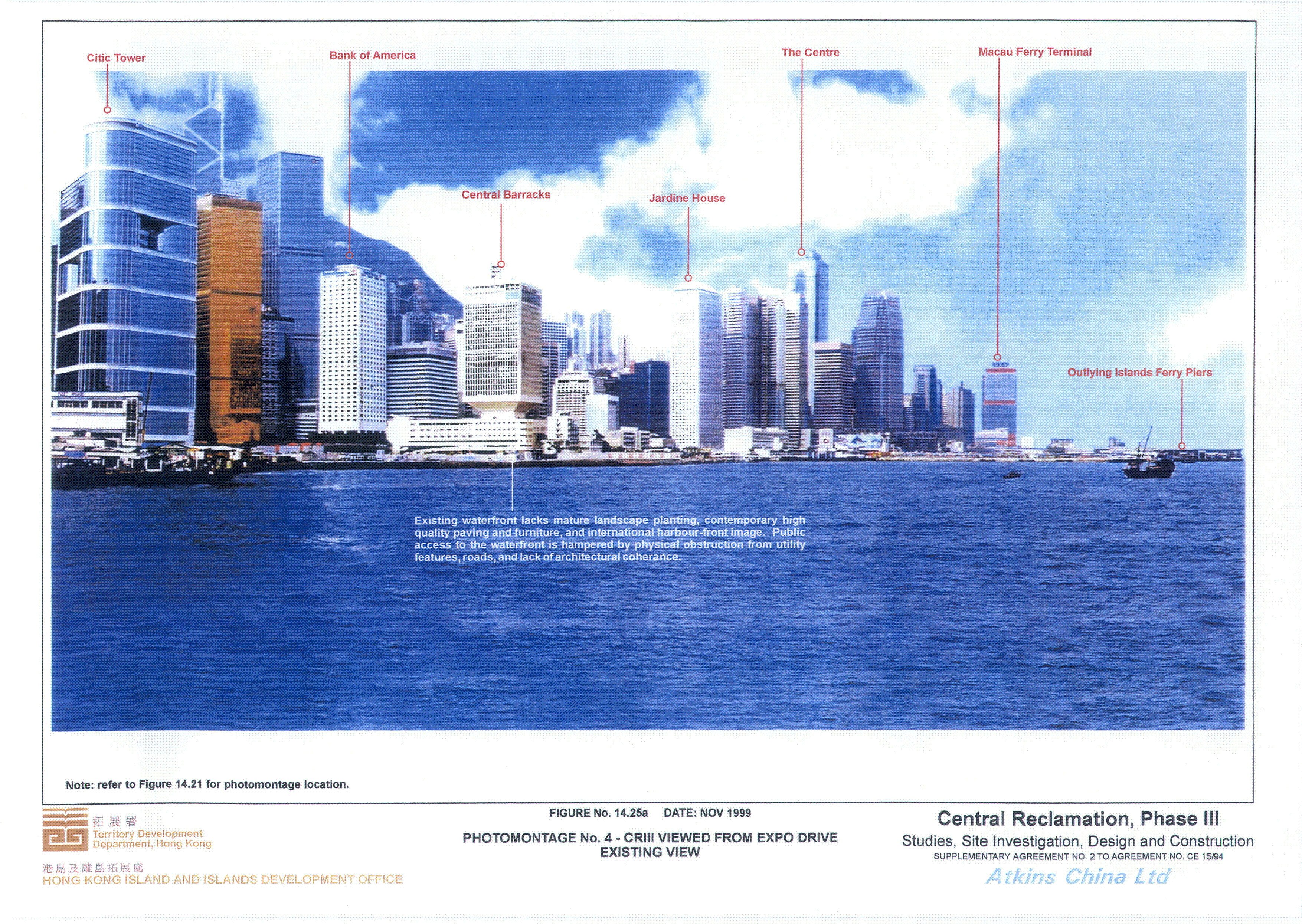
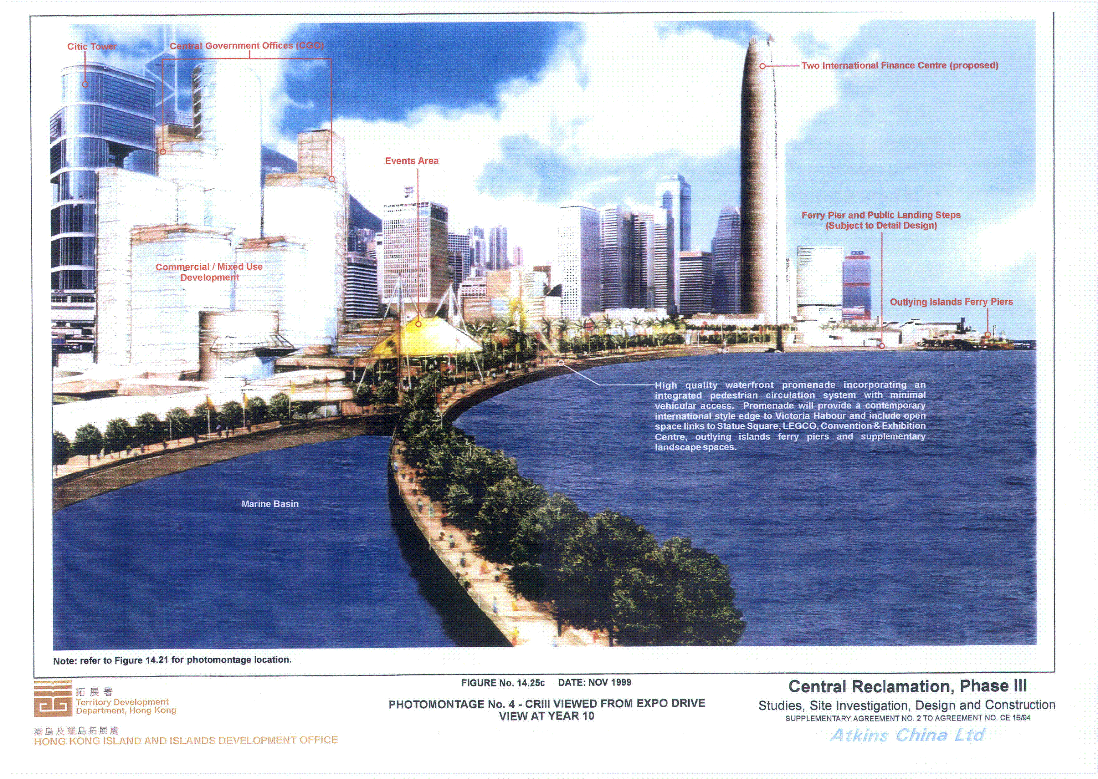
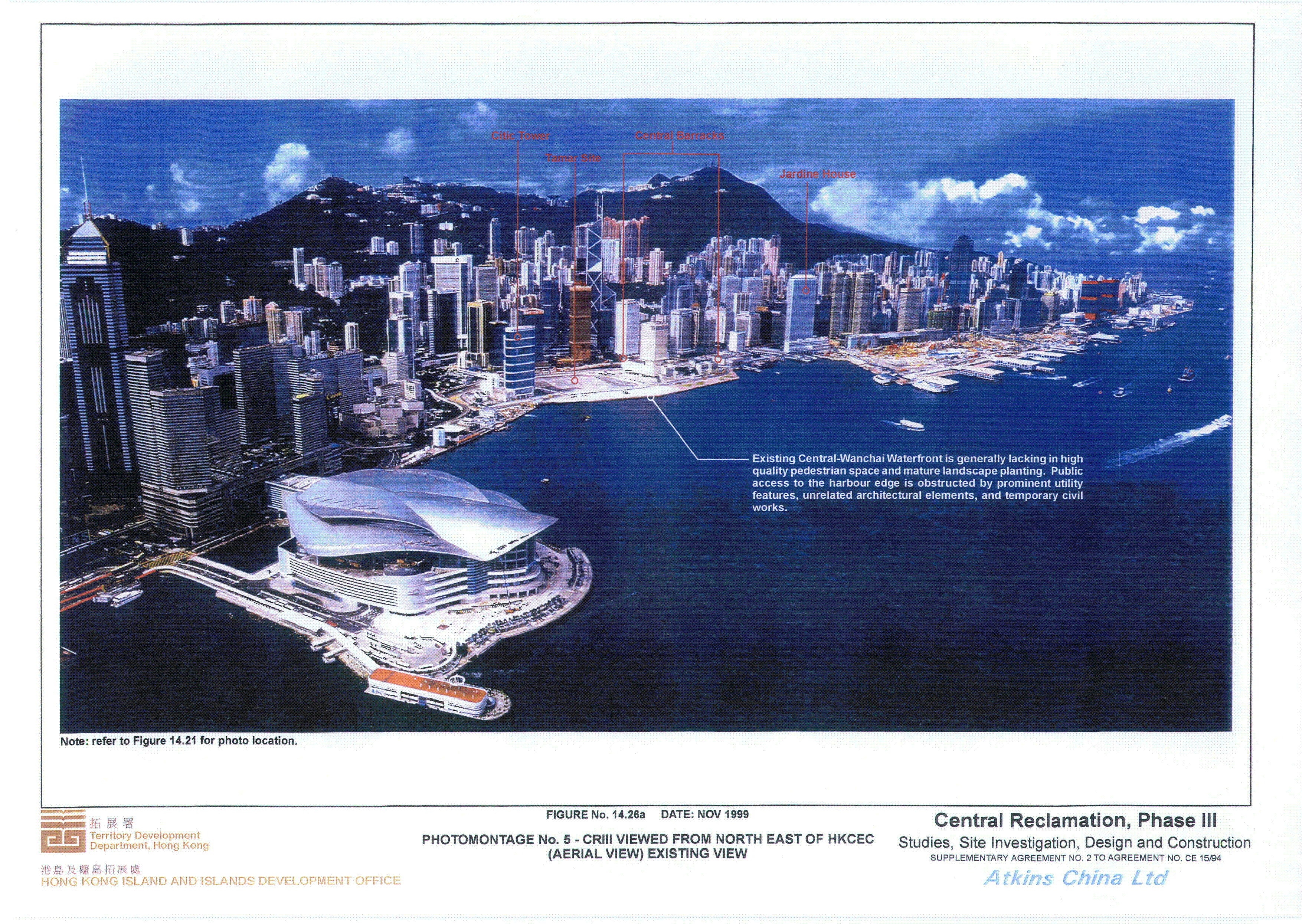
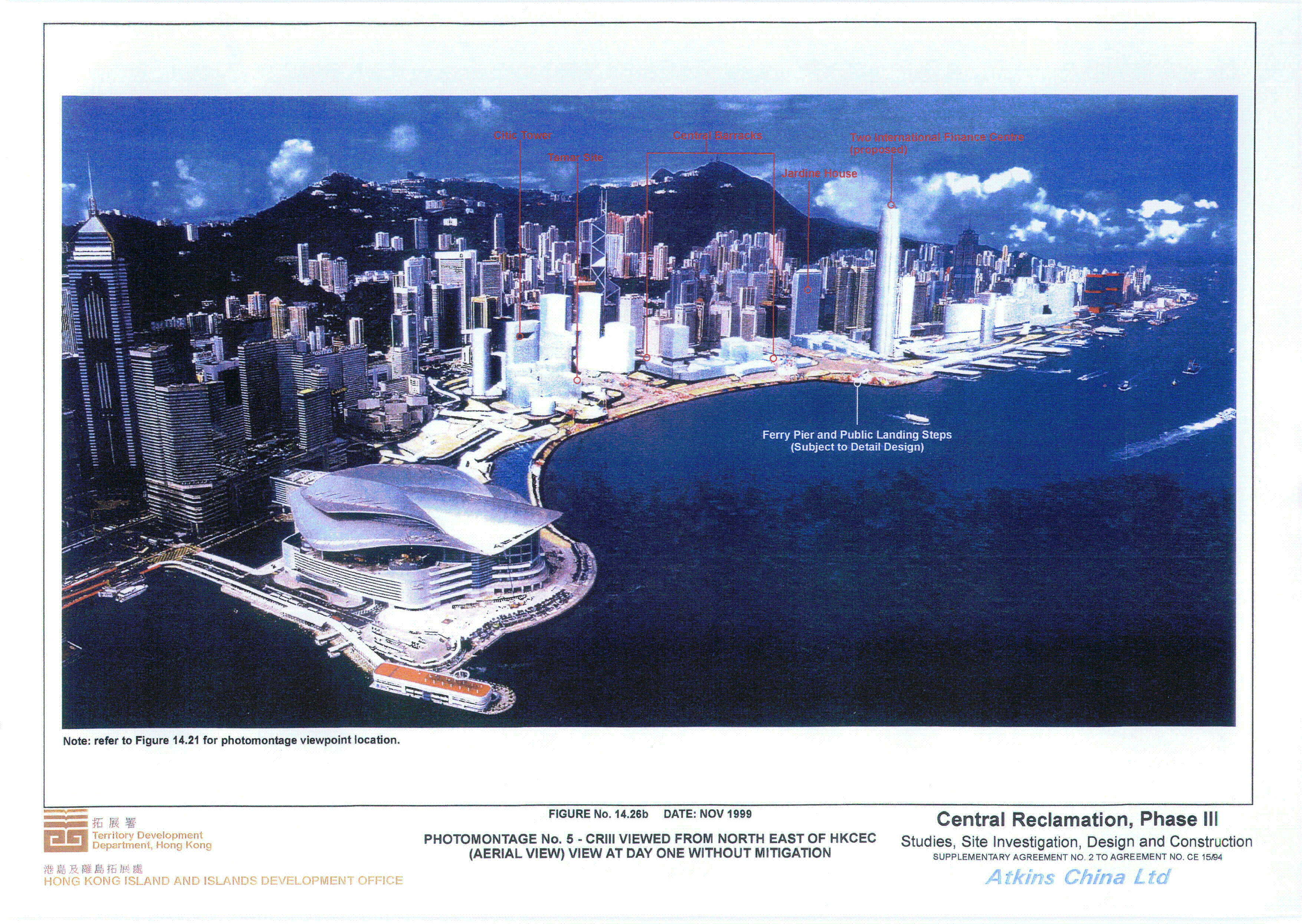
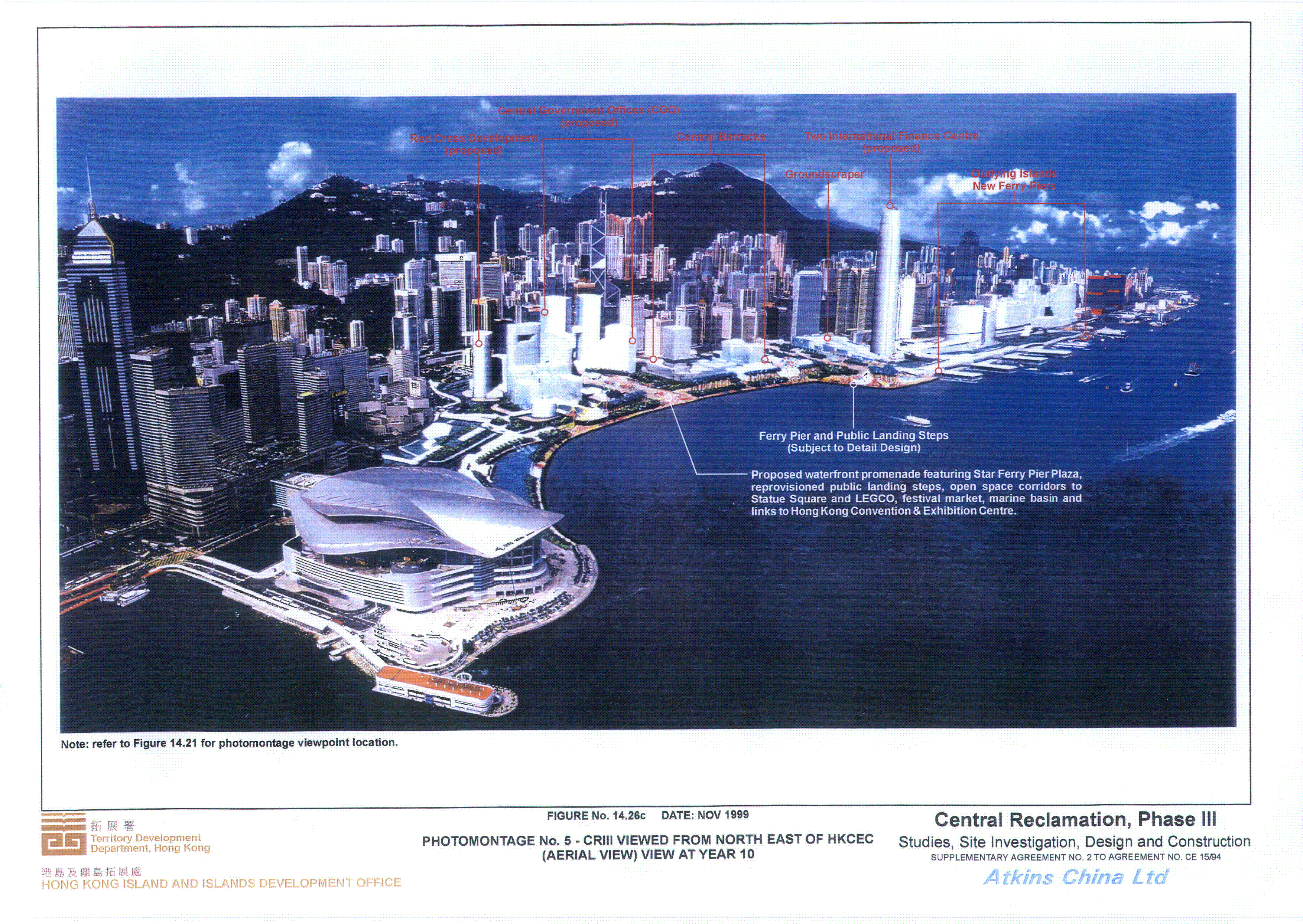
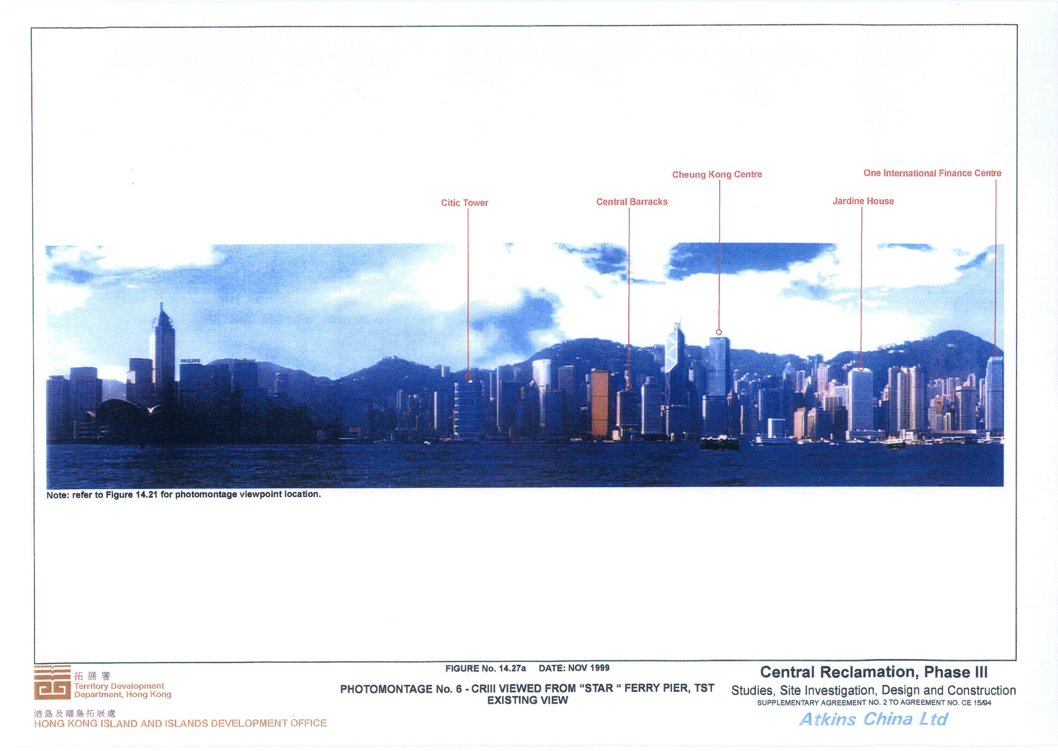
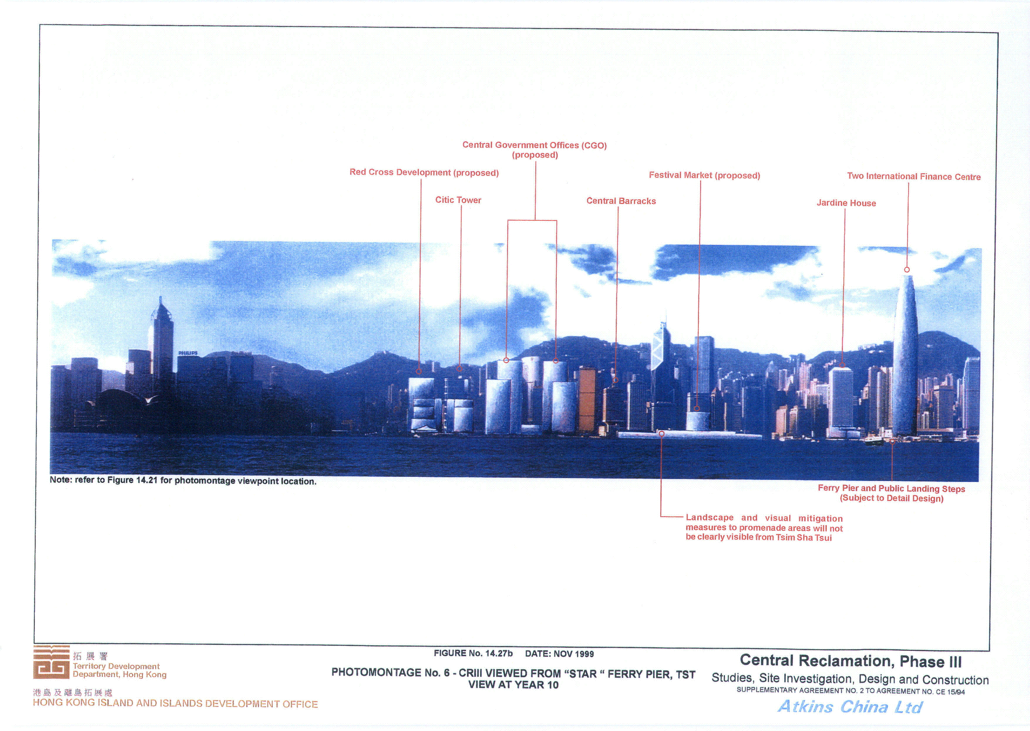