The proposed works were recommended under the “Review of Yuen Long and Kam Tin Sewerage and Sewage Treatment Requirements” (SMP Review) commissioned by the Environmental Protection Department (EPD) to provide adequate infrastructure for sewerage and sewage disposal in North West New Territories to match the planned development and population. The SMP Review reconsidered the proposals made in the “Yuen Long and Kam Tin SMP” (completed in 1992) in the light of changes in the catchment. The SMP Review included an environmental review of the proposed alignment of the works and identified no insurmountable environmental impacts. The alignment of the works is mostly based on that described in the original SMP study, although some changes have been made as the design has progressed. The alignment, having taken into account site constraints and engineering requirements, follows the existing roads or proposed new roads for the majority of its length. The pumping stations have been sited based on engineering requirements for the sewerage works with due regard to land use and environmental impacts. If the proposed works are not implemented, the area will remain unsewered and the absence of proper sewerage and sewage treatment and disposal facilities would cause untreated sewage to continue to be discharged to watercourses leading to the Deep Bay.
Implementation of the recommendations in the SMP Review will include the construction of about 45km trunk sewers, rising mains, and sewage pumping stations to collect and convey sewage flows in the North West New Territories to the Yuen Long or San Wai Sewage Treatment Works. The effluent will be treated before ultimate marine disposal through the Urmston Road outfall. Not included in the scope of this EIA is the expansion of the facilities at the existing Ha Tsuen Pumping Station and San Wai Sewage Treatment Works.This development is subject of a separate EIA Study.
The projects will be implemented in 2 stages. The first stage mainly includes construction of trunk sewers/rising mains and associated pumping stations to transfer sewage from the Kam Tin Core Area to the Yuen Long Sewage Treatment Works and expansion of the existing facilities at Ha Tsuen Pumping Station and San Wai Sewage Treatment Works to cope with increased sewage flow. The second stage is to construct branch sewers/rising mains and associated pumping station for transfer of sewage from Ngau Tam Mei and San Tin to Yuen Long Sewage Treatment Works and from Lau Fau Shan and Yuen Long South to San Wai Sewage Treatment Works.
This EIA Study addresses the impacts caused by the Stage 1 works on sewers, rising mains and ancillary pumping stations (PWP Item No 215DS). Two further EIA Studies will be commissioned to address respectively the works at the existing Ha Tsuen pumping Station and San Wai STW, and Stage 2 of the Project.
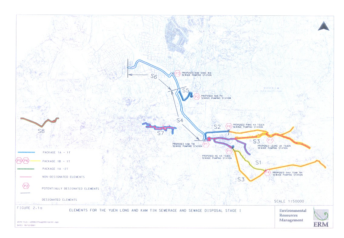
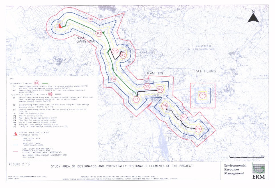
The overall Study Area for this Assignment is presented in Figure 2.1a. The scope of this EIA Study includes the Designated and Potentially Designated Elements of the Project which includes the construction and operation of a trunk sewerage system with five sections of sewers/rising mains and seven associated pumping stations. These elements are listed in Table 2.1a and are shown in Figure 2.1b.
Table 2.1a Designated and Potentially Designated Elements of the Project
|
Item |
Locations |
|
Designated
Elements - The following items are regarded as Designated Projects by virtue
of Item Q1 of the Schedule 2, Part I of the EIAO. |
|
|
S4 |
Sewers/rising mains between
Kam Tin sewage pumping station (KTPS) and Nam Sang Wai sewage pumping station
(NSWPS) [2.8km running along
maintenance access road of Kam Tin MDC with one crossing beneath the MDC]. |
|
S6 |
Sewers/rising mains from
NSWPS to Yuen Long sewage treatment works (YLSTWs) [3km running along maintenance
access road of Kam Tin MDC with two crossings beneath the MDC]. |
|
Potentially
Designated Elements - The following items could potentially become Designated
Projects in the context of the ongoing “Planning and Development Study on
North West New Territories”. |
|
|
S1 |
Sewers/rising mains along
Kam Tin Main Drainage Channel (MDC) from Shui Tsan Tin sewage pumping station
(STTPS) to Ng Ka Tsuen sewage pumping station (NKTPS) [1.8km running along
maintenance access road of Kam Tin MDC]. (by virtue of Item Q1 of the
Schedule 2, Part 1 of the EIAO) |
|
S2 |
Sewers/rising mains along
Kam Tin MDC from Pang Ka Tsuen sewage pumping station (PKTPS) to KTPS [1.3km
running along maintenance access road of Kam Tin MDC]. (by virtue of Item Q1
of the Schedule 2, Part 1 of the EIAO) |
|
S5 |
Branch sewers/rising mains
from Sha Po sewage pumping station (SPPS) to item S4 [1.2km running along
maintenance access road of Kam Tin MDC and existing roads]. (by virtue of
Item Q1 of the Schedule 2, Part 1 of the EIAO) |
|
P1 |
Kam Tin Sewage Pumping
Station (KTPS) [Design Flow = 37,409 m3 day-1]. (by virtue of Item F3 (b) of the
Schedule 2, Part 1 of the EIAO) |
|
P2 |
Sha Po Sewage Pumping
Station (SPPS) [Design Flow = 21,944 m3 day-1]. (by virtue of Item F3 (b) of the Schedule
2, Part 1 of the EIAO) |
|
P4 |
Shui Tsan Tin Sewage
Pumping Station (STTPS) [Design Flow = 2,712 m3 day-1].
(by virtue of Item F3 (b) of the Schedule 2, Part 1 of the EIAO) |
|
P5 |
Ng Ka Tsuen Sewage Pumping
Station (NKTPS) [Design Flow = 27,842 m3 day-1]. (by
virtue of Item F3 (b) of the Schedule 2, Part 1 of the EIAO) |
|
The
following are classified as potentially designated elements of the Project
for the sake of assessment under this Study in the light of possible changing
circumstances of the ongoing planning for the areas. |
|
|
P3 |
Nam Sang Wai Sewage Pumping
Station (NSWPS) [Design Flow = 68,702 m3 day-1]. |
|
P6 |
Pang Ka Tsuen Sewage
Pumping Station (PKTPS) [also known as Kam Tin San Tsuen Sewage Pumping
Station] [Design Flow = 1,792 m3 day-1]. |
|
P7 |
Leung Uk Tsuen Sewage Pumping Station (LUTPS) [Design Flow = 1,360m3
day-1]. |
The total length of sewers/rising mains to be constructed for this phase of the project is approximately 10km, the majority of which will be constructed along the maintenance access road of the Kam Tin MDC. The diameters of the proposed sewers and rising mains range from about 225 mm to 1,650 mm. The expansion of sewers/rising mains networks under the Stage 1 works will deliver domestic sewage for treatment at the Yuen Long Sewage Treatment Works and so extend the coverage of the sewage collection system. The works will allow 33% more sewage flow to be collected from the Kam Tin Catchment, rather than being discharged to inland waters without any treatment.
The Sewerage Projects Division and the Electrical & Mechanical Projects Division of DSD are undertaking the design of the Project. The selection criteria for sewers/rising mains alignment and SPSs are listed in Table 2.1b. The construction works will be carried out in 3 packages, as presented in Table 2.1c.
Table 2.1b Selection Criteria for Sewer Alignments and SPS
|
|
Selection Criteria |
|
S4 |
The proposed alignment of the sewers/rising mains runs along the
maintenance access road of the Kam Tin River. The northern portion encroaches on the edge of the
Conservation Area (CA) on both
banks of the Kam Tin River. The
alignments has been selected along the access road to avoid disturbance to
undeveloped area with the CA. |
|
S6 |
The entire length of the sewers/rising mains runs inside the CA. The proposed alignment has been
selected along the access road to avoid disturbance to undeveloped area with
the CA. |
|
S1 |
Instead of selecting the shortest distance, which would require more
extensive land resumption and more extensive habitat loss, the proposed
sewers/rising mains from Shui Tsan Tin sewage pumping station (STTPS) to Ng Ka
Tsuen sewage pumping station (NKTPS) were selected along alignment along Kam
Tin Main Drainage Channel (MDC) which would have only short term impact to
sensitive receivers and minimal habitat loss. |
|
S2 |
The proposed sewers/rising mains along Kam Tin MDC from Pang Ka Tsuen
sewage pumping station (PKTPS) to KTPS has been selected along the
maintenance access road to minimise potential impacts such as habitat loss. |
|
S5 |
The proposed branch sewers/rising mains from Sha Po sewage pumping
station (SPPS) to S4 runs along existing roads. |
|
Pumping Stations (General) |
· Sewage pumping
stations will be constructed to provide head for low points such that
shallower sewers could be adopted. · The sewage pumping
stations should be close to the river/streamcourse where possible. · Vehicle access
should be made available for ease of routine inspection and maintenance of
pumping station. To minimize the
cost of the vehicular access, the sewage pumping station will be placed
nearby the existing road network. · The sewage
pumping station should be close to existing residents or future development
where possible so as to minimise the extension of the sewer network. · To minimise
resumption of private land as far as possible. · To have least
environmental and ecological impacts as far as possible. |
|
Kam Tin SPS (P1) |
· The SPS is
required to pump sewage after passing Kam Tin River. · The proposed
location has already been developed and hence minimise the potential habitat loss. · The SPS is
located adjacent to the existing Kam Tin Road for *
minimising the need for further access roads which would further
introduce potential environmental impact *
ease of routine inspection and maintenance |
|
Sha Po SPS (P2) |
· Due to site
constraints, the landtake requirements has already considered minimum uptake
of the fishpond adjacent to the proposed site. · The SPS is
located close to KCRC West Rail Station development and other future
development to minimise extension of the sewer network and hence minimise
further potential environmental impact. |
|
Nam San Wai SPS (P3) |
· Nam San Wai SPS
is required to pump the sewage across the Kam Tin River. Sewage from San Tin and Kam Tin will
be conveyed by two sewer pipelines to the Nam San Wai SPS before passing the
Kam Tin River. A desirable
location to build the Nam San Wai SPS is at the junction between two pipelines. · The SPS is
located within the G/IC zone of the Nam San Wai OZP · The SPS is
chosen adjacent to the Flood Pumping Station (currently under construction)
to avoid disturbing separate greenfield site. · The SPS is
located adjacent to the existing maintenance access road for *
minimising the need for further access roads which would further
introduce potential environmental impacts *
ease of routine inspection and maintenance |
|
Shui Tsan Tin SPS (P4) |
· The SPS is
required for pumping sewage before passing a stream. · The site has been
developed. · The SPS will be
located adjacent to the Kam Tin Road for *
minimising the need for further access roads which would further
introduce potential environmental impact *
ease of routine inspection and maintenance |
|
Ng Ka Tsuen SPS (P5) |
· The SPS is
required for pumping sewage before passing the Kam Tin River. · The SPS will be
located adjacent to the Kam Sheung Road for *
minimising the need for further access roads which would further
introduce potential environmental impact *
ease of routine inspection and maintenance |
|
Pang Ka Tsuen SPS (P6) |
· The SPS is
required for pumping sewage after passing the Kam Tin River. · The SPS will be
located adjacent to the maintenance access road for Kam Tin Road for *
minimising the need for further access roads which would further
introduce potential environmental impact *
ease of routine inspection and maintenance |
|
Leung Uk Tsuen SPS (P7) |
· The SPS is
required for pumping sewage after passing a stream. · The SPS will be
located adjacent to the Kam Tin Road for *
minimising the need for further access roads which would further
introduce potential environmental impact *
ease of routine inspection and maintenance |
Table 2.1c Construction Period
|
Package |
Construction
Period |
|
1A-1T Kam Tin
Trunk Sewerage Phase 1 |
Aug 2003 - Feb 2006 |
|
·
(S2)
Sewers/rising mains along Kam Tin MDC from PKTPS to KTPS. |
|
|
·
(S4)
Sewers/rising mains between KTPS and NSWPS; |
|
|
·
(S5) Branch
sewers/rising mains from SPPS to item S4. |
|
|
·
Part of (S3) Sewers/rising mains in the Kam Tin/Shek Kong areas
upstream of Kam Tin Sewage Pumping Station |
|
|
·
(S7) Sewers in Au Tau Area |
|
|
·
S6)
Sewers/rising mains from NSWPS to YLSTWs; |
|
|
·
(P1) KTPS; |
|
|
·
(P2) SPPS; |
|
|
·
(P3) NSWPS; |
|
|
1B-1T Kam Tin
Trunk Sewerage Phase 2 |
Jun 2004 - Nov 2006 |
|
·
(S1)
Sewers/rising mains along Kam Tin MDC from STTPS to NKTPS. |
|
|
·
Part of (S3) Sewers/rising mains in the Kam Tin/Shek Kong areas
upstream of Kam Tin Sewage Pumping Station |
|
|
·
(P4) STTPS; |
|
|
·
(P5) NKTPS; |
|
|
·
(P6) PKTPS; |
|
|
·
(P7) LUTPS; |
|
|
1A-2T
Sewers/Rising Mains between Ha Tsuen SPS and San Wai STW |
Aug 2004 - Feb 2008 |
|
·
(S8) Sewers/Rising Mains between Ha Tsuen SPS and San Wai STW |
|
The construction works for the Designated Elements and Potentially Designated Elements (and hence the scope of this EIA Study) will fall under packages 1A-1T and 1B-1T (Items in bold) (See Figure 2.1a).
The construction of pumping stations varies in duration from 12 to 24 months and will be undertaken simultaneously. The construction time for the sewers and rising mains varies from 24 to 36 months and the Temporary Traffic Measures recommended by Traffic Impact Assessment (TIA) Study will also have implications for the construction programme. The normal working hours are from 7am to 7 pm, Monday to Saturday (except Public Holidays). No construction works outside the normal working hours are envisaged.
The Project is located in the Sub-urban area of Yuen Long and Kam Tin. According to the definitions described in the Study Brief, the study areas in relation to specific environmental aspects are as defined in Table 2.2a and are shown graphically in Figure 2.1b.
Table 2.2a Study Areas for Specific Environmental Aspects
|
Environmental Aspects |
Study Area |
|
Construction dust impact |
Within 500m of the Project
boundary. |
|
Noise impact |
Within 300m of the Project
boundary. |
|
Water quality impact |
Within 300m of the Project boundary. |
|
Waste management |
Within 500m of the Project
boundary. |
|
Land contamination |
Area within Project
boundaries |
|
Ecological impact (both
aquatic and terrestrial) |
500m from either side and along
the full stretch of the Project boundary and adjacent areas likely to be
affected by the Project. |
|
Fisheries impact |
500m from either side and
along the full stretch of the Project boundary and adjacent areas likely to
be affected by the Project. |
|
Cultural heritage |
150m from either side and
along the full stretch of the Project boundary and adjacent areas likely to
be affected by the Project. |
|
Landscape and visual impact |
All areas within a 500m distance from the proposed Project for
landscape impact assessment and a 8 km radius visual envelope for visual
impact assessment. |
Due to the rapid development in the NWNT area, a large number of development projects will be undertaken simultaneously, creating the potential for cumulative impacts during construction. Table 2.3a lists the concurrent projects in the NWNT and identifies potential cumulative impacts. Although most of the projects will be constructed within the same timeframe as the Designated and Potentially Designated Elements of this Project, the potential to cause cumulative will also depends on the distances between the projects.
Table 2.3a Concurrent Projects with the Designated and Potentially Designated Elements
|
|
Concurrent Project |
Scheduled Construction
Period |
Overlapping Months with
this Project |
Separation Distance (m) |
Potential to Cause
Cumulative Impacts |
|
|
|
|
Start |
Complete |
|
|
|
|
1. |
215DS - Yuen Long and Kam Tin Sewerage and Sewage Disposal Stage 1
(Non-Designated Element of this Project) |
Aug 2003 |
Feb 2008 |
40 |
Adjacent
to P1, P4, P5, P6, P7, S1 and S2.
|
|
|
2. |
81CD - Main Drainage Channels for Yuen Long and Kam Tin Stage 2
Remainder |
May 2001 |
Jun 2003 |
0 |
Adjacent to S4 |
û |
|
3. |
30CD - Village Flood Protection for Yuen Long, Kam Tin and Ngau Tam
Kei, NWNT : Pok Wai Drainage Channel |
Dec 2001 |
May 2004 |
10 |
Over
1,000 |
û |
|
4. |
30CD - Village Flood Protection for Yuen Long, Kam Tin and Ngau Tam
Mei, NWNT, Stage I v- Wang Chau (Phase 2) |
Jun 2002 |
Oct 2004 |
15 |
Over 2,000 |
û |
|
5. |
74CD - Village Flood Protection for Yuen Long, Kam Tin and Ngau Tam
Mei, NWNT, Stage I - Wang Chau |
Jun 2002 |
Oct 2004 |
15 |
Over 2,000 |
û |
|
6. |
74CD - Village Flood Protection for Yuen Long, Kam Tin and Ngau Tam Mei,
NWNT, Stage II · Mai Po Lo Wai
and Mai Po San Tsuen · Shui Pin Wai · Ma Tin · Shui Pin Tsuen
and Tai Kiu |
Jan 2002 Nov 2001 Nov 2001 Mar 2003 |
Mar 2005 Nov 2003 Nov 2003 Apr 2005 |
19 3 3 20 |
3,500 3,000 2,750 2,500 – 3,000 |
û û û û |
|
7. |
22CD - Main Drainage Channels for Yuen Long
and Kam Tin · Tin Tsuen
Channel · Sham Chung
Channel |
May 2003 Mar 2001 |
Mar 2005 Jan 2004 |
19 6 |
Over 5,000 2,900 |
û û |
|
8. |
70CD - Yuen Long Bypass Floodway |
Nov 2002 |
Nov 2005 |
28 |
Within 300 |
|
|
9. |
73CD - Main Drainage Channels and Poldered
Village Protection Scheme for San Tin, NWNT Phase 3 Part 1 - Eastern Main
Drainage Channels for San Tin |
Nov 2002 |
Nov 2005 |
28 |
Over 4,500 |
û |
|
10. |
112CD - Drainage Improvement in Northern New
Territories - package A San Tin
Western Drainage Channel |
Oct 2005 |
Oct 2008 |
14 |
Over 5,000 |
û |
|
11. |
157DS - Yuen Long and Kam Tin Sewerage Stage
II |
May 1999 |
Oct 2006 |
39 |
3,250 |
û |
|
12. |
61 DS - NWNT Development - Trunk Sewers,
Sewage Pumping Stations and Rising Mains, Stage III (reminder) |
Nov 2000 |
Nov 2004 |
16 |
2,500 |
û |
|
13. |
274 DS - Yuen Long and Kam Tin Sewerage,
Stage III · Phase 1A - Shap
Pat Heung Rising Mains and Gravity Sewer · Phase 1B - Au
Tau Sewage Pumping Station and ancillary works · Phase 2A - 7B -
provision of sewerage to 35 village in Yuen Long |
Nov 2002 Nov 2002 Dec 2003 |
Nov 2004 Nov 2004 Nov 2008 |
16 16 37 |
600 600 over 500 |
û û û |
|
14. |
215DS - Yuen Long and Kam Tin Sewerage and
Sewage Disposal Stage 2 · Package 2A-1T -
Yuen Long STW Effluent Pipeline · Package 2A-2T -
Ngau Tam Mei/San Tin Trunk Sewerage Phase 1 & Package 2B-1T - Ngau Tam
Mei/San Tin Trunk Sewerage Phase 2 · Package 2A-3T -
Lau Fau Shan/Mong Tseng Trunk Sewerage & Package 2B-2T - Yuen Long South
Branch Sewers |
May 2005 late 2005 late 2005 |
Aug 2007 late 2008 late 2007 |
19 ~12 ~12 |
500 – 4,750 Within 300 –
6,000 2,500 from S6 |
û û |
|
15. |
223DS - Yuen Long and Kam Tin Sewage
Treatment Upgrade (Upgrade of San Wai STW) |
Aug 2004 |
Feb 2008 |
28 |
Over 6,500 |
û |
|
16. |
64CD - Rural Drainage Rehabilitation |
Apr 2003 |
Apr 2005 |
21 |
300 – 2,700 |
û |
|
17. |
92CD - Yuen Long, Kam Tin, Ngau Tam Mei and
Tin Shui Wai Drainage Improvement, Stage I |
Dec 2001 |
Jun 2006 |
35 |
Adjacent to S1,
S4 P2, P5, P7 to over 5,000 |
|
|
18. |
227WF - Mainlaying between Au Tau treatment
works and Yuen Long Town - remaining works |
Mar 2002 |
Dec 2004 |
17 |
Over 1,000 |
û |
|
19. |
232WF - Reconstruction of catchwater
channels and tunnels in Tai Lam Chung |
May 03 |
Dec 11 |
40 |
2,500 |
û |
|
20. |
6246 TH - Kam Tin Bypass |
Jun 2001 |
Dec 2003 |
4 |
Within 300 |
|
|
21. |
702TH - Improvement to Kam Tin Road Stage II |
As advised by
HyD, programme to be reviewed in 2003 |
Adjacent to S7 |
|
||
|
22. |
Eastern Access Road |
Dec 01 |
Mid 2003 |
0 |
Adjacent to P5 |
û |
|
23. |
28CG - Yuen Long Western Extension · Site Formation,
Roads & Drainage (Phase 1 Site Formation for Housing Site in Area 13) · Site Formation,
Road & Drainage (Phase 2, Roadworks) |
Sep 2003 May 2002 |
May 2005 Nov 2004 |
21 17 |
Over 3,700 |
û û |
|
24. |
27CG - Yuen Long South Eastern Extension -
Site Formation, Road & Drainage Works |
May 2002 |
Nov 2004 |
17 |
Over 3,000 |
û |
|
25. |
278CL - Kau Hui Development engineering
works, area 16, Yuen Long (Phase II) |
Jan 2004 |
Jan 2006 |
24 |
1, 500 from S4 |
û |
|
26. |
Deep Bay Link |
Aug 2003 |
Jun 2006 |
30 |
Over 3,500 |
û |
|
27. |
Hung Shiu Kiu New Town Development
(Tentative) · Contract 1 -
site formation for Areas 1B 9part), 1C(part), 1C (part) and 4A(part) · Contract 2 -
site formation of Area 1B(remaining), 1C(remaining), 2A9part) and engineering
infrastructure to serve the Areas 1B,1C, 2A and 2B(part) · Contract 3 -
Site formation of Areas 1A, 2B (remaining), 2C & 2D associated
engineering infrastructure · Contract 4 -
Site formation for amenity area and engineering infrastructure of Road P1
(part) · Contract 5 -
site formation of Areas 2E, 2F(part) & 5A and associated engineering
infrastructure including Road P1 (remaining) and service reservoir · Contract 6 -
engineering infrastructure including Hung Tin Road flyover and Road L2 and L3 |
May 2004 Dec 2004 Apr 2005 Dec 2004 Aug 2005 Dec 2005 |
Apr 2005 Nov 2007 Mar 2008 Nov 2007 Jul 2008 Nov 2008 |
12 24 19 24 16 12 |
Over 4,000 |
û |
|
|
Notes: = possible û = unlikely |
|
|
|
|
|