This section of the report presents the results of an assessment of potential impacts on cultural heritage resources within the Study Area as a result of construction and operational activities. Mitigation measures required to ameliorate the potential impacts to acceptable levels have been recommended, where appropriate.
10.2
Relevant Legislation and Guidelines
The following legislation is applicable
to the assessment of archaeological and historic resources in Hong Kong:
·
Environmental Impact Assessment Ordinance (Cap.
499.S16). Technical Memorandum on the EIA Process (EIAO-TM);
·
Antiquities and Monuments Ordinance (Cap. 53); and
·
Hong Kong Planning Standards and Guidelines
(HKPSG).
10.2.1 Environmental Impact Assessment Ordinance (Cap. 499)
The technical scope of cultural
heritage impact assessments is defined within Annex 10 of the EIAO-TM
which states that the criteria for evaluating impacts to sites of cultural
heritage should include the following:
· The general presumption in favour of the protection and conservation of all sites of cultural heritage because they provide an essential, finite and irreplaceable link between the past and the future and are points of reference and identity for culture and tradition; and
· Adverse impacts on sites of cultural heritage shall be kept to an absolute minimum.
10.2.2 Antiquities and Monuments Ordinance (Cap.53)
In addition to the EIAO, the heritage resources of Hong Kong are protected by a range of
legislative and planning mechanisms.
The Antiquities and Monuments
Ordinance (Cap. 53), provides powers for the designation of Antiquities and
Monuments Sites or Declared Monuments in Hong Kong. The Ordinance provides statutory protection against the threat
of development for declared monuments, historic buildings and archaeological
sites which have been recommended by the Antiquities Advisory Board (AAB),
approved by the Chief Executive and gazetted in the government gazette to
enable their preservation for posterity.
Deemed Monuments have been identified
by the Antiquities and Monuments Office (AMO) and agreements reached with the
owners of the Monument to provide for specific measures to ensure
preservation. Deemed Monuments
have the potential to be upgraded to statutory Declared Monuments.
A wide range of sites of cultural
heritage have been identified and recorded by the AMO. Recorded historic buildings and
structures are defined as follows:
Grade I Buildings
of outstanding merit; which every effort should be made to preserve these if
possible.
Grade II Buildings of special merit; efforts should be made to selectively
preserve.
Grade III Buildings of some merit, but not yet
qualified for consideration as possible monuments. These are to be recorded and used as a pool for future
selection.
Although there are no statutory
provisions for the protection of Sites of Historical Interest, Deemed Monuments
and Graded Buildings in Hong Kong, the Government has administrative procedures
which state that consideration must be given to protect listed and locally
designated historic buildings and sites of cultural interest.
Although Section 11 (and its relevant sub-sections) of the Antiquities and Monuments Ordinance
require any person who discovers an antiquity, or supposed antiquity, to report
the discovery to the Antiquities Authority, there is a need to ensure that
procedures and mechanisms which ensure the preservation or formal notification
of previously unknown archaeological resources that may be revealed or
discovered during a project assessment or during construction are identified at
an early stage in project planning.
10.2.3 Hong Kong Planning Standards and Guidelines
The HKPSG,
Chapter 10 (Conservation), provides
general guidelines and measures for the conservation of historical buildings,
archaeological sites and other antiquities.
10.3.1 Scope
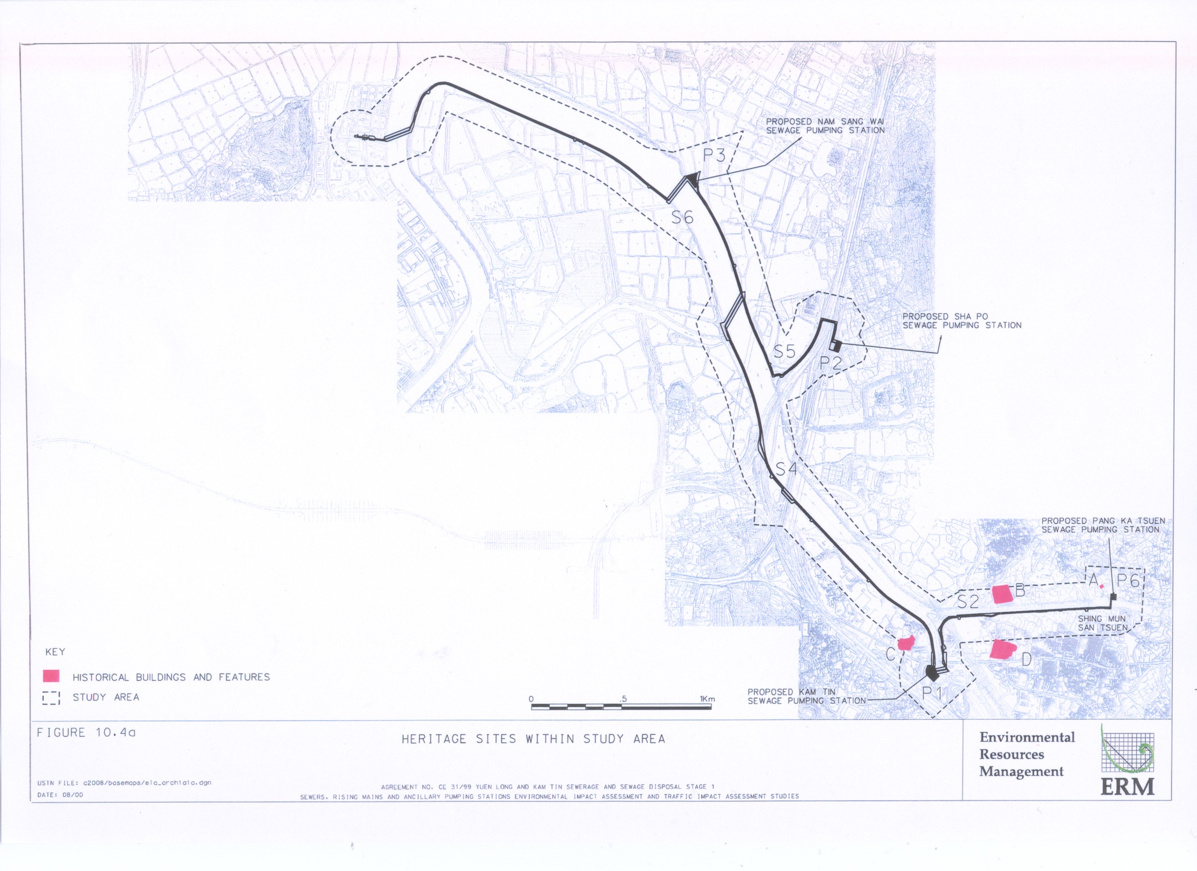
Following the categories laid down in Clause Appendix I, Section 3.11, Annex A of the Study Brief, the cultural heritage resources within an area of 150m from either side and along the full stretch of the proposed Project boundary have been assessed (see Figures 10.4a and b):
· all sites of archaeological interest;
· all pre-1950 buildings and structures;
· selected post-1950 buildings and structures of high architectural and historical significance and interest; and
· landscape features include sites of historical events or providing a significant historical record or a setting for buildings or monuments of architectural or archaeological importance, historic field patterns, tracks and fish ponds and cultural elements such as fung shui woodlands and clan graves.
10.3.2 Methodology
Desktop Study
A desktop search was undertaken to compile a comprehensive inventory of places, buildings, sites and structures of archaeological and historical value within the Study Area. The search included the review of:
· archive information held by the Antiquities and Monuments Office;
· publications on local historical, architectural, anthropological, archaeological and other cultural studies; and
· unpublished papers, records, archival and historical documents through public libraries, archives, tertiary institutions and other government departments.
The full Bibliography and source of information consulted is presented in Annex E of this report.
In cases where currently available information is not adequate, appropriate surveys were undertaken to identify any additional heritage resources not recorded by the AMO.
Archaeological Survey
The objective of the Archaeological Survey is to adopt appropriate methods to assess the archaeological potential and its possible extent within the Study Area. The survey included:
· Field scan of the natural land undisturbed in the recent past to search for artefacts and determine appropriate locations for augering and test pits.
· Conduct systematic auger survey/shovel testing to establish the horizontal spread of cultural material deposits.
· Excavation of test pits to establish the vertical sequence of cultural materials, with hand digging of 1 m x1m or 1.5 m x 1.5 m test pits, and to determine the presence or absence of deeper archaeological deposits and their cultural history.
An Archaeological Survey Report for Designated/ Potentially Designated Elements and Non-designated Elements containing the detailed survey findings is attached in Annex F1. Relevant information from the Archaeological Survey Report for the purpose of the assessment is incorporated into Section 10.4.5.
Historical Buildings and Structures Survey
This Survey is to identify any additional standing heritage sites and features within the Study Area which may be impacted by the development and not recorded by the AMO or not recorded in other surveys. The survey comprises the following:
· field scan of the historic buildings and structures within the Study Area focusing on features not recorded by the AMO;
· photographic recording of any historic building or structure not already recorded by AMO, in as much detail as possible;
· interviews with local informants, if necessary; and
· architectural appraisal of the historic buildings and structures.
The surveyed villages relevant to this study is presented in Table 10.3a and the findings are detailed in Section 10.4.5.
Table 10.3a Surveyed Villages
|
Village/Place Name |
Location in Relation to
Proposed Development |
|
Ng Ka Tsuen |
P5, S1 |
|
Kam
Tsin Wai |
S1 |
|
Kam Hing Wai |
S2 |
|
Kam Tin Shi |
S2 |
|
Ko Po Tsuen |
P5, P1 |
|
Kong Ha Wai |
S1 |
|
Leung Uk Tsuen |
P7 |
|
Nam Sang Wai |
S6 |
|
Sha Po |
P2, S5, S4 |
|
Shui Tsan Tin |
P4 |
|
Shing Mun San Tsuen / Kam Tin San Tsuen |
P6 |
10.3.3 Impact Assessment
Preservation in totality is taken as the first priority and the assessment has taken into account the requirements as specified in Section 2.1 of Annex 10 and Section 2.6 -2.14 of Annex 19 of the EIAO-TM.
10.4.1 Topography and Geology
The topography of the Study Area comprises the Kam Tin flood plain, Sha Po coastal region, former shallow bay at Tin Shui Wai and Nam Sang Wai,
and the alluvial terrace at Kam Tin valley. Six thousand years ago the coastline of the northwest New Territories in relation to the study area was near the existing walled village area at the Kam Tin valley. This topography is favourable for human inhabitation as it favoured coastal transportation.
The superficial deposits of the Study Area are dominated by sandy silty soil and hill wash debris transported from hill slopes during the late Pleistocene and middle Holocene (100,000 to 5, 000 years ago) period.
The geological formation of the deposits can be classified into 3 groups:
1) Hang Hau Formation: mud flat deposit comprising shell fragments commonly found at the seabed of shallow bays such as west of Kam Tin, west of Sha Po Tsuen, Tin Shui Wai, Yuen Long and south of Nam Sang Wai formed in Holocene Period. Hang Hau Formation is usually formed on top of Chek Lap Kok Formation colluvium.
2) Fanling Formation: inland alluvial deposit found in Kam Tin valley formed during late Pleistocene and early Holocene (100,000 to 8,000 years ago).
3) Chek Lap Kok Formation: colluvium beneath Hang Hau Formation and Fanling Formation, it is a colluvial terrace form, found in Yuen Long and Kam Tin; The formation period of this colluvium is similar to the organic clays from alluvial terrace at Shan Ha Tsuen dated to 162,89 to 79,000 years before AD1950 ( Fyfe et al 2000) which is located south of Yuen Long outside the Study Area.
Sha Po (P2), Nam San Wai (P3) pumping stations are located within the Hang Hau Formation while Kam Tin (P1), Leung Uk Tsuen (P7) and Pang Ka Tsuen (P6) pumping stations are located in Fanling Formation alluvium and Shui Tsan Tin (P4) is located in the Chek Lap Kok Formation colluvium.
10.4.2 Archaeological Resources
No Neolithic artefacts have been recorded within the Study Area. However, Bronze Age double-f and net pattern stoneware shards have been identified in Shek Kong and two Tang dynasty funnel urns with open work decoration pottery stands were found in Shek Kong in 1964. A Neolithic age stone adze had also been collected outside the Study Area at a hill slope at north of Pak Wai Tsuen a few years ago by an archaeologist ( Mok, pers. comm.).
Apart from the above mentioned archaeological records, a number of archaeological investigations have been undertaken from 1998 to 1999 which covered the main drainage channels at Yuen long and Kam Tin and along the whole Kam Tin Road widening project.
Known Archaeological Sites
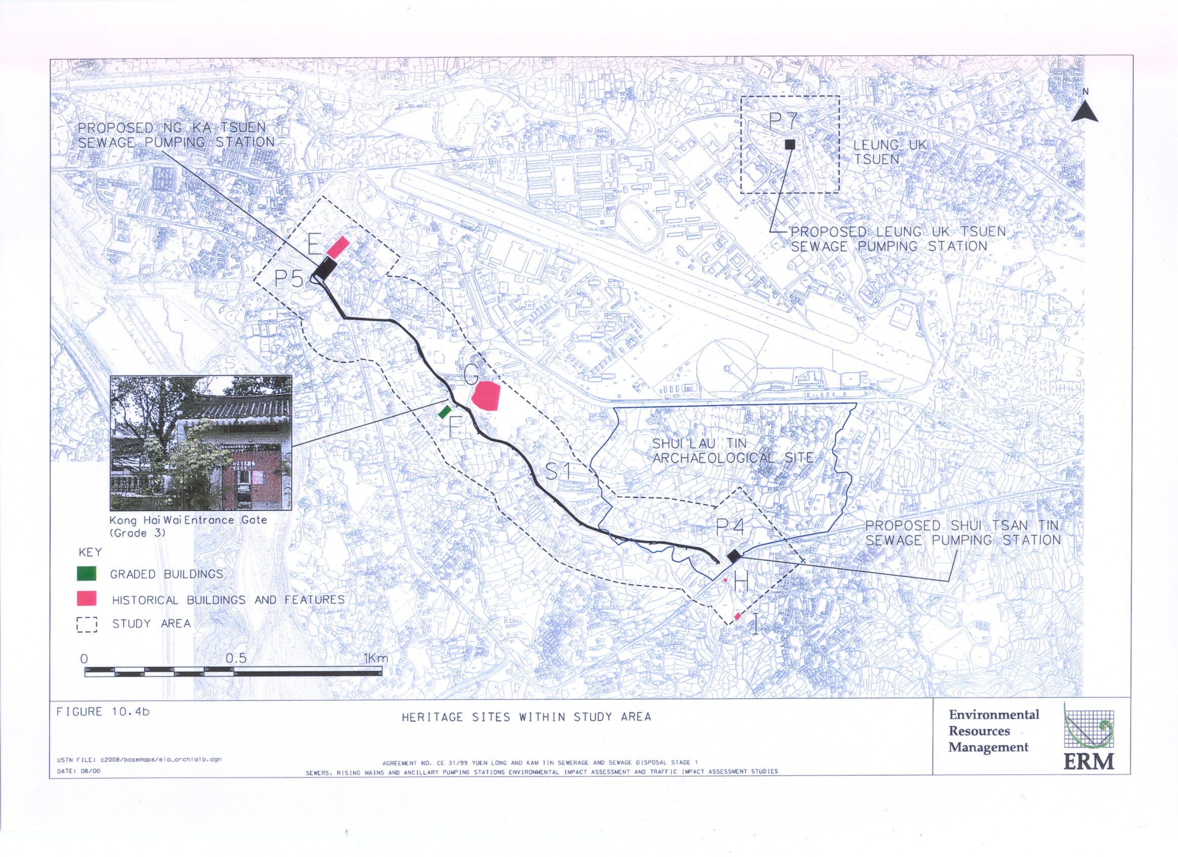
Shui Lau Tin was identified as a site of archaeological interest by the AMO (see Figure 10.4b for location). The topography of the area is of archaeological interest and artefacts dated Song dynasty were collected in the previous survey.
Therefore, although only one archaeological site is identified within the Study Area, the topography, geology, historical and archaeological records indicate that the area has archaeological potential.
10.4.3 Archaeological Survey Result Summary
The EIA(DE) Study Area was field walked but no artefacts dated from pre 1800 were found.
Sewers S4 - S6 and Nam Sang Wai Pumping Station (P3) areas were previously a shallow bay and now used as fish ponds, such topography would have no archaeological interest.
Previous archaeological investigations were undertaken for the main drainage channels for Yuen Long and Kam Tin, main drainage channels for Yuen Long and Kam Tin Stage 2 Remainder and Kam Tin road improvement works. Those reports indicated that no archaeological deposit was to be expected, therefore, no augering or test pit excavation was considered necessary for Sewers S1 and S2 and Pang Ka Tsuen pumping station (P6). Two auger holes were bored at P6, although no archaeological deposits are identified at these auger holes, recent archaeological investigations (approximately 500m from P6) identified Bronze age archaeological remains which may suggest that archaeological potential at P6.
Although Bronze Age double-f pattern shard was picked up from the ground near the proposed Leung Uk Tsuen pumping station (P7), the previous archaeological investigation has bored 4 auger holes at the site and no artefacts were revealed. (Liu and Ngan 1999). The study team intensively field walked the P7 area again and confirmed that there are no archaeological remains.
Kam Tin Pumping Station (P1)
The proposed P1 site is now occupied by a vehicle selling company and other factories in a fenced area. It is impossible to undertake any test pits or auger holes within P1. However, according to desktop research, the area in P1 was dry agricultural land in 1958. The area was then converted into a fish pond of at least 2 m in depth prior to the 1990s and filled up again in the 1990s (see Figure H in Annex F1). Therefore, any archaeological remains present would have already been destroyed by previous land use.
Two auger holes (AH9 and 10) were bored at the original ground level closest to P1 (at least 1.5 m below the existing road level). White coarse sand was found in layer 5 which is natural alluvial sediment from river channel deposits. Layer 1-4 are mainly filled material. No human artefacts are likely to exist. It is now a car repair workshop and hence no in situ archaeological deposit is likely to exist.
Sha Po Pumping Station (P2)
Two auger holes (AH7, 8) and 1 test pit (TP2) were made at P2. Auger hole results indicated dark grey sandy soil mixed with organic deposits in layer 3. Above layer 3, fill material was found. Similar results were found in the test pit.
Old aerial photographs and old maps were reviewed. In the 1950s, this area was used for agriculture and it was converted into fish ponds in the 1970s. The ponds were filled and used as open storage for containers in the 1990s. Therefore, it is probable that any archaeological deposit has already been the destroyed by previous land use changes.
Shui Tsan Tin Pumping Station (P4)
Although P4 is located at the periphery area within the Shui Lau Tin archaeological site, a previous archaeological investigation did not identify archaeological deposits. From an engineering point of view, the site proposed for the pumping station is preferred as it can make use of a portion of the land to be resumed under the DSD Main Drainage Channel project. In addition, the proposed sewer alignments and sites of all the 7 sewage pumping stations have been circulated, revised and re-circulated among all the relevant parties such that there is no major objection to the current scheme. Further to the discussion with AMO, it was agreed that no significant deposit has been identified at this site, therefore, it is acceptable to site P4 within the periphery of the archaeological site. As P4 site is currently private land, no access for an archaeological survey was allowed. Therefore, no investigation within site P4 is possible. However, 3 auger holes (AH 17-19) and 2 test pits (TP3-4) were advanced as near to P4 as possible (30 m and 40 m from P4). Qing dynasty blue and white porcelain was identified in layer 2 (14.39 mPD) and Song dynasty celadon porcelain bowl bottom shard, yellowish dark brown glaze stoneware pot shards and a broken grey brick were identified in layers 3 and 4 (14.11-14.7 mPD) in TP3. Two cultural layers exist in TP3, Qing dynasty (1644-1911) and Song dynasty (960 - 1279). The Song dynasty layer is believed to be a re-deposit of artefacts from the upper layer (alluvial sediment). Any remains in layer 3 and below are regarded as redeposits.
An iron pan (hardpan) layer (layer 4) was identified in TP4 and is likely to have been formed from long term paddy farming cementation (Grant 1986). Broken roof tiles (no impression), village stoneware shards dated to the late Qing dynasty were identified in layers 3 and 2 small pieces of coarse ware shards, dating to the Neolithic Age (3500 years ago) were identified in layers 4 and 5. Artefacts identified in layer 3 are probably left from farming activity. The two Neolithic pieces of shards are rounded, indicating that they are shaped by water movement and hence likely to be re-deposited artefacts and of little significance.
Ng Ka Tsuen Pumping Station (P5)
The Ng Ka Tsuen area has been surveyed in 1999, intensive auger holes (22 holes) and intensive surface collection were undertaken (Liu and Ngan 2000). Five auger holes were bored at Ng Ka Tsuen in close vicinity to P5. It is also indicated in the report that 4 Song dynasty pottery shards were surface collected at Ng Ka Tsuen. However, the surface collection area was not mentioned in the report. No artefacts are identified in the auger holes at Ng Ka Tsuen. However, the soil profile of the auger holes, in particular AH15, are similar to the auger hole result bored at Ng Ka Tsuen (AH11).
The proposed pumping station site is now a private site, although footpaths are found in the area, all of them are covered with concrete which limited the use of hand augers. One auger hole (AH11), located 60 m to the north west of P5 on a small river terrace near a stream, was bored. The soil profile indicated that layers 3 to 6 are alluvial sediment (silty soil and coarse sand) which is next to a river stream. Therefore, it is regarded as a secondary deposit. As a result the archaeological potential of the area is considered low.
With reference to the auger hole result and previous bored holes, it is likely that the soil deposit of P5 and the surrounding areas is secondary deposit. However, in this stage of the study, since P5 is occupied by private lots, no test pits could be undertaken. Although there are some footpaths between individual lots, they are covered with concrete and probably have public utilities underneath (eg electricity cables). No further fieldwork is possible within P5 at this stage.
10.4.4 History
There is not much detailed local history in relation to the Yuen Long and Kam Tin area. However, it is noted that they were absorbed into the administrative sphere of Panyu county in the Qin dynasty (226 - 206 BC).
The Yuen Long and Kam Tin area has a long history as an agricultural centre with salt production and pearl cultivation in ancient times.
In the Tang dynasty (AD 736), the Study Area was under the rule of Tunmen Zhen (Tuen Mun military division), which was stationed in the present Nantao district at Shenzhen City. By the 9th century, Hong Kong was already a key salt production centre.
Since the Song dynasty (AD 960 ~ ), the local history of the area is better understood as genealogical records of clan groups were better recorded. The following presents a further detailed history of the local place, Yuen Long and Kam Tin.
Yuen Long
The original Chinese character for Yuen Long means being surrounded, well developed lowland along a river lake. Yuen Long is a large alluvial plain surrounded by hills on three sides. It comprises six rural areas with 140 villages. It was a favourable site for salt and pearl production and agricultural activities.
After the Yuen Long Market was built at Tai Kiu Tun in the late Ming dynasty and relocated to Yuen Long Kau Hui in Qing dynasty, there was tremendous economic growth in the Yuen Long area.
Kam Tin
Chan Tin (Chan Field) was the original name of Kam Tin before the Tang clan immigrated to Kam Tin. Therefore, the Kam Tin area may have been dominated by a Chan clan during 950 - 980, before the Tangs. When the Tang ancestors first settled in Hong Kong in 973, they were staying on the south hill slope of Kai Kung Leng called Sham Tin (meaning village on a hillslope). As the Tang clan became richer, they bought the Chans field and replaced the local name by Sham Tin ( Yao, 1999).
The Tang clan continued their growth and progressively occupied the existing Kam Tin, Yuen Long and Ha Tsuen area and dominated the area. Five walled villages were built in Kam Tin by the Tang clan; including Kat Hing Wai, Wing Lung Wai, Tai Hong Wai, Pak Wai and Nam Wai.
In 1587, Hong Kong was zoned within Xin¢an County and suffered from severe famine. The Tang clan took part in contributing rice as they had fertile land. It was appreciated by the Xin¢an County magistrate who visited Sham Tin and renamed the area from Sham Tin to Kam Tin (ornamental field) and this name is used today.
However, in 1661, the Manchu government promulgated a Coast Evacuation requirement to withdraw the population inland by 50 li (about 80.5 km), to stifle the supply of the Anti Manchu rebels in Taiwan. Many villages in the Yuen Long, Kam Tin and Ha Tsuen areas were seriously affected.
In 1669, the Boundary Extension was promulgated, but few of the original inhabitants returned to their homes. The government then encouraged the Hakka people from Jiangxi, Guangdong and Fujian to immigrate to the Yuen Long, Kam Tin and Ha Tsuen areas. Since then, the area has comprised a number of Hakka villages, such as the Wang Toi Shan village.
According to the survey undertaken by James H. Stewart Lockhart in the 1890s, the inhabitants in Yuen Long and Kam Tin were mainly farmers of grain, peanuts, taro, sugar cane and vegetables. Transportation was well developed and villages were linked by stone paths, enabling travel on foot and by horse.
10.4.5 Historical Buildings and Features
Following a desktop literature review supplemented by a survey, a full inventory of historical buildings and features within the Study Area has been developed and is presented below.
S2 and P6 Study Area at Kam Tin
Sewer S2 follows the main drainage channel from the proposed Kam Tin pumping station (P1) to the Pang Ka Tsuen pumping station (P6). No declared/deemed monuments or graded buildings are identified. However, one village (Site B), one old market (Site D) and one temple (Site A) are identified. They are detailed in Table 10.4a and Figure 10.4a. The photographic record and location plan of the sites are presented in Annex F2.
S4 - 6 and P2 Study Area at Nam Sang Wai to Kam Tin
The Nam Sang Wai area is mainly low land occupied by fish ponds. A main drainage channel had been constructed in this fish pond area. The proposed sewers S4 and S6 are to be laid along the maintenance road of the main drainage channel. No declared/deemed monuments and graded buildings are located within this Study Area.
One old village, the Ko Po Tsuen (Site C) is identified some 90 m from S4 near the Kam Tin pumping station (P1). The details are presented in Table 10.4a and Figure 10.4a. The photographic record and location plan of the sites are presented in Annex F2.
P4, P5 and S1Study Area at Ng Ka Tsuen to Shui Tsan Tin
No declared/deemed monuments are identified in this Study Area. One Grade 3 building, the Kong Ha Wai (see Site F in Table 10.4a), is located 15 m from the proposed development. It is now occupied by a factory and in poor condition. Detailed information can be found in Table 10.4a and a location plan of the site is presented in Annex F2.
Four historical village / buildings / features are also identified; the Ng Ka Tsuen historic compound (Site E), Kam Tsin Wai (Site G), Lee Tat Bridge Inscription Tablet (Site H) and Kwong Wah Tong (Site I) at Shui Tsan Tin. They are detailed in Table 10.4a and shown in Figure 10.4b (Site E, G to I). The photographic record and location plan of the sites are presented in Annex F2.
Study Area at Leung Uk Tsuen Sewerage Pumping Station (P7)
No declared/deemed monuments or graded buildings were identified. No historical buildings or features were identified within the Leung Uk Tsuen pumping station study area.
Table 10.4a Identified
Historical Buildings and Features at Kam Tin
|
Map Ref. Code |
AMO File No. |
Site Name |
Location |
Description |
Closest
Distance from the proposed development |
|
A |
940584 |
Hip Tin Kung |
Kam Tin San Tsuen, Kam Tin |
Owned by the Cheng clan probably built around 1920 and renovated in
1990. The villagers of Shing Mun
San Tsuen were in the Chengs clan, and have lived in Tsuen Wan since the
village was established. The
ancestors of the villagers worshipped Kwan Tai, and built a temple for this
purpose in 1875. In the 1920s,
the Government built the Shing Mun Reservoir which flooded the Shing Mun San
Tsuen village, and the villagers relocated to Kam Tin and brought along the
relics from the temple and built the present Hip Tin Kung. The temple has been renovated several
times (in 1972, 1982 and 1990).
It is a 2-hall temple with a open courtyard. The walls are built with
bricks. The cladding roofs are
supported with timber beams. |
60 m |
|
B |
5899-03 |
N1-3, 38 village houses and a Shrine |
Kam Hing Wai |
An old walled village established by the Tang clan
probably dated to the Ming dynasty.
It was a walled village with a moat surrounding the village; however, the moat was filled and the
walls no longer stand. Only 3 to
4 village houses remain in the original traditional architectural style built
with grey bricks. Others are
replaced by 2 to 3 storey modern buildings. There is a temple without name at the northeast corner of
the village built with modern material.
An earth shrine is located at the southeast of the village which is
arm chair style shrine. The
surface is covered by concrete. |
60 m |
|
C |
5910 |
Ko Po Tsuen |
Ko Po Tsuen |
An old
village with identical traditional Chinese houses. The village have been heavily modified and more modern 2-3
storeys village houses built. |
90 m |
|
D |
5912 |
Kam Tin Shi |
Kam Tin Shi, Kam Tin |
Kam Tin Shi was an old
market distribution centre for farm produce for the region. It is now mixed with modern
buildings, ruins and some old buildings in fair to poor condition. |
125 m |
|
E |
5295, 8454-55 |
Ng Ka Tsuen historic compound |
Pat Heung |
A village of the Ng clan.
N1 village house, Ng Ka Tsuen Wai Mun, Kwong Ha
Tsuen Ng Ka Tsuen, N2-3 village houses The
village is walled. The buildings
are mainly 2 storey buildings facing north west of mixed Chinese and western
design and built with grey brick.
The ancestral hall is located at the middle of the historical building
compound. |
5 m |
|
F |
830318/ AM5296-97 |
Kong Ha Wai |
Kam Tin |
The
building is a residence of Lai Kam-tai.
It is a 2-storey Hakka building built in 1904. The mansion is walled-in with a
courtyard and entrance on the left.
Inside the mansion has an altar in the central open skylight
courtyard, and 2 sides are used for residential quarters. A pond was located in front of the
house. There is an
entrance Gateway (AM 5296) and the Yuen Yuen Tong (AM5297) at Kong Ha Wai
that are part of this Grade 3 structure recorded by AMO within the Wai. |
15 m |
|
G |
4698-15, 8246-47 |
Kam Tsin Wai and Kam Tsin Wai Tsuen |
Kam Tsin Wai |
The villagers came from Shing Mun Reservoir area
as the village was forced to move for the construction of the reservoir in
the 1930s. The residents are
mainly of the Cheng Clan. Village houses included: No. 33 N1, 36-37,
23,19-22. A Hung Tsz Tong, a two
storey, one hall grey brick Chinese building. An expansion of the village, village houses included: No
9-13, 3-5, 24, 25 Kam Tsin Wai Tsuen.
Ancestral Hall of the Cheng clan |
50 m |
|
H |
- |
Lee Tat Bridge Inscription Tablet at Shui Tsan
Tin |
Shui Tsan Tin |
A granite stone tablet built in 1903 dedicated to the memory of those
who had funded the construction of the bridges for the convenience of local
people. |
40 m |
|
I |
4338 |
Kwong Wah Tong |
Shui Tsan Tin Tsuen |
Two storey mixed Western and Chinese style building |
140 m |
10.5
Identification of Cultural Heritage Impacts
10.5.1 Existing Impacts
There are a variety of existing land uses and developments within the Study Area which have modified or disturbed the cultural heritage resources:
· village houses in the process of ongoing development;
· channelled streams, rivers and drainage channels;
· major road access, such as the Kam Tin road,
· modified channels such as the Main Drainage Channel at Nam Sang Wai, Sa Po Tsuen Kam Tin, Kam Tsin Wai to Shui Tsan Tin.
· village access roads;
· light industrial buildings, factory, open storage, both abandoned and in use;
· conversion of agricultural fields to fish ponds;
· levelling of original landform.
10.5.2 Potential Impacts
Potential impacts on identified cultural heritage resources within the Study Area may arise from the following.
· Landtake
for permanent pumping station facilities which may result in damage to, or loss
of, archaeological remains and deposits or changes to the physical coherence of
historic landscapes.
· Construction
works may result in damage to or loss of buried archaeological sites by a)
disturbance through excavation at or near an archaeological site, topsoil
stripping and the passage of heavy machinery on exposed and buried deposits; b)
change in the watertable due to construction and development activities.
· The
burial of sites resulting in a limitation on accessibility for future
archaeological investigations (including surface survey and remote sensing
techniques) and obscuring visible surface evidence.
· Ground
compaction due to construction activities or the weight of permanent filled
materials may cause damage or distortion to buried archaeological remains,
especially in soft alluvial deposits.
Indirect impacts such as visual and noise intrusion on the setting and amenity of historic and cultural resources are addressed in Sections 3, 4 and 11 of this report.
10.6
Assessment of Cultural Heritage Impacts
Although 1 graded building and 8 sites of historical buildings or features are identified in the Study Areas, as shown in Table 10.5a, none of them are located within the works areas and hence no direct impact is expected.
No indirect impact at Site C (Ko Po Tsuen) is expected as it is 90 m from the proposed work site. It is not the closest residential building to the works area and so it is not considered as a sensitive receiver. Mitigation of impact to the sensitive receiver will ensure that impact to Site C are also effective.
Site F (Kong Ha Wai) is now a factory site, and hence, is not regarded as a sensitive receiver.
Site H (Lee Tat Bridge Inscription Tablet) is a stone tablet, therefore, no indirect impact is expected.
Site I (Kwong Wah Tong) is now a vacant site, and located 140 m from the works area. No indirect impact is expected.
Site A (Hip Tin Kung), Site B (Kam Hing Wai), Site D (Kam Tin Shi), Site E (Ng Ka Tsuen) and Site G (Kam Tsin Wai) are regarded as air and noise sensitive receivers D27, D23, D22, D32 and D38, respectively. The detailed air and noise assessments of these sites are addressed in Sections 3.3, 3.4, 4.3 and 4.4.
The potential visual and landscape impacts to Site A (60 m from P6) is addressed in Section 11.6.
Sites B and D are located 90m and 125 m from Sewer S2. The sewer would be constructed underground, and hence visual impacts would occur during the construction phase only. Given the distance from the sewer, visual and landscape impacts are predicted to be minimal. The detailed visual and landscape impact assessment is presented in Section 11.6.
Similarly, Site G is located 50 m from Sewer S1. Given the distance from the sewer, visual and landscape impacts are likely to be significant.
Site E, Ng Ka
Tsuen historic compound, is located 5m from the work site boundary of P5. The detailed landscape and visual
impact assessment is addressed in Section
11.6.
With regard to
impacts, during the construction phase, ground borne vibration from sheet
piling close to Ng Ka Tseun at P5 has the potential to impact upon the
structure of the historic compound at Site E. From a preliminary external
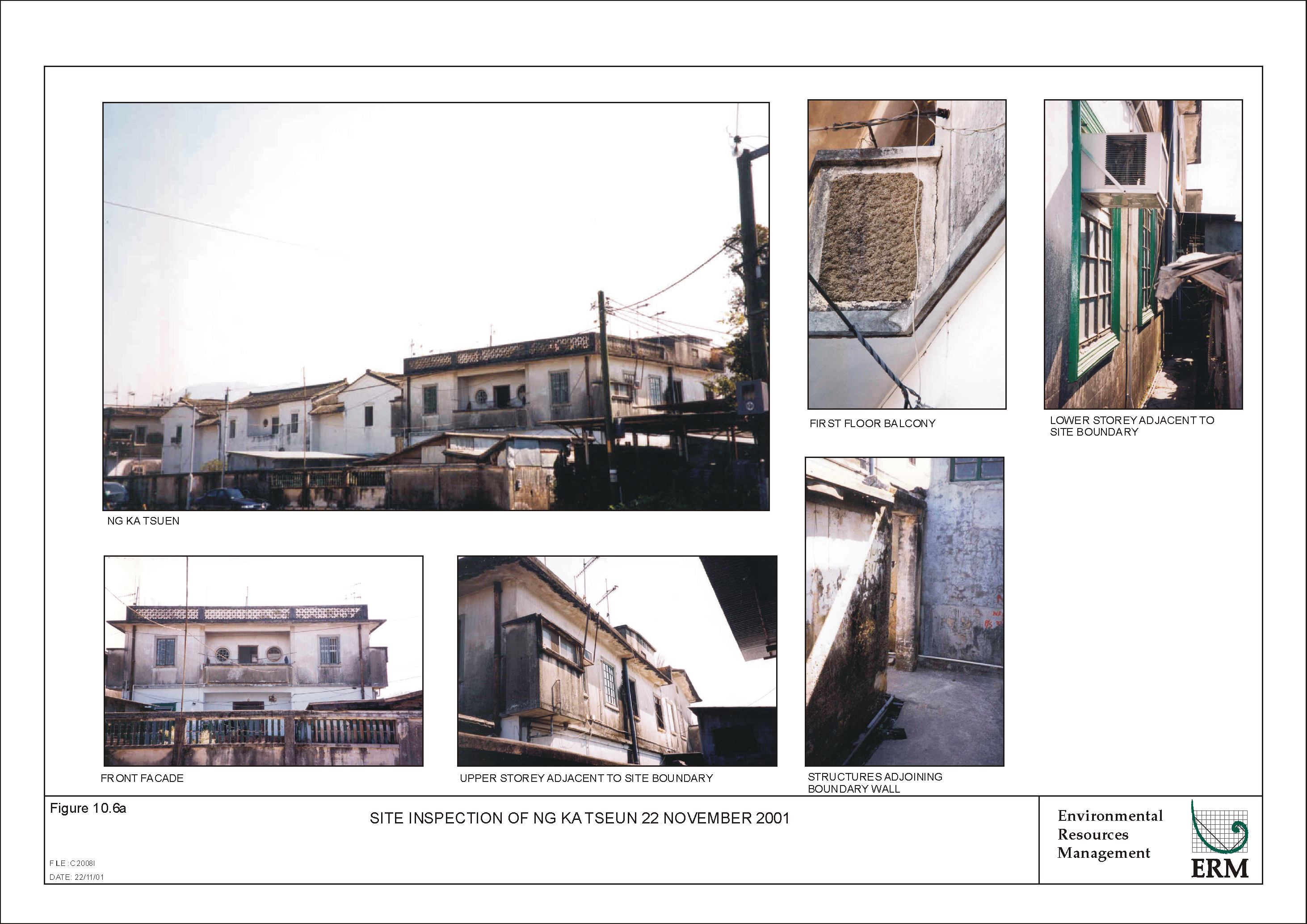
inspection of the buildings, cracks are apparent in the rendering and at the
joint of a first floor balcony closest to the site, as shown in Figure 10.6a. For historic structures such as
Ng Ka Tseun historic compound, a limit of 4mm/s peak particle velocity (ppv) at
any point within the compound is proposed to avoid the potential for further
deterioration of the structure and boundary walls. This limit is adopted to provide protection against
further cosmetic and minor damage, defined as formation of hairline cracks to
formation of large cracks or loosening and falling plaster.
From the construction
plant inventory presented in Table A2-1,
no percussive driven piling equipment will be used on the pumping station
site.
For the foundation works
of the pumping station, the bored piling method with a reverse circulation
drill and vibropiling will be used in place of the aforementioned equipment
presented in Table A2-1 and this will
reduce the likelihood of exceedances of the proposed criterion. For vibropiling, it is expected
that the transmission of the vibration imparted in the pile to the surrounding
ground will be by friction with the adjacent soils and this will probably
dominate the force impact of the pile toe as it is driven down. During start up and run down of
the pile driver the rotational frequency of the driver machinery will pass
through resonant modes.
While being transient events the vibration arising will be higher than
in steady state operation.
During steady state
operation it is expected that the vibration from vibropiling will be highest
but would still meet the criterion of 4 mm/s ppv at the minimum set back
distance of 25 m. For start
up and shut down during the pile driving cycle, it may exceed the criteria for
a short period, but only a transient effect is expected.
While vibration will be
influenced by site conditions, and the selection and use of plant, it is
expected that in the preparation of the finished earthworks and site formation,
small vibratory compaction equipment will be used, while sheet piling works
would be required for the construction of the main pump house. It is expected that the
activities of bored piling and vibratory compaction equipment within 7.5 m of
the structure or earthmoving and excavation equipment within 2.5 m will likely
exceed the above criterion.
During the operation
phase, the operation of rotating equipment within the pumping station has the
potential to excite the ground slab and foundations and subsequently transmit
vibration into the surrounding lithology and buildings. In sufficient magnitude this
vibration would be perceived as noise radiated within rooms and as tactile
vibration. However,
under continuous running, the frequency of the pump vibration within the
station will be much higher than the natural resonances of the building
elements of Ng Ka Tsuen, and so vibration impact will not arise.
Since the
majority of the proposed sewer alignments are located at existing road/road
sides or newly built drainage channels, no impacts on features of
archaeological or cultural heritage interest are predicted for any of the
sewers alignments. For the pumping
stations, with the exception of P4, P5 and P6, all of them are to be developed
on sites of no archaeological interest, and hence no impacts are predicted.
Although no test pits or auger holes were possible within P4 due to access constraints, the results from two test pits and three auger holes developed in the immediate vicinity indicate that there is a potential of archaeological remains in the area. The survey results indicated, however, that any archaeological remains at P4 are likely to be re-deposited from another location and hence the impact on archaeological features arising from the P4 is low and considered acceptable. Since no survey can be undertaken at this stage of the study, a further archaeological investigation will be necessary in future to confirm that the impact is low.
According to a previous survey that covered the whole alignment (Liu and Ngan 1999), no significant deposits exist along the S1 alignment. Hence, although part of S1 is located in the Shui Lau Tin archaeological site, no impact is predicted.
Similarly, no test pits or auger holes were possible within P5 due to access constraints. Previous fieldwork results, geological analysis and an auger hole bored in close proximity to P5 indicate that since P5 is located next to a stream, it is likely that any archaeological deposit identified in P5 has been re-deposited from somewhere at higher level. Therefore, impacts on any archaeological deposits within P5 is expected to be low and considered acceptable. However, a further archaeological investigation will be necessary in future to confirm that the impact is low.
10.7
Mitigation of Adverse Cultural Heritage Impacts
After land resumption but before the construction work for the proposed Shui Tsan Tin pumping station (P4), Ng Ka Tsuen pumping station (P5) and Pang Ka Tsuen pumping station (P6) commences, a period of 6 months for each of the sites should be allowed for an archaeological investigation, with the method agreed with the AMO. It is recommended that the survey be carried out into two phases. The first phase is to undertake 6 test pits with dimensions 1 m x 1.5 m (2 test pits for each site) to assess if archaeological deposits exist and their possible extent. If no archaeological interest is identified, no further action will be required. If deposits are found, a rescue excavation should be undertaken if the deposits are considered common and not significant by AMO, so that preservation by record is achieved. However, if a significant archaeological deposit is identified, the design of the P4, P5 and P6 should be reviewed to integrate the preservation in situ of the archaeological materials or, if feasible, an alternative site for P4, P5 and P6 should be sought. Rescue excavation of highly significant archaeological deposits, should be regarded as the last resort. AMO should be consulted on the result of the test pit investigation and any proposed excavation or preservation mitigation measures. The archaeological investigation would be laid down as a condition in the Environment Permit.
As no direct impact on the identified historical buildings and features is expected, no mitigation is necessary.
With regard to the potential vibration impact on Site E, Ng Ka Tsuen historic compound, during construction since bored piling and vibration compaction within 7.5 m and vibropiling within 25m of the Site E will likely exceed the 4mm/s ppv limit, it is recommended to set back the pumping station so that these separation distances from the Ng Ka Tsuen historic compound can be achieved.
During construction, the Contractor will be required to avoid encroachment of the safe margin of
7.5 m from the historic compound of Ng Ka Tsuen and pay particular attention to
remove underlying obstructions such as buried foundations, floors etc before
continuing with bored piling and sheet piling operations. All
sheet piling operations must be set back 25 m from the compound of
buildings. If demolition within
7.5 m of the building is required, preference should be given to hand methods
and use of mini excavator ( Bobcat type plant) to remove materials.
Careful selection of
pile driving equipment by the Contractor to meet the criteria is
recommended. For sheet
piling, a resonant free vibrator is recommended. It is a type of pile driver designed so that the rotating
system of weights within the driver can be accelerated to operating speed with
the rotating masses in balance and, once at operating frequency and above
resonant mode, the weights are rearranged to be out of phase and hence generate
the vibration required to drive the pile.
It is recommended that a
trial of sheet piling using the proposed plant be undertaken and the resulting
vibration monitored prior to the Contractor proceeding with works to enable the
Engineer to assess the potential risk from the expected levels of vibration at
Ng Ka Tseun.
In addition, and prior
to the commencement of site operations it is recommended that a structural
survey of Ng Ka Tsuen be undertaken by specialist surveyor approved by AMO to
record the condition of the historic buildings. This survey shall focus on the on the quality of construction
and finishes and the general condition of the structure and its finishes. A schedule of defects (including
cracks) is to be prepared for submission to the Engineer and AMO and shall be supported by photographic
record. Upon approval to
proceed with the works, vibration monitoring is recommended during the site
preparation, earthworks and foundation and reinstatement stages. Monitoring shall be carried out
firstly on a trial basis to ascertain locations of highest impact within the
building relative to an appropriate ground level location on the worksite
boundary; the setting of these levels shall be subject to AMO approval and
accessibility. Thereafter
monitoring shall be undertaken for the duration of these stages of the works
and, where exceedance of the limit is noted, the works shall stop and the
Contractor required to prepare a plan for the approval of the Engineer and AMO
to ensure that the works could continue without exceedance of the vibration
criteria. Should, at any
time during the works, the Engineer note damage to the decoration and structure
of the Ng Ka Tsuen compound, the Contractor ¢s works shall be stopped and a method proposed by the Contractor to
ensure no further deterioration of the building. Such measures may comprise alternative selection of
plant, method of construction, or use of a cut off trench located close to the
source of the vibration.
For operational
vibration impact, care shall be taken to ensure that in the start up and
stopping of the pumps the damping of the isolators to be installed between the
pumps and mounting will be adequate to ensure that higher amplitude vibrations
at lower frequencies will not cause intermittent impacts to the occupants of
adjacent historic compound at Ng Ka Tsuen. For the avoidance of noise being radiated within the
structure from pumping station operation, care should be taken to avoid or
isolate potential flanking paths to sensitive buildings via existing and new
pipes and other underground structures.
For tactile vibration BS 6472:
1992 Evaluation of human exposure to vibration in buildings (1Hz to 80Hz) provides
limits for the threshold of perception which should be used as design guide for
the pumping station and not exceeded during operation.
With the adoption of the
above methods for the control of the vibration, impact to the historic compound
at Ng Ka Tsuen will be controlled to minimise the risk of damage to the
structure and its decorative features.
10.8
Conclusions
A literature review identified 9 historical buildings or features and one archaeological site (Shui Lau Tin) as sites of cultural heritage within the Study Area.
No direct impact to the identified historical buildings or features is expected. With regard to the indirect impact (noise, air and visual impact), these are addressed in Sections 3.3, 3.4, 4.3, 4.4 and 11.6 of this report. Appropriate mitigation measures have been recommended, if necessary, in Section 3.5, 4.7 and 11.7.
With the adoption of the mitigation measures recommended in Section 10.7 to control vibration, impact to the historic compound at Ng ka Tsuen will be controlled to minimise the risk of damage to the structure and its decorative features.
No significant archaeological deposits would be impacted by the proposed sewerage facilities, except P4, P5 and P6. A 6 month programme should be allowed for an archaeological field investigation to be undertaken at each of the proposed pumping stations, P4, P5 and P6, once the land is resumed and access gained, but before any construction takes place. Mitigation measures agreed with the AMO, should be implemented to mitigate the potential impacts, if any. The archaeological investigation should be stipulated as a condition in the Environmental Permit for the project. The investigation should be undertaken by a qualified archaeologist who should obtain a licence from the Authority under the Antiquities and Monuments Ordinance (Cap. 53) before undertaking any fieldwork.