Agreement No. CE 57/2001 Environmental and Traffic Impact Assessment Study for Fill Bank at Tseung Kwan O Area 137 Environmental Impact Assessment Report Executive Summary
Project Consultancy Team: CH2M HILL (China) Limited in association with MVA Hong Kong Limited ACL Asia Limited
Reference : R0369F-2ADD.02 Client : Civil Engineering Department Date : March 2002
TABLE OF CONTENTS
2.1 The subject site and
its Environs
3.1 Dust Emission Impact
Assessment
3.2 Vehicular Emission Impact
Assessment
4.1 Noise from trucks
using the Fill Bank along Wan Po Road
4.2 Construction/ Fixed
Noise Impact
5. Water Quality Impact Assessment
6. Landfill GAs Hazard Assessment
7. Landscape and Visual Impact Assessment
8. Other Environmental FActors
LIST OF FIGURES
Figure A Location
of the Subject Site
Figure D Fill Bank Preliminary Development Programme
Figure E Preliminary Fill Bank Design and Stockpiling
Heights
Figure F North-south cross section of the fill bank
1.1.1 Excavated earth, asphalt, building debris, broken rock and concrete form the primary content of Construction and Demolition (C&D) material and are generated in large quantity by the construction industry each year. These materials are inert and are collectively referred to as “public fill”. It is the government policy to make beneficial reuse of public fill. In 2000, the construction industry in the territory generated about 7.7 million cubic metres (Mm3) of C&D material. Of which, about 6.1 Mm3 was inert and was reused in reclamation projects.
1.1.2 However, it is impracticable to perfectly match programmes of reclamation projects with the rate of public fill generation. Civil Engineering Department (CED) identified that except for the ongoing reclamation works at Area 137 which may receive further public fill, the existing filling capacity provided by the ongoing Category A reclamation projects will be exhausted by October 2002.
1.1.3 It was identified that from then, and until end of 2005, there will be a significant shortfall in public filling capacity. In April 2001, the Government put forward the proposal of establishing temporary fill banks for storage of public fill during these years in the absence of other alternative solutions. The Government will also take all practicable steps to ensure that the reclamation projects starting before 2005 will receive public fill as planned.
1.1.4
It is expected that starting from
2003, there will be a number of reclamation projects ready for implementation. These projects together with and other long term measures
being investigated, such as recycling and export, that mightwill be able to absorb
the public fill stored at the fill banks and those generated direct from the
construction industry. These planned
reclamation projects include Penny’s Bay Reclamation Stage 2, South East
Kowloon Development, Development in Tung Chung and Tai Ho Phase 3, Wanchai
Development Phase II, Central Reclamation Phase III, and Sham Tseng
Development.
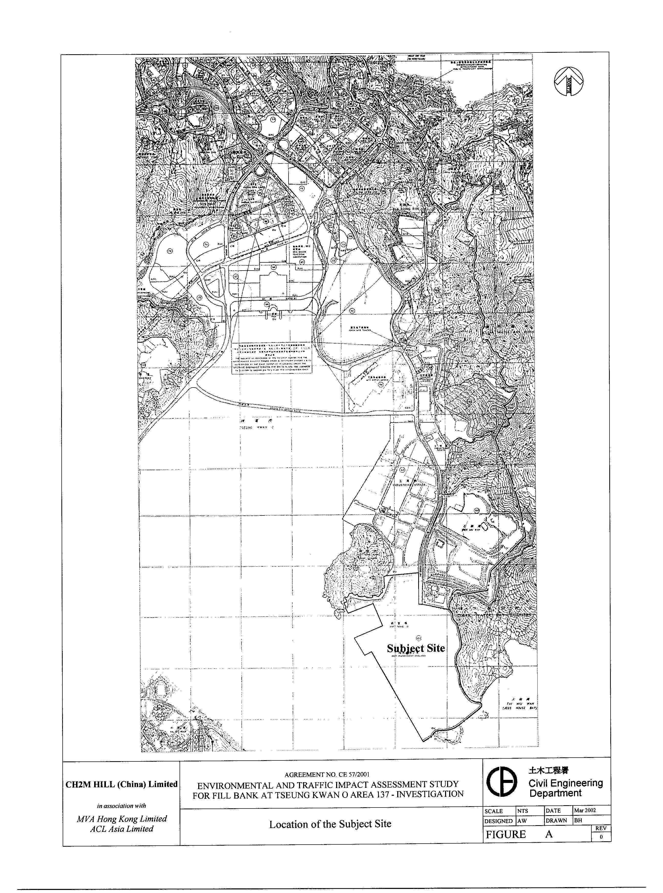
1.1.5 Area 137 in Tseung Kwan O (TKO Area 137) in the southeastern side of the territory was identified by the Government to be a suitable site to establish a temporary fill bank to provide a total public fill storage capacity of 6Mm3. Figure A shows the location of the site. The proposed fill bank is a designated project by virtue of C.11 in Section C Reclamation, Hydraulic and Marine Facilities, Dredging and Dumping in Schedule 2, Part I of the EIA Ordinance. C.11 specifies that a public dumping area of not less than 2 hectares in size is a designated project. A project profile was submitted by CED to Director of Environmental Protection (DEP), which was displaced for public inspection from 18 August 2001 to 31 August 2001. DEP issued an Environmental Impact Assessment (EIA) Study Brief (No. ESB-083/2001) for carrying out of the EIA study.
1.1.6 The provision of the fill bank for beneficial reuse of temporarily stored public fill in future reclamation (and earth filling projects) will reduce the demand on general fill and help to conserve natural resources and avoid environmental impact from earth borrowing activities and marine sand extraction. Provision of the fill bank is also considered as an important measure to avoid the disposal of reusable public fill to landfills and incidences of illegal dumping.
1.1.7 CH2M HILL (China) Limited (CH2M), in association with MVA Hong Kong Limited (MVA) and ACL Asia Limited (ACLA), has been commissioned by CED on 23 November 2001 to undertake an Environmental and Traffic Impact Assessment Study for the Fill Bank at TKO Area 137. This Executive Summary presents a summary on the key findings of the EIA study undertaken for the proposed fill bank at TKO Area 137.
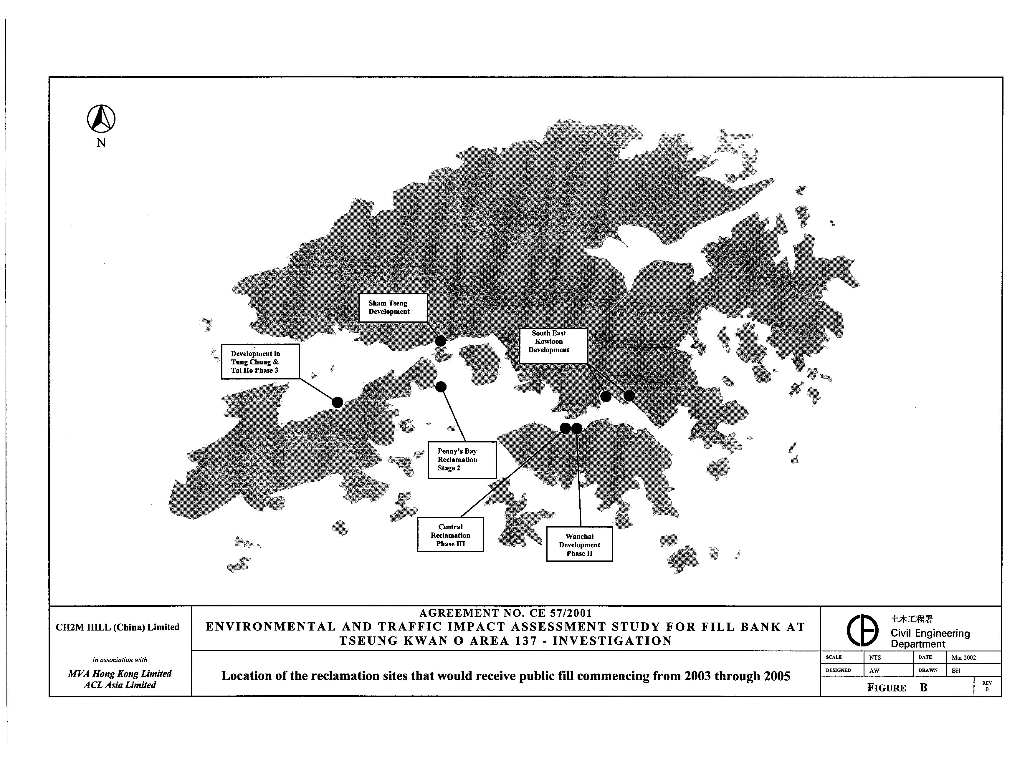
1.2.1 A review of the origins of the public fill and the locations of the planned reclamation projects indicate that, location-wise, it is considered appropriate to set up the temporary fill banks in both the south-eastern and south-western sides of the territory. Figure B shows the location of these planned reclamation project sites that are going to receive public fill commencing from 2003 through 2005.
1.2.2
The sites for setting up the temporary
fill banks must be available between October 2002 and 2007 to allow the
temporary stockpiling, and subsequent removal, of a total quantity of
approximately 11.5Mm3 public fill, which is the estimated total
deficit in public fill receiving capacity up to end 2004. As there will be two temporary
fill banks, each will have a storage capacity
of 5 to 6 Mm3.
1.2.3
Stockpiling
of 6 Mm3 of fill material would require a site area of about 100
hectares with consideration of the slope stability, safety, environment and
other engineering factors. The sites
shall be located at sufficient distance away from sensitive receivers to allow
the potential environmental impact (e.g. air quality and noise) to be
controlled to within acceptable levels. The sites must be accessible in terms
of public fill intake from various construction sites directly by trucks, or
via barges. Selecting a site that is located
along the coastline is also preferred to make possible the effective delivery
of stockpiled fill material to reclamation sites directly by barges without
double handling by trucks during the decommissioning of the fill bank.
1.2.4 On the eastern side of the territory, sites with an area of at least 100 hectares that would also be available from 2002 to 2007 was identified to be rare. The only available site was identified to be the subject site at TKO Area 137, which has an area of approximately 104 hectares. An alternative site that only meets the site area requirement was identified to be the ex-Kai Tak Airport. However, contaminated land remediation works have been taking place on this land, and after then, demolition of existing buildings and construction of new roads and drains will occupy the site from 2003. Even the runway area has already been allocated for the temporary stockpiling of excavated fill material generated from Contract No. CV/2000/06 “Formation and Associated Infrastructure Works for Development at Choi Wan Road and Jordan Valley”, and would also be used for temporary storage of excavated material generated from “Development at Anderson Road” from September 2002 based on the latest programme. After a comparison of the environmental performance and other factors of the candidate sites, including requirements on site area, site availability, location of the site in respect of accessibility, distance separation from nearby sensitive receivers, and potential traffic impact, the newly reclaimed land at TKO Area 137 was identified by the Government to be the suitable site for establishment of the temporary fill bank.
1.2.5
TKO Area 137 is a newly reclaimed
land, and in the north side of the site, reclamation activities are still
ongoing and would not be completed until end of 2003. Sufficient time is required need to be provided for
soil consolidation before the site can be developed for future industrial/
commercial uses. This provides an opportunity for operation
of the TKO Area 137 site as a temporary fill bank. The site is zoned as “Other Specified Uses” for deep-waterfront
industry under the latest Draft Outline Zoning Plan (OZP) No. S/TKO/12. While aAccording to the
Explanatory Notes, temporary uses of any land are permitted in all zones as
long as they comply with other Government requirements. Moreover, and there is
no need for these uses to conform to the zoned uses or the Notes of the OZP,. Nevertheless, it is noted that the
“Column 1” uses (i.e. uses always permitted) allowed for the “Other Specified
Uses” (Deep Waterfront Industry) include uses of similar nature at the site
such as construction material storage area, sand depot, and bulk cement storage
area.
1.3.1
Without the proposed fill bank at
Tseung Kwan O Area 137 which will provide an outlet for temporary storage
of a total quantity of 6Mm3 public
fill, the adverse environmental effect is that it may become inevitable
that the inert, reusable public fill would have to may become inevitably be
disposed of at landfills. The three
strategic landfills in Hong Kong are operated for disposal of degradable
municipal wastes and the landfills are provided with
impermeable lining systems, leachate and gas control systems. The landfill space is expensive and running
out far more rapidly than originally planned.
The disposal of public fill at landfills should therefore be avoided. Besides, increase in incidences on illegal
dumping of C&D materials would likely happen in the absence of sufficient
public filling facilities.
1.4.1 The objectives of the EIA Study, in brief, is to assess the potential environmental impacts arising from the establishment, operation and decommissioning of the fill bank and related activities taking place concurrently, and to identify the environmental mitigation measures where necessary.
2.1
The subject site and its Environs
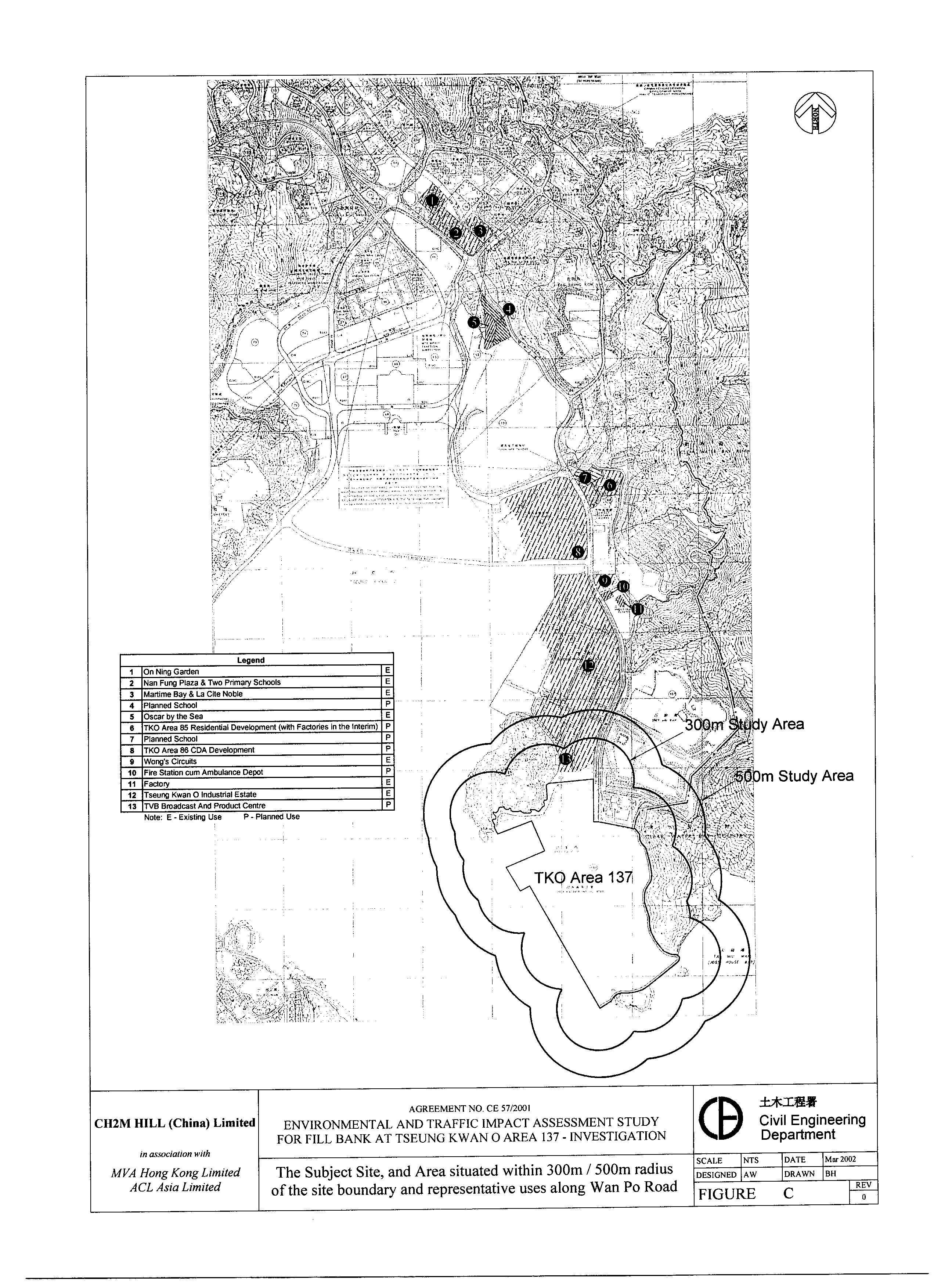
2.1.1 Area 137 is situated in the southern side of Tseung Kwan O. Reclamation activities are still ongoing in the northern part of the site. Upon completion of the reclamation planned in December 2003, the site will have a total area of approximately 104 hectares. The reclamation site has served as a public filling area since 1997 to receive public fill generated from the construction industry. Existing and planned landuses in the vicinity of the site are all of industrial nature. TKO Industrial Estate, Fat Tong Chau (Junk Island) and SENT landfill are located to the north of the site. To the east of the site is the eastern boundary of Clear Water Bay Country Park. TVB Broadcast and Production Centre is located adjacent to the northern boundary of the site. The nearest existing residential development and schools in Tseung Kwan O are located at more than 3km from the site boundary. The nearest sensitive receivers on the Hong Kong Island are also located at more than 1.8km from the site. Initial phase of the planned residential development and schools in Area 85 and Area 86 would not be completed until 2006 according to information from Planning Department.
2.1.2 Tseung Kwan O Tunnel is the existing strategic route linking TKO with the Kowloon districts. Po Lam Road is the other connection between TKO and Kowloon. Hang Hau Road provides a convenient access from TKO to Sai Kung and Clear Water Bay. The major committed transport infrastructure in TKO is the MTR Tseung Kwan O Extension, which is scheduled to be operational in September 2002.
2.1.3 Figure C shows the site, the area situated within 300m or 500m radius of the site boundary, and the representative existing and planned uses along Wan Po Road.
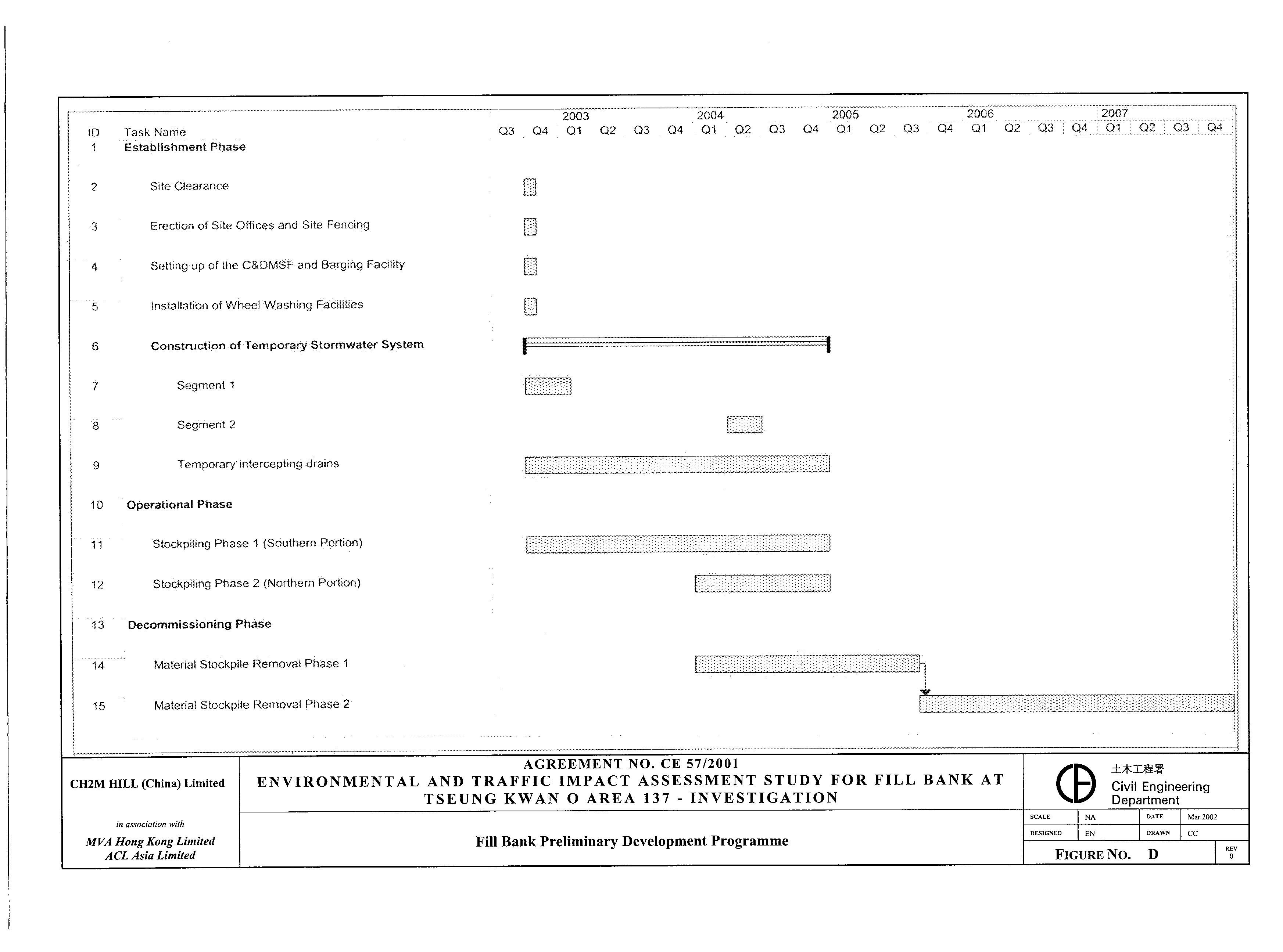
2.2.1 Figure D presents a preliminary programme for the establishment, operation and decommissioning of the fill bank.
Mobilisation and Establishment
2.2.2 Mobilisation and establishment works for the proposed fill bank are planned to commence in early October 2002. The works involved in the initial establishment would be minor, as the site has been operated in the past years as a public filling area in receiving public fill from the construction industry for the reclamation works. There are temporary access roads with concrete paving at the site entrance. Wheel washing facilities are also provided at the exit points. Berthing area is present in the northern end of the site. There are site offices and site fencing onsite.
2.2.3 The activities during the establishment phase are expected to mainly involve site clearance, fabrication of machinery for the C&DMSF and steel structures for the barging point, and realignment of the existing trapezoidal drainage channels equipped with sand/ silt removal facilities at required locations.
Operation
2.2.4 The fill bank will start receiving public fill in the southern side of site in mid October 2002 upon completion of the necessary environmental protection measures for the stockpiling works to begin. From January 2004, the northern half of reclaimed land would be available for the fill bank operation. To allow sufficient time for removal of stockpiled material for long term development in TKO Area 137, it is planned that the fill bank will not receive further public fill from January 2005.
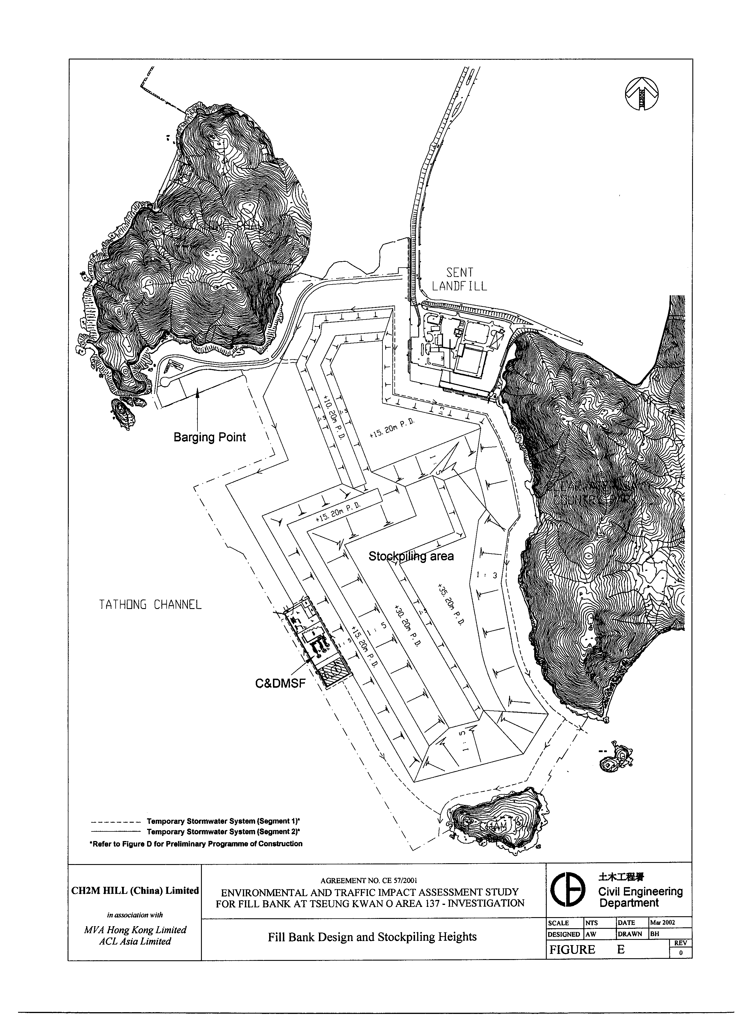
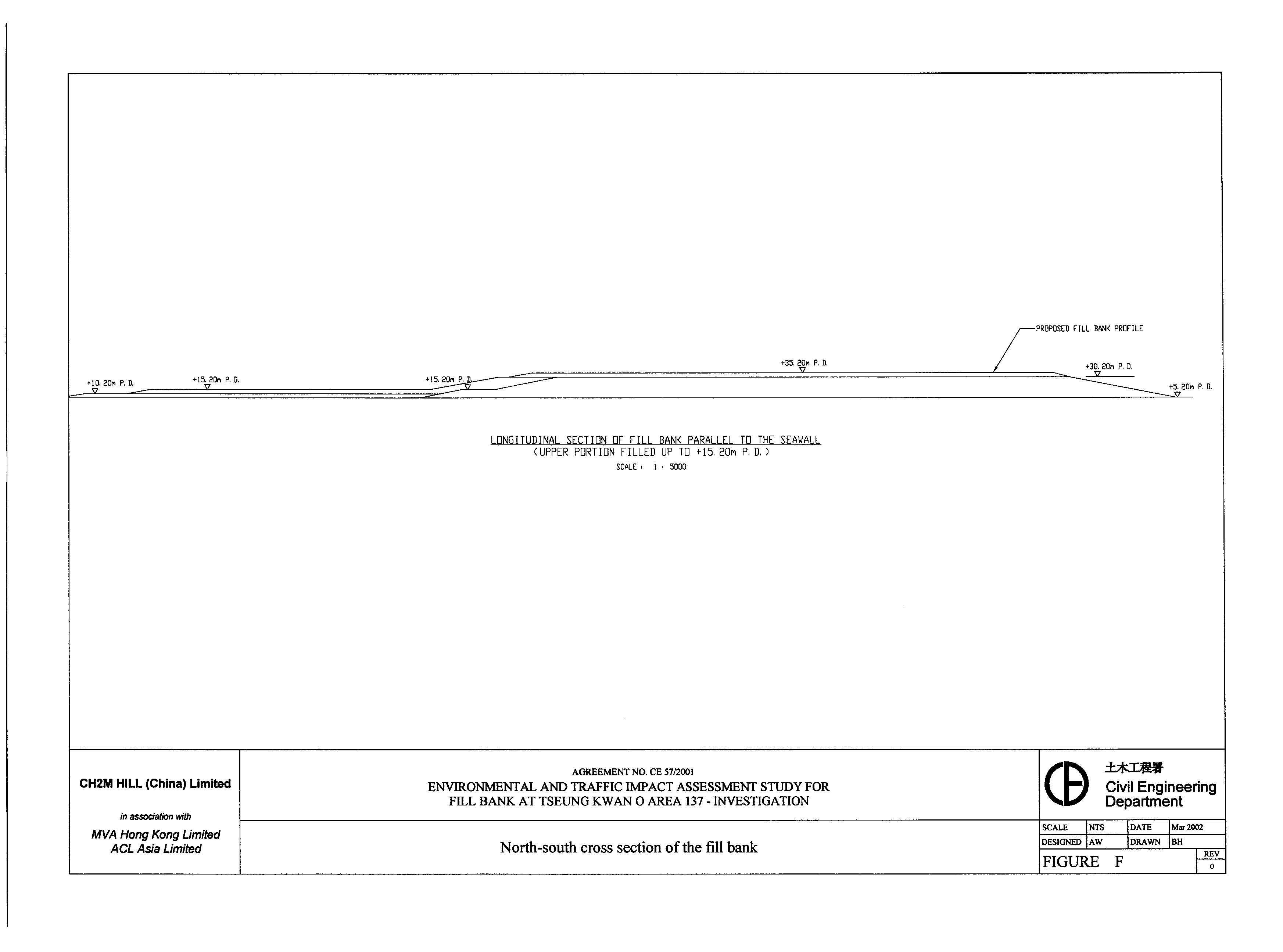
2.2.5 Figure E illustrates the preliminary design of the fill bank and the stockpiling heights. Figure F presents a north-south cross-section of the fill bank.
2.2.6
To accommodate a total quantity of 6
Mm3 public fill, the fill bank would need to be filled up to a
maximum height of approximately +35.2mPD (i.e. about 30m above ground). Design of the stockpiling heights have taken
into the existing landform to allow the fill bank to mimic the existing
topography. The fill bank will be
constructed platform-by-platform, with compaction and application of adequate
load on required areas. The induced
lateral pressure and slope stability and other engineering factors have been
carefully considered by CED in the detailed design of the fill bank profile. To ensure the works are carried out as
planned, , and the implementation of the
stockpiling operation will also be closely monitored by CED. Measures including the provision of
intercepting drains, hydroseeding, coloured geo-textile matting and/or water
spraying wouldill be applied for slope protection, reduction
of dust emissions and as visual mitigation measures. Locations of temporary intercepting drains wouldill be altered from
time to time to suit the stockpiling sequence to effectively divert stormwater
collected to the temporary trapezoidal channels provided along the perimeter of
the site. Sufficient buffer distance
will be provided between the work areas and the nearby sensitive receivers.
2.2.7 To avoid potential environmental impact from the fill bank operation, a buffer distance of at least 100m will be maintained between the stockpiling area and the nearest Air Sensitive Receiver, TVB Broadcast and Production Centre, situated to the north of the site. On the western and southern sides of the fill bank, a buffer distance of at least 100m will also be maintained between the edge of the stockpiling area and the waterfront.
2.2.8
The proposed fill bank will open daily
from 8:00 a.m. to 9:00 p.m. to serve the construction industry except during
the Chinese New Year holidays, similar to the operation of the existing public
filling area at TKO Area 137. The fill
bank will provide a convenient public fill outlet for the construction
industry. Based on the truckload
records gainedgathered from the long-term operation of the
public filling area at TKO Area 137, it is expected that the truckloads before
9:00 a.m. and after 6:00 p.m. wouldill be low.
After 7:00p.m., both the barging facility and C&DMSF will not be in
operation. The closure of the barging
point after 7:00p.m. will prevent avoid any potential visual impact caused by from glare.
2.2.9
In view of the potential traffic and
environmental concerns associated with the vehiclestrucks using the
fill bank, CED will also establish a barging facility at TKO Area 137 to allow delivery of
public fill by marine access. This will
to allow reduce the number of trucks using the road network in
TKO the truckloads of public fill be shared by
diverting them to a
planned public
filling barging facility planned at the runway of the ex-Kai
Tak Airport in South East Kowloon (SEK) that would be in
operation with the proposed fill bank. The onsite barging point
will remain operational during the decommissioning phase to allow at least 90%
of stockpiled material to be directly delivered offsite to reclamation sites by
barges.
Decommissioning
2.2.10 Decommissioning of the fill bank is planned to commence early in January 2004 when the fill bank is still receiving public fill. Stockpiled fill material will be removed starting from the northern end of the fill bank and transported to the commended reclamation project sites for reuse.
2.2.11 During the overlapping period of the operation and decommissioning phases (from about January 2004 to December 2004), to avoid double handling, incoming trucks containing public fill that meets the specified technical requirements and quality will be directed to the barging point for transportation to reclamation sites without sorting/ stockpiling. Therefore, depending on the public fill demand at the reclamation sites in 2004 and the incoming rate of C&D material, public fill storage at the fill bank may gradually build up and reach the maximum capacity of 6 Mm3 under the worst-case situation in December 2004. The fill bank will not receive further fill material by trucks or barges commencing from January 2005.
2.2.12 All public fill (i.e. 100%) removed from the fill bank during the operation-decommissioning overlapping period in 2004 will be transported away by barges to avoid generation of additional offsite traffic. From January 2005, maximum vehicle dispatch rate from the fill bank during decommissioning will be limited to a maximum of 200 vehicles per day.
2.2.13 The key milestones to be achieved under the decommissioning programme is to have a site area of at least 55 hectares in the northern portion of the site to be cleared by September 2005 to allow infrastructure works to commence to prepare for future industrial developments at TKO Area 137, and to have the fill bank fully decommissioned by December 2007.
3.1
Dust Emission Impact Assessment
3.1.1 Potential dust emission impact during the operation and decommissioning phases was identified to be the focus of the air quality study. Truck movement on haul roads within the site was identified to be the key contributor to potential dust impact. The contractor shall be required to strictly follow the dust control requirements as stipulated in the Air Pollution Control (Construction Dust) Regulation.
3.1.2 To protect the nearest Air Sensitive Receiver (ASR), TVB Broadcast and Production Centre from potential dust impact, a buffer zone of at least 100m will be maintained between the edge of the stockpiling area and the boundary of the production centre. As stockpiling activity will proceed from the southern to the northern side of the site, and the northern part of site will not be available for storage of public fill until January 2004, the buffer distance maintained between the stockpile and the ASR would be maximised and more than 100m for most of the time.
3.1.3 During the establishment of the fill bank, it is recommended that a site hoarding of 2.4m high (from ground level) shall be erected along the northern side of the site boundary except at the site entrance/ exit location. All designated haul roads, especially those lying within 100m of the site boundary shall be paved with concrete, bituminous materials, hardcores or metal plates and regularly maintained. Work areas where excavation or earthmoving activities are carried out shall be sprayed with water or a dust suppression chemical. Any temporary stockpiling of excavated material generated from the establishment works shall be covered by impervious sheeting or sprayed with water or a dust suppression chemical. With the dust control measures implemented, potential dust impact during the establishment phase is not expected to be a concern.
3.1.4 Any works that involve the stockpiling of dusty materials are regulated under the Air Pollution Control (Construction Dust) Regulation as regulatory work. Sufficient dust control measures have been recommended for implementation during the operation through the decommissioning of the fill bank. Truck speed should be limited to within 10km per hour. Vehicle washing facilities should be provided. Material transfer and stockpiling activities shall be monitored to ensure that fugitive dust emissions are minimised. The portions of site allocated and maximum allowable stockpiling height designed by the project engineers in the daily operation of the fill bank shall be strictly followed. Stockpiled material shall be compacted to prevent segregation, erosion or instability. Surface protection measures recommended to minimise dust emission shall be implemented.
3.1.5 The air quality modelling results revealed that with the implementation of the recommended dust control measures required under the Regulation, the potential dust impact at all nearby Air Sensitive Receivers (ASRs) will be controlled to within acceptable levels. The implementation and environmental performance of the recommended dust control measures during the establishment, operation and decommissioning phases of the fill bank will be checked through the recommended Environmental Monitoring and Audit (EM&A) programme.
3.2
Vehicular Emission Impact Assessment
3.2.1 The vehicular emission impact assessment covers the ASRs situated within 500m radius of the project site but have also been extended to include other ASRs along Wan Po Road covering a vast distance of more than 4.3km from the boundary of the fill bank site. The vehicular emission impact assessment revealed that taking into consideration the cumulative effect from aerial industrial emissions in the area, vehicular pollutant emissions from the trucks using the fill bank will unlikely pose any significant air quality impact on the nearby ASRs along Wan Po Road. The relevant Air Quality Objectives will be satisfied.
4.1
Noise from trucks using the Fill Bank along Wan Po Road
4.1.1 In general, the noise impact assessment covers the NSRs situated within 300m radius of the project site but have also been extended to include NSRs located up to 4.3km away from the fill bank site along Wan Po Road.
4.1.2 The fill bank will not be in operation during night-time so that potential truckload noise impact during this time period is not a concern. Potential daytime truckload noise impact on Noise Sensitive Receivers (NSRs) along the existing Wan Po Road arising from the public fill delivery trucks using the fill bank was identified to be the focus of the noise impact assessment.
4.1.3 Truckloads using the proposed fill bank would only be high during the non-peak hours, and would peak at around 11:00a.m. - 12:00 based on the typical truck arrival pattern in the past operation of the public filling area at TKO Area 137. As a proactive approach to further minimise the potential traffic noise impact arising from trucks on NSRs along Wan Po Road when they are travelling to/ from the fill bank, CED has planned to establish a barging facility onsite at TKO Area 137 to allow public fill to be transported from the temporary public filling barging point planned at the runway area of the ex-Kai Tak Airport.
4.1.4 Operation of similar public filling barging facilities by CED in the past indicated that the maximum handling capacity of the barging point at the SEK and TKO Area 137 would be about 1,000 truckloads of material per day. Making use of the trip-ticket system to divert truckloads generated from Government/ public sectors’ works contracts in Kowloon Districts and part of the New Territories to the SEK barging point as a traffic noise mitigation measures will enable the average daily truckloads on Wan Po Road to be reduced from 2,000 vehicles per day to 1,000 vehicles per day.
4.1.5 The traffic noise impact assessment assessed the worst-case mitigated maximum truckloads of 1,500 vehicles per day on Wan Po Road as a conservative approach taking into consideration possible daily variation in truckloads. The assessment results revealed that during all three representative scenarios (i.e. A.M. peak hour, P.M. peak hour and fill bank peak hour), the mitigated overall noise levels at most NSRs would be within the traffic noise criteria of L10(1-hr) 70dB(A) and L10(1-hr) 65dB(A) for residential units and schools, respectively. Where the overall noise levels were predicted to be above the relevant traffic noise criteria at a few NSRs that are located in close proximity to the existing Wan Po Road, the exceedance was identified to be a result of the dominant background noise from the existing traffic on Wan Po Road. To these NSRs, the mitigated noise contribution attributable to the fill bank operation at TKO Area 137 was identified to be less than 1.0dB(A), which is considered insignificant.
4.1.6 Vehicles dispatch rate from the fill bank will be limited to a maximum of 200 vehicles/day during the decommissioning phase (from January 2005 to December 2007). This limited traffic generated from the fill bank decommissioning will not generate any significant traffic noise contribution on the existing and planned NSRs along Wan Po Road.
4.2
Construction/ Fixed Noise Impact
4.2.1 Quantitative assessments confirmed that construction noise impact during the establishment period of the fill bank, as well as fixed noise impact during the operation and decommissioning were not key concern due to the great distance separation between the NSRs and the site. Nevertheless, good site practices and noise management measures have been recommended for implementation during the establishment, operation and decommissioning phases. The implementation and environmental performance of these measures by the Contractor shall be checked by the recommended Environmental Monitoring and Audit Programme.
5.1.1 The water quality impact assessment identified the sources and evaluated the extent of potential water pollution associated with the land-based activities during the establishment, operation and decommissioning of the fill bank. Proper measures forming the Best Management Practices (BMPs) have been recommended for implementation.
5.1.2 Existing trapezoidal channels, sand/ de-silting traps and realigned drainage and water pollution control facilities shall be provided and used at the fill bank. The recommended buffer distances between the stockpiling area or C&DMSF and the waterfront shall be maintained. The slope surface protection measures recommended shall be followed. The temporary storage area for sorted C&D Material at the C&DMSF shall be at least enclosed on three sides. Wheel washing facilities at the site exit shall be used and maintained. Sewage from toilets should be discharged into foul sewer or chemical toilets should be provided. Effluent discharge from the fill bank shall meet the requirements specified in the Technical Memorandum issued under the Water Pollution Control Ordinance. Water pollution control measures recommended for activities associated with the transportation of public fill by barges should be followed.
5.1.3 With the implementation of the recommended water pollution control/ mitigation measures, the establishment, operation and decommissioning of the fill bank will unlikely pose any unacceptable marine water quality impact.
6.1.1 A site area of about 21 hectares in the north-eastern side of the site is lying within the 250m consultation zone of the South East New Territories (SENT) landfill. A qualitative risk assessment has been carried out following the “Source-Pathway-Target” model presented in the Landfill Gas Hazard Assessment Guidance Note.
6.1.2 The site area situated within the SENT landfill consultation zone will be occupied by site haul road, public fill stockpiling area and buffer area and surface channels. No underground structures, drainage and sewerage systems including underground pipelines and chambers are planned within this area. Site offices will be located outside the SENT landfill consultation zone. A container office at the entrance situated within the SENT landfill consultation zone will be supported by a raised hollow platform to avoid accumulation of landfill gas beneath the container. Members of the general public will have restricted access to the site. Based on the “Source-Pathway-Target” model, the risk category was assessed to be Low. Landfill gas (LFG) and leachate precautionary/ protection measures including an action plan triggered by LFG monitoring have been recommended.
7.1.1 The existing quality of the Landscape Character Area at TKO Area 137 is low, being a newly reclaimed area with no landscape resources of value. With the implementation of the recommended mitigation measures in form of fill bank design and slope treatment, the Significance Threshold of Landscape Impact will be reduced during the operation phase from moderate/significant to slight/negligible and during the decommissioning phase from slight/negligible to negligible.
7.1.2 With the implementation of the recommended mitigation measures in form of fill bank design and slope treatment, the Significance Threshold of Visual Impact will be reduced during the operation phase from moderate/significant to slight/negligible impact. During the decommissioning phase, the Significance Threshold of Visual Impact will be reduced from slight/moderate to slight/negligible impact.
7.1.3 In conclusion, it is considered that the proposed Fill Bank at TKO Areas 137 will be acceptable with mitigation from a landscape and visual viewpoint.
8.1.1 As TKO Area 137 is a reclaimed land, there is no cultural heritage concern onsite. Junk Island House Ruin on Fat Tong Chau is located to the north of the project site. While there will not be any construction works offsite at Fat Tong Chau under the project, a 2.4m high site fencing will still be erected along the northern site boundary abutting Fat Tong Chau to avoid any accidental disturbance of the cultural heritage site by the workers. Besides, a buffer zone of at least 10m wide will be provided along the eastern boundary of the site to separate the work areas of the fill bank from the western boundary of the adjacent Clearwater Bay Country Park.
9.1.1 All key environmental issues associated with the establishment, operation and decommissioning of the proposed fill bank have been identified, assessed and mitigation measures, where required, recommended in accordance with the requirements of the EIA Study Brief and the EIAO-TM. The impacts were identified to be either within acceptable levels, or where mitigation measures are necessary on specific environmental issues, the mitigated environmental impacts are within acceptable levels.