Table of Content
1. INTRODUCTION
1.1 Background
1.2 Purpose of this Report
2. PRoject information and history of the site
3. Results of reCent Sediment qualitly sampling
4. Conclusion and recommendation
5. references
List of Tables
Table
3.1 Results of Chemical Analysis
of Sediment Samples (mg/kg), 1994 Data
Table 3.2 Results of
Chemical Analysis of Sediment Samples (mg/kg), 1997 Data
Table 3.3 Results of
Chemical Analysis of Sediment Samples (mg/kg), 1998 Data
List of Figures
Figure 3.1 Sediment Sampling Locations at Navigation Channel (1994)
Figure 3.2 Sediment Sampling Locations at Turning Basin (1997)
Figure 3.3 Sediment Sampling Locations at Power Station Extension Area (1998)
List of APPENDICES
Appendix A Figures
1.1
Background
In May 2001, The Hongkong Electric Company Limited (HEC) commissioned Hyder Consulting Limited to undertake an Environmental Impact Assessment (EIA) study for the Improvement Work of Lamma Power Station Navigation Channel. The work involves dredging of marine sediment within the existing Navigation Channel and disposal of the dredged sediment. The purpose is to maintain a safe and adequate water depth at the Navigation Channel.
It is the requirement of the Work Branch Technical Circular (WBTC) No.3/2000 that a sediment quality assessment be undertaken in order to determine the disposal option of the dredged sediment. This report presents the Tier I screening of the sediment quality assessment. The purpose of Tier I screening is to review available information for determining the quality of sediment to be dredged.
1.2
Purpose of this Report
The
purpose of this report is to:
i
provide
information on the Project and the Site;
ii
detail
the sediment sampling programme recently conducted in or around the area to be
dredged;
iii
present
available information on the relevant sediment chemistry analysis results; and
iv
assess
the sediment quality of the area to be dredged based on the information above.
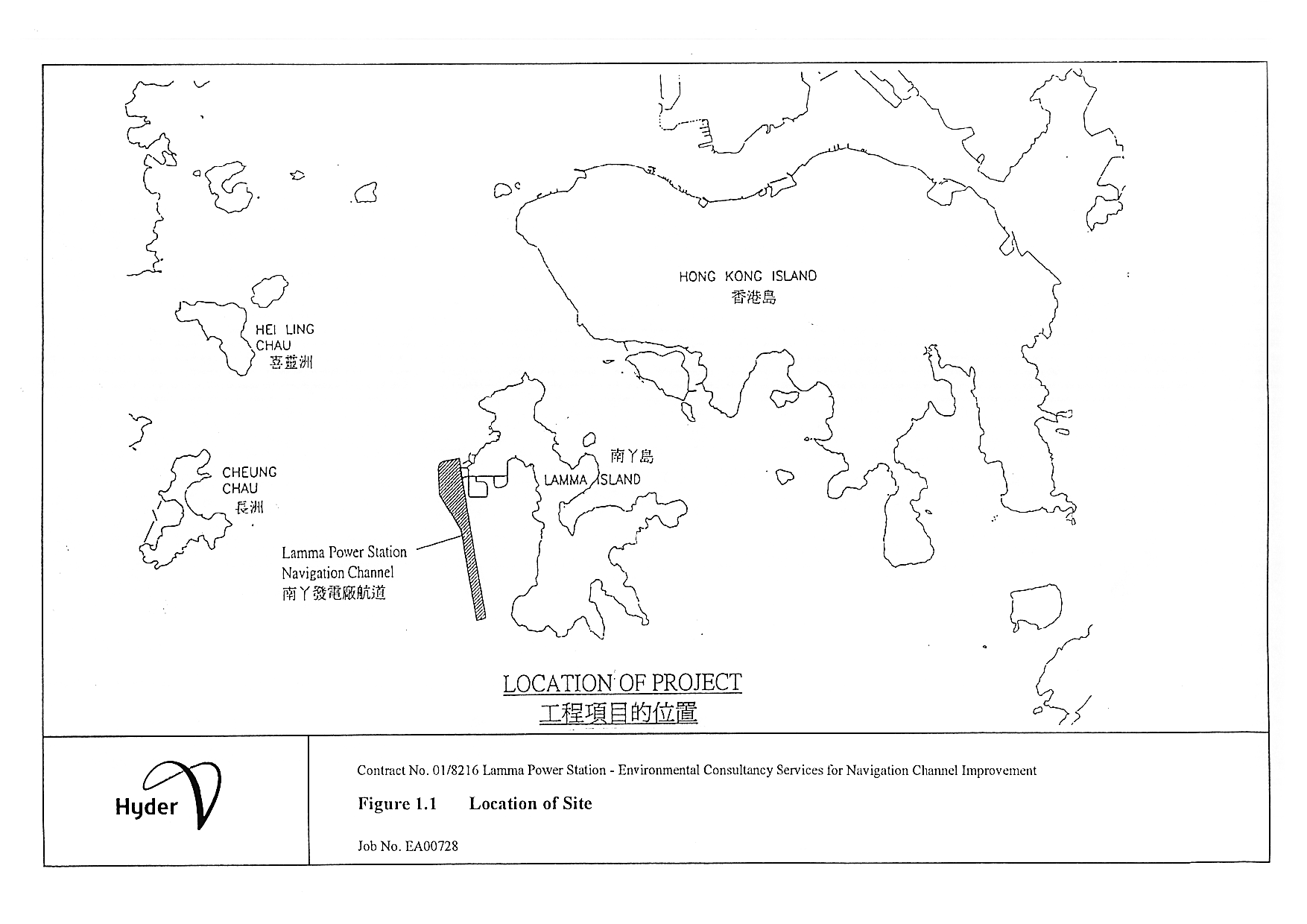
Location of the area to be dredged is shown in Figure 1.1. The estimated dredging volume is 2.98M m3. The dredging will take place between July 2002 to April 2003. The Site is the existing Lamma Power Station Navigation Channel which was first dredged to –15.9 mPD in 1981. Improvement to the Channel by means of dredging to about –16.5 mPD level was carried out in 1989-1990. To cope with the updated vessel operations, the turning basin of the Channel was enlarged southwards by 250m in early 2001.
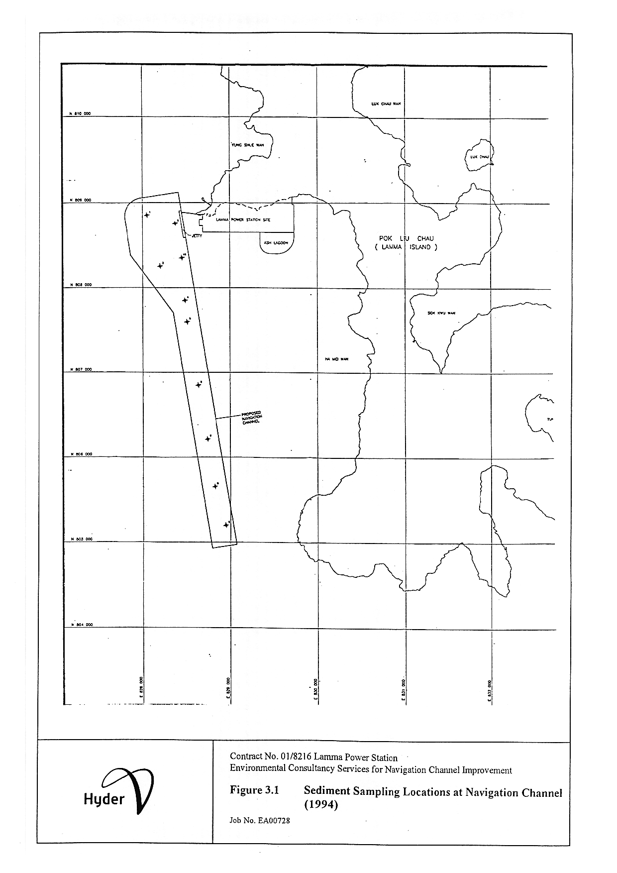
Three sets of sediment quality data were recently collected in or around the Channel. The first set of data was collected at 10 locations at the existing Navigation Channel in 1994. Of these ten samples 8 were cores samples of 2m depth and 2 were surface grab samples. Sub-samples were taken from the top and middle layers of the gravity cores for laboratory analysis. The sampling locations are shown on Figure 3.1, and the laboratory analysis results are given in Table 3.1.
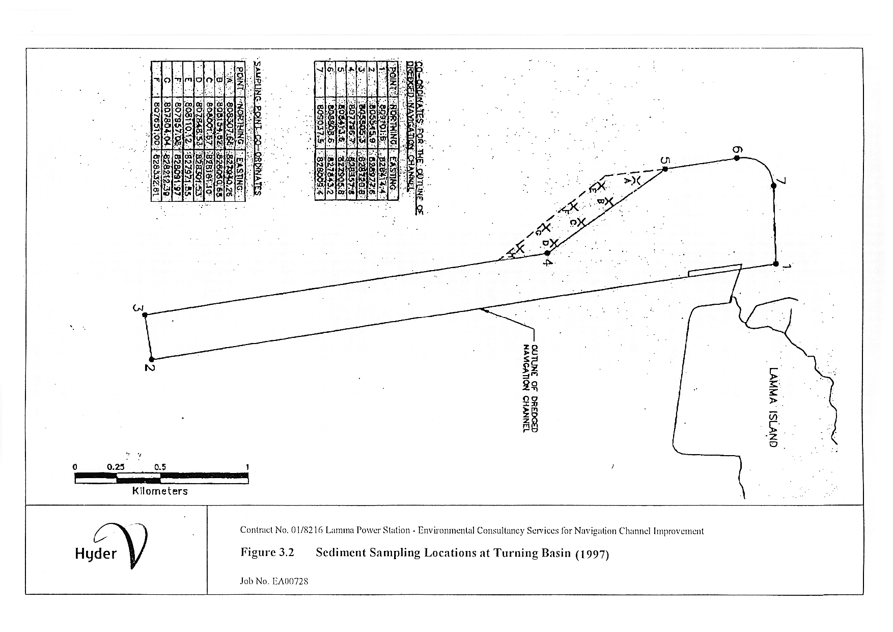
The second set of sampling data was collected in 1997. A total of eight core samples were taken at the turning basin of the Navigation Channel using a piston corer, with analysis being undertaken on sub-samples of the cores. Sub-samples for analysis were taken at five depths as follows: (0.0 - 0.1m), (0.9 - 1.0m), (1.9 - 2.0m), (2.9 - 3.0m) and (5.9 - 6.0m) measured from the surface. Figure 3.2 shows the 1997 sampling location plan, and the laboratory analysis results are provided in Table 3.2.
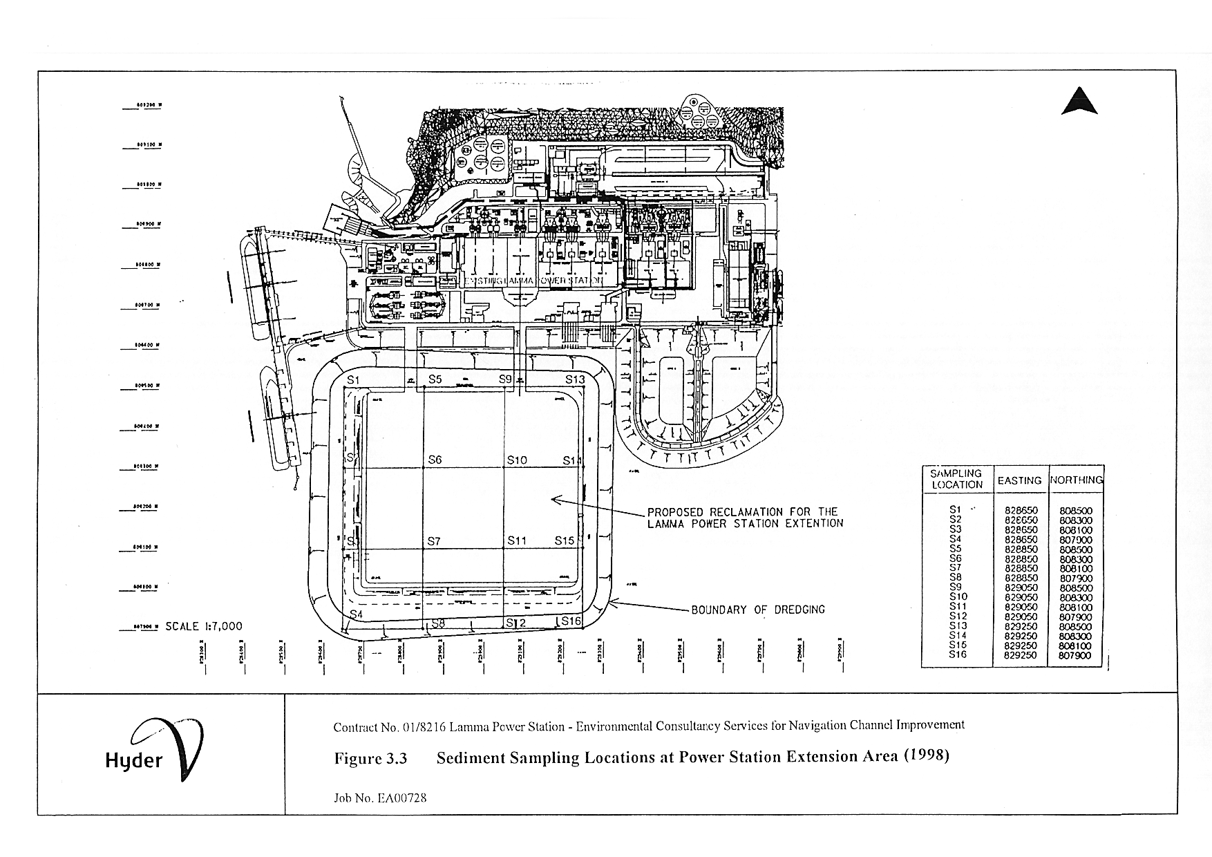
The third set of sampling data was collected in 1998. A total of 16 vibrocore samples were collected at the new power station extension area. The vibrocore stations are shown in Figure 3.3. Sub-samples (each 100 to 200mm thick) were removed from depths of 0m, 0.9m, 1.9m, 2.9m measured from the surface, and then at 3 m intervals to the base of the vibrocore sample for sediment chemistry analysis. The laboratory analysis results are given in Table 3.3.
All sediment samples were analysed by HOKLAS accredited laboratories. All measured contaminant levels are below the Lower Chemical Exceedance Level (LCEL).
Table 3.1 Results of Chemical Analysis of Sediment Samples (mg/kg), 1994 Data
|
Location |
Depth |
Copper |
Cadmium |
Chromium |
Lead |
Nickel |
Zinc |
Mercury |
|
1 |
Top |
25 |
<0.02 |
39 |
37 |
16 |
88 |
0.15 |
|
Middle |
30 |
<0.02 |
35 |
36 |
15 |
83 |
0.17 |
|
|
2 |
Top |
36 |
<0.02 |
45 |
43 |
19 |
100 |
0.21 |
|
Middle |
35 |
<0.02 |
39 |
41 |
17 |
92 |
0.23 |
|
|
3 |
Top |
25 |
<0.02 |
38 |
35 |
17 |
86 |
0.18 |
|
Middle |
8.3 |
<0.02 |
27 |
19 |
13 |
53 |
<0.05 |
|
|
4 |
Top |
24 |
<0.02 |
37 |
36 |
16 |
86 |
0.13 |
|
Middle |
19 |
<0.02 |
35 |
32 |
17 |
77 |
0.14 |
|
|
5 |
Top |
22 |
<0.02 |
36 |
33 |
17 |
79 |
0.12 |
|
Middle |
10 |
<0.02 |
28 |
33 |
14 |
67 |
<0.05 |
|
|
6 |
Top |
20 |
<0.02 |
34 |
27 |
15 |
79 |
0.12 |
|
Middle |
8.6 |
<0.02 |
31 |
35 |
15 |
58 |
<0.05 |
|
|
7 |
Top |
23 |
<0.02 |
37 |
19 |
17 |
83 |
0.12 |
|
Middle |
11 |
<0.02 |
27 |
24 |
14 |
58 |
0.08 |
|
|
8 |
Top |
27 |
<0.02 |
38 |
37 |
17 |
87 |
0.15 |
|
Middle |
7.2 |
<0.02 |
32 |
17 |
15 |
60 |
<0.05 |
|
|
9 |
Surface Grab |
25 |
<0.02 |
37 |
36 |
17 |
83 |
0.17 |
|
10 |
24 |
<0.02 |
36 |
36 |
16 |
86 |
0.14 |
Table 3.2 Results of Chemical Analysis of Sediment Samples (mg/kg), 1997 Data
|
Location |
Depth |
Copper |
Cadmium |
Chromium |
Lead |
Nickel |
Zinc |
Mercury |
|
A |
0 – 0.1 m |
10 |
<0.5 |
25 |
26 |
9 |
65 |
<0.4 |
|
0.8 – 1 m |
10 |
<0.5 |
32 |
20 |
17 |
73 |
<0.4 |
|
|
1.9 – 2 m |
10 |
<0.5 |
36 |
20 |
20 |
82 |
<0.4 |
|
|
2.9 – 3 m |
10 |
<0.5 |
36 |
21 |
20 |
81 |
<0.4 |
|
|
5.9 – 6 m |
10 |
<0.5 |
38 |
20 |
22 |
80 |
<0.4 |
|
|
B |
0 – 0.1 m |
<10 |
<0.5 |
13 |
<15 |
<6 |
37 |
<0.4 |
|
0.8 – 1 m |
10 |
<0.5 |
14 |
20 |
8 |
40 |
<0.4 |
|
|
1.9 – 2 m |
10 |
<0.5 |
35 |
20 |
19 |
78 |
<0.4 |
|
|
2.9 – 3 m |
10 |
<0.5 |
36 |
21 |
20 |
77 |
<0.4 |
|
|
5.9 – 6 m |
10 |
<0.5 |
38 |
21 |
21 |
80 |
<0.4 |
|
|
C |
0 – 0.1 m |
23 |
<0.5 |
27 |
29 |
13 |
74 |
<0.4 |
|
0.8 – 1 m |
<10 |
<0.5 |
25 |
20 |
12 |
61 |
<0.4 |
|
|
1.9 – 2 m |
10 |
<0.5 |
36 |
21 |
19 |
76 |
<0.4 |
|
|
2.9 – 3 m |
10 |
<0.5 |
36 |
20 |
22 |
77 |
<0.4 |
|
|
5.9 – 6 m |
10 |
<0.5 |
36 |
21 |
21 |
79 |
<0.4 |
|
|
D |
0 – 0.1 m |
20 |
<0.5 |
25 |
29 |
14 |
64 |
<0.4 |
|
0.8 – 1 m |
10 |
<0.5 |
40 |
22 |
24 |
86 |
<0.4 |
|
|
1.9 – 2 m |
10 |
<0.5 |
41 |
22 |
23 |
90 |
<0.4 |
|
|
2.9 – 3 m |
10 |
<0.5 |
36 |
20 |
20 |
62 |
<0.4 |
|
|
5.9 – 6 m |
10 |
<0.5 |
37 |
20 |
20 |
65 |
<0.4 |
|
|
E |
0 – 0.1 m |
10 |
<0.5 |
34 |
24 |
17 |
73 |
<0.4 |
|
0.8 – 1 m |
<10 |
<0.5 |
30 |
<15 |
17 |
62 |
<0.4 |
|
|
1.9 – 2 m |
<10 |
<0.5 |
33 |
20 |
19 |
72 |
<0.4 |
|
|
2.9 – 3 m |
10 |
<0.5 |
34 |
20 |
19 |
73 |
<0.4 |
|
|
5.9 – 6 m |
10 |
<0.5 |
38 |
20 |
21 |
76 |
<0.4 |
|
|
F |
0 – 0.1 m |
10 |
<0.5 |
30 |
24 |
14 |
70 |
<0.4 |
|
0.8 – 1 m |
<10 |
<0.5 |
32 |
<15 |
18 |
66 |
<0.4 |
|
|
1.9 – 2 m |
<10 |
<0.5 |
36 |
20 |
21 |
76 |
<0.4 |
|
|
2.9 – 3 m |
10 |
<0.5 |
36 |
20 |
20 |
80 |
<0.4 |
|
|
5.9 – 6 m |
10 |
<0.5 |
36 |
20 |
20 |
74 |
<0.4 |
|
|
G |
0 – 0.1 m |
<10 |
<0.5 |
27 |
20 |
14 |
58 |
<0.4 |
|
0.8 – 1 m |
<10 |
<0.5 |
32 |
<15 |
17 |
65 |
<0.4 |
|
|
1.9 – 2 m |
<10 |
<0.5 |
35 |
20 |
19 |
72 |
<0.4 |
|
|
2.9 – 3 m |
10 |
<0.5 |
36 |
20 |
20 |
76 |
<0.4 |
|
|
5.9 – 6 m |
10 |
<0.5 |
42 |
20 |
23 |
83 |
<0.4 |
|
|
H |
0 – 0.1 m |
24 |
<0.5 |
35 |
20 |
17 |
81 |
<0.4 |
|
0.8 – 1 m |
10 |
<0.5 |
41 |
20 |
22 |
81 |
<0.4 |
|
|
1.9 – 2 m |
10 |
<0.5 |
43 |
20 |
23 |
81 |
<0.4 |
|
|
2.9 – 3 m |
10 |
<0.5 |
41 |
20 |
24 |
79 |
<0.4 |
|
|
5.9 – 6 m |
10 |
<0.5 |
39 |
20 |
21 |
70 |
<0.4 |
Table 3.3 Results of Chemical Analysis of Sediment Samples (mg/kg), 1998 Data
|
Location |
Depth |
Copper |
Cadmium |
Chromium |
Lead |
Nickel |
Zinc |
Mercury |
|
S1 |
Values shown in the table are ranges of
metal levels measured in the subsamples of different depths. |
<10 |
<0.5 |
19-31 |
20-21 |
<6-20 |
27-72 |
<0.4 |
|
S2 |
<10-20 |
<0.5 |
25-36 |
20-39 |
14-22 |
65-87 |
<0.4 |
|
|
S3 |
<10-20 |
<0.5 |
26-36 |
<15-35 |
16-22 |
59-79 |
<0.4 |
|
|
S4 |
<10-21 |
<0.5 |
31-34 |
20-33 |
18-30 |
64-85 |
<0.4 |
|
|
S5 |
<10-23 |
<0.5 |
8-32 |
<15-36 |
<6-19 |
17-85 |
<0.4 |
|
|
S6 |
<10-24 |
<0.5 |
27-36 |
<15-36 |
17-21 |
54-86 |
<0.4 |
|
|
S7 |
<10-24 |
<0.5 |
19-46 |
<15-24 |
11-30 |
42-130 |
<0.4 |
|
|
S8 |
<10-20 |
<0.5 |
26-42 |
20-33 |
16-23 |
48-78 |
<0.4 |
|
|
S9 |
<10-10 |
<0.5 |
8-33 |
<15-22 |
<6-20 |
28-74 |
<0.4 |
|
|
S10 |
<10-10 |
<0.5 |
8-36 |
<15-28 |
<6-23 |
18-75 |
<0.4 |
|
|
S11 |
<10 |
<0.5 |
17-38 |
<15-21 |
7-21 |
33-76 |
<0.4 |
|
|
S12 |
<10-20 |
<0.5 |
11-35 |
<15-33 |
<6-22 |
<15-79 |
<0.4 |
|
|
S13 |
<10 |
<0.5 |
7-33 |
<15-21 |
<6-20 |
<15-75 |
<0.4 |
|
|
S14 |
<10-10 |
<0.5 |
18-35 |
<15-33 |
11-23 |
58-77 |
<0.4 |
|
|
S15 |
<10-10 |
<0.5 |
17-33 |
<15-27 |
<6-23 |
<15-75 |
<0.4 |
|
|
S1 6 |
<10-10 |
<0.5 |
26-35 |
<15-26 |
15-22 |
52-76 |
<0.4 |
The existing sediment quality information indicates that the sediment in and around the navigation channel belongs to Category L. The three sets of sediment sampling data covering a period of 3 years, show no marked changes in sediment quality. It is unlikely that it will be significantly different by the time the proposed dredging commences. The existing sediment quality information is considered to have sufficient coverage and resolution for the Navigation Channel and it is concluded that the sediment to be dredged from the proposed Navigation Channel improvement is suitable for open sea disposal.
Axis
Environmental (1995), Sediment Quality Report, HEC
Lamma Power Station; Jetty & Navigation channel Modification Works
Hyder Consulting Limited (1997), Sediment Quality Report, HEC Lamma Power Station; Turning Basin Enlargement Works
ERM (1998), Sediment Quality Report, Environmental Impact Assessment of a 1,800MW Gas-fired Power Station at Lamma Extension
Works Bureau (April 2000) Technical Circular No. 3/2000 – Management of Dredged/Excavated Sediment