This section presents
the findings of the landscape and visual impact
assessment (LVIA) for the proposed wind turbine at Tai Ling in Lamma Island (hereafter described as “The Project”) and outlines the potential
impacts to the existing landscape and visual context of the area together with
the mitigation measures proposed to alleviate those impacts.
The
methodology of the LVIA is based on Annexes
10 and 18 in the Hong Kong SAR Government's Technical Memorandum on the Environmental Impact Assessment Process
(EIAO-TM) under the EIA Ordinance (Cap.499, S16), entitled
"Criteria for Evaluating Visual and Landscape Impact" and
"Guidelines for Landscape and Visual Impact Assessment", respectively
and the EIAO Guidance Note No. 8/2002
“Preparation of Landscape and Visual Impact Assessment Under the Environmental
Impact Assessment Ordinance.”
In addition, The Hong Kong Planning Standards and
Guidelines (HKPSG) Chapter 10 – Landscape and Conservation outlines
relevant design criteria that should be considered in this project.
In accordance with the EIAO Guidance Note No.8/2002, the main components of the LVIA will be as follows:
·
description of the Project;
·
baseline study of landscape and visual resources;
·
review of planning and development control
framework;
·
landscape impact assessment during construction and
operation;
·
visual impact assessment during construction and
operation;
·
recommendations for landscape and visual mitigation
measures for both construction and operation stage; and
·
assessment of residual impact and conclusion on the
acceptability of the Project.
The
baseline study is examined in Section 6.4 of this report. It identifies and examines the existing
landscape and visual resources within the study area. The baseline study
describes the landscape resources by identifying broadly landscape character areas
(LCAs)
and key
landscape elements within the study area (refer to Figure 6.1).
The landscape character was rated low, medium or high depending not only on the
quality of elements present but also to its sensitivity to change and its
importance at a local, district, regional or international level.
Visual
resources considered were key viewpoints, location and direction of views
towards the project. A visual envelope (refer to Figures 6.2 and 6.3) was established which approximately defined
the extent of visual influence of the project and, therefore, of the potential
visual impacts. Definition of the
extent of the viewshed was based on desktop study and site investigation. The
visual envelope/viewshed is generally formed by natural/man made features such
as ridgeline or building blocks.
Visually Sensitive Receivers (VSRs)
identified in here are “representative” in that individuals or groups that have
a similar sensitivity to changes in the visual and landscape environment are
grouped together within a single VSR that can represent the whole group. The
Hong Kong Planning Standards and
Guidelines (HKPSG) define sensitive users as “land uses which, by virtue of
the nature of the activities thereon…. are susceptible to the
influence of residual or physical changes generated by polluting uses”.
The
next stage was a review of the planning
and development control framework. Landscape related zonings on the Outline
Zoning Plan (OZP) and other relevant non-statutory layout plan were mapped and
analyzed to provide an insight to the future outlook of the area affected and
the way the Project would fit into its wider context. For the proposed works, the following document is reviewed:
·
The Lamma
Island Outline Zoning Plan (Plan
no. S/I-LI/4, 2002)
·
Hong Kong Planning Area No. 10 – Pok Fu Lam – Outline Zoning Plan
(Plan no. S/H10/14)
·
Hong Kong Planning Area No. 14 - The Peak Area – Outline Zoning Plan
(Plan no. S/H14/6)
·
Hong Kong Planning Area Nos. 15 & 16 – Aberdeen & Ap Lei Chau –
Outline Zoning Plan (Plan no. S/H15/20)
·
Hong Kong Planning Area No. 17 – Shouson Hill & Repulse Bay –
Outline Zoning Plan (S/H17/7)
·
Hong Kong Planning Area No. 19 – Stanley – Outline Zoning Plan
(S/H10/14)
The
following stage was to assess impacts
on the landscape and visual resources during construction and operation. The impact assessments allow
predictions to be made about the likely levels and significance of landscape
and visual impacts.
The sensitivity
of receivers for evaluation of landscape impacts will result from:
·
quality of landscape characters/resources;
·
importance and rarity of special landscape
elements;
·
ability of the landscape to accommodate change;
·
significance of the change in local and regional
context, and
·
maturity of the landscape.
The degree of sensitivity is classified as
follows:
·
High –
eg important components or landscape of particularly distinctive character
susceptible to small changes;
·
Medium –
eg a landscape of moderately valued characteristics reasonably tolerant to
change;
·
Low – eg a relatively
unimportant landscape which is able to accommodate extensive change.
The magnitude of
change for assessing landscape
impacts is based on:
·
compatibility of the project
with the surrounding landscape;
·
duration of impacts under
construction and operation phases;
·
scale of development, and
·
reversibility of change.
The magnitude of
change is classified as follows:
·
Large –
notable change in the landscape characteristics over an extensive area ranging
to very intensive change over a more limited area;
·
Intermediate –
moderate changes to a local area;
·
Small –
changes to components;
·
Negligible –
no perceptible changes.
The system for the assessment of landscape and
visual impact is summarized in Tables 6.1 and 6.2. The
significance threshold of landscape and visual impact is derived from the combined analysis of the magnitude of change and the sensitivity of receivers. The
matrix in Table 6.1
indicates how the significance threshold is derived. Table 6.1
explains the terms used to in Table 6.2.
Table 6.1 Significance Threshold of Potential Landscape/Visual Impact
|
Magnitude of Change |
|
Sensitivity
of Receiver |
||
|
Low |
Medium |
High |
||
|
Large |
Moderate Impact |
Moderate-Significant Impact |
Significant Impact |
|
|
Intermediate |
Slight-Moderate Impact |
Moderate Impact |
Moderate- Significant
Impact |
|
|
Small |
Slight Impact |
Slight- Moderate Impact |
Moderate Impact |
|
|
Negligible |
Negligible |
Negligible |
Negligible |
|
Table 6.2 Adverse / Beneficial Impacts of Landscape/Visual Impact
|
Significant: |
Moderate: |
Slight: |
Negligible |
|
Adverse
/ beneficial impact where the proposal would cause significant degradation or
improvement in existing landscape baseline conditions or visual character of
the setting |
Adverse / beneficial
impact where the proposal would cause noticeable degradation or improvement
in existing landscape baseline conditions or visual character of the setting |
Adverse
/beneficial impact where the proposal would cause a barely noticeable
degradation or improvement in existing landscape conditions or where the
changes brought about by the project would not be apparent in visual terms |
The
proposal does not affect the existing landscape baseline conditions or visual character of
the setting. |
The
assessment of potential visual impacts
will result from:
·
The sensitivity of receivers at VSR locations to change and
visual intrusion;
·
The magnitude
of change to the visual baseline condition.
The sensitivity
of receivers for evaluation of visual impacts will result from:
·
value and quality of existing views;
·
availability and amenity alternative views;
·
type and estimated number of receiver population;
·
duration or frequency of view, and
·
degree of visibility.
The sensitivity of receivers at VSR locations will be
classified as follows:
·
High
–
i. The nature of the viewer groups expect a high degree of control over their immediate environment, (eg people residing in their homes); and
ii. The viewer groups are in proximity to the Project.
·
Medium
-
i. The nature of the viewer groups expect a high degree of control over their immediate environment, (eg people residing in their homes); or
ii. The nature of the viewer groups expect some degree of control over their immediate environment, (eg teachers in schools); but
iii. The viewer groups are not in proximity to the Project.
·
Low –
i. The nature of the viewer groups do not expect a high degree of control over their immediate environment, (eg people at their place of employment or temporarily in attendance at the VSR location); or
ii. People in transit (eg drivers and passengers in vehicles).
The magnitude of
change for assessing visual
impacts is based on:
·
compatibility of the project
with the surrounding landscape;
·
duration of impacts under
construction and operation phases;
·
scale of development;
·
reversibility of change;
·
viewing distance,
and
·
potential blockage of view.
The magnitude of change to the views will be
classified as follows:
· Large: eg the majority of viewers affected / major change in view.
· Intermediate: eg many viewers affected / moderate change in view.
· Small: eg few viewers affected / minor change in view.
· Negligible: eg very few viewers affected / no discernible change in view.
The degree of visual impact or significance threshold
has been rated in a similar fashion to the landscape impact described above, ie
significant, moderate, slight and negligible. The impacts may be
beneficial or adverse.
The significance
threshold of visual impact is rated for the construction phase and for Day 1
and Year 10 of the operation phase and is illustrated in Tables 6.1 and 6.2.
The next stage of the
study following impact assessment is to recommend
mitigation measures. The
identification of the landscape and visual impacts will highlight those sources
of conflict requiring design solutions to reduce adverse impacts. Mitigation measures
may include revisions/refinement to the engineering design and/or the
implementation of landscape design measures including screen tree planting,
hard landscape design to minimize adverse landscape and visual impacts.
The
final stage of the LVIA study is to assess
the significance of the residual impacts of the study assuming landscape and visual mitigation
measures are incorporated into the design. In conclusion of the landscape and visual impacts were then
classified into one of five levels of significance based on criteria in Annex 10 of the EIAO-TM, as summarized below:
·
The impact is beneficial if the project will
complement the landscape and visual character of its setting, will follow the
relevant planning objectives and will improve the overall and visual quality of
the study area;
·
The impact is acceptable if the assessment
indicates that there will be no significant effects on the landscape, no
significant visual effects caused by the appearance of the project, or no
interference with key views;
·
The impact is acceptable with mitigation
measures if there will be some adverse effects, but these can be
eliminated, reduced or offset to a large extent by specific measures;
·
The impact is unacceptable if the adverse effects
are considered too excessive and are unable to mitigate practically; and
·
The impact is undetermined if significant
adverse effects are likely, but the extent to which they may occur or may be
mitigated cannot be determined from the study. Further detailed study will be
required for the specific effects in question.
The aim of the installation of wind turbine by The Hongkong Electric Co., Ltd. is to supply renewable electric energy to the customers of The Hongkong Electric Co., Ltd. in order to provide quality power supply to customers with due care for the environment. The Project is described in detail in Section 3 of the EIA. This section summarises the main elements of the proposed works affecting the landscape and visual baseline conditions.
The project will
comprise of the construction and operation of a 600-850kW wind turbine and
associated equipment. The wind turbine
comprises basically of 3 rotor blades, a nacelle and a tapered monopole. Hub
height and rotor blade diameter of a 600-850kW wind turbine are approx. 45 and
approx. 52m respectively as shown in Figure
6.23. The overall height is approximately 71m. The
aspects of the project elements that are likely to affect the landscape and
visual baseline conditions during construction and operation will be activity
associated with:
·· site formation of the
platform for the wind turbine and the two equipment huts including construction
of retaining walls;
·· laying of approx. 50m
underground distribution cables;
·· views of the wind turbine
with rotating blades.
The proposed wind
turbine is located adjacent to the existing concrete paved 275kV cable road at
approximately 92m P.D. . The Project Site is approached on the cable road from
the southwest which slopes gently upwards. To the immediate west and southeast
of the Project Site are two knolls of 127m and 136mP.D. respectively. These two
knolls form a natural visual screen for most viewers from the west and southeast
such as those at Yung Shue Wan, Tai Wan San Tsuen, Tai Wan Kau Tsuen and Lo Tik
Wan.
The topography
slopes steeply towards the northeast from the site and as a result, the views
from the east and north will be relatively open. Most viewers on the coastline
of Hong Kong Island south and Ap Lei Chau will have an uninterrupted view
across the Lamma East Channel. The existing view of Lamma Island from these
viewers is generally a lush green island with gently undulating terrain. The
three chimneys of the Lamma Power Station can be seen in the background behind
the ridges of Lamma Island.
On a closer
scale, the Project Site is dominated by grass with some small shrubs and
occasional trees. East of the site a footpath is located leading up to Tai Ling
Pavilion overlooking the northeastern part
of Lamma Island. This pavilion is
located less than 100m from the Wind Turbine at the level of approximately 104m
P.D. half-way between the Wind Turbine platform and the top of the southeastern
knoll. The pavilion is an
important lookout point to Hong Kong Island. The view from this pavilion
towards the proposed wind turbine is shown on Figure 6.23.
For the purpose
of assessing potential impacts on landscape resources, the study has included
all areas within 500m from the proposed wind turbine.
The limits of the
visual impact studies are the zones of visual influence (ZVIs) of the works
during the construction and operation phases. For the purpose of assessing
potential visual impacts of the proposed wind turbine, the study area comprises
ZVIs extending to Ap Lei Chau, South-east Hong Kong and Lamma Island, ferry
en-route to Lamma Island and popular walking trails on Lamma Island. This and
the location of VSRs within it are shown in Figures 6.2 and 6.3.
The Study Area is
defined as the area within 500m of either side and along the site boundary and
is located at Tai Ling on Lamma Island adjacent to the Joint Bay No. 8 along
the 275kV Cable Route from Lamma Power Station to Cable Landing Point at Luk
Chau Wan. It faces the Hong Kong Island to the northeast.
To assist in the
assessment of landscape resources in the study area one (1) Landscape Character Area (LCA) have been identified and
five (5) landscape resources (LRs) within the Study Area have been quantified .
The landscape
character of North Lamma Island is typical of Hong Kong rural island coastal
upland covered with shrubby grassland with scattered trees/tree clumps and a
small amount of village settlements on exposed hilly slopes. The whole study area is considered to
be covered under one single Landscape Character Area (LCA 1).
Landscape Resources found within the Study Area include secondary woodland, shrubland, shrubby grassland, village/developed area and streams (Figure 6.1). Colour photographs of these landscape resources types, as well as other features and species of conservation interest, are presented in Figures 5.3, 5.4 and 5.5.
A total of 122
plant species were recorded. For details, please refer to Annex C Table 5. A locally protected
species Pavetta hongkongensis was
recorded within the Study Area (Figure 5.8). The number of plant species and the
size of each identified Landscape Resources type are presented in Table 6.3.
Table 6.3 Landscape Resources Recorded Within the Study Area
|
Landscape Resources type |
Number |
Area (hectare)/ Length (Km) |
Number of Plant Species Recorded |
|
Secondary Woodland |
LR1 |
20.5 ha |
64 |
|
Shrubland |
LR2 |
49.4 ha |
74 |
|
Shrubby Grassland |
LR3 |
5.7 ha |
25 |
|
Stream |
LR4 |
|
42 |
|
Stream S1 |
|
0.03 km |
|
|
Stream S2 |
|
0.38 km |
|
|
Stream S3 |
|
0.46 km |
|
|
Stream S4 |
|
0.23 km |
|
|
Village/Developed Area |
LR5 |
3.8 ha |
18 |
|
|
Total |
79.4 ha |
|
Details
description of each of these Landscape Character Area and
Landscape Resource are listed below:
North Lamma Coastal Uplands – LCA 1
North Lamma
Coastal Uplands is a landscape character area consisting of coastal uplands and
hillsides and is characteristic of most of Lamma Island except for urban
peripheral village landscapes formed by settlements such as Pak Kok San Tsuen
to Hung Shing Ye; Lo So Shing and Sok Kwu Wan; and Mo Tat Old Village and Tung
O. Other identified landscape
character areas of the island are quarry landscape around Luk Chau Village, the
industrial urban landscape of the Power Station, and one unsettled valley and
rural inland plains to the mid south of the island. As the Study Area is within the North Lamma Coastal Upland
area the Landscape Character Area under discussion shall be focused on this
landscape area type.
The topography of
this area consists of rolling and sometimes hilly ridges, spurs and hillsides
with isolated boulders and crags protruding above the scattered trees/tree
clumps, woodland scrub and grasslands (Figure 6.4). It tends to be steeper on the eastern
slopes which fall directly to the east lamma channel. The area is undeveloped except for small villages at Lo Tik
Wan (Figure 6.5). Western slopes, in comparison, are
criss-crossed by footpaths and a trail between Yung Shue Wan and Sok Kwu
Wan. The slopes are also traversed
by a 5.5m wide cable trench running from the power station to the sea off Luk
Chau Wan in the south and Pak Kok in the north. Hills are of a similar height, ranging from 138mPD at Pak
Kok Shan in the north to 135 mPD in the south. Landuse within the hills is characterised by pockets of
semi-abandoned fields and village development (Figure 6.6), a
service reservoir in the centre and the Lamma Island Youth Hostel to the
south.
Vegetation is
dominated by emergent scrub and grassland with small pockets of trees located
within sheltered seasonal stream courses.
The uplands command open views across the East Lamma Channel to Aberdeen
and Ap Lei Chau in the east.
The
site is located at the valley form by two knolls in the central portions of
north Lamma Island, some 200m north north-east of Tai Ling. The knolls are 127 – 136 mPD high and
the Wind Turbine platform is to be at 92mPD. Hence the Wing Turbine is to be sited at a somewhat shelter
position within the topography.
The
aesthetic and perceptual quality of the landscape is of large, open, remote,
and coherent characteristics with low diversity of landuse and high visual
exposure to other landscape character areas. It is frequently visited by tourists and urban dwellers as
an outing destination for its pleasant and tranquil natural qualities. It is considered to have an overall high landscape character value.
Secondary woodlands were found mainly at the east and southwest of the Study Area. A total of 64 plant species were recorded in the secondary woodlands.
The secondary woodlands located at the southwest of the Study Area were semi-natural with exotic plantation at the fringe of the woodland and the understory was dominated by native plant species. The secondary woodlands were fragmented by the 275 kV Cable Route, which was covered by cement and grass-crete acting as a concrete road connecting to other areas on Lamma Island. The exotic plantation was found mainly at the fringe of the woodland and along the 275 kV Cable Route at Tai Wan Kau Tsuen, Long Tsai Tsuen and Tai Ling Tsuen. Village houses were scarcely located within the woodland, which were mainly on both sides of the 275 kV Cable Route. The canopy species were 10 to 14 m in height and dominated by Acacia confusa, Albizia labbeck, Leucaena leucocephala and Melaleuca leucadendron. The understory was occupied by native trees and shrubs, which can be divided into a middle layer 4 to 8 m in height and a lower layer 1 to 3 m in height. The middle layer of understory was dominated by Cinnamomum camphora, Macaranga tanarius and Schefflera octophylla while the lower layer of understory was dominated by Ilex asprella, Litsea glutinosa and Sterculia lanceolata.
Secondary
woodland found in the east of the Study Area near Lo Tik Wan was a large patch
of woodland dominated by native tree species. Village houses were scarcely located within the woodland and
some of them were abandoned. The
woodland was dominated by climax species such as Cinnamomum camphora, Mallotus
paniculatus, Sterculia lanceollata,
Macaranga tanarius and Dimocarpus longan. Canopy species reached a height of 12-15 m. The understorey was densely vegetated and dominated by woody species
including Litsea rotundifolia, Ligustrum sinensis, Eurya nitida and the
climbers Gnetum montanum and Uvaria microcarpa. A locally
protected species Pavetta hongkongensis
were found within the secondary woodland (Figures 5.7 and 5.8). This woodland is remote from the
turbine location.
This Landscape
Resource LR1 - Secondary Woodland has an
overall medium landscape sensitivity.
Shrubland was the dominant landscape resources type within the Study Area and was 1 to 4 m in
height. It was dominated by
several native shrub species including Rhodomrytus
tomentosa, Cratoxylum cochinchinensis,
Dalbergia benthami, Eurya nitida, Embelia laeta, Embelia ribes and
Gordonia axillaries. Shrubland patches in the valleys were
usually taller with an average 2 to 4 m in height while those on the hill slope
and ridge of the hills were 1 to 2.5 m in height. A total of 74 plant species were recorded within the
shrublands.
This Landscape
Resource LR2 - Shrubland has an overall medium
landscape sensitivity.
Shrubby grasslands were mainly found in the middle of the Study Area and
close to the Project Area, which was located at the north of Yung Shue Long Old
Village and next to the WSD Service Reservoir. The area was expected originally to have been shrublands but
has been disturbed due to hill fires leading the area to become dominated by
grass species. The area had been
burnt a short period of time before the surveys. A total of 25 plant species were recorded within the
shrubland and dominated by Ischaemum
aristatum and Eriachne pallescens.
This Landscape
Resource LR3 – Shrubby Grassland
has an overall medium landscape
sensitivity.
Three partially modified and one less disturbed streams, S1 to S4, were found within the Study Area (Figure 5.2). Forty-two plant species were recorded along the streams and no rare/protected species were found during the surveys.
Stream S1 is a drainage channel running along with the 275 kV Cable Route (Figure 5.2). The lower course of stream S1 was cemented while the upper course was an underground channel. Only limited water flow was recorded in Stream S1 during the survey.
Stream S2 was partially channelized in the upper and middle courses (from the Service Reservoir to Tai Ling Tsuen). Stream S2 has natural bottom, particularly in the middle and lower courses, dominated by medium to small sized boulders and sand. The upper and middle courses were covered by the close canopy of the adjacent woodland while the lower course of the stream was more open with limited shading by the shrubs and grasses in the vicinity. Only limited water flow was recorded in lower course and no water flow recorded in the upper and middle courses during the survey.
Stream S3, located at the northwest of the Study Area, was relatively less disturbed. Water flow in stream S3 was low and the stream bank was natural with medium-sized boulders and sand bottom. The riparian vegetation of the stream was integrated with the surrounding shrubland with semi-open canopy.
Stream S4 was partially channelized in the lower course but the
upper and middle courses remained natural, with relative steep slope. The bottom of Stream S4 remains natural,
composed of sand and small to medium sized boulders. No water was found in the upper course. The middle course has several small
pools filled with water but the water flow was limited. The close canopy of secondary woodland
covered the whole section of the stream with limited open space in the middle
and lower courses.
This Landscape
Resource LR4 – Streams has an
overall medium landscape sensitivity.
Village/developed
areas, comprising village houses,
275 kV Cable Route and the Service Reservoir, were scattered within the Study
Area. The Service Reservoir was
located close to the Project Area.
All of the vegetation recorded within this landscape
resource type, such as Michelia alba and Ficus
microcarpus, were planted for landscaping purposes. Fruit trees such as Musa paradisiacal, Dimocarpus longan, Citrus sinensis and Clausena lansium were also recorded.
A total of 18 plant species were found in this landscape
resource area and no rare plant species were
found.
This Landscape
Resource LR5 – Village/Developed Areas has an
overall medium landscape sensitivity.
In accordance
with the study methodology, the Visually Sensitive
Receivers (VSRs) within the visual
envelope are identified. The representative viewpoints on Lamma Island
and Hong Kong Island are identified from VSRs. (refer to Table 6.4 and 6.5).
In summary, the
VSRs can be classified into 3 main groups.
·
Resident and people at work VSRs on Lamma Islands
where the proposed wind turbine would be visible
·
Resident and people at work VSRs on Hong Kong
Island south and Ap Lei Chau
·
Visitors and viewers
in transit such as those on hiking tracks on Lamma Island and along the ferry
routes as well as those in Ocean
Park
·
Visitors to the Tai Ling Pavilion and cable road
adjacent to the Project Site
People in transit
are considered to be less sensitive to visual impact than people residing in
their homes, although the visitors to the cable road and Tai Ling Pavilion
immediately next to the site will be much more sensitive to the visual impact
of the Wing Turbine.
The
representative visual receiver groups on Lamma Island are identified in Figure
6.2. The natural topography
of Lamma Island provides a visual barrier over the southern areas of the
island. To the south, the proposed wind turbine would be visually screened from
the villages around Lo Tik Wan Hung Sing Ye Beach, Lo So Shing Beach, Sok Kwu
Wan Pier and Mo Tat Wan Pier by the Headland or the southeastern knoll near the
site. To the west, the views from Yung Shue Long, Tai Wan San Tsuen and Tai Wan
Kau Tsuen are screened by the natural steep terrain or the western knoll.
Along the waterfront of Yung Shue Wan including the future waterfront
promenade and the dense settlements around Yung Shue Wan including Sha Po New
Village, Sha Po Old Village and Tai Yuen Village, the view
towards the wind turbine would be largely
blocked by houses. The views from the upper
storeys of the houses where a clear view towards the wind turbine is possible,
would be similar to the view from Yung Shue Wan Pier.
To the northwest
of the wind turbine at Tai Peng, most of the houses are orientated facing
southwest and the views towards the Project Site are largely blocked by other
houses or the relatively tall woodland at the fringe of the village.
All three houses
at Tai Ling Tsuen face downhill while the wind turbine is on the uphill side.
However,
the proposed wind turbine would be visible from the villages of Pak Kok San
Tsuen, the beaches of Tai Wan To and the nearby Long Tsai Tsuen and the pier of
Yung Shu Wan, with a middle ground view from a distance within 1.3 km. In
addition, the proposed wind turbine would also be visible to the hikers on the relatively
higher ridgelines of the Lamma Island hiking trails and one of the four pavilions along the hiking route between Yung She
Wan and Sok Kwu Wan. Existing views are shown in Figures 6.7, 6.8, 6.9, 6.10 and 6.11.
The proposed wind
turbine would be most visible from visitors and hikers to the track and
pavilion next to the site. From
the track the entire wind turbine would be visible and from the pavilion the
wind turbine shaft would be visible whilst the blades would be hidden from view
by the pavilion roof. Existing view is shown in Figure 6.23.
The
proposed wind turbine would be visible from a number of higher locations
including The Peak and southern coastal areas on Hong Kong Island including
Repulse Bay, Mount Davis, Pok Fu Lam Road, Wah Fu, Cyberport, Ocean Park, Ap
Lei Chau and Chung Hom Kok. Representative visual receiver groups are shown in Figure
6.3.
All of them are over 3 km away and the proposed wind turbine would be visible
in relatively small scale from these long distant visual reference points.
In addition,
similar views would be available to recreational boat users using the Lamma
East Channel.
The
existing views from the representative receiver groups are shown in Figures 6.12, 6.13, 6.14, 6.15, 6.16, 6.17, 6.18, 6.19, 6.20 and 6.21.
|
VSR
|
Name |
Nature
of Viewer Group/
no. of receivers |
Distance
to Proposed Works |
Analysis of view towards proposed development Source
of impact |
Sensitivity
to change and visual intrusion |
|
VSR 1 |
Pak Kok San Tsuen |
Residents Approximate
number of receivers: small |
over
1km |
Partially obstructed views with the rotor blades of the wind turbine protruding out on the ridgeline as illustrated
in Figure 6.7. Proposed wind turbine |
Medium |
|
VSR 2 |
Yung Shu Wan Pier/Sha Po New Village/Sha Po Old Village/Tai Yuen
Village |
Residents, passenger & boat travellers Approximate
number of receivers: small |
over 1km |
Partially obstructed views with the rotor blades of the wind turbine protruding out on the ridgeline as illustrated
in Figure 6.8. Rotor blades of wind turbine |
Medium |
|
VSR 3 |
Tai Wan To/Long Tsai Tsuen |
Hikers and residents in
transit Approximate
number of receivers: small |
750m |
Partially obstructed views with the rotor blades of the wind turbine protruding out on the ridgeline as illustrated
in Figure 6.9. Rotor blades of wind turbine |
Medium |
|
VSR 4 |
Hiking Trail on Lamma Island (Pavilion) |
Hikers Approximate
number of receivers: small |
over 1.5km |
Partially obstructed views towards the rotor blades of the wind turbine at the relatively higher points of the trail as illustrated in Figure 6.10 and fully obstructed views by the Lamma topographical headland along a large proportion of hiking
trail. Rotor blades of wind turbine |
Low |
|
VSR 5 |
Hiking Trail on Lamma Island |
Hikers Approximate number
of receivers: small |
over 2.5km |
Partially obstructed views towards the rotor blades of the wind turbine at the relatively higher points of the trail as illustrated in Figure 6.11 and fully obstructed views by the Lamma topographical headland along a
large proportion of hiking trail. Rotor blades of wind turbine |
Low |
|
VSR 16 |
Tai Ling Pavilion/adjacent cable road |
Hikers Approximate
number of receivers: small |
Less than 100m |
Dominant view of the wind turbine, the site
platform and the retaining wall on a close scale. Wind turbine, site platform and retaining wall |
High |
|
VSR
|
Name |
Nature
of Viewer Group/
no. of receivers |
Distance
to Proposed Works |
Analysis of of view towards proposed development Source
of impact |
Sensitivity
to change and visual intrusion |
|
VSR 6 |
Repulse Bay |
Residents and tourists Approximate number of
receivers: Intermediate |
over 8km |
Open and very distant views towards the upper part of wind turbine
which would be relatively very small as illustrated in Figure 6.12. Proposed
wind turbine |
Medium |
|
VSR 7 |
Pok Fu Lam Road |
Residents Approximate
number of receivers: Many |
over 4km |
Open, unobstructed and distant views towards the wind turbine which
would be relatively small as illustrated in Figure 6.13. Proposed
wind turbine |
High |
|
VSR 8 |
The Peak |
Residents and tourists Approximate
number of receivers: Intermediate |
over 5km |
Open, unobstructed and distant views towards the wind turbine which
would be relatively small as illustrated in Figure 6.14. Proposed wind turbine |
Medium |
|
VSR 9 |
Wah Fu |
Residents Approximate number
of receivers: Many |
over 3km |
Open and unobstructed views towards the wind turbine which would be seen clearly situated near the top of the
ridgeline as illustrated in Figure 6.15. Proposed wind turbine |
High |
|
VSR 10 |
Cyberport |
Residents & office occupants Approximate
number of receivers: Many |
over 3km |
Open and unobstructed views towards the wind turbine which would be clearly situated near the top of the
ridgeline as illustrated in Figure 6.16. Proposed wind turbine |
High |
|
VSR 11 |
Ap Lei
Chau |
Residents Approximate
number of receivers: Many |
over 3km |
Open and unobstructed views towards the wind turbine which would be clearly situated near the top of the
ridgeline as illustrated in Figure 6.17. Proposed wind turbine |
High |
|
VSR 12 |
Mount
Davis |
Residents and tourists Approximate number
of receivers: Small |
over 5km |
Open and very distant views towards the wind turbine against the
backdrop of the Lamma hilly landscape behind. The wind turbine would be
relatively small as illustrated in Figure 6.18. Proposed wind turbine |
Medium |
|
VSR 13 |
Chung
Hom Kok |
Residents and tourists Approximate
number of receivers: small |
over 8km |
Open and very distant views towards the wind turbine which would be relatively
very small as illustrated in Figure 6.19. Proposed wind turbine |
Medium |
|
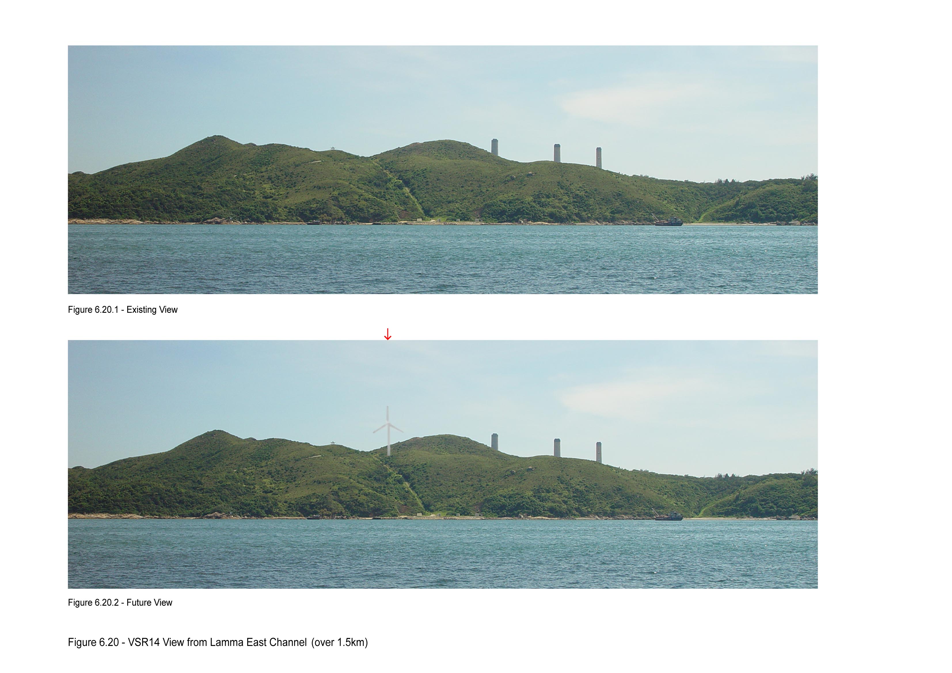
VSR 14 |
Lamma East Channel |
Ferry users Approximate
number of receivers: small |
over 1.5km |
Open and unobstructed views towards the wind turbine which would be clearly situated in the headland as
illustrated in Figure 6.20. Proposed wind
turbine |
Low |
|
VSR 15 |
Ocean Park |
Visitors/ Tourists Approximate
number of receivers: Many |
over 3km |
Open and unobstructed views towards the wind turbine which would be clearly situated near the top of the
ridgeline as illustrated in Figure 6.21. Proposed wind turbine |
Medium |
The
starting point for the review of the planning and development control framework
was a review of the various statutory and non-statutory controls relevant to
the proposed project, which affect landscape and visual impacts.
The review includes information on:
·· The Lamma Island Outline Zoning Plan (Plan no.
S/I-LI/4, 2002)
·· Hong
Kong Planning Area No. 10 – Pok Fu
Lam – Outline Zoning Plan (Plan no. S/H10/14)
·· Hong
Kong Planning Area No. 14 - The
Peak Area – Outline Zoning Plan (Plan no. S/H14/6)
·· Hong Kong Planning Area
Nos. 15 & 16 – Aberdeen & Ap Lei Chau – Outline Zoning Plan (Plan no.
S/H15/20)
·· Hong Kong Planning Area
No. 17 – Shouson Hill & Repulse Bay – Outline Zoning Plan (S/H17/7)
·· Hong Kong Planning Area
No. 19 – Stanley – Outline Zoning Plan (S/H10/14)
·
Plan showing Land Use Concept of Yung Shue Wan Reclamation Phase 2
Under the approved Lamma Island Outline
Zoning Plan (Plan no. S/I-LI/4, 2002), the proposed wind turbine falls within
the “Green Belt” (GB) zoning.
The Government intend to reclaim land
in the Yung Shue Wan area to form a landscaped promenade in front of the
existing one. The visual impact of
the extended promenade has been discussed in Section 6.4.5.
Under the Outline Zoning Plans for South Hong Kong including plan no. S/H10/4, S/H14/6, S/H15/20, S/H17/7 and S/H10/14, there is no large development/reclamation planned for the future. Landuse within Hong Kong South Island would be foreseen to not have a significant change. The recently developed Cyberport has been included as one of the visual sensitive receivers in this assessment.
The magnitude of the impacts, before implementation of mitigation measures, on the landscape resources and landscape character areas that would occur in the construction phase are described below and tabulated. All impacts are adverse unless otherwise stated.
Construction activities which
will affect landscape and visual aspect include:
· Erection of a wind turbine (hub height approximately 45m and rotor blade diameter of approximately 52 m, overall height of the wind turbine approximately 71 m);
· Excavation and construction of the wind turbine foundation (affected area approximately 15 m by 15 m);
· Construction of a site platform and retaining wall (affected area approximately 3,100sq.m.);
· Construction of one stainless steel hut as high voltage distribution pillar (HVDP) (size approximately 4.6 m length, 2.5 m width, 2.8 m height) for housing of switchgear and power conditioning devices;
· Laying of underground distribution cables for connecting to the nearby existing cable route (approximately 50 m in length).
The total effect
of all the above works would result in the disturbance of approximately 3,100
sq.m.. The whole of this is within the Project Site. The extent and location of
these impacts are shown on Figure
6.26.
The
quantification of the disturbances to the LCA1 and various LR types are presented in Table 6.6.
Table 6.6 Summary of Disturbance to LCA1 and Various Landscape Resources
|
LCA/LR |
Type of Landscape Resources Present in the LCA/LR |
Quantification of Landscape Resources within the LCA/LR |
Area in conflict with the proposed works |
Magnitude of Change during Construction |
|
LCA1 |
North
Lamma Coastal Uplands |
Approx. 79.4 ha |
Approx. 3,100 m2 |
Small |
|
LR1 |
Secondary Woodland |
20.5 ha |
0m2 |
Negligible |
|
LR2 |
Shrubland |
49.4 ha |
0m2 |
Negligible |
|
LR3 |
Shrubby Grassland |
5.7 ha |
Approx. 3,100 m2 |
Small |
|
LR4 |
Stream |
Total 1.1 km |
0 km |
Negligible |
|
LR5 |
Village/Developed Area |
3.8 ha |
0m2 |
Negligible |
Disturbance to North Lamma Coastal Uplands – LCA 1
The
work areas as described above (approx. 3,100 sq.m.) fall within LCA1.
In the context of the study area, the possible
affected area is considered small
(representing 0.39%) and thus
the magnitude of change to the overall landscape character of the area is small. As LCA1 is considered to have an
overall high landscape character
value, the significance threshold is moderate/adverse.
Disturbance to Shrubby Grassland – LR3
The whole
work areas fall within LR3. During the construction works approximately 3,100
sq.m. of shrubby grassland need to be removed which represents 5.4% of the 5.7
ha of LR3. The magnitude of change is considered small. As LR3 has an overall medium
landscape sensitivity, the significance threshold is slight moderate/adverse.
Disturbance to Stream – LR4
During construction activities the primary sources of water quality impacts will be from pollutants in site run-off. Pollutants, mainly suspended sediments, may also enter receiving waters if any pumped groundwater is not adequately controlled on-site.
The potential sources of impacts to water quality may be readily
controlled by appropriate on-site measures to minimise potential impacts as
described in Section 8.6. With the implementation of such
measures adverse impacts to water quality are not expected to result from land
based construction activities. The magnitude of change and the significance
threshold are both negligible.
Disturbance to
Other Landscape Resources Secondary Woodland – LR1, Shrubland – LR2 and Village/Developed Area – LR5
The
construction activities do not confilict with these LRs and the magnitude of
change and the significance threshold are negligible
for all these LRs.
A
detailed tree survey has been conducted for the Project site. The survey
identifies trees that are in or at the vicinity of the works area. The survey
identifies 45 nos. of trees in which 2 nos. are within the Project site. All 45 trees are to be retained.
The visual impact during construction will be arising from:
·· site formation and construction
activities for maintenance platform, mini-pile and pile cap;
·· lifting
of turbine components by crane;
·· temporary
hoarding.
The visual impacts during construction will be (refer to
Table 6.8 for summary):
·· VSR1 Pak Kok San Tsuen, VSR2 Yung Shu Wan Pier/Sha Po New Village/Sha Po Old Village/Tai Yuen Village, VSR3
Tai Wan To/Long Tsai Tsuen, VSR4 Hiking
Trail in Lamma Island (Pavilion)
& VSR5
Hiking Trail in Lamma Island – The construction plants would be dominant
unsightly elements partially visible in the middleground seen by residents in
their homes and hikers along trials. The magnitude of change during
construction would be intermediate as
the full view would be blocked by topography and existing trees/houses in the
foreground.
Since the
sensitivity to change for VSR 1 Pak Kok San Tsuen, VSR2
Yung Shu Wan Pier/Sha Po New Village/Sha Po Old
Village/Tai Yuen Village and VSR3 Tai Wan To/Long Tsai Tsuen is medium, the significant threshold would
be moderate/adverse. The sensitivity to change for the other VSRs is low and the corresponding significant threshold would be slight-moderate/adverse.
·· VSR7
Pok Fu Lam Road, VSR9 Wah Fu, VSR10 Cyberport, VSR11 Ap Lei Chau, VSR14 Lamma
East Channel and VSR15 Ocean Park – The
construction plants and site formation works would be seen in the distant
middleground from a distance of 1.5 to 5km by residents in their homes or
commuters on ferries or tourists/visitors.
However, these are not dominant elements and the magnitude of change during
construction is considered intermediate.
Since the sensitivity to change for VSR14 Lamma East Channel is low, the significant threshold would be slight-moderate/adverse. The sensitivity to change for VSR15 Ocean Park is medium, the significant threshold would be moderate/adverse. The sensitivity to change for the other VSRs is high and the corresponding significant threshold would be moderate-significant/adverse.
·· VSR6
Repulse Bay, VSR8 The Peak, VSR12 Mount Davis, VSR13 Chung Hom Kok – The
construction plants and site formation works would be seen in the distant
background from a distance of over 5km. The construction work is not noticeable
in this far distance. The magnitude of change during construction is considered
small.
Since the sensitivity to change for VSR6 Repulse Bay, VSR8 The Peak, VSR12 Mount Davis,
VSR13 Chung Hom Kok is medium, the
significant threshold would be slight-moderate/adverse.
·
VSR16 Tai Ling Pavilion/adjacent cable road – The
construction plants and site formation works would be seen upclose and would be
dominating especially during the erection of the wind turbine when large scale
cranes are used. The magnitude of
change during construction is large.
Since the sensitivity to change for VSR16 Tai Ling Pavilion/adjacent
cable road is high, the significant threshold would be significant/adverse.
Upon
the completion of the construction, part of the new cut and fill slopes and other land
affected by construction works would be reinstated to natural land form and topography of the natural slope as far as
practical. New shrub
land/grass land planting would be implemented in-keeping with the surrounding landscape
character. In addition,
appropriate landscape planting including trees, shrubs and grasses (approx. 1,400 sq.m.) will be provided to soften the ground level appearance resulting in a
net loss of 1,700 sq.m.of vegetation. These mitigation measures are more
described in more detail in section 6.7.
The extent and
location of the loss of vegetation ie the landscape impact during operation is
shown on Figure 6.26.
The quantification
of the net loss to the LCA1 and various LR types are
presented in Table 6.7.
Table 6.7 Summary of Net Loss to LCA1 and Various Landscape Resources
|
LCA/LR |
Type of Landscape Resources Present in the LCA/LR |
Quantification of Landscape Resources within the LCA/LR |
Net Loss in Area |
Magnitude of Change during Construction |
|
LCA1 |
North Lamma
Coastal Uplands |
Approx. 79.4 ha |
Approx. 1,700 m2 |
Small |
|
LR1 |
Secondary Woodland |
20.5 ha |
0m2 |
Negligible |
|
LR2 |
Shrubland |
49.4 ha |
0m2 |
Negligible |
|
LR3 |
Shrubby Grassland |
5.7 ha |
Approx. 1,700 m2 |
Small |
|
LR4 |
Stream |
Total 1.1 km |
0 km |
Negligible |
|
LR5 |
Village/Developed Area |
3.8 ha |
0m2 |
Negligible |
The net loss in Landscape Resources is
considered small in LCA1 as it only represents 0.2% of the total Study
Area. The significance threshold is moderate/adverse.
The
magnitude of change to LR3 remains small and
the significance threshold also remains at slight
moderate/adverse.
The
operation of the proposed wind turbine will not consume fuel and generate waste
or side products. Major impacts during operational phase are associated with
the visual impact of the wind turbine with rotating blades and other associated
built structures including the platform, retaining wall at a closer scale.
The
visual impact arising during operation will be:
·· VSR1 Pak Kok San Tsuen, VSR2 Yung Shu Wan Pier/Sha Po New Village/Sha Po Old Village/Tai Yuen Village, VSR3
Tai Wan To/Long Tsai Tsuen, VSR4 Hiking
Trail in Lamma Island (Pavilion) and VSR5
Hiking Trail in Lamma Island – The rotating blades of the proposed wind turbine
would be permanently discernible against background, but is not conspicuous.
The magnitude of change during operation would be intermediate as the views would be partially blocked by topography
and existing trees/houses in the foreground.
Since the
sensitivity to change for VSR 1 Pak Kok San Tsuen, VSR2
Yung Shu Wan Pier/Sha Po New Village/Sha Po Old
Village/Tai Yuen Village and VSR3 Tai Wan To/Long Tsai Tsuen is medium,
the significant threshold would be moderate/adverse.
The sensitivity to change for the other VSRs is low and the corresponding significant threshold would be slight-moderate/adverse.
·· VSR7
Pok Fu Lam Road, VSR9 Wah Fu, VSR10 Cyberport, VSR11 Ap Lei Chau, VSR14 Lamma
East Channel and VSR15 Ocean Park – The
proposed wind turbine would be seen in the distant middleground from a distance
of 1.5 to 5km. The proposed wind turbine would be prominent, but it is not
dominating the whole view to the Lamma Island. The magnitude of change during operation is
considered intermediate.
Since the sensitivity to change for VSR14 Lamma East Channel is low, the significant threshold would be slight-moderate/adverse. The sensitivity to change for VSR15 Ocean Park is medium, the significant threshold would be moderate/adverse. The sensitivity to change for the other VSRs is high and the corresponding significant threshold would be moderate-significant/adverse.
·· VSR6
Repulse Bay, VSR8 The Peak, VSR12 Mt. Davis, VSR13 Chung Hom Kok – The proposed
wind turbine would be seen in the distant background from a distance of over
5km. The proposed wind turbine is not noticeable in this far distance. The
magnitude of change during operation is considered small.
Since the sensitivity to change for VSR6 Repulse Bay, VSR8 The Peak, VSR12 Mount Davis,
VSR13 Chung Hom Kok is medium, the
significant threshold would be slight-moderate/adverse.
·
VSR16 Tai Ling Pavilion/adjacent cable road – The
wind turbine with rotating blades and other associated built structures
including the platform, retaining wall would be seen upclose and would be
dominating. The magnitude of change during operation at this close distance is large.
Since the sensitivity to change for VSR16 Tai Ling Pavilion/adjacent cable road is high, the significant threshold would be significant. There is no doubt that the visual impact of the wind turbine at this close distance would be significant. However, whether it is an adverse or beneficial impact would very much depend on the viewers acceptance towards the use of this kind of renewable energy as a substitute to coal burning.
One of the objectives of this project is to educate the public and in particular students, for promotion of green awareness. With the gain in knowledge of the benefits of renewable energy such as the improvement of air quality, the likelihood of acceptance of the visual impact would be increased.
A summary of landscape and visual impacts during operation is given in Table 6.8 and 6.9.
In order to
mitigate these impacts, a number of soft landscape and colour scheme mitigation
measures are recommended for incorporation into the Project. These mitigation measures are
summarised in the following paragraphs and shown on Table 6.11. The extent and location is shown
on Figure 6.24 and a photomontage of the project with and without
mitigation measures is shown on Figure
6.25.
Mitigation
Measure 1 (MM1) – Partial Reinstatement of Disturbed Areas (To be completed
with construction stage)
· New cut and fill slopes and other land affected by construction works would be reinstated to natural land form and topography of the natural slope as far as practical. Grading of these slopes to resemble a natural, rolling landform similar to that of adjacent topography would be carried out.
Approximately 1,400 sq.m. of disturbed areas would be reinstated.
Mitigation Measure 2 (MM2) –
Compensatory Planting (To be completed with construction stage and maintained during
operation)
In compensation for the disturbance to existing vegetation area of approximately 3,100 sq.m., appropriate landscape planting including trees, shrubs and grasses (approx. 1,400 sq.m.) will be provided to soften the ground level appearance of the proposed
wind turbine site. These include hydroseeding of a
grass mix similar to those found in the area, together with the following native tree and shrub seeds
included in the hydroseeding mix, to quickly re-establish any disturbed slopes.
Botanical Name |
Size |
|
Tree |
|
|
Acacia confusa |
Light Standard |
|
Schefflera heptaphylla |
Light Standard |
|
Ficus hispida |
whip |
|
Celtis sinensis |
Light Standard |
|
Cinnamomum camphora |
Light Standard |
|
Litsea glutinosa |
whip |
|
Microcos paniculata |
whip |
|
Sterculia lanceolata |
whip |
|
Sapium discolor |
Light Standard |
|
Notes: A mixture of the above trees will be
planted at Standard to Heavy Standard size immediately in front of the
retaining wall at
the downside slope of the edge of the platform area,
to mitigate the impact of the wall. |
|
|
Shrub |
|
|
Ilex pubescens |
500-600mm Ht. |
|
Melastoma candidum |
500-600mm Ht. |
|
Rhodomytrus tomentosa |
500-600mm Ht. |
|
Rhaphiolepis indica |
500-600mm
Ht. |
Mitigation
Measure 3 (MM3) – Colour Scheme and non-reflective paints (To be completed with
construction stage)
A
proper colour selection will be made to enable the proposed wind turbine to
blend in well with natural surroundings and minimise the visual intrusion.
It is
noted that in general practices the rotor blades, nacelle and pole are
generally in white colour. In this case, as demonstrated in the photomontages
from the different VSRs, the wind turbine would be seen either against a sky or
greenery backdrop.
An investigation
was carried out to find out the visual effect of various light colour tones on
the wind turbine (see Fig.
6.22). In case of good visibility and weather conditions,
the wind turbine in any light colour would be relatively prominent due to its
special shape either against the sky or greenery. However, a light grey colour
would render the wind turbine less intrusive in mid to low visibility
conditions as the light grey colour is less contrasting to the grey sky
backdrop comparing with other colours such as white, green or blue. The effect
of reducing the intrusiveness would be particularly noticeable for the distant
viewers.
As a
colour mitigation measure, a light grey non-reflective colour is thus selected.
The proposed colour is similar to the colour chip as shown in Fig.
6.23 (ICI colour code 1369 North Beach 50BG 72/011).
Mitigation
Measure 4 (MM4) –Soil Conservation (To be completed with construction stage)
Soil
conservation is a consideration in the management of the construction phase.
Existing soil resources on site from the cut slope will be re-used for
backfilling at site as far as practicable to minimize the need to import or
export soils.
Mitigation
Measure 5 (MM5) – Selection of low rotating speed machine (To be completed with
construction stage)
In order to minimize the visual disturbance, a
low rotating speed machine will be chosen.
In addition to the above, the following good
site practices would also be implemented:
·
Screening of site construction by means of
temporary hoarding that is appropriate to its site context.
·
Tree protective measures will be implemented to
ensure the existing trees within the Project site identified as to be preserved
are satisfactorily protected during the construction phase.
The
incorporation of mitigation measures into the scheme will reduce the impacts in
most cases as follows:
MM1 will ensure
that new fill slope work will resemble a natural, rolling landform similar to that of adjacent
topography. MM2 will compensate for the loss of vegetation through the
implementation of planting of trees, shrubs and grasses as appropriate. MM4
will ensure that the valuable soil will be re-used where possible. The extent
and location of these mitigation measures is shown on Figure 6.24.
Residual Landscape Impact to North Lamma
Coastal Uplands – LCA 1 & Shrubby Grassland – LR3
With the implementation of the above mitigation measures, the magnitude of change to LCA1 and LR3 would be reduced from a net loss of 3,100 sq.m. to 1,700sq.m. ie from 0.39% to 0.2% for LCA1 and from 5.4% to 3.0% for LR3. While the overall effect of the mitigation measure towards the LCA1 is not significant, MM2 will result in a net increase in the quantity of vegetation at the Project Site and would reduce the significance threshold of the residual impact for LR3 from “slight-moderate/adverse” to “slight/adverse” during Year 1 of operation and “slight/beneficial” during Year 10 of operation.
A summary of residual landscape impacts is
shown in Table 6.8.
The
incorporation of mitigation measures into the scheme will reduce the visual
impacts in most cases as follows:
·· VSR7
Pok Fu Lam Road, VSR9 Wah Fu, VSR10 Cyberport and VSR11
Ap Lei Chau and – MM3 would
improve the visual appearance of the proposed wind turbine during operation
with a light grey non-reflective colour scheme (MM3). Selection of low rotating
speed machine (MM5) will render the wind turbine to be less conspicuous. This
will lead to a reduction of “moderate-significant/adverse” unmitigated
visual impact down to “moderate/adverse”
residual visual impact during Year 1 and 10 years of operation.
·· VSR 1 Pak Kok San Tsuen, VSR2
Yung Shu Wan Pier/Sha Po New Village/Sha Po Old
Village/Tai Yuen Village, VSR 3 Tai Wan To/Long Tsai Tsuen and VSR15 Ocean Park – MM3 would
improve the visual appearance of the proposed wind turbine during operation
with a light grey non-reflective colour scheme (MM3). Selection of low rotating
speed machine (MM5) will render the wind turbine to be less conspicuous. This
will lead to a reduction of “moderate/adverse”
unmitigated visual impact down to “slight-moderate/adverse”
residual visual impact during Year 1 and 10 years of operation.
·· VSR 4 Hiking Trail in Lamma Island (Pavilion) & VSR 5 Hiking Trail in Lamma Island, VSR6 Repulse Bay,
VSR8 The Peak, VSR12 Mount Davis, VSR13 Chung Hom Kok
and VSR14 Lamma East Channel – Similar to the VSRs above, MM3 and MM5 would
improve the visual appearance of the proposed wind turbine during operation leading
to a reduction of “slight-moderate/adverse”
unmitigated visual impact down to “slight/adverse”
residual visual impact during Year 1 and 10 years of operation.
·
VSR16 Tai Ling Pavilion/adjacent cable road – As
the VSR is very close to the Project, the mitigation measures would not reduce
the visual impacts of the wind turbine. However, MM1 and MM2 would help to
improve the visual impact by minimizing the apparent disturbance to the natural
landscape and screening of the retaining wall. The significance threshold would
remain as significant.
A summary of
residual visual impacts is shown in Table 6.10.
The
major findings of the LVIA are as follows:
· The Project would result in the disturbance of approximately 3,100 sq.m. of Landcape Character Area LCA1 - North Lamma Coastal Uplands and Landscape Resources LR3 – Shrubby Grassland out of which approximately 1,400 sq.m. will be reinstated resulting in a net loss of approximately 1,700 sq.m. With the implementation of appropriate mitigation measures including MM1 - Partial Reinstatement of Disturbed Areas, MM2 – Compensatory Planting and MM4 – Soil Conservation, the significance threshold of the residual landscape impacts are generally negligible and range from “slight/adverse” during Year 1 of operation and “slight/beneficial” during Year 10 of operation for LR3.
·
The proposed wind turbine would be visible from
various VSRs on Lamma Islands, Hong Kong Island south, Ap Lei Chau and visitors and viewers in transit such as those on hiking tracks
on Lamma Island and along the ferry routes. The
resultant significance threshold of the residual visual impact in slight to moderate/adverse
residual visual impact on views from Lamma Island and Hong Kong Island during
operation. The overall residual visual impacts are considered acceptable.
Based on the
above findings, the landscape and visual impacts of the proposed wind turbine
are considered to be acceptable with mitigation measures.
It is
recommended that implementation and operational maintenance of proposed
Landscape and Visual Mitigation Measures is included with the EM&A. The
design stage EM&A will consist of auditing the detailed landscape designs.
Construction and operational stage EM&A will comprise audit of the
compensatory planting and planting establishment in the form of site
inspection. Further details of the specific EM&A requirements are detailed
in the EM&A Manual Section of this report. Summary Landscape and visual
Mitigation Measures Programming, Funding, Implementation, Management and
Maintenance Agents is given in Table 6.11.
Table 6.8 Summary of Landscape Impacts (with and without
Landscape Mitigation Measures)
|
LCA/LR
Name |
·
Source
of Impact ·
Resulting
Disturbed Area |
Proposed Mitigation Measures |
Quality/ Sensitivity to Change |
Landscape Impacts without Mitigation Measures |
Landscape Impacts with Mitigation Measures |
||
|
Construction Phase |
Operation Phase (1 & 10 years) |
Construction Phase |
Operation Phase (1 & 10 years) |
||||
|
Magnitude of Change and Significance
Threshold of Landscape Impact |
|||||||
|
LCA1 North Lamma
Coastal Uplands - Approx. 79.4 ha |
· Transportation
and construction activities including foundation and site formation (for
details, please refer to Section 6.5.1) ·
disturbance of approximately 3,100 sq.m., 1,400
sq.m. of which would be reinstated. Resulting in a net loss of 1,700 sq.m.
The whole of this is within the Project Site. |
MM1 (1,400sq.m.)will ensure that new fill slope work will
resemble a natural, rolling landform similar to that of adjacent topography. MM2 (1,400 sq.m.)
will compensate for the loss of vegetation through the implementation of planting
of trees, shrubs and grasses as appropriate. MM4 will ensure
that the valuable soil will be re-used where possible. The extent and
location of these mitigation measures is shown on Figure 6.24. |
High |
Small and Moderate / Adverse |
Small and Moderate / Adverse |
Small and Moderate / Adverse |
Small and Moderate / Adverse for both 1 & 10
Years |
|
LR1 Secondary Woodland – 20.5 ha |
·
Negligible impact and no disturbed area. |
|
Medium |
Negligible |
Negligible |
Negligible |
Negligible |
|
LR2 Shrubland – 49.4 ha |
·
Negligible impact and no disturbed area. |
|
Medium |
Negligible |
Negligible |
Negligible |
Negligible |
|
LR3 Shrubby Grassland – 5.7 ha |
· Construction
activities including foundation and site formation (for details, please refer
to Section 6.5.1) ·
Disturbance of approximately 3,100 sq.m., 1,400
sq.m. of which would be reinstated. Resulting in a net loss of 1,700 sq.m.
The whole of this is within the Project Site. |
MM1 (1,400sq.m.)will ensure that new fill slope work will
resemble a natural, rolling landform similar to that of adjacent topography. MM2 (1,400 sq.m.)
will compensate for the loss of vegetation through the implementation of
planting of trees, shrubs and grasses as appropriate. MM4 will ensure
that the valuable soil will be re-used where possible. The extent and
location of these mitigation measures is shown on Figure 6.24. |
Medium |
Small and Slight-Moderate/ Adverse |
Small and Slight-Moderate/ Adverse for both 1 & 10 years |
Small and Slight-Moderate/ Adverse |
Small and Slight/ Adverse for 1 year Slight/ Beneficial for 10 years |
|
LR4 Stream – Total 1.1km |
·
Negligible impact and no disturbed area. |
|
Medium |
Negligible |
Negligible |
Negligible |
Negligible |
|
LR5 Village/Developed Area – 3.8 ha |
·
Negligible impact and no disturbed area. |
|
Medium |
Negligible |
Negligible |
Negligible |
Negligible |
Table 6.9 Assessment of Visual Impacts (without
Landscape and Visual Mitigation Measures)
|
VSR |
Name (refer to Table 6.43 & 6.5 for
detailed information on VSRs) |
Sensitivity to Change and Visual Intrusion |
Construction Phase |
Operation Phase |
||
|
Magnitude of Visual Change |
Significance Threshold of
Visual Impact |
Magnitude of Visual Change |
Significance Threshold of
Visual Impact |
|||
|
VSR 1 |
Pak Kok San Tsuen |
Medium |
Intermediate |
Moderate/Adverse |
Intermediate |
Moderate/Adverse |
|
VSR 2 |
Yung Shu Wan Pier/Sha Po New Village/Sha Po Old Village/Tai Yuen
Village |
Medium |
Intermediate |
Moderate/Adverse |
Intermediate |
Moderate/Adverse |
|
VSR 3 |
Tai Wan To/Long Tsai Tsuen |
Medium |
Intermediate |
Moderate/Adverse |
Intermediate |
Moderate/Adverse |
|
VSR 4 |
Hiking Trail on Lamma Island (Pavilion) |
Low |
Intermediate |
Slight-Moderate/Adverse |
Intermediate |
Slight-Moderate/Adverse |
|
VSR 5 |
Hiking Trail on Lamma Island |
Low |
Intermediate |
Slight-Moderate/Adverse |
Intermediate |
Slight-Moderate/Adverse |
|
VSR 6 |
Repulse Bay |
Medium |
Small |
Slight-Moderate/Adverse |
Small |
Slight-Moderate/Adverse |
|
VSR 7 |
Pok Fu Lam Road |
High |
Intermediate |
Moderate-Significant/Adverse |
Intermediate |
Moderate-Significant/Adverse |
|
VSR 8 |
The Peak |
Medium |
Small |
Slight-Moderate/Adverse |
Small |
Slight-Moderate/Adverse |
|
VSR 9 |
Wah Fu |
High |
Intermediate |
Moderate-Significant/Adverse |
Intermediate |
Moderate-Significant/Adverse |
|
VSR 10 |
Cyberport |
High |
Intermediate |
Moderate-Significant/Adverse |
Intermediate |
Moderate-Significant/Adverse |
|
VSR 11 |
Ap Lei
Chau |
High |
Intermediate |
Moderate-Significant/Adverse |
Intermediate |
Moderate-Significant/Adverse |
|
VSR 12 |
Mount Davis |
Medium |
Small |
Slight-Moderate/Adverse |
Small |
Slight-Moderate/Adverse |
|
VSR 13 |
Chung
Hom Kok |
Medium |
Small |
Slight-Moderate/Adverse |
Small |
Slight-Moderate/Adverse |
|
VSR 14 |
Lamma East Channel |
Low |
Intermediate |
Slight-Moderate/Adverse |
Intermediate |
Slight-Moderate/Adverse |
|
VSR 15 |
Ocean Park |
Medium |
Intermediate |
Moderate/Adverse |
Intermediate |
Moderate/Adverse |
|
VSR 16 |
Tai Ling Pavilion/adjacent cable road |
High |
Large |
Significant /Adverse |
Large |
Significant |
Table 6.10 Summary of Residual Visual Impacts (with
Landscape and Visual Mitigation Measures)
|
VSR
Number |
WITHOUT Recommendation Mitigation Measures |
Recommended Mitigation Measures (Refer to Section 6.7) |
WITH Recommendation Mitigation Measures |
|||
|
Significance
Threshold of Visual Impact during Construction |
Significance
Threshold of Visual Impact during Operation |
Significance
Threshold of Visual Impact during Construction |
Significance
Threshold of Visual Impact during Operation |
|||
|
YEAR
1 |
YEAR
10 |
|||||
|
VSR 1 |
Moderate/Adverse |
Moderate/Adverse |
MM3 and 5 |
Moderate/Adverse |
Slight-Moderate/Adverse |
Slight-Moderate/Adverse |
|
VSR 2 |
Moderate/Adverse |
Moderate/Adverse |
MM3 and 5 |
Moderate/Adverse |
Slight-Moderate/Adverse |
Slight-Moderate/Adverse |
|
VSR 3 |
Moderate/Adverse |
Moderate/Adverse |
MM3 and 5 |
Moderate/Adverse |
Slight-Moderate/Adverse |
Slight-Moderate/Adverse |
|
VSR 4 |
Slight-Moderate/Adverse |
Slight-Moderate/Adverse |
MM3 and 5 |
Slight-Moderate/Adverse |
Slight/Adverse |
Slight/Adverse |
|
VSR 5 |
Slight-Moderate/Adverse |
Slight-Moderate/Adverse |
MM3 and 5 |
Slight-Moderate/Adverse |
Slight/Adverse |
Slight/Adverse |
|
VSR 6 |
Slight-Moderate/Adverse |
Slight-Moderate/Adverse |
MM3 and 5 |
Slight-Moderate/Adverse |
Slight/Adverse |
Slight/Adverse |
|
VSR 7 |
Moderate-Significant/Adverse |
Moderate-Significant/Adverse |
MM3 and 5 |
Moderate-Significant/Adverse |
Moderate/Adverse |
Moderate/Adverse |
|
VSR 8 |
Slight-Moderate/Adverse |
Slight-Moderate/Adverse |
MM3 and 5 |
Slight-Moderate/Adverse |
Slight/Adverse |
Slight/Adverse |
|
VSR 9 |
Moderate-Significant/Adverse |
Moderate-Significant/Adverse |
MM3 and 5 |
Moderate-Significant/Adverse |
Moderate/Adverse |
Moderate/Adverse |
|
VSR 10 |
Moderate-Significant/Adverse |
Moderate-Significant/Adverse |
MM3 and 5 |
Moderate-Significant/Adverse |
Moderate/Adverse |
Moderate/Adverse |
|
VSR 11 |
Moderate-Significant/Adverse |
Moderate-Significant/Adverse |
MM3 and 5 |
Moderate-Significant/Adverse |
Moderate/Adverse |
Moderate/Adverse |
|
VSR 12 |
Slight-Moderate/Adverse |
Slight-Moderate/Adverse |
MM3 and 5 |
Slight-Moderate/Adverse |
Slight/Adverse |
Slight/Adverse |
|
VSR 13 |
Slight-Moderate/Adverse |
Slight-Moderate/Adverse |
MM3 and 5 |
Slight-Moderate/Adverse |
Slight/Adverse |
Slight/Adverse |
|
VSR 14 |
Slight-Moderate/Adverse |
Slight-Moderate/Adverse |
MM3 and 5 |
Slight-Moderate/Adverse |
Slight/Adverse |
Slight/Adverse |
|
VSR 15 |
Moderate/Adverse |
Moderate/Adverse |
MM3 and 5 |
Moderate/Adverse |
Slight-Moderate/Adverse |
Slight-Moderate/Adverse |
|
VSR 16 |
Significant /Adverse |
Significant |
MM1, 2, 3 and 5 |
Significant /Adverse |
Significant
|
Significant |
Table 6.11 Summary Landscape and Visual Mitigation Measures Programming, Funding,
Implementation, Management and Maintenance Agents
|
MM Reference |
Description of Landscape Mitigation Measures |
Programme Stages |
·
Funding ·
Implementation
Agent |
1.
Management Agency during operation 2.
Maintenance
Agency during operation |
||
|
D |
C |
O |
||||
|
MM1 |
New cut and fill
slopes and other land affected by construction works would
be reinstated to natural land form and topography of the natural slope as far as
practical. Grading of these slopes to resemble a
natural, rolling landform similar to that of adjacent topography would be
carried out. Approximately 1,400 sq.m. of disturbed areas would be reinstated. |
ü |
ü |
|
·
Project
proponent ·
Contractor |
Project proponent |
|
MM2 |
Appropriate
landscape planting including trees, shrubs and grasses (approx. 1,400
sq.m.) will be provided to soften the ground
level appearance of the proposed wind turbine site. |
ü |
ü |
ü |
·
Project
proponent ·
Contractor |
Project proponent |
|
MM3 |
A light grey non-reflective colour scheme will be used to enable the
proposed wind turbine to blend in well with natural surroundings and minimise
the visual intrusion. |
ü |
ü |
ü |
·
Project
proponent ·
Contractor |
Project proponent |
|
MM4 |
Existing soil resources on site from the cut slope will be re-used for
backfilling at site as far as practicable to minimize the need to import or
export soils. |
ü |
ü |
|
·
Project
proponent ·
Contractor |
N/A |
|
MM5 |
Selection of
low rotating speed machine to minimize the visual disturbance. |
ü |
ü |
ü |
·
Project
proponent ·
Contractor |
Project proponent |