CONTENTS
Executive Summary
1.1
Project
Background
1.2
Objectives
of EIA Study
1.3
Considerations
of the Environmental Impact Assessment Ordinance
1.4
Structure
of the EIA Report
2.1
Reporting
Phase of Existing Golf Course Development (The Existing Course)
2.2
Refinement
of the project since issue of the EIA Study Brief
2.3
Description
of the Area and Project
2.4
Need
for the Project
2.5
Major
components of the Project
2.6
Consideration
of Alternative Location
2.7
Design
considerations of Closed low flow Drainage and Irrigation System
2.8
Scenario
With the Project
2.9
Continuous
Public Involvement (
2.10
Project
Programme
2.11
Interactions
with Other Projects
3.2
Residential
Properties
3.3
Beaches & Sandy Bays
3.7
Existing
and Past Land Uses of the Project Site
4.1
Introduction
4.2
Environmental
Legislation, Policies, Plans, Standards and Criteria
4.3
Description
of Environment
4.4
Air
Sensitive Receivers
4.6
Impact
Evaluation
4.7
Mitigation
Measures
4.8
Residual
Impact
4.9
Cumulative
Impact
4.10
Environmental
Monitoring and Audit Requirement
4.11
Conclusion
5.1
Introduction
5.2
Study
Area
5.4
Representative
Noise Sensitive Receivers
5.5
Construction
Noise Assessment
5.6
Operational
Noise Assessment
5.7
Residual
Impact
5.8
Cumulative
Impact
5.9
Environmental
Monitoring and Audit Requirement
5.10
Summary
6.2
Environmental
Legislation, Policies, Standards and Criteria
6.3
Summary
of Turfgrass Management Plan (
6.4
Review
of Existing Water Quality
6.5
Proposed
closed low flow drainage system at the proposed third golf course
6.6
Assessment
Methodology & Criteria
6.7
Identification
of Water Sensitive Receivers
6.8
Identification
of Possible Environmental Impacts
6.9
Impact
Evaluation during the Construction Phase of Proposed Third Golf Course
6.10
Impact
Evaluation during the Operational Phase of the Proposed Third Golf Course
6.11
Mitigation
Measures
7.1
Mitigation
Measures
7.3
Environmental
Legislation, Policies, Standards and Criteria
7.4
Baseline
Condition
7.5
Assessment
Methodology
7.6
Identification
of Potential Sources of Wastes
7.7
Prediction
and Evaluation of Environmental Impacts
7.8
Proposed
Mitigation Measures for Construction Waste
7.9
Evaluation
of Residual Impact
7.10
Environmental
Monitoring and Auditing
7.11
Conclusion
8.1
Project
Background
8.3
Literature
Review
8.4
Baseline
Condition
8.5
Evaluation
of habitats and species of conservation interest
8.6
Impact
Identification and Assessment
8.7
Impact
Avoidance and Mitigation Measures
9.2
Environmental Legislation,
Standards and Guidelines
9.3
Baseline Methodology
9.4
Assessment Methodology
9.5
Baseline conditions
9.6
Evaluation of ecological
importance of habitats and species
9.7
Impact assessment
9.8
Mitigation measures
9.9
Residual impact
9.10
Environmental audit and
monitoring
9.11
Conclusion
9.12
Reference
10.1
Introduction
10.2
Environmental Legislation, Standards and Guidelines
10.3
Environmental Baseline Methodology
10.4
Assessment Methodology
10.5
Baseline conditions
10.6
Fisheries sensitive receivers
10.7
Impact assessment
10.8
Mitigation measures
10.9
Residual impacts
10.10
Environmental sudit and monitoring
10.11
Conclusion
10.12
Reference
11.1
Introduction
11.2
Environmental Legislation,
Policies, Plans, Standards and Criteria
11.3
Assessment Methodology
11.4
Identification of Sensitive Receivers
11.5
Description of Existing Environment
11.6
Review of Historic and Current Land Uses
11.7
Impact Evaluation
11.8
Contamination Assessment Plan (
11.9
Mitigation Measures for Land Contamination during
Construction Stage
11.10
Potential for
12. Landscape
and Visual Impact
12.1
Introduction
12.2
Relevant Legislation
and Guidelines
12.3
LVIA Assessment
Methodology
12.4
Project Description
12.5
Review of Planning and Development Control Framework
12.6
Existing Landscape Baseline Conditions
12.7
Landscape Impact Assessment
12.8
Visual Baseline Conditions
12.9
Visual Impact Assessment
12.10
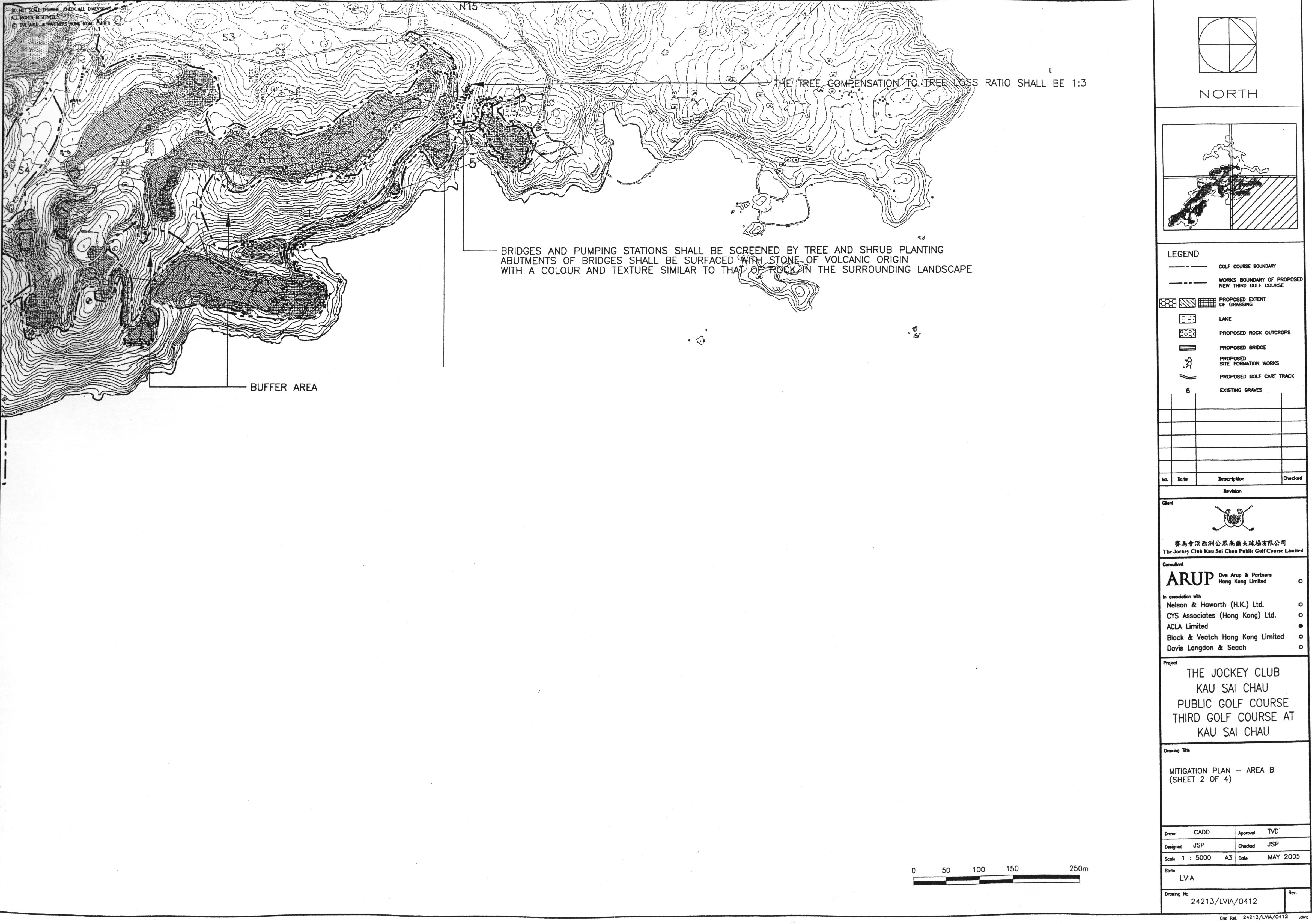
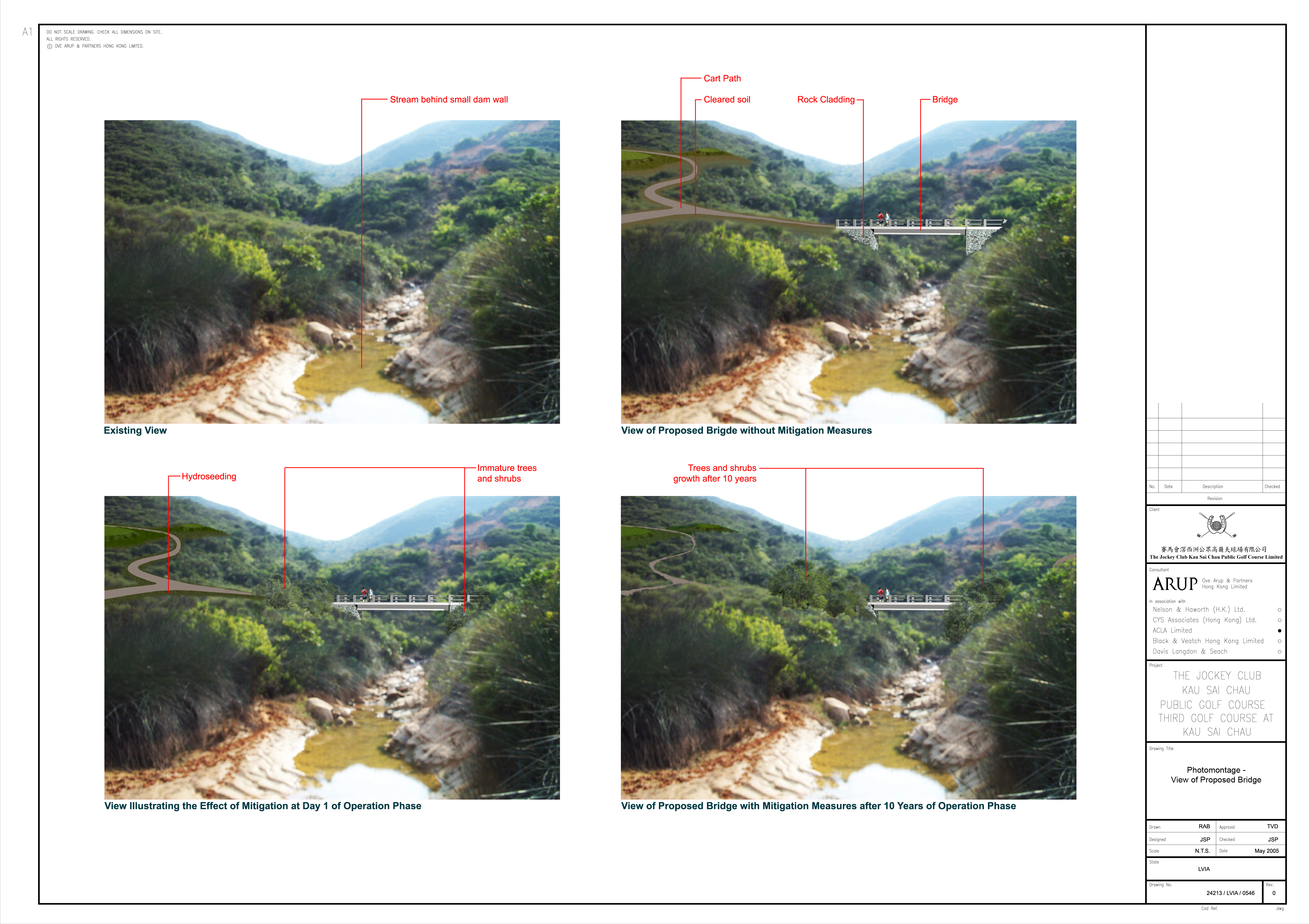
Recommended Landscape and Visual Impact Mitigation Measures
12.11
Residual Landscape Impacts
12.12
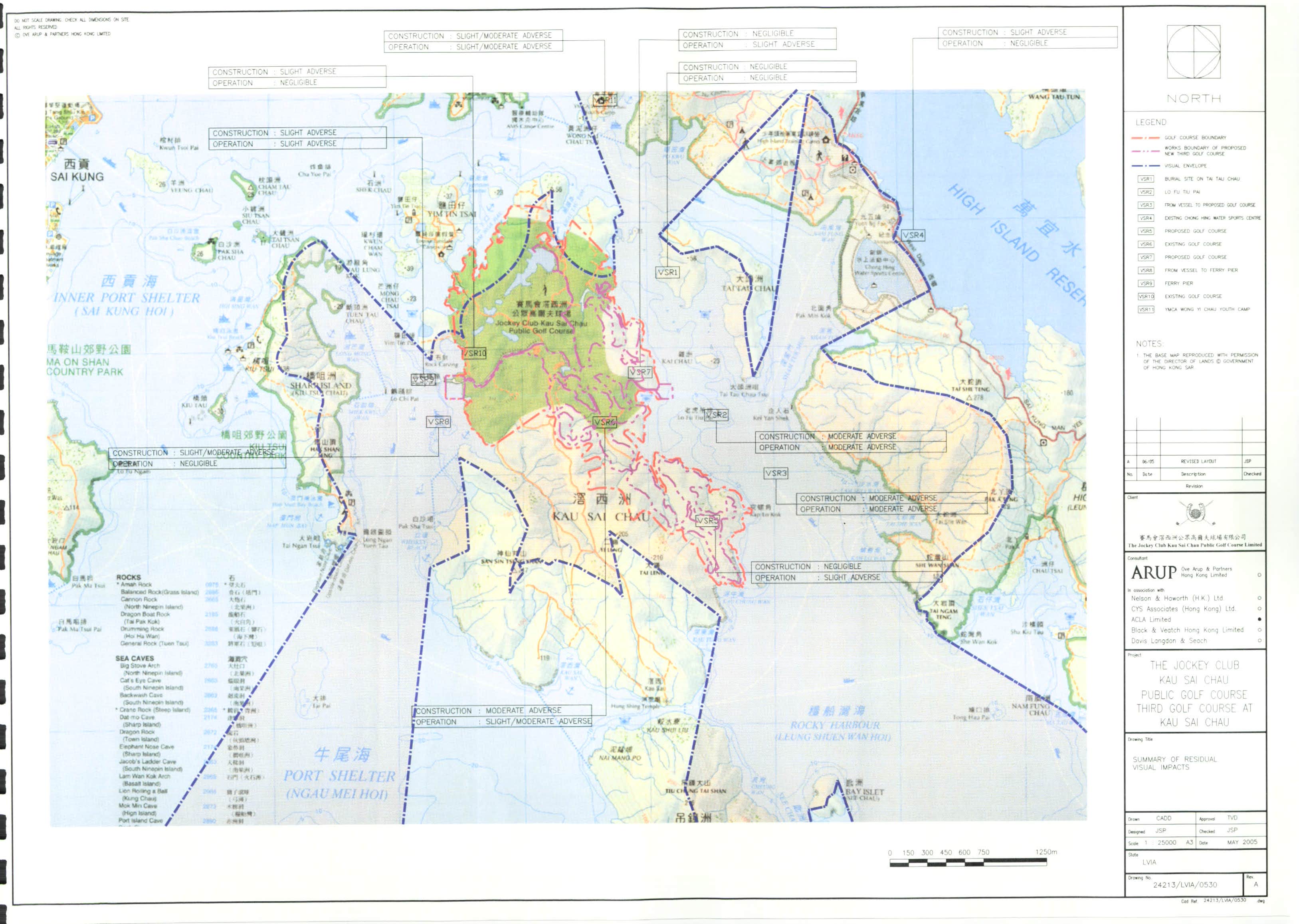
Residual Visual Impacts
12.13
Environmental Monitoring and Audit Manual
12.14
Provisional Programme of Landscape Works
12.15
Funding, Implementation, Management and Maintenance of
Landscape Works
12.16
Summary and Conclusions
13. Cultural
Heritage Impact Assessment
14. Environmental
Monitoring and Audit
Air Quality
Noise
Water Quality
Waste Management
Terrestrial Ecology
Marine Ecology
Fisheries
Land Contamination
Landscape and Visual
Assessment
Cultural Heritage
Air Quality
Noise
Water Quality
Waste Management
Terrestrial Ecology
Marine Ecology
Fisheries
Land Contamination
Landscape and Visual Assessment
Cultural Heritage
LIST OF APPENDICES
Appendix A EIA
Study Brief No. ESB-64/2000
Appendix B Terrestrial ecology monitoring report (2004/2005) for the existing golf courses
Appendix A4.1 Details
of Construction Programme
Appendix A4.2 Detailed
Calculation of Emission Factors
Appendix A4.3 Sampling
Input/Output Files for the FDM Modelling
Appendix A6.1 Cormix
Modelling
Appendix A6.2 Land
Drainage System
Appendix A6.3 Material
Safety Data Sheet
Appendix A6.4 Turf
Grass Management Plan
Appendix A6.5 Schematic
approach of silty runoff during construction phase
Appendix A6.6 Silt
curtain arrangement scenario
Appendix A7.1 Final
Sediment Test Report
Appendix A8.1 Terrestrial
Ecology Baseline
Appendix A9.1 Dive
Survey Report
Appendix A9.2 Coral
Mapping Report
Appendix A11.1 Detection
Limits for the Soil Samples
Appendix A11.2 Dutch
guidelines
Appendix A11.3 Soil
Testing Report
Appendix A12.1 Tree
Survey Report Summary
Appendix A13.1 Inventory
for Graves
Appendix A15.1 Implementation
Schedule
LIST
OF FIGURES
Figure
1.1 Proposed
and existing golf course locations and boundaries at Kau Sai Chau
Figure
2.1 Proposed
18-hole third golf course at Kau Sai Chau
Figure 2.2 Tentative
Construction Programme
Figure 2.2a Proposed
Construction Areas
Figure 3.1 Sensitive
Receivers
Figure 4.1 Locations
of Air Sensitive Receivers
Figure
4.2 Tentative
Earthwork Phases
Figure 4.3a Contours
of Mitigated 1-hour TSP Concentrations at Level 1.5M above ground (Scenario A)
Figure 4.3b Contours
of Mitigated 1-hour TSP Concentrations at Level 1.5M above ground (Scenario B)
Figure 4.3c Contours
of Mitigated 1-hour TSP Concentrations at Level 1.5M above ground (Scenario C)
Figure 4.4a Contours
of Mitigated 24-hour TSP Concentrations at Level 1.5M above ground (Scenario A)
Figure 4.4b Contours
of Mitigated 24-hour TSP Concentrations at Level 1.5M above ground (Scenario B)
Figure 4.4c Contours
of Mitigated 24-hour TSP Concentrations at Level 1.5M above ground (Scenario C)
Figure 6.1a Water
Quality at Port Shelter
Figure 6.1b Water
Quality at Port Shelter
Figure 6.1c Water
Quality Compliance Rate
Figure 6.2 Locations
of Marine Water Monitoring Stations at Existing Golf Courses
Figure 6.3 Locations
of Freshwater Water Monitoring Stations at Existing Golf Courses
Figure 6.4 Closed
Low-Flow Drainage System
Figure 6.5 Water
Sensitive Receivers
Figure 6.6a Streams
and Proposed Permanent Bridges
Figure 6.6b Proposed
Buffer Zones at Streams
Figure
6.7a Proposed
Temporary Barging Point
Figure 6.7c Proposed
Desalination Plant and Silt Curtain Locations
Figure 6.8 Proposed
Concrete Batching Plant and Storage Area locations
Figure 6.9 Proposed
Desalination Plant Schematic Flow Diagram
Figure 6.10b Proposed
Filter System Locations - Sheet 2 of 2
Figure 7.1 Location
of Dredging Area and Proposed Sediment Sampling Points
Figure 8.1 Project
Area, Assessment Area and Site of Conservation Importance
Figure 8.2 Sampling
locations for Terrestrial Fauna
Figure 8.3 Habitat
Map and Locations of Species of Conservation Interest
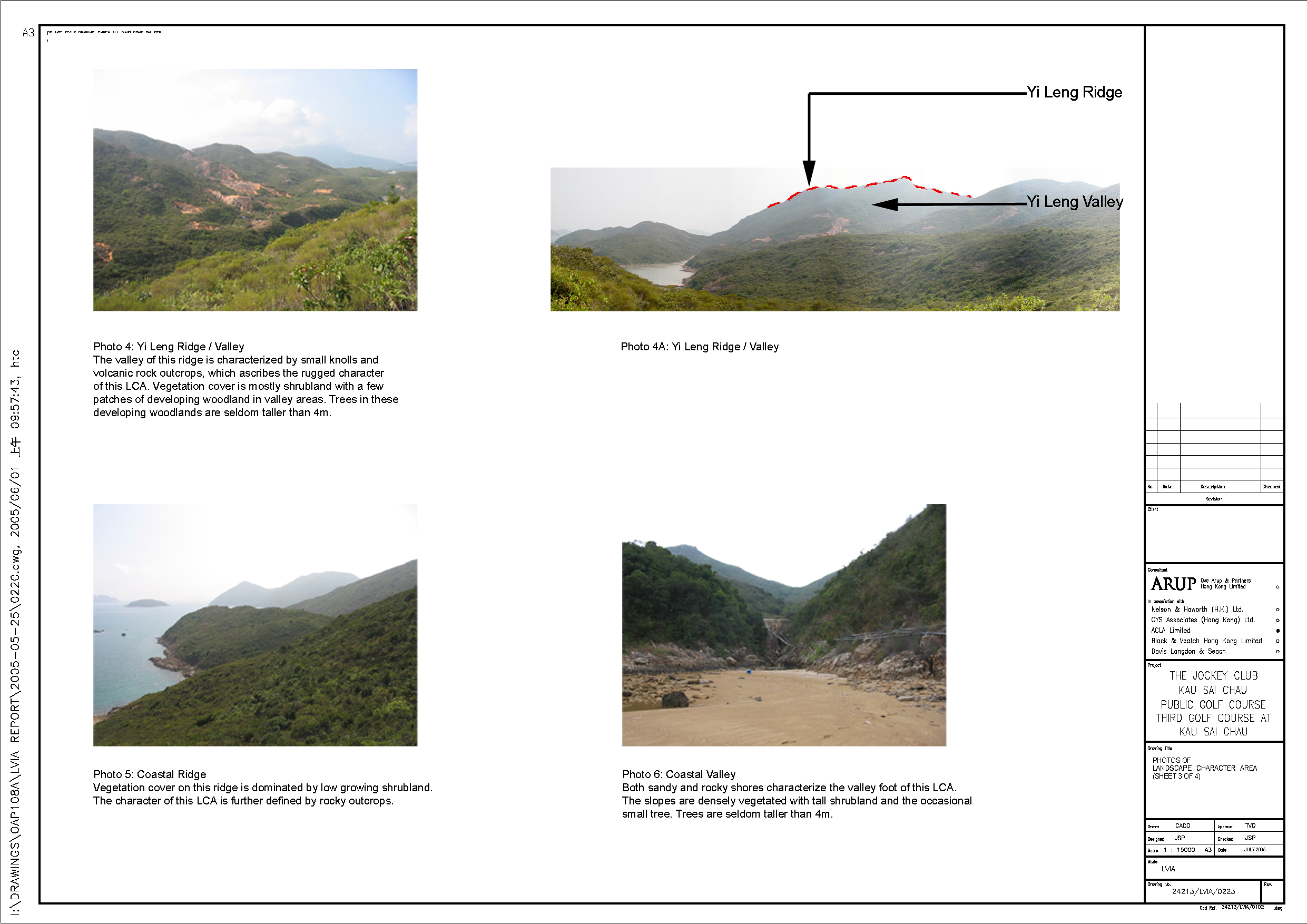
Figure 8.4 Photos
of Habitats and Species of Conservation Interest
Figure 8.6 Stream Crossings in form of Bridge and Underground Culvert
Figure 9.2 Marine
Assessment Area
Figure 9.3 Sites
of Marine Ecology Importance within Port Shelter WCZ
Figure 9.4 Location
of Sampling Sites
Figure 9.5 Distribution
of Chinese White Dolphin (Source: AFCD 2004b))
Figure 9.6 Distribution
of Finless Porpoise (Source: AFCD 2004b))
Figure 9.7 The
Original Design of Temporary Barging Point
Figure 9.8 The
New Design of Temporary Barging Point
Figure 9.9 First
option of Desalination Plant Pipelines
Figure 9.10 Second
Option of Desalination Plant Pipelines
Figure 11.1 Sampling
Locations for Land Contamination
|
Draft Tai Mong
Tsai and Tsam Chuk Wan Outline Zoning Plan No. S/SK-TMT-2 |
|
Figure 13.4 The
Two Study Areas for the golf course extension (North Section and Kap Law Kok)
%20copy.jpg)