7.7
Identification of Sensitive
Receivers
7.7.1
As part of the ecological survey data (reported in Section 4) most
of the proposed intake locations are located on concrete and polluted nullahs. A minor portion of them will be located
near natural streams. They
are THR(2), BR7(P), MA13(P) and MA14(P), TP789 (P), TP(5) and PFLR1(P). These locations will be identified as
potential inland water SRs.
7.7.2
At all intake locations, base flow upstream of the diversion
intakes will bypass the intakes and continue discharging into the downstream
watercourses. When the capacities
of the bypasses are exceeded during rainfall events, the excess runoff will
enter the diversion intakes. The
catchment areas are shown in Figure 7.1.
7.7.3
The operation of the tunnel system during rainfall events will have
the potential to directly affect water quality in the waters along the western
side of Hong Kong Island. SRs have been identified in these potentially affected
areas which are seawater intakes, fish culture zones and sites of ecological
interests. The relevant water SRs are shown in Figure 7.2. The identified SRs
in each of these categories are as follows:
·
Water Intakes:
WSD Kennedy Town seawater
intake, Queen Mary Hospital seawater intake, seawater intake at Wah Fu Estate, WSD water intakes at Cyperport.
·
Fish Culture Zones:
Lo Tik
Wan and Sok Kwu Wan
·
Sites of Ecological Interests (Corals):
Pak Kok,
Green Island, Luk Chau Wan
and Sok Kwu Wan
7.7.4
As the results of the water quality modelling carried out for the
present EIA clearly demonstrate, the discharge plume from the Western Portal
does not affect any other marine SRs beyond those
listed above and therefore only SRs listed above are
considered by the present EIA.
7.7.5
In addition to the identified SRs, there
is a number of open water monitoring stations including VM8, WM1, WM2, SM3 and
SM4 which have been considered in this study to assess water quality in the
marine waters potentially affected by the proposed Project operation
activities.
7.8
Assessment Methodology
7.8.1
To assess the potential impacts on water quality and the
associated risks to the marine environment, a comprehensive desktop study
covering the following aspects has been carried out:
·
Identify water SRs and users which may
be impacted by the proposed work and the assessment criteria to be complied
with.
·
Identify potential sources of water quality impacts that may be generated
during the construction and operation phases.
·
Identify the baseline water quality at SR locations when the
tunnel system becomes operation in 2012.
·
Assess potential impacts upon the identified water SRs during the construction and operation phases.
·
Provide actions/remedial measures that need to be implemented to
reduce impacts to acceptable levels and best site management practices.
·
Evaluate residual impacts and identify the requirement for the
preparation of an Environmental Monitoring and Audit manual.
7.9
Potential Impacts during
Construction
Source of Impacts
7.9.1
Siltation generated by different construction
Construction of Temporary Berthing
Point at Western Outfall
7.9.2
In order to reduce the inland traffic, a temporary pier with
dimensions of
Construction of Stilling Basin
at Western Portal Outfall
7.9.3
The proposed Western Portal and associated features are located on
the west coast of Hong Kong Island, beneath an existing multiple-span bridge
which is part of the Northern Access Road.
Immediately downstream of the Western Portal is the stilling basin
(Figure 7.4).
7.9.4
There will be a discharge from the Western Portal during various
storm events. Before discharging
the diverted rainstorm water from intakes to the sea, the stilling basin will effectively
reduce the flow’s energy to avoid unnaturally high currents along the immediate
coastline that may cause erosion and impact on sea life.
7.9.5
Blasting in combination with tunnel boring methods will be adopted
for construction of the tunnel exit at Kong Sin Wan. The stilling basin will
then be constructed after completion of the tunnel. The stilling basin will be
constructed by open excavation method.
A temporary cofferdam in the form of sheet piles around the basin will
first be constructed prior to bulk excavation for the basin. All construction for the basin will be
carried out inside the temporary cofferdam.
7.9.6
The proposed invert level of the stilling basin is -5.4 mPD and therefore a watertight cofferdam in the form of sheet-pile
wall outside the stilling basin will be constructed prior the construction of
basin. The cofferdam will be
dewatered to provide a
7.9.7
Following the construction of stilling basin the temporary pier
will be demolished and an armour rock panel (about 25m x
7.9.8
Details of the construction method for the stilling basin and
temporary berthing point are shown in Appendix H (Attachment I).
Construction of Intakes
7.9.9
The main construction activities which have the potential to
impact on the water bodies along the proposed drainage tunnel are those which
may result in generation of silt.
This is likely at all intakes owing to the construction of the intakes
within rock however there is slightly more potential for silt to be generated
at sites that are very shallow (<
7.9.10
Most of the excavated spoil will be disposed at either
portal. The estimated total
quantity of excavated spoil from the proposed drainage tunnel will be about 524,000m³. It will then be removed through road
access at Eastern Portal and by marine access at the Western Portal. Excavated spoil will be disposed of as
separate waste materials to public fill and/or landfill properly, as described
in the Waste Chapter.
7.9.11
Excavated spoil will be transported within the tunnel by using a
conveyor system that terminates at either portal where the spoil will be
immediately transported away or unloaded to a temporary stockpile area. The conveyor will be covered on 3 sides
and the discharge point to the stockpile area will be fully enclosed. For the construction of intakes, many drop
shafts will be excavated using the raised boring method, thus, most of the
excavated spoil will not be stored or exposed to the surface of the
construction sites.
7.9.12
Suspended solids run-off (turbidity) and nutrient loading may
increase and enter adjacent watercourse due to the increase of site exposure,
reducing light penetration and affecting aquatic organism in the waterbody and downstream. With the proper handling and disposal
procedures, impacts from this source are likely to be minimal.
General Construction Activities
and Workforce
7.9.13
Water quality may be affected during construction period as
follows:
·
Wash water from dust suppression activities and wheel washing
facilities.
·
Domestic sewage and waste generated by work force.
·
Construction waste being washed off-site by surface runoff.
·
Run-off and erosion from site surfaces, earth working areas,
material stockpiles and drainage channels.
·
Accidental chemical/fuel/oil spillages from vehicle and plant
usage and maintenance.
7.10
Evaluation of Potential Impacts
during Construction phase
Construction of Temporary Berthing
Point at Western Outfall
7.10.1
The construction/demolition period for the temporary berthing
point is short (less than 2 months) and no reclamation is required. However, the construction of a temporary
pier may lead to the suspension of fine material which, if uncontrolled, can lead
to a rise in the suspended solid level around the area. Removal activities can also disturb the
bottom sediments. The water quality
impact will likely be localised and temporary and no long term deterioration is
expected.
Construction of Stilling Basin
at Western Portal Outfall
7.10.2
A watertight cofferdam, in the form of a sheet-pile wall around
the outside of the stilling basin, will be constructed prior to the
construction of the stilling basin.
So seawater is unlikely to be impacted by the stilling basin
construction. After the cofferdam
construction is completed and before the construction of stilling basin, dewatering
the silty water within the cofferdam area is
required. Water should be pumped to
a sedimentation tank or settling devices before discharging to the sea in order
to reduce the water quality impacts to seawater. The contractor should ensure discharge
water from the sedimentation tank meet the WPCO/TM requirements before discharging
to the sea.
Construction of Tunnel and Intakes
7.10.3
Ground excavation will be carried out at few shallow intakes with
most drop shafts being excavated using the raise boring method. This means that most major works will be
carried out at both portals.
Potential impacts on water quality will depend on the nature of the
material excavated and the runoff that can enter these watercourses. Other pollutants, such as oil and grease
and chemicals, may also be present in the run-off where it flows over storage
or maintenance areas. With proper
implementation of mitigation measures and good site practices, no significant
impact to the water quality is expected.
7.10.4
Volcanic rock will be encountered in most sections of the proposed
drainage tunnel which may require more frequent maintenance of the TBM cutter
head. Recycle water is also
required for the cooling of the cutter head during boring. All discharge will be conveyed to
sedimentation tanks for treatment prior to proper disposal. With implementation
of mitigation measures, no significant impact to nearby water SR is expected. Sections of tunnel alignment will
be underneath Country Parks. Prior to
tunnel excavation, ground treatment works will be carried out. Therefore it will not cause unacceptable
variation in underground watertable during tunnel
construction.
7.10.5
As far as practicable, the construction of the intakes and drop
shafts is planned to take place during the dry season when ground water levels
are typically low. Also, volcanic rock will be encountered at most intake and
drop shaft sites, which generally mean that the presence of groundwater should be
minimal. Therefore, impact on the local groundwater is not expected during the
construction phase. All intakes and
drop shafts are located outside the Country Parks. Therefore variation of underground watertable during intakes and drop shaft construction is
not expected.
General Construction Activities
and Workforce
7.10.6
Unmitigated surface runoff can lead to incidents of increased levels
of SS, oil and grease content, turbidity, BOD5 and nutrient
enrichment at nearby watercourses.
This may result in a reduction of light penetration and dissolved oxygen
which may reduce the assimilative capacity of the receiving waters for various
organic and inorganic pollutants.
7.10.7
Potential floating refuse problems entering the water column,
which may be aroused by site-generated debris and rubbish, would reduce the
aesthetic quality of the receiving water body. However, with proper site waste
management it can be well controlled and properly disposed. Also, with the appropriate storage and
handling of chemicals/lubricants/oil and grease, the risk of accidental
chemical losses to environment is expected to be low.
7.11
Mitigation Measures
Precaution Measures for Construction
Work Near Natural Streams
7.11.1
For the proposed drainage tunnel, most of the intakes are located in
urban areas. Moreover, the small
affected stream portion is located at the very downstream end of the natural stream
(immediately near to residential/urban area). The government provides guidelines (ETWB
TCW NO. 5/2005 and DSD TC 2/2004) to minimize impacts when there is
construction work carried out at near natural streams course. Relevant mitigation measures for the
intakes are summarised as follows:
·
Temporary site access to the work sites should be carefully
planned and located to minimize disturbance caused to the substrates of
streams/rivers and riparian vegetation by construction plant.
·
Locations well away from the rivers/streams for temporary storage
of materials (e.g equipment, filling materials,
chemicals and fuel) and temporary stockpile of construction debris and spoil
should be identified before commencement of works.
·
Proposed works areas inside, or in the proximity of, natural
rivers and streams should be temporarily isolated to prevent adverse impacts on
the stream water quality.
·
Stockpiling of construction materials, if necessary, should be completely
covered and located away from any natural stream/river.
·
Construction debris and spoil should be covered up and/or disposed
of as soon as possible to avoid being washed into nearby rivers/streams by rain
and local runoff
7.11.2
For construction works to be carried out in the vicinity to
natural stream course, any effluent generated including surface runoff shall be
properly treated to WPCO-TM requirements and the effluent should be diverted
away from the natural stream.
Construction of Temporary Berthing
Point at the Western Portal
7.11.3
Throughout the construction works at the Western Portal (including
stilling basin and temporary berthing point), the contractor shall implement
mitigation measures and ensure that the impact on the water quality is within
acceptable standard.
7.11.4
Prior to the construction of the temporary berthing point, a silt
curtain shall be constructed to minimize sediment migration. The respective areas of the marine works
will be completely enclosed by the silt curtain. The curtain shall be extended from water
surface down to the seabed where it is anchored using sinker blocks. The Contractor shall inspect the silt
curtain on regular basis to ensure its integrity and it is serviceable for all
times. It is expected that there is
no noticeable impact on water quality during construction.
7.11.5
Transfer of armour rock onto the seabed from barge at the
temporary pier location should be conducted by careful grabbing and unloading
to the seabed (to minimize sediment migration), thereby minimize impacts on
water quality in the receiving waterbody and
disturbance to the seabed.
7.11.6
During the construction of the proposed drainage tunnel, excavated
spoil will be transported at the Western Portal to the temporary berthing point
for disposal. The conveyor belt
should be completely covered and muddy effluent from the temporary barge should
be contained, treated and disposed of for compliance with WPCO requirements. Where there is transfer of excavated
wastes, the Contractor should provide appropriate measures to ensure that the
waste is free from floatables, putrescibes,
organic wastes and toxic materials and when required a refuse collection vessel
be provided to collect float refuse.
With these measures and with the correct installation of the silt
curtain, water quality impacts during construction phase should not be
anticipated.
Construction of Stilling Basin
at Western Portal Outlet
7.11.7
All construction for the basin should be carried out inside the
temporary cofferdam which is a temporary watertight enclosure built in the
water and pumped dry to expose the bottom so that construction of stilling
basin can be undertaken. A
cofferdam is composed of steel pilings driven into the seabed level to form a
watertight structure around the stilling basin area. The cofferdam not only
prevents water from entering the work area, but it prevents excavated and
drilled material escaping to the open seawater. After excavating within the cofferdams,
the seal courses would be placed to allow de-watering of the work area within
the cofferdams. After the seal
courses and cofferdams are in place, the water would be pumped from the
cofferdams.
7.11.8
During the dewatering process, appropriate desilting/sedimentation
devices should be provided on site for treatment before discharge. The Contractor should ensure discharge
water from the sedimentation tank meet the WPCO/TM requirements before
discharge.
7.11.9
The use of the cofferdam is essential to avoid impacts to the
marine SRs.
The cofferdam should be constructed to minimize contact of the works
area with the surrounding water body.
The cofferdam will remain on site until after the construction of
stilling basin has been completed.
The coffer dam shall be regularly inspected and maintained to ensure no
spillage of waste or wastewater into the sea. Conveyance of dredged materials from the
coffer dam shall be carried out cautiously to avoid spillage into the sea.
7.11.10
The filled material for the stilling basin should be contained
inside the temporary cofferdam. The
top level of the cofferdam shall be constructed higher than the final
backfilled level. With this
measure, potential spillage of fill material will be avoided.
7.11.11
In order to minimize any adverse impacts during construction of
the cofferdam to identified SRs, where appropriate,
silt curtains should be utilized to minimize sediment migration. The Contractor shall be responsible for
the design, installation and maintenance of the silt curtains to minimize the
impacts on the water quality and the protection of water quality. The design and specification of the silt
curtains shall be submitted by the Contractor to the Engineer for approval.
7.11.12
Indicative locations and details of cofferdam and silt curtains
are shown in Figures 7.4 and 7.5a. A typical suspended solids reduction of 75%
can be achieved with the incorporation of silt curtain. Two-layer silt curtains
have generally been used for dredging projects of larger scale to further
ensure this reduction. However, as the scale of proposed project is relatively small,
it is recommended to use only a single layer silt curtain.
7.11.13
Silt curtains shall be formed from tough, abrasion resistant,
permeable membranes, suitable for the purpose, supported on floating booms in
such a way as to ensure that the sediment plume shall be restricted to within
the limit of the works area. The
silt curtain shall be formed and installed in such a way that tidal rise and
fall are accommodated, with the silt curtains always extending from the surface
to the bottom of the water column and held with anchor blocks. The contractor shall regularly inspect
the silt curtains and check that they are moored and marked to avoid danger to
marine traffic. Any damage to the silt curtain shall be repaired by the
Contractor promptly and the works shall be stopped until the repair is fixed to
the satisfaction of the Engineer.
7.11.14
Although impacts from the construction of the armour rock based
panel are likely to be minimal, care should be taken to avoid suspended solids
re-suspension from the seabed during the construction process. Transfer of rock fill material (armour
rock) from the barge onto the site location should be conducted by grabbing and
placement on the seabed to minimize sediment migration. No free dropping of the
material will be allowed.
7.11.15
Prior to the construction of armor rock
based panel, a silt curtain shall also be installed prior to carry out any
marine works as a preventive mitigation measure. It is expected that there is no
noticeable impact on water quality during construction. The respective areas of the marine works
will be completely enclosed by the silt curtain.
Construction of Tunnel at Both Portals
and Intakes
7.11.16
The bored tunnel operation has been designed to minimize impacts
on water quality. Recycled water
will be used at the cutter face for cooling purposes. Used water will be collected and
discharged to a settling tank for settlement. Excess water from the settling tank will
be transferred to the water treatment plant on site where the addition of
flocculants will assist in settlement of solids. The Contractor should ensure discharge
water from the sedimentation tank meet the WPCO/TM requirements before
discharge.
7.11.17
The intake shaft shall be constructed by raise boring machines. A typical intake layout structure is
shown in Figure 7.5b. No works will
commence until the completion of the tunnel construction. The main operation procedures for raise
boring are:
·
Set up the raise boring machine at ground level
·
Sink down a pilot drill hole down and break through the soffit of tunnel/adit
·
Dismantle the pilot bit and a reamer head is connected to the
drill rod inside the tunnel/adit
·
Up-reaming commences from the bottom and travel up-wards to the
ground level
·
During the up-reaming process, the excavated material is dropped
to the tunnel/adit invert. The excavated material is transported by
conveyor belt system inside the tunnel to the portals for proper disposal
·
The up-reaming process ends when the whole intake drop shaft is
formed
7.11.18
No storing of earth material on ground level is required by the
raise boring method. During the
drilling process, all flushing water will be recycled for use. Discharge of the treated water to nearby
drainage system shall be allowed provided that it has been treated to a level
meeting with statutory requirements.
7.11.19
Water flow at streams should be maintained by a temporary
diversion system during the construction phase of intakes and drop shafts. With the addition of appropriate site
runoff control practices this should prevent construction effluent from
entering the downstream watercourses.
7.11.20
Spent effluent arising from tunnel boring shall be treated with
adequately designed and maintained sedimentation tank to WPCO-TM
standards. Works carried out in the
vicinity to natural stream courses shall be carried out cautiously to avoid
disturbance to the natural habitats and the flora and fauna therein. All tunnel boring effluent shall be
diverted away from the stream course.
General Construction Activities
and Workforce
A. Surface Runoff
7.11.21
Effluent produced from construction activities are subjected to
WPCO control. Effluent produced from sites would be treated before discharging
to the nearby sewerage system. Where practicable, construction works near
stream course should be scheduled in the dry season to avoid excessive site
runoff discharge.
7.11.22
Potential run-off from construction activities (e.g. site
formation and excavation mainly) must be minimized to avoid impacts on adjacent
watercourses. Under the WPCO,
turbid water from construction sites must be treated to minimize the solids
content before being discharged into storm drains. The suspended solids load can be reduced
by directing the runoff into temporary sand traps or other silt-removal facilities,
and other good and appropriate site management practices. Where surface runoff or construction
effluent is likely to be contaminated with oil, properly designed and
maintained petrol interceptor shall be provided to meet WPCO-TM
requirement. Advice on the handling
and disposal of construction site discharge is provided in the ProPECC Paper (PN 1/94) on Construction Site Drainage.
7.11.23
A drainage system layout should be prepared by the Contractor for
each of the works areas (portals and intakes), detailing the facilities and
measures to manage pollution arising from surface runoff from those works
areas. The drainage layout and an
associated drainage management plan to reduce surface runoff sediments and
pollutants entering watercourses, should be submitted to the Engineer for
approval.
7.11.24
The system should be capable of handling stormwater
from the site and directing it to sediment removal facilities before
discharge. If oil and grease is
used on the site or brought to the site, the stormwater
should pass through oil interceptors before discharge. The interceptors should have a bypass to
prevent washout in heavy storms.
7.11.25
A temporary channel system or earth bunds or sand barriers should
be provided in works areas on site to direct stormwater
to silt-removal facilities.
Stockpiled materials, if susceptible to erosion of rain or wind, should
be covered with tarpaulins (or similar fabric) or hydroseedings
as far as practical especially during the wet season.
7.11.26
Silt removal facilities should be checked and the deposited silt
and grit should be removed regularly to ensure these facilities are in good
working condition and to prevent blockages.
7.11.27
Vehicle washing areas should be drained into a settlement basin to
settle out the suspended solid before discharging to storm water drains. The water should be recycled on site
whenever possible. It is suggested
that the wash water from the wheel wash basin is either reused for road
watering or pumped to the on-site settling tanks for treatment. Water used for dust depression purposes
should be minimized as far as practicable; and an alternative soil holding
agent should be considered.
B. Spillage, Oil and Solvents
7.11.28
Any contractor generating waste oil or other chemicals as a result
of his activities should register as a chemical waste producer and provide a
safe storage area for chemicals on site.
Oil interceptors need to be regularly inspected and cleaned to avoid
wash-out of oil during storm conditions.
A bypass should be provided to avoid overload of the interceptor’s
capacity.
7.11.29
Any spillage of oils and chemicals shall be properly handled in
accordance with the requirement stipulated under the Waste Disposal (Chemical
Waste) (General) Regulation. Spills
should be contained to avoid spreading and contaminating the water resources.
7.11.30
Oil and fuels should be used and stored properly in designated
area. All fuel tanks and storage
areas should be provided with locks and be sited within sealed areas surrounded
by bunds with a capacity equal to 110% of the storage capacity of the largest
tank.
7.11.31
Good housekeeping practices are required to minimize careless
spillage and keep the work space in a tidy and clean condition. Appropriate training, including safety
codes and relevant manuals, should be given to the personnel who regularly
handle the chemicals on site.
C. On-Site Effluent Generation
7.11.32
Sewage arising from the additional population of workers on site
should be collected in a suitable storage facility (chemical mobile toilets). Most of the work site locations are
close to the public sewerage system and therefore the use of septic tanks are not
encouraged. Portable toilets should
be used coupled with tankering away services provided
by a licensed collector. They
should be positioned at appropriate locations across the site to ensure no
direct discharge of foul water off-site.
D. Protection of Existing Flora
and Fauna
7.11.33
The Contractor should provide details of the plant and operation
organisation each site’s for approval by the Engineer before commencing
construction. The plans should
include how the existing flora and fauna will be protected. As part of the groundwater monitoring
programme groundwater levels at intake sites on key natural watercourses shall
be monitored both during the construction period and for the first year that
the tunnel scheme is operation, to ensure that the groundwater regime, and its
interaction with existing flora and fauna, is not adversely affected.
7.12
Residual Impacts
7.12.1
With the appropriate adoption of proper mitigation measures during
the construction for stilling basin, temporary pier, tunnel and intakes, any
potential impacts should be minimized.
Therefore, no significant impacts on the water quality are expected.
7.12.2
The construction and demolition of the temporary pier may create
short term impacts on the local marine water quality. However, the situation will be restored
once the work is finished. By
proper phasing of the works programme and implementation of the adequate
mitigation measures (e.g. silt curtain) the impacts will be minimized.
7.12.3
The water discharge from site is subject to the control of the
WPCO. The Contractor must obtain a
discharge license prior to the commencement of the construction who is obliged
to comply with the standards set out in the license which specifies the maximum
allowable limits for the parameters of concern in the discharge. The Contractor also has the responsibility
to design, operate and monitor the performance of any on-site treatment
systems.
7.12.4
If the identified mitigation measures are properly applied it is
anticipated that impacts will be minor, temporary and localised. Moreover, no significant impacts upon
the existing seawater intakes, drain outfalls or either marine or fresh water
ecology are predicted.
7.13
Potential Impacts during Operation
Phase
7.13.1
The proposed intakes to the tunnel scheme include provision for
the bypass of baseflows to the existing downstream
drainage system. This means that the
tunnel is only operation during storm events when runoff will be diverted into
the tunnel system and consequentially discharge to the Western Portal during
storm events (preliminary design of the proposed intake structure is presented
in Appendix G).
7.13.2
The operation of the proposed drainage tunnel will result in
pollutant laden stormwater discharging to the marine
water at the Western Portal outfall.
It should be noted that the overall water and pollutant fluxes to the
Hong Kong marine waters will not be changed, but they will be released in one
point (proposed Western Portal at Kong Sin Wan), rather than in a diffuse way (across
the lower catchment of northern Hong Kong Island). The concentrations of pollutants that
are likely to discharge to the Western Portal are discussed further in Appendix
G where there are details on the estimation of the pollutant and sediment
loads.
7.13.3
Based on the result of the estimated pollutant and sediment loads
to the marine water at the Western Portal, only fresh water salinity, E. coli and suspended solids will be
investigated using a Water Quality Model.
Comparisons between the estimated pollutant loads against Water Quality
Objectives will also be discussed in following section for pollutant parameters
which are not quantitatively assessed by modelling,
7.13.4
The flow diverted into the tunnel system may also convey floating
objects such as vegetation (including leaves), plastic bags and other forms of
litter, although for plastic bags and litter there is unlikely to be large
amount because the catchments are mostly natural or country parks. Care has been taken to minimise the amount
of vegetation entering the tunnel system which may affect the aesthetic
appearance WQO mentioned in Table 7.2.
Note that vegetation will not cause objectionable odours or
discolouration of the water. Furthermore
there should be no oil, surfactants, sewerage-derived debris, floating objects
that are likely to interfere with the movement of vessels, or substances that
settle to form objectionable deposits in the flow discharging from the Western
Portal. Notwithstanding the aforementioned,
some vegetation may discharge from the Western Portal which may create an
adverse aesthetic impact.
7.13.5
During operation of the tunnel system the intakes will divert
runoff from the upstream catchments that currently discharge into the existing
downstream watercourses and drainage systems. To avoid these watercourses from drying
and causing ecological and odour problems, the proposed intakes include a provision
for the bypass of baseflow. This means that the intakes will only
divert flow to the Western Portal during rainfall events.
7.14
Evaluation of Potential Impacts
during Operation Phase
7.14.1
The mathematical modelling activities are intended to support the
analysis of the effects on the marine water quality of storm water discharges
during the operation phase of the proposed drainage tunnel at Western Portal.
7.14.2
During the operation phase of the proposed drainage tunnel, flood
flow from streams within the study area will be diverted up to the 200-year
storm event, conveyed by the proposed drainage tunnel system and discharged via
the Western Portal outfall to the sea at Kong Sin Wan. The stream’s base water flow (dry
weather flow) will bypass the intakes, and continue flowing downstream along
their existing watercourses. Most
of the pollution loads together with the storm flow will be diverted from
intakes to the Western Portal outfall only during rain storm events.
7.14.3
Many of the sampling points (proposed intake locations) are
located at urban areas where are already channelised
or affected by human activities to different extents. Some of the water samples contained
relative high concentrations of E. coli
and SS due to the vicinity of those intakes located within built up
residential/school/community areas.
7.14.4
For estimation of pollutant loading to the Western Portal and to
quantify the water quality impacts to marine environment, the present
methodology assumes all stream flow is diverted into the proposed drainage
tunnel and will be discharged at the Western Portal outfall during different
rain storm events. Therefore, the water
quality impact is assessed for the wet season only (the wet season occurs from
April to September inclusive) when significant rainstorm events are expected to
occur.
7.14.5
Stream sampling of a number of pollutants was carried out at 13
intake locations during dry-weather and wet-weather flows. The main pollutants that were identified
for testing are suspended solids, Oil and Grease, BOD5, Total
Organic Carbon, Total Kjeldahl Nitrogen, Nitrate,
Ammonia Nitrate, Total Phosphorus, Orthophosphorus, E-coli and Chlorophyll-a. Analysis of the sampling results
indicates that both their dry-day and wet-day concentration loadings are low. The major reason being that about 80% of
the catchment is located within both the Country Park and the water supply catchwaters.
7.14.6
Inherently, the water quality model will consider the relative
changes in suspended solids, E. coli
and salinity owing to the discharge of storm water (freshwater) from the
Western Portal for the proposed drainage tunnel.
7.14.7
Very short term episodes and processes will predominantly determine
the impact of the proposed drainage tunnel on the marine environment.
Therefore, the focus of the water quality modelling will be on the transport
and dispersion of the drainage water in the vicinity of the drainage tunnel
outfall following individual storm events.
The model covers the Southern and Southern Supplementary, Victoria
Harbour, Eastern and Western Buffer Water Control Zones as designated under the
Water Pollution Control Ordinance.
7.14.8
Under the first phase of the Harbour Area Treatment Scheme (HATS)
Stage
7.14.9
The existing Western Harbour Model (WHM) was used for the modelling
assessment. The application of the Delft3D modelling suite has been accepted by
the HKSAR government in previous studies, and is available with WL | Delft
Hydraulics. The WHM is based on and
nested in the so called “Update Model” which was prepared by a consortium led
by Hyder, including WL | Delft Hydraulics.
7.14.10
For the simulation of the spreading of the Drainage Tunnel’s
outfall plume, the particle tracking model Delft3D-PART was applied using the
flow field produced with Delft3D-
Water Levels and Currents at
the Discharge Point
7.14.11
The definition of the “ebb” and “flood” discharges was based on a
simulated tidal flow direction at a location (WM1) in the Lamma
Channel, northwest of the discharge point. The “flood” discharge was started when
the tide turns and flows in a northwest direction at location WM1 (25 July,
5.00h), while the “ebb” discharge was started when the tide turns and flows in
a southeast direction at location WM1 (25 July,11.00h).
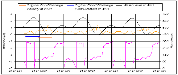
7.14.12
The water levels at the location of the discharge show a small
phase shift as compared to location WM1. The precise timing of the discharges in
relation to the local water level is shown in Figure 7.6 along with the tidal
velocity and direction.
Figure 7.6 Flood and Ebb
Water levels
7.14.13
The direction of current at the discharge point during the
discharge event is also shown in Table 7.5. The ebb tide discharges are
characterised by a southeast current during the initial stage of the discharge,
followed by predominantly northwest current from 13.00h onwards, which is just
before the peak flow of the discharge.
7.14.14
The flood tide discharges are characterised by a northwest current
during the initial stage of the discharge, followed by southeast currents from
about 8.00h onwards, which is just after the peak flow of the discharge.
Table 7.5 Characteristic of Ebb
and Flood Discharges
|
|
Ebb-discharge |
|
Flood-discharge |
||
|
|
1/2 year |
1/50 year |
|
1/2 year |
1/50 year |
|
25-07-25 11:00 |
SE |
SE |
25-07-25 5:00 |
NW |
NW |
|
25-07-25 12:00 |
SE |
SE |
25-07-25 6:00 |
NW |
NW |
|
25-07-25 13:00 |
NW |
NW |
25-07-25 7:00 |
NW |
NW |
|
25-07-25 14:00 |
NW |
NW |
25-07-25 8:00 |
SE |
NW |
|
25-07-25 15:00 |
NW |
NW |
25-07-25 9:00 |
SE |
SE |
|
25-07-25 16:00 |
NW |
NW |
25-07-25 10:00 |
SE |
SE |
|
25-07-25 17:00 |
SE |
SE |
25-07-25 11:00 |
SE |
SE |
|
25-07-25 18:00 |
NW |
NW |
25-07-25 12:00 |
SE |
SE |
Baseline Conditions
7.14.15
There is a period of about 2 years between 2012 and 2014 when both
the tunnel scheme and the Cyberport
7.14.16
The working paper “Performance Verification of Cyberport
Sewage Outfall – Investigation: Working Paper on Effluent Plume Modelling
(Final)”[5] has modelled the likely WQ of the Lamma Channel in the vicinity of the Western Portal and
provides WQ information on SS and E.coli near the SRs identified
under the present study. This
information is used in the present EIA as the baseline conditions and these
values appear in Tables 7.8a&b and 7.9a&b. The absolute concentration loadings
modelled as part of the present EIA are added to the baseline conditions to
assess the cumulative concentration loadings. Note that the baseline concentration
values taken from the report “Performance Verification of Cyberport
Sewage Outfall – Investigation, Working Paper on Effluent Plume Modelling
(Final)” in which year 2016’s (HATS Year X) bathymetry and coastline were
assumed with effluent loadings of the then SSDS Stage 1 outfall, Tathong Channel, Rambler Channel and sewage outfalls near
the western outfall incorporated.
This baseline is not exactly the ‘natural ambient level’ as stipulated
under the WQO/WPCO.
7.14.17
The following is a brief summary of the estimated Cyberport STW submarine discharge in the Year 2016:
·
The maximum discharge flow rate of the Cyberport
STWs is 9,807 m³ per day which will be discharged
through a diffuser on the sea floor.
·
The estimated E.Coli concentration discharging from the Cyberport
·
The estimated concentration of Total Suspended Solids within the daily
discharge of the Cyberport STW is 73.9 mg/L
Suspended Sediments
7.14.18
Impacts from SS may be caused by sediment plumes being transported
to sensitive areas, such as water intakes, FCZ and areas of high ecological
values (corals). There may be a
possibility of those SRs which are likely to be
affected by increased SS concentrations from the proposed drainage tunnel
during its operation phase.
7.14.19
The Delft model predicts the extent and movement of the sediment
plumes along with the concentration of SS.
The model will determine the impact to those SRs.
7.14.20
The WQOs of the waste discharge shall
neither cause the natural ambient level to be raised by more than 30% nor give
rise to accumulation of SS which may adversely affect aquatic communities. The predicted maximum values from the
water quality model of those SRs will be compared
with 30% tolerance values to determine acceptability of the impacts.
7.14.21
In addition to the above criteria for suspended solids, the
seawater intakes which have been defined as SRs have
specified SS criteria to protect abstraction systems and maintain appropriate
water quality for the designated use.
The SS concentration should be maintained below 10 mg/L for WSD seawater
intakes. In addition, a pragmatic guideline
of controlling SS concentrations to below 20 mg/L at flushing and cooling water
intakes has been used on a number of other EIA projects in and around Victoria
Harbour.
7.14.22
As the seawater intakes are normally located at mid-depth or
above, the assessment criteria for the seawater intakes has been based on the
pollution levels at the surface layer.
Sediment Deposition
7.14.23
Impacts from SS may be caused by sediment plumes being transported
to the SRs, leading to the elevation of the SS levels
at the SRs.
Following an EIA prepared for Sand Dredging at the West Po Toi Marine Borrow Area, a limit on the coral sedimentation
rate of 0.1 kg/m²/day is applied to this EIA. Sediment deposition can adversely impact
on ecological SRs, namely corals that are located at
the bottom of the water column.
Therefore, the results of the WQ model consider the concentration of SS
at the sea floor and the rates of deposition.
Bacteriological Indicator, Escherichia Coli
7.14.24
The presence of E.coli in the seawater is considered as a clear indication
of faecal contamination and the possible presence of other pathogens. The WQO standard of E. coli is an annual geometric mean that should not exceed 610
cfu/100mL in secondary contact recreation area and fish culture zones. Both of these are located across the
full extent of the water column and therefore the WQ modelling results consider
the depth-average results. In
addition, E. coli levels of seawater
intakes for flushing should not exceed 20,000 cfu/100mL which is measured at
the surface layer.
Salinity
7.14.25
For general information only Table 7.6 represents the background
salinity at 5 regular
Table 7.6
Pre-project Background Water
Quality (Salinity) at Various Sensitive Receivers
|
Sensitive receivers |
|
Depth Average |
Surface |
|
(Relevant |
|
ppt |
ppt |
|
Pak Kok
(Coral) |
N* |
20 |
20 |
|
Cyberport Intake |
Average# |
30.5 |
25.1 |
|
Wah Fu Estate Intake |
Min^ |
26.7 |
13.0 |
|
(WM1) |
Max^^ |
33.8 |
33.6 |
|
Green Island (Coral) |
N* |
20 |
20 |
|
Queen Mary Hospital Intake |
Average# |
28.9 |
24.9 |
|
|
Min^ |
24.2 |
14.3 |
|
(WM2) |
Max^^ |
33.5 |
33.1 |
|
Luk Chau
Wan (Coral) |
N* |
14 |
14 |
|
Lo Tik
Wan (FCZ) |
Average# |
31.5 |
27.8 |
|
(SM3) |
Min^ |
29.8 |
21.1 |
|
|
Max^^ |
33.7 |
33.6 |
|
Sok Kwu
Wan (Coral) |
N* |
14 |
14 |
|
Sok Kwu
Wan (FCZ) |
Average# |
30.4 |
28.2 |
|
(SM4) |
Min^ |
28.2 |
22.3 |
|
|
Max^^ |
33.7 |
33.6 |
|
Kennedy Town WSD Intake |
N* |
20 |
20 |
|
(VM8) |
Average# |
29.6 |
27.6 |
|
|
Min^ |
25.3 |
21.0 |
|
|
Max^^ |
33.3 |
33.2 |
Remarks:
* : wet season
water quality conditions at 5 regular
# - Average value of 5 years at
^ - Minimum value at
^^ - Maximum value at
Leaves within the Tunnel System
7.14.26
The quantity of leaves that may enter the tunnel is not quantifiable
by modelling since their presence is dependent on a large number of variables
that vary widely. Therefore, the
present study only simply assumes that leaves will be present in the tunnel
discharge.
Water
Quality Modelling
7.14.27
The
7.14.28
The Delft3D-
Scenario 1 : 1 in 50 years storm events discharge (wet season, Spring and ebb
tide), which simulated the SS, E. coli
and salinity following the implementation of proposed drainage tunnel in 2012;
Scenario 2: 1 in 50 years storm events discharge (wet season, Spring and
flood tide), which simulated the SS, E.
coli and salinity following the implementation of proposed drainage tunnel
in 2012;
Scenario 3: 1 in 2 years storm events discharge (wet season, Spring and ebb
tide), which simulated SS, E. coli
and salinity following the implementation of proposed drainage tunnel in 2012;
Scenario 4: 1 in 2 years storm events discharge (wet season, Spring and flood
tide), which simulated SS, E. coli
and salinity following the implementation of proposed drainage tunnel in 2012;
7.14.29
For the pollutant concentrations in the discharge at Western
Portal, Delft3D-Part simulations have been carried out for two pollutants: SS
and E. Coli. Furthermore, the impact of the discharge
on the salinity has been calculated with Delft3D-
Table 7.7
Pollutant Concentrations in the
Discharge at Western Portal
|
Scenario |
Flood Volume (m3) |
E Coli (cfu/100 ml /
total cfu) |
Suspended
Solids (mg/l / total
kg) |
|
1/2 years event |
273,345 |
425 / 1.156x10¹² |
124 / 33,895 |
|
1/50 years event |
844,752 |
140 / 1.156x10¹² |
124 / 104,750 |
7.14.30
Since the E. Coli is
derived from a constant source the total amount of E. Coli remains the same for both the 1 in 2 years and 1 in 50 year
storm events. Conversely however,
the concentration will change owing to the difference in rainfall-runoff
volumes. The estimated E. coli loading are derived in
estimation of pollutant and sediment reports (Appendix G).
7.14.31
An investigation of the sediment runoff from the catchments above
the intakes is discussed in Appendix G.
This analysis estimates a SS concentration loading of 124 mg/L. Since the sediment is from a source with
continuous supply (the earth) the concentration won’t change between runoff
events with different magnitudes but it will affect the total volume of
sediment runoff.
7.14.32
The discharge events cause very short episodes of reduced salinity
and elevated pollutant concentrations.
For this reason, maximum pollutant
concentrations and minimum salinity occurring at a certain location, at any
time during the event are used to characterize the impacts of the
discharge. These maximum value
areas are represented as a map of iso-concentration
contours which give a clear picture of the area potential affected, and the level
of the potential pollution impact.
These results are contained in the Appendix I of this report.
7.14.33
In general, the maximum concentration plots show a clear
picture. Relatively high pollutant
concentrations occur only in the direct vicinity of the Western Portal along
the coast NW and SE of the outfall.
As soon as the discharged storm water is entering the fast flowing and
deeper waters, it is diluted and the maximum concentrations drop sharply. In the flood scenarios, the impact is
strongest to the SE. While in the
ebb scenarios, the NW direction is affected strongest. In the ebb scenarios, the impacted area
tends to be smaller than in the flood scenarios.
7.14.34
In additional to the contour plots, the results are presented in
form of maximum concentrations occurring at SRs. This provides clear indication of the
potential impact on those SRs. Tables 7.8a and 7.8b show the
modelling result of maximum concentrations of SS at selected SRs for the 1 in 50 year and 1 in 2 year storm events,
respectively. Tables 7.9a and 7.9b show the modelling
result of maximum concentrations of E.
coli at selected SRs for the 1 in 50 year and 1
in 2 year storm events, respectively.
7.14.35
Each simulation has been run for a sufficiently long duration following
the storm discharge event in order to determine the spread of the plume. The storm discharge will occur on Spring
Tide Cycle.
7.14.36
The modelling results are shown in a series of contour plots and tables
at selected SRs as follows:
·
The maximum concentration of SS, on logarithmic concentration
scales;
·
The maximum deposition rate of SS;
·
The maximum concentration of E.
coli, on logarithmic concentration scales;
·
The minimum surface salinity, on a scale of < 10 ppt to > 30 ppt.
7.14.37
The use of logarithmic concentration scales allows the impact
assessment for different levels of pollution.
7.14.38
All plots present maximum/minimum values of vertically average
concentrations, except where it is mentioned otherwise.
Table 7.8a
Modelling Results of Net Suspended
Solids (Maximum Concentrations),
predicted SS Concentrations
with Background Values and the Respective Exceedance
Duration
during
|
Location
of sensitive receivers |
Baseline^ |
WQO |
Relevant |
1 in 50 yrs |
Cumulative |
Exceedance |
1 in 50 yrs |
Cumulative |
Exceedance |
|
(Position
in Water Column) |
Concentration |
30% increase |
Guidelines |
Max |
Max |
Time^^ |
Max |
Max |
Time^^ |
|
|
|
|
|
SS-Flood |
SS |
|
SS-Ebb |
SS |
|
|
|
(mg/L) |
(mg/L) |
(mg/L) |
(mg/L) |
(mg/L) |
(Min) |
(mg/L) |
(mg/L) |
(Min) |
|
Coral
(Bottom) |
|
|
|
|
|
|
|
|
|
|
Green
Island |
8 |
10 |
- |
0 |
8 |
- |
0 |
8 |
- |
|
Luk Chau Wan |
7 |
9 |
- |
0 |
7 |
- |
0 |
7 |
- |
|
Pak Kok |
8 |
10 |
- |
0 |
8 |
- |
0 |
8 |
- |
|
Sok Kwu Wan |
7 |
9 |
- |
0 |
7 |
- |
0 |
7 |
- |
|
Fish
Culture Zones (Depth Average) |
|
|
|
|
|
|
|
|
|
|
Lo Tik Wan |
8 |
10 |
50* |
0 |
8 |
- |
0 |
8 |
- |
|
Sok Kwu Wan |
7 |
9 |
50* |
0 |
7 |
- |
0 |
7 |
- |
|
Seawater
Intakes (Surface) |
|
|
|
|
|
|
|
|
|
|
Cyberport |
8 |
10 |
10** |
21 |
29 |
260 |
13 |
21 |
141 |
|
Kennedy
Town |
8 |
10 |
10** |
7 |
15 |
140 |
1 |
8 |
- |
|
Queen
Mary Hospital |
8 |
10 |
20# |
27 |
35 |
190 |
57 |
65 |
270 |
|
Wah Fu Estate |
8 |
10 |
20# |
23 |
31 |
80 |
10 |
18 |
- |
|
|
|
|
|
|
|
|
|
|
|
|
SM3 |
8 |
10 |
- |
2 |
10 |
- |
3 |
11 |
20 |
|
SM4 |
8 |
10 |
- |
0 |
8 |
- |
0 |
8 |
- |
|
VM8 |
8 |
10 |
- |
0 |
8 |
- |
1 |
8 |
- |
|
WM1 |
8 |
10 |
- |
0 |
8 |
- |
8 |
16 |
40 |
|
WM2 |
8 |
10 |
- |
0 |
8 |
- |
0 |
8 |
- |
Remarks: Bold and underline: Exceedance
WQO standards or relevant standard
* the water quality objectives
applicable to fish culture zones are that the SS level should not exceed 50
mg/l or a 100% elevation above the
maximum value recorded over the past five years whichever is the lower.
** WSD flushing water quality
guidelines for seawater intake
# Acceptable water quality for
seawater intake
^ Baseline concentration values
are taken from the report “Performance Verification of Cyberport
Sewerage Outfall – Investigation, Working Paper on Effluent Plume Modelling
(Final)”. Refer to Paragraph
7.14.16.
^^ The duration that the
Relevant Guidelines (or WQO if no relevant guidelines) is exceeded.
Table 7.8b
Modelling Results of Net
Suspended Solids (Maximum Concentrations),
predicted SS Concentrations
with Background Values and the Respective Exceedance
Duration during
|
Location
of sensitive receivers |
Baseline |
WQO |
Relevant |
1 in 2 yrs |
Cumulative |
Exceedance |
1 in 2 yrs |
Cumulative |
Exceedance |
|
(Position
in Water Column) |
Concentration |
30% increase |
Guidelines |
Max |
Max |
Time^^ |
Max |
Max |
Time^^ |
|
|
|
|
|
SS-Flood |
SS |
|
SS-Ebb |
SS |
|
|
|
(mg/L) |
(mg/L) |
(mg/L) |
(mg/L) |
(mg/L) |
(Min) |
(mg/L) |
(mg/L) |
(Min) |
|
Coral
(Bottom) |
|
|
|
|
|
|
|
|
|
|
Green
Island |
8 |
10 |
- |
0 |
8 |
- |
0 |
8 |
- |
|
Luk Chau Wan |
7 |
9 |
- |
0 |
7 |
- |
0 |
7 |
- |
|
Pak-Kok |
8 |
10 |
- |
0 |
8 |
- |
0 |
8 |
- |
|
Sok Kwu Wan |
7 |
9 |
- |
0 |
7 |
- |
0 |
7 |
- |
|
Fish
Culture Zones (Depth Average) |
|
|
|
|
|
|
|
|
|
|
Lo Tik Wan |
8 |
10 |
50* |
0 |
8 |
- |
0 |
8 |
- |
|
Sok Kwu Wan |
7 |
9 |
50* |
0 |
7 |
- |
0 |
7 |
- |
|
Seawater
Intakes (Surface) |
|
|
|
|
|
|
|
|
|
|
Cyberport |
8 |
10 |
10** |
12 |
19 |
160 |
4 |
12 |
60 |
|
Kennedy
Town |
8 |
10 |
10** |
0 |
8 |
- |
0 |
8 |
- |
|
Queen
Mary Hospital |
8 |
10 |
20# |
8 |
15 |
- |
24 |
32 |
70 |
|
Wah Fu Estate |
8 |
10 |
20# |
13 |
21 |
40 |
4 |
11 |
- |
|
|
|
|
|
|
|
|
|
|
|
|
SM3 |
8 |
10 |
- |
0 |
8 |
- |
1 |
9 |
- |
|
SM4 |
8 |
10 |
- |
0 |
8 |
- |
0 |
8 |
- |
|
VM8 |
8 |
10 |
- |
0 |
8 |
- |
0 |
8 |
- |
|
WM1 |
8 |
10 |
- |
0 |
8 |
- |
4 |
11 |
20 |
|
WM2 |
8 |
10 |
- |
0 |
8 |
- |
0 |
8 |
- |
Remarks: Bold and underline: Exceedance
WQO standards or relevant standard
* the water quality objectives
applicable to fish culture zones are that the SS level should not exceed 50
mg/l or a 100% elevation above the
maximum value recorded over the past five years whichever is the lower.
** WSD flushing water quality
guidelines for seawater intake
# Acceptable water quality for
seawater intake
^ Baseline concentration values
are taken from the report “Performance Verification of Cyberport
Sewerage Outfall – Investigation, Working Paper on Effluent Plume Modelling
(Final)”. Refer to Paragraph
7.14.16.
^^ The duration that the
Relevant Guidelines (or WQO if no relevant guidelines) is exceeded.
Table 7.9a
Modelling Results of Net E.coli (Maximum
Concentrations),
predicted E. coli Concentrations with Background Values
during
|
Location
of sensitive |
Baseline^ |
WQO |
WSD |
1 in 50 yrs |
Cumulative |
1 in 50 yrs |
Cumulative |
|
Receivers |
Concentration |
Fish Culture |
seawater |
E. Coli –flood |
Max |
E. Coli –
Ebb |
Max |
|
(Position
in Water Column) |
|
Zone |
intake for |
Max |
E.Coli |
Max |
E.Coli |
|
|
|
|
flushing |
|
|
|
|
|
|
(cfu/100mL) |
(cfu/100mL) |
(cfu/100mL) |
(cfu/100mL) |
(cfu/100mL) |
(cfu/100mL) |
(cfu/100mL) |
|
Coral
(Bottom) |
|
|
|
|
|
|
|
|
Green
Island |
200 |
- |
- |
0 |
200 |
0 |
200 |
|
Luk Chau Wan |
5 |
- |
- |
0 |
5 |
0 |
5 |
|
Pak Kok |
6 |
- |
- |
0 |
6 |
0 |
6 |
|
Sok Kwu Wan |
10 |
- |
- |
0 |
10 |
0 |
10 |
|
Fish
Culture Zones (Depth Average) |
|
|
|
|
|
|
|
|
Lo Tik Wan |
10 |
610 |
- |
0 |
10 |
0 |
10 |
|
Sok Kwu Wan |
15 |
610 |
- |
0 |
15 |
0 |
15 |
|
Seawater
Intakes (Surface) |
|
|
|
|
|
|
|
|
Cyberport |
1,100 |
- |
20,000 |
21 |
1,121 |
14 |
1,114 |
|
Kennedy
Town |
500 |
- |
- |
10 |
510 |
2 |
502 |
|
Queen
Mary Hospital |
500 |
- |
- |
24 |
524 |
57 |
557 |
|
Wah Fu Estate |
1,100 |
- |
- |
16 |
1,116 |
9 |
1,109 |
|
|
|
|
|
|
|
|
|
|
SM3 |
25 |
- |
- |
3 |
28 |
2 |
27 |
|
SM4 |
25 |
- |
- |
0 |
25 |
0 |
25 |
|
VM8 |
500 |
- |
- |
0 |
500 |
0 |
500 |
|
WM1 |
1,100 |
- |
- |
0 |
1,100 |
6 |
1,106 |
|
WM2 |
500 |
- |
- |
0 |
500 |
0 |
500 |
Remarks:
^ Baseline concentration values
are taken from the report “Performance Verification of Cyberport
Sewerage Outfall – Investigation, Working Paper on Effluent Plume Modelling
(Final)”. Refer to Paragraph
7.14.16.
Table 7.9b
Modelling Results of Net E.coli (Maximum
Concentrations),
predicted E. coli Concentrations with Background Values
during
|
Location
of sensitive |
Baseline^ |
WQO |
WSD |
1 in 2 yrs |
Cumulative |
1 in 2 yrs |
Cumulative |
|
Receivers |
Concentration |
Fish Culture |
seawater |
E. Coli -flood |
Max |
E. Coli -
Ebb |
Max |
|
(Position
in Water Column) |
|
Zone |
intake for |
Max |
E.Coli |
Max |
E.Coli |
|
|
|
|
flushing |
|
|
|
|
|
|
(cfu/100mL) |
(cfu/100mL) |
(cfu/100mL) |
(cfu/100mL) |
(cfu/100mL) |
(cfu/100mL) |
(cfu/100mL) |
|
Coral
(Bottom) |
|
|
|
|
|
|
|
|
Green
Island |
200 |
- |
- |
0 |
200 |
0 |
200 |
|
Luk Chau Wan |
5 |
- |
- |
0 |
5 |
0 |
5 |
|
Pak Kok |
6 |
- |
- |
0 |
6 |
0 |
6 |
|
Sok Kwu Wan |
10 |
- |
- |
0 |
10 |
0 |
10 |
|
Fish
Culture Zones (Depth Average) |
|
|
|
|
|
|
|
|
Lo Tik Wan |
10 |
610 |
- |
0 |
10 |
0 |
10 |
|
Sok Kwu Wan |
15 |
610 |
- |
0 |
15 |
0 |
15 |
|
Seawater
Intakes (Surface) |
|
|
|
|
|
|
|
|
Cyberport WSD |
1,100 |
- |
20,000 |
36 |
1,136 |
13 |
1,113 |
|
Kennedy
Town |
500 |
- |
- |
2 |
502 |
1 |
501 |
|
Queen
Mary Hospital |
500 |
- |
- |
26 |
526 |
71 |
571 |
|
Wah Fu Estate |
1,100 |
- |
- |
29 |
1,129 |
16 |
1,116 |
|
|
|
|
|
|
|
|
|
|
SM3 |
25 |
- |
- |
0 |
25 |
2 |
27 |
|
SM4 |
25 |
- |
- |
0 |
25 |
0 |
25 |
|
VM8 |
500 |
- |
- |
0 |
500 |
0 |
500 |
|
WM1 |
1,100 |
- |
- |
0 |
1,100 |
8 |
1,108 |
|
WM2 |
500 |
- |
- |
0 |
500 |
0 |
500 |
Remarks:
^ Baseline concentration values
are taken from the report “Performance Verification of Cyberport
Sewerage Outfall – Investigation, Working Paper on Effluent Plume Modelling
(Final)”. Refer to Paragraph
7.14.16.
7.15 Discussion
on the Water Quality Modelling Result
Suspended Sediment
7.15.1
The SS plots show the areas most affected by the SS for the 1 in 2
year and
7.15.2
Four coral sites in Lamma and Hong Kong
Island (i.e. Pak Kok, Luk Chau Wan, Sok Kwu
Wan and Green Island) were selected as ecological sensitive receivers (SR) for
water quality assessment due to their relatively closer distances to the
outfall location and the higher sensitivity of corals. The distances are ranged
from 2.5km to 5.5km. The two closest
FCZs (Lo Tik Wan & Sok Kwu Wan FCZs,
4km and 5.5 km respectively) were also taken as sensitive receivers for water
quality. For both the Coral and FCZ SRs the absolute
and cumulative maximum concentrations of SS presented in Tables 7.8a and 7.8b show
that they are not affected by the plume.
For all flood and tide scenarios, no net increase of the maximum and
cumulative SS concentrations are predicted from the model and therefore, all
predicted results are well within the Marine WQOs.
All the recognised sites of marine conservation importance and the remaining FCZs inside the assessment area are further away from the
outfall, ranging from 10km to 22km and from 12km to 17 km respectively, than those
SRs (Please refer to Chapter 11 & 12 for
details). As these ecological and
FCZ SRs are not affected by the SS, all other
recognised sites of marine conservation importance and the remaining FCZs which are much farther away are also not affected.
Sediment Deposition
7.15.3 Table
7.10 presents the modelled deposited sediment per m² for the coral SRs and shows that the maximum deposition, regardless of modelled
flood and tide scenario, is extremely small (all less than 3g/m²/d), well below
the coral sedimentation rate limit of 0.1kg/m2/day. Therefore, no adverse impacts to the
corals are expected to occur because of the proposed tunnel scheme. As the ecological SRs are not affected by the deposited
sediment, all
other recognised sites of marine conservation importance which are much farther
away are also not affected.
Table 7.10
Maximum Sediment Deposition
Rates at Ecological Sensitive Receivers
|
Site |
Maximum Deposition Rate (g/m2/day) |
|||
|
|
1 in 2 year Flood |
1 in 2 year Ebb |
1 in 50 year Flood |
1 in 50 year Ebb |
|
Green Island |
0.2 |
0.6 |
0.9 |
2.1 |
|
Luk Chau Wan |
0.0 |
0.0 |
0.2 |
0.1 |
|
Pak Kok |
0.1 |
0.1 |
0.5 |
0.2 |
|
Sok Kwu Wan |
0.0 |
0.0 |
0.1 |
0.1 |
E. Coli
7.15.4 Maximum relative concentrations
of higher than 100 cfu/100ml are limited to the immediate vicinity of the
discharge point. E. coli concentrations up to 95 cfu/100ml
are limited to a narrow strip along the west coast of Hong Kong Island,
however, for all modelled flood and tide scenarios no exceedance
in terms of maximum cumulative concentrations will occur at any of the SRs (Tables 7.9a and 7.9b). The impact is considered insignificant. As the ecological and FCZ SRs are not affected by E.
coli, all other recognised sites of marine conservation importance and the
remaining FCZs which are much farther away are also
not affected.
Salinity
7.15.5
The minimum salinity plots again show the areas affected by the storm
water discharge. These areas are
limited to a narrow strip along the west coast of Hong Kong Island. The most affected areas are located
immediately adjacent to the Western Portal where in the 1 in 2 years and the 1
in 50 year flood scenarios the minimum surface salinity is about 20 ppt and 10 ppt, respectively. Salinity will be higher in the middle and
bottom layers of the water column owing to the density gradient. In the flood scenarios, the impact is
stronger to the SE, while in the ebb scenarios the NW direction is affected the
most. It should be noted that the background salinity shows a spatial gradient,
due to the presence of the Pearl River plume.
7.15.6
The change in salinity at the ecological SRs
(namely coral sites) are assessed with the results shown in Tables 11a and 11b
for the 2-year and 50-year storm events, respectively. The tables show the maximum difference
between the modelled baseline condition and the modelled implementation
scenario (which is the accumulation of the baseline and the proposed tunnel’s
discharge plume). The WQO requires
that “human activity should not cause the natural ambient salinity to change by
more than 10%”.
Table 7.11a
Change in Salinity at
Ecological Sensitive Receivers for 2-year Storm Events
|
Site |
Baseline Salinity (ppt) |
Implementation Salinity (ppt) |
% Change in Salinity |
|||
|
Ebb |
Flood |
Ebb |
Flood |
Ebb |
Flood |
|
|
Green Island |
35.00 |
35.14 |
34.90 |
35.04 |
0.28 |
0.29 |
|
Lo Tik
Wan |
35.72 |
36.03 |
35.65 |
35.80 |
0.22 |
0.28 |
|
Pak Kok |
34.51 |
34.51 |
34.18 |
34.21 |
0.94 |
0.87 |
|
Sok Kwu
Wan |
35.99 |
35.36 |
35.91 |
35.27 |
0.22 |
0.23 |
Table 7.11b
Change in Salinity at
Ecological Sensitive Receivers for 50-year Storm Events
|
Site |
Baseline Salinity (ppt) |
Implementation Salinity (ppt) |
% Change in Salinity |
|||
|
Ebb |
Flood |
Ebb |
Flood |
Ebb |
Flood |
|
|
Green Island |
35.33 |
34.27 |
35.21 |
34.27 |
0.33 |
0.00 |
|
Lo Tik
Wan |
36.00 |
35.89 |
35.90 |
35.84 |
0.25 |
0.17 |
|
Pak Kok |
34.51 |
32.25 |
34.18 |
32.10 |
0.94 |
0.47 |
|
Sok Kwu
Wan |
35.99 |
35.99 |
35.90 |
35.91 |
0.24 |
0.22 |
7.15.7
For both magnitude storm events and tide scenarios the change in
salinity is less than 1% and therefore meets the WQOs. Furthermore, the change in salinity
resulting from the freshwater plume discharged from the Western Portal is
significantly less than the natural daily fluctuations in salinity at the SRs. As the
ecological SRs are not affected by the salinity, all
other recognised sites of marine conservation importance and the remaining FCZs which are much farther away are also not affected.
7.15.8
In summary, the water quality modelling simulated the 1 in 2 years
and the 1 in 50 year rain storm events are chosen for simulation to represent
the reasonable frequent and typical worst case scenarios that may happen in
Hong Kong respectively. Suspended
solid, E. coli, and salinity were simulated. The water quality assessment result indicated
that the discharge plume at Western Portal during operation phase from the
proposed drainage tunnel would only be confined to the landward coastal waters on
the west coast of Hong Kong Island from Green Island to Ap
Lei Chai.
The most affected waters are the surface layer in areas located
immediately adjacent to the Western Portal.
7.15.9
The predicted water quality results show that no significant
impact of the SS, E. coli and Salinity is expected on the four coral SRs and the two FCZ SRs during
the operation phase, all other recognised sites of ecological importance and
the remaining FCZs inside the assessment area which
are much further away should not be affected.
7.16
Mitigation Measures
Maintaining
Baseflow in Downstream Watercourses
7.16.1
To maintain a baseflow in the
watercourses downstream of the proposed intakes, their preliminary design
includes a bypass system which is elaborated as follows and is shown in Figures
7.7 & 7.8.
·
Purpose of the by-pass device is to maintain the base-flow of the
affected stream course.
·
The by-pass system comprises an approach link and a trapezoidal
channel.
·
The approach link is section with inclined profiled surface at a gradient
of 1 in 100. It is used to direct
the base flow to the by-pass trapezoidal channel at its down stream end during
the normal days.
·
The trapezoidal channel is sized such that it could handle the
base flow in the affected stream course which is estimated to be about 20
l/s.
·
Whenever the flow in the stream course exceeding the base flow
rate, the excessive flow will overflow into the intake structure via the bottom
rack structure. The bottom rack
structure has bar screen on the top and inclined channel at the bottom. The top level of the bar screen is level
with the by-pass channel with an aim to receive the overflow from the by-pass
channel.
·
The by-pass channel is designed requiring minimum
maintenance. However, it is
recommended that the maintenance authority carry out regular maintenance
inspection prior to onset of seasons and after significant rainstorm event to
prevent blockage of the by-pass and bottom rack structure.
7.16.2
The base flow will be maintained in all existing affected streams
due to the installation of the intake structures. Only the excess flow is diverted into
the drainage tunnel during rain storm events. Therefore, it is anticipated that the water
quality impacts on the downstream watercourses during the operation phase of
the proposed drainage tunnel is insignificant.
7.17
Residual Impacts
Marine Water Quality
7.17.1
Based on the results of the maximum concentrations for all
selected SRs, there are only three SRs (seawater intakes) that are significantly affected by
SS and these are located along the SW coast of HK Island. They are Queen Mary Hospital
(predominantly in the ebb scenarios), as well as Cyberport
and Wah Fu Estate (predominantly in flood
scenarios). The impact at Kennedy
Town is also noticeable (no exceedance of SS was predicted
by the water quality model to this intake standard during the 1 in 2 year
event) but considered reasonably insignificant.
7.17.2
WSD have been consulted with the results of the present study and
informed that the SS concentrations in the vicinity of their intake sites
(Kennedy Town and Cyberport) will exceed their WQOs during storm events. For the Kennedy Town site WSD have
indicated that they accept the exceedences since the exceedences are minor and are likely to occur only very
infrequently. For the future Cyberport site, which is currently being designed, WSD would
consider to incorporate SS sensors/turbidity meters or other appropriate
equipment at the intake and increase the seawater storage capacity to cater for
the situation when the pumps are shut down with exceedance of
SS.
7.17.3
Both the Housing Authority and Queen Mary Hospital have been advised
of the elevated SS concentrations in the vicinity of their intake sites owing
to the operation of the tunnel scheme during storm events. Having considered the distance
separation, the level of exceedance, the frequency of
occurrence and the mitigation measures taken at the sources, both the Housing
Authority and Queen Mary Hospital have no adverse comment to the occasional slightly elevated SS
concentrations at their intake sites.
7.17.4
From the contour plots, it is concluded that the area that is
affected by the SS, E. coli and
Salinity is a narrow strip along the SW coast of the Hong Kong Island, reaching
to the western tip of the Island in the NW and to the waters around Ap Lei Chau in the SW.
7.17.5
Higher impacts are only expected in the direct vicinity of the
outfall, directly on the coast. It
should be noted the numbers mentioned are maximum values occurring for only a
short period of time.
7.17.6
Based on the WQO guidelines there is no adverse water quality
impacts from pollutants in the storm water (salinity, suspended solids and E. coli), to all the identified coral sites
and fish culture zones. Insignificant
residual impact of suspended solids is expected only during
7.17.7
Vegetation (including leaves) and other materials will be washed
into the stream flow above the intake sites and may be conveyed to the
intakes. To maximise the benefits
of the tunnel system providing flood alleviation to the lower catchments of
Northern Hong Kong Island, the intakes have been designed to operate under
extreme hydraulic conditions in order to divert high energy flow into the
tunnel system while minimising adverse affects to the surrounding intake sites. Therefore the bar sizing, shape and
spacing of the intakes are designed to maximise their hydraulic effectiveness
but also to prevent large stones and debris (including larger wooden branches
and trunks) from entering the tunnel system. Intake structures that currently operate
in Hong Kong generally do not provide upstream facilities for trapping and
removing large stones, debris and other material. Conversely, for the present project a
design has been proposed that will maximise hydraulic efficiency while trapping
stones and debris, and that will aid self-cleansing by allowing material to
wash downstream of the intakes without entering the tunnel system thereby
preventing blockage. In addition to
the bar racks at the entrance of the intake
structure,
sand trap is provided at the bottom of the intake shaft to
collect debris, boulders and coarse sand.
The sand trap will be operating at its maximum efficiency during the low flow
condition. During storm flows material will be washed
over the intake to be deposited immediately downstream in a collection area ready
for removal by maintenance staff. A
typical plan and long-section of the intake sites showing the collection area
is shown in Figure 7.9.
7.17.8
Even though the intakes are design primarily based on hydraulic
effectiveness, the size and spacing of the screen will trap a portion of the vegetation
and leaves, and any other material.
The trapped material will accumulate on the bars and will be washed
downstream to the collection area for removal. Any vegetation and leaves that pass
through the intake will be flushed through the tunnel system by the storm flow
and will discharge into the sea similar to what occurs for all currently
operating stormwater intakes and drainage systems. Some of this material will float on the
surface of the sea but because of flow conditions within the tunnel system and
site constraints at the tunnel outlet (the Western Portal) there are no formal
facilities proposed to further trap leaves or other floating material. Maintenance, including the removal of
leaves and other potential floating material, will be carried out on the water
courses at the intakes and within the tunnel system itself before the onset of
every wet season to minimise the amount of leaves and floating objects that may
discharge to the sea. A refuse
collecting barge will also be employed to collect leaves and other debris
floating within the discharge plume should it be necessary following large
storm events. Based on the balance
of maximising the effectiveness of the tunnel system preventing flooding in the
lower catchments of Northern Hong Kong Island and the occasional possible discharge
of leaves during extreme storm events into sea, the latter is considered a reasonable
residual impact.
7.18
Interpretation of Impacts other
than Modelling Parameters
7.18.1
The Water Pollution Control Ordinance (Cap. 358) provides the
major statutory framework for the protection and control of water quality in
Hong Kong. Under the WPCO, Hong
Kong marine waters are divided into 10 Water Control Zones (WCZs). Each WCZ has a designated set of
statutory Water Quality Objectives (WQOs). The proposed drainage tunnel outfall
falls within the Western Buffer WCZ which has declared in June 1993. During operation, pollutant plumes
generated from outfall may impact the Western Buffer WCZ as well as the
adjacent Southern WCZs. The WQOs set
limits for different parameters that should be achieved in order to maintain
the water quality within the Western Buffer and Southern WCZs.
7.18.2
Thirteen streams were selected out of the thirty-five streams that
will be intercepted by intake identified in this project, they are at the
Eastern Portal, W1, W5, W10, E5(B)(P), W11(P), PRLR1(P), W3(P), TP789(P),
THR2(P), W8, P5(P) and W12. The aim
of the sampling is to characterize the water quality of the streams in order to
make a preliminary estimation on the pollutant loading that will be discharged
from the Western Portal at Pok Fu Lam. Sampling points were selected based on
flow proportion of the streams entering the intakes shafts. Those sampling points represent about
65% of the likely diverted flow and include the largest catchment in the
project area, the Eastern Portal with 19% of the total catchment area draining
to the Western Portal.
7.18.3
Sampling of water quality at the thirteen streams for the dry and
wet seasons are shown in Tables 7.12a and 7.12b, respectively. The water qualities for most of the
streams are good which are contributed mainly by low BOD5, high DO, low
nutrients and organic pollutants except water samples collected at W5 and W10
locations. The high quality is most
likely because the stream water is flowing from the Country Parks Catchment
areas upstream. For water sample
collected at W5 and W10 locations, they have a relatively higher BOD5, SS,
turbidity and Ammonia Nitrogen concentrations during the dry and wet seasons
owing to the sites being located in built-up and residential areas. Raw sewage contamination was observed in
the water sample results.