4.
ECOLOGICAL ASSESSMENT
4.1.1
This
Chapter covers ecological issues arising as a consequence of the proposed KT13
stream channelisation works. The objectives of this ecological assessment are
as follows:
· to establish an ecological baseline for the KT13 study area, focusing on key habitats and species present;
· to assess the ecological impacts of the proposed channelisation works;
· to detail effective ecological mitigation measures to reduce or eliminate significant impacts;
· to determine whether residual, post-mitigation impacts are acceptable; and
· to assess the post-mitigation acceptability of the proposed project.
4.2
Baseline Ecological Conditions
4.2.1
A habitat
survey was conducted in an area of 500 m radius around the existing KT13
streamcourse and the proposed project boundary (Figure 4.1). Appendix C
shows the form for ecological field surveys. Twelve habitat types were
identified within the Study Area :
• bare ground/works in progress;
• agricultural land;
• fishpond;
• hillside grassland;
• low-lying grassland/fallow land;
• marsh;
• orchard/horticultural land;
• river/stream;
• shrubland;
• urban and industrial area;
• woodland;
• drainage channel.
4.2.2
The same
habitat types were found during the dry-season and wet-season surveys, but
minor seasonal changes were observed in the habitat areas of fallow fields and
agricultural lands. Some areas used as agricultural land in the dry season
became fallow fields in wet season. No seasonal variation was found in other
types of habitat between the dry and wet seasons. Hence, wet-season habitat
surveys were considered to represent the baseline conditions of habitats within
the Study Area. The areas of each habitat type within the Study Area and
Project Area are listed in Table 4.1 and Table 4.2 respectively. Note that the
Project Area refers to the proposed alignment which includes the natural stream
courses and the proposed channel within the site boundary, whilst the Study
Area includes the proposed alignments of the secondary drainage channel KT13
and the surrounding area up to 500 m from the site boundary.
Habitat
Types and Areas within the Study Area
|
Habitat type |
Area (ha) |
% |
|
Bare
ground/works in progress |
8.70 |
4.7 |
|
Agricultural
land |
13.32 |
7.1 |
|
Fishpond |
2.30 |
1.2 |
|
|
29.44 |
15.8 |
|
Low-lying
grassland/fallow land |
17.05 |
9.1 |
|
Marsh |
1.18 |
0.6 |
|
Orchard/horticultural
land |
4.66 |
2.5 |
|
River/stream |
3.07 |
1.6 |
|
Shrubland |
13.50 |
7.2 |
|
Urban/industrial
area |
64.14 |
34.4 |
|
|
26.69 |
14.3 |
|
Drainage
Channel |
2.63 |
1.4 |
|
Total |
186.68 |
100 |
Habitat
Types and Areas within the Project Area
|
Habitat type |
Area (ha) |
% |
|
Bare
ground/works in progress |
0.133 |
4.32 |
|
Fishpond |
0.083 |
2.69 |
|
Low-lying
grassland/fallow land |
0.781 |
25.35 |
|
Marsh |
0.009 |
0.29 |
|
Orchard/horticultural
land |
0.687 |
22.30 |
|
River/stream |
1.000 |
32.46 |
|
Urban/industrial
area |
0.380 |
12.33 |
|
|
0.008 |
0.26 |
|
Total |
3.081 |
100.0 |
Woodlands
4.2.3
Two areas
of woodland are present within the Study Area.
4.2.4
A large
woodland is established behind Ma On Kong and Ho Pui Villages. It is dominated
by Schefflera octophylla, Pinus
massoniana, Aporusa chinensis, Celtis sinensis, Bridelia tomentosa, Cinnamomum
camphora, Rhus chinensis and Rhus succedanea. The woodland is mainly
natural but some modification by afforestation has occurred. Thus, some
commonly used species for forestry plantation such as Tristania conferta, (an exotic tree) can also be found within the
woodland. The understorey is quite rich in shrubs including Litsea rotundifolia, Ilex graciliflora, Ilex
asprella, Phyllanthus cochinchinensis, Berchemia racemosa, Rhodomyrtus tomentosa,
Melastoma sanguineum and Rhaphiolepis
indica. An insectivorous herb, Drosera
spathulata was observed on some damp rock faces. The Ma On Kong woodland is
of much ecological importance because of large size, species diversity, and
ecological linkage with the
4.2.5
A small
woodland present near the Ho Pui Egretry (Plate 4.1) is dominated by Euphoria longan, Rhus chinensis, and Ficus hispida. Euphoria longan is a
common fruit tree planted by villagers while Ficus hispida and Rhus
chinensis are common wild tree species. A Reeve’s Smooth Skink Scincella reevesii was found in this
woodland on the day of the habitat survey. Typical species of butterflies in
woodland habitats include Cupha
erymanthis, Cyrestis thyodamas, Discophora sondaica, etc. were also
observed in the patch of woodland close to the egretry.
Shrublands
4.2.6
Two patches
of shrubland are present within the Study Area. One is located behind Ma On
Kong Village while another one is located on the hillside east of the toll gate
area of the Route 3. The Ma On Kong shrubland (Plate 4.2) is adjacent to the
woodland and hence may be of higher ecological importance. The shrub species
found are common in (and native to)
Marsh
4.2.7
One small
freshwater marsh (1.2 ha) was found at Ma On Kong (Plate 4.3). It is close to small
areas of abandoned fishponds and the woodland behind the village. The dominant
wetland species including Colocasia
esculenta, Alocasia macrorrhiza, Commelina nudiflora, and Rumex maritimus are common to
Fishponds
4.2.8
Fishponds
within the Study Area are very small and scattered. The remaining fishponds
located at Ma On Kong are of moderate ecological value as they are linked with
a stream, marsh, woodland and some wetland on both sides of the stream and are
thus a component of the wetland environs of Ho Pui Egretry. However, the area
of these ponds has recently been reduced by filling, considerably decreasing
their area and reducing their ecological value, especially as a feeding area
for waterbirds. Wetland plants found on the bunds are common species in
Rivers/Streams
4.2.9
Two streams
are present within the Study Area; KT 13 which flows through Ho Pui and KT 12
which passes to the south of Cheung Po. The two streams join the primary
drainage channel within the West Rail construction area. All vegetation along
these sections has been removed and the path was also being changed. The upper
watercourse of KT13 is semi-natural with a length over 800m (Plate 4.5). The
water quality is poor with strong odor owing to the discharge of domestic
sewage and livestock waste. However, the stream passes through the Ho Pui
Egretry and is associated with ponds nearby to provide a feeding ground for
avifauna. During fauna surveys, several Chinese Pond Herons, Ardeola bacchus and one Little Egret, Egretta garzetta were found foraging in
the stream. A Checkered Keelback, Xenochrophis
piscator was also found swimming in the downstream from the egretry.
4.2.10
A second
natural stream section is present within the Study Area, the mid-course of KT12
to the south of Cheung Po village. The water quality of this section of KT12 is
quite good and a locally rare fish Hongkong Bitterling Rhodeus ocellatus is present in
this section of the stream. Wetland plants observed include Commelina nudiflora, Solanum nigrum,
Alocasia macrorrhiza, Microstegium ciliatum, and Cyperus alternifolius. An ecological
evaluation of KT12 and the impacts of proposed channelisation of this stream
has been detailed elsewhere (BBV 2002).
Low-Lying Grasslands/Fallow Land
4.2.11
Twelve
areas of low-lying grassland/fallow field (Plate 4.6) are present within the
Study Area, of which two are moderate in size (4-5 ha) and others are small.
The two moderate sized low-lying grasslands/fallow fields located south of the
village are very close to the egretry, and thus are of higher ecological
importance. The dominant plants species are common in abandoned paddy fields,
including Solanum nigrum, Amaranthus
spinosus, Panicum maximum, Panicum paludosum, Commelina nudiflora, Eleusine
indica, Gnaphalium purpureum, Polygonum perfoliatum, Alocasia macrorrhiza,
Ageratum conyzoides, Microstegium ciliatum, Colocasia esculenta, Ipomoea
cairica, Mikania micrantha, Rumex maritimus, Polygonum chinense, Hedychium
coronarium, etc. A notable
species of butterfly Danaid Eggfly (Hypolimnas
misippus) was seen in disused agricultural land close to the pig farms at
the southern end of the site.
4.2.12
Several
areas of hillside grassland are present within the Study Area (Plate 4.7).
Various kind of common grass were found, such as Miscanthus floridulus, Imperata cylindrica, Arundinella setosa,
Microstegium ciliatum, Bothriochloa intermedia, Rhynchelytrum repens, Setaria
pallide-fusca, etc. A common hillside fern, Dicranopters linearis was also observed. This grassland is a
plageoclimax maintained by hillfires.
Agricultural
Lands
4.2.13
Several
areas of agricultural land are present within the Study Area, of which one is
large (over 7 ha) and others are small (about 1 ha). The largest one is located
around the Cheung Po village (Plate 4.8). The common crops in these cultivated
fields are vegetables such as Ipomoea
aquatica, Lactuca sativa and flowers such as Gladiolus gandavensis and
Lilium longiflorum. Some fruit trees were also observed here including, Musa paradisiaca, Euphoria longan, and Prunus persica. This type of habitat is
widespread in Hong Kong, as well as
Orchard/Horticultural
Lands
4.2.14
Three small
orchards are present within the Study Area. Common fruit trees Euphoria longan, Litchi chinensis, and Clausena lansium can be found (Plate
4.9). The Ma On Kong egretry is situated in the smallest patch of orchard, to
the northwest of the proposed alignment.
4.2.15
The
horticultural land is located at Ma On Kong village. Both native and exotic
ornamental plants can be found, including Araucaria
heterophylla, Chrysalidocarpus lutescens, Livistonia chinensis, Caryota
ochlandra, Podocarpus macrophyllus, Bauhinia blakeana, Ficus benjamina, Ficus
rumphii, Erythrina speciosa, etc.
Urban
and Industrial Areas (UIA)/Bare Ground/Works In Progress
4.2.16
UIA
includes villages, roads, animal farmhouses and the Route 3 highway. A large
site for the West Rail occupies the area from Cheung Po to
Drainage Channel
4.2.17
The Study
Area (but not the Project Area) contains recently constructed concrete-lined
drainage channels supporting little or no flora and fauna.
Overall
Species Survey
4.3.1
A total of
205 floral species were recorded within the Study Area, of which 155 are native
to Hong Kong, and the other 50 are exotic species (Floral list is given in
Appendix E). Aporusa chinensis, Bridelia
tomentosa, Celtistetrandra, Cinnamomum camphora, Pinus massoniana, Rhus
chinensis, Rhus succedanea, and Schefflera octophylla are the most common
tree species present in the woodlands. In the low-lying area, Euphoria longan and Musa paradisiaca are the most abundant trees planted by the
villagers for their fruits, while Ficus
hispida is the most common wild tree species. An exotic species of
4.3.2
Three
species protected under the Forestry Regulations, Michelia alba, Michelia figo, and Rhododendron championae were found during the floral surveys. All
of these species are outside the works area. Michelia alba (Plate 4.10) and Michelia
figo (Plate 4.11) were present in
the villages of Cheung Po, Ho Pui, and Ma On Kong. These are not naturally
occurring but planted by the villagers for amenity purposes. These two species
are not included in the floral list as the habitat in which they are located is
of low ecological importance. A group of azaleas, Rhododendron championae (Plate 4.12) were found within the
shrubland on the hillside behind Ho Pui. These azaleas are far from the Project
Area and therefore not expected to be affected by the proposed works. A large
banyan tree Ficus tinctoria located
in Ho Pui is at least 60 years old. Its location is about 40 to 50 m away from
the boundary of the Project Area. It is neither a rare nor protected species.
Because of the resistant nature of this species, it is not expected to be
affected by the proposed channelization works upstream.
4.3.3
No rare/protected
species or species of conservation importance were found within the Project
Area and the dominant floral species observed included Bidens pilosa, Cynodon dactylon, Ipomoea cairica, Mimosa pudica,
Commelina nudiflora, Alocasia macrorrhiza, Amaranthus spinosus, Panicum
maximum, Panicum paludosum, Microstegium ciliatum, Mikania micrantha, Solanum
nigrum, and Ipomoea cairica. Ficus
hispida and Lantana camara are the
most common tree and shrub species found within the Project Area respectively.
Transect
Survey
4.3.4
Along the
transect placed in the upstream-section alignment, a total of nine and ten
species were encountered in five quadrats placed along the transects during
dry- and wet-season surveys respectively (Table 4.3a). The transect ran
along the stream section that is within the Project Area (Figure 4.2). The
common riparian grass, Panicum maximum had
the highest percentage cover, 32% and 26% respectively in both seasons. Ficus hispida is the most abundant tree
species found along the stream.
Belt Transect Floral
Survey Results (Upstream Section)
|
Species |
Coverage (%) |
|
|
Dry Season |
Wet Season |
|
|
Amaranthus viridis |
2.0 |
|
|
Bidens pilosa |
1.0 |
3.0 |
|
Boehmeria nivea |
NP |
2.0 |
|
Cuscuta chinensis |
0.4 |
NP |
|
Eleusine indica |
NP |
1.0 |
|
Ficus hispida |
6.0 |
2.0 |
|
Lantana camara |
NP |
2.0 |
|
Microstegium ciliatum |
8.6 |
23.0 |
|
Mikania micrantha |
5.0 |
13.0 |
|
Panicum maximum |
32.0 |
26.0 |
|
Panicum paludosum |
7.0 |
10.0 |
|
Solanum nigrum |
16.0 |
NP |
|
Total |
78.0 |
83.0 |
Note:
1. The percentage values = the mean of the five
quadrats
2. NP = not present
4.3.5
In the
mid-section alignment, the habitat type was low-lying grassland. A total of 14
and 15 species were recorded during the dry- and wet-season surveys respectively
(Table 4.3b). Bidens pilosa, Cynodon
dactylon, Ipomoea cairica, Mimosa pudica and Urena lobata were the most common species occupying the grassland.
Belt Transect Floral
Survey Results (Mid-Section)
|
Species |
Coverage (%) |
|
|
Dry Season |
Wet Season |
|
|
Amaranthus viridis |
0.4 |
|
|
Bidens pilosa |
2.0 |
1.8 |
|
Bothriochloa ischaemum |
NP |
0.2 |
|
Pueraria phaseoloides |
NP |
0.2 |
|
Cuscuta chinensis |
0.1 |
NP |
|
Cynodon dactylon |
1.5 |
1.4 |
|
Digitaria sanguinalis |
0.4 |
0.4 |
|
Eleusine indica |
0.8 |
0.6 |
|
Erechthites hieraciifolia |
NP |
0.4 |
|
Erigeron floribundus |
0.4 |
0.6 |
|
Ipomoea cairica |
70 |
75 |
|
Lantana indica |
0.1 |
NP |
|
Mikania micrantha |
0.8 |
0.6 |
|
Mimosa pudica |
5.5 |
8.0 |
|
Sesbania cochinchinensis |
0.2 |
0.2 |
|
Sida rhombifolia |
0.2 |
0.2 |
|
Urena lobata |
1.5 |
1.6 |
|
Total |
83.9 |
91.8 |
Note:
1. The percentage values = the mean of the five
quadrats
2. NP = not present
4.3.6
The two
transect surveys showed that similar vegetation composition between different
seasons and all flora species found were very common and typical species
throughout the HKSAR.
Bird,
Amphibian & Reptile, Mammal, Insects, Aquatic Invertebrates and Fish
Surveys
4.4.1
Faunal
surveys accordingly to the methodology shown in Table 4.4 were conducted on
during the period from April to July 2000, as is detailed in Table 4.5. The bird,
amphibian, reptile, mammal and insects surveys essentially covered the area
300m from the proposed channel in accordance with the EIA Study Brief.
Reference is made to study of active egret nests in August 2000 by Kwok et al (2001). The findings indicate
that there were no active nests in Ma On Kong in August 2000.
Overall
Fauna Survey Results
(i) Birds
A total
of 27 bird species was recorded in an extended survey to a radius of 300 m from
the discharge points at KT13 (see Table 4.5a). These included three raptors
seen flying over the site: Crested Serpent Eagle and Bonelli’s Eagle on 22 May,
and Eurasian Hobby on 10 April. This compares with a total of 45 species
recorded during the Hong Kong Bird Watching Society (HKBWS) breeding bird
survey (Carey et al. 2001). Results
from the two surveys are presented and compared in Table 4.4. Note, however,
that the 1 km square which includes most of the Study Area also includes part
of the Shek Kong catchwater forest on the hills above. Thus, a number of forest
species were recorded in the 1 km square during the HKBWS survey which would
not be expected in the present Study Area.
For
species where breeding was not proven, likely status is based on Carey et al. (2001), Kwok and Corlett (1999)
for forest species, Leven (1998) for farmland species and Leven (2001) for
shrubland species. Percentage of 1 km squares in
Faunal Surveys of KT13 –
Summary of Methodologies
|
Faunal Group |
Survey Dates |
Time / Duration |
Methodology |
|
Birds – general surveys |
25.05.00 |
1000-1400h |
The entire
Study Area of KT13, including areas up to a distance of 300m from the
discharge points, was walked on four separate dates during the period
May-June 2000, and all wetland-associated birds which were seen utilizing the
Study Area (i.e. foraging or perching, but not flying over) were identified
with the aid of 8 x 32 binoculars. |
|
Birds – breeding ardeids |
10.04.00 |
0730-0930h |
The two
egretries at Ho Pui and Ma On Kong were visited at least once per month in
the early morning during the period April to July 2000. During each visit,
the following data were collected for each ardeid species present:: number of
adults present, number of active nests, number of juveniles, and size of
obvious broods. Observations were made with 10 x 50 or 8 x 40 binoculars. |
|
Birds – ardeid flight-lines |
29.05.00 |
0600-1100h |
Observations
of flight lines were made from the Shek Kong Water Catchment road on the
south side of the valley. This was 80 m above sea level, and as such allowed
excellent views of the valley. Observations commenced at or close to dawn,
and continued for five hours. This was to coincide with the period of peak
activity, which has been shown to significantly higher in the early morning
(Young 1993). Observations were made with 10 x 50 or 8 x 40 binoculars, and a
30 x 70 telescope, and involved following individual adult egrets until they
landed at the foraging site. At which point the location at which they landed
was recorded using a 1:20,000 map of the study area, and the habitat type
selected. If birds flew out of sight before they landed, this was noted, and
the location at which they were lost from sight. For data analysis, the
distance flown was taken as the point at which the bird was lost from sight.
While this results in an under estimate of the average distance flown, it is
preferred to ignoring these data which would result in even greater bias as
bird lost from sight were not surprisingly, relatively distant when this
happened. By excluding these data, the average distance flown would be
significantly reduced and this would place greater value on those habitats
closer to the egretry. |
|
Mammals |
22.05.00 |
1000-1400h + 1930-2130h |
Non-flying
terrestrial mammals were surveyed on four days and three nights during the
period May-July 2000. During day-time surveys, mammal signs such as scats,
prints and burrows were searched for over the entire Study Area, including up
to 300m from the discharge points. Any such signs encountered were recorded
and species identification was made based on the surveyor’s knowledge of the
signs left by different mammal species in |
|
Reptiles |
22.05.00 |
1000-1400h + 1930-2130h |
Reptiles
were surveyed on four days and three nights during the period May-July 2000.
During day-time surveys, the entire Study Area, including up to 300m from the
discharge points, was walked and the surveyor investigated microhabitats such
as piled material, large stones, tree trunks, buildings, drainage channels
and the stream channel itself. All reptiles observed were identified in the
field, occasionally with the aid of binoculars. During night surveys, the
Study Area was walked and foraging reptiles were spotlighted using a strong
flashlight, and identified on site. |
|
Amphibians |
22.05.00 |
1000-1400h + 1930-2130h |
Amphibians
were surveyed on four days and three nights during the period May-July 2000.
During day-time surveys, the entire Study Area, including up to 300m from the
discharge points, was walked and the surveyor identified all species
observed. During night surveys, the Study Area was walked with a strong
flashlight and all amphibians seen were identified. In addition, amphibians
were identified from male breeding vocalizations. |
|
Fish |
09.05.00 |
Daytime |
As the
streams are heavily polluted, visual observation was employed. |
|
Butterflies |
25.05.00 |
1000-1400h |
Butterflies
were surveyed on four days, during the warmest part of the day, during the
period May-June 2000. In each survey the entire Study Area, including up to
300m from the discharge points, was walked and all adult butterflies observed
were identified. Identifications were facilitated by use of close-focusing 8
x 32 binoculars. A long-handled net was occasionally employed to catch
species which required examination in the hand for proper identification. |
|
Dragonflies |
25.05.00 |
1000-1400h |
Dragonflies
were surveyed on four days, during the warmest part of the day, during the
period May-June 2000. In each survey the entire Study Area, including up to
300m from the discharge points, was walked and all adult dragonflies observed
were identified. Identifications were facilitated by use of close-focusing 8
x 32 binoculars. A long-handled net was occasionally employed to catch
species which required examination in the hand for proper identification. |
Bird Species Recorded in the KT 13 Study Area during the Present
Study and in the HKBWS Breeding Bird Survey and Their Probable Status
|
Species |
Recorded in: |
Per Cent of 1
km squares in HK |
Breeding
habitat |
Likely current
status in Study Area* |
||
|
Common name |
Scientific name |
Present study |
HKBWS breeding survey |
|||
|
Little
Grebe |
Tachybaptus ruficollis |
- |
Present |
2.8 |
Fishponds |
Former breeder** |
|
Little
Egret |
Egretta garzetta |
Breeding |
Breeding |
14.5 |
Tree and bamboo clumps near wetlands |
Breeding at egretry |
|
Cattle
Egret |
Bubulcus ibis |
Breeding |
Breeding |
9.7 |
Tree and bamboo clumps near wetland agriculture |
Breeding at egretry |
|
Chinese
Pond Heron |
Ardeola bacchus |
Breeding |
Breeding |
21.2 |
Tree and bamboo clumps near wetlands |
Breeding at egretry |
|
Black
Baza |
Aviceda leuphotes |
- |
Present |
5.5 |
|
Summer visitor in catchwater forest |
|
Black
Kite |
Milvus migrans |
- |
Present |
37.7 |
|
Casual visitor |
|
Crested
Serpent Eagle |
Spilornis cheela |
One
sighting |
Present |
7.0 |
|
Occasional visitor from forest |
|
Crested
Goshawk |
Accipiter trivirgatus |
- |
Breeding |
9.6 |
|
Resident in catchwater forest |
|
Bonelli’s
Eagle |
Hieraaetus fasciatus |
One
sighting |
- |
N.A.*** |
Mountains |
Casual visitor |
|
Eurasian
Hobby |
Falco subbuteo |
One
sighting |
Present |
2.1 |
Scattered trees in grassland |
Casual summer visitor |
|
White-breasted
Waterhen |
Amaunornis phoenicurus |
Present |
Present |
18.2 |
Wetland, streams |
Resident along streams |
|
Rock
Dove |
Columba livia |
- |
Present |
10.8 |
Anthropogenic habitats |
Resident around settlement |
|
Spotted
Dove |
Streptopelia chinensis |
Present |
Present |
62.4 |
Anthropogenic habitats |
Resident |
|
Emerald
Dove |
Chalcophaps indica |
- |
Present |
4.3 |
|
Resident in forest, shrubland |
|
Chestnut-winged
Cuckoo |
Clamator coromandus |
- |
Present |
9.7 |
|
Summer visitor in forest, shrubland |
|
Large
Hawk Cuckoo |
Hierococcyx sparverioides |
- |
Present |
19.7 |
|
Summer visitor in forest, fung shui woods |
|
Indian
Cuckoo |
Cuculus micropterus |
- |
Present |
21.1 |
|
Summer visitor in forest, shrubland |
|
Common
Koel |
Eudynamys scolopacea |
Present |
Present |
40.0 |
Farmland, anthropogenic habitats |
Resident |
|
Greater
Coucal |
Centropus sinensis |
Present |
Present |
31.8 |
Farmland, grassland |
Resident |
|
Lesser
Coucal |
Centropus benghalensis |
- |
Present |
27.7 |
Grassland |
Resident in grassland |
|
Collared
Scops Owl |
Otus bakkamoena |
- |
Present |
4.5 |
|
Resident in forest, fung shui woods |
|
Little
Swift |
Apus affinis |
Present |
Present |
39.2 |
Aerial feeder, breeds in towns |
Casual visitor |
|
Great
Barbet |
Megalaima virens |
- |
Present |
6.4 |
|
Resident in catchwater forest |
|
White-Throated
Kingfisher |
Halcyon smyrnensis |
Present |
- |
21.7 |
Shrubland, farmland, near wetland and streams |
Breeding resident near stream |
|
Barn
Swallow |
Hirundo rustica |
Present |
Breeding |
50.3 |
Farmland, anthropogenic habitats |
Breeding summer visitor |
|
White
Wagtail |
Motacilla alba |
- |
Present |
5.8 |
Farmland |
Breeding resident |
|
Red-Whiskered
Bulbul |
Pycnonotus jocosus |
Present |
Breeding |
71.8 |
Shrubland, anthropogenic habitats |
Breeding resident |
|
Chinese
Bulbul |
Pycnonotus sinensis |
Present |
Breeding |
87.2 |
Ubiquitous |
Breeding resident |
|
Long-Tailed
Shrike |
Lanius schach |
Present |
Breeding |
33.8 |
Farmland, grassland |
Breeding resident |
|
Oriental
Magpie Robin |
Copsychus saularis |
Present |
Breeding |
45.4 |
Anthropogenic habitats |
Breeding resident |
|
Blue
Whistling Thrush |
Myophonus caeruleus |
- |
Present |
18.9 |
|
Breeding resident |
|
Masked
Laughingthrush |
Garrulax perspicillatus |
Present |
Breeding |
51.2 |
Farmland, anthropogenic habitats |
Breeding resident |
|
Hwamei |
Garrulax canorus |
- |
Present |
43.3 |
Shrubland |
Breeding resident in shrubland |
|
Yellow-Bellied
Prinia |
Prinia flaviventris |
Present |
Breeding |
62.4 |
Grassland, grassland-shrubland mosaic |
Breeding
resident |
|
Plain
Prinia |
Prinia inornata |
- |
Present |
8.2 |
Grassland near wetland, wetland |
Former resident** |
|
Common
Tailorbird |
Orthotomus sutorius |
Present |
Breeding |
67.1 |
|
Breeding resident |
|
Great
Tit |
Parus major |
Present |
Breeding |
37.4 |
|
Breeding resident |
|
Fork-Tailed
Sunbird |
Aethopyga christinae |
- |
Breeding |
16.4 |
|
Breeding resident |
|
Japanese
White-Eye |
Zosterops japonicus |
Present |
Present |
52.9 |
|
Breeding resident |
|
White-Rumped
Munia |
Lonchura striata |
Present |
Breeding |
11.2 |
|
Breeding resident |
|
Eurasian
Tree Sparrow |
Passer montanus |
Present |
**** |
49.4 |
Anthropogenic habitats |
Breeding resident |
|
Black-Collared
Starling |
Sturnus nigricollis |
Present |
Breeding |
29.2 |
Farmland, anthropogenic habitats |
Breeding resident |
|
Common
Myna |
Acridotheres tristis |
Breeding |
- |
2.4 |
Farmland |
Breeding resident |
|
Crested
Myna |
Acridotheres cristatellus |
Present |
Breeding |
53.1 |
Farmland, anthropogenic habitats |
Breeding resident |
|
Black
Drongo |
Dicrurus macrocercus |
- |
Present |
32.3 |
Farmland, anthropogenic habitats |
Breeding resident |
|
Blue
Magpie |
Urocissa eythrorhyncha |
- |
Breeding |
17.4 |
|
Breeding resident |
|
Common
Magpie |
Pica pica |
- |
Present |
40.0 |
Anthropogenic habitats |
Breeding resident |
* Where
current status is not qualified by reference to a particular habitat, status
refers to the immediate environs of KT 13 (within c. 50 m) and hence a species
is likely to be impacted by the development project.
** Suitable
habitat in the Study Area has been destroyed by filling since the HKBWS survey.
*** Exact
distribution not published by Carey et al.
(2001) for security reasons.
**** Breeding
map omitted by Carey et al. (2001) in
error.
4.4.2
The habitat
utilization of this total of 47 species recorded from the Study Area in respect
of the habitats present in the Study Area is indicated in Table 4.5b. Note that
this Table includes species which are not tied to one habitat hence the totals
are more than the total number of species recorded. For example, White Wagtail
regularly makes use of streams and favours this habitat but is not dependent
upon it.
Characteristic
Habitat Utilization and Status of Bird Species Recorded from the Study Area
|
Habitat type |
Resident
(probably breeding) |
Non-Breeding
Visitor |
|
Bare ground / works
in progress |
0 |
0 |
|
Agricultural land |
15 |
7 |
|
Fishpond |
10 |
3 |
|
|
6 |
5 |
|
Low-lying grassland /
fallow field |
10 |
3 |
|
Marsh |
4 |
4 |
|
Orchard /
horticultural land |
27 |
4 |
|
|
11 |
5 |
|
River / stream |
7 |
4 |
|
Shrubland |
12 |
8 |
|
|
13 |
4 |
|
Mountains* |
2 |
3 |
|
*Habitat not present in the Study Area |
||
4.4.3
Thus, the
majority of bird species recorded in the Study Area are those of anthropogenic
habitats (especially cultivated land) or woodland and shrubland. Species in the
former category are common and widespread in
Wetland Dependent Species
Recorded in the Study Area
|
Species |
Status in Study Area |
|
Little Egret |
Breeding in egretry;
limited use of the stream for foraging (see Flight-line study below). |
|
Cattle Egret |
Breeding in egretry,
feeds in wet agricultural land. |
|
Chinese Pond Heron |
Breeding in egretry;
limited use of the stream for foraging (see Flight-line study below). |
|
White-breasted
Waterhen |
Several individuals
recorded foraging in the stream; probably dependent on this habitat. |
|
White-throated
Kingfisher |
Observed in the
downstream section of KT 13. May depend on the stream for nesting and, in
part, for feeding |
(ii) Amphibians
and Reptiles
Five anurans, five lizards and three snakes were
recorded at KT13 and to 300 m from the discharge points, as follows:
Asian Common Toad Bufo
melanostictus- several
individuals spotted both upstream and downstream of the egretry.
Günther’s Frog Rana guentheri -
present at scattered localities across the Study Area.
Paddy Frog Rana limnocharis - present at scattered localities across the
Study Area.
Brown Tree Frog Polypedates
megacephalus - one individual in vegetation beneath the egretry and one on
the stream bank vegetation downstream of the egretry.
Asiatic Painted Frog Kaloula pulchra -
present at scattered localities across the Study Area.
Bowring’s Gecko Hemidactylus
bowringii - individuals seen on several buildings across the Study Area.
Changeable Lizard Calotes versicolor –
recorded in shrubby vegetation beside the road which runs parallel to the west
of the downstream section.
Chinese Skink Eumeces chinensis
- one individual on the path next to the stream, c. 100 m upstream of the
egretry.
Long-tailed Skink Mabuya longicaudata -
one individual on the road beside the egretry; one in Ho Pui village adjacent
to the stream.
Reeve’s Smooth Skink Scincella reevesii -
one individual in woodland beneath the egretry.
Checkered Keelback Xenochrophis
piscator - one individual swimming in the stream c. 50m downstream of the
egretry.
Red-necked Keelback Rhabdophis
subminiatus – a juvenile seen on a unsurfaced track close to the northern
alignment.
Chinese Cobra Naja atra - one
dead individual on the stream bank close to the egretry (Plate 4.13).
All
species are common and widespread in
(iii) Mammals
A dead
Musk Shrew Suncus murinus was found
in Ho Pui village on 16 July (Plate 4.14). This species is considered to be
common in
(iv) Dragonflies
& Damselflies
A total
of 24 species were recorded across the extended study site (see Table 4.7), the
most notable records being those of the stream damselflies Prodasineura autumnalis and Pseudagrion
rubriceps. Several individuals of the large stream libellulid Zygonyx iris were observed soaring over
the woodland behind Ho Pui village. This species breeds in clear, fast-running
streams (see
Odonates Observed in the Study Area
|
Ischnura senegalensis |
|
Ceriagrion auranticum |
|
Copera marginipes |
|
Prodasineura autumnalis |
|
Pseudagrion rubriceps |
|
Brachydiplax chalybea |
|
Orthetrum glaucum |
|
Orthetrum luzonicum |
|
Orthetrum pruinosum |
|
Orthetrum sabina |
|
Brachythemis contaminata |
|
Crocothemis servilia |
|
Diplacodes trivialis |
|
Neurothemis tullia |
|
Neurothemis fulvia |
|
Pseudothemis zonata |
|
Trithemis aurora |
|
Trithemis festiva |
|
Rhyothemis variegata |
|
Tramea virginia |
|
Hydrobasileus croceus |
|
Pantala flavescens |
|
Tholymis tillarga |
|
Zygonyx iris |
|
No.
of species recorded: 24 |
(v) Butterflies
A
substantial total of fifty species were recorded across the extended study area
(see Table 4.8). This is a significantly larger number of species than was
recorded at KT2, KT4-7, KT12 and KT14-15 where a range of 9 – 26 species was
recorded during the same time period with a similar survey effort (BBV, 2002).
The most notable species recorded was Danaid Eggfly Hypolimnas misippus seen in disused agricultural land close to the
pig farms at the southern end of the site. Some species more typical of
woodland habitats, e.g. Cupha erymanthis,
Cyrestis thyodamas, Discophora sondaica, Euthalia phemius, Faunis
eumeus and Pantoporia hordonia
and Melanitis leda were recorded in
the patch of woodland close to the egretry.
Butterfly
Species Observed in the Study Area
|
Euploea midamus |
|
Ideopsis similis |
|
Elymnias hypermnestra |
|
Lethe confusa |
|
Lethe rohria |
|
Melanitis leda |
|
Mycalesis mineus |
|
Ypthima baldus |
|
Faunis eumeus |
|
Discophora sondaica |
|
Euthalia phemius |
|
Cyrestis thyodamas |
|
Charaxes bernardus |
|
Ariadne ariadne |
|
Athyma selenophora |
|
Cupha erymanthis |
|
Hestina assimilis |
|
Hypolimnas bolina |
|
Hypolimnas misippus |
|
Junonia atlites |
|
Kaniska canace |
|
Neptis hylas |
|
Pantoporia hordonia |
|
Symbrenthia lilaea |
|
Abisara echerius |
|
Zemeros flegyas |
|
Iraota timoleon |
|
Acytolepis puspa |
|
Famegana alsulus |
|
Zizeeria maha |
|
Zizina otis |
|
Pieris canidia |
|
Hebomoia glaucippe |
|
Eurema blanda |
|
Eurema hecabe |
|
Graphium agamemnon |
|
Graphium doson |
|
Graphium sarpedon |
|
Papilio bianor |
|
Papilio demoleus |
|
Papilio helenus |
|
Papilio memnon |
|
Papilio paris |
|
Papilio polytes |
|
Papilio protenor |
|
Astictopterus jama |
|
Erionota torus |
|
Parnara guttatus |
|
Polytremis lubricans |
|
Potanthus confucius |
(vi) Aquatic
Invertebrates
Aquatic
invertebrates were not sampled due to heavily polluted state of the water.
(vii) Fish
The
surveys were conducted on 9th and 15th May and
Discussion
4.4.4
All of the
survey work reported above was undertaken on a limited time-scale in one season
(summer), and therefore cannot purport to be a fully comprehensive record of
the fauna likely to be present. In particular, seasonal birds are
under-represented due to the survey timing, which has excluded most winter
visitors and passage migrants. However, it is considered that the key concern
with respect to avifauna is the potential impact on wetland dependent bird
species, in particular the ardeids using the Ho Pui egretry. No additional
pertinent data would have been gathered in this respect from a dry (winter)
season survey. Accordingly, notwithstanding these caveats, the following
observations can be drawn.
Birds
4.4.5
The site is
considered to be potentially of ecological importance for a breeding (or
potentially breeding) bird species if it meets the following criteria:
•
It supports
a breeding population of a species which occurred in less than 5% of 1 km grid
squares in Hong Kong in the HKBWS breeding bird survey (Carey et al., 2001);
•
Or, it
supports 5% or more of the
•
Or, it
supports 1% or more of the Hong Kong population of a species for which the
•
Or, it
supports a significant population of a species which is declining in
4.4.6
Species of
conservation importance or concern could be recorded in the Study Area, but in
circumstances under which the Study Area population does not satisfy the above
criteria. This applies, in particular, to wide-ranging species such as raptors
where a casual observation does not indicate that the habitat over which the
bird is passing is of any importance to the species. In the present study, this
exclusion applies to raptors such as Bonelli’s Eagle and Crested Serpent Eagle
which are species of mountains and forest respectively and would not make use
of Study Area habitats to any significant extent.
4.4.7
Another
difficulty applies to species which are likely to be under-recorded during
general surveys because they are cryptic or nocturnal. Such species include
owls, which are usually only recorded at night (night-time surveys were not a
requirement of the HKBWS breeding survey). Caution, has, therefore, to be
applied in assessment of the conservation importance of cryptic species in
order that undue importance is not attached to sightings of such species.
4.4.8
As a
further point, exotic species are not considered to be of conservation
significance unless the population meets global threat criteria as defined in
BirdLife (2000).
4.4.9
Accordingly,
Table 4.9 indicates those species of potential
conservation concern recorded in the Study Area and highlights those which meet
the foregoing criteria and are, therefore, of actual conservation concern with respect to this EIA.
Bird Species of Potential and Actual Conservation Concern
with respect to Their Use of the Study Area
Note: Those species of actual conservation concern (the presence of which is significant
in determining the acceptability of the proposed development and for which
appropriate mitigation measures should be entertained) for this EIA are shown
in bold.
|
Species |
Conservation concern criterion to be satisfied |
Is criterion satisfied? |
|
Little Grebe |
Breeding population of a species
occurring in less than 5% of 1 km squares in |
No, already eliminated from the Study
Area by habitat destruction. |
|
Little Egret |
Supports at least 5% of the |
No, 4 prs. at Ho Pui is only 1.6% of
2000 |
|
Cattle
Egret |
Supports
at least 5% of the |
Yes,
18 prs. at Ho Pui comprises 27% of 2000 |
|
Chinese
Pond Heron |
Supports
at least 5% of the |
Yes,
6 prs. at Ho Pui is 5% of 2000 |
|
Bonelli’s Eagle |
Breeding population of a species occurring
in less than 5% of 1 km square in |
No, casual observation of a bird flying
over does not indicate that the Study Area is of importance for this species. |
|
Eurasian Hobby |
Breeding population of a species
occurring in less than 5% of 1 km squares in |
No, casual observation of a bird flying
over does not indicate that the Study Area is of importance for this species. |
|
Emerald
Dove |
Breeding
population of a species occurring in less than 5% of 1 km squares in |
Yes,
recorded in 4.3% of 1 km squares in |
|
Collared
Scops Owl |
Breeding
population of a species occurring in less than 5% of 1 km squares in |
Yes,
recorded in 4.5% of 1 km squares in |
|
White-throated
Kingfisher |
Declining
as a breeding species in |
Yes,
presence in suitable habitat suggests that it may breed in the Study Area. |
|
Common Myna |
Breeding population of a species
occurring in less than 5% of 1 km squares in |
No, this is an exotic species with a
huge global range. |
4.4.10
Thus, as
noted in Table 4.9, the bird species of conservation concern present in the
Study Area are Cattle Egret and Chinese Pond Heron (breeding colony of
importance), Emerald Dove and Collared Scops Owl (restricted breeding
distribution in Hong Kong) and White-throated Kingfisher (declining in Hong
Kong). However, Emerald Dove is unlikely to use any habitat close to the
development area, whilst Collared Scops Owl probably only meets the
conservation concern category because it is an elusive nocturnal species.
Accordingly, the key species, the needs of which should be taken account when
the acceptability of the proposed development is evaluated, are Cattle Egret,
Chinese Pond Heron and White-throated Kingfisher. Since the Ho Pui egretry
supported 27% of the
Amphibians
and Reptiles
4.4.11
Thirteen
species of herpetofauna were recorded at KT13. Five of the six snake species
encountered during the surveys were shared between the Ma On Kong and Ho Pui
sites, including one species – Checkered Keelback Xenochrophis piscator – usually associated with wetland habitats.
4.4.12
Significantly,
no obligate stream species (amphibian or reptile) were recorded, undoubtedly as
a consequence of severe pollution and other anthropogenic disturbance at all
sites. However, seasonal marshes are present at KT13, and due consideration
should be given to protection of the area during stream channelization works at
the site.
4.4.13
Sightings
of herpetofauna within the KT 13 channel involved only one snake (Checkered
Keelback Xenochrophis piscator).
Channelization would remove refuges from the streams and therefore make them
even less attractive for breeding amphibians. Rehabilitation of the rivers, by
reduction or removal of major pollution sources (e.g. pig farms), would,
conversely, lead to greater use by amphibians and perhaps eventual
recolonization by obligate stream species such as Green Cascade Frog Rana livida.
4.4.14
With the
exception of Checkered Keelback none of the reptile species encountered is
particularly associated with wetland habitats.
Dragonflies
& Damselflies
4.4.15
KT13 was
rich in odonates (24 species). Obligate stream species were encountered in this
channel (P. autumnalis, P. rubriceps and Zygonyx iris). The presence of these species at the heavily
polluted KT13 may be attributed to non-breeding colonization from the nearby,
slightly polluted, KT12.
4.4.16
Although
some lowland dragonflies (e.g. Pantala
flavescens, Brachythemis contaminata,
Orthetrum sabina) can breed
successfully in almost any body of water, many species require a specific
substrate such as submerged vegetation, woody or weedy margins, or coarse
gravel as oviposition site, and/or larval habitat, and partially submerged
objects such as boulders or emergent vegetation as larval emergence sites (see
e.g. Corbet, 1999). Insensitive channelization which resulted in removal of
such substrates would therefore also remove many breeding odonates, including
the seemingly ubiquitous Ischnura
senegalensis, as well as more sensitive species.
Butterflies
4.4.17
Butterflies
are not especially associated with wetland habitats. However they tend to be
numerous and species-rich where floral diversity is high, and where woodland
edge is a common element of the landscape. There were 50 species recorded in
KT13 during the extended survey.
4.4.18
Only one
rare species, Danaid Eggfly Hypolimnas
misippus, was recorded during the surveys. This appeared to be an irruptive
species during 2000 (G.T. Reels, pers. obs.).
Aquatic Invertebrates
4.4.19
KT13 was
very badly polluted and hence aquatic invertebrates were not surveyed. However,
it is reasonable to assume that aquatic invertebrate communities would show
characteristics intermediate between those of the KT2 and KT7 streams (see BBV (2002)).
4.4.20
It is
highly likely that a reduction in the pollution load in the channels would lead
to eventual re-colonization by pollution-sensitive species. River
channelization, on the other hand, would inevitably lead to a loss of
appropriate microhabitats (e.g. coarse gravel, boulders, trailing vegetation,
and submerged woody material) for many invertebrate species, and a consequent
decline in species diversity. Any deposits on the channel bottoms would be
dominated by fine sediments and organic particles, which can clog the gills and
feeding apparatus of some animals, as well as restricting water movement within
the substrate, thereby reducing oxygen levels (Dudgeon & Corlett, 1994).
Fish
4.4.21
No fish
were observed during the site visits. The streams are heavily polluted, making
it impossible for fish fauna to survive.
Overall
stream characteristics
4.4.22
Despite the
stream itself being heavily polluted at the present time, the KT13 Study Area
is a rare and ecologically significant lotic habitat, characterized by a gravel
streambed and meandering platform; streams with this type of geomorphology are
restricted to northern
4.5
Egretry and Flight-line Survey Results of Ho Pui
and Ma On Kong Egretries
4.5.1
A safe nest
site is a fundamental requirement for successful breeding in birds. In colonial
species such as ardeids (herons and egrets), pressure for breeding sites is
thought to be a major factor influencing coloniality (Kushlan and Hafner 2000).
Coloniality brings with it many ecological advantages such as predator
avoidance and assistance in locating the most profitable food resources. With
it also come potentially major disadvantages, not least of all vulnerability to
disturbance or loss of the nesting site, which for local populations at least
can have severe negative impacts.
4.5.2
The purpose
of this aspect of the study was to survey the two egretries that may be
affected as part of the project, and to investigate foraging areas and habitats
of the ardeids during the breeding season.
Egretry
Surveys
4.5.3
The Ho Pui
and Ma On Kong egretries (Figure 4.3) were visited on 10th and 30th
April, 22nd and 26th May, 22nd and 26 June and
1st and 16th July. Plate 4.15 and Plate 4.16 show the two
egretries. Plate 4.17 shows a Chinese Pond Heron in the Ma On Kong Egretry. The
data collected were compared to published data for the area, notably Young
(1993), Young and Cha (1995), Carey (1998), and Wong et al. (undated).
4.5.4
Results
(i) Population
size
A
maximum of 42 pairs of egrets was present in the two egretries. Three species
were found breeding Chinese Pond Heron Ardeola
bacchus (20 pairs) Cattle Egret Bulbulcus
ibis (18 pairs) and Little Egret Egretta
garzetta (4 pairs). The details of these are given in Tables 4.10 and 4.11.
Number of Pairs of Breeding Egrets at Ho Pui during Summer
2000
|
|
April |
May |
June |
Maximum |
|
Chinese
Pond Heron |
6 |
6 |
3 |
6 |
|
Little
Egret |
4 |
2 |
2 |
4 |
|
Cattle
Egret |
10+ |
18 |
8 |
18 |
|
No. of pairs |
20+ |
26 |
13 |
28 |
Number of Pairs of Breeding Egrets at Ma On Kong during
Summer 2000
|
|
April |
May |
June |
Maximum |
|
Chinese
Pond Heron |
0 |
4+ |
14 |
14 |
|
Little
Egret |
0 |
0 |
0 |
0 |
|
Cattle
Egret |
0 |
0 |
0 |
0 |
|
No. of pairs |
0 |
4+ |
14 |
14 |
(ii) Brood
Size
Brood
sizes recorded at the two egretries are given in Tables 4.12 and 4.13.
Brood Size and Frequency at Ho Pui Egretry during June 2000
|
Brood size |
Chinese Pond Heron |
Little Egret |
Cattle Egret |
|
1 |
0 |
0 |
0 |
|
2 |
0 |
0 |
2 |
|
3 |
3 |
3 |
5 |
4.5.5
At least 47
Cattle Egret chicks or juveniles were noted on
Brood Size and Frequency at Ma On Kong Egretry during June
2000
|
Brood size |
Chinese Pond Heron |
|
1 |
0 |
|
2 |
0 |
|
3 |
5 |
4.5.6
At least 40
young were present on
Discussion
Population
Size
4.5.7
Combined,
the two egretries at Ma On Kong and Ho Pui accounted for 27% and 16% of the
Hong Kong breeding population for Cattle Egret and Chinese Pond Heron
respectively in 2000 (Kwok et al.,
2001). The percentage of the Little Egret breeding population was, however,
only 2%. The
4.5.8
Numbers of
breeding pairs of egrets increased at both Ho Pui and Ma On Kong during 2000.
At Ho Pui, this ended the decline noted there since 1997 (Figure 4.4). However,
the long-term decline of Chinese Pond Heron continued, although there was a
slight increase during 2000, the six pairs breeding are considerably lower than
the peak of 32 in 1991. The overall increase in 2000 was due to higher Cattle
Egret numbers, which were close to the peak of 22 pairs in 1997.
Number
of Pairs of Egrets Breeding at Ho Pui during 1991-2000
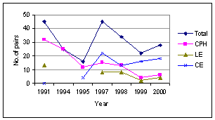
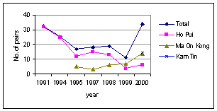
4.5.9
At Ma On
Kong, numbers of breeding egrets increased by 50% during 1999 (Figure 4.5). Only
Chinese Pond Heron breeds at Ma On Kong, and although both Cattle Egret and
Little Egret bred in 1995, they have not since. Numbers of Chinese Pond Herons
have increased steadily since 1997, although there was a marked drop from 12 to
3 pairs between 1996 and 1997.
Number
of Pairs of Egrets Breeding at Ma On Kong during 1995-2000
4.5.10
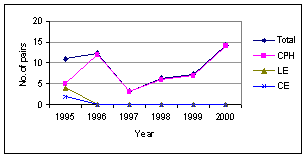
The
increase in numbers of Chinese Pond Herons at Ma On Kong may in part explain
the decrease at Ho Pui, although even if the numbers at the two egretries are
combined there are marked fluctuations overall, indicating additional factors.
However, as can be seen from Figure 4.6, in recent years combined numbers of
pairs of Chinese Pond Herons breeding at Ma On Kong and Ho Pui have been more
stable.
4.5.11
A new
egretry found at Kam Tin Shui Mei (grid reference 974856 on Lands Department
Map HM20C) during summer 2000 may also be of influence. At least 14 pairs of
Chinese Pond Heron were present at this egretry during 2000 (Table 4.14). The
age of the Kam Tin Shui Mei egretry is not known, and it is impossible to
determine whether Chinese Pond Herons breeding there originated from Ho Pui. It
is notable that at 34 pairs, the number of Chinese Pond Herons breeding at all
three egretries in the Kam Tin Valley in 2000 is only two pairs greater than
the peak of 32 pairs at Ho Pui in 1991 (Figure 4.6).
Number
of Pairs of Breeding Egrets at Kam Tin during Summer 2000
|
|
April |
May |
June |
Maximum |
|
Chinese
Pond Heron |
nc |
14 |
12 |
14 |
|
Little
Egret |
nc |
2 |
2 |
2 |
|
Cattle
Egret |
nc |
0 |
0 |
0 |
|
No. of pairs |
nc |
16 |
14 |
16 |
nc = not counted
Numbers
of Chinese Pond Herons Breeding at Ho Pui, Ma On Kong and Kam Tin Shui Mei
during 1991-2000
4.5.12
Unfortunately,
no data exist on breeding success for previous years for the three egretries
covered here. However, limited details of breeding success given in Wong et al. (undated) at other egretries in
Summary
of Brood Size in Hong Kong Egretries during 1999
(after
Wong et al. undated).
|
Brood size |
Chinese Pond Heron |
Little Egret |
Cattle Egret |
|
1 |
3 |
23 |
1 |
|
2 |
0 |
26 |
0 |
|
3 |
1 |
12 |
0 |
|
4 |
0 |
1 |
0 |
4.5.13
While these
results are not directly comparable, they do indicate that the breeding success
at the three egretries under investigation was high during 2000.
4.5.14
Cattle
Egrets are less piscivorous than other egrets; they primarily feed on insects,
amphibians and reptiles (Voisin, 1991). As such they prefer freshwater wetlands
to saline or brackish habitats (Wong et
al., undated). Food availability is a major factor influencing chick
mortality, with starvation being noted in some studies as the major cause of
mortality in Cattle Egret chicks (Siegfried, 1972). The direct affects of
weather on chick mortality in
Environmental
Factors Influencing Utilization
4.5.15
Some nests
sites have apparently been lost in the past year through clearance of bamboo
for the construction of village houses (R. Fan pers comm. to P. J. Leader). In
addition, the invasive exotic creeper Mikania
micrantha appeared to be colonizing parts of the main egretry. This species
has been known to cause sections of other egretries in
Summary
4.5.16
There was
an increase in numbers of breeding ardeids at both Ho Pui and Ma On Kong during
2000. A further egretry was located at Kam Tin Shui Mei during the summer.
Results of surveys from all three egretries indicate high breeding success. It
is suggested that the 2000 breeding season was generally good for egrets, and
that the increase in number of egretries in the northwest
4.5.17
Studies
elsewhere (Hafner, 2000) have identified the potential for disturbance at
egretries to have a severe negative impact on breeding success, and in order to
reduce this likelihood, a buffer area of 100 m from the egretries where
construction works should not take place is recommended for the period April to
September. The location of the buffer area is shown on Figure 4.13.
Changes in numbers and distribution of egretries during
2000 - 2005
4.5.18
Since a
period of five years has elapsed since the egretry survey data was collected,
the following updated information has been added detailing changes in the
numbers and distribution of breeding egrets during the period 2000 – 2005
(Sources: Hong Kong Bird Watching Society Egretry Counts and Asia Ecological
Consultants Ltd. unpubl. data).
Number
of Pairs of Breeding Egrets at Ho Pui 2000 - 2005
|
|
2000 |
2001 |
2002 |
2003 |
2004 |
2005 |
|
Chinese
Pond Heron |
2 |
2 |
1 |
0 |
3 |
0 |
|
Little
Egret |
2 |
2 |
2 |
0 |
1 |
0 |
|
Cattle
Egret |
9 |
5 |
17 |
12 |
9 |
0 |
|
Total |
13 |
9 |
20 |
12 |
13 |
0 |
Number
of Pairs of Breeding Egrets at Ma On Kong 2000 - 2005
|
|
2000 |
2001 |
2002 |
2003 |
2004 |
2005 |
|
Chinese
Pond Heron |
6 |
5 |
12 |
17 |
15 |
16 |
|
Little
Egret |
0 |
0 |
0 |
0 |
0 |
0 |
|
Cattle
Egret |
0 |
0 |
0 |
0 |
0 |
0 |
|
Total |
6 |
5 |
12 |
17 |
15 |
16 |
Number
of Pairs of Breeding Egrets at Kam Tin Shui Mei 2000 - 2005
|
|
2000 |
2001 |
2002 |
2003 |
2004 |
2005 |
|
Chinese
Pond Heron |
15 |
11 |
0 |
0 |
0 |
0 |
|
Little
Egret |
1 |
3 |
0 |
0 |
0 |
0 |
|
Cattle
Egret |
0 |
3 |
0 |
0 |
0 |
0 |
|
Total |
16 |
17 |
0 |
0 |
0 |
0 |
Number
of Pairs of Breeding Egrets at Tung Shing Lei (Au Tau) 2000 - 2005
|
|
2000 |
2001 |
2002 |
2003 |
2004 |
2005 |
|
Chinese
Pond Heron |
7 |
3 |
5 |
7 |
19 |
37 |
|
Little
Egret |
21 |
6 |
27 |
16 |
38 |
52 |
|
Cattle
Egret |
0 |
0 |
0 |
0 |
0 |
13 |
|
Total |
28 |
9 |
32 |
23 |
57 |
102 |
Total Number of Pairs of Breeding Egrets in the Kam Tin
Area 2000 - 2005
|
|
2000 |
2001 |
2002 |
2003 |
2004 |
2005 |
|
Chinese
Pond Heron |
30 |
21 |
18 |
24 |
37 |
53 |
|
Little
Egret |
22 |
5 |
29 |
16 |
39 |
52 |
|
Cattle
Egret |
9 |
8 |
17 |
12 |
9 |
13 |
|
Total |
61 |
34 |
64 |
52 |
85 |
118 |
4.5.19
The main
trend in egretry distribution over the past six years is the concentration of breeding
pairs at Tung Shing Lei, which was first utilized in 2000, since 2004.
Meanwhile, the egretry at Shui Mei was abandoned in 2001 and that at Ho Pui was
deserted in 2005, whilst the number of pairs at Ma On Kong showed an increase
in 2002 and has since remained stable.
4.5.20
The
increase in the importance of the Tung Shing Lei egretry has been accompanied
by an increase in numbers of Chinese Pond Herons and Little Egrets, but not of
Cattle Egrets. Numbers of this species have fluctuated between eight and 17
pairs, with no clear trend. Cattle Egrets were the main species utilizing the
Ho Pui egretry during 2000 – 2004, and it seems likely that in 2005 the birds
which formerly nested at Ho Pui moved to Tung Shing Lei, which was utilized by
Cattle Egrets for the first time that year.
4.5.21
The reason
for the abandonment of the Ho Pui egretry in 2005 is not certain. Abandonment
of egretries in
4.5.22
Historically,
there has been a pattern of rather frequent changes in location of egretries in
Flight Line Surveys
4.5.23
A common
method of investigating feeding habitat use by ardeids involves following their
flight lines. Individual egrets are observed as they leave the colony and land
at their feeding sites. This methodology has been used in a number of studies
in
4.5.24
In this
project, investigation of flight lines has been used to address specific
questions relating to habitat type and location of the foraging areas of
breeding adults at the two egretries. This information was considered essential
to establish whether the construction works to be undertaken would impact upon
the breeding egrets through habitat loss, or disturbance of foraging areas.
Disturbance of the breeding sites is dealt with elsewhere.
4.5.25
Flight line
observations were undertaken on 29th May, 3rd, 14th and
23rd June and
Results
4.5.26
During the
fieldwork, exactly 200 individual egrets were followed as they left either Ho
Pui or Ma On Kong. Most birds (89%) were from Ho Pui, and related to Cattle
Egret, Little Egret, Chinese Pond Heron, and Night Heron. Further details are
given for all species except for Night Heron, which related to a single
individual on one date, and was not recorded during the breeding surveys.
(i) Distance
flown
Details of distance flown by the birds followed
are given in Table 4.21.
Details of Distances Flown by Egrets at Ho Pui
and Ma On Kong Egretries,
Summer 2000 (All
measurements in meters)
|
|
All birds |
Little Egret |
Cattle Egret |
Chinese Pond Heron |
Chinese Pond Heron (Ho Pui only) |
Chinese Pond Heron (Ma On Kong only) |
|
Minimum |
80 |
500 |
150 |
80 |
80 |
200 |
|
Maximum |
5700 |
4700 |
5700 |
4040 |
4040 |
2900 |
|
Average |
2178.5 |
1640.9 |
2471.6 |
1317.4 |
1544.2 |
1187.0 |
|
s.d. |
1218.9 |
1091.7 |
1216.6 |
787.3 |
1075.1 |
643.2 |
|
n. |
199* |
22 |
137 |
40 |
18 |
22 |
*excludes a single
Black-crowned Night Heron
4.5.27
The number
of individual egrets in each 100 m band radiating out from the egretry was also
calculated. These data are presented in Figure 4.7.
Distance from Egretry (m), and
Number of Birds for Ho Pui and Ma On Kong,
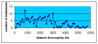
Summer
2000.
(ii) Flight
Direction
Direction
of flight was divided into 8 sectors, and this was further sorted into distance
(Figure 4.8) following Young (1993). Data for each species, with those data for
Chinese Pond Heron separated for the two egretries, are given in Figures 4.9 to
4.12.
(iii) Habitat
Selection
Of
the birds followed, habitat selection was noted for 45%. The remainder either
were lost from sight, or landed at a location where it was not possible to
determine the habitat (as this was obscured, often by buildings). Details of
habitat selection are given in Table 4.22.
Habitat
Selection of Egrets at Ho Pui and Ma On Kong Egretries, Summer 2000.
|
|
All birds |
Little Egret |
Cattle Egret |
Chinese Pond Heron |
|
Active
dry agriculture |
1 (1%) |
0 (0%) |
0 (0%) |
1 (4%) |
|
Active
wet agriculture |
39 (43%) |
3 (60%) |
21 (32%) |
17 (74%) |
|
Inactive
wet agriculture |
36 (40%) |
1 (20%) |
33 (51%) |
3 (13%) |
|
Grass |
8 (9%) |
0 (0%) |
8 (12%) |
0 (0%) |
|
Trees |
6 (7%) |
1 (20%) |
3 (5%) |
2 (9%) |
|
Total |
90 (100%) |
5 (100%) |
65 (100%) |
23 (100%) |
Discussion
Distance
Flown
4.5.28
As can be
seen from Figure 4.7, there was a peak of distance flown from the egretry at
about 800 m. Below this distance numbers were very low and there was a general
increase (although with marked fluctuations) between 1000 m and 3000 m. The
distance 1000 to 3000 m accounted for 62.6% of all flights. It is therefore of
potential concern that all of the proposed drainage channels at KT13 and KT12
also fall within this range, with implications on habitat loss, and
construction disturbance, of foraging areas.
Flight
Direction
4.5.29
Flight
direction was concentrated within the NNE and ENE sectors (Figure 4.8) for all
three species breeding at Ho Pui, and within the ENE and SEE sectors for the
Chinese Pond Herons breeding at Ma On Kong. At Ho Pui, the NNE and ENE sectors
accounted for 45% of Little Egrets, 75% of Cattle Egrets, and 83% of Chinese
Pond Herons. At Ma On Kong, the ENE and SEE sectors accounted for 68% of the
Chinese Pond Herons breeding there.
4.5.30
Given that
both egretries lie at the southwest end of a northeast-southwest orientated
valley, which has shrub-covered hills to the south and west, and wetlands to
the north and east, it is not surprising that the northeast holds the main
foraging areas. However, it is again of note that the proposed works for KT12,
KT13, KT14 and KT15 are either north to east from Ho Pui or northeast to south
east from Ma On Kong, i.e. within the preferred sectors at both.
Habitat
Selection
4.5.31
The importance
of wet agricultural areas, as foraging sites for the egrets breeding at Ho Pui
and Ma On Kong are apparent from Table 4.17. Active and inactive wet
agriculture accounted for 83% of the habitat selected by all birds. It was in
fact similar for all three species: 80% for Little Egret, 83% for Cattle Egret
and 87% for Chinese Pond Heron. There were differences in utilization of active
and inactive wet agriculture, with both Little Egret and Chinese Pond heron
preferring active wet agriculture, and Cattle Egret preferring inactive wet
agriculture.
4.5.32
Rivers,
creeks and drainage channels have been recorded as foraging areas for ardeids
in similar
Summary
4.5.33
The flight
line data showed that the preferred areas of foraging ardeids were also those
where KT12 and KT13 are to be constructed. Whilst it appears that birds make
little use of the KT13 stream for foraging, other
Flight Direction and Distance
Flown from the Egretry
Direction
of Flight and Distance Traveled for Little Egret
Little
Egret (n=21)
Note: Underlined
figures are total for that sector.
Direction of
Flight and Distance Traveled for Cattle Egret
Cattle Egret (n=137)
Note: Underlined
figures are total for that sector.
Figure 4.11
Direction of
Flight and Distance Traveled for Chinese Pond Heron
Chinese Pond Heron
(Ho Pui) (n=18)
Direction of
Flight and Distance Traveled for Chinese Pond Heron
Chinese Pond Heron
(Ma On Kong) (n=22)
4.6
Ecological Evaluation of Different Habitats
4.6.1
The site
(KT13) is generally an important area, supporting good communities of birds,
herpetofauna, dragonflies and butterflies. Until 2005 the most important
ecological feature of the stream was the presence of the egretry to the east of
Ho Pui village. The egretry was not occupied in 2005 but it is not possible at
this point to state whether or not it has been permanently abandoned. Tables 4.23
- 4.33 provide an evaluation of the ecological value of the eleven habitats
within the Study Area.
Ecological
Evaluation of Woodlands
|
Criteria |
Ma On Kong |
Ho Pui |
|
Naturalness |
Mainly natural but modified by afforestation |
Semi-natural |
|
Size |
Large (26.08 ha) |
Small (0.61 ha) |
|
Diversity |
High |
Moderate |
|
Rarity |
Not rare |
Not rare |
|
Re-creatability |
Re-creatable in long term (over 30
years) |
Re-creatable in long term (over 30
years) |
|
Fragmentation |
Continuous |
Fragmented by footpaths, roads |
|
Ecological linkage |
Connected with the |
Adjacent to the Ho Pui Egretry |
|
Potential value |
High |
High if the egretry is re-occupied |
|
Nursery/breeding ground |
The woodland potentially provides a
breeding ground for birds, butterflies, and reptiles. |
|
|
Age |
Over 40 years |
Over 40 years |
|
Abundance/ richness of wildlife |
The woodlands contain moderate species
richness. |
The woodlands contain moderate species
richness. |
|
Ecological value |
Moderate - high |
High in area occupied by egretry,
otherwise moderate |
Ecological Evaluation of
Shrublands
|
Criteria |
Ma On Kong |
East of Route 3 |
|
Naturalness |
Natural |
Mainly
natural but with little modification by grave worshippers |
|
Size |
Moderate
within the Study Area (4.5 ha) |
Moderate
(9 ha) |
|
Diversity |
Moderate
|
Moderate
|
|
Rarity |
Not
rare |
Not
rare |
|
Re-Creatability |
Readily
re-Creatable |
Readily
re-Creatable |
|
Fragmentation |
Continuous |
Lightly
fragmented by some footpaths |
|
Ecological linkage |
Connected
with the |
Some
linkage with woodland |
|
Potential value |
Moderate |
Moderate |
|
Nursery/breeding ground |
Moderate
value |
A
potential breeding ground for birds, reptiles and insects.. |
|
Age |
At
an early successional stage, the habitat is young |
At
an early successional stage, the habitat is young |
|
Abundance/
richness of wildlife |
Moderate |
Moderate |
|
Ecological
value |
Low
- moderate |
Low
- moderate |
Ecological
Evaluation of Marsh
|
Criteria |
Remarks |
|
Naturalness |
May be derived from abandoned
agricultural fields |
|
Size |
Small (1.18 ha) |
|
Diversity |
Low to moderate floral
diversity but moderate to high in terms of wildlife supported |
|
Rarity |
Not rare, but becoming rarer |
|
Re-creatability |
Can be re-created within a
short time for such young marsh |
|
Fragmentation |
No fragmentation |
|
Ecological linkage |
Close to the Ho Pui Egretry
and provides suitable feeding conditions for breeding egrets |
|
Potential value |
Moderate |
|
Nursery/breeding ground |
The marsh is potential
breeding ground for birds, reptiles and insects. |
|
Age |
Young |
|
Abundance/ richness of
wildlife |
Moderate abundance |
|
Ecological value |
Moderate |
Ecological Evaluation of Fishponds
|
Criteria |
Remarks |
|
Naturalness |
Man-made habitat |
|
Size |
Small (2.3 ha) |
|
Diversity |
Low habitat diversity but
high in terms of wildlife supported |
|
Rarity |
Not rare, but becoming rarer |
|
Re-creatability |
Can be re-created
artificially |
|
Fragmentation |
- |
|
Ecological linkage |
Some ponds are adjacent to
the egretry |
|
Potential value |
Ponds at egretry are of high
value |
|
Nursery/breeding ground |
The ponds are potential
breeding grounds for birds and insects |
|
Age |
No information is available |
|
Abundance/
richness of wildlife |
Moderate |
|
Ecological
value |
Moderate |
Ecological
Evaluation of Stream (KT13)
|
Criteria |
Remarks |
||
|
Naturalness |
Natural |
||
|
Size |
Moderate (about 1km in length
within the Study Area, 3 ha) |
||
|
Diversity |
Moderate |
||
|
Rarity |
Not
rare but lowland unchannelised streams rapidly becoming rarer |
||
|
Re-Creatability |
Re-creatable |
||
|
Fragmentation |
The stream is continuous but
the path of the section with the West Rail Working Site is being changed |
||
|
Ecological linkage |
The stream passes through the
egretry location |
||
|
Potential value |
The
site has potential as a relatively ecologically important area, if the
pollution load in the stream can be brought down. |
|
||
|
Nursery/breeding ground |
Prior
to 2005, an important breeding ground for egrets and Chinese Pond Heron, as
well as invertebrates (including dragonflies and butterflies), amphibians,
reptiles and common fish species. |
||
|
Age |
Old
(over 50 years) |
||
|
Abundance/ richness of
wildlife |
High
abundance. |
||
|
Ecological value |
Moderate
overall, high in vicinity of the egretry (if egretry present) |
||
Ecological Evaluation of Low-lying
Grasslands/Fallow Land
|
Criteria |
Remarks |
|
Naturalness |
Derived from agricultural
lands |
|
Size |
Small to moderate (from 17.05
ha) |
|
Diversity |
Low to moderate |
|
Rarity |
Common |
|
Re-creatability |
Re-creatable within a short
time (1 to 2 years) |
|
Fragmentation |
Fragmented by footpaths,
local roads |
|
Ecological linkage |
Adjacent to woodland,
streams, ponds, shrubland and orchard |
|
Potential value |
Some area of this habitat are
of higher value as they are adjacent to the egretry |
|
Nursery/breeding ground |
Potential breeding ground for
reptiles, amphibians and insects. |
|
Age |
Young |
|
Abundance/
richness of wildlife |
Moderate |
|
Ecological
value |
Moderate |
Ecological
Evaluation of
|
Criteria |
Remarks |
|
Naturalness |
Natural |
|
Size |
Moderate
to large in size within the Study Area (29.44 ha) |
|
Diversity |
Low |
|
Rarity |
Not
rare |
|
Re-creatability |
Easily
re-creatable naturally or artificially within 1 to 2 years |
|
Fragmentation |
Continuous |
|
Ecological
linkage |
Connected
with the |
|
Potential
value |
Low
but can be improved if hill-fire ceases and succession is allowed |
|
Nursery/breeding
ground |
Low
value |
|
Age |
Relatively
recent |
|
Abundance/
richness of wildlife |
Low |
|
Ecological
value |
Low |
Ecological
Evaluation of Agricultural Lands
|
Criteria |
Remarks |
|
Naturalness |
Man-made
habitat for crop production |
|
Size |
Small
to large (from 13.32 ha) |
|
Diversity |
Low |
|
Rarity |
Widespread |
|
Re-creatability |
Re-creatable
artificially |
|
Fragmentation |
Fragmented
by footpaths, roads, and other areas of urban environment such as villages |
|
Ecological
linkage |
May
act as movement corridors and foraging habitat for animals from woodlands
nearby |
|
Potential
value |
Low,
but can be higher by applying some management practice to enhance the habitat
heterogeneity |
|
Nursery/breeding
ground |
Not
important |
|
Age |
From
recent to old |
|
Abundance/
richness of wildlife |
Low |
|
Ecological
value |
Low |
Ecological
Evaluation of Orchard/Horticultural Land
|
Criteria |
Remarks |
|
Naturalness |
Man-made
habitat |
|
Size |
Small
(4.66 ha) |
|
Diversity |
Low |
|
Rarity |
Not
rare |
|
Re-creatability |
Can
be re-created artificially |
|
Fragmentation |
Fragmented
by footpaths, roads |
|
Ecological
linkage |
May
provide foraging habitat for birds |
|
Potential
value |
Low |
|
Nursery/breeding
ground |
Feeding
ground for birds and invertebrates. One patch of litchee orchard at Ma On
Kong contains an egretry which is an important nursery and breeding ground
for Chinese Pond Herons. |
|
Age |
From
recent to old |
|
Abundance/
richness of wildlife |
Moderate
abundance but generally very common and widespread species |
|
Ecological
value |
Generally
low, but moderate in the case of the litchee orchard at Ma On Kong used as an
egretry. |
Ecological
Evaluation of Urban
and
Industrial Area(UIA)/Bare Ground/Works in Progress
|
Criteria |
Remarks |
|
Naturalness |
Man-made
habitat with heavy disturbance from human activities |
|
Size |
Small
to large (72.84 ha) |
|
Diversity |
Very
low |
|
Rarity |
Not
rare |
|
Re-creatability |
Artificially
re-creatable |
|
Fragmentation |
Fragmented
within the Study Area |
|
Ecological
linkage |
None |
|
Potential
value |
Very
low |
|
Nursery/breeding
ground |
Not
important |
|
Age |
From
recent (Route 3) to old (Ma On Kong village) |
|
Abundance/
richness of wildlife |
Very
low |
|
Ecological
value |
Very
low |
Ecological
Evaluation of Drainage Channel
|
Criteria |
Remarks |
|
Naturalness |
Man-made
habitat with heavy disturbance from human activities |
|
Size |
Small
(2.63ha) |
|
Diversity |
Very
low |
|
Rarity |
Not
rare |
|
Re-creatability |
Artificially
re-creatable |
|
Fragmentation |
Not
particularly fragmented |
|
Ecological
linkage |
None |
|
Potential
value |
Very
low |
|
Nursery/breeding
ground |
Not
important |
|
Age |
Recent |
|
Abundance/
richness of wildlife |
Very
low |
|
Ecological
value |
Very
low |
4.7
Potential Ecological Impacts
Identification
of Ecological Impacts
4.7.1
This
section identifies all potential impacts caused by the unmitigated
channelization works within the Study Area during the construction and
operation phases. The next section will evaluate these ecological impacts.
Construction
Impacts
4.7.2
Activities
during the construction phase include site clearance, site formation, dredging,
construction of the bypass culvert, paving of access road, etc. These are likely to have the impacts described below on fauna
and flora species and the habitats in which they live.
(i) Habitat
Loss /Damage (Direct Impacts)
The direct impact of site
clearance works on the existing stream channel is removal of riparian
vegetation, loss of natural banks with woody or weedy margins and loss of
substrate including submerged vegetation and/or coarse gravel. There will
therefore be a direct impact on vegetation and non-vagile animal groups,
notably invertebrates and amphibians. There will also be direct habitat loss
for all other animal groups using the stream corridors, notably birds,
amphibians, reptiles and dragonflies (which have vagile adults but non-vagile
larvae).
The project will result in the direct permanent loss of habitats within the project site area as detailed in Table 4.34 below.
Direct habitat loss
arising from construction of the secondary drainage channel KT13
|
Habitat |
Area (ha) |
Ecological value of habitat |
|
Bare ground |
0.133 |
Very low |
|
Fishpond |
0.083 |
Moderate |
|
Low-lying grassland / Fallow
land |
0.781 |
Moderate |
|
Marsh |
0.009 |
Moderate |
|
Orchard / Horticultural land |
0.687 |
Low |
|
River / Stream |
1.000 |
Moderate |
|
Urban / Industrial area |
0.380 |
Very low |
|
|
0.008 |
Moderate (because egretry not
affected) |
|
Total |
3.081 |
|
The area of moderate value
habitat to be impacted is about 1.881 ha. This comprises a very small area of
fishpond, woodland and marsh and larger areas of low lying grassland/fallow
land as well as the stream itself. The woodland area which would be lost does
not form part of the area occupied by the egretry prior to 2005. It is located at the eastern bank of the
meander outside the CA zone (Figure 4.1). Whilst the woodland at Ho Pui as a
whole is considered to be of high ecological value if the egretry is present,
the area to be lost, which does not form part of the egretry area, is
considered to be only of moderate value, as is the woodland as a whole if the
egretry is not re-occupied.
Approximately
59 trees will be retained under this Project, while approximately 60 trees will
be transplanted and approximately 74 trees will inevitably need to be felled.
No rare/protected or species of conservation importance were found.
Of
the habitat to be lost, a total of 0.042 ha falls within the CA zone. However,
the area to be lost comprises grassland habitat rather than woodland. A total
of 8 trees will be affected within the CA zone of which 4 trees will be
transplanted and 4 trees will inevitably be felled.
(ii)
Habitat
Loss /Damage (Indirect Impacts)
Construction activities
are likely to have immediate effects on the water table in the low-lying wet
grassland derived from abandoned paddy fields, abandoned fish ponds and
adjacent freshwater. Lowering of the water table may arise as a consequence of
increased drainage, whereas compaction or deliberate or accidental stream
diversions may result in temporary flooding.
(iii) Disturbance
of Wildlife (Indirect Impacts)
Indirect impacts will arise through disturbance activities affecting disturbance-sensitive animal groups, primarily birds (mammals are also disturbance-sensitive but, as is described above, mammal diversity is low). Disturbance impacts for some bird species may be severe. Though ardeids do show some habituation to regular disturbance sources, they are likely to be particularly sensitive to irregular disturbance associated with construction activities.
Potential Disturbance to the Egretry
The proposed works associated with KT13 are, in part, in very close proximity to the area occupied by the egretry prior to 2005. This applies, in particular to the bypass culvert which is proposed to be constructed immediately adjacent to the north part of the egretry site (Figure 4.3). This close proximity is well within the distance within which ardeids are sensitive to disturbance and therefore if the egretry is re-occupied in subsequent years and if construction activity takes place during the breeding season it is likely to have a considerable negative impact on nest site availability and breeding success and, in a worst case scenario, could lead to partial or total desertion of the egretry.
Some disturbance effects may arise even if construction activity does not take place when the egretry is occupied if it renders all or part of the egretry more accessible and vulnerable to casual disturbance by people. The scale of disturbance which nesting egrets will tolerate is variable. Regular low-key human activities, such as people walking along a path, are generally tolerated, especially where these are already occurring before the beginning of the breeding season. Egrets are more sensitive to irregular disturbance, especially if these involve intrusive activities such as cutting vegetation (even if this does not extend to the nest trees themselves) and/or if they commence after the egretry has been occupied.
In the present case, it is considered that the construction of the bypass culvert would render the egretry (if it is re-occupied) more vulnerable to accidental casual disturbance by people as the removal of vegetation to permit the bypass culvert to be built will leave some of the nest trees more exposed. This disturbance could either be active (i.e. it might be easier for people to gain access to the egretry) or passive in that nesting egrets might avoid nest sites which have become more exposed.
Depending upon the scale of such disturbance and the response of the egrets, there is some risk that the northern section of the former egretry site would be unsuitable for breeding in subsequent years. This, however, remains a hypothetical concern since the egretry was not occupied in 2005 and, if re-occupation occurs, birds will respond depending upon current conditions at the time.
Other Potential Disturbance Impacts
Any changes in the water table of the wet grassland areas would have short-term effects on the fauna of these areas, including changes in their suitability for breeding amphibians and dragonflies and other invertebrates. This would have a consequent effect on their value as feeding areas for ardeids and other waterbirds. This, if combined with construction activity and human disturbance during the breeding season, may have a negative impact on egret numbers and their breeding success.
(iv) Fragmentation
of Habitats
The proposed channelized stream passes through a large area of low-lying grassland southwest of Ho Pui village. Site clearance of the Project Area along the stream will increase fragmentation of the grassland. This fragmentation will be increased by the creation of the bypass culvert which will isolate a small section of the grassland in the north-east. Fragmentation will result in barriers to dispersal, especially by less vagile species such as amphibians. In addition, the smaller fragments may fall below a minimum area threshold for utilisation by more disturbance sensitive species such as waterbirds.
(v) Dust
Deposition on Vegetation
Some construction activities will generate suspended particulates that can cause vegetation damage, which in turn, have secondary effects on associated fauna, such as insects and birds.
(vi) Increased Sediment Load
During the construction phase, dust and exposed soil may enter the stream through run-off, especially during heavy rainfall periods. However, as mentioned in the habitat evaluation section, the water quality in existing watercourse is already poor. Ecological degradation of the affected habitat may not occur if pollutant levels due to run-off does not exceed those of the watercourse.
Operational Impacts
(i) Habitat
Loss
The stream sections within the Project Area are proposed to be widened and channelized. The habitats on both sides of the stream (as well as the microhabitats of the main channel itself) will be lost permanently. Operational maintenance work such as removal of sediment and vegetation will hinder any recolonization of the channelized stream and will prevent all but a transitory recovery of its plant and animal community. As with construction, disturbance may have a severe effect on disturbance-sensitive taxa. If maintenance work was undertaken during the ardeid breeding season disturbance could have significant effects including, at worst, abandonment of the egretry (should it be re-occupied in subsequent years).
Construction will result in permanent loss of some habitats of moderate value including low-lying grassland, woodland and fishpond and orchard/horticultural land. The area of habitats to be lost is small and the areas to be lost are already highly fragmented, hence the direct impacts of the loss of habitat are expected to be small. In general, small and highly fragmented patches of habitat are less species rich and have lower potential to support important populations of species of conservation interest than large, unfragmented habitat patches. Small and highly fragmented patches of habitat are also less likely to support species which are dependent upon that particular habitat type. Hence the direct impacts of the loss of habitat are expected to be small.
If water levels in the wet grassland areas are lowered permanently they will progressively change to dry grassland and, if succession is allowed to proceed, to shrubland. Species associated with wet grassland including a number of dragonflies will be permanently lost. In addition, feeding areas for ardeids will be permanently lost.
(ii) Ecological
Barrier
On completion of the project, the channel will become an ecological barrier. Some animals may experience difficulty crossing these barriers when they attempt to move between habitats.
(iii) Continuing
Disturbance Impacts
During the initial operational period a part of the area occupied by the egretry prior to 2005 will remain more vulnerable to disturbance than it was prior to the commencement of the project. However, as noted above this is a hypothetical concern only since the egretry was not occupied in 2005 and, if re-occupation occurs, birds will respond depending upon current conditions at the time.
Evaluation of
Ecological Impacts
Construction Impacts
(i) Habitat
Loss /Damage
The removal of riparian vegetation would impact negatively and significantly on ‘skulking’ birds such as White-Breasted Waterhens. It may also affect White-throated Kingfisher, removing potential nest site locations (bare vertical earth banks) and roosting/hunting perches. The loss of appropriate microhabitats for many invertebrate species will lead to decline in species diversity.
Intra-seasonal effects on the water table in the low-lying wet grassland derived from abandoned paddy fields, abandoned fish ponds and adjacent freshwater are unlikely to have significant adverse impacts as the wetlands are seasonal and the plant and animal communities will be made up of species which are tolerant of short-term changes in water levels. However, there may be some short term effects on the availability of feeding areas for ardeids. If such changes result in a reduction of food availability during the breeding season then ardeid breeding success may be compromised.
The impact of habitat damage due to land used for construction, supporting facilities and other storage areas should largely be temporary. After completion of the works the affected habitats can be restored. Habitats that may be affected include fishponds, low-lying grasslands/fallow fields, woodland, orchard, horticultural land and bare ground. The areas of these habitats to be impacted are small, and the construction period will be relatively short, whilst the habitats are re-creatable within two to three years (at least 20 years, in the case of woodland). Accordingly, the significance of this impact on ponds, woodland and low-lying grasslands/fallow fields is moderate and reversible; while for orchard, horticultural land, and bare ground impacts will be low and reversible.
No rare/protected or tree species of conservation importance will be affected.
(ii) Disturbance
to Wildlife
The most significant impacts on wildlife are
potential disturbance of breeding egrets should the Ho Pui egretry be
re-occupied in subsequent years. The proximity of the Ma On Kong egretry to
Route 3 attests to egrets’ ability to acclimatize to traffic disturbance,
although the increase in numbers, following the construction period suggests
some impacts during that phase of the project. However, the construction
disturbance at the
Human intrusion and indirect
egretry disturbance linked to human activities are major factors affecting
breeding success of the birds. Intense disturbance may cause birds to desert a
nesting site permanently and move elsewhere. There is considerable evidence
that this is already happening in Hong Kong, with short-term occupation of
egretry sites at Kam Tin and in the
Disturbance can be especially disastrous during the early stages of the breeding cycle, when eggs and small young, if left unattended, can be easily lost or die. Conversely, if disturbance prevents to commencement of breeding activities it is of less significance, especially if birds move, and breed successfully, elsewhere. This appears to be what occurred in 2005 where the abandonment of the Ho Pui egretry in 2005 was matched by an increase in numbers at Tung Shing Lei and the breeding of Cattle Egrets (formerly the main breeding species at Ho Pui) there for the first time.
Overall, therefore, and if the egretry should be re-occupied, subsequent disturbance effects on egrets there could range from insignificant and temporary (if the birds adapt readily to disturbance or merely move within the egretry) to moderate (if disturbance displaces egrets and these are unable to breed elsewhere). Within this range it is considered that the disturbance effects will most likely be insignificant or small and the probability of moderate impacts is considered to be low. However, it is considered that the most likely scenario is that the egretry will not be re-occupied and hence there would be no disturbance impacts.
White-throated Kingfisher has been identified as vulnerable to habitat loss due to potential loss of nest sites and perches. Should nest sites be lost there may be a permanent, irreversible, effect leading to the loss of a breeding territory of this species. However, in the case of the present project there is no evidence that actual nest sites will be affected and suitable nest site locations will remain in the section of stream which is not to be channelised. As this is a relatively low density species (Carey et al. 2001) it is unlikely that more than one territory exists within the project area. Accordingly, since a significant area of suitable habitat will remain it is considered unlikely that the project prevent utilisation of the stream and loss of a breeding territory and potential ecological impacts on this species are considered to be low.
Even temporary habitat loss may result in permanent loss of populations of non-vagile taxa of invertebrates. However, given the highly polluted state of the stream it is most unlikely that such populations exist. Accordingly, it is considered that the scale of such impacts is likely to be very low.
(iii) Fragmentation
of Habitats
During the construction phase, the natural sections of the stream and the adjacent grasslands will be fragmented. These two habitats are important components of the egretry environment and, in addition, support a number of avifauna, herpetofauna, dragonflies and butterflies. The significance of this impact on such habitat is considered to be low if the egretry is not re-occupied (as the other species are relatively common and widespread) to moderate if the egretry is re-occupied prior to commencement of construction.
(iv) Dust Deposition on Vegetation
Potentially a large area could be affected by dust deposition. However, this situation is temporary and reversible, therefore the significance is low.
(vi) Increased
Sediment Load
As reported in habitat survey results, the water quality of the existing stream is already very poor. Thus, the significance of this temporary impact is low.
Operational Impacts
(i) Habitat Loss
The stream sections inside the Project Area will be widened and deepened after the proposed channelization works. Areas adjacent to the stream are expected to be lost permanently. If water levels in the wet grassland areas are lowered permanently they will progressively change to dry grassland and, if succession is allowed to proceed, to shrubland. Species associated with wet grassland including a number of dragonflies will be permanently lost. In addition, feeding areas for ardeids will be permanently lost. Thus, the significance of this impact on this habitat is moderate, for the size of land loss is small (<0.5ha).
Construction of the bypass culvert will result in permanent loss of a small area of low-lying grassland. The direct habitat loss is small, however the loss of any feeding areas of low-lying grassland near to the egretry is of some significance as it exacerbates a trend of continuing habitat loss. Overall, however, given the small area of habitat involved, the significance of the habitat loss is considered to be small.
(ii) Ecological
Barrier
The widening and re-alignment of the stream will enlarge the ecological barrier for wildlife wishing to cross over the stream. However, there is no evidence that there are significant populations of non-vagile taxa which might be affected and hence the significance of this impact is considered to be low.
(iii) Disturbance to Wildlife
The creation of the access track associated with the bypass culvert will open up the northern section of the egretry site to significantly higher levels of casual disturbance than is the case at present. Deliberate or accidental human disturbance is, therefore, more likely to occur if the egretry is re-occupied and this re-occupation includes the northern section of the former egretry site. Potential impacts, therefore range from none (if the egretry is not re-occupied) to low (if the egretry is re-occupied prior to the construction phase and then is partially displaced) to moderate (if there has been significant abandonment during the construction phase and re-occupation does not take place). However, given that the egretry was not utilized in 2005, the most likely scenario is that the egretry will not be re-occupied and hence there will be no impacts.
In the longer term, the proposed planting of bamboos along the eastern side of the by-pass culvert will serve to screen the egretry site from human disturbance (and will, in addition, provide potential nesting habitat). Accordingly, it is considered that there will be no residual adverse impacts to the egretry site in the long term.
Cumulative
Impact from Concurrent Projects
4.7.3
The KT13 Channel is the most southerly of several drainage
projects being undertaken in the
4.7.4
In the
wider area of the Kam Tin valley there have been a number of development
projects in recent years which have had significant effects in reducing the
areas of natural or semi-natural wetland. These include the construction of the
Route 3 road link, channelisation of the
4.7.5
Whilst
there are no direct cumulative linkages between the potential impacts of the
proposed channelisation of KT13 and these projects, there may be some indirect
effects as a consequence of the long-term progressive reduction in foraging
areas for ardeids. Indeed, habitat loss in the wider area may have been a
factor in the abandonment of the Ho Pui egretry in 2005, though the proximal
cause of this was considered to be a change in agricultural practice (i.e. not
a consequence of development activity) in an area that had formerly been a
favoured feeding site for Cattle Egrets. Such cumulative egrets remain of concern
in respect of the Ma On Kong egretry as much of the affected area lies within
the potential foraging range of nesting egrets (Wong et al. 1999). However, since the main wetland area (the Buffalo
Fields) lies more than 3 km from the egretry and only 18% of foraging flights
recorded from the egretry were of more than 3 km (see paragraphs 4.5.23 – 4.5.33),
the effects of these projects, and hence cumulative impacts on the Ma On Kong
egretry, are considered to be minor.
4.7.6
As a
corollary, much more significance must be attached to cumulative impacts of
developments within 3 km of the Ma On Kong egretry, as it is within this zone
that 72% of egrets breeding in the egretry were observed to forage (see
paragraphs 4.5.23 – 4.5.33). In this zone, as well as the effects of the channelisation
of other streamcourses (see paragraph 4.7.3), major cumulative impacts arise as
a consequence of small-scale progressive loss of wetland habitat. Such
progressive loss of wetland habitat is likely to continue as, in addition to
those projects designated under the EIA Ordinance and Government projects for
which an Environmental Study is required, small-scale developments conforming
to the Outline Zoning Plan will continue to take place.
4.7.7 Much of the Study Area, including all of the triangle formed by the villages of Ho Pui, Ma On Kong and Tai Kek is zoned for Village development. Continuing progressive loss of non-urbanised areas to urbanization is therefore predicted. This habitat loss is likely to include many of the remaining fishponds and permanent and seasonal wetlands. Continued reduction in the areas of habitat available to wetland-dependant fauna will, therefore, occur. In the long term this impact is predicted to be major and may result in the permanent loss of the Ma On Kong egretry and reduce the likelihood of the re-establishment of an egretry at Ho Pui or nearby.
4.8
General Recommendations
on Ecological Impact Mitigation
4.8.1 The prime objective of the present project is land drainage improvement. The key to a practical yet environmentally sustainable management scheme is the integration of hydraulic and ecological techniques. The following management measures have largely been adopted internationally by engineers and ecologists as part of a set of standard best practices. These measures also adhere to the aforementioned impact mitigation policies set out in the Technical Memorandum on EIA Process. Recommendations on specific ecological mitigation measures to be undertaken at KT13 are presented in Section 4.9.
Alternative
1: Avoidance
4.8.2 The first and foremost alternative is the avoidance of channelization of streams with particular ecological value.
4.8.3 In the present case, avoidance of channelisation of the section of KT13 above the bridge leading to Ho Pui Village would leave intact the most ecologically valuable section of the stream and would avoid entirely the part of the stream that is adjacent to the Ho Pui egretry site. This option would, therefore, result in there being no adverse ecological impacts on the upper reaches of the stream and, if taken in parallel with the design measures to minimize impacts on the lower part of the stream (as the discussed under Alternative 3 below), will not cause any residual ecological impacts. This option would not however relieve the area from flooding.
Alternative 2: Dredging and Widening without
Constructing Permanent Banks and Bottoms Structures; Combined with Scheduling
of Construction Works – A Means of Impact Minimization
4.8.4 For streams where avoidance of construction work is not warranted and where increased hydraulic capacity is needed, such work should be limited to dredging and widening only, with a minimum of permanent structures on the bank sides and bottoms, and without excessive removal of the existing stream and riparian vegetation. Preferably, one of the banks should be left undisturbed. If protection of the banks from erosion is necessary, rock armouring or gabion structures may be placed along the margin of the watercourse (Plate 4.18). It must be emphasized that the concreting of banks and bottoms will definitely render the stream sterile ecologically. Not only are the existing ecosystems lost, reestablishment of flora and fauna in the future is also precluded. The use of grasscrete at channels, although less damaging than bare concrete does have value in mitigating visual and landscape impacts, but falls far short of meaningful conservation.
4.8.5
The execution of the
construction works should be planned to minimize any potential disturbance to
fauna of conservation importance. Generally, in
Alternative
3: Dredging and Widening, and the Placement of Gabions for Structural
Stability; Combined with Scheduling of Construction Works – A Means of
Impact Compensation/Impact Minimization
4.8.6
Under circumstances where
protection of stream bank/bottom from erosion is crucial, gabions, instead of
concrete or grasscrete, should preferably be used to provide the required bank
stability. Successful overseas cases of such applications are common (please
refer to Plates 4.19 to 4.21 for examples). Plate 4.22 shows typical examples
of gabion channel in
(i) Gabions allow the natural exchange of water between the stream and the substrate, thus connecting the watercourse with the surrounding phreatic strata (if concrete base platform is not used), and allow the growth of riverine flora through the gabions; the flora in turn provide a rich habitat for fauna, including microorganisms which together with the flora are essential food sources for other organisms in the riverine food chain.
(ii) The interstices between the rocks or stones within a gabion make an excellent habitat for biota, especially invertebrates and fish, as well as their eggs, larvae or fry, all of which at various times need this form of refuge. The open form of the gabion also provides refuge from fast currents, predators, changing ambient temperatures and other threats. Gabions thus closely mimic the functions of natural bank/bottom, thereby allowing the stream and riparian ecosystems to largely maintain their biocoenosis, albeit in a somewhat artificially altered state.
(iii) The open form of the gabion is far more desirable than that offered by concrete or grasscrete, the former supports no life and the latter provides little opportunity for biodiversity or recolonization by ecosystems. With gabions, habitats lost to the dredging and widening of the river/stream can largely be compensated by natural reestablishment.
4.8.7 From the engineering perspective, channels constructed with gabions in the last 100 years attest to their suitable hydraulic and structural performance. The design life span of PVC sheathed gabions in a river/stream setting is conservatively estimated to be at least 15 to 20 years. To ensure the continual satisfactory performance of gabions, however periodic inspection and maintenance are, required. When necessary, sections will need to be strengthened or replaced. Also, vegetation growing in the gabions at critical segments of the channel will need periodic trimming to maintain adequate hydraulic conditions. Such routine maintenance would, in any case, be required for alternative construction techniques.
4.8.8 From the aesthetic perspective, as vegetation will fully establish on the gabions within just a few years, these artificial elements will completely integrate with the surrounding natural riverine environs. This establishment of flora takes place naturally, and hydroseeding or planting at gabions is therefore usually not necessary, except where specific plants are required.
4.8.9 Figure 2.4 present a typical possible configuration of gabion for channel lining.
4.8.9 As
in the previous alternative, the execution of
the construction works should be planned to minimize any potential disturbance
to fauna of conservation importance.
4.9
Proposed Ecological
Impact Mitigation Measures at KT13
4.9.1 Since Alternative 1 described above fails to meet the design objectives of the project, it is proposed that mitigation of adverse impacts should be mitigated by a combination of measures described under Alternative 2 (for the most ecologically sensitive section of the stream) and Alternative 3 (for the remainder). These measures are detailed below.
Mitigation of operational
phase impacts
4.9.2 Mitigation of operational phase impacts arising from stream channelisation is proposed by designing the required channelisation measures at KT13 as detailed in Figures 2.2A, 2.2B and 2.4. The proposed design contains the following elements:
(i)
Mid-stream section around Ho Pui egretry site
The mid-stream section of KT13 around the location of the egretry site is not proposed to be channelised as it is considered that any form of artificial channel construction is likely to have major adverse permanent impacts on the egretry site which would prevent its successful re-occupation.
The normal stream flow will continue to follow the existing stream, but a bypass culvert will be formed to divert floodwater from the existing channel when water reaches flood level. The design of this culvert addresses the requirement to avoid modification of the middle section of the stream for the preservation of the Ho Pui Egretry and the associated habitats and will ensure that continuous flow of the existing stream is maintained. Should the egretry be re-occupied prior to the commencement of construction, further mitigation measures are required to compensate for the impacts of this culvert on the egretry.
In order to form the bypass channel it will be necessary to realign a short section of the existing natural stream (c. 25 m) by shortening a meander. The section to be realigned will be restored with gabion banks and natural substrates as stream bed materials. Gabions are necessary to provide stability to the stream banks given the scouring effect at the meander.
(ii) Upstream section (Section B) and Downstream Section (Section A)
The
upstream section of KT13 is considered to have intrinsic moderate ecological
value and provides habitat for wetland-dependant fauna. Use of a gabion-lined channel is
proposed in order to maintain the ecological value of the channel whilst not
compromising flood-prevention objectives. Trapezoidal channel with gabion sides
and gabion bottom (as shown in Figures 2.2A, 2.2B and 2.4) is proposed.
Once the gabion channels have been constructed the water table in the adjoining areas will be restored and there will be no significant changes in the water table in wetlands. Hence no long-term impact on wetland habitats and their biota in expected.
Potentially adverse impacts arising from the maintenance of the channelized sections will be minimized by restricting routine channel maintenance to annual silt removal by hand or light machinery during the dry season (October to March). The management of woody / emergent vegetation will be limited to manual cutting, to be carried out only when unchecked growth of such vegetation is very likely to impede channel flow.
Bypass
channel alignment
4.9.3 Although the construction of a bypass channel would eliminate adverse impacts to the most sensitive section of the existing stream, the construction of the bypass channel also has potential ecological impacts. The selected alignment was chosen after evaluation of alternative alignment options. Alternative alignment options are described in detail in Appendix B, Table B1 and illustrated in Figure B1 and are summarised below:
- Option 1: bypass channel largely to the west of the existing stream, largely passing through filled land (former ponds) but requiring some loss of land zoned Conservation Area, some woodland area and minor realignment of a meander in the section of stream to be bypassed.
- Option 2: bypass channel further to the west of the existing stream than Option 1, avoiding Conservation Area zone but bisecting woodland area and requiring resumption of existing houses as well as significant landscape impact due to need to traverse a low hill.
- Option 3: bypass channel direct route, approximately 50% to the west and 50% to the east of the existing stream (i.e. bisecting the egretry location and crossing the most sensitive stream section) with minor intrusion into Conservation Area.
- Option 4: bypass channel eastern route, passing through Ho Pui village and impacting a section of the existing stream close to the egretry location and wetland in Ho Pui.
- Option 5: “no-build” option.
4.9.4 The “no-build” option is preferable ecologically but will result in failure to satisfy the project objective of eliminating flooding. Of the remaining options, both Options 3 and 4 would have unacceptable impacts on the existing stream and the egretry location. The potential ecological impacts of Options 1 and 2 are similar in scale and importance. Both options would avoid permanent impacts on the egretry location; but both would result in some adverse impacts on habitats of ecological value. However, Option 1 is preferable in respect of its lower landscape impact and avoidance of village houses
4.9.5 Accordingly, Option 1 was selected, but it was then refined to reduce ecological impacts to an acceptable level. Avoidance of some potential adverse impacts was achieved by minor adjustments to the alignment to reduce the extent of intrusion into the Conservation Area and to reduce loss of trees. In order to minimize impacts on the section of stream meander to be realigned it is proposed to make use gabion banks and natural bottom instead of concrete walls, and measures to mitigate construction phase impacts and compensate for unavoidable loss of trees are proposed. These proposed avoidance, minimization, mitigation and compensation measures are described in more detail in below.
Mitigation
of adverse impacts of bypass channel construction
4.9.6 The northern section of the proposed bypass channel will be immediately adjacent to the northern section of the egretry site. Even with the controls which are proposed to restrict the adverse effects of construction works, it is considered that the proximity of the bypass channel will open up this section of the egretry site to accidental or deliberate disturbance. Since the egretry was abandoned in 2005 and it is likely that it will not be re-occupied, it is most likely that there will be no impacts on breeding egrets. However, in the event that the egretry is re-occupied prior to the commencement of construction and such re-occupation includes the northern part of the area occupied by breeding egrets prior to 2005, there is a significant likelihood that disturbance will result in the abandonment of all or part of the northern section of the egretry. In addition to passing close to the egretry, this northern section of the bypass channel will pass directly through an area which is zoned as Conservation Area (see Figure 4.13), though this area is no longer suitable for egrets occupation (due to recent clearance of trees and bamboos).
4.9.7 Accordingly, temporary chain link fence should be provided along the site boundary near the CA zone and Ho Pui Egretry (Figure 4.13) to restrict access by construction workers or equipment or works to these sensitive areas. Disturbance of the vegetation outside the site boundary is prohibited. Signage should be provided at conspicuous location to warn workers from entering and disturbing the sensitive areas.
4.9.8 Approximately 59 trees will be retained under this Project, while approximately 60 trees will be transplanted and approximately 74 trees will inevitably need to be felled. No rare/protected or species of conservation importance will be affected. Compensatory planting of about 148 heavy standard size trees (in 2:1 ratio) will be provided. Details can be found below and in the Landscape and Visual Impact Assessment (Chapter 10).
4.9.9 It is proposed to mitigate for the loss of trees by planting an area (855 m²) of appropriate tree and bamboo species to provide compensatory habitat in the long term (Figure 4.13). The proposed planting area is at the southern end of the proposed channel. This location has been chosen as it is a relatively large block of land within the project area (compensatory planting can only be provided within the boundaries of the project area) in proximity to a mixture of wetland and fishpond areas. As such, it is considered to be an area with potential for egretry establishment in the long term. The tree and bamboo species to be used in the compensatory planting area are detailed in Table 4.35. The tree and bamboo species are the same or similar to native trees which have to be felled and include species suitable for nesting egrets. Planting should be completed before the commencement of Operation Phase.
4.9.10 In addition, it is proposed to plant Bambusa eutuldoides in a staggered double row as a screen along the east side of the bypass culvert where this is close to the egretry (Figure 4.13). When mature, the bamboos will form a screen, shielding the egretry from disturbance, and will also provide potential breeding sites. To ensure the right species of bamboo is planted, an experienced botanist should be acquired by the contractor to source the correct bamboo species. Moreover, to ensure the planting of the bamboo for screening to be effective, the bamboos should have a minimum stem diameter of 8-10 cm and clump size of 5 shoots per plant.
Tree and bamboo species to be used in compensatory
planting area
|
Species |
Percentage of total |
|
Bambusa eutuldoides |
40 |
|
Cinnamomum camphora |
15 |
|
Celtis tetranda |
15 |
|
Ficus virens |
15 |
|
Ficus microcarpa |
15 |
Mitigation
of construction phase impacts
4.9.11 As discussed above, the principal concern during the construction period is minimizing adverse impacts to nesting egrets should the Ho Pui egretry be re-occupied. Accordingly, monitoring of the egretry site should be conducted as part of the EM&A during the breeding season in order to establish if breeding egrets are present. Monitoring should be carried out during the months of March to August. Notwithstanding the monitoring result, no construction works should take place within 100m of the egretry location (Figure 4.13) during the period from 1st March to end of May. This covers the early nesting period because of early warming up weather in recent years which may lead to some egrets preparing for nesting as early as March. During this period, construction activities within the works area within 100m of the egretry should be limited to transit movements by construction vehicles. If no egret nest is found at the Ho Pui egretry, construction works can be carried out from June to February in the next year subject to approval obtained from AFCD and EPD. Otherwise, the ‘no works’ period should be extended till the end of September.
4.9.12 Prior approval from AFCD and EPD should be obtained before commencement of construction works on the bypass culvert. Adequate time should be allowed for the vetting process by the relevant authority.
4.9.13 Construction phase impacts on the stream as a whole will be minimized by phasing the major construction activities to a maximum of 75 m length at Section A and Section B of the Channel (except for 100 m sections at the extreme upstream and downstream sections of the project works area where no restriction will apply as these areas are remote from the Conservation Area and egretry site). As the two work fronts will be constructed in one direction and since there are more than 300 m separation between Section A and Section B of the Channel, the above 75 m restricted length could be implemented concurrently at both Section A and Section B of the Channel. This will reduce the duration of construction phase impacts at any one location and will minimize the duration of time during which the water table will be drawn-down at any one location, thereby minimizing the adverse effects to adjacent wetland habitats and their plant and animal communities. The water table is expected to be lowered by approximately 600 mm and the lateral distance affected is expected to be of the same magnitude. Draw-down will be temporary and the water table will be restored once construction is completed.
4.9.14 The contractor should ensure continuous water flow to the remaining part of the stream during the construction stage and the ‘no works’ period. A typical temporary drainage diversion plan is shown in Figure 7.3 to demonstrate that keeping continuous water flow is feasible and workable.
4.9.15 The contractor should provide details of the mitigation measures to be implemented during construction stage as part of their working method statement to the Engineer for approval. This should also be reviewed by the Environmental Team Leader with reference to the baseline ecological monitoring results if necessary.
4.10.1 Predicted significant ecological impacts and proposed mitigation measures to eliminate or reduce these to acceptable measures are summarised below:
Construction Phase Impacts
Disturbance to existing stream habitats and fauna due to
channelisation.
4.10.2 In the absence of mitigation measures, disturbance to stream habitats and fauna due to channelisation of sections of the stream is considered to result in a moderate adverse ecological impact. The nature of the project is such that the direct physical impacts on stream habitats and fauna cannot be eliminated or reduced; however, it is proposed to restrict the works area to a maximum of 75 m length at Section A and Section B of the Channel except for the 100 m sections at the extreme upstream and downstream limits of the project area. As the two work fronts will be constructed in one direction and since there are more than 300 m separation between Section A and Section B, the works could be undertaken concurrently at Section A and Section B of the Channel. This will reduce the duration of construction phase impacts at any one location and will reduce the extent of habitat loss for wildlife which may use the streamcourse and surrounding riparian corridor as a feeding or roosting area.
4.10.3 It is considered that with such mitigation, the residual construction phase impact would be reduced to an acceptable level.
Disturbance to egretry due to channelisation
4.10.4 Should the Ho Pui egretry be re-occupied, in the absence of mitigation measures, there is a significant risk that construction activity could cause it to be abandoned again, which would be a major adverse impact. However, by restricting construction works within 100m of the egretry to the non-breeding season direct disturbance impacts to the breeding egrets will be eliminated.
4.10.5 Because the proposed bypass culvert is close to the northern section of the egretry site, the project would make the egretry more vulnerable to casual disturbance in the event of its being re-established in this location. It is considered most likely that the egretry will not be re-occupied. However, in the event of re-occupation prior to the commencement of construction it is considered most probable that any egrets which are displaced from the disturbed part of the egretry will move to another part of the egretry or to another egretry in the area and it is unlikely that they will be prevented from breeding entirely. Accordingly, it is considered that the residual impact of any disturbance would, most likely, be insignificant or small and of only local importance and the risk of the residual impact being of moderate importance (birds being displaced and prevented from breeding) is very small.
Disturbance to habitats and fauna (other than the egretry) due to
construction of the bypass culvert.
4.10.6 In the absence of mitigation measures, the construction of the bypass culvert would have only a low adverse impact of habitats and species other than egrets. Nonetheless, it is proposed to provide chain link fence along the site boundary near the CA zone and Ho Pui Egretry to restrict access by the contractor into these sensitive areas. Whilst there may be some impact on breeding habitat of White-throated Kingfisher, a sufficient unchannelised length of the stream will remain to provide breeding habitat for this species. Accordingly, it is considered that specific mitigation measures will not be required to mitigate for minor impacts on this species.
Changes to water table in adjacent wetlands
4.10.7 Construction works are predicted to result in the reduction of the water table in adjacent wetlands by up to 600 mm (both vertically and laterally). The overall area of wetlands affected would, therefore, be very small and the predicted adverse ecological impact is considered to be low. Making provision to limit the working area to a maximum of 75 m length at both Sections of the Channel (except for the 100 m extreme upstream and downstream limits) would further reduce the duration of this adverse impact at any one location. However, this does not alter the overall evaluation of the residual impact as it is already considered to be low in the absence of mitigation.
Operational Phase Impacts
Loss of stream habitat and fauna
4.10.8 In the absence of mitigation measures, loss of stream habitats and fauna due to channelisation of sections of the stream is considered to result in a moderate adverse ecological impact. The proposed use of gabions to form the banks and bottom of the channelised sections of the stream will permit recolonisation by riparian and aquatic fauna and flora. Accordingly, it is considered that, with mitigation measures in place, operational phase impacts on stream habitat and fauna will be very low.
Loss of low-lying grassland/fallow land of moderate ecological value
4.10.9 The proposed secondary drainage channel KT13 will result in the permanent loss of an area of low-lying grassland/fallow land. Though this habitat is considered to be of moderate ecological importance, the area affected is small and hence the scale of the impact is considered to be low. As such, no mitigation measures are considered necessary.
Loss of fishponds of moderate ecological value
4.10.10 The proposed secondary drainage channel KT13 will result in the permanent loss of an area of fishponds. Though this habitat is considered to be of moderate ecological importance, the area affected is small and the loss of habitat and feeding areas for birds and other wildlife is also small. The scale of the impact is, therefore considered to be low and, in the absence of an alternative alignment for KT13, is considered to be acceptable without additional mitigation measures.
Loss of woodland of moderate ecological value
4.10.11 Loss of woodland of moderate ecological value has been reduced to a minimum (only 0.008 ha) by fine-tuning the bypass channel alignment to minimize the requirement for felling of existing trees. Though this habitat is considered to be of moderate ecological importance, the area affected is very small and the ecological value of the habitat and individual trees to be lost is correspondingly small. As such the scale of the impact is considered to be low. No ecological measures to compensate for the loss of individual trees are considered necessary. However, it is proposed to compensate for the habitat loss by carrying out tree planting at the location shown in Figure 4.13.
Disturbance to egretry
4.10.12 In the absence of mitigation measures, channelisation of the section of the stream which passes through the egretry site is predicted to result in a high likelihood of abandonment of the egretry, should it be re-established prior to the commencement of construction. This would be a major adverse ecological impact. Avoidance of channelisation of the section of stream (except for a small localized realignment of the meander) with bypass culvert design which passes through the egretry site together with the restriction of the timing of construction works is predicted to eliminate this potential adverse impact. The bypass culvert design is such that continuous water flow similar to existing condition will be maintained at the unmodified portion of the stream.
4.10.13 However, in the long term, any adverse impacts to the egretry site will be eliminated once the recommended screen planting of bamboo matures. This will screen the egretry site from human disturbance and will also provide potential nesting sites in the event that the egretry is re-established. Long term impacts on the egret population of the area are considered to be insignificant as there will be no net reduction in the available nesting, roosting and foraging habitat, either in the immediate vicinity of the egretry or in the wider area.
4.10.14 Accordingly, there will be no significant permanent residual ecological impacts arising from this project. It is considered, therefore, that in the context of the wider benefits of the project in reducing flooding, the low to moderate impacts arising during the construction period are acceptable.
References
Anon. 1998.Urbanization and streams: studies of
hydrologic impacts. US Environmental Protection Agency, Office of Water.
http://www.epa.gov/OWOW/NPS/urbanize/report.html.
Barclay, J.S. 1980. Impact of stream alterations on riparian
communities in south-central
Bascombe, M. J., Johnston, G., and Bascombe, F. S. 1999.
The butterflies of Hong Kong,
Academic Press.
BBV. 2002. Yuen
Long, Kam Tin, Ngau Tam Mei & Tin Shui Wai Drainage Improvement, Stage 1.
Environmental Study for Phase 2 Works. Binnie Black and Veatch Hong Kong
Ltd.,
Carey, G. J. 1998. Egretry Counts in
Carey, G.J., Chalmers, M.L., Diskin, D.A., Kennerley,
P.R., Leader, P.J., Leven, M.R., Lewthwaite, R.W., Melville, D.S., Turnbull, M.
and Young, L. 2001. The Avifauna of
Cheung, K.W. 1998. Sightings of three freshwater fish. Porcupine! 18, 9.
Corbet, P. S. 1999. Dragonflies:
Behavior and Ecology of Odonata,
Dudgeon, D. (1995). Environmental impacts of increased
sediment loads caused by channelization: a case study of biomonitoring in a
small
Dudgeon, D. 1999a. Tropical
Asian Streams: Zoobenthos, Ecology and Conservation,
Dudgeon, D. 1999b. More about
Dudgeon, D., and Corlett, R. 1994. Hills and streams: An Ecology of Hong Kong, Hong Kong University
Press.
Federal Interagency
Stream Restoration Working Group. 1998. Stream
corridor restoration: principles, processes and practices. US Department of
Agriculture, Washington.
Fellowes, J.R., Lau,
M.W.N., Dudgeon, D., Reels, G.T., Ades, G.W.J., Carey, G.J., Chan, B.P.L.,
Kendrick, R.C., Lee, K.S., Leven, M.R., Wilson, K.D.P. and Yu, Y.T. (in press).
Wild animals to watch: terrestrial and freshwater fauna of conservation concern
in
Hill, D. S., and Phillipps, K. 1981. Hong Kong animals, Government Printer,
Hafner, H.2000. Heron
Nest Site Conservation in Kushlan. J.A. and Hafner H. (eds.) Heron
Conservation Academic Press,
Hilton, C. 1995. “Feedback.” Porcupine 13, 7.
Hirano, T. 1997. The
effect of river bank repair works on wintering waterbird populations. Strix 15: 39-44.
Karsen, S. J, Lau,
M.W.N. & Bogadek, A. (1998).
Kushlan, J. A. and Hafner, H. 2000. Heron Conservation. Academic Press.
Kwok, H.K. and Corlett, R.T. 1999. Seasonality of a forest bird
community in Hong Kong,
Kwok, H.K. and Dahmer,
T.D. 2000. Impact of drainage channel on
wetland avifauna diversity and implication of grasscrete embankment in Hong
Kong. Paper presented at the Workshop on Integration of Impact Assessment
and Spatial Planning, International Association of Impact Assessment 2000
Conference, 19-23 June 2000,
Kwok, H.K., Wong, L.C.
and Carey, G.J. 2001. Egretry birds in
Hong Kong: with particular reference to the
Krapu, G.L. 1996.
Effects of legal drain clean-out on wetlands and waterbirds: a recent case
history. Wetlands 16: 150-162
Lau, M. W. N., and Dudgeon, D. 1999. Composition and
distribution of Hong Kong Amphibian fauna. Memoirs
of The
Leven, M.R. 1998. Birds
[of farmland]. Porcupine! 18: 19-23.
Leven, M.R. 2001.
Shrubland birds in
Loneragan, N.R. and
Bunn, S.E. 1999. River flows and estuarine ecosystems: implications for coastal
fisheries from a review and a case study of the
Moore, N.W. (1997). Dragonflies – Status Survey and Conservation
Action Plan. IUCN/SSC Odonata Specialist Group. IUCN,
Roper-Lindsay, J 1994.
Tales of the riverbank – examples of bank restoration on urban rivers. Pp.
125-143 in Collier, K.J. (ed.) Restoration of aquatic habitats. Selected
papers from the second day of the
Seigried, W. R. 1972. Breeding success and reproductive output of
Cattle Egret. Ostrich, 45: 43-55.
Viney, C., Phillipps, K., and Lam, C. Y. 1994. Birds of Hong Kong and South China, The
Government Printer,
Vivash, R. and Murphy,
D. 1999. Manual of river restoration
techniques. River Restoration Centre, Silsoe.
Voisin, C.1991. The Herons
of
Walthew, G. 1997. The status and flight periods of Hong
Kong Butterflies. Porcupine! 16,
34-37.
Weller, M.W. 1995. Use
of two waterbird guilds as evaluation tools for the
Weller, M.W. 1999. Wetland birds: habitat resources and
conservation implications.
White, K. 1996.
Restoration of channelized streams to enhance fish habitat: a case study of the
Middle Fork John Day River, Oregon.
http://www.ies.wisc.edu/research/ies900/kimchannelization.htm
Willard, D.E., Finn,
V.M., Levine, D.A. and Klarquist, J.E. 1990. Creation and restoration of
riparian wetlands in the agricultural
Wilson, K. D. P. 1995. Hong Kong Dragonflies, Urban Council of
Wong, F.K.O. 1991. Habitat
Utilization by Little Egrets Breeding at Mai Po, Hong Kong Bird Report
1990:185-190.
Wong, L. C. Corlett, R. T., Young, L., and Lee, J. S. Y. 1999.
Foraging flights of Nesting Egrets and herons at a Hong Kong Egretry,
Wong, L. C., Kwok, H.
K. and Carey, G. J. undated. Egretry
Counts in Hong Kong, with particular reference to the Mai Po and Inner Deep Bay
Ramsar Site. The Conservancy Association,
Wong, L. C. and Woo, C.
K. 2004. Summer 2003 Report on Egretry
Counts in Hong Kong, with particular reference to the Mai Po Inner Deep Bay
Ramsar Site. Hong Kong Bird Watching Society,
Young, L. (1993) The
Ecology of Hong Kong Ardeidae (Aves) with Special Reference to the Chinese Pond
Heron at the Mai Po Marshes Nature Reserve. Phd. Thesis,
Young, L., and Cha, M. W. 1995. The history and status of
egretries in Hong Kong with notes on those in the Pearl River