12
Cultural
Heritage Assessment
This section presents the results of
the cultural heritage impact assessment (CHIA) for the construction and
operation of the proposed an LNG terminal at Black Point.
It summarises information gathered from a literature review and field surveys to establish the baseline
cultural heritage and marine archaeological conditions. The detailed field survey findings are
presented in Annex 12. Potential impacts have been evaluated
and measures have been recommended to
mitigate potentially adverse impacts, where appropriate.
The study area for terrestrial
archaeological investigation included areas within 100 m from the Project Site
boundary and works areas that were considered to potentially have adverse
impacts on known and unknown archaeological sites. The Study Area for the marine
archaeological investigation included the seabed that will be affected by the
marine works on the Project. These
areas are shown on Figure
12.1.
12.2
Legislative Requirements and Evaluation
Criteria
The following legislation and
guidelines are applicable to the assessment of sites of cultural heritage in
·
Environmental
Impact Assessment Ordinance (EIAO) (Cap. 499.S16);
·
Environmental
Impact Assessment Ordinance (Cap. 499.S16). Technical
Memorandum on the EIA Process (EIAO TM);
·
Antiquities
and Monuments Ordinance (Cap. 53)(AM Ordinance);
·
Land
(Miscellaneous Provisions) Ordinance (Cap. 28);
·
·
Criteria
for Cultural Heritage Impact Assessment (CHIA); and
·
Guidelines
for Marine Archaeological Investigation (MAI).
12.2.1
Environmental
Impact Assessment Ordinance
According to the EIAO, Schedule 1 Interpretation, “Sites of Cultural
Heritage” are defined as:
“an antiquity or
monument, whether being a place, building, site or structure or a relic, as
defined in the Antiquities and Monuments Ordinance (Cap. 53) and
any place, building, site, or structure or a relic identified by the
Antiquities and Monuments Office to be of archaeological, historical or palaeontological significance”.
12.2.2
Technical
Memorandum on the EIA Process
The
technical scope for evaluating and assessing cultural heritage impacts is
defined in Annexes 10, 18 and 19 of the EIAO TM. The approach
recommended by the guidelines can be summarized as follows.
·
The
general presumption in favour of the protection and conservation of all sites
of cultural heritage because they provide an essential, finite and
irreplaceable link between the past and the future and are points of reference
and identity for culture and tradition; and
·
Adverse
impacts on sites of cultural heritage shall be kept to an absolute minimum.
12.2.3
Antiquities and Monuments Ordinance (Cap. 53)
The Antiquities
and Monuments Ordinance (Cap. 53) (AM
Ordinance) provides statutory protection against the threat of development
on
In practice, the Antiquities and
Monuments Office (AMO) also identifies Deemed Monuments([1]) and then seeks to reach agreements
with the owners of the monuments to provide for specific measures that will
ensure preservation. Deemed
Monuments have the potential to be upgraded to statutory Declared Monuments
under the AM Ordinance.
A large range of potential sites of
cultural heritage, among which are historical buildings and structures and
archaeological sites, have been identified and recorded by AMO in addition to
those for which a declaration has been made under the AM Ordinance.
Historic buildings and structures are
recorded by AMO according to the grading system summarised in Table 12.1.
Table 12.1 The Grading of Historical Buildings
|
Grade
|
Description |
|
I |
Buildings
of outstanding merit; every effort should be made to preserve if possible |
|
II |
Buildings
of special merit; effort should be made to selectively preserve |
|
III |
Buildings
of some merit, but not yet qualified for consideration as possible
monuments. These are to be
recorded and used as a pool for future selection |
It should be noted that the grading of
historical buildings is intended for AMO’s internal
reference only and has no statutory standing. Although there are no statutory
provisions for the protection of recorded archaeological sites and historical
buildings and features (including deemed, graded and recorded), the Government
has established a set of administrative procedures([2]) for giving consideration to the
protection of these resources.
Over the years, surveys have been
undertaken to identify archaeological sites in Hong Kong. The AMO has established boundaries for
the identified sites and a set of administrative procedures for the protection
of the known archaeological sites.
However, the present record of archaeological sites is known to be
incomplete as many areas have not yet been surveyed. Therefore procedures and mechanisms,
which enable the preservation and formal notification of previously unknown
archaeological resources that may be revealed or discovered during project
assessment or construction, must be identified and implemented at an early
stage of the planning of a project.
Section
11 of
the AM Ordinance requires any person
who discovers an antiquity, or supposed antiquity, to report the discovery to
the Antiquities Authority. By
implication, construction projects need to ensure that the Antiquities
Authority, the Antiquities Advisory Board (AAB)([3]), is formally notified of
archaeological resources which are discovered during the assessment or
construction of a project.
12.2.4
Land
(Miscellaneous Provisions) Ordinance (Cap. 28)
Under this Ordinance, it is required that a permit be obtained for any
excavation within government land prior to commencement of any excavation work
commencing.
12.2.5
Hong Kong Planning Standards and Guidelines
Chapter
10, Conservation, of the HKPSG provides
general guidelines and measures for the conservation of historical buildings,
archaeological sites and other antiquities.
12.2.6
Criteria
for Cultural Heritage Impact Assessment(CHIA)
The criteria as stated in EIA Study Brief No. ESB-126/2005 details
the criteria for the CHIA which include a baseline study, field evaluation and
impact assessment.
12.2.7
Marine
Archaeological Investigation (MAI) Guidelines
Guidelines for MAI outlined in Appendix D of the EIA Study Brief No. ESB-126/2005 provide details on the standard
practice, procedures and methodology that must be undertaken in determining the
marine archaeological potential, presence of archaeological artefacts and
establishing suitable mitigation measures.
The first step, a Stage 1 MAI involves a baseline review, geophysical
survey and establishing archaeological potential. Subject to the results of the Stage 1
MAI, a Stage 2 MAI investigation may or may not be required.
12.3.1
Terrestrial
Cultural Heritage Resources
A comprehensive inventory of cultural
heritage resources has been prepared from a desktop review supplemented by
field surveys and identified the following:
·
No declared monuments or graded
buildings identified;
·
Built Heritage – two building
structures at Terraces 1 and 3, a WWII cave at Terrace 2 (see Figures 12.2 to 12.5) and a grave site(G001)(see Figure 12.2); and
·
Former Yung Long and existing Lung Kwu Sheung Tan archaeological
sites (see Figure
12.6).
The sites are described below.
Built Heritage - Building Structure 1
at Terrace 1
Two separate building structures were identified and were named
Structure 1a and 1b (see Figures 12.2 and 12.3). The two structures are located at the
northern tip of the Project Area facing northeast at approximately +22mPD.
Structure 1a is a dilapidated building measuring approximately 2m x
2m. It has a pitch roof with mostly
broken roof tiles. The foundations
of the gable walls were built with granite blocks with lime plastered with grey
and reddish bricks built on top of the foundations. The structure measures about 1.6 m
high. No decorative features or
datable artefacts were identified and therefore, it
is not known when the structure was built.
Based on the material used for the building, it is considered to have been
built in the late 19th century to early middle 20th
century. Since buildings of similar
material can still commonly be found in most of the New Territory areas, the
structure is considered to have little architectural value.
Structure 1b is a stone wall measuring approximately 2m x 4m, a terraced
platform with stone wall supports and a circle shaped stone structure likely to
have been used for cooking. Based
on the material used for the building, it is likely to have been built in the
late 19th century to early 20th century. The structure is considered to have
little architectural value.
Built Heritage – WWII Cave at Terrace 2
A terrace area with granite block built
retaining walls was identified (see Figures 12.2 and 12.4).
However, no artefacts were identified. On the slope from the terrace towards
the rocky shore, a 1.5 m high cave was identified. The cave is approximately 2.3 m deep
facing northwest towards the Urmston Road. It is expected that the cave was
constructed during the Japanese occupation for military purposes([4]).
Built Heritage - Building Structure at
Terrace 3
A stone built rectangular structure measuring
approximately 2 m x 4 m is located by the coast at approximately +20mPD facing
the sea (see Figures
12.2 and 12.5) on a terraced platform. The structure is unroofed with stone
built stairs were constructed linking the terraced platform to the rocky
shore. No datable artefacts were
identified around the structure, and thus, it is not known when the structure
was built. Based on the
construction materials, it is estimated that the structure was built in the
late 19th to early 20th century. The structure is considered to have
little architectural value as similar structures can commonly be found in most
areas of the New Territories.
Grave Site
A grave site was identified within the
project area (see Figures 12.7 and 12.8).
It is facing the south and generally in good condition. It is not know which clan group the
grave belongs to.
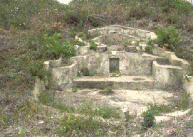
Figure 12.7 Grave of Unknown Person
Former Yung Long Archaeological Site
The Project Site is located next to the
former Yung Long archaeological site (at the beach area beneath the existing
Black Point Power Station) (see Figure
12.7). The archaeological site was identified
by the Hong Kong Archaeological Society in 1974 and listed as an archaeological
site in 1981. In 1983 two test pits
were excavated and kiln furniture such as kiln bars, kiln brick, kiln cover,
fire grille and pot-stands were identified that identified the site as a
Neolithic pottery kiln complex ([5]). During 1992 and 1993, due to the
construction of the Black Point Power Station, a full rescue excavation was
conducted to preserve the site by record. The findings included archaeological features
such as a house foundation, post holes, firing stove, burials, workshop areas
and artefacts such as stone tools and stone rings, stone weights, pottery
shards and bone tools dated to the early phase of the Late Neolithic Age([6]) (2,900 BC to 2,400 BC).
Lung
Kwu Sheung Tan
Archaeological Site
The site was first recorded by the
Hong Kong Archaeological Society in 1976 where a small excavation was conducted
and identified finds which included coarseware, chalk
pottery and quartz discs. It was
again then visited by AMO in 1978 during which celadon and prehistoric shards
were identified. In the 1980s,
Peacock and Nixon undertook investigations at the site and prehistoric artefacts and Song dynasty artefacts
were identified([7]) .
Archaeological
Survey Result
As the Project Area is located
relatively close to the former Yung Long Archaeological Site where Neolithic
Age artefacts have been unearthed, the archaeological potential could not be
ruled out.
To obtain field data for the CHIA, an archaeological survey at Black Point as
part of the EIA was therefore undertaken between 12 and 15 October 2005.
A total of 40 auger holes and 9 test
pits were conducted for the archaeological survey (see Figure 12.8). Some late 19th to early 20th
century common village ware pottery shards and roof tiles fragments were
identified. However, as these artefacts can still be commonly found in the New
Territories, they are considered to have low cultural heritage
significance. No earlier period
finds were discovered from the survey.
Thus, it is considered that the Project Area is of negligible to low
archaeological potential.
12.3.2
Marine
Archaeological Resources
The waters between Shekou (situated in Shenzhen) and Black Point were used as
a war junk anchorage from the 8th century. In the 8th century (Tang
Dynasty), Black Point was within the military division area of Tunmen Bing Zhen (屯門兵鎮) whose 2,000 soldiers were under the
command of one Defence Commissioner. The headquarters of this division was
situated in the present Nantou (南頭) walled city of Shenzhen and its
military division area also covered the HKSAR, as well as the Huizhou (惠州) and Chaozhou
(潮州) areas ([8]). The military division was
serving the same area until the Yuan Dynasty (A.D.1279-1368).
In the late 16th century
(Ming Dynasty), China was facing frequent disturbance from coastal invaders and
more forts and beacon towers were set up to protect the key locations from
Japanese pirates. The Nantou Military Division (南頭寨) was established in 1565 and
commanded 53 war junks and 1,486 soldiers ([9]). The military force was
increased to 1,659 soldiers in 1645.
During this period, the Portuguese
explorer, Jorge Alvares was permitted to land on Lintin Island (Neilingding 內伶仃) in 1513 ([10]). He then built a fort and erected a stone column with a carving of the
Portuguese national symbol. The
Chinese navy attacked and demolished the Portuguese fort in 1518 ([11]). In 1522, it was recorded
that a sea battle between the Chinese navy and Portuguese ships was fought in
the water between Lantau Island and Tuen Mun. The Chinese navy won the battle.
A review of a historical chart of
the mouth of the Pearl River dated 1658 ([12]), also indicated that the waters between Black Point and Lintin Island were part of the main shipping route from the
West to the East.
During the Ming to Qing Dynasties
(A.D.1368 -1911), Imperial Junks sailing from Guangdong to Southeast Asian
countries were required to anchor at a bay known as Chiwan
(赤灣) on the Nantou peninsula,
located to the west of Shenzhen City (located some 9 km north of Black
Point). The Nantou
area used to zone as the Nantou Military
Division. During the early Qing
Dynasty in the 1660s, although the Nantou Military
Division was replaced by Xin’an Camp (新安營), it was still situated within the Nantou Walled City ([13]). A Tin Hau
Temple was established in this Chiwan Bay, probably
in 1410 according to an inscription of the Temple where sailors worshipped Tin Hau seeking protection from mishaps at sea([14]). Two stone forts were also
built near the Tin Hau Temple during the Qing Dynasty
and the remains of the forts can still be found.
Based on this historical review, it
is considered that Black Point is located in the vicinity of a historically
busy marine sea route. The waters
at Black Point, Deep Bay and Neilingding Island have
provided the main shipping channel between Guangdong and the Southern China Sea
and Southeast Asian countries as well as East and West for centuries. On this basis, the waters at Black Point
are considered to have marine archaeological potential.
A review of the Study on the Potential, Assessment, Management and Preservation of
Maritime Archaeological Sites in Hong Kong undertaken in 1998([15]) identified a number of shipwrecks
recorded some 3.5 km Northwest outside the proposed project area but no
shipwrecks were identified within the proposed project area. A review of the wreck files kept by the
United Kingdom Hydrographic Office identified no
shipwrecks were found to be within 1km of the Project Area.
Geophysical Survey Data Review
Geophysical surveys were undertaken
by CAPCO’s geophysical contractor EGS(
The geophysical survey
using multi beam system, side scan sonar system and sub-bottom profiler system
showed that the surveyed area has been impacted by anchoring, trawling and the
dumping of materials. A site was
identified as possible wrecks on the seabed (Figures
12.9 and
12.10, and Table 12.2).
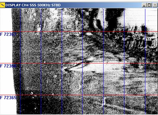
Figure
12.10 Possible
Wreck (SC086)
Table 12.2 Sonar Contact SC086
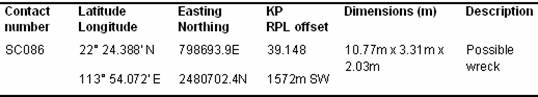
Based on the side scan
sonar image SC086 was considered to be a possible wreck. In order to address the doubt as well as
the possibility that the recognizable shipwreck could be modern sites, (i.e.,
post-1800 the date which AM Ordinance
defines an antiquity as a relic) a magnetic survey was conducted to ascertain
how much ferrous material remained on the anomalies. While pre-1800 ships would have carried
ferrous equipment and used ferrous material in their construction, it was
considered that the amount of ferrous material detected during a magnetic
survey could provide an indication on the age of the vessel.
Magnetic Survey
EGS
performed the magnetic survey and conducted a measurement of turbidity from 2
to 4 September 2005 at 14 Sonar Contacts of archaeological potential between
South Soko and Black Point. Sonar
Contact SC086 is located within the Black Point Study Area.
The
magnetometer survey confirmed
the presence of ferrous material at SC086 to
contain in excess of 1,000nt more that the surrounding area. This was estimated to be in excess of 2-3
tons of ferrous material and given the size of SC086, this site was interpreted
as a wooden vessel containing a reasonable amount of iron/steel.
Remote Operated Vehicle (ROV)
In order
to investigate the age and nature of SC086, an ROV survey was undertaken on 15
February 2006 by EGS under the marine archaeologist’s supervision. The finding is summarized in Table
12.3 and detailed
in Annex 12-B.
Table
12.3 ROV
Survey Findings
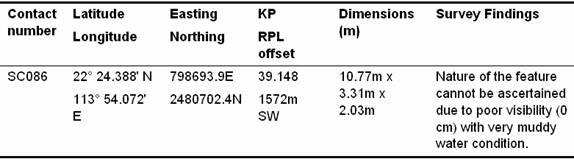
Because of the poor (nil) visibility,
the nature and ages of SC086 could not be determined. The presence of fishing nets found on
SC086 also made a diver survey too hazardous due to the prominence of the nets
on the seabed and the likelihood of trapping nets. Therefore, a more detailed sonar survey
was carried out in an attempt to further define SC086.
Side Scan Sonar and Multi Beam Sonar
Survey
A further detailed side scan sonar and multi
beam sonar survey was undertaken by EGS in April 2006 for Sonar Contact
SC086. An analysis of this new data
in context with the earlier survey work (side scan sonar survey and
magnetometer data) was carried out by the marine archaeologist. The summary result is presented below
and detailed findings are presented in Annex
12-B.
The
result indicated that the vessel and its location has the appearance of a
‘recent’ motorised wooden sampan.
Located close to the rocks at Black Point and effected by the swells
breaking over it, and the continual sea traffic, the vessel could not be
expected to maintain its integrity for very long (perhaps months or just a year
or so). Seats can be seen in the
vessel and it shows damage to its hull which is considered to have been caused
from its continual movement/sinking.
A vessel of pre-1800 age would not be in this condition at this
location.
The
Marine Department salvaged a similar looking sampan on the 22 March 2006 which
they reported was about 30 years old.
SC086 is probably of a similar vintage. Based on the survey data, SC086 is
considered to be a motorised sampan and is therefore not an antiquity or relic
of archaeological value according to the Antiquities
and Monuments Ordinance (Cap. 53).
12.4
Assessment Methodology for Cultural
Heritage Impact Assessment
The CHIA methodology follows the
criteria and guidelines in Annexes 10
and 19 of the EIAO TM and the criteria for Cultural Heritage Impact Assessment
(CHIA) and Guidelines for Marine Archaeological Investigation (MAI) as stated
EIA Study Brief No. ESB-126/2005.
12.4.1
Baseline
Study for Terminal Site
A comprehensive inventory of cultural
heritage resources within the project area was compiled and includes:
·
All declared monuments or graded
historical buildings listed by AMO;
·
All sites of archaeological interest
(including marine archaeological sites);
·
All pre-1950 buildings and structures;
·
Selected post-1950 buildings and
structures of high architectural and historical significance and interest; and
·
Landscape features including sites of
historical events or providing a significant historical record or a setting for
buildings or monuments of architectural or archaeological importance, historic
field patterns, tracks and fish ponds and cultural elements such as fung shui woodlands and clan
graves.
Information sources included the AMO, Hydrographic Office of Marine Department, the Royal Naval Hydrographic Department in UK, Lands Department, Public
Records Office, tertiary libraries and the internet.
12.4.2
Field
Surveys
Historical Buildings and Features
Survey
The Project Area (defined as the area
within and up to 100 m from the terminal site boundary) was field scanned to
identify all historical buildings and structures. Photographic records of each building or
structure, (exterior and interior where possible) as well as the surroundings
were taken. Architectural and
historical appraisals of identified sites were also developed. Three building
structure sites located at three Terrace areas were identified. They are detailed in Section 12.3.1 above.
Terrestrial Archaeological Survey
Prior to fieldwork commencement, a
desktop review was undertaken through the review of old maps, aerial
photographs, topography, geological background and previous archaeological survey
findings to establish the fieldwork scope for agreement with AMO. Relevant licences and permits were
obtained from DLO/Tuen Mun
and AMO. The fieldwork was
undertaken between 12 and 15 October 2006.
A total of 40 auger holes and 9 test pits were conducted within the
surveyed area (see Figure 12.8).
The detailed findings are presented in Annex 12-A and summarised in Section
12.3.1
Marine Archaeological Investigation
Following a baseline review including
review of literature and old maps, consultation with UK Hydrographic
Office and Hong Kong Hydrographic Office on their
database of shipwrecks, comprehensive geophysical survey comprising the use of
side scan sonar system, multi-beam system, magnetometer system, sub-bottom
profiler system and Remote Operated Video (ROV) system were undertaken in
varies stages covering the proposed submarine Project Area. Table
12.4 summarised the systems adopted and survey period undertaken for the
Geophysical Survey. The survey
data obtained by EGS were reviewed and interpreted by the marine archaeologist
to identify features of possible archaeological potential. The detailed
methodology and findings are presented in Annex
12-B and summarised in Section 12.3.2.
Table
12.4 Geophysical
Survey Conducted for MAI
|
Stages |
Survey
System Adopted |
Survey
Period |
Remarks([16]) |
|
1 |
Side Scan Sonar System, multi-beam
system, sub-bottom profiler system |
May to July and August to September 2005 |
Covers
the submarine project area |
|
2 |
Magnetometer system |
1-4 September 2005 |
For 14
Sonar Contacts only |
|
3 |
Remote Operated Video |
15 February 2006 |
For 6
Sonar Contacts only |
|
4 |
Side Scan Sonar System, multi-beam
system |
6-7 April 2006 |
For 6
Sonar Contacts only |
12.5
Potential Sources of Impact
12.5.1
Construction
Phase
The construction phase of a development
may have direct or indirect impacts to sites of potential sites of cultural
heritage. Such impacts may arise
from the following activities:
·
Direct loss of historical buildings or
structures due to temporary or permanent landtake for
development;
·
Indirect impact on access for future
archaeological surveys due to temporary or permanent landtake
for development where the archaeological deposits are preserved in situ within the development site but
in instances where no soil excavation work is required at the archaeologically
sensitive area;
·
Temporary or permanent change of
cultural landscape around standing heritage that indirectly reduces the associated
cultural landscape value;
·
Construction vibration impacts on
standing heritage;
·
Temporary or permanent access
disturbance to standing heritage due to construction work near standing
heritage.
·
Direct loss of potential marine
archaeological deposits due to seabed construction works such as dredging and
piling; and
·
Direct loss of archaeological deposits
due to soil excavation in archaeological deposits area.
12.5.2
Operation
Phase
The operation phase of a development
may have direct or indirect impacts to sites of potential sites of cultural
heritage from the following activities:
·
Indirect impact on access for future
archaeological surveys; and
·
Permanent access disturbance to
standing heritage if the standing heritage are conserved within the developed area.
As there are no Declared Monuments
or Deemed Monuments located within the Project Area and no sites of cultural
heritage protected under the AM Ordinance
have been identified, construction and operational impacts to sites of cultural
heritage are not expected.
Direct loss of two building structures
at Terrace 1, a WWII cave at Terrace 2 and a stone structure at Terrace 3 is
expected due to the site formation works for the development within the Project
Boundary. As these features are
considered to have low heritage value their loss is acceptable.
Impact to the grave is not expected as
it is located outside the project boundary.
One potential marine archaeological
site (SC086) was identified from a review of geophysical data and magnetometer
data review. A ROV survey and
further detailed side scan sonar and multi beam survey was undertaken to
inspect the nature and age of the site.
The surveys indicated that SC086 is a modern motorized sampan and is
therefore considered to have no archaeological value. Since no marine archaeological resources
were identified within the marine area of the proposed development, no impact
is expected.
At present there are no planned
projects on Black Point that could have cumulative cultural heritage
impacts with the construction of the LNG terminal.
12.7
Mitigation Measures
Although the direct loss of two building structures at Terrace 1, a
WWII cave at Terrace 2 and a stone structure at Terrace 3 is expected due to
the site formation works for the development, these cultural heritage resources
are considered to have low cultural heritage value. Thus, the impact is considered
acceptable provided that a photographic and cartographic recording is undertaken
for the sites following AMO’s requirements.
As no impact on the grave is expected,
no mitigation measure is required.
As no marine archaeological interest
sites have been identified, no impact is expected. Thus, no mitigation measures are
considered necessary.
A literature review supplemented by
a field survey has identified four terrestrial sites of cultural heritage
comprising two
building structures at Terrace 1, a WWII cave at Terrace 2, a stone structure
at Terrace 3 and a grave site. Construction activities will impact the
three building structures, but they are considered to have little cultural
heritage value. Appropriate
mitigation measures comprising the preparation of photographic and cartographic
records prior to their removal will be undertaken to preserve these structures
by record.
No impact to the identified grave is
expected as it is located outside the project boundary.
No marine
archaeological sites have been identified, thus, the proposed development
imposes no marine archaeological impact and no mitigation measures are
considered necessary.
With the implementation of the
mitigation measures as detailed in Section
12.7, no residual impact is expected.