The proposed development of the bathing beach at Lung Mei,
Tai Po was established under this Assignment, through liaison with ArchSD, LCSD and CEDD. The current development layout and
arrangement has been selected through critical review of key issues such as
traffic, road safety, drainage impacts, sewerage impacts, beach building
facilities, topography, marine, environmental impacts, reclamation, current and
future development and design standards.
The current land
area opposite Lo Tsz Tin, south of Ting Kok Road, where the car park and beach building are to be
located on are basically at the correct formation level and therefore, to
completely form the land for the above facilities, there will be a need of
around 21,000 m3 backfill material. The backfill will mostly come
from outside sources but around 8,300 m3 will be available from
within the site, which will mainly come from the insitu
material in constructing the eastern box culvert and for the western drainage
channel.
The proposed Lung Mei beach facilities and carpark area will be accessible off
Based on an estimate of the quantities of sand, public fill and other construction materials and equipments required for the construction of this project, and taking into consideration that some of the construction materials would be transported to the site by barge, it has been estimated that the maximum construction traffic generated by this project would be about 50 trucks per day each way.
The downstream of the existing Lo Tsz
River is proposed to be diverted to the west of the Project site by about
70m. The diversion scheme comprises a
3.7m wide drainage channel and a reinforced concrete box culvert, which will
function as a transition for connecting the existing box culvert and the
proposed drainage channel. The drainage
channel is proposed to be formed with sloping gabion embankments and rip-rap
bedding. The proposed open channel is approximate 59m long with 5 layers
gabion baskets. To enhance the
environmental values and mitigate visual impact from
The existing single cell box culvert
at Lung Mei is proposed to be diverted with a right angle turn to the east by
around 90m. The proposed diversion works include construction of a reinforced
concrete box culvert, and also the re-profile of a section of the existing box
culvert invert level with concrete.
To consider the visual impact from
Tai Mei Tuk, the finishing of the proposed eastern
box culvert will be consistent with its adjacent vertical seawall. Moreover, additional planting area is
proposed on the top of box culvert to enhance the environmental aspects of the
works.
For ease of construction and
minimize the environmental impacts, the box culvert is proposed to be
constructed as pre-cast and cast in-situ segments with toe protection along the
proposed culvert.
Seven existing gullies in the
proximity of Lo Tsz Tin are proposed to be
re-constructed for local widening of
A separate stormwater
drainage system is proposed within the beach carpark.
The proposed system comprises a petrol interceptor in compliance with EPD
regulations, and a pipeline with diameters varying from 375mm to 750mm. The
collected runoff within the carpark is proposed to be
finally discharged to the sea through the proposed box culvert at Lo Tsz River.
It is proposed to collect all sewer
and wastewater flow from the beach development. There will be 4 foul sewer
manholes and one sewage holding tank proposed with a proposed sewer of 225mm
diameter that will be aligned across the car park, across the existing Ting Kok Road and eventually connect to the existing trunk sewer
by tapping into an existing foul sewer manhole.
The most appropriate orientation of
the beach and groyne structures has been determined
from mathematical modelling. The design beach profile has also been determined
from modelling studies that examined the beach response to normal and storm
wave conditions. From current assessment of grain size for the available beach
sand sources and with reference to relevant design guidelines, the proposed
designed slope of the beach will be constructed consisting of a 1:12.5 upper slope
above +2.0mPD and 1:15 below, with the beach recharge offshore of the natural
step consisting of a 1:25, as shown on Figures 2.8 and 2.9.
A wave modelling
was carried out to assess the storm response upon a design construction profile
and a design equilibrium profile. The sediment sizes used for the modelling were focused upon 0.4mm (although grain sizes of
0.2mm, 0.3mm and 0.5mm were also modelled) as this had been
identified as the most probable sediment size to be used, which is an average
representative of the random sieve analysis taken from samples taken from
beaches in Hong Kong in late 2006, namely Lung Mei, Tai Po, Lower and Upper
Cheung Sha Beach, Lantau
Island, Golden Beach and Ping Chau Beach. However,
Fill Management Division of CEDD has confirmed that sand sources from Hong Kong
SAR should not be considered on environmental and political grounds. Therefore,
sand sources from outside Hong Kong SAR should be investigated in the detailed
design stage.
Sand source distributors for the proposed beach have been contracted and
it was ascertained that sand sources of D50, from 0.2mm to 0.5mm,
are currently available from
Notwithstanding the above, it is
understood that the sand source for the Cheung Sha
Replenishment in Lantau Island during the period from
late 2006 to the first quarter of 2007 have been acquired from Zhujiang estuary (Shajiao) in
Mainland China. Port Works Division of CEDD has also recently completed some
sand replenishment works at Peng Chau
where the sand was sourced from Ma Wan and Zhujiang
estuary (Shajiao), Mainland
The sand quality will be based on
similar requirements in respect to sand for a recreational beach as set out in
Section 3.6 of the Port Works Design Manual: Part 5 – Guide to Design of
Beaches and shall comply with the requirements as promulgated in WBTC No.
10/1995.
It
has been ascertained that the required sand fill required for beach is 37,500m3
of sand.
The extreme wave conditions
established by the modelling studies were used to determine an appropriate
armour rock size, beach crest height, and groyne
cross-section. Therefore, there will be two rock groynes,
one 100m on the east and the other 120m on the western end of the beach. The groynes will be protecting the bathing beach using natural
rock armour construction. It is anticipated the recharging of the beach with
sand and the groyne construction under low water mark
will be carried by marine based plant and equipments.
During the construction works, there
will be a silt curtain to minimise the water quality impact due to the sand
filling and dredging works.
Finally, at the operation stage,
there will be a shark prevention net at the perimeter of the bathing beach,
surrounding the toe and side of the beach.
The proposed orientation of the beach is aligned at 145o to the north
and the wave and sediment modelling results presented
in Appendix B shows that the net longshore drift of
the sediment is not significant (10 to 150m3 per year) for sediment
sizes of 0.25mm, 0.3mm and 0.5mm. However, with the groynes
in position, the sediment will eventually drift towards the western groyne and in general be contained by the groynes as shown on
Figures 2.7 to 2.9. In addition, there
is no significant problem with cross-shore sediment movement under storm wave
conditions. Therefore, no sand loss is anticipated for the proposed bathing
beach and as such, no environmental impact would be induced on the adjacent
environmental sensitive areas.
Therefore,
under the operational phase of the beach development, the two groynes at either end of the beach will contain the small
net drift amount that has been identified in the wave and sediment modelling results presented under Appendix B. Consequently, the assessment demonstrated that there
will be no ecological impacts to the environment, in particularly the SSSI on
the west of the Project site and those corals identified in the EIA study.
The bathing facilities
for this development have designed by ArchSD and will
mainly consist of 3 building structures as discussed below and shown on Figure 2.4:
·
There will be a one level
building near the
·
The other two structures
will be adjacent to the beach, facing the sea. The building on the eastern side
will have one level, which will comprise of the family and female changing
rooms, toilets and shower rooms; this will also include all the associated
E&M facilities. Outdoor shower facilities will be situated at the side of
this building; and
·
The third building on the
west will basically be a two storey structure, which will comprise of the
ancillary facilities including management office, lookout/surveillance post,
first aid room, solar water tank & pump room, fire services tank room,
water tank room, fast food kiosk, etc. It will also have equipment / machinery
stores for catamarans, motorized boats, beach transporters, beach cleansing and
sand levelling machines, etc., as well as goods stores. A sun shading will
be situated at the west of the building to accommodate a seating area.
A Category 5 (Substances
Giving Off Inflammable Vapour)
dangerous good (DG) store is required for storing Oil dispersant, Motor spirit,
petrol, Kerosene and Lubricant for operation of machinery. In addition,
lacquers, varnish and paint thinner will also be stored for painting
maintenance. The DG store will be located within the administrative building at
the carpark level, which can be reached directly by
DG vehicle for delivery of DG and by fire appliances during emergency. The
storage of containerized LPG and containerized chlorine are not expected, but
small quantity of bleaching solution (Sodium hypochlorite, Cat. 4 D.G.), less
than 250 litres which are below the FSD exempted
quantities, will be stored at beach for cleansing purpose e.g. toilet/changing
room.
The Water/FS Pumps and
the Mechanical Ventilation of plant rooms would be in operation for 24 hours.
There are 3 numbers of pumps in the water tank room and 3 numbers of pumps in
the FS pump room. Both of the pump rooms would be on Level 2 (see Appendix I for building elevation) and
mechanical ventilation fans would be provided at each plant room.
There will also be a fee
paying car park, which will accommodate 100 private cars, 10 motorcycles and 3
coaches, with drop off arrangements. In addition, there will be two lookout
towers at the beach level.
Landscaping works are
planned around the perimeter of the car park as well as the roof terraces above
the changing rooms, along the groynes and also above
the proposed culvert at the east section of the bathing beach.
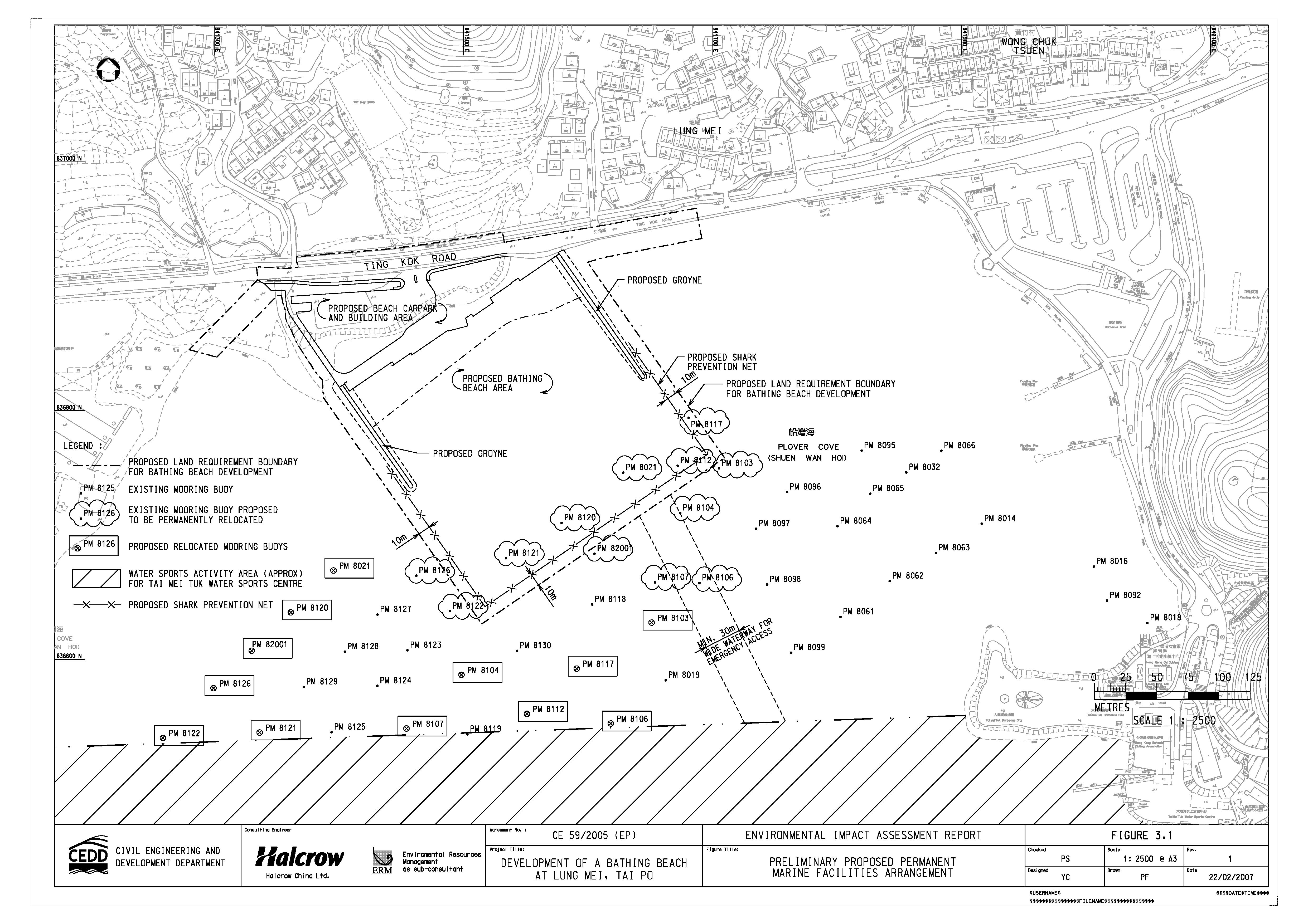
There
are 38 mooring buoys for the leisure yachts, which are located in the vicinity
of the proposed footprint of the beach development. For the beach operation, it was suggested to Marine Department (MD) that 12 of the
existing mooring buoys should be permanently relocated as shown on Figure 3.1. The relocations are proposed
in the vicinity of the Lung Mei waters taking into account the following
criteria:
·
Provision of about 50m clearance from the Shark Prevention Net, which should be sufficient clearance from
the leisure yachts in light of the information provided by MD on the chain
lengths attached to the buoy and will also be sufficient clearance for future
maintenance of the Shark Prevention Net;
·
Sufficient clearance between the
leisure yachts, which are also determined according to the chain lengths of the
affected buoys;
·
Away from the Ting Kok SSSI as far as possible;
·
Sufficient water depth for yachts
access (the proposed relocation will be further confirmed with the latest
sounding survey records);
·
Avoid disturbances to the waterway
for access to the existing landing steps at Tak Mei Tuk;
· Minimizing interfaces with the existing water sports activity area of Tai Mei Tuk Water Sports Centre (Approximate extent of the area is shown on Figure 3.1).
Moreover, the marine facilities arrangement proposal as shown on Figure 3.1 will be subject to the agreement with the relevant government departments as well as to the latest sounding survey prior to commencement of the construction works.
The operation phase of the Proposed Beach Development is
considered as commencement of the handover date to LSCD so that the proposed
measures recommended under EM&A should be carried out as appropriate after
the handover. However, there may be a time lapse between the handover date and
the formal opening for public use due to the application of the beach gazette
by LCSD.
Furthermore, the proposed swimming
area, which will be about 200m long and 200m wide, will be protected with shark
prevention net located at the perimeter of the swimming area. The proposed swimming area together with a
buffer zone will fall within the gazette beach boundary.
The normal beach operating hours as well as the PA system
operation hours are as follows –
|
Period |
Time |
Remark |
|
April,
May, September, October |
9:00
a.m. - 6:00 p.m |
Daily |
|
June,
July, August |
9:00
a.m. - 6:00 p.m. |
Weekdays |
|
8:00
a.m. - 7:00 p.m |
Saturdays,
Sundays & Public Holidays |
|
|
November,
December, January, February, March |
8:00
a.m. - 5:00 p.m |
Daily |
As
discussed in Section 3.9, the arrangement of the beach groynes will prevent any sand loss and therefore, regular sand
replenishment is not anticipated. However if sand replenishment on the proposed
beach is required in the future due to possible sand loss occurring after
extreme storm conditions, such as the passing of extreme typhoons, it is
anticipated that in such case, sand replenishment will be carried out using
land plant and the sand will be placed above the mean high water level. Eventually, the beach
will reprofile due to naturally occurring
environmental factors such as wave actions, current movements and wind.
The Proposed Bathing
Beach Development will be carried out under two
construction contracts. The beach buildings and associated facilities will be
constructed under one construction contract, whilst the other civil engineering
works will under a separate contract.
The construction works are
currently programmed to commence in December 2008 and the works are scheduled
to be completed within two years, exclusive of delays due to issues such as
inclement weather. The programme is shown on Figure 3.2.
The