5.3 Legislation, Standards & Guidelines
5.5 Ecological Baseline Profile – Literature Review
5.7 Construction Phase Impact Assessment
5.8 Operational Phase Impact Assessment
5.10 Mitigation Measures & Best Practice
5.11 Residual Impact Assessment
5.12 Environmental Monitoring & Audit Requirements
5.13 Conclusions & Recommendations
5.1.1.1 This section presents the approach to and the findings of the benthic ecology baseline assessment and the Project Impact assessment.
5.1.1.2 The aim of the benthic ecological impact assessment is to examine the benthic ecological conditions within the assessment area in order to protect, maintain or rehabilitate the natural environment.
5.2.1.1
The benthic ecological
assessment has been undertaken in accordance with the criteria and guidelines
in Annexes 8 and 16 respectively of the EIA-TM, and with reference to the
requirements of Clause
5.2.1.2 The key objectives are as follows:
· Review the findings of relevant studies/surveys and collate the
available information regarding the ecological characters of the assessment
area;
· Evaluate information collected and identify any information gap
relating to the assessment of potential ecological impact;
· Conduct ecological field surveys and investigations of at least six
months duration covering both wet and dry season to fill in the information
gaps identified in Sections
· Establish the general ecological profile of the Study Area taking
into account seasonal variations, and describe the characteristics of each
habitat found. Major information shall include inter alia the types / locations of habitats and species of
conservation interest such as hard coral, octocorals and black coral
communities; and notable marine benthic / littoral communities, in particular
amphioxus Branchiostoma spp.
· Identify and quantify as far as possible impacts such as
deterioration or disturbance to corals, and removal or disruption of
potentially valuable benthic communities such as amphioxus, Branchiostoma spp.
· Evaluate the significance and acceptability of the ecological
impacts during Project construction and operation, including management and
maintenance requirement.
· Recommend all possible alternatives and practicable mitigation
measures to avoid adverse ecological impacts during Project construction and
operation upon corals and amphioxus.
· Evaluate the feasibility and effectiveness of any recommended mitigation measures, quantify as far as practicable the residual impacts of mitigation measure implementation and evaluate the acceptability of any residual impacts using the criteria in Annex 8 of the TM.
· Review any requirements for ecological monitoring.
5.3 Legislation, Standards & Guidelines
5.3.1.1
Reference has been made to the following local legislation governing
conservation of marine ecological resources:
· Protection of Endangered Species of Animals and Plants Ordinance (Cap. 586) controls the local possession of any endangered species of animals and plants listed in its schedules. These include various types of coral, including Stony (hard) corals (order Scleractinia) and Black corals (order Antipatharia). Soft coral is not protected under this Ordinance.
· Fisheries Protection Ordinance and Regulations (Cap. 171) regulates fishing practices, aims to prevent activities detrimental to the fishing industry and aims to protect fishes and other marine biota in HKSAR waters.
· Relevant Mainland regulations
include the Wild Animals
Protection Law that inter alia protects the habitats of all wild fauna,
including the creation of Class I /II protected species lists (Class I species
being of greater concern).
· International / regional conservation regulations, standards and guidelines of relevance include the Convention on International Trade in Endangered Species (CITES) [of Wild Flora and Fauna] and the international Convention on Biological Diversity under which there are provisions for the protection of corals. Black corals gained protection under Appendix II of CITES in 1981.
· The International Union for Conservation of Nature and Natural Resources (IUCN) Red List is a comprehensive global inventory of species of conservation concern, with species listed according to conservation risk criteria.
5.4.1.1
A review of available data and information has been conducted. The most
relevant updated sources of data / information for corals / epifauna included
inter alia:
· HATS Corals Survey Report, 2003.
· Ecological Status and Revised Species of Hong Kong’s Scleractinian Corals, 2004.
·
Field Guide to Hard Corals of
· Further Development of Tseung Kwan O Feasibility Study, 2005, and
· Distribution and Community Structure of Octocorals in Eastern Waters of Hong Kong, unpublished data from May 2006 survey.
5.4.1.2 The key data source on benthic infauna communities of the HKSAR and Eastern Waters was the Consultancy Study on Marine Benthic Communities in Hong Kong, 2002.
5.4.2 Marine Geophysical Survey
5.4.2.1 A side scan sonar survey was conducted during August 2006, with one of the objectives being to identify areas of rocky outcrop or angular dumped materials (e.g., boulders or concrete) that may be suitable for coral establishment.
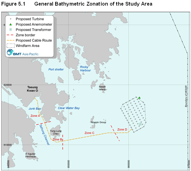
5.4.2.1 As displayed by Figure 5.1, the marine geophysical survey results led to the seabed in the Study Area being divided into four zones corresponding with the general bathymetry:
5.4.2.2
Zone A -
Inshore
5.4.2.3
Zone B -
Tathong Channel: deeper water to ~15 -
5.4.2.4
Zone C -
Nearshore Eastern Waters: waters some 20
5.4.2.5 Zone D - Offshore Eastern Waters: waters east of the Ninepins with depths to -30mPD. Seabed in the windfarm area characterised by silty mud, with low potential for hard substrate.
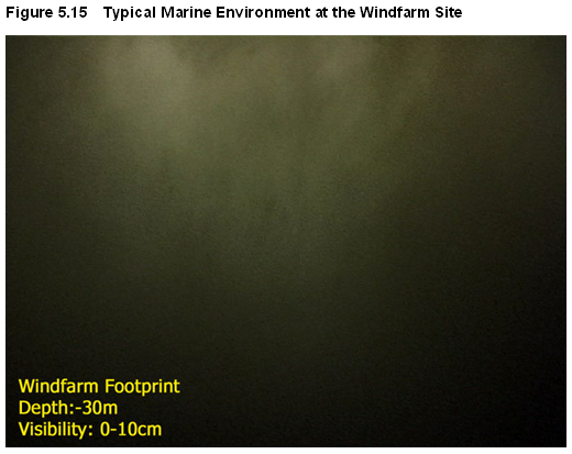
5.4.2.6 Reconnaissance dives at 3 locations in the windfarm area ultimately confirmed the absence of suitable substrate in an environment dominated by silty material. Figure 5.15 shows typical marine conditions at the wind farm site. Dives at two locations in the Tathong Channel with potential consolidated seabed material could not be completed due to safety reasons, given the locations were in the marine navigation channel.
5.4.1.1 Baseline surveys of the coral / epifauna community were conducted using standard dive survey methodology involving:
5.4.1.2 Spot-check (reconnaissance) dives: used for the initial assessment of depth zones and the suitability of a location for detailed transect surveys.
5.4.1.3 Rapid Ecological Assessment (REA) method: following DeVantier et al (1998, 2000), REA involves the standardised collection of semi-quantitative data concerning reef development, various environmental attributes and details of coral community structure.
5.4.1.4 Prior to positioning of transects for the REA assessment, a series of reconnaissance dives were systematically conducted to identify suitable survey areas at each location. Following each reconnaissance dive, observations were discussed and an appropriate depth zone and number / length of transects was apportioned for each suitable location.
5.4.1.5
At the inshore survey locations
each transect was placed parallel to the shoreline, comprising a survey line of
up to
5.4.1.6 Video footage was recorded first at each location to avoid potential disturbance of fine sediment, followed by REA survey and data collection. All REA transect surveys were recorded using a mini DV format video camera, with footage transferred to DVD using an MPEG compression programme. Footage was reviewed to verify the REA data. A photographic record was also compiled for each location.
5.4.2.1
Baseline surveys of the infauna
community were conducted using standard methodology involving the collection of
5 replicate sediment samples at each station using a
5.4.2.2
To increase the survey coverage
the replicates were no closer than
5.4.2.3 Each grab sample, once collected, was inspected to ensure that the volume of sediment obtained was not less than 2 litres and that there were no signs of uneven penetration by the grab during lowering. A photographic record of sediment colour at each station was taken prior to sample processing.
5.4.2.4
For faunal analysis, the
sediment sample was gently washed with seawater through a stack of
5.4.2.5
Sorting of all residues
remaining on the
5.4.2.6
Determination of sediment
particle size distribution was conducted for one replicate per sampling station
by wet sieving through a stack of sieves of 2,000 to
5.4.2.7 A variety of Quality assurance / quality control measures were implemented consistency in the species identification process. In processing all faunal samples in both surveys, no animals were missed during the sorting and identification stages. Field data were entered to a database prior to statistical analyses.
5.5 Ecological Baseline Profile – Literature Review
5.5.1.1 With regard to hard corals, much of the inshore Study Area (i.e., west of Tung Lung Chau) is characterised by exposed rocky coastline against a generally silty seabed, and with turbid marine waters. As such, most hard coral communities in the area are limited to small colonies.
5.5.1.2 The communities with the highest diversity, density and most hard coral accretion in the HKSAR are generally found in offshore eastern waters, and generally belong to one of three community types (AFCD, 2004):
· Platygyra
– Favia community: clear shelter waters with low turbidity
and sediment and high salinity;
· Acropora
solitaryensis – Montipora peltiformis community: more exposed
areas of moderate to high water clarity and salinity and low sediment; and
· Porites
deformis – Cyphastrea community: deeper communities – moderate water
clarity and sediment deposition.
5.5.1.3
Octocorals /
soft corals prefer deeper and more turbid sites where
hard coral cover is generally low.
Coverage averaged 1% in the hard coral dominated sites, while Victor
Rock reportedly had a soft coral coverage of ~70% (ibid). From the HATS Coral
Survey (Oceanway, 2003), the best octocoral diversity and percentage coverage
in the study area was at Ngan Wan (Tseung Kwan O /
5.5.1.4
Local
literature on black coral is extremely limited.
Zhou and Zhou (1984) first documented three species of Antipathes and three species of Cirripathes
from the
5.5.1.5 Other more recent records of black coral in the HKSAR include:
· South Ninepin: occasional black coral found at
· Tolo Channel: extensive black coral communities growing in shallow
waters on both sides of the Channel, particularly towards
5.5.1.6
The
5.5.1.7
The
dominant Antipathes species in
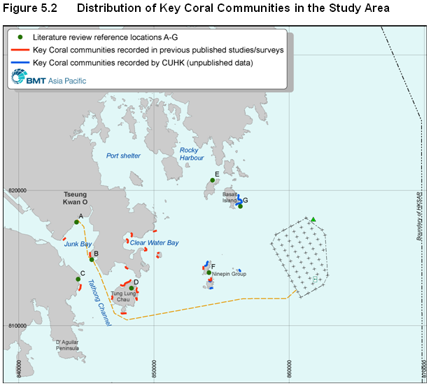
5.5.1.8 A literature review yielded more specific information regarding coral distribution, as presented below. Figure 5.2 displays these and other locations of interest.
A. Southwest
coast of
5.5.1.9 Although only a very low abundance of hard corals has been recorded, the coastal area close to Lei Yue Mun has been found to have high abundance of soft and gorgonian corals (Maunsell, 2005). These soft and gorgonian corals are especially prevalent in the mid-depth and deep zones where up to 50% coverage has been noted, but a relatively high mortality of up to 30% has also been observed (Oceanway, 2003).
B.
5.5.1.10 Very few hard corals have been recorded in the shallow waters (only one single colony of Acanthastrea echinata was recorded in HATS Study). In contrast, soft corals and gorgonians have been identified as moderately abundant and occurred more frequently in middle zone (25-50% cover).
5.5.1.11
A rich and diverse soft /
gorgonian coral community dominated by Echinomuricea
sp. has been found extending from the shallows into deeper waters, with certain
groups of fauna such as sea fans, sea whips and soft corals being markedly
larger in the shallow waters than in the middle and deep depths. This group of
soft coral community has been perceived to be one of the best in
5.5.1.12 Low cover (<5%) of both hard and soft corals has been recorded along the south and west coast of Tung Lung Chau. However, the north Tung Lung Chau has been found to have a good hard coral cover (10-25%) occurring in the shallow waters.
5.5.1.13
Ung Kong Wan is described as
being among the top 12 most important coral sites in
F. Ninepin Group
5.5.1.14
The AFCD (2004) study suggests
that both North and
5.5.1.15
The most recent survey
conducted by
5.5.1.16 In South Ninepin waters, a relatively high abundance of hard and soft corals has been recorded at Kwo Chau Wan (north of South Ninepin), while gorgonians have been found to be moderately abundant on the southern side of South Ninepin.
G. Southeast
of
5.5.1.17
Researchers from
5.5.2 Benthic Infauna
5.5.2.1
As regards benthic infauna, the
largest field survey conducted in the HKSAR in recent years was ‘The Consultancy Study on Marine Benthic
Communities in Hong Kong’ conducted by
5.5.2.2
Some 179 species were found
only in the wet season, and 137 species were found solely from the dry season
survey. Despite this, the study
concluded there was no distinct seasonality in
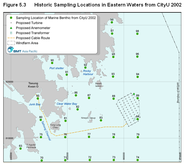
5.5.2.3 A number of the survey stations were located in Eastern Waters in the vicinity of the proposed project. Figure 5.3 displays the coverage of the CityU 2002 work in relation to this EIA Study Area.
5.5.2.4 Species diversity (H’) is a joint representation of species richness (d) and the evenness (J) of species distribution, and is usually high (e.g., H’ >3) in an undisturbed community and low (e.g., H’ <1) in a heavily disturbed community.
5.5.2.5
Shin (1989) reported previous
benthic surveys in Eastern Waters revealed diversity (H’) values of 2.21 – 3.50 and evenness (J) values of 0.80 – 0.91. In
contrast, diversity and evenness off
Table
5.1 Key
Biodiversity Indicators for the Study Area from CityU 2002
|
Area |
Species diversity (H’) |
Species evenness (J) |
|
Cable landing
( |
2.43 - 2.73 |
0.77 - 0.87 |
|
Nearshore cable (Tathong Channel) |
3.21 - 3.29 |
0.72 - 0.75 |
|
Offshore cable (South Ninepin) |
2.31 - 3.10 |
0.90 - 0.92 |
|
Windfarm |
2.99 - 3.58 |
0.84 - 0.92 |
Notes: Data for project locations with reference to CityU (2002) stations 85, 80, 77 and 88.
5.5.2.6
Maunsell (2005) conducted supplementary sub-tidal grab samples at three
soft substrate stations in
5.5.2.7
Overall, the survey results indicated these stations in
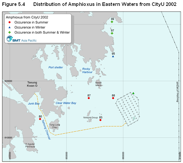
5.5.2.8 CityU (2002) also reported the presence of the cephalochordate (amphioxus) Branchiostoma belcheri in the Study Area, with records of 1 or 2 individuals collected from the vicinity of the nearshore cable route in the Tathong Channel, East Ninepins and the Windfarm footprint in the wet season only.
5.5.2.9 There also appears to be a resident population of Amphioxus at Tai Long Wan where densities of 50 – 100 per m2 recorded in both wet and dry seasons, although signs of seabed disturbance from human activity are of potential concern as regards marine conservation (ibid). Figure 5.4 presents the locations of Amphioxus within the Study Area.
5.5.2.10
Amphioxus is of conservation
significance because of its primitive morphology and because of its
over-exploitation as a fishery resource in coastal waters of the South China
Sea, especially near
5.6.1 Benthic Epifauna
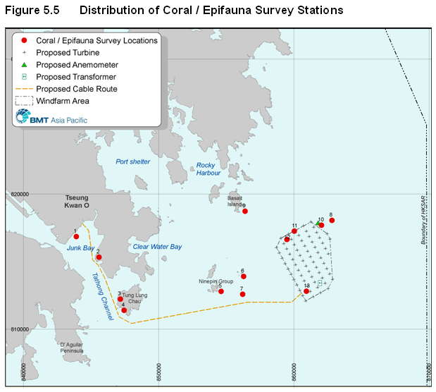
5.6.1.1 Following literature review and interpretation of side scan sonar, dive surveys were conducted at thirteen locations that together provide spatial representation across the study area. Table 5.2 presents the names and co-ordinates of the survey locations. Figure 5.5 displays the locations.
Table 5.2 Coral / Epifauna Survey Locations
|
Station |
Location |
GPS
Position |
|
1 |
Chiu Keng Wan |
N 22 17 527 E 114 14 936 |
|
2 |
Fat Tong Chau |
N 22 16 704 E 114 15 909 |
|
3 |
Tung Lung Chau West |
N 22 15 019 E 114 16 826 |
|
4 |
Tung Lung Chau South |
N 22 14 569 E 114 16 982 |
|
5 |
South Ninepins |
N 23 15 327 E 114 21 161 |
|
6 |
East Ninepins |
N 22 15 924 E 114 22 121 |
|
7 |
One Foot Rock |
N 22 15 207 E 114 22 080 |
|
8 |
Victor Rock |
N 22 18 163 E 114 25 927 |
|
9 |
|
N 22 18 532 E 114 22 189 |
|
10 |
Mast Area |
N 22 17 978 E 114 25 482 |
|
11 |
Wreck #1 |
N 22 17 723 E 114 24 355 |
|
12 |
Wreck #2 |
N 22 17 399 E 114 23 991 |
|
13 |
Un-identified object |
N 22 15 320 E 114 24 823 |
5.6.1.2 Six stations (1 - 5 and 7) were selected to cover the proposed cable route area. Four stations (10 - 13) were selected to provide representative spatial coverage within the windfarm area against known areas of potential interest.
5.6.1.3
East Ninepin (6) was selected
as it has been documented as a site of interest mid-way between the cable route
and the turbine area. Surveys were also
conducted at Victor Rock (8) - the submerged rocky pinnacle at about
5.6.1.4 A total of 30 REA transects were surveyed, with the shallow depth zone and deep depth zone accounting for 15 transects each.
5.6.1.5
The dive surveys were carried
out between March and June
5.6.1.6
Within
5.6.1.7
A description of the physical
and ecological characteristics of each of the 13 survey locations is presented
below. Appendix
5.6.1.8
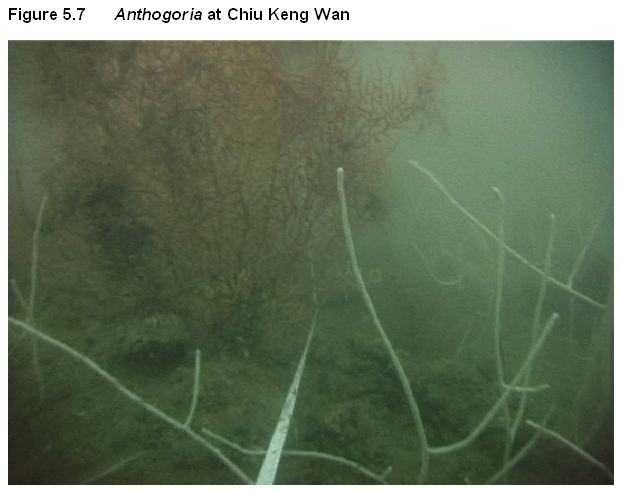
Chiu Keng Wan dive site was
located along the western coastline of
5.6.1.9
The shallow zone consisted of
both hard coral (<2%) and octocoral (5-10%), but with the latter being more
dominant. The deep zone was colonised
mainly by octocoral (20-25%) and black coral (<1%). The occasional Hippocampus kuda (seahorse) was also
noted attached to some of the gorgon
5.6.1.10
A total of four hard coral
species were recorded in the shallow zone (Favites
pentagona, Turbinaria peltata, Psammocora superficialis and Oulastrea crispata). All colonies were
small in size (<
5.6.1.11 Five octocoral genera were also found in the shallow zone (Euplexaura, Paraplexaura, Dendronephthya, Echinogorgia and Lobophytum), with nine genera recorded in the deep zone (Euplexaura, Paraplexaura, Echinomuricea, Menella, Dendronephthya, Carijoa, Scleronephthya, Astrogorgia and Anthogorgia).
5.6.1.12
The station was dominated by
the gorgonian Echinomuricea, ranging
between 15 and
5.6.1.13 Several black coral colonies of Cirripathes were also recorded.
5.6.1.14
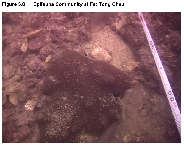
Fat Tong Chau on the eastern
coastline of
5.6.1.15 The shallow zone supported very little coral growth, with both hard coral and octocoral recorded at <1% level. The deep zone recorded an octocoral cover of 35%.
5.6.1.16
A total of three hard coral
species were recorded in the shallow zone, namely
5.6.1.17
In the shallow zone, four
colonies of the octocoral Euplexaura sp.
were recorded, with four genera in the deep zone (Paraplexaura, Echinomuricea, Euplexaura and Dendronephthya). The common gorgonian genera Echinomuricea and Paraplexaura dominated the deep zone community, accounting for
30-35% of total benthic cover. A few
soft coral colonies of Dendronephthya
(
5.6.1.18 No black coral colonies were found in this site.
5.6.1.19
Tung Lung Chau is a
semi-exposed site, with a boulder/cliff coastline. The shallow zone was about -
5.6.1.20
Overall the shallow zone had
very little coral cover with only about <1% of hard coral coverage and 5% of
octocoral coverage. A total of four hard
coral species were recorded in the shallow zone. These were Porites lutea, Plesiastrea versipora, Turbinaria
peltata and one Favites sp. All of the species were uncommon to this area
and were small, <
5.6.1.21
Two genera of octocorals were
recorded in the shallow zone: the soft coral Sinularia and the gorgon
5.6.1.22 No black corals were recorded.
5.6.1.23
The shallow zone of Tung Lung
Chau was an exposed site around Nga Ying Pai rocky outcrop ranging between -6
to
5.6.1.24
Two hard coral species were
recorded in the shallow zone: Goniopora
stutchburyi and Psammocora superficialis. Both were small in size, being 10
5.6.1.25 Coscinaraea n. sp. remains undescribed but the coral species associates itself with low light habitats in western, eastern and southeastern waters. Favia helianthoides is described as uncommon, mainly from locations in eastern waters.
5.6.1.26
All of the hard coral colonies
were smaller than
5.6.1.27
A total of seven genera of
octocorals were found in the shallow zone. The total coverage was only about 5%
of the total benthic cover. Besides Dendronephthya, Euplexaura and Menella, the other genera recorded in
this site were Nephthyigoria, Chironephthya,
Muricella and Anthogorgia. All are classified as being uncommonly
recorded octocoral genera with respect to their distribution and abundance in
Northeastern waters. The sizes of the colonies were comparatively small (10
5.6.1.28 A small number of black coral Cirripathes were found in the shallow zone.
5.6.1.29
South Ninepins was a very
exposed site with shallow zone transects at
5.6.1.30
No hard coral species were
recorded in the shallow zone, although three species were found in the deep
zone: Plesiastrea versipora, Montipora peltiformis and Psammocora superficialis. All of these species were common to this
site, but all were small in size at 10
5.6.1.31
Two genera of octocorals were
recorded in the shallow zone: the gorgonian Euplexaura
and the soft coral Carijoa. Carijoa
is classified as uncommon in
5.6.1.32
Dendronephthya was the most
common genus found in this site, with colony sizes ranging 5 –
5.6.1.33 A few colonies of black coral Cirripathes were recorded in the deep zone.
5.6.1.34
East Ninepins was a
semi-exposed site with a strong current. A sloping cliff of medium to large
sized rocks extended to a flat silty seabed.
The shallow zone transect ranged from -5 to
5.6.1.35 The shallow zone supported little hard coral growth (5-10%) while the deep zone had slight octocoral growth (<5%) and little hard coral cover (5-10%).
5.6.1.36
Five hard coral species were
recorded in the shallow zone: Montipora
peltiformis, Montipora turgescens,
Montipora mollis, Psammocora superficialis and Favia speciosa. Both Montipora and Psammocora were common to
this area, with some colonies being
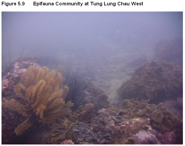
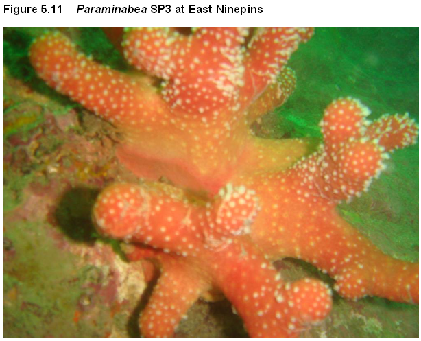
5.6.1.37 A few colonies of three octocoral genera were found in the shallow zone: Carijoa, Dendronephthya and Euplexaura. Six genera were recorded in the deep zone: Dendronephthya, Menella, Acanthogorgia, Echinomuricea, Paraminabea and SP3 (a genus of an unknown encrusting soft coral, being the same as found at Victor Rock). Figure 5.11 displays a typical view of the marine environment at this location.
5.6.1.38 A number of black coral Cirripathes were recorded in the deep zone, growing on the flat bedrock channel and contributing 5-10% to total benthic cover.
5.6.1.39
One Foot Rock - a submerged
rocky pinnacle - was a very exposed site with smooth bedrock around its surface
and small rocks/rubble on a silty / sandy seabed in the deep zone. The shallow transect was placed at
5.6.1.40 The shallow zone supported a fairly good hard coral cover of up to 10% and slight octocoral growth (<5%). In the deeper zone, up to 40% octocoral coverage was recorded.
5.6.1.41
Three hard coral species were
recorded: Pleasiatrea versipora, Montipora peltiformis and Psammocora superficialis. All were common to this area, and were mostly
small in size, ranging from 5 to
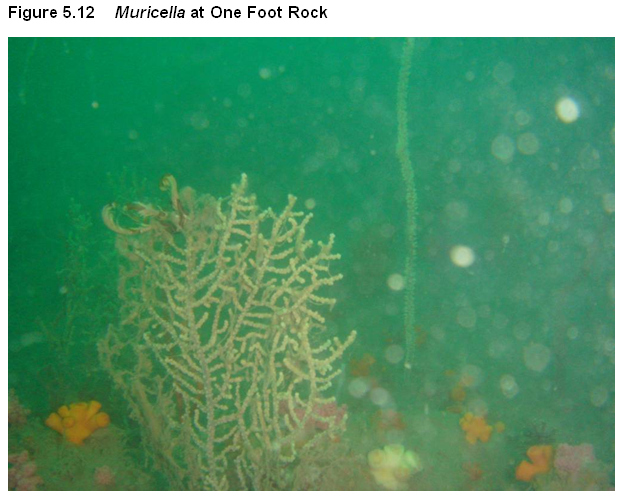
5.6.1.42 Only colonies of the soft coral Dendronephthya were recorded in the shallow zone, accounting for up to 10% of the total benthic cover. There was higher octocoral diversity in the deep zone, with thirteen genera recorded: Nephthyigorgia, Dendronephthya, Muricella, Echinogorgia, Menella, Astrogorgia, Scleronephthya, Viminella, Anthogorgia (could be 1 of 3 species), Paraminabea, Acanthogorgia, Euplexaura and Echinomuricea.
5.6.1.43
The soft corals Dendronephthya, Scleronephthya and the
sea fan Muricella generally dominated
the community. Nephthyigorgia is an uncommon octocoral genus in
5.6.1.44 The black coral genera Antipathes and Cirripathes were recorded, with the latter generally being more abundant.
8. Victor Rock
5.6.1.45
Victor Rock is a submerged and
very exposed pinnacle that comes to about
5.6.1.46 The main benthic fauna composition was octocorals and black corals. In the shallow zone octocoral covered some 20-30% with very little hard coral growth. The deep zone supported a very extensive octocoral cover of around 70%.
5.6.1.47
In the shallow zone a single
specimen of hard coral Montipora
peltiformis was recorded, which is commonly found in this area. Four octocoral genera were also recorded in the shallow zone: Dendronephthya, Scleronephthya, Muricella
and Chrionephthya. The genus Chironephthya is classified as uncommon
in
5.6.1.48
In the deep zone, fifteen octocoral genera were recorded:
Scleronephthya, Astrogorgia, Muricella, Dendronephthya, Anthogorgia,
Acanthogorgia, Echinomuricea, Paraplexaura, Paraminabea, Menella,
Nephthyigorgia, Echinogorgia, Euplexaura, Viminella and SP 3 (one genus of
unknown encrusting soft coral). These
octocorals made up between 60-70% of the total benthic cover. The dominant
species were the soft coral Dendronephthya (30
5.6.1.49
The soft coral genera Paraminabea
(uncommon) and Nephthyigorgia (common)
were also abundant at this site. In
addition small patches of encrusting orange-coloured soft corals (SP3) were
found at
5.6.1.50
The black coral genera Antipathes
and Cirripathes were recorded in the
deep zone, with Cirripathes colonies
of 60
9.
5.6.1.51
5.6.1.52
The shallow zone transect at -7 to
5.6.1.53
A total of six hard coral species were recorded: Psammocora
superficialis, Goniopora stutchburyi, Cyphastrea serailia, Plesiastrea
versipora, Favites pentagona and Montipora peltiformis. The species P.superficialis, C.serailia,
P.versipora and M. peltiformis were very abundant, with
colonies of the latter being up to
5.6.1.54
Three genera of octocorals were recorded in the shallow zone: Dendronephthya, Cladiella and Euplexaura. The genus Cladiella,
a zooaxnthellate soft coral, is classed as uncommon in
5.6.1.55
The black coral genera Antipathes
and Cirripathes were recorded, with
the latter generally being more abundant in deeper areas.
5.6.1.56 The prevalence of deep and highly fluidised silty mud within the windfarm footprint precluded the establishment of an epifauna community at locations 10 - 13. Figure 5.15 displays a typical view of the marine environment at the wind farm site.
5.6.2 Benthic Infauna
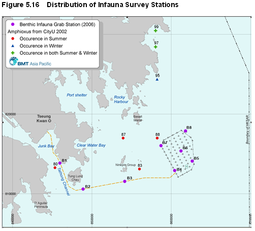
5.6.2.1 The wet season survey was undertaken in August 2006 and the dry season survey in January 2007. Eight sampling stations were adopted for the benthic infauna survey. Table 5.3 summarises the general characteristics of each station, while Figure 5.16 presents their locations.
5.6.2.2 Table 5.3 displays that the mean Total Organic Matter (TOM) content in the wet season ranged from 2.43% (Station 2) to 6.78% (Station 1), with an average across the 8 stations of 4.99%. Mean TOM was at statistically significantly higher levels at all stations in the dry season, ranging from 2.73% (Station 2) to 7.70% (Station 1) and with an average of 6.03%. Sediment samples collected at all stations in both wet and dry season surveys were pale grey in colour and did not emit pungent smell.
Table 5.3 Characteristics of Benthic Infauna Sampling Stations
|
|
|
|
|
Mean TOM (%) |
MDf |
||
|
Station |
Latitude |
Longitude |
Depth (m) |
Wet
Season |
Dry
Season |
Wet
Season |
Dry
Season |
|
B1 |
22o |
114o |
16 - 18 |
6.78 |
7.70 |
6.19 |
6.02 |
|
B2 |
22o |
114o |
28 - 31 |
2.43 |
2.73 |
5.39 |
3.19 |
|
B3 |
22o |
114o |
29 - 32 |
3.69 |
4.43 |
3.31 |
5.55 |
|
B4 |
22o |
114o |
27 - 31 |
5.36 |
6.44 |
6.14 |
6.21 |
|
B5 |
22o |
114o |
27 - 32 |
4.84 |
7.40 |
6.20 |
6.20 |
|
B6 |
22o |
114o |
27 |
5.31 |
7.13 |
6.18 |
6.20 |
|
B7 |
22o |
114o |
28 - 30.5 |
6.55 |
7.18 |
6.21 |
6.23 |
|
B8 |
22o |
114o |
28 - 30 |
4.98 |
5.20 |
6.12 |
6.16 |
5.6.2.3
From the wet season survey, only
Station 3 had particle size (MDf) less than 4f, indicating the presence of coarser materials. All other stations
had MDf over 5f, suggesting they were composed mostly of very find sand and
silt/clay. From the dry season survey
only Station 2 indicated coarser sediment, with all other stations indicating a
seabed of predominantly very find sand and silt/clay. Although varying MDf values from Stations 2 and
5.6.2.4 In terms of infauna composition, the wet season survey produced a total of 1,498 specimens with 92 species in 8 phyla, while the dry season survey produced a total of 1,856 specimens with 85 species in 9 phyla. Polychaete annelids, crustaceans and bivalves were the dominant taxa, in both seasons comprising >55%, >20% and >9% of the total species respectively. Of all species, 71 (66.3%) were recorded in both surveys, with 22 species (20.6%) only recorded in the wet season and 14 species (13.1%) only recorded in the dry season survey.
5.6.2.5 Appendix 5B presents the complete species list and data on other characteristics of all common species in the benthic infauna community (i.e., those present in ³50% of the 8 sampling stations).
5.6.2.6 Table 5.4 summarizes the number of species, individuals and biomass at each sampling station in wet and dry seasons.
|
Station |
No. of
species (/0.5 m2) |
No. of
individuals (/m2) |
Wet
weight (g/m2) |
|||
|
|
Wet
Season |
Dry
Season |
Wet
Season |
Dry
Season |
Wet
Season |
Dry
Season |
|
B1 |
18 |
14 |
468 |
40 |
1.77 |
0.27 |
|
B2 |
46 |
46 |
538 |
332 |
39.83 |
8.37 |
|
B3 |
41 |
53 |
546 |
378 |
7.38 |
19.55 |
|
B4 |
34 |
19 |
264 |
182 |
16.99 |
2.69 |
|
B5 |
37 |
26 |
326 |
288 |
4.80 |
15.65 |
|
B6 |
29 |
24 |
296 |
196 |
4.98 |
3.68 |
|
B7 |
31 |
17 |
276 |
204 |
7.35 |
1.69 |
|
B8 |
32 |
22 |
282 |
236 |
11.79 |
13.79 |
5.6.2.7
In the wet season there were an
average of 33.5 species 0.5 m-2, 374.5 individuals m-2
and a biomass (wet weight) of
5.6.2.8 A total of 28 species were commonly found in the wet season survey, with the most common being the sipunculan Apionsoma trichocephalus and nemertean species that were present at all 8 stations. These were followed by the polychaetes Magelona sp., Aglaophamus dibranchis and the crustacean (ghost shrimp) Callianassa japonica which occurred at 7 stations. In the dry season there were 20 species commonly found, with the sipunculan Apionsoma trichocephalus and nemertean species again being present at all stations. The crustaceans Callianassa japonica and amphipod species also occurred at all 8 stations, while the polychaetes Aglaophamus dibranchis and Cossurella dimorpha and the echinoderm (brittle starfish) Amphiura hexactis were found at 7 stations.
5.6.2.9 Field survey data analysis was conducted to assist the interpretation of community attributes and ecological baseline value. Table 5.5 displays index values for species richness (d), diversity (H’) and evenness (J) for each sampling station and seasonal survey.
Table 5.5 Univariate statistics for the infauna community (CityU, 2007)
|
Station |
Species
richness (d) |
Species diversity (H’) |
Species evenness (J) |
|||
|
|
Wet Season |
Dry Season |
Wet Season |
Dry Season |
Wet Season |
Dry Season |
|
B1 |
2.76 |
3.52 |
0.97 |
2.53 |
0.34 |
0.96 |
|
B2 |
7.16 |
7.75 |
3.05 |
3.32 |
0.80 |
0.87 |
|
B3 |
6.35 |
8.76 |
2.65 |
3.43 |
0.71 |
0.86 |
|
B4 |
5.92 |
3.46 |
2.59 |
2.19 |
0.73 |
0.74 |
|
B5 |
6.22 |
4.41 |
2.66 |
1.91 |
0.74 |
0.58 |
|
B6 |
4.92 |
4.36 |
2.41 |
2.32 |
0.71 |
0.73 |
|
B7 |
5.34 |
3.01 |
2.70 |
1.85 |
0.79 |
0.65 |
|
B8 |
5.49 |
3.84 |
2.80 |
1.81 |
0.81 |
0.59 |
5.6.2.10 In the wet season survey, the values of d ranged from 2.76 (station 1) to 7.16 (station 2), H’ from 0.97 (station 1) to 3.05 (station 2) and J from 0.34 (station 1) to 0.81 (station 8). Of these 8 stations, the highest species diversity was found at station 2, followed by station 8. Station 1 had the lowest species diversity and evenness, being dominated by shrimp larvae and nemertean spp.
5.6.2.11 In the dry season survey, the values of d ranged from 3.01 (station 7) to 8.76 (station 3), H’ from 1.81 (station 8) to 3.43 (station 3) and J from 0.59 (station 8) to 0.96 (station 1). Highest species diversity was found at station 3, followed by station 2. Stations 5, 7 and 8 had the lowest species diversity and evenness, being dominated by the sipunculan Apionsoma trichocephalus and crustacean Callianassa japonica.
5.6.2.12
From both surveys, except for
station
5.6.2.13 Spatial and seasonal patterns among the 8 sampling stations were determined using cluster analysis and multi-dimensional scaling analysis.
5.6.2.14
In the wet season it was noted
that there is general similarity in spatial pattern between the communities at
stations 2 and 3, represented by inter
alia several polychaete species, nemertean spp. and the sipulcuan Apionsoma trichocephalus. There is also similarity in the wet season communities at stations
4 – 8 where inter alia the polychaete
Aglaophamus dibranchis,
crustacean copepod spp. and Callianassa
japonica were dominant. Shrimp larvae, in contrast, dominated station
1. There were
also similarities in the spatial pattern of dry season communities at stations
2 – 3 and across stations 4 – 8, while the standalone station 1
revealed impoverished infauna.
5.6.2.15 Seasonal analysis also showed the same clustering of stations into 3 groups, i.e., stations 2 - 3, stations 4 – 8, and station 1. Stations 2 - 3 were dominated by the polychaete worms Prionospio malmgreni, Glycera chirori, Tharyx sp., Marphysa sanguinea, Loimia ingens, Magelona sp. and Paralacydonia paradoxa, sipunculan Apionsoma trichocephalus, the crustacean amphipod spp. and nemertean spp. This group was most diverse among the three station groups.
5.6.2.16 Stations 4-8 were characterized by the sipunculan Apionsoma trichocephalus, nemertean spp., polychaete Aglaophamus dibranchis, and crustacean (ghost shrimp) Callianassa japonica. Station 1 was represented by the polychaetes Lumbrinereis shiinoi and Aglaophamus dibranchis, sipunculan Apionsoma trichocephalus, and nemertean spp. Overall, the data suggested that seasonal changes at these sampling stations were minimal.
5.6.2.17 Abundance and biomass comparison (ABC) plots were also prepared for the stations to provide an indication of sediment disturbance. According to Warwick and Clarke (1994), a negative W value suggests a “disturbed” community while a W value <0.1 suggests moderate disturbance. In the wet season survey it was found that all stations except 1 were “undisturbed”, while in the dry season all stations except 7 were “undisturbed”.
5.6.2.18 Apart from water depth, the spatial pattern of the benthic composition in the wet season survey was best correlated with the inclusive graphic standard deviation (s), or the degree of sorting, of the sediments. However, the spatial pattern of the benthic composition in the dry season sampling was best correlated with total organic matter of the sediments. Overall, when both survey results were analyzed, water depth and sorting of sediments were best correlated with the community pattern.
5.6.2.19
The most notable finding from the
surveys was the presence in the wet season of the cephalochordate (amphioxus) Branchiostoma belcheri at stations 2 and
3. Figure 5.16 presents
station locations. At station 2, 3 individuals were collected in the 5-pooled
grab samples whereas at station 3, 32 individuals (or
5.6.2.20
Past studies have revealed
densities of amphioxus up to
5.6.2.21
The occurrence of small
juveniles at station B
5.6.3.1 The ecological evaluation of benthic habitats has been conducted in accordance with Annex 8 of the TM on the EIAO Process.
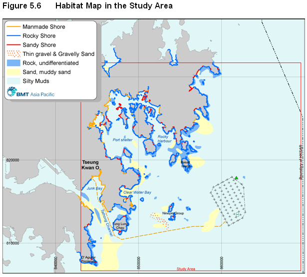
5.6.3.2 Tables 5.6a to d present a general baseline evaluation of each major habitat type within the Study Area (Figure 5.6 displays the habitat types).
5.6.3.3 Table 5.7 presents a more specific evaluation of each benthic habitat survey location in order to present the variability within a broad habitat type.
Table 5.6a Ecological Evaluation of Seawall Habitat
|
Criteria |
Seawall |
|
Naturalness |
Artificial hard substrate |
|
Size |
The total seawall length is about 30 kilometres |
|
Diversity |
Low/moderate epifauna diversity and no infauna |
|
Rarity |
Habitat is common in harbour areas. Localised presence of uncommon octocoral Carijoa. No rare coral species found. |
|
Re-creatability |
Readily re-creatable (artificial structure) |
|
Fragmentation |
Widespread variable lengths of wall |
|
Ecological Linkage |
Some linkage with adjacent hard shore habitat |
|
Potential Value |
Low |
|
Nursery/ Breeding Ground |
Nothing of note identified |
|
Age |
Not applicable (Artificial) |
|
Abundance/ Richness of Wildlife |
Low epifauna abundance and no infauna |
|
Overall Ecological Value |
Low |
Coral rarity ratings, (AFCD, unpublished)
Table 5.6b Ecological Evaluation of Rocky Shore
|
Criteria |
Rocky Shore |
|
Naturalness |
Natural with some recreational disturbance. |
|
Size |
The total shoreline length is about 300 kilometres |
|
Diversity |
Moderate/high epifauna diversity and no infauna. |
|
Rarity |
Habitat is common in eastern waters. Highly localised presence of uncommon octocoral Carijoa and rare black coral Cirripathes sp |
|
Re-creatability |
Re-creatable |
|
Fragmentation |
Widespread variable lengths of shoreline |
|
Ecological Linkage |
Limited linkage with adjacent soft seabed habitat |
|
Potential Value |
Limited potential, as baseline value already high |
|
Nursery/ Breeding Ground |
Nothing of note identified |
|
Age |
Not applicable |
|
Abundance/ Richness of Wildlife |
Moderate epifauna abundance and no infauna |
|
Overall Ecological Value |
Moderate/high |
Coral rarity ratings, (AFCD, unpublished)
Table 5.6c Ecological Evaluation of Silty Seabed Habitat
|
Criteria |
Silty Seabed |
|
Naturalness |
Largely natural, localised mud disposal |
|
Size |
Total seabed area of about 45,000 hectares |
|
Diversity |
Low/moderate epifauna diversity and moderate infauna |
|
Rarity |
Habitat is common in eastern areas. Localised presence of restricted Amphioxus |
|
Re-creatability |
Difficult to recreate |
|
Fragmentation |
Continuous seabed |
|
Ecological Linkage |
Good linkage with adjacent soft seabed habitat |
|
Potential Value |
Low |
|
Nursery/ Breeding Ground |
Localised seasonal nursery for Amphioxus |
|
Age |
Not applicable |
|
Abundance/ Richness of Wildlife |
Low/moderate epifauna abundance and high infauna abundance |
|
Overall Ecological Value |
Low/Moderate |
Coral rarity ratings, (AFCD, unpublished)
Table 5.6d Ecological Evaluation of Rocky Pinnacle
|
Criteria |
Rocky Shore |
|
Naturalness |
Natural with some recreational disturbance. |
|
Size |
The total height is about 15-20 meters |
|
Diversity |
High epifauna diversity and no infauna. |
|
Rarity |
Uncommon feature. 4 uncommon species of octocoral present. No rare coral species found. |
|
Re-creatability |
Moderate to difficult re-creatability |
|
Fragmentation |
Scattered clusters in eastern waters |
|
Ecological Linkage |
Some linkage with adjacent soft seabed habitat |
|
Potential Value |
Limited potential, as baseline value already high |
|
Nursery/ Breeding Ground |
Nothing of note identified |
|
Age |
Localised nursery for reef associated fish |
|
Abundance/ Richness of Wildlife |
Moderate/high epifauna abundance and no infauna |
|
Overall Ecological Value |
Moderate/High |
Coral rarity ratings, (AFCD, unpublished)
Table 5.7 Specific Subtidal Habitat Evaluation of EIA Study Baseline Survey Locations
|
Criteria |
||||||||||
|
Subtidal Habitat Type(s) |
Seawall |
Rocky Shore / Silty Seabed |
Rocky Shore |
Rocky Shore / Silty Seabed |
Rocky Shore / Silty Seabed |
Rocky Shore |
Rocky Pinnacle |
Rocky Pinnacle |
Rocky Shore |
Silty Seabed |
|
Survey |
E |
E / I |
E |
E / I |
E / I |
E |
E |
E |
E |
E / I |
|
Naturalness |
Adjacent to reclamation |
Adjacent to reclamation / landfill |
Natural rocky shore |
Natural rock outcrop near light beacon |
Natural steep rocky shore |
Natural rocky shore |
Submerged rocky pinnacle |
Submerged rocky pinnacle |
Natural rocky shore |
Soft silty mud |
|
Diversity |
HC low |
Epifauna low / Infauna low |
Epifauna low |
Epifauna moderate / Infauna high |
Epifauna moderate / Infauna moderate-high |
HC in the shallow zone. OC in the deep zone |
OC high in deep zone |
SC high in deep zone |
HC in shallow zone. BC in deep zone |
Epifauna low / Infauna moderate |
|
Rarity |
Uncommon OC Carijoa in the deep zone |
No rare species recorded |
No rare species recorded |
Uncommon OC Coscinarea n. sp. Uncommon Favia helianthoides |
OC Carijoa in shallow zone. Dominant BC Cirripathes sp in deep zone. Juveniles of Amphioxus (restricted) in wet season. |
Rare HC Montipora turgescens in shallow zone. Two uncommon OC species recorded |
One uncommon OC species recorded |
Two uncommon OC species recorded |
One uncommon OC species recorded. BC in deep zone |
No rare species recorded |
|
Abundance |
Abundant OC in deep zone |
Epifauna low / Infauna moderate |
Epifauna low |
Moderate HC / Infauna high |
Epifauna low / Infauna high |
Cirripathes abundant in deep zone |
Up to 40% OC cover |
Up to 70% OC cover |
Abundant BC in deep zone |
Epifauna low / Infauna high |
|
Overall value |
Low |
Low |
Low |
Moderate / High |
Moderate / High |
Moderate/ High |
Moderate / High |
Moderate / High |
Moderate / High |
Low |
Notes: E = Epifauna
Coral rarity ratings, (AFCD,
unpublished)
5.7 Construction Phase Impact Assessment
5.7.1.1 Two key sources of potential impact upon the marine benthic community have been identified during project construction:
· Direct impacts on the project ‘footprint’ from the installation of project components resulting in temporary or permanent loss of seabed habitat.
· Induced impacts through deteriorating water quality during installation of project components, most notably potential for mobilisation and deposition of suspended sediment upon sessile benthic epifauna.
5.7.1.2 The potential the impacts to arise, and their implications on the benthic community in the Study Area, are discussed below.
5.7.2 Direct Impacts on Benthic Infauna
5.7.2.1 No construction activities are proposed in the vicinity of any hard substrate habitat where corals are present. There will however be a loss of soft seabed habitat from the following construction activities:
·
Nearshore
transmission cable dredging: temporary habitat loss in
· Offshore transmission and array cable jetting: temporary habitat loss in Eastern Waters
· Offshore foundation construction: permanent habitat loss from installation of wind turbine and transmission station foundations
5.7.2.2
Regarding nearshore transmission cable dredging, a summary of
these works is presented in sub-section 2.8.5.
Approximately
5.7.2.3
The significance of the
dredging works on the benthic infauna community in
5.7.2.4
Previous study suggests that the disturbed seabed will naturally be
re-colonised by species recruited from adjacent seabed areas within a short
period. For example, Valente et al (1999) found that 2-3 years after cessation of dredged material disposal in Eastern Waters a benthic
epifauna community had established that possessed a significantly greater
abundance and diversity than those at nearby reference stations. The results suggest that the variety of
dredged material disposed at the site effectively increased habitat diversity
relative to the adjacent homogenous seabed habitat.
5.7.2.5
A summary of the procedure for offshore transmission and array cable jetting is
presented in sub-section 2.8.6. These
proposed works would involve the displacement of soft sediment under
high-pressure jets of ambient water, resulting in the temporary loss of an
approximately
5.7.2.6
As seabed jetting is proposed
from the relatively shallow Tathong Channel, through increasingly deep and
exposed waters south of Tung Lung Chau and the
5.7.2.7 The baseline ecological surveys and data analysis presented under sub-section 5.5 were able to distinguish three ‘groups’ of infauna community according to similarity in key sediment character and species composition criteria, with baseline field survey suggesting that the grouping of stations 2 - 3 was the most biodiverse. Figure 5.16 presents station locations.
5.7.2.8 Stations 2 - 3 also represent an area of some conservation significance due to the wet season presence of juvenile amphioxus Branchiostoma belcheri. Three individuals of amphioxus were recorded from 2 of 5 replicate samples at station 2, with 32 individuals from 4 of 5 replicate samples at station 3. Amphioxus was not recorded from these (or any other) survey stations during the dry season. As stations 2 - 3 are remote from the core amphioxus habitat area at offshore Tai Long Wan it is considered that the small number of individuals present arose through the random settlement of planktonic larvae. A 2007 CityU study on amphioxus which noted that, “clear oceanic water combined with sand sediment with low organic content are the most important habitat requirements for amphioxus (CityU, 2007).” Accordingly, it is concluded that the silty sediment of the seabed at stations 2 - 3 is not a major habitat for amphioxus. No adverse impact is predicted to Amphioxus during construction and operation.
5.7.2.9
During cable jetting benthic
infauna may be damaged by the water jet, and / or may be exposed to predation
while suspended in the water column.
Such impacts will be highly localised given the jetting width of just
5.7.2.10
It is noted that the proposed
jetting zone has a high
edge / area ratio, in the order of 2.5:1.0.
Various ecological studies, for example the Coral Growth at High Island
Dam study (Binnie Consultants Ltd, 1996), have proven that such areas are
likely to be re-colonised more rapidly than those with a small ratio because of
the greater area of adjacent donor sites available from which to recruit,
although a longer period may be required for full ‘recovery’.[*]
5.7.2.11
With reference to past studies of benthic re-colonisation of seabed
areas subject to mechanical disturbance, pollution or anoxia, it can be
expected that initial re-colonisation will occur with a period of weeks to
months following jetting (WBM, 2004; Santos and Simon, 1980). Field survey data for this EIA Study
indicates that the characteristics of the benthic infauna community are broadly
consistent across the five replicate samples at each survey station. As such, the narrow width of the jetting zone
disturbed by jetting zone will thus facilitate re-colonisation by species from
adjacent seabed areas.
5.7.2.12 Overall, impacts on the benthic infauna community from cable installation are anticipated to be moderate / low in the vicinity of stations 2 - 3, and of little or no significance elsewhere along the cable route.
5.7.2.13 As regards offshore foundation construction, these proposed works differ from the proposed dredging and jetting activities in that there would be a direct loss of habitat due to the presence of permanent (~20 year lifespan) of fixed structures. These proposed works would occur in exposed offshore water where surveys conducted for this EIA Study indicate a moderately biodiverse infauna community may exist, although no species of conservation significance were recorded (sub-section 5.5 refers).
5.7.2.14 At this planning stage it is assumed there shall be no more than 67 turbines and one offshore transformer station. Each of these components shall have a single foundation system comprised of four suction caissons each with a diameter of approximately 15 metres. This generates a cumulative area of permanent benthic habitat loss of:
5.7.2.15
4 x (p x (7.5m)2) x 68 = ~48,000m2
5.7.2.16
Compared with cumulative soft
sub-tidal habitat area in the wind farm of ~1,500 hectares, this represents an
insignificant habitat loss of ~0.3% of total seabed in the wind farm area. The total area of soft sub-tidal habitat in
the Study Area is >
5.7.3 Indirect Impacts on Benthic Epifauna
5.7.3.1 Through desktop review and baseline field survey work it is known that the Study Area is of general conservation importance for epifauna, and particularly coral communities, mainly due to the prevalence of rocky offshore islands and submerged rocky pinnacles in Eastern Waters.
5.7.3.2 Given the general sensitivity of the Eastern Waters, the approach for construction of the Project has been to avoid or at least minimise marine sediment handling where practicable. This philosophy has led, in turn, to the development of construction methodologies that avoid marine dredging / excavation activities in offshore waters.
5.7.3.3 There are, however, cable jetting and foundation construction activities proposed in the offshore waters, and also cable dredging and jetting activities in nearshore waters. The potential impacts of these works have been assessed cumulatively to present a worst-case scenario for project development, and details of the methodology for the assessment of indirect (water quality induced) impacts on benthic epifauna are presented in sub-section 4.6.
5.7.3.4 Table 5.8 presents the degree of impact associated with sediment release, transport and deposition at those benthic communities nearest to the proposed Project.
Table 5.8
|
ID |
Coral Community |
Allowable Elevation |
Unmitigated peak concentration above baseline* / Scenario |
|||||
|
Dry |
Wet |
1 |
2 |
3 |
4 |
5 |
||
|
CC26 |
|
1.82 |
0.96 |
3.03 |
3.03 |
0 |
0 |
0 |
|
CC27 |
|
1.82 |
0.96 |
4.79 |
0 |
0 |
0 |
0 |
|
CC11 |
Fat Tong Chau West |
1.82 |
0.96 |
2.97 |
0 |
10.26 |
7.29 |
7.29 |
|
CC8 |
West Tung Lung Chau |
1.84 |
1.30 |
0 |
0 |
0 |
0 |
0 |
|
CC7 |
South Tung Lung Chau |
3.08 |
2.15 |
0 |
0 |
0 |
0 |
0 |
|
CC14 |
South Ninepin in |
3.08 |
2.15 |
0 |
0 |
0 |
0 |
0 |
|
CC16 |
East Ninepins |
4.46 |
2.33 |
0 |
0 |
0 |
0 |
0 |
|
CC19 |
One Foot Rock |
4.46 |
2.33 |
0 |
0 |
0 |
0 |
0 |
|
CC18 |
|
4.46 |
2.33 |
0 |
0 |
0 |
0 |
0 |
|
CC20 |
Victor Rock |
4.46 |
2.33 |
0 |
0 |
0 |
0 |
0 |
Note: * Worst-case results predicted during unmitigated wet season dredging. Impact levels in bold.
5.7.3.5
The results in Table 5.8
indicate that adverse impacts are anticipated at the coral communities of
5.7.3.6
Adverse impacts may also arise
by the deposition of suspended sediment upon corals. Table 5.9
summarises the predicted deposition rate at representative coral communities
during the dry season. The assessment
criterion of
|
ID |
Coral Community |
Scenario |
||||
|
1 |
2 |
3 |
4 |
5 |
||
|
CC26 |
|
35.8 |
35.8 |
0 |
0 |
0 |
|
CC27 |
|
0 |
0 |
0 |
0 |
0 |
|
CC11 |
Fat Tong Chau West |
35.4 |
0 |
248.4 |
212.9 |
212.9 |
Note: Impact levels in bold
5.7.3.7 Given the predicted high sediment deposition rates at Fat Tong Chau coral community in the dry season, mitigation measures are required to ensure no adverse impacts from concurrent dredging and jetting activities.
5.7.3.8 Table 5.10 presents the predicted deposition results for the wet season scenario. Adverse impacts are anticipated to be greatest at the coral community at Fat Tong Chau from concurrent dredging and jetting activities. Adverse impacts are also anticipated at other nearby coral communities, and hence mitigation is required. Section 5.11 presents details of analysis with mitigation measures to ensure no adverse impacts from dredging and jetting activities at these coral sensitive receivers.
|
ID |
Name |
Scenario |
||||
|
1 |
2 |
3 |
4 |
5 |
||
|
CC26 |
|
130.9 |
130.9 |
0 |
0 |
0 |
|
CC27 |
|
206.9 |
0 |
0 |
0 |
0 |
|
CC11 |
Fat Tong Chau West |
128.3 |
0 |
443.2 |
314.9 |
314.9 |
Note:
Impact levels in bold.
5.8 Operational Phase Impact Assessment
5.8.1.1 Section 4.8 identified that normal project operation will cause no significant changes in water quality, which indicates that there will be no adverse impacts on benthic communities during normal project operation. Sections 5.8.2 to 5.8.4 present a summary of key findings.
5.8.2 Current Speeds, Accumulated Flows and Hydrodynamics
5.8.2.1 The location of the wind farm is in open waters and the spacing between the substructure elements is large (approximately 450 m – 600 m). Water flows freely across the entire site.
5.8.2.2 Changes in current speeds outside the wind farm site, due to the presence of the wind turbines, were negligible and unmeasurable (maximum change of 0.006m/s). No significant changes in accumulated flows were predicted at any of the modeled locations. Local changes (increases) in flow at the seabed near the foundation structure will occur within the area of the top of the suction caissons – hence no additional scour of the seabed is expected.
5.8.2.3 Given these minute changes, it is anticipated that flushing capacities and sediment transport within major channels and semi-enclosed areas will remain unchanged from existing conditions and there will be no effect on benthic communities due to these issues.
5.8.3 Storm water and Maintenance Vessels
5.8.3.1 No adverse impacts due to storm water generation are expected as the exposed surfaces of the wind turbine components contain no contaminants. Detailed information on maintenance vessel frequencies and activities is presented in Section 2. Wastewater generated from machinery spaces would be contained within the vessels. Sewage generated from workforce would be disposed of by licensed waste collectors. No water quality impacts arising from routine maintenance operations are anticipated.
5.8.4 Oil Spill
5.8.4.1 Vessel collision risk is very low as the designation of the wind farm footprint as a controlled water space, as detailed in Section 8.8.2.4, will reduce vessel traffic below low current levels.
5.8.4.2
If a collision does occur, the
Operator’s marine craft and Marine Department oil spill control vessels will be
easily able to reach the Ninepins within 4 hours, and will quickly contain any
fuel oil spills. Hydrodynamic flow modelling of the study area for oil spills
(Section 4) showed that all spills at the project site remain in open waters
and do not approach or strand on any coastlines within this
5.8.5 Enhancement
5.8.5.1 There is some potential for benefits associated with project operation through the provision of additional surface area for natural benthic colonisation and hence development of artificial reef systems.
5.8.5.2 The cumulative surface area of the anticipated 68 jacket substructures between seabed and the water surface shall be approximately 100,000m2 (based on the Base Case Development Scenario, presented in Section 2.6, of 67 tripod structures with legs nominal 5m diameter in 30m water depth) and taking account of the fact that although the surface area shall not be solid, the faces of the metal grid sub-structure will offer a substantial cumulative surface area.
5.8.5.3 This available surface area will more than make up for the loss of benthic infauna habitat of low ecological value. Based on previous studies it is anticipated this artificial hard substrate shall enable natural colonisation by a range of epifauna, producing a net benefit at the wind farm footprint area.
5.8.5.4
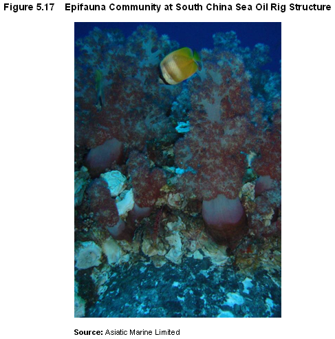
Recent investigations into the
rate and extent of marine growth on new marine structures in the South China
Sea recorded a biomass of almost
5.8.5.5
A parallel study, also in
south-eastern waters, of communities of at least 5 years old recorded a total
of 105 taxa, with molluscs (bivalves), arthropods and annelids being the most
abundant. Surveys at depths from 3 to 38
metres recorded a mean biomass of ~
5.8.5.6
A series of qualitative
observations of benthic colonization of marine structures has also been made by
recreational divers at oil platforms in waters about ~100 metres deep in the
5.8.5.7
An epifauna community ~
5.9.1.1 No cumulative water quality impacts are anticipated as a result of the operation of the East Ninepins and East Tung Lung Chau Sediment Disposal Areas, or from construction activities associated with Further Development of Tseung Kwan O.
5.9.1.2
EIA’s for the Cruise Terminal
at Kai Tak project and the Wan Chai Development Phase II project have suggested
that coral colonies be translocated from their current locations to small sites
in
5.9.1.3 No cumulative impacts are anticipated during operation of the proposed wind farm.
5.10 Mitigation Measures & Best Practice
5.10.1.1
Although it has been identified
that the coral communities at Fat Tong Chau and
5.10.1.2 Accordingly, the following controls on marine dredging activities are proposed:
·
Working rate for dredging in
·
Closed grab dredgers should be
used for sediment dredging in
· Silt curtains should be provided closely surrounding the dredging point to minimise dispersion of sediment plumes.
· Barges for disposal of dredged marine sediment:
· Should be fitted with tight seals to prevent leakage of sediment during transport.
· Should not be filled beyond a level that would result in spillage or being washed overboard by wave action during transport to the disposal site.
· Should be kept clear of excess material on the deck and the exposed barge fitting should be cleaned before transport to the disposal site.
5.10.2.1
The assessment of the proposed jetting
works for submarine cable burial in the near-shore environment of
·
Not exceeding 75 metres / hour
in the section between
· Not exceeding 150 metres / hour in all other locations.
· The project proponent will best endeavour to program jetting at the southern section of the cable alignment in the dry season to avoid/minimize impact on amphioxus.
5.10.3.1 The sub-structure of the wind turbine foundations shall provide a net increase in the surface area of hard substrate available as an artificial reef for colonization by reef dwelling organisms. Artificial Reef enhancement options shall be investigated in parallel with the detailed foundation design. Further details are provided in Section 8.
5.11 Residual Impact Assessment
5.11.1.1 Table 5.11 presents the predicted suspended sediment levels at potentially impacted coral communities following the implementation of dredging controls and other mitigation measures.
|
ID |
Coral Community |
Allowable Elevation |
Mitigated peak concentration above baseline* / Scenario |
|||||
|
Dry |
Wet |
1 |
2 |
3 |
4 |
5 |
||
|
CC26 |
|
1.82 |
0.96 |
0.91 |
0.91 |
0 |
0 |
0 |
|
CC27 |
|
1.82 |
0.96 |
0.94 |
0 |
0 |
0 |
0 |
|
CC11 |
Fat Tong Chau West |
1.82 |
0.96 |
0.02 |
0 |
0.80 |
0.77 |
0.77 |
Note: * Worst-case results predicted during unmitigated wet season dredging.
5.11.1.2 Accordingly, Table 5.11 indicates that no residual adverse impacts are anticipated at representative receivers with the adoption of controls measures.
5.11.1.3
Table 5.12 and Table 5.13 present the
predicted sediment deposition results for dry and wet season construction
activities, respectively. The effectiveness of the proposed controls on marine
activities and the deployment of silt curtains in
|
ID |
Name |
Scenario |
||||
|
1 |
2 |
3 |
4 |
5 |
||
|
CC26 |
|
7.8 |
7.8 |
0 |
0 |
0 |
|
CC27 |
|
0 |
0 |
0 |
0 |
0 |
|
CC11 |
Fat Tong Chau West |
0 |
0 |
25.9 |
25.9 |
25.9 |
|
ID |
Name |
Scenario |
||||
|
1 |
2 |
3 |
4 |
5 |
||
|
CC26 |
|
39.30 |
39.30 |
0 |
0 |
0 |
|
CC27 |
|
40.60 |
0 |
0 |
0 |
0 |
|
CC11 |
Fat Tong Chau West |
0.86 |
0 |
34.60 |
33.30 |
33.30 |
5.12 Environmental Monitoring & Audit Requirements
5.12.1.1 No environmental monitoring & audit (EM&A) programme is proposed for the benthic infauna community, as no significant adverse impacts are anticipated.
5.12.1.2 For the benthic epifauna, particularly corals, it is proposed that water quality monitoring be conducted at Fat Tong Chau during dredging activities in Junk Bay to ensure levels of suspended solids outside the silt curtain enclosure do not exceed the Water Quality Objectives. The details of water quality monitoring are presented in the stand-alone EM&A Manual.
5.12.1.3 It is also proposed that the positioning of the silt curtains be checked prior to implementation of marine dredging and jetting activities off Fat Tong Chau as this location is the closest sensitive receiver to the works.
5.12.1.4 Literature reviews and dive surveys undertaken as part of the EIA identified the site adjacent to the transmission cable at Tung Lung Chau South as of moderate to high ecological value due to the abundance and diversity of coral found at the sites.
5.12.1.5 Although adverse impacts to any corals are not predicted to occur as a result of the mitigation measures adopted during cable installation, the project proponent has offered to conduct coral impact monitoring at those sites with the most valuable coral communities identified in proximity to the cable alignment (value > moderate & distance < 400m (about 3 time mixing zone) to verify that the project will have no adverse ecological impacts.
5.12.1.6 In addition, the EIA has predicted that no impacts will occur at Victor Rock and South Ninepins sites given that they lie about 1km from works areas. However, as a further precaution given their moderate to high value, the project proponent has also offered to conduct coral monitoring at one site at Victor Rock when turbines are installed within 1km and at one site at the South Ninepins when cable Jetting is conducted within 1km.
5.12.1.7 The measures proposed for this project are similar to those in, "The proposed Submarine Gas Pipelines from Cheng Tou Jiao Liquefied Natural Gas Receiving Terminal, Shenzhen to Tai Po Gas Production Plant, Hong Kong" (EIA 089/2003) submitted by the Hong Kong Gas China Gas Company Ltd. Details of the coral monitoring are presented in the stand-alone EM&A Manual.
5.13 Conclusions & Recommendations
5.13.1.1
Desk-top review and field
survey has reaffirmed that the Eastern Waters of the HKSAR are of generally
high marine conservation interest with regard to its epifauna community and, at
a more localised level, infauna community.
The conservation value of the benthic community in the more sheltered
waters of
5.13.1.2
Field surveys were conducted
from August 2006 to June 2007, and covered wet and dry seasons. From dive surveys conducted at 13 survey
locations it was recorded that the benthic epifauna communities of the highest
conservation significance were at the East Ninepin,
5.13.1.3
The key potential impact
from Project development was identified as being sediment release and resettlement
associated with marine dredging and cable jetting activities. Numerical simulation was conducted to assess
water quality impacts, and the model predicted adverse impacts at coral
communities in
5.13.1.4 Adverse direct impacts on seabed habitat from temporary dredging and cable jetting activities shall be of short duration and reversible, with anticipated re-colonisation of the affected areas within a short period of time.
5.13.1.5
The presence of the turbine
foundations at the wind farm area will provide an artificial habitat for
potential colonisation by benthic epifauna. The cumulative surface area of over
5.14 References
5.14.1.1 AFCD (2004). Ecological Status and Revised Species of Hong Kong’s Scleractinian Corals. Marine Conservation Division, Agriculture, Fisheries and Conservation Department, HKSAR Government.
5.14.1.2 AFCD (unpublished). Reference Collection and Study on Octocorals and Black Corals in Hong Kong Waters, Agriculture, Fisheries and Conservation Department, HKSAR Government
5.14.1.3
Asiatic
Marine (2002).
Proposed Submarine Gas Pipelines from Cheng Tou Jiao LNG Receiving
Terminal Shenzhen to Tai
5.14.1.4
Asiatic
Marine (2007).
Unpublished Observations of Marine Community at
5.14.1.5
Binnie
Consultants Limited (1995). Marine Ecology of
Binnie Consultants
Limited (1996). Fill Management Study Investigation and
Development of Marine Borrow Areas, Coral Growth at
5.14.1.6
CAPCO (2006). Liquefied Natural Gas (LNG) Receiving Terminal and Associated
Facilities EIA. Castle Peak Power Company Limited.
5.14.1.7
CityU (2002). Agreement No. CE 69/2000. Consultancy Study on Marine Benthic
Communities in
5.14.1.8
CityU (2007).
5.14.1.9
CityU (2007). The Ecology and Biology of Amphioxus in
5.14.1.10
DeVantier,
L.M., De’Ath, G., Done, T.J. and
5.14.1.11
DeVantier,
L.M., Turak, E., Al-Shaikh, K.A. and De’Ath, G (2000).
Coral Communities of the Central-Northern Saudi Arabian
5.14.1.12
Huang, Z.G.
(ed.) (2006). Diversity of Species in
5.14.1.13
Lee, M.W.
(2007). The
Distribution and Community Structure of Octocorals in Northeastern to
Southeastern Waters of Hong Kong SAR 2007.
5.14.1.14
Lu, Z., Yan
Y. and Du, Q (1998). Variation of Fishery Resources and
Estimation of Suitable Fishing Efforts in
5.14.1.15
Maunsell
Consultants
5.14.1.16 Oceanway Corporation Limited (2003). HATS Dive Survey Report for Drainage Services Department, HKSAR Government.
5.14.1.17
5.14.1.18
Shin, P.K.S.
(1999). Natural
Disturbance of Benthic Infauna in the Offshore Waters of
5.14.1.19
Shin,
P.K.S., Cheung, S.G. and Kong, R (2006). The Ecology
and Aspects of Biology of Amphioxus in
5.14.1.20
Valente,
R.M., McChesney, S.M. and Hodgson, G (1999). Benthic
Recolonisation Following Cessation of Dredged Material Disposal in
5.14.1.21
5.14.1.22
WBM Oceanics
Limited (2004).
5.14.1.23
Yan, T. W.,
Yan, Y., Dong, H., Wang, Y. and Liang, G. (2006).
Marine fouling of Offshore Installations in the Northern Beibu Gulf of China. International Biodeterioration &
Biodegradation 58, 99-105.
5.14.1.24 Zhou, R. and Zhou J. (1984). Antipatharians from Hong Kong Waters with a Description of a New Species. Asian Marine Biology 1: 101-105.
[*] Following