2.2
The Need for the Public Private Partnership Project
In November 2004, the Administration announced
the New Nature Conservation Policy and implementation programme. It had also revised the conservation policy
statement to –
“Our nature conservation policy is to
regulate, protect and manage natural resources that are important for the
conservation of biological diversity of Hong Kong
in a sustainable manner, taking into account social and economic
considerations, for the benefit and enjoyment of the present and future
generations of the community. The policy
objectives are –
(a)
to
identify and monitor the important components of biological diversity;
(b)
to
identify, designate and manage a representative system of protected areas for
the conservation of biological diversity;
(c)
to
promote the protection of ecosystems and important habitats, and the maintenance
of viable populations of species in natural surroundings;
(d)
to
identify, monitor and assess activities that may have adverse impacts on
biological diversity and to mitigate such impacts;
(e)
to rehabilitate
degraded ecosystems and promote the recovery of threatened species where
practicable;
(f)
to
promote the protection and sustainable use of natural resources that are
important for the conservation of biological diversity;
(g)
to provide
opportunities for people to appreciate the natural environment;
(h)
to
promote public awareness of nature conservation;
(i)
to
collaborate with the private sector, including the business community, non-governmental
organizations and the academia to promote nature conservation, and to conduct
research and surveys as well as to manage ecologically important sites for such
purpose; and
(j)
to co-operate and
participate in regional and international efforts in nature conservation.”
This Project responds directly to the
former Environment, Transport and Works (ET&W) (now Environment) Bureau’s
invitation to submit proposals for areas selected as potential “pilot projects”
for “Public-Private Partnership” (PPP) schemes under the Government’s New
Nature Conservation Policy announced in November 2004. Under the PPP scheme, it is stated in the
policy that “development of an agreed scale will be allowed at the ecologically
less sensitive portion of the priority site, provided that the project
proponent undertakes to conserve and manage the rest of the site that is
ecologically more sensitive on a long-term basis”. The conservation objectives incorporated in
the Project are directed at conservation, ecological enhancement, sustainable
use and education. Following the
intention of the policy, the Proponent’s commitment to these objectives is
achieved through an obligation to donate to the statutory fund an amount of fund upfront to cover the
recurrent cost for long-term conservation management
(refer to Figure
2.3). The Proponent partners with Green Power who
will be the Conservation Agent.
With 96% of the private land within the
Valley owned by the Sha Lo Tung Development Company Ltd (SLTDC), the commitment
of Green Power and co-operation of Government, such a partnership can be
established immediately to start early conservation action within the Valley
and provide a basis for sustainable management over the long term.
The Project identifies three critical
reasons for endorsement of a pilot priority project within the Sha Lo Tung
Valley under the New Nature Conservation
Policy as detailed below.
(1) The
Valley is Accorded High Priority for Nature Conservation and Management -
In the announcement of the New Nature Conservation Policy on 12 November 2004,
the Sha Lo Tung Valley was ranked no. 2 (scored 2.7 out of 3.0) among the 12
Priority Sites for Enhanced Conservation identified by an expert group convened
by the Government based on an agreed scoring system. The stream course and riparian habitats have been the subject of many local and international
specialist studies and the ecological significance of the area is reflected in
the Sha Lo Tung Outline Zoning Plan No. S/NE-SLT/4 which
states “the primary planning intention is
to conserve the areas of ecological significance, to preserve the natural
landscape, to promote conservation and to maintain the rural character of the
area”. The Project will protect
the habitats and preserve the natural landscape through active management and
hence protect the dragonfly habitats, while preventing anthropogenic threats
such as the use of four wheel drive vehicles, wargames
and vegetation removal and undesirable natural succession which are
unfavourable to the existing wildlife.
It will also relieve development pressure on buildings lots (up to some
29,000 sq m GFA as of right) and the development of small houses (NTEHs) (up to 160 as advised by District Office/Tai Po in
1996) in the Valley and hence minimise long term human disturbance to
wildlife. The development concession to
fund conservation management in the Valley is sensitively designed so as to be
compatible with the rural character of the Valley.
(2) Nature Conservation must be Beneficial
to the Biodiversity, Successfully Planned and Sustainable alongside Limited
Compatible Development
- The Project proposes to set up an Ecological
Reserve on ecological sensitive land in the Sha Lo Tung Valley (SLT Valley). SLTDC will draw up a conservation management
plan and inject an agreeable upfront capital into a Government statutory fund
for the long term conservation and management of the Ecological Reserve. The adequacy and practicability of the
conservation management plan and funding will be advised by the
Government. Green Power is nominated to
be the conservation agent to manage the Ecological Reserve and Nature
Interpretation Centre with recurrent funding to be granted by the Government
statutory fund. The other institutional
uses in the greenbelt zone comprising the Multi-Cultural Education Retreat and
a Columbarium would be owned and operated by the SLTDC. Sha
Lo Tung Road, which requires improvement on public
safety grounds, will remain a public road under the management of SLTDC.
(3) Institutional Arrangements and Funding
Must Be Realistic and Achievable - The New Nature
Conservation Policy encourages commitment from the landowner and proponent (the
SLTDC) through encouraging compatible development concessions on less
ecologically sensitive land within the project area under the pilot project
that will fund conservation facilities and operations. In this Project, the concession takes the
form of institutional development in the form of a Multi-Cultural Education
Retreat and Columbarium located in the greenbelt zone at the entrance to the
Valley. The details of all development
within the green belt zone shall be subject to approval by the Town Planning
Board and implemented according to the agreed terms of a later execution of
lease modifications and land exchange.
This concession will enable the SLTDC to cover construction and
equipping conservation, educational and public facilities supporting the
Ecological Reserve and to improve SLT
Road and to inject upfront capital into the
Government statutory fund and to cover long term management of the conservation
operation. SLTDC will also set aside a
lump sum for the long term maintenance of the improved SLT road. The capital injected to the Government statutory
fund will generate steady income to meet recurrent cost for carrying out
measure to conserve the Ecological Reserve.
The conservation agent shall apply to the Government statutory fund for
the funding to carry out the conservation management plan for Sha Lo Tung
Valley. The Government statutory fund
will be responsible for assessing the performance of the conservation agent and
the justification for the amount of funds applied for.
2.2.1
Sha Lo Tung Public-Private Partnership
(PPP) Conservation Scheme
This Project establishes a workable and
equitable framework for a public-private partnership to conserve the Sha Lo
Tung Valley in Tai Po. The key objective
of this Project is to ensure long-term active conservation management of the
ecologically sensitive areas, currently majority located on private lands owned
by the SLTDC, by providing the source of funds to sustain such action. The Project is fully in line with
Government’s announced policy intentions for conserving Priority Sites for
Enhanced Conservation such as Sha Lo Tung, by packaging long term conservation
management at the ecologically sensitive area with sustainable, commercial
activities within the ecologically non-sensitive area within the site.
There is widespread appreciation amongst
public conservationists and the scientific community that the specialised and
diverse dragonfly fauna associated with the stream course and riparian habitats
within Sha Lo Tung Valley are in urgent need of active conservation. Neglect of the site in terms of a total lack
of conservation management is also taking a steady toll, with natural
succession slowly but relentlessly altering the open habitats so prized by the
dragonfly fauna. Eventually these
habitats will become so densely vegetated that Hong Kong
will lose one of its most unique ecological settings. Clearly, this process
must be arrested and reversed. In addition, these and other habitats in the
Valley are subject to abuse by war-gamers and four-wheel drive
enthusiasts.
There is also land pressure associated
with local expectations for village house development on the extensive amount
of building land in the “V” zones within the Valley, which must be addressed.
Reconciling the needs of nature conservation on the one hand with human use
expectations on the other, has not been achieved in the past, leaving the
Valley currently unmanaged and effectively unprotected.
Announcement of the New Nature
Conservation Policy offers an equitable way forward to resolving conservation
and development aspirations at Sha Lo Tung.
Properly planned, implemented and managed the balance between
development and conservation expectations will enable the Valley to become a
unique nature attraction and educational resource for both locals and tourists,
and one that can be achieved quickly and without Government funding.
Project Commitment
(1)
The
SLTDC intends, following the granting of planning approval under the Town Planning Ordinance and subsequent
agreement on land exchange terms for concession development in the Development
Site, to dedicate all ecologically sensitive land it owns in the Sha Lo Tung
Valley (both within the Ecological Reserve and adjoining Country Park) solely
for conservation purpose. In the long
term, SLTDC is willing to donate such ecologically sensitive land as a whole
and with the prior approval of the relevant government authorities, to a
dedicated body responsible for nature conservation. Upon completion of the land exchange, the
SLTDC will proceed to develop the ecologically non-sensitive area at the
entrance to the Valley (Development Site) for the agreed concessional
development. Upon the SLTDC’s acceptance of all concession development approvals,
the SLTDC will provide upfront funding of the agreed facilities and
infrastructure to establish the conservation operation and to inject a one-off
capital to be agreed by the Government into a Government Statutory Fund. This fund, to be administered by others, will
provide annual income for drawdown to cover recurrent expenditure on
conservation operations in the Valley.
The conservation management plan for the SLT Ecological Reserve,
prepared annually, will recommend such drawdown required from the Government
statutory fund. Green Power (the NGO),
the nominated conservation agent responsible for conservation management,
resource management and nature education within the Valley, agrees to undertake
long-term management responsibility of the SLT Ecological Reserve subject to
the agreed availability funds from the government statutory fund to cover the establishment
costs and annual operational costs of the conservation management plan.
(2)
The
SLTDC will, under the terms of its new lease, undertake the necessary works
required to establish the SLT Ecological Reserve, Nature Interpretation Centre,
public parking area and improvements to Sha Lo Tung Road. Upon completion, the Nature Interpretation
Centre and Public Parking Area will be operated and managed together with the
SLT Ecological Reserve as a whole. The
remaining private institutional facilities within the Development Site would be
owned, operated and maintained by the SLTDC.
For nature conservation, a construction cost of $50 million would be
provided by SLTDC, upon successful completion of all concession development
approval procedures, to cover:
·
design
and implementation of valuable and practical ecological enhancements within the
SLT Ecological Reserve;
·
improvement
of existing trails with an environmentally-friendly design in the SLT
Ecological Reserve to enhance public access and appreciation of stream and
riparian habitats; and,
·
design and construction of
a Nature Interpretation Centre to be operated by Green Power to raise public
awareness of environmental issues and ecologically valuable habitats within the
Valley. This centre will be equipped
with facilities and equipment to undertake extensive conservation management
and nature education.
(3)
The
SLTDC is willing to undertake and fund the necessary improvement of Sha Lo Tung Road to
single track access standard to meet Transport Department requirements on
public safety. The SLTDC will also set
aside a lump sum for the long term maintenance of the improved SLT Road. The SLT
Road will be a public road and the SLTDC is
prepared to hand over the improved public road to Highways Department upon request.
(4)
All
funding above is dependent on the terms of the planning approval and land
grant/premium for the Multi-cultural Education Retreat and Columbarium
development on the ecologically non-sensitive area.
(5)
The SLTDC
has reached mutual agreements with the village representatives to divert the
potential for 160 NTEH (small house) sites outside Sha Lo Tung Valley to
alleviate the environmental impacts on the Valley.
Other Considerations of the Conservation
Scheme
The SLT Ecological Reserve currently
includes private land owned/partially owned by SLTDC, Government land and unpurchased land.
The unpurchased land is currently only about
4% of the private land holdings within the Valley or about 1 to 2% of the SLT Valley
area. While the SLTDC will continue to
acquire the remaining unpurchased private land within
the Ecological Reserve area, some lots have complicated ownership and ownership
is difficult to trace. Nonetheless, it
is anticipated that the proportion of unpurchased
land would gradually decline as more owners opted to sell their land lots when
the PPP Scheme is implemented. Even if
some of the owners do not sell their private lots to the Proponent, there would
not be adverse impacts on the conservation plan as the current statutory land
use and related control mechanisms are adequate to prevent development or
misuse of these residual lots. The
majority of the unpurchased agricultural land
(approximately 1% of the SLT Valley Area) is located within the Site of Special
Scientific Interest (SSSI) zone and Conservation Area – where there is a
presumption in planning terms against any form of development/ use, especially
small house development (refer to Figure 2.3).
Hence the remaining unpurchased private land
outside the “V” zones would not undermine the integrity of the Conservation
Management Plan.
There are currently 240 building lots in
the “V” zone and 236 of them are owned by the Proponent. These 236 old scheduled building lots could
potentially generate up to 29,000sq m GFA.
Under the PPP Scheme, SLTDC envisages the dedication of these lots for
conservation would reduce village housing pressure within such “V” zones. There are only four unpurchased
private housing lots within two of the three “V” zones (as indicated in Figure 2.3).
Those in Cheung
Uk
Village are
Grade II historic buildings as are many of the nearby lots owned by
the SLTDC. The prevailing Outline Zoning
Plan specified that any additional, modification or redevelopment of existing
buildings within “V” zone would require permission from the Town Planning
Board. The conservation intention of the
Sha Lo Tung Valley and the potential impacts of NTEH on the ecological
sensitive Sha Lo Tung Valley would be critical considerations among others in
considering redevelopment of NTEH on unpurchased
building lots in “V” zones. To address
local demand for NTEH sites under the Small House Policy, the project proponent
has entered into mutual agreement with village representatives to divert NTEH
demand amounting to 160 NTEH sites outside the SLT Valley. Information from the Lands Department reveals
that the majority of eligible indigenous villagers in SLT
Valley had applied for building small
houses outside SLT
Valley. It is anticipated that this trend will
continue as conservation of the Valley proceeds. The improvement of SLT Road will have no bearing on this
trend, as accessibility to the “V” zones would not be improved.
Despite the prevailing
OZP No. S/NE-SLT/4 directed at conservation
intention of the SLT valley, specific Land Uses and Remarks may need to be
added to the Notes of the OZP to give full effect to the nature conservation
proposal. Following the approval of the
EIA report, S12A and/or S16 approval of the Town Planning Board would be sought
separately on the statutory provision to enable the PPP proposal.
2.2.2
Current Assessment of the Public-Private
Partnership (PPP) Proposal
The Pilot Project for Public-Private Partnership
Conservation Scheme, Sha Lo Tung Valley, Tai Po is one
of the six PPP applications. An inter-departmental Task Force (Task Force),
comprising representatives from the Environmental Protection Department (EPD),
Agriculture, Fisheries and Conservation Department (AFCD), Lands Department (LandsD) and Planning Department (PlanD),
was set up to examine the applications in accordance with the vetting criteria
set out in the Guide to Application. The
Task Force’s assessment on the Sha Lo Tung Valley PPP is presented in Table 2.1.
The PPP application and Task Force
assessment were discussed by the Advisory Council on the Environment (ACE) on
14 April 2008. It was recommended that
the Sha Lo Tung project should be supported from a nature conservation angle,
but certain implementation issues would need to be addressed before the
proposal could be taken forward.
Table 2.1 Task Force’s Assessment on Sha Lo Tung PPP (presented in
Appendix IV of Legislative Council Paper No. CB(1)
1123/08-09(07))
|
Assessment Criteria
|
Evaluation
|
|
1.
Net benefits of the proposal in enhancing conservation of
the site and in evaluating the effectiveness of the PPP measure
|
· The proposed land
exchange for the development of an Ecological Reserve will provide
opportunities to conserve the Sha Lo Tung Valley on a long-term basis.
Through site management, visitor control and education, the proposal will
provide long-term protection to the valuable habitats and species in the
Valley.
|
|
2.
Possible adverse environmental impacts arising from the
proposed development
|
· The Environmental Study
(ES) completed in 2007 shows that with full implementation of design features
and mitigation measures recommended in the ES, the environmental impacts
arising from the construction and operation stages of the proposed
Multi-cultural Education cum Columbarium development and the improved Sha Lo Tung Road
will comply with established standards and guidelines.
|
|
3.
Sustainability of the proposal including recurrent costs
involved, and the long-term commitment of the proponent
|
· The proponent will
inject substantial amount of fund into a trust to finance the long-term
operation of the proposed Ecological Reserve. On the amount undertaken by the
proponent, it is expected that it is sufficient to ensure the long term
financial sustainability of the Reserve.
|
|
4.
Track record, capability and credibility of the proponent
in implementing a proposal
|
· The proponent started
consolidating landholdings in Sha Lo Tung since 1970s. The proponent now owns
about 96% of the private land in Sha Lo Tung.
· The proponent has
engaged Green Power, a local green group, which lends credibility to the
implementation of the proposal.
|
|
5.
Readiness of the proposal for implementation
|
· Issues involving removal
of graves and urns can be potentially sensitive. Villagers’ support to the
proposal will affect implementation of the project. In this connection, the
project proponent has already secured the support of the majority of the
villagers and the Tai Po Rural Committee for the implementation of the
project.
· Implementation of the proposal
will be subject to further statutory requirements, including a rezoning
application under the Town Planning Ordinance.
|
|
6.
Resource implications, if any, for the Government
|
· The proposed site for
exchange is immediately adjacent to the land to be surrendered and is in the
Green Belt which will not be released to the market for open bidding.
Moreover, full market premium will be charged for the future land grant.
· The proponent does not
require the Government to bear the capital costs for the Ecological Reserve
and road improvement and would inject sufficient funds to the Trust to
support the on-going expenses of the Ecological Reserve.
|
2.3
Consideration of Alternative Development Options
2.3.1
Selection of Development Site
While the SLT
Valley contains sensitive
areas and woodlands worthy of preservation, there are also considerable areas
of low ecological value. Under the PPP
scheme of the New Nature Conservation Policy, “development of an agreed scale
will be allowed at the ecologically less sensitive portion of the priority
site, provided that the project proponent undertakes to conserve and manage the
rest of the site that is ecologically more sensitive on a long-term basis.” From past environmental assessments
undertaken by the SLTDC, it is clearly evident that the green belt knoll
designated at the entrance to the Valley (south of the existing toilet) on the
statutory plan is comparatively lower in ecological value than areas on the
floor of the valley. As such the green
belt knoll is recommended to be the Development Site in this Project. The location of this Development Site is
shown in Figure 2.2.
Due to the ecological sensitivity of Sha Lo Tung
Valley, the proposed Development Site which accommodates the Nature
Interpretation Centre and Public Parking Area and Multi-cultural Education
Retreat cum Columbarium should be located in area of low ecological concern and
of the least ecological impact due to the development. To avoid unacceptable disturbance to terrestrial
ecological resources of acknowledged conservation significance, the following
areas were screened out from consideration in selection of the proposed
Development Site:
·
Pat Sin
Leng Country Park;
·
Sha Lo Tung Site of Special Scientific
Interests (SSSI); and
·
Conservation Area.
Considering
the distribution of the key habitats in the Sha Lo Tung Valley i.e. natural
streams, Fung Shui woods, secondary woodlands and
freshwater marshes and the potential impacts due to the construction of new
access road within the valley, restricting development to the Green Belt zone at the entrance of
the Valley (an existing informal village burial ground) would allow the Project
to appropriately balance conservation objectives and development funding
requirements. Furthermore, within this
zone - locating the Nature Interpretation Centre adjacent to the Ecological
Reserve and public parking area ably integrates management requirements of the
conservation facilities with the requisite level of public permeability. Such location also places the proposed
low-rise Multi-cultural Education Retreat cum Columbarium development furthest
from the Ecological Reserve but within close proximity to Sha Lo Tung Road.
2.3.2
Proposed Development Site
The proposed Development Site, which is a low knoll
located at the upland area of Sha Lo Tung Valley and at the northern end of the
Sha Lo Tung Road,
avoids secondary woodland, wet abandoned agricultural land, natural streams and
important dragonfly habitats. This area
is mainly covered by grassland of low ecological value and has no special
environmental or landscape qualities. Figure 2.4 is an aerial photos showing the topography and
terrain of the proposed Development Site and the nearby Sha Lo Tung
valley. Also from Figure 2.5 it can be seen that the area is occupied by scattered graves
and urns, which makes the site susceptible to hill fire and human
disturbance. Although not a formally
designated burial ground, the knoll has been used for over 70 years by local
villagers for this purpose. Both photos in Figures
2.4 and 2.5 were taken shortly after hill fire.
A more recent site photo (Year 2011) showing the current conditions of
the Development Site is provided in Figure 2.6.
The Site is accessible by Sha Lo Tung Road via Ting Kok Road
and is located next to an existing small car park area. Visitors need to pass through this car park
and over a small bridge across Sha Lo Tung Stream to access the Valley and
surrounding Country
Park trails. The location of the Development Site makes it
highly accessible to workers (during construction) and visitors (during
operation) without passage through the ecological sensitive Sha Lo Tung Valley
and the Sha Lo Tung SSSI. Therefore the
construction and operational impacts, as well as the disturbance to Sha Lo Tung
Valley can largely be controlled, i.e. no access road will be required within
Valley areas.
While other sites of equally low ecological value
exist within the Sha Lo Tung Valley areas, they are more important in visual
terms to maintaining “a sense of a rural character” within the Valley
floor. More importantly as these other
sites lie within the core valley area, their identification as possible
development concession sites would necessitate provision of new access, which is
undesirable and in conflict with the conservation objective. Also in being closer to more ecologically
sensitive locations they are more susceptible to construction and potentially
operational impacts.
Locating the proposed Development Site adjacent to
the existing Sha Lo Tung Road (which is the only vehicular access serving the
SLT Valley) and making use of the knoll (which susceptible to hill fire and
human disturbance due to the presence of scattered graves and urns)
can therefore maintain the integrity of the Sha Lo Tung Valley, avoid potential
disturbance on the key habitats and unnecessary habitat fragmentation within
the valley. Though the New Nature
Conservation Policy stated that under the PPP scheme, “development of an agreed
scale will be allowed at the ecologically less sensitive portion of the
priority site, provided that the project proponent undertakes to
conserve and manage the rest of the site that is ecologically more sensitive on
a long-term basis” while the proposed Development Site is located outside the
boundary of the Priority Site (Figure 2.2), the proposed boundary of the
Development Site is considered in line with the general conservation objective
of the New Nature Conservation Policy which in fact does not require the
development site to be located wholly within the Priority Site.
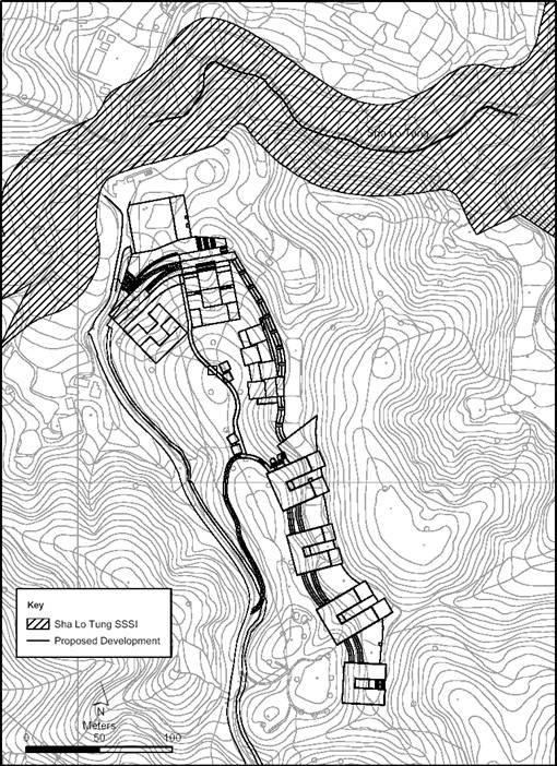
Figure 2.4 Aerial Photograph of the Proposed
Development Site located at the entrance of Sha Lo Tung Valley,
which avoids any natural streams and important dragonfly habitats (Year 2005,
captured shortly after hill fire)
Figure
2.5 The
Proposed Development Site scattered with a number of graves and urns and
dominated by grassland (Year 2005, captured shortly after hill fire)
Figure
2.6 Current condition of
the
Proposed Development Site, mainly covered by grassland (Year 2011)
2.3.3
Consideration of Alternative Layout of the
Development Site
Master
Layout Plan Options
The Project has identified and examined three layout
options for the proposed development concession within the Development
Site. The options differ primarily in
regard to the future development profile in the central and northern portions
of the site. Option 1 emphasised
retaining the natural knoll as far as possible which resulted in locating
development in the northern lower-lying area - closer to the sensitive SSSI
zone and involving significant tree felling around this habitat. Option 2 reflects the priority given to
setting back construction works from the SSSI zone and retaining the majority
of the secondary woodland - resulting in more development on and around the
knoll. Option 3 reflects the priority
given to setting back construction works from the SSSI zone, retaining the
natural knoll and the majority of the secondary woodland as far as possible -
resulting in less visual concern. In
more detail, these three options differed in the following ways:
Option 1 – fully utilise the
existing profile and natural topography. The building
design of Option 1 adopted typical layout and orientation. This option would minimise the site formation
and reduce the excavated materials so as to minimise the potential ecological
impacts due to construction runoff (see Figure 2.7). In addition,
most of the development would be shielded by the natural topography, therefore
visual impact will be largely minimised.
Land required for the building blocks, not including site formation and
landscaping areas, is approximately 2 ha.
Figure
2.7 Preliminary Master Layout Plan – Option 1
Option 2 – locate the
development away from the Sha Lo Tung SSSI and natural stream, make use of the
existing profile and natural topography as much as practicable.
This option avoids development and construction works within 20 m of the
boundary of the Sha Lo Tung SSSI, avoids construction runoff impact and
minimises disturbance to the existing trees as much as possible (see Figure 2.8). It should be noted that the SSSI comprises
the natural stream courses and generally a 30 m buffer area on both sides of
the streams. Thus, the practical
distance from the stream courses within the Sha Lo Tung SSSI to the
construction would be generally of 50 m buffer.
This option also has a smaller footprint than Option 1 (approximately
1.5 ha for the building blocks but not include areas for site formation and
landscaping), will occupy only about 2.7 % of the whole SLT area (approximately
56.6 ha). This option also makes a good balance between the extent of site
formation and disturbance to existing trees. In addition, Option 2 removes all
incompatible facilities such as vegetarian restaurant which may cause other
pollution issues.
Figure
2.8 Preliminary Master Layout Plan – Option 2
Option 3 – locate the
development away from the Sha Lo Tung SSSI and natural stream, fully utilise
the existing profile and natural topography and avoid the ridge top.
This option also avoids any development and construction works within 20
m of the boundary of the Sha Lo Tung SSSI and avoids construction runoff impact
and minimises disturbance to the existing trees as much as practically possible
(see Figure 2.9). Thus, the practical distance from the stream
courses within the Sha Lo Tung SSSI to the construction would also be generally
of 50 m buffer. This option also has a
smaller footprint than Options 1 and 2 (approximately 1.27 ha for the building
blocks and major paths - not including site formation and landscaped areas), in
occupying only about 2.2 % of the whole SLT area). In addition, the proposed development largely
preserved the woodland adjacent to Sha Lo Tung stream (avoided >95% of the
woodland habitat). This option also
allows for an appropriate balance between the extent of site formation,
disturbance to existing trees and visual impact (minimised the number of
building blocks). In addition, Option 3,
as with Option 2, removes all incompatible facilities such as vegetarian
restaurant which may cause other pollution issues.
Figure
2.9 Preliminary Master Layout Plan – Option 3
Options
Evaluation
In assessing whether an alternative is practical and
reasonable, the following five criteria were applied to the Development Site:
·
Extend of Land Take and Site Formation;
·
Encroachment into Sha Lo Tung SSSI;
·
Encroachment into Country Park;
·
Potential Disturbance to Existing Woodland and Trees; and
·
Potential Environmental Impact.
Extend of Land Take and Site Formation
In general the three options occupied a small
building footprint comprising a number of low-rise buildings. Option 3 had the smallest building layout
footprint.
Encroachment into Sha Lo Tung SSSI
All three Options do not encroach into the Sha Lo
Tung SSSI. To avoid potential secondary impact to the nearest Sha Lo Tung SSSI
and natural stream, Options 2 & 3 included a 20m wide buffer zone within
which there would be no development or construction works. Effectively, this additional buffer area
extends the existing general 30 m buffer areas (designated under the SSSI zone)
up to generally of 50 m buffer from the nearest stream courses within the Sha
Lo Tung SSSI.
Encroachment into Country Park
All of the three Options will not encroach into the
Pat Sin Leng Country Park (PSLCP) and hence no direct
impact on the PSLCP is envisaged.
Potential Disturbance to Existing Woodland and Trees
With provision of the non-building 20 m buffer zone,
Options 2 & 3 can preserve the majority of the woodland habitat and Option
3 provide the least impact on the existing trees. Option 1 includes the most tree felling.
Key Environmental Impacts
Water Quality Impact:
Options 2 & 3 provide a minimum of 20 m wide non-building buffer off
the existing SSSI zone to avoid or minimise potential impacts to the Sha Lo
Tung SSSI and natural stream. The
provision of this buffer allows for construction and operation runoff to be
properly controlled to avoid/ minimise water quality impacts to the stream and
SSSI.
Construction Impact:
The site formation and excavated materials in Option 3 (which has the
least building footprint) will be reduced by making use of the existing profile
and natural topography, so as to avoid major earthworks and to minimise the
construction impacts.
Ecological Impact:
Majority of the woodland and associated vegetation including tree and
wildlife will be preserved by Options 2 & 3 due to the provision of a
minimum of 20 m wide non-building buffer off the existing Sha Lo Tung
SSSI. Option 3 is considered to have the
least ecological impact as it has the smallest building layout footprint
amongst the three options. In addition
the development in this option almost avoids the entire woodland habitat.
Landscape and Visual Impact:
In Options 1 & 3, most of the development would be shielded by the
natural topography, therefore visual impact will also be largely minimised.
Selection
of Preferred Layout Option
The environmental benefits and dis-benefits
of the three layout options are summarised in Table 2.2. From this
assessment, it is considered that Option 3 is recommended as the preferred
option for the layout of the development concession to be taken forward for the
purposes of the detailed environmental assessment and subsequent planning
approval applications. The Option 3
Landscape Master Layout Plan is presented in Figure 2.10.
2.3.4
Alternative Access Road Design
The existing Sha Lo Tung Road (approximately 2.3 km)
is the only vehicular access serving the SLT Valley. Being only 3-3.5m wide, it is substandard in
geometry, in relatively poor condition and subject to frequent slope failures
during heavy rain leading to occasional road closures. Under the Project, the existing roadway will
be improved to the minimum safety requirement of a Single Track Access Road
that would also enable emergency access for fire engines and provide safe
access to visitors of the surrounding country park, the proposed Nature Reserve
with Nature Interpretation Centre and the development concession facilities.
An alternative design for the lower section of Sha Lo Tung Road as
shown in Figure 2.11, was
considered. The alternative route is an
abandoned track route with staircase connecting Ting Kok Road
near Ha Hang Estate and Sha Lo
Tung Road near the WSD Ha Hang Fresh Water Service
Reservoirs. The width of the existing
track route is approximate 1 – 1.2 m. It
rises from 4.4 mPD to around 62 mPD
in 700 m length. The gradient of the
staircase is over 1:6 (greater than 16%).
A significant amount of cut and fill slope work would be involved if the
staircase was converted into vehicular access.
Moreover, there are a large number of trees and vegetation located along
both sides of the track route and staircase.
As a result, the existing track route is only suitable for a small
volume of pedestrian use.
The following constraints have been considered during
the design of the proposed route:
Vertical Alignment
Constraint
Over its 2.3 km length, the existing Sha Lo Tung Road
rises from 3.8 mPD to around 205 mPD
at the crest of Sha Lo Tung Valley before descending to the entrance of the
conservation area at 179.4 mPD. The average gradient over the rise from Ting Kok Road
to the crest is about 1:10. Gradient is
a major constraint in the design of the vertical alignment.
Horizontal Alignment Constraint
The east side of the existing Sha Lo Tung Road is generally up-slope
from the pavement while the west side is mostly down-slope. There are man-made slopes along the existing Sha Lo Tung Road
with designated slope maintenance agents.
These slopes are also a constraint for design of the horizontal
alignment.
Other Site Constraints in the Study Area
The existing Fung Yuen Playground, WSD Ha Hang
Service Reservoirs (Salt Water & Fresh Water), Fung Yuen Valley Site of
Special Scientific Interest (SSSI), existing woodland at the western side of
the road and Pat Sin Leng
Country Park
located within the Study Area are the other constraints for design of the
access road.
Based on the existing contour plan, gradient and the
local site constraint, upgrading and improving the whole existing Sha Lo Tung
Road is preferred rather than constructing a new road alignment for the lower
section. The benefits of this are summarised as follows:
·
Minimal
cut and fill slope area
·
Minimal
impact on trees/vegetation
·
Minimal
impact to the environment, i.e. air quality and noise impact to Ha Hang village
·
Minimal
construction time
2.4
Consideration of Alternative Construction Methods and
Sequence of Works
2.4.1
Construction Method
The construction methods that could be used for the
three components of the Project i.e. the Ecological Reserve, Development Site
and Sha Lo Tung Road Improvement, are summarised in the following section. Typical construction practices in Hong Kong are assumed.
With the implementation of standard pollution control measures, no
adverse environmental impacts are anticipated.
Hence, alternative construction methods for works were not identified. The construction methods identified for the
Project and their respective environmental benefits and dis-benefits,
as well as other considerations are summarised in Table 2.3.
Fencing
and Temporary Footbridge within Ecological Reserve
The construction would comprise the followings:
·
Site clearance at the location
of the proposed footbridge (maximum of 2.2 m length and 1.5 m width)
·
Excavation of the footings
(dimensions of 500mm (height) x 500mm (length))
·
Construction of the bridge
footings
·
Installation of the joist and
planking
·
Fixing the transoms and posts
·
Fence installation at Lei Uk after completion of the temporary footbridge
To further minimise the potential ecological impacts
on the Sha Lo Tung SSSI and the stream, the temporary footbridge will be
constructed by using prefabricated timber instead of concrete. Prefabricated timber sections will be
transported near the site and hand carried to the proposed site for assembly.
Minimal soil excavation for the posts and fence installation are
anticipated. The temporary footbridge
will be removed manually after the erection of fencing around Lei Uk.
Development
Site
The major construction work for the Development
Site will include the following key activities:
-
Site clearance;
-
Excavation and site formation
works;
-
Construction of drainage and
sewage system;
-
Slope stabilization works;
-
Superstructure and building
construction; and
-
Landscaping works.
The formation works will involve some cutting of
existing slopes to provide sufficient
space for constructing the superstructure within the Development Site. In order to avoid adverse environmental
impacts, the construction methods will minimize the permanent and temporary
cutting required and local trimming will be adopted for soil nailing of the
platforms before construction of the permanent structures. In-situ excavated materials will be reused as
far as practical, for backfilling and to reduce visual impact, slopes will be
engineered as naturally as practicable with soft landscaping solutions adopted
for surface protection on slopes where geotechnical conditions allow. Hard surface protection cover such as shotcrete will only be considered at the last resort. As the structures are only a maximum of
4-storeys high and are relatively light in weight, raft foundation or pad
footings (instead of piling which may generate higher potential environmental
impacts) will be considered for the foundations.
Sha
Lo Tung Road
Improvement
The principles adopted for the design of the road
improvement works are: -:
·
Minimize disturbance to the
existing landscape and trees;
·
Preserve woodlands of
ecological value;
·
Provide a safe access road
engineered to meet the traffic demand; and
·
Enable emergency vehicle access
to the Ecological Reserve, Nature Interpretation Centre, Multi-Cultural
Education Retreat cum Columbarium.
With such principles, the impacts arising from the
improvement works will be kept to a minimum.
In light of the low volume of traffic expected, the improved access road
shall remain a single track access which satisfies the following Transport and
Planning Design Manual (TPDM) requirements:
·
Widening the existing access
road to a minimum width of 4.5 m, which under the TPDM is suitable for use of
emergency vehicles;
·
Providing additional
inter-visible passing places at maximum spacing 60 m for 2-way traffic;
·
Appropriate local widening at
bends of up to 6 m wide to cater for travel of emergency vehicles from Ting Kok Road;
·
The access road shall follow
the existing road alignment and profile to minimise earthworks and impacts to
the existing environment. Nevertheless,
the road shall be re-profiled to ensure a maximum gradient less than 16%
because a gradient more than 16% is not suitable for use of emergency vehicles;
·
The road will be widened
towards the eastern side through cutting the uphill slopes to avoid disturbing
the woodland dominating on the western side;
·
Soil nailing, if required to
stabilise slopes particularly downhill, can be implemented carefully to avoid
damage to trees and the slope surface can be planted to maintain a green
landscape after the improvement works are finished;
·
Provision of a drainage system
with additional verges and a sewer;
·
No encroachment into the
Conservation Area and Pat
Sin Leng Country
Park; and
·
Appropriate landscape design
along the access road.
There will be no direct impact to Pat Sin Leng Country
Park or to the SSSIs as the road improvement works will avoid these
areas. Most of the woodland with
conservation interest is located on the western or downhill section of the
road, thus the improvement of Sha
Lo Tung Road will generally be implemented on the
eastern uphill side unless there are restrictions such as woodlands of
conservation interest and private lots adjacent to the road. The road will be widened mainly by cutting
the eastern hill slope.
Most of the improvement works involve cutting the
existing slopes to generate space
for improving Sha Lo Tung Road. This is the main cause of disturbance to the
landscape. To avoid excessive impacts
the adopted construction methods would minimise the permanent and temporary
cutting, thereby minimising impacts to the surrounding landscape. Construction of a conventional retaining wall
requires temporary slope cutting behind the future slope surface to provide a
working area in which to build the retaining wall. When the wall is completed earth is
backfilled between the retaining wall and the temporary slope face. The volume of excavated material exceeds the
volume to be disposed off-site. In
contrast, with soil-nailing the slope cutting stops at the future slope surface
and then the soil nails are installed.
No unnecessary earthworks are involved.
Soil nailing is therefore proposed to stabilize the
cutting. In cases where the road
platform requires stabilising downhill from the road, soil-nailing is also the
preferred option because no earthwork is required. Only soil nails will be inserted to stabilise
the existing slope and no shotcreting work will be conducted after the soil nailing
work. Additionally, the soil-nails can
be installed carefully to avoid existing trees and therefore of limited
disturbance to the existing soil and vegetation on the surface. Therefore the impact is expected to be
temporary and limited disturbance on the secondary woodland. An advantage of soil nailing is that the
finished slope surface can be planted for landscaping purpose. The works boundary along Sha Lo Tung Road
Improvement has taken into account of the potential penetration depth of soil
nails within the soil mass (underground).
It should be noted that the construction work activities will be
restricted to the proposed road alignment, cut slope and soil nailing.