8. Land
Contamination Impacts
8.2 Environmental
Legislation, Standards and Guidelines
8.4 Description
of the Environment
8.6 Identification
and Evaluation of Land Contamination
8.7 Remediation
Action Plan for LMC Loop
This section presents the assessment of land contamination impacts
which may arise during the construction phase. The assessment has covered the
entire LMC Loop as well as the contamination assessment area including
footprint of associated infrastructure, working space and works area for the
associated infrastructure outside the LMC Loop. Details of the assessment can
be referred to their respective Contamination Assessment Plans (CAPs) given in Appendix 8-1 and Appendix 8-3 respectively.
This section presents the
assessment of land contamination impacts which may arise during the
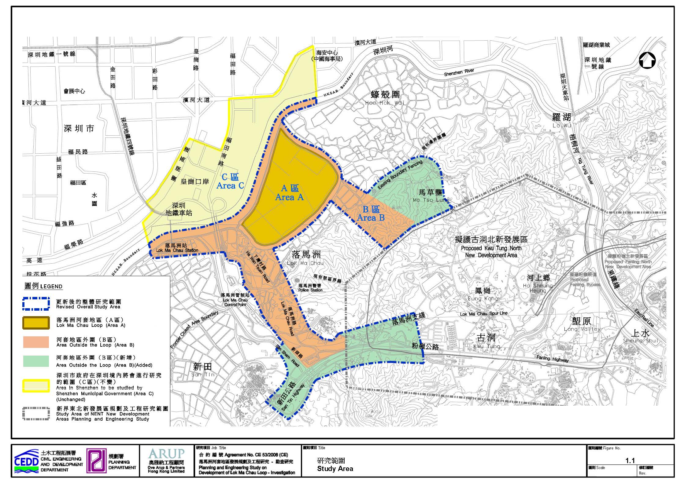
construction phase. The assessment has covered the entire Lok
Ma Chau Loop (Area A) as shown in Figure 1.1 (hereby refers to LMC Loop) as
well as the contamination assessment area including footprint of associated
infrastructure, working space and works area for the associated infrastructure
outside the LMC Loop. The location of the contamination assessment area for the
associated infrastructure in adjacent area in Hong Kong outside the LMC Loop
can be referred to Figure 1.4 in the Contamination Assessment Plan (CAP) for
Associated Infrastructure outside Lok Ma Chau Loop
given in Appendix 8-3. Details of
the assessment can be referred to their respective CAPs given in Appendix 8-1
and Appendix 8-3 respectively.
Environmental site investigation
has been conducted for the Project within the LMC Loop. The concentration of
the metal “Arsenic (As)” from 6 soil samples collected at 5 boreholes
marginally exceeded the Risk-Based Remediation Goals (RBRGs) of Rural
Residential and Urban Residential land uses. With the implementation of
Remediation Action Plan, all contaminated soils would be remediated during the
construction phase. No groundwater contamination was detected.
No potentially contaminated site
was identified within the contamination assessment area for the associated
infrastructure outside the LMC Loop as shown in the plan of Superimposition of
Study Area and Assessment Area i.e. Figure 1.4 of Appendix 8-3. It is also confirmed that there will not be any
works/development outside the contamination assessment area under the present
EIA study.
The land contamination assessment
has been conducted in accordance with the requirements of Annexes 19 of the
TM-EIAO as well as the requirements set out under Clause 3.4.9 of the EIA Study
Brief.
8.2 Environmental Legislation, Standards and Guidelines
The
relevant legislations, standards and guidelines applicable to the present study
for the assessment of land contamination include:
· Annex 19 of the TM-EIAO, Guidelines for Assessment of Impact On Sites of Cultural Heritage and Other Impacts (Section 3 : Potential Contaminated Land Issues), EPD, 1997;
· Guidance Manual for Use of Risk-Based Remediation Goals (RBRGs) for Contaminated Land Management, EPD, 2007.
· Guidance Notes for Contaminated Land Assessment and Remediation EPD, 2007 ; and
· Practice Guide for Investigation and Remediation of Contaminated Land, EPD, 2011.
8.2.1 Environmental Impact Assessment Ordinance (EIAO) (Cap. 499), Technical Memorandum on Environmental Impact Assessment Process (TM-EIAO)
Under
Annex 19 of the TM-EIAO, a number of potentially contaminating historical land
uses should be considered, including oil installations, gas works, metal
workshops, car repair and dismantling workshops, which have the potential to
cause or have caused land contamination.
8.2.2 Guidance Manual for Use of Risk-Based Remediation Goals (RBRGs) for Contaminated Land Management
The
Guidance Manual introduces the risk based approach in land contamination
assessment and present instructions for comparison of soil and groundwater data
to the Risk-based Remediation Goals (RBRGs) for 54 chemicals of concern
commonly found in Hong Kong. The RBRGs were derived to suit
Table 8.1 Risk-Based
Remediation Goals (RBRGs) for Soil & Soil Saturation Limit
|
Chemical |
Risk-Based
Remediation Goals (RBRGs) for Soil |
|
|||
|
Urban
Residential |
Rural
Residential |
Industrial |
Public Park |
Soil
Saturation Limit (Csat) |
|
|
(mg/kg) |
(mg/kg) |
(mg/kg) |
(mg/kg) |
(mg/kg) |
|
|
VOCs |
|
|
|
|
|
|
Acetone |
9,590 |
4,260 |
10,000 |
10,000 |
*** |
|
Benzene |
0.704 |
0.279 |
9.21 |
42.2 |
336 |
|
Bromodichloromethane |
0.317 |
0.129 |
2.85 |
13.40 |
1,030 |
|
2-Butanone |
10,000 |
10,000 |
10,000 |
10,000 |
*** |
|
Chloroform |
0.132 |
0.0529 |
1.54 |
253 |
1,100 |
|
Ethylbenzene |
709 |
298 |
8,240 |
10,000 |
138 |
|
Methyl tert-Butyl Ether |
6.88 |
2.80 |
70.1 |
505 |
2,380 |
|
Methylene Chloride |
1.30 |
0.529 |
13.9 |
128 |
921 |
|
Styrene |
3,220 |
1,540 |
10,000 |
10,000 |
497 |
|
Tetrachloroethene |
0.101 |
0.0444 |
0.78 |
1.84 |
97.1 |
|
Toluene |
1,440 |
705 |
10,000 |
10,000 |
235 |
|
Trichloroethene |
0.523 |
0.211 |
5.68 |
69.4 |
488 |
|
Xylenes (Total) |
95.0 |
36.8 |
1,230 |
10,000 |
150 |
|
SVOCs |
|
|
|
|
|
|
Acenaphthene |
3,510 |
3,280 |
10,000 |
10,000 |
60.2 |
|
Acenaphthylene |
2,340 |
1,510 |
10,000 |
10,000 |
19.8 |
|
Anthracene |
10,000 |
10,000 |
10,000 |
10,000 |
2.56 |
|
Benzo(a)anthracene |
12.0 |
11.4 |
91.8 |
38.3 |
|
|
Benzo(a)pyrene |
1.20 |
1.14 |
9.18 |
3.83 |
|
|
Benzo(b)fluoranthene |
9.88 |
10.1 |
17.8 |
20.4 |
|
|
Benzo(g,h,i)perylene |
1,800 |
1,710 |
10,000 |
5,740 |
|
|
Benzo(k)fluoranthene |
120 |
114 |
918 |
383 |
|
|
Bis-(2-Ethylhexyl)phthalate |
30.0 |
28.0 |
91.8 |
94.2 |
|
|
Chrysene |
871 |
919 |
1,140 |
1,540 |
|
|
Dibenzo(a,h)anthracene |
1.20 |
1.14 |
9.18 |
3.83 |
|
|
Fluoranthene |
2,400 |
2,270 |
10,000 |
7,620 |
|
|
Fluorene |
2,380 |
2,250 |
10,000 |
7,450 |
54.7 |
|
Hexachlorobenzene |
0.243 |
0.220 |
0.582 |
0.713 |
|
|
Indeno(1,2,3-cd)pyrene |
12.0 |
11.4 |
91.8 |
38.3 |
|
|
Naphthalene |
182 |
85.6 |
453 |
914 |
125 |
|
Phenanthrene |
10,000 |
10,000 |
10,000 |
10,000 |
28.0 |
|
Phenol |
10,000 |
10,000 |
10,000 |
10,000 |
7,260 |
|
Pyrene |
1,800 |
1,710 |
10,000 |
5,720 |
|
|
Metals |
|
|
|
|
|
|
Antimony |
29.5 |
29.1 |
261 |
97.9 |
|
|
Arsenic |
22.1 |
21.8 |
196 |
73.5 |
|
|
Barium |
10,000 |
10,000 |
10,000 |
10,000 |
|
|
Cadmium |
73.8 |
72.8 |
653 |
245 |
|
|
Chromium III |
10,000 |
10,000 |
10,000 |
10,000 |
|
|
Chromium VI |
221 |
218 |
1,960 |
735 |
|
|
Cobalt |
1,480 |
1,460 |
10,000 |
4,900 |
|
|
Copper |
2,950 |
2,910 |
10,000 |
9,790 |
|
|
Lead |
258 |
255 |
2,290 |
857 |
|
|
Manganese |
10,000 |
10,000 |
10,000 |
10,000 |
|
|
Mercury |
11.0 |
6.52 |
38.4 |
45.6 |
|
|
Molybdenum |
369 |
364 |
3,260 |
1,220 |
|
|
Nickel |
1,480 |
1,460 |
10,000 |
4,900 |
|
|
Tin |
10,000 |
10,000 |
10,000 |
10,000 |
|
|
Zinc |
10,000 |
10,000 |
10,000 |
10,000 |
|
|
Dioxins / PCBs |
|
|
|
|
|
|
Dioxins (I-TEQ) |
0.001 |
0.001 |
0.005 |
0.001 |
|
|
PCBs |
0.236 |
0.223 |
0.748 |
0.756 |
|
|
Petroleum Carbon Ranges |
|
|
|
|
|
|
C6 - C8 |
1,410 |
545 |
10,000 |
10,000 |
1,000 |
|
C9 - C16 |
2,240 |
1,330 |
10,000 |
10,000 |
3,000 |
|
C17 - C35 |
10,000 |
10,000 |
10,000 |
10,000 |
5,000 |
|
Other Inorganic Compounds |
|
|
|
|
|
|
Cyanide, free |
1,480 |
1,460 |
10,000 |
4,900 |
|
|
Organometallics |
|
|
|
|
|
|
TBTO |
22.1 |
21.8 |
196 |
73.5 |
|
Note:
(1) For Dioxins, the cleanup levels in USEPA
Office of Solid Waste and Emergency Response (OSWER) Directive of 1998 have
been adopted. The OSWER Directive value of 1 ppb for residential use has been
applied to the scenarios of "Urban Residential", "Rural
Residential", and "Public Parks", while the low end of the range
of values for industrial, 5 ppb, has been applied to the scenario of
"industrial".
(2) Soil saturation limits for petroleum carbon
ranges taken from the Canada-Wide Standards for Petroleum Hydrocarbons in Soil,
CCME 2000.
(3) * indicates a 'ceiling limit'
concentration.
(4) *** indicates that the Csat
value exceeds the 'ceiling limit' therefore the RBRG applies.
Table 8.2 Risk-Based
Remediation Goals (RBRGs) for Groundwater and Solubility Limit
|
Chemical |
Risk-Based
Remediation Goals (RBRGs) for Groundwater |
|
||
|
Urban
Residential |
Rural
Residential |
Industrial |
Solubility
Limit |
|
|
(mg/L) |
(mg/L) |
(mg/L) |
(mg/L) |
|
|
VOCs |
|
|
|
|
|
Acetone |
9,590 |
4,260 |
10,000 |
*** |
|
Benzene |
0.704 |
0.279 |
9.21 |
336 |
|
Bromodichloromethane |
0.317 |
0.129 |
2.85 |
1,030 |
|
2-Butanone |
10,000 |
10,000 |
10,000 |
*** |
|
Chloroform |
0.132 |
0.0529 |
1.54 |
1,100 |
|
Ethylbenzene |
709 |
298 |
8,240 |
138 |
|
Methyl tert-Butyl Ether |
6.88 |
2.80 |
70.1 |
2,380 |
|
Methylene Chloride |
1.30 |
0.529 |
13.9 |
921 |
|
Styrene |
3,220 |
1,540 |
10,000 |
497 |
|
Tetrachloroethene |
0.101 |
0.0444 |
0.78 |
97.1 |
|
Toluene |
1,440 |
705 |
10,000 |
235 |
|
Trichloroethene |
0.523 |
0.211 |
5.68 |
488 |
|
Xylenes (Total) |
95.0 |
36.8 |
1,230 |
150 |
|
SVOCs |
|
|
|
|
|
Acenaphthene |
10,000 |
7,090 |
10,000 |
4.24 |
|
Acenaphthylene |
1,410 |
542 |
10,000 |
3.93 |
|
Anthracene |
10,000 |
10,000 |
10,000 |
0.0434 |
|
Benzo(a)anthracene |
|
|
|
|
|
Benzo(a)pyrene |
|
|
|
|
|
Benzo(b)fluoranthene |
0.539 |
0.203 |
7.53 |
0.0015 |
|
Benzo(g,h,i)perylene |
|
|
|
|
|
Benzo(k)fluoranthene |
|
|
|
|
|
Bis-(2-Ethylhexyl)phthalate |
|
|
|
|
|
Chrysene |
58.1 |
21.9 |
812 |
0.0016 |
|
Dibenzo(a,h)anthracene |
|
|
|
|
|
Fluoranthene |
10,000 |
10,000 |
10,000 |
0.206 |
|
Fluorene |
10,000 |
10,000 |
10,000 |
1.98 |
|
Hexachlorobenzene |
0.0589 |
0.0234 |
0.695 |
6.20 |
|
Indeno(1,2,3-cd)pyrene |
|
|
|
|
|
Naphthalene |
61.7 |
23.7 |
862 |
31.0 |
|
Phenanthrene |
10,000 |
10,000 |
10,000 |
1.00 |
|
Phenol |
|
|
|
|
|
Pyrene |
10,000 |
10,000 |
10,000 |
0.135 |
|
Metals |
|
|
|
|
|
Antimony |
|
|
|
|
|
Arsenic |
|
|
|
|
|
Barium |
|
|
|
|
|
Cadmium |
|
|
|
|
|
Chromium III |
|
|
|
|
|
Chromium VI |
|
|
|
|
|
Cobalt |
|
|
|
|
|
Copper |
|
|
|
|
|
Lead |
|
|
|
|
|
Manganese |
|
|
|
|
|
Mercury |
0.486 |
0.184 |
6.79 |
|
|
Molybdenum |
|
|
|
|
|
Nickel |
|
|
|
|
|
Tin |
|
|
|
|
|
Zinc |
|
|
|
|
|
PCBs |
|
|
|
|
|
Dioxins (I-TEQ) |
|
|
|
|
|
PCBs |
0.433 |
0.171 |
5.11 |
0.031 |
|
Petroleum Carbon Ranges |
|
|
|
|
|
C6 - C8 |
1,410 |
545 |
10,000 |
1,000 |
|
C9 - C16 |
2,240 |
1,330 |
10,000 |
3,000 |
|
C17 - C35 |
10,000 |
10,000 |
10,000 |
5,000 |
|
Other Inorganic Compounds |
|
|
|
|
|
Cyanide, free |
|
|
|
|
|
Organometallics |
|
|
|
|
|
TBTO |
|
|
|
|
Note:
(1) Blank indicates
that RBRG could not be calculated because the toxicity or physical/chemical
values were unavailable, or the condition of Henry's Law Constant>0.00005
was not met for the inhalation pathway.
(2)
Where solubilities for
Petroleum Carbon Range aliphatic C9-C16 and greater than C16 generally are
considered to be effectively zero and therefore the aromatic solubility for
C9-C16 is used.
(3)
* indicates a 'ceiling limit' concentration.
(4) *** indicates
that the solubility limit exceeds the 'ceiling limit' therefore the RBRG
applies.
8.2.3 Guidance Note for Contamination Land Assessment and Remediation
In accordance with EPD’s Guidance Note for Contamination Land Assessment and Remediation, a
contamination assessment evaluation should:
· provide a clear and detailed account of the present land-use and the relevant past land history in relation to possible land contamination;
· identify areas of potential contamination and associated impacts, risks or hazards; and
· submit a plan to evaluate the actual contamination conditions for soil and/or groundwater, if required.
8.2.4 Practice Guide for Investigation and Remediation of Contaminated Land
The EPD’s Practice Guide for Investigation and Remediation of Contaminated Land includes a summary of the general steps to be followed in conducting a contamination assessment study.
Land contamination assessment has been conducted according to the following procedures:
· Desktop review of site history;
· Site survey to identify the potentially contaminated sites;
· Prepare Contamination Assessment Plan for EPD’s agreement;
· Site Investigation for soil and groundwater sampling and testing;
· Interpret the laboratory test results and evaluate the contamination level:
· Prepare Contamination Assessment Report to summarize the assessment findings for EPD’s agreement;
· If contamination is confirmed, propose remediation method and prepare Remediation Action Plan for EPD’s agreement.
8.3.1 Desktop Review of Site History
The
following information have been collated for the
desktop review of site history:
· Hong Kong Ordinance Survey Maps from various years;
· Relevant Outline Zoning Plans (OZPs) in the vicinity of LMC Loop;
· Hong Kong Geological Survey Map;
· Relevant aerial photos from 1973;
· “Mapping Hong Kong, A Historical Atlas”, Government Information Services, 1992;
· Environmental Impact Assessment Study on Shenzhen River Regulation Project - Study Report for Stage 1 Works; Nov., 1994;
· Environmental Impact Assessment Study on Shenzhen River Regulation Project - Final EIA Study Report; Nov., 1995;
· 落馬洲河套地區-土壤污染評估報告-安社亞洲(香港)有限公司, 二零零七年六月; (Translate: Lok Ma Chau Loop-Soil Contamination Assessment Report; AECOM Asia Co. Ltd; Jun., 2007);
·
港深落馬洲河套地區聯合開發項目環境影響評價大綱 (送審稿) - 深圳市環境科學研究所, 北京大學, 二零零七年八月; (Translate: Hong Kong Shenzhen Joint
Study on Development of Lok Ma Chau Loop -
Environmental Impact Assessment Summary (Draft); Shenzhen Institute of Environmental Science, Peking University; Aug.,
2007)
· “Sheung Shui to Lok Ma Chau Spur Line Contaminated Land Assessment, Contamination Assessment Report (CAR) and Remediation Action Plan (RAP) Final (May 2002) with Addendum (August 2002) (2141/913)”, MTR, 2002; and
· Information related to potential land contamination from Environmental Compliance Division of Environmental Protection Department (EPD) and Fire Services Department (FSD).
8.3.2 Site Survey
Site surveys were conducted subsequently to ground truth the findings of desktop review and to identify any other land uses within the Project area which may have the potential for causing soil and groundwater contaminants. Possible contaminants were identified in accordance with Table 2.3 of EPD’s Practice Guide for Investigation and Remediation of Contaminated Land.
8.3.3 Preparation of Contamination Assessment Plan
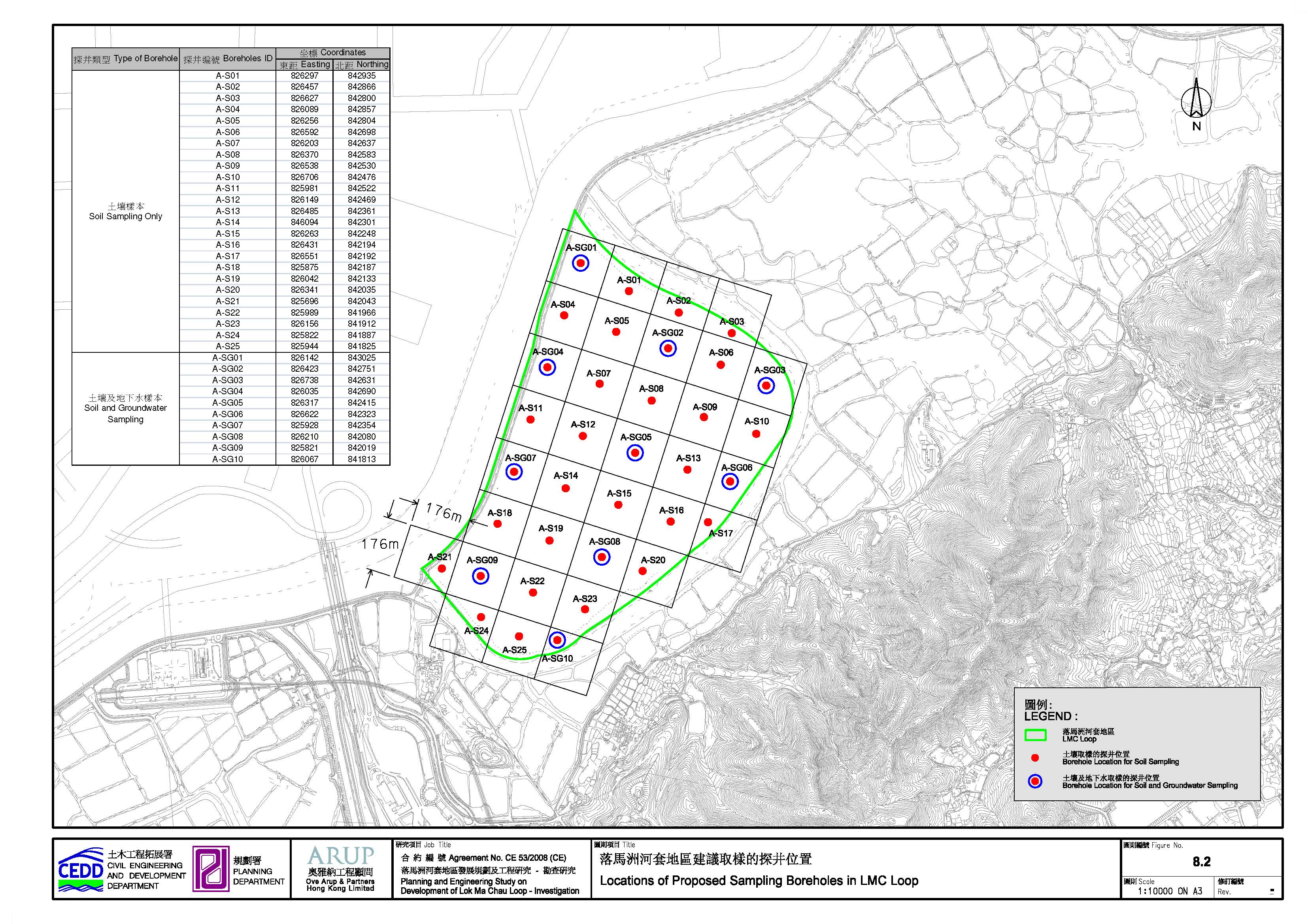
According
to the findings of desktop study and site surveys, the CAPs for the entire LMC
Loop and that for the associated infrastructure outside the LMC Loop as given
in Appendix 8-1 and Appendix 8-3 were prepared and
submitted to EPD. Sampling locations and sampling depths for soil and groundwater
within the LMC Loop have been proposed for the site investigation (SI) works in
its respective CAP. The CAP for LMC Loop also specified the sampling and
testing requirements for the SI works.
Since no
potentially contaminated site was identified in the contamination assessment
area for the associated infrastructure outside the LMC Loop, no SI work was
proposed in this area.
8.3.4 Site Investigation and Data Interpretation
After
completion of the SI works (i.e. boreholes drilling, soil and groundwater sampling
and testing) within LMC Loop, the analytical results of the soil and
groundwater were interpreted using RBRGs.
The nature, level and extent of the land contamination within LMC Loop
were evaluated.
According
to the findings of desktop study and site survey, no potentially contaminated
site was identified in the contamination assessment area for the associated
infrastructure outside the LMC Loop and therefore SI work was not required.
8.3.5 Preparation of Contamination Assessment Report and Remediation Action Plan for LMC Loop
The
findings of laboratory test results were documented in the Contamination
Assessment Report (CAR) and Supplementary CAR for LMC Loop. Options of remedial
works for contaminated soil have been reviewed and evaluated, and appropriate
remediation option has been recommended.
Details are presented in the Remediation Action Plan (RAP) and
Supplementary RAP. Copies of the CAR/RAP and Supplementary CAR/RAP are given in
Appendix 8-2.
8.4 Description of the Environment
8.4.1 Existing Environment of LMC Loop
The LMC
Loop is a flat land with grasses and shrubs. No temporary structure was found
in this restricted area. No special land use or activity was observed that may
have the potential for causing soil and groundwater contamination.
8.4.1.1
Potentially Contaminated Site
within LMC Loop
Historically,
the LMC Loop (i.e. former agricultural land and fish ponds in 1980s and early
1990s) was used as a dumping ground for mud extracted from Shenzhen River
Training Works Stages 1 and 2.
Approximately 1Mm3 contaminated mud and 3Mm3
uncontaminated mud were dredged and disposed of within the LMC Loop from year
1995 to 2000. The depth of the disposed mud within the LMC Loop was
approximately 5m (which include about 1m to 1.5m thick top layer of
uncontaminated mud for capping). However, the disposal pattern, e.g. the
disposal location and area of contaminated mud within the LMC Loop is unknown.
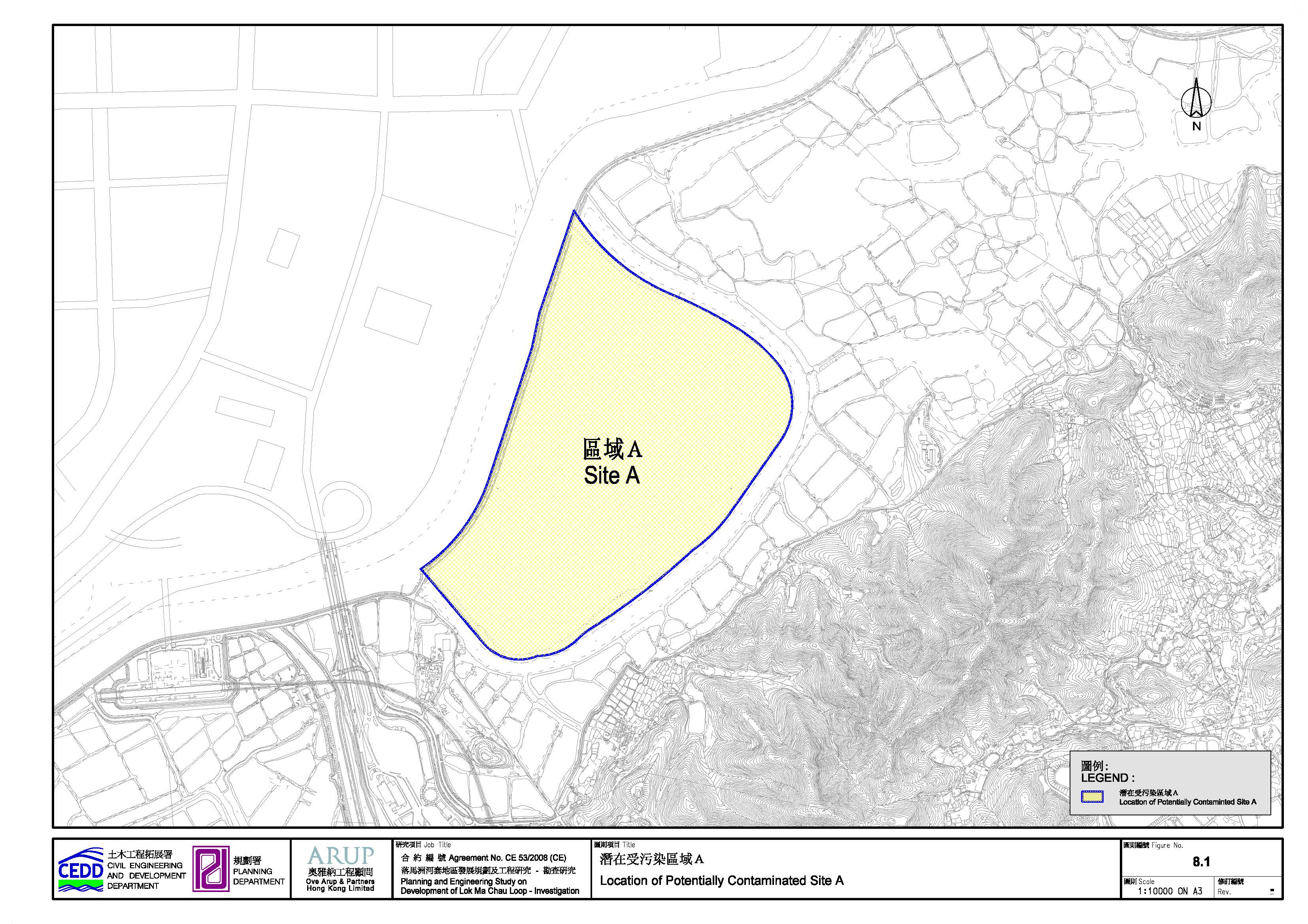
Therefore, the entire LMC Loop is considered as a potentially contaminated
site, namely “Site A” (Table 8.3).
The location of Site A and the proposed boreholes are
shown in Figure 8.1 and Figure 8.2 respectively.
Table
8.3 Potentially
contaminated landuse within the LMC Loop
|
Site ID |
Location |
Current Land Use |
Potential Sources of Contamination |
Approximate Area (m²) |
Recommended No. of Boreholes(i) |
|
A |
Entire LMC Loop |
Flat land with Grasses and Shrubs |
Approx. 1Mm3 contaminated mud and 3Mm3
uncontaminated mud were dredged from the Shenzhen River and disposed of within the LMC Loop from year 1995 to 2000. Total filling depth within the LMC Loop is about 5m, which include 1m to 1.5m
thick top layer of uncontaminated mud for capping. |
870,000 (87ha) |
35 |
Note
(1)
The
recommendation in港深落馬洲河套地區聯合開發項目環境影響評價大綱(送審稿) [Hong Kong Shenzhen Joint Study
on Development of Lok Ma Chau Loop - Environmental
Impact Assessment Summary (Draft)] under the Law of the People’s Republic of
China on Environmental Impact Assessment
has been taken into account for the determination of the number of boreholes.
8.4.2 Existing Environment of Contamination Assessment Area for the Associated Infrastructure outside LMC Loop
Details of the existing surrounding environment of contamination assessment area for the associated infrastructure outside the LMC Loop are described below.
Direct
Link to Lok Ma Chau Station
The contamination assessment area mainly consisted of fish ponds and agricultural lands, intersecting with San Sham Road and the nullah. The area extends westward towards Lok Ma Chau Station with no industrial activity identified.
Western
Connection Road
The upper section of the contamination assessment area comprised of fish ponds along Ha Wan Tsuen and Lok Ma Chau Road. For the lower section, Lok Ma Chau Public Transport Interchange, a taxi chit waiting area, and a fenced government land were observed. The contamination assessment area also includes part of the Fanling Highway, San Tin Highway and San Tin Interchange. No industrial activity with land contamination potential was identified.
Eastern Connection Road
The contamination assessment area
mainly consisted of fish ponds, agricultural land and natural terrain. Only Lok Ma Chau Police Station was identified and thus no
industrial activity was observed.
Flushing
Water Service Reservoir
The contamination assessment area consisted of natural terrain only and no industrial activity was identified.
8.4.2.1 Potentially Contaminated Site within Contamination Assessment Area for the Associated Infrastructure outside LMC Loop
Based on the information collected from site survey
and review of available historical records e.g. historical aerial photos, no
potentially contaminated site was identified in the contamination assessment
area for the associated infrastructure outside the LMC
Loop. Hence, SI work was not required.
As the construction of the associated infrastructures would only commence a few years later, the entire contamination assessment area for the associated infrastructure outside the LMC Loop, which are currently road structure and natural terrain, should be re-appraised. The objective of re-appraisal of this area is to ensure any potential contamination activities from land use changes after the approval of this land contamination assessment study is subject to a proper updating review prior to commencement of the construction works.
8.5.1 LMC Loop
A total
of 35 boreholes (3 soil samples per borehole) were drilled for soil and
groundwater sampling in accordance with the CAP for the LMC Loop. The
laboratory testing results showed that the Arsenic levels from 6 soil samples
at 5 boreholes marginally exceeded the RBRGs for both Rural and Urban
Residential land uses. In order to determine the extent of the contamination at
these 5 locations, 3 additional boreholes near each of the 5 contaminated
boreholes were drillled (i.e. a total of 15
additional boreholes were drilled) for additional soil sampling and testing.
The laboratory testing results of the additional soil samples show compliance
with the RBRG for Rural Residential (i.e. the stringent set of RBRGs).
In order
to further confine the horizontal extent of the contamination, 3 further
additional boreholes were drilled roughly mid-way in-between the pairs of
contaminated and uncontaminated boreholes (i.e. a total of 15 further
additional boreholes were drilled). The estimation of final horizontal extent
of the contaminated zones in LMC Loop is detailed in Section 8.6.
The
entire SI programme was supervised by the on-site Land Contamination
Specialist. All soil and groundwater samples were analysed by a HOKLAS accredited
laboratory for all parameters listed in the Appendix 8-1.
Re-appraisal
on the LMC Loop will be required to ensure any potential contamination
activities from land use changes after the approval of this land contamination
assessment study, subject to a proper updating review prior to commencement of
the construction works. Where re-appraisal or re-assessment is required, the PP
would prepare and submit the Supplementary CAP to EPD prior to the commencement
of SI works. Following on from the submission of Supplementary CAP and
completion of additional SI, the PP would prepare CAR, RAP and RR and submit to
EPD for agreement prior to commencement of the development works.
8.5.2 Contamination Assessment Area for the Associated Infrastructure outside LMC Loop
Re-appraisal on the entire contamination assessment area for the associated infrastructure outside LMC Loop will be required to ensure any potential contamination activities from land use changes after the approval of this land contamination assessment study, subject to a proper updating review prior to commencement of the construction works. Where re-appraisal or re-assessment is required, the PP would prepare and submit the Supplementary CAP to EPD prior to the commencement of SI works. Following on from the submission of CAP and completion of SI, the PP would prepare CAR, RAP and RR and submit to EPD for agreement prior to commencement of the development works.
8.6 Identification and Evaluation of Land Contamination
8.6.1 LMC Loop
The
laboratory test results of soil, groundwater and elutriate samples have been
reviewed and they are summarized in the CAR/RAP for LMC
Loop and
Supplementary CAR/RAP for LMC Loop (Appendix 8-2).
A total
of 105 soil samples were collected from 35 boreholes (i.e. 3 soil samples per
borehole) from November 2009 to January 2010. The test results indicated that
all but 6 of the soil samples collected from 5 boreholes were below RBRG for
Rural Residential (i.e. the most stringent set of RBRGs for SVOCs, Metals,
Dioxins, PCBs and Cyanide) and Intervention Value (i.e. for Chlorinated
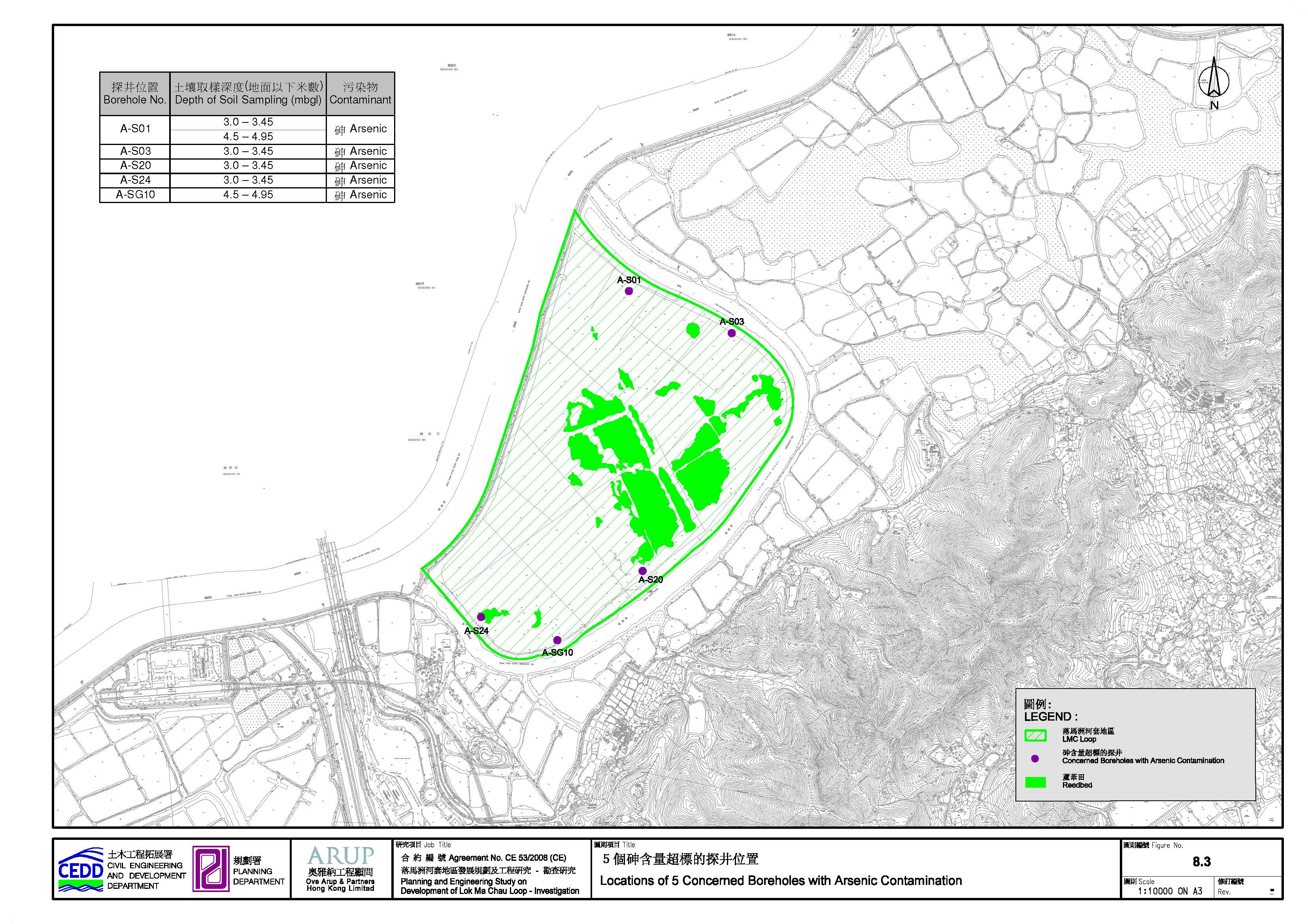
Pesticides). In these 6 samples, the concentrations of metal “Arsenic (As)”
have marginally exceeded the RBRGs for Rural Residential and Urban Residential
land uses. The results are presented Table
8.4 and their respective 5 borehole locations are shown in Figure
8.3.
Table 8.4 Summary
of soil samples exceeding RBRGs
|
Borehole No. |
Depth of Soil Sampling (mbgl) |
Contaminant |
Concentration (mg/kg dry soil) |
RBRGs of Arsenic (mg/kg dry soil) |
|
A-S01 |
3.0 – 3.45 |
Arsenic |
22.2 |
Rural Residential RBRG : 21.8 Urban Residential RBRG : 22.1 Public Parks RBRG : 73.5 Industrial RBRG : 196 |
|
4.5 – 4.95 |
Arsenic |
24.0 |
||
|
A-S03 |
3.0 – 3.45 |
Arsenic |
26.8 |
|
|
A-S20 |
3.0 – 3.45 |
Arsenic |
23.0 |
|
|
A-S24 |
3.0 – 3.45 |
Arsenic |
27.7 |
|
|
A-SG10 |
4.5 – 4.95 |
Arsenic |
27.3 |
In order
to determine the extent of contamination at these 5 locations, 3 additional
boreholes near each of the 5 contaminated boreholes were drillled
(i.e. a total of 15 additional boreholes were drilled) from January 2010 to
February 2010 for additional soil sampling and testing. The locations of these
15 additional boreholes were chosen roughly mid-way in between the pairs of
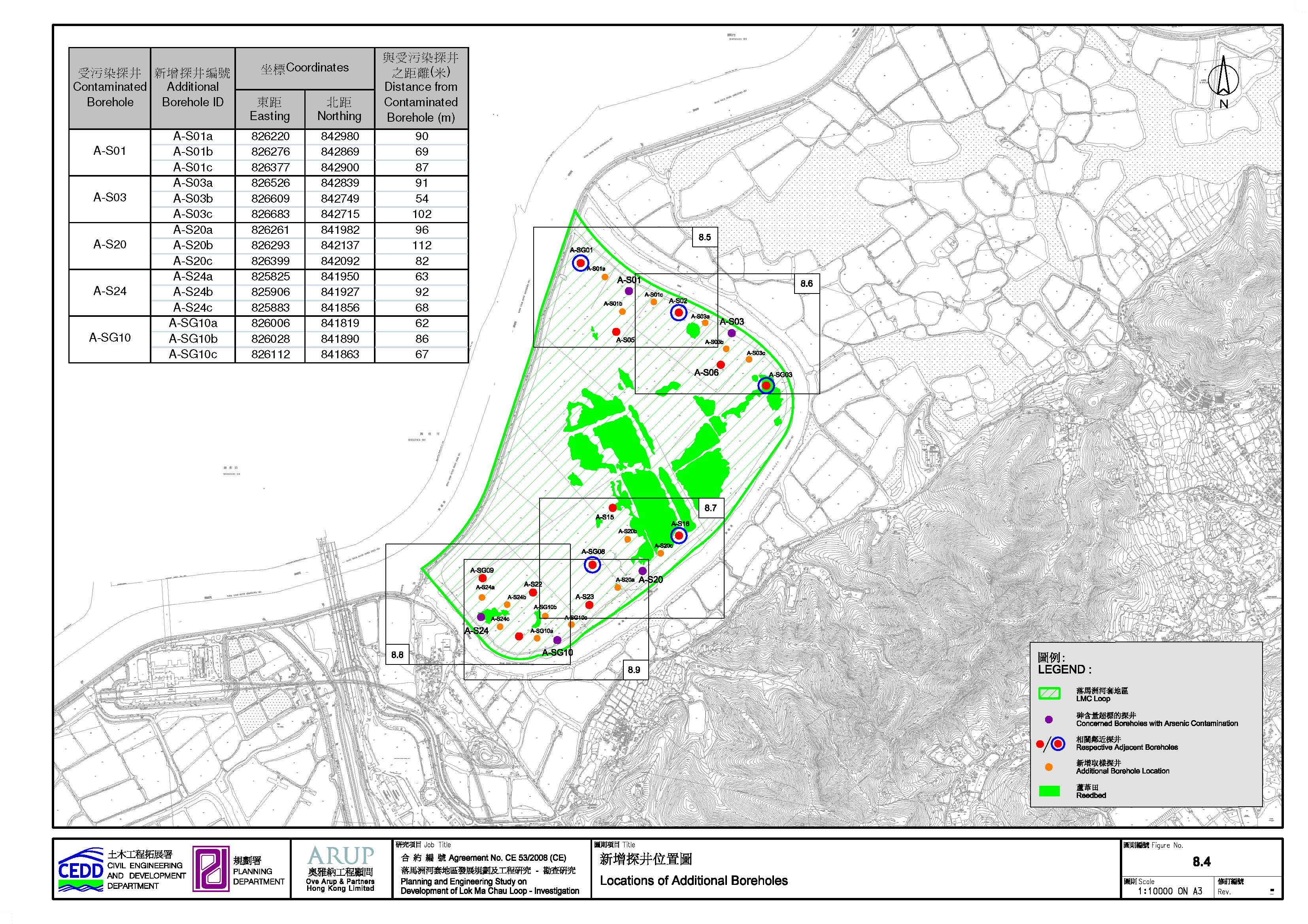
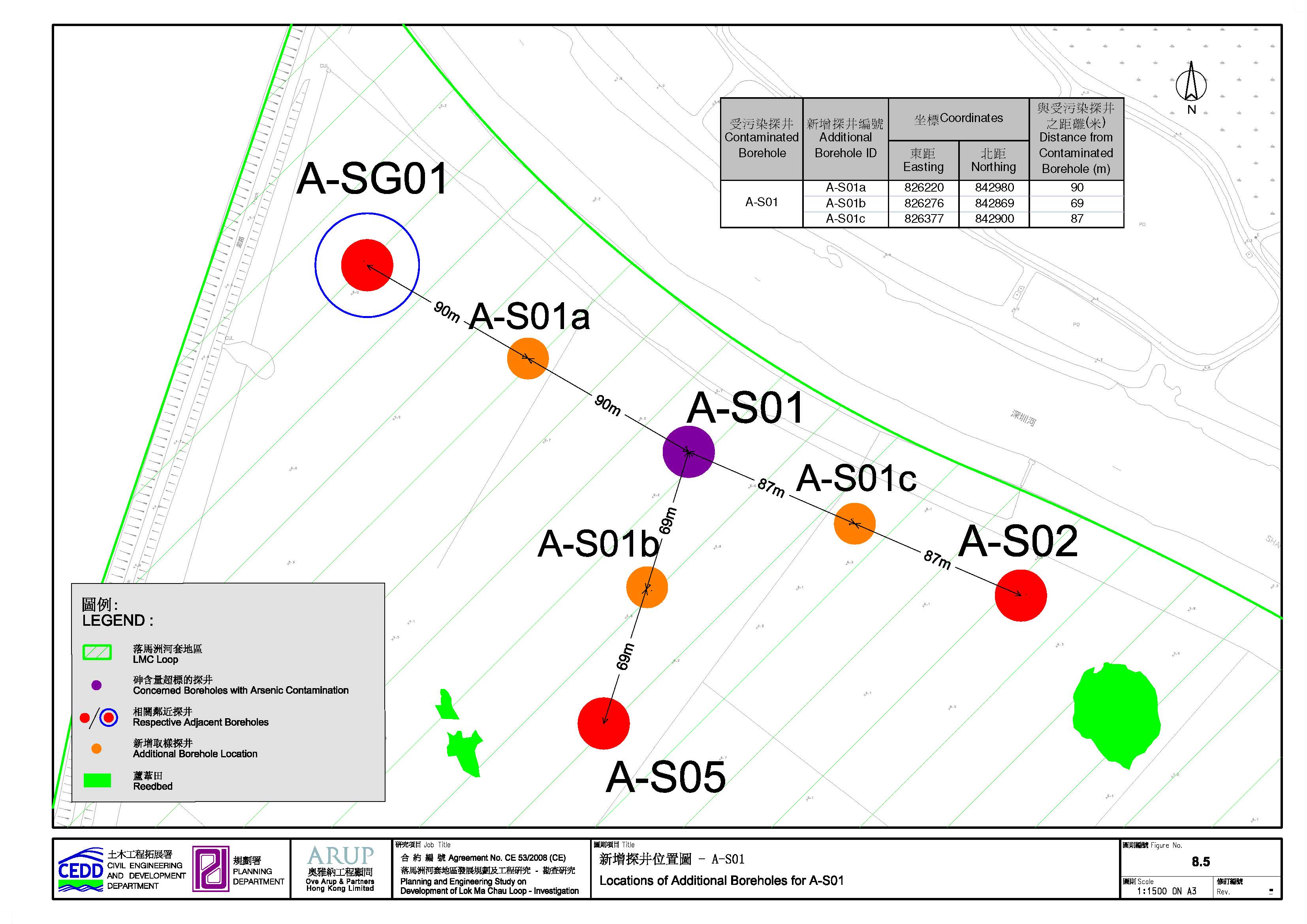
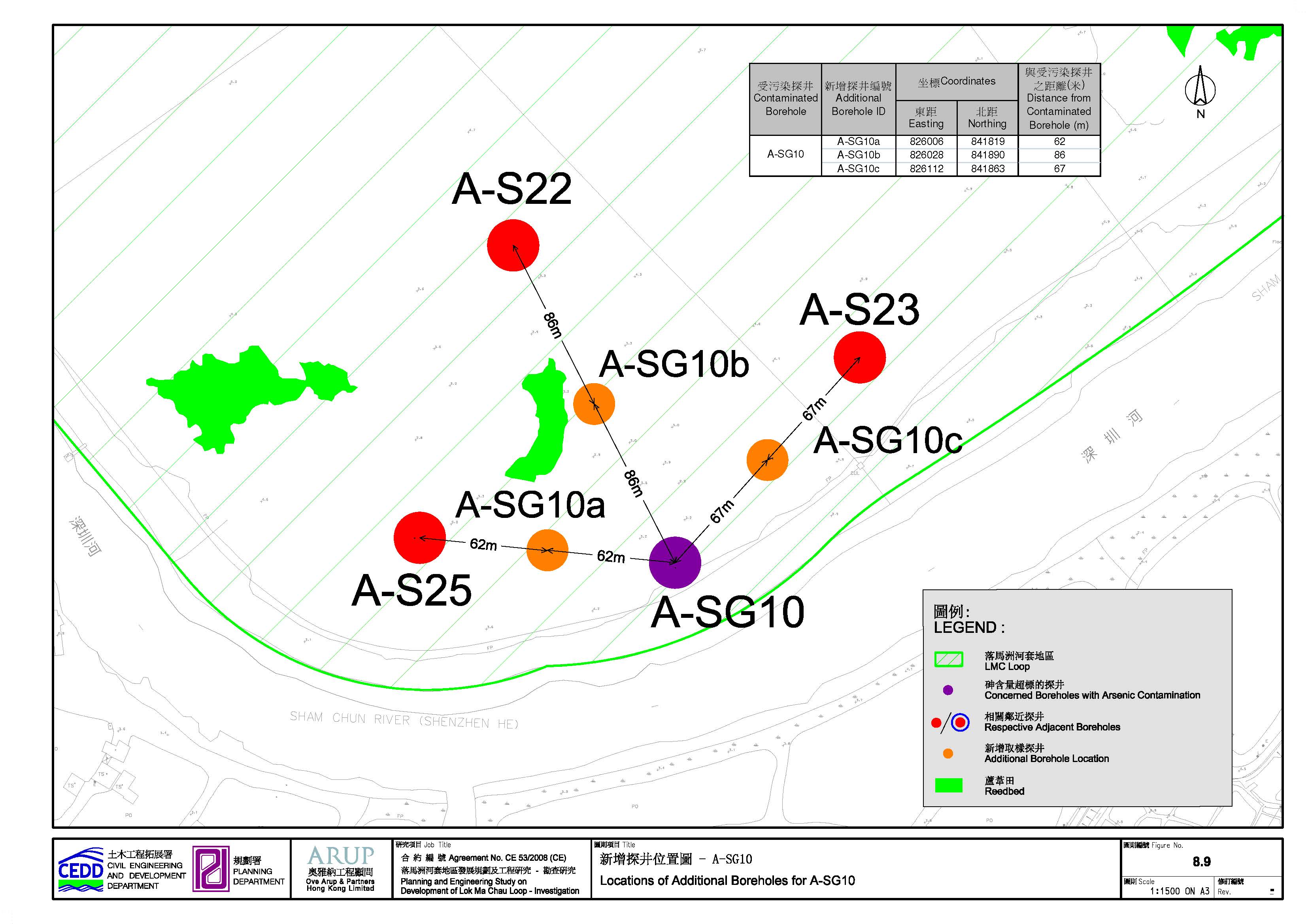
contaminated and uncontaminated boreholes, as shown in Figure 8.4 and
depicted in Figures 8.5 to 8.9. All laboratory
testing results at these 15 additional boreholes show compliance with the RBRG
for Rural Residential (i.e. the stringent set of RBRGs).
As the 5
contaminated boreholes have exceeded only marginally of the RBRGs and the
laboratory testing results of the 15 additional boreholes has complied, there
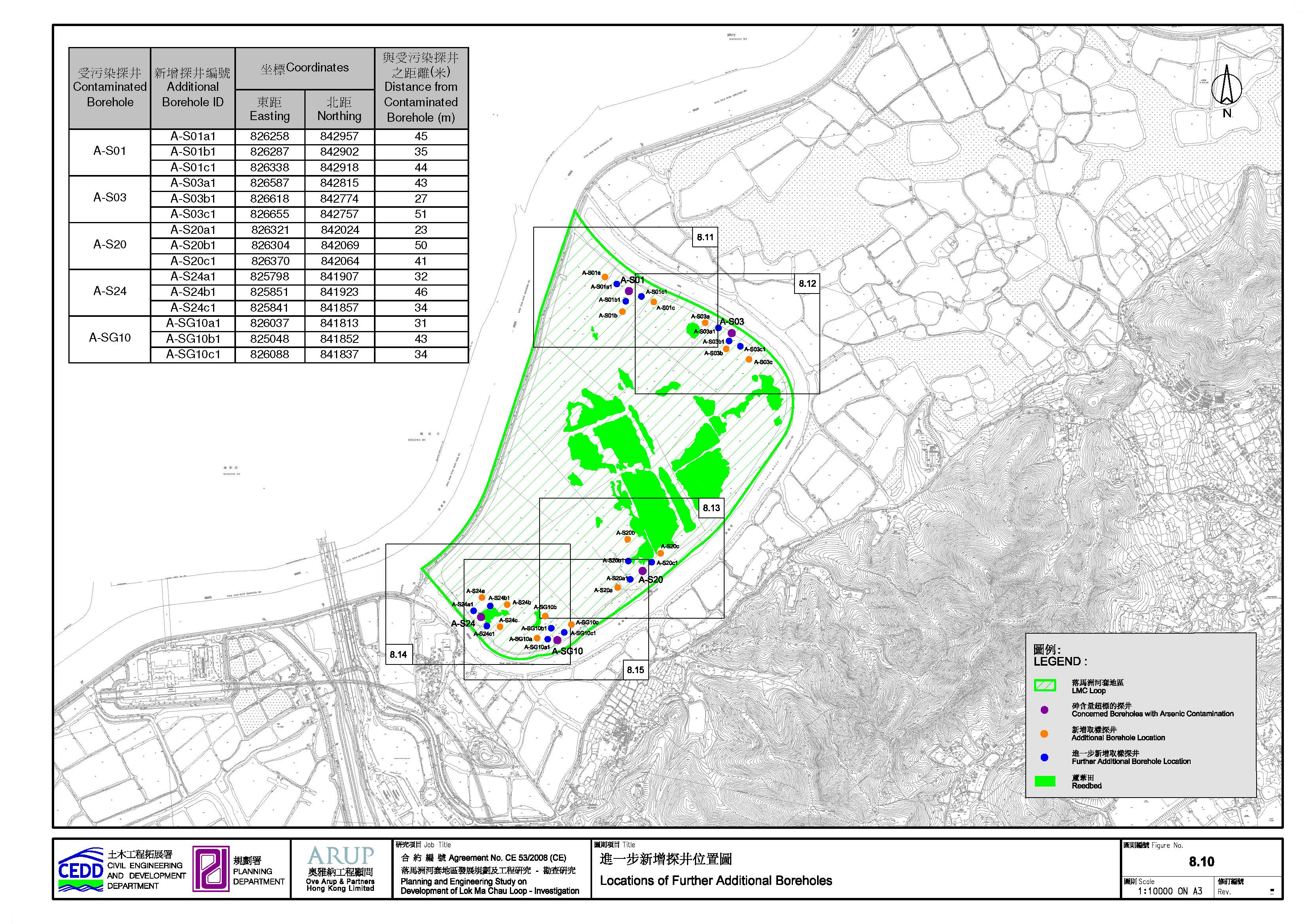
is scope to further confine the horizontal extent of contamination estimation. Therefore, 3 further additional boreholes
were drilled roughly mid-way in-between the pairs of contaminated and
uncontaminated boreholes (i.e. a total of 15 further additional boreholes were
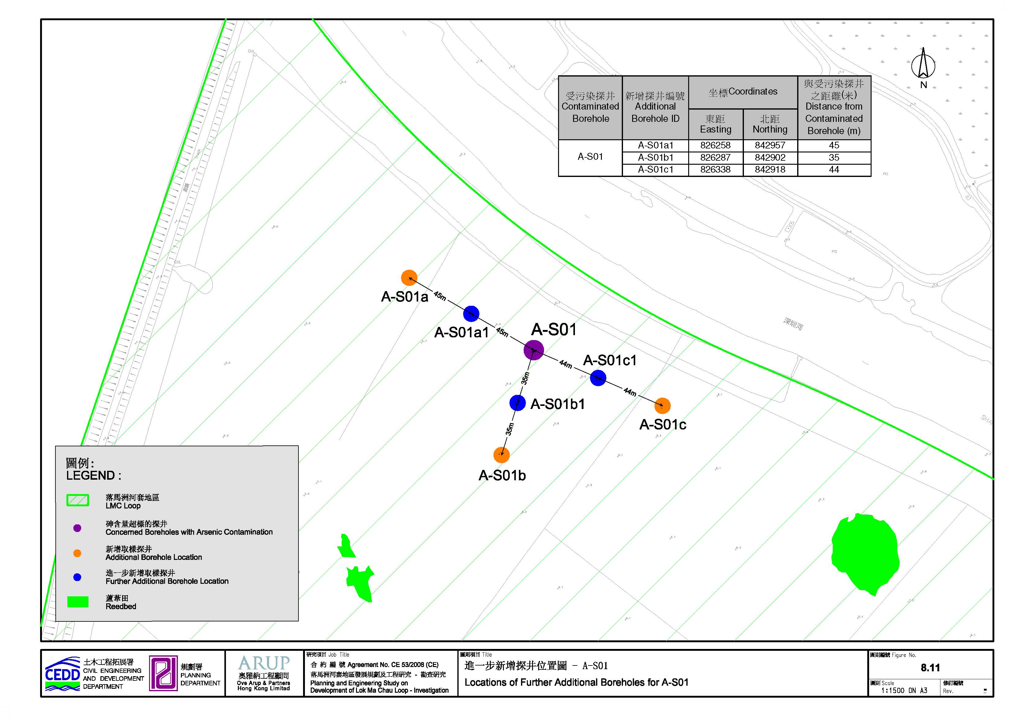
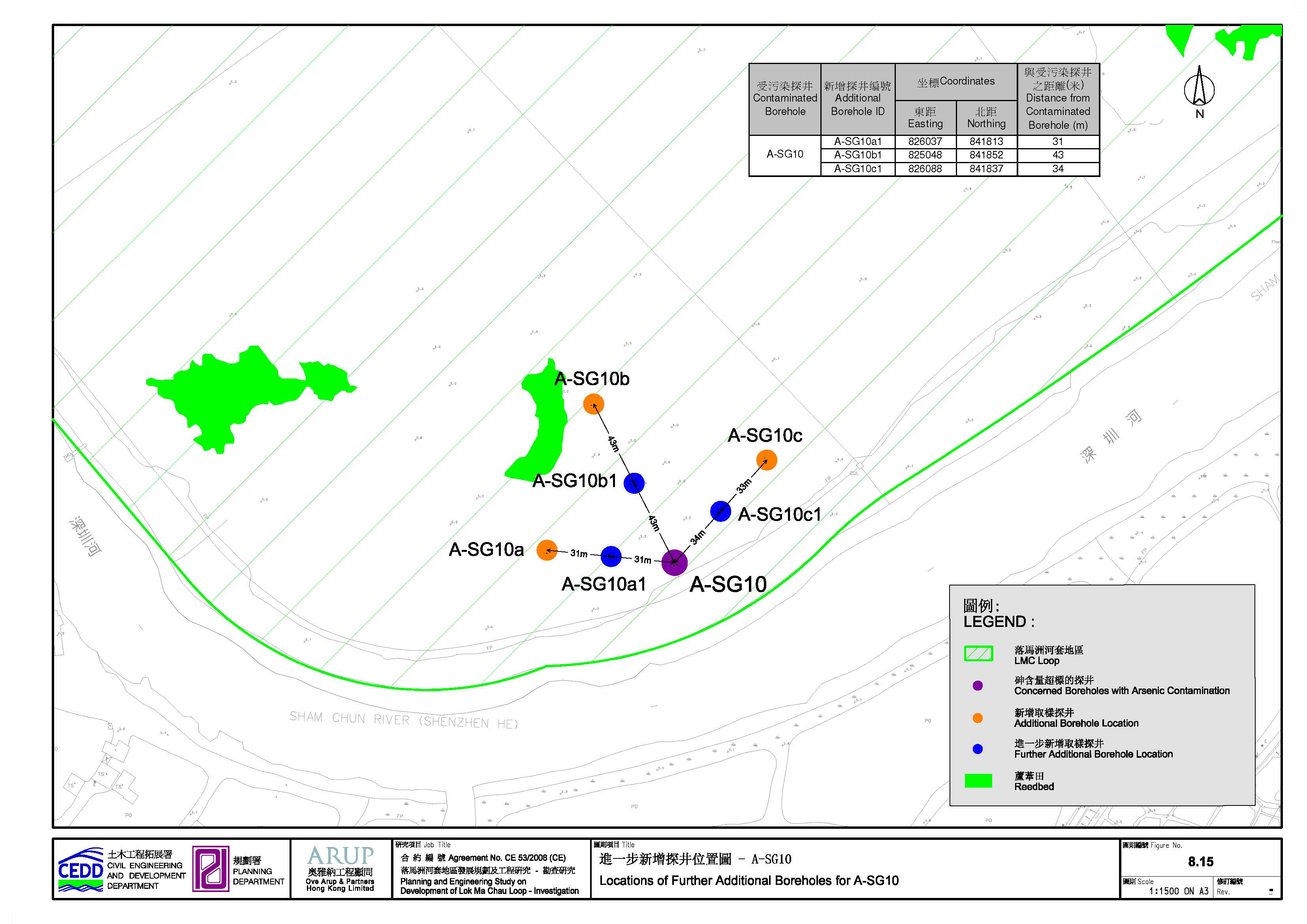
drilled) from May 2011 – July 2011. The locations of the 15 further additional
boreholes are shown in Figure 8.10 and depicted
in Figures 8.11 to 8.15.
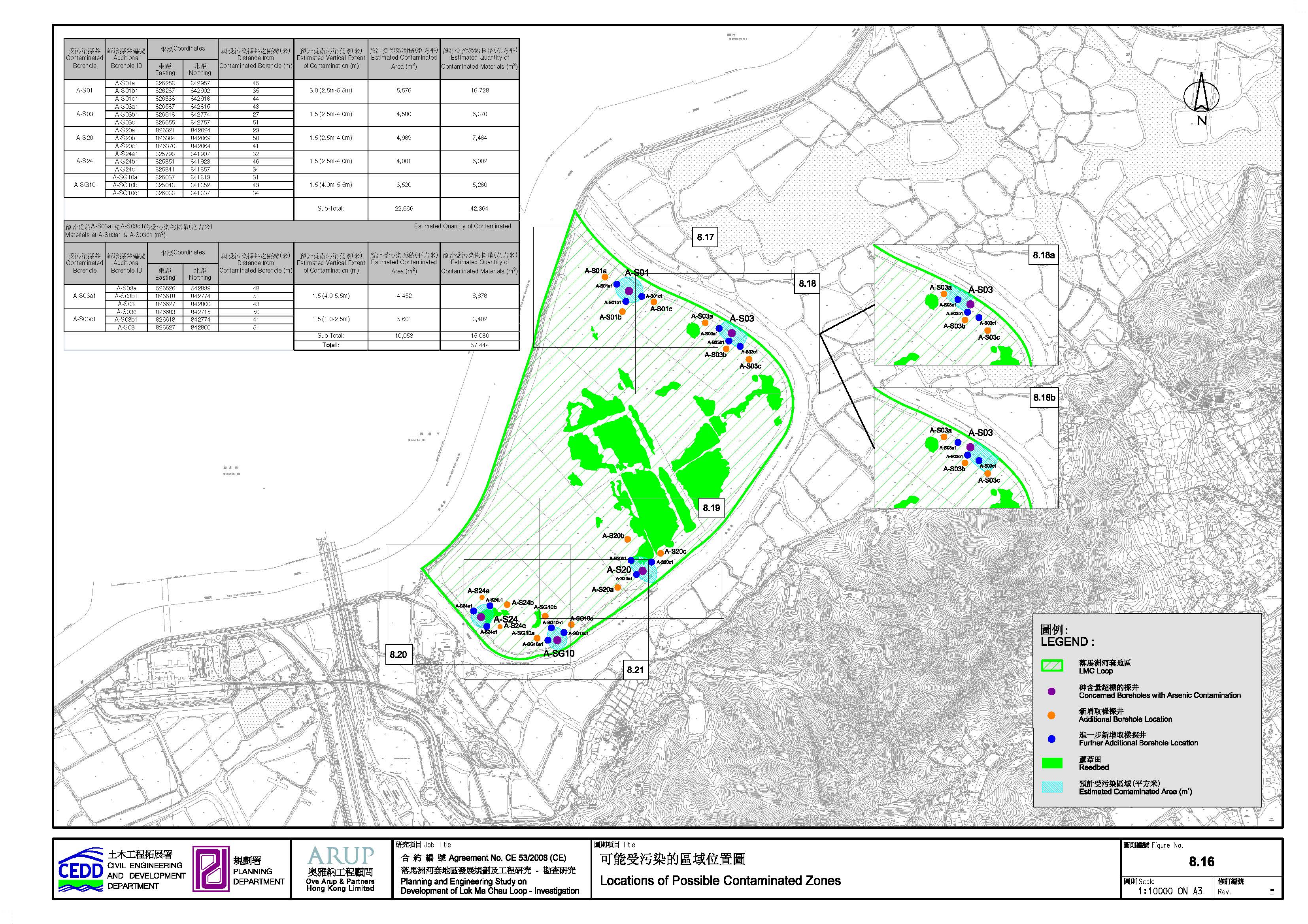
8.6.1.2 Possible Soil Contamination Extent in LMC Loop
The
estimated quantity of contaminated soil within LMC Loop is summarized in Table 8.5. The extents of which the 5 contaminated
zones lie are depicted in Figures 8.16 to 8.21. Calculations of the
contaminated soil quantity are detailed in Appendix
8-2. The respective soil remediation method and disposal criteria are
described in Section 8.8.
8.6.1.3 Groundwater Contamination
Groundwater
samples were taken from 10 boreholes. The test results indicated that none of
the groundwater samples have exceeded the RBRG levels for Rural Residential
land use. Chlorinated Pesticides were not detected in the groundwater samples.
8.6.1.4 Elutriate Test
The
objective of the Elutriate Test is to assess the potential of contaminants
release from the sediment filled mud during excavation within LMC Loop.
Elutriate test was conducted on the deepest soil samples (i.e. 4.5mbgl)
collected from 10 boreholes. Groundwater samples from the same boreholes were
used for preparation of elutriate. The test results
have shown non-detectable level, which indicated that the potential of
contaminants release is insignificant.
8.6.2 Contamination Assessment Area for the Associated Infrastructure outside LMC Loop
No
potentially contaminated site was identified in the contamination assessment area for the associated infrastructure outside LMC Loop and hence, no SI was conducted.
Table
8.5 Initial
estimate of contaminated soil quantity
|
Contaminated Borehole
(Concerned Zone) ID |
Borehole ID |
Estimated
Distance from Contaminated Borehole
(m) |
Estimated
Vertical Extent of Contamination (m) |
Estimated
Contaminated Area (m2) |
Estimated Quantity
of Contaminated Materials (m3) |
|
|
A-S01 |
A-S01a1 |
45 |
3.0 (2.5m-5.5m) |
5,576 |
16,728 |
|
|
A-S01b1 |
35 |
|||||
|
A-S01c1 |
44 |
|||||
|
A-S03 |
A-S03a1 |
43 |
1.5 (2.5m-4.0m) |
4,580 |
6,870 |
|
|
A-S03b1 |
27 |
|||||
|
A-S03c1 |
51 |
|||||
|
A-S20 |
A-S20a1 |
23 |
1.5 (2.5m-4.0m) |
4,989 |
7,484 |
|
|
A-S20b1 |
50 |
|||||
|
A-S20c1 |
41 |
|||||
|
A-S24 |
A-S24a1 |
32 |
1.5 (2.5m-4.0m) |
4,001 |
6,002 |
|
|
A-S24b1 |
46 |
|||||
|
A-S24c1 |
34 |
|||||
|
A-SG10 |
A-SG10a1 |
31 |
1.5 (4.0m-5.5m) |
3,520 |
5,280 |
|
|
A-SG10b1 |
43 |
|||||
|
A-SG10c1 |
34 |
|||||
|
Sub-Total: |
22,666 |
42,364 |
||||
|
Estimated Quantity of
Contaminated Materials at A-S03a1 & A-S03c1 |
||||||
|
Contaminated Borehole
(Concerned Zone) ID |
Borehole ID |
Estimated
Distance from Contaminated Borehole (m) |
Estimated
Vertical Extent of Contamination (m) |
Estimated
Contaminated Area (m2) |
Estimated
Quantity of Contaminated Materials (m3) |
|
|
A-S03a1 |
A-S03a |
48 |
1.5 (4.0-5.5m) |
4,452 |
6,678 |
|
|
A-S03b1 |
51 |
|||||
|
A-S03 |
43 |
|||||
|
A-S03c1 |
A-S03c |
50 |
1.5 (1.0-2.5m) |
5,601 |
8,402 |
|
|
A-S03b1 |
41 |
|||||
|
A-S03 |
51 |
|||||
|
Sub-Total: |
10,053 |
15,080 |
||||
|
Total: |
57,444 |
|||||
8.7 Remediation Action Plan for LMC Loop
8.7.1 Remediation Strategy
According to the Recommended Outline
Development Plan (RODP), the 5 contaminated zones are located within the RBRG
land use categories of “Public Park” and “Industrial”. Subject to confirmation
of these planned land uses, their exceedances against
with the RBRGs are given in Table 8.6.
Table 8.6
Possible
future land uses of the contaminated zones
|
Contaminated
Zone |
Proposed
Future Land Uses |
Corresponding
RBRGs |
Exceed the
Corresponding RBRGs |
|
A-S01 |
· Amenity/
Activity Corridor · Commercial · Open
Space |
· Urban
Residential · Public
Park |
Yes
(Urban Residential) |
|
A-S03 |
· Sewage
Treatment Works · Open
Space |
· Industrial · Public
Park |
No |
|
A-S20 |
· Ecological
Area |
· Public
Park |
No |
|
A-S24 |
·
Amenity/ Activity Corridor ·
District Cooling System ·
Open Space |
· Industrial · Public
Park |
No |
|
A-SG10 |
· Ecological
Area |
· Public
Park |
No |
Regardless of the test results evaluation against the RBRGs land use categories, excavation at the 5 contaminated zones is expected for the proposed land uses during construction. Therefore, the chance of construction workers and other site staff having contact with the contaminated soil cannot be ruled out. In view of the safety concerns about human contact with the contaminated soil, it is recommended to remediate all the contaminated soil. This decision can also benefit to providing flexibility for any future adaptation of land use changes.
8.7.2 Remediation Method
After review of various remediation methods,
“Solidification/Stabilization” (S/S) treatment method was proposed for the
remediation of arsenic-contaminated soil. Toxicity Characteristic Leaching
Procedure (TCLP) test should be undertaken after S/S
in order to ensure that the contaminant will not leach to the environment.
Unconfined Compressive Strength (UCS) test should be conducted,
and not less than 1MPa should be met prior to the backfilling or stockpiled for
future reuse within the study area. Off-site disposal or reuse of the
solidified material is not allowed.
8.7.2.1 Toxicity Characteristic Leaching Procedure (TCLP) Test
The sampling frequency for the TCLP test
should be 1 TCLP sample per 100m3 of broken up hardened mixture
after S/S treatment. Each TCLP sample should be a composite sample collected at
5 locations throughout the 100m3 broken up hardened mixture. Same
volume of sample should be collected at each of the 5 locations in order to
facilitate unbiased sample compositing.
Any hardened samples to be submitted to
laboratory for TCLP analysis should be broken up to small pieces with maximum
diameter of 10cm. The sample preparation method of USEPA Method 1311 will be
followed for the TCLP analysis. It is specified in USEPA Method 1311 that the
maximum grain size of samples to be analysed is 1cm. As such, the samples
should be further broken up in the laboratory prior to TCLP analysis.
TCLP tests should be conducted in accordance
with USEPA Method 1311 and USEPA Method 6020 for metal arsenic. The EPD’s TCLP
limits as specified in EPD’s Guidance
Notes for Investigation and Remediation of Contaminated Sites of Petrol Filling
Stations, Boatyards, and Car Repairing/Dismantling Workshops are standard leachability test standards. However, this set of standards
is only applicable to disposal to landfill.
For on-site reuse, these standards are not applicable.
“Universal Treatment Standards” (UTS) could
be used for interpretation of the TCLP testing results in this Study. The UTS
were derived from the performance of the Best Demonstrated Available
Technologies (BDAT) for treating most prohibited hazardous wastes and were adopted
in pervious local land contamination studies e.g. decontamination works at the Cheoy Lee Shipyard at Penny’s Bay and reclamation works at
North Tsing Yi Shipyard site. The UTS for the metal
arsenic is given in Table 8.7.
Table 8.7 Universal
Treatment Standards (UTS) for metal arsenic
|
Parameter |
Universal Treatment Standard (1) |
|
Arsenic |
5 mg/L as TCLP |
Note:
(1)
Reference
to Universal Treatment Standards (UTS) of U.S. Resource Conservation and
Recovery Act (RCRA) in Title 40 of the Codes of Federal Regulations (CFR) Parts
268.
Any pile of broken up solidified mixture that
does not meet the UTS of arsenic should be crushed and re-treated by S/S. The
re-treated pile should be tested again for TCLP to confirm if it could be
reused on site.
8.7.2.2 Unconfined Compressive Strength (UCS)
The treated material should be allowed to set
to achieve the Unconfined Compressive Strength (UCS) of not less than 1mPa with
reference to the USEPA guideline (1986) – Handbook of Stabilization /
Solidification of Hazardous Wastes, EPA/540/2-86-00. The test procedure of UCS
test should be based on BS 1377 - Methods of test for soils for civil
engineering purposes.
For complete removal of contaminated soil, a
closure assessment in the form of confirmatory test should be conducted after
excavation to confirm complete clean-up of the contaminated zones/concerned
areas. A Remediation Report (RR) will be submitted to EPD for agreement before
starting of any development works within the LMC Loop, should remediation is
deemed as necessary after the site investigations and site re-appraisals.
The detail requirements of the proposed
remediation work are given in the RAP (Appendix
8-2). In any case, reference will be
made to the RAP for remediation works. As the remediated soil would be fully
reused within the LMC Loop and off-site disposal or reuse is not allowed, the
remediation work would not increase the amount of waste disposal to the
landfill or other disposal sites.
8.7.3 Environmental Mitigation Measures
In order to minimise the potential
environmental impacts arising from the handling of contaminated materials, the
following environmental mitigation measures are recommended during the course
of the site remediation:
8.7.3.1 Excavation and Transportation
· Excavation profiles must be properly designed and executed with attention to the relevant requirements for environment, health and safety;
· In case the soil to be excavated is situated beneath the groundwater table, it may be necessary to lower the groundwater table by installing well points or similar means;
· Excavation should be carried out during dry season as far as possible to minimise contaminated runoff from contaminated soils;
· Stockpiling site(s) should be lined with impermeable sheeting and bunded. Stockpiles should be properly covered by impermeable sheeting to reduce dust emission during dry season or contaminated run-off during rainy season. Watering should be avoided on stockpiles of contaminated soil to minimise contaminated runoff;
· Supply of suitable clean backfill material after excavation, if required;
· Vehicles containing any excavated materials should be suitably covered to limit potential dust emissions or contaminated run-off, and truck bodies and tailgates should be sealed to prevent any discharge during transport or during wet season;
· Speed control for the trucks carrying contaminated materials should be enforced; and
· Vehicle wheel washing facilities at the site’s exit points should be established and used.
8.7.3.2 Solidification / Stabilization
· The loading, unloading, handling, transfer or storage of cement should be carried out in an enclosed system;
· Mixing process and other associated material handling activities should be properly scheduled to minimise potential noise impact and dust emission;
· The mixing facilities should be sited as far apart as practicable from the nearby noise sensitive receivers;
· Mixing of contaminated soil and cement / water / other additive(s) should be undertaken at a solidification plant to minimise the potential for leaching;
· Runoff from the solidification / stabilization area should be prevented by constructing a concrete bund along the perimeter of the solidification / stabilization area;
· The run-off contained in the concrete bund area along the perimeter of the paved solidification / stabilization area, if any, will be collected, stored and used for the mixing process of cement / contaminated soil;
· If stockpile of treated soil is required, the stockpiling site(s) should be lined with impermeable sheeting and bunded. Stockpiles should be properly covered by impermeable sheeting to reduce dust emission during dry season or site run-off during rainy season; and
· If necessary, there should be clear and separated areas for stockpiling of untreated and treated materials.
8.7.4 Safety Measures
In order to minimize the potential adverse
effects on health and safety of construction workers during the course of site
remediation, the Occupation Safety and Health Ordinance (OSHO) (Charter 509)
and its subsidiary Regulations should be followed by all site personnel working
on the site at all times. In addition, basic health and safety measures should
be implemented, including but not limited to the following:
· Set up a list of safety measures for site workers;
· Provide written information and training on safety for site workers;
· Keep a log-book and plan showing the contaminated zones and clean zones;
· Maintain a hygienic working environment;
· Avoid dust generation;
· Provide face and respiratory protection gear to site workers if necessary;
· Provide personal protective clothing (e.g. chemical resistant jackboot, liquid tight gloves) to site workers, if necessary;
· Provide first aid training and materials to site worker;
· Bulk earth moving equipment should be utilized as much as possible to minimize workers’ handling and contact of the contaminated materials; and
· Eating, drinking and smoking should not be allowed in contaminated areas to avoid inadvertent ingestion of contaminant.
This
land contamination assessment has examined the potential contaminative landuses within the project area and their potential
impacts to future use. The assessment involved site appraisal, site
investigation, assessment of contamination extent and where necessary
formulation of remedial actions.
5 zones
within LMC Loop were identified as contaminated by metal Arsenic. The volume of contaminated soil is
tentatively estimated as 57,444m3.
Remediation
by Solidification/Stabilization is recommended. Mitigation measures are
proposed during excavation and remediation of the contaminated soil in order to
safeguard the general environmental, health and safety on site during the
construction phase.
In
addition, re-appraisal on the LMC Loop and the entire contamination assessment
area for the associated infrastructure outside LMC Loop would be required to
ensure any potential contamination activities from land use
changes after the approval of this land contamination assessment study, subject
to a proper updating review prior to commencement of the construction works.
Where re-appraisal or re-assessment is required, the PP would prepare and
submit the Supplementary CAP to EPD prior to the commencement of SI works.
Following on from the submission of CAP and completion of SI, the PP would
prepare a CAR, a RAP and a RR and submit to EPD for agreement prior to
commencement of the works on the development.