Central Reclamation, Phase III
Studies, Site Investigation, Design and
Construction
Environmental
Impact Assessment
Executive Summary
(July 2001)
2.4 Construction
Methods and Engineering Requirements
2.4.1 Dredging
Requirements and Methods
2.4.2 Construction
of the Reclamation
2.5 Cumulative
Assessment to include Concurrent WDII and CWB Project Works
3.1 Construction
Impact Assessment and Mitigation Summary
3.2 Operation
Impact Assessment and Mitigation Summary
3.3 Cumulative
Effects of Reclamation on Victoria Harbour
3.3.1 Construction
Phase Scenario
3.3.2 Operation
Phase Scenario
8 Landscape and
Visual Assessment
9 Environmental
Monitoring And Audit
10 Environmental
protection measures and enhancements
Tables
Table 9.1 : Summary of EM&A Requirements
Figures
Figure 1.1 Interrelationship of CRIII-MO, WDII and CWB Projects
Figure 2.1 CRIII-MO Study Area and Proposed Layout
Figure 2.2 Envisaged Construction Phasing of CRIII-MO
Figure 3.1 Location of Water Quality Sensitive Receivers
Figure 4.1 Location of Air and Noise Sensitive Receivers/ Prediction Points
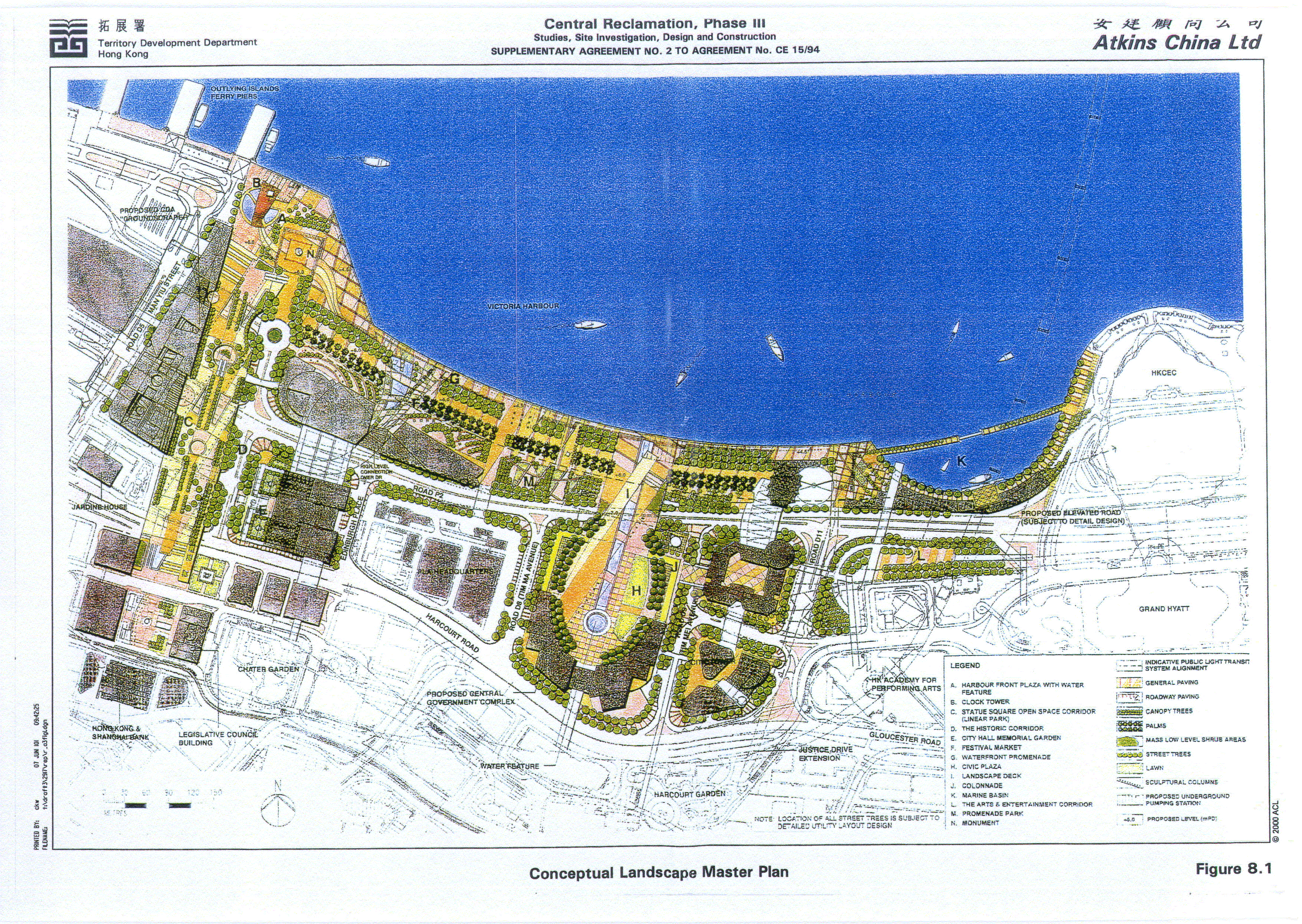
Figure 8.1 Conceptual Landscape Master Plan
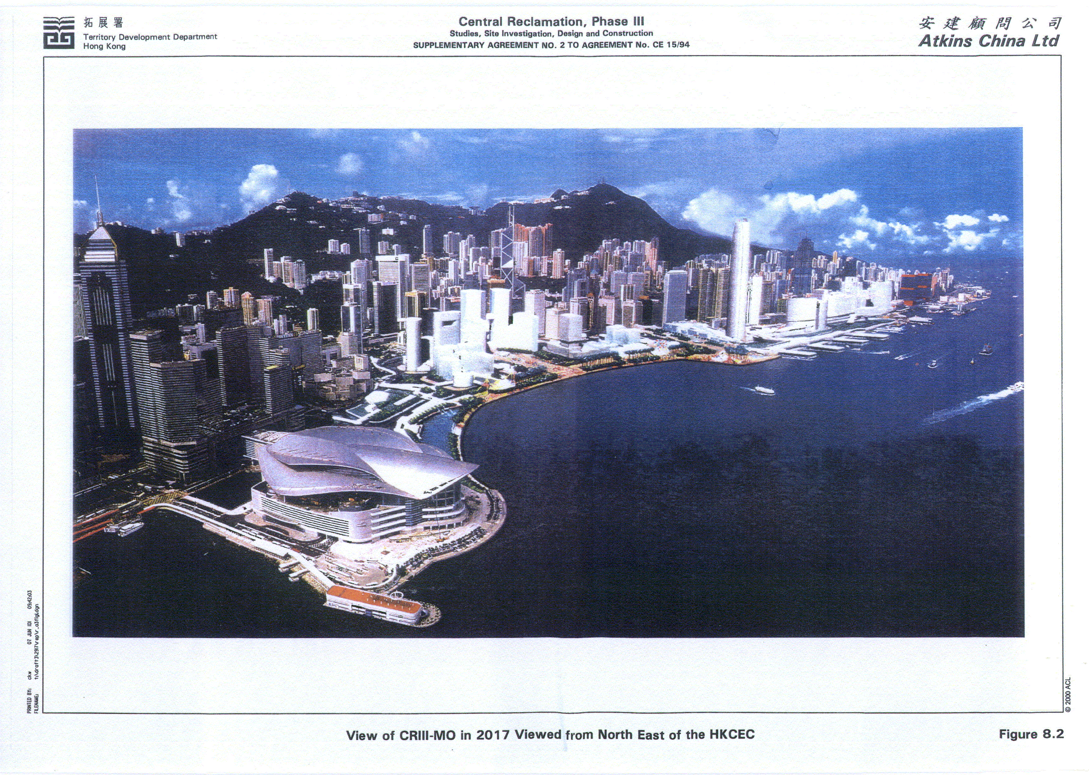
Figure 8.2 View of CRIII-MO in 2017 Viewed from North East of the HKCEC
The Central Reclamation Phase III - Minimum Option, hereafter referred to as the CRIII-MO, will consist of approximately 18 ha of new reclamation connecting Central Reclamation Phase 1 (CRI) to Central Reclamation Phase II (CRII). The CRIII-MO Project will provide land for accommodation of the Central-Wanchai Bypass (CWB) and the Hong Kong Station Extended Overrun Tunnel.
Atkins China Ltd has been commissioned by the Government of Hong Kong Special Administrative Region, Territory Development Department (TDD), Hong Kong Island and Islands Development Office to undertake the feasibility study for the CRIII-MO Project. HR Hong Kong Ltd is responsible for the carrying out of the water quality and hydraulic modelling in the study.
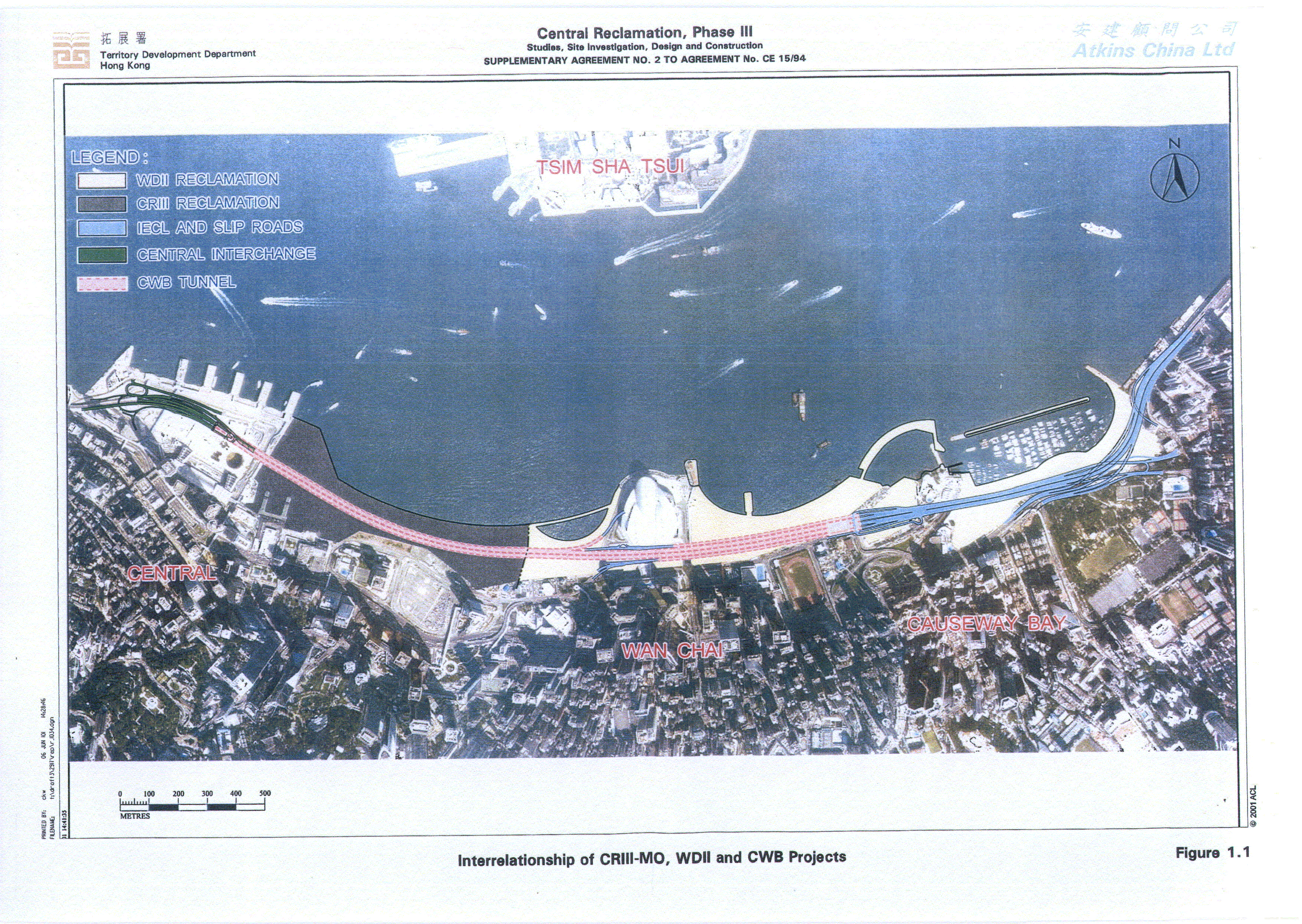
The CRIII-MO project works will, in part, be in progress at the same time as the Wan Chai Development Phase II (WDII) and Central - Wan Chai Bypass (CWB) projects. Based upon the current programmes for these projects, concurrent works will take place between March 2004 and March 2007 i.e. the completion date of the CRIII-MO project. The extent of the WDII and CWB projects relative to the CRIII-MO works are illustrated on Figure 1.1.
The primary objective of the EIA is to provide information on the nature and extent of the potential environmental impacts associated with the proposed development of the CRIII-MO Project. This information will contribute to decisions on the acceptability of any adverse environmental impacts likely to result from the construction and subsequent operation of the CRIII-MO Project, and the conditions for the design and construction of the Project.
The enforcement of the Environmental Impact Assessment Ordinance (EIAO) on 1 April 1998 means that the CRIII-MO is subject to requirements additional to those of the CRIII Study Brief which was registered (Reference SB-004/BC) with the Environmental Protection Department under Section 15(1)(b) of the EIAO (Part I List: Brief issued prior to commencement of Ordinance). The CRIII-MO Project falls under Schedule 3 - "Major Designated Projects Requiring EIA Report" as it is "an engineering feasibility study of urban development projects with a study area covering more than 20 ha". Under the EIAO, an Environmental Permit is not required for a Schedule 3 Designated Project.
The CRIII - MO construction does, however, include four Schedule 2 Designated Projects (or parts of) which require Environmental Permits prior to commencement of construction.
These are :
· The reclamation and associated dredging;
· The construction and operation of the Primary and Distributor Roads;
· The Central-Wanchai Bypass (construction); and
· The North Island Line Protection Works (construction).
This section describes the proposed reclamation and infrastructure of the CRIII-MO Project. The Project is scheduled to be commenced in August 2002 and to be completed in March 2007.
The entire Central and Wan Chai Reclamation Development comprises a total of approximately 77 ha of new reclamation and existing land to be redeveloped. As of the time of preparation of this report, construction works on the CRI and CR II, the MTRC 50 m Overrun Tunnel and the Hong Kong Convention and Exhibition Centre Extension (Wan Chai Reclamation Phase I) (WRI) have already been completed.
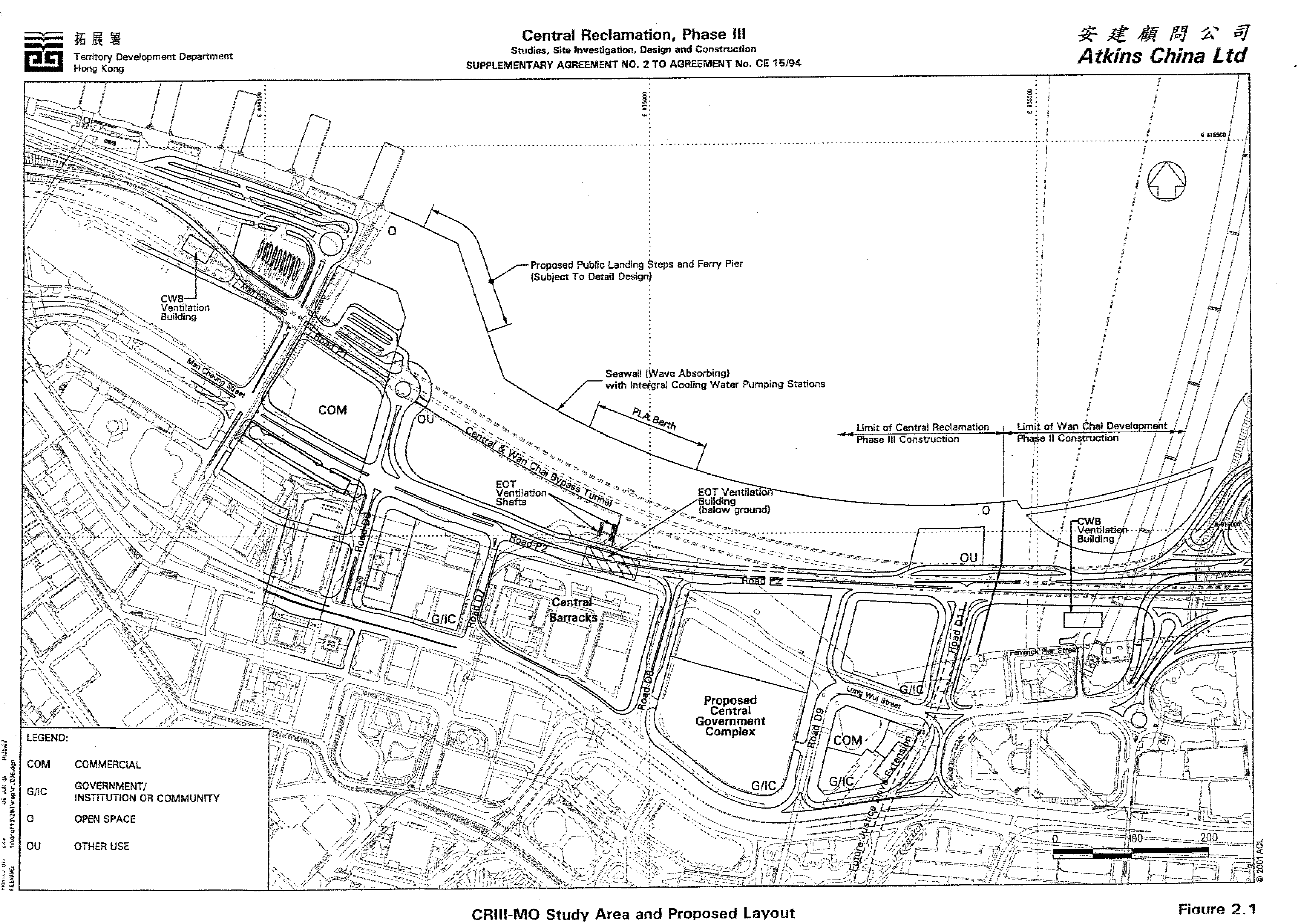
The CRIII-MO Project Area is located between CRI and Wan Chai Development Phase II (WDII). The area to be reclaimed under CRIII-MO extends from outside the General Post Office Building in the west to Lung King Street near the Servicemen's Guides Association in the east of the Project Area. The reclamation will be joined along its western border to CRI, encompass CRII (Tamar Basin Reclamation) to the south and be connected to the WDII to the east.
The CRIII-MO reclamation boundary area is smaller than the Central District (Extension) - Outline Zoning Plan (OZP) (Plan No. S/H24/3) boundary area. The Central District (Extension) - OZP boundary area includes a large strip of existing land at the south and a piece of reclaimed land to be formed in the WDII at the east. Although these pieces of land are outside the CRIII-MO reclamation boundary, this EIA Study has taken full account of them and environmental impacts on and arising from them in relation to the CRIII-MO have been assessed. The limit of the CRIII-MO reclamation is illustrated on Figure 2.1.
One of the main purposes of the CRIII-MO Project is to provide the essential accommodation places for the extension of the MTRC Hong Kong Station Extended Overrun Tunnel and the CWB. The CWB will also need to be accommodated in the WDII as it extends from the CRIII-MO to the WDII to provide a direct linkage for the east-west traffic of the Hong Kong Island. These infrastructures are important to Hong Kong's strategic provision of transport facilities. Certain protection works for the MTRC North Island Line will also be constructed as part of the CRIII works. The inclusion of these work is justified on the basis that failure to construct the works at the same time as the CRIII works would result in major disruption to the newly completed roads and infrastructure constructed as part of the CRIII project.
A further benefit of the Project is that it will provide
sufficient land for the creation of a world class waterfront promenade. The
major infrastructure works and future land uses for the CRIII - MO are
illustrated on Figure 2.1.
The main public concerns of the CRIII-MO Project are expected to be the potential impacts on the environment during the construction and operation phases and the need to have the reclamation. To address these public concerns, the environmental impacts, or residual impacts after mitigation; arising from the Project have been assessed to meet the requirements of the EIAO and other relevant standards. As regard to the need to have the reclamation, it has been explained by the main project purposes given above.
2.4 Construction Methods and Engineering Requirements
2.4.1 Dredging Requirements and Methods
A detailed review of reclamation methods and settlement issues applicable to the CRIII-MO has been conducted. This review considered :
· The nature of the works to be constructed on the reclamation platform and their ability to tolerate both primary and secondary settlements;
· Constraints which affect the manner in which the reclamation can be constructed. These include maintaining existing facilities / operations and provision of land to suit external programme constraints; and
· Government policies and standards on reclamation works.
The review concluded that a fully dredged reclamation method be adopted for the CRIII - MO Project. After consideration of the review findings, the Secretary for the Marine Fill Committee advised that he had no objection to the full removal of soft marine deposits from below the CRIII - MO site.
2.4.2 Construction of the Reclamation
2.4.2.1 Presently Envisaged Phasing
The sequencing of reclamation works is constrained by a number of factors largely associated with maintaining existing facilities and operations prior to completion of reprovisioned facilities. An envisaged sequence has been developed which divides the reclamation into four areas as shown on Figure 2.2.
Construction will begin at Initial Reclamation Area West in August 2002. During the Initial Reclamation Area West and Initial Reclamation Area East construction periods, it will be necessary to maintain an access channel between the reclamation areas in order to allow manoeuvring of vessels to existing piers prior to their relocation.
The reclamation at Initial Reclamation Area East will be in the form of an extension to the existing shoreline to ensure maximum tidal flushing and minimise potential water quality impacts. Cooling water inlets, outlets and pumping stations will be diverted to this reclamation (refer to Figure 2.2).
Once Initial Reclamation Area West is completed, the ferry services will be relocated and the cooling water systems reprovisioned. Following the ferry relocation and the commissioning of reprovisioned cooling water systems, construction of Final Reclamation Area West will commence and will be completed to accommodate Culvert F extension (refer to Figure 2.2). The remainder of the reclamation will also proceed in Final Reclamation Area East. After completion of the reclamation platform, the CWB Tunnel and the MTRC Extended Overrun Tunnel can be constructed and the culverts and services can be laid.
A number of marine (coastal) facilities will be constructed during CRIII including a reprovisioned ferry pier (Pier 8), reprovisioned public landing steps (in the form of two public piers) and a berth for the PLA. The pier and public landing steps will be “piled deck” structures, while the berth will be an integral part of the seawall (refer to Figure 2.1). As such the facilities will not influence the movement of water within the Harbour after the completion of CRIII.
2.4.2.2 Fill Materials and Sources
It is estimated that 3.51 Mm3 of fill and 0.65 Mm3 of rockfill will be required for the CRIII-MO. The reclamation will be formed using both marine sand fill and public fill (surplus soft fill from land formation projects). The public fill will be used to form a large portion of Final Reclamation Area West. It will also be used above +2.5mPD over most of the site and as backfill to tunnels and culverts. The Marine Fill Committee has indicated that they maybe able to provide the required marine sand from a source under their control. Alternatively, sand supplied from the Constractor’s own sources, which meets the requirements and specifications of the detailed engineering design, may also be used. The source of the soft fill material will be confirmed by the Secretary of the Public Fill Committee.
2.5 Cumulative Assessment to include Concurrent WDII and CWB Project Works
As indicated previously in Chapter 1, the CRIII-MO works will take place concurrently with the WDII and CWB works between March 2004 and March 2007.
With respect to the assessment of environmental impacts, the key indicators of air, noise and water quality will be influenced by the cumulative effects of the overlapping construction works. The concurrent activities and the means in which the cumulative environmental impacts have been assessed are described below
|
Construction
Air Quality |
|
|
Concurrent Works (March 2004 – March 2007) |
Assessment Method |
|
· CRIII-MO works · CWB tunnel entrusted to CRIII-MO · CWB Central Interchange · WDII works · CWB tunnel entrusted to WDII |
· CRIII construction air quality assessment includes concurrent WDII and CWB works. |
|
Construction Noise |
|
|
Concurrent Works (March 2004 – March 2007) |
Assessment Method |
|
· CRIII-MO works · CWB tunnel entrusted to CRIII-MO · CWB Central Interchange · WDII works · CWB tunnel entrusted to WDII |
· Assessment for HKAPA open air arena NSR includes WDII concurrent works. · Assessment for Central Barracks and City Hall noise prediction points includes concurrent CWB works, as appropriate. |
|
Construction Water Quality |
|
|
Concurrent
Works (March 2004 – March 2007) |
Assessment Method |
|
· CRIII-MO works · WDII works |
· Cumulative water quality assessment for concurrent CRIII-MO and WDII reclamation works undertaken by WDII study but presented in CRIII-MO Study reports. |
|
Operation Air Quality |
|
|
Completed
Works (Year 2027) |
Assessment Method |
|
· Road Traffic · Portal/ Deckover Emissions · Tunnel Ventilation Buildings |
· Cumulative assessment for completed CRIII-MO, WDII and CWB works undertaken by CWB study but presented in CRIII-MO study reports, as applicable to the CRIII-MO study area. |
|
Operation Noise |
|
|
Completed
Works (Year 2027) |
Assessment Method |
|
· Road Traffic |
· CRIII-MO assessment is a cumulative assessment for completed CRIII-MO, WDII and CWB road network, as applicable to the CRIII-MO area. |
|
Operation Water Quality |
|
|
Completed
Works (Year 2027) |
Assessment Method |
|
· CRIII-MO reclamation · WDII reclamation · All other planned reclamations up to 2012 |
· Cumulative assessment for completed CRIII-MO, WDII and all other planned reclamations up to 2012 undertaken by WDII study but presented in CRIII-MO study reports. |
3.1 Construction Impact Assessment and Mitigation Summary
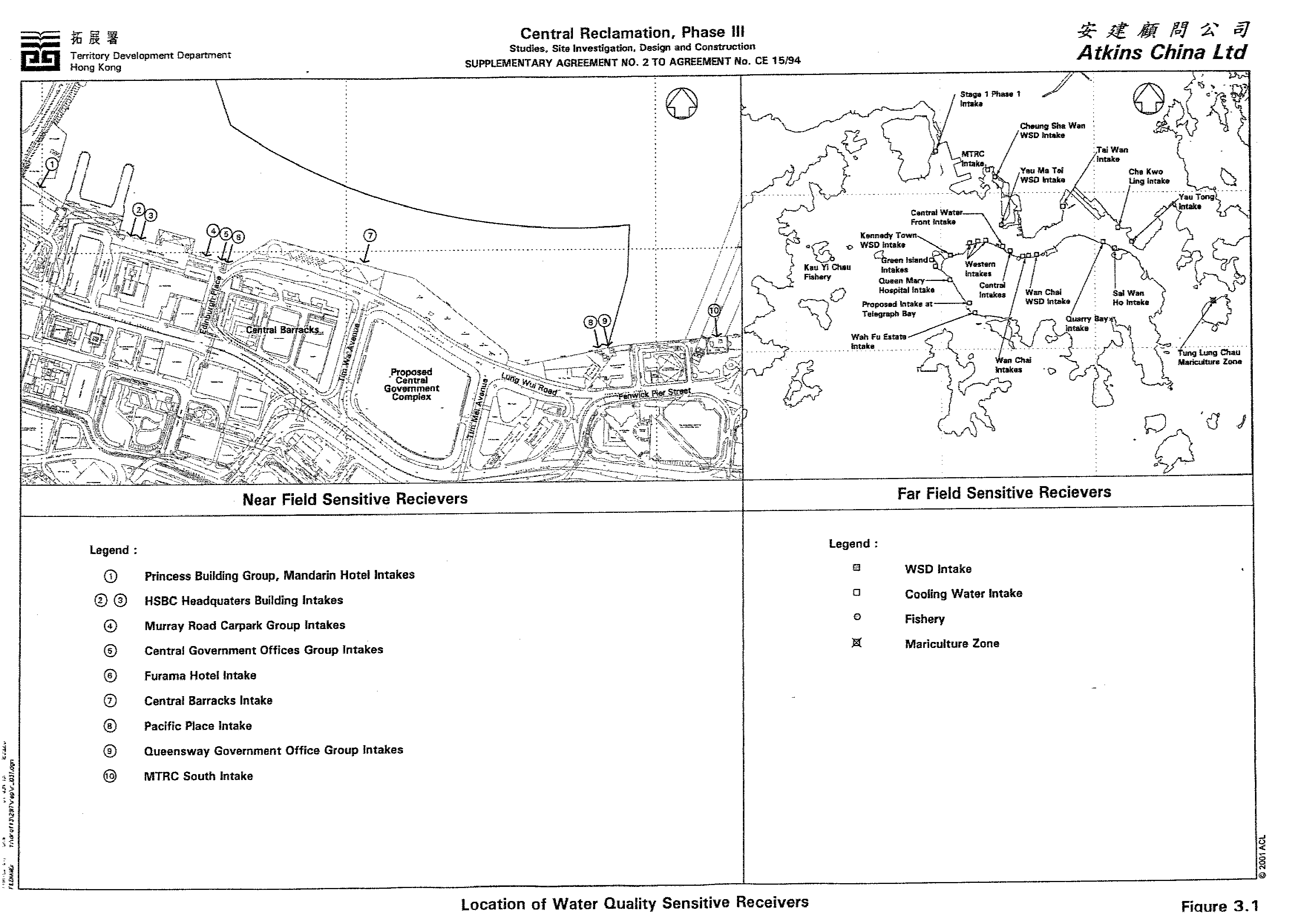
Within the CRIII-MO Study Area and the nearby area of CRI, there are a number of seawater pumping stations and associated intakes which supply seawater to the air conditioning systems of a number of commercially-important buildings and Government buildings in the Central Business District of Hong Kong. The locations of these intakes and other water quality sensitive receivers used in the CRIII-MO study are indicated on Figure 3.1.
An assessment of the water quality impact during the construction phase has been made on the basis of the reclamation design layout proposed in Section 2.4.2.
Sediment plume modelling has been used to simulate two scenarios for the dredging and filling activities at the CRIII-MO. Scenario 1 simulated filling activities occurring concurrently for both the Initial Reclamation Area West and Initial Reclamation Area East reclamation areas. Scenario 2 simulated dredging and filling occurring concurrently within the Final Reclamation Area East reclamation area. The results indicated local increases in SS near the area of dredging and filling but also indicated that water quality objectives and cooling water intake thresholds would not be exceeded at water sensitive receivers. Maximum elevations in SS at the nearest cooling water intake of 68mgL-1 and the nearest WSD intakes of 2mgL-1 are predicated during the dredging and filling works. Measures to further limit SS elevations including the use of closed clamshell grab dredging and prohibition of stockpiling of dredged material on site are, however, recommended in view of the proximity of cooling water intakes and the presence of contaminated mud to be dredged. Framed geotextile fabric silt screens installed at the opening of the intakes in and adjacent to the CRIII-MO site would also reduce the impact of dredging works on the intakes. The use of such screens would be good practice given the nature of the intakes.
The model results indicated that for all the water quality parameters simulated, there was no obvious deterioration in water quality in any local CRIII-MO area during construction. It is thus concluded that the construction phase will not result in any significant deterioration in water quality compared to present day conditions and early reprovisioning of cooling water intakes and other recommended mitigation measures will be effective in preventing water quality impacts in Victoria Harbour.
Based on the assessment of the water quality impact during the construction of CRIII-MO, a baseline environmental monitoring and audit (EM&A) programme is considered necessary to obtain baseline information of water quality before the construction to monitor any variation in water quality during the construction period and the efficacy of recommended mitigation. An EM&A Manual for this Project has been produced as a separate stand-alone document.
3.2 Operation Impact Assessment and Mitigation Summary
Based on hydraulic modelling simulations it is predicted that after the completion of the reclamation, flows at the boundary of the reclamation, except in the water body between the CRIII-MO and HKCEC Extension reclamation, will return to those proximal to the original coastline prior to reclamation.
For the simulations of the operational phase impact, it was largely found that there was no evidence that the completed reclamation had any significant adverse impact on water quality. Indeed there is a significant improvement associated with the relocation of Outfall J1 to Outfall J during the initial phase of the works. The creation of a zone of relatively slack water around culvert outfall L in a temporary embayment to the east of the CRIII-MO results in localised elevations in E.coli. The embayment will last from the construction of the CRIII eastern seawall in May 2005 until the reclamation of the adjacent area under the WDII project in January 2007. As a mitigation measure, to avoid the accumulation of water borne pollutants within this embayment, an impermeable barrier, suspended from a floating boom on the water surface and extending down to the seabed, will be erected by the CRIII Contractor on completion of the CRIII eastern seawall. The barrier will channel the stormwater discharge flows from Culvert L to the outside of the embayment. The CRIII Contractor will maintain this barrier until the WDII Contractor takes possession of this site, where upon the WDII Contractor will takeover the maintenance of this barrier until the reclamation works in this area are carried out and the new Culvert L extension is constructed.
Assessments of thermal and residual biocide discharges associated with the cooling water pumping stations concluded that the temperature and chemical criteria will be achieved and that no adverse impact of the cooling water discharge is predicted.
The simulation of floating debris showed that the CRIII-MO did not have a high potential to trap floating debris but to avoid accumulation of floating debris, appropriate collection and removal facilities should be deployed to the site.
Collection should be carried out by the CRIII Contractor at least once every day, and more frequently near the cooling water intakes where large floating objects could block screens and filter pipes of the intakes.
3.3 Cumulative Effects of Reclamation on Victoria Harbour
3.3.1 Construction Phase Scenario
The Wan Chai Development Phase II Project EIA Study considered a construction phase scenario in which the CRIII - MO and WDII reclamation works would be in progress at the same time. The modelling works for this scenario concluded that in order to minimise the potential SS impact, the following specific mitigation measures were recommended:
· Deployment of silt curtains around the close grab dredgers to contain SS within the construction site during dredging and seawall filling; and
· Deployment of silt screens at the cooling water intakes and WSD salt water intakes to further minimise the intake of SS within the sea water.
With these mitigation measures in place, the water quality impacts on sensitive receivers would be kept within acceptable limits.
3.3.2 Operation Phase Scenario
The Wan Chai Development Phase II Project EIA Study operational phase scenario (in year 2012) considered the water quality impact of the CRIII – MO cumulatively with all other developments planned to take place in Victoria Harbour by 2012. They key conclusions of the assessment were :
· The wet season ebb tide flood speeds in the Victoria Harbour are higher than in the dry season. For the flood tide simulation, the flow speeds are more compatible between the two seasons.
· The flow speed distribution within the Victoria Harbour before and after the implementation of the projects up to 2012 are very similar. The reclamation will cause slight changes only in the prevailing currents in the Harbour.
· The predicted mean discharges across the Victoria Harbour (Lei Yue Mun) and Victoria Harbour West (Yau Ma Tei – Western District) will be decreased by less than 5% and 2%, respectively, during the wet season after the completion of WDII reclamation, as well as other reclamations within the Victoria Harbour, including the CRIII, Kowloon Point Development, the South East Kowloon Development, the Yau Tong Bay Development and the Western Coast Road reclamation.
· The predicated mean discharges across the Victoria Harbour East (Lei Yue Mun) and Victoria Harbour West (Yau Ma Tei – Western District) will be decreased by about 4% and less than 1.5%, respectively, during the dry season after the completion of WDII reclamation, as well as other reclamations within the Victoria Harbour, including the CRIII, Kowloon Point Development, the South East Kowloon Development, the Yau Tong Bay Development and the Western Coast Road reclamation.
The report therefore concluded that in overall terms, planned reclamations within the Harbour up to 2012 will have minimal impact on the hydrodynamic regime of the Harbour and that there would consequentially be no insurmountable hydrodynamic impacts.
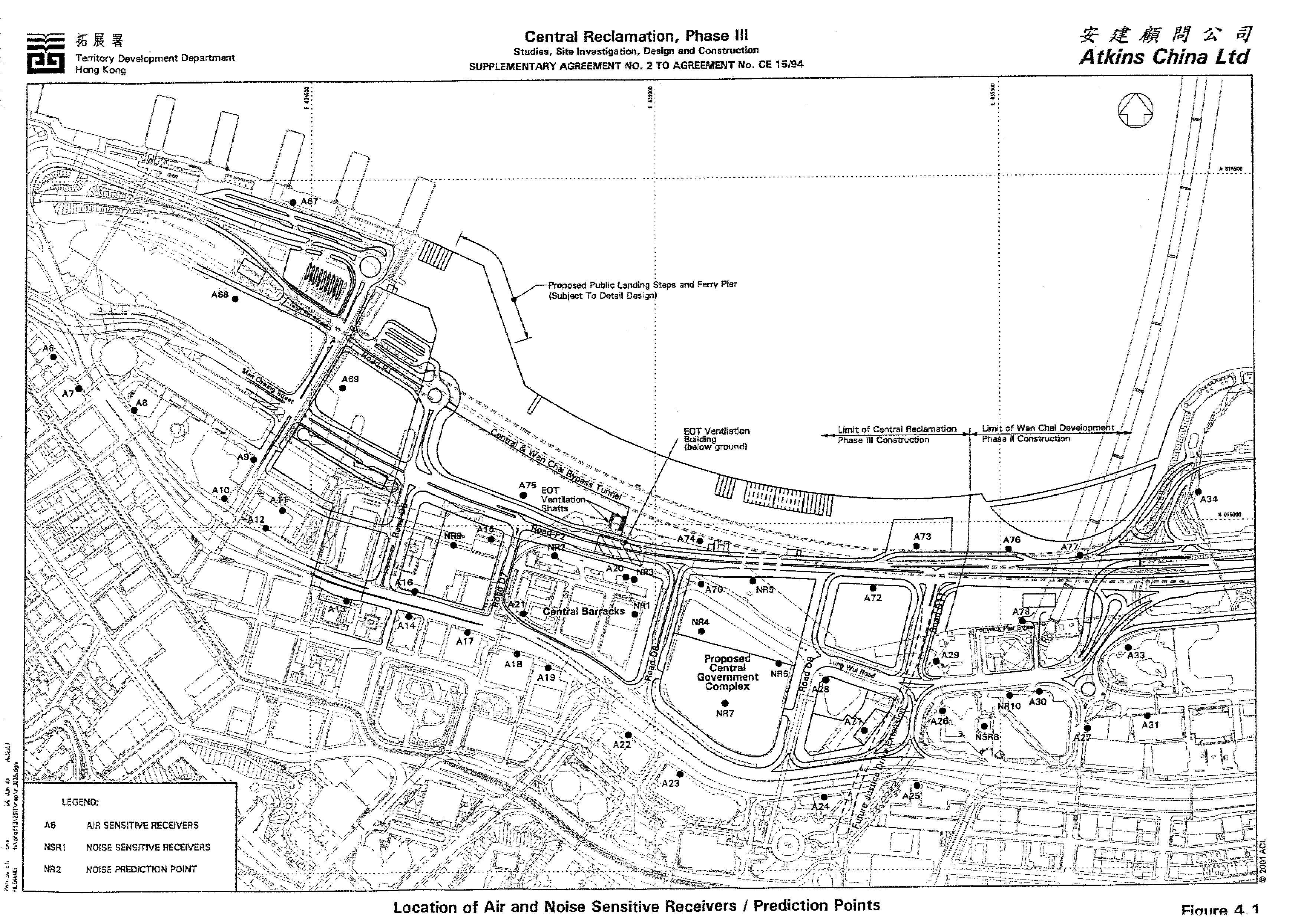
Noise sensitive receivers (NSRs) and noise sensitive facilities identified in the vicinity of the CRIII-MO construction area included the Hong Kong Academy for Performing Arts outdoor arena, the City Hall and the Central Barracks. The locations of these facilities are shown on Figure 4.1. Results of construction noise assessments indicated that noise exceedences of the EIAO-TM guideline are likely during certain periods of the construction works with noise levels of 65dB(A) to 93dB(A) predicted at the City Hall and 62dB(A) to 94dB(A) predicated at the Central Barracks. Such impacts can be mitigated through the use of quiet plant and noise barriers at various stages of the construction works. The mitigated noise levels were predicted to be 64dB(A) to 78dB(A) at the City Hall and 61dB(A) to 79dB(A) at the Central Barracks. Although the predicted mitigated noise levels at the buildings still exceed the 75dB(A) guideline all affected buildings are, however, air-conditioned and therefore adverse noise impact is not expected at the indoor areas of these buildings.
If construction works are to be carried out during restricted hours (all hours outside of 0700-1900 Monday through Saturday, as well as all day on Sunday and Public Holidays), a Construction Noise Permit (CNP) would be required.
No noise impacts are likely as a result of fixed plant items such as cooling water pumping stations, electricity sub-stations, stand-by generators and the Hong Kong Station Extended Overrun Tunnel ventilation building.
Road traffic noise modelling has been undertaken to assess possible impacts arising from not only the road traffic associated with CRIII - MO but also traffic arising for the Central-Wan Chai Bypass and Wan Chai Development Phase II projects.
Predicated road traffic noise levels at the City Hall (70.6dB(A)), HKAPA (78.5dB(A))and Central Barracks (77.7dB(A)) are predicted to exceed the EIAO-TM. Direct mitigation measures were found to be not practical. However, these buildings are all equipped with air-conditioning systems and do not rely on openable windows for ventilation. As such the indoor environment of these buildings is not expected to be adversly affected by traffic noise and so no additional mitigation measures are required for them.
Air sensitive receivers (ASRs) have been identified within 500 m from the CRIII-MO construction area. The locations of ASRs are shown on Figure 4.1. Total suspended particulates (TSP) will be the major pollutant during construction of the CRIII-MO. Dust dispersion modelling has been employed to predict the TSP impact upon ASRs.
Dust impacts in some construction periods will be high due to the extensive activities at the work site and proximity of ASRs. Major dust generating activities will be truck movements over unpaved haul roads, material handling, bulldozing, wind erosion over stockpiles and infrastructure construction. The highest TSP concentrations were predicted at the City Hall with a maximum 1-hour TSP concentration of 2,668mgm-3 and a maximum 24-hour TSP concentration of 1,389mgm-3. Dust suppression measures have been recommended to reduce these dust impacts. The measures include:
· Strictly limit truck speed on site to below 10km per hour and water spraying to keep the haul road in wet condition;
· Twice daily watering of the work site with active operations when the weather and the works site are dry;
· watering during excavation and material handling;
· provision of vehicle wheel and body washing facilities at the exit points of the site, combined with cleaning of public roads where necessary; and
· tarpaulin covering of all dusty vehicle loads transported to, from and between site locations.
With the incorporation of the recommended mitigation measures, the highest TSP concentrations are still predicted at the City Hall with a maximum 1-hour TSP concentration of 348mgm-3 and maximum 24-hour TSP concentration of 221mgm-3. Predicted TSP concentrations with the mitigation measures in place all comply with the air quality objectives (AQO) criteria.
Vehicle emissions are expected to be the major air pollutants during the operational phase of the CRIII-MO. It has been assessed that the maximum hourly concentration of nitrogen dioxide (NO2), 24-hour average concentration of NO2, 24-hour average RSP concentration and 1-hour average concentration of CO at all ASRs, including cumulative impacts from the operation of the CWB and WDII projects, will comply with the AQO criteria. The range of values predicted at existing and future NSRs are:
· 1-hour Average NO2 : 125 - 278mgm-3
· 24-hour Average NO2 : 83 – 145mgm-3
· 24-hour Average RSP : 63 –90mgm-3
· 1-hour Average CO : 1820 – 6621mgm-3
To ensure that the air sensitive receivers will not be seriously affected by the major roads, the buffer distances recommended by HKPSG should be followed in planning the landuse of the CRIII-MO area. Proposed public transport facilities and underground carparks should be designed to meet the requirements specified in the respective ProPECC notes and comply with the appropriate air quality guidelines.
Material dredged during reclamation and seawall construction will be disposed of off-site. The total amount of dredged material will be approximately 580,000 m3. Sediment will be dredged by mechanical, closed grab dredging technique. Hopper barges and tugs will be used to transport dredged marine sediment to the designated dumping areas.
A Sediment Quality Report was prepared for the CRIII Project in 1996. The findings of assessment, conducted in accordance with EPD TC 1-1-92, indicate that approximately 375,000m3 of the CRIII-MO dredged material would require confined disposal. The Sediment Quality for the CRIII-MO site is being reviewed at present to take account of the introduction of the new sediment assessment framework as set out in WBTC No. 3/2000. A Sediment Quality Report prepared at the completion of this work will be submitted to DEP at least three months prior to the dredging contract being tendered in accordance with WBTC 3/2000.
Options for waste minimisation, recycling, treatment, storage, collection, transport and disposal of waste arising from CRIII-MO have been examined. Procedures for waste reduction and management are considered and mitigation measures for minimising the impacts of the wastes are recommended.
The measures include:
· wastes should be handled and stored in manner which ensures that they are held securely without loss or leakage thereby minimising the potential for pollution.
· only reputable waste hauliers authorised to collect the sepecific category of waste concerned should be employed;
· appropriate measures should be employed to minimise windblown litter and dust during transportation by using enclosed bins, covering trucks or transporting wastes in enclosed containers;
· the necessary waste disposal permits and registrations should be obtained from the appropriate authorities,
· collection of general refuse should be carried out frequently, preferably daily;
· waste should only be disposed of at licenced sites and the civil engineering contractor should develop procedures to ensure that illegal disposal of wastes does not occur;
· waste storage areas should be well maintained and cleaned regularly;
· records should be maintained of the quantities of wastes generated, recycled and disposed, determined by weighing each load or other method; and
· A ”trip ticket” system should be implemented, if required by Government.
It is likely that 50,000m3 of excavated material will require disposal off-site. It is, however, planned that the WDII project will still be in progress at the time that this material will need to be disposed off-site. As such it is possible that the surplus material could be used as fill material in that project. Only small volumes of chemical wastes and construction waste will be generated from the CRIII-MO works. Mitigation measures relating to good waste management practice have therefore been recommended to ensure that adverse environmental impacts are prevented and that opportunities for waste minimisation and recycling are followed.
Provided that the recommendations put forward in the EIA Report are conscientiously acted upon, the storage, handling, collection, transport, and disposal of wastes arising from the CRIII-MO construction will be in full compliance with the regulatory requirements.
An ecological review indicated that poor water and sediment conditions and a lack of natural coastline in Victoria Harbour have led to ecologically degraded habitats that support only those species which are adapted to polluted conditions and can colonise unnatural substrata such as wharf piles, concrete walls and embankments. Field surveys showed that within the proposed reclamation area the soft seabed was anoxic and supported no macrofauna. The Harbour is utilised by resident and migratory birds, however urban development has reduced the number of natural, shore-side perching sites and habitats are continually disturbed by marine traffic. The reclamation area is not considered an important habitat for these birds.
As the Study Area holds no unique habitats or ecological resources of conservation value or interest, impacts which would require mitigation are not anticipated to result from the Project. Impacts to ecological resources outside the Study Area are not predicted.
The primary landscape impact will be the loss of 18Ha of Victoria Harbour. Other landscape resources affected include two sitting out areas (combined approximate size 0.75ha) and approximate 300 trees, most of which can be transplanted within the CRIII-MO or off site. The provision of an international quality landscape promenade, connected to open space corridors and plazas, as part of a larger provision for District and Regional Open Space, would reduce this negative landscape impact from very substantial in the construction stage to very slight in the operational stage. Whilst the loss of harbour will remain as a very slight residual impact, it is considered an acceptable impact without which the numerous positive landscape impacts would not be achievable.
The primary visual impact will be the loss of views to Victoria Harbour from Visually Sensitive Receivers (VSRs) in existing developments along the southern boundary of CRIII - MO. The majority of visual obstruction will be caused by the new Central Government Complex development on the existing Tamar site, which will reach a 180mPD height. Moderate negative impacts are likely to be caused to VSRs in the Admiralty Centre, Far East Finance Centre and HK Police Force Headquarters. However, due to stepped building heights and the generally open and low rise nature of development, set within a landscaped open space framework, the majority of visual impacts are expected to be positive.
As indicated in Chapter 1, the CRIII-MO includes four Schedule 2 Designed Projects. The landscape and visual impacts associated with each of these designed projects are described briefly below:
Designed Project 1 (DP1) – Reclamation and Associated Dredging
The magnitude of residual landscape impacts attributable to reclamation will be highest in locations adjacent to the existing seawall. Landscape impacts at a majority of character zones are predicted to range between substantial to slight negative at the construction phase, reducing to moderate to very slight at the operation phase. Magnitude of visual impacts will be highest at locations adjacent to the existing seawall including City Hall, HKCEC, Citic Tower and Victoria Harbour, where a majority of impacts upon VSRs are predicted to range between substantial and moderate. Residual visual impacts will be reduced in the operation phase by implementation of comprehensive mitigation measures including hydroseeding to transitional land. Landscape and visual impacts attributable to DP1 are considered acceptable with mitigation measures as described in category (c) of Annex 10 of the EIA-TM.
Designed Project 2 (DP2) – Primary and District Distributor Roads
Residual landscape impacts attributable to Primary and District Distributor Roads are predicated to be slight to very slight negative in the operation phase. The landscape sensitivity of character areas is lowered by their proximity to the reclamation upon which the roads will be located. Similarly the sensitivity of VSRs to the development is considered to be reduced due to their proximity to the reclamation. The majority of visual impact characteristics are predicted to range between moderate to negligible negative in the operation phase. It is considered that the residual landscape and visual impacts attributable to DP2 are acceptable with mitigation measures as described in category (c) of Annex 10 of the EIA-TM.
Designed Project 3 (DP3) – Central –Wan Chai
Bypass Tunnel (Construction only)
The completion of the tunnel will coincide with the completion of the reclamation (DP1) and impacts are assessed in this context. Construction phase landscape impacts are predicted to range between moderate and slight negative. The majority or residual visual impacts at the construction phase are predicted to range between moderate and very slight negative. It is considered that the residual landscape and visual impacts attributable to DP3 are acceptable with mitigation measures as described in category (c) of Annex 10 of the EIA-TM.
Designed Project 4 (DP4) – North Island Line Protection Works
(Construction only)
The construction of the advanced station structural envelope works will coincide with implementation of the reclamation (DP1) and impacts are assessed within this context. Construction phase landscape impacts are predicted to range between moderate and negligible negative. The majority or residual visual impacts at the construction phase are predicted to range between moderate and very slight negative. It is considered that the residual landscape and visual impacts attributable to DP4 are acceptable with mitigation measures as described in category (c) of Annex 10 of the EIA-TM.
The key mitigation measures recommended for the CRIII-MO project are:
· implementation of the Waterfront Promenade, Statue Square Corridor, Historic Corridor, Civic Corridor, Arts and Entertainment Corridor, Streetscape Network, Landscape Decks, and Supplementary Landscape Space;
· provision of a legible, integrated pedestrian circulation system linking major activity nodes, reinforcing links with adjoining areas, and providing an international quality hard and soft landscape treatment;
· provision of a grade separated pedestrian system to minimise vehicular/pedestrian conflict;
· provision of an integrated network of local and regional open spaces for passive and active recreation;
· preservation of selected architectural features;
· preservation insitu of existing significant vegetation, principally the two Banyan Trees flanking the Tamar Site;
· new roads to incorporate suitable streetscape amenity and landscape planting to minimise visual and environmental impacts;
· existing roads upgraded to ‘marry’ with the proposed landscape framework;
· hydroseeding of reclamation if there is no immediately use of the site, periphery of the reclamation;
· designated service corridors beneath footpaths to prevent potential impacts upon vegetation during services maintenance;
· sensitively designed colour themes to footpath paving areas; and
· sensitively designed seawall to enhance the recreational value of the future promenade can be included.
The key mitigation measures are illustrated on Figures 8.1 and 8.2.
In conclusion, it is considered that both the landscape and visual impacts associated with CRIII - MO are acceptable with mitigation measures as described in category (c) of Annex 10 of the EIA-TM. The project will complement the landscape and visual character of its setting, will follow the relevant planning objectives and will improve overall and visual quality.
Environmental monitoring and audit (EM&A) are identified to be required in certain environmental aspects of the CRIII-MO during the construction phase. The details of the EM&A programme have been provided in a stand-alone EM&A Manual.
The EM&A requirements are briefly summarised in Table 9.1.
|
Environmental Aspect |
EM&A Requirements |
|
Water Quality |
Baseline monitoring for water quality is required to establish ambient conditions prior to the commencement of works and to demonstrate the suitability of the proposed impact, control and reference monitoring stations. Monitoring shall take place for 4 weeks prior to the commencement of marine works. |
|
|
During the course of marine works, impact monitoring shall be undertaken at the designated monitoring stations at a frequency of 3 days per week, at both mid-ebb and mid-flood tides. |
|
Noise |
Baseline monitoring for noise shall be carried out at designated monitoring stations over a continuous period of at least two weeks in order to establish ambient conditions prior to the commencement of any construction works. There shall not be any construction activities in the vicinity of the monitoring stations during the baseline monitoring. |
|
|
Impact monitoring shall be carried out at the designated monitoring stations at the recommended frequencies on a weekly basis when noise generating activities are in progress. General construction work carried out during restricted hours shall comply with the conditions of a construction noise permit. |
|
Air Quality |
Baseline monitoring for air quality shall be carried out at designated monitoring stations for both 1-hour and 24-hour TSP prior to the commencement of any construction work to establish ambient conditions. 24-hour monitoring shall be carried out on consecutive days for a period of no less than 14 days. 1-hour sampling shall be conducted at least 3 times per day when the highest dust impact is expected, over these same 14 days. |
|
|
During construction activities, 24-hour TSP sampling shall be conducted at designated monitoring stations at a frequency of at least once every 6 days, when the highest dust impact is expected. |
|
Solid Waste |
A comprehensive waste management plan shall be set up at the commencement of the Project and periodically audited to determine whether the waste is being effectively managed. These audits shall be conducted against approved procedures with review on all aspects of waste management including waste generation, storage, recycling, treatment, transport and disposal. Audit shall be conducted at the commencement of construction works and quarterly thereafter. |
|
Landscape and Visual |
Monitoring and audit of landscaping works will to a large extent be conducted through site inspections to ensure that the works are implemented in accordance with specifications. Results of visual inspections would be reported in monthly audit reports. The contractor would also be required to provide site maintenance for 12 months following completion of the works. Monitoring and audit of design works will be done through the implementation of quality assurance procedures adopted by design consultants and through the submission to and approval of design proposals by Government. |
Assessment conducted indicate that the CRIII-MO works have the potential to generate adverse air quality, noise, water quality, waste and landscape and visual impacts during their construction. In order to ensure that the impacts are reduced to acceptable levels a number of mitigation measures have been recommended to be implemented during the works. With these measures in place assessments have shown that residual impacts will be acceptable. A summary of the unmitigated and mitigated impacts is provided below along with brief details of the mitigation measures recommended and residual impacts, if any, present after mitigation. A full listing of the recommended mitigation measures is provided in Chapter 16 of the Environmental Impact Assessment Report.
|
Environmental Perameter |
Unmitigated Impact |
Key Mitigation Measures |
Mitigated Impact |
Residual Impact After Mitigation |
|
Air Quality |
Max 1-hr TSP
conc. 2,668mgm-3 Max 24-hr TSP conc. 1,389mgm-3 |
· Reduce & limit vehicle speeds · Regular watering of work site · Water sprays during excavation / material handling · Vehicle washing facilities · Taurpaulin cover of dusty loads |
Max 1-hr TSP conc. 348mgm-3 Max 24-hr TSP conc. 221mgm-3 |
TSP concentrations comply with AQO criteria |
|
Noise |
City Hall Central Barracks HKAPA Outdoor
Arena |
· Use of quiet PMEs · Use of moveable noise barriers · Good site practices |
*City Hall *Central Barracks
*HKAPA Outdoor
Arena (*5dB(A) reduction for movable or fixed noise screens adopted) |
Slight exceedences of 75dB(A) guideline but affected buildings are air conditioned and do not rely on openable windows for ventilation |
|
Water Quality |
Max SS elevation
at Cooling Water Intakes 68.3mgL-1 Max SS elevation
at WSD Intakes |
· Dredging control requirements · Marine disposal & sand filling control requirements · WDII/ CRIII-MO concurrent works control requirements · Floating debris collection · Culvert L outfull discharge control measures · Construction run-off & drainage control requirements |
Quantitative values not determined as unmitigated values do not exceed water quality criteria |
Not exceedences of water quality criteria |
|
Waste |
Not quantifable |
· Waste segregation · Control measures for storage, collection and transport of waste |
Not quantifable |
No adverse impacts predicated |
|
Landscape & Visual |
· Loss of 18ha Victoria Harbour water resource · Loss of 0.75ha public open space · Loss of "Star" Ferry Pier and adjacent pedestrian space |
· Minimise access/ working areas · Protect/ Retain existing vegetation, where possible · Transplant trees, where appropiate · Advance planting/ visual screening · Conserve topsoil · Sensitive site hoarding |
18 ha of land available for a variety of uses including: · International style waterfront promenade · Marina Basin · Festival Market · Star Plaza · Harbour Steps · Open Space Corridors · New "Star" Ferry Pier · New Public Landing Steps |
Impacts are acceptable with mitigation |
Longer term environmental conditions associated with the CRIII-MO have been found to satisfy all relevant statutory and non-statutory guidelines. In some instances environmental standards will be improved from those currently prevailing within the study area.
This EIA has quantitatively assessed the impacts arising from the construction and operation of the CRIII-MO and cumulative impacts arising from the WDII and CWB projects. Where appropriate, details of the mitigation recommendations have been presented to ensure that the residual impacts (ie: after mitigation) are within the appropriate statutory and non-statutory environmental standards.
Assuming the mitigation measures
are appropriately implemented, the EIA has identified that the scale, extent
and severity of environmental impacts arising from the CRIII-MO Project, and
the cumulative residual environmental impacts (ie: after mitigation) will be
within the appropriate statutory and non-statutory environmental standards.
Additionally, in order to verify the effectiveness of the recommended
mitigation measures in practice, a detailed EM&A programme has been
formulated, with feedback into the construction activities, to ensure full
compliance with all appropriate statutory and non-statutory environmental
standards throughout the Project.