Environmental Impact Assessment Ordinance (Cap.
499), Section 5(7)
Environmental Impact Assessment Study Brief No. ESB-124/2005
Project
Title: Relocation
of Yiu Lian Floating Dock No. 3
(hereinafter known as the “Project”)
Name
of Applicant: Yiu
Lian Dockyards Ltd.
(hereinafter known as the “Applicant”)
1. BACKGROUND
1.1 An
application (No. ESB-124/2005) for an Environmental Impact Assessment (EIA)
study brief under section 5(1) of the Environmental Impact Assessment Ordinance
(EIAO) was submitted by the Applicant on 24 January 2005 with a Project Profile
(No. PP-239/2005).
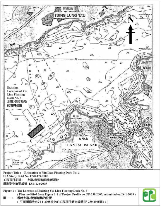
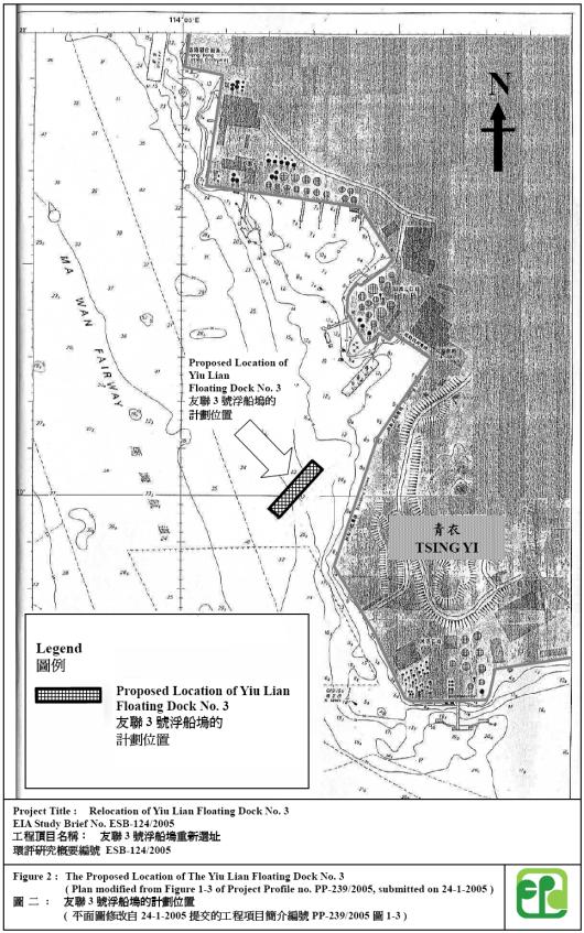
1.2 The proposed
Project is to decommission the Yiu Lian Floating Dock No. 3 (the Dock) at the Yam
O Wan of North Lantau (North Lantau), and to construct and operate the Dock at
a proposed location at the South-west coast of Tsing Yi (Tsing Yi) after
relocation. As given in the Project Profile, the Dock has a pontoon length of
about 287m and breadth of 55m and has been operating at North Lantau for a
substantial period of time since late 80s. Present and proposed locations of
the Dock at Lantau and Tsing Yi are shown respectively in Figures 1 and 2 (as modified
from the plans in the Project Profile ref: PP-239/2005). Key elements of the
Project are to:
(i) Decommission the Dock at North Lantau, and
(ii)
Construct and operate the Dock at Tsing Yi.
1.3 Pursuant to
section 5(7)(a) of the EIAO, the Director of Environmental Protection (the
Director) issues this EIA study brief to the Applicant to carry out an EIA
study.
1.4 The purpose
of this EIA study is to provide information on the nature and extent of
environmental impacts arising from the Project and related activities taking
place concurrently. This information will contribute to decisions by the
Director on:
(i)
the overall acceptability of any adverse environmental consequences
that are likely to arise as a result of the Project;
(ii)
the conditions and requirements for the Project to mitigate against
adverse environmental consequences wherever practicable; and
(iii)
the acceptability of residual impacts after the proposed mitigation
measures are implemented.
2. OBJECTIVES
OF THE EIA STUDY
2.1 The
objectives of the EIA study are as follows:
(i)
to describe the Project and associated works together with the
requirements for carrying out the Project;
(ii)
to identify and describe the elements of the community and environment
likely to be affected by the Project and/or likely to cause adverse impacts to
the Project, including natural and man-made environment and the associated
environmental constraints;
(iii)
to identify potential Tributyltin (TBT)
and heavy metal contamination in marine sediments due to operation of the Dock
in Lantau and ways to minimise and mitigate the impacts;
(iv)
to identify and quantify emission sources and determine the significance
of impacts on sensitive receivers and potential affected uses including those
along the Sham Tseng coast, especially in respect of marine water and sediment quality
impacts;
(v)
to identify mitigation measures for the proposed Dock at Tsing Yi with
regard to the risk incidence associated with the Caltex and ExxonMobil West
terminals at South-west Tsing Yi;
(vi)
to propose the provision of mitigation measures so as to minimize
pollution, environmental disturbance and nuisance arising from the Project;
(vii)
to investigate the feasibility, practicability, effectiveness and implications
of the proposed mitigation measures;
(viii)
to identify, predict and evaluate the residual environmental impacts
(i.e. after practicable mitigation) and the cumulative effects expected to
arise from the Project in relation to the sensitive receivers and potential
affected uses;
(ix)
to identify, assess and specify methods, measures and standards, to be
included in the detailed design, decommissioning, construction and operation
stage of the Project which are necessary to mitigate these environmental
impacts and reduce them to acceptable levels;
(x)
to investigate the extent of the secondary environmental impacts that
may arise from the proposed mitigation measures and to identify constraints associated
with the mitigation measures in the EIA study, as well as the provision of any
necessary mitigation measures;
(xi)
to identify constraints associated with the mitigation measures
recommended in the EIA study; and
(xii)
to design and specify the environmental monitoring and audit
requirements to ensure the effective implementation of the environmental protection
and pollution control measures.
3. DETAILED
REQUIREMENTS OF THE EIA STUDY
The Purpose
3.1 The purpose
of this study brief is to scope the key issues of the EIA study and to specify
the environmental issues that are required to be reviewed and assessed in the
EIA report. The Applicant has to
demonstrate in the EIA report that the criteria in the relevant sections of the
Technical Memorandum on the Environmental Impact Assessment Process of the
Environmental Impact Assessment Ordinance (hereinafter known as the “TM”) are
fully complied with.
The Scope
3.2 The
scope of this EIA study shall cover the Project proposed in the Project Profile
and works mentioned in section 1.2 above.
The EIA study shall address the key issues described below, together
with any other key issues identified during the course of the EIA study, and the
cumulative environmental impacts of the Project, through interaction or in
combination with other existing, committed, planned and known potential
development in the vicinity of the Project. Key issues include, amongst others:
Decommissioning
of the Dock at North Lantau
(a)
the potential TBT and heavy metal contaminated marine
sediments caused by operation of the
Dock at Lantau and their handling/treatment method(s);
(b) the
potential water quality impacts caused by decommissioning activities,
especially when potentially contaminated sediments are disturbed during
handling/treatment process;
Construction
and Operation of the Dock at Tsing Yi
(c)
the potential water quality impacts during
handling/disposal of marine sediments caused by construction works;
(d)
practicable means to implement and audit the Applicant’s
proposal in section 3.2.2.1 of the Project Profile with regard to receiving
ships without TBT containing paints during operation stage of the Dock, and
(e)
the potential operational water quality impacts from wastewater
of the Project that might contain anti-fouling chemicals or TBT, where
applicable.
3.3 Notwithstanding that the
study brief has scoped the key issues for assessment, to facilitate public
inspection, the EIA shall cover information presented in the Project Profile
together with necessary updates, and explain why no adverse impacts are
anticipated in certain areas or issues covered by the TM.
3.4 Consideration
of Alternative Options and Methods in Decommissioning, Construction and
Operation
3.4.1
Proposed site at Tsing Yi
i) The
Applicant shall present considerations for the proposed project siting, and the
history of the Project.
3.4.2 Consideration of Alternative Options
and Methods for the Project
Decommissioning
of the Dock at North Lantau
i)
Where the EIA predicts/identifies TBT and heavy metal
contamination in marine sediments caused by operation of the Dock, the
Applicant shall consider different handling/treatment methods for the
contamination. With a view to proposing the best practicable means, a
comparison shall be made with regard to environmental benefits and dis-benefits
of different approaches to handle/treat the contaminated sediments. The
approaches can include, among others, “Leave the sediments in place”, “In-situ
or Ex-site treatment” or disposal as a last resort;
ii)
Where dredging/disturbance of the TBT and heavy metal
contaminated marine sediments are unavoidable especially during sediments
handling and/or anchor removal, the Applicant shall explore alternative
construction methods in order to minimize adverse water quality impacts;
Construction and Operation of the
Dock at Tsing Yi
iii)
Where the EIA predicts adverse water quality impacts
during construction stage, the Applicant shall explore alternative construction
methods and sequences of works, and
iv)
Where the EIA predicts adverse direct/cumulative water
quality and sediment deposits impacts to sensitive receivers (including those
along the Sham Tseng coast) from wastewater discharge of the Dock, the
Applicant shall consider, among others, alternative wastewater treatment
methods, discharge locations, work modes, mooring location and layout in order
to avoid and minimize adverse environmental impacts during operation stage to
the maximum practicable extent.
3.5 Technical
Requirements
The Applicant shall conduct the EIA study to address the
environmental aspects of the works and activities as described in the scope set
out above. The EIA study
shall include the following technical requirements on specific impacts unless
otherwise approved by the Director specifically in writing.
3.5.1
Water Quality Impact
3.5.1.1 The
Applicant shall follow the criteria and guidelines for evaluating and assessing
water pollution as stated in Annexes 6 and 14 of the TM respectively for the
Project.
3.5.1.2 The study
area for the purpose of this water quality impact assessment shall cover relevant sensitive receivers that
have a bearing on the environmental acceptability of the Project within the
North Western Water Control Zone, Western Buffer Water Control Zone and part of
the Southern Water Control Zone north of Hei Ling Chau. Sensitive receivers
include beaches along the Sham Tseng coast.
3.5.1.3 The
Applicant shall identify and analyse in the assessment respective physical,
chemical and biological disruptions of marine water and sediments arising from
the Project.
3.5.1.4 The
applicant shall include the following in the water quality impact assessment:
General
(i)
collection and review of background
information on the existing and planned water system(s) and sensitive receivers
which might be affected by the Project;
(ii)
characterization of water quality and
sediment quality on the respective water system(s) and sensitive receivers
which might be potentially affected by the Project based on existing
information or site surveys/tests as appropriate;
(iii)
identification and analysis of existing
and planned future activities (such as respective floating docks operating at
Tsing Yi); beneficial uses related to the water system(s) and water sensitive
receivers;
(iv)
identification of pertinent water
quality and sediments objectives and establishment of other appropriate water
and sediments quality criteria or standards for the water system(s) and
sensitive receivers as identified above;
(v)
establishment of an emission inventory
on the quantities and characteristics
of pollution sources arising from the Project;
(vi)
prediction of impacts on the water
system(s) and sensitive receivers due to those alterations and changes, and the
pollution sources identified above. The prediction shall include different activities
and sequences of the Project;
(vii)
assessment of cumulative impacts due to
relevant concurrent and planned projects, activities or pollution sources within
the identified water system(s). In particular, the cumulative impacts due to
other floating docks moored at Tsing Yi shall be assessed during the operation
stage;
Impact prediction for decommissioning works at Yam O
Wan
(viii)
identification and quantification of dredging,
filling and disposal activities together with any proposed fill source and
disposal ground. Characterization of marine sediments and mobilization of any contaminants
through field investigation, sampling, and chemical laboratory tests including
chemical screening for those contaminants listed in Appendix B. The Applicant
should submit a plan for the Director’s agreement with regard to the range of
investigation parameters; the number, type, location and methods of sampling;
sample preservation, and chemical laboratory test method/protocols;
(ix)
prediction and quantification of impacts
on water system(s) and aquatic lifes due to the presence of contaminated sediments
based on the chemical screening above. Possible impacts include the effect on
benthic organism, aquatic organisms and marine mammal at organismic and
ecosystem levels. The Applicant should submit a plan for the Director’s
agreement with regard to the study methodology, testing and analysis such as
sediment biological toxicity test, bioaccumulation test, sampling and chemical
testing of the water column;
(x)
evaluation and comparison of alternative
handling and treatment methods for the contaminated sediments in accordance
with contaminants investigation results in section ix in order to mitigate the
impacts to within acceptable limits. These alternatives shall include the “Leave
the sediments in place”, “In-situ or Ex-situ treatment” and “Disposal” options.
The comparison of different options should comprise at least assessment of the
associated environmental impacts and identification of any residual
environmental impact;
(xi)
simulation and quantification of degree
of mobilization of various contaminants during decommissioning stage by
Elutriate tests (USACE) if marine sediments are found to be contaminated.
Prediction and quantification of impacts associated with the proposed
handling/treatment method above where adverse impacts are anticipated. The possible
impacts include changes in sediment erosion or deposition, water and sediment
quality and the effect on the aquatic organism due to such activities. The Applicant shall seek the Director’s
agreement whether a mathematical modeling
or other technique should be applied to quantify the impacts. Where a
mathematical modeling is necessary to predict and quantify the impacts, the
model shall comply with the specifications listed in Appendix C;
Impact prediction during construction stage at Tsing Yi
(xii)
identification and quantification of
dredging, filling, and disposal activities during the construction stage.
Characterization of marine sediments and mobilization of any contaminants through
field investigation, sampling, and chemical laboratory tests including chemical
screening for those contaminants listed in Appendix B. The Applicant should submit
a plan for the Director’s agreement including the range of investigation
parameters to be analyzed; the number, type, location and methods of sampling;
sample preservation and chemical laboratory test method/protocols;
(xiii) simulation
and quantification of the degree of mobilization of various contaminants during
construction stage by Elutriate tests (USACE) if marine sediments are found to be contaminated. Prediction and
quantification of the marine water quality impacts by techniques approved by
the Director where adverse impacts are anticipated. Possible impacts include
changes in sediment erosion or deposition, water and sediment quality and the
effect on the aquatic organism due to such activities;
Impact prediction during operation stage at Tsing Yi
(xiv)
identification of any physical changes due
to operation of the Dock at Tsing Yi;
(xv)
identification and quantification of pollution
including existing and likely future water pollution sources. The potential
contaminants shall include those caused by ship servicing, in particular due to
hull washing and sand blasting of exterior hull surface. An emission inventory
on the quantities and characteristics of existing and future pollution sources
shall be provided with a view of assessing the cumulative effect. Field
investigation and laboratory tests shall be conducted as appropriate;
(xvi)
conduct of a literature /desktop review
to identify different types of non-TBT paints commonly used on the market and
identification of their characteristics and impacts on the environment arising
from ship servicing activities, because the project profile specifies that the
Dock will only receive ships using non-TBT containing paint;
(xvii)
prediction and quantification, by
mathematical modeling or other technique approved by the Director, of impacts
on water system(s) and sensitive receivers, especially those along the Sham
Tseng coast, due to alterations and changes and the pollution sources
identified. Possible impacts include changes in sediment erosion or deposition,
water and sediment quality, the effect on the aquatic organisms and any
potential impact on sensitive uses. The mathematical model shall comply with
the specifications listed in Appendix C;
Mitigation
(xviii)
proposal to avoid or minimize the
adverse impact identified above, in particular suitable handling method for
potentially contaminated sediments and/or their disposal in the decommissioning and construction stages;
(xix)
proposal of water pollution prevention
and mitigation measures to be implemented for the Project so as to reduce the
water quality, sediment quality and ecological impacts to within acceptable
standards. Best management
practices to reduce waste-water, and non-point source pollution shall be
investigated and proposed as appropriate;
(xx)
proposal of practical and effective
mitigation measures to be implemented for the Dock at Tsing Yi with regard to:
(a)
the
audit of proposal to receive ships without TBT containing paint, and
(b)
management
of waste-water from ship-servicing activities that might contain potentially
contaminated sediments, and
(xxi)
evaluation and quantification of
residual impacts on the water system(s) and the sensitive receivers with regard
to the appropriate water and sediment quality criteria, standards and
guidelines.
3.5.2
Waste Management
Implications
3.5.2.1 The Applicant shall follow the criteria and guidelines for evaluating and assessing waste management implications as stated in Annexes 7 and 15 of the TM respectively.
3.5.2.2 The assessment of waste management implications shall cover the followings :
(i) Analysis
of Activities and Waste Generation
The
Applicant shall identify the quantity, quality and timing of the waste arising
from the Project, based on the sequence and duration of these activities of the
Project.
(ii) Proposal
for Waste Management
(a)
Prior to consideration of disposal options for various types of wastes,
the Applicant shall evaluate opportunities for reducing waste generation and
on-site or off-site reuse. Measures
should be considered separately for
planning/design and decommissioning/construction stage respectively to
include proposals for design modification and measures for maximizing waste
reduction.
(b)
After taking into account of opportunities for reducing waste
generation and maximizing reuse, the Applicant shall estimate the types and
quantities of the wastes that require disposal, and describe the disposal
options for each type of waste in detail.
The disposal options for each type of wastes shall take into account of
the assessment in section (c) below.
(c)
An assessment shall be carried out for the impact associated with waste
handling (including labelling, packaging & storage), collection, treatment,
transportation and disposal of wastes, together with proposal of mitigation
measures, where appropriate. The
assessment should at least cover potential hazard, air and odour emission,
wastewater discharge, and transportation risk.
3.5.3 Hazard Assessment for the
Dock at Tsing Yi
3.5.3.1
The proposed dock will be within consultation zone of the Potentially Hazardous
Installation of the Caltex Terminal and Exxon Mobil West Terminals at Tsing Yi,
the Application shall provide an assessment/review for risk incidence and
propose necessary mitigation measures, including, among others, an evacuation
plan.
3.5.4. Air Quality Assessment during Operation Stage at
Tsing Yi
3.5.4.1 The Applicant shall provide
a breakdown of the average fuel consumption per day of the Dock. Based on the
fuel consumption rate, and in the event that air pollutant emissions from the Dock
have potential to cause non-compliance of the criteria in section 1 of Annex 4
in the TM at affected Air Sensitive Receivers, assessment shall be carried out
to confirm environmental acceptability of the Project following Appendix D.
3.5.5
Summary of Environmental Outcomes
3.5.5.1 The EIA report shall contain a summary of
the key environmental outcomes arising from the EIA study, including the
population and environmentally sensitive areas protected, environmentally
friendly designs recommended, key environmental problems avoided, compensation
areas included and the environmental benefits of environmental protection
measures recommended.
3.5.6 Environmental Monitoring and Audit (EM&A)
Requirements
3.5.6.1 The
Applicant shall identify and justify in the EIA study whether there is any need
for EM&A and/or environmental management system (EMS) activities during the
decommissioning, construction and operation of the Dock and, if affirmative to
define the scope of the EM&A requirements for the Project in the EIA study.
3.5.6.2 Subject to the
confirmation of EIA findings, the Applicant shall comply with the requirements
as stipulated in Annex 21 of the TM.
The Applicant shall also propose real-time reporting of monitoring data
for the Project through a dedicated internet website.
3.5.6.3 The Applicant
shall prepare a project implementation schedule (in the form of a checklist as
shown in Appendix A to this EIA study brief or otherwise as approved by the
Director) containing all the EIA recommendations and mitigation measures with
reference to the implementation programme.
4. DURATION
OF VALIDITY
The
EIA Study Brief is valid for 36 months from the date of issue. If the EIA study
does not commence within this period, the Applicant shall apply to the Director
for a fresh EIA study brief before commencement of the EIA study.
5. REPORT
REQUIREMENTS
5.1 In
preparing the EIA report, the Applicant shall refer to Annex 11 of the TM for
the contents of an EIA report. The Applicant shall also refer to Annex 20 of
the TM, which stipulates the guidelines for the review of an EIA report.
5.2 The
Applicant shall supply the Director with the following number of copies of the
EIA report and the executive summary:
(i) 50
copies of the EIA report in English and 80 copies of the executive summary
(each bilingual in both English and Chinese) as required under section 6(2) of
the EIAO to be supplied at the time of application for approval of the EIA
report.
(ii)
where necessary, addendum to the EIA report and the executive summary
submitted in 5.2 (i) above as required under section 7(1) of the EIAO, to be
supplied upon advice by the Director for public inspection.
(iii)
20 copies of the EIA report in English and 50 copies of the executive
summary (each bilingual in both English and Chinese) with or without Addendum
as required under section 7(5) of the EIAO, to be supplied upon advice by the
Director for consultation with the Advisory Council on the Environment.
5.3
The Applicant shall, upon request, make additional
copies of the above documents available to the public, subject to payment by
the interested parties of full costs of printing.
5.4
In addition, to facilitate the public inspection of the EIA report via
the EIAO internet website, the Applicant shall provide electronic copies of
both the EIA report and the executive summary prepared in HyperText Markup
Language (HTML) (version 4.0 or later) and in Portable Document Format (PDF
version 4.0 or later), unless otherwise agreed by the Director. For the HTML version, a content page
capable of providing hyperlink to each section and sub-section of the EIA
report and the executive summary shall be included in the beginning of the
document. Hyperlinks to all figures, drawings and tables in the EIA report and
executive summary shall be provided in the main text from where the respective
references are made. All graphics in the EIA report and/or executive summary
shall be in interlaced GIF format unless otherwise agreed by the Director.
5.5 The
electronic copies of the EIA report and the executive summary shall be
submitted to the Director at the time of application for approval of the EIA report.
5.6 When the
EIA report and the executive summary are made available for public inspection
under section 7(1) of the EIA Ordinance, the content of the electronic copies
of the EIA report and the executive summary must be the same as the hard copies
and the Director shall be provided with the most updated electronic copies.
5.7 To
promote environmentally friendly and efficient dissemination of information,
both hard copies and electronic copies of EM&A reports recommended by the
EIA study shall be required and their format shall be agreed by the Director.
6. OTHER
PROCEDURAL REQUIREMENTS
6.1 During the
EIA study, if there is any change in the name of Applicant for this EIA study
brief, the Applicant must notify the Director immediately.
6.2 If there is
any key change in the scope of the Project mentioned in section 1.2 of this EIA
study brief, in Project Profile No. PP-239/2005 and affected sensitive
receivers, the Applicant shall seek confirmation from the Director in writing
on whether or not the scope of issues covered by this EIA study brief can still
cover the key changes, and the additional issues, if any, that the EIA study shall
also address. If the changes to
the Project fundamentally alter the key scope of the EIA study brief, the
Applicant shall apply to the Director for a fresh EIA study brief.
--- END OF EIA
STUDY BRIEF ---
March 2005
Environmental
Assessment and Noise Division,
Environmental
Protection Department
![]()
![]()
![]()
Figure 2 : The Proposed Location of The Yiu Lian Floating Dock No. 3 (
Plan modified from Figure 1-3 of Project Profile no. PP-239/2005, submitted
on 24-1-2005 ) 圖
二 : 友聯3號浮船塢的計劃位置 (
平面圖修改自24-1-2005提交的工程項目簡介編號PP-239/2005圖1-3 ) 
![]()
Appendix
A - Implementation Schedule for *Decommissioning /Construction
/Operation
Phase
|
EIA Ref. |
EM&A Ref. |
Recommended
Mitigation Measures |
Objectives
of the Recommended Measure & Main Concerns to address |
Who
to implement the measure |
Location
of the measure |
When
to implement the measure |
What
requirements or standards for the measure to achieve |
|
|
|
|
|
|
|
|
|
|
|
|
|
|
|
|
|
|
|
|
|
|
|
|
|
|
|
|
|
|
|
|
|
|
|
|
|
|
|
|
|
|
|
|
|
|
|
|
|
|
|
|
|
|
|
|
|
|
|
|
|
|
|
|
|
|
|
|
|
|
|
|
|
|
|
|
|
|
|
|
|
|
|
|
|
|
|
|
|
|
|
|
|
|
|
|
|
|
|
*Please delete as appropriate
Appendix B - List of contaminants:
Metals: Cadmium
Chromium
Copper
Mercury
Nickel
Lead
Zinc
Metalloid: Arsenic
PAHs: Low
molecular weight polychlorinated (PAHs)
High
molecular weight PAHs
Total
Polychlorinated biphenyls (PCBs)
Tributyltin
(TBT)
Appendix C - Water
Quality Modeling Requirements
Modelling software general
1.
The modelling software shall be fully 3-dimensional capable
of accurately simulating the stratified condition, salinity transport, and
effects of wind and
tide on the water body within the model area.
2.
The modelling software shall consist of hydrodynamic, water
quality, sediment
transport and particle dispersion modules. The hydrodynamic, water quality and sediment transport modules shall have been proven with
successful applications locally and overseas.
3.
The hydrodynamic,
water quality and
sediment transport modules shall be strictly mass conserved at all levels.
Model details – Calibration & Validation
1. No
field data collection is required for model calibration for this study. However, the models shall be properly
calibrated and validated before its use in this study in the area including the
North Western Water Control Zone, Western Buffer Water Control Zone and part of
the Southern Water Control Zone north of Hei Ling Chau, with the field data
collected by:
· Hydraulic and Water Quality Studies in
Victoria Harbour (1987)
·
Port and Airport Development Strategy - Enhancement of
WAHMO
Mathematical Models (1990)
·
Strategic Sewage Disposal Scheme Stage II - Oceanic
Outfall, Oceanographic Surveys and Modelling (1992)
·
Update on Cumulative Water Quality and Hydrological Effect
of Coastal Developments and Upgrading of Assessment Tool (1998)
· Environmental Protection Department
(EPD)’s routine monitoring data
· Tidal data from Hong Kong Observatory,
Macau and relevant Mainland Authorities
2. Tidal data shall be calibrated and validated in both frequency and time domain manner.
3. For the purpose of calibration and validation, the model shall run for not less than 15 days of real sequence of tide (excluding model spin up) in both dry and wet seasons with due consideration of the time required to establish initial conditions.
4. In
general the hydrodynamic models shall be calibrated to the following criteria:
Criteria Level
of fitness
with
field data
· tidal elevation (rms) <
8 %
· maximum phase error at high water and
low water < 20 minutes
· maximum current speed deviation <
30 %
· maximum phase error at peak speed <
20 minutes
· maximum direction error at peak speed <
15 degrees
· maximum salinity deviation <
2.5 ppt
Model details – Simulation
1. The
water quality modelling results shall be qualitatively explainable, and any
identifiable trend and variations in water quality shall be reproduced by the
model. The water quality model
shall be able to simulate the interaction of dissolved oxygen, phytoplankton,
organic and inorganic nitrogen, phosphorus, silicate, BOD, temperature,
suspended solids, contaminants release of dredged and disposed material,
air-water exchange, E. coli and
benthic processes. It shall also
be able to simulate salinity.
Salinity results simulated by hydrodynamic models and water quality
models shall be demonstrated to be consistent.
2.
The sediment transport module for assessing impacts of sediment loss due to marine works
shall include the processes of settling, deposition and re-erosion. The values of the modelling parameters
shall be agreed with the Director.
3.
The models shall at least cover the Hong Kong waters, the Pearl Estuary and the Lema (Dangan)
Channel to incorporate all major influences on hydrodynamic and
water quality. A fine grid model can be used for detailed assessment of this
study. It shall either be linked to the far field model or form
part of the far field model by gradual grid refinement. The
coverage of the proposed model shall be properly designed such that it is
remote enough so that the boundary conditions would not be affected by the
proposed project. The model
coverage area shall be agreed with the Director. For indicative
purpose, it shall cover the
North Western Water Control Zone, Western Buffer Water Control Zone and part of
the Southern Water Control Zone north of Hei Ling Chau.
4.
In general, grid size at the area affected by the project
shall be less than 400 m in open waters and less than 75 m around sensitive
receivers. The grid schematization shall be agreed with the Director.
5.
The assessment shall include the construction and operation
phases of the project. Scenarios
to be assessed shall cover different
options proposed by the Applicant in order to quantify the environmental
impacts and improvements from these options. Corresponding pollution load, bathymetry and coastline
shall be adopted in the model set up.
6.
Hydrodynamic, water quality, sediment transport and particle dispersion modules, where appropriate, shall be run for (with proper model
spin up) at least a real sequence of 15 days spring-neap tidal cycle in both
the dry season and the wet season.
7.
The results shall be assessed for compliance of Water
Quality Objectives. Any changes in hydrodynamic regime shall be assessed. Daily erosion / sedimentation rate
shall be computed and its ecological impact shall be assessed.
8.
The impact on relevant representing sensitive receivers
shall be assessed.
9.
Cumulative impacts due to other projects, activities or
pollution sources within the Study Area to the agreement of Director shall also
be predicted and quantified.
10.
All modelling input data and results shall be submitted in
digital media to the Director.
Appendix D– Technical Requirement for Air Quality Assessment during Operation Stage at
Tsing Yi
1.
Prior to the assessment, the Applicant shall provide a
breakdown of the average daily fuel consumption of the Dock. Having regard to
the fuel consumption rate, and in the event that air pollutant emissions have
potential to cause non-compliance of the criteria in section 1 of Annex 4 in
the TM at the Air Sensitive Receivers (ASRs), an air quality assessment shall
be carried out to confirm the environmental acceptability of the Project.
2.
The Applicant
shall follow the criteria and guidelines for evaluating and assessing the air
quality impact as stated in section 1 of Annex 4 and Annex 12 of the TM,
respectively. The “Assessment Area” for air quality impacts shall be generally
defined by a distance of 500m from the boundary of the Project site. The
Applicant shall assess the air pollutant concentrations in accordance with the
relevant sections of the guidelines in Appendixes D1, D2 to D3, or other
methodology as agreed by the Director.
3.
The air quality impact assessment shall include the following:
i) Background
and Analysis of Activities -
The Applicant shall provide background information of the Dock/plant and report
the consideration/measures, where appropriate, that had been taken in the planning of the Project . With a
view of abating air pollution impacts, alternative operation methods shall be
reviewed to avoid and minimize the impacts.
ii)
Identification of ASRs and Examination of Emission/Dispersion
Characteristics – The Applicant shall identify and describe representative existing
and planned/committed ASRs that would likely be affected by the Project. The
assessment points of the identified ASRs should be such that they represent the
worst impact point of these ASRs.
A map showing the location and description including the name of the
buildings, their uses and height of the selected assessment points shall be
given.
iii)
Quantitative Assessment Methodology - The Applicant shall apply
the general principles in the modelling guidelines while making allowance for
the specific characteristic of the Project. This specific methodology must be documented in such level
of details (preferably with tables and diagrams) to allow readers of the
assessment report to understand set-up of the model without referring to input
files.
iv)
Remedies and Mitigation Measures - The Applicant shall
propose remedies and mitigation measures where the predicted air quality impact
exceeds the criteria set in section 1 of Annex 4 in the TM. The Applicant shall
demonstrate quantitatively that the mitigated impacts will comply with the
criteria stipulated in section 1 of Annex 4 in the TM together with evaluation
of residual impact, where necessary.
v)
Submission of Electronic File - Input and output file(s)
of the model run(s) shall be submitted to the Director in electronic format.
Appendix D1 - Guidelines on Choice of Models and Model Parameters
[The information contained in
this Appendix is meant to assist the Applicant in performing the air quality
assessment. The Applicant must
exercise professional judgement in applying this general information.]
1. Introduction
1.1 To expedite the review process by the
Authority and to assist project proponents or environmental consultants with
the conduct of air quality modelling exercises which are frequently called for
as part of environmental impact assessment studies, this paper describes the
usage and requirements of a few commonly used air quality models.
2. Choice of models
2.1 The models which have been most commonly
used in air quality impact assessments, due partly to their ease of use and
partly to the quick turn-around time for results, are of Gaussian type and
designed for use in simple terrain under uniform wind flow. There are
circumstances when these models are not suitable for ambient concentration
estimates and other types of models such as physical, numerical or mesoscale
models will have to be used. In situations where topographic, terrain or
obstruction effects are minimal between source and receptor, the following
Gaussian models can be used to estimate the near-field impacts of a number of
source types including dust, traffic and industrial emissions.
|
Model |
Applications |
|
FDM |
for evaluating fugitive and open dust source impacts (point, line
and area sources) |
|
CALINE4 |
for
evaluating mobile traffic emission impacts (line sources) |
|
ISCST3 |
for
evaluating industrial chimney releases as well as area and volumetric sources
(point, area and volume sources); line sources can be approximated by a
number of volume sources. |
These
frequently used models are also referred to as Schedule 1 models (see
attached list).
2.2
Note that both FDM and CALINE4
have a height limit on elevated sources (20 m and 10m, respectively). Source of
elevation above these limits will have to be modelled using the ISCST3 model or
suitable alternative models. In using the latter, reference should be made to
the 'Guidelines on the Use of Alternative Computer Models in Air Quality
Assessment'.
2.3 The models can be used to estimate both
short-term (hourly and daily average) and long-term (annual average) ambient
concentrations of air pollutants. The model results, obtained using appropriate
model parameters (refer to Section 3) and assumptions, allow direct comparison
with the relevant air quality standards such as the Air Quality Objectives (AQOs) for the relevant pollutant and time averaging
period.
3. Model input requirements
3.1 Meteorological Data
3.1.1 At least
1 year of recent meteorological data (including wind speed, wind direction,
stability class, ambient temperature and mixing height) from a weather station
either closest to or having similar characteristics as the study site should be
used to determine the highest short-term (hourly, daily) and long-term (annual)
impacts at identified air sensitive receivers in that period. The amount of
valid data for the period should be no less than 90 percent.
3.1.2
Alternatively, the meteorological conditions as listed below can be used to
examine the worst case short-term impacts:
Day time:
stability class D; wind speed 1 m/s (at 10m height); worst-case wind angle;
mixing height 500 m
Night time:
stability class F; wind speed 1 m/s (at 10m height); worst case wind angle;
mixing height 500 m
This is a common
practice with using the CALINE4 model due to its inability to handle lengthy
data set.
3.1.3 For situations where, for example, (i)
the model (such as CALINE4) does not allow easy handling of one full year of
meteorological data; or (ii) model run time is a concern, the followings can be
adopted in order to determine the daily and annual average impacts:
(i)
perform a frequency occurrence analysis of one year of
meteorological data to determine the actual wind speed (to the nearest unit of
m/s), wind direction (to the nearest 10o) and stability (classes A
to F) combinations and their frequency of occurrence;
(ii)
determine the short term hourly impact under all of the
identified wind speed, wind direction and stability combinations; and
(iii)
apply the frequency data with the short term results to
determine the long term (daily / annual) impacts.
Apart
from the above, any alternative approach that will capture the worst possible
impact values (both short term and long term) may also be considered.
3.1.4 Note that
the anemometer height (relative to a datum same for the sources and receptors)
at which wind speed measurements were taken at a selected station should be
correctly entered in the model. These measuring positions can vary greatly from
station to station and the vertical wind profile employed in the model can be
grossly distorted from the real case if incorrect anemometer height is used.
This will lead to unreliable concentration estimates.
3.1.5 An
additional parameter, namely, the standard deviation of wind direction, σθ,
needs to be provided as input to the CALINE4 model. Typical values of σθ range
from 12o for rural areas to 24o for highly urbanised
areas under 'D' class stability. For semi-rural such as new development areas,
18o is more appropriate under the same stability condition. The
following reference can be consulted for typical ranges of standard deviation
of wind direction under different stability categories and surface roughness
conditions.
Ref.(1):
Guideline On Air Quality Models (Revised), EPA-450/2-78-027R, United States
Environmental Protection Agency, July 1986.
3.2
Emission Sources
All the
identified sources relevant to a process plant or a study site should be
entered in the model and the emission estimated based on emission factors
compiled in the AP-42 (Ref. 2) or other suitable references. The
relevant sections of AP-42 and any parameters or assumptions used in deriving
the emission rates (in units g/s, g/s/m or g/s/m2) as required by
the model should be clearly stated for verification. The physical dimensions,
location, release height and any other emission characteristics such as efflux
conditions and emission pattern of the sources input to the model should also
correspond to site data. If the emission of a source varies with wind speed,
the wind speed-dependent factor should be entered.
Ref.(2):
Compilation of Air Pollutant Emission Factors, AP-42, 5thEdition, United States
Environmental Protection Agency, January 1995.
3.3
Urban/Rural Classification
Emission
sources may be located in a variety of settings. For modelling purposes these
are classed as either rural or urban so as to reflect the enhanced mixing that
occurs over urban areas due to the presence of buildings and urban heat
effects. The selection of either rural or urban dispersion coefficients in a
specific application should follow a land use classification procedure. If the
land use types including industrial, commercial and residential uses account
for 50% or more of an area within 3 km radius from the source, the site is
classified as urban; otherwise, it is classed as rural.
3.4
Surface Roughness Height
This
parameter is closely related to land use characteristics of a study area and
associated with the roughness element height. As a first approximation, the
surface roughness can be estimated as 3 to 10 percent of the average height of
physical structures. Typical values used for urban and new development areas
are 370 cm and 100 cm, respectively.
3.5
Receptors
These include
discrete receptors representing all the identified air sensitive receivers at
their appropriate locations and elevations and any other discrete or grid
receptors for supplementary information. A receptor grid, whether Cartesian or
Polar, may be used to generate results for contour outputs.
3.6
Particle Size Classes
In evaluating
the impacts of dust-emitting activities, suitable dust size categories relevant
to the dust sources concerned with reasonable breakdown in TSP (< 30 μgm)
and RSP (< 10 μgm) compositions should be used.
3.7
NO2 to NOx Ratio
The conversion
of NOx to NO2 is a result of a series of complex photochemical
reactions and has implications on prediction of near field impacts of traffic
emissions. Until further data are available, three approaches are currently
acceptable in the determination of NO2:
(a) Ambient Ratio
Method (ARM) - assuming 20% of NOx to be NO2; or
(b)
Discrete Parcel Method (DPM, available in the CALINE4
model); or
(c)
Ozone Limiting Method (OLM) - assuming the tailpipe NO2
emission to be 7.5% of NOx and the background ozone concentration to be in the
range of 57 to 68 μg/m3 depending on the land use type (see also EPD
reference paper 'Guidelines on Assessing the 'TOTAL' Air Quality Impacts').
3.8
Odour Impact
In assessing
odour impacts, a much shorter time-averaging period of 5 seconds is required
due to the shorter exposure period tolerable by human receptors. Conversion of
model computed hourly average results to 5-second values is therefore necessary
to enable comparison against recommended standard. The hourly concentration is
first converted to 3-minute average value according to a power law relationship
which is stability dependent (Ref. 3) and a result of the statistical
nature of atmospheric turbulence. Another conversion factor (10 for unstable
conditions and 5 for neutral to stable conditions) is then applied to convert
the 3-minute average to 5-second average (Ref. 4). In summary, to
convert the hourly results to 5-second averages, the following factors can be
applied:
|
Stability Category |
1-hour to 5-sec Conversion Factor |
|
A & B |
45 |
|
C |
27 |
|
D |
9 |
Under 'D' class
stability, the 5-second concentration is approximately 10 times the hourly
average result. Note, however, that the combined use of such conversion factors
together with the ISCST results may not be suitable for assessing the extreme
close-up impacts of odour sources.
Ref.(3):
Richard A. Duffee, Martha A. O' Brien and Ned Ostojic, 'Odor Modeling - Why and
How', Recent Developments and Current Practices in Odor Regulations, Controls
and Technology, Air & Waste Management Association, 1991.
Ref.(4):
A.W.C. Keddie, 'Dispersion of Odours', Odour Control - A Concise Guide, Warren
Spring Laboratory, 1980.
3.9
Plume Rise Options
The ISCST3
model provides by default a list of the U.S. regulatory options for concentration
calculations. These are all applicable to the Hong Kong situations except for
the 'Final Plume Rise' option. As the distance between sources and receptors
are generally fairly close, the non-regulatory option of 'Gradual Plume Rise'
should be used instead to give more accurate estimate of near-field impacts due
to plume emission. However, the 'Final Plume Rise' option may still be used for
assessing the impacts of distant sources.
3.10
Portal Emissions
These include
traffic emissions from tunnel portals and any other similar openings and are
generally modelled as volume sources according to the PIARC 91 (or more
up-to-date version) recommendations (Ref. 5, section III.2). For
emissions arising from underpasses or any horizontal openings of the like,
these are treated as area or point sources depending on the source physical
dimensions. In all these situations, the ISCST3 model or more sophisticated
models will have to be used instead of the CALINE4 model. In the case of portal
emissions with significant horizontal exit velocity which cannot be handled by
the ISCST3 model, the impacts may be estimated by the TOP model (Ref. 6)
or any other suitable models subject to prior agreement with EPD. The EPD's 'Guidelines
on the Use of Alternative Computer Models in Air Quality Assessment' should
also be referred to.
Ref.(5):
XIXth World Road Congress Report, Permanent International Association of Road
Congresses (PIARC), 1991.
Ref.(6):
N. Ukegunchi, H. Okamoto and Y. Ide "Prediction of vehicular emission pollution
around a tunnel mouth", Proceedings 4th International Clean Air Congress,
pp. 205-207, Tokyo, 1977
3.11
Background Concentrations
Background
concentrations are required to account for far-field sources which cannot be
estimated by the model. These values, to be used in conjunction with model
results for assessing the total impacts, should be based on long term average
of monitoring data at location representative of the study site. Refer to EPD
reference paper 'Guidelines on Assessing the 'TOTAL' Air Quality Impacts' for
further information.
3.12
Output
The highest
short-term and long-term averages of pollutant concentrations at prescribed
receptor locations are output by the model and to be compared against the
relevant air quality standards specified for the relevant pollutant. Contours
of pollutant concentration are also required for indicating the general impacts
of emissions over a study area.
Copies of model
files in electronic format should also be provided for EPD's reference.
Schedule 1
Air Quality Models Generally Accepted by Hong
Kong Environmental Protection Department For Regulatory Applications as at 1
July 1998*
Industrial
Source Complex Dispersion Model - Short Term Version 3 (ISCST3) or the latest
version developed by U.S. Environmental Protection Agency (USEPA)
California
Line Source Dispersion Model Version 4 (CALINE4) or the latest
version developed by Department of Transportation, State of California, U.S.A.
Fugitive
Dust Model (FDM) or the latest version developed by USEPA.
*
EPD is continually reviewing the latest development in air quality models and
will update this Schedule accordingly.
Appendix D2 - Guidelines on Assessing the “Total” Air Quality Impacts
[The information contained in
this Appendix is meant to assist the Applicant in performing the air quality
assessment. The Applicant must
exercise professional judgement in applying this general information.]
1. Total Impacts - 3 Major
Contributions
1.1 In evaluating
the air quality impacts of a proposed project upon air sensitive receivers,
contributions from three classes of emission sources depending on their
distance from the site should be considered. These are:
Primary contributions: project induced
Secondary contributions: pollutant-emitting activities in the immediate neighbourhood
Other contributions: pollution not accounted for by the previous two (Background contributions)
2. Nature of Emissions
2.1 Primary
contributions
In most cases,
the project-induced emissions are fairly well defined and quite often (but not
necessarily) the major contributor to local air quality impacts. Examples
include those due to traffic network, building or road construction projects.
2.2 Secondary
contributions
Within the
immediate neighbourhood of the project site, there are usually pollutant
emitting activities contributing further to local air quality impacts. For most
local scale projects, any emission sources in an area within 500m radius of the
project site with notable impacts should be identified and included in an air
quality assessment to cover the short-range contributions. In the exceptional
cases where there is one or more significant sources nearby, the study area may
have to be extended or alternative estimation approach employed to ensure these
impacts are reasonably accounted for.
2.3 Background
contributions
The above two
types of emission contributions should account for, to a great extent, the air
quality impacts upon local air sensitive receivers, which are often amenable to
estimation by the 'Gaussian Dispersion' type of models. However, a background
air quality level should be prescribed to indicate the baseline air quality in
the region of the project site, which would account for any pollution not
covered by the two preceding contributions. The emission sources contributing
to the background air quality would be located further afield and not easy to
identify. In addition, the transport mechanism by which pollutants are carried
over long distances (ranging from 1km up to tens or hundreds of kms) is rather
complex and cannot be adequately estimated by the 'Gaussian' type of models.
3. Background Air Quality -
Estimation Approach
3.1 The
approach
In view of the
difficulties in estimating background air quality using the air quality models
currently available, an alternative approach based on monitored data is
suggested. The essence of this approach is to adopt the long-term (5-year)
averages of the most recent monitored air quality data obtained by EPD. These
background data would be reviewed yearly or biennially depending on the
availability of the monitored data. The approach is a first attempt to provide
a reasonable estimate of the background air quality level for use in
conjunction with EIA air quality assessment to address the cumulative impacts
upon a locality. This approach may be replaced or supplemented by superior
modelling efforts such as that entailed in PATH (Pollutants in the Atmosphere
and their Transport over Hong Kong), a comprehensive territory-wide air quality
modelling system currently being developed for Hong Kong. Notwithstanding this,
the present approach is based on measured data and their long term regional
averages; the background values so derived should therefore be indicative of
the present background air quality. In the absence of any other meaningful way
to estimate a background air quality for the future, this present background
estimate should also be applied to future projects as a first attempt at a
comprehensive estimate until a better approach is formulated.
3.2 Categorisation
The monitored
air quality data, by 'district-averaging' are further divided into three
categories, viz, Urban, Industrial and Rural/New Development. The background
pollutant concentrations to be adopted for a project site would depend on the
geographical constituency to which the site belongs. The categorisation of
these constituencies is given in Section 3.4. The monitoring stations suggested
for the 'district-averaging' (arithmetic means) to derive averages for the
three background air quality categories are listed as follows:
Urban: Kwun Tong, Sham Shui Po, Tsim Sha Tsui
and Central/Western Industrial: Kwun Tong, Tsuen Wan and Kwai Chung Rural/New
Development: Sha Tin, Tai Po, Junk Bay, Hong Kong South and Yuen Long
The averaging
would make use of data from the above stations wherever available. The majority
of the monitoring stations are located some 20m above ground.
3.3 Background
pollutant values
Based on the
above approach, background values for the 3 categories have been obtained for a
few major air pollutants as follows:
|
POLLUTANT |
URBAN |
INDUSTRIAL |
RURAL/NEW DEVELOPMENT |
|
NO2 |
59 |
57 |
39 |
|
SO2 |
21 |
26 |
13 |
|
O3 |
62 |
68 |
57 |
|
TSP |
98 |
96 |
87 |
All units are
in micrograms per cubic metre. The above values are derived from 1992 to 1996
annual averages with the exception of ozone which represent annual average of
daily hourly maximum values for year 1996.
In cases where
suitable air quality monitoring data representative of the study site such as
those obtained from a nearby monitoring station or on-site sampling are not
available for the prescription of background air pollution levels, the above
tabulated values can be adopted instead. Strictly speaking, the suggested
values are only appropriate for long term assessment. However, as an interim measure
and until a better approach is formulated, the same values can also be used for
short term assessment. This implies that the short term background values will
be somewhat under-estimated, which compensates for the fact that some of the
monitoring data are inherently influenced by secondary sources because of the
monitoring station location. Indeed, if good quality on-site sampling data
which cover at least one year period are available, these can be used to derive
both the long term (annual) and short term (daily / hourly) background values,
the latter are usually applied on an hour to hour, day to day basis.
3.4 Site
categories
The categories
to which the 19 geographical constituencies belong are listed as follows:
|
DISTRICT |
AIR QUALITY CATEGORY |
|
Islands |
Rural/New Development |
|
Southern |
Rural/New Development |
|
Eastern |
Urban |
|
Wan Chai |
Urban |
|
Central & Western |
Urban |
|
Sai Kung |
Rural/New Development |
|
Kwun Tong |
Industrial |
|
Wong Tai Sin |
Urban |
|
Kowloon City |
Urban |
|
Yau Tsim |
Urban |
|
Mong Kok |
Urban |
|
Sham Shui Po |
Urban |
|
Kwai Tsing |
Industrial |
|
Sha Tin |
Rural/New Development |
|
Tsuen Wan |
Industrial |
|
Tuen Mun |
Rural/New Development |
|
Tai Po |
Rural/New Development |
|
Yuen Long |
Rural/New Development |
|
Northern |
Rural/New Development |
3.5 Provisions
for “double-counting”
The current
approach is, by no means, a rigorous treatment of background air quality but
aims to provide an as-realistic-as-possible approximation based on limited
field data. 'Double-counting' of 'secondary contributions' may be apparent
through the use of such 'monitoring-based' background data as some of the
monitoring stations are of close proximity to existing emission sources.
'Primary contributions' due to a proposed project (which is yet to be realised)
will not be double-counted by such an approach. In order to avoid
over-estimation of background pollutant concentrations, an adjustment to the
values given in section 3.3 is possible and optional by multiplying the
following factor:
(1.0 - ESecondary
contributions/ETerritory) where E stands for emission.
The
significance of this factor is to eliminate the fractional contribution to
background pollutant level of emissions due to 'secondary contributions' out of
those from the entire territory. In most cases, this fractional contribution to
background pollutant levels by the secondary contributions is minimal.
4. Conclusions
4.1 The above
described approach to estimating the total air quality impacts of a proposed
project, in particular the background pollutant concentrations for air quality
assessment, should be adopted with immediate effect. Use of short term
monitoring data to prescribe the background concentrations is no longer
acceptable.
Appendix D3 - Guidelines on the Use of Alternative Computer Models in Air Quality Assessment
[The information contained in
this Appendix is meant to assist the Applicant in performing the air quality
assessment. The Applicant must
exercise professional judgement in applying this general information.]
1. Background
1.1 In Hong
Kong, a number of Gaussian plume models are commonly employed in regulatory
applications such as application for specified process licences and
environmental impact assessments (EIAs). These frequently used models (as
listed in Schedule 1 attached; hereafter referred to as Schedule 1
models) have no regulatory status but form the basic set of tools for
local-scale air quality assessment in Hong Kong.
1.2 However, no
single model is sufficient to cover all situations encountered in regulatory
applications. In order to ensure that the best model available is used for each
regulatory application and that a model is not arbitrarily applied, the project
proponent (and/or its environmental consultants) should assess the capabilities
of various models available and adopt one that is most suitable for the project
concerned.
1.3 Examples of
situations where the use of an alternative model is warranted include:
(i)
complexity of the situation to be modelled far exceeds the
capability of the Schedule 1 models; and
(ii)
performance of an alternative model is comparable or better
than the Schedule 1 models.
1.4 This paper
outlines the demonstration / submission required in order to support the use of
an alternative air quality model for regulatory applications for Hong Kong.
2. Required Demonstration /
Submission
2.1 Any model
that is proposed for air quality applications and not listed amongst the
Schedule 1 models will be considered by EPD on a case-by-case basis. In such
cases, the proponent will have to provide the followings for EPD's review:
(i) Technical
details of the proposed model; and
(ii) Performance evaluation of the proposed model
Based on the
above information, EPD will determine the acceptability of the proposed model
for a specific or general applications. The onus of providing adequate
supporting materials rests entirely with the proponent.
2.2 To provide
technical details of the proposed model, the proponent should submit documents
containing at least the following information:
(i)
mathematical formulation and data requirements of the model;
(ii) any previous performance evaluation of the model; and
(iii) a complete set of model input and output file(s) in commonly used
electronic format.
2.3 On
performance evaluation, the required approach and extent of demonstration
varies depending on whether a Schedule 1 model is already available and
suitable in simulating the situation under consideration. In cases where no
Schedule 1 model is found applicable, the proponent must demonstrate that the
proposed model passes the screening test as set out in USEPA Document
"Protocol for Determining the Best Performing Model"
2.4 For cases
where a Schedule 1 model is applicable to the project under consideration but
an alternative model is proposed for use instead, the proponent must
demonstrate either that
(i)
the highest and second highest concentrations predicted by
the proposed model are within 2 percent of the estimates obtained from an
applicable Schedule 1 model (with appropriate options chosen) for all receptors
for the project under consideration; or
(ii)
the proposed model has superior performance against an
applicable Schedule 1 model based on the evaluation procedure set out in USEPA
Document "Protocol for Determining the Best Performing Model"
2.5 Should EPD
find the information on technical details alone sufficient to indicate the
acceptability of the proposed model, information on further performance
evaluation as specified in Sections 2.3 and 2.4 above would not be necessary.
2.6 If the
proposed model is an older version of one of the Schedule 1 models or was
previously included in Schedule 1, the technical documents mentioned in Section
2.2 are normally not required. However, a performance demonstration of
equivalence as stated in Section 2.4 (i) would become necessary.
2.7 If EPD is already in possession of some of
the documents that describe the technical details of the proposed model,
submission of the same by the proponent is not necessary. The proponent may
check with EPD to avoid sending in duplicate information.
Schedule
1
Air Quality Models
Generally Accepted by Hong Kong Environmental Protection Department For Regulatory
Applications as at 1 July 1998*
Industrial Source Complex Dispersion Model -
Short Term Version 3 (ISCST3) or the latest version
developed by U.S. Environmental Protection Agency (USEPA)
California Line Source Dispersion Model Version
4 (CALINE4) or the latest version developed by Department
of Transportation, State of California, U.S.A.
Fugitive Dust Model (FDM)
or the latest version developed by USEPA.
* EPD is continually
reviewing the latest development in air quality models and will update this
Schedule accordingly.