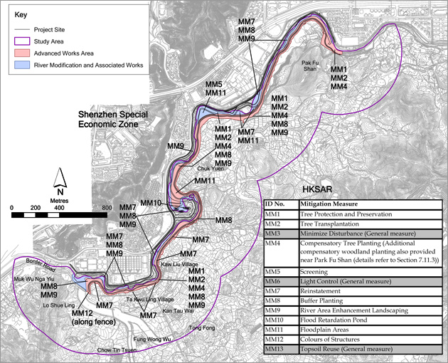
Mitigation Measures are proposed to reduce the significance of adverse landscape and visual impacts and generally improve the amenity value of the Project Site. The proposed mitigation measures are:
| Landscape Mitigation Measures |
| MM1(a) |
Tree Protection and Preservation - Trees/ woodland within the Project Site will be protected and preserved as far as possible in accordance with ETWB TCW No. 29/2004 and 3/2006. |
| MM2(a) |
Tree Transplantation – Should removal of trees be unavoidable due to construction impacts, trees will be transplanted or felled(b) according to the Detailed Tree Survey and Tree Felling Application. Established trees of value are to be re-located where practically feasible. |
| MM3 |
Minimise Disturbance – temporary structures and construction works should be planned with care to minimise disturbance to existing built structures as well as vegetation including riparian vegetation along the river. |
| MM4 |
Compensatory Tree Planting - Where loss of existing trees is unavoidable, compensatory planting of trees should be provided in accordance with ETWB TCW No. 03/2006 to compensate for those trees felled. Space is to be allowed within the Project Site (mainly planting in riverbank landscape areas of ~4.1 ha) for such planting. Plants will have 12 months to establish.
Approximately 0.5 ha of compensatory woodland planting (in addition to the reinstatement of the woodland (LR4) if unavoidably affected) will be provided within the Project Site near Pak Fu Shan. The proposed compensatory woodland planting site will locate adjoining to the reinstated and existing (undisturbed by the Project) woodland on hillside. The selection of planting species shall be made with reference to the species identified in the Tree Survey and be native to Hong Kong or the South China region. The compensatory woodland planting should also adopt ecological design, ie provision of rare butterfly species larval food plant (Trema sp.). The arrangement of the on-site compensatory planting, ie tree/ shrub mix and Trema sp., will be subject to detailed landscape design and planting plan, and recommended to be implemented prior to the construction activities as far as practical.
|
| MM5 |
Screening – Stockpiles of materials should be covered or hoarding erected where possible to reduce undesirable views of the construction site (such as the stockpiling area within the HKSAR on the sharp bend of the river to the north of Chuk Yuen Village, also located within the river modification works), having consideration of safety and security. It is proposed that screening be compatible with the surrounding environment and where possible, non-reflective, recessive colours be used. Hoarding should be taken down at the end of the construction period. |
| MM6 |
Light Control – Control of night time lighting glare shall be implemented to minimize glare impact to adjacent VSRs. |
| MM7 |
Reinstatement – Terrestrial areas temporarily disturbed by the Project during construction, should be re-vegetated with shrubs, ground cover or grass in order to restore the green ambiance or LR as existed before the commencement of the Project to blend with the new environment, eg the earth embankment underneath the boundary patrol road near Pak Fu Shan should be planted to ensure the embankment structure blends in with the new environment. |
| MM8 |
Buffer Planting – Tree and Shrub planting shall be provided for screening the natural watercourse, woodland and shrubby grassland on lowland, proposed boundary patrol road and fencing, where needed and taking into account security and boundary control limitations. |
| MM9 |
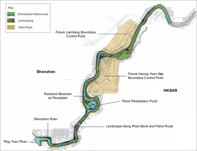
River Area Enhancement Landscaping – The river bed should be non-concreted as far as practical. The River bank and margins of approximately 4.1 ha should be enhanced with vegetation to compensate for the loss of existing vegetation and to enhance the visual and landscape value of the river where slope gradient allows. The overall objectives for the landscaping works will be mainly concerned with ecological enhancement but also include landscape enhancement (see also Note c below).
Final details of the landscaping will be prepared during the detailed design stage of the Project.
|
| MM10 |
Flood Retardation Pond - The flood retardation pond lies within the Shenzhen side of this Project. It should be planted with suitable flora (both aquatic and, riparian) to enhance its landscape value.
Further details of the flood retardation pond can be found in Section 3 (see also Note d below) and final details of the landscaping will be prepared during the detailed design stage of the Project. |
| MM11 |
Floodplain Areas - The areas bound by sharp turns in the natural meander of the river should be made into floodplain areas to retain some of the riparian landscape at the river margins. The overall objectives for the landscaping works will be mainly concerned with ecological enhancement but also include landscape enhancement. Further details will be developed during Detailed Design Stage. |
| MM12 |
Colours of Structures - Colours for the structures eg fences should be chosen to complement the surrounding area. Lighter colours such as shades of light grey, off-white and light brown may be utilised where technically feasible to reduce the visibility of the structures. |
| MM13 |
Topsoil reuse - Excavated topsoil should be conserved for re-use by the Project or other projects. |
|
|