Contents
1.5 Objectives of the EIA Study
1.7 Structure of the EIA Report
Table 1.1: Development Site Area Changes in Town Planning Applications
Table 1.2: Summary of Parameter of the Major Development Components
|
CDWE |
Comprehensive Development with Wetland Enhancement |
|
DP |
Designated Projects |
|
EIA |
Environmental Impact Assessment |
|
EIAO |
Environmental Impact Assessment Ordinance |
|
EIAO-TM |
Technical Memorandum on Environmental Impact Assessment Process |
|
EPD |
Environmental Protection Department |
|
ES |
Executive Summary |
|
GFA |
Gross Floor Area |
|
LC |
Lut Chau |
|
NSW |
Nam Sang Wai |
|
NR |
Nature Reserve |
|
OU(CDWEA1) |
“Other Specified Used” annotated “Comprehensive Development and Wetland Enhancement Area 1” |
|
OZPs |
Outline Zoning Plans |
|
SSSI(1) |
Site of Special Scientific Interest (1) |
|
TPB |
Town Planning Board |
|
TPAB |
Town Planning Appeal Board |
|
TPO |
Town Planning Ordinance |
|
WBA |
Wetland Buffer Area |
|
WCA |
Wetland Conservation Area |
|
WEA |
Wetland Enhancement Area |
|
WCPs |
Wetland Conservation Parks |
1
Introduction
1.1
Background of the Project
1.1.1 This Project “Proposed Comprehensive Development with Wetland Enhancement (CDWE) at Nam Sang Wai (NSW) and Lut Chau (LC)” (herewith “The Project”) aims to conserve and enhance the ecological value and functions of the existing fishponds or abandoned wetlands by creating new wetland habitats and putting into place long term conservation management plan while providing a comprehensive residential development. On the other hand, the Chief Executive’s 2022 Policy Address proposed to develop a Wetland Conservation Parks (WCPs) System, with a view to enhancing conservation of Deep Bay wetlands and increasing the environmental capacity for the development of the Northern Metropolis. The Project is anticipated to contribute positively to the wetland ecosystem of the Inner Deep Bay region. The NSW Wetland Enhancement Area (WEA) and LC Nature Reserve (NR) are both located within the proposed NSW WCP, which will be an important element of the WCPs System, which is a crucial component of the Northern Metropolis Development Strategy.
Planning History
1.1.2 In 1993, an application for planning permission for the development of 2,550 residential units and a golf course at NSW covering 98.3ha and a 41ha NR in LC was made. The application was approved by the Town Planning Appeal Board (TPAB) in 1994 and the decision upheld by the Privy Council in 1996.
1.1.3 In 1994, the Town Planning Board (TPB) gazetted the first Outline Zoning Plans (OZPs) for this area. LC was designated as “Site of Special Scientific Interest (1)” (SSSI(1)) and NSW as “Other Specified Uses” annotated “Comprehensive Development and Wetland Enhancement Area 1” (OU(CDWEA1)). Although the sites fall under different OZPs, both require the sites be developed together and that the development be subject to submission of a comprehensive development scheme covering the residential development and the conservation components of the sites. Accordingly, LC was proposed to be enhanced as a NR with no development permitted, while part of NSW was proposed to be a WEA with a residential development portion permitted.
1.1.4 In 1995, about 1,500ha of wetland in the Mai Po and Inner Deep Bay area including LC (but not NSW) was listed as the Mai Po Inner Deep Bay Ramsar Site.
1.1.5 In 2012, a new application for planning permission (Application No. A/YL-NSW/218) was made to the TPB for a scheme complying with the OZPs. The scheme consisted of 1,600 houses to be built along man-made water courses covering about 49ha (the “Canal Scheme”). That application was rejected by the TPB. Upon application for review of the TPB’s decision under Section 17 of the TPO, the development footprint was reduced to about 40ha. Nevertheless, the TBP still considered the development footprint too large and the “no-net-loss of wetland” principle was not met. The application was rejected, and an appeal was lodged with the TPAB (Appeal No. 3/2014).
1.1.6 In 2015, a further application (No. A/YL/NSW/242) was lodged with a significant decrease in the Development Site area from 40ha to about 11.6ha. The scheme comprised a mixture of towers and houses, an elderly centre, a visitor centre, and an interpretive trail through the edge of the NSW wetland and the NSW WEA and LCNR. This application was rejected by the TPB, and an appeal was lodged with the TPAB (Appeal No. 1/2017).
1.1.7 In 2020-2021, the TPAB considered the two appeals together. During the hearing, it became clear that the second scheme with its much smaller development footprint better satisfied the planning requirements. In view of this, the Project Proponent withdrew the appeal for the first scheme (Application No. A/YL-NSW/218). After detailed examination of the critical assessments of the second scheme, including the ecological and landscape and visual impact assessments, the TPAB issued its decision on 31 December 2021 and granted approval for the Application No. A/YL/NSW/242.
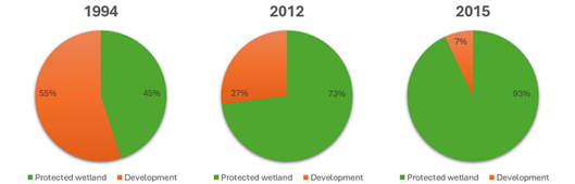
1.1.8 During the prolong planning process, the area of the Development Site was one of the major considerations to minimise the ecological impacts and satisfy the town planning requirement. The development site area has been decreasing during the town planning process and the development scheme with the smallest development footprint is adopted for this Environmental Impact Assessment (EIA). The changes in Development Site area are shown in Table 1.1.
Table 1.1: Development Site Area Changes in Town Planning Applications
|
Year |
Application No. |
Change of Development Site Area and Managed Wetland |
|
1994 |
DPA/YL-NSW/12 |
Development Site area about 98.3ha; Managed Wetland area about 41ha |
|
2012 |
A/YL-NSW/218 |
Development Site area reduced from 98.3ha to 40ha; Managed Wetland area increased from 41ha to 127.7ha |
|
2015 |
A/YL/NSW/242 |
Development Site area reduced from 40ha to 11.6ha; Managed Wetland area increased from 127.7ha to 154.4ha. |
Change in Development Area versus Protected Wetland across the Three Schemes
Environmental
Impact Assessment Ordinance Submission
1.1.9 A Project Profile (PP-461/2012) for the “Proposed Comprehensive Development with Wetland Enhancement (CDWE) at Nam Sang Wai and Lut Chau” (“the Project”) was submitted to the Environmental Protection Department (EPD) on 27 March 2012 under Section 5(1)(a) of the Environmental Impact Assessment Ordinance (EIAO). On 7 May 2012, EPD issued an EIA Study Brief for the Project (ESB-244/2012).
1.1.10 The EIA Study commenced in August 2012. While the EIA Study was underway, the Project Proponent gave due consideration to alternative schemes including but not limited to the layout and scale, comparing the benefit and dis-benefits to the environment, as required under Clause 2.1(iii) of the EIA Study Brief, to formulate a preferred comprehensive development scheme that strikes a balance between conservation and development and at the same time enhances the ecological value and function of those degraded and abandoned wetland habitats. The Project Boundary was updated to exclude a piece of land and a section of a stream south of LC to further reduce the project footprint.
1.1.11 In April 2022, the Project Proponent consulted with the Director of Environmental Protection and were advised that as the key components in the Project Profile submitted with the application for the EIA Study Brief had not been altered, and the scope covered by the EIA Study Brief would remain unchanged. Thus, an application for a new EIA Study Brief was not required.
1.1.12 The EIA study was conducted for the Project in accordance with the requirements of the EIA Study Brief and the Technical Memorandum on Environmental Impact Assessment Process (EIAO-TM). The purpose of this EIA Study is to provide detailed assessment on potential environmental impacts and environmental benefits arising from the construction and operation of the Project.
1.2
Details of the Project
1.2.1 The Project consists of two separate sites located in NSW and LC with total area of 177.3ha which comprises 154.4ha of managed wetland, 11.6ha of Development Site providing 2,521 residential units with a design population of 6,500, 3.3ha of public park cum visit centre and a proposed bridge.
1.2.2 The Development Site is in the southern portion of NSW, which is farthest away from Inner Deep Bay area, while the NSW WEA creates a buffer area separating the Development Site from Inner Deep Bay and the LCNR creates direct ecological linkages with MPNR. Table 1.2 summarises the major development components of the Project.
Table 1.2: Summary of Parameter of the Major Development Components
|
Development Component |
Development Parameter |
|
Total Managed Wetland |
154.4ha |
|
- LCNR |
55.4ha |
|
- NSW WEA |
99ha |
|
Development Site |
11.6ha |
|
- Residential Use |
Total Gross Floor Area (GFA): 306,581 m2 Total No. of Units: 2,521 |
|
- Houses |
No. of Units: 140 No. of Storeys: 3 Storeys above Basement Car Park |
|
- Apartment Blocks |
No. of Blocks: 28 No. of Units: 2,381 No. of Storeys: 19 to 25 Storeys above Basement Car Park |
|
- Residents’ Clubhouse |
No. of Storeys: 2 Storeys including Basement |
|
- Elderly Centre |
GFA: 6,754 m2 No. of Storeys: 6 Storeys |
|
- Commercial Use |
Area: 1,575 m2 No. of Storey: 1 Storey |
|
- Visitor Centre |
GFA: 1,230 m2 No. of Storeys: 2 Storeys |
|
- Proposed Bridge |
Connecting southwestern part of the NSW site and Wang Lok Street |
|
Note: (1) The Project Site also include (1) Developed Area (~3.0ha); (2) Managed grassland (~1.2ha); and (3) Plantation areas (~7.1ha) in NSW will be remained as current status. (2) Approximately 3.3ha managed grassland and plantation area currently open for public use will be preserved in the proposed public park. |
|
1.3
Designated Projects
1.3.1 The Project aims to conserve and enhance the ecological value and functions of the existing fishponds or abandoned wetlands by creating new wetland habitats and putting into place long term conservation management plans while providing a comprehensive residential development. The Project is a designated project under Item P1, Part I, Schedule 2 of the EIAO, “A residential or recreational development other than New Territories exempted houses, within Deep Bay Buffer Zone 1 or 2.”.
1.3.2 Following amendments made to the relevant ordinance to optimize the EIAO process in 2023, this project is no longer classified under the designated projects listed in EIAO Schedule 2 Part 1 Category Item A.8 (i.e., amended wording for this item), Item F.3(b) (i) & (v) (i.e., repealed for this item) and Item Q1 (i.e. amended wording for exception list of this item). Furthermore, the designated project specified in EIAO Schedule 3 Item 1 was repealed, i.e., “Engineering feasibility study of urban development projects with a study area covering more than 20 ha or involving a total population of more than 100 000.”.
1.4
Purpose of the
EIA Study
1.4.1 In accordance with Clause 1.5 of the EIA Study Brief, the purpose of this EIA Study is to provide information on the nature and extent of environmental impacts arising from construction and operation of the Project and related activities taking place concurrently. This information will contribute to decisions by the Director on:
i. The acceptability of adverse environmental consequences that are likely to arise as a result of the Project;
ii. The conditions and requirements for the design, construction and operation of the Project to mitigate against adverse environmental consequences; and
iii. The acceptability of residual impacts after the proposed mitigation measures are implemented.
1.5
Objectives of the EIA Study
1.5.1 In accordance with Clause 2.1 of the EIA Study Brief, the objectives of the EIA are as follows:
i. To describe the Project and associated works together with the requirements and environmental benefits for carrying out the Project;
ii. To identify and describe elements of community and environment likely to be affected by the Project and/or likely to cause adverse impacts to the Project, including the natural and man-made environment and the associated environmental constraints;
iii. To provide information on the consideration of alternatives including, but not limited to, location, layout, scale, scope, design, construction method and mode of operation, with a view to avoiding and minimising the potential environmental impacts to environmentally sensitive areas and other sensitive uses; to compare the environmental benefits and dis-benefits of different alternatives; to provide reasons for selecting the preferred option(s); and to describe the part environmental factors played in the selection of the preferred option(s);
iv. To identify and quantify all environmental sensitive receivers, emission sources and determine the significance of the impacts on sensitive receivers and potential affected uses and to propose measures to mitigate these impacts with respect to air quality, noise, water quality, waste, land contamination and landscape and visual;
v. To identify and quantify any potential losses or damage to flora, fauna and wildlife habitats and to propose measures to mitigate these impacts;
vi. To identify any negative impacts on sites of cultural heritage and to propose measures to mitigate these impacts;
vii. To identify and systematically evaluate any potential landscape and visual impacts and to propose measures to mitigate these impacts;
viii. To propose mitigation measures to minimise pollution, environmental disturbance and nuisance during the construction and operation of the Project;
ix. To investigate the feasibility, practicability, effectiveness and implications of the proposed mitigation measures;
x. To identify, predict and evaluate the residual environmental impacts (i.e. after practicable mitigation) and the cumulative effects expected to arise during construction and operation of the Project in relation to the sensitive receivers and potentially affected uses;
xi. To identify, assess and specify methods, measures and standards, to be included in the detailed design, construction and operation of the Project which are necessary to mitigate these environmental impacts and cumulative effects and reduce them to acceptable levels;
xii. To investigate the extent of the secondary environmental impacts that may arise from the proposed mitigation measures and to identify constraints associated with the mitigation measures recommended in the EIA study, as well as the provision of any necessary modification;
xiii. To identify, within the study area, any individual project(s) that fall under Schedule 2 and/or Schedule 3 of the EIA Ordinance; to ascertain whether the findings of this EIA study have adequately addressed the environmental impacts of those projects; and where necessary, to identify the outstanding issues that need to be addressed in any further detailed EIA study; and
xiv. To design and specify environmental monitoring and audit requirements to check the effective implementation of the recommended environmental protection and pollution control measures.
1.6
Scope of the EIA Study
1.6.1 This EIA report addresses all key potential environmental issues associated with the construction and operation phases of the Project, which are as specified under Clause 3.2 of the EIA Study Brief:
i. Noise impacts arising from construction and operation of the Project to the nearby village areas and development;
ii. Air quality impacts on air sensitive receivers during the construction and operation of the Project, including dust, gaseous emissions and odour arising from the construction and operation of the Project;
iii. Landscape and visual impacts during construction and operation of the Project;
iv. The potential water quality impacts caused by site formation, pond draining and filling, drainage diversion, and any other works activities during construction; the potential water quality impacts caused by the operation of the Project;
v. The potential impacts on sites of cultural heritage from construction and operation of the Project;
vi. Direct and indirect terrestrial and aquatic ecological impacts, in particular the potential impacts of wetland loss, disturbance and fragmentation on the recognized sites of conservation importance in the project site and its vicinity including, for example, the Mai Po Nature Reserve, Mai Po Inner Deep Bay Ramsar Site, Mai Po Marshes SSSI, Inner Deep Bay SSSI, Priority Sites for Enhanced Conservation identified under the New Nature Conservation Policy, Wetland Conservation Area (WCA) and Wetland Buffer Area (WBA) [both were defined under Town Planning Board Guidelines TPB PG-No.12B] and important habitats such as fish ponds, reedbeds, mangroves and intertidal mudflat, Kam Tin Main Drainage Channel and Shan Pui River, roosting sites of Great Cormorant and egretries, due to the construction and operation of the Project;
vii. Fisheries impacts during construction and operation of the Project;
viii. Collection and disposal of potentially contaminated dredged spoil arising from the Project;
ix. The potential waste management issues and impacts arising from the construction and operation of the Project, including handling and disposal of construction and demolition materials and sludge from wastewater treatment if any;
x. The potential land contamination arising from the Project;
xi. The potential cumulative environmental impacts of the Project and associated works, through interaction or in combination with other existing, committed and planned projects in their vicinity, and that those impacts may have a bearing on the environmental acceptability of the Project.
1.7
Structure of the EIA Report
1.7.1 This EIA report has been structured as follows:
Chapter 1 – Introduction presents the project background and objective of the EIA study.
Chapter 2 – Project Description presents information on project details including concurrent projects and the consideration of project alternatives.
Chapter 3 – Air Quality Impact presents the approach, findings and recommendations from the air quality impact assessment.
Chapter 4 – Ecological Impact (Terrestrial and Aquatic) presents the approach, findings and recommendations from the ecological impact assessment.
Chapter 5 – Fisheries Impact presents the approach, findings and recommendations from the fisheries impact assessment.
Chapter 6 – Water Quality Impact presents the approach, findings and recommendations from the water quality impact assessment.
Chapter 7 – Waste Management presents the approach, findings and recommendations from the waste assessment.
Chapter 8 – Land Contamination presents the approach, findings and recommendations from the land contamination assessment.
Chapter 9 – Noise Impact presents the approach, findings and recommendations from the noise impact assessment.
Chapter 10 – Landscape and Visual Impact presents the approach, findings and recommendations from the landscape and visual impact assessment.
Chapter 11 – Cultural Heritage Impact presents the approach, findings and recommendations from the cultural heritage impact assessment.
Chapter 12 – Sewerage and Sewage Treatment Implications presents the approach, findings and recommendations from the sewerage impact assessment.
Chapter 13 – Conclusion summarises the findings and recommendations from the EIA.
Chapter 14 – Environmental Monitoring and Audit summarises the environmental monitoring and audit requirements specified in Chapters 3 to 12.
An Executive Summary (ES) was prepared in both Chinese and English as separate documents.
|
|