Contents
2.2 Existing and Surrounding Conditions of the Project Site
2.3 Opportunities and Constraints of Project
2.5 Consideration of "Without Project" Scenario
2.7 Consideration of Alternatives
Table 2.1: Number of Bird Species Recorded at NSW, LC and MPNR
Table 2.2: Summary of Parameter of the Major Development Components
Table 2.3: Timeline of the Past Town Planning Application Process
Table 2.4: Evaluation of Development Alternatives
Table 2.5: Overlapping Construction Period of Potential Concurrent Projects
|
Location of the Project |
|
|
Key Project Components |
|
|
Proposed Master Layout Plan |
|
|
Proposed Basement Plan |
|
|
Conceptual Design of Proposed Bridge |
|
|
Development Alternatives Considered |
|
|
Options for Vehicular Access to the Site |
|
|
Construction Phasing Plan |
|
|
Location of Concurrent Projects |
Appendices
|
Tentative Construction Programme |
|
ADWF |
Average Dry Weather Flow |
|
CDWE |
Comprehensive Development with Wetland Enhancement |
|
CEDD |
Civil Engineering and Development Department |
|
CMP |
Conservation Management Plan |
|
DS |
Development Site |
|
EcoIA |
Ecological Impact Assessment |
|
E&M |
Electric and Mechanical |
|
EIA |
Environmental Impact Assessment |
|
GBA |
Greater Bay Area |
|
GIC |
Government, Institution and Community |
|
GFA |
Gross Floor Area |
|
HOS |
Home Ownership Scheme |
|
KTMDC |
Kam Tin Main Drainage Channel |
|
LC |
Lut Chau |
|
LCNR |
Lut Chau Nature Reserve |
|
MPNR |
Mai Po Nature Reserve |
|
MSB |
Multi-Storey Building |
|
MTR |
Mass Transit Railway |
|
NR |
Nature Reserve |
|
NSW |
Nam Sang Wai |
|
OZP |
Outline Zoning Plan |
|
PPP |
Public-Private Partnership |
|
RCHE |
Residential Care Home for the Elderly |
|
TPAB |
Town Planning Appeal Board |
|
TPB |
Town Planning Board |
|
WCA |
Wetland Conservation Area |
|
WEA |
Wetland Enhancement Area |
|
YLEPP |
Yuen Long Effluent Polishing Plant |
|
YLSTW |
Yuen Long Sewage Treatment Works |
|
YLTN |
Yuen Long Town Nullah |
2
Project Description
2.1
Project Site History
2.1.1 The land use and landscape of Nam Sang Wai (NSW) and Lut Chau (LC) have changed throughout the various stages of economic growth in Hong Kong. Historically, Gei wai (shrimp) ponds were prevalent by the 1980s, all had been converted to freshwater fishponds. By the mid-1990s, many fishponds at NSW were inactive.
2.1.2 The NSW site consist of both private and government land. Part of the NSW site has been in the ownership of the Fu’s Family for many years and had previously been used for farming and fishpond operations. The remains of the family house can still be found located near the centre of the site. The private land has been unused for many years and much of the fishpond area has been colonised by reeds and other aquatic plants. The remaining parts of the NSW site are government land, some of which is leased for commercial fish farming and some of which is an informal area for leisure. When the government undertook the drainage channel improvements, areas of reclamation were created, and a maintenance access road built. Public access is available to this area, and use of the government land as an informal public open space which has become an important location for passive recreation and for the public to view the birdlife on the former fishpond area and on the river channels.
2.2
Existing
and Surrounding Conditions of the Project Site
2.2.1 The Project consists of two separate sites located in NSW and LC, Yuen Long with a total area of 177.3ha. The location and existing condition of the Project Site are described below, and the location of the Project is shown in Figure 2.1.
Nam Sang Wai
2.2.2 NSW is 121.9ha is currently zoned as "Other Specified Uses (Comprehensive Development and Wetland Enhancement Area 1)" (OU(CDWEA1)) under the Approved Nam Sang Wai Outline Zoning Plan No. S/YL-NSW/9. NSW is also within the boundary of Wetland Conservation Area (WCA) but not within the Ramsar Site.
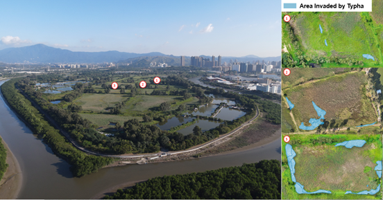
2.2.3 NSW largely consists of fishponds that are managed for fish farming and abandoned fishponds that have been undergone ecological succession through sedimentation and colonisation by vegetation which led to the establishment of the largest area of reedbed (a much rarer habitat than fishpond) in Hong Kong. However, this process is now at a point where the reedbed is drying out and being replaced by common non-wetland habitats of very limited ecological value. Furthermore, the reedbed is being invaded by Typha, an aggressive non-native herb that outcompetes and replaces the reeds, whilst other areas have become degraded by illegal dumping and poor fishpond management practices. Around the perimeter are areas of plantation and an area of grassland used by the public for leisure.
2.2.4 NSW is bounded by Shan Pui River and Kam Tin Main Drainage Channel (KTMDC) River to the west and the east, and the Mai Po Inner Deep Bay Site of Special Scientific Interest (SSSI) which is within the Mai Po Inner Deep Bay Ramsar Site to the north. Yuen Long Industrial Estate is situated to the west of NSW across Shan Pui River while the Tung Tau industrial/ business area of Yuen Long Town, which is a mixture of village development and high-rise residential development, are located to the south.
Lut Chau
2.2.5 LC is 55.4ha and is currently zoned as SSSI(1) under the Approved Mai Po and Fairview Park Outline Zoning Plan No. S/YL-MP/8. LC falls within the Mai Po Inner Deep Bay Ramsar Site and is contained within the Mai Po Inner Deep Bay Ramsar Site Management Plan.
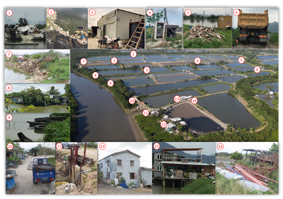
2.2.6 LC is largely used for commercial fish farming; the physical environment is generally poor due to improper management practices and unauthorized activities. These include the storage of materials unrelated to fisheries operation (notably abandoned houses and empty containers), illegal dumping of construction materials/waste and general waste, suction dredging of fishpond mud into adjacent creeks connected to Deep Bay, and the destruction of mangroves to expand fishponds. The latter is particularly destructive, and an analysis of aerial photographs has shown that between 2005 and May 2021, approximately 4.1ha of mangrove (some of which is within the Core Area of the Ramsar Site) have been destroyed. Such improper activities bring additional disturbance to wildlife and this is exacerbated by presence of large numbers of free-roaming dogs and cats, which could cause disturbance to bird using nearby fishponds.
|
Photos of Nam Sang Wai Existing Environment |
|
|
|
Photo taken in January 2024 |
|
Photos of Lut Chau Existing Environment |
|
|
|
Photo taken in January to April 2024 |
2.3
Opportunities and Constraints of Project
2.3.1 The Project comprises four key components: (i) a Nature Reserve (NR) and Wetland Enhancement Area (WEA), (ii) a public park cum visitor centre, (iii) a Development Site, and (iv) a proposed bridge. This section outlines the opportunities and constraints for the Project.
Project Opportunities
Conservation of Wetland Habitat
2.3.2 Since 2008, the number of migratory waterbirds in Inner Deep Bay has declined by half and the number has remained low in the past decade. One of the key factors of the decline in waterbirds is the deterioration of wetland habitats because of a lack of proper management and an increase in human disturbance. As echoed in the Strategic Feasibility Study on the Development of Wetland Conservation Parks System Under the Northern Metropolis Development Strategy (hereafter as WCP Feasibility Study Report) “the wetlands still face multiple challenges, including gradual degradation in their ecological value / function due to lack of conservation management, illegal development and fly tipping, etc.” (AFCD, 2024), there is an urgent need for wetland enhancement with long term management planning to conserve the wetland ecosystems in the Inner Deep Bay and Mai Po ecosystem. As elaborated in Section 2.2 above, the condition of the wetland in NSW and LC continues to deteriorate. There is an urgent need to implement the zoning intention of the OZPs to enhance the ecological value and function in these areas.
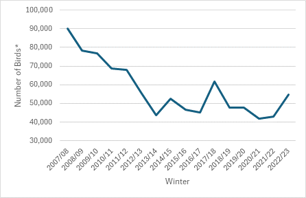
Peak waterbird number in Deep Bay, 2007/08 to 2022/23
2.3.3 As shown in Table 2.1, it is notable that despite its being immediately adjacent to MPNR and hence its lying in the heart of the Ramsar Site, both the Literature Review and the Baseline Surveys undertaken for this EcolIA revealed that fewer bird species and bird species of conservation importance are present at LC than at NSW. Also, whilst the totals shown in Table 2.1 are not directly comparable, the much greater number of species seen at MPNR is a clear indication of the potential that might be realised at LC with appropriate conservation management in place. The Project thus provides a major opportunity to restore and enhance LC and allow it to fulfil its ecological potential after decades of neglect.
Table 2.1: Number of Bird Species Recorded at NSW, LC and MPNR
|
Avifanua |
NSW |
LC |
MPNR* |
||
|
Literature Review |
Baseline Survey |
Literature Review |
Baseline Survey |
||
|
Number of species of conservation importance |
57 |
55 |
38 |
37 |
248 |
|
Total number of species |
138 |
122 |
79 |
79 |
420 |
|
* The “Mai Po bird species list” (WWFHK, 2022) |
|||||
2.3.4 The WCP Feasibility Study Report also mentioned that “For the area of the Nam Sang Wai / Lut Chau project which is a potential project under the NNCP PPP Scheme that is identified as “Area for Potential Inclusion”, it is approximately 179ha, comprising mainly marsh habitats in Nam Sang Wai and fishpond habitats in Lut Chau. If the area of Nam Sang Wai / Lut Chau project is considered suitable / feasible for inclusion in the NSW WCP in future after further detailed study, the concerned area could be enhanced as ecological habitats and / or eco-friendly aquaculture.” (AFCD, 2024), the area of the NSW WEA and LCNR are demarcated as “Area for Potential Inclusion” in the boundary delineation of the Nam Sang Wai Wetland Conservation Park (NSW WCP), which will be an important element of the WCPs System, which is a crucial component of the Northern Metropolis Development Strategy. The WCPs System is proposed to “create environmental capacity for the development of the Northern Metropolis by enhancing natural habitats and other environmental conditions” (AFCD, 2024). The Project proposals have taken into consideration the possibility of future incorporation of the NSW WEA and LCNR into the NSW WCP.
2.3.5 As mentioned in S.1.1.3, the planning intention of the “OU(CDWEA1)” zone for NSW is to enhance the ecological value and function of the existing fishponds or wetland through development or redevelopment under the “private-public partnership (PPP) approach”. This offers an opportunity for providing long-term conservation and management of the NSW WEA and LCNR through the implementation of the Project.
2.3.6 Originally the Eucalyptus trees planted at NSW were chosen to demarcate the private landholding, but these trees unintentionally became the signature element of the NSW landscape character and a ‘heritage’ feature. They also now provide important roost trees for wintering Great Cormorants. However, they are now reaching the end of their limited life spans of about 60 years. Without the implementation of the proposed management and replanting plan, this important feature of the NSW will gradually be lost.
Promotion of Eco-tourism and Nature Conservation
2.3.7 NSW is frequently visited by the public for nature appreciation, and there are currently no amenities to serve the visitors. There is an opportunity to provide facilities including Nature Trails and Boardwalks, Bird Watching Hides and a Visitor Centre in the Project to cater for the visitors and promote eco-tourism as well as education on nature conservation. These proposals are compatible with the proposed theme of the NSW WCP as “An Eco-tourism Paradise”.
Support Accommodation for Elderly
2.3.8 The elderly population in Hong Kong continues to grow and there is an increasing demand for suitable care home accommodation. The Project is an opportunity to provide Residential Care Homes for the Elderly (RCHE) facilities to meet this need and play a part in promoting a more inclusive community.
Project Constraints
Planning Intention of OU(CDWEA1)
2.3.9 The planning intention of NSW site requires that any new building be located farthest away from Deep Bay; accordingly the proposed Development Site is located in the southernmost portion of NSW which is the farthest away from Deep Bay.
Habitat Fragmentation
2.3.10 Bird usage is higher in contiguous and continuous ponds, and fragmentation or disturbance can reduce their habitat use and the number of birds present. To address this, the design of the NSW WEA and the LCNR needs to provide a large area of interconnected ponds, both to conserve the existing function of the ponds and maintain their continuity and contiguity. As well as avoiding the Eucalyptus clusters which are the roosting sites for the Great Cormorants, the Development Site is located where it will entirely avoid fragmentation as a result of interruption of flightlines used by the cormorants flying from the roosting sites to their feeding areas, as well as flightlines of other species such as egrets.
No-net-loss of Wetland Function
2.3.11 Any development impact must be compensated for by maintaining no net loss in wetland function. In this regard, the Project will result in no net loss in wetland function whilst the proposed NSW WEA and LCNR will achieve a level of wetland function that considerably greater than the existing condition.
Ecological Constraints
2.3.12 Within the Project Site, there are existing groups of Eucalyptus trees in NSW which form an important roosting site for Great Cormorants, while existing mangroves at NSW and LC also provide habitat for Mai Po Bent-winged Fireflies. Conservation of these roosting sites and habitats, as well as the need to avoid blocking the flightlines of the cormorants between their roosting sites and foraging areas and other flightlines of birds impose constraints on the Project’s layout and design.
No Net Increase in Pollution Load in Deep Bay
2.3.13 The Deep Bay catchment is recognised as being a highly sensitive ecological area with a requirement for ‘no net increase in pollution load’ from development activities. To meet this requirement, the Project will include design and operational measures to prevent pollution discharge into the surrounding rivers during the construction and operational phases. The development will be supported in this aspect by the Yuen Long Sewage Treatment Works at the north of Yuen Long Industrial Estate.
Consideration of Fung Shui
2.3.14 An ancestral hall of Shan Pui Village is located nearby, making crucial for the Project to maintain a Fung Shui corridor for the village after the consultations with the villagers. The layout of the houses and apartment blocks will be designed in a way that minimizes the impact on the Fung Shui Corridor which runs in a north-south direction. This imposes another constraint in the planning of the development.
2.4
Benefits of the Project
Conservation before Development
2.4.1 To minimise and compensate for the adverse environmental impacts of the Project and as a commitment of ecological enhancement, the Project is adopting conservation before construction approach. The construction works of wetland enhancement will be completed in advance of the commencement of construction of the residential portion, such that compensatory habitat will be available for fauna which may be displaced by loss or disturbance to habitats within or in vicinity to the Development Site. Thereafter the Project Proponent intends to adopt for the Additional Option under the New Nature Conservation Policy (NNCP) PPP Scheme regarding the LCNR and NSW WEA. The requirements of the Additional Option under the NNCP PPP Scheme are that, inter alia, (i) a lump sum contribution be made to the Government, and (ii) the Conservation Portion be surrendered to the Government for management by the Government. In this instance the Conservation Portion shall comprise the LCNR and the NSW WEA which will be handed over to the Government for long-term conservation works. This will provide a settled and stable environment in perpetuity for nature conservation and ensure no degradation in ecological value of the enhanced habitats.
2.4.2 LC will become a NR and the NSW WEA will also be a managed wetland reserve with some public access.
Enhancement of Biodiversity with Different Habitats Created
2.4.3 At LCNR, the establishment of new wetland habitats (including shallow tidal pond, lily pond and permanently wet reedbed) will provide a more diverse mix of habitats and will create habitats suitable for a wider range of species. Conservation management of LCNR will contribute to enhancing ecological connectivity with the Mai Po and Inner Deep Bay wetland ecosystem.
Removal of Illegal Activities, Pollutions and Disturbance
2.4.4 Establishing the LCNR will end damaging and illegal practices there, including the destruction of mangrove in the Core Area of the Ramsar Site. Free-roaming dogs and cats will be removed ending predation and disturbance of wildlife. Despite being adjacent to MPNR, it is notable that Eurasian Otter has never been observed at LC. It is highly likely that this absence is related to high levels of disturbance and the presence of stray dogs (which are known to kill otters in Hong Kong). Provision of suitable conditions for Eurasian Otter will be a conservation priority in the LCNR.
Proper Long-term Management
2.4.5 The implementation of a plan for replacement of the Eucalyptus trees that are reaching the end of their biological life will secure the long-term integrity of the Great Cormorant roosting sites.
2.4.6 At NSW and LC, a Mangrove Management Plan will be formulated to restore and maintain native mangrove areas. Areas that have been filled and invasive exotic plants will be removed and replaced with native mangrove communities creating a habitat for the Mai Po Bent-winged Firefly, and other mangrove-dependent species.
Synergistic Effect on Conservation of Inner Deep Bay Wetland Ecosystem
2.4.7 Only 11.6ha of the Project Site will be developed. With the implementation of the Project, 154.4ha (99ha at NSW and 55.4ha at LC) of enhanced wetland will be made available in a few years’ time and added to the managed and protected wetland network in Inner Deep Bay. This equates to about 72% of the area of MPNR or about 45% of the proposed Sam Po Shue Wetland Conservation Park .
2.4.8 In para. 167 of its Decision on 31 December 2021, the TPAB quoted from the Appellant’s case that “It is considered that by a combination of fish pond enhancement and the creation of a more intensely managed reedbed and marshland area it is realistic to predict that at least a doubling in the carrying capacity of the current fish pond habitat can be achieved overall”, and stated “We accept that the statement (which referenced the LMC Environmental Impact Assessment) [is] objective and reasonable. There is no good practical reason why the extent of enhancement at the NSW and LC sites combined would not at least double (TPAB’s emphasis).
2.4.9 Indeed, as is referenced in para. 137 of its Decision, the LMC EEA achieved an enhancement factor of 5 times. With a much larger area and a location much closer to the key intertidal mudflats and MPNR area, there is a strong likelihood that the NSW WEA and the LCNR will achieve a similar degree of enhancement of wetland function. As found in the TPAB, the enhancement would be at least double, and up to some 5 times (para. 169 of its Decision). As this enhancement is higher than the levels of enhancement required to mitigate for the impacts of the Project, NSW WEA and the LCNP may potentially in a significant contribution to ecological conservation and increasing the environmental capacity of the Inner Deep Bay wetland ecosystem in perpetuity.
Additional Conservation Initiatives
2.4.10 The peripheral bund at LCNR will be raised to create safe high tide roosting sites for shorebirds and other species using the intertidal mudflats of Deep Bay, considering storm surges and compensate for some of the impacts to the mudflat in Deep Bay Area from rising sea levels caused by climate change.
2.4.11 The LCNR will also create a permanent and safe site for egrets to roost and potentially breed, providing an island sanctuary for egrets and other bird species thereby contributing to their conservation.
2.4.12 Though Eurasian Otter was not found during the recent ecological survey, otter holts will be provided in the WEA as an additional conservation initiative in case they appear again in the future.
Promotion of Sustainable Fisheries
2.4.13 With the implementation of fishpond enhancement works and management measures, it is anticipated that the fishponds in LCNR and NSW WEA will be managed and operated in an environmentally sustainable manner. The overall aquaculture environment and quality of fisheries resources in both NSW WEA and LCNR will be significantly improved; in conjunction with the comprehensive wildlife management measures proposed in the CMP, the Project will result in a significant improvement in the overall environment of LC and NSW.
Societal Benefits
2.4.14 The existing public park to the west of NSW is popular for recreational activities including pre-wedding photo shoots, outdoor fitness training, informal sports activities, exercising dogs, and bird watching. This area will be retained as a public park that is separated from the NSW WEA, with improvement works designed to retain the existing character of the area while enhancing the user-friendliness and safety for enjoyment by the public.
2.4.15 The proposed visitor centre provided with small convenience shop and café to cater for the visitors and space for educational activities, group activities and bird watching will help to promote eco-tourism and education on nature conservation.
2.4.16 An elderly centre, a unique 6-storey building designed for RCHE use, is proposed at an exclusive location in the northern part of the Development Site, away from traffic noise and having a magnificent view of and adjacent to the wetland and public park. The elderly centre will provide quality accommodation for the elderly in a serene environment and contribute to easing the shortage of RCHE facilities.
2.4.17 The proposed Development Site will provide a total of 2,521 residential units, comprising dwellings of various sizes, to meet the long-term housing demand of Hong Kong.
2.4.18 The project proponent shall explore with relevant government departments to obtain agreement to access the government land within LCNR and NSW WEA for implementation of the wetland enhancement works. The Project Proponent will carry out the wetland enhancement work on the Conservation Portion of the Project Site before surrendering the private land and making a lump sum contribution to the Government adequately for the long-term management and maintenance of the Conservation Portion (i.e. LCNR and NSW WEA), subject to (i) the Government’s acceptance of the Project Proponent’s application/proposal for and (ii) the Project Proponent’s compliance with the requirements of the NNCP PPP Scheme.
2.4.19 The Project proposals will be in line with the objectives of the proposed NSW WCP as “An Eco-tourism Paradise” by providing facilities including Nature Trails and Boardwalks, Bird Watching Hides and a Visitor Centre to cater for the visitors and promote eco-tourism as well as education on nature conservation. The Project proposals also aim at enhancing the existing wetland ecological value and function by wetland creation for target species that will also benefit to other wetland fauna with long-term management plan in order to “create environmental capacity for the development of the Northern Metropolis” as is stated in the AFCD’s WCP Feasibility Study Report.
2.5
Consideration of "Without Project" Scenario
2.5.1 It is anticipated that the situation of Project Site remains status quo without the implementation of the Project. The abandoned fishponds within the NSW will continue to degrade through sedimentation and colonisation of exotic vegetation. NSW ultimately will lose the wetland function and the important natural feature of the NSW site will be completely lost. Besides, as mentioned in S.2.2.6, the illegal activities, pollutions and disturbance at LC were observed and these are highly disturbing the habitats at LC and subsequently invading the mangrove habitat. The continuous lack of proper management and illegal acts (e.g., mangrove destruction) in the areas are expected to cause further environmental degradation, leading to decreasing in ecological value and biodiversity.
2.5.2 It is foreseeable that unless the Project Site be developed in a comprehensive manner with long-term wetland enhancement and management, the area will continue to undergo degradation and would not achieve the wetland conservation objectives and zoning intention.
2.6
Project
Components
2.6.1 The Project consists of two separate sites located in NSW and LC with total area of 177.3ha which comprises 154.4ha of managed wetland, 11.6ha of Development Site providing 2,521 residential units with a design population of 6,500, 3.3ha of public park cum visit centre and a proposed bridge.
2.6.2 The Development Site is in the southern portion of NSW, which is the farthest away from Inner Deep Bay area, while the NSW WEA creates a buffer area separating the Development Site from Inner Deep Bay and the LCNR creates direct ecological linkages with Mai Po Nature Reserve (MPNR). The locations are shown in Figure 2.2. Table 2.2 summarises the major development components of the Project.
Table 2.2: Summary of Parameter of the Major Development Components
|
Development Component |
Development Parameter |
|
Total Managed Wetland |
154.4ha |
|
- LCNR |
55.4ha |
|
- NSW WEA |
99ha |
|
Development Site |
11.6ha |
|
- Residential Use |
Total Gross Floor Area (GFA): 306,581 m2 Total No. of Units: 2,521 |
|
- Houses |
No. of Units: 140 No. of Storeys: 3 Storeys above Basement Car Park |
|
- Apartment Blocks |
No. of Blocks: 28 No. of Units: 2,381 No. of Storeys: 19 to 25 Storeys above Basement Car Park |
|
- Residents’ Clubhouse |
No. of Storeys: 2 Storeys including Basement |
|
- Elderly Centre |
GFA: 6,754 m2 No. of Storeys: 6 Storeys |
|
- Commercial Use |
Area: 1,575 m2 No. of Storey: 1 Storey |
|
- Visitor Centre |
GFA: 1,230 m2 No. of Storeys: 2 Storeys |
|
- Proposed Bridge |
Connecting southwestern part of the NSW site and Wang Lok Street |
|
Note: (1) The Project Site also include (1) Developed Area (~3.0ha); (2) Managed grassland (~1.2ha); and (3) Plantation areas (~7.1ha) in NSW will be remained as current status. (2) Approximately 3.3ha managed grassland and plantation area currently in open for public use will be preserved in the proposed public park. |
|
Nature Reserve and Wetland Enhancement Area
2.6.3 As permitted under the OZP and to ensure compliance with the Town Planning Board (TPB) Guideline No.12C in no net loss of wetland function, the Project is proposed to be developed together with the conservation of SSSI (i.e., the LC Site) in a comprehensive and integrated manner. The proposed NSW WEA and LCNR will cover a total area of 154.4ha, providing a gross wetland area of approximately 151.8ha upon completion of the implementation of the Conservation and Management Plan (CMP). The NSW WEA and LCNR will complement the existing Mai Po NR to increase the area of wetland in Deep Bay which is protected and actively managed for the benefit of wildlife. The location of these sites close to the intertidal mudflats at the core of Deep Bay will provide a larger protected area within the Deep Bay ecosystem and ensure enhanced ecological links between these three managed areas. The NR and WEA will mainly consist of the following habitats, further detailed in Chapter 4:
● Ponds/open waters;
● Lily pond;
● Shallow tidal pond;
● Reedbed;
● Wet grassland;
● Mangrove; and
● Tidal watercourse.
2.6.4 The proposed habitat enhancement at LCNR and NSW WEA, as detailed in Chapter 4 and appended CMP is expected to provide increased security for wetland habitats and allow for future enhancement by appropriate wetland management. Following the completion of the development and the implementation of the CMP, the total managed wetland will be 154.4ha, approximately 71.6% of the MPNR area (According to the Mai Po Nature Reserve Management Plan: 2019-2024, the Biodiversity Management Zones in the MPNR being 212ha).
Public Park cum Visitor Centre
2.6.5 On the western side of NSW WEA, there is an open space currently functioning as public park, located adjacent to the Shan Pui River. A proposed 3.3ha public park would preserve the grassland and trees without changing the informal character and retaining it in public ownership. In addition, a 2-storey visitor centre will be provided aiming to provide space for interpretation and public education on wetlands. The existing wooden jetty popular for wedding photography within the Development Site is intended to be reprovisioned at the pond edge of the public park, offering photo opportunities without conflicting with the WEA’s ecological conservation objectives. The visitor centre with a footprint of 684 m2 (i.e., 0.0684ha), with public toilets, a small café, an exhibition space, a lecture room, and a bird view club. The visitor centre will also be a hostel with 40 beds to provide overnight accommodation for groups to stay. The details of the proposed public park and visitor centre might be subject to further discussion and agreement with the government.
Development Site
2.6.6 The Development Site is proposed to be located at the NSW site, with an area of approximately 11.6ha. The Development Site will consist of residential units, two clubhouses, a commercial centre, an elderly centre, and a basement car park. For residential use, there will be 140 3-storey houses and 28 apartment buildings, those apartment blocks ranging from 19 to 25 floors. The residential development offers 2,521 units in total with a design population of 6,500. The proposed master layout plan (MLP) and basement plan are illustrated in Figure 2.3 and Figure 2.4 respectively. A stepped building height profile has been adopted where the low-rise houses have been proposed along the edge of the WEA and taller residential buildings to be located closer to the Shan Pui River, away from the WEA.
2.6.7 A 6-storey elderly centre with 250 beds inside is proposed to meet the needs of the elderly primarily from Tuen Mun and Yuen Long, and in the New Territories and urban areas. A range of services is expected to be provided, such as residential care, daycare, respite services, and wellness and brain health centres.
2.6.8 The area is served by the north-western New Territories sewerage catchment. There is no existing sewerage system within the Development Site, where the nearest existing sewerage network is located across the Shan Pui River. Therefore, a private underground sewage pumping station (SPS) has been proposed within the site. The location of the proposed SPS is shown in Figure 2.2. Sewerage generated from the Project will be conveyed to the SPS and pumped across the Shan Pui River to the existing public gravity sewer. A new twin rising main is proposed to be mounted to the proposed bridge. While the design capacity of the proposed SPS is subject to detailed design, its capacity is expected to be a maximum of 4,000m3/day to handle the expected sewerage generated from the Project. The owners of the proposed development are responsible for the construction of terminal manhole within the development to convey sewage to the existing public sewerage system. The sewerage system within the Development Site will be maintained by the Project Proponent.
Proposed Bridge
2.6.9 Existing vehicular access to the Project Site is inadequate and incompatible, where visitors generally visit NSW via a river-crossing boat provided near the Shan Pui Village. Therefore, a connecting road bridge is proposed between the southwestern part of the NSW site and Wang Lok Street and over the Shan Pui River. The bridge is to connect the roads leading to the Yuen Long Industrial Estate, becoming the main public vehicular access to NSW. In addition to vehicular access, a pedestrian footpath and a cycle track will also be provided on the bridge to provide alternative travel options for the public visiting NSW. The existing Nam Sang Wai Road could be restricted to permitted access only (e.g. maintenance/emergency/village vehicles with permit granted) for the section that is only a one-lane road, allowing it to return to its original function as a maintenance service road for safety.
2.6.10 The alignment and location of the bridge have been designed to avoid mangroves on the eastern bank and to avoid the site area of a concurrent project (i.e., Yuen Long Barrage Scheme from the Drainage Services Department). The conceptual design of the proposed bridge is provided in Figure 2.5.
2.7
Consideration
of Alternatives
2.7.1 The EIA Study Brief requires consideration of alternative layout options and building profiles for the Project in arriving at the preferred option. The comparison of the environmental merits and demerits of each alternative option and the selection process for the preferred option should be documented. The preferred option should avoid or mitigate adverse environmental impacts as practicably as possible. Where avoidance is not possible then minimisation and mitigation of potential environmental impacts to acceptable levels is required.
2.7.2 During the planning stage, it was concluded that the Development Site should be located in the southern portion of the NSW site which is the farthest away from the Inner Deep Bay area, which is the least ecologically sensitive part of the site. To further develop various alternative layout options, the Project Proponent has considered the environmental constraints and the relevant requirements under the OU(CDWEA1) zone in the OZP. In particular, the ecological impacts should be taken into consideration to avoid disturbance to the adjacent recognized conservation importance sites and important habitats areas during the construction and operation phases of the Project.
Consideration of Alternative Development Layout
Options
2.7.3 According to the EIA Study Brief (No. ESB-244/2012) Clause 3.3, background information on the consideration of alternative options has to be provided in the EIA Report.
2.7.4 The two options considered in this section are based on the two planning applications. The timeline for the past town planning application process is presented in Table 2.3.
Table 2.3: Timeline of the Past Town Planning Application Process
|
Application No. |
Date of Application |
Date of Rejection by the TPB |
Date of Rejection at Section 17 Review by the TPB |
Consideration by the Town Planning Appeal Board (TPAB) |
|
A/YL-NSW/218 |
19 October 2012 |
19 July 2013 |
14 February 2014 |
Withdrawn by the Applicant on Day 9 of the Appeal Hearing |
|
A/YL-NSW/242 |
24 June 2015 |
22 January 2016 |
24 February 2017 |
Approved by the TPAB by Written Decision Dated 31 December 2021 |
2.7.5 The technical information submitted with those planning applications has been used as the basis for the evaluation of the options in Table 2.4.
2.7.6 The Project Proponents have refined the project components for compliance with the planning intention, balancing between development opportunities and wetland conservation. The details of the two planning applications are presented below and the MLP of the planning applications is illustrated in Figure 2.6.
Planning Application, A/YL-NSW/242
(Option A)
2.7.7 This planning application’s key project components consist of:
● The Lut Chau Nature Reserve of 55.4ha;
● The Nam Sang Wai Wetland Enhancement Area of 99ha;
● Residential development of 11.6ha;
● Parkway public park of about 3.3ha;
● A Visitors Centre;
● An Elderly Centre; and
● A new bridge.
2.7.8 In the planning application A/YL-NSW/242, the Development Site of about 11.6ha comprises the development of about 140 houses and 29 apartment blocks, the total domestic gross floor area is about 306,581 m2. This planning application layout proposed to develop 11.6ha as Development Site and 154.4ha as managed wetland conservation area. The Development Site is located within the NSW portion of the site and as far to the south as possible which is located furthest from Deep Bay and in a less ecologically sensitive location. This layout option has also considered the reconfiguration and re-profiling of ponds to provide larger wetlands to ensure no net loss of water surface area with minimum pond filling activities.
Planning Application, A/YL-NSW/242
(Option A - Approved under the Town Planning Application)
2.7.9 The planning application A/YL-NSW/242 mentioned above has demonstrated its compliance with the planning intention under the OU(CDWEA1) and (SSSI(1)) zone to conservation and enhancement of ecological value and functions of the existing fishponds or wetland and the purpose of “no net loss” in the wetland. To achieve the conservation objectives of the Project, the planning application A/YL-NSW/242 has been reviewed and refined during the section 17 review stage. The Development Site of about 11.6ha comprises the development of about 140 houses and 28 apartment blocks, and the total domestic gross floor area remained unchanged at about 306,581 m2. The changes have created a more open and low-rise development scheme closest to the wetland area and increased the buffer distance for the residential tower to avoid the negative impact on the cormorants in the existing roost. In addition, a series of single aspect buildings located in the sensitive area which would not have any lights on the façade facing the firefly habitat is proposed. For mitigation of the bridge construction over the Shan Pui River, the area of the tidal ponds at LC has been increased to close to a 1:1 ratio relative to the construction phase exclusion zone on the Shan Pui River.
Planning Application, A/YL-NSW/218 (Option B)
2.7.10 This planning application’s key project components consist of:
● The Lut Chau Nature Reserve of 56.8ha;
● The Nam Sang Wai Wetland Enhancement Area of 70.9ha;
● Residential development of 40ha;
● Parkway public park of about 2.29ha;
● A Visitors Centre;
● An Elderly Centre; and
● A new bridge.
2.7.11 In the planning application A/YL-NSW/218, the Development Site of 40ha comprises the development of about 960 houses and 640 apartments, the total domestic gross floor area is about 306,581 m2. Of the Development Site of 40ha, 16ha was proposed as water environment between the houses. The ‘development footprint’ consisting of the land portion will therefore be 24ha (i.e., 13.4% of the total site area). The amount of wetland lost is approximately 8.5ha, this development option has addressed the wetland functionality by replacing the ecologically low-value lake within the Development Site, with an additional 9.2ha of high-value continuous reedbed in the wetland enhancement area.
Table 2.4: Evaluation of Development Alternatives
|
Considerations |
Development Alternatives |
||
|
A/YL-NSW/242 (Option A) |
A/YL-NSW/242 (Option A - Approved) |
A/YL-NSW/218 (Option B) |
|
|
Ecological |
|||
|
Precautionary Approach
|
● Through the implementation of measures proposed in the CMP, the ecology would be enhanced and permanently managed; ● Removal of risk to the ecology of NSW and LC from fire, degradation through illegal dumping, and threats and disturbance from uncontrolled public access; and ● An external louvre system would be installed on the façades of the residential buildings and controlled by a central management system to reduce the light disturbance on wildlife (i.e., fireflies). |
● Through the implementation of measures proposed in the CMP, the ecology would be enhanced and permanently managed; ● Removal of risk to the ecology of NSW and LC from fire, degradation through illegal dumping, and threats and disturbance from uncontrolled public access; ● A series of single aspect buildings which would not have any lights on the façade facing the firefly habitat is proposed; and ● For mitigation of the bridge construction over the Shan Pui River, the area of the tidal ponds at LC has been increased to close to a 1:1 ratio relative to the construction phase exclusion zone on the Shan Pui River. |
● Through the implementation of measures proposed in the CMP, the ecology would be enhanced and permanently managed; and ● Removal of risk to the ecology of NSW and LC from fire, degradation through illegal dumping, and threats and disturbance from uncontrolled public access. |
|
No Net Loss in Wetland Function
|
● The Development Site footprint of the project has been restricted to 11.6ha, only 6.5% of the Project Site; ● There will be no net loss in area for reedbed, wet grassland, wetland habitat mosaic, mangrove, or intertidal habitats; ● Loss of 6.2ha reedbed under the Development Site footprint will be compensated by conversion of 6.8ha fishpond and 7.8ha Typha marsh to reedbed in NSW WEA, and there will be a net gain of 8.4ha reedbed habitat; ● The loss of wet grassland area under the development footprint will be compensated by the conversion of ponds in the northeast of NSW to wet grassland, thus ensuring that there is no net loss in wet grassland area; and ● Wetland management will increase the wetland function of the retained wetland features. |
● The amount of wetland lost is approximately 8.5ha; and ● A significant overall benefit to wildlife using the Project Site as a result of the active management of the NSW WEA and LCNR. |
|
|
Location / Layout of the Development Site
|
● The Development Site located in the extreme southwest of NSW and furthest from Deep Bay and adjacent to the existing Yuen Long urban area in Option A; ● Option A Development Site located more far away from the Deep Bay and smaller development footprint in comparison to Option B in order to minimise the ecological impacts on the important Deep Bay wetland ecosystem; and ● A stepped building height profile has been adopted, with the lowest buildings being located along the edge of the WEA and lower buildings in the easternmost area to minimize intrusion into bird flight paths and to provide greater separation from the cormorant roosts. |
● The Development Site located in the extreme southwest of NSW and furthest from Deep Bay and adjacent to the existing Yuen Long urban area in Option A - Approved; ● Option A – Approved Development Site located more far away from the Deep Bay and smaller development footprint in comparison to Option B and also provide a greater buffer distance in comparison to Option A and B in order to minimise the ecological impacts on the important Deep Bay wetland ecosystem; and ● Relocated several towers and low-rise houses to establish a more open and low-rise development scheme closer to the wetland area. |
● The location of the Development Site is closer to the Deep Bay in comparison to Option A. |
|
Other Environmental Aspects |
|||
|
Air Quality |
● Smaller development footprint leading to a shorter construction period and potential dust impacts compare to Option B; and ● No adverse impact during the operational phase. |
● Larger development footprint leading to a longer construction period and potential dust impact compared to Option A; and ● No adverse impact during the operational phase. |
|
|
Noise |
● Smaller development footprint leading to a shorter construction period, construction noise impacts are expected to be of shorter duration in comparison to Option B; and ● Larger design population may lead to an increase in project-induced vehicles and greater traffic noise during the operational phase compared to Option B. |
● Larger development footprint is expected to involve a longer construction period, and construction noise impacts are expected to be of longer duration in comparison to Option A; and ● Smaller design population may result in a decrease in project-induced vehicles and reduced traffic noise during the operational phase compared to Option A. |
|
|
Water Quality |
● The area of water bodies under Option A is much larger than that of Option B; ● The Development Site footprint is much smaller than Option B, resulting in a larger unpaved area than Option B. Less surface runoff is expected; ● No direct impact on existing rivers and channels; and ● No adverse impact during the operational phase. |
● The area of water bodies under Option B is much smaller than that of Option A; ● The Development Site footprint is much larger than Option A, resulting in a smaller unpaved area than Option A. More surface runoff is expected; ● No direct impact on existing rivers and channels; and ● No adverse impact during the operational phase. |
|
|
Waste |
● The area of the Development Site of Option A is smaller than Option B. Hence, the construction waste generation from Option A will be less than Option B; and ● Larger design population leads to increased domestic waste generation from the project during the operation phase compared to Option B. |
● The area of the Development Site of Option B is larger than Option A. Hence, the construction waste generation from Option B will be more than from Option A; and ● Smaller design population leads to generate less domestic waste from the project during the operation phase compared to Option A. |
|
|
Landscape and Visual |
● Arrangement of the buildings’ tower structures, which are spaced to avoid creating a wall effect and to preserve a degree of visual permeability; ● Two visual corridors will also be created bisecting the site from east to west to minimise visual impacts; ● Trees along the west of the Development Site will be retained to provide screening; and ● Sensitive design of the buildings, particularly the choice of materials and colour schemes will be adopted to reduce the visual impact of the Development Site by blending in the facades with the colours and tones of the surrounding landscape. |
● The 3-storey houses and 7 to 9-storey residential towers will completely blend into the surrounding landscape from almost all locations; and ● The residential development will be hidden visually by the existing and new buffer trees. |
|
|
Sewerage and Sewage Treatment |
● The sewage from the proposed development will be collected at the proposed private underground sewage pumping station and pumped across the Shan Pui River through twin rising mains mounted on the bridge. These mains will then connect to the existing public gravity sewer in Wang Lok Street and flow to the YLEPP; and ● Larger design population leads to increased sewage generation from the project, thereby a larger potential impact on the public sewer and the overall sewerage system during the operational phase compared to Option B. |
● Provide a sewer as part of the design of the new bridge proposed across the Shan Pui River, which would connect all the sewage and transfer it to the public sewer located in Wang Lok Street and then to the YLEPP; ● Greywater diverted into the water body around the residential development will first undergo a chemical and mechanical treatment; and ● Smaller design population leads to reduced sewage generation from the project, thereby a smaller potential impact on the public sewer and the overall sewerage system during the operational phase compared to Option A. |
|
|
Operational Phase Environmental Impact |
● All options will offer enhanced wetland habitats to the area and are expected to contribute positively to long-term biodiversity conservation; and ● Due to the size of the proposed development mix and composition of the options, Option A is expected to bring greater benefits in relation to ecological conservation where it provides more enhanced habitats at NSW. |
||
|
Planning Layout / Development Mix |
|||
|
Bridge
|
● A bridge is proposed between the south-western part of the NSW site and Wang Lok Street and over the Shan Pui River; and ● The alignment and location of the bridge have been designed to avoid mangroves on the eastern bank and to avoid the site area of a concurrent project (i.e., Yuen Long Barrage Scheme). |
● A bridge is proposed between the south-western part of the NSW site and Wang Lok Street and over the Shan Pui River. |
|
|
Open Space Provision
|
● Public Open Space: 33,436 m2 (i.e., 3.34ha) ● Residential Communal Space: 29,346 m2 (i.e., 2.93ha) ● Elderly Centre Green Area: 783 m2 (i.e., 0.08ha) ● Commercial Centre Green Area: 770 m2 (i.e., 0.08ha) |
● Public Open Space: 22,978 m2 (i.e., 2.30ha) ● Residential Development Open Space: 348,306 m2 (i.e., 34.83ha) ● Commercial Centre, Elderly Centre, and Visitor Centre Open Space: 2,182 m2 (i.e., 0.22ha) ● Open Space for Other Areas: 68,973 m2 (i.e., 6.90ha) |
|
|
Elderly Centre
|
● An elderly centre with a GFA of 6,754 m2 |
● A proposed residential care home for the elderly (RCHE) with a GFA of 6,754 m2 |
|
|
Visitor Centre
|
● A visitor centre with a GFA of 1,230 m2and is located outside the Development Site |
● A visitor centre with a GFA of 3,311 m2 located outside the Development Site |
|
|
Commercial Use Area
|
● A 1-storey commercial use area occupying 1,575 m2 (i.e., 0.16ha) |
● A 1-storey commercial use area occupying 2,000 m2 (i.e., 0.20ha) |
|
|
Residential Development (including GFA, Building Height, and No. of Block)
|
● The GFA of the residential use development will be 306,581 m2, with a total of 2,531 units; ● 140 houses with an average unit size of 340 m2 (i.e., 0.034ha). The GFA of houses is 47,530 m2; ● 29 apartment blocks (26 towers of apartments and 3 towers of small flats) with 19 to 25 storeys above and consisting of 1 to 2 basement car park; ● The total number of apartments will be 2,391, and the average flat size is 108.3 m2 (i.e., 0.01ha); and ● The GFA of the apartment is 233,124 m2, while the GFA of the small flat is 25,650 m2. |
● The GFA of the residential use development will be 306,581 m2, with a total of 2,521 units; ● 140 houses with an average unit size of 340 m2 (i.e., 0.034ha). The GFA of houses is 47,530 m2; ● 28 apartment blocks (26 towers of apartments and 2 towers of small flats) with 19 to 25 storeys above and consisting of 1 to 2 basement car park; ● The total number of apartments will be 2,381, and the average flat size is 108.8 m2 (i.e., 0.01ha); and ● The GFA of the apartment is 233,401 m2, while the GFA of the small flat is 25,650 m2. |
● The GFA of the residential use development will be 306,581 m2, with a total of 1,600 units; ● 960 houses with an average unit size of 282 m2 (i.e., 0.028ha). The GFA of houses is 270,926 m2; and ● 10 apartment blocks with 7-9 storeys above and consisting of 1 basement car park; and ● The total number of apartments will be 640, and the average flat size is 55.7 m2 (i.e., 0.01ha); and ● The GFA of the apartment is 35,655 m2. |
|
Residents’ Clubhouse |
● 2 residential clubhouses with 2 storeys including basement; and ● The clubhouses occupy 3,441 m2 (i.e., 0.34ha). |
● 1 residential clubhouse with 2 storeys above 1 storey basement; and ● The clubhouse occupies 2,000 m2 (i.e., 0.2ha). |
|
|
Design Population |
● 6,500 |
● 4,480 (excluding Government, Institution and Community (GIC)) |
|
2.8
Evaluation
of Options
Development Options
2.8.1 As mentioned in previous sections, the scenario of two alternative development options has been considered in this EIA. The development scheme (A/YL-NSW/242) has undergone further refinement to meet the relevant planning approval conditions. Various aspects including the environmental benefits and disbenefits based on the project footprint, and environmental and ecological considerations of all development options have been compared and evaluated in Table 2.4.
2.8.2 To achieve the objective of enhancing the environmental benefits of the Project, Development Option B has been withdrawn during the appeal hearing. As shown in Figure 2.6, while the total area of the Project Site remains unchanged when considering alternatives, the area of the Development Site has reduced significantly from Development Option B to Development Option A (from 40ha to 11.6ha, i.e., a 71% decrease in the area). Meanwhile, to further enhance the environmental benefits of the Project, the NSW WEA increased from 70.9ha to 99ha. During the planning application stage, the MLP of Development Option A has been reviewed and refined to incorporate mitigation measures on ecological impacts such as providing a greater buffer distance from residential towers to roosting sites of Great Cormorants and avoiding lights on the façade facing the firefly habitat through a series of single aspect buildings. Development Option A (Approved under the Town Planning Application) is the best option for achieving the conservation objectives of the Project and resulting in the least environmental impact while respecting the statutory intention. Hence, Development Option A (Approved under the Town Planning Application) has been selected as the preferred option and adopted in this EIA. Specific mitigation measures for further minimising environmental impacts to acceptable levels are provided in the respective Chapters.
Vehicular Access Options
2.8.3 Various options for vehicular access to the site were also considered, and Figure 2.7 shows the alignment/layout of the three options.
● Option 1: Upgrading the existing NSW Road along the KTMDC, linking back to Castle Peak Road near the Au Tau interchange;
● Option 2: A bridge across the KTMDC to the northeast, joining Castle Peak Road near Wing Kei Tsuen; and
● Option 3: A bridge connecting directly across the Shan Pui River. Since the bridge alignment overlaps with the site boundary of a concurrent project (i.e., Yuen Long Barrage Scheme), the bridge alignment has been revised. The revised bridge alignment slightly differs from the bridge alignment in the planning submission.
2.8.4 The sections of KTMDC and Shan Pui River along NSW are man-made channels with artificial banks with natural riverbed accumulated with sediment to form intertidal mudflat during low tide, which are ecologically linked to mudflats and mangroves at Deep Bay, fishpond areas, and upstream sections. Due to the high abundance and diversity of wetland birds utilizing these intertidal channels, both sections have very high ecological value.
2.8.5 For Option 1, significant impacts to the channel and the wetland birds utilizing it are expected due to the upgrading of a long section of the existing NSW Road along the KTMDC. Also, this option would result in a long connection that would bring adverse disturbance impacts on the ecology of the KTMDC.
2.8.6 For Option 2, the KTMDC is a wider channel, and footings are required for the bridge, resulting in direct impacts on other areas in NSW and the KTMDC, such as the loss of intertidal habitat.
2.8.7 For Option 3, this option would be the shortest route, providing a convenient connection to Yuen Long Town and the Long Ping MTR Station. The shortest route results in a shorter construction period, and therefore, a shorter duration of environmental impacts such as construction noise and dust emissions will result and have less disturbance on the surrounding ecology.
2.8.8 Based on the consideration of the environmental and ecological impact, Option 3 would be expected to have a less adverse environmental and ecological impact compared to Options 1 and 2. Option 3 has been selected as the preferred vehicular access option.
Construction Activities
2.8.9 Major construction activities and methods involved will be generally in line with the residential development project with wetland restoration in the North West New Territories. The Project is expected to involve three key forms of construction, namely wetland enhancement, site formation, and building construction. The sequences of works and construction methods considered for each form are further discussed below.
Construction Sequence of Works and Operational
Programme
2.8.10 Ecological considerations have been given a high priority when planning the construction sequence of works for the Project. To minimise and compensate for the adverse environmental impacts of the Project and as a commitment of ecological enhancement, the Project is adopting conservation before construction approach. The construction works of wetland enhancement will be completed in advance of the commencement of construction of the residential portion, such that compensatory habitat will be available for fauna which may be displaced by loss or disturbance to habitats within or in vicinity to the Development Site.
2.8.11 The construction works will begin with pond/wetland enhancement at LC. Once sufficient pond/wetland enhancement works are completed to achieve no-net-loss of ecological function throughout the construction phase of the Project, the construction of the proposed bridge, visitor centre, and Phase I of the development at NSW will follow. The intentionally phased construction would lengthen the duration of construction activities but would reduce the magnitude and area of the disturbance impacts leading to an overall reduction in severity of construction impact. The tentative construction programme and construction phasing plan are shown in Appendix 2.1 and Figure 2.8 respectively.
2.8.12 Instead of carrying out site formation works for the whole Development Site at the same time, which would trigger adverse construction impacts such as construction dust and construction noise due to the large extent of the works area and the large number of construction plants working within the Project. The site formation works of the entire development will be carried out in three phases with the northern portion to commence first. Also, the machinery/plants will be mobilized on-site from one phase to another phase to minimize the total number of plants operating on-site. As a result, the potential air and noise construction impacts could be minimized.
2.8.13 The current construction programme has been scheduled to avoid concurrent works as far as possible. All construction works are expected to be carried out in daytime on any day, not on Sundays or general holidays. Construction will not be conducted at night, which will avoid night-time disturbance. However, the bored piling activities in the NSW site are to be carried out only from 0900 to 1600 hours in the dry season (October to April of next year) to avoid disturbance to the Great Cormorants during their main roosting period.
Tentative Operational Programme
2.8.14 The population intake for phases 1, 2, and 3 of the residential development is tentatively scheduled to occur after their respective constructions, specifically in 2030, 2033, and 2036.
2.8.15 The operation of the proposed bridge across the Shan Pui River will be in the early phase, as it will provide servicing and vehicular access for the first part of the Development Site.
Construction Methods
Wetland Enhancement
2.8.16 Major works associated with the construction/enhancement of LCNR and NSW WEA are expected to be re-profiling of the existing ponds and bund area, such that there will be no net loss in wetland function upon completion. A minimalistic approach will be adopted where site formation is not expected. The LC and NSW sites will be cleared of unwanted structures and waste, as well as vegetation removal where necessary. Existing bunds and ponds will be strengthened and repaired, which may involve the following works:
● Partial or full drain;
● Reprofiling bunds and ponds via refilling or excavation;
● Plantation;
● Installation of water control structures where necessary;
● Ponds filling; and
● Fish stocking.
2.8.17 During the pond reprofiling, the pond needs to be dewatered before the reprofiling works, the water will be pumped to surrounding ponds for temporary storage within the Project Site and will not be discharged into surrounding rivers or Deep Bay to avoid water pollution.
Proposed Bridge
2.8.18 The proposed bridge over the Shan Pui River will be constructed without pier structures within the river boundary, it will be supported by abutments on both sides of the riverbank. Piling and modification works would be required on both sides of the riverbank to construct the bridge abutments. No piling or foundation works will be undertaken at the Shan Pui River to avoid direct disturbance of the riverbed.
2.8.19 The proposed bridge shall be erected using a prefabricated steel structure construction method, launched from the riverbanks to minimize disturbance to the Shan Pui River.
Site Formation and Excavation
2.8.20 The construction methods to be deployed for site formation are all conventional methods which include site clearance, excavation and filling where necessary. For these works, the methods are well established and there are limited alternative options.
2.8.21 Site formation is expected to only take place within the Development Site area and the visitor centre in the public park, and it will commence upon the completion of construction of Phase IIB wetland enhancement at the NSW site. Site formation work has been planned to be undertaken in three phases, with the northern portion to commence first. Existing water features within the Development Site will be drained with sheet piles for lateral support, if necessary, surrounding the perimeter of the Development Site, followed by excavation of the basement, private underground sewage pumping station and sunken gardens. The basement level is at approximately +0.9mPD and, in the level two basement covering a smaller portion at the southwest end of the site, at approximately -3.6mPD.
2.8.22 Excavation methods considered include open cut with temporary cut slopes or via excavation lateral support (ELS). Considering the nature and distance of surrounding sensitive receptors, the potential of moist excavated material and the site area, as well as to minimize excavation and the amount of generation of inert C&D materials and excavated pond mud and marine deposit, open cut with temporary cut slopes and the current excavation level are considered to be the preferrable option. The ELS method may be considered subject to detailed engineering design and ground investigation results.
2.8.23 Excavated material from the Development Site will be handled carefully to minimise waste generation. One of the options to handle excavated material is by delivering to a public fill reception facility and/or landfill site subject to the quality of excavated materials. This would increase the amount of waste generated in this Project. Reducing waste generation and disposal has been considered and the inert C&D material will be reused in the LC site. The Contractor will be required to reuse inert C&D materials in the LC site and to minimize waste from arising. Thus, the amount of waste generated will be minimized which requires off-site delivery or disposal and the amount of import fill material will be also minimized, this is further discussed in Chapter 7.
2.8.24 Due to the ecological consideration of minimising impact from construction noise, bored piling activities will not be scheduled between the hours of 16:00 and 09:00 during dry season(from October to April of next year) to avoid the roosting cormorant.
Building Construction and Other
Works
2.8.25 The Project will consist of a mix of low-rise houses and high-rise residential building ranging from 19 to 25 storey high and 2 storey high visitor centre. Shallow foundation will be required for the 3-storey houses and visitor centre, where common foundation types include pad foundation, strip foundation and raft foundation. However, to prevent unexpected and undesirable potential settlement, raft foundation is not considered. Mini-piles or box footing may be adopted for the foundation of the 3-storey houses, elderly centre, clubhouses, commercial centre, and visitor centre.
2.8.26 Due to the sensitivity of the surrounding environment, the foundation of the high-rise residential buildings is expected to be in the form of reinforced concrete columns instead of percussive piling to avoid significant noise impact. Therefore, bored pile options that emit less noise and vibration while providing large structural capacity have been considered, including large diameter bore piles, pre-bored rock socket steel H-piles and driven steel H-piles. Since driven steel H-piles emit greater noise levels than the other two, this type is not favourable. While the environmental impacts of the first two options are similar, large diameter bore piles will provide greater loading capacity for the high-rise buildings; and hence the preferred piling option.
2.8.27 Superstructure construction will be subjected to detailed design but erection of precast concrete elements, in-situ concreting work are envisaged. Other works will involve general civil works including sewerage and drainage systems, as well as internal road works and landscaping works.
2.9
Concurrent
Projects
2.9.1 The following major projects under planning and/or construction are likely to interface with the project:
● Yuen Long Barrage Scheme (AEIAR-228/2021)
● Yuen Long Effluent Polishing Plant (AEIAR-220/2019)
● Improvement of Yuen Long Town Nullah (Town Centre Section) (AEIAR-223/2020)
● Proposed Private Residential Development in D.D.115 at Chung Yip Road, Nam Sang Wai, Yuen Long (Approved Planning Application No. A/YL-NSW/282)
● Agreement No. CE 3/2016(CE) Study on Proposed Multi-storey Buildings in Yuen Long Area for Brownfield Operations - Feasibility Study
● Proposed Public Housing Development in Sha Po
● Proposed Development under LSPS Application No. LSPS/002
● Proposed Residential and Community Hub Development in Tung Shing Lei (Approved Planning Application No. A/YL-NSW/274)
● Northern Metropolis Highway
● Sam Po Shue Wetland Conservation Park
2.9.2 Further details on each of the concurrent projects are provided below, and the location of concurrent projects is shown in Figure 2.9.
Yuen Long Barrage Scheme
2.9.3 The Yuen Long Barrage Scheme involves enhancing of flood protection level of the existing Yuen Long Nullah and Kam Tin River, as well as minimising flood risk. The project will involve the construction and operation of the pumping station, tidal barrier, and link bridge; widening and deepening of Yuen Long Nullah; revitalisation works; and refinements to the existing intersection of Yuen Long Nullah and Yuen Long Bypass Floodway. Based on the updated information from the project team, the project commenced in May 2023 with completion expected by 2030. Upon completion of the barrage, the Low Flow Pumping Station would be decommissioned, and the existing inflatable dam would be removed from Yuen Long Nullah. The EIA study for this project (AEIAR-288/2021) was approved on 24 May 2021. The approved alignment of the proposed bridge will be located within the site boundary of the Yuen Long Barrage Scheme. Therefore, a revised bridge alignment is being proposed to avoid conflict with the site area of the Yuen Long Barrage Scheme.
Yuen Long Effluent Polishing Plant
2.9.4 The YLEPP project is an upgrade of the existing Yuen Long Sewage Treatment Works (YLSTW) to cater for future needs in the catchment and improve the water quality of Deep Bay. The YLSTW will reconstruct within the same footprint in two stages, and the YLEPP is expected to have a treatment capacity of 150,000 m3/day in average dry weather flow (ADWF). This project involves the demolition and reconstruction of existing facilities at the YLSTW, as well as other new ancillary works such as deodourizers, landscaping, electric and mechanical (E&M) facilities, and roadworks.
2.9.5 The EIA study for this project (AEIAR-220/2019) was approved on 25 April 2019. According to the EIA Report, Phase 1 construction commenced in January 2020 and is scheduled for completion in October 2026. At the same time, the Phase 2 construction works are expected to be complete by March 2030. Based on the latest information provided by the Drainage Services Department, the stage 1 works commenced in November 2022 and are expected to complete in 2026/2027, while the implementation of Stage 2 works is currently under review.
Improvement of Yuen Long Town Nullah (Town Centre Section)
2.9.6 The improvement works for the Town Centre Section of the Yuen Long Town Nullah (YLTN) involves constructing dry weather flow interceptors, continuous u-channels to either side of retaining walls, a pumping station, and a 400m long twin rising main. The project is expected to reduce odour nuisance, improve downstream water quality as well as promotion of scenic and water-friendly leisurely environment for public enjoyment. Based on the latest information from the project team, the construction was commenced in May 2023 for completion is expected in 2030.The EIA study for this project (AEIAR-223/2020) was approved on 31 July 2020.
Proposed Private Residential Development in D.D.115 at Chung Yip Road, Nam Sang Wai, Yuen Long (Approved Planning Application No. A/YL-NSW/282)
2.9.7 This project involves approximately eight blocks of private residential development within the 1.5ha site at Chung Yip Road, Nam Sang Wai. This planning application was approved on 18 December 2020 for the minor relaxation of plot ratio and building height restrictions and filling and excavation of land for site formation. The Lands Department announced on 17 August 2021 the land tender award of the site. However, there is no publicly available information on this development's construction and occupation programme.
Agreement No. CE 3/2016(CE) Study on Proposed Multi-storey Buildings in Yuen Long Area for Brownfield Operations - Feasibility Study
2.9.8 This study was commissioned by the Civil Engineering and Development Department (CEDD) in mid-2016 to evaluate and establish the feasibility of developing the proposed multi-storey building (MSB) at a site in the vicinity of Yuen Long Industrial Estate to accommodate brownfield operations. According to the information retrieved from the Town Planning Board website (Section 16 Application No: A/YL/312), the MSBs, with a total site area of 3.23ha, are targeted to start operation in 2028/2029, with a construction period of 4 to 5 years. There is no further publicly available information on the construction programme.
Proposed Public Housing Development in Sha Po
2.9.9 The project is intended for public housing development by the Housing Department (HD) on a site area of 15.9 hectares. The site is located to the north of Sha Po Tsuen, bounded by San Tin Highway and San Tam Road to the west, Mo Fan Heung to the north, and Wah Shing Tsuen to the northeast. The project consists of sixteen residential towers with around 18,760 public housing flats planned to be built on the site, along with its necessary facilities. The tentative completion year of the project is 2031.
Proposed Development under LSPS Application No. LSPS/002
2.9.10 The proposed development is located at Ho Chau Road, Yuen Long, with an application site area of about 57,055 m2, including the total development site area under LSPS/002 development and land designated for the access road and other uses such as the compensation pond. The development involves the construction of three composite blocks under the private housing development portion, with a maximum building height of 24 storeys, and four composite blocks under the public housing/starter homes portion, with a maximum building height of 26 storeys. The anticipated date for the commencement of statutory procedures on planning and road works is 2026, while the expected completion date for site formation works for the public housing/starter homes portion is by the end of 2031. There is no further publicly available information regarding the construction programme.
Proposed Residential and Community Hub Development in Tung Shing Lei (Approved Planning Application No. A/YL-NSW/274)
2.9.11 This planning application is submitted in support of a proposed residential and community hub development (including community facilities, commercial uses, and transport lay-bys) at various lots in D.D. 115, Tung Shing Lei, Yuen Long, the New Territories, to facilitate a "Multi-Generational Housing" development. The proposed multi-generational housing is a medium-rise and medium-density development that includes two major portions, including a domestic and non-domestic portion. The development comprises eight domestic blocks with eight to 21 storeys and three non-domestic blocks with three to four storeys, providing 1,518 flats for residential use. However, there is no publicly available information on this development's construction and occupation programme.
Northern Metropolis Highway
2.9.12 According to the “ Hong Kong Major Transport Infrastructure Development Blueprint” issued in December 2023, the Northern Metropolis Highway comprises four main road sections, namely the Tin Shui Wai Section, San Tin Section, Kwu Tung Section, and the New Territories North (NTN) New Town Section, with a view to linking the core developments in Northern Metropolis. Based on the information from Highways Department, the alignment of Northern Metropolis Highway and the implementation programme will be reviewed in the upcoming Investigation Study. There is no further publicly available information on the construction programme.
Sam Po Shue Wetland Conservation Park
2.9.13 In the Northern Metropolis Development Strategy (the Strategy), establishment of a Wetland Conservation Parks (WCPs) System is proposed. The proposed Sam Po Shue WCP is one of the WCPs under the Strategy and is recommended as a mitigation measure for the potential loss of wetland habitats for the San Tin Technopole Development. The proposed area of Sam Po Shue WCP is approximately 338 ha. Sam Po Shue WCP will be established in phases, with Phase 1 works anticipated to commence in 2026/2027 for completion in 2031 and the remaining phases scheduled for completion by 2039.
Potential Cumulative Impacts
2.9.14 The potential overlapping construction period of this Project with other potential concurrent projects within the Assessment Area was summarised in Table 2.4 below.
Table 2.5: Overlapping Construction Period of Potential Concurrent Projects
|
Interfacing Projects |
Tentative Construction Period |
Overlapping Construction Period (Months) |
|||
|
Start |
Complete |
||||
|
Yuen Long Barrage Scheme (AEIAR-228/2021) |
May 2023 |
2030 |
67 |
||
|
Yuen Long Effluent Polishing Plant (AEIAR-220/2019) |
Nov 2022 |
2026/2027 |
31 |
||
|
Improvement of Yuen Long Town Nullah (Town Centre Section) (AEIAR-223/2020) |
May 2023 |
2030 |
67 |
||
|
Proposed Private Residential Development in D.D.115 at Chung Yip Road, Nam Sang Wai, Yuen Long (Approved Planning Application No. A/YL-NSW/282) |
No publicly available information |
||||
|
Agreement No. CE3/2016(CE) Study on Proposed Multi-storey Buildings in Yuen Long Area for Brownfield Operations - Feasibility Study |
2024 |
2028/2029 |
55 |
||
|
Proposed Public Housing Development in Sha Po |
Q3 2025 |
2031 |
78 |
||
|
Proposed Development under LSPS Application No. LSPS/002 |
2026 |
2031 |
72 |
||
|
Proposed Residential and Community Hub Development in Tung Shing Lei (Approved Planning Application No. A/YL-NSW/274) |
No publicly available information |
||||
|
Northern Metropolis Highway |
No publicly available information |
||||
|
Sam Po Shue Wetland Conservation Park |
2026/2027 |
2039 |
126 |
||
2.9.15 The consideration of concurrent projects in the cumulative impact assessment involves analysing various factors, such as location, scale, overlapping of the construction programme, and construction activities of the projects. Specific details on which concurrent projects are considered in the assessment and the potential cumulative impacts that arise from the interfacing works are provided in the respective chapters of this EIA.
|
|