10.
CONTAMINATED LAND ASSESSMENT
10.1
Introduction
10.1.1
Contamination
can be defined as "the introduction by man into the environment of
substances or energy liable to cause hazards to human health, harm to living
resources and ecological systems, damage to structures or amenity, or
interference with legitimate uses of the environment" (Holdgate 1979, and
adopted by the RCEP, 1984). The soil is a primary recipient, intended or
otherwise, of many waste products and chemicals used in modern society.
10.1.2
The
Spur Line passes in tunnel beneath a range of landuses, including agricultural,
residential, container storage, industrial and fish farming areas. While there
are no extensive areas of contaminated land such as landfills, chemical stores,
etc. that would be impacted by works associated with Spur Line, there is
potential for the presence of small industries or storage sites to create an
impact in the construction and operation of the Spur Line. This contaminated
land assessment has been written to present the potential impact from the
presence of contaminated land on the Spur Line project in accordance with EPD
Practice Note for Professional Persons Concerning ProPECC PN 3/94 - Contaminated Land Assessment and Remediation and
the EPD Guidance Notes for Investigation
and Remediation of Contaminated Sites of: Petrol Filling Stations, Boatyards or
Car Repair/Dismantling Workshops. The assessment is also written in
accordance with sections 3.11.1 and 3.11.2 of the EIA Study Brief.
10.2
Methodology
10.2.1
This
contaminated land assessment includes the following steps:
(i)
A desktop study on the history
of landuse along the Spur Line alignment (the Desktop Study) which provides a
clear and detailed account of the relevant past land history and the present
land uses along the alignment. This identifies areas of potential land
contamination.
(ii)
Identification
of works associated with Spurline construction that may impact contaminated
sites.
(iii)
A
site survey in order to identify all potentially contaminated areas and
pollutants for the land contamination assessment.
(iv)
Recommendations
for a schedule of 2 stage sampling, initially at potentially contaminated areas
identified in the Desktop Study and during the site survey followed by further
sampling to determine the extent of contaminated areas if contamination is
confirmed, and the laboratory analysis of essential parameters. This should be
carried out at the site investigation stage of works to confirm the presence or
absence of contamination.
(v)
Recommendations
on appropriate remedial action for several scenarios based on the range of
different types of contaminants which may be found during site investigations.
Any remedial action proposed will be beneficial not only in terms of preparing
the land for construction but will also alleviate potential impacts on
groundwater, water quality in river courses and the ecology of the area.
(vi)
The
application of the recommended sampling, analysis and remediation programme to
specific locations along the alignment to facilitate the implementation of the
Contamination Action Plan during the site investigation stage.
10.3
Study Area
10.3.1
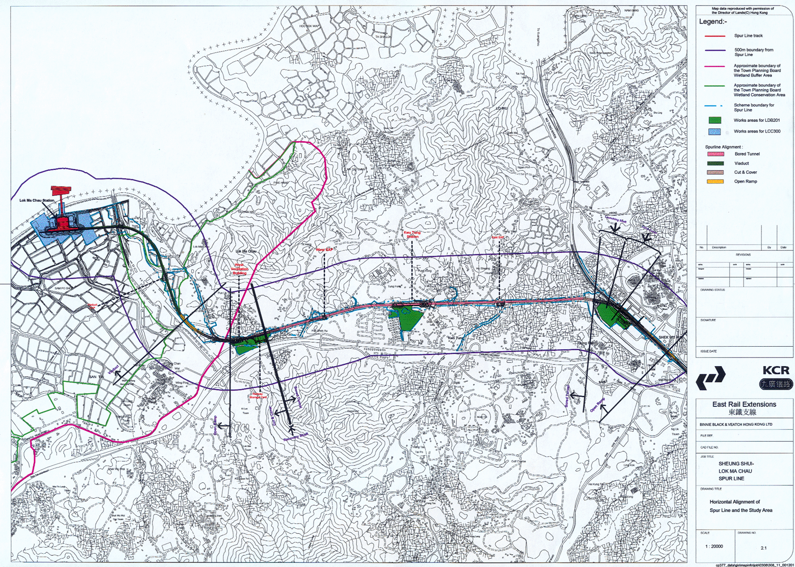
The Study Area includes
the immediate track and tunnel alignment and the engineering works boundary
(Figure 2.1). Three temporary
works areas have been earmarked at Lok Ma Chau, Kwu Tung and at the Sheung
Shui Temporary Housing Area. In the Lok Ma Chau area, fishponds will require
temporary draining and stabilisation with partial or complete infilling to
create a base for pier and station foundation works.
10.3.2
4.3
km of the alignment passes through a tunnel under rural areas dominated by
agriculture. Within this predominantly tunnelled section, a range of ground
surface works will be undertaken, some in locations where there is potential
for contaminated land to be impacted. These surface works include: the TBM
launching shaft at Sheung Shui, the recovery shaft at Chau Tau, Emergency
Access Points (EAPs) and ventilation buildings, the locations where surface jet
grouting is required for the construction of cross passages and the Kwu Tung
station box. The most significant areas where potential impacts may occur are
the Kwu Tung station box where a number of small industries and storage areas
are located, at the scrap metal yards in Sheung Shui around the launching shaft
and around the recovery shaft at Chau Tau, where a number of container storage
yards may contribute to land contamination.
10.3.3
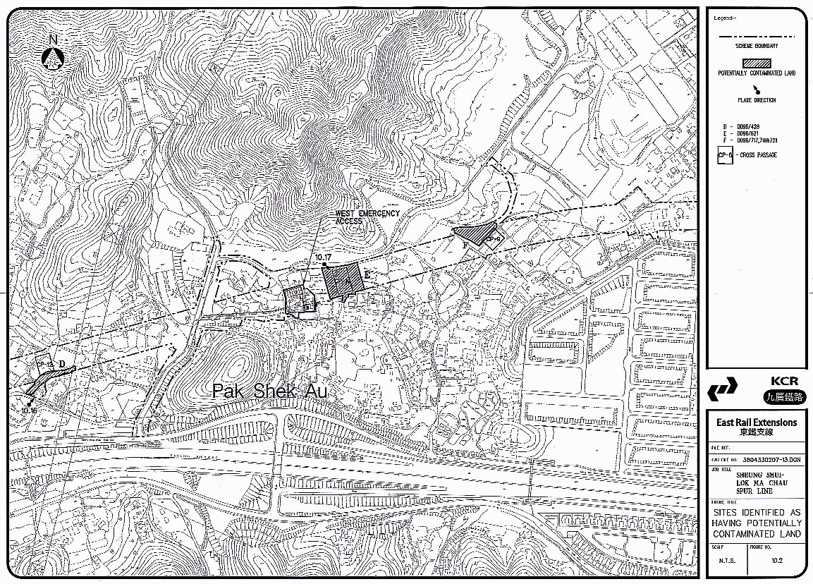
Figures
10.1, 10.2, 10.3,
10.4 show the alignment and
surface structures which may have impacts on contaminated land.
10.3.4
Construction
methods will include excavation works for surface structures, for the cut and
cover tunnel sections, launching and reception shafts and the Kwu Tung station
box, bored piling works for the viaduct supports and for Lok Ma Chau station
construction, and excavation of material from the tunnel. The tunnel is
sufficiently deep that it is unlikely to impact any contaminated areas. The
extent of surface impacts, and the type of remediation to be proposed will
depend on whether the works is extensive, such as the TBM launching and
recovery shaft excavation, or minimal, as in the viaduct pier supports.
10.4
Risks to Health
10.4.1
A
contamination assessment is important because of the health risks posed to site
workers on exposure to contaminated soil or sediments, and contamination of
groundwater during earth moving operations, excavation or piling works. Workers
could become exposed to contaminants either directly e.g. skin contact during
the work by inhalation of dust or vapours, or through ingestion whilst eating
or smoking on site.
10.4.2
If
remediation is found to be necessary at any point of the alignment it should be
carried out to a suitable level so as not to pose any future health risks to
users of the site. As long as there is no direct human - soil interface, it is
likely that in many places the soil could remain in-situ or be remediated to a
level sufficient for its future use.
10.4.3
Contaminants
of particular concern due to their potential health risks include inorganics
such as cyanides and heavy metals, organics such as mineral oils, halogenated
solvents, polycyclic and volatile aromatic hydrocarbons and minerals such as
asbestos.
10.4.4
Contaminants
may also pose a fire hazard or explosion risk if volatile gasses or flammable
contaminants are found.
10.5
Desktop Study
Industries Having the
Potential to Cause Land Contamination
10.5.1
Historically
there is evidence that the New Territories was the location for various light
industries and other landuses which change frequently but often have a
potential to contaminate the land. These include car repair yards, container
storage areas, livestock farms, paint and dye factories and other small scale
industries. Many of these small industries still operate today, although the
density of factories has reduced over recent years. In addition there are
dumping grounds, refuse collection points and illegal dumping areas which are
likely to result in some ground contamination. Many of these landuses fall
within the areas of the proposed alignment and, if unmitigated, give rise to
concern for their future landuse.
10.5.2
A
number of industries have been identified in ProPECC PN 3/94 as having the
potential to cause land contamination. These include:
·
oil installations (e.g. oil
depots, oil filling stations);
·
gas
works;
·
power
plants;
·
shipyards/boatyards;
·
chemical
manufacturing/processing plants;
·
steel
mills/metal workshops; and
·
car
repairing/dismantling workshops.
10.5.3
This
list is not exhaustive and judgement is needed to determine if contamination is
likely from other land uses or industries. For example, there is a site (C)
along the Spur Line alignment where chemicals used to treat leather are stored.
Such solvents are known to be hazardous to the environment (LaGrega, 1994).
Land Ownership
10.5.4
There
is a variety of ownership along the alignment of the Spur Line. In the Long
Valley area there are many agricultural lots, whilst in Kwu Tung many owner
occupied small houses typical of the New Territories are found. Some areas of
land along the alignment are Government Land, particularly in the Lok Ma Chau
and Sheung Shui areas. However, the latter Government-owned areas are generally
not areas of potential contamination.
Landuse History
10.5.5
In
order to assess potential land contamination, the past landuse history and the
present landuse of the areas which will fall under works associated with
Spurline construction have been reviewed. Aerial photographs have been used and
landuse information has been obtained from the District Land Offices in Yuen
Long (DLO Yuen Long) and Fanling (DLO North).
10.6
Site Survey
Objectives and Methodology
10.6.1
The
objectives of a site survey for the land contamination assessment are to
confirm any land-uses found in the DLO records and to identify any other uses
which may be illegal and not recorded. The Study Area was taken to be the
gazetted area of the Spurline, although large portions of this gazetted
alignment will not be directly affected except via the underground tunnel. The
site survey was also used to gather information on other activities such as
storage and management of hazardous substances.
10.6.2
Site
inspections were carried out on 17 May, 27 July 1999 and 17 September 2001. No
advance notice was given to land users in order to obtain as authentic
information as possible. A number of sites along the alignment were disregarded
due to information obtained during the desktop study and site visits which
indicated no likelihood of contamination. The findings of the site survey are
evaluated to identify potential "hot spots" and parameters for
further investigation in a sampling and analysis programme.
10.6.3
Ground
conditions were also observed during the site surveys to determine the ease of
infiltration and potential for underground dispersion of pollutants.
Results of Desktop Study and
Site Visits
10.6.4
A full listing of the
desktop study results and the findings of site visits to each site are provided
in Appendix A10.1. As some sites cover more than one lot, each site listed
has been assigned a letter. The sites are described from west to east along
the alignment and their locations are identified in Figures
10.1, 10.2, 10.3,
10.4. The nature of the land
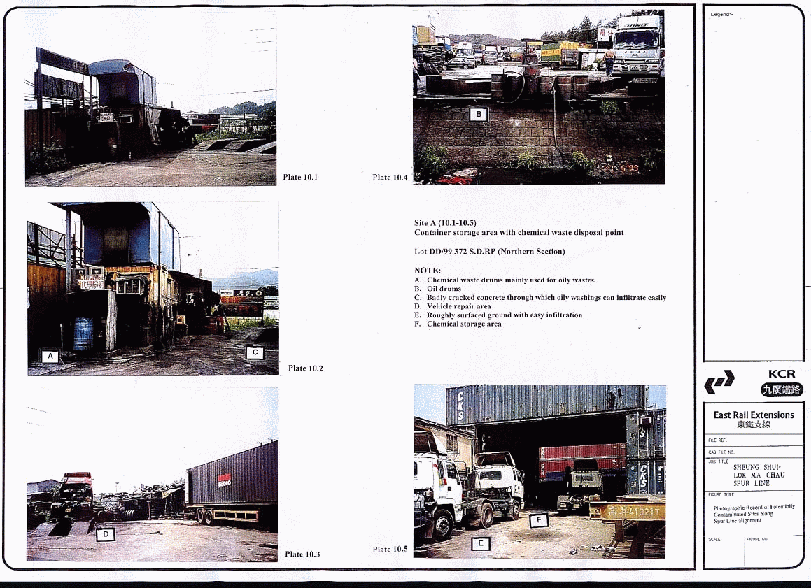
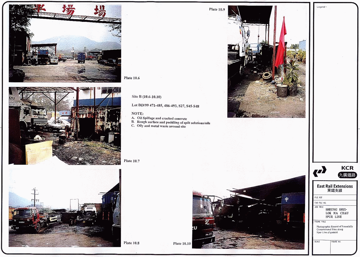
in each lot, and the activities being carried out which may potentially contaminate
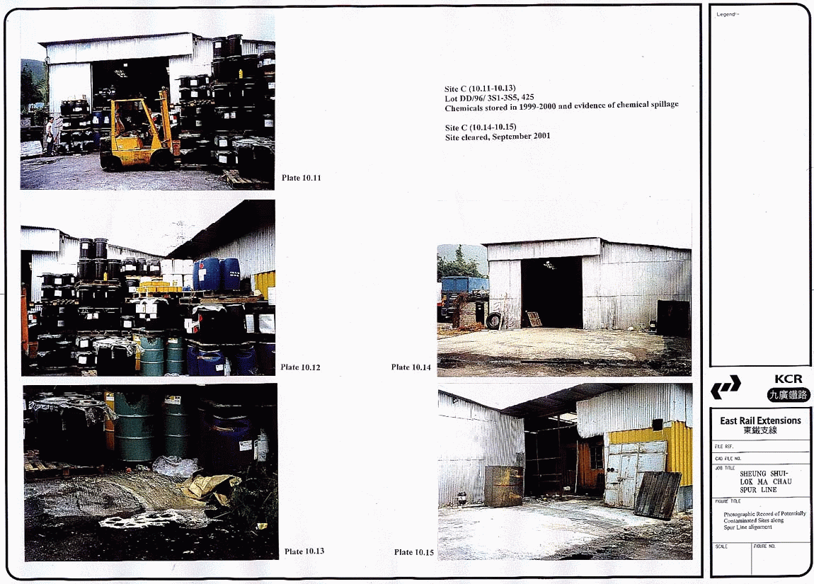
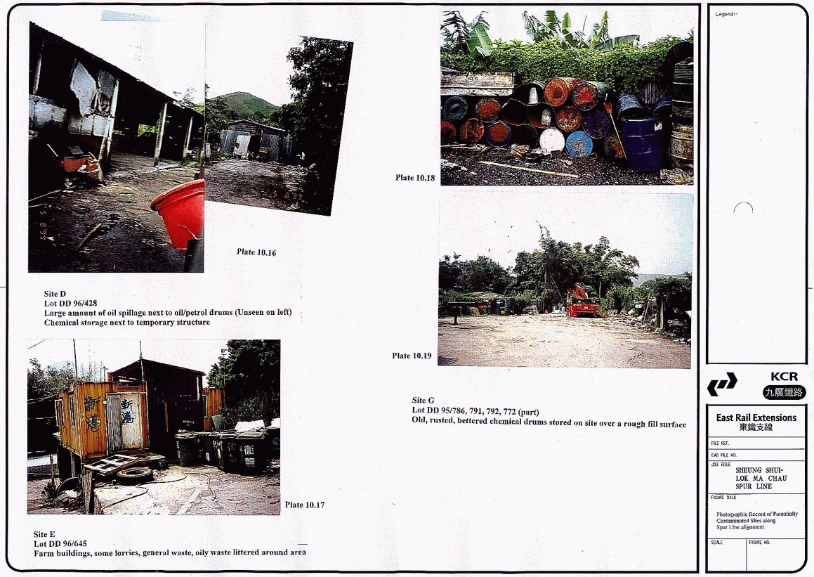
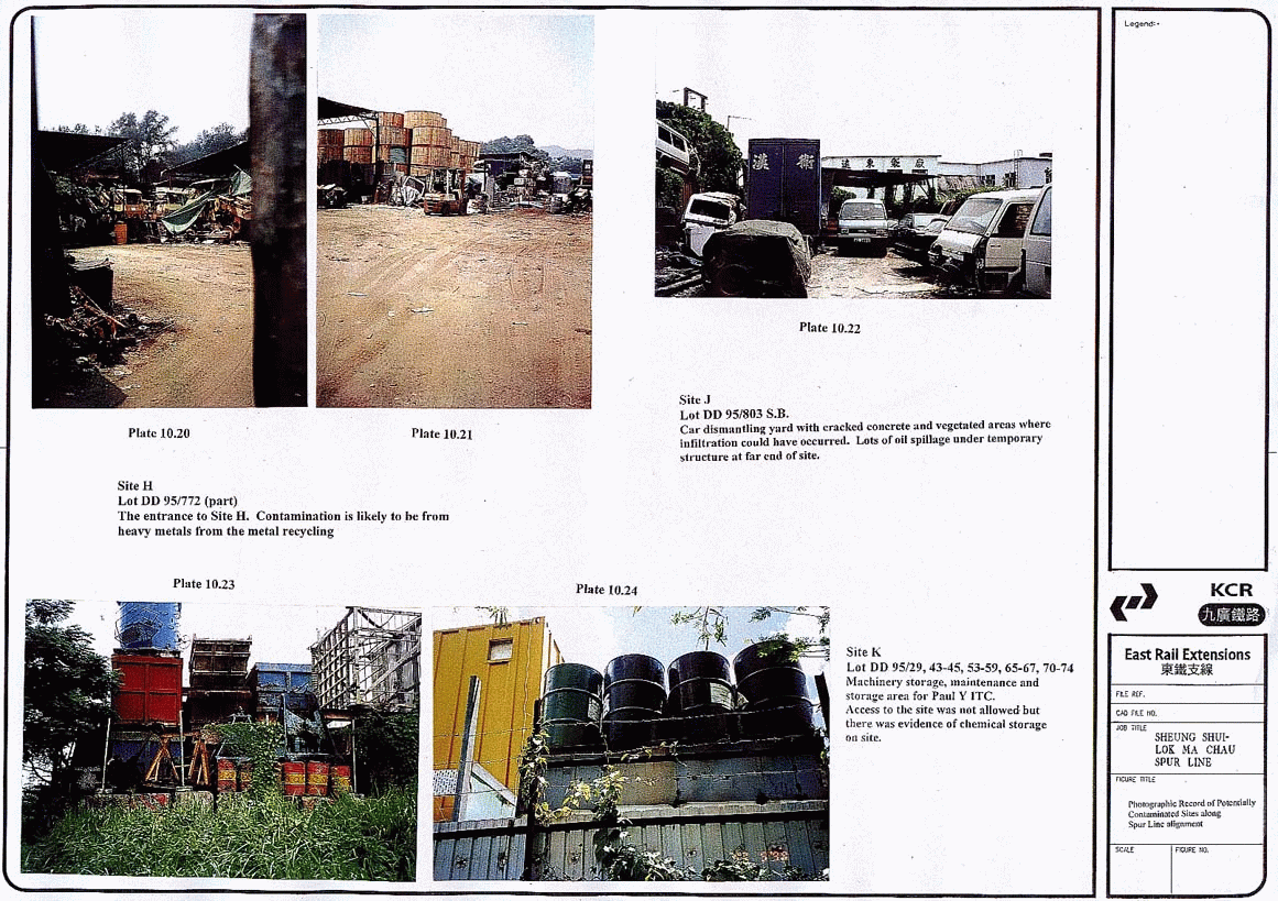
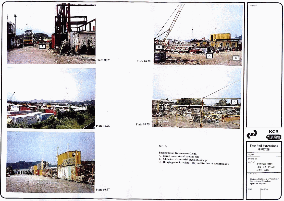
the ground, are shown in Plates 10.1 to 10.29.
Not all lots could be photographed, however, a description of each lot is
given in the following tables. Table 10.1 lists lot numbers, their assigned
letter and the type of works which may impact the area (viaduct, EAP, launching
shaft, etc).
Table
10.1
Lot
Numbers, Assigned Letters and Section
|
Letter |
Lot Number |
Section |
Letter |
Lot Number |
Section |
|
A |
DD99/372
S.D RP |
Ramp and Viaduct |
G |
DD95/ 786, 791, 792, 772 (part) |
Kwu Tung Station Box |
|
B |
DD99/ 470 -
483, 486 – 493, 527, 545 - 548 |
Recovery Shaft |
H |
DD96/ 772
(part) |
Kwu Tung Station Box |
|
C |
DD96/352,
353, 354, 355, 423 |
Miscellaneous Storage
Area (TBC) |
I |
DD95/ 803 S.A. ss. |
Kwu Tung Station Box
(TBC) |
|
D |
DD96/ 428 |
Miscellaneous Storage
Area/Cross Passage |
J |
DD95/ 803 S.B. |
Kwu Tung Station Box
(TBC) |
|
E |
DD 96/645 –
sections |
Cross Passage |
K |
DD95/ 43 - 45, 53 - 59, 65 - 67, 70 -
74 |
Cross Passage |
|
F |
DD 96/717, 718, 721 |
Cross Passage |
L |
Sheung Shui
Government Land |
Launching Shaft |
TBC: To be
confirmed. These sites may fall outside of the above ground works areas and
therefore may be removed from the contamination assessment at a later date if
it is found that they will not be impacted by works.
10.6.5
Table
10.2 summarises the results of the desktop study and site visits. The table
lists the registered landuse of the site and the likely potential and extent of
contamination. Appendix A10.1 includes any permit numbers or Short Term Tenancy
Agreements (STT) or Short Term Waivers (STW) which cover the lots.
Table
10.2
Findings
of Desktop Study & Site Visits and the likely Potential for Contamination
|
Site and Lot No. |
Figure No. / Plate No |
DLO Registered Landuse |
Site Inspection |
Potential for Land
Contamination |
|
A DD99/372 |
Container
vehicle park, open storage |
Confirmed
landuse. Some petrol pumps, chemical waste area |
Likely,
rough surface, cracked concrete, storage of chemical and hydrocarbons on site |
|
|
B DD99/470-483,
486-493, 527, 545-548 |
NA* |
Containers,
open storage, storage of chemicals, oils and solvents |
Likely,
gravel and cracked surface and storage of potential contaminants and scrap metals |
|
|
C DD96/352,
353, 354, 355, 423 |
NA* |
Sign
stated car repairs. Previous storage of many chemical drums, most marked
harmful. Site now cleared (Sept 2001). |
Likely,
evidence of spillage on ground. Concrete cracked (Works area TBC) |
|
|
D DD96/428 |
NA* |
Disused/abandoned
pig farm with chemical storage |
Likely,
cracked surface and spillage evident |
|
|
E DD96/645 |
NA* |
Farm
buildings, chemical storage, livestock waste drums, site generally littered
with waste |
Inventory
of chemicals and pesticides used required. Rough surface may have allowed
some infiltration |
|
|
F DD96/717,
718, 721 |
P:
- |
NA* |
Container
storage area, some parked vehicles and drum storage |
Possible,
some containers are very old, and battered, spillages could have occurred. |
|
G DD95/786,
791, 792, 722 |
Illegal
container storage |
Container
and storage area with temporary structures. Surface rough and some chemicals
stored |
Possible
- depending on whether any spillages have occurred. |
|
|
H DD96/772 |
No
registered landuse |
Metal
recycling company. Many parked vehicles, rough gravel surface. |
Possible
- depending on whether spillages have occurred |
|
|
I DD95/803 |
P:
- |
NA* |
Storage
area for adjacent factory. |
Possible
from historic contamination as this was a leather goods factory |
|
J DD95/803 |
NA* |
Car
repairs/dismantling yard. Ground concreted and vegetated |
Likely
due to infiltration through cracked concrete and vegetation |
|
|
K DD95/43-45,
53-59, 65-67, 70-74 |
NA* |
Access
denied but site is fenced and appears to be used as a repairs and maintenance
site for Paul Y ITC |
Likely
but activities carried out here must be clarified. Site access not possible. |
|
|
L
Government Land in Sheung Shui |
NA* |
Access
denied but scrap metal yard in operation observed. Some storage of chemical
drums and metal waste |
Likely
but exact locations must be determined. |
Note NA* - No information available from DLO
10.6.6
The
main areas for concern are container storage areas, particularly those in DD99
close to Lok Ma Chau (A and B), the car repair/dismantling yards at Kwu Tung
(J) and the scrap metal yards in Sheung Shui (L).
10.6.7
The
main contaminants are likely to be oils, organic solvents and heavy metals.
Some chemicals known to be hazardous were found. These included methylene
chloride, listed as a hazardous air pollutant (under the US Clean Air Act,
1991). Many chloro alkanes are designated as priority pollutants (Clean Water
Act) and are on the Superfund Hazardous substances list. In addition to
specific named substances and chemicals there was much evidence of oil and
petrol spillage, piles of scrap metals and storage of unspecified chemicals.
Site Appraisal
10.6.8
From
the desktop study and site visit information collected, it is possible to
determine whether a contaminated land site investigation is needed. This
information was used to check against the set of criteria described in Table
10.3 which is taken from the EPD Guidance
Notes for Investigation and Remediation of Contaminated Sites of: Petrol
Filling Stations, Boatyards or Car Repair/Dismantling Workshops. For this
set of landuses if the answer to any of the criteria is 'No', a full scale site
investigation is recommended. A positive answer to all criteria indicates that
simplified site investigation may be sufficient. The criteria can be used as
guidelines or indicators for different potentially contaminating landuses.
Table
10.3
Criteria
for Adoption of Full-scale or Simplified Site Investigation
|
Criteria |
Yes/No |
|
1. Length
of operation of the site is less than 5 years. |
|
|
2. There
is a practice of recording spill incidents or monitoring chemical storage. |
|
|
3. Waste
disposal is carried out in accordance with Government requirements |
|
|
4. Absence
of underground storage tank on site |
|
|
5. Absence
of surface contamination indicators which include: a) stained areas b) uncontrolled chemical drum
storage c) cracked concrete near
storage of chemical drums d) unnatural colours and
odours; and e) abandoned
piping/mechanical components or cans. |
|
10.6.9
In
the case of Spur Line, no site along the alignment is known to have an
underground storage tank. At several sites where chemicals are stored, a
negative answer is likely to criteria 2 and 3 as most sites landuse is illegal
and no DLO records are available. At some of the sites there is evidence of
spillage of chemicals, uncontrolled chemical drum storage, cracked concrete or
rough gravel surfaces, all of which are criteria for full scale site
investigations. On the basis of this information, a Land Contamination
Assessment Plan (CAP) is recommended. The following section describes the
development of the CAP for the Spurline Project.
10.7
Land Contamination Assessment
Plan (CAP)
10.7.1
This
section summarises the results of the desktop study and site inspection and
describes the approach to be taken in the development of the CAP. A detailed
CAP showing the locations of the boreholes and defining depths to be sampled
and parameters to be sampled, will be presented to EPD for approval and is
included in Appendix A10.1. The CAP included as part of this EIA is preliminary
and is subject to review, including revision of sampling locations and numbers
of boreholes/trial pits once access to land for site investigation is obtained.
If a revised CAP is required it will be submitted to EPD as a stand-alone
document, for approval before commencement of actual drilling and sampling.
Site Investigations
10.7.2
A
site investigation should be approached in a systematic way bearing in mind the
purpose and the level of detail which is required. The main topics, as defined
by EPD (1999) are:
·
Physical site conditions,
including geology, topography, soil type and physical properties, drainage and
groundwater.
·
Likely
contaminants - previous site use.
·
Extent
and severity of contamination, the concentrations, depth, spatial distribution
of contamination in both soils and groundwater.
·
Effects
on users, including the nature and level of contamination with regard to future
use.
·
Potential
environmental harm.
·
Hazards
during construction.
10.7.3
The
subsurface geology and groundwater flow are important as petroleum hydrocarbons
in particular can float and migrate some distance. This could impact other
drainage waters around the Spur Line alignment and increase levels of BOD5,
SS and other important parameters. Many of the areas where potential
contamination sites were identified, are located on flat, low-lying land, not
far above the water table. There is therefore potential for contaminants to
enter the groundwater in these areas.
10.7.4
Table
10.4 below lists the lot numbers and the main activities at each site
identified. Likely contaminants associated with different site activities are
listed in Table 10.5. The level of contamination and the extent of
contamination need to be determined through a formal sampling and analysis
programme and the most suitable methods for clean up of the site determined.
Table
10.4
Lots
along the Spur Line and Potential Contaminating Landuses
|
Site |
Fuelling Areas |
Servicing /Parking Areas |
Paint Shop |
Fitting out/ repairs |
Coating/ steel treatment |
Vehicle Breaking |
Chemicals or waste storage |
Drainage and soakaway systems |
Agricultural Activities |
|
A |
√ |
√ |
√ |
√ |
√ |
√ |
√ |
√ |
|
|
B |
√ |
√ |
√ |
√ |
√ |
√ |
√ |
|
|
|
C |
|
|
|
|
|
|
√ |
|
|
|
D |
|
|
|
|
|
|
√ |
|
√ |
|
E |
√ |
|
|
|
√ |
|
√ |
|
|
|
F |
|
|
|
|
|
|
√ |
|
|
|
G |
|
√ |
√ |
√ |
|
√ |
√ |
|
|
|
H |
|
√ |
|
|
|
|
√ |
|
|
|
I |
|
|
|
|
|
|
√ |
|
|
|
J |
|
√ |
√ |
√ |
|
|
√ |
|
|
|
K |
√ |
√ |
√ |
√ |
√ |
√ |
√ |
|
|
|
L |
√ |
√ |
|
√ |
√ |
√ |
√ |
√ |
|
Table
10.5
Activities
found along the Spur Line and their likely associated contaminants
|
Contaminant |
Fuelling Areas |
Servicing/ Parking Areas |
Paint Shop |
Fitting out/ repairs |
Coating/ steel treatment |
Vehicle Breaking |
Chemicals or waste storage |
Drainage and soakaway systems |
Others |
|
Metals (all) |
√ |
√ |
√ |
√ |
√ |
√ |
√ |
√ |
√ |
|
Lead |
√ |
√ |
√ |
|
|
|
|
|
|
|
Chromium |
|
√ |
|
|
|
|
|
|
|
|
Zinc |
√ |
|
√ |
|
|
|
|
|
|
|
Copper |
√ |
√ |
|
|
|
|
|
|
|
|
Cyanides |
|
|
|
√ |
√ |
|
√ |
√ |
√ |
|
Organic Contaminants |
|
√ |
√ |
√ |
√ |
|
√ |
√ |
√ |
|
Simple
aromatics |
√ |
√ |
|
√ |
√ |
√ |
√ |
|
√ |
|
Organic
solvents |
√ |
√ |
√ |
√ |
√ |
|
√ |
|
√ |
|
Polyaromatic
hydrocarbons |
|
√ |
|
|
√ |
√ |
√ |
|
√ |
|
Fuels/oils |
√ |
√ |
|
√ |
|
√ |
√ |
√ |
√ |
|
Biocides |
|
|
|
√ |
√ |
√ |
√ |
√ |
√ |
|
Oily
sludges |
|
√ |
|
√ |
√ |
√ |
√ |
√ |
√ |
|
Microbacteriological |
|
|
|
|
|
|
√ |
√ |
√ |
|
Acids |
|
|
|
√ |
√ |
√ |
√ |
√ |
|
NOTE:
Simple
aromatics includes benzene, toluene, ethylbenzene, xylene etc
Organic
solvents includes non-halogenated and halogenated solvents
Fuels/oils
includes Total Petroleum Hydrocarbons
Acids
includes sulphuric and hydrochloric
SOURCE:
EPD
(1999)
Voelcker
Science (1999)
Preliminary Methodology for
Evaluation of Contaminated Land
Selection
of Sampling Locations
10.7.5
From
the desktop study and site visit information collected, the need for a
contaminated land site investigation was determined. This information was used
to identify areas of potentially contaminated land. The approach taken in the
CAP in selecting suitable locations for sampling and analysis takes into
account the following factors:
·
The
extent to which the potentially contaminated land site overlaps with the KCRC
Scheme boundary and areas where construction will take place above ground.
·
The
form of the railway alignment at the location of each site (viaduct, cut and
cover, ramp or tunnel).
·
The
location of boreholes conducted for the Site Investigation (S.I.).
10.7.6
The sections of each
potentially contaminated land site which fall within the Spur Line Scheme
Boundary and may potentially be impacted by above ground activities are shown
on Figures 10.1, 10.2,
10.3, 10.4
and tabulated in Table 10.4. The figures also show the limits of the viaduct
and tunnel sections along the alignment. Boreholes which are defined as part
of the SI should be located, as far as possible, at worst case scenario locations
defined in the CAP. These are generally locations where staining has been
noted from vehicles, chemical storage areas, or spillage.
10.7.7
The
number of boreholes and/or trial pits needs to be defined in the CAP and
approved by EPD as part of the Stage 1 sampling. If samples from these
locations are contaminated according to the Dutch list criteria (Appendix
A10.1), Stage 2 sampling is required. Stage 2 sampling takes the form of sampling
to determine the extent of contamination across the area, according to ProPECC
PN 3/94.
10.7.8
Where
the sites are beneath a viaduct section of the railway, samples should be taken
from boreholes close to the proposed pilecaps. If further testing is required, this
will be limited to the pilecap locations and other areas where significant
ground disturbance or excavation may occur. If changes are made to the
interface of the viaduct/ramp sections during the detailed design stage, the
principles described in this section regarding number and location of samples
in each type of railway section should be followed. Other locations in the
tunnel section of the alignment that may require testing include areas where
jet grouting for cross passages is required, or at the locations of the EAPs,
ventilation buildings, launching and reception shafts and the Kwu Tung station
box.
10.7.9
Where
no boreholes are available for sampling close to the potentially contaminated
site, a trial pit should be dug within the site of interest at a suitable
“hotspot”. In some cases, access could not be gained during the site visits and
the location of the trial pit will need to be defined when access has been
obtained.
Sampling
methodology
10.7.10
Prior
to a borehole being constructed, it is usual practice to dig an inspection pit
up to 3m deep to verify the presence or absence of utilities. An environmental
scientist with experience in contaminated land assessment should be on site to
monitor the first few boreholes to confirm that the samples are being taken at
the right locations and in the correct manner. A visual inspection of the trial
pits will enable the environmental scientist to make a visual assessment of the
likelihood of contamination.
10.7.11
It
is preferable that samples are taken from the trial pit because a visual
assessment of the ground material can be made more readily than a borehole and
the exact sample depth can be verified. If contamination is suspected at the
base of the trial pit, samples should be taken at a greater depth from the borehole.
10.7.12
The
CAP should describe the locations and number of boreholes and trial pits to be
sampled, the number of samples to take and the parameters to be tested. From
site visits, it is likely that Total Petroleum Hydrocarbons (TPHs) will need to
be analysed in all cases. In selected samples, metals, cyanide and organics
(chlorinated and non-chlorinated solvents, aromatics and polyaromatic
hydrocarbons (PAHs)) will be included in Stage 1 sampling. In sites such as
container yards, organics are less likely to be a problem. However, in chemical
storage sites, organics are one of the main potential contaminants. The result
of these analyses will help to fine tune the testing required for Stage 2
sampling and analysis.
10.7.13
At
Stage 2, additional samples should be taken in the same area if the samples
from potentially contaminated areas are shown to be contaminated. These
additional samples will be taken on a grid sample basis as outlined in ProPECC
PN 3/94 and the Contaminated Sites
Investigation Remediation Guidance Notes. The locations covered by the grid
at the potentially contaminated sites are shown in the CAP.
10.7.14
The
proposed analysis programme is summarised below:
Two Stage Analysis Programme
![]() Stage
1
Stage
1
Sampling
of all
potentially
contaminated areas
![]()
![]() General Examination of TPH,
Heavy Metals (and Organics and CN for selected sites)
General Examination of TPH,
Heavy Metals (and Organics and CN for selected sites)
![]() Evaluation
of Analytical Results
Evaluation
of Analytical Results
![]()
![]()
![]() Not Contaminated Contaminated
Not Contaminated Contaminated
![]() Proceed with Project without Stage 2
Proceed with Project without Stage 2
any
Remediation Measures
Sampling
to determine extent
of contamination
![]()
![]()
Examination of Form of
Heavy Metals
![]() PAH,
BTEX
if not previously determined
PAH,
BTEX
if not previously determined
(TCLP)
![]()
![]() Evaluation
Evaluation
![]()
![]()
![]()
![]() Not
Contaminated Contaminated
Not
Contaminated Contaminated
Remediation
Remediation Remediation
Measures Measures Measures
for
non hazardous for
hazardous for
heavy
organics organics metals
Sampling
Methods
10.7.15
There
are several methods that can be used to obtain samples of potentially
contaminated material within the ground. These are listed below:
·
Hand methods - usually for
depths up to 0.5m by manual excavation or up to 5m with a hand auger. This
usually produces only small, disturbed samples.
·
Trial
pits - can be used up to about 3m depth. Allows easy collection of large
samples.
·
Light
cable percussion boreholes - traditional method for geotechnical soil
investigations. Can penetrate to 50m depth and allow easy water monitoring or
gas wells to be inserted.
·
Power auger drilling - very
quick method, however samples are limited to around 6 m depth and are
disturbed.
10.7.16
Trial
pits are the most widely used technique, especially when sampling is required
to depths of less than 3m. Care should be taken to avoid underground services.
It is likely that a combination of boreholes and trial pits can be used for the
Spurline investigations.
10.7.17
For
borehole sampling, samples will be collected from the top, middle and bottom
(above rockhead) of the borehole as recommended in BSI DD175. The depth of the
samples will depend on the field sampling data. For trial pit sampling, samples
will be taken at three depths (e.g. 0.5m, 1.5m and 3m). If contamination is
evident at 3 m depth, additional samples at greater depths should be collected.
Where groundwater is encountered, groundwater samples should also be taken and
records kept of the ground water level in the trial pit. Photographic records
should be kept of each borehole and trial pit to show the gradient of pollution
into the ground and the appearance of each sample. The presence of any free
product floating on the top of the groundwater and the thickness should be
recorded. The floating layer should be removed/recovered and analysed.
10.7.18
All
soil samples should weigh not less than 0.5 kg and must be representative of
the location at which they are taken. Samples should be handled in an
appropriate manner so as to avoid cross contamination, and should be stored
between 0 - 4ºC. Cooling of samples containing volatile contaminants is
especially important. All samples should be properly labelled and any excess
sample kept for further testing if necessary. Sample containers should be
thoroughly cleaned between sampling of individual samples. It is important for
the sampling person to avoid direct or indirect contact with potentially
contaminated materials.
10.7.19
All
samples should be well contained, sealed, properly labelled and any excess
sample kept for further testing if necessary.
Parameters
to be Tested for Contamination
10.7.20
The
parameters to be tested at each proposed sampling location shall be based on
the expected contaminants related to the land use. Prior to sampling, an
examination of the site should be made by an environmental scientist
responsible for the sampling, to confirm whether additional or alternative
analyses are required to those listed in the CAP.
10.7.21
Waste
automotive oils which may be detected at container sites are composed of an
organic base with additives to increase performance. Additional compounds such
as chlorinated solvents may be present in the waste oils due to blending of
used oils during storage. The presence of such suspected carcinogens and
mutagens is the basis of concern about waste oils in the environment. The
sampling programme recommends that in Step 1 only total petroleum hydrocarbons
(TPH) are tested for, and organics and CN at certain specified sites. If
necessary, Polyaromatic hydrocarbons (PAHs) and Benzene, Toluene, Ethylbenzene
and Xylene (BTEX) will be required to be determined if Step 2 of the analysis
programme is to be implemented.
10.7.22
For
the inorganic analysis heavy metals (including Cd, Cr, Cu, Hg, Ni, Pb and Zn)
should be determined in addition to cyanides.
Analytical
Laboratory and Methodology
10.7.23
The
laboratory for chemical analysis for the land contamination assessment should
achieve HOKLAS accreditation for environmental testing of sediment trace
metals: Cd, Cr, Cu, Ni, Pb, Zn and Hg and preferably for TPH, PAHs and BTEX.
10.7.24
The
methodology should be compatible with international standard methods. Detection
limits should be to standards listed in Table 10.6.
Table 10.6
Detection Limits of Parameters
to be analysed
|
Group No. |
Parameter |
Detection Limit (mg/kg dry soil) |
|
1 |
Metals: Cd Cr Cu Hg Ni Pb Zn |
0.2 20 10 0.1 10 10 40 |
|
2 |
Total
Petroleum Hydrocarbons (TPH) |
20 |
|
3 |
Benzene Toluene Ethylbenzene Xylene |
0.002 0.01 0.01 0.01 |
|
4 |
Polyaromatic
Hydrocarbons (PAH) |
0.2 |
10.7.25
A
detailed land contamination assessment plan will be submitted for approval by
the Director in accordance with the requirements set out in the ProPECC
Practice Note 3/94 “Contaminated Land Assessment and Remediation” prior to
on-site assessment before commencement of works.
Evaluation of Potential
Impacts
10.7.26
The
interpretation of analytical results should be considered by comparing the data
with the Dutch Indicative List which is recommended by EPD in ProPECC PN 3/94
for interpretation of the analytical results.
10.7.27
The
soils, geology, groundwater and climate of Hong Kong are different to those of
the Netherlands. The reference values have been developed for use under these
specific conditions. The adsorption of pollutants to soil colloids may be
different under such conditions and therefore pose a different toxicity risk.
10.7.28
Appendix
A10.1 contains the Dutch list which should be considered carefully in terms of
application to the Hong Kong environment. It can be used as an indicative
measure of levels of contamination, qualitatively based on like groups of
contaminants, known landuses and possible pollutants.
Preliminary Results from SI
10.7.29
Sampling has been carried
out at a number of potentially contaminated land locations during a previous
site investigation study. The locations that were sampled are shown in Figure
10.5 and the results found are shown in Table 10.7. Some sites are included
in both the previous EIA (BBV, 2000) and under this EIA. Other sites listed
in Table 10.7 were affected under the viaduct option but are now unaffected
by works under the tunnel scheme. As a result of this some of the lettering
of sites may differ between the previous EIA and the current EIA. All sites
are reported here for completeness in presenting site investigation results.
Sites were sampled by borehole or trial pit depending on the location and
possible depth of contamination. Table 10.7 details the depths sampled at
each site. Samples were sent to a HOKLAS approved laboratory for analysis.
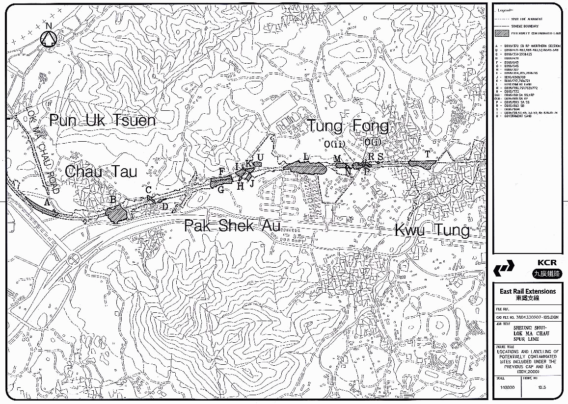
Table 10.7
Preliminary Site
Investigation Results
|
Site |
Borehole/trial pit |
Parameters tested for |
Depth (m) |
Findings |
|
L |
DH/037 |
TPH |
0.5, 1.5, 3.0 |
< Dutch B |
|
M |
DH/34 |
Heavy metals, TPH |
0.5, 1.5, 3.0 |
< Dutch B |
|
O (i) |
O(i)-TP1 |
Heavy metals, TPH |
0.5, 1.5 |
< Dutch B |
|
O(ii) |
DH/031 |
Heavy Metals |
0.5, 1.5, 3.0 |
< Dutch B |
|
P |
P-TP1 |
Heavy Metals, TPH |
0.5, 1.5 |
< Dutch B |
|
S |
S-TP1 |
Heavy Metals, TPH |
0.5 |
Cu > Dutch C |
|
T |
DH/028 |
Heavy Metals |
0.5, 1.5, 3.0 |
< Dutch B |
NOTE:
Site L – not impacted by works
under this EIA
Site M – included under this EIA as Site G
– as a result of different ground works more sampling will be proposed at this
site (see CAP)
Site O(i) and
O(ii) – not impacted by works under this EIA
Site P – included under this
EIA as Site I – further sampling proposed but works area TBC.
Site S – not impacted
by works under this EIA
Site T – included under this
EIA as Site K – site area changed due to different above ground works – further
sampling will still be proposed at this site (See CAP)
10.7.30
These
results showed contamination was only present at S-TP1. This site, a former
metal works, is no longer impacted by any site works and will not therefore be
assessed in the contamination assessment. Other sites sampled previously which
show no contaminants to be present will not be assessed further except where
additional ground works will be required. Only selected locations could be
assessed at the time of the SI. The remaining sites need to be sampled and
analysed preferably before construction starts. If the access cannot be
obtained until the land is available for construction, a contaminated land
specialist should be present before any excavation takes place, to monitor the
works required to identify hotspots, sample, analyse and define the extent of
the contamination and to define the volume to be excavated and treated or
disposed of off site.
10.8
Remediation Measures to be
Considered in the Remediation Action Plan (RAP)
10.8.1
Following
approval of the CAP by EPD and completion of the sampling and analysis
programme, a Contamination Assessment Report (CAR) will be produced. The CAR
will detail the results of the implementation of the CAP and evaluate the
extent of the potential contamination on the site. Suitable means of minimising
the environmental impact from these areas of contamination should be defined.
If remediation of the land is required, the type of remediation should be
identified in a Remediation Action Plan (RAP).
10.8.2
The
selection of an appropriate remediation technique for a site is dependent on a
number of factors including:
(i)
the type of contamination;
(ii)
the
extent of contamination;
(iii)
the
time available and speed of each technique;
(iv)
cost
effectiveness;
(v)
the
future use of the site;
(vi)
availability
of expertise and equipment.
10.8.3
There
are a range of options available for treating contaminated land sites and new
techniques are constantly being developed. The main methods in use are:
·
Retention and isolation of
material on-site using an appropriate form of cover, barrier or encapsulation
system.
·
Physical,
chemical or biological treatment to eliminate or immobilise the contaminants.
·
Removal of material from the
site for disposal elsewhere.
10.8.4
ProPECC
Note PN 3/94 also includes recovery trenches or wells for removal of leaked oil
and soil venting for volatile organic compounds (VOCs). It suggests that
"wherever possible, in-situ remedial measures should be adopted".
This policy should be followed as far as possible in order to prevent
increasing the pressure on landfills.
10.8.5
Table
10.8 describes several remediation techniques which may be applicable to
contamination expected within the works of the Spur Line.
Table
10.8
Remediation
Techniques that could be Used at Sites along the Spur Line
|
Type
of Contamination |
Technique |
|
Oil – surface layers |
Bioremediation - in-situ or on site
degradation of organic pollutants to harmless CO2 & water
using microbes. Ranked I by Haiges (1989). Other bioremediation
techniques include adding cotton which absorbs the oils. Bacteria which occur
naturally in the cotton then degrades the oils before decomposing the cotton
into the soil and enriching it. Soil washing/flushing – addition
of a surfactant/solvent and flushing in-situ or washing excavated soil. The
oils and fluids separate out and the oily waste can then be bioremediated. |
|
Oil - above groundwater or at depth in the
soil. |
Recovery trenches or wells – used to
constrain groundwater flow so that oils settle and can be skimmed off. A dual
pump system uses a deep pump in the groundwater to create a depression cone
into which the free floating product will migrate. This can then be pumped
off. The dual pump system is ranked I by Haiges. Other
techniques include simpler pumps which extract both oils and water which can
then be separated at the surface.. |
|
Heavy hydrocarbons and oily sludges |
Thermal treatment - soil is excavated,
sorted and fed into a rotary kiln thermal unit and heated until combustion
occurs. The clean soil is then cooled and moistened and can be replaced. |
|
Cyanides |
Incineration – similar thermal
heating and combustion as for heavy hydrocarbons. Care must be taken to
ensure that air emissions achieve required standards. |
|
Heavy Metals |
Soil washing – soil is passed
through sieves and scrubbers using water or oxidising chemicals which leach
the contaminants out. The sludge residue can then be disposed of at a
chemical waste treatment plant. Discharge of washed water must comply with
WPCO standards. Stabilisation – contamination can
be permanently isolated using lime, cement, thermoplastic or soluble silicate
reagents to chelate metal ions to soil colloids. The soil is excavated,
sorted and injected with the reagent before replacing and compacting to high
density. |
|
Volatile Compounds |
Soil Venting – contaminant are
removed through extraction wells using a vacuum which enhances chemical
movement from soil particles to air pockets. Air Sparging – mainly used to remove
volatiles from groundwater by injecting air into the saturated zone and
transferring the contaminants to the vadose zone from which they can be
vented. |
|
Microbiological |
Incineration – to eliminate any
toxic micro-organisms or bacterias, such as anthrax spores, the only
consistently dependable method is incineration. |
|
Broad spectrum of contaminants |
Excavation and Landfilling – best used
for shallow contaminants and one off excavations. Because of limits on
contaminants that can be disposed of in landfills (based on TCLP)* pre
treatment may be required by another method (e.g. bioremediation) prior to
disposal. |
NOTE:
Haiges (1989) rated techniques from 1 (best) to 8 (worst) for treatment of oil contaminated soils on the basis of technical feasibility, achievable treatment levels, adverse impacts, cost and time taken.
* TCLP -
Toxicity Characteristic Leaching Procedure Limits - as outlined in the Guidance
notes issued by EPD (1999).
10.9
Application of Contamination
Action Plan to Spur Line
10.9.1
From
the desktop study, site survey and generic methodology for sampling and
analysing pollutants from potentially contaminated sites, a number of sites
along the Spur Line alignment have been identified as being potentially
contaminated.
10.9.2
Prior
to the implementation of the CAP and CAR, an estimate has been made of the
quantity of contaminated land which may be present at each site (Table 10.9).
This is based on site visits, the extent of the area used at each site, and the
assumption that the contamination has penetrated to a depth of approximately
1 m from the ground surface. Where viaduct occurs, it is assumed that only
the area around the viaduct pile cap will be impacted during construction (each
pile cap is assumed to be 6.0 m diameter with an additional 2.0 m allowed
for the works area.) In the sections where EAPs will be constructed or large
excavation is carried out, the area overlapping with a potential contaminated
land area has been included in the calculation. In the tunnel sections it is
assumed that there is no contamination at depth and therefore the only areas
where contaminants may be encountered are where surface works associated with
tunnel construction are required. Where quantities of material are too small to
make physico-chemical or biological treatment cost-effective, disposal of the
material may be considered.
10.9.3
The
maximum quantity of contaminated land is estimated at this stage of the
assessment to be up to 18,350m³. This volume needs to be confirmed through
finalising of the above ground works, implementation of the CAP and the
sampling and analysis programme during site investigation, at which time the
quantities requiring remediation or disposal will be more accurately defined.
Where a jet grouting for a cross passage may be impacted an average size for
cross passages of 25m x 10m has been assumed for all sites.
10.9.4
Where
volumes are relatively small and/or contaminant level is low, disposal may be a
preferable option. Where volumes are large and/or contaminant levels are high,
remediation techniques should be considered as a cost effective and
environmentally favourable option.
Table
10.9
Main
Activities at Each Site, Contaminants Likely to be
Present
and Possible Maximum Extent of Contamination
|
Site |
Main
Activities |
Structure or Works Impacting Area |
Estimated Maximum quantity (m³) |
Main Contaminants Likely to be present |
|
A |
Container
Storage |
Ramp and Viaduct |
5,000 |
Metals,
fuels/oils, acids, cyanides |
|
B |
Container
Storage |
Recovery Shaft |
5,000 |
Metals,
fuels/oils, acids, cyanides |
|
C |
Chemical
Store |
Miscellaneous Storage
Area (TBC) |
TBC |
Organics,
oils, metals, solvents |
|
D |
Pig Farm |
Cross Passage |
100 |
Metals,
microbacteriological |
|
E |
Farm
Buildings |
Cross Passage |
250 |
Metals, microbiological |
|
F |
Chemical
Storage |
Cross Passage |
100 |
Organics,
solvents, metals, oils |
|
G |
Container
Storage |
Kwu Tung Station Box |
1,500 |
Metals,
fuels/oils, acids, cyanides |
|
H |
Metal
Recycling |
Kwu Tung Station Box |
600 |
Metals, TPH
|
|
I |
Storage |
Kwu Tung Station Box
(TBC) |
TBC |
Organics,
solvents, metals, oils |
|
J |
Car
Repairs/ Dismantling |
Kwu Tung Station Box
(TBC) |
TBC |
Metals,
cyanides, organics, fuels/oils, acids |
|
K |
Vehicle
Maintenance |
Cross Passage |
800 |
Metals,
cyanides, organics, fuels/oils, acids |
|
L |
Scrap Metal
Yard |
Launching Shaft |
5,000 TBC |
Metals,
fuels/oils |
|
Total
volume (m³) |
|
18,350 m³ |
|
|
Precautionary Measures to be
taken during Construction
10.9.5
The
following measures should be implemented to minimise risks to workers during
remediation works, excavation of soil, construction of viaducts, jet grouting
for cross passages, piling works or excavation of Kwu Tung station and
construction of the EAPs. These measures will also mitigate against
transferring contamination to groundwater, to surface water courses or to the
air.
·
Site
workers should wear gloves, masks, and other protective clothing where exposure
to vapours or contaminated soil may be encountered.
·
Contaminated
materials should be moved with bulk earth movers to prevent human contact.
·
Adequate
washing facilities should be provided and smoking/eating should be prohibited
in the area.
·
Contaminated
sediments which have been stockpiled or are being transported should be covered
with tarpaulin.
·
Leakage
of pollutants or leaching from excavated soil should be prevented by storing on
an impermeable surface.
Temporary Works Areas
10.9.6
Temporary
works areas are proposed in the Sheung Shui area which have previously been
used as container parking areas. The site inspection showed that, as is typical
of such landuses there has been some leakage of oils and lubricants. However,
these sites should not pose a health risk during their use in the construction
phase provided there are no earth moving activities at the sites. The leaked
oil can be covered with a layer of gravel or sawdust to soak up the leaks, and
the materials disposed of appropriately. However, if earth movement is carried
out, the precautionary measures detailed above should be followed.
10.10
Other Projects in the Study
Area
10.10.1
The
recently publicised Kwu Tung North NDA under the NENT Study also has the
potential to be impacted by contaminated land. The findings and recommendations
of the Spur Line EIA should be taken into account in the EIA for the NDA, and
in the development of a CAP for the NDA. In this way, the information available
about areas which overlap the two projects will be maximised and potential
environmental impacts minimised.
10.11
Summary
10.11.1
This
contaminated land assessment includes a desktop study on relevant past and
present landuses, a site survey, an assessment on the findings of and
recommendations on the approach to the sampling / analysis of essential
parameters and appropriate remediation measures. Application of the
sampling/analysis programme to specific sites identified to have potential
contamination along the Spur Line alignment is included. Preliminary results
from a Site Investigation in accessible location showed no contamination in
these areas. An outline of the methods for sampling and analysis of the
identified potentially contaminated sites, and criteria for evaluation have
been detailed in section 10.7. A Contaminated Land Assessment Plan (CAP) is
included as an appendix of this EIA.
10.11.2
No
underground storage tanks or extensive areas of contaminated land have been
identified in this assessment within the works area of the alignment. The main
areas for concern are container storage areas, particularly those in DD99 close
to Lok Ma Chau (A and B) and any car repair/dismantling yards (e.g. J). The
main contaminants are likely to be oils, organic solvents and heavy metals.
10.11.3
Remediation
measures for different types of potentially contaminated land are recommended,
however, the small quantities which have been identified for several sections
of the alignment are likely to be make remediation too costly to be effective,
and disposal should be considered. It is estimated that the maximum quantity of
material in areas of potential contamination, which requires treatment or
disposal is approximately 18,350 m³. These quantities and the degree of contamination
need to be confirmed at the site investigation stage. Following the
implementation of the approved CAP, a Contamination Assessment Report (CAR) and
Remediation Action Plan (RAP) will be prepared to recommend the methods of
remediation or disposal to be followed. This assessment indicates that
potentially contaminated material excavated during the construction of the
alignment, does not present an insurmountable environmental impact to the
Project.
REFERENCES
Holdgate,
M.W., (1979) A Perspective of Environmental
Pollution, University Press, Cambridge.
Royal
Commission on Environmental Pollution (RCEP), (1984), 10th Report: Tackling Pollution - Experience and Prospects, Cmnd
9194, HMSO, London.
LaGrega M.D.,
Buckingham P.L & Evans J.C. (1994), Hazardous
Waste Management, McGraw-Hill, Singapore.
Cairney T
(ed) (1993), Contaminated Land: Problems
and Solutions, Chapman & Hall, London.
EPD (!999), Guidance Notes for Investigation and
Remediation of Contaminated Sites of: Petrol Filling Stations, Boatyards or Car
Repair/Dismantling Workshops. Report EPD/TR1/99
Voelcker
Science (1999) Guide to Contamination
Packages
HSE (1998), Protection of Workers and the General Public
during Development of Contaminated Land.
http://www.ContaminatedLAND.co.uk/
- Pages on Past Industrial uses, Causes
of Contamination, Standards and Guidelines, Remediation Techniques
British
Standards Institution (1988), Draft for Development DD175: 1988 Code of Practice for the Identification of Potentially
Contaminated Land and its Investigation, BSI, London.
Kelly R.T.
(1980) Site Investigation and Material Problems, in: Reclamation of Contaminated Land, B21-B2-13, Society of Chemical
Industry.
Haiges L et al. (1989) Evaluation of underground
fuel spill clean-up technologies, in Haztech
International Conference, San Francisco.
ProPECC PN
3/94. Environmental Protection Department. Practice Note for Professional
Persons: Contaminated Land Assessment and Remediation.
BBV (2000)
Sheung Shui to Lok Ma Chau Spur Line EIA, Submitted June 2000, not published.