8.
WATER QUALITY IMPACT ASSESSMENT
8.1
Introduction
8.1.1
The
Sheung Shui to Lok Ma Chau Spur Line alignment passes under a number of
watercourses within the Long Valley, Kwu Tung, Chau Tau and Lok Ma Chau areas.
This section of the report assesses the potential of the Spur Line to impact
water bodies, all of which ultimately discharge to the Deep Bay Water Control
Zone (DBWCZ). The section is divided as follows:
· assessment methodology and relevant legislation;
· description of water bodies in the Study Area and their existing conditions;
· identification and assessment of construction and operational activities with potential impact;
· concurrent projects;
· recommendations for mitigation measures; and
· assessment of residual impacts after implementation of mitigation measures.
8.1.2
The
potentially impacted water bodies all ultimately discharge to Deep Bay, a
highly sensitive water body and an ecologically important area with
international significance.
8.2
Assessment Methodology
8.2.1
This
assessment is conducted in accordance to the EIA Ordinance, the Technical
Memorandum on EIA Process (Annexes 6 and 14), and the EIA Study Brief. The
Study Area, as specified in the Brief, is a corridor 300m to each side of the
Alignment. Environmental effects of the Project have been quantified where feasible.
Relevant Environmental Legislation
8.2.2
The
principal legislation for protecting water quality in Hong Kong is the Water Pollution Control Ordinance, which
defines Water Control Zones, Water Quality Objectives for each Zone, and
standards for effluent discharges. The Zero Discharge Policy for Deep Bay has
also been implemented by EPD, requiring that effluents discharged directly or
ultimately into Deep Bay be subject to appropriate prior treatment and disposal
such that no net increase in pollution load to Deep Bay occurs.
8.2.3
The
Livestock Waste Control Scheme (LWCS) under the Waste Pollution Control Ordinance was in 1994 to prevent further
deterioration in water quality as a result of livestock waste discharged into
rivers.
8.2.4
The
LWCS aims to impose a guideline and control on the livestock farming activities
to minimise their impacts on the water quality of local watercourses. In
addition to complying with the Waste
Disposal (Livestock Waste) Regulation, all livestock farmers in these areas
are required to achieve discharge standards for BOD5 and SS (BOD5:SS)
in planned stages. Hong Kong is divided into prohibited, restricted control
areas. In the Sheung Shui area, the Spur Line alignment passes through a
prohibited area. The rest of the alignment is within restricted areas.
8.2.5
The
details of legal requirements are presented in Appendix A.
8.3
Water Quality Sensitive Receivers
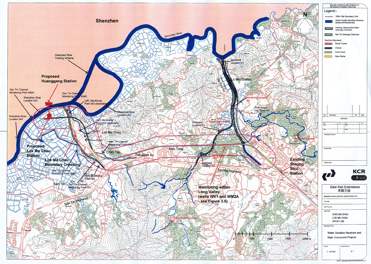
8.3.1
All water bodies that are
potentially sensitive receivers in the Study Area are shown on Figure
8.1, together with the Spur Line Alignment and concurrent projects. The
alignment falls into four topographically different sections that relate to
the water body catchments.
8.3.2
Bordering
the eastern section of Long Valley, works will be carried out in the River
Sutlej (Shek Sheung Ho) as part of the tunnelling operation. The tunnel will pass beneath the
wetland area of Long Valley, River Beas (Sheung Yue Ho), a fish pond, and an
area of agricultural fields. This chapter presents an assessment of the potential
impacts on groundwater quality and levels within the Long Valley area. Shek Sheung Ho and Sheung Yue Ho are tributaries of the River Indus,
the flood waters from which are pumped to Plover Cover Reservoir during storm
events. The River Indus and the Pumping Station in the Indus are therefore also
considered to be sensitive receivers.
8.3.3
Within
the Kwu Tung and Pak Shek Au sections of the alignment, there are several minor
streams some of which have been concreted to reduce flooding risks within this
developed area. The Spurline is in tunnel in this section, and the works
include construction of an EAP and the Kwu Tung Station Box. Impacts are
expected to be minimal providing measures to control surface runoff from works
are implemented.
8.3.4
In
Chau Tau, the alignment rises out of the tunnel, onto a short ramp and onto
viaduct. This section crosses
several inactive or filled fishponds before crossing a stream (which drains
into Shenzhen River), Lok Ma Chau Boundary Crossing and into the area where the
future Lok Ma Chau station will be constructed. A number of fishponds will be
filled during construction of the station building.
8.3.5
In
addition to the water bodies directly in the path of the alignment, other water
bodies are also present within the 600m Study Area corridor (300m either side
of the alignment). These include the River Indus, Shenzhen River, and a large
number of small streams. River Beas, River Indus, Shek Sheung Ho, and all of
the streams drain into Shenzhen River and ultimately into Deep Bay.
8.4
Existing Conditions at Water Quality Sensitive Receivers
8.4.1
A
considerable amount of water quality data for the water sensitive receivers of
the area has been collected from a number of studies. In addition, field
surveys have been conducted in several locations of the alignment for the
purposes of this assessment.
Long Valley
EPD data
River Beas (Sheung Yue Ho)
8.4.2
Similar
to most watercourses in the New Territories, the River Beas suffers from
pollution by sewage, livestock waste, contaminated runoff, and industrial
effluent.
8.4.3 With the efforts of the Government in the past years, especially with the enactment of the Livestock Waste Control Scheme, the conditions of this water course has improved from a Water Quality Index (WQI) of “Very Bad” in the years preceding 1996 to “Bad” (location RB3) or “Fair” (locations RB1 & RB2) in 1999. The location of the EPD monitoring points is shown in Figure 8.1.The most recent water quality data available from the EPD, presented in Table 8.1, indicate that the existing water quality within River Beas is still unsatisfactory. The E.coli levels remained high, ranging from 17,000 to 130,000 cfu/100mL. Throughout 1999, suspended solids did not reach the WQO level, and BOD5 was compliant only 3% of the time.
Table 8.1
Summary water quality data
for River Beas during recent years
(EPD River Water Quality
1996 to 1999)
(a) RB1
Monitoring Location
|
Parameters |
1996 |
1997 |
1998 |
1999 |
|
DO
(mg/l) |
3.8 (0.2-6.9) |
6.8 (1.9-10.5) |
7.2 (4.7 - 10.2) |
8.1 (5.6-10.5) |
|
pH |
7.1 (6.7-7.5) |
7.4 (7.2-7.8) |
7.4 (7.2 - 7.8) |
7.6 (7.2-7.8) |
|
SS
(mg/l) |
28 (11-80) |
26 (6-69) |
8.3 (6.5 - 28.0) |
39 (8-200) |
|
BOD5
(mg/l) |
70 (12-160) |
19 (2-170) |
5.3 (2.2 - 24.0) |
5 (3-11) |
|
COD
(mg/l) |
53 (17-100) |
34 (8-110) |
15.2 (7.0 - 25.0) |
22 (7-48) |
|
E.coli (cfu/100ml) |
157,013 (15,000-900,000) |
57,373 (15,000-51,0000) |
19,095 (3,600 – 66,000) |
16,500 (4,000-110,000) |
|
NH3-N
(mg/l) |
2.50 (0.99-13.00) |
2.85 (0.06-10.00) |
2.1 (0.9 - 7.5) |
4.80 (0.40-24.00) |
(b) RB2
Monitoring Location
|
Parameters |
1996 |
1997 |
1998 |
1999 |
|
DO
(mg/l) |
3.5 (0.3-6.4) |
5.4 (1.7-9.5) |
5.5 (1.8 - 8.2) |
6.4 (1.6-10.2) |
|
pH |
7.1 (6.6-7.3) |
7.2 (6.9-7.6) |
7.2 (6.6 - 7.5) |
7.3 (7.2-7.8) |
|
SS
(mg/l) |
26 (12-260) |
28 (11-170) |
74.5 (5.3 - 310.0) |
26 (10-220) |
|
BOD5
(mg/l) |
20 (11-86) |
10 (3-21) |
5.7 (1.7 - 35.0) |
7 (2-14) |
|
COD
(mg/l) |
30 (19-280) |
29 (4-44) |
24.0 (6.0 - 68.0) |
23 (2-68) |
|
E.coli (cfu/100ml) |
245,686 (40,000-1,200,000) |
62,067 (14,000-430,000) |
9,703 (1,300 – 470,000) |
24,400 (9,300-80,000) |
|
NH3-N
(mg/l) |
6.90 (1.30-20.00) |
6.95 (0.95-11.00) |
3.7 (1.4 - 21.0) |
7.25 (0.80-22.00) |
(c) RB3
Monitoring Location
|
Parameters |
1996 |
1997 |
1998 |
1999 |
|
DO
(mg/l) |
1.0 (0.2-4.4) |
3.1 (0.1-6.8) |
2.9 (0.4 - 5.5) |
3.7 (0.2-7.3) |
|
pH |
6.9 (6.5-7.2) |
6.8 (6.7-7.5) |
7.1 (6.7 - 7.4) |
7.2 (6.9-7.5) |
|
SS
(mg/l) |
24 (13-630) |
22 (6-44) |
6.9 (9.7 - 53.0) |
69 (17-140) |
|
BOD5
(mg/l) |
32 (6-68) |
22 (3-77) |
11.7 (3.8 - 48) |
9 (3-80) |
|
COD
(mg/l) |
47 (18-120) |
39 (12-81) |
26.8 (17.0 - 43.0) |
24 (7-130) |
|
E.coli (cfu/100ml) |
440,505 (70,000-1,900,000) |
185,059 (57,000-1,500,000) |
57,681 (5,800 – 380,000) |
132,000 (16,000-4,8000,000) |
|
NH3-N
(mg/l) |
10.95 (1.30-22.00) |
9.75 (2.00-20.00) |
6.8 (1.7 - 25.0) |
6.70 (1.40-32.00) |
River Indus (Ng Tung Ho)
8.4.4 River Indus has attained a higher degree of improvement in water quality than River Beas over recent years. Up to 1999, 87% of the organic load had been removed. In the upper reaches of the River Indus (out of the Spur Line project area), the Water Quality Index was “Good” in 1999 according to EPD data. Further downstream, at location IN2, water quality was “Fair” with improving water quality during the period (locations shown in Figure 8.1). Further downstream still, at IN1, the water quality remained “Bad” during 1996 to 1999. Compliance with WQOs was less than 40% for suspended solids (33%), BOD5 (23%) and COD (36%). The high bacterial level was mainly due to livestock waste and contaminated discharges from unsewered villages. The most recent water quality data available from EPD are presented in Table 8.2. These data indicate that the existing condition of River Indus is still unsatisfactory.
Table 8.2
Summary water quality data for River Indus during recent years
(EPD River 1996 - 2001)
(a) IN1
Monitoring Location
|
Parameter |
1996 |
1997 |
1998 |
1999 |
|
DO
(mg/l) |
3.2 (0.3-7.4) |
4.0 (0.6-7.1) |
4.2 (1.2-7.1) |
5.0 (1.4-7.1) |
|
PH |
6.9 (6.7-7.4) |
7.0 (6.7-7.6) |
7.2 (7.1-7.5) |
7.3 (7.1-7.4) |
|
SS
(mg/l) |
24 (4-430) |
32 (10-79) |
37.9 (14.0-94.0) |
59 (3-150) |
|
BOD5
(mg/l) |
8 (6-28) |
9 (3-21) |
8.1 (1.9-17.0) |
7 (3-20) |
|
COD
(mg/l) |
20 (13-49) |
24 (14-40) |
22.6 (14.0-37.0) |
25 (5-63) |
|
E.coli (cfu/100ml) |
290,602 (80,000-2,500,000) |
318,506 (58,000-3,000,000) |
92,881 (11,000-1,400,000) |
108,000 (17,000-750,000) |
|
NH3-N
(mg/l) |
3.60 (1.00-17.00) |
6.65 (0.96-13.00) |
5.5 (0.7-11.0) |
5.05 (1.10-11.00) |
(b) IN2
Monitoring Location
|
Parameter |
1998 |
1999 |
2000 |
2001(Jan-Jun) |
|
DO
(mg/l) |
3.2 (0.6-6.8) |
4.7 (0.8-11.1) |
5.2 (2.0-7.2) |
4.6 (2.4-7.6) |
|
PH |
7.0 (6.7-7.3) |
7.2 (6.9-7.5) |
7.0 (6.5-7.4) |
6.8 (6.8-7.0) |
|
SS
(mg/l) |
36.5 (8.3-180.0) |
11 (5-96) |
37 (9-100) |
38 (16-72) |
|
BOD5
(mg/l) |
4.2 (2.6-7.7) |
5 (2-23) |
5 (2-10) |
8 (4-14) |
|
COD
(mg/l) |
14.8 (9.0-23.0) |
16 (4-50) |
15 (6-29) |
20 (13-35) |
|
E.coli (cfu/100ml) |
32,623 (800-1,400,000) |
20,500 (4,300-130,000) |
101,424 (4,600-11,000,000) |
164,020 (6,100-350,000) |
|
NH3-N
(mg/l) |
1.7 (0.4-3.0) |
1.60 (0.35-27.00) |
1.59 (0.41-3.30) |
2.08 (1.90-2.30) |
Water Quality Data from
other EIA Studies
8.4.5
In the Fanling, Sheung Shui
and Hinterland Main Drainage Channels EIA undertaken by the TDD between 1996
and 1997 (Maunsell 1997), water quality monitoring was conducted at a number
of points along both River Beas and River Indus (Locations S1, S3 and S4 are
shown in Figure 8.1). The EIA
(Maunsell 1997) presented the data as Water Quality Indices (WQI) for each
station and for the EPD station RB3 (Table 8.3a). Water quality at stations
close to each other (S1 and 1N1, and S3, S4 and RB3) indicates that the water
quality along this watercourse is still poor.
8.4.6
Sediment
testing indicated high concentrations of zinc at location S3 (Table 8.3b),
probably due to livestock waste discharges. Upstream, at location S4, metal
concentrations are lower, possibly due to the coarser sediment that cannot
adsorb as many pollutants. Elutriate testing indicated this metal may be
released upon washing of the sediment, particularly in the wet season (Table
8.4).
Table 8.3
Sediment quality in River
Beas (Maunsell 1997)
a) Water Quality Indices for Monitoring Stations in River Beas
|
Date |
Location |
||||
S1
|
S3 |
S4 |
EPD Station RB3 |
EPD Station INI |
|
|
1990 |
- |
- |
- |
Bad |
Bad |
|
1991 |
- |
- |
- |
Very Bad |
Very Bad |
|
1992 |
- |
- |
- |
Very Bad |
Bad |
|
1993 |
- |
- |
- |
Very Bad |
Bad |
|
1994 |
- |
- |
- |
Very Bad |
Bad |
|
1996 |
Bad to Very Bad |
Bad to Fair |
Fair to Good |
Very Bad |
Bad |
b) Sediment Quality in the River Beas
Date
|
Location |
Cd Mg/kg |
Cr mg/kg |
Cu Mg/kg |
Ni mg/kg |
Pb mg/kg |
Zn mg/kg |
Hg mg/kg |
|
20/02/97 |
Site 1
|
0.78 |
53.3 |
216 |
36.8 |
78.6 |
1270 |
0.2 |
|
Site 3 |
0.29 |
1.8 |
23.9 |
1.8 |
8.8 |
502 |
<0.1 |
|
|
Site 4 |
0.13 |
2.5 |
21.9 |
2.1 |
19.4 |
88 |
<0.1 |
|
|
23/7/97 |
Site 1 |
1 |
64.7 |
208 |
40.5 |
94 |
2070 |
0.2 |
|
Site 3 |
<1 |
1.8 |
34.2 |
0.9 |
13.7 |
218 |
<0.1 |
|
|
Site 4 |
1 |
0.2 |
0.2 |
0.2 |
0.2 |
2 |
0.1 |
REMARKS:
All values in mg/kg dry weight.
Results are based on mass of sample dried
at 103-105°C.
Values in shaded boxes are Class B. Bold
values in shaded boxes are Class C.
Location of sample sites is shown in Figure
8.1.
Table 8.4
Elutriate test results for
sediment from River Beas (Maunsell 1997)
Date
|
Location |
Total Organic Carbon mg/l |
NH4-N mg/l |
Cd µg/l |
Cr µg/l |
Cu µg/l |
Ni µg/l |
Pb µg/l |
Zn µg/l |
Hg µg/l |
|
20/2/97 |
Site 1
|
33 |
24.3 |
<0.2 |
7 |
42 |
19 |
8 |
100 |
<0.5 |
|
Site 3 |
13 |
17.3 |
<0.2 |
<1.0 |
18 |
5 |
6 |
350 |
<0.5 |
|
|
Site 1 Blank |
8 |
1.7 |
<0.2 |
2 |
5 |
20 |
<1 |
50 |
<0.5 |
|
|
Site 3 Blank |
10 |
13.9 |
<0.2 |
<1 |
2 |
3 |
<1 |
20 |
<0.5 |
|
|
23/7/97 |
Site 1 |
28 |
29.2 |
0.6 |
21 |
182 |
21 |
36 |
480 |
<0.5 |
|
Site 3 |
17 |
4.4 |
1.0 |
30 |
66 |
19 |
140 |
1080 |
<0.5 |
|
|
Site 1 Blank |
3 |
3.6 |
<0.2 |
<1 |
4 |
8 |
<1 |
50 |
<0.5 |
|
|
Site 3 Blank |
<1 |
1.3 |
<0.2 |
<1 |
3 |
3 |
<1 |
410 |
<0.5 |
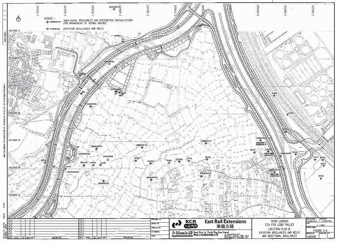
Groundwater Quality in Long Valley Wells
8.4.7
Data was collected during
groundwater well pumping investigations conducted in Long Valley as part of
the site investigations for Spur Line. The specific location of each well
is shown on Figure 3.5. Well
WV1 is located in the west of Long Valley, while WM2A is in the north-west
segment of the valley. The groundwater quality was low in BOD5
and phosphorous, but nitrogen levels (primarily in the form of ammonia nitrogen)
ranged from 2.1 to 4.3mg/L (Table 8.5). The source may be through connection
with the aquifer beneath the River Beas, or from farming practices in the
area, such as use of fertilisers.
Table 8.5
Groundwater quality data for wells in Long Valley
(unpublished data, December 2000)
|
Parameter |
Well
Reference |
|
|
WV1 |
WM2A |
|
|
Salinity (ppt) |
<0.1 |
<0.1 |
|
Total nitrogen |
2.2 – 4.3 |
2.6 |
|
Reactive
Phosphorus |
<0.1 |
<0.1 |
|
Total Phosphorus |
<0.1 |
<0.1 |
|
pH value |
6.1 – 6.3 |
6.2 – 6.3 |
|
Dissolved oxygen |
5.1 – 6.4 |
6.4 – 8.2 |
|
BOD5 |
<2 – 3 |
<2 |
|
Ammonia Nitrogen |
2.1 – 4.3 |
2.3 – 2.4 |
All values are reported in mg/l unless otherwise
specified
Kwu Tung, Pak Shek Au and Chau Tau
8.4.8
The
only data available to assess water quality in this area is from field
observations (Table 8.6). The water quality in several streams is poor, with
livestock waste being the main source of pollution at Kwu Tong, while the water
quality at Chau Tau is contaminated by run-off from construction sites,
container storage sites and vehicle maintenance and repair workshops.
Table 8.6
Field Observations at Water Courses
in Kwu Tong and Chau Tau areas
|
Location |
Stream Description |
Observation of Water Quality |
|
Along Lok Ma Chau Road south-east of the Boundary Crossing Plaza |
Part of the stream is channelized with concrete sloping sides. Thin
vegetation on the upper sides. |
Water was darkish grey in colour, slightly odorous and slow flowing.
Oil and grease, and large quantity of garbage observed flowing on water
surface. Pollution sources are mainly nearby small construction sites,
container yards, and garages. |
|
Kwu Tung, near the western portal |
Part of the stream is channelized with concrete sloping sides.
Vegetation on the sides beyond concreted banks. |
Water was darkish grey in colour and odorous. Debris/sediments on the
bottom observed. Pollution sources are mainly livestock farms in nearby
villages. |
Lok Ma Chau
Lok Ma Chau water courses and fishponds
8.4.9
No EPD water quality data
is available for this section of the Spur Line alignment. However, data available
from the EIA study on expansion of Lok Ma Chau Boundary Crossing (Tables 8.7
and 8.8) indicates that the San Tin River water quality is poor, with low
DO and high ammoniacal-N concentrations. Water quality was also measured in
two inactive fishponds on the east side of the Crossing (Figure
8.1). Water quality was generally good, with low nutrient levels. Sediment
in these unmanaged fishponds is uncontaminated (Table 8.8).
8.4.10
Data
collected on water quality in active fishponds for the Phase 1 Monitoring of
Off-site Compensation Works at Mai Po (Compensation for Regulation of Shenzhen
River, Stage II, Phase I works) shows that the nutrient levels of recently
active fishponds are higher (ranging from 5.8 to 8.1NH4mg/L and 0.1
to 0.45mgPO4/L) than fishponds that have been inactive for a long
time. This is due to the addition
of fishfeed and waste discharges from fish in actively managed ponds.
Table 8.7
Water quality in
watercourses and unmanaged ponds
alongside Lok Ma Chau
Boundary Crossing (Binnie 1999)
Date of sampling : January 1999
|
Parameter |
Location |
||||
|
Fishpond 1 (inactive) |
Fishpond 2 (inactive) |
Stream W1 |
Stream W2 (Upstream) |
Stream W2 (Downstream) |
|
|
pH |
9.2 |
9.0 |
7.4 |
7.6 |
7.6 |
|
Turbidity (NTU) |
76.0 |
28.0 |
43.0 |
3.6 |
1.2 |
|
DO |
13.0 |
13.0 |
0.5 |
9.5 |
8.5 |
|
BOD5 |
28 |
14 |
24 |
<2 |
2 |
|
SS |
- |
- |
59 |
7 |
18 |
|
Ammonia as N |
<0.01 |
<0.01 |
44.0 |
0.35 |
5.50 |
|
NO2 + NO3 as N |
0.02 |
0.02 |
0.78 |
2.00 |
1.40 |
|
Total Inorganic N |
0.02 |
0.02 |
45.0 |
2.40 |
6.9 |
|
Total Phosphorous |
0.2 |
0.1 |
12.0 |
<0.1 |
0.4 |
|
E.
Coli (cfu/100 ml) |
60 |
150 |
- |
- |
- |
Notes: All values are in mg/l unless otherwise indicated.
Table 8.8
Sediment Quality in unmanaged ponds alongside
Lok Ma Chau Boundary Crossing (Binnie 1999)
Date of sampling : January 1999
|
Metal |
Location
and Category |
|
|
Fishpond
1 |
Fishpond
2 |
|
|
Cadmium |
0.06 |
0.05 |
|
Chromium |
21.6 |
10.0 |
|
Copper |
17.8 |
14.1 |
|
Nickel |
4.5 |
3.8 |
|
Lead |
39.1 |
26.8 |
|
Zinc |
91.0 |
38.0 |
|
Mercury |
0.04 |
<0.04 |
|
Ammonia as N |
8 |
3 |
|
Total Phosphorous |
244 |
172 |
|
Overall
Classification |
A |
A |
All values are in mg/kg.
8.4.11 Data has also been collected along the San Tin Drainage Channel during December 2000 as part of the LDD300 Detailed Design contract for Lok Ma Chau station (Table 8.9). The data shows high levels of BOD5, particularly at upstream locations. Further downstream, close to the proposed Lok Ma Chau station location, water quality improves, although suspended solids and E. coil levels are still high. The pollutant concentrations are significantly higher than those measured in the wet season at Lok Ma Chau Boundary Crossing, illustrating the change in water quality between dry and wet seasons.
Table 8.9
Water quality in San Tin
Channel (unpublished data, 2000)
|
Monitoring Point(s) / location (s) |
San Tin Channel |
Shenzhen River |
Min. value |
Location of min. value |
Max. value |
Location of max. value |
||||
|
W1 |
WM1 |
WM2 |
WM3 |
WM4 |
W3 |
|||||
|
pH value |
7.5 |
7.9 |
7.5 |
6.8 |
6.9 |
7.3 |
6.8 |
WM3 |
7.9 |
WM1 |
|
Water temperature (oC) |
25 |
24.0 |
24.0 |
22.3 |
24.0 |
23.7 |
22.3 |
WM3 |
25 |
W1 |
|
DO (mg/L) |
1.5 |
9.3 |
1.0 |
5.1 |
0.3 |
0.3 |
0.3 |
WM3, WM4 |
9 |
WM1 |
|
Turbidity (NTU) |
103 |
8 |
26 |
85 |
42 |
33 |
8 |
WM1 |
103 |
W1 |
|
COD (mg/L) |
380 |
76 |
170 |
28 |
265 |
195 |
28 |
WM3 |
380 |
W1 |
|
BOD (mg/L) |
200 |
26 |
85 |
10 |
113 |
70 |
10 |
WM3 |
200 |
W1 |
|
TSS (mg/L) |
190 |
36 |
62 |
118 |
30 |
31 |
30 |
WM4 |
190 |
W1 |
|
NH3-N (mg/L) |
83 |
20 |
41 |
8 |
37 |
18 |
8 |
WM3 |
83 |
W1 |
|
NH3-N + NO3-N (mg/L) |
0.1 |
2.1 |
0.4 |
0.2 |
0.1 |
0.1 |
0.1 |
W1, W3, WM4 |
2 |
WM1 |
|
Total inorganic nitrogen (mg/L) |
83 |
23 |
41 |
8 |
37 |
18 |
8 |
WM3 |
83 |
W1 |
|
Total phosphorus (mg/L) |
15 |
5 |
11 |
0.4 |
2 |
2 |
0.4 |
WM3 |
15 |
W1 |
|
Orthophosphate (mg/L) |
12 |
3 |
10 |
<0.1 |
2 |
2 |
<0.1 |
WM3 |
12 |
W1 |
|
E. coil (cfu/100mL) |
1,036,667 |
50,000 |
870,000 |
16,333 |
985,000 |
1,126,667 |
16,333 |
WM3 |
1,126,667 |
W3 |
|
Salinity (ppt) |
0.7 |
0.4 |
0.6 |
0.5 |
2.5 |
2.2 |
0.4 |
WM1 |
2.5 |
WM4 |
|
Water flow (m/s) |
0.9 |
2.3 |
1.8 |
<0.1 |
0.3 |
0.7 |
0.3 |
WM3 |
2.3 |
WM1 |
Values are average
values from three sampling occasions between 28 November and 6 December 2000.
Source: KCRC
Detail Design of Lok Ma Chau Station, ongoing.
Shenzhen River Water
Quality
8.4.12
All of
the watercourses described ultimately flow into the Shenzhen River. This
receiving water body may therefore be impacted by construction and operational
related activities. The water quality in Shenzhen River has been monitored
intensively in the on-going Regulation Project, however, these data are not
available until the Regulation Project is complete. Data reported in the San
Tin EIA (ERM 1999) indicate poor water quality with low DO and high BOD5
and SS, due to discharge of untreated effluent from industry, agriculture,
poultry and livestock farming, and human sewage (Table 8.10).
8.4.13
Sediment
testing indicated that high levels of copper, zinc and lead were present (Table
8.11). However, in contrast to the Fanling Drainage Channel results, elutriate
testing showed that minimal pollutants are released from the sediment (Table
8.12).
Table 8.10
Water quality data for Shenzhen River (high and low water levels)
in dry season of 1994 (ERM 1999)
|
Station No. |
W2 |
W3 |
W4 |
|||
|
Water Levels |
High |
Low |
High |
Low |
High |
Low |
|
Dissolved Oxygen (DO) |
1.0 |
0.8 |
0.7 |
0.6 |
0.8 |
0.7 |
|
SS |
250 |
241 |
120 |
87 |
135 |
125 |
|
BOD5 |
74 |
75 |
63 |
62 |
25 |
46 |
All values in mg/l.
Table 8.11
Sediment quality data for Shenzhen River
(Shenzhen River Regulation Project, reported in ERM, 1999)
|
Location |
|
Cr |
Cu |
Hg |
Ni |
Pb |
Zn |
Cd |
|
River |
Zhanmatou |
106.0 |
207.0 |
0.30 |
- |
102.0 |
523.0 |
0.43 |
|
Hekou |
65.0 |
99.0 |
0.13 |
- |
82.0 |
308.0 |
0.24 |
All values are in mg/kg.
Bold values are Class C.
Shaded values are Class B.
Table 8.12
Elutriate test results for sediment from Shenzhen River (ERM 1999)
|
|
|
TN |
TP |
COD |
Cu |
Pb |
|
River Water |
No sediment |
26.97 |
2.82 |
19.39 |
0.018 |
0.048 |
|
1:100 |
24.50* |
0.55* |
20.13 (+3.8%) |
0.014+ |
0.048 |
|
|
1:1000 |
28.48 (+5.6%) |
1.87* |
21.06 (+8.6%) |
0.014+ |
0.048 |
Note: * Decrease due probably to adsorption
or degradation.
All values in mg/l.
Deep Bay
8.4.14 Deep Bay is a large shallow bay fed by outflow from the Shenzhen River and runoff from the surrounding land. It has a surface area of approximately 112 km² and a length of about 15 km with an average depth of 3m. Water from Deep Bay flows into the main Pearl River estuary. The complex hydrography of the Bay results in water flow from the NWNT area being trapped in Inner Deep Bay, an estuarine area with exposed mudflats during low tides. The current hydrological conditions are the result of natural accretion in Deep Bay, reclamation, and intensive anthropogenic disturbances in recent years. These anthropogenic disturbances include discharges of domestic sewage, industrial effluent, agricultural runoff and livestock waste.
8.4.15
The
rivers, streams and nullahs flowing into the Deep Bay from Hong Kong and
Shenzhen contribute domestic sewage and livestock waste generated in the
catchment to the Bay. This pollution is a source of concern for the Inner Deep
Bay area which provides a feeding area for thousands of migratory birds and is
an internationally recognised Ramsar site for waterfowl and other birds. The
total catchment area of Deep Bay is about 535 km².
Current Water Quality of Deep Bay
8.4.16
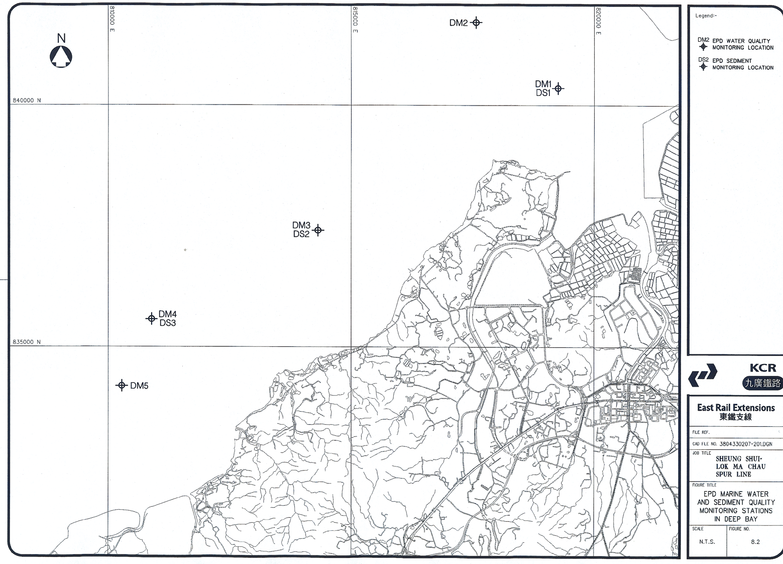
EPD has established five
monitoring stations in the Deep Bay Water Control Zone. Stations DM1, DM2
and DM3 are located within the inner subzone whereas DM4
and DM5 are located in the outer subzone (Figure
8.2). Tables 8.13 and 8.14 present selected water quality data within
Inner Deep Bay and the Outer Deep Bay subzone within the last 4 years.
8.4.17
During 1996, levels of TIN, TN and
ammoniacal-N were higher than previous years, particularly in Inner Deep Bay. A
decrease in ammonia (8-43%) and total nitrogen (2-41%) was observed. DM3 and DM4 showed that the stations
achieved full compliance with WQO for DO in 1999. Levels decreased in 1999, however, non-compliance with Water
Quality Objectives (Appendix A) were experienced for TIN and unionised ammonia
(DM1 and DM2 only). Long term trends have been examined and are presented in
EPD’s Marine Water Quality 1999 publication.
8.4.18
Data
in Tables 8.13 and 8.14 show that the water quality improves as one
moves from Inner Deep Bay into the Outer Deep Bay zones. At location DM1, DO
levels fluctuate around the WQO level of 4.0 mg/l although BOD5
levels remain low. The low BOD5 levels are largely a result of the
enforcement of the Livestock Waste Control Scheme and improvement of sewerage
provision in NWNT. E. coli levels
decrease as one moves out of Inner Deep Bay, but increase again at location
DM5, possibly due to additional discharges from Hong Kong and China sides, and
influence from the Pearl River.
Table 8.13
Monitoring Results
from Inner Deep Bay in Recent Years
(EPD Marine 1996,
1997, 1998, 1999)
|
Parameters |
1996 |
1997 |
1998 |
1999 |
|
Station
DM1 |
||||
|
Surface DO (mg/L) |
6.1 (0.6 - 7.5) |
6.8 (5.1 - 8.5) |
7.0 (4.7 - 9.6) |
4.6 (1.8-7.7) |
|
Bottom DO (mg/L) |
- |
- |
- |
- |
|
pH |
7.4 (7.0-7.9) |
7.0 (6.2-8.3) |
6.9 (6.3-7.7) |
7.6 (7.0-8.2) |
|
SS (mg/L) |
89.8 ( 11.0-320) |
72.4 (22.0-240.0) |
66.3 (23.0-130.0) |
70.8 (19.0-180.0) |
|
E.coli
(cfu/mL) |
69.4 (10.0-350) |
5,754 (670-55,000) |
2,621 (410-18,000) |
700 (16-14,000) |
|
BOD5 (mg/L) |
9.0 (1.4-19.8) |
2.6 (0.7-8.7) |
2.6 (1.6-5.2) |
3.8 (1.9-6.6) |
|
Ammoniacal Nitrogen (mg/L) |
7.53 (2.40-13.0) |
3.4 (1.6-4.2) |
3.5 (2.0-6.9) |
3.16 (0.13-7.40) |
|
TIN (mg/L) |
7.79 (2.82-13.04) |
4.21 (2.52-7.25) |
4.21 (2.72-7.42) |
4.12 (1.28-7.95) |
|
TN (mg/L) |
10.34 (2.82-18.01) |
5.06 (2.82-9.55) |
5.3 (3.22-10.52) |
4.95 (1.87-8.35) |
|
Station
DM2 |
||||
|
Surface DO (mg/L) |
7.4 (0.6 - 8.6) |
5.3 (1.8 - 13.0) |
4.7 (2.6 - 7.3) |
5.1 (2.1-7.7) |
|
Bottom DO (mg/L) |
- |
- |
- |
- |
|
pH |
7.6 (7.1 - 7.9) |
7.1 (6.3 - 8.2) |
7.4 (6.6 - 8.3) |
7.5 (7.0-8.2) |
|
SS (mg/L) |
52.0 (5.0-150) |
32.9 (12.0 - 140.09) |
27.7 (20.0 - 46.0) |
61.8 (17.0-160.0) |
|
E.coli
(cfu/mL) |
32.7 (4.8-151) |
1,065 (22 – 31,000) |
1600 (310-7,600) |
280 (8-2,900) |
|
BOD5 (mg/L) |
4.1 (0.1-12.6) |
1.5 (0.6 - 6.3) |
1.6 (1.0 - 2.4) |
3.0 (1.7-6.1) |
|
Ammoniacal Nitrogen (mg/L) |
4.29 (1.7 - 8.4) |
2.39 (1.4 - 4.0) |
2.72 (1.6 - 4.30) |
2.16 (0.10-4.60) |
|
TIN (mg/L) |
4.75 (2.34 - 8.45) |
3.26 (2.22 - 5.12) |
3.42 (2.46 - 4.93) |
3.08 (0.99-5.29) |
|
TN (mg/L) |
6.55 (2.70 - 11.27) |
3.82 (2.60 - 6.02) |
4.1 (2.96 - 5.53) |
3.74 (1.71-6.07) |
|
Station
DM3 |
||||
|
Surface DO (mg/L) |
7.0 (3.6-10.3) |
6.2 (3.7 - 11.6) |
5.5 (3.5 - 8.0) |
6.1 (3.2-8.2) |
|
Bottom DO (mg/L) |
- |
- |
- |
- |
|
pH |
7.9 (7.2 - 8.8) |
7.0 (6.2 - 7.9) |
7.4 (6.5 - 8.1) |
7.6 (7.1-8.1) |
|
SS (mg/L) |
28.1 (7.6 - 91) |
21.7 (3.0 - 37.0) |
14.2 (7.1 - 28.0) |
11.8 (4.7-21.0) |
|
E.coli
(cfu/mL) |
23.9 (5.6 - 96.2) |
241 (10 – 19000) |
144 (21 - 760) |
24 (1-380) |
|
BOD5 (mg/L) |
2.3 (0.3 - 7.2) |
0.8 (0.3 - 2.1) |
1.0 (0.3 - 1.5) |
1.6 (0.8-3.7) |
|
Ammoniacal Nitrogen (mg/L) |
1.33 (0.12 - 3.70) |
1.21 (0.20 - 3.60) |
0.86 (0.39 - 2.00) |
0.58 (0.01-1.10) |
|
TIN (mg/L) |
1.91 (0.52 - 4.69) |
1.99 (1.05 - 4.30) |
1.6 (0.88 - 2.64) |
1.33 (0.81-1.83) |
|
TN (mg/L) |
2.57 (0.86 - 7.19) |
2.51 (1.29 - 4.60) |
2.1 (1.59 - 3.14) |
1.62 (1.13-2.13) |
Source: Marine
Water Quality in HK 1996, 1997, 1998, 1999, EPD
Data presented are
depth-average, unless specified
Data presented are
annual arithmetic means except for E.
Coli which are geometric means
Table 8.14
Monitoring Results
from Outer Zone of Deep Bay in Recent Years
(EPD Marine 1996,
1997, 1998, 1999)
|
Parameters |
1996 |
1997 |
1998 |
1999 |
|
Station
DM4 |
||||
|
Surface DO (mg/L) |
6.1 (0.6 - 7.5) |
6.8 (5.1 - 8.5) |
7.0 (4.7 - 9.6) |
5.9 (3.1-7.5) |
|
Bottom DO (mg/L) |
6.5 (5.1 - 7.4) |
6.7 (5.3 - 8.6) |
6.9 (4.3 - 9.7) |
5.8 (2.9-7.4) |
|
pH |
8.0 (7.8 - 8.3) |
7.8 (6.5 - 8.3) |
8.1 (7.7 - 8.5) |
7.9 (7.5-8.1) |
|
SS (mg/L) |
16.6 (3.3 0 51.5) |
9.4 (4.1 - 27.0) |
8.6 (3.6 - 18.0) |
10.7 (4.6-25.2) |
|
E.coli
(cfu/mL) |
176 (30 - 720) |
99 (10 – 700) |
88 (8 - 660) |
96 (22-270) |
|
BOD5 (mg/L) |
0.7 (0.3 - 1.3) |
0.9 (0.3 - 2.0) |
1.6 (0.4 - 3.40) |
0.9 (0.5-1.7) |
|
Ammoniacal Nitrogen (mg/L) |
0.3 (<0.01 - 0.88) |
0.42 (0.13 - 1.10) |
0.38 (0.05 - 1.30) |
0.20 (0.01-0.58) |
|
TIN (mg/L) |
0.93 (0.14 - 1.76) |
1.06 (0.45 - 1.65) |
1.0 (0.39 - 1.36) |
0.80 (0.38-1.49) |
|
TN (mg/L) |
.20 (0.32 - 2.10) |
1.58 (1.35 - 1.85) |
1.8 (1.35 - 2.74) |
1.03 (0.62-1.77) |
|
Station
DM5 |
||||
|
Surface DO (mg/L) |
6.2 (4.7 - 7.4) |
7.0 (4.9 - 9.9) |
6.5 (4.9 - 9.1) |
5.6 (3.3-8.1) |
|
Bottom DO (mg/L) |
5.7 (3.4 - 6.9) |
6.1 (3.9 - 7.8) |
6.0 (4.1 - 8.4) |
5.4 (2.6-7.8) |
|
pH |
8.0 (7.8 - 8.3) |
7.8 (6.9 - 8.4) |
8.0 (7.3 - 8.5) |
7.9 (7.2-8.1) |
|
SS (mg/L) |
9.7 (3.0 - 16.0) |
11.5 (4.1 - 52.0) |
11.9 (3.2 - 34.0) |
13.0 (1.3-50.8) |
|
E.coli
(cfu/mL) |
480 (52 – 17,000) |
232 (5 – 2,600) |
266 (23 - 840) |
330 (56-1,000) |
|
BOD5 (mg/L) |
0.5 (0.2 - 1.3) |
0.7 (0.2 - 4.9) |
0.7 (0.2 - 2.5) |
0.9 (0.5-1.7) |
|
Ammoniacal Nitrogen (mg/L) |
0.11 (<0.01 - 0.20) |
0.15 (0.03 - 0.40) |
0.18 (0.06 - 0.32) |
0.11 (0.01-0.23) |
|
TIN (mg/L) |
0.55 (0.14 - 1.07) |
0.64 (0.28 - 092) |
0.8 (0.38 - 1.66) |
0.53 (0.25-0.89) |
|
TN (mg/L) |
0.80 (0.34 - 1.38) |
1.22 (0.74 - 1.50) |
1.6 (1.28 - 2.05) |
0.72 (0.44-1.14) |
Source: Marine
Water Quality in HK 1996, 1997, 1998, 1999, EPD
Data presented are
depth-average, unless specified
Data presented are
annual arithmetic means except for E.
Coli which are geometric means
8.4.19 Sediment data collected by EPD at monitoring locations DS1 and DS2 since 1995 show that there has been an increase in some heavy metals during this period. In particular, higher levels of lead, zinc, copper and mercury have been measured at DS1 in 1997 and the first part of 1998 compared with previous years (Table 8.15). These data suggests a deterioration in sediment quality which may be due to the increased industrial and commercial discharges from both sides of the border.
Table 8.15
Metal Concentrations in Sediment in
EPD Monitoring Locations
in Deep Bay (EPD Marine 1996, 1997,
1998, 1999)
|
Metal
(mg/kg) |
Location |
1996 |
1997 |
1998 |
1999 |
|
Lead |
DS1 |
5-64 |
73.5 |
68 |
64 |
|
|
DS2 |
5-64 |
64 |
64 |
64 |
|
Zn |
DS1 |
1-149 |
305 |
270 |
>200 |
|
|
DS2 |
150-199 |
205 |
170 |
150-190 |
|
Cu |
DS1 |
0.1-54 |
88 |
84 |
55-64 |
|
|
DS2 |
0.1-54 |
53 |
54 |
54 |
|
Hg |
DS1 |
0.05-0.7 |
0.15 |
0.15 |
0.7 |
|
|
DS2 |
0.05-0.7 |
0.12 |
0.16 |
0.7 |
|
Ni |
DS1 |
5-34 |
31 |
28 |
34 |
|
|
DS2 |
5-34 |
25 |
28 |
34 |
|
Cd |
DS1 |
0.1-0.9 |
0.5 |
0.5 |
0.9 |
|
|
DS2 |
0.1-0.9 |
0.35 |
0.2 |
0.9 |
|
Cr |
DS1 |
5-49 |
53 |
47 |
49 |
|
|
DS2 |
5-49 |
42 |
47 |
49 |
Summary of Water Quality in Study Areas
8.4.20
Water
quality in the rivers within the Study Area is generally poor, with low DO and
high BOD5 and SS concentrations. The major pollution source is
livestock waste from farms in the area, although run-off from container sites
around Chau Tau also contributes to the pollutant load. With the implementation
of the LWCS, the water quality in the major rivers is improving. Sediment data
shows contamination by zinc and copper, metals used in food additives for
livestock. The difference in elutriate results from different studies may be
due to different sediment composition.
8.4.21
The
receiving water body for all waterbodies within the Study Area is Shenzhen
River, a highly polluted watercourse receiving pollutants from many sources.
Ultimately, water drains into Inner Deep Bay, where pollutants are easily
trapped due to poor flushing. The deteriorating water quality in this water
body is of concern because of its ecological importance.
8.5
Potential Impacts during
Construction
8.5.1 The main construction activities which have the potential to impact water bodies along the alignment are those which may result in generation of wastewater, with potential to flow into adjacent watercourses and affect groundwater through physical or chemical impact. This section is divided into construction activities carried out during Spur Line construction, namely: excavation works, diaphragm walling (including concreting works), tunnel boring, cross passage construction, works in the River Sutlej, viaduct and station construction, draining of fishponds and construction of a footbridge across Shenzhen River. Potential impacts are assessed in terms of the location and type of impact, and an evaluation of the potential severity of the impact to determine the need for mitigation.
Excavation Activities
8.5.2 Excavation will be carried out at a number of sites along the alignment, the most significant being the TBM launching shaft, the Kwu Tung station box, the TBM reception shaft and the ventilation buildings. The cut and cover sections, diaphragm walling and embankments at each end of the alignment will also involve considerable excavation of material. Potential impacts on water quality from these activities will depend on the nature of the material excavated. At the River Sutlej, there is a potential for run-off to enter the adjacent watercourses and cause turbidity, with adverse consequences on aquatic life in the immediate receiving waters and downstream. The data presented in this report indicate that the water quality of River Sutlej is poor. Where sediment is excavated from the River Sutlej for ground treatment works (see following sections), tests should be conducted to determine the contamination state of the sediments prior to removal. If contaminated, the sediment should be carefully removed, drained and disposed of as defined by EPD and FMC. The disposal site depends on the quantity of material to be removed, and the degree of contamination, if any.
8.5.3 The activities carried out for Spur Line construction must not cause a further deterioration of the water quality. At the Chau Tau end of the alignment, there are a number of channelised watercourses close to the works area. In the absence of adequate mitigation, there is a potential for run-off to enter these watercourses. Other pollutants, such as oil and grease, and chemicals, may be present in the run-off where it flows over storage or maintenance areas for the works.
8.5.4 In works areas, the site formation process may alter the existing permeability characteristics of the soil, possibly reducing the infiltration of the top soil by introducing finer material, compacting the soil structure and removing the surface vegetation. During wet weather conditions, surface run-off with high suspended solids loading may flow off-site in the absence of appropriate mitigation measures. Erosion of soil enriched in organic matter may release nutrients into the adjacent watercourses. Erosion of stockpiles may also release suspended solids into nearby watercourses.
Diaphragm walling
8.5.5 This operation will involve excavation and earth movement within the site. Bentonite will be used to stabilize the excavation, and this will be pumped out as the diaphragm wall is constructed. After the majority of the excavation work is complete, concrete retaining walls will be constructed to support the ramp down for the alignment. Potential impacts from these activities include turbid site run-off from the works, and bentonite and concrete washings entering watercourses. Turbidity will reduce light penetration into a water body. The River Sutlej is already highly polluted and the addition of turbid water may not appear to have significant adverse effect. However, there is potential for downstream effects to occur, including damage to Mai Po Marshes and Deep Bay and must be avoided through good site management of run-off.
8.5.6 Bentonite washings and concrete washings have potentially more serious impacts on water quality. Bentonite is a highly turbid material and will cause damage to aquatic organisms in receiving waters. Run-off may arise during extraction of the bentonite or during preparation for recycling or disposal. Concrete washings are potentially toxic to aquatic organisms, raising pH of receiving water bodies and increasing the toxic, unionized ammonia content. Concrete washings also increase turbidity in a waterbody.
Bored Tunnel Operation
8.5.7 The bored tunnel operation will extend from the launching shaft at Sheung Shui through to the reception shaft at Chau Tau. Due to the nature of the ground (mostly Completely Decomposed Volcanic Tuff (CDV)), the Tunnel Boring Machine will be operated in Earth Pressure Balance mode in which the cutter head is maintained at a defined pressure through the addition of sufficient water to the soil at the face, to form a paste against which the machine can maintain pressure. This pressure prevents the soil caving in from above, or blowing out due to balanced pressures. The water-soil mixture is removed through a screw conveyor system back to the launching shaft for settlement and treatment.
8.5.8 During this tunneling operation, there is a potential for impacts on both the underground water resource and surface watercourses. As material is conveyed to the surface, run-off may occur and turbid water may enter adjacent watercourses, reducing light penetration and affecting aquatic organisms in the waterbody and downstream. The supernatant from the settled water/soil mix must be treated before discharge to prevent polluted water entering water bodies.
8.5.9 After settlement in the soil basin, the soil is removed for disposal off site. If not adequately dried, there is potential for spillage from the lorries onto public roads. Supernatant from the settlement process will be turbid and have the potential to impact watercourses if not adequately handled and treated. A mortar plant will be present on site, producing mortar for use in the sealing of precast tunnel lining units. There is a potential for run-off from the works area around the TBM launching shaft to become polluted with spillage from the processes being operated. The drainage from this area will enter the River Sutlej.
8.5.10 In some sections of the tunnel, rock will be encountered. Tunneling through rock may require more frequent maintenance of the cutter head. Short manned interventions require the use of bentonite to support the excavation and avoid collapse. A bentonite production plant will be located within the launching shaft area. Upon completion of each intervention, the first section of material together with the bentonite will be excavated and removed separately. The bentonite will not be recycled because of the small amounts to be used. It will be disposed of as a separate waste material to public fill after dewatering, as described in the Waste Chapter. With correct handling and disposal, impacts from this source are likely to be minimal. For longer interventions, jet grouting may be required. The use of bentonite results in the potentially adverse impact of this material entering watercourses through spillage and site run-off. Impacts include increase in turbidity in receiving waters.
Hydrological Impacts during
Construction
8.5.11 As the tunnel boring machine passes through the soft material below Long Valley and sections of Kwu Tung and Chau Tau, there is a potential for groundwater to enter the tunnel as the cutter head moves through the groundwater layer. This potential impact is minimised through the operation of the TBM in Earth Pressure Balance Mode (EPB TBM), details of which are provided in Section 3 which assesses potential hydrological impacts during construction of the TBM in detail.
8.5.12 Piezometer measurement data from previous tunneling operations using this EPB TBM indicate that there is a slight drop in the groundwater level as the TBM passes, but the groundwater level returns to normal after the cutter head has passed. The potential for impacts on groundwater levels during the bored tunnel operation is therefore minimal.
8.5.13 At the cutter head, the soil is formed into a paste through the addition of water and a biodegradable foaming agent (a non-toxic material comprising a tensoactive compound and a polymer similar to that used in the DB320 Contract for West Rail) that creates the correct consistency for the excavation. There is a small potential for the foaming agent to enter the groundwater, although the effect will be minimal, as the material is non-toxic and biodegradable.
Formation of Cross Passages
8.5.14 Two methods will be used for this construction activity. To avoid works on the ground surface in Long Valley cross passages in this section will be drilled after the completion of the two tunnels. Ground freezing will be used to stabilize the ground before construction of the cross passage. This activity will have minimal impacts on groundwater quality or movement and the effects will be temporary, until passage drilling has been completed.
8.5.15 In other, less ecologically sensitive, areas, ground treatment for cross passages will comprise jet grouting from the surface over an area of approximately 10m x 23m to stabilize the ground before the tunneling operation begins. The jet grouting operation involves a drilling rig and grouting plant on site pumping grout into the defined box below the surface, containing the proposed tunnels and cross passage. Potential spillage of grout and the possible use of water in the drilling operation may result in spillage entering adjacent watercourses, with potentially adverse consequences on water quality, including increased turbidity. Some of the proposed cross passage locations are adjacent to, or within, potentially contaminated sites. Any contaminated material disturbed, or material which comes into contact with the contaminated material, has the potential to be washed with site run-off into watercourses.
Works in River Sutlej
8.5.16 Two possible methods are proposed for the stabilization of the base of the River Sutlej before the bored tunnel passes below the River. The concrete base of the River Sutlej will be broken up for access to the alluvial phase below and the low flow channel will be diverted to prevent water entering the excavation or material from the works being washed into the river water.
8.5.17 The first method to stabilize the sand/silt alluvial phase will be by jet grouting to create a solid block of ground containing the two tunnels (at different levels at this chainage). Alternatively, the ground will be excavated down to the base tunnel level, supported with sheet piles, and the void filled with lean mix concrete to the channel invert.
8.5.18 Potential impacts may occur if rain falls during the excavation works, and water from the river enters the excavated area, or silt and sand material from the excavation enters the river water, increasing turbidity. Excavated material will be wet and there will likely be spillage of water from the material onto the ground as it is being loaded into the lorries for transfer for re-use or disposal.
Potential Hydrological
Impacts from River Sutlej works
8.5.19 The construction of a large impermeable block from approximately –5mPD to –15mPD below the River Sutlej may have an impact on the flow of underground channels in the alluvial phase. The extent of this impact will be determined by the exact levels of the impermeable box and the flow of underground channels. Underground channels may be diverted from their course and will be forced to find an alternative route. The potential hydrological impacts from this operation are described in detail in Section 3.
Concrete batching plant
8.5.20 If it is necessary to use a concrete batching plant on site, it will be located close to the works areas of Sheung Shui, Kwu Tung and Chau Tau. The concrete production operation may result in spillage of waste concrete onto the ground and wash off into the watercourses in the area. In the absence of a covered area for concrete related activities and appropriate drainage for any spillage, there is a potentially severe adverse impact in the area of the batching plant.
EAP and Ventilation Buildings Construction
8.5.21 These structures require excavation to base tunnel level, in some cases adjacent to major watercourses (the eastern ventilation building next to the River Sutlej and east EAP next to the River Beas). In the case of the west EAP, this is adjacent to potentially contaminated ground and there is therefore potential for contaminated material to enter site run-off and pollute watercourses.
Draining of Fishponds or Rivers
8.5.22 Dredging of pond sediment or bottom mud may be required during the construction of the borepiles along the viaduct section of the alignment near Lok Ma Chau. Disturbance and exposure of the pond mud which contains high levels of organic matter, and possibly other contaminants, may lead to release of these pollutants into adjacent water courses through run-off. If the mud is stockpiled, run-off containing potentially contaminated material will have on adverse impact on water quality and on associated aquatic ecology.
8.5.23 Where piling works are required within fishponds for viaduct pier construction, the pond may need to be filled, and after work is complete, reinstated. There will therefore be a temporary loss of the fishpond, which acts as a storage device for rainwater during storms. Runoff will increase temporarily, the main pollutant being suspended solids from the fill material.
Diversion of Chau Tau Channel
8.5.24 Diversion of the Chau Tau Channel will require removal of sediment from the riverbed. This sediment may be contaminated and its disturbance may result in turbidity and pollutants being released downstream. Reconstruction of the channel to discharge further downstream will involve the use of concrete. Potential impacts include discharge of concrete slurry and other grouting materials generated by concreting work, which may have an adverse impact on the aquatic life in local water bodies by increasing alkalinity which increases the dissociation of, and hence the toxicity of, ammonia. The hydraulics of water flow may also change, although the impact is likely to be small.
Viaduct Construction
8.5.25 Viaduct structures are likely to be manufactured off site and brought to site by road. This will minimize impacts from concreting on site. However, construction of the viaduct supporting columns and the Lok Ma Chau Station will involve concreting works on site. If a concrete batching plant is required, it is likely to be located in the works area at Chau Tau, close to the viaduct construction works.
8.5.26 Concrete will be transported from here to locations along the alignment for viaduct support construction and to Lok Ma Chau area for station construction. There is potential for run-off from the batching area to enter drains and watercourses in the area, with consequential impacts on water quality and ecology downstream. Transport of concrete along roads gives rise to potential impacts from run-off entering watercourses and fishpond in the Lok Ma Chau area. During concreting activities, large quantities of concrete will be handled, a proportion of which may be deposited on the ground. Site effluent or run-off may therefore contain waste concrete washings from this source or from washing of concrete mixers. The piling operation may require the use of lubricants that are potentially harmful. If wastewater from this activity is allowed to drain into surrounding water courses, the lubricant may have a toxic effect on aquatic ecology.
Lok Ma Chau Station Construction
8.5.27 The station construction will require filling of fishponds on which the platform will be sited. This will reduce the area of water storage during storms. A drain will be constructed to the west of the station through which runoff from the station will be discharged. This will alter the hydraulics of stormwater flow in the area, however, as the proportion of the station area relative to the surrounding fishpond area is small, the impact is likely to be low.
8.5.28 Pumping water out of fishponds may result in discharge of turbid and nutrient rich water into surrounding waterbodies. The use of concrete in station construction will increase the potential for run-off of concrete washings to enter adjacent watercourses and fishponds, leading ultimately to Deep Bay. This will have deleterious effects on the aquatic organisms of the ecologically sensitive area.
Footbridge between Lok Ma Chau Station and Shenzhen
8.5.29 A footbridge will be constructed across the Shenzhen River to link Lok Ma Chau station with Huanggang Station. The current design of the bridge is a cable stayed design, with one main pier close to the Shenzhen side, and a smaller pier near the Hong Kong river bank. The construction of these supports will likely be carried out by constructing a cofferdam, forming a sheet pile box and excluding water from the piling and concreting area. Construction in the water environment has the potential to create impacts on water quality through release of river water which needs to be pumped out of the cofferdam, and the discharge of concrete washings during construction of the piers. Dewatering will potentially release turbid water into the environment, which will affect the turbidity of the watercourse downstream. Concrete washings are of more concern, in particular due to the poor water quality and high ammonia content in the Shenzhen River, and potential impacts on the ecologically sensitive Deep Bay downstream. The high pH in concrete washings raises the unionized ammonia level, a contaminant that is highly toxic to many aquatic organisms. Measures to avoid spillage of turbid water and concrete washings into the watercourse should be implemented to minimize impacts on water quality and associated ecology. This is particularly important in view of the ecologically sensitive mud flats downstream within and around Mai Po Marshes Nature Reserve.
8.5.30 The bridge deck units are likely to be pre-cast units brought from the Shenzhen side, thus minimizing water quality impacts.. The works area alongside the bridge will be limited and materials are likely to be brought by vehicles along paved roads within the urban area. If there is a need for concrete work to be is carried out in-situ over the river, there is a potential for concrete washings to drip into the watercourse. Suitable mitigation measures must be implemented to prevent this occurrence, which may have adverse effects on water quality and ecologically sensitive areas downstream.
Jetties for materials transfer
8.5.31 At the present time, it is expected that three jetties will be used for bringing materials to the Lok Ma Chau station site or removing materials. One jetty will be approximately 30m x 60m and be supported by 35 piles, the other two will be 15m x 60m and have 21 piles each. The construction of the jetties is unlikely to create significant water quality impacts providing steel sheet piles are used and the jetty is constructed in situ. Dismantling of the structure will be carried out in reverse and impacts are likely to be minimal providing the work is carried out carefully and no waste materials enter the river.
8.5.32 It is likely that sand fill will be brought in by Pelican Barges to the site. Pelican or perhaps other types of barges will deliver construction materials (cement, bentonite, steel reinforcement, aggregate), prefabricated concrete units or steel structural sections, and possibly plant. Removal of materials by barge from the site is likely to include construction waste and unsuitable excavated material to a landfill or public filling area. Providing the transfer of materials is carried out carefully, impacts on water quality should be minimal.
8.5.33 Pelican barges are 18 to 20m wide and vary between 35 to 40m in length with an average volume capacity of 800m3. In order to deliver the required volume of sand for filling purposes (630,000m3) approximately 790 barges of sand fill will be required to complete the filling of the fishponds. Assuming a 3-hour turnaround time for each barge, and two mooring points at the jetty, 8 barges per day could be handled during each 12-hour shift. This would continue for a period of 100 days. Following filling, other barges would be utilized for delivery of other construction materials and structural sections/units.
8.5.34 The sand fill is carried in covered tanks below the deck level of the Pelican barges. The sand fill is pumped into these tanks and then the water removed. This means that the fill is washed and the fines content will be minimal. There is potential for the discharged water to be slightly turbid if not settled before discharge to the nearest watercourse. The impact depends largely on the location at which the sand is collected. On delivery a sliding conveyor belt on the barge, with a controlled feed so that no overloading and spillage of materials occurs, will be used to off load the sand directly onto the conveyors feeding the site works. There is a possibility that small spillage of fill could occur during this period. During all deliveries (sand fill and other construction materials, there is a potential impact from barge fuel/lubricants to enter the river. Mitigation measures must be implemented to minimize this impact.
8.5.35 The sand fill will either be carried by a conveyor belt over the fence or under the fence. It is likely that all other construction materials, concrete units and steel structural sections will be lifted over the fence by vehicle or permanent crane (which would be situated on the HKSAR side of the fence line). The sand from the Pelican Barges will be washed and will therefore have a low fines content, minimizing dust impacts. However, for safety purposes, the conveyor is likely to be covered. Potential impacts from handling of the sand fill are primarily related to turbidity in watercourses downstream. As Deep Bay and Mai Po marshes are downstream of this works area, and are ecologically sensitive to increases in pollution, mitigation measures must be implemented to prevent adverse impacts to these ecologically important areas.
8.5.36 Potential hydrological impacts from the physical presence of the jetties have been assessed in a Drainage Impact Assessment Report prepared as part of the detailed design for Lok Ma Chau station and associated works (KCRC LDD300, 2001). The DIA model results indicated that under a worst case scenario of 200yr tide and 10yr rainfall event, the presence of the three jetties would result in a maximum river water level of 4.139mPD, an increase in 11mm from the baseline condition. During a 200yr rainfall and 10yr tide event, the river water level would increase by 54mm compared with the baseline condition for this scenario. Given the temporary nature of the jetties, and the small chance of the worst case scenario occurring during this period, this impact was considered to be acceptable. Although the construction programme of the footbridge to Shenzhen Metro Station is not yet known, there is a possibility that the bridge pier construction and the presence of the jetties may be concurrent. The potential impacts and risk to flooding from this scenario are considered acceptable from the model results of the DIA and are described in the Operational Impacts Section of this chapter.
Site Workshop or Depot
8.5.37 A workshop or depot is often set up to provide maintenance and repair services for the equipment on site in the vicinity of the Works Area. The use of engine oil and lubricants, and their storage as waste materials has the potential to create impacts on the water quality of adjacent water courses if spillage occurs and enters watercourses. Waste oil may infiltrate into the surface soil layer, or runoff into local water courses, increasing hydrocarbon levels.
Presence of Additional Population (Workers)
8.5.38 During construction, the increased workforce will contribute to the local population of the area, although the number of workers will vary over the construction period. Impacts include the generation of rubbish and wastewater from eating areas, temporary sanitary facilities and waste disposal areas. Although the impact will be temporary, this additional population may impose significant stress on the quality of water in local water courses.
8.5.39 The construction activities and their associated impacts on water quality are summarized in Table 8.16.
Table 8.16
Summary of Construction
Activities and Potential Impacts
|
Construction Activity |
Potential impact |
|
Excavation
and Earth Movement |
Increase
of site run-off from exposed surfaces. Increase
in suspended solids and nutrient loading into local water courses. |
|
Diaphragm
Walling |
Site
run-off containing bentonite and concrete washings, resulting in turbidity
and high pH levels in adjacent watercourses |
|
Bored
Tunnel Construction |
Wet
material excavated may result in runoff of silt into watercourses. Potential
temporary drop in groundwater levels due to TBM operation. Use of
chemical agent may result in contamination to excavated wet material and its
runoff. |
|
Formation
of Cross Passages |
Site
run-off during drilling may impact watercourses. Drilling
within areas of potentially contaminated land may release pollutants into
watercourses. |
|
Works
in River Sutlej |
Run-off
from excavation or grouting may affect local watercourse. Washings
from concreting works after excavation and during diversion of low flow
channel may impact water quality in watercourses. Potential
impact on groundwater hydrology from presence of large impermeable structure. |
|
Concrete
Batching Plant |
Concrete
washings in run-off if batching plant not covered and with suitable drainage. Generation
of concrete washings may increase pH value, suspended solids and turbidity
levels, leading to ecotoxic levels of ammonia in receiving water bodies of
low water quality. |
|
EAP
and Ventilation Building Construction |
Site
run-off, concrete washings, particularly in eastern structures which are
adjacent to major watercourses. |
|
Draining
of fishponds or rivers |
Increase
of suspended solids, nutrient levels and turbidity in water courses. Temporary
loss of storage capacity of ponds. |
|
Diversion
of Chau Tau Channel |
Release
of pollutants from removed sediment into surrounding water. Concrete
washings in watercourses during channel construction. Minor
changes in hydrology of channel during diversion. |
|
Viaduct Construction |
Concrete
washings during piling, pile cap and pier construction. Turbid
run-off during excavation. Contamination
of watercourses with chemical lubricants during bored piling. |
|
Lok Ma
Chau Station Construction |
Turbid
run-off during filling and station construction. Removal
of storage capacity of pond. |
|
Culverting
of stream |
Increase
of suspended solids and turbidity in water courses through disturbance of
stream course. Elevation
of pH value by concrete washings. Change
of physical hydrology of stream. |
|
Footbridge
at LMC Station |
Impacts
from footbridge construction include turbidity and concrete workings
affecting downstream water bodies including Deep Bay. |
|
Bored
piling |
Contamination
of local water courses with chemical lubricants. |
|
Jetties
for materials transfer |
Turbidity
due to loss of sand and silt during transfer process. Potential impacts
downstream in Deep Bay Potential
hydrological impacts from the presence of piles and the jetty in the River. |
|
Site
workshop and maintenance facilities |
Land
contamination with spillage of waste oils and chemicals. Contamination
of groundwater or runoff into local water courses. |
|
Additional
workforce |
Generation
of rubbish, additional sewage, and waste / wastewater which may impact water
quality locally. |