APPENDIX A2.1
EVALUATION OF ALTERNATIVE HORIZONTAL ALIGNMENT
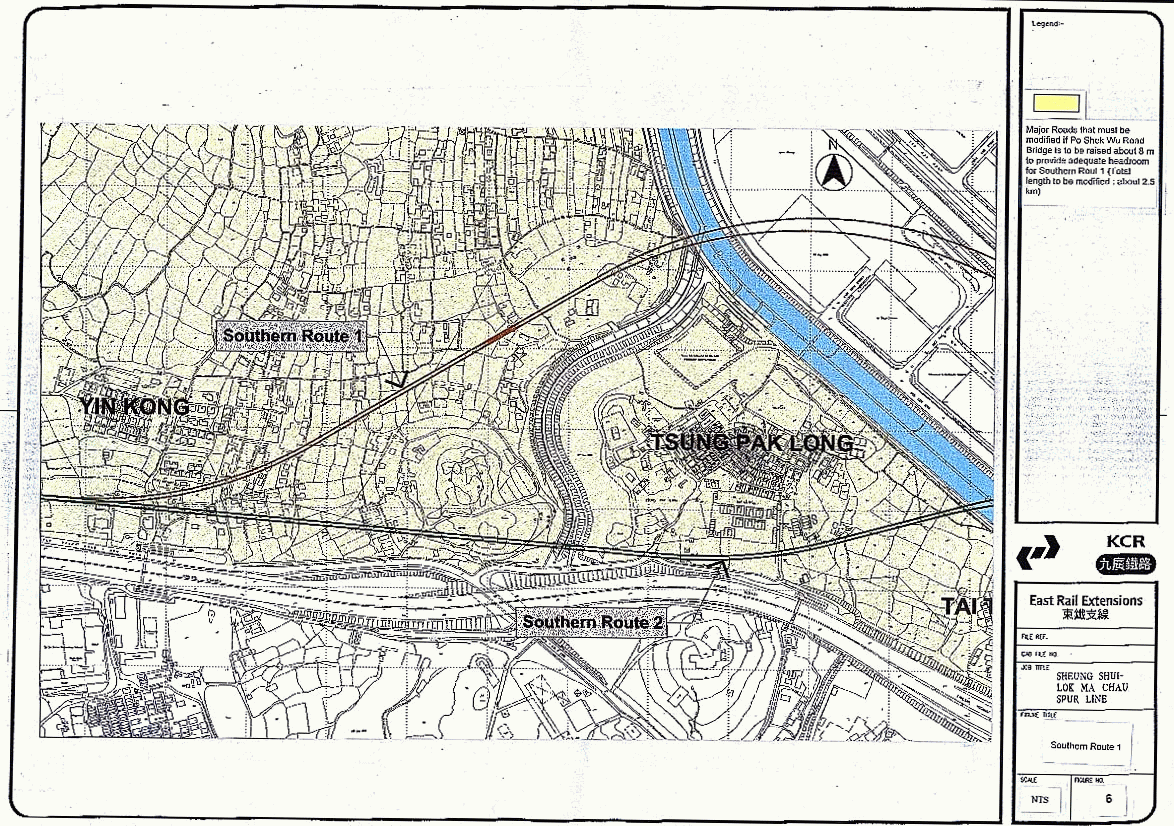
OPTIONS
1. Introduction
1.1 This appendix describes the evaluation of different horizontal alignments for Spur Line. Five alternative routes were defined and evaluated, with thorough consideration of all the requirements described in section 2.9.3 of the EIA. Careful evaluation of various route options was made to ensure the choice of an optimum alignment. This section describes the selection of the optimum horizontal alignment for the eastern end of the alignment, which would be required to traverse the ecologically sensitive area of Long Valley.
2. Alternatives
Considered - Eastern Part
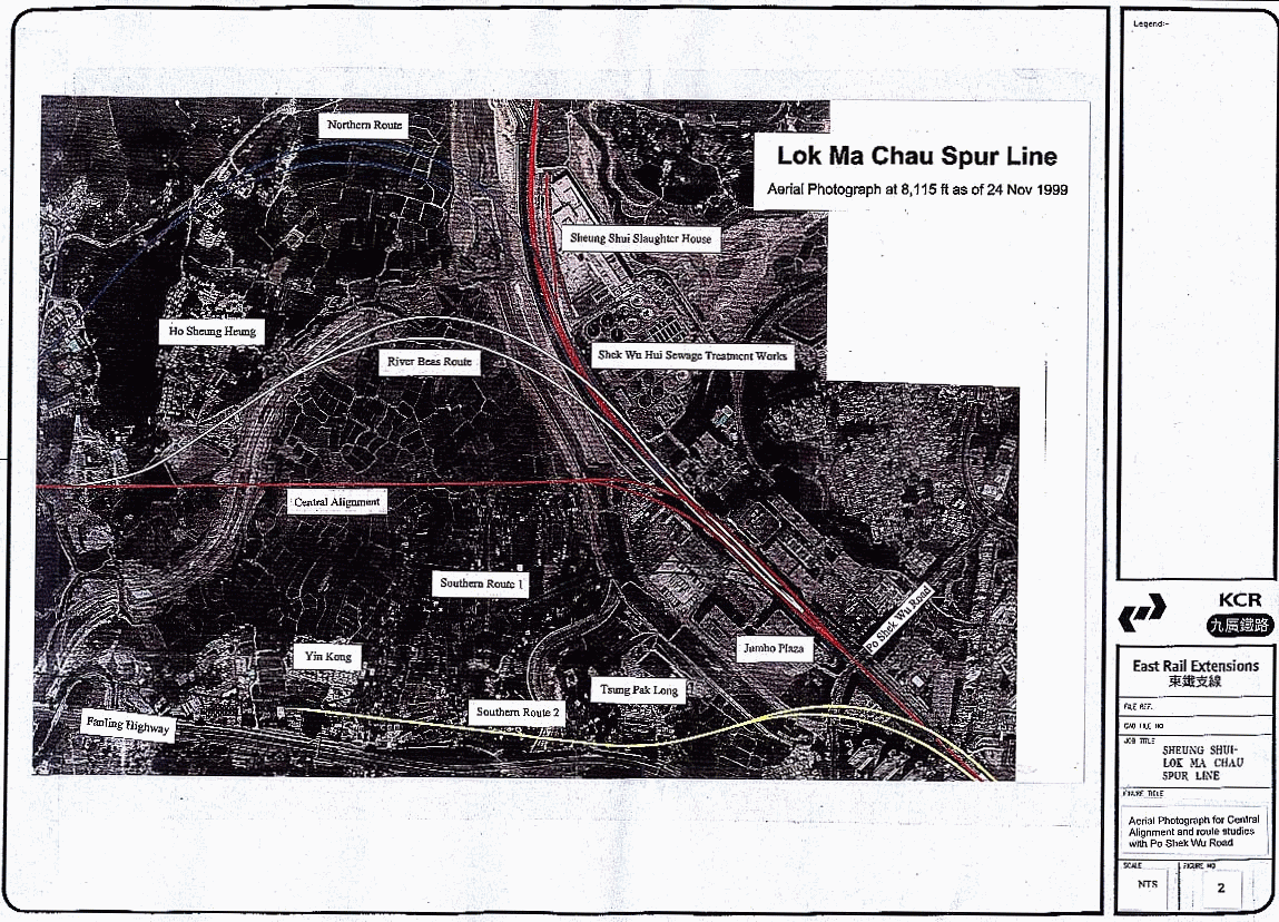
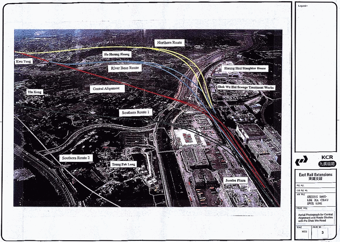
2.1 Recognizing the ecological importance of Long Valley, an area of about 34 ha, five alternative route options as shown in Figures 1, 2 and 3 were evaluated. The results are summarized in the following sections.
Central
Alignment
2.2 For this alignment the Spur Line begins immediately north of Sheung Shui Station and branches off from East Rail at a point 500 metres north of Po Shek Wu Road where it turns west to traverse Long Valley on viaduct. It follows a straight alignment towards Tong Kok in order to avoid the most northerly farms and village houses that predominate in the southern 12 ha of the valley. The alignment footprint takes up about 0.85 ha of agricultural land, all of which is in private ownership. Agricultural land in Long Valley is subject to the crop growing preferences of the various farmers, and the ecological importance of the area can therefore change on a temporal basis. With the railway the wetland created under the viaduct and its ecological value will become secure, even in the very long term.
2.3 The Central Alignment would fully meet the planning, land use, railway safety and operations and general engineering requirements set down in sections 2.9.3.2 to 2.9.3.6 of the EIA. In particular the Central Alignment begins at a straight section of East Rail, it also avoids the constraints arising from Shek Wu Hui Sewage Treatment Works and the Sheung Shui Slaughter House which block other routes. It does have an impact on the ecology of Long Valley, but constructing the railway on viaduct enables the creation of wetland along its alignment, and the enhancement of areas distant from the viaduct, such as the proposed meanders of River Beas. Together, these mitigation areas will provide long term secure wetland. During operation of the railway, adoption of the multi-pleunum floating slab track for the viaduct means that airborne noise and vibration at ground level would be minimized and long term impacts are considered to be acceptable.
2.4 Ecological impacts during the construction phase would be compensated through the provision of an area of compensatory wetland habitat, which would be completed prior to construction works commencing in the particularly sensitive marsh area within Long Valley. Access to the Long Valley by contractors would be severely limited, including the use of precasting, including viaduct deck segments, to minimize temporary works and the need to work from ground level.
Northern
Route
2.5 For this route the Spur Line branches off from East Rail at a point further north, near to the Sheung Shui Sewage Treatment Works. Immediately after branching off it traverses a westward curve and eventually turns southwest to join the Central Alignment west of Tong Kok.
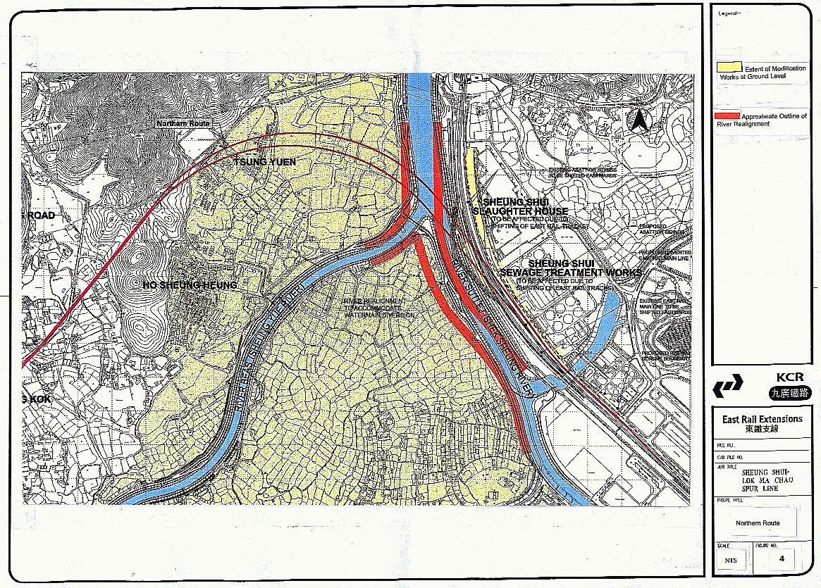
2.6 The proposed branching off point of this alignment is located on an existing 800 metre radius eastward curve on East Rail that is unacceptable on safety grounds. The curve has to be straightened to overcome the operational safety issue described in section 2.9.3.3 of the EIA. Figure 4 shows that to achieve this the existing East Rail tracks must be realigned such that they encroach into a substantial part of the Shek Wu Hui sewage treatment works and the recently completed Sheung Shui slaughterhouse.
2.7 Discussions with the Drainage Services Department with regard to the effects of this alignment on the sewage treatment works have indicated that the impacts would seriously compromise the operations of the facility. The Shek Wu Hui sewage treatment works is operating at its full capacity of 60,000 cubic metres of sewage per day. The sewage treatment works totally occupies its existing site.
2.8 If the treatment process is to be maintained, taking sections of the works out of commission is not feasible unless they can be re-provided in advance. Advance re-provisioning cannot be achieved, as there is no available land, the site being fully occupied with existing essential facilities.
2.9 Discussions with the operators of the slaughterhouse have indicated that this alignment would directly impact the unloading sidings to the west of the abattoir to where all the arriving animals are delivered. This area is essential for the normal operations of the slaughterhouse and cannot be made available to facilitate the construction of the viaduct that is needed for this route.
2.10 Construction of the railway viaduct in this location would effectively close down the slaughterhouse operations. This facility has only recently been opened at a cost of $2.0 Billion after a construction period of 4 years and a planning period of over 10 years. Given the long lead-time to develop such a facility, there is no possibility of it being re-located.
2.11 To overcome the conflict with the slaughter house and sewage treatment works the alternative of elevating East Rail to pass over the Spur Line was considered. It is concluded that this alternative is not feasible on both railway safety and operational grounds. The principal reason is that as East Rail carries freight traffic and therefore the maximum allowable gradient is 1.0%. This differs from the Spur Line gradient criterion of 2.5% because Electric Multiple Units (EMU)’s can accommodate more severe gradients than freight trains.
2.12 If the Spur Line were to join East Rail at grade, by extending the straight section of East Rail northwards, there is insufficient distance, from the Po Shek Wu Road bridge to the point at which the East Rail up-track viaduct would cross the at-grade Spur Line, to gain the required headroom. There is also insufficient distance to the north of the crossing point for the upline to get down to the level of the Lo Wu Goodsyard. In addition, it is not possible for an at-grade railway to cross the five Dongjiang water mains and maintain the minimum clearance required to ensure the pipes are not subjected to excessive loading. This is because the crowns of the pipes are at approximately the same level as the existing rails.
2.13 The Northern Route will necessitate substantially more private land resumption and will require the demolition of approximately 20 village houses as it traverses through the new village of Tsung Yuen. This social impact is considered to be unacceptable.
2.14 The route also requires extensive cutting of the hills to the rear of Ho Sheung Heung which will create a severe visual impact, affect a large number of graves and generate a large quantity of surplus spoil.
2.15 Operationally journey time will be longer but more importantly, the requirement for a double cross-over close to Sheung Shui station will be impossible to achieve. The nearest location a straight section of track where it is safe to install the double cross-over could be located is over 2.3 km from Sheung Shui station. This deficiency renders this alignment unacceptable on operational grounds.
2.16 In summary, the Northern Route is not available for the railway, given the severe social impact on Tsung Yuen, and the blockages from existing essential infrastructure facilities. The latter arises from severe railway operational and safety constraints, associated with the need to re-lay 0.6 km of existing East Rail.
River Beas Route
2.17 For this route the Spur Line branches off from East Rail at a point between that of the Central Alignment and the Northern Route and traverses through the northern section of Long Valley. The route utilizes a continuous reverse curve to join to the Central Alignment east of Tong Kok, passing close to the village of Ho Sheung Heung and the Hung Shing Pui Fung Temple.
2.18 As with the Northern Route, there is no possibility of introducing the necessary length of straight track into this alignment near to Sheung Shui station, to permit the insertion of the double cross-over. The nearest location is some 1.7 km away, which is a serious departure from the fundamental operational requirements of the railway as stated in Section 2.9.3 of the EIA.
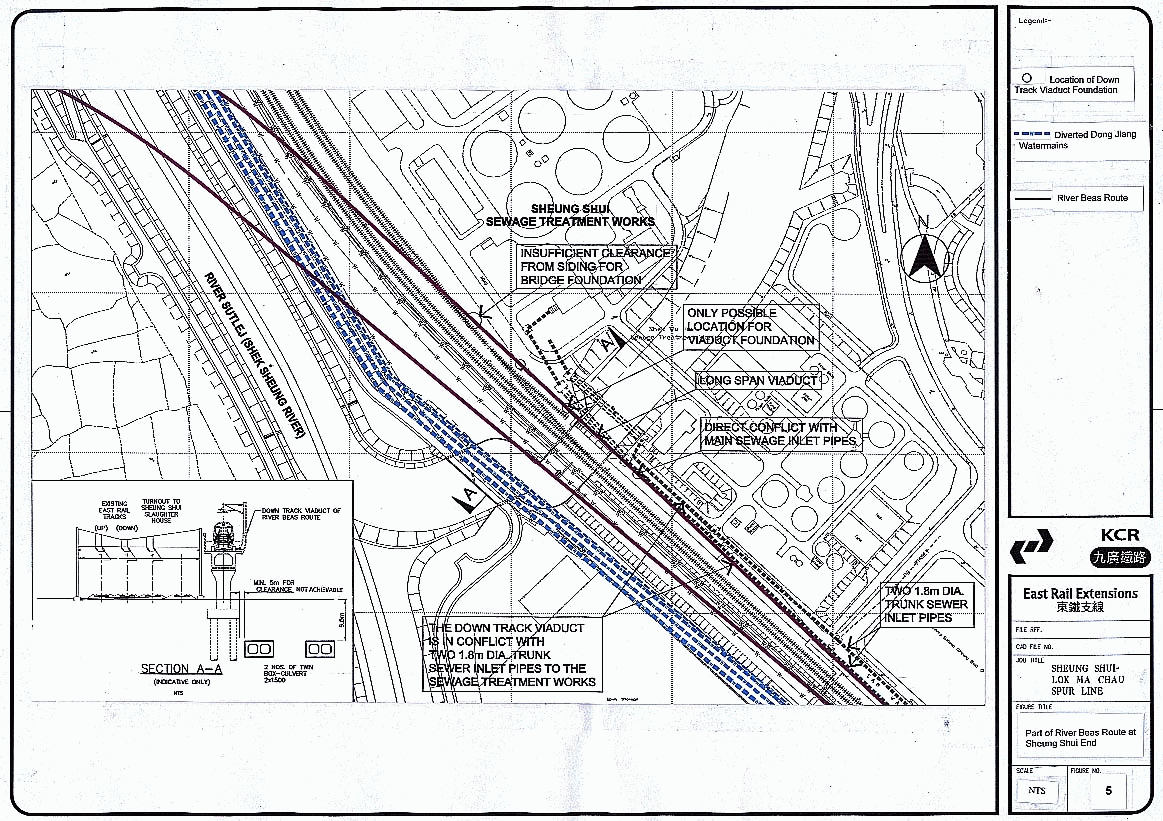
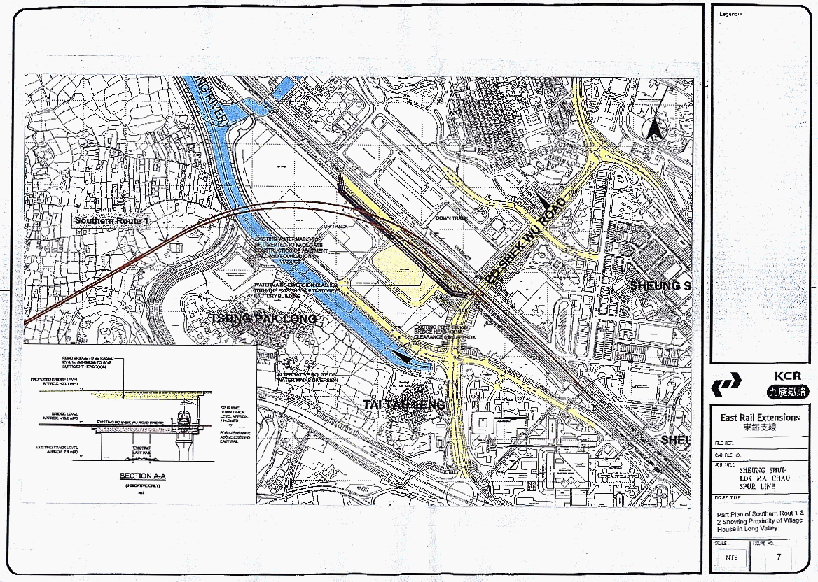
2.19 As illustrated in Figure 5, this River Beas route locates the down track viaduct (where it connects to East Rail) in between the existing railway and the sewage treatment works. Within this corridor, which is approximately 10 metres wide, are located two 1.8 metre diameter trunk sewer inlet pipes to the sewage treatment works together with a 250millimetre diameter leachate pipe from the North East New Territories Landfill.
2.20 There is a critical location on this corridor where the sewer inlet pipes pass under the River Sutlej tributary in a box culvert. At this location the delivery sidings to the Sheung Shui Slaughterhouse connect to East Rail. The combination of the underground pipelines and the siding turnout from East Rail effectively sterilizes the available space between the railway and the sewage treatment works making it impossible to construct the viaduct support column foundations. There is no potential to move the sewer inlet pipes as any alternative route would impact other essential sewage treatment works facilities.
2.21 If these major engineering constraints were solvable, there is a further major constraint associated with this route. Because of the obtuse angle at which this route crosses East Rail and the slaughterhouse delivery sidings, a bridge with a clear span of approximately 250 metres would be needed, as there is no room between the East Rail tracks to locate intervening support columns. The construction of such a bridge over the existing operating railway may well be impractical, as well as imposing unacceptable risk to the operating railway. The impact on the project programme, given the complexity and severity of the construction problems, as well as railway safety considerations, makes this route unacceptable. In contrast, the Central Alignment is designed to cross East Rail at a more acute angle utilizing conventional viaduct construction techniques. The River Beas Route is therefore not feasible due to the these engineering constraints.
2.22 Although the River Beas route poses major engineering constraints, the route has been reviewed in respect of the key environmental issues of noise, ecology, visual impact and cultural heritage. The main environmental impacts arising from the Central Alignment and the River Beas Route are detailed in Annex A and summarized in Table 2.
2.23 The detailed noise assessment on the nearest sensitive receiver in the village of Ho Sheung Heung (contained in Appendix A7 of the EIA) indicates that by adopting the same railway viaduct approach as for the Central Alignment neither construction nor operational noise will present problems. As with the railway as a whole, adequate mitigation can be provided to contain potential noise impacts.
2.24 The detailed ecological assessment is summarised in Table 1. In summary, the ecological impacts of the Central Alignment and the River Beas Route are almost the same. However, as this table states, both alignments have some adverse ecological impacts. Whilst the River Beas Route causes less fragmentation and impact on species, on the other hand, the Central Alignment provides better opportunity for off-site mitigation, therefore both alignments are equal after considering all ecological aspects.
Table 1
Key Ecological Impacts
|
|
Central Alignment |
River Beas route |
Comments |
Preferred Option in
respect of impact reviewed |
|
Construction period |
||||
|
Impact on habitats of ecological importance |
Major: freshwater marsh severely affected, wetland agriculture areas
affected |
Minor: some wetland agriculture areas affected, but much of alignment
already impacted by River Beas channelisation, longer period of construction
activity in area of River Beas not considered critical (since no advance
compensatory habitat provision was required in respect of River Beas
channelisation project temporary loss of this habitat has already been judged
not to be of critical importance) |
|
River Beas alignment less destructive in short term |
|
Impacts on Bird Species of Conservation Importance if no mitigation |
Major: freshwater marsh is principal refuge habitat for Greater
Painted-snipe and several other bird species; construction activities will
create general disturbance in Long Valley |
Medium: principal impact predicted to be on flightline between Ho
Sheung Heung egretry and Long Valley; construction activities will create
general disturbance in Long Valley |
Disturbance effects in Long Valley as a whole similar between options |
River Beas alignment has less impact |
|
Mitigation potential |
Major: temporary wetland provision will create alternative marsh area
for Greater Painted-snipe and other species doing construction period |
Minor: no scope for temporary habitat provision; limited scope for
control of working practices to minimise disturbance |
|
Impacts of Central Alignment easier to mitigate (but impacts greater
to begin with) |
|
Residual impacts |
Minor: temporary habitat provision will mitigate for short term
impacts on habitat |
Minor/Medium: residual disturbance to egretry flightlines cannot be
mitigated |
Response to disturbance by egrets unpredictable |
Potential for residual impacts greater for River Beas alignment |
|
Operational Period |
||||
|
Impact on habitats of ecological importance if no mitigation |
Major: significant fragmentation of Long Valley as route passes
through core area; direct loss of wetland habitat; impact on key marsh area;
indirect loss due to disturbance |
Major: some fragmentation of Long Valley (though route avoids core
area and there is relatively little linkage between main area of Long Valley
and portion north of River Beas), direct loss of wetland habitat; indirect
loss due to disturbance |
Central Alignment has more impact on marsh, River Beas alignment
creates more overall habitat loss due to wider disturbance footprint of twin
viaducts |
Both alignments have major adverse ecological effects if no
mitigation but River Beas alignment preferable due to less fragmentation of
wetland |
|
Impacts on Bird Species of Conservation Importance if no mitigation |
Major: potential threat to Greater Painted-snipe population and
significant adverse effects on populations of many other wetland bird species
including freshwater specialists such as Pheasant-tailed Jacana and Watercock |
Major: significant adverse effects on populations of many wetland
bird species especially Chinese Pond Heron but also some (albeit lesser than
for Central Alignment) effects on a suite of freshwater specialists including
Greater Painted-snipe, Pheasant-tailed Jacana and Watercock |
Both alignments have major adverse effects |
River Beas alignment preferable because of lower impact on Greater
Painted-snipe |
|
Mitigation potential |
Area under viaducts and River Beas meanders offer scope to mitigate
for all habitat loss (both direct and indirect) for all species |
Area under viaducts (which includes River Beas meanders) offers scope
to mitigate for direct habitat loss for all species. No scope to mitigate for
indirect habitat loss as all mitigation areas will be subject to avoidance of
viaduct structure and noise impacts from railway operations |
No scope to provide off-site mitigation for River Beas route |
Central Alignment much preferred because of opportunity to provide
off-site mitigation |
|
Cumulative impacts including cumulative effect of River Beas
channelisation, Spur Line and new road to north of River Beas |
Conversion of River Beas meanders to permanent wetland will have a
net overall benefit on ecological function of these areas. Long term
fragmentation effects for core area of Long Valley greater than for River
Beas alignment as largest part of Long Valley will be situated in a triangle
bounded by road and railways. However the northern part of Long Valley will
be undisturbed once river channelisation is completed |
Conversion of River Beas meanders to permanent wetland will have some
benefit but this will be partially negated by their being affected by
disturbance impacts. No scope for off-site mitigation of cumulative
disturbance impacts to River Beas available. Cumulative fragmentation effects
of road and railway smaller for core area of Long Valley, but a large area of
northern Long Valley on either side of the River Beas will be impacted |
River channelisation not expected have significant long term
fragmentation effects whilst effects of road will be much greater than those
of the railway |
Whilst fragmentation effects of River Beas route are less this is
achieved at the price of sterilising a swathe of land on both sides of the
River Beas. Central Alignment is clearly preferable with respect to
cumulative impacts on River Beas and the channelisation mitigation. |
|
Residual impacts |
Significant habitat fragmentation unavoidable, but all habitat loss
and impacts on species fully mitigated; significant long-term increase in
permanent freshwater wetland area managed for conservation purposes, part of
this area free from disturbance impacts |
Some habitat fragmentation unavoidable, direct habitat loss fully
mitigated but significant indirect habitat loss for disturbance sensitive
species; significant long-term increase in permanent freshwater wetland area
managed for conservation purposes, but entire area (including mitigation
areas previously proposed for River Beas channelisation) affected by
disturbance impacts |
Key factors to be evaluated are relative importance of permanent
fragmentation impacts vis-à-vis permanent indirect habitat loss for
disturbance sensitive species |
As both alignments have some adverse ecological impacts, they are
equal after considering all ecological aspects. |
2.25 This route places the railway 100 metres nearer to the village of Ho Sheung Heung and the heritage site of the Hung Shing Pui Fung Temple. The assessments (detailed in Annex A of this Appendix) indicate that the impacts will be greater than those predicted for the Central Alignment. Exploratory discussions with the villagers of Ho Sheung Heung have indicated that they would raise very strong objections to any proposal that would locate the railway nearer to the village.
2.26 Overall the River Beas Route is inferior to the Central Alignment, given the ecological dis-benefits, coupled with serious social and environmental consequences.
2.27 Table 2 summarizes the main environmental impacts for the Central Alignment and the River Beas Route. This summary represents a synthesis of the detailed comparison for each environmental discipline presented in Tables A1 to A5b in Annex A.
2.28
From an overall environmental
perspective, the Central Alignment has a lesser impact and is preferable.
Summary
of Environmental Impacts Comparison between Central Alignment and River Beas
Route
|
|
Central Alignment |
River Beas Route |
Comments |
Preferred Option |
|
Ecology |
Significant fragmentation of wetland habitat unavoidable as route bisects core area of Long Valley (c.f. Appendix 1, Table A1). |
Some fragmentation of wetland habitat unavoidable, route avoids core area of Long Valley but leaves small isolated area to the north of River Beas with little linkage to other wetland areas (c.f. Appendix 1, Table A1) |
Area impacted by River Beas route already adversely impacted by River Beas channelisation |
River Beas route preferable with respect to fragmentation impacts as it is, on balance, preferable to retain a large unfragmented wetland area |
|
|
Significant construction impact on freshwater marsh |
No construction impact on freshwater marsh |
Freshwater marsh habitat very important but is not protected and can be re-created |
The Beas River Route is preferred |
|
|
Significant impact on key habitat for Greater Painted-snipe and other wetland species |
Significant impact on habitat available to wetland dependant species especially those more sensitive to disturbance such as Ardeids |
Mitigation for loss of marsh habitat for Greater Painted-snipe feasible, mitigation for disturbance impacts requires off-site areas |
River Beas route preferable with respect to impact on freshwater marsh |
|
|
All direct and indirect impacts on wetland habitats and species of conservation importance can be mitigated by temporary and permanent on-site and off-site compensation areas |
Direct impacts to wetland habitats and species of conservation importance can be mitigated by permanent on-site compensation areas. No off-site compensation areas available to mitigate for disturbance impacts |
Central Alignment allows River Beas meanders to be used for off-site mitigation. These meanders will be on-site mitigation areas for River Beas route |
Central Alignment preferable because all impacts on wetland habitats and species of conservation importance can be mitigated |
|
|
Residual impacts can be limited to fragmentation effect on Long Valley ecosystem. These cannot be entirely eliminated but can be reduced in the long term by appropriate habitat management of the Long Valley ecosystem; off-site compensation areas (River Beas meanders) permit elimination of residual impacts with respect to habitat loss for disturbance-sensitive species |
Residual impacts can be limited to some fragmentation and habitat loss for disturbance-sensitive species. The small remaining wetland area north of the River Beas will be of little value once linkage with the larger Long Valley area is broken, whilst habitat loss for disturbance-sensitive species cannot be made good by off-site mitigation since the only available areas for compensation are impacted by this route |
Final assessment of ecological merits of options
hinges on evaluation of relative importance of residual impacts |
Whilst fragmentation and loss of linkage with the small area north of the River Beas consequent on selecting the River Beas route is of less significance than the fragmentation of the core Long Valley area caused by the Central Alignment. As both alignments have some adverse ecological impacts, they are equal after considering all ecological aspects. |
|
Noise |
Noise levels due to Central Alignment at sensitive receivers in Long Valley are below the ANL. |
Noise levels at selected NSRs in Ho Sheung Heung are greater than the ANL due to the presence of points and crossings on River Beas Route alignment at this location. Mitigation in the form of a barrier or enclosure will be required. |
Noise impacts from both alignments can be adequately mitigated |
Central Alignment |
|
Cultural |
Minimal impacts on historical buildings (primarily in Ho Sheung Heung) arise due to the Central Alignment. |
The River Beas Route lies very close to selected historical sites in Ho Sheung Heung. Woodland that is affected by the alignment must be replaced and a buffer woodland planted to provide a visual barrier between the railway and the sites of cultural heritage. |
The alignment must maintain a minimum distance of 50m from any cultural or historical sites in Ho Sheung Heung. River Beas Route may need to be slightly realigned to achieve this requirement. |
Central Alignment |
|
Landscape and Visual |
The impact of the Central Alignment on the landscape character of Long Valley is greater than that predicted for the River Beas Route. However, visual impacts on Ho Sheung Heung village would be less significant than those which would accrue as a result of the River Beas route. The Central Alignment would be open to a large number of Visually Sensitive Receivers both to the south in areas such as Yin Kong and Tsung Pak Long, and in the north with Ho Sheung Heung. However these views would be largely long distance in nature. |
Impacts on the Long Valley landscape character area would be less significant than those predicted for the Central Alignment. However the landscape character of the village environs would be subject to more adverse impacts due to the proximity of the alignment. Visual impacts would be more severe for this option despite being partially screened by the existing woodland. This is largely due to the requirement for noise barriers or enclosures which would increase the visual mass of the viaduct structure and reduce the effectiveness of landscape mitigation measures such as woodland planting. However for visually sensitive receivers situated in the south of the study area such as those in Yin Kong and Tsung Pak Long the visual impacts arising from the River Beas Route would be less significant. |
The Central Alignment would have the most significant impact on the landscape character of the Long Valley area although the River Beas alignment would have an additional adverse impact on the Ho Sheung Heung village environs. In terms of visual impact both alignments would be open to a large number of visually sensitive receivers however the requirement for noise barriers on the River Beas alignment would result in a more significant level of visual impacts. |
The River Beas Route would be preferable in terms of the significance of adverse impacts on the landscape character of Long Valley. The Central Alignment would be preferable in terms of the visual impact on visually sensitive receivers although both options are open to a large number of potential receivers. Overall considering the significance of the predicted landscape and visual impacts there would be negligible difference between the two options. |
|
Other Issues |
Potential impacts on water quality may occur where the viaduct crosses River Beas. As the distance across the channels is short (relative to the distances for River Beas Route), the viaduct may be constructed to span the channels. |
The alignment will cross a longer stretch of the Rivers Beas and Sutlej than Central Alignment, creating the potential for greater water quality impacts. Drainage impacts are likely to be greater than Central Alignment. Spoil heaps to the south of Ho Sheung Heung may create more waste than Central Alignment. |
Differences between the options are minimal in terms of air quality impacts. |
Central Alignment. |
Southern
Routes: 1
2.29 Southern routes have been studied which are closer to the head of Long Valley than the Central Alignment. Route 1 branches off between Sheung Shui Station and Po Shek Wu Road, and if feasible would not impact on the ecologically sensitive marsh area but at the expense of impacting on human habitat, including the village of Yin Kong.
2.30 As shown in Figure 6, for Route 1 to work the Po Shek Wu road bridge would have to be demolished and rebuilt 8 metres higher, in order to accommodate the down line branch of the Spur Line which crosses East Rail on viaduct structure.
2.31 Highways and Transport Departments of government has confirmed that Po Shek Wu Road forms a critical part of the road network, connecting to the Man Kam To boundary crossing. Uplifting of the Po Shek Wu Road bridge would necessitate major reconstruction of approximately 2.5 km of roads in the area, as well as blocking access to numerous buildings and residences. The impact on Man Kam To that would arise in the event of demolition and re-construction of the bridge, would be totally unacceptable, given the importance of this boundary crossing route and the volume of heavy traffic that would seek to spill over into roads intended only for lighter traffic.
2.32 As presented in Figure 7, the village of Yin Kong would be impacted by this route, resulting in more private land resumption and increased visual impacts due to the close proximity of the railway.
2.33 From a planning and land use perspective, the Southern Routes are incompatible with the proposed Kwu Tung SGA development, requiring the SGA station to be located at the southern boundary of the development area instead of near its centroid. Reducing the accessibility of the station to SGA residents would be a serious departure to the SGA development concept, which is intended to ensure use of the railway to provide the major mode of transport to and from the SGA development area.
2.34 Resumption of Jumbo Plaza, an existing industrial building adjacent to East Rail, would also be required for the diversion of the Dong Jiang water mains. Given the judicial review experience of Government and the KCRC in resuming Wah Kai Industrial Centre, an industrial building on West Rail, resumption cannot necessarily be expected to succeed. Owners could argue that the alternative Central Alignment makes it unnecessary to resume their building, and thereby win their case.
2.35 In summary, whilst a Southern Route appears attractive on paper, Route 1 is not feasible because of the impact on Po Shek Road bridge and the obstruction arising from Jumbo Plaza. Any ecological benefit must also be weighed against the negative environmental impacts on Yin Kong village, and the future potential damage to sustainable environmental planning by reducing the attractiveness of rail transportation for the Kwu Tung North SGA.
Southern
Routes: 2
2.36 Route 2 avoids the conflict with Po Shek Wu road bridge and the Jumbo Plaza industrial building, by branching off mid-way between Sheung Shui Station and Fanling Station. This route however brings negative environmental impacts on Tsung Pak Long as well as Yin Kong villages (see Figure 7), as well as the potential damage to sustainable environmental planning of Kwu Tung North SGA. Route 2 also fails to meet the requirement of Sheung Shui passengers traveling directly to Lok Ma Chau and vice versa, Route 2 also involves the demolition of a substantial part of Sheung Shui Station which cannot be contemplated given railway operation and safety constraints. Accordingly the adoption of Route 2 is not possible, and indeed there is no Southern route available which on balance improves on the Central Alignment.
Annex A
Detailed Comparison of Environmental Impacts
for Central Alignment and River Beas Route
ANNEX A
ENVIRONMENTAL COMPARISONS OF ALTERNATIVE ALIGNMENTS
Table A1
Comparison of Central Alignment and River Beas Route
in terms of Ecological Impacts
and Mitigation requirements
|
|
Central Alignment |
River Beas Route |
Comments |
|
Direct permanent habitat loss |
0.009ha occupied by viaduct piers. |
0.005ha occupied by viaduct piers. |
Both alignments entirely on viaduct in Long Valley. |
|
Habitat types |
Wet agriculture, inactive agriculture and
marsh. The latter is the only area of marsh within the Long Valley area,
which due to its semi-natural state has higher value for birds, especially
Greater Painted-snipe. |
Wet agriculture and inactive agriculture |
Ecological value of wet agriculture and inactive agriculture similar for both Options. Both Options have limited impact on
isolated fishponds west of the MDC (slightly greater impact for River Beas
Route), however this is considered of limited importance compared to impacts
in Long Valley proper. |
|
Habitat naturalness |
Largely anthropogenic habitats, but with area of semi-natural marsh (though this can be easily recreated) |
Entirely anthropogenic. |
|
|
Habitat diversity |
Higher due to presence of semi-natural marsh. |
Lower due to lack of semi-natural areas. |
|
|
Habitat rarity |
Wet agriculture and inactive agriculture are both scarce habitats in Hong Kong. Freshwater marsh is now a rare habitat type in Hong Kong. |
Wet agriculture and inactive agriculture are both scarce habitats in Hong Kong. |
Freshwater marsh only impacted in Central Alignment . |
|
Recreatability |
Readily recreated. |
Readily recreated. |
|
|
Bird Species of Conservation Importance |
Central Alignment has
higher impacts for: Japanese Yellow Bunting Red-billed Starling Black-winged Stilt Pheasant-tailed Jacana Watercock Chestnut Bittern Common Snipe Pintail Snipe Swinhoe's Snipe |
River Beas Route has higher impacts for: Chinese
Pond Heron Little
Egret |
Impacts on other species do not differ between Options (see Table A3). |
|
Other taxa |
None identified in the EIA as being of Conservation Imp ortance. |
None identified in the EIA as being of Conservation Importance. |
|
|
Nursery / breeding grounds |
Greater impact on species breeding within the area, in particular Greater Painted Snipe through impact on area of marsh. Lower impact is likely for Chinese Pond Herons from the Ho Sheung Egretry due to greater distance from egretry and less partitioning of foraging areas. |
Lower impact on species breeding within the area, in particular Greater Painted Snipe, through absence of impact on area of marsh. Higher impact is likely for Chinese Pond Herons from the Ho Sheung Egretry due to shorter distance from egretry and less partitioning of foraging areas. |
|
|
Fragmentation and ecological linkage |
Divides Long Valley into two sections, the area north of the Spurline being 23.0ha, and that south of it 11.8ha. Both areas are of sufficient size to retain much of the current ecological function, although with a corridor of reduced densities along the alignment. Although the southern section will be partitioned from Chinese Pond Herons from Ho Sheung Heung Egretry foraging at Long Valley, the northern section remains unaffected. |
Also divides Long Valley into two sections. However, the relative sizes are very different with one very large contiguous section of 31.5ha, and a much smaller one of 1.0ha. This smaller area becomes extremely isolated, with very little linkage with the rest of Long Valley. As such this area will likely suffer high reductions in the densities of most Species of Conservation Importance. This option, being closer to Ho Sheung Egretry results in a greater part of Long Valley being partitioned. While Chinese Pond Herons may fly over the railway to reach Long Valley some birds may be deterred, effectively reducing densities of foraging ardeids during the breeding season. This 1.0ha area would also require mitigation. |
Long Valley is now a relatively isolated unit due to the channelisation of the Rivers Beas and Sutlej and the existing East Rail line although there is linkage with the Ho Sheung Egretry. Effects on foraging by Chinese Pond Herons from Ho Sheung Heung Egretry are difficult to predict. |
|
Cumulative impacts |
Higher as this option creates a new disturbance corridor, which although bordered at least in part by village area, passes through currently undisturbed areas. |
Lower as the alignment follows, at various points, East Rail, the channelised River Beas and River Sutlej, and the proposed Fanling Bypass. |
|
|
Potential ecological value of impacted areas |
Higher as further from current disturbance corridors caused by the channelised Rivers Beas and Sutlej and the proposed Fanling Bypass. |
Lower as closer to current disturbance corridors caused by the channelised Rivers Beas and Sutlej and the proposed Fanling Bypass |
|
|
Direct mortality |
Most species using Long Valley not considered vulnerable to collision impacts. |
As Central Alignment . |
|
|
Direct avoidance due to physical effects of structure |
Smaller area affected but value of that area higher due to impacts on area of semi-natural marsh. |
Higher area affected due to wider gap between lines and fragmentation of small area north of alignment, however, value of impacted area lower. |
Methodological difficulty in comparing lesser impacts on a greater area and greater impacts on a smaller area. |
|
Area avoided |
Direct loss 0.85ha (under viaduct) and indirect loss of 0.85ha (reduced use due to disturbance for most disturbance sensitive species. |
Direct loss of 0.45ha and indirect loss of 1.4ha (between viaducts) and 0.45ha (from disturbance impacts north and south of the viaducts), for most disturbance sensitive species. Impact to the small area north of the viaducts and to three meander areas amounts to 1.4ha. |
The
split in the viaduct for River Beas Route will create a larger area
of impact than Central Alignment. |
|
Direct avoidance due to Construction Impacts |
Higher impact on semi-natural marsh, and in particular to Greater Painted-snipe. Lower impact on egrets from Ho Sheung Heung Egretry. |
No impact on areas of semi-natural marsh. Higher impact on egrets from Ho Sheung Egretry. |
Assessment based on the assumption that construction works associated with channelisation of the Rivers Beas and Sutlej will be completed prior to commencement of construction of Spur Line. |
|
Impact on mitigation areas for other projects. |
No adverse impacts, opportunity to enhance three mitigation areas of MDC by turning these into permanent wetlands. |
Direct impacts on three of the River Beas compensation meanders. Mitigating for this is potentially impossible given constraints on mitigating away from resumption area, which would be required to ensure mitigation areas are not within zone of disturbance. |
|
|
Requirement for temporary or advance habitat creation as mitigation during construction period |
Temporary marsh required to compensate for disturbance impacts to species using the marsh, especially Greater Painted-snipe, during construction period. |
No temporary mitigation area requirement as habitat continuity not disrupted. |
Temporary marsh area of 1.3ha proposed under Central Alignment. |
|
Permanent requirement for wetland habitat provision / enhancement to compensate for impacts. |
Provision of 1.7ha of wetland habitat required, of which at least 0.85ha must be outside area affected by disturbance. To satisfy this requirement proposed marshland habitat of 2.4ha along the line of the viaduct and 1.4ha of enhanced meanders alongside the River Beas to be provided. |
In order to completely mitigate for impacts due to River Beas Route, provision of 3.7ha of wetland required of which 2.8ha must be outside area affected by disturbance. An area of approximately 2ha would be available along the line of the viaducts, depending upon the area to be resumed. If meanders are available, these areas can be used as mitigation for impacts within the disturbance area. Due to restrictions on the resumption of private land for ecological mitigation, not land has been identified at this stage for off-site mitigation. |
For River Beas Route there is a potential mitigation area along the viaduct (including the meanders area alongside the River Beas). Exact area available would depend on the area to be resumed but would extend from approximately 1.9ha (if only the viaducts' shadow and a 10m wide strip each side of the viaduct were resumed) to 2.6ha (if the area between the two viaducts was also resumed). |
|
Predicted effectiveness of proposed mitigation areas / management implications |
Shape of area under viaduct not ideal as it will be difficult to manage and is vulnerable to disturbance from use of surrounding land. Proposed enhanced meanders, however, benefit from remoteness from the viaduct. |
Resumption area to be determined. Huge differences in potential effectiveness of options, with the least desirable being two narrow strips being used for mitigation areas. All potential mitigation areas will suffer to some degree from avoidance impacts. |
Full comparison not possible unless the area to be resumed is established. Two separate strips (under River Beas Route) is least desirable option whereas if the area between the viaducts were resumed then the shape of the area would be preferable to Central Alignment - albeit all would suffer from disturbance impacts. |
Table A2
Comparison of Central Alignment and River Beas Route in terms of Noise Impacts
and Mitigation requirements
|
|
Central Alignment |
River Beas Route |
Comments |
|
Closest NSRs within Long Valley area |
NSR 13 and NSR14. |
NSR 1 and NSR4 (se Figure A1) |
NSRs for River Beas Route are further from the railway alignment than NSRs for Central Alignment. |
|
Noise level (Leq30mins) at NSR during early hours (critical morning hours) |
NSR13: 46.8 to 48.8 NSR14: 45.3 to 46.5 |
NSR1: 47.3 NSR4: 50.5 |
High level at NSR4 for River Beas Route is due to the presence of points and crossings close to this NSR. Mitigation of the air-borne noise from this source will be required by installing a noise barrier or enclosure along a 100m length of the railway at this point. |
|
Required mitigation for noise impacts within Long Valley. |
No mitigation required for air-borne noise. |
A noise barrier or enclosure to cover the points and crossings will be required close to NSR4. |
|
Table
A3
Disturbance
Impacts for bird Species of Conservation Importance that regularly occur
or
have the potential to occur in the Long Valley area
|
Species |
Sensitivity to disturbance |
Overall impact of disturbance from Central Alignment |
Overall impact of disturbance from River Beas Route |
Comments |
|
Japanese Yellow Bunting |
Small |
Slightly higher as closer to core area |
Slightly lower as further from core area |
Largely opportunistic in selection of foraging areas, although generally prefers less disturbed areas |
|
Red-billed Starling |
Small-medium |
Slightly higher as closer to core area |
Slightly lower as further from core area |
Largely opportunistic in selection of foraging areas, although generally prefers less disturbed areas |
|
Black-winged Stilt |
Medium-large |
Slightly higher as closer to core area, but scope for additional habitat provision through off-site compensation |
Slightly lower as further from core area |
Largely opportunistic in selection of foraging areas, although generally prefers less disturbed areas |
|
Chinese Pond Heron |
Medium |
Although closer to core area, this is outweighed by the greater distance from Ho Sheung Egretry. Also, scope for additional habitat provision through off-site compensation |
Higher as closer to Ho Sheung Egretry |
|
|
Great Egret |
Large |
Insignificant |
Insignificant |
Only recorded within Long valley area in low numbers. Some scope for additional habitat provision through off-site compensation |
|
Little Egret |
Medium-large |
Higher as closer to core area, but scope for additional habitat provision through off-site compensation |
Lower as further from core area, but full mitigation not possible |
|
|
Greater Painted Snipe |
Moderate |
Higher due to impacts on area of semi-natural marsh, but full mitigation possible through provision of off-site compensation |
Low due to lack of direct impacts on area of semi-natural marsh, full mitigation for any impacts may be difficult |
|
|
Northern Hobby |
Large |
Insignificant |
Insignificant |
Only recorded within Long valley area in low numbers |
|
Pheasant-tailed Jacana |
Medium-large |
Higher as closer to core area, but full mitigation possible through provision of off-site compensation |
Lower as further from core, but full mitigation for all impacts may be difficult |
|
|
Watercock |
Medium |
Higher as closer to core area, but full mitigation possible through provision of off-site compensation |
Lower as further from core, but full mitigation for all impacts may be difficult |
|
|
Bluethroat |
Small |
Higher as closer to core area, but full mitigation possible through provision of off-site compensation |
Lower as further from core, but full mitigation for any impacts may be difficult |
|
|
Chestnut Bittern |
Small |
Higher as closer to core area, but full mitigation possible through provision of off-site compensation |
Lower as further from core, but full mitigation for all impacts may be difficult |
|
|
Common Snipe |
Medium |
Higher as closer to core area, but full mitigation possible through provision of off-site compensation |
Lower as further from core, but full mitigation for all impacts may be difficult |
|
|
Common Stonechat |
Small |
Impacts broadly similar |
Impacts broadly similar |
|
|
Japanese Quail |
Medium-low |
Impacts broadly similar |
Impacts broadly similar |
|
|
Pallas’s Grasshopper Warbler |
Very small |
Impacts broadly similar |
Impacts broadly similar |
|
|
Pintail Snipe |
Medium |
Higher as closer to core area, but full mitigation possible through provision of off-site compensation |
Lower as further from core, but full mitigation for all impacts may be difficult |
|
|
Richard’s Pipit |
Small |
Impacts broadly similar |
Impacts broadly similar |
|
|
Swinhoe’s Snipe |
Medium |
Higher as closer to core area, but full mitigation possible through provision of off-site compensation |
Lower as further from core, but full mitigation for all impacts may be difficult |
|
|
Zitting Cisticola |
Small |
Impacts broadly similar |
Impacts broadly similar |
|
Table A4
Comparison of Central Alignment and River Beas Route
in terms of Cultural Heritage Impacts
and Mitigation requirements
|
Cultural/ Heritage Resource |
Central Alignment |
River Beas Route |
||||||||||||||
|
Predicted
Impact Const’n Oper’n |
Mitigation |
Conclusion |
Predicted
Impact Const’n Oper’n |
Mitigation |
Conclusion |
|||||||||||
1
2
Ho Sheung
Heung Village
|
None |
Minor |
· The extension of the existing woodland at the southern end of the village to provide a buffer zone for the village as an historical unit. |
· The proposed alignment, at approx. 150 m. distance, is acceptable with appropriate mitigation measures. |
Moderate |
Moderate |
· A buffer zone of 50 metres must be maintained between the village and the alignment. · The extension of the existing woodland at the southern end of the village to provide a buffer zone for the village as an historical unit. |
· A landscaped buffer zone is acceptable mitigation. |
||||||||
|
Hau Kui Shek Ancestral
Hall |
None |
Minor |
· Existing structures will partially shield the building from the alignment. · A foliage screen must be planted between the structure and the alignment. |
· The proposed alignment, at approx. 150 m distance is acceptable with appropriate mitigation measures. |
Moderate |
Moderate |
· Existing structures will partially shield the building from the alignment. · A buffer zone of 50 metres must be maintained between the structure and the alignment. · The buffer zone must include the planting of trees to provide a foliage screen. |
· A landscaped buffer zone is acceptable mitigation. |
||||||||
|
Sin
Wai Nunnery |
None |
None |
· No mitigation measures are necessary as the structure is adequately buffered by existing woodland. |
· The proposed alignment located at a distance of approximately 150 m. is acceptable. |
Moderate/ Major |
Moderate |
· Any existing woodland that is affected by the proposed alignment must be replaced after the construction phase. · The alignment must maintain a minimum distance of 50 m. from the nunnery compound |
· The maintenance/ replacement of the woodland between the compound and the alignment is acceptable mitigation. |
||||||||
|
Hung
Shing Pui Fung Temple |
None |
Minor |
· The extension of the existing woodland at the southern end of the village to provide a landscaped buffer zone. |
· The proposed alignment, at approx. 150 m. distance, is acceptable with appropriate mitigation measures. |
Major |
Major |
· The alignment must maintain a minimum distance of 50 m. from the temple compound. · The existing woodland at the southern end of the village should be extended to provide a landscaped buffer zone. |
· A landscaped buffer zone is acceptable mitigation. |
||||||||
|
Shrine |
None |
Minor |
· The shrine is located next to a car park and road in a low lying area. The extension of the woodland, as mentioned above, will provide adequate screening. |
· The proposed alignment, at approx. 150 m. distance, is acceptable with appropriate mitigation measures. |
Moderate |
Moderate |
· The shrine is located next to a car park and road in a low lying area. The extension of the woodland, as mentioned above will provide adequate screening. · The alignment must maintain a minimum distance of 50 m. |
· A landscaped buffer zone is acceptable mitigation |
||||||||
|
Village
Houses |
None |
Minor |
· Existing structures will partially shield the buildings from the alignment. · The creation of a wooded buffer zone will provide a sufficient screen for the historical structures. |
· The proposed alignment, at approx. 150 m. distance, is acceptable with appropriate mitigation measures. |
Moderate |
Moderate |
· The alignment must maintain a minimum distance of 50 m. · Existing structures will partially shield the buildings from the alignment, · The addition of a foliage screen in open areas between the historical structures and the alignment will provide a sufficient screen for the houses. |
· A landscaped buffer zone is acceptable mitigation |
||||||||
|
Location
of archaeological finds |
Moderate potential |
None |
· It is recommended that the alignment to the south of Ho Sheung Heung be monitored during excavations for support columns. |
· The alignment will pass approx. 80m to the south of the area tested and is predicted to have minimal impact on any potential deposit associated with the historical village. |
Moderate Potential |
None |
· It is recommended that further archaeological field testing of the area be carried out in advance of excavations for the support columns. |
· The alignment will pass approx. 20m to the south of the area tested and is predicted to have more direct impacts on any potential deposit associated with the historical village |
||||||||
Table A5a
Comparison of Central Alignment and River Beas Route
in terms of Landscape and Visual Impacts
and Mitigation requirements
|
Impacts on Landscape Character |
Central Alignment |
River Beas Route |
||||||
|
Predicted Residual Impact |
Mitigation Measures |
Conclusion |
Predicted Residual Impact |
Mitigation Measures |
Conclusion |
|||
|
Con |
Oper |
Con |
Oper |
|||||
|
MUD 1: Sheung Shui |
Slight adverse |
Slight adverse |
Reinstatement of planting along track side where appropriate. The design of noise enclosures and barriers to be responsive to the existing landscape and minimise impacts on the existing landscape character. |
The proposed scheme including the introduction of the proposed noise enclosure and barrier would be integrated into an existing urban context of large high rise buildings with its existing rail infrastructure. |
Slight adverse |
Slight adverse |
Reinstatement of planting along track side where appropriate. The design of noise enclosures and barriers to be responsive to the existing landscape and minimise impacts on the existing landscape character. |
The proposed scheme including the introduction of the proposed noise enclosure and barrier would be integrated into an existing urban context of large high rise buildings with its existing rail infrastructure. There would be no substantive differences in the predicted landscape impact between these two options. |
|
L2 River Beas Plain / Long Valley and Fung Kong |
Significant adverse |
Significant adverse |
Provision of wetland areas as ecological mitigation below the viaduct. Design of viaduct to be visually permeable and integrate with rural character of this Long Valley. Screen planting along the boundary of the proposed emergency area to the west of Long Valley. |
The proposed scheme including the introduction of the proposed noise enclosure and barrier would be integrated into an existing urban context of large high rise buildings with its existing rail infrastructure. |
Moderate to Significant adverse |
Moderate adverse |
Provision of wetland areas as ecological mitigation below the viaduct. Design of viaduct to be visually permeable and integrate with rural character of this Long Valley. The
concentration of the proposed Fanling Bypass, the River Beas retrained river
channel and the Spur Line proposals in one area. |
In the wider context of the landscape
character of the Long Valley agricultural plain the alignment of River Beas
alignment would have a less significant impact than that proposed for the
Central Alignment. The proposed alignment would leave much of the Long Valley
area physically intact and preserve the long distance south north views. This
would leave the integrity of the landscape character of Long Valley |
|
|
|
|
|
|
|
|
|
more substantially intact and preserve its
perceived landscape quality; therefore the operational impacts would be lower
than those predicted for the Central Alignment. In addition to this part of
the northern alignment of the River Beas Option would utilise a landscape
already degraded through the construction of the River Beas retrained river
channel and an area used for open storage to the east of Ho Sheung Heung. |
|
|
|
|
|
|
|
|
|
The cumulative landscape impacts of
concentrating the River Beas retrained river channel, and the proposed
Fanling Bypass and Spur Line proposals would be less significant were they to
follow separate alignments. |
|
V4 Ho Sheung Heung |
Neutral impact |
Neutral impact |
None required |
This character area is remote from the proposed works resulting in no impact to the existing landscape character. |
Substantial to moderate adverse |
Moderate adverse |
Woodland planting to integrate the proposed viaduct into the existing landscape of this area and reduce the impact of the proposed scheme on the landscape setting of the village. The design of noise enclosures and barriers to be responsive to the existing landscape and minimise impacts on the existing landscape character. |
The predicted impact of River Beas Route would be more adverse than that of Central Alignment due to the proximity of the proposed scheme alignment to the village and the requirement for the noise barriers or enclosures on the viaduct structure. The cumulative impacts associated with the River Beas alignment on
the village environs would be more adverse than those predicted for the KCRC
option due to the concentration of large scale projects including the
existing River Beas retrained river channel works and the proposed Fanling
Bypass. |
|
C1 Ho Heung Sheung |
Moderate adverse |
Moderate adverse |
Minimization of slope cutting and embankment Compensatory tree and shrub planting along slopes and to visually integrate the proposed scheme into the landscape framwork. Provision of footpaths and bridges to avoid segregation of development. |
The proposed scheme would lead to the disturbance of a number of remnant fishponds in the southern part of the character area and the introduction of the viaduct as a major feature in local landscape. This would result in a substantive moderation of the existing landscape character. |
Substantial adverse |
Substantial to moderate adverse |
Minimization of slope cutting and embankment Compensatory tree and shrub planting along slopes and to integrate to local context. Provision of footpaths and bridges to avoid segregation of development. The design of noise enclosures and barriers to be responsive to the existing landscape and minimise impacts on the existing landscape character. |
The proposed scheme would lead to the disturbance of a number of remnant fishponds in the southern part of the character area and the introduction of the viaduct as a major feature in local landscape. This would result in a substantive moderation of the existing landscape character. This impact of River Beas Route would be more pronounced that predicted for Central as a larger part of the existing character area would be affected. |
|
RC1 Fanling Highway |
Neutral impact |
Neutral impact |
None required |
This character area is remote from the proposed works resulting in no impact to the existing landscape character. |
Neutral impact |
Neutral impact |
None required |
This character area is remote from the proposed works resulting in no impact to the existing landscape character. |
|
F1 River Beas Plain |
Neutral impact |
Neutral impact |
None required |
This character area is remote from the proposed works resulting in no impact to the existing landscape character. |
Substantial to moderate adverse |
Moderate adverse |
Provision of wetland areas as ecological mitigation below the viaduct. Design of viaduct to integrate with rural character. Screen planting along the banks of the River Beas retrained river
channel to provide a form of limited integration between the proposed viaduct
and the existing landscape framework. |
The proposed railway viaduct through the southern section of this character area and its proximity to the northern part of the Long Valley character area would cause a substantive modification to the landscape character of these areas. However this predicted impact would be minimised to an extent through the movement of the alignment to the peripheral regions of these identified character areas. This would leave the integrity of the landscape character of Long Valley and the agricultural land north of the River Beas retrained river channel more substantially intact, therefore the operational impacts would be lower for River Beas Route than those predicted for Central Alignment. |
|
|
|
|
|
|
|
|
|
The cumulative landscape impacts of concentrating the River Beas retrained river channel, and the proposed Fanling Bypass and Spur Line proposals would be less significant were they to follow separate alignments. |
Table A5b
Comparison of the Predicted Impacts of Central Alignment and River Beas Route
on
|
Impacts on Visually Sensitive Receivers |
Central
Alignment |
River Beas Route
|
||||||
|
Predicted
Residual Impact |
Mitigation
Measures |
Conclusion |
Predicted
Residual Impact |
Mitigation
Measures |
Conclusion |
|||
|
Con |
Oper |
Con |
Oper |
|||||
|
1.
Choi Po Court (Viewing distance to nearest part of the proposed scheme
250m for Central Alignment and 250m for River Beas Route) |
Slight adverse |
Slight adverse |
Design of
viaduct crossing Long Valley to reduce the visual impact of the proposals and
integrate it within the existing rural context. The design of
noise enclosures and barriers to be responsive to the existing landscape and
minimise impacts on the existing landscape character. |
The proposed scheme
would be visible in views to the east and those to the north east. The first
view would be of the existing Sheung Shui Station and the second Long Valley.
The main impacts to the Sheung Shui station view would arise from the
introduction of the proposed noise enclosure and barriers as major linear
elements in the urban landscape |
Slight adverse |
Slight adverse |
Design of
viaduct crossing Long Valley to reduce the visual impact of the proposals and
integrate it within the existing rural context. The design of
noise enclosures and barriers to be responsive to the existing landscape and
minimise impacts on the existing landscape character. |
The proposed scheme
would be visible in two directions one the existing Sheung Shui Station and
the second Long Valley. The main impacts to the Sheung Shui station view
would be the introduction of the proposed noise enclosure and barriers as
major linear elements in the urban landscape. These impacts would remain
unchanged through the movement of the alignment. |
|
|
|
|
|
Views of Long Valley
would be degraded through the introduction of the viaduct as a major linear
element in the rural landscape. These predicted impacts would be exacerbated
by the movement of trains. |
|
|
|
Views of Long Valley
would be degraded due to the introduction of the viaduct as a major linear
element in the rural landscape. The predicted impact would be exacerbated by
the movement of trains. However the movement of the proposed alignment to a
more northerly location would reduce the visual impacts associated with the
proposed scheme in this view. Therefore River Beas Route would have a less
adverse impact than Central Alignment in this view. |
|
2. Sheung Shui Sewage Treatment
Works (Viewing distance to nearest part of the proposed scheme 250m for
Central Alignment and 20m for River Beas Route) |
Slight adverse |
Slight adverse |
Design
of viaduct crossing Long Valley to reduce the visual impact of the proposals
and integrate it within the existing rural context |
Views to the west would be degraded through the introduction of the proposed viaduct structure as a major linear element in this largely rural landscape. The predicted impact would be compounded by the movement of trains into Long Valley and the loss of some limited woodland / scrub lining the existing KCR line to Lo Wu. |
Moderate to slight adverse |
Moderate to slight adverse |
Design of viaduct to be as visually permeable as possible, allowing views through the structure to the landscape of Long Valley and Fung Kong Shan beyond. Woodland planting to line the railway corridor to screen views of the structures and visually integrate the line into the existing landscape framework. |
Views to the west would be dominated by the proposed viaduct structure as a major linear element in close proximity to the VSR and the loss of some limited woodland / scrub lining the existing KCR line to Lo Wu. However this viewpoint would have a low sensitivity as a product of its function. Therefore River Beas Route would have a more adverse impact on this VSR than Central Alignment. |
|
3. Former Sheung Shui THA (Viewing distance to nearest
part of the proposed scheme 20m for Central Alignment and 20m for River Beas
Route) |
Slight adverse |
Slight adverse |
Design of the viaduct
structure to reduce the visual impact of the proposals and integrate them
within the rural context. |
Views to the north and west would be degraded through the introduction of the proposed viaduct structure as a major linear element in the this urban fringe landscape. The predicted impacts would be compounded by the movement of trains into Long Valley and the loss of some limited woodland / scrub lining the existing KCR line to Lo Wu. |
Slight adverse to neutral impact |
Slight adverse to neutral impact |
Design of viaduct to be as visually permeable as possible allowing views through the structure to the landscape of Long Valley and Fung Kong Shan beyond. Woodland planting to line the railway corridor to screen views of the structures and visually integrate the line into the existing landscape framework. |
Views to the west would be dominated by the proposed viaduct structure as a major linear element in close proximity to this VSR and the resulting visual impacts would be compounded by the loss of some limited woodland / scrub lining the existing KCR line to Lo Wu. However this viewpoint would have a low sensitivity as a product of its function. Therefore Central Alignment would have a more adverse impact on this VSR than River Beas Route. |
|
4. Tsung Pak Long (Viewing distance to nearest
part of the proposed scheme 20m for Central Alignment and 200m for River Beas
Route) |
Moderate adverse |
Moderate adverse |
Design of the viaduct structure to reduce the visual
impact of the proposals and integrate them into the rural context. |
Views of Long Valley would be degraded by the introduction of the viaduct as a major linear element in this largely rural landscape. The predicted impacts would be compounded by the movement of trains. |
Moderate adverse |
Moderate to slight adverse. |
Design of the viaduct structure to reduce the visual
impact of the proposals and integrate them within the rural context. |
Views of Long Valley would be degraded by the introduction
of the viaduct as a major linear element in the rural landscapes compounded
to an extent by the movement of trains. However the movement of the proposed
alignment to a more northerly location would reduce the visual impacts
associated with the proposed scheme in this view. Therefore for this view
River Beas Route would have a lower level of impact than Central Alignment. |
|
5. Yin Kong
(Viewing distance to nearest part of
the proposed scheme 400m for Central Alignment and 800m for River Beas Route) |
Moderate adverse |
Moderate adverse |
Design of the viaduct
structure to reduce the visual impact of the proposals and integrate them
into the rural context. |
Views of Long Valley would be degraded by the introduction of the viaduct as a major linear element in this largely rural landscape including the movement of trains. |
Moderate adverse |
Moderate to slight adverse. |
Design of the viaduct
structure to reduce the visual impact of the proposals and integrate them
within the rural context. |
Views of Long Valley
would be degraded due to the introduction of the viaduct as a major linear
element in the rural landscapes. This impact would be compounded to an extent
through the movement of trains. However the movement of the proposed
alignment to a more northerly location would reduce the visual impacts
associated with the proposed scheme in this view. Therefore for this view
River Beas Route would have a lower level of impact than Central Alignment. |
|
6.
Fanling Highway East (Viewing distance to nearest part of the proposed scheme
700m for Central Alignment and 1200m for River Beas Route) |
Slight adverse to
neutral |
Slight adverse to
neutral |
Design of the viaduct
structure to reduce the visual impact of the proposals and integrate them
within the rural context. |
Filtered but severely interrupted views of Long Valley would be degraded through the introduction of the viaduct as a major linear element in this largely rural landscape including the movement of trains. |
Slight adverse to
neutral |
Neutral impact. |
Design of the viaduct
structure to reduce the visual impact of the proposals and integrate them
within the rural context. |
Filtered but severely
interrupted views of Long Valley would be degraded through he introduction of
the viaduct as a major linear element in this largely rural landscape,
compounded to an extent by the movement of trains. However the movement
of the proposed alignment to a more northerly location would reduce the
visual impacts associated with the proposed scheme. Therefore in this view
River Beas Route would be a neutral level of impact during the operational
phase due to the availability of views and the viewing distances involved. |
|
7.
Ho Sheung Heung (Viewing distance to nearest part of the proposed scheme 250m for
Central Alignment and 100m for River Beas Route) |
Moderate adverse |
Moderate adverse |
Design of the viaduct
structure to reduce the visual impact of the proposals and integrate them
within the rural context. |
Views of Long Valley would be degraded due to the introduction of the viaduct as a major linear element in this largely rural landscape and impacts would be exacerbated through the movement of trains. |
Substantial adverse impact |
Moderate to substantial adverse impact |
Design of the viaduct
structure including the proposed noise barriers mounted on the viaduct
parapets to reduce the visual impact of the proposals and integrate them
within the rural context. Woodland planting
along the northern side of the proposed viaduct to partially screen views of
the proposed scheme for River Beas Route. |
Views of Long Valley
would be dominated by the introduction of the proposed viaduct as a major
linear element in this largely rural landscape and impacts would be
exacerbated through the movement of trains. Both alignment the
KCRC and River Beas alignments will have adverse visual impacts on those
views available from the village houses however the requirement for noise
barriers with the river Beas option and it’s closer proximity to the village
will cause more significant impacts than those which accrue from the Central
Alignment. Therefore the visual
impacts arising for residents of Ho Sheung Heung under River Beas Route would
be more severe than those for Central Alignment. |
|
28. KCR line to Lo Wu (Viewing distance to nearest
part of the proposed scheme 20m for Central Alignment and 20m for River Beas
Route) |
Slight adverse |
Slight adverse |
Design of viaduct crossing Long Valley to
reduce the visual impact of the proposals and integrate it within the
existing rural context |
Filtered and interrupted views to the west would be degraded through the introduction of the proposed viaduct structure as a major linear element in this largely rural landscape. These predicted impacts would be compounded by the movement of trains into Long Valley and the loss of some limited woodland / scrub lining the existing KCR line to Lo Wu. |
Moderate to slight
adverse |
Moderate to slight
adverse |
Design of viaduct to be as visually permeable as possible so as to allow views through the structure to the landscape of Long Valley beyond. Woodland planting to line the railway corridor to screen views of the structures and visually integrate the line into the existing landscape framework. |
Views to the west would be dominated by the proposed viaduct structure as a major linear element in close proximity to this VSR and the loss of some limited woodland / scrub lining the existing KCR line to Lo Wu. Although this viewpoint would have a low sensitivity to change resulting from the availability of views there would be a more adverse impact on this VSR than Central Alignment due to the nature of the existing view. |
|
29. Europa Gardens (Viewing distance
to nearest part of the proposed scheme 550m for Central Alignment and 550m
for River Beas Route) |
Slight adverse to
neutral |
Slight adverse to
neutral |
Design of
viaduct to be as visually permeable as possible so as to allow views through
the structure to the landscape of Long Valley beyond. Compensatory planting to soften the engineered form of
the proposed earthworks and screen the movement of trains. |
The introduction the
viaduct across Long Valley as major linear element in rural landscape would
have a low level of impact from this VSR due to the availability of views and
the viewing distances involved. |
Slight adverse to
neutral |
Slight adverse to
neutral |
Design of
viaduct to be as visually permeable allowing views through the structure to
the landscape of Long Valley beyond. Compensatory planting to soften the engineered form of
the proposed earthworks and screen the movement of trains. |
The introduction the
viaduct across Long Valley as major linear element in rural landscape would
have a low level of impact from this VSR due to the availability of views and
the viewing distances involved. Therefore the impact of the two options would
be of a similar level of significance for options 1 and River Beas Route. |