APPENDIX A3.1
GEOLOGICAL ASSESSMENT DETAILS
FOR HYDROLOGICAL IMPACT
ASSESSMENT
Table of Content
Table of Content................................................................................................................................................................. 1
Table of Figures & Appendices....................................................................................................................................... 2
DESK STUDY..................................................................................................................................................................... 3
1 GENERAL............................................................................................................................................................... 3
2 AERIAL
PHOTOGRAPH INTERPRETATION................................................................................................. 3
4 GASP
REPORT...................................................................................................................................................... 5
5 EXISTING
BOREHOLE AND AVALIABLE INFORMATION....................................................................... 6
6 HYDROLOGY......................................................................................................................................................... 7
7 HYDROGEOLOGY................................................................................................................................................. 7
8 TIDE
& GROUNDWATER LEVEL RELATIONSHIP....................................................................................... 9
MODELLING...................................................................................................................................................................... 9
9 SEEP/W
ANALYSIS............................................................................................................................................. 9
10 HYDROGEOLOGICAL
MODELS................................................................................................................. 10
11 RESULTS
OF SEEP/W ANALYSIS.............................................................................................................. 12
12 CONCLUSIONS............................................................................................................................................... 13
13 REFERENCES.................................................................................................................................................. 14
Table of Figures &
Appendices
FIGURES
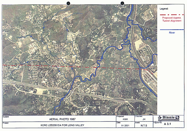
Figure 1
Aerial Photo 1987
Figure 2
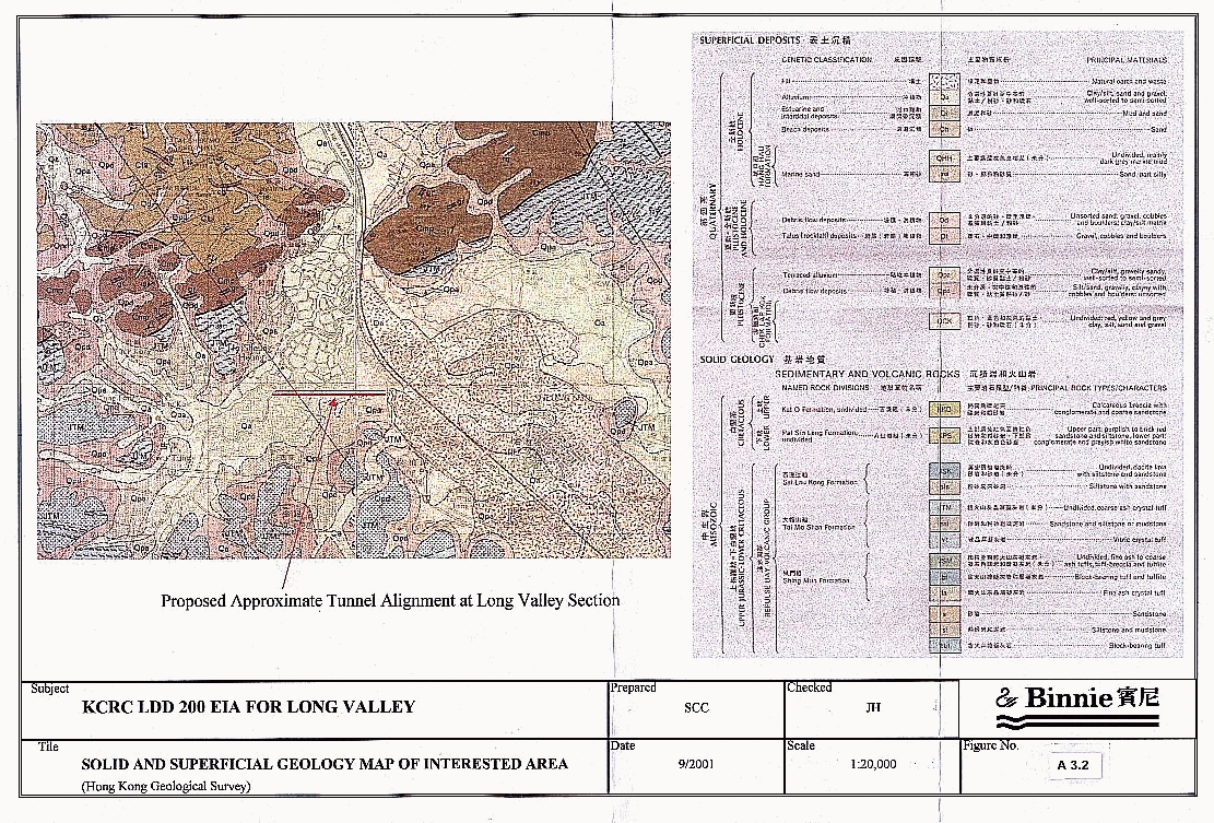
Solid and Superficial Geology Map of Interested Area
Figure
3
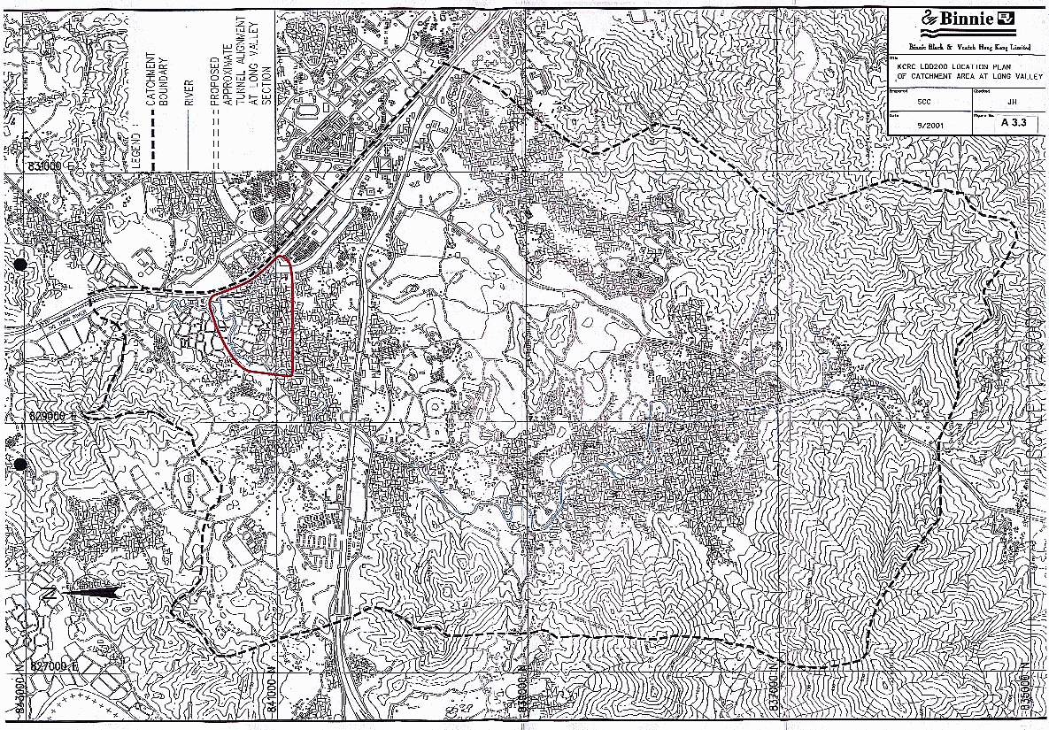
Location Plan of Catchment Area at Long Valley
Figure 4
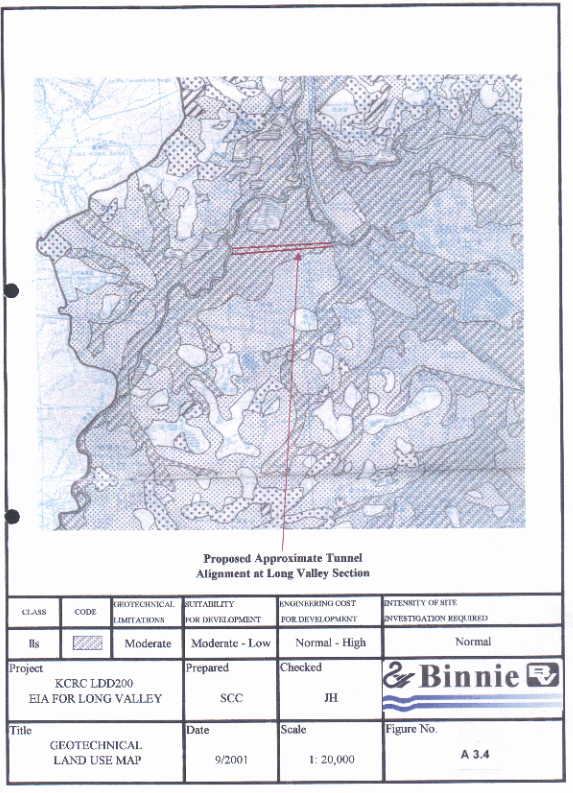
Geological Land Use Map
Figure 5
Physical Constraints Map
Figure 6
Engineering Geology Map
Figure
7
Location Plan for Existing Borehole and Pumping Well
Figure
8
Predicted Tidal Level at Tsim Bei Tsui from Hong Kong Observatory
Figure 9
Tide & Groundwater Level vs Time Plot
APPENDICES
Appendix A3.1a
Borehole Logging
Appendix A3.1b
Cross Sections
Appendix A3.1c Data Field Sheet at Exiting Pump Well WM2A Observation Wells SP1, SP2 & SP3 and Reference Point ‘S2’ on the Bridge.
Appendix A3.1d
Permeability Test Results
Appendix A3.1e Location Plans of Proposed Tunnel Alignment at Long Valley
Appendix A3.1f
SEEP/W Modelling Results and Diagrams
Appendix A3.1g
Seep/W Model Analysis
DESK STUDY
1.1 The purpose
of this desk study is to access the study area and its surrounding geology,
using information already available. This section gives a summary of the
relevant information, and identifies the various sources.
1.2 The
desk study has involved the study of the following information:
(a)
Borehole information mainly from previous site investigation report;
(b)
Topographical Survey Data from the map sheets 2 and 3 (1: 20000);
(c)
Geotechnical Area Studies Programme (GASP) Report V, North New
Territories (GCO, 1988);
(d)
Geological Map Sheet Nos. 2 & 3, Solid and Superficial Geology
(1:20000) by Hong Kong Geological Survey;
(e)
Aerial Photograph Interpretation;
(f)
Relevant Geotechnical Engineering Office (GEO) Reports and Hong Kong
Observatory (HKO) Technical Notes
1.3 The main
objective is to assess both surface and ground hydrology system of the study
area and determine the hydraulic parameters of the aquifer system of the area.
2 AERIAL
PHOTOGRAPH INTERPRETATION
2.1 The
following aerial photographs were inspected in the GEO and Lands Department,
which comprise both high and low flight cover over the entire site area. A
summary of the features observed is contained in Table 1 below.
Table1. API Summary
|
Year |
Photo No. |
Height (ft) |
Observation |
|
1961 |
F41/81A/RAF/ 625 |
30,000 |
1. About 90% of land use identified as farmland. No fish ponds existed inside Long Valley. 2. The number of cottages reflected low population in the Long Valley. |
|
1964 |
2809 |
12,500 |
1. Number of cottages increasing. 2. Fish ponds and farmlands identified. |
|
1973 |
7882 |
12,500 |
1. Abandoned Farmland found adjacent to the junction of the River Beas and River Sutlej. |
|
1976 |
16329 |
12,500 |
1. Number of cottages increasing within Long Valley. 2. No significant change as previous photo. |
|
1979 |
28340 |
10,000 |
1. Sewage Treatment Works visible, the course of River Sutlej still meandering. 2. Southwestern part of Sheung Shui Temporary Housing Area under construction. 3. No significant change as previous photo. |
(Table
1 cont’)
|
Year |
Photo No. |
Height (ft) |
Observation |
|
1981 |
39334 |
10,000 |
1. Northeastern part of Sheung Shui Temporary Housing Area was under-constructed and southwestern part squatters were observed. 2. Improvement works at the southern end of the Shek Sheung River (River Sutlej) was observed. 3. No significant change as previous photo. |
|
1983 |
47014R |
20,000 |
1. Improvement works at the southern end of the Shek Sheung River (River Sutlej) was visible. 2. No significant change as previous photo. |
|
1985 |
A01832 |
10,000 |
1. Fanling Highway under-construction. 2. No significant change as previous photo. |
|
1987 |
CN1206 (Figure 1) |
9,000 |
1. Fanling Highway visible and Tai Ping Estat under construction. 2. No significant change as previous photo. |
|
1989 |
A09106 |
10,000 |
1. Number of Cottages inside Long Valley increasing. About 35% of landuse has become cottages and fenced compounds 2. No significant change as previous photo. |
|
1990 |
A23504 |
4000 |
1. No significant change as previous photo. |
|
1991 |
A17174 |
10,000 |
1. The southwestern part of Sheung Shui Temporary Housing Area demolished and changed to Industrial-use. 2. No significant change as previous photo. |
|
1993 |
A34422 |
4000 |
1. Improvement works at the junction between Ng Tung River & Shek Sheung River in progress.. 2. No significant change as previous photo. |
|
1996 |
CN15330 |
3000 |
1. Site formationcompleted at the Sheung Shui Slaughterhouse. 2. Shek Sheung River (Tsung Pak Long section) under construction. 3. No significant change as previous photo. |
|
1997 |
CN16994 |
3500 |
1. Sheung Shui Slaughterhouse under construction. 2. Natural flow paths of Sheung Yue River (River Beas) and Ng Tung River, and temporary Housing Area are observed. 3. No major change of Long Valley. |
|
1999 |
CN23758 & CN23702 |
3500 |
1. Sheung Yue River (River Beas), Ng Tung River and the junction between Ng Tung River & Shek Sheung River improvement works under construction. 2. The original flow path of Sheung Yue River can still be clearly observed. 3. Temporary Housing Area demolished and some industrial buildings and open storage observed adjacent to Shek Sheung River 4. No major change of Long Valley. |
|
2000 |
CN27690 & CN27691 |
3000 |
1. Sheung Yue River (River Beas) & Ng Tung River improvement works still under construction. 2. Open storage observed at the junction of Shek Sheung River and Ng Tung River. 3. No major change of Long Valley. |
3.1 The relevant parts of Geological Map Sheets 2 and 3 (see Figure A3.2) show that the study catchment area (Figure A3.3) is mainly covered by Quaternary age alluvium sand and clay deposits, pond deposits and fill materials. At the southern, eastern and southwestern boundaries of the flat low lying lands are hills of predominantly Mesozoic decomposed slightly metamorphosed coarse ash crystal tuff of the Tai Mo Shan Formation. There are two sets of faults; the older set is running ESE-WNW and dipping ENE whist the younger set is cutting through the older set with trending NNE-SSW. One of this NNE-SSW trending faults appears to cut across the proposed tunnel.
3.2 The proposed tunnel alignment cuts across the Long Valley between two main stream-courses, namely the River Beas & River Sutlej, where it is covered by the Pleistocene and Holocene alluvial deposits. These are well sorted to semi-sorted clay and silt, and sand and gravel materials. Fill, pond and estuarine deposits are found above the alluvial deposits in some parts of the valley.
4.1 The Report VI for North New Territories (GCO, 1988) has been consulted and relevant information is summarized below.
Table 2. Summarized information of GASP Report VI for the Long Valley
|
Maps (Figure No.) |
Remarks |
|
GLUM (Figure A3.4) |
1. Long Valley is located in zones of moderate geotechnical limitations, where normal intensity site investigation is required. |
|
Physical Constraints Map (Figure A3.5) |
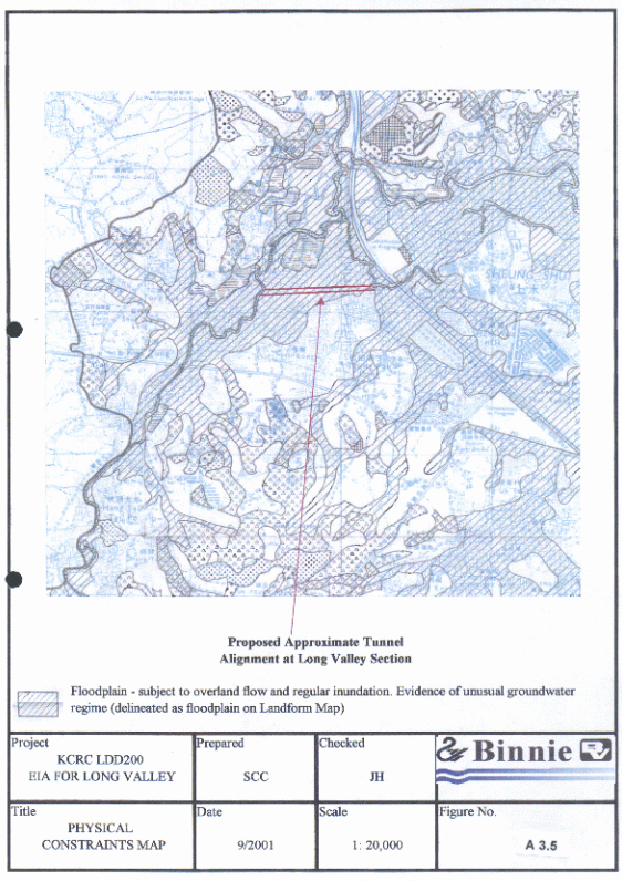
1. Long Valley is located on a floodplain where it is subject to overland flow and regular inundation, There is evidence of unusual groundwater regime (delineated as floodplain on Landform Map). 2. Other parts of the alignment are without any physical constraints. |
|
Engineering Geology Map (Figure A3.6) |
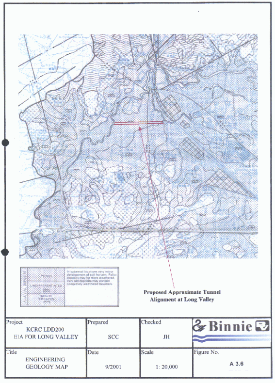
1. The site is covered by ponds and undifferentiated alluvial deposits. Materials are usually saturated and of a low density – clay layers are normally consolidated. Buried channels may pose local problems of high water flows into tunnels or excavation. |
5 EXISTING
BOREHOLE AND AVALIABLE INFORMATION
5.1
Based on the existing borehole records, 20 boreholes were drilled in
the study area and 5 geological sections are cut for interpreting the geology.
One of the cross sections is cut along the proposed tunnel alignment beneath
the Long Valley. The other 4 cross-sections cut across both of the proposed
tunnel and the two channelised rivers. These sections have been used for SEEP/W
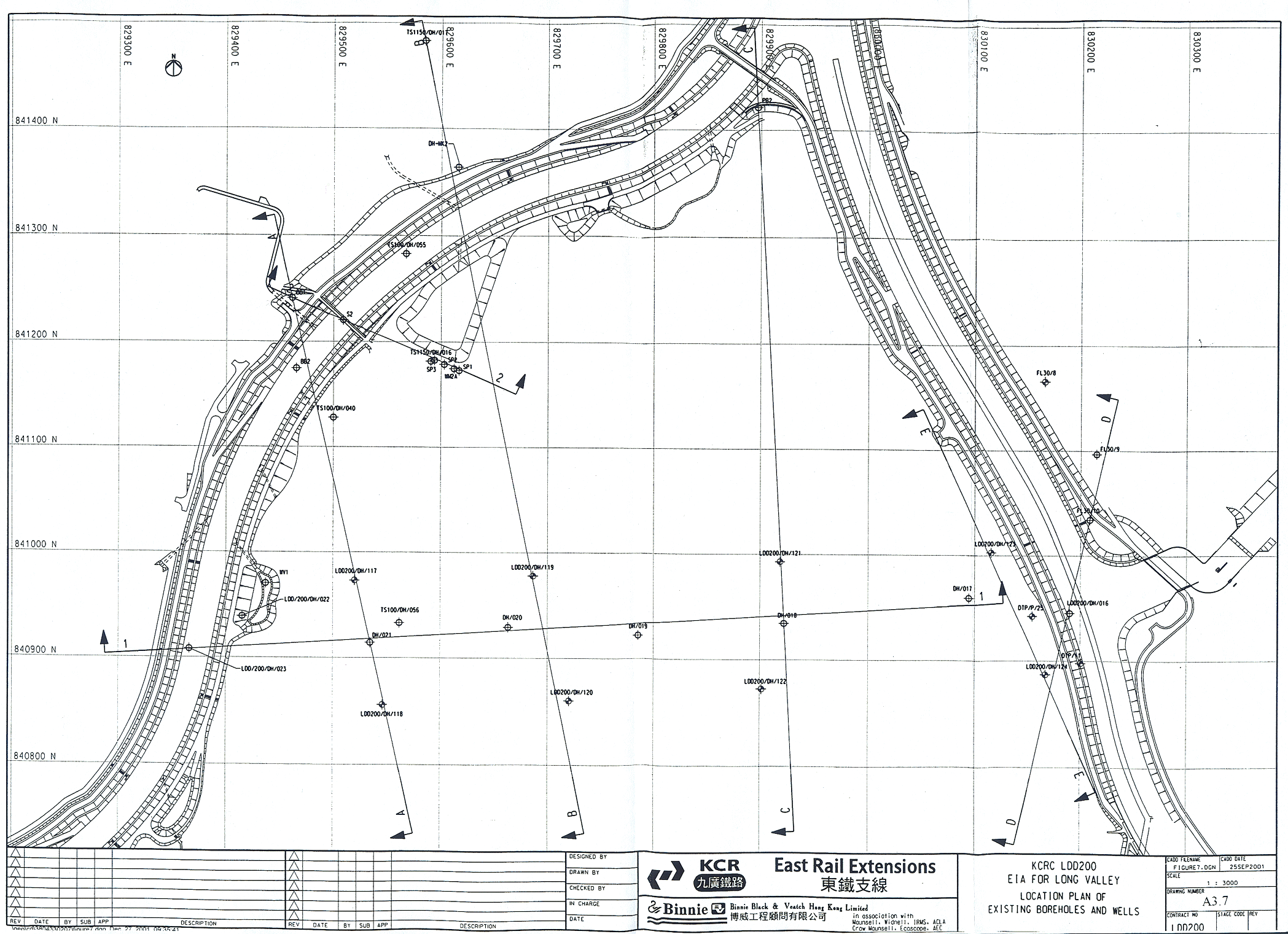
modelling to study the groundwater flow system. The locations of the boreholes
and sections are plotted on Figure 7, and the borehole records are contained in
Appendix A3.1a.
5.2
The existing ground level of the Long Valley varies from approximately
+3.4 mPD on the valley floor to +6.38 mPD along the new channel bunds. The
borehole information shows those superficial deposits of pond, estuarine and
alluvium, and fill can be found. Summarized description of each strata is
summarized in Table 3 below and the geological sections are shown in Appendix
A3.1b.
Table 3. Summary of borehole information
|
Strata |
Thickness (m) |
Level (mPD) |
a)
Descriptions |
|
Fill |
0 – 3.1 |
4.91to 0.59 |
1. Grey/ dark brown angular fine to coarse gravel and cobble sized concrete and occasional steel and rubber (< 150mm) fragments and root. |
|
Pond Deposits |
0 – 3 |
4.80 to 2.49 |
1. Soft to firm brownish grey sandy silt and clay. |
|
Estuarine Deposits |
0 – 3.7 |
4.37 to 0.67 |
1. Soft to firm grey and dark grey mottled reddish brown slightly sandy very clayey silt with occasional wood fragments. 2. SPT N- Value varies from 3 to 15 |
|
Alluvium (Clay/Silt) |
0 – 6.8 |
6.38 to -5.6 |
1. Soft to firm light greyish white reddish brown clay/silt. 2. SPT N-Value varies from 3 to 14. |
|
Alluvium (Sand/Gravel) |
1 – 8 |
4.53 to -8.06 |
1. Occasionally loose sand, medium dense to very dense greyish brown slity clayey fine to coarse sand and sub-angular fine to medium gravel of quartz. 2. SPT N-Value varies from 4 to 180. |
|
CD Tuff |
8.75- 39.4 |
0.15 to -41.01 |
1. Extremely weak grey, locally brown, light grey and black, very narrowly banded (schistose) completely decomposed ash tuff. 2. SPT N-Value varies from 12 to >200. |
5.3
In addition, boreholes LDD200/DH/018, FL30/10, BB2, DTP/11 and
TS100/DH040 revealed that layers of silty/clayey alluvial materials are
interbedded with the sandy/clayey alluvial materials. In the other parts of the
Long Valley, boreholes LDD200/DH/019, LDD200/DH/020, LDD200/DH/023, MK2,
LDD200/DH/017, TS1150/DH/017 TS100/DH/056 and TS1150/DHPZ/016 revealed that the
silty/clayey alluvial materials are overlying the sandy/gravely materials. In
boreholes LDD200/DH/021, LDD200/DH/022, BB2, PB2, LDD200/DH/016, FL30/9 and
TS100/DH/055 the silty/clayey alluvial materials are missing, and only
sandy/gravely materials were found in the drillholes. Underneath the alluvial
materials, extremely weak, brownish yellow, completely decomposed volcanic tuff
is found varying from 13 to 40m in thick.
The rock head level is found at –16mPD to –41mPD.
6.1
The total catchment area for the Long Valley is about 23.3 km2 (Figure
A3.3). Within the catchment, the River Beas (Sheung Yue River) flows from SW to
NE and the River Sutlej (Shek Sheung River) flows from SE to NW. They flow and join together to join
with the River Indus (Ng Tung River) near Sheung Shui Sewage Treatment Works,
and discharge into the Sham Chun River. The surface water flow within the Long
Valley is mainly controlled by these two rivers which collect surface runoff
from the surrounding hill-slopes within the main catchment during the wet
season. The immediate sub-catchment to which Long Valley will respond in future is defined by the new
inner bunds of the Rivers Beas and Sutlej, the Tsung Pak Long channel and the
old Castle Peak Road. As designed a 1in 10year or bigger event would be needed
for flows from the main catchment to overtop the new river bunds and inundate
the whole valley
6.2
The tidal flow also affects the river flow and groundwater system.
Available tidal information at the nearest location of Tsim Bei Tsui is
obtained from Hong Kong Observatory. The predicted highest and lowest tide
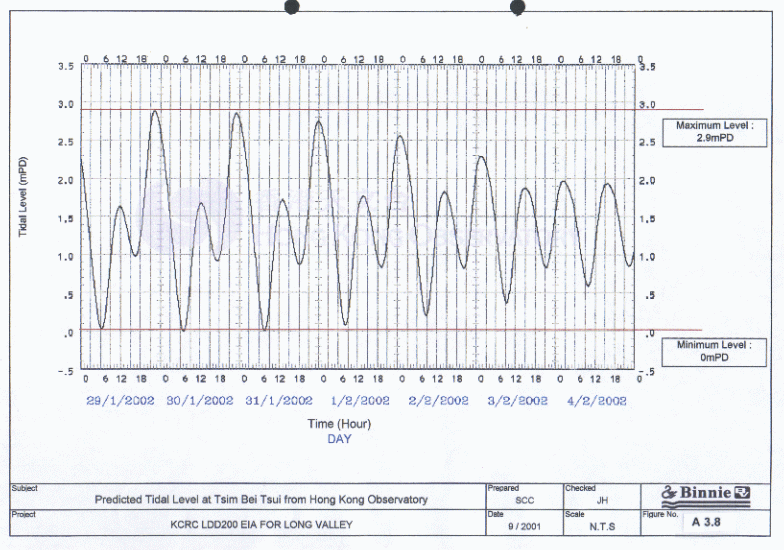
levels are varied between +2.90mPD and +0.00mPD respectively (see Figure A3.7).
And the measured tidal range of the River Beas shows the water level varies
from the main channel floor at 1 to 1.5 m PD and a top Spring tide level of up
to +3.0mPD in normal conditions (shown in Appendix A3.1C).
6.3
The groundwater flow is accompanied with surface water flow (river
system). The basal groundwater flow direction is interpreted as from South to
North. However, the groundwater levels in Long Valley also respond to tidal variation,
once the tide level exceeds the immediate groundwater. The new channels have
perforated floors to overcome uplift and the granular bedding of the channel as
constructed is directly connected in many places to the main alluvial acquifer
beneath the valley.
7.1
The main aquifer is composed of alluvial sands. The mean thickness of
alluvial sand is about 4.5m (ranges from 1m to 7.06m). The base of the aquifer
is bounded by completely composed tuff (Grade V) with low permeability. Below
Grade V rock, the impermeable Grade III or better volcanic tuff acts as no flow
basement. The aquifer is confined in some parts of Long Valley as the alluvial
clay/silt layer provides cover at the top. In other parts of Long Valley, the
aquifer is unconfined, as there is no clay/silt layer covered.
7.2
The existing borehole and pumping well records show that the water
level varies from +0.75mPD to +3.79mPD between the River Sutlej and the River
Beas. There are 4 different layers:
·
Fill (F) / Pond (P) / Estuarine (E) deposits
·
Alluvial clay/silt deposits (A1/ A2)
·
Alluvial sand/gravel deposits (A3/ A4)
·
Completely decomposed volcanic tuff (V)
The results of permeability tests carried out within the strata are
listed in Table 4
below. Detailed permeability test results are included in Appendix
A3.1d.
Table
4. Permeability Test Results
|
Borehole No. |
Response zone (m, BGL) |
Materials with response
zone |
Permeability (m/s) |
|
LDD-200/DH/006 (I) |
4.50 to 5.50 |
Alluvial SAND (A3) |
3.32 x 10⁻⁵ |
|
LDD-200/DH/006 (II) |
4.50 to 5.50 |
Alluvial SAND (A3) |
2.99 x 10⁻⁵ |
|
LDD-200/DH/007 |
4.50 to 5.50 |
Alluvial SAND (A3) |
2.3 x 10⁻⁵ |
|
LDD-200/DH/012 (I) |
14.30 to 15.60 |
Completely Decomposed Tuff (V) |
1.45 x 10⁻⁷ |
|
(Table 4 Cont’) |
|
|
|
|
LDD-200/DH/012 (II) |
14.30 to 15.60 |
Completely Decomposed Tuff (V) |
1.65 x 10⁻⁷ |
|
LDD-200/DH/021 |
4.50 to 5.50 |
Alluvial SAND (A3) |
6.38 x 10⁻⁵ |
|
LDD-200/DH/025 |
3.50 to 4.50 |
Alluvial SAND (A3) |
8.91 x 10⁻⁵ |
|
LDD-200/DH/033 (I) |
2.30 to 3.80 |
Alluvial SAND (A3) |
7.23 x10⁻⁵ |
|
LDD-200/DH/033 (II) |
2.30 to 3.80 |
Alluvial SAND (A3) |
5.84 x10⁻⁵ |
|
LDD-200/DH/035 |
9.50 to 10.60 |
Completely Decomposed Tuff (V) |
5.55 x 10⁻⁶ |
|
LDD-200/DH/041 (I) |
6.00 to 7.00 |
Alluvial Clay/Silt (A1/A2) |
5.84 x10⁻⁶ |
|
LDD-200/DH/041 (II) |
6.00 to 7.00 |
Alluvial Clay/Silt (A1/A2) |
4.68 x10⁻⁶ |
|
LDD-200/DH/082 (I) |
16.50 – 18.00 |
Completely Decomposed Tuff (V) |
6.02 x 10⁻⁷ |
|
LDD-200/DH/082 (I) |
16.50 – 18.00 |
Completely Decomposed Tuff (V) |
2.87 x 10⁻⁷ |
|
BB1 (I) |
13.50 to 14.50 |
Completely Decomposed Tuff (V) |
6.50 x10⁻⁶ |
|
BB1 (II) |
13.50 to 14.50 |
Completely Decomposed Tuff (V) |
2.17 x10⁻⁶ |
|
BB2 |
3.00 to 4.00 |
Alluvial SAND (A3) |
1.78 x10⁻⁵ |
|
BE10 |
5.00 to 6.00 |
Alluvial SAND (A3) |
5.83 x10⁻⁵ |
|
FL3/4 |
1.00 to 2.10 |
Fill (F) |
7.67 x10⁻⁶ |
Table 5. Summarized Permeability Test Results
|
Strata |
Permeability |
|
Fill (F) |
7.67 x 10⁻⁶ m/s |
|
Alluvial Clay/Silt (A1/A2) |
4.68 x 10⁻⁶ - 5.84 x 10⁻⁶ m/s |
|
Alluvial Clay/Silt (A1/A2) (Geometric Mean) |
5.32 x 10⁻⁶ m/s |
|
Alluvial Sand (A3) |
1.78 x 10⁻⁵ – 8.91 x 10⁻⁵ m/s |
|
Alluvial Sand (A3) (Geometric Mean) |
4.36 x 10⁻⁵ m/s |
|
Completely Decomposed Tuff (V) |
1.45 x 10⁻⁷ – 6.50 x 10⁻⁶ m/s |
|
Completely Decomposed Tuff (V) (Geometric Mean) |
8.51 x 10⁻⁷ m/s |
8 TIDE
& GROUNDWATER LEVEL RELATIONSHIP
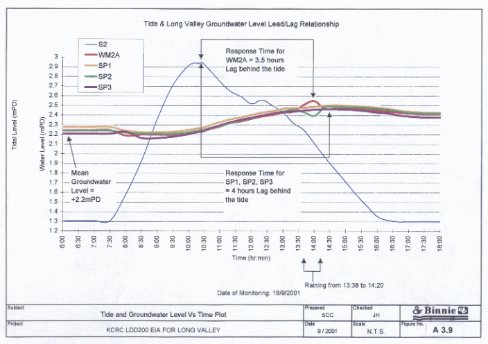
8.1 Refer to above sections, the tide level in the rivers is affecting the groundwater level at Long Valley. On 18th Sept 2001, there was a water level monitoring field test of the river, pumping well (WM2A), observation wells (SP1, SP2 & SP3) was carried out. The reference point of the river is taken on the bridge across the River Beas at Ho Sheung Heung, and the pumping well WM2A was 110m away from the river. The other three observations points were located 5m (SP1), 10m (SP2) and 20m (SP3) from the pumping well WM2A in different directions (locations of wells are shown on Figure A3.7 and cross-section 2-2 is kept in AppendixA3.1b). Water level data were taken from 6:00AM to 6:00PM over the major part of a peak Spring tide cycle. Detailed data field sheet is kept in Appendix I3 and the data was plotted in Figure 9. The incoming tide first reached the footbridge at a level of +1.32 mPD at 7:50AM. The tide peaked at +2.95 mPD at 10:25AM. The mean groundwater level in the morning of the observations, some 100m inland from the channel bund was +2.2mPD. At the end of the monitoring, the groundwater level rose to +2.5mPD. A moderate rainfall event (01:38PM to 02:20PM) occurred for a 40 minute period after the measured groundwater levels had risen some 250mm in response to the earlier high tide.
8.2 In Figure A3.9, the shapes of curves WM2A, SP1, SP2 and SP3 are sinusoidal, while curve S2 represented the river level with half-sinusoidal shape due to the presence of riverbed. Pumping well and observation wells showed different response times to the tide. WM2A curve showed 3.5 hours lag behind the peak of the tide, but water level in standpipes SP1, SP2 and SP3 was at maximum when 4 hours after the peak of the tide. The difference between the results could be due to localized heterogeneity of soil materials and measurement error and the differing response times between the large well screen and the smaller observation wells. The maximum differences in groundwater level of observation wells (SP1, SP2 and SP3) and pumping well WM2A due to the influence of the tide are 0.28m (280mm) to 0.36m (360mm) respectively.
MODELLING
Adopting the information from desk study, four SEEP/W models were constructed to study the impact of implantation of Twin Tunnels on the groundwater system of Long Valley. The location plans of the proposed tunnel alignment at Long Valley are shown on Appendix A3.1e.
9.1 SEEP/W is a finite element software product that can be used to model the movement and pore-water pressure distribution within porous materials such as soil and rock. It is formulated on the basis that flow of water through saturated soil follows Darcy’s Law which states that:
![]()
where :
q = specific discharge [L/T]
K = permeability [L/T]
i = hydraulic gradient [1]
SEEP/W model is constructed to solve 2-Dimensional with multiple soil layers. Flow directions of groundwater can be analyzed. Under steady state conditions, the difference between input flux and output flux is zero at all times. The governing equation used in the formulation of SEEP/W is:
![]()
where:
Kx= permeability in the x-direction
Ky = permeability in the y-direction
H = total head
Q = applied boundary flux
(GEO-SLOPE, 1994)
9.2 For finite element calculation, the SEEP/W model is divided by nodes. The elevation of water level at each node is calculated.
10.1 Geometry
of SEEP/W Models
Section A-A
There are 4 layers of materials in the model. Fill (F) deposits are found at the northern part of the section with maximum thickness approximate 1.6m. Pond (P) deposits are found at the southern part of the section, 1.3m thick. The middle part of the section is covered with alluvial clay/ silt (A1/A2) materials (0.5m to 3.1m thick). The alluvial sand/ gravel (A3/A4) materials are found beneath the former layers everywhere in the section. The range of thickness of A3/A4 is 1.5m to 6m. The thickness of the layer is thinner at the middle of the section and thicker at both ends. Completely decomposed volcanic tuff (V) is underlying the whole of the A3/A4 layer with 9.93m to 22.12m thick. The floor of the channelised River Beas in this section is about +1.15mPD.
Section B-B
There are also 4 layers of materials in this section. Fill (F) and estuarine (E) deposits are found at the two sides of the River Beas with maximum thickness 1.5m and 3.13m respectively. Pond (P) deposits are found at the southern part of the section with maximum thickness 1.5m and disappear on both sides. Underneath, alluvial clay/silt (A1/A2) is found with thickness ranging from 1.5m to 6.8m. Alluvial sand (A3) is found underlying the A1/A2 layer with thickness ranging from 2.2 to 7m (thicker at the northern side of the section). Completely decomposed volcanic tuff (V) underlies below the whole of the A3 layer. The thickness of completely decomposed tuff varies from 8.75m to 24.18m. The base of the River Beas in this section is about +1.15mPD.
Section C-C
Fill (F) and pond (P) deposits are found at the both end of the section with maximum thickness 3.1m and 1.5m respectively. In this section, alluvial clay/silt (A1/A2) is found interbedded at the top and bottom of the alluvial sand (A3) layer at the southern end. However, at the northern end of the section, only A3 layer is found underlying the F layer. The thickness of alluvial sand increases from 1m at the southern end to >6.48m. On the other hand, completely decomposed volcanic tuff (V) varies from 14.02m to 30.05m (from south to north respectively) in thick. The base of the River Beas in this section is about +0mPD.
Section D-D
Fill (F) deposits are found at the two sides of the River Sutlej with thickness around 4m. Alluvial sand/gravel (A3/A4) is found underneath the fill deposits with thickness ranging from 3m to 6.5m. Alluvial clay/silt (A1/A2) is interbedded inside A3/A4 layer at the southern end of the section and bounded the A3/A4 layer in the northern end with 1m to 4m in thickness. Completely decomposed volcanic tuff (V) with thickness around 20m lies underneath the A3 layer. The base of the River Sutlej in this section is about +1mPD.
Section E-E
Pond (P) deposits are found above the proposed tunnel alignment with maximum thickness of about 2m. Alluvial clay/silt (A1/A2) is found underneath the pond deposits to the north of the tunnel alignment with thickness ranging from 0m to 2.5m. To the south of the tunnel alignment, an alluvial sand/gravel (A3/A4) layer is found directly underlying the pond deposits. Elsewhere the (A3/A4) layer is overlain by the A1/A2 layer. The thickness of the A3/A4 layer ranges from 7.5m to 10m. Zones or lenses of alluvial clay/silt (A1/A2) are to be found inside the A3/A4 layer of 1m to 2m thick. Completely decomposed volcanic tuff (V) with thickness around 20m lies underneath the A3/A4 layer.
10.2 Assumptions:
In these models, the assumptions have been made are as follows:
I. The aquifer is heterogeneous and isotropic;
II. The aquifer is partly confined and unconfined. There are four materials in the model with different hydraulic conductivity.
Table 6. Permeability Input Data
|
Soil |
Permeability |
|
Fill |
7.67 x 10⁻⁶ m/s |
|
Alluvial Clay/silt (A1/A2) |
5.32 x 10⁻⁶ m/s |
|
Alluvial Sand/gravel (A3/A4) |
4.36 x 10⁻⁵ m/s |
|
Completely decomposed Tuff (V) |
8.51 x 10⁻⁷ m/s |
Without permeability test results on pond (P) and estuarine (E) deposits, the permeability of these two materials are assumed to be the same as the fill deposits. The transmissivity is calculated by multiplying the saturated thickness to hydraulic conductivity.
III. The water level in the boreholes near the Twin Tunnels Center is around + 3mPD (shown on Table below). By extrapolation, the water level of 100m horizontally away (upstream) from the Twin Tunnels is set to be constant total head boundary = 4mPD. On the other hand, there was a measurement of the observation wells near the River Beas and reference point at on the bridge. The test shows that when the river dried out, the water level of the observation wells was still around 2mPD. As a result, the total head at the bases of the two rivers and the total water head below the center of the rivers is set to be constant = 2mPD.
Table 7. Highest Water Level at Start of Drilling Shift in Boreholes near the Twin Tunnels Center
|
Borehole No. |
Highest Water Level at
Start of Drilling Shift (mPD) |
|
LDD-200/DH/016 |
2.09 |
|
LDD-200/DH/018 |
3.38 |
|
LDD-200/DH/019 |
3.34 |
|
LDD-200/DH/021 |
4.0 |
|
TS100/DH/056 |
3.06 |
|
Average |
3.174 |
IV. Twin Tunnels are totally impermeable, i.e. no water sink into twin tunnels. Recharge from rainfall will increase the water level in the aquifer, which is beneficial to the aquifer. As the worst scenario, recharge to the aquifer is set to be zero.
10.3 The models were run in steady state. Firstly, the models were run without the implantation of the twin tunnels. Then sections A-A, B-B and C-C are run with the implantation of the twin tunnels and sections D-D was run with the implantation of the twin tunnels and the lean-mix concrete block.
11.1 The models were run. Groundwater level at each location was compared with and without implantation of the twin tunnel and concrete block. The following table summarized the results (detailed results and diagrams are included in the Appendix A3.1f):
Table 7. SEEP/W Analysis Results
|
|
Groundwater
table variation after construction of twin tunnels |
|||||
|
Sections |
60m
south of twin tunnels alignment |
Above
twin tunnels alignment |
60m
north of twin tunnels alignment |
|||
|
A-A |
No change |
No change |
10mm drop |
|||
|
B-B |
No change |
No change |
No change |
|||
|
C-C |
No change |
No change |
No change |
|||
|
E-E |
No change |
No change |
No change |
|||
|
D-D |
60m
south of twin tunnels alignment |
30m
south of twin tunnels alignment |
20m
south of twin tunnels alignment |
10m
south of twin tunnels alignment (south
channel embankment) |
70m
north of twin tunnels alignment (north channel embankment) |
90m
north of twin tunnels alignment |
|
1)
without drain pipes in concrete block |
260mm
rise |
450mm
rise |
510mm
rise |
560mm
rise |
700mm
drop |
470mm
drop |
|
2)
with drain pipes in concrete block |
No change |
No change |
No change |
No change |
70mm
drop |
13mm
drop |
12.1 In the SEEP/W analysis, which tested for the sensitivity of an assumed 2 m hydraulic head loss between a point 100m upstream of the proposed twin tunnel alignment and the same river bank, there was no impact on the steady state groundwater flow system in sections B-B, C-C and E-E after implanting the impermeable twin tunnels. In sections A-A, there was only very small impacts on the water level with 10mm rise.
12.2 Clearly, the alluvial acquifer dominates the sub-surface drainage regime and changes or even stoppages in flow in the less permeable CDV beneath the main acquifer have no significant impact on the overall drainage regime.
12.3 In section D-D, the proposed lean-mix concrete block above the twin tunnel would prohibit ground water flow in the main acquifer. As a result ground water would be forced to flow downstream through the CDV layer and/or seep out of the channel base and embankment. The permeability of the CDV is sufficiently low that the analysis indicates that a significant ground water rise and flow up through the channel floor would result. It can be concluded that local to the River Sutlej, cutting off the flow in the main buried channel acquifer would have significant impact on the ground water regime.
12.4 A sample engineered solution with the inclusion of an up and downstream drainage blanket to the lean mix block and piped connections between the two can be shown to greatly reduce the adverse impact of the block on the groundwater regime. A detailed engineering design of such a drainage system will be necessary to ensure that no permanent residual impact occurs. Other temporary engineering alternatives to sustain the tunneling process beneath the drainage channel also exist.
12.5 The recent field test of groundwater response to tidal variation in the Beas and Sutlej rivers showed a maximum change in groundwater level due to the passage of the Spring tide as recorded on the 18th September 2000 ranged between 0.28m and 0.36m from the field monitoring test. These wells lie 85m to 110m inboard of the Beas River confining bund. Typically, the peak tide level rose 0.75m above the ambient groundwater level for that period of Spring tides and the groundwater response to the temporary tidal excess head of water was some 35 to 45% of the difference at the peak.
12.6 By comparing the above results, the impact from this particular tide effect is more than an order of magnitude greater than the impact from implanting the totally impermeable twin tunnels in the underlying less permeable stratum. A similar trial will be run in the dry season Neap tides to confirm that the groundwater response occurs in other less extreme tidal and groundwater scenarios.
12.7 The monitoring event only characterises the groundwater response some 110 m beyond the river bank, whereas within the valley the tunnel ranges from 0 to 400m from either the Beas or the Sutlej. This is the best measure possible at present from previously installed equipment. The current SI will install 4 pairs of double piezometers (One each in the main alluvial and underlying CDV acquifers) as baseline reference for the tunnel drive. Regular readings of groundwater level variation with tide and season will commence as soon as the sites of piezometers are installed. These same piezometer sets will be used to monitor the consequences of the actual tunnel drive.
12.8 On the basis of the tests immediately possible, we conclude that in the permanent condition the totally impermeable twin tunnels, when implanted in the low permeability layer of completely decomposed tuff, have no significant impact on the hydrogeological system.
1.
M.C.D. La Touche & R.J. Osborn (1966). Paper 3 - “River Indus
Pumping Station”. Some aspects of Stage II of the Plover Cove Water Scheme. The
Engineering Society of Hong Kong.
2. B.O.O. Submissions for BD Approval - Std. Notes for “Monitoring and Utilities”. Items 1-5 & 7-16 incl.
3.
Aerial Photographs.
4.
Geotechnical Control Office, 1988. Geotechnical Area Studies Programme
(GASP) Report V, North New Territories.
5.
Geotechnical Control Office, 1991, Geological Map Sheet Nos. 2 & 3,
Solid and Superficial Geology (1:20,000).
6.
GEO, 1987. Geoguide 2 – Guide to
Site Investigation. Geotechnical Engineering Office, Hong Kong Government.
7.
GEO, 1988. Geoguide 3 – Guide to
Rock and Soil Descriptions. Geotechnical Engineering Office, Hong Kong
Government.
8.
GEO-SLOPE, 1994. User’s Guide SEEP/W Version 3. GEO-SLOPE International
Ltd.
9.
Previous Borehole Records.
10.
Sheung Shui to Lok Ma Chau Spur Line – Alignment and Associated Works,
Technical Report on Pumping Tests, April 2001.
11.
http://www.info.gov.hk/hko/tide/eTBTtide.htm, 18/09/2001.