Binnie
Black and Veatch Hong Kong Ltd has been commissioned by the Kowloon-Canton
Railway Company (KCRC) to prepare a Habitat Creation and Management Plan (HCMP)
for the ecological mitigation scheme at Lok Ma Chau, identified within the
Sheung Shui to Lok Ma Chau Spur Line Environmental Impact Assessment (EIA)
Report (BBV 2000). This scheme comprises off-site fishpond
enhancement and marshland creation around the Lok Ma Chau station complex.
1.1.1
This report is produced
under the KCRC Environmental Support Services (ESS) Contract and documents
the design and proposed long-term management and monitoring
of the wetland enhancement, creation and restoration in the vicinity of the
Spur Line terminus at Lok Ma Chau.
1.2
Description of the Spur Line
1.2.1
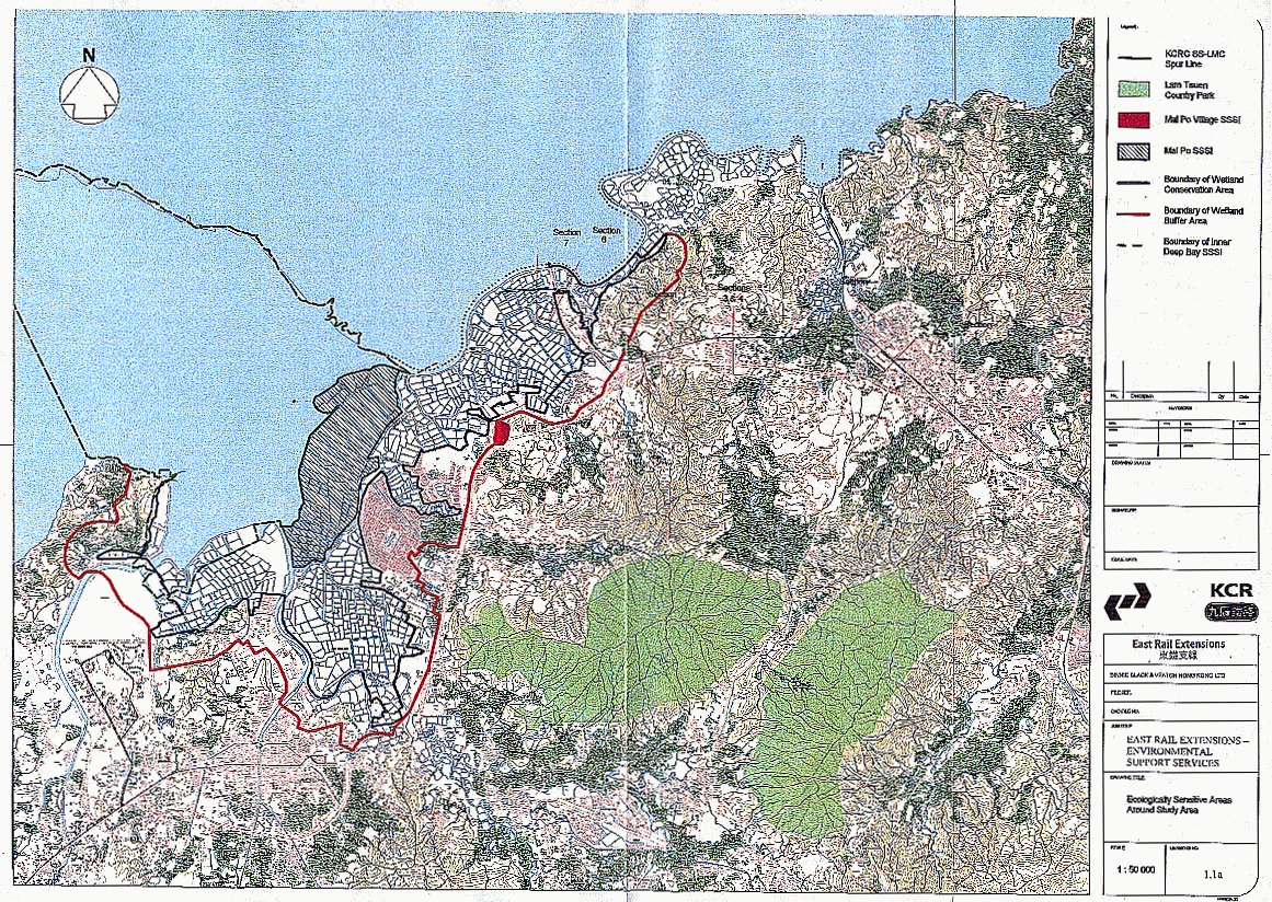
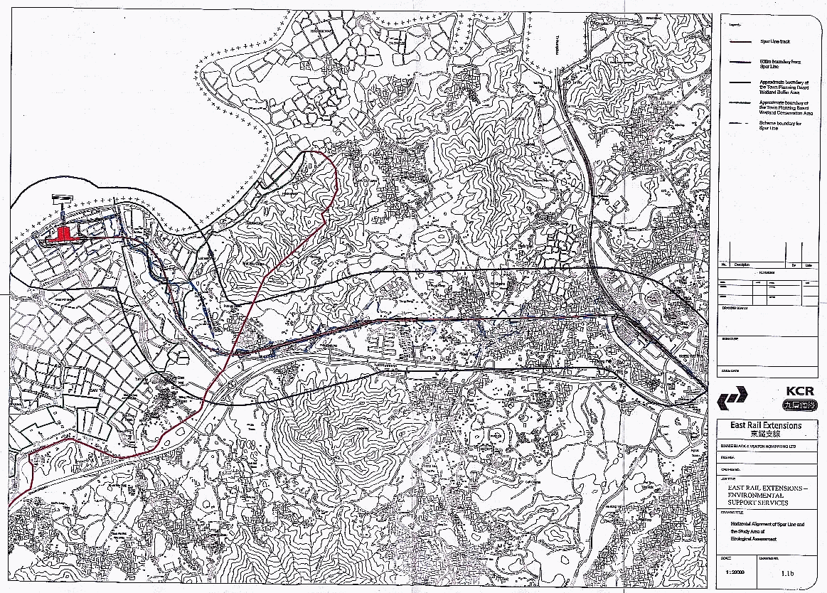
The Spur Line is an
extension to the northern end of the existing East Rail system. Figures
1.1a, 1.1b and 1.2
shows the horizontal alignment of the track and outline of the Lok Ma Chau
Station Complex together with the Study Area covered by the EIA and the boundary
of the ecological mitigation area.
1.2.2
The
major components of the project are:
• Lok
Ma Chau Station: consisting of an island platform, two tracks and two concourse
levels, one for arriving and one for departing passengers, KCRC public
facilities, staff facilities, and plant and support facilities.
• Immigration
and Customs Facilities for Lok Ma Chau Station.
• A
two level footbridge linking Lok Ma Chau and Huanggang Stations.
• A
permanent track of 7.4 km in total length between Lok Ma Chau and Sheung Shui
Stations, in both tunnel and on viaduct, with short sections at grade and on
open ramp.
• Environmental
mitigation measures as documented in the EIA, including ecological mitigation
(through habitat creation, restoration and enhancement) and landscaping works.
• Diversion
of the Dongjiang Raw Water Mains near the existing Sheung Shui Station.
1.2.3
Only
passenger trains will use the Spur Line at a frequency of 6 trains per hour
from the time of opening (currently planned in 2007) increasing to an ultimate
frequency of 12 per hour in each direction by 2016. The speed limit for the
line will be 120km/h. To accommodate the Boundary Crossing Point opening hours,
trains will run between 06.00 and 00.30.
1.2.4
The
construction of the Spur Line is programmed to start in mid 2002 for completion
in mid 2007.
The EIA carried out on the project found that there are potentially significant ecological impacts that require mitigation measures. The major potential impacts occur as a result of disturbance and the loss of fishponds (mainly resulting from the station complex) within the Wetland Conservation Area near Lok Ma Chau. Low impacts occur from direct mortality, habitat fragmentation, dust deposition, increased sediment load in water courses, toxic pollution, soil compaction and hydrological disruption.
It is considered that the impacts from disturbance, habitat loss and fragmentation can be fully mitigated for through the enhancement of 27.1 ha of fishponds and creation of 4.9 ha of semi-natural marsh around the Lok Ma Chau Station site as compensation for construction and operational impacts.
1.2.5
Standard
avoidance and minimisation measures are considered to be adequate to eliminate
all other residual impacts from other potential impact sources.
1.2.6
Responsibility
for the long-term management of the ecological habitat compensation areas will
be taken up by KCRC until such time as a wetland management authority is
established for overseeing wetlands in Hong Kong.
1.3
Purpose of the Habitat Creation
and Management Plan
1.3.1
This
Habitat Creation and Management Plan (HCMP) aims to provide the detailed
specifications for the habitats and ecological functions to be provided by the
wetland mitigation within the vicinity of the Lok Ma Chau station area and to
define the long-term management and monitoring requirements for these habitats.
The recommendations and specifications given in this document and the
accompanying appendices will be incorporated as appropriate into forthcoming
contract documentation.
1.3.2
Thus
the document includes:
• a
summary of the current condition of the site, including its current ecological
characteristics and importance and physico-chemical conditions that may affect
habitat restoration and enhancement measures;
• definition
of the target species requiring mitigation at the site and the target habitats
to be restored, created or enhanced for them;
• a
summary of the specific habitat requirements and associated management measures
required by target species;
• detailed
design drawings and specifications for the habitats (e.g. vegetation
composition and structure and water regimes) and associated structures (e.g.
topography, water courses for water supply and drainage and water control
structures), with underlying design calculations where appropriate;
• management
prescriptions and required actions to maintain the long-term ecological value
and functions of the mitigation areas;
• a
detailed monitoring programme for habitat attributes and target species (with
associated Standard Operating Procedures); and
• an
outline programme for the implementation of the Habitat Creation and Management
Plan.
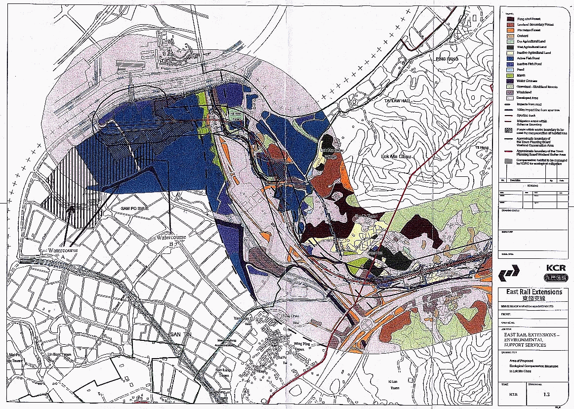
1.4.1
The wetland mitigation
will take place in the area of fishponds indicated in Figure
1.2.
1.4.2
A
detailed site topographical survey was carried out for the preparation of this
HCMP and detailed designs for the marsh and enhanced fishponds. Spot height
measurements and extrapolated contours that were measured indicate that the
average base levels of the existing fish ponds are typically 0.5 – 1.0 mPD,
whilst bund heights vary between 3.0 – 4.0 mPD. At the time of the survey (June
to July 2000), water levels typically varied between 2.3 – 2.9 mPD, giving
approximate water depths of 1.8 – 2.0 m.
1.4.3
Cross-sections
through the area indicate that, whilst there is some variation in the pond
depth profiles, most show a steep increase in slope towards the top of the
bund, with slopes at the water
line often of 1:2 or steeper. As anticipated some pond enhancement can be
readily carried out by increasing the extent of shallow water areas in the
ponds. This may be feasible by creating islands and shallows from bunds,
reducing operating water levels so that the water edge coincides with less
steep areas of the bunds or by reprofiling of bunds (e.g. during pond
maintenance).
1.4.4
There are two water
courses that flow through the site and discharge to the Shenzhen River (see
Figure 1.2). Water course A is tidal and flows
into the Shenzhen River via an open outfall. The water course has been recently
dredged, having an invert level of about 0.0 – 0.5 mPD. There are no water
control structures on this water course within the vicinity of the mitigation
area.
1.4.5
The
watercourse currently has a large catchment in part draining the San Tin area.
No data are available on flow rates or water levels in the watercourse.
However, recent observations have shown that the watercourse to the south of
the site does run full, and overtopped the bank into the channel in June 2001.
This situation should ease with the construction of the San Tin Eastern Main
Drainage Channel (San Tin EMDC).
1.4.6
In
the wet season/normal flow periods, observations suggest that the watercourse
level is of the order of +1 to 1.5mPD. This may change after construction of
the San Tin EMDC.
1.4.7
Water
course B is short (c. 540 m) and is separated from Water course A by a earth
bund and therefore has no appreciable catchment. The outfall and top section
will be channelised as part of the drainage works for the station. The outfall
will be fitted with tidal flap valves to prevent tidal inflows. Design figures
for the channel next to the station indicate that under a ten year return
period rainfall event and two year tide, upstream water level is +3.3 mPD. A ten year tide / 2 year rainfall
upstream level is +3.45 mPD. For a
50 year rainfall / 10 year tide, upstream level is 3.74 mPD, and a 10 year
rainfall / 50 year tide upstream level is +3.97 mPD. The tops of the bunds are generally in the range +3.5 to 4
mPD.
1.4.8
There
are a number of sluices interconnecting some ponds or connecting some ponds
with the water courses. Some of these are, however, in disrepair or have been
blocked with spoil. These sluices
are in the process of being repaired or blocked to retain water during the dry
season of 2001/2002.
1.4.9
The
following account of the soils of the study area is based on Grant (1960;
1986). The soils around the fishponds of Lok Ma Chau are predominantly from the
Mai Po Association. These soils are mainly found around the Mai Po, San Tin and
Sheung Shui areas. They are similar to the soils of the Chik Nai Ping
Association; these are soils derived from Tai Mo Shan porphyry material and
imperfectly drained. Soils of the Mai Po Association tend to be sandier than
the Chik Ni Ping, particularly at the base of the soil profile.
1.4.10
Mai
Po Association soils are formed over alluvial and colluvial material from rocks
of the Lok Ma Chau formation and metamorphosed Pat Sin rock as well as Tai Mo
Shan porphyry.
1.4.11
In
the fish pond area the soils are particularly Mai Po Poorly Drained, Mai Po
Very Poorly Drained and Mai Po Saline, in addition to a large amount of
undifferentiated alluvium.
1.4.12
The
soils are considered to be very fertile, yielding up to 250 catties per dau chung,
depending on salinity. They tend to exhibit strong sharp horizon changes likely
to be associated with the level of the water table. It has been noted that the
pH of the soils decreases with depth to as low as 2.6. The soil tends to be
clayey at the surface and become coarser in texture with depth.
1.4.13
The
soils are acid sulphates due to the sulphate of the sea water which is broken
down to sulphur which combines with iron, which was commonly deposited in
sediments in the Deep Bay area, to form iron sulphides. Percentages of sulphur
can be up to 3% of the total dry matter.
Land Use, Habitat and
Ownership
1.4.14
The
ecological mitigation area is government land and has until recently been
leased for freshwater fish culture. However, fish farming activities ceased at
the end of 2000.when the government land was cleared by DLO. At this time most
of the ponds were emptied of fish and water.
1.5
Existing Ecological Interest
Habitat
Evaluation
1.5.1
The
ecological value of the current habitats
were evaluated in the EIA Final
Report (BBV 2000), largely on the basis of desk studies and field surveys
undertaken by ERM (ERM 1999) for KCRC. Subsequently, baseline studies were
conducted during May 2000 to May 2001 (BBV 2001a, BBV in prep.). These reviewed habitat changes and the following taxa
groups: plants, mammals, birds, reptiles, amphibians, dragonflies and
butterflies. In addition to general bird surveys, detailed studies were
conducted into the occurrence of Greater Spotted Eagles Aquila clanga and Imperial Eagles Aquila heliaca and the use of fish ponds by Black-faced Spoonbills Platalea minor.
1.5.2
At
the time of the surveys undertaken by ERM (ERM 1999), the majority of the area
consisted of active fish ponds. There were also some smaller areas of inactive
fishpond which had been partially filled in as a result of the Shenzhen River
Regulation works and partly restored but were not under active fish pond
management. However, during 2000 the leases of the ponds within the area
covered by the proposed LMC station footprint and the area covered by this HCMP
were terminated by Government and all ponds were inactive at the time of the
baseline studies.
1.5.3
As
indicated in Table 1.1 both the active and inactive fish ponds within the Lok
Ma Chau and nearby San Tin areas are considered to be of moderate to high
ecological value and the recent change from active to inactive status of many
of the ponds does not alter fundamentally the evaluation of their potential as
wildlife habitats.
Table 1.1
Ecological evaluation of active fish ponds within 500 m of the Spur Line and Station area at San Tin and Lok Ma Chau (Source: BBV 2000)
|
|
Active fish ponds |
Inactive fishponds |
||
|
Criteria |
San Tin |
Lok Ma Chau |
San Tin |
Lok Ma Chau |
|
Naturalness |
Man-made
habitat, currently subject to limited human disturbance |
Man-made
habitat, currently subject to limited human disturbance |
Man-made
habitat, currently subject to limited human disturbance |
Man-made
habitat, currently subject to limited human disturbance |
|
Size |
Small |
Small |
Small |
Small |
|
Diversity |
Low habitat
diversity but high in terms of wildlife recorded |
Low habitat
diversity but high in terms of wildlife recorded |
Low habitat
diversity but high in terms of wildlife recorded |
Low habitat
diversity but high in terms of wildlife recorded |
|
Rarity |
The habitat
is not rare but some of the species supported are rare locally or globally,
notably some avifauna |
The habitat
is not rare but some of the species supported are rare locally or globally,
notably some avifauna |
The habitat
is not rare but some of the species supported are rare locally or globally,
notably some avifauna |
The habitat
is not rare but some of the species supported are rare locally or globally,
notably some avifauna |
|
Re-creatability |
Readily-re-creatable |
Readily-re-creatable |
Readily-re-creatable |
Readily-re-creatable |
|
Fragmentation |
Heavily fragmented |
Slightly fragmented |
Heavily fragmented |
Slightly fragmented |
|
Ecological Linkage |
Part of the wider fishpond habitat of the Deep
Bay area and serves similar function to those located at Mai Po Nature
Reserve |
Part of the wider fishpond habitat of the Deep
Bay area and serves similar function to those located at Mai Po Nature
Reserve |
Part of the wider fishpond habitat
of the Deep Bay area and serves similar function to those located at Mai Po
Nature Reserve |
Part of the wider fishpond habitat of the Deep
Bay area and serves similar function to those located at Mai Po Nature
Reserve |
|
Potential Value |
High ecological potential if managed properly
to enhance wildlife use |
High ecological potential if managed properly
to enhance wildlife use |
High ecological potential if managed properly
to enhance wildlife use |
High ecological potential if managed properly
to enhance wildlife use |
|
Nursery/breeding ground |
Part of the wider Deep Bay fishponds habitats
that provide an important breeding/nursery ground for the prey of bird and
other mammals, notably the Tilipia and chironomids |
Part of the wider Deep Bay fishponds
habitats that provide an important breeding/nursery ground for the prey of
bird and other mammals, notably the Tilipia and chironomids |
Part of the wider Deep Bay fishponds habitats
that provide an important breeding/nursery ground for the prey of bird and
other mammals, notably the Tilipia and chironomids |
Part of the wider Deep Bay fishponds habitats
that provide an important breeding/nursery ground for the prey of bird and
other mammals, notably the Tilipia and chironomids |
|
Age |
No information is available |
No information is available |
No information is available |
No information is available |
|
Abundance/Richness of Wildlife |
High |
High |
High |
High |
|
Conclusion |
High Ecological Value |
High Ecological Value |
Moderate to High Ecological Value |
Moderate to High Ecological Value |
1.5.4
The
only other habitats present are a water course, some marsh and a small patch of
plantation forest. These habitats are not considered to be of ecological value
because the water course is highly polluted, the marsh is small and highly
disturbed as it lies alongside the San Sham Road Boundary crossing point, and
the forest is of low intrinsic value. Both the marsh and plantation forest were
reduced in extent during 2001 due to expansion of the Boundary Crossing point
though the former will be partly restored following the implementation of
mitigation measures (BBV 1999).
1.5.5
Existing
vegetation was studied during June 2000 (wet season) and March 2001 (dry
season) (BBV in prep.). The existing vegetation is highly modified as a
consequence of commercial fish farming and other agricultural activities and
primarily comprises rank grassland along bunds, together with remnant patches
of crops, especially the widely planted exotic Canna indica. Planted or naturally dispersed trees are found on
some bunds; these are largely fruit trees or the naturalised exotic Melia azedarach. Some semi-natural
vegetation occurs along the edges of ponds, especially where these are adjacent
to drainage channels. However, no protected species or species considered to be
rare by Corlett et al. (2000) were
found.
Species
of Conservation Importance
1.5.7
A
list of Species of Conservation Importance that occur within the San Tin and
Lok Ma Chau fishpond areas is provided in Table 1.2 below. The list of Species
of Conservation Importance contained in the EIA Final Report (BBV 2000) has
been updated to reflect both the findings of the baseline studies conducted
during 2000-01 (BBV 2001a, BBV in prep.), the recent review of the global list
of bird species of conservation concern (BirdLife International 2000) and a
current review of terrestrial species of conservation importance in Hong Kong
(Fellowes et al. in press).
Table 1.2
Species of Conservation Importance that occur within 500 m of the Spur Line and Station area at San Tin and Lok Ma Chau (Sources: BBV 2000, BBV 2001a, BBV in prep.) Note that species found to be of only irregular occurrence in the area during the 2000-2001 baseline study or those not recorded during the baseline study but recorded previously in the area and listed in BBV (2000) are shown in brackets.
|
Common name |
Lok Ma Chau |
San Tin |
|
MAMMALS |
|
|
|
Regionally Important Species |
|
|
|
Eurasian
Otter Lutra lutra |
(√)* |
|
|
BIRDS |
|
|
|
Globally
Threatened Species |
|
|
|
Black-faced
Spoonbill Platalea minor |
√ |
|
|
Greater
Spotted Eagle Aquila clanga |
(√) |
(√) |
|
Imperial
Eagle Aquila heliaca |
√ |
(√) |
|
Japanese
Yellow Bunting Emberiza sulphurata |
(√) |
|
|
Regionally Important Species |
|
|
|
Black-winged
Stilt Himantopus himantopus |
√ |
√ |
|
Common
Teal Anas crecca |
√ |
√ |
|
Eurasian
Coot Fulica atra |
(√) |
√ |
|
Great
Cormorant Phalacrocorax carbo |
√ |
√ |
|
Chinese
Pond Heron Ardeola bacchus |
√ |
√ |
|
Great
Egret Egretta alba |
√ |
√ |
|
Grey
Heron Ardea cinerea |
√ |
√ |
|
Little
Egret Egretta garzetta |
√ |
√ |
|
Red-billed
Starling Sturnus sericeus |
√ |
√ |
|
Restricted
Range in Hong Kong |
|
|
|
Greater
Painted-snipe Rostratula benghalensis |
(√) |
|
|
Northern
Hobby Falco subtteo |
(√) |
(√) |
|
Black-naped
Oriole Oriolus chinensis
|
(√) |
(√) |
|
Declining in Hong Kong |
|
|
|
Pheasant-tailed Jacana Hydrophasianus chirurgus |
(√) |
|
|
Bluethroat
Luscinia svecica |
(√) |
√ |
|
Common
Snipe Gallinago gallinago |
√ |
√ |
|
Common
Stonechat Saxicola torquata |
√ |
√ |
|
Locally
Important Species |
|
|
|
Japanese
Quail Coturnix japonica |
(√) |
|
|
Pallas’s
Grasshopper Warbler Locustella
certhiola |
(√) |
(√) |
|
Pintail
Snipe Gallinago stenura |
(√) |
√ |
|
Richard’s
Pipit |
√ |
√ |
|
Swinhoe’s
Snipe Gallinago megala |
(√) |
|
|
Zitting
Cisticola Cisticola juncidis |
√ |
√ |
|
AMPHIBIANS |
|
|
|
Chinese Bullfrog Rana rugulosa |
√ |
|
|
Total number of Species of
Conservation Importance regularly recorded |
15 |
15 |
* A
single observation of Eurasian Otter was made during winter 2000-01 fieldwork.
Further fieldwork is required to determine whether Eurasian Otter is of regular
occurrence in the study area.
1.6
Summary of Predicted Ecological
Impacts
1.6.1
The location of the
proposed route of the railway in relation to existing protected areas of high
ecological value is indicated in Figure 1.1a. This indicates that the only protected area
near to the study area is the Inner Deep Bay Ramsar site (a Wetland of International
Importance under the Ramsar Convention) and SSSI. The Deep Bay area comprises
natural and man-made wetlands (rivers, freshwater marshes, fish ponds, gei
wais (tidal shrimp ponds), mangal, inter-tidal mudflats and the bay),
which provide a wide range of habitats that support a high diversity of biota
(plants, insects, reptiles, amphibians, birds and mammals).
1.6.2
The
Ramsar site is particularly important for waterbirds, including a number of
globally threatened species (Collar et al.
1994), species which regularly have high proportions of their global or
biogeographical wintering or passage populations within the site and species that
are of regional or local conservation importance (Aspinwall Clouston &
Wetlands International - Asia Pacific, 1997). Many of these species have been
recorded within the study area, or are likely to occur in the area.
1.6.3
The fish ponds in the
San Tin / Lok Ma Chau area are close to and contiguous with the Deep Bay Ramsar
site and fall within the Wetland Conservation Area (WCA) and Wetland Buffer
Area (WBA) as recently delineated by the Town Planning Board (TPB PG-No 12B)
(Figure 1.2). The planning intention of the WCA
is to conserve the ecological value of the fishponds that form an integral
part of the wetland system in the Deep Bay Area.
1.6.4
As
stated in the EIA report (BBV 2000), the Town Planning Board has adopted a
“precautionary approach” to development in the Deep Bay area in view of the
known intrinsic value of fish ponds in ecological terms, and the complex
response of birds to future landuse changes and carrying capacity which has not
been fully understood. The intention is to protect and conserve the existing
ecological function of fishponds in order to maintain the ecological integrity
of the Deep Bay wetland as a whole. In considering development proposals in the
Deep Bay Area, the Board adopts the principle of “no-net-loss in wetland” which
provides for the conservation of continuous and adjoining fishponds. The
no-net-loss can refer to both loss in “area” and “function”.
1.6.5
It is therefore clear
that the station site and surrounding fish ponds in the San Tin / Lok Ma Chau
area is of high ecological importance. A summary of the main impacts predicted
to potentially affect the habitats and associated species in this area is
provided in the main EIA Report (BBV 2000). These impacts are primarily 9.6
ha of habitat loss (mainly from the station building complex) and disturbance
from the construction and operation of the line and station.