This section presents the results of the preliminary investigation into the potential issues associated with land contamination, and where appropriate, previews areas for further assessment.
The objective is to identify and assess any concerns with respect to potential soil and groundwater contamination along the route of the Designated and Potentially Designated Elements of the Project. Excavation works will be required for the construction of the pumping station buildings and associated structures and for the laying of the sewers. This EIA Study has assessed the potential contamination impacts according to the relevant standards specified in the Environmental Impact Assessment Ordinance (EIAO) and relevant guidance notes for land contamination assessment.
Practical mitigation measures are recommended, where necessary, to reduce any negative impacts to within stipulated limits or other appropriate guidelines.
7.2
Relevant Legislation and Guidelines
Assessments of land contamination are guided by the EPD's guidance document Professional Persons Environmental Consultative Committee Practice Note 3/94 - Contaminated Land Assessment and Remediation (ProPECC PN 3/94), the Technical Memorandum on Environmental Impact Assessment Process (EIAO-TM), and EPD's 1999 Guidance Notes for Investigation and Remediation of Contaminated Sites of: Petrol Filling Stations; Boatyards; and Car Repair/Dismantling Workshops (Guidance Notes).
Under the ProPECC PN 3/94, the "Dutch Ministry of Housing, Planning and Environmental Soil and Groundwater Standards" (the Dutch List) (1994) are used as reference criteria for the classification of contaminated materials.
Under the EIAO-TM, Annex 19: Guidelines for Assessment of Other Impacts, and the 1999 Guidance Notes, consideration is given to a number of potentially contaminating historical land uses, including petrol filling stations, boatyards and car repair/dismantling workshops.
The following legislation, documents and guidelines also cover or have some bearing upon land contamination and the handling, treatment and disposal of contaminated waste in Hong Kong:
· Water Pollution Control Ordinance (WPCO);
· Waste Disposal Ordinance (Cap 354);
· Waste Disposal (Chemical Waste) (General) Regulation (Cap 354); and
· Code of Practice on the Packaging, Labelling and Storage of Chemical Wastes, Environmental Protection Department (1992).
7.3
Baseline Environmental Conditions
As detailed above, the principal elements of the Project include the construction of a trunk sewerage system with five sections of sewers/rising mains and seven pumping stations. As detailed in Section 2, the Project will be located in the sub-urban area of Kam Tin and Yuen Long. The alignment of the Project is mainly along existing roads at Kam Tsin Wai, part of Kam Sheung Road and along maintenance access roads of the Kam Tin Main Drainage Channel.
The present land uses that give rise to potential concerns for land contamination include numerous small scale vehicle maintenance and repair yards, metal scrap yards, storage yards, and uncontrolled dumping sites. Many of these properties are listed currently on the Lands Department Central Database of the Task Force (Blackspots) on Flytipping Control (March 1999). The potential concerns and key issues relating to these properties are discussed in the following sections.
7.4
Identification of Environmental Impact
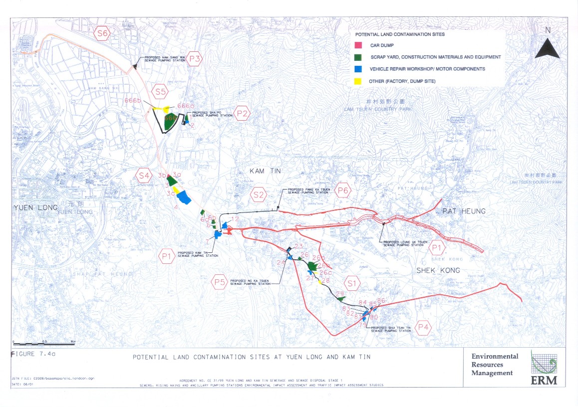
The primary information collected on potentially contaminating sites was obtained from the Lands Department Central Database of the Task Force (Blackspots) on Flytipping Control (March 1999), and supplemented with a site appraisal exercise and review of aerial photographs and survey maps. These data were used to determine the potentially contaminated land within the proposed works areas of the Project and potentially contaminated land adjacent to the works areas (see Figure 7.4a).
The site appraisal was undertaken during August 2000 to confirm and identify any additional sites which may be considered as being involved in potentially contaminating activities or showing evidence of contamination.
7.5.1 Introduction
In accordance with ProPECC PN 3/94 and the EPD’s Guidance Notes, an assessment evaluation should:
· past land use history, in relation to possible land contamination;
· identify those areas of potential contamination and associated impacts, risks or hazards; and
· as required, submit a p provide a clear and detailed account of the present use of the land in question and the relevant lan to evaluate the actual contamination conditions for soil and/or groundwater.
The EPD’s Guidance Notes include a summary of the ‘essential steps of a Contamination Assessment’. Figure 7.5a clearly demarcates the steps that have been undertaken as part of this contaminated land assessment and the outstanding tasks which have not been carried out in this Study due to restrictions on private property access.
Figure 7.5a Steps
of a Contamination Assessment
Site
Appraisal (Information collection) Plan
& design site investigation Submission
of Generic Contamination Assement Plan (cap) to EPD Obtain endorsement of site specific CAP
from EPD Site
Investigation (samples collection & laboratory tests) Results Interpretation Prepare
Contamination Assement Report (CAR) and sumit to EPD Remediation
Required? Prepare
Remediation Action Plan (RAP) and obtain approval from EPD Implement
RAP Activities includes within this EIA Activities requiring permitted sites assess Keep
CAR for future record NO YES
As site access is restricted at this stage, it has not been practicable to undertake a detailed sampling and analysis programme.
Rather, the timing of the specific site investigations should be considered on a site-by-site basis, with the initiation of the investigation work being dependent upon the endorsement of the site specific CAP by the EPD and attaining consent from the relevant private landowners and/or Government Departments.
The following approach was used for the land contamination assessment.
(i) Review of the current and historical land uses was undertaken using information from aerial photographs, site visits, and government and public information on potential "blackspot" areas. The objective was to identify any potentially contaminative land uses within the Study Area. The information was compiled on base maps showing the locations of sites that fall within the category of, or are associated with, potentially contaminative land uses, as identified in the Section 3.1 of Annex 19 of the EIAO-TM.
(ii) Verification and visual inspection was undertaken to confirm the general environmental conditions associated with each of the identified sites. This non-intrusive approach was used to make an initial determination of the likely nature of any potential contamination, and, where identified, to evaluate whether there were any significant land contamination concerns associated with these properties.
(iii) A site appraisal profile was developed for each of the sites identified as having the potential for contamination. This profile identified the major potential land contamination concerns. For these sites, a preliminary review was made of potential environmental impacts or health concerns that may arise from, or during, future use of the land as a result of exposure to potentially contaminated materials.
(iv) Based on the profile results and type of land uses identified, an overview of the typical mitigation measures was undertaken.
7.5.2 Sources of Information
Reference has been made to the following sources of information:
· Hong Kong Ordinance Survey maps (1:1000 and 1:1200 scale) from various years along the proposed alignment;
· Selected aerial photos along the alignment from 1999;
· Outline Zoning Plans (OZP's) along the alignment;
· Hong Kong Geological Survey Memoir No. 3, Geology of the Western New Territories;
· Hong Kong Geological Survey Solid and Superficial Geology Series Map No. 6, Yuen Long; and
· Lands Department Blackspots database (March 1999).
A list of the aerial photographs reviewed during the course of the
study is presented in Table 7.5b.
Table
7.5b Aerial Photographs Reviewed
|
Date/Year |
Photographs |
Notes |
|
10.08.2000 |
CN27738 - 39 |
3,500ft (near P1 and P6) |
|
01.06.2000 |
CN26526 |
3,500ft (near P3) |
|
10.08.2000 |
CN27969 |
3,500ft (near P5) |
|
10.08.2000 |
CN28014 - 16 |
3,500ft (near P4) |
|
10.08.2000 |
CN27973 |
3,500ft (near P7) |
|
05.11.1999 |
CN24457 |
3,500ft (near Yuen Long STW) |
|
09.02.1999 |
CN24485 - 87 |
3,500ft (near Yuen Long STW) |
|
05.11.1999 |
CN24439 - 40 |
3,500ft (North of STW) |
|
09.02.1999 |
A49172 - 73 |
1,500ft (Ha Tsuen) |
|
09.02.1999 |
A49105 - 06 |
4,000ft (Ha Tsuen) |
|
05.11.1999 |
CN24536 - 40 |
3,500ft (Yuen Long) |
|
09.02.1999 |
CN22439 - 40 |
3,500ft (Au Tau) |
|
05.11.1999 |
CN24502 - 03 |
3,500ft (near S3, P2) |
|
09.02.1999 |
CN22432 - 38 |
3,500ft (from P1 to P2) |
|
09.02.1999 |
CN22413 - 19 |
3,500ft (S3 alignment) |
|
05.11.1999 |
CN24568 - 70 |
3,500ft (Kam Tin, Shek Kong) |
|
05.11.1999 |
CN24621 - 26 |
4,000ft
(Tai Leng to
Yuen Kong) |
|
19.12.1995 |
CN13125 |
3,500ft
|
|
19.12.1995 |
CN13111 |
3,500ft
(near P4) |
|
19.07.1995 |
CN10216 |
3,200ft
(near P1) |
|
19.07.1995 |
CN10287 |
3,200ft
(near P1) |
|
02.05.1995 |
A40857 |
3,500ft
(near P6) |
|
09.07.1995 |
CN10285 |
3,200ft
(near P6) |
|
07.02.1995 |
CN9425 |
3,000ft
(near P4) |
|
19.07.1995 |
CN10308 |
3,200ft
(near P4) |
|
05.10.1990 |
A22851 |
2,000ft
(near P2) |
|
05.10.1990 |
A22863 |
2,000ft
(near P2) |
|
05.10.1990 |
A22846 |
2,000ft
(near P3) |
|
05.10.1990 |
A22885 |
2,000ft
(near P3) |
|
05.10.1990 |
A22907
- 12 |
2,000ft
(near P1) |
|
05.10.1990 |
A22985 |
2,000ft
(near P1) |
|
05.10.1990 |
A22934
- 35 |
2,000ft
(near P1) |
|
Note: Photographs
were reviewed for generalised land changes, as well as development of specific
properties along the Project alignment. |
||
7.5.3 Potential Impacts
The potential impacts to the Project from contaminated soil and groundwater are judged to be the following:
· health risks to site workers;
· disposal of contaminated soils, where encountered;
· disposal of contaminated groundwater, where encountered; and
· potential health risks to future users of the sites.
Health Risk to Site Workers
Site construction workers may become exposed to contaminated soils and groundwater during earth moving operations and the laying of pipelines or underground services. The main exposure routes for site construction workers are accidental direct ingestion of contaminated materials through poor hygiene and eating or smoking on site, or through direct contact with potentially toxic or harmful contaminants in excavated soil or sediments.
Disposal of Contaminated Soil
In the event that any contaminated soils are identified during site investigation (SI) works or further environmental investigations, they may require remediation or disposal prior to or as part of the construction programme. Prior agreement will need to be reached with EPD to ensure that these materials are dealt with appropriately in accordance with ProPECC Note 3/94. Any contaminated soils which are excavated will require treatment and/or off site disposal at an appropriate site which is licensed to accept ‘contaminated’ soils. The actual type(s) and concentration(s) of contaminants will determine the final disposal requirements, following agreement of the proper disposal option with the Waste Facilities Management Group, and Waste Policy and Services Group of the EPD.
Contaminated Groundwater Disposal
Where excavations for sewers or pumping stations take place below the groundwater table, there may be a need to dewater the pits for safety and construction purposes. Where dewatering takes place through layers of contaminated material or where any contaminated soil is being excavated, the groundwater may become contaminated, thereby requiring appropriate handling and disposal. Depending on the level of contamination encountered, and subject to the agreement of the EPD, groundwater will need to be disposed of in an appropriate manner, compliant with the Water Pollution Control Ordinance (WPCO).
Potential Health Risks to Future Users of the Site
During the operational phase of the works, there is considered to be little potential for impacts associated with contaminated soils which may remain in situ. However, maintenance workers or workers who may be commissioned to perform extensions or alterations to the sewers, mains or at the pumping stations at a later stage may come into contact with such materials, at which time all of the above mentioned impacts may be applicable. However, if contaminated material is identified during the construction stage, it is expected that appropriate remedial measures will have been undertaken either to ensure this material is mitigated or removed, or to ensure that future, direct contact with in situ materials is avoided.
The presence of any potential contamination along the Project alignment is related to the historical and current uses to which land has been put, both within and adjacent to the planned development. A review of current and historical land uses has been undertaken and the findings are presented below.
Review of Land Use Types
A review of historical maps and selected historical aerial photos indicates that the majority of the proposed Project is to be developed on open or slightly developed land, along roadway and public access corridors. There is little available information to indicate that there has been any major or large scale industrial usage along the proposed alignment of the sewers and the sites for the pumping stations. This was confirmed with site visits, which indicated that the proposed alignment would generally be located at the boundaries or adjacent to the potential sites of concern. The land uses of the potentially contaminated sites adjacent to the works areas include:
· vehicle maintenance and repair yards;
· car dumps and wrecker yards;
· construction material and equipment storage yards;
· small scale metal scrap yards; and
· uncontrolled dumps or debris fields.
Current Land Uses
A summary of the current, potentially contaminating land uses along the Project alignment is given in Table 7.5c. These sites are identified in Figure 7.5a. A total of 32 sites has been identified based on the EPD’s criteria. A total of 21 of these sites are currently listed on the March 1999 edition of the Land’s Department “Blackspots” database. Sites located in excess of 50m from the proposed Project alignment have not been considered, as all of the sites identified are fairly small in size (ranging from 0.4ha to 2.8ha) and there have been no reported cases of large scale spillages or leakages of potential contaminants. Land contamination potential has been judged to be localised. Furthermore, only the soil along the alignment will be disturbed which in most cases is within 10m either side of the alignment.
Table 7.5c Potentially Contaminated Sites in Project Area
|
Site No. |
Current Land use |
Observed Evidence of
Contamination |
General Project Location |
Blackspot Reference (if any) |
|
1 |
Small Scrap and Storage
Yard, with construction materials and equipment |
Metal scrap, minor vehicle
repairs (in one service bay), unpaved areas with fuel storage |
P2 |
1 |
|
2 |
Vehicle/Motor Components,
with some trailer storage |
Observed scrap motor bikes,
vehicle parts; unpaved areas |
P2 |
2 |
|
666 |
Cosmo Way Enterprises
Trailer Storage |
Trailer storage; paved,
appears to be well kept; minor vehicle maintenance |
S5 |
-- |
|
666a |
Kon Chueng Food Processing
Factory |
Dumping area behind
factory; small burn pits noted (suspected for burning of trash); storage of
full and empty chemical containers; site maintains one Cat. 5 underground
storage tank |
S5 |
-- |
|
666b |
Vacant Land area along dirt
road |
Uncontrolled dumping: fresh
dirt and debris piles; some oil based product or oily residues dumped; paint
cans |
S5 |
-- |
|
3 |
Scrap Yard |
large scrap metal piles; unpaved
areas with metal storage, scrap shredding, vehicle dumping |
S4 |
3 |
|
3a |
Scrap and Construction
Material Storage |
Observed scrap metal piles,
at least 100 drums (suspected empty), scrap vehicles; steel pilings and construction materials
stored; area unpaved |
S4 |
-- |
|
3b |
Car Dump |
Observed scrap vehicles,
scrap metal |
S4 |
-- |
|
3c |
Temporary Concrete Batching
Plant |
Typical concrete batching
activities; suspected fuel tanks present; sand and gravel piles; detailed inspection
not allowed |
S4 |
-- |
|
4 |
San Tin Vehicle Maintenance |
Observed four vehicle
service bays; much of property vacant, unpaved |
S4 |
4 |
|
6 |
Vacant land; some storage |
Mostly vacant; has some
construction materials and scrap |
P1, S4 |
6 |
|
6a |
Scrap Metal Storage |
Miscellaneous scrap
storage, metal and vehicles |
S4 |
-- |
|
6b |
Equipment and Materials
Storage |
miscellaneous materials in
open unpaved area; observed six empty portable storage tanks |
S4 |
-- |
|
7 |
Jaguar, Tai Hing Motor
Companies |
Vehicle/motor components;
used cars and scrap cars; minor vehicle maintenance; no access to site |
P1 |
7 |
|
12 |
Car Storage |
New and used cars; no
apparent maintenance |
P1, S2 |
12 |
|
23 |
Vehicle Repair/Scrap Yard |
Vehicle and motor
components; observed spillages on ground, which is only partially paved; fuel
storage |
P5, S1 |
23 |
|
24 |
Kam Luem Motor Vehicle
Repair |
Vehicle repair activities;
no access allowed to site |
S1 |
24 |
|
26 |
Ya Luen Storage |
Storage of construction
materials and equipment; no access allowed to site |
S1 |
26 |
|
26a |
Hop Wo Construction
Materials |
Scrap materials and scrap
vehicles; metal parts; stacked drums, old heavy construction equipment and
materials |
S1 |
-- |
|
26b |
Construction Material
Storage |
Storage of metal
scaffolding and parts; some drums observed; no access allowed to site. |
S1 |
-- |
|
26c |
Yau Fai Factory |
Apparent small steel
factory and metal plating works; storage of construction materials, crane and
lift parts |
S1 |
-- |
|
27 |
Excellence Engineering
Company |
Warehouse and Timber
operation; minor vehicle maintenance observed; no access allowed to site. |
S1 |
27 |
|
28 |
Unidentified Factory
Building |
Old slaughterhouse? Observed
large concrete tank (water?), storage of bags of seeds |
S1 |
28 |
|
29 |
Construction Materials and
Equipment |
Civil engineering company
storage; observed some above ground storage tanks and storage of oil drums
(without secondary containment) |
S1 |
29 |
|
79 |
Vacant Lot; Former Vehicle
storage |
Vacant; paved; former
storage activities |
S1 |
79 |
|
80 |
Fai Wong Junk Yard and
Vehicle Repair Workshop |
Observed old vehicles and parts;
general construction materials; partially paved, with staining of soil; no
access allowed to site |
S1, P4 |
80 |
|
81 |
Jitwing Motor Components |
Vehicle repair and
maintenance activities; scrap cars, junk yard; site is paved, but oil
staining observed; no access allowed to site |
S1, P4 |
81 |
|
82 |
Wah Sing Vehicle Machine
Trading |
Vehicle repair and
maintenance activities; vehicle and machine parts observed; drum storage,
with staining noted on concrete; site partially paved; no access allowed |
S1, P4 |
82 |
|
83 |
Fungs World Industrial
Limited |
Machinery and motor
maintenance activities; various parts and components stored; generally looked
in good condition; paved |
S1, P4 |
83 |
|
84 |
Chuen Yip Vehicle Repair |
Vehicle repair and maintenance,
motor components and scrap parts; area unpaved, and heavy staining observed;
painting activities note; no access allowed to site |
S1, P4 |
84 |
|
85 |
Hop Yik Generator Company |
Motor maintenance activities,
generator components; site generally clean |
S1, P4 |
85 |
|
86 |
Vacant lot |
Vacant; suspect trailer
storage |
P4 |
86 |
|
Note: Refer to Figure 7.4a for
locations. |
||||
As the majority of the various vehicle maintenance facilities and scrap operations are operating, access to the properties for inspection was usually not permitted. Therefore, only a limited, preliminary visual assessment of these properties could be made. It is recommended that once site access can be gained and the site specific CAP has been endorsed by the EPD, detailed site investigation works should be carried out.
7.5.5
Identification of Environmental
Impacts
The evaluation of the potential impacts associated with the presence of these potentially contaminating land uses is presented below.
Sources of Impact
As the various properties in question are all fairly small in size, the land contamination potential is judged to be localised. Therefore, the overall contamination concerns are considered to be low. All the identified potential areas of concern lie within the current 50 m consultation boundary. Overall, contamination concerns from these facilities would only arise if any leakages or spillages of chemicals or contaminants have migrated from the specific sites through to areas where construction workers might come into contact with the soil.
Since the incidence of any spillages or leakages is unknown, there still remains a small, yet unquantified potential for impacts to arise from the migration of contaminants from the sites to the Project site, or from other unidentified sources such as illegal dumping. With regard to the migration of contaminants from the properties, it is considered that relatively large volumes of contaminating materials would have been spilled to cause a significant negative impact to the works areas.
Potential Impacts from Contamination
Typical contaminants associated with vehicle maintenance and related activities include petroleum hydrocarbons, fuels and lead. Potential impacts may arise from localised spillages and the possible presence of underground or aboveground storage tanks (USTs/ASTs). These contaminants may cause negative impacts to sensitive receivers, including humans, during construction works or during the operational phase. A description of the general hazardous properties of typical compounds which may have been used or stored at these sites is presented in Table 7.5d.
Based on available information on the proposed sewers/rising mains alignment, trench widths and the identified potentially contaminated sites, It is estimated that under the worst case scenario (ie assuming all the excavated materials from the trenches adjacent to potentially contaminated sites are contaminated), the amount of contaminated soil to be treated and disposed of will be in the order of 14,000m3. However, it should be noted that this is a very conservative assumption. As suggested by the visual inspection, the land contamination potential is judged to be localised. Therefore the potential for off-site migration of contaminants from the potentially contaminated sites to the excavation area will be remote and hence it is expected that the actual quantity of contaminated soil, if any, to be excavated will be much less that estimated under the worst case scenario.
Table 7.5d General Properties of Hazardous Substances Potentially Present at Project Sites
|
Typical
Material |
General
Hazardous Properties |
|
Petroleum
hydrocarbons (including benzene, toluene, xylenes, and ethyl benzene - BTEX) |
· Can
be toxic by inhalation, ingestion and contact · May
be flammable at high concentrations |
|
Oils,
oily wastes |
· Can
be toxic by contact ·
Concentrations may be flammable |
|
Thinners,
solvents, degreasants(a) |
· Toxic
by contact, inhalation and ingestion |
|
Heavy
Metals(a) (including copper, chromium, lead, and zinc) |
· Can
be toxic by ingestion and contact · Most
are toxic to fish, plants, and marine plants (especially copper) ·
Specific precautions may be required in
relation to monitoring and dust control in site formation works |
|
Acids
(batteries) (a) |
· Toxic
and harmful by contact · Corrosive
to metal, concrete |
|
Polycyclic Aromatic Hydrocarbons (PAHs) |
· Toxic
by contact and ingestion |
|
Note: (a) These
materials are considered likely, although not solely restricted to being
present at vehicle repair or service sites. The presence of such material has not been confirmed as no
access was allowed at the sites. |
|
7.5.6 Further Investigations
The preliminary investigation has identified land uses adjacent to the proposed alignment of the sewer with the potential to give rise to land contamination, as defined in the EPD’s guidance documents. Whilst the investigation has concluded that these land uses, have only a minimal potential to cause contaminated land impacts, it is a requirement under Annex 19 of the EIAO-TM and the Guidance Notes that a Contamination Assessment Plan (CAP) is prepared and submitted to the EPD for approval. The preliminary CAP is attached as Annex C and provides an outline of the sampling procedures, proposed locations and analytical parameters. This preliminary CAP is subjected to review in particular the number and location of sampling points and updated information should be given when access is gained. Such revised CAP should be submitted to EPD for approval before the commencement of actual drilling and sampling. Following receipt of the EPD’s approval, the CAP will be implemented and the findings of the investigations will be reported in the Contamination Assessment Report (CAR), as specified in the EPD’s Guidance Notes for Investigation and Remediation of Contaminated Sites.
As the potential for adverse impacts is considered to be minimal, the CAP recommends that specific site investigations be undertaken on a case by case basis, once access can be gained, in order to verify this conclusion. As appropriate, soil sampling may be performed at individual properties, with chemical analysis of selected samples from near the surface and at selected depths. Analyses will be performed, as appropriate, for the parameters listed in Table 3.1 of the Guidance Notes. Due to the restricted access, the exact locations of the boreholes/trail pits, are currently undetermined. However, once site access becomes available, the preliminary CAP shall be updated to include specific information on each of the sites.
This preliminary CAP is subjected to review, in particular the number and location of sampling points and updated information should be given when access is gained. The future CAP should be submitted to EPD for approval before the commencement of actual drilling and sampling. Moreover, the CAR/RAP should be approved by the EPD before commencement of any construction work which may disturb the ground of the concerned sites.
If land contamination is confirmed, a Remediation Action Plan (RAP) shall be prepared, and both the CAR and the RAP shall be submitted as a combined report to the EPD for approval before disturbing the ground at the concerned sites. If applicable and required in consultation with the EPD, the contaminated site(s) shall be remediated in accordance with the approved CAR/RAP.
It should be noted that there is presently no legislation in Hong Kong that requires the clean-up of soil or groundwater contamination. The presence of contaminated soil or groundwater becomes a waste disposal issue, based upon the limitations that arise for the handling and disposal of contaminated material (refer to Section 6).
Preliminary Mitigation Measures
As stated above, it is considered unlikely that contaminated land issues will be a significant concern during either the construction or operation of the Project. However, specific site investigations will need to be conducted to confirm the presence of any contamination.
As a precaution, it is recommended that standard good practice measures are implemented during the construction phase to minimise any potential exposure to contaminated soils or groundwater. These measures include:
· The use of bulk earth-moving excavator equipment will minimise construction workers’ potential contact with contaminated materials.
· Exposure to any contaminated materials may be minimised by the wearing of appropriate clothing and personal protective equipment such as gloves (when interacting directly with contaminated material), preventing smoking and eating during such activities, and providing adequate hygiene and washing facilities.
· Vehicles containing any contaminated materials should be suitably covered to limit potential dust emissions or contaminated wastewater run-off, and truck bodies and tailgates should be sealed to prevent any discharge during transport or during wet conditions.
· Only reputable waste hauliers should be used to collect and transport any contaminated material to an appropriate disposal site and procedures should be developed to ensure that illegal disposal of wastes does not occur.
· The necessary waste disposal permits should be obtained, as required, from the appropriate authorities, in accordance with the Waste Disposal Ordinance (Cap 354), Waste Disposal (Chemical Waste) (General) Regulation (Cap 354), as required.
· Records of the quantities of wastes generated and disposed of should be maintained.
· In accordance with good construction practice, silt traps should be used to reduce the impact to drainage caused by suspended solids (SS) arising from disturbed ground, or any construction materials such as cement and gravel. Groundwater should be disposed of in accordance with the WPCO, and its discharge licence requirements.
Detailed mitigation measures will need to be developed following site specific investigations.
7.6
Summary
A number of potentially contaminated sites are located within 50m of the proposed alignment of the sewers and SPS. These sites have the potential to cause land contamination. The contaminative activities include numerous small scale vehicle maintenance and repair yards, metal scrap yards, storage yards, and uncontrolled dumping sites. Many of these properties are currently listed among the Lands Department database of Blackspots. However, in light of the fact that the sites are in use, access to the properties for inspection and site investigation works was not possible during the EIA study.
The potential impacts to the Project from contaminated soil and groundwater are judged to be the following:
· health risks to site workers;
· disposal of contaminated soils, where encountered;
· disposal of contaminated groundwater, where encountered; and
· potential health risks to future users of the sites.
Based on available information on the proposed sewers/rising mains alignment, trench widths and the identified potentially contaminated sites, it is estimated that under the worst case scenario (ie assuming all the excavated materials from the trenches adjacent to potentially contaminated sites are contaminated), the amount of contaminated soil to be treated and disposed of will be in the order of 14,000m3. However, it should be noted that this is a very conservative estimate. As suggested by the visual inspection of the potential contaminated sites, the land contamination potential is judged to be localised. Therefore the potential for off-site migration of contaminants from the potentially contaminated sites to the excavation area will be remote and hence it is expected that the actual quantity of contaminated soil, if any, to be excavated will be much less that estimated under the worst case scenario.
As land uses with the potential to give rise to land contamination have been identified (i.e. vehicle maintenance facilities and scrap yards), Annex 19 of the EIAO-TM requires that a Contamination Assessment Plan, (CAP) be prepared. The preliminary Contamination Assessment Plan (CAP) for this Project is included in Annex C. The preliminary CAP identifies the indicative sampling locations and analytical parameters that will need to be updated, once site access is available, and included in the finalised CAP with prior endorsement by the EPD. Following the receipt of the EPD’s approval, the CAP will be implemented and the findings of the investigations will be reported in the Contamination Assessment Report (CAR). The results of these investigations will determine whether contaminated land is, in fact, an issue that needs to be addressed further. If the presence of contaminants is confirmed then there may be a need to update or amend the current construction programme in light of the findings, and perform further investigations to determine the extent of required remediation.
7.7
Further actions
A stand alone CAP has been prepared and is submitted in Annex C of this Report for the approval of EPD. The CAP report is preliminary only and is subjected to review when site access is gained. The revised CAP should be submitted to the EPD for approval before the commencement of actual drilling and sampling. Following receipt of the EPD’s approval, the CAP will be implemented and the findings of the investigations will be reported in the Contaminated Assessment Report (CAR), before disturbing the ground of the concerned sites. If land contamination is confirmed, a Remediation Action Plan (RAP) shall be prepared, and both the CAR and the RAP shall be submitted as a combined report to the EPD for approval before disturbing the ground at the concerned sites. If applicable and required in consultation with the EPD, the contaminated site(s) shall be remediated in accordance with the approved CAR/RAP.