8.1
Introduction
This section presents the results of the assessment of potential impacts from the construction and operation of the sewerage system and pumping stations, associated with the Designated and Potentially Designated Elements of the Project, on terrestrial and aquatic ecological resources in the Study Area. Field surveys covering a period of 12 months (April 2000 to March 2001) were undertaken to establish the baseline ecological conditions of the Study Area. Measures required to mitigate identified impacts are recommended, as appropriate.
8.2
Relevant Legislation And Guidelines
A number of international conventions and local legislation and guidelines provide the framework for the protection of species and habitats of ecological importance. Those related to the Project are:
· Country Parks Ordinance (Cap 208);
· Forests and Countryside Ordinance (Cap 96);
· Wild Animals Protection Ordinance (Cap 170);
· Animals and Plants (Protection of Endangered Species) Ordinance (Cap 187);
· Town Planning Ordinance (Cap 131);
· Town Planning Board Guidelines for Application for Developments within Deep Bay Area under Section 16 of the Town Planning Ordinance (revised April 1999);
· Hong Kong Planning Standards and Guidelines Chapter 10 (HKPSG);
· The Technical Memorandum on Environmental Impact Assessment Process under the Environmental Impact Assessment Ordinance (EIAO TM);
· United Nations Convention on Biodiversity (1992);
· Convention on Wetlands of International Importance Especially as Waterfowl Habitat (the Ramsar Convention); and
· PRC Regulations and Guidelines.
The Country Parks Ordinance provides for the designation and management of Country Parks and Special Areas. Country Parks are designated for the purpose of nature conservation, countryside recreation and outdoor education. Special Areas are created mainly for the purpose of nature conservation.
The Forests and Countryside Ordinance prohibits felling, cutting, burning or destroying of trees and growing plants in forests and plantations on Government land. The subsidiary Forestry Regulations prohibit the picking, felling or possession of listed rare and protected plant species. The list of protected species in Hong Kong which comes under the Forestry Regulations was last amended on 11 June 1993 under the Forestry (Amendment) Regulation 1993 made under Section 3 of the Forests and Countryside Ordinance.
Under the Wild Animals Protection Ordinance, designated wild animals are protected from being hunted, whilst their nests and eggs are protected from destruction and removal. All birds and most mammals including all cetaceans are protected under this Ordinance, as well as certain reptiles, amphibians and invertebrates. The Second Schedule of the Ordinance that lists all the animals protected was last revised in June 1992.
The purpose of the Animals and Plants (Protection of Endangered Species) Ordinance is to restrict the import and export of scheduled species. The Ordinance is primarily related to controlling trade in threatened and endangered species and restricting the local possession of them.
The Town Planning Ordinance provides for the designation of Conservation Areas, Coastal Protection Areas, Sites of Special Scientific Interest (SSSIs), Green Belt or other specified uses that promote conservation or protection of the environment. The authority responsible for administering the Town Planning Ordinance is the Town Planning Board.
The Town Planning Board Guidelines for Application for Developments within Deep Bay Area under Section 16 of the Town Planning Ordinance (revised April 1999) adopts “precautionary approach” and the principle of “no-net-loss in wetland” to conserve the ecological value of fish ponds within Deep Bay Area. The designation of Wetland Conservation Area (WCA) and Wetland Buffer Area (WBA) are used for landuse planning control to avoid undesirable landuses and human disturbance.
Chapter 10 of the HKPSG covers planning considerations relevant to conservation. This chapter details the principles of conservation, the conservation of natural landscape and habitats, historic buildings, archaeological sites and other antiquities. It also addresses the issue of enforcement. The appendices list the legislation and administrative controls for conservation, other conservation related measures in Hong Kong, and Government departments involved in conservation.
Annex 16 of the EIAO TM sets out the general approach and methodology for assessment of ecological impacts arising from a project or proposal, to allow a complete and objective identification, prediction and evaluation of the potential ecological impacts. Annex 8 recommends the criteria that can be used for evaluating ecological impacts.
The Peoples’ Republic of China (PRC) is a Contracting Party to the United Nations Convention on Biological Diversity of 1992. The Convention requires signatories to make active efforts to protect and manage their biodiversity resources. The Government of the Hong Kong Special Administrative Region has stated that it will be ‘committed to meeting the environmental objectives’ of the Convention (PELB 1996).
The Convention on Wetlands of International Importance Especially as Waterfowl Habitat (the Ramsar Convention) applies to the HKSAR. The Convention requires parties to conserve and make wise use of wetland areas, particularly those supporting waterfowl populations. Article 1 of the Convention defines wetlands as ‘areas of marsh, fen, peatland or water, whether natural or artificial, permanent or temporary, with water that is static or flowing, fresh, brackish or salt, including areas of marine water the depth of which at low tide does not exceed six meters.’ The Mai Po/Inner Deep Bay wetland was declared a Wetland of International Importance (“Ramsar site”) under the Convention in 1995.
The PRC in 1988 ratified the Wild Animal Protection Law of the PRC, which lays down basic principles for protecting wild animals. The Law prohibits killing of protecting animals, controls hunting, and protects the habitats of wild animals, both protected and non-protected. The Law also provides for the creation of lists of animals protected at the state level, under Class I and Class II. There are 96 animal species in Class I and 156 in Class II. Class I provides a higher level of protection for animals considered to be more threatened.
8.3
Assessment Methodology
8.3.1 Literature Review
A literature review was conducted to determine the existing conditions within the Study Area and to identify habitats and species of potential importance that may be affected by the Project. The literature review included Government and private sector reports, independent and Government published literature, academic studies, vegetation maps and land use maps. The review included the following:
· Assessment of Effects of Mangrove Removal on Water Quality in Deep Bay (Binnie 1992);
· Kam Tin Bypass and associated reports (Binnie 1996);
· Improvement to Kam Tin Road, Stage 1 Environmental Impact Assessment and Drainage Impact Assessment Studies. Environmental Impact Assessment (Babtie 1996);
· EIA for the Yuen Long Bypass Floodway Feasibility Study (Binnie 1998);
· West Rail Initial Assessment Report: Volume 2. Corss-Border Freight and Passenger Services. Environmental Impact Assessment (ERM 1998a);
· West Rail Environmental Impact Assessment Report (ERM 1998b);
· Hong Kong Bird Report;
· Monthly Waterfowl Count (HKBWS);
· Ecological Monitoring Report for Main Drainage Channels for Ngau Tam Mei, Yuen -Long and Kam Tin (Ecosystems Ltd. 2000a, 2000b);
· Porcupine!; and,
· other relevant Environmental Monitoring and Audit Reports (ie Route 3 post-construction and West Rail Phase 1).
8.3.2 Field Survey
The Study Area was defined as the area within 500 m of either side and along the full stretch of the Project and works boundary. Following a literature review of available ecological data characterising the Study Area, a number of reconnaissance surveys were undertaken to update and field check the validity of the information gathered in the review. A number of more focused baseline field surveys were then proposed to supplement the review findings. The baseline surveys were carried out to determine the existing environmental conditions, and were designed to fill any data gaps, and to facilitate an adequate assessment of the Project’s impacts upon ecology and the development of appropriate mitigation measures. The baseline surveys cover a 12 month period from April 2000 to March 2001.
The following baseline surveys were identified as being required:
· Habitat survey (once in wet season and once in dry season);
· Vegetation survey (once in wet season and once in dry season);
· Bird survey (once per month for 12 months);
· Invertebrate survey (once in wet season and once in dry season);
· Mammal survey (once in wet season and once in dry season);
· Herpetofauna survey (once in wet season and once in dry season, including a night survey of amphibians in wet season); and
· Stream fauna survey (once in wet season and once in dry season).
The information presented in the following sections has been based on the findings of baseline surveys performed during the period April 2000 to March 2001. The baseline ecological conditions were evaluated based on the criteria laid out in Annex 8 & 16 of the EIAO TM.
Habitat Survey
A reconnaissance survey was performed at the commencement of the survey period to characterise habitats and to select representative areas for detailed baseline surveys. Special attention was paid to those areas which will be directly impacted by the proposed sewer alignments and pumping stations. Detailed habitat surveys were performed during April, June, July, September, December 2000 and January 2001 to describe the habitats in these areas. Colour photographs were taken of all habitat types surveyed as well as other features or species of ecological importance or conservation value. Habitats identified within the Study Area were mapped based on Government aerial photos taken in 1999 and updated during the field surveys.
Vegetation Survey
The vegetation survey recorded all plant species and their relative abundance (common, occasional and scarce) in each habitat type within the Study Area. Efforts were also made to find species protected under local regulations, or species known to be rare or of conservation importance on a regional or territorial basis.
A list of plant species and their relative abundance recorded at each habitat type covering both the wet and dry seasons (April 2000 to March 2001) within the Study Area are presented in Tables D1 to D8 of Annex D. This list covers all the plant species recorded during the vegetation surveys.
The terminology adopted to describe the conservation status of plant species follows Wu and Lee (2000), Xing et al. (2000), and Siu (2000). Relative abundance of the plant species recorded are classified as “common”, “occasional” and “scarce”. Plant species widely present in sampling locations within a habitat type and are abundant in number when seen are classified as “common”. Plant species present in only some of the sampling locations within a habitat type or moderately abundant while seen are classified as “occasional”. Plant species only seen in a few sampling locations or with a small number of individuals when seen are classified as “scarce”. It should be noted that such rankings are relative based on occurrence and frequency of the species observed during the surveys for the Project. Readers should refer to Wu and Lee (2000), Xing et al. (2000), and Siu (2000) for local (Hong Kong SAR) abundance of the plant species.
Bird Survey
Habitats and areas of potential ecological importance for avifauna within the Study Area were identified in a reconnaissance survey. Baseline surveys of bird populations were undertaken within those selected habitats using the point count method. A total of ten minutes was spent counting birds at each point in each sampling event. All birds seen or heard within 30 m of each point were counted. The locations of the point count sampling sites are shown in Figure 8.3a. Bird abundance in each type of habitat was then expressed in number of birds per hectare (total birds counted divided by total surveyed area). Bird species outside the counting points but within the Study Area were also actively searched and recorded in order to supplement the findings from point count surveys and produce a complete species list. Signs of breeding (e.g. nests, recently fledged juveniles) were also recorded. Efforts were made to supplement the findings from point count surveys, and to produce a complete species list. Signs of breeding (eg nests, recently fledged juveniles) were also recorded. Bird surveys were undertaken monthly between April 2000 to March 2001. The survey time for the bird surveys covered flood and ebb tides, particularly during winter period. Ornithological nomenclature in this report followed Viney et al. (1994). Commonness and distribution of bird species in Hong Kong follows Viney et al. (1994), rarity and protection status of birds follows Collar et al. (1994) and Zheng and Wang (1998).
Invertebrate Survey
Surveys of terrestrial invertebrates (butterflies and dragonflies) were conducted within the Study Area during June 2000 (wet season) and February 2001 (dry season). The invertebrate survey was designed to search for and to record dragonfly and butterfly species, as well as their relative abundance in each habitat type within the Study Area. An ordinal scale was used to indicate the abundance of butterfly and dragonfly species in each type of habitat: I (1-10 individuals); II (11-30 individuals); III (31-100 individuals). Nomenclature of butterflies in this report follows Walthew (1997) and that of dragonflies follows Wilson (1997).
Mammal Survey
Surveys of mammals within the Study Area were conducted during June 2000 (wet season) and December 2000 (dry season). Efforts were made to produce a species list in the Study Area through active searching. During the surveys, all sightings, tracks, and signs of mammals found were recorded. A night time survey was also undertaken in early July 2000. Nomenclature of mammals in this report follows Reels (1996) and Ades (1999). No quantification of abundance of mammals in the Study Area was made, due to the difficulties in translating sights and tracks (eg burrows) to actual abundance.
Herpetofauna Survey
Surveys of herpetofauna within the Study Area were conducted during June and July 2000 (wet season), and January 2001 (dry season). No quantification of abundance of herpetofauna in the Study Area was made, due to the secretive nature of these fauna. Therefore, efforts were made to produce a species list in the Study Area through active searching. During the surveys, all reptiles and amphibians sighted and heard were recorded. A night time survey for amphibians was also undertaken in early July 2000. Nomenclature of reptiles in this report follows Karsen et al. (1998) while that of amphibians follows Lau and Dudgeon (1999).
Stream Fauna Survey
Streams identified in the Study Area were visited and surveyed during June and July 2000 for the wet season and during January and February 2001 for the dry season. Colour photographs were taken, and the stream fauna were studied by direct observation, active searching and netting, as well as baiting.
Channel Survey
In addition to the stream fauna survey, a supplementary aquatic fauna survey was undertaken at locations where the sewer alignment proposed to cross existing drainage channels (60 CD) in June 2000 and February 2001. Three drainage channel sampling locations were selected for sampling, as shown in Figure 8.3a. At each location, a three-layer gill net was deployed for 10 minutes and aquatic organisms were driven toward the gill net by noise disturbance. Three replicate surveys were undertaken at each location.
8.4
Baseline Environmental Conditions and Sensitive Receiver
8.4.1 Literature Review
Vegetation
A search of the Hong Kong Biodiversity Survey plant checklist by relevant locations shows that 4 rare native plant species were recorded in Shek Kong and Kam Tin (Table 8.4a).
Table 8.4a Rare Native Plant Species Previously Recorded in the Vicinity of the Study Area (Adapted from Wu and Lee (2000), Xing et al. (2000), and Siu (2000))
|
Species |
Habit |
Location |
Conservation Status |
Habitat |
|
Humata tyermannii |
Fern |
Shek Kong |
Rare |
- |
|
Spatholobus suberectus |
Climber |
Shek Kong |
Rare |
Streamside |
|
Castanopsis fargesii |
Tree |
Shek Kong |
Very rare |
Forest |
|
Ceratopteris thalictroides |
Fern |
Kam Tin |
Rare |
Wetlands |
Birds
Literature review revealed some anecdotal records of birds in the Kam Tin area. A total of 89 bird species were recorded in the Kam Tin area between 1995 and 1997 (Carey 1996, Carey 1998, Carey and Tai 1999); however, the exact locations of the records were not specified. Kam Tin and Long Valley are the only two locations in Hong Kong where Painted Snipe Rostratula benghalensis are regularly recorded (ERM 1998b, Leader 1999) and Kam Tin (including Old School Marsh and Buffalo Field) is the only location where breeding of Painted Snipe is regularly observed in Hong Kong (ibid.).
Birds recorded in Sha Po marsh were typical of wetland habitats (Carey 1996, Carey 1998, Carey and Tai 1999) (Table D9 of Annex D). Six species were recorded as probably breeding and one species as confirmed breeding in Sha Po marsh (Table D9 of Annex D) (ERM 1998a). None of the breeding species are of conservation interest.
The Kam Tin River was channelised under the Main Drainage Channels Project for Ngau Tam Mei, Yuen Long and Kam Tin (MDC Project). Isolated segments of the Kam Tin River were retained to provide foraging habitats for wading birds as mitigation for the loss of wetlands due to the MDC Project (ERM, 1996). The bird communities of two river meanders near Ko Po Tsuen within the Study Area (Meanders A and B in Figure 8.4a) were studied as part of the ecological monitoring of the MDC Project between November 1998 and January 2000. A total of 51 and 40 bird species were recorded in Meanders A and B respectively (Ecosystems Ltd. 2000a). Avifauna recorded in these two meanders included some species of conservation importance (Table D10 of Annex D). Since these two meanders are located outside the proposed sewerage alignment and pumping station sites, the bird communities will not be directly affected.
Bird communities of two drainage channels within the Study Area, Channel 60 CD (Contract B) and Channel 43 CD (Figure 8.4a), were studied in the MDC Project, whereas the survey period was similar this Study.
The bird community of the Channel 60 CD (Contract B), including the mangrove-planted section (downstream) and rubble-lined section (upstream), was surveyed between November 1998 and May 2000. A total of 19 species were recorded in the rubble-lined section and these avifauna are widespread in Hong Kong (Ecosystems Ltd. 2000b). A total of 49 species were recorded in the mangrove-planted section of Channel 60 CD (Contract B) and there were some species of conservation importance (Table D11 of Annex D). Avifauna in the mangrove-planted section of Channel 60 CD (Contract B) included a wide spectrum of bird species including cormorants, ducks, ardeids, rails, gulls, plovers and kingfishers, which usually forage in mangroves and inter-tidal mudflats. Solitary Black-faced Spoonbills Platalea minor were observed foraging in the mangrove plantation of Channel 60 CD (Contract B) in February, November and December 2000. The highest number of Black-faced Spoonbills recorded in the downstream section of Channel 60 CD (Contract B) in 2000 was 13 birds (2.2% of global population), and the number of this species in the downstream section of Channel 60 CD (Contract B) was observed to be increasing during the last two years (Y. T. Yu, pers. comm.). This species is listed as “Endangered” (BirdLife International 2000) and is a Class 2 Protected Animal of the PRC. The world population of Black-faced Spoonbills is estimated to be about 600 individuals (Dahmer and Felley 2000), though observations in winter 2000-2001 suggest a significantly larger total (Felley pers. comm.).
A total of 30 bird species were recorded in Channel 43 CD between November 1998 and May 2000 (Ecosystems Ltd. 2000b). Species of conservation importance in Channel 43 CD included Grey-headed Lapwing Vanellus cinereus and Spotted Munia Lonchura punctulata (Table D11 of Annex D). The majority of the avifauna in Channel 43 CD are common and widespread in Hong Kong, and are typical of disturbed areas (eg Barn Swallow Hirundo rustica and Tree Sparrow Passer montanus).
There were two active egretries within the Study Area, at Shui Mei and Au Tau (Figure 8.4a). The Shui Mei and Au Tau egretries accounted for 2.1% and 3.8% of total nests in Hong Kong in 2000 (746 nests) (Table D12 of Annex D). Chinese Pond Herons Ardeola bacchus and Little Egrets Egretta garzetta nested in both colonies. The local abundance of Chinese Pond Herons is declining due to the progressive loss of wetland in Hong Kong (Viney et al. 1994). Nesting ardeids in these two colonies probably feed in nearby cultivated lands, fishponds, and the mangrove plantation and inter-tidal mudflat downstream of Channel 60 CD (Contract B).
Cormorants Phalacrocorax carbo are winter visitors in Hong Kong and are wetland dependent. Deep Bay holds one of the largest wintering populations of this species in Asia (Carey and Young 1999). The mean peak count of Cormorants in Hong Kong during winter 1993-4 to 1997-8 was 6310 (Carey and Young 1999), and the highest count was 8,009 birds in January 1996 (Carey 1998). This constituted about 1.1% of the Northern Hemisphere population (ibid.). The Casuarina equisetifolia trees on the fishpond bunds in Nam Sang Wai, near S6, are an important cormorant roost in Hong Kong. The number of roosting cormorants in Nam Sang Wai was surveyed in winter 1994 - 1995 and the highest count was 1,230 birds (Agriculture and Fisheries Department 1997). This comprised a significant proportion (19.5%) of the wintering population in Hong Kong. This cormorant roost is located outside the proposed sewerage alignment and pumping station sites and therefore will not be affected.
Invertebrates
No published information on butterflies/dragonflies in the Study Area was found in the literature review.
Mammals
There were sightings of six mammal species within the Study Area between mid-1992 and 1996 (Reels 1996; Batie 1996) (Table D19 of Annex D). All six species are protected under the WAPO (Cap. 170) in Hong Kong. All except Javan Mongoose are Class II Protected Animals of PRC and listed in Appendices I or II of CITES. No large mammal sighting has been reported within the Study Area since 1996. No bat roosts have been reported within the Study Area (Ades 1999).
Two species of bats were recorded in fishponds, streams and marsh habitat between Tung Shing Lei and Kam Hing Wai and reported in the EIA of Improvement to Kam Tin Road (Babtie BMT Hong Kong Ltd 1996). These were the Japanese Pipistrelle Pipistrellus abramus and Noctule Bat Nyctalus noctula. These two species forage over and around fishponds (Ades 1995). Japanese Pipistrelle is common and widespread in Hong Kong and this species is largely insectivorous (Ades 1991, 1999). Little is known about the status and distribution of Noctule Bat in Hong Kong (ibid.). Only a few specimens of this species have been caught in Northeast and Central New Territories (ibid.).
Herpetofauna
Three species of amphibian, including Gunther’s Frog Rana guentheri, Chinese Bullfrog Rana rugulosa and Asian Common Toad Bufo melanostictus, were recorded within the Study Area between November 1991 and December 1996 by Lau and Dudgeon (1999) (Table D20 of Annex D). Except Chinese Bullfrog Rana rugulosa which is a Class 2 Protected Animal in PRC (Hua and Yin 1993), none of the recorded species are protected in Hong Kong. The locations where these amphibians were recorded (eg fishponds, cultivated lands) are outside the proposed sewerage alignment and pumping station sites and therefore will not be directly affected by the works. No published information on reptiles in the Study Area was found in the literature review.
Stream / Channel Fauna
Literature review revealed little information on aquatic fauna within the Study Area. It is noted that the area of Yuen Long and Kam Tin was not included in the Hong Kong-wide stream fish survey conducted by Chong & Dudgeon (1992). The section of Kam Tin River within the 43CD Works area was found to have a "very poor macrobenthic community" with only 2 to 4 species, dominated by oligochaetes (Binnie 1992). Catfish were sighted in the lower section under tidal influence. Mosquito fish Gambusia affinis and the Apple snail Pomacea lineata have been recorded in the Kam Tin area, and 4 individuals of terrapins of unidentified species, which were probably exotic and imported for food, were observed in the Kam Tin River (Kam Tin Bypass, Binnie 1996).
8.4.2 Study Area
The Northwest New Territories (NWNT) is targeted for major growth under the Territorial Development Strategy. As the core area of many major infrastructure projects, including transport (eg Route 3, West Rail, Deep Bay Link, Crosslinks), flood protection (eg Main Drainage Channel Projects), and housing developments, it is subject to intensive development pressure. At the same time, however, it harbours some of the most ecologically important habitats in Hong Kong, including Mai Po, Deep Bay, and an extensive area of fishponds.
The southeast part of the core area of the proposed Project, ie Kam Tin, lies on the alignment of two major transport projects, Route 3 and West Rail. A certain part of the Study Area, especially the part to the west of Kam Sheung Road, has been affected by construction works for those projects.
This area is also subject to severe flooding. River training schemes, river rehabilitation works, poldered village flood protection schemes, and Main Drainage Channel projects have been planned and implemented to reduce flooding. This primary drainage infrastructure creates further development pressure on the area.
Wetland Conservation Area (WCA)
The planning intention of the WCA (Figure 8.4a) is to conserve the ecological value of the fish ponds which form an integral part of the wetland ecosystem in the Deep Bay Area. It comprises the existing and contiguous, active or abandoned fish ponds in the Deep Bay area, which should all be conserved. New development within the WCA would not be allowed unless it is required to support the conservation of the ecological value of the area or the development is an essential infrastructural project with overriding public interest. Some elements of the project, ie S4, S5, S6 & P3, are located within the WCA.
Wetland Buffer Area (WBA)
The intention of the WBA (Figure 8.4a) is to conserve the ecological integrity of the fish ponds and wetland within the WCA and prevent development that would have a negative off-site disturbance impact on the ecological value of fish ponds. A buffer area of about 500 m along the landward boundary of the WCA is thus designated as a WBA. Some elements of the project, ie S4 & S5, are located within the WBA.
Habitats
Most of the Study Area, particularly the area to be directly affected by the proposed Project is highly urbanised and degraded by existing and on-going development, including village housing, roads and drainage channels. Habitats found within the Study Area include secondary woodland, grassland/shrubland, cultivated land, fishpond, marsh, stream, mangrove and disturbed/urbanised areas (Figures 8.4b1-3 to 8.4d). Habitat types and delineation are in general not affected by seasonality, as observed in the wet season and dry season surveys. It should be noted, however, that due to the change in human practices, the status of cultivated land and fishponds is prone to change. Active and abandoned cultivation, in particular, are always interspersed among each other or next to village houses, therefore these two categories were mapped together as cultivated land (active and abandoned), although plant species seen on active and abandoned cultivation were recorded separately. Active and abandoned fishponds, on the other hand, were mapped separately due to their discrete boundary, although plant species (mostly on pond bunds) for both types of ponds were recorded simultaneously due to similar vegetation composition. Habitats along on-going projects, eg West Rail, MDC, and Kam Tin Road widening, also change continuously. The habitat map provided reflects the results of mapping using 1999 aerial photos and results of field surveys as of February 2001.
The “Important Habitats Where an Ecological Assessment Will Be Necessary” listed in Note 1, Appendix A, Annex 16 to the EIAO TM existing in or near to the Study Area are:
· Woodlands larger than 1 ha in size (secondary woodland and plantation woodland);
· Mangrove stands at Lut Chau and along 60CD;
· Freshwater or brackish marshes larger than 0.5 ha in size; and
· Natural stream courses over 100 metres.
Most of these habitats are located away from areas to be directly impacted by the Project. Table 8.4b lists the area of each habitat type recorded within the Study Area.
Table 8.4b Habitat Types Recorded within the Study Area.
|
Habitat type |
Area (ha) |
No. of plant species recorded |
|
Secondary woodland |
12.2 ha |
54 |
|
Grassland/Shrubland |
57.7 ha |
44 |
|
Cultivated Land (active and abandoned) |
208.6 ha |
12 (active) 65 (abandoned) |
|
Fishpond (active and abandoned) |
264.4 ha |
49 |
|
Marsh |
27.5 ha |
39 |
|
Mangrove |
7.7 ha |
14 |
|
Urbanised/Disturbed |
529.5 ha |
137 |
|
Stream/ Channel & Nullah |
- |
41 |
Secondary Woodland: Secondary woodlands were found on knolls or hillsides mainly along the fringe of the southeast part of the Study Area. Woody canopies were found to be established despite the presence of grave sites. The secondary woodlands are formed from a mixture of planted and native species. The secondary woodland habitats are young in age and have an open canopy and an understorey densely overgrown with grasses and shrubs. Canopy species reached a height of 8-12 m and included Cratoxylum cochinchinensis, Macaranga tanarius, Ficus variegata, and Celtis sinensis, while understorey species included Psychotria rubra, Litsea glutinosa and Litsea rotundifolia. The secondary woodland habitats within the Study Area have moderate species diversity compared with the other habitats identified. 54 plant species were recorded in the secondary woodland habitats.
Grassland/Shrubland: Patches of grassland and shrubland were found on hillsides with graves present, in areas frequently burnt by fires. These areas had low plant cover and were dominated by fire tolerant grasses and ferns, including Dicranopteris linearis and Neyraudia reynaudiana. Pioneer trees such as Rhus hypoleuca and Sapium sebiferum as well as fire-tolerant shrubs such as Rhodomyrtus tomentosa and Baeckea frutescens were also found to be colonising some of the sites. Other grasslands in the Study Area included turfed areas such as at Shek Kong Camp. Grass species used in the hydroseed mix including Cynodon dactylon, as well as some weeds were commonly found. The turf at Shek Kong Camp is known to be subject to frequent mowing. Both the native and turfed grasslands and low shrubland within the Study Area have low to medium species diversity and a simple structure. A total of 44 plant species were recorded in these habitats.
Cultivated Land: Cultivation was mainly found within the Kam Tin valley. Most of the active cultivation was located at Kam Hing Wai; major crops included vegetables (Water Spinach Ipomoea aquatica, Lettuce Lactuca sativa) and fruit trees (Peach Amygdalus persica, Banana Musa paradisiaca and Longan Dimocarpus longan). Cultivation areas at Shui Lau Tin and Shui Tsan Tin were mostly abandoned. Remnants of crops were also found in abandoned fields together with grasses, herbs and weeds that naturally colonise the land. During the study period, some actively cultivated fields were abandoned or cleared while some abandoned fields were re-cultivated especially during Chinese New Year for flowers. The cultivated land within the Study Area represents man-made habitat and is of little floristic importance.
Fishponds: Fishponds were concentrated on the north western edge of the Study Area along 60CD, at Nam Sang Wai and Cheung Chun San Tsuen. About three quarters of the fishponds were found to be active. Some of the pond bunds were planted with trees including Melia azedarach, Albizia lebbeck, various fruit trees including Clausena lansium and Dimocarpus longan, as well as grasses and weeds including Paspalum spp. and Bidens pilosa. Most of the remaining pond bunds were grassy and appeared to be actively managed by spraying and trimming of vegetation. Abandoned fishponds had similar vegetation composition, except that the grassy bunds were not managed and therefore had taller vegetation. 49 plant species were recorded in this habitat type.
Anon (1995) noted that Chau (unpublished data) recorded about 120 terrestrial plant species on fishpond bunds around Deep Bay. Most of the bund vegetation consisted of common and widespread plant species. The five fishpond study sites of Chu (1995) in the North West New Territories also had similar and simple floristic composition, and no protected species were recorded. At nearby Lin Barn Tsuen, 83 plant species were recorded, more than half of which were grasses and herbs. Despite the simplicity in community structure, grassy and shrubby pond bunds provide important refuges for some birds and larger mammals. Habitats at Lin Barn Tsuen are similar to those in the Study Area in that they are both dominated by fishponds, villages, and limited light industry.
Marsh: Marshes were mainly located at Sha Po and along the Main Drainage Channel (MDC). The marshes were formed upon the abandonment of fishponds or wet agricultural land through colonisation by vegetation. Despite its distance from Deep Bay, the marsh at Sha Po was subject to tidal influence through 60CD and therefore was brackish. The vegetation in this marsh was dominated by Phragmites australis growing in open water more than 1 to 2m in depth. Other plant species included typical wetland species such as Cyperus spp., Fimbristylis spp. and Alternanthera sessilis. Xing et al. (2000) also recorded 2 exotic weedy species (Typha angustifolia and Mimosa diplotricha) at Sha Po, probably in or near the marsh.
The marsh along the MDC was fairly dry during the survey period. Grasses and weeds such as Pennisetum purpureum and Mikania micrantha were common at the site, while typical wetland species including Phragmites australis, Cyclosorus interruptus, and Cyperus spp. were found in areas that were comparatively wet.
Mangrove: Remnants of natural mangroves were located along a tributary to the south of Lut Chau feeding 60CD. These mangroves lie on the fringe of the Mai Po and Inner Deep Bay Ramsar Site and Mai Po Marshes SSSI. They form the southern tip of the 56.36 ha “Lut Chau” mangrove study site, which was ranked as “Class IV: Can be conserved” in Tam and Wong’s (1997) study. The mangrove stand formed a thin but dense and tall (approximately 5 m high) belt along the stream bank. The canopy was dominated by Kandelia candel. Other species commonly found at mangrove habitats including Phragmites australis and Acanthus ilicifolius were also recorded.
Mangrove stands were also found along the lower reach of 43CD, planted by DSD in 1998 as compensation for the loss of mangroves as a result of the Main Drainage Channels project (Ecosystems Ltd. 1999). Dominant species were Kandelia candel, Aegiceras corniculatum and Acanthus ilicifolius. Many individuals of the planted K. candel and A. corniculatum had exceeded 1 m in height and set fruits, while A. ilicifolius formed a dense belt at the rear of the mudflat. Reeds and sedges were also found to have naturally colonised the rear of the mudflat.
Disturbed / Urbanised Area: This habitat type consists mainly of village houses, roads, parks, construction sites and wasteland. Over 50% of the vegetation recorded within this habitat type are exotic species planted for landscaping purposes. Common roadside plantation trees include Melaleuca quinquinervia, Acacia confusa, Celtis sinensis, Gossampinus malabaricum, and Casuarina equisetifolia. Many of these roadside trees along Kam Tin Road and Kam Sheung Road were mature (and old in age), reaching a height of above 15 m. Planter boxes grown with a variety of landscaping trees, shrubs and herbs were also common along main roads. Plantation at Shek Kong Camp was mainly composed of Acacia confusa. Village associated plantings include fruit trees (eg Dimocarpus longan and Clausena lansium) and native trees (eg Ficus hispida, Bridelia tomentosa, Celtis sinensis). Most of these trees were planted in rows or as isolated individuals among houses. Their ecological value is therefore limited.
Stream / Channel & Nullah: Geographically, stream courses within the Study Area belong to the Kam Tin catchment, and can all be regarded as part of the Kam Tin River system. Each of these stream courses flows into the Kam Tin River which discharges into Deep Bay.
The Kam Tin River is considered to be severely impacted by sewage. Previous studies have reported that the Kam Tin River was heavily polluted with domestic and industrial sewage, and its anoxic condition together with its pollution were responsible for a low species richness and diversity (Binnie 1992; 1996). The water quality remained “very bad” in 1998 (EPD, 1999), with low DO, and very high BOD, E. coli and ammonical-nitrogen. Among all inland watercourses in the territory monitored by EPD, the Kam Tin River showed the lowest index of compliance with the WQOs.
The habitat and stream fauna survey confirmed that the majority of streams within the Study Area were heavily polluted. In these locations the stream water was black in colour, odorous and with emerging bubbles, which indicated bacterial activity and low dissolved oxygen levels. The remaining streams also had poor water quality.
During the survey, approximately two thirds of the stream courses within the Study Area were found to be channelised, including the section of 43CD from Kam Tin San Tsuen to Ko Po Tsuen and the 60CD from Kam Tin Road to Lut Chau. Of the remaining stream courses with natural banks, half of them will be channelled by on-going projects, such as West Rail (the stream courses to the west of Kam Sheung Road lie mostly within the works boundary of the on-going West Rail project), and the remaining part of the 43 CD. Remnants of earthen banks of the Kam Tin River system were found to be mostly disturbed.
The last section of the Kam Tin River, ie Channel 60 CD (Contract B), is an artificial channel which was constructed in 1996 to replace the original narrow and meandering stream course. This young artificial stream habitat is connected to Deep Bay and under tidal influence. It is also the only section of the stream course within the Study Area falling inside the Ramsar site and WCA boundary.
As most of the streams within the Study Area were channelled, culverted with either concreted or grasscreted banks, or were disturbed by the on-going Main Drainage Channel project, the original riparian vegetation has been almost completely lost. Remnants of earthen banks were also mostly disturbed and dominated by grasses and weeds including Panicum maximum, Bidens pilosa and Alocasia macrorrhiza. Native (eg Macaranga tanarius, Sterculia lanceolata and Ficus hispida) and exotic (eg Melia azedarach and Ficus elastica) trees were occasionally found along the earthen banks. The only rare/restricted tree species found during the field survey for this Project was the Humped Fig Tree Ficus tinctoria subsp. gibbosa located along a concreted stream bank (see below).
Existing Vegetation and Wildlife
Vegetation: A total of 247 plant species were recorded during the vegetation surveys, 97 of which were exotic species (Tables D1 to D8 of Annex D). Most of the native plants recorded are common and widespread in Hong Kong.
One individual of the Humped Fig Tree Ficus tinctoria subsp. gibbosa, was recorded near the proposed pumping station P7 (Figure 8.4b and 8.4e). The individual was about 3 m tall and grew on concrete stream banks near Leung Uk Tsuen. This tree is a riparian species and its local abundance has been described as rare (Zhuang et al. 1997) or restricted (Xing et al. 2000).
A few individuals of a roadside plantation tree species, Ailanthus fordii, were recorded along Kam Sheung Road. Although listed as a protected species in the Forestry Regulations (Cap. 96 subsidiary regulations), only native and wild populations or individuals are considered of higher conservation value under this regulation. Ailanthus fordii is commonly planted in the SAR as a roadside tree, although in the wild it is locally rare (Xing et al. 2000).
None of the rare native plant species previously recorded in the vicinity of the Study Area (Hong Kong Biodiversity Survey plant checklist) were recorded during the current surveys. This may be because they were recorded in habitats outside the Study Area boundary (eg upland forest and streamside at Shek Kong).
Birds: A total of 73 bird species were recorded within the Study Area, inside and outside the counting points (Table D13 of Annex D). Estimated bird abundance and species richness in each type of habitat are summarised in Table 8.4c. High bird abundance and species richness were recorded in fishponds and cultivated lands. Streams and roadside plantations supported the lowest bird abundance. Avifauna recorded in these habitats are mostly common and widespread species. The recorded avifauna could be classified into two main groups based on habitat use, wetland dependent and non-wetland dependent. Wetland dependent birds are species that mostly forage in wetland habitats (ie Chinese Pond Heron Ardeola bacchus, Little Egret Egretta garzetta, Intermediate Egret Mesophoyx intermedia, White-breasted Waterhen Amaurornis phoenicurus and Common Sandpiper Actitis hypoleucos). These species are less flexible in habitat use and consequently are vulnerable to habitat loss. The non-wetland dependent species can be found in a wide range of habitats, and therefore are not particularly vulnerable to habitat loss. Wetland dependent species made up significant proportions of the bird communities in cultivated lands, fishponds and marsh in terms of bird abundance and species richness (Table 8.4c). Therefore, these habitats can be considered of higher ecological importance.
Table 8.4c Bird Abundance and Species Richness in each Type of Habitat
|
Habitats |
Bird abundance (No. ha-1) |
Wetland dependent species bird abundance (No. ha-1) |
Total species number |
Wetland dependent species number |
|
Fishponds |
28.6 |
17.0 |
46 |
19 |
|
Cultivated lands |
28.1 |
4.7 |
33 |
6 |
|
Marsh |
20.8 |
9.0 |
38 |
15 |
|
Stream (meander) |
18.3 |
0.7 |
23 |
2 |
|
Secondary woodland |
16.5 |
0.6 |
19 |
2 |
|
Urbanised/ Disturbed Area (Roadside plantation) |
11.2 |
0.0 |
21 |
0 |
Note: Grassland was not
included as one of the habitat categories during the bird survey since grasslands
are widely known as a habitat with low diversity of vertebrate fauna (Hill and
Phillipps, 1981; Dudgeon and Corlett, 1994). In addition, though this type of
habitat is of significant size within the Study Area, only a small fraction of
this is found close to or on the proposed sewerage alignments.
|
|
Based on the results of the point count method (Table D13 and D 14 of Annex D), temporal trends of bird abundance and species richness in each of the six types of habitats within the Study Area are shown in Figure 8.4f. Bird abundance recorded in river meanders, woodlands and roadside plantations was higher between May and July than in other months. However, the differences were not very large. No obvious seasonal trend was observed in cultivated lands, fishponds, marshes and woodlands. The December peak of bird abundance in fish ponds was mainly due to the presence of a large flock of Silky Starlings. Species richness recorded in river meanders and roadside plantations was higher between May and July than in other months.
No obvious seasonal trend of bird abundance and species richness was observed in fishponds or marsh inside the WCA and WBA within the Study Area (Figure 8.4g). Bird abundance in fishponds remains more or less constant throughout the year. The December peak of bird abundance in fish ponds was mainly due to the presence of a large flock of Silky Starlings. Bird abundance in marsh also remained more or less constant throughout the year. There were two small peaks in July and November 2000. However, this peak was not much higher than species richness recorded in other times of the year.
There were 20 bird species sighted outside counting points within the Study Area. 17 out of those 20 species had already been recorded during the point count surveys. The 17 species are of low conservation interest (eg Chinese Bulbul Pycnonotus sinensis and Magpie Pica pica), and are generally common and widespread in Hong Kong. The other three species, Black-faced Spoonbill Platalea minor, Imperial Eagle and Avocet Recurvirostra avosetta, were recorded only outside the counting points. All were recorded along or near Channel 60 CD (Contract B). Black-faced Spoonbill and Avocet are wetland dependent species. Imperial Eagle is classified as "vulnerable" by Collar et al. (1994, 2001). This species is Class 1 Protected Animal of PRC and listed in Appendix 1 of CITES (Zheng and Wang 1998). The conservation importance of Black-faced Spoonbill is summarised in Table D15 of Annex D.
Seven rare or endangered bird species were recorded during the surveys and are listed in Table D15 of Annex D, their rarity are mainly referenced to (Viney et al. (1996), Yan et al. (1996) and BirdLife International (2000). The locations of these sightings are shown in Figure 8.4h. These species were mainly recorded in fishpond habitat along S6. These species are either locally rare (eg Intermediate Egret Mesophoyx intermedia), listed under international treaties or conventions (eg Hobby Falco subbuteo, Buzzard Buteo buteo), or subject to identified conservation threats (eg Avocet Recurvirostra avosetta). The following some brief notes regarding each of the species:
1. Intermediate Egret Mesophoyx intermedia is a rare non-breeding visitor in Hong Kong (mostly recorded during winter). A few birds are seen annually in the Deep Bay area (Viney et al. 1994).
2. Avocet Recurvirostra avosetta is a winter visitor and is recorded mostly in Deep Bay annually.
3. Black-eared Kite Milvus lineatus is the commonest bird of prey in Hong Kong. However, the local breeding population of this species has been noted to be declining in recent years (Viney et al. 1994).
4. Buzzard Buteo buteo (winter visitor) is endangered species in China, and the decline in numbers may be due to illegal trading (Zheng and Wang 1998).
5. Hobby Falco subbuteo (passage migrant, April and October) is endangered species in China, and the decline in numbers may be due to illegal trading (Zheng and Wang 1998).
6. Imperial Eagle Aquila heliaca is a winter visitor. This species is very rare in China, and is a Class I Protected Animal in China (Zheng and Wang 1998) and listed as “vulnerable” species in Red Data Book (Collar et al. 2001).
7. Black-faced Spoonbill Platalea minor is a winter visitor in Hong Kong. This species is listed as “Endangered” (BirdLife International 2000) and is a Class 2 Protected Animal of PRC. The world population of Black-faced Spoonbills is estimated to be about 600 individuals (Dahmer and Felley 2000), though winter 2000-2001 sightings suggest a significantly larger total (Felley pers. comm.).
Observations of
breeding birds within the Study Area are listed in Table D16 of Annex D. All were recorded along S6. Plain Prinia
Prinia inornata is usually recorded
in wetland habitats while Yellow-bellied Prinias Prinia flaviventris are found a wider spectrum of habitats. Plain Prinias usually nest near wetland
habitats while Yellow-bellied Prinia usually nest in grassy and shrubby
habitats. None of the breeding
species recorded are of conservation interest.
Invertebrates: Eleven butterfly species, including Common Mormon Papilio polytes, Blue Spotted Crow Euploea midamus and Great Eggfly Hypolimnas bolina, were recorded within the Study Area during the field surveys in the wet season (Table D17 of Annex D). No butterflies were observed in the dry season survey, and this might be related to the drier and cooler weather. Except the Blue Pansy Junonia orithya, all species recorded are common and widespread in Hong Kong (eg Common Mormon Papilio polytes and Common White Artogeia canidia) (Walthew 1997) and none are protected. Blue Pansy is uncommon in Hong Kong, but this species can be found in a wide range of habitats (eg woodlands) (Lau 1997). Blue Pansy was recorded on cultivated lands along S2. The species richness of butterflies was higher in stream habitats and lowest in marshes and roadside plantation (Table 8.4d). Relative abundance was highest in cultivated lands, and low in streams, roadside plantations and marsh. Angled Castor Ariadne ariadne and Common Black Jezebel Delias pasithoe were the two most abundant species during the study. Both were present in high abundance in cultivated lands (Table D17 of Annex D).
Table 8.4d Species
Richness and Relative Abundance of Butterflies in each Type of Habitat in the
Study Area.
|
Habitats |
Total species |
Relative abundance |
|
Cultivated lands |
6 |
III |
|
Stream |
8 |
I |
|
Secondary Woodland |
6 |
II |
|
Fishponds |
4 |
II |
|
Urbanised/
Disturbed Area (Roadside plantation) |
3 |
I |
|
Marsh |
3 |
I |
Relative abundance: I
= 1-10 individuals
II
= 11-30 individuals
III
= 31-100 individuals
|
|
Wilson (1997) reported five species of dragonflies, including Epopthalmia elegans, Crocothemis servilia, Tholymis tillarga, Zyxomma petiolatum and Brachydiplax chalybea, within the Study Area. All were recorded at Au Tau, and are either fairly common or common in Hong Kong (Wilson 1997).
Twelve dragonfly species, including Brachythemis contaminata, Ictinogomphus pertinax, Anax parthenope and Orthetrum glaucum, were recorded within the Study Area during field surveys in the wet season (Table D18 of Annex D). No dragonflies were observed in the dry season survey, and this may be related to the drier and cooler weather. All of the species (eg Ischnura senegalensis and Orthetrum sabina) are common and widespread in Hong Kong, and occur in many types of wetland habitats (Wilson 1995). Streams supported the highest dragonfly species richness (Table 8.4e). Streams within the Study Area are not considered to be important breeding habitats of dragonflies since most are heavily polluted. However, inundated cultivated lands within the Study Area are potential breeding habitats for dragonflies (eg Ictinogomphus pertinax). Species richness of dragonflies in marshes and fishponds, which are wetland habitats, was lower than that recorded in streams. This could be related to the salinity of the water and the presence of large fish (predators of dragonfly nymphs). No dragonfly species were recorded in the roadside plantations during invertebrate surveys. Relative abundance of dragonflies was similar in all surveyed habitats except woodland. Wandering Glider Pantala flavescens was the most abundant species observed during the study. This species was present in high abundance in cultivated lands along Channel 43 CD. Wandering Glider is the commonest dragonfly in Hong Kong, and sometimes occur in big flocks of hundreds of individuals (Wilson 1995).
Table 8.4e Species Richness and Relative Abundance of Dragonfly in each Type of Habitat in the Study Area.
|
Habitats |
Total species |
Relative abundance |
|
Cultivated
lands |
5 |
III |
|
Stream |
10 |
II |
|
Fishponds |
6 |
II |
|
Secondary Woodland |
5 |
I |
|
Marsh |
5 |
II |
|
Urbanised/ Disturbed Area (Roadside plantation) |
0 |
- |
Relative abundance: I
= 1-10 individuals
II
= 11-30 individuals
III = 31-100 individuals
|
|
Mammals: During the present study, bats (Japanese Pipistrelle) were observed in fishponds (5 individuals) on S6 during the wet season field surveys. No bats were observed during the dry season surveys. Bats in Hong Kong normally hibernate during the colder months. Burrows of rodents (Rattus spp.) were observed on grassy hillsides within the Study Area. Rattus spp. are commonly found near residential areas and the species known to occur in Hong Kong are of low conservation value. No other signs or tracks of mammals (eg footprints) have been recorded within the Study Area to date.
Herpetofauna: Three species of frog, Asian Common Toad Bufo melanostictus, Gunther’s Frog Rana guentheri and Brown Tree Frog Polypedates megacehalus, were recorded in fishponds, cultivated land and stream channels within the Study Area during the field surveys. All were recorded in the wet season surveys with low abundance (< 5). All recorded species are common and widespread in Hong Kong (Table D21 of Annex D).
Two species of reptiles, Red-necked Keelbacks Rhabdophis subminiatus and Changeable Lizard Calotes versicolor, were recorded within the Study Area during the field surveys (Table D22 of Annex D). Both of these species are widely distributed in Hong Kong and occur in many types of habitats (Karsen et al. 1998). For example, Changeable Lizard Calotes versicolor can be found throughout Hong Kong, including all major islands (ibid.). Both of the species were present in low abundance (< 3 individuals). The two Red-necked Keelbacks Rhabdophis subminiatus observed in the cultivated land were juveniles (10 cm in length), indicating that this species may be breeding in this site.
Stream / Channel Fauna: Despite the extensive size of the Study Area, aquatic fauna were found to have a limited distribution and were only recorded in a few isolated locations during the present study, including Shui Tsan Tin, cultivated land at Ng Ka Tsuen, 43CD (Kam Tin San Tsuen), Kat Hing Wai (Figure 8.4i and Table 8.4f). There was no major difference in the aquatic fauna communities observed between the wet and dry seasons in the present survey.
Table 8.4f Results of the Stream Survey for the Present Study during April 2000 to March 2001.
|
Location |
Common name |
Species name |
Abundance |
|
Shui Tsan Tin |
Tilapia |
Oreochromis sp. |
+++ |
|
Ng Ka Tsuen |
Tilapia |
Oreochromis sp. |
++ |
|
|
Apple snail |
Pomacea lineata |
++ |
|
Kat Hing Wai |
Tilapia |
Oreochromis sp. |
+++ |
|
Kam Tin San Tsuen (43CD) |
Tilapia |
Oreochromis sp. |
++ |
Abundance: +++: Abundant, ++: Common, +: Occasional
|
|
In Shui Tsan Tin, just upstream of Kam Sheung Road, Kam Tin San Tsuen and Kat Hing Wai, the dominant aquatic fauna was the fish Tilapia Oreochromis sp. Tilapia were first introduced to China in the early 1970s for pond culture. In Hong Kong, wild Tilapia are believed to be of pond stock origin. Their high adaptability make them successful in wild conditions and they are able to colonise habitats that most native fish species cannot survive in, such as polluted stream courses with low oxygen levels. Although they mainly feed on plant material, Tilapia can consume virtually every kind of organic material including zooplankton, phytoplankton, aquatic invertebrates, detritus and sediments. They are also capable of naturally breeding in many types of water bodies including small, static ponds. In many cases, Tilapia dominate the aquatic habitats and are the only fish species found.
In the cultivated land at Ng Ka Tsuen, the apple snail Pomacea lineata was found. This snail originates from South America. It was first introduced into China as a pond culture species, but like Tilapia, has become a naturalised fauna. In Hong Kong, there is no rearing of this snail and they are not taken as food. Pomacea lineata is considered an agricultural pest known to damage vegetables. A previous study reported its occurrence in the Kam Tin area agricultural fields in high abundance (Binnie 1996).
The dominant aquatic organism found in the drainage channels during both the wet season and dry season surveys was the widespread Tilapia Oreochromis spp. (Table D23 of Annex D). Other aquatic fauna found, though in very low numbers, included Mud Crab Scylla serrata and Mullet Mugil affinis in the dry and wet season surveys, and Mud Carp Cirrhinus molitorella in the wet season survey. The species composition and the yield of the dry and wet season samplings were similar. The predominance of Tilapia was expected since they had been found to be abundant in several locations upstream of the Channel 60CD. Mud Crab and Mullet are common species in estuaries, especially in the vicinity of mangroves. Both animals are harvested from Gei Wais in Mai Po. The single Mud Carp collected during the wet season sampling is suspected as being an escapee from fishponds or vessels transporting freshwater fishes from the Mainland.
8.4.3 Areas Within the Proposed Sewer Alignment and Pumping Station Sites
This section focuses on the environmental baseline conditions of the proposed sewer alignment and pumping stations sites (ie areas which will be lost due to construction).
The proposed sewerage alignment lies along roads and a main drainage channel in habitats classified as “urbanised/disturbed”. Roadside plantations which include many exotic tree and shrub species commonly used for landscaping planting are located alongside sections of the roads. Some of the roadside trees are fairly mature in size, for example, Melaleuca quinquinervia along the Fan Kam Road and Melia azedarach at Shui Lau Tin along the Kam Sheung Road.
The seven proposed pumping stations (P1 to P7) are located mainly in urbanised areas (see Figure 8.4b and Table 8.4g), including open storage areas (P5), an automobile selling area (P1), a nursery (P4), a construction site (P3), cultivated land including an orchard (P7) and a dry abandoned field (P6) (Figure 8.4j and Table 8.4g). P2 also encroaches part of a small abandoned and partially filled fishpond (less than 0.15 ha, Figure 8.4k). Vegetation in the immediate vicinity of the proposed pumping stations is mainly roadside plantation or landscaping planting. A list of plant species recorded within or near the boundary of the proposed pumping stations is provided in Table D24 of Annex D. No plants of conservation interest were recorded within these areas.
Table 8.4g Habitat Types and Size within the Pumping Station Sites
|
Pumping Station |
Habitat |
Area (ha) |
|
P1 |
Urbanised/disturbed Area |
0.42 |
|
P2 |
Abandoned and Partially Filled Fishpond |
0.15 |
|
|
Urbanised/disturbed Area |
0.02 |
|
P3 |
Urbanised/disturbed Area |
0.32 |
|
P4 |
Cultivated Land |
0.09 |
|
|
Urbanised/disturbed Area |
0.00 |
|
P5 |
Urbanised/disturbed Area |
0.24 |
|
P6 |
Cultivated Land |
0.07 |
|
|
Urbanised/disturbed Area |
0.02 |
|
P7 |
Cultivated Land |
0.10 |
Only a few bird species were recorded in the proposed pumping station sites (Table D25 of Annex D) and the avifauna were typical of disturbed areas. Avifauna diversity recorded at these sites was much lower than at regular counting points for the bird surveys, ie less disturbed habitats (eg cultivated lands and fishponds) within the Study Area. For example, the maximum number of bird species recorded at any one pumping station site was 3, compared to a total of 25 species recorded on cultivated land. The proposed sites of the pumping stations P1, P4 and P5 are located on developed land, and are hence of limited ecological importance to wildlife. In comparison, the proposed sites for pumping stations P2 (abandoned and partially filled fishpond), P6 (abandoned cultivated land) and P7 (an orchard) are less disturbed. The site for P2 and P7 are surrounded by urbanised areas and is located beside a busy road, whereas the site for P6 is subject to disturbance from construction activities adjacent to the site.
8.4.4 Ecological Evaluation
In this Section the ecological importance of the habitats and wildlife identified within the Study Area are evaluated in accordance with the EIAO TM Annex 8 criteria. The evaluation is based upon the information presented in Sections 8.4.1 and 8.4.2.
Ecological importance of the Study Area as a whole is summarised in Table 8.4h, while ecological values of each habitat type are evaluated separately (Tables 8.4i to 8.4p). Overall, though some habitats within the Study Area were considered as important for birds, only limited ecological value was identified at the locations of the proposed alignment and the proposed pumping station sites.
Table 8.4h Summary
Evaluation of Ecological Importance of the Study Area
|
Criteria |
Discussion |
|
Naturalness |
There are very few truly natural habitats left inside the Study
Area. Most are man-made or
highly disturbed. |
|
Size |
Varied habitats exist.
Only fishponds and cultivated lands are significant in size, others
are small and isolated. |
|
Diversity |
Medium diversity of flora and fauna; medium diversity of habitats (8
types of habitats) |
|
Rarity |
Marsh, which is found inside the Study Area, is an uncommon
habitat. Other habitats within
the Study Area are not rare in the SAR.
The locally rare Fig tree Ficus
tinctoria subsp. gibbosa was
recorded. Avocet, Black-eared
Kite, Black-faced Spoonbill, Buzzard, Hobby, Imperial Eagle, Intermediate
Egret were also sighted. |
|
Re-creatability |
Habitat characteristics and structure as well as species composition
of secondary woodland and marsh are difficult to re-create. Other habitats within the Study Area
are readily creatable. |
|
Fragmentation |
All habitats except fishponds and urbanised/disturbed are subject to
certain levels of fragmentation or isolation. |
|
Ecological linkage |
The fishponds within the Study Area could be regarded as part of the
fishpond wetland system of ecological importance in the Northwest New
Territories. |
|
Potential value |
Limited by on-going development and infrastructure projects. |
|
Nursery/ breeding ground |
Some birds displayed breeding behaviour. Records of juveniles of
Plain Prinia, Yellow-bellied Prinia and Common Myna within the Study Area. |
|
Age |
Generally young or early succession |
|
Abundance/ Richness of wildlife |
Low abundance/richness of wildlife |
Secondary Woodland
Secondary woodland areas surveyed within the Study Area, despite their small size and patchiness, are relatively natural in terms of species composition and have moderate diversity. These habitats, which are relatively difficult to recreate, have higher potential value and therefore are of moderate ecological value. A high diversity of butterfly species was also recorded in the woodland habitats.
Table 8.4i Ecological
Evaluation of Secondary Woodland Within the Study Area
|
Criteria |
Woodland |
|
Naturalness |
Secondary, semi-natural, formed of a mixture of planted and native
species. Moderately disturbed by
presence of the grave sites. |
|
Size |
Varied in size, the size of individual woodlands ranged from 0.4 ha
to 5 ha, with total approximately 12.2 ha. |
|
Diversity |
Moderate diversity of plant (54 species), structural complexity and
fauna. |
|
Rarity |
Neither rare nor protected species were recorded during the survey. |
|
Re-creatability |
Habitat characteristics and species composition are difficult to
recreate. It will take 10-40
years for the secondary woodlands to be re-created. |
|
Fragmentation |
Moderately fragmented.
Isolated patches scattered on the fringe of the Study Area. |
|
Ecological linkage |
Not functionally linked to any highly valued habitat in close
proximity in a significant way. |
|
Potential value |
Moderate, becoming mature woodland given time and protection from
disturbance. |
|
Nursery/ breeding ground |
No significant nursery or breeding ground recorded during the survey. |
|
Age |
Young ( mostly less than 30 years) based on tree size, woodland structure
and species composition. |
|
Abundance/ Richness of wildlife |
The abundance of avifauna and other terrestrial fauna was moderate. |
|
Overall
Ecological value |
Moderate. |
Grassland/Shrubland
The ecological value of grassland/shrubland is relatively low due to intensive human and/or fire disturbance and low species diversity.
Table 8.4j Ecological
Evaluation of Grassland/Shrubland Within the Study Area
|
Criteria |
Grassland/Shrubland |
|
Naturalness |
Man-made habitat (lawn) or natural but subject to high level of
human disturbance (hillside grassland and shrubland frequently burned by
fire). |
|
Size |
Moderate (the size ranges from 0.2 ha to 17 ha), with total
approximately 57.7 ha. |
|
Diversity |
Low to moderate diversity in flora (44 species) and fauna. |
|
Rarity |
Neither rare nor protected species were recorded during the survey. |
|
Re-creatability |
Could be re-created. |
|
Fragmentation |
Moderately fragmented. Isolated
patches within Study Area. |
|
Ecological linkage |
Not functionally linked to any highly valued habitat in close
proximity. |
|
Potential value |
Limited due to presence of graves and consequent frequent fire
disturbance. |
|
Nursery/ breeding ground |
No significant nursery or breeding ground recorded. |
|
Age |
Young, early stage of succession or in an arrested climax imposed
and maintained by hillfires. |
|
Abundance/ Richness of wildlife |
The abundance of avifauna and other terrestrial fauna was low. |
|
Ecological
value |
Low. |
Cultivated Land
Cultivated lands surveyed in the Study Area, despite their man-made nature, simple structure and low plant diversity, are of moderate ecological value. This is due to the relatively large size of these areas, their contiguity, and the wildlife recorded in this habitat type during the present Study. Cultivated land supports a high diversity of avifauna and is an important habitat for dragonflies and herpetofauna.
Table 8.4k Ecological
Evaluation of Cultivated Land Within the Study Area
|
Criteria |
Cultivated land |
|
Naturalness |
Man-made habitat. |
|
Size |
Small individual units forming a large continuous patch in some areas
(the size varies from 0.4 ha to 35 ha), with total approximately 208.6
ha. |
|
Diversity |
Low for vegetation (totally 68 species for the whole area > 208
ha, 11 for active and 65 for abandoned), but the second highest for bird, and
the highest for butterfly and dragonfly. |
|
Rarity |
Neither rare nor protected species recorded during the survey. |
|
Re-creatability |
Readily creatable. |
|
Fragmentation |
Most formed a relatively continuous cover, although some scattered within
the developed area and were therefore fragmented. |
|
Ecological linkage |
Not functionally linked to any highly valued habitat in close
proximity. |
|
Potential value |
Low. |
|
Nursery/ breeding ground |
No significant nursery or breeding ground recorded, but recently
fledged juveniles of Common Myna were observed. |
|
Age |
Varied, depending on period of operation/inactivity. |
|
Abundance/ Richness of wildlife |
The abundance of bird and butterfly was high. |
|
Overall
Ecological value |
Moderate. |
Fishpond
Fishponds surveyed in the Study Area, like cultivated land, are man-made in nature, simple in structure and low in plant diversity. The fishponds located inside the WCA and WBA are of high ecological value due to the relatively large size of these areas, their contiguity, and their known value to wildlife, especially birds (Aspinwall 1997). Among the habitats surveyed, the highest species richness for avifauna was recorded in fishpond habitats. Fishponds generally support many wetland dependent species of birds. A high diversity of butterflies was also recorded in fishponds. Due to the limited size and isolation effect, the fishponds located outside the WCA and WBA are of relative lower ecological value.
Table 8.4l Ecological
Evaluation of Fishponds Within the Study Area
|
Criteria |
Fishponds
within WCA & WBA |
Fishponds
outside WCA & WBA |
Fishpond
at/near P2 |
|
Naturalness |
Man-made habitat. |
Man-made habitat. |
Man-made habitat, partially filled. |
|
Size |
Large in size and in contiguity, with total approximately 213.3 ha. |
Small in size individually, with total approximately 51.1 ha. |
Small in size, with total approximately 0.85 ha. |
|
Diversity |
The highest in total bird species and wetland dependant species,
while the diversity of flora was restricted by the fish farming practices. |
The highest in total bird species and wetland dependant species,
while the diversity of flora was restricted by the fish farming practices. |
Low. |
|
Rarity |
Rare bird species Intermediate Egret Mesophoyx intermedia and Hobby Falco subbuteo were recorded. |
Neither rare nor protected species recorded during the survey. |
Neither rare nor protected species recorded during the survey. |
|
Re-creatability |
Readily creatable. |
Readily creatable. |
Readily creatable. |
|
Fragmentation |
The fishponds still form a continuous cover. |
Scattered within the developed area and therefore isolated. |
Scattered within the developed area and therefore isolated. |
|
Ecological linkage |
Functionally and geographically linked to other fishponds identified
as having ecological value inside Wetland Conservation Area. |
Not functionally linked to any highly valued habitat in close
proximity. |
Not functionally linked to any highly valued habitat in close
proximity. |
|
Potential value |
High if properly managed to maximise use by waterfowl and wildlife. |
Moderate. |
Moderate. |
|
Nursery/ breeding ground |
No significant nursery or breeding ground recorded, but recently
fledged juveniles of Plain Prinia & Yellow-bellied Prinia were observed. |
No significant nursery or breeding ground recorded. |
No significant nursery or breeding ground recorded. |
|
Age |
Varied, depending on period of operation/inactivity. |
Varied, depending on period of operation/inactivity. |
Varied, depending on period of operation/inactivity. |
|
Abundance/ Richness of wildlife |
Highest abundance for bird and wetland dependent bird species. |
Highest abundance for bird and wetland dependent bird species. |
Low. |
|
Overall
Ecological value |
High. |
Moderate. |
Low. |
Marsh
Marshes surveyed within the Study Area, despite their small size and patchiness, are relatively natural in terms of species composition with moderate diversity. These habitats, which are difficult to recreate, have high potential value and therefore are of high ecological value. Marsh also supports a high diversity of avifauna, particularly wetland dependent species.
Table 8.4m Ecological
Evaluation of Marsh Within the Study Area
|
Criteria |
Marsh |
|
Naturalness |
Formed of abandoned ponds/fields and therefore semi-natural. |
|
Size |
Moderate in size (the size varies from 3.5 ha. to 12.5 ha.). Approximately 27.5 ha in total. |
|
Diversity |
Low plant species diversity (39 species), high in bird diversity (the
second highest diversity for overall bird and wetland dependent bird). |
|
Rarity |
Although marsh is an uncommon habitat in the SAR, no rare species
were found in this habitat during the survey. |
|
Re-creatability |
Habitat readily creatable but no guarantee on species composition,
structure and function. |
|
Fragmentation |
Isolated within the Study Area. |
|
Ecological linkage |
Fall within WCA or in close proximity to WBA, but not functionally
linked to any highly valued habitat. |
|
Potential value |
Moderate to high if managed as wildlife habitat. |
|
Nursery/ breeding ground |
No significant nursery or breeding ground recorded. |
|
Age |
Young, varied according to period of inactivity of fishponds/farm
operation. |
|
Abundance/ Richness of wildlife |
The second highest abundance of wetland dependent bird species among
the habitats surveyed. |
|
Overall
Ecological value |
High. |
Stream / Channel & Nullah
In addition to the seriously polluted conditions, a main feature of the stream courses inside the Study Area observed during the survey was their rapid replacement by artificial channels. Stream courses surveyed within the Study Area were, or are currently, largely being modified or re-routed by various channelisation projects. The Study Area covers the majority of the middle and lower courses of the Kam Tin River, which have long been heavily polluted and support limited aquatic fauna. None of the recorded species was rare or of conservation value. The majority of the streams within the Study Area are therefore of low ecological value to aquatic fauna.
Table 8.4n Ecological
Evaluation of Stream / Channel & Nullah Within the Study Area
|
Criteria |
Stream /
channel & nullah |
|
Naturalness |
Semi-natural (stream) to man-made (nullah/channel). |
|
Size |
The total length of all channels and stream courses exceeds 10 km. |
|
Diversity |
Low species diversity in plant (41 species) and aquatic fauna. The
second highest diversity for butterfly and dragonfly. |
|
Rarity |
A few individuals of a locally rare fig tree Ficus tinctoria subsp.
gibbosa was recorded along channel banks. Black-faced Spoonbill was observed foraging in the mouth
of MDC near Lut Chau (Channel 60). |
|
Re-creatability |
Channel/nullah – readily creatable. Natural stream course - difficult to re-create. |
|
Fragmentation |
Not applicable. |
|
Ecological linkage |
Not functionally linked to any highly valued habitat in close
proximity. |
|
Potential value |
Low ecological potential as the ongoing Main Drainage Channel
projects have been transforming the remaining natural stream courses into
concrete channels. |
|
Nursery/ breeding ground |
No significant nursery or breeding ground recorded. |
|
Age |
Not applicable. |
|
Abundance/ Richness of wildlife |
The abundance of aquatic fauna was high in some locations (eg 60CD,
Shui Tsan Tin). |
|
Overall
Ecological value |
Low, except the
MDC section near Lut Chau where the Black-faced Spoonbill recorded has
moderate value. |
Mangrove
Mangrove areas surveyed within the Study Area, despite their small size and patchiness, were relatively natural in terms of species composition with moderate diversity. These habitats are relatively difficult to recreate, have higher potential value and therefore are of high ecological value.
Table 8.4o Ecological
Evaluation of Mangrove Within the Study Area
|
Criteria |
Mangrove |
|
Naturalness |
Some are remnants of natural mangroves, while others are mangrove
plantations. |
|
Size |
Small (the size varies from 0.1 ha. to 3.4 ha.). Approximately 7.7 ha in total. |
|
Diversity |
Low in plant species (14 species) but high in terms of avifauna
included a wide spectrum of bird species including cormorants, ducks,
ardeids, rails, gulls, plovers and kingfishers (Ecosystems, 2000b and this
study). |
|
Rarity |
No rare species recorded in this Study, but Black-faced Spoonbills
were observed foraging in the mangrove plantation of Channel 60 CD (Contract
B) in February, November and December 2000 (Ecosystems, 2000b). |
|
Re-creatability |
Readily creatable in terms of species composition, but no guarantee
on ecological functions. |
|
Fragmentation |
Moderately fragmented. A
few patches of remnants left after construction, and plantation forming a
narrow belt along MDC. |
|
Ecological linkage |
Not functionally linked to any highly valued habitat in close
proximity. |
|
Potential value |
Moderate due to use by waterfowls, but limited by the small size, |
|
Nursery/ breeding ground |
No significant nursery or breeding ground recorded. |
|
Age |
Remnants are mature (probably more than 20 years), while plantations
are young (2-3 years). |
|
Abundance/ Richness of wildlife |
Low. |
|
Ecological value |
High. |
Urbanised /Disturbed Area
Urbanised areas have relatively low ecological value due to intensive human disturbance and low species diversity.
Table 8.4p Ecological
Evaluation of Urbanised /Disturbed Area Within the Study Area
|
Criteria |
Urbanised
/Disturbed Area |
|
Naturalness |
Man-made habitat. |
|
Size |
Large in size, with total approximately 529.5 ha. |
|
Diversity |
Relatively high in terms of flora (137 species recorded, but mostly
plantations). |
|
Rarity |
Neither rare nor protected species recorded during the survey. |
|
Re-creatability |
Readily re-creatable. |
|
Fragmentation |
Formed a continuous cover within the Study Area. |
|
Ecological linkage |
Not functionally linked to any highly valued habitat in close
proximity. |
|
Potential value |
Low. |
|
Nursery/ breeding ground |
No significant nursery or breeding ground recorded. |
|
Age |
Not applicable. |
|
Abundance/ Richness of wildlife |
Low in terms of terrestrial fauna and avifauna. |
|
Overall
Ecological value |
Low. |
Based on the ecological conditions presented in the above sections, it is considered that the grassland/shrubland, urbanised/disturbed area, fishpond located at/near P2, stream/ channel & nullah have generally low value because of their low species diversity and most of the species identified are common, widespread and typical to such habitats in Hong Kong, as well as frequent human disturbance. Secondary woodlands, cultivated lands and fishponds located outside the WCA and WBA have generally moderate ecological value. Fishponds located inside the WCA and WBA, mangrove and marshes recorded within the Study Area were classified as having high ecological value.
The proposed sites of the pumping stations P1, P3, P4 and P5 are located on developed land, and are hence unlikely to directly affect areas of ecological importance or the associated wildlife. The proposed sites for pumping P2 (abandoned and partially filled fishpond), P6 (abandoned cultivated land) stations and P7 (an orchard) are comparatively less disturbed. The site for P2 and P7 is surrounded by urbanised areas and is located beside a busy road, whereas the site for P6 is adjacent to the MDC access road. The ecological value of these sites is therefore not considered to be high.
In terms of flora, most species recorded within the Study Area during the survey, except Ficus tinctoria subsp. gibbosa, are typical of species found in that particular habitat and are commonly found in Hong Kong. Of the bird species recorded within the Study Area during the twelve-months field surveys (Table D15 of Annex D), seven species including Black-faced Spoonbill, Imperial Eagle, Buzzard, Black-eared Kite, Hobby, Avocet and Intermediate Egret are considered to be of ecological importance. All the rare or endangered bird species were recorded inside the WCA. Buzzard was recorded in two locations, within WCA and Sha Po Marsh. The activities of the birds of prey (Imperial Eagle, Buzzard, Black-eared Kite and Hobby) were mainly soaring and flying over the recorded sites, which indicated the recorded locations might be one of their feeding areas.
An evaluation of the species with ecological interest according to the EIAO TM is given below.
Table 8.4q Evaluation
of Floral Species with Ecological Interest Within Study Area
|
Species |
Growth Form |
Location |
Protection
status |
Distribution |
Rarity |
|
Ficus tinctoria subsp. gibbosa |
Tree |
Near Leung Uk Tsuen |
Not protected by local or regional regulations |
Widely distributed in eastern hemisphere, including South China
(Guangxi, Guangdong, Yunnan, Guizhou, Fujian), Taiwan, Vietnam, India,
Malaysia and Australia |
Locally rare (Zhuang 1998) or restricted (Xing et al. 2000) |
Table 8.4r Evaluation
of Faunal Species with Ecological Interest Within Study Area
|
Species |
Common Name |
Location and
activities |
Protection
status* |
Distribution |
Rarity |
|
Platalea minor |
Black-faced Spoonbill |
Foraging; MDC near Lut Chau during low tide, inside WCA |
Class 2 Protected Animal of PRC |
East Asia |
Locally rare; Classified as “Endangered” by BirdLife International
2000; Global population is around 600 birds (Dahmer and Felley 2000) |
|
Aquila heliaca |
Imperial Eagle |
Pass-over Lut Chau during low tide, inside WCA |
Class 1 Protected Animal of PRC Appendix 1 of CITES |
Eurasia and Africa |
Locally uncommon; Regionally rare, Classified as “vulnerable” by
BirdLife International 2000 |
|
Buteo buteo |
Buzzard |
Pass-over near Lut Chau on S6 (inside WCA) and Sha Po Marsh |
Class 2 Protected Animal of PRC Appendix 2 of CITES |
Eurasia and Africa |
Locally uncommon |
|
Milvus lineatus |
Black-eared Kite |
Pass-over middle of S6, inside WCA |
Class 2 Protected Animal of PRC Appendix 2 of C*ITES |
East Eurasia |
Locally common; but local breeding population declining |
|
Falco subbuteo |
Hobby |
Soaring; Fishpond near Lut Chau on S6, inside WCA |
Class 2 Protected Animal of PRC Appendix 2 of CITES |
Eurasia and Africa |
Locally rare |
|
Recurvirostra
avosetta |
Avocet |
Pass-over Lut Chau, inside WCA |
|
Mainly in Deep Bay area, Eurasia and Africa |
Locally rare |
|
Mesophoyx
intermedia |
Intermediate Egret |
Perching; Fishpond near P3, inside WCA |
|
Deep Bay area in Hong Kong, Asia, Africa and Australia |
Regionally rare |
*
All birds in Hong Kong are protected under the Wild Animals Protection
Ordinance (Cap. 170).
8.4.5 Ecological Sensitive Receivers
Country Park & Site of Special Scientific Interest
A small area near the eastern fringe of the Study Area, close to Sha Po, lies within the boundary of Lam Tsuen Country Park, while the southern tip of the Mai Po Marshes SSSI lies within the northern boundary of the Study Area (Figure 8.4a).
Ramsar Site & Wetland Conservation/ Buffer Area
Approximately 3.9% (59 ha out of 1,500 ha) of the Mai Po and Inner Deep Bay Ramsar Site lies within the Study Area close to Lut Chau. Some elements of the project, ie S4, S5, S6 & P3, are also located within the Deep Bay Wetland Conservation Area (WCA) and the Deep Bay Wetland Buffer Area (WBA) defined by the Town Planning Board Guideline TPB PG-NO.12B in 1999 (Figure 8.4a).
Fishponds inside WCA and WBA
Fishponds in the North West New Territory have been identified as being of particular importance to internationally and regionally important bird populations (Aspinwall 1997). The WCA and WBA were established thereafter to protect the fishponds. Part of the sewer alignment of the present project, ie the section running along Channel 60CD, falls inside the WCA and WBA. The fishponds within the 500m perimeter are inside these two zones. Furthermore, although the alignment itself is outside of the Ramsar site, the fishponds to the north of 60 CD are inside the Ramsar site. Due to their conservation importance, the fishponds along Channel 60CD are regarded as sensitive receivers.
Sha Po Marshes
Sha Po Marsh, which is relatively large in size and of high ecological value, is located close to the proposed site of pumping station P2. Due to its close proximity, Sha Po Marsh is regarded as a sensitive receiver.
Mangroves
Of the three crossover locations for the alignment along 60 CD, the middle one will be laid at the upstream end of the mangrove plantation established as a mitigation measure for the MDC project. The construction activities (eg dredging during the construction of the crossing section of the alignment) has the potential to indirectly affect these mangroves. Consequently, these mangroves are regarded as a sensitive receiver.
Ecologically Sensitive Species
The ecologically sensitive species are those listed in Tables 8.4q and 8.4r.
8.5
Potential Impacts
The potential terrestrial ecological impact arising from the construction of the proposed sewerage system and pumping stations, based on the layout drawings (Figure 2.1a), may arise from the following:
8.5.1 Construction Phase
· Direct habitat loss and habitat fragmentation resulting from land take for the construction of the sewerage system and pumping stations;
· Direct loss of inactive/less mobile/habitat-specific wildlife nesting/inhabiting the affected area;
· Direct and indirect impacts to watercourses, including silty run-off and sedimentation effect, as a result of construction discharge;
· Indirect impacts to wildlife as a result of isolation and fragmentation of ecological habitat; and
· Indirect impacts to the surrounding habitat and associated wildlife due to physical disturbance of this habitat including noise, increased human activity, inappropriate storage or dumping of construction material, or hill fire.
8.5.2 Operational Phase
· Indirect impacts to the surrounding habitat and associated wildlife due to increased human activities/ disturbance associated with the operation of the proposed Project.
8.6
Impact Assessment
8.6.1 Construction Phase
All of the proposed sewerage alignments lie along roads and main drainage channels in habitats classified as “urbanised/disturbed area” with low ecological value. Most of the sewers will be buried underneath footpaths and/or roads, and the ground surface will be reinstated afterwards. Impacts due to habitat fragmentation and isolation therefore would not be expected. It should be noted that approximately two-thirds of S1 lies along the access road of 81 CD MDC for Yuen Long and Kam Tin Stage 2 - remainder, and the sewers will be constructed in the mean time of the construction or after the completion of the MDC. Therefore, only the direct loss of low ecological value habitats due to the construction of the sewerage system will be expected. Apart from the proposed pumping stations P1, P3 and P5 located in areas of low ecological value (urbanised/disturbed area), P2 (abandoned and partially filled fishpond), P4 (nursery), P6 (dry abandoned field) and P7 (orchard) were situated in areas of moderate ecological value. Direct habitat/ area loss would not be expected in the listed ecological sensitive receivers, including Lam Tsuen Country Park, Mai Po Marshes SSSI, Ramsar Site, fishponds inside WCA and WBA, Sha Po Marshes and mangroves.
The potential impacts during the construction phase will be:
· Direct habitat loss of approximately 0.26 ha cultivated lands of moderate ecological value, including the proposed location of pumping stations P4 (0.09 ha), P6 (0.07 ha) and P7 (0.10 ha), approximately 0.15 ha of abandoned and partially filled fishpond (P2) and approximately 1.02 ha of urbanised/developed areas necessary for the construction of the sewerage works;
· Indirect impact to the associated fauna and mangrove in the vicinity of the MDC, particularly in the sections that the sewer crosses over;
· Indirect impact to the birds inside WCA and WBA due to the increased noise impact, human activities and disturbance such as storage or dumping of construction material and construction site runoff;
· Indirect impact to the birds inside the abandoned and partially filled fishpond (location of P2), as well as the Sha Po Marsh in the vicinity, due to the increased noise impact, human activities and disturbance such as storage or dumping of construction material and construction site runoff; and
· Indirect impact to the surrounding habitats and associated wildlife existing from the potential for increased noise impact, human activities and disturbance such as storage or dumping of construction material and construction site runoff.
8.6.2 Operational Phase
No operational impacts are expected as all of the proposed sewer alignments and pumping stations are located in less significant habitats, and most of the sewers will be buried underneath footpaths and/or roads. It should also be noted that the impacts to the highly polluted stream/channel & nullah, with only a few common pollution tolerant species recorded, due to emergency discharge of the sewage during operational phase is not predicted to be unacceptable.
8.6.3 Cumulative Impact
The Study Area covers a large area of the NWNT in which, a number of development projects, including Kam Tin Bypass, Kam Tin Road Improvement Stages 1 & 2, West Rail, MDC works within the Kam Tin/Yuen Long regions and NWNT New Town Development, are currently being implemented or planned. The contribution of the development projects to the cumulative ecological impacts in the Kam Tin region is not expected to be high as most of the affected areas have been developed previously and each project has/will provide specific mitigation measures. No residual impacts from the various development projects are expected to affect the area. The proposed works in this Study aim to provide a sewerage system to cater for the existing and additional developments in the NWNT area thereby improving the water quality of a polluted region and ultimately benefiting the environment in the future. With the implementation of the mitigation measures proposed in Section 8.7, no unacceptable cumulative impacts are anticipated. The proposed works in this Study have no impacts on the existing or planned mitigation measures (ie compensatory wetlands) of the development projects, including Kam Tin Bypass, Kam Tin Road Improvement Stages 1& 2, West Rail, MDC works within the Kam Tin/Yuen Long regions and NWNT New Town Development.
8.6.4 Impact Evaluation
Importance of the Project
The Project will provide a sewerage system that will improve the quality of watercourses in the Kam Tin region. Consequently, implementation of the Project is expected to improve the ecology of the Kam Tin region through improvements to the quality of aquatic habitats. The early completion of the Project will, therefore, quicken the reduction of pollution impacts to the existing watercourses, and is expected to be beneficial to the habitats and associated wildlife in the Kam Tin region, as well as the Deep Bay areas.
Direct Impacts
Potential impacts on terrestrial ecology have been evaluated according to Table 1 of Annex 8 of the EIAO TM. Tables 8.6a to 8.6d present an evaluation of the direct impacts due to the Project.
Table 8.6a Overall Impact Evaluation for Urbanised/ Disturbed Areas within the WCA and WBA
|
Evaluation Criteria |
WCA and WBA |
|
Habitat quality |
The habitat quality of the WCA and WBA is generally high,
particularly the fishponds.
However, the potentially directly affected habitats are
urbanised/disturbed areas with low ecological value. |
|
Species |
The potential exists for indirect impacts to the wildlife inhabiting
the areas. The seven rare or
endangered birds (mainly winter visitor), including Black-faced Spoonbill,
Imperial Eagle, Buzzard, Black-eared Kite, Hobby, Avocet and Intermediate
Egret, may be indirectly affected (mainly through noise impact). |
|
Size/Abundance |
The size of direct loss of urbanised/disturbed areas (0.32 ha) is
very minor. |
|
Duration |
The impact will persist only during the construction phases. |
|
Reversibility |
The indirect impact is reversible. |
|
Magnitude |
The magnitude is small. |
|
Overall Impact Conclusion |
Low to Moderate |
Table 8.6b Overall Impact Evaluation for Fishpond located outside WCA and WBA (at/near Proposed Pumping Station P2)
|
Evaluation Criteria |
Fishpond at/ near P2 |
|
Habitat quality |
The habitat quality of the potentially affected abandoned and
partially filled fishpond is low.
Part of the pond bund was broken and the pond is brackish due to tidal
influence. |
|
Species |
The potential exists for direct or indirect impacts to the wildlife
inhabiting the areas. However,
neither rare nor protected species will be affected. |
|
Size/Abundance |
Approximately 0.15 ha of abandoned fishpond (total size is 0.85 ha) close
to Sha Po marsh will be lost. |
|
Duration |
The impact will persist during the construction and operational
phases. |
|
Reversibility |
The impact of this direct habitat loss is irreversible. |
|
Magnitude |
The scale of the habitat loss is small in the context of the
surrounding similar habitats. |
|
Overall Impact Conclusion |
Low |
Table 8.6c Overall Impact Evaluation for Cultivated Land
|
Evaluation Criteria |
Cultivated Land |
|
Habitat quality |
The areas of potentially affected cultivated land in P4, P6 and P7
are nursery, dry abandoned field and orchard respectively. All of the areas are located adjacent
to frequently disturbed areas, ie road-side and beside channelised MDC. The habitat quality is, therefore,
considered low. |
|
Species |
The potential exists for direct or indirect impacts to the wildlife
inhabiting the areas. However,
neither rare nor protected species will be affected. |
|
Size/Abundance |
Approximately 0.26 ha of the habitat will be lost. |
|
Duration |
The impact will persist during the construction and operational
phases. |
|
Reversibility |
The impact of direct habitat loss is irreversible. |
|
Magnitude |
The scale of the habitat loss is small in the context of the
surrounding similar habitats. |
|
Overall Impact Conclusion |
Low |
Table 8.6d Overall Impact Evaluation for Urbanised/Disturbed Area outside WCA and WBA
|
Evaluation Criteria |
Urbanised/Disturbed Area |
|
Habitat quality |
The habitat quality of the urbanised/disturbed area is low. |
|
Species |
The potential exists for direct or indirect impacts to the wildlife
inhabiting the areas. However, neither
rare nor protected species will be affected. |
|
Size/Abundance |
Approximately 1.02 ha will be lost. |
|
Duration |
The impact will persist during the construction and operational
phases. |
|
Reversibility |
The impact of direct habitat loss is irreversible. |
|
Magnitude |
The scale of the habitat loss is small in the context of the
surrounding similar habitats. |
|
Overall Impact Conclusion |
Low |
In conclusion, with the exception of low to moderate impact to the WCA and WBA, the direct ecological impact due to the construction and operation of the sewerage system and pumping stations is expected to be low, and will not contribute to any potential cumulative impact. Given that only a small area (0.15 ha) of the abandoned and partially filled fishpond will be affected and the remaining pond areas (0.70 ha) can still serve the stated ecological function, the impact is considered as low.
Ecological Sensitive Receivers
No direct impacts on any of the listed ecological sensitive receivers, including Lam Tsuen Country Park, Mai Po Marshes SSSI, Ramsar Site, fishponds inside WCA and WBA, Sha Po Marshes and mangroves, are expected. There is no-net-loss of wetland habitat within the WCA and WBA as a result of the Project. Indirect impacts to the ecologically sensitive species are discussed in the following text.
Indirect Impacts
In general, the proposed sewerage alignment and pumping stations will be located in, or very close to, developed/highly disturbed areas. The construction activities will only affect a small part of the habitats utilised by the wildlife (particularly the ecologically sensitive species). Consequently, the impacts to the area outside the WCA and WBA during the construction and operational phase will be of low severity.
The most sensitive potential indirect impacts will be noise disturbance due to the construction activities which may temporarily affect the surrounding habitats and associated wildlife, particularly the ecologically sensitive species (of which all are rare/endangered birds), recorded within the WCA and WBA, and the Sha Po Marshes during winter (November to March). However, the indirect impacts to the habitats particularly those inside WCA/ WBA (including marsh, mangrove and fishponds), Sha Po Marshes and the affected abandoned and partially filled fishpond (location of P2), and the associated wildlife, during construction phases, are not expected to be high owing to the temporary nature and small scale of the construction work and given that regular checks on good construction practice and appropriate works programme will be conducted.
As the existing stream courses including the MDC are highly polluted and only a few common pollution tolerant aquatic species were found, impacts on the stream/channel & nullah and the mangroves inhabiting the MDC are not expected to be unacceptable. Given that good construction practices are to be implemented, impacts are expected to be avoided. No impacts during the operational phase are expected.
8.7
Mitigation Measures
Annex 16 of the EIAO TM states that the general policy for mitigation of significant ecological impacts is to pursue avoidance, minimisation, on-site compensation, and off-site compensation, in that order. At each stage, residual impacts are to be re-assessed to determine whether there is a need to proceed to the next stage of mitigation. The following measures have been developed in accordance with this approach to mitigate the impacts discussed in the preceding section.
8.7.1 Avoidance
Mitigation Measures Adopted
All of the proposed sewers, rising mains and pumping stations will be located on areas classified as being of low ecological value. In this way impacts to ecologically important habitats will be avoided.
Further Recommendation
For the sections of the sewerage alignment which unavoidably fall within the Deep Bay Wetland Conservation Area and the Deep Bay Wetland Buffer Area (WCA and WBA) and those sections close to the location of ecologically sensitive species (including Intermediate Egret, Black-faced Spoonbill, Buzzard, Imperial Eagle and Avocet) (Figure 8.7a), all construction works are recommended to occur outside of the winter season (November to March) in order to avoid possible noise impacts to winter visiting rare birds.
8.7.2 Minimisation
Mitigation Measures Adopted
Where the sewers and rising mains
cross over existing MDC within the WCA and WBA, the pipe jacking method instead
of dredging will be adopted. It is
expected that the construction noise will be restricted to the pit area only,
as noisy powered mechanical equipment such as the hydraulic jack will mainly be
underground. Therefore the noise
impact and disturbance to the MDC will be greatly reduced.
The use of temporary noise barriers, in the form of site hoarding, along the site boundary of the pumping station site is considered to be a practicable and an effective mitigation measure to further reduce the noise impacts associated with the construction of the pumping station.
Further Recommendation
Schedule noisy construction activities for the remaining sections of the sewerage alignment (including parts of S4, S5 and S6) within the WCA and WBA outside the winter period as far as possible. For the unavoidable schedule during winter, reducing the number of workfronts (definition of workfront refer to Section 4.4.1) and erection of movable noise barriers with a suitable footing located along active work sites in order to minimise the construction noise impacts.
8.7.3 Compensation
With the implementation of the mitigation measures proposed in Section 8.7.1 and 8.7.2, given that only a small area will be lost due to the Project and that the impact is generally considered as low, no habitat compensation is required.
8.7.4 Construction Practice
The following mitigation measures are recommended to minimise disturbance to the surrounding habitats.
· Use of quietened construction plant and equipment (refer to Table G2 in Annex G) for the construction of pumping stations (P3) and sewerage alignment (S4, S5 and S6) located within the Deep Bay Wetland Conservation Area and the Deep Bay Wetland Buffer Area, as well as pumping station P2 located beside Sha Po marsh (location refer to Figure 8.4b), to minimise the noise impact to the wildlife, particularly rare birds including Black-faced Spoonbill, Buzzard, Hobby, Imperial Eagle, Intermediate Egret, Avocet and Black-eared Kite.
· Erect fences along the boundary of pumping station construction sites (P1 to P7) before the commencement of works to prevent tipping, vehicle movements, and encroachment of personnel into adjacent areas, particularly where close to the Humped Fig Tree Ficus tinctoria subsp. gibbosa (pumping station P7, location refer to Figure 8.4b) and P2 to avoid disturbance to the remaining pond areas (0.7 ha).
· Avoid any disturbance, particularly filling and illegal dumping, to the remaining abandoned fishpond where pumping station P2 to be constructed.
· Prevent stream and pond (P2) sedimentation during construction, particularly pumping station construction (P1 to P7), through erection of sediment barriers and operation of siltation traps in streams which could potentially be affected.
· Treat any damage that may occur to individual major trees in the adjacent area with surgery.
· Reinstate temporary work sites/disturbed areas immediately after completion of the construction works, ie through on-site tree/shrub planting. Tree/shrub species used should make reference from those in the surrounding area.
· Regularly check the work site boundaries to ensure that they are not exceeded and that no damage occurs to surrounding areas, particularly the location of pumping station P2.
· Prohibit and prevent open fires within the site boundary during construction and provide temporary fire fighting equipment in the work areas.
8.8
Residual Impacts
There will be the loss of 0.15 ha of abandoned fishpond with low impact and other low quality habitats including 0.26 ha of cultivated land (refer to Table 8.6b) and 1.02 ha of urbanised/disturbed area. No adverse residual impact (direct or indirect) is expected due to the construction and operation of the sewerage system and pumping stations after the implementation of the proposed mitigation measures.
8.9
Environmental Monitoring and Audit
Since no construction works within the sections of the sewerage alignment which unavoidably fall within the Deep Bay Wetland Conservation Area and the Deep Bay Wetland Buffer Area (WCA and WBA) and those sections close to the location of ecologically sensitive species (including Intermediate Egret, Black-faced Spoonbill, Buzzard, Imperial Eagle and Avocet) (Figure 8.7a) are recommended during the winter season (November to March), regular inspections (at least twice a month) should be carried out during the winter season to ensure proper implementation of such requirement..
For the unavoidable schedule with the remaining sections of the sewerage alignment (including parts of S4, S5 and S6) within the WCA and WBA during winter, regular inspections (at least twice a month) should be carried out by an Environmental Team during the winter season (November to March) to check the number of workfronts and proper implementation of mitigation measures such as erection of movable noise barriers with a suitable footing along the sites. The Environmental Team should report the details in the Monthly EM&A Report. An Independent Environmental Checker should review the regular inspections of the Environmental Team and the Contractor is responsible to ensure the proper implementation of the recommended mitigation measures.
The implementation of the terrestrial ecological mitigation measures stated in Section 8.7 should be checked as part of the environmental monitoring and audit procedures during the construction period as presented in the separate Environmental Monitoring and Audit Manual. No other ecology-specific measures are considered necessary.
8.10
Conclusion
The ecological resources recorded within the Study Area included secondary woodland, grassland/shrubland, cultivated land, fishpond, marsh, stream/ channel & nullah and mangrove habitats, as well as the associated wildlife. Of these habitats, grassland/shrubland, streams/channel & nullahs and urbanised areas have low ecological value. Cultivated land, fishponds located outside WCA and WBA and secondary woodland areas surveyed within the Study Area are of moderate ecological value. Mangrove, marsh and fishponds within WCA and WBA are of high ecological value. The proposed sewerage alignment and pumping station sites are mainly located on existing roads/footpaths which are classified as urbanised/disturbed habitats of minimal ecological value. The impact on the relatively low quality habitats is considered to be low, and no adverse residual impact is expected after the implementation of the recommended mitigation measures. The most sensitive issue is the indirect impact within the WCA and WBA, in which scheduling of works and noisy activities outside of the winter period is expected to counteract any predicted impacts. Mitigation measures in the form of good construction practice and the use of quietened construction plant/ equipment and movable barriers are recommended to minimise potential disturbance to the surrounding environment.
8.11
Impact Summary
A summary of impact prediction, mitigation measures and residual impacts associated with the proposed sewerage system and pumping stations, is presented in Table 8.11a.
Table 8.11a Summary of Major Ecological Impacts for the Project
|
Issue |
Construction Impact |
Operational
Impact |
|
Potential Impacts |
Direct habitat loss of approximately 0.26 ha
cultivated lands of moderate ecological value, including the proposed
location of pumping stations P4 (0.09 ha), P6 (0.07 ha) and P7 (0.10 ha),
approximately 0.15 ha of abandoned and partially filled fishpond (P2) and
approximately 1.02 ha of urbanised/developed areas as a result of landtake
for the construction and related temporary storage areas; |
No operational impact is expected. |
|
|
Indirect impact to the associated fauna and
mangrove in the vicinity of the MDC, particularly in the sections that the
sewer crosses; |
|
|
|
Indirect impact to the birds inside WCA and
WBA due to the increased noise impact, human activities and disturbance such
as storage or dumping of construction material and construction site runoff; |
|
|
|
Indirect impact to the birds inside the
abandoned and partially filled fishpond (location of P2), as well as the Sha
Po Marsh in the vicinity, due to the increased noise impact, human activities
and disturbance such as storage or dumping of construction material and
construction site runoff; and |
|
|
|
Indirect impact to the surrounding habitats
and associated wildlife arising from increased noise impact, human activities
and disturbance such as storage or dumping of construction material and
construction site runoff. |
|
|
Mitigation |
For the sections of the sewerage alignment
which unavoidably fall within the Deep Bay Wetland Conservation Area and the
Deep Bay Wetland Buffer Area (WCA and WBA) and those sections close to the
location of ecologically sensitive species (including Intermediate Egret,
Black-faced Spoonbill, Buzzard, Imperial Eagle and Avocet) (Figure 8.7a), all construction works
are recommended to occur outside of the winter season (November to March) in
order to avoid possible noise impacts to winter visiting rare birds; |
|
|
|
Schedule noisy construction activities for
the remaining sections of the sewerage alignment (including parts of S4, S5
and S6) within the WCA and WBA outside the winter period as far as possible. For the unavoidable scheduled during
winter, reducing the number of workfronts
(definition of workfront refer to Section
4.4.1) and erection of movable noise barriers with a suitable footing
located along active work sites in order to
minimise the construction noise impacts; |
|
|
|
Use of quietened construction plant and
equipment for the construction of pumping stations (P3) and sewerage
alignment (S4, S5 and S6) located within the Deep Bay Wetland Conservation
Area and the Deep Bay Wetland Buffer Area, as well as pumping station P2
located beside Sha Po marsh (location refer to Figure 8.4b), to minimise the noise impact to the wildlife,
particularly rare birds including Black-faced Spoonbill, Buzzard, Hobby,
Imperial Eagle, Intermediate Egret, Avocet and Black-eared Kite; |
|
|
|
Erect fences along the boundary of pumping
station construction sites (P1 to P7) before the commencement of works to
prevent tipping, vehicle movements, and encroachment of personnel into adjacent
areas, particularly where close to the Humped Fig Tree Ficus tinctoria subsp.
gibbosa (pumping station P7, location refer to Figure 8.4b) and P2; |
|
|
|
Avoid any disturbance, particularly filling
and illegal dumping, to the remaining abandoned and partially filled fishpond
where pumping station P2 to be constructed. |
|
|
|
Prevent stream and pond (P2) sedimentation
during construction, particularly pumping stations construction (P1 to P7),
through erection of sediment barriers and operation of siltation traps in
streams which could potentially be affected; |
|
|
|
Treat any damage that may occur to
individual major trees in the adjacent area with surgery. |
|
|
|
Reinstate temporary work sites/disturbed
areas immediately after completion of the construction works, ie through
on-site tree/shrub planting.
Tree/shrub species used should make reference from those in the surrounding
area; |
|
|
|
Regularly check the work site boundaries to
ensure that they are not exceeded and that no damage occurs to surrounding
areas, particularly the location of pumping station P2; and |
|
|
|
Prohibit and prevent open fires within the
site boundary during construction and provide temporary fire fighting
equipment in the work areas. |
|
|
|
|
|
|
Residual Impacts |
With the implementation of the mitigation
measures recommended above, no adverse residual impact is expected. |
|
Reference
Ades, G. W. J. (1991). Bats of Hong Kong. WWF, Hong Kong.
Ades, G. W. J. (1995). "Focus on Fishponds: IV. Bats." Porcupine! No. 13. August 1995.
Ades, G. W. J. (1999.). “The species composition, distribution and population size of Hong Kong bats.” Memoirs of the Hong Kong Natural History Society 22: 183-209.
AFD (1997.). Cormorants and pond fish culture in Hong Kong. Agriculture and Fisheries Department, Hong Kong.
Anon (1995). “Focus on Fishponds: IV. Other Fauna and Flora.” Porcupine! No. 13. August 1995.
Aspinwall and Company H. K. Limited (1997). Study on the Ecological Value of Fishponds in Deep Bay Area. Final Report. Submitted to Planning Department, Hong Kong.
Babtie BMT H. K. Ltd. (1996). Improvement to Kam Tin Road, Stage 1. Environmental Impact Assessment and Drainage Impact Assessment Studies. Environmental Impact Assessment (Final Report).
Binnie Consultants Limited (1992). Assessment of Effects of Mangrove Removal on Water Quality in Deep Bay. Submitted to Territory Development Department, Hong Kong.
Binnie Consultants Ltd. (1996). Kam Tin Bypass - Design & Construction Consultancy. Environmental Impact Assessment.
Binnie Consultants Limited (1998). Yuen Long Bypass Floodway Feasibility Study: Final EIA Study Report.
BirdLife International (2000). Threatened Birds of the World. Barcelona and Cambridge, UK – Lynx Editions and BirdLife International.
Carey, G. J. (1996). Hong Kong Bird Report 1995. Hong Kong Bird Watching Society, Hong Kong.
Carey, G. J. (1998). Hong Kong Bird Report 1996. Hong Kong Bird Watching Society, Hong Kong.
Carey, G. J. and S. L. Tai (1999). Hong Kong Bird Report 1997. Hong Kong Bird Watching Society, Hong Kong.
Carey, G. J. and L. Young. (1999). The importance to waterfowl of the Mai Po Marshes and Inner Deep Bay Ramsar Site. Hong Kong Bird Report 1997, Hong Kong Bird Watching Society, Hong Kong.: 141-149.
Cheung, K. W. (1998). “Sightings of three freshwater fish.” Porcupine! No.18: 9.
Chong, D. H. & D. Dudgeon (1992). “ Hong Kong stream fishes: An annotated checklist with remarks on conservation status.” Memoirs of the Hong Kong Natural History Society. No. 19: 79-112.
Chu, W. H. (1995.). “Fishponds in the ecology of the Inner Deep Bay wetlands of Hong Kong.” Asian Journal of Environmental Management 3(1): 13-36.
Collar, N. J. et al. (1994.). Birds to Watch 2. BirdLife International, Cambridge.
NJ Collar, AV Andreev, S Chan, MJ Crosby, S Subramanya and JA Tobias (2001). Threatened Birds of Asia (2 Volume Set): The BirdLife International Red Data Book.
Dahmer, T. D. & M. L. Felley (2000). Winter Census of Black-faced Spoonbill Platalea minor, 1996-98. Conservation and Research of Black-faced Spoonbills and Their Habitats, Wild Bird Society of Japan, Tokyo.
Dudgeon, D. (1999). "More about Hong Kong freshwater fishes". Porcupine! No.19: 17.
Dudgeon, D. & Corlett R. (1994). Hills and stream - An Ecology of Hong Kong. Hong Kong University Press.
Ecosystems Ltd. (1999). Ecological Monitoring for Main Drainage Channel (MDC) for Ngau Tam Mei, Yuen Long and Kam Tin - Mangrove Survival Monitoring and Invertebrate Re-colonisation. Submitted to Territory Development Department.
Ecosystems Ltd. (2000a). Main Drainage Channels for Ngau Tam Mei, Yuen Long and Kam Tin Ecological Monitoring - Avifauna Use of Abandoned Channels and Constructed Channels: Winter 1999-2000. Submitted to Territory Development Department.
Ecosystems Ltd. (2000b). Main Drainage Channels for Ngau Tam Mei, Yuen Long and Kam Tin Ecological Monitoring - Avifauna Use of Abandoned Channels and Constructed Channels: Spring 2000. Submitted to Territory Development Department.
EPD (1999). River Water Quality in Hong Kong in 1998. Environmental Protection Department, Hong Kong.
ERM Limited (1996). Main Drainage Channels for Ngau Tam Mei, Yuen Long and Kam Tin: Environmental Impact Assessment.
ERM Limited (1998a). West Rail Initial Assessment Report: Volume 2. Corss-Border Freight and Passenger Services. Environmental Impact Assessment.
ERM Limited (1998b). West Rail Final Assessment Report: West Kowloon to tuen Mun Centre. Environmental Impact Assessment.
Hill D. S. and Phillipps K. (1981). Hong Kong Animals. Government Printer, Hong Kong.
Hua, H. L. and J. W. Yin. (1993.). Protected Animals in China. Shanghai Scientific and Technological Education Publishing House.
Karsen, S. J. et al. (1998.). Hong Kong Amphibians and Reptiles. Urban Council, Hong Kong.
Kwok, H. K. et al. (2001). “Egretry counts in Hong Kong, with particular reference to the Mai Po and Inner Deep Bay Ramsar Site.” Summer 2000 report. The Conservancy Association.
Lau, M. W. N. and D. Dudgeon (1999). “Composition and distribution of Hong Kong Amphibian fauna.” Memoirs of the Hong Kong Natural History Society 22: 1-80.
Lau, P. (1997). Butterflies of Hong Kong. Paul Lau Photography, Hong Kong.
Leader, P. J. (1999.). “The status of Greater Painted-snipe in Hong Kong.” Hong Kong Bird Report 1997: 128-140.
Reels, G. (1996.). “Distribution of large mammals in Hong Kong.” Porcupine! 15: 36-38.
Siu, G. L. P. (2000). “Orchidaceae of Hong Kong.” Memoirs of the Hong Kong Natural History Society 23: 137-148.
Tam, N.F.Y. & Y.S. Wong 1997. Ecological Study on Mangrove Stands in Hong Kong. A report submitted to Agriculture and Fisheries Department, HKSAR.
Viney, C. et al. (1994). Birds of Hong Kong and South China. Government Printer, Hong Kong.
Walthew, G. (1997.). “The status and flight periods of Hong Kong butterflies.” Porcupine! 16: 34-37.
Wang, S. (1998). China Red Data Book of Endangered Animals: Mammalia. Science Press, Beijing.
Wilson, K. D. P. (1995). Hong Kong Dragonflies. Urban Council, Hong Kong.
Wilson, K. D. P. (1997). “An annotated checklist of the Hong Kong dragonflies with recommendations for their conservation.” Memoirs of the Hong Kong Natural History Society 21: 1-68.
Wu, S. H. and W. T. C. Lee. (2000). “Pteridophytes of Hong Kong.” Memoirs of the Hong Kong Natural History Society 23: 5-20.
Xing, F. W. et al. (2000). “Gymnosperms and angiosperms of Hong Kong.” Memoirs of the Hong Kong Natural History Society 23: 21-136.
Yan, Z. W., Z. J. Zhao, G. M. Zheng, W. S. Xu and Y. K. Tan. (1996). A Field Guide to the Birds of China. Kingfisher Publisher, Taipei.
Zhao, E. M. (1998). China Red Data Book of Endangered Animals: Amphibia and Reptilia. Science Press, Beijing.
Zheng, G. M. and Q. S. Wang. (1998). China Red Data Book of Endangered Animals: Aves. Science Press, Beijing.
Zhuang, X. Y. et al. (1997). “The tree flora of Hong Kong: Distribution and conservation status.” Memoirs of the Hong Kong Natural History Society 21: 69-126.
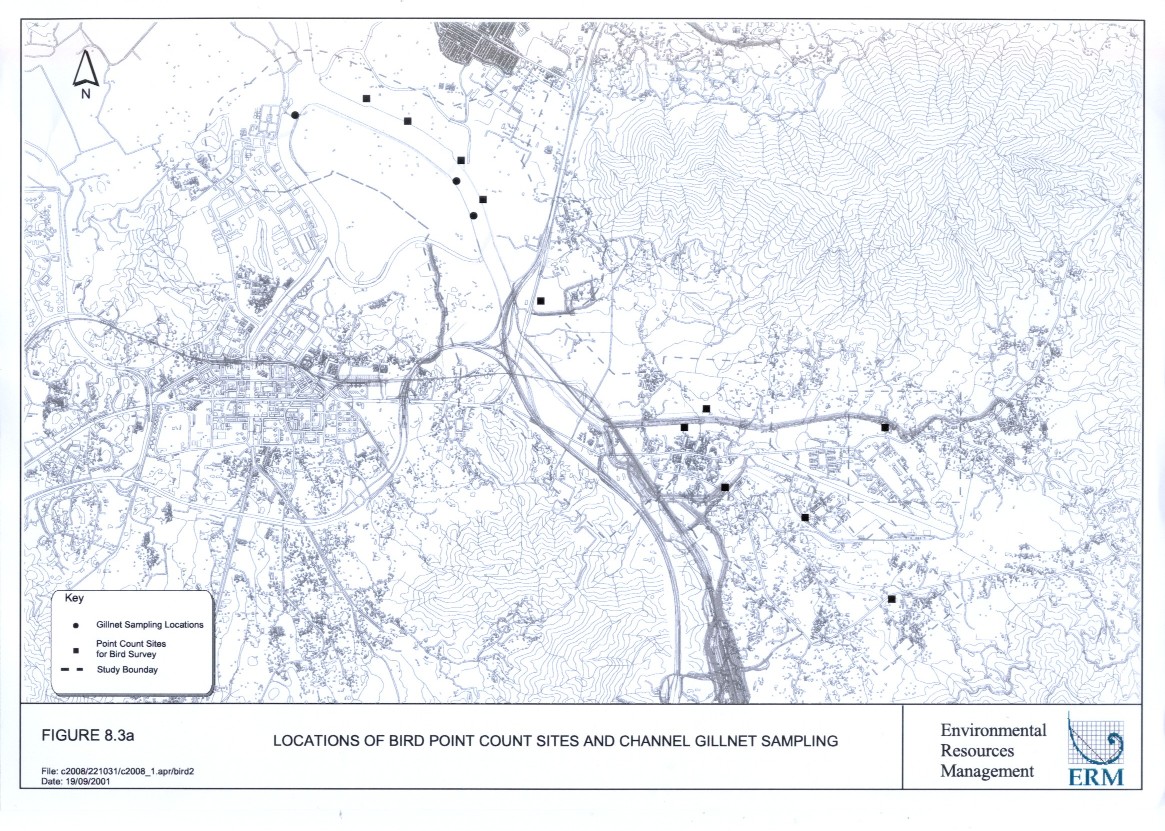
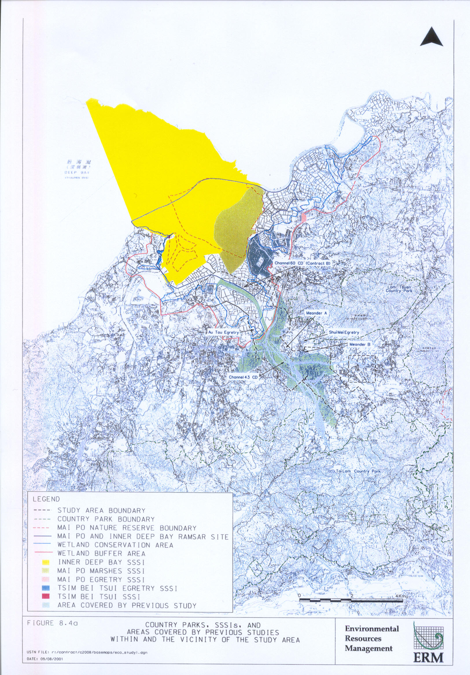
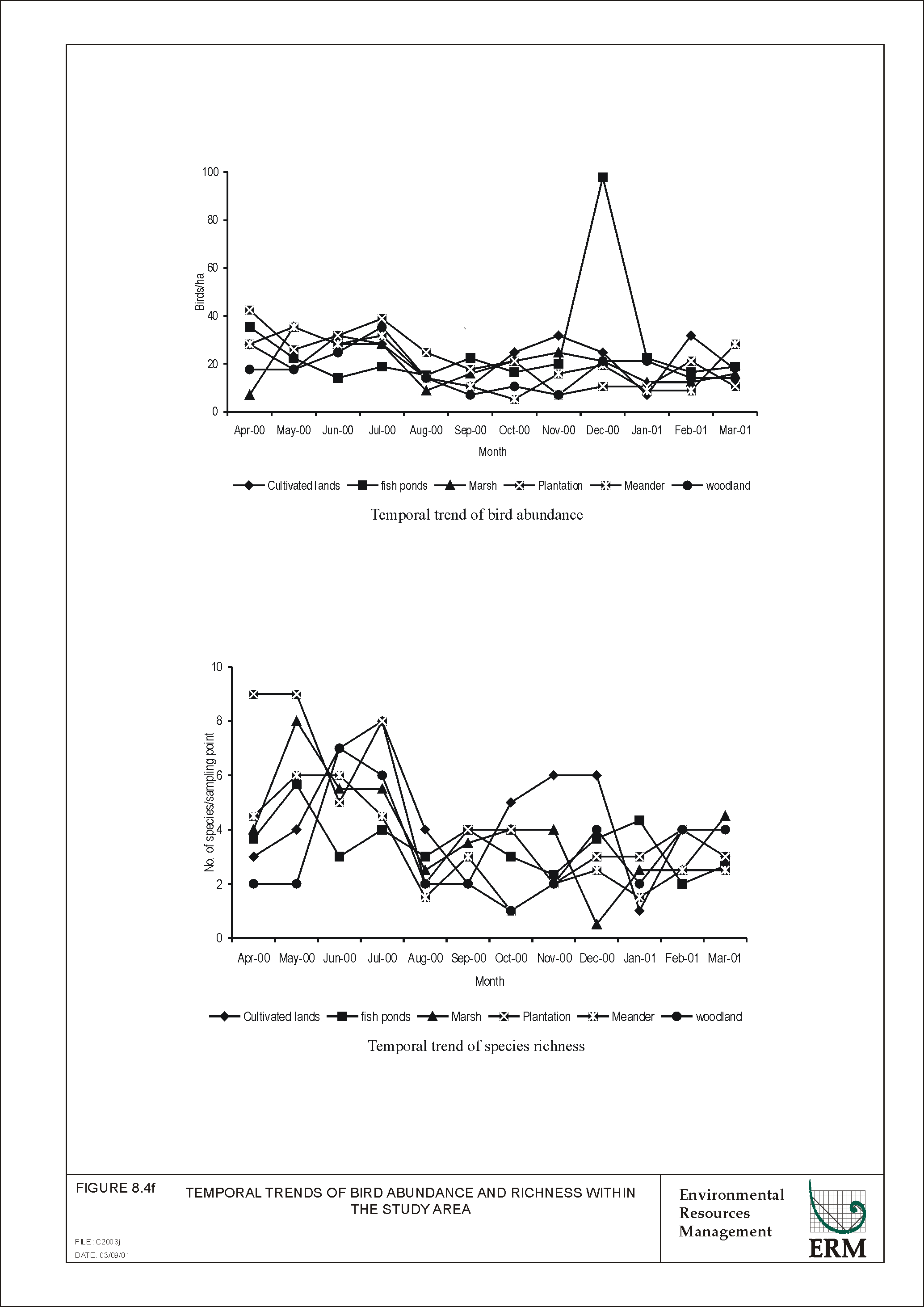
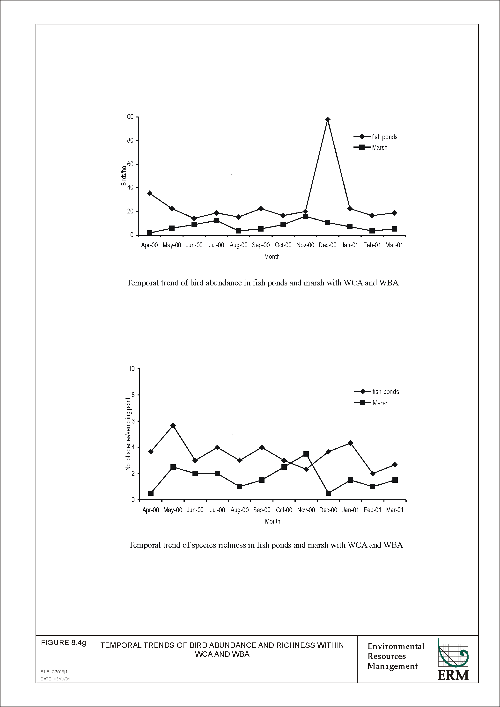
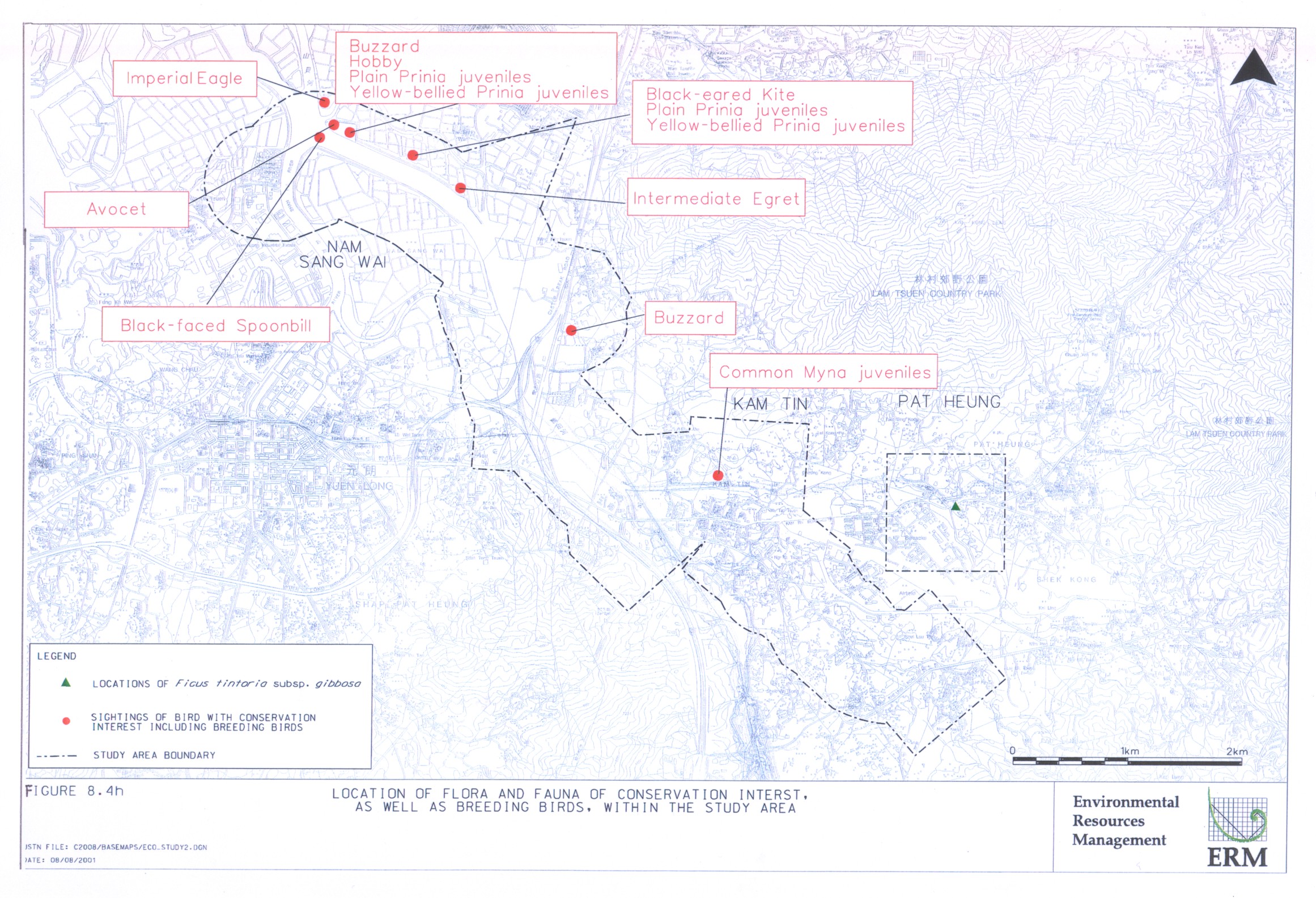
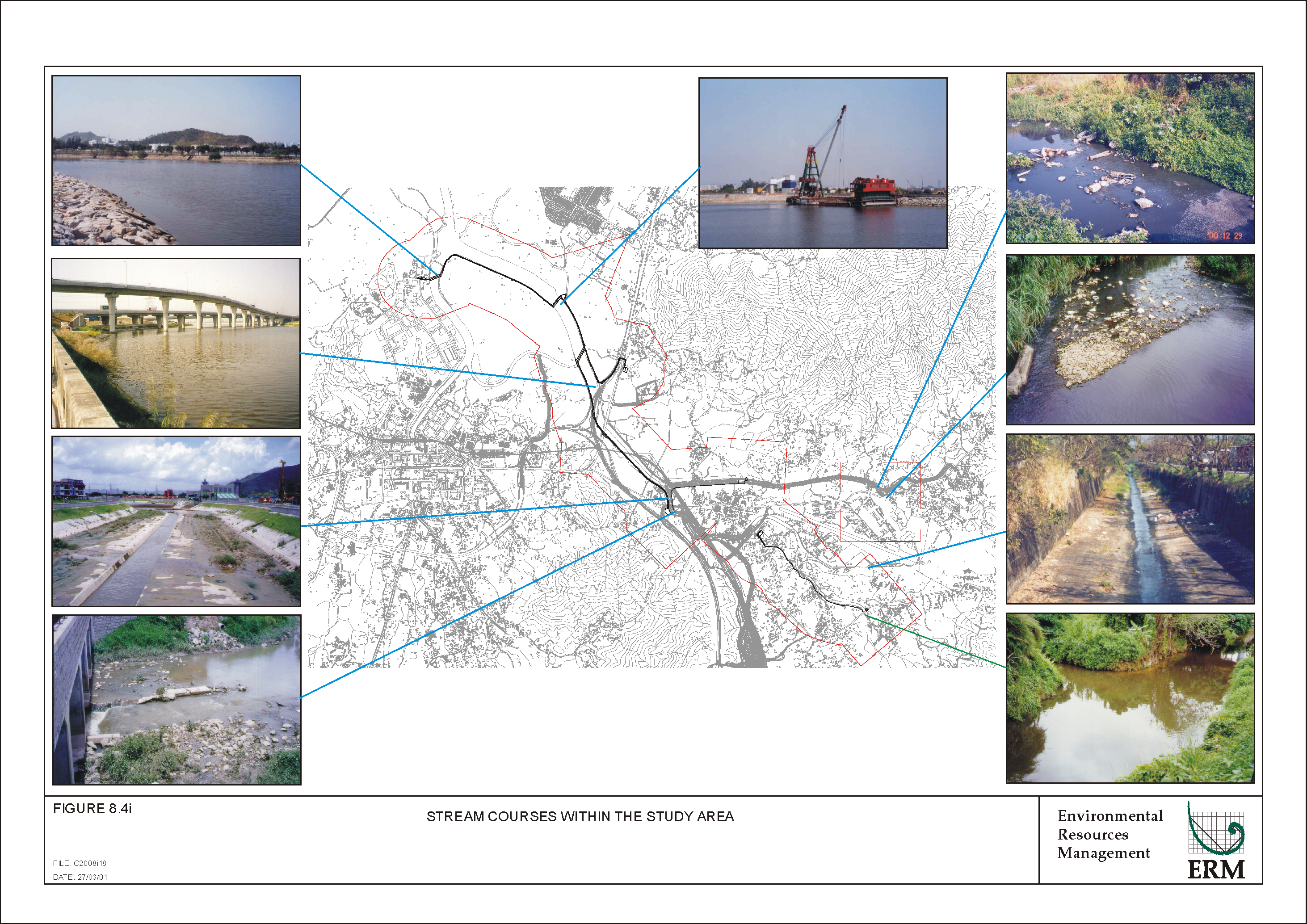
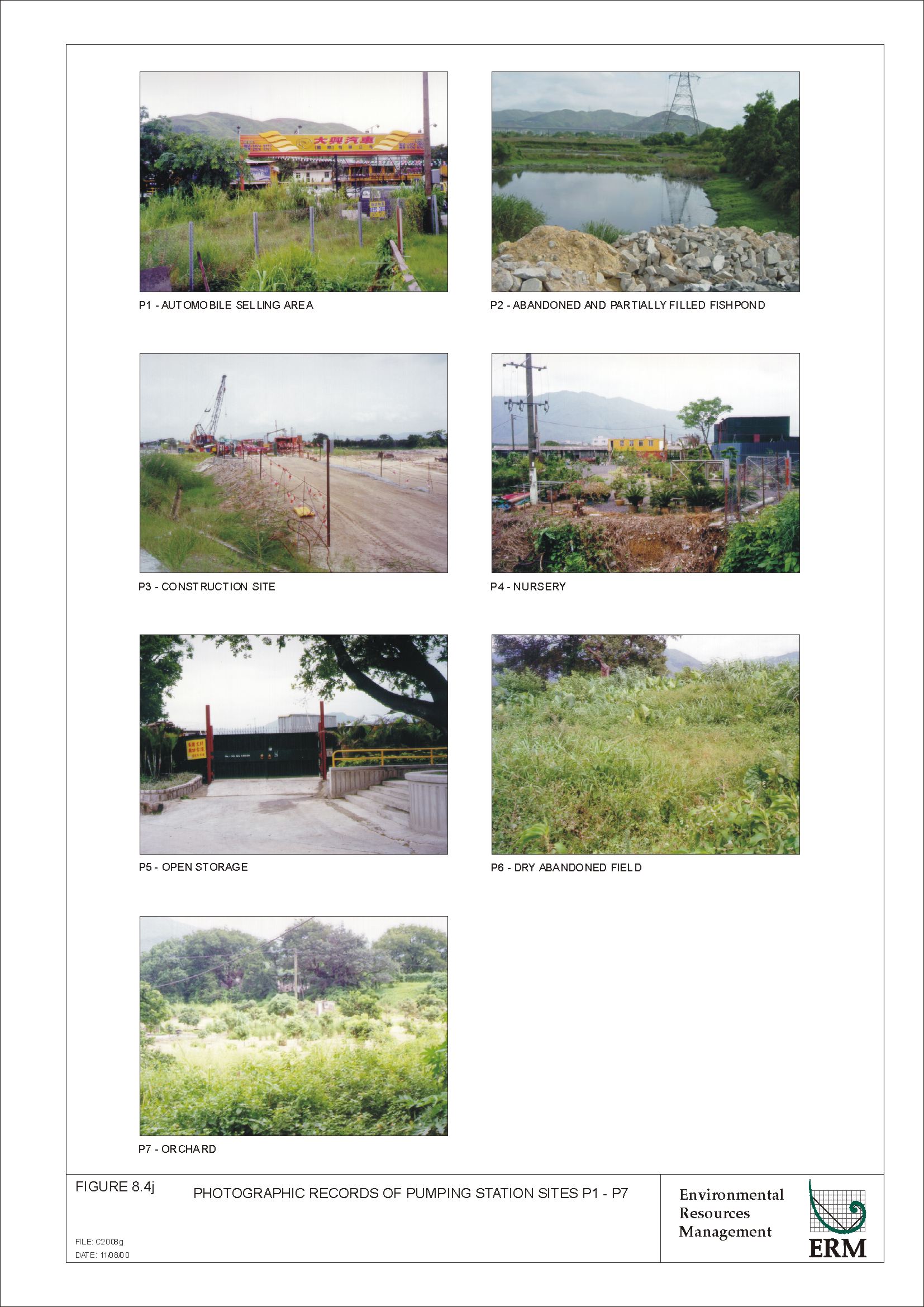
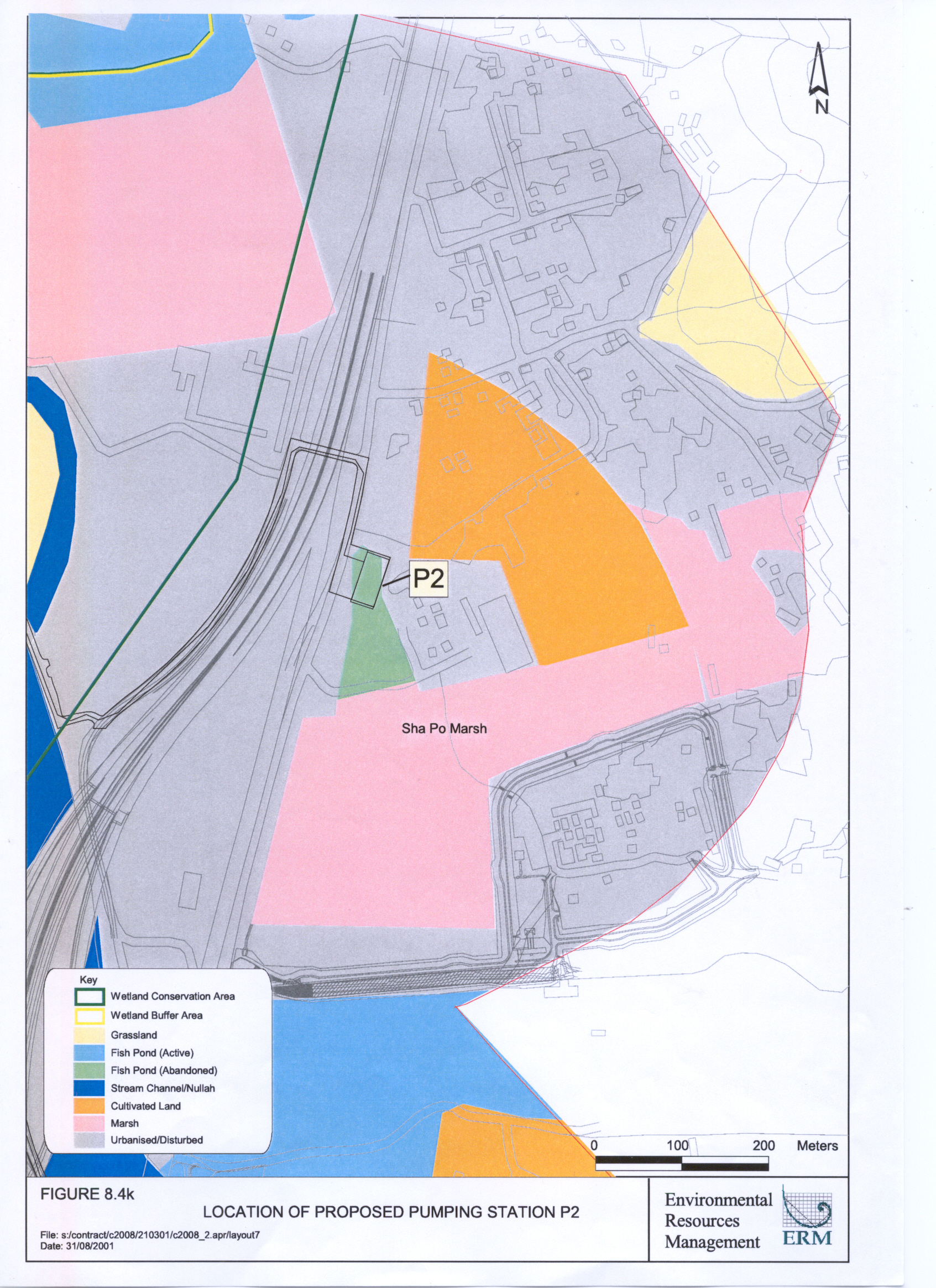
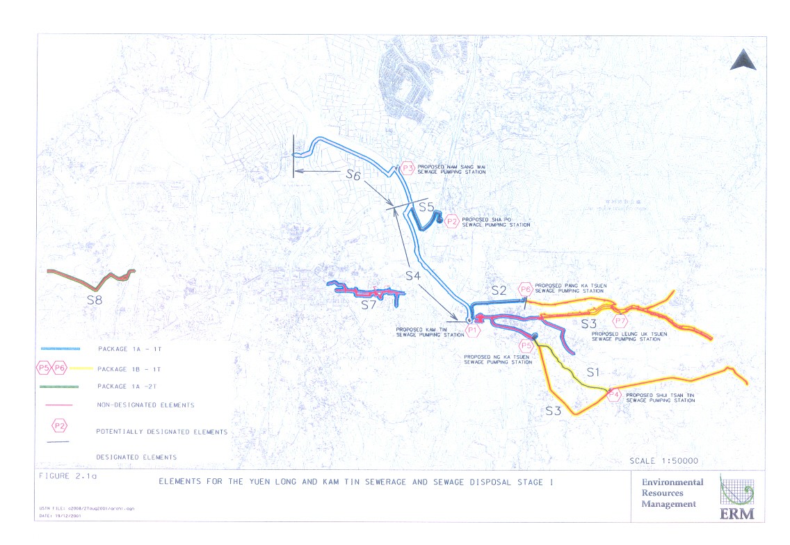
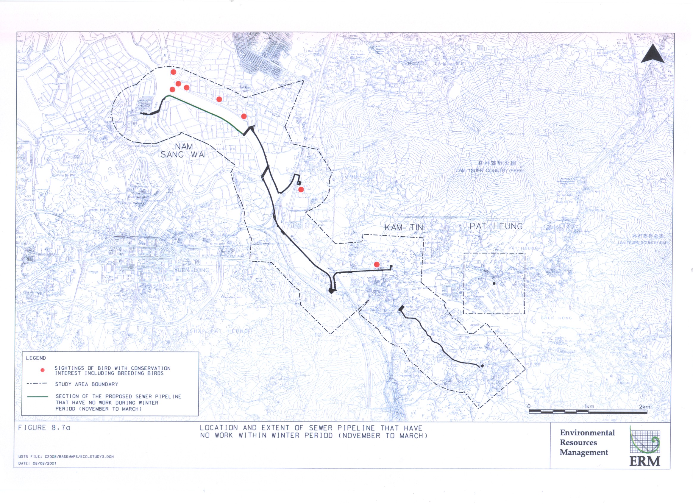