11.1 Introduction
This section deals with the key landscape and visual impact issues of the Designated and Potentially Designated Elements of the proposed Yuen Long and Kam Tin Sewerage and Sewer Disposal Stage 1 Sewers, Rising Mains and Ancillary Pumping Stations (hereafter described as the Project). The purpose of this section is to:
· identify the relevant legislation and guidelines to be used in the landscape and visual impact assessment (LVIA);
· define the LVIA methodology;
· conduct a LVIA;
· evaluate the significance of landscape and visual impacts.
11.2 Relevant
Legislation and Guidelines
The methodology of the LVIA will be based on Annexes 10 and 18 in the Hong Kong SAR Government's Technical Memorandum on the Environmental Impact Assessment Process (EIAO-TM) under the EIA Ordinance (Cap.499, S16), entitled "Criteria for Evaluating Visual and Landscape Impact" and "Guidelines for Landscape and Visual Impact Assessment", respectively and EIAO Guidance Note No. 8/2002 Preparation of Landscape and Visual Impact Assessment under the Environmental Impact Assessment Ordinance.
11.3 Assessment
Methodology
The main components of the LVIA were as follows:
· baseline study of landscape and visual resources including a review of planning and development control framework;
· landscape impact assessment during construction and operation;
· visual impact assessment during construction and operation;
· recommendations for landscape mitigation design measures.
· assessment of residual impact and conclusion on the acceptability of the Project.
The baseline study identified and examined the existing landscape and visual resources within the study area.
Landscape resources considered included topography, woodland types, other vegetation, built forms, settlement patterns, land use, scenic spots and details of local streetscapes. The baseline study describes the landscape resources by identifying broadly homogenous landscape units (LCUs) of a similar character. The landscape character was rated low, medium or high depending not only on the quality of elements present but also on its sensitivity to change and its importance at a local, district, regional or international level.
Visual resources considered were typical viewpoints, location and direction of views towards the Project. A viewshed (refer to Figures 11.3a-b) was established which approximately defined the extent of visual influence of the Project and, therefore, of the potential visual impacts. Definition of the extent of the viewshed was based on a desktop study and site investigation. Sensitive visual receivers who would be present at typical viewpoints and likely to be affected by the Project were identified within the viewshed. Sensitive visual receivers (SVRs) are individuals or groups of who are sensitive to changes in the visual environment. The Environmental Guidelines for Planning in Hong Kong defines sensitive users as “land uses which, by virtue of the nature of the activities thereon….are susceptible to the influence of residual or physical changes generated by polluting uses”.
The next stage was a review of the planning and development control framework. Landscape related zonings on the Outline Zoning Plan (OZP) were mapped and analysed to provide an insight to the future outlook of the area affected and the way the Project would fit into its wider context.
The following stage was to assess impacts on the landscape and
visual resources during construction and operation. The impact assessments
allow predictions to be made about the likely levels and significance of
landscape and visual impacts. The assessment of landscape impacts will result from:
·
Identification
of the sources of impact and their magnitude that would be generated during
construction and operation of the project;
·
Identification
of the principal landscape impacts primarily in consideration of the degree of
change to the baseline conditions. The impacts are considered systematically in
terms of landscape elements, the project and its context.
The overall landscape
impact is a product of the following:
·
The
landscape character and its quality;
·
The
sensitivity of the landscape in accommodating change;
·
Source,
nature and magnitude of impacts;
·
The
degree of change caused by the impacts to the existing landscape;
·
Significance
of the change in consideration of the local and regional areas and other
developments;
·
Cumulative
effects with other proposals;
·
Identification
of vegetation of significant value which should be conserved.
The sensitivity /
quality of the landscape will be assessed as follows:
·
High: eg
important components or landscape of particularly distinctive character
susceptible to small changes;
·
Medium:
e.g. a landscape of moderately valued characteristics reasonably tolerant to
change;
·
Low:
e.g. a relatively unimportant landscape which is able to accommodate extensive
change.
The magnitude of
change in the landscape is as follows:
·
Large –
notable change in the landscape characteristics over an extensive area ranging
to very intensive change over a more limited area;
·
Intermediate
– moderate changes to a local area;
·
Small
–changes to components;
·
Negligible
– no perceptible changes.
The system for the
assessment of landscape impact is summarised in Tables 11.3a and 11.3b. The significance threshold of landscape impact is derived
from the combined analysis of the magnitude of change and the landscape’s
quality and sensitivity to change.
The matrix in Table 11.3a
indicates how the significance threshold is derived. Table 11.3b
explains the terms used in Table 11.3a.
Table 11.3a Significance Threshold of Landscape Impact
|
|
Large |
Moderate Impact |
Moderate / Significant Impact |
Significant Impact |
|
|
Intermediate |
Slight / Moderate Impact |
Moderate Impact |
Moderate / Significant Impact |
|
Magnitude
of Change |
Small |
Slight Impact |
Slight / Moderate Impact |
Moderate Impact |
|
|
Negligible |
Negligible |
Negligible |
Negligible |
|
|
|
Low |
Medium |
High |
|
|
|
Sensitivity
/ Quality |
||
Table 11.3b Adverse / Beneficial Impacts of Landscape Impact
|
Level of Impact |
Description |
|
Significant: |
adverse / beneficial impact where the proposal would cause
significant degradation or improvement in existing landscape baseline
conditions. |
|
Moderate: |
adverse / beneficial impact where the proposal would cause
noticeable degradation or improvement in existing landscape baseline
conditions |
|
Slight: |
adverse / neutral /beneficial impact where the proposal would cause a
barely noticeable degradation or improvement in existing landscape conditions
or where the changes brought about by the project would not be apparent in
visual terms |
|
Negligible |
The proposal does not affect the existing landscape baseline
conditions |
This analysis of
the degree of landscape impact will apply in the majority of situations;
however, in certain cases a deviation may occur e.g. the impact may be so major
that a significant impact may occur to a low quality element.
The assessment of potential visual impacts will result from:
· The sensitivity of the viewer groups at SVR locations to change and visual intrusion;
· the magnitude of change to the visual baseline condition.
The sensitivity of viewer groups at SVR locations will be classified as follows:
· High -
i. The nature of the viewer groups expect a high degree of control over their immediate environment, (eg people residing in their homes); and
ii. The viewer groups are in proximity to the Project; and
iii. The foreground and middleground cannot visually absorb the Project.
· Moderate -
i. The nature of the viewer groups expect a high degree of control over their immediate environment, (eg people residing in their homes); but
ii. The viewer groups are not in proximity to the Project; and
iii. The foreground and middleground can partially absorb views of the Project.
· Low -
i. The nature of the viewer groups do not expect a high degree of control over their immediate environment, (eg people at their place of employment or temporarily in attendance at the SVR location); or
ii. People in transit (eg drivers and passengers in vehicles).
The magnitude of change is classified as follows:
· Large -
i. Prominent and permanent visual changes in the foreground, middleground or background where the project dominates the view;
ii. Permanent visual changes where the project contrasts conspicuously against the middleground and/or background;
iii. Temporary visual changes where the project dominates the foreground view.
· Intermediate -
i. Permanent visual changes in the foreground or middleground where the project is prominent but does not dominate the view;
ii. Permanent visual changes where the project is discernible against background, but is not conspicuous.
iii. Temporary visual changes where the project dominates the middleground view.
· Small -
i. Permanent visual changes in the foreground, middleground or background where the project is present but not noticeable;
ii. Temporary visual changes where the project dominates the background view.
· Negligible -
i. No visual changes are apparent.
The significance threshold of visual impact is rated for the construction phase, and for Day 1 and Year 10 of the operation phase and is illustrated in Tables 11.3c and 11.3d.
Table 11.3c Significance Threshold of Visual Impact
|
Magnitude of Change |
Large |
Moderate Impact |
Moderate / Significant Impact |
Significant Impact |
|
|
|
Intermediate |
Slight / Moderate Impact |
Moderate Impact |
Moderate / Significant Impact |
|
|
|
Small |
Slight Impact |
Slight / Moderate Impact |
Moderate Impact |
|
|
|
Negligible |
Negligible |
Negligible |
Negligible |
|
|
|
|
Low |
Medium |
High |
|
|
|
|
Sensitivity
to Change and Visual Intrusion |
|||
Table 11.3d Adverse/Beneficial Impacts of Visual Impact
|
Level of Impact |
Description |
|
Significant: |
adverse
/ beneficial impact where the proposal would cause significant degradation
or improvement in existing landscape baseline conditions. |
|
Moderate: |
adverse
/ beneficial impact where the proposal would cause noticeable degradation or
improvement in existing landscape baseline conditions |
|
Slight: |
adverse /beneficial
impact where the proposal would cause a barely noticeable degradation or
improvement in existing landscape conditions or where the changes brought
about by the project would not be apparent in visual terms |
|
Negligible: |
The
proposal does not affect the existing landscape baseline conditions |
The next stage of the study is to recommend mitigation measures. The identification of the landscape and visual impacts will highlight those sources of conflict requiring design solutions or modifications to reduce impacts, and if possible absorb the development and associated activities into the surrounding landscape. These mitigation efforts should consider factors including :
· Woodland, tree and shrub planting to new or disturbed slopes, amenity strips, highway reservations and adjacent to any proposed structures;
· Contouring of new slopes to blend with existing topography in a natural manner;
· Earth mounding and screening;
· Highlighting unacceptable impacts and considering alternative proposals;
· Hard landscape elements including design and appearance of proposed structures;
· Significant landscape elements.
The above will result in the formulation of landscape and visual mitigation proposals (LMM’s: refer to Section 11.6) which will, as far as possible, help to alleviate the previously identified landscape and visual impacts.
The final stage of the LVIA study is to assess the significance of the residual impacts of the study assuming landscape mitigation measures are incorporated into the design. The landscape and visual impacts were then classified into five levels of significance based on criteria in Annex 10 of the EIAO-TM, as summarised below:
· The impact is beneficial if the project will complement the landscape and visual character of its setting, will follow the relevant planning objectives and will improve the overall and visual quality of the study area;
· The impact is acceptable if the assessment indicates that there will be no significant effects on the landscape, no significant visual effects caused by the appearance of the project, or no interference with key views;
· The impact is acceptable with mitigation measures if there will be some adverse effects, but these can be eliminated, reduced or offset to a large extent by specific measures;
· The impact is unacceptable if the adverse effects are considered too excessive and are unable to mitigate practically;
· The impact is undetermined if significant adverse effects are likely, but the extent to which they may occur or may be mitigated cannot be determined from the study. Further detailed study will be required for the specific effects in question.
11.4 Baseline Conditions
11.4.1 Project Description
The proposed works are described in detail in Section 2. The main elements of the proposed works affecting the landscape and SVRs will be pumping stations (SPS) (refer Figure 11.4a) and the construction of sewers and rising mains.
The project elements likely to affect the landscape and visual baseline conditions during the construction phase will be the activity associated with the construction of the SPSs and underground sewers and rising mains. The construction of the SPSs includes borepiling, sheetpiling, excavation, concrete casting, backfilling, compaction etc. The sewers and rising mains will be constructed underground through both the open trench (typically in 50m sections) and pipe jacking methods (when crossing the Main Drainage Channel). The construction plant inventory is presented in Annex A2. The diameters of the proposed sewers and rising mains range from about 225 mm to 1,650 mm. The construction works will be carried out in three packages, as presented in Table 2.1c.
The project elements likely to affect the landscape and visual baseline conditions during the operation phase will be the SPSs only. There are 3 types of preliminary layouts for the SPSs: Type A for Pang Ka Tsuen PS, Shui Tsan Tin Ps and Leung Uk Tsuen PS (see Figure 11.6a for the layout plan) which will be a single storey building (approximately 4 - 5 m above existing ground level); Type B for Ng Ka Tsuen PS, Sha Po PS and Kam Tin PS (see Figure 11.6d for the layout plan) which will be a single storey building (approximately 7-8 m above existing ground level) and Type C for Nam San Wai PS (see Figure 11.6c for the layout plan) which will be a single storey building (approximately 7-8 m above existing ground level). The buildings will be of simple concrete construction and finished in either ceramic tiles or textured concrete. Neutral grey colours will be used in the chromatic design of the SPSs. There will be an access road and carparking spaces on the site. The SPS sites will be fenced for security. Screen planting will implemented within the SPS site to reduce its visibility.
During construction, existing vegetation and trees will be either protected or transplanted if protection is not possible. Where construction activity occurs near existing trees, no excavation will be undertaken underneath the canopy dripline. Where tree roots are encountered outside the canopy dripline, horticultural remedial works will be undertaken to repair any damage. Tree felling will be necessary in some locations, however this aspect is examined in Section 11.5.
Owing to the nature of the project, most adverse impacts would be expected during the construction phase resulting from construction works and tree felling. During the operation phase, potential adverse visual impacts would only be expected resulting from the presence of pumping station. No night-time lighting is proposed and therefore glare will not occur.
11.4.2 Categorization of Landscape Character Units
In accordance with the study methodology, the Study Area (refer to Figure 11.4b) was categorised into broadly homogenous LCUs (refer to Figures 11.3a-c).
The Study Area is low-lying flat land forming of a series of broad alluvial valley floors draining into Deep Bay. The main land uses are villages, industry and some agricultural activities. The general level of density of development is highest next to the main roads and major intersections in the east of the Study Area, giving way to agricultural land and fish ponds in the west. The study area is loosely bounded by Fairview Park and the woodland and foothills of the Lam Tsuen Country park to the north, and by Shap Pat Heung and Yuen Long and Ha Tsuen to the south.
A number of distinct landscape character units (LCUs) were identified within the Study Area (refer to Figures 11.3a, 11.3b and 11.4c). They are:
· Fish ponds and agricultural land LCU;
· Industrial development and main roads LCU;
· Woodland and foothills LCU;
· Village development LCU;
· Agricultural land LCU.
The Fish Ponds and Agricultural Land LCU is to the west of the Study Area (see Figures 11.3a-b) and is characterized by flat land formed into fish ponds and separated by a major drainage channel feeding into the Shan Pui River. It is devoid of trees and planting other than grass and low shrubs and contains few structures. It is extremely homogenous in appearance and is not considered sensitive to the type of changes that would result from the construction and operation of the project. This LCU has already been heavily modified by man-made activity and therefore would have a low sensitivity to the type of changes that would result from the construction and operation of the Project.
There are pockets of industrial/container storage development to the west and east of the fish ponds and associated agricultural land LCU, as well as in the vicinity of the Shek Kong Airfield which are intersected or connected to main roads (see Figures 11.3a-b and 11.4c). Visually-cluttered large, unattractive industrial buildings surrounded by streets and bisected by main roads devoid of roadside planting characterise this LCU. Owing to the presence of these existing elements, this LCU would have a low sensitivity to the type of changes that would result from the construction and operation of the Project.
The Woodland and Foothills LCUs are present to the east of Sha Po (see Figure 11.3a), east of Leung Uk Tsuen (see Figure 11.3b) and south of Shui Tsan Tin (see Figure 11.3b). These LCUs are characterized by extensive areas of woodland and/or foothills covered with mature trees (see Figure 11.4c). For this reason, this LCU would have a high sensitivity to the type of changes that would result from the construction and operation of the Project.
The Village Development LCUs are fragmented throughout the study area and are characterized by a dense network of narrow streets, two-and three-storey village houses interspersed by small pockets of open space, woodland and abandoned agricultural land. Within this LCU exists a group of historic houses at Ng Ka Tsuen (cf Section 10.4.5) which contribute to the character of this village. Random woodland and street trees are found within this LCU which provide a valuable landscape resource to the urban fabric along roads and footpaths (see Figures 11.3a and 11.3b). Owing to the type of changes that would result from the construction and operation of the project, this LCU is considered to have a high sensitivity attributed mainly to its function as a place where people live.
Large tracts of abandoned land that once supported agricultural activities are present in the Study Area. These tracts tend to amalgamate into a distinctive landscape designated as the Agricultural Land LCU. This LCU is characterised by overgrown fields and extremely homogenous vegetation types lacking in ecological diversity and visual interest. Owing to the type of changes that would result from the construction and operation of the Project, this LCU is considered to have a low sensitivity to change.
Table 11.4a Summary of LCUs
|
LCU Name |
Sensitivity to Change |
|
Fish
ponds and agricultural land (274
Ha) (Fishponds:
264 Ha, agricultural land: 10 Ha) |
Low |
|
Industrial
development and major roads (290 Ha) (Industrial:
275 Ha, roads: 15 Ha) |
Low |
|
Woodland
and foothills (73 Ha) (Secondary
woodland: 13 Ha, foothills 60 Ha) |
High |
|
Village
development (240 Ha) |
High |
|
Agricultural
land (208.6 Ha) |
Low |
A tree survey and assessment was conducted along
the alignment of the proposed rising sewers and mains and at the proposed sites
of the SPSs. In total, 610 trees within the site boundary were identified.
The majority of the trees consist of one of tree species: Celtis sinensis, Casuarina equisetifolia, Melaleuca
leucadendron. Celtis spp is native to Hong Kong while Casuarina and Melaleuca spp are fast-growing non-natives. There are also Eucalyptus tereticornis, Acacia confusa, Bombax malabaricum, Macaranga
tanarius, Roystonea regia and Archontophoenix
alexandrae present in substantial numbers.
11.4.3 Sensitive Visual Receivers
In accordance with the study methodology, the Sensitive Visual Receivers (SVRs) within the Study Area were identified, and grouped into types (refer to Table 11.4b and Figures 11.3a-b and 11.4c).
In summary, the SVRs can be classified into two main groupings. SVRs with a high sensitivity to the type of changes that would result from the construction and operation of the project are adjacent residents living in their homes who would have permanent, unobstructed views from a short distance away. SVRs with a low sensitivity to the type of changes that would result from the construction and operation of the project are drivers and passengers in transit through the Study Area and workers who are employed in industrial and agricultural businesses in the Study Area. People engaged in employment or business are considered to be less sensitive to visual impact than people residing in their homes as the latter viewing group expect a higher degree of control over their environment.
It was determined during the visual analysis of the Study Area that it was extremely unlikely that viewer groups from SVR locations further than approximately 200m away would be affected by the Project elements for the following reasons (refer Figure 11.4a):
· the rising mains and sewers would not be seen during operation as they would be underground;
· the alignment of the rising mains and sewers and the siting of SPSs would be in flat level areas and therefore the blocking of views of construction activity and SPSs by intermediate elements such as structures, fences, existing vegetation and building is significant.
The approved
comprehensive residential development to the west of Nam Sang Wai across Kam
Tin river may be a future SVR of the proposed works S6 and Nam Sang Wai Pumping
Station. This approved CRD area is over 200 metres from the Nam Sang Wai SPS
site and is separated by a nullah (industrial drainage channel). Existing views
from the CRD area to the PS site are unobstructed, though more detailed
information regarding the CRD building heights, footprint positions or
orientation is unknown at this stage therefore a more detailed visual impact
assessment is not possible. However, given the considerable distance to the SPS
site, combined with the foreground views of the nullah and the proposed
mitigation measures for the SPS (e.g. screen planting, advanced transplantation
works, and security fencing that is visually permeable) it is expected that the
visual impact will range from negligible to slight.
Table 11.4b summarises the key information about each SVR in accordance with requirements of the methodology.
Table 11.4b Sensitive Visual Receivers
|
SVR |
Name |
Nature of Viewer Group |
Distance to
Proposed Works |
Frequency and duration
of view towards proposed development and source of impact |
Sensitivity to
change and visual intrusion |
|
SVR-1A |
Sha Po Tsuen Residential development |
Residents |
50-100m |
Obstructed and frequent views
towards proposed Sha Po SPS in the foreground |
High |
|
SVR-1B |
Kam Tin Shi Residential Development |
Residents |
50-100m |
Unobstructed views towards the Kam Tin SPS site by 2nd and 3rd storey of houses.
The proposed SPS would be seen in the foreground. |
High |
|
SVR-1C |
Ng Ka Tsuen Historic Compound |
Residents |
5-30m |
Unobstructed views from from the roof and south of building in the
general direction of the SPS site and sewer route. |
High |
|
SVR-1D |
Residential Development Opposite Road from proposed Shui Tsan Tin SPS |
Residents |
50-100m |
Obstructed views to the site by some residents in their homes to the
SPS site and sewer route. |
High |
|
SVR-1E |
Residential Development opposite to proposed Pang Ka Tsuen SPS |
Residents |
50-100m |
Obstructed and continuous views from the upper stories to across
drainage channel to PKT SPS and sewer route. |
High |
|
SVR-1F |
Hip Tin Kung |
Residents & Visitors |
60m |
Completely obstructed views to PKT SPS and sewer route |
High |
|
SVR-2A |
Residential Development
adjacent to proposed Leung Uk Tsuen SPS |
Residents |
20-50m |
Obstructed views to Leung Uk Tsuen SPS site. |
High |
|
SVR-3A |
Residential Development at Kam Tin |
Residents |
30-50m |
Obstructed views to SPS site. |
High |
|
SVR-3C |
Residential developments along Kam Sheung |
Residents |
10-30m |
Unobstructed views towards Sewer S1 location |
High |
|
SVR-3D |
Residential developments west from proposed Pang Ka Tsuen SPS |
Residents |
50-100m |
Unobstructed views to
Pang Ka Tsuen SPS |
High |
|
SVR-4A |
Kam Tin Rd |
Road users |
5-30m |
Temporary views by pedestrians and vehicular passengers to KT and LUTSPS’s
which would be seen in the foreground. |
Low |
|
SVR-4B |
Kam Sheung Rd |
Kam Sheung road users |
5-30m |
Temporary views by pedestrians and vehicles to S1 sewer construction
along roads and NKT and STT
SPS’s which would be seen in the foreground. |
Low |
|
SVR-5A |
Hill Lookout above Pang Ka Tsuen SPS |
Recreational users |
50-100m |
Unobstructed and continuous views over the SPS site. |
Medium |
|
SVR-6A |
Yuen Long Sewerage Treatment Works overlooking proposed Sewer S6 |
Employees |
20-50m |
Unobstructed and continuous views |
Low |
|
SVR-6B |
Industrial development at Sha Po Tsuen which proposed Sewer S5 runs
through |
Employees |
10-50m |
Obstructed and infrequent views |
Low |
|
SVR-6C |
Industrial development opposite proposed Sha Po SPS |
Employees |
30-50m |
Unobstructed and infrequent views to of SPS in foreground. |
Low |
|
SVR-6D |
Industrial development at Kam Tin opposite proposed Kam Tin SPS |
Employees |
30-50m |
Obstructed and infrequent views to of SPS in foreground. |
Low |
|
SVR-6E |
Leung Uk Tsuen Industrial Development |
Employees |
50-100m |
Obstructed and infrequent views down to SPS site. The proposed development would be
seen in the foreground. |
Low |
|
SVR-7A |
Fish Ponds north of Yuen Long Sewerage Treatment Works opposite to
proposed Sewer S6 |
Agricultural Workers |
50-200m |
Unobstructed and continuous views |
Low |
|
SVR-7B |
Fish Ponds east across drainage channel from Yuen Long Sewerage Treatment
Works adjacent to proposed Sewer S6 |
Agricultural Workers |
10-50m |
Unobstructed and continuous views |
Low |
|
SVR-7C |
Fish Ponds north of proposed Nam Sang Wai SPS and across drainage
channel from proposed Sewer S6 |
Agricultural Workers |
50-200m |
Unobstructed and continuous views to SPS and S6 across drainage
channel within a flat fishpond landscape. |
Low |
|
SVR-7D |
Fish Ponds across drainage channel from proposed Nam Sang Wai SPS and adjacent to proposed Sewer S6
crossing drainage channel twice |
Agricultural Workers |
50-300m |
Unobstructed and continuous views to SPS and S6 across drainage
channel within a flat fishpond landscape. |
Low |
|
SVR-7E |
Fish Ponds across drainage channel from Kam Tin Tsuen opposite
drainage channel from proposed Sewer S4 |
Agricultural Workers |
50-200m |
Unobstructed and continuous views |
Low |
|
SVR-7F |
Fish Ponds west from proposed Pang Ka Tsuen SPS with views across drainage channel to
proposed Sewer S2 |
Agricultural Workers |
100-200m |
Unobstructed and continuous views |
Low |
|
SVR-7G |
Fish Ponds opposite drainage channel from proposed Pang Ka Tsuen
SPS with views across drainage
channel to proposed SPS and proposed Sewer S2 |
Agricultural Workers |
100-200m |
Unobstructed and continuous views |
Low |
|
SVR-7H |
Fish Ponds opposite road from proposed Leung Uk Tsuen SPS |
Agricultural Workers |
20-100m |
Obstructed and infrequent views to SPS |
Low |
|
SVR-7I |
Fish Ponds adjacent to proposed Shui Tsan Tin SPS |
Agricultural Workers |
20-100m |
Obstructed and infrequent views to SPS |
Low |
|
SVR-7J |
Fish Ponds adjacent to proposed Shui Tsan Tin SPS and proposed Sewers S1 along road |
Agricultural Workers |
10-100m |
Obstructed and frequent views to SPS and S1 along road |
Low |
11.4.4 Review of Planning and Development Control Framework
The starting point for the review of the planning and development control framework was an evaluation of the statutory Outline Zoning Plans for Tai Tong (S/YL-TT/8), Kam Tin North (S/YL-KTN/4), Kam Tin South (S/YL-KTS/6), Pak Heung (S/YL-PH/6), Shek Kong (S/YL-SK/4) and Nam Sang Wai (S/YL-NSW/4). These plans are the statutory basis for the control of the use of land, and provide an insight into the future pattern of development. The recommended outline development plans for Kam Tin and Au Tau New Development Area (NDA) were also evaluated, although these are not statutory documents. Part of S1, S2 and S4 Sewers and Kam Tin SPS, Sha Po SPS, Pang Ka Tsuen SPS and Ng Ka Tsuen SPS are located within this NDA. In summary, the land use zones relevant to the LVIA are Green Belts, Conservation Areas and Open Spaces (refer to Figures 11.4d and 11.4e).
The western section of the proposed works S6 run from the existing Yuen Long Sewage Treatment Works to Sha Po Pumping Station in Nam Sang Wai (refer to Figure 11.4d) This area is next to various Conservation Area zones. The primary planning intention of Conservation Area zoning is to retain the existing natural characteristics of the area. Nam Sang Wai Pumping Station falls within an area zoned “G/IC” which is surrounded by a Conservation Area (“CA”) on Nam Sang Wai OZP No. S/YL-NSW/4. Neither the S6 sewer route or Nam Sang Wai and Sha Po Pumping Stations will encroach into Conservation Areas.
The proposed works S5 run through an Open Space zoning adjacent to Sha Po Pumping Station (refer to Figure 11.4d). As an underground installation this section of the sewerage mains is not seen as being in conflict with the primary planning intention of Open Space zoning which is to provide land for active and recreational land use.
The eastern section of the proposed works run through an Open Space zoning adjacent to the Sha Po and Kam Tin Pumping Stations (refer to Figure 11.4d). As an underground installation these sections of the sewerage mains are not seen as being in conflict with the primary planning intention of Open Space zoning which is to provide land for active and recreational land use.
Pang Ka Tsuen and Kam Tin Pumping Stations are located in proximity to Green Belt zones (refer to Figure 11.4e). The primary planning intention of the Green Belt zoning is to provide for the conservation of prominent and high value landscape features and limiting the expansion of urban areas into rural areas. Encroachment towards this interface of these Green Belt areas is not seen as a weakening of its planning function, provided suitable screen tree planting is incorporated.
Pang Ka Tsuen
SPS is located next to land designated in the recommended outline development
plans for Kam Tin and Au Tau NDA as a Wildlife Park (refer to Figure 11.4e). However the
two activities are seen as compatible if a buffer zone of screen planting is
incorporated between the two land uses within the SPS site (refer to Landscape
and Visual Mitigation Measures-LMM5).
In general,
the proposed works would be compatible with the landscape zonings within the
Study Area, assuming that some level of localized mitigation measures are
incorporated in the scheme.
11.5 Impact
Studies and Recommended Mitigation Measures
11.5.1 Landscape Impact Study
The landscape impacts of the Project would arise from the construction phase only. There are no aspects of the aboveground SPS and underground rising mains and sewer functions which will give rise to landscape impacts during the operation phase.
The following paragraphs summarise the magnitude of change to landscape elements attributable to the Project assuming no landscape mitigation measures are incorporated (refer to Figure 11.5a):
·
Fish
Ponds and Agricultural Land LCU. Sewers S2, S4, S5 and S6 would be aligned under and along existing
drainage channel embankments (refer to Figure 11.5a), e.g. embankments around Nam
Sang Wai and Pang Ka Tsuen, and will involve excavation, storage of materials
and plant movement. No vegetation and trees along drainage channel embankments
would be affected and the extent of the construction activity is not extensive,
but there would be a barely noticeable
degradation in the existing conditions because of the excavation and trenching
works. The magnitude of
change during construction is therefore considered to be adverse small.
·
Industrial
Development and Main Roads LCU. Sections of Sewers S5, S6 and Sha Po SPS will be sited through this
LCU (refer to Figures 11.5a and b). The alignments of underground sewers
are confined to roads and will involve excavation, storage of materials and
plant movement. The site of the
Sha Po SPS (see Figures 11.3a and 11.4c)
will be on land in a derelict state.
The magnitude of change is expected to be negligible as there are no landscape characteristics or
elements in the LCU affected by the Project elements during the construction
phase.
·
Woodland
and Foothills LCU. No project elements are proposed within this LCU and therefore there
will be nil change during both the construction and operation phases.
·
Village
Development LCU. Sections of Sewer S1 and Ng Ka Tsuen and Shui Tsan Tin SPSs will be
sited in this LCU. The alignments of the underground sewer is confined to roads
and will involve excavation, storage of materials and plant movement. The proposed site for the Ng Ka Tseun
SPS (refer to Figure 11.5b and Figure
11.4c) may affect a small number of individual trees owing to
construction activities and is in proximity to a group of historic houses nearby.
These buildings have a high architectural and cultural importance. The proposed SPS is located
approximately 25m distance and but faces a different orientation (refer to Figure
11.6e for explanatory photograph and Figure
11.6e2 for photomontage). The construction activity is likely
to affect village streetscapes particularly existing trees, however it is not
considered particularly extensive.
Therefore the magnitude of change is considered to be small.
·
Agricultural
Land LCU. Sections of S1 and S2 will be sited through this LCU (see Figure
11.5b). The construction
activity is likely to affect the existing vegetation within the LCU, however it
is not considered particularly extensive. Therefore the magnitude of change is
considered to be small.
Table 11.5a
summarises the significance thresholds of the landscape impacts during
construction and operation on LCUs, as stipulated by Table 11.3a.
In total, 30 trees may be affected by the Project. The trees affected are as follows (see Figures 11.5a and 11.5b for tree locations, and 11.5ci and 11.5cii for tree photos):
·
Tree 063/07;
·
Tree 031/14;
·
Tree PS01-22/22; and
·
Tree PS01- 6/23.
The details of each tree are as follows.
Table 11.5b Summary of Tree Loss
|
Tree No. |
Tree Species |
Habitat Type |
Amenity Value |
Rate of Survival if it was
Transplanted |
|
063/07 |
Eucalyptus tereticornis |
Urbanised / Disturbed (road side plantation) |
Medium |
Low |
|
031/14 |
Euphoria longan |
Fish Pond (abandoned) |
Medium |
Medium |
|
PS01-22/22 |
Euphoria longan |
Cultivated Land |
Medium |
Low |
|
PS01/23 |
Melia azedarach |
Cultivated Land |
High |
Medium |
|
PS02-06/23 |
Ficus microcarpa |
Cultivated Land |
Medium |
High |
As the rate of survival of each tree are considered to be low, it is likely that these 30 trees will need to be felled. Owing to the common species of the trees, the medium to low amenity value and the small number of trees affected, the landscape impact within the Study Area owing to tree loss would be slight adverse.
Table 11.5a Summary
of Landscape Impacts on LCUs (without Landscape Mitigation Measures)
|
LCU Name |
Quality/
Sensitivity to Change |
Magnitude of Change
during Construction Phase and Source of Landscape Impact |
Significance
threshold of landscape impact during Construction (refer to Table 11.3a) |
Magnitude of
Change during Operation Phase |
Significance threshold
of landscape impact during Operation (refer to Table 11.3a) |
|
Fish ponds and agricultural land LCU |
Low |
Small Sewers S2, S4, S5 and S6, Construction plant activity, Trenching and
excavation, Construction of Nam Sang Wai and Kam Tin SPSs, Re-instatement of existing vegetated
surfaces. |
Slight Adverse |
Negligible |
Negligible |
|
Industrial development
and main roads LCU |
Low |
Negligible Sewers S5 and S6, Construction plant activity, Trenching and excavation,
Construction of Sha Po SPS |
Negligible |
Negligible |
Negligible |
|
Woodland and foothills LCU |
High |
Negligible |
Negligible |
Negligible |
Negligible |
|
Village development LCU |
High |
Small Sewer S1, Construction plant activity, Trenching and excavation,
Construction of Ng Ka Tsuen and Shui Tsan Tin SPSs, Re-instatement of
existing vegetated surfaces. |
Moderate Adverse |
Negligible |
Negligible |
|
Agricultural land LCU |
Low |
Small Sewers S1 and S2 Construction plant activity, Trenching and
excavation, Construction of SPSs, Re-instatement of existing vegetated
surfaces. |
Slight Adverse |
Negligible |
Negligible |
11.5.2 Visual Impact Study
The visual impact study was conducted in accordance with the methodology outlined in Section 11.3.3. In summary, the visual impacts of the pumping stations and sewers will affect viewer groups at SVR locations mainly during construction.
The pumping stations are above ground and therefore visual impact is expected on viewer groups at SVR locations during operation. The following paragraphs describe the sources of visual impact and the magnitude of change expected. Table 11.5b summarises this information and predicts the significance threshold of visual impact by reference to the matrix in Table 11.3b.
Underground Sewers
S2 and S5 (refer to Figure 11.6a) will be laid under existing roads and will involve excavation, storage of materials and plant movement along busy main roads, eg the Kam Tin and Kam Sheung Roads. The visual clutter normally associated with construction of utilities will be evident to vehicular passengers and nearby residents along the road corridors. However, the short-term duration of the views and the relatively small-scale nature of the construction activity are expected to generate only a small magnitude of change to viewer groups at SVR locations.
Construction of the S4 and S6 sewers under and along existing drainage channel embankments (e.g. embankments near to Nam Sang Wai and Pang Ka Tsuen, refer to Figure 11.6a) will involve excavation, storage of materials and plant movement. However, the short-term duration of the views and the relatively small-scale nature of the construction activity are expected to generate only a small magnitude of change to viewer groups at SVR locations.
Sewer S5 will be aligned through an existing industrial development (refer to Figure 11.6a). The short-term duration of the views, the small numbers of people affected and the relatively small-scale nature of the construction activity are expected to generate only a small magnitude of change to viewer groups at SVR locations. During operation, the sewers will be underground and therefore no visual impacts are predicted.
Sewer S1 (refer to Figure 11.6b) will be laid under existing roads within villages and will involve excavation, storage of materials and plant movement within a confined residential environment. The visual clutter normally associated with construction of utilities will be clearly evident to nearby residents. However, the short-term duration of the views and the relatively small-scale nature of the construction activity are expected to generate only a small magnitude of change to viewer groups at SVR locations.
Pumping Stations
The construction of pumping stations will be evident to viewer groups at SVR locations (refer to Figures 11.6a-d). However, the short-term duration of the views and the relatively small-scale nature of the construction activity are expected to generate only a small magnitude of change (except for Ng Ka Tsuen SPS). During operation, the pumping stations will be clearly visible from a range of distances, although the proposed screen planting within each SPS site will reduce the magnitude of change (see Table 11.5c for more detailed information).
Table 11.5c Assessment of Visual Impact (without Landscape Mitigation Measures) of Designated Elements (DEs).
|
SVR |
Name |
Nature of Viewer Group and Distance to Project |
Frequency and
duration of view towards proposed development and source of impact |
Sensitivity to
change and visual intrusion |
Magnitude of
visual change during construction |
Significance
threshold of visual impact during construction (refer to Table 11.3) |
Magnitude of
visual change during operation |
Significance
threshold of visual impact during operation (refer to Table 11.3) |
|
SVR-1A |
Sha Po Tsuen Residential development |
Residents 50-100m |
Unobstructed and frequent
views towards proposed Sha Po SPS in the foreground |
High |
Large |
Slight/Moderate Adverse |
Intermediate |
Slight/Moderate Adverse |
|
SVR-1B |
Kam Tin Shi Residential Development |
Residents 50-100m |
Unobstructed views towards the Kam Tin SPS site by 2nd and 3rd storey of houses.
The proposed SPS would be seen in the foreground. |
High |
Large |
Slight/Moderate Adverse |
Intermediate |
Slight/Moderate Adverse |
|
SVR-1C |
Ng Ka Tsuen Historic Compound |
Residents 5-30m |
Unobstructed views from the roof and side of buildings in the general
direction of the Ng Ka Tsuen SPS site. |
High |
Large |
Significant |
Large |
Significant |
|
SVR-1D |
Residential Development Opposite Road from proposed Shui Tsan Tin |
Residents 50-100m |
Obstructed views to the site by some residents in their homes to the
Shui Tsan Tin SPS site. |
High |
Small |
Slight/Moderate Adverse |
Small |
Slight/Moderate Adverse |
|
SVR-1E |
Residential Development opposite to proposed Pang Ka Tsuen SPS |
Residents 50-100m |
Obstructed and continuous views from the upper stories to across
drainage channel to proposed Pang Ka Tsuen SPS |
High |
Small |
Slight/Moderate Adverse |
Small |
Slight/Moderate Adverse |
|
SVR-1F |
Hip Tin Kung |
Residents & visitors 60m |
Obstructed views to PKT SPS and sewer route |
High |
Negligible |
Negligible |
Negligible |
Negligible |
|
SVR-2A |
Residential Development adjacent to proposed Leung Uk Tsuen SPS |
Residents 20-50m |
Obstructed views to Leung Uk Tsuen SPS site. |
High |
Small |
Slight/Moderate Adverse |
Small |
Slight/Moderate Adverse |
|
SVR-3A |
Residential Development at Kam Tin |
Residents 30-50m |
Obstructed views towards S4. |
High |
Negligible |
Negligible |
Negligible |
Negligible |
|
SVR-3C |
Residential developments along Kam Sheung Road |
Residents 10-30m |
Unobstructed views towards Sewer S1 |
High |
Small |
Slight Adverse |
Negligible |
Negligible |
|
SVR-3D |
Residential developments west from proposed Pang Ka Tsuen SPS |
Residents 50-100m |
Unobstructed views to
Pang Ka Tsuen SPS |
High |
Intermediate |
Slight/ Moderate Adverse |
Intermediate |
Slight/ Moderate Adverse |
|
SVR-4A |
Kam Tin Rd |
Road users 5-30m |
Temporary views by pedestrians and vehicular passengers KT and
LUTSPS’s which would be seen in the foreground. |
Small |
Small |
Slight Adverse |
Small |
Slight Adverse |
|
SVR-4B |
Kam Sheung Rd |
Kam Sheung road users 5-30m |
Temporary views by pedestrians and vehicles to S1 sewer construction along roads
and NKT and STT SPS’s which
would be seen in the foreground. |
Small |
Small |
Slight Adverse |
Small |
Slight Adverse |
|
SVR-5A |
Hill Lookout above Pang Ka Tsuen SPS |
Recreational users 50-100m |
Unobstructed and continuous views over site. |
Medium |
Small |
Slight Adverse |
Small |
Negligible |
|
SVR-6A |
Yuen Long Sewerage Treatment Works overlooking proposed sewer S6 |
Employees 20-50m |
Unobstructed and continuous views |
Small |
Small |
Slight Adverse |
Negligible |
Negligible |
|
SVR-6B |
Industrial development at Sha Po Tsuen which proposed sewer S5 runs
through |
Employees 10-50m |
Obstructed and infrequent views |
Small |
Small |
Slight Adverse |
Negligible |
Negligible |
|
SVR-6C |
Industrial development opposite proposed Sha Po SPS |
Employees 30-50m |
Unobstructed and infrequent views to Sha Po SPS in foreground. |
Small |
Small |
Slight Adverse |
Small |
Negligible |
|
SVR-6D |
Industrial development at Kam Tin opposite proposed Kam Tin SPS |
Employees 30-50m |
Obstructed and infrequent views to Kam Tin SPS in foreground. |
Small |
Small |
Slight Adverse |
Small |
Negligible |
|
SVR-6E |
Leung Uk Tsuen Industrial Development |
Employees50-100m |
Obstructed and infrequent views down to Leung Uk Tsuen SPS site seen
in the foreground. |
Small |
Small |
Slight Adverse |
Small |
Negligible |
|
SVR-7A |
Fish Ponds north of Yuen Long Sewerage Treatment Works opposite to
proposed sewer S6 |
Agricultural Workers 50-200m |
Unobstructed and continuous views |
Small |
Small |
Slight Adverse |
Negligible |
Negligible |
|
SVR-7B |
Fish Ponds east across drainage channel from Yuen Long Sewerage
Treatment Works adjacent to proposed sewer S6 |
Agricultural Workers 10-50m |
Unobstructed and continuous views |
Small |
Small |
Slight Adverse |
Negligible |
Negligible |
|
SVR-7C |
Fish Ponds north of proposed Nam Sang Wai SPS and across drainage
channel from proposed sewer S6 |
Agricultural Workers 50-200m |
Unobstructed and continuous views to SPS and S6 across drainage
channel within a flat fishpond landscape. |
Small |
Small |
Slight Adverse |
Small |
Negligible |
|
SVR-7D |
Fish Ponds across drainage channel from proposed Nam Sang Wai SPS and
adjacent to proposed sewer S6 crossing drainage channel twice |
Agricultural Workers 50-300m |
Unobstructed and continuous views to SPS and S6 across drainage
channel within a flat fishpond landscape. |
Small |
Small |
Slight Adverse |
Small |
Negligible |
|
SVR-7E |
Fish Ponds across drainage channel from Kam Tin Tsuen opposite
drainage channel from proposed sewer S4 |
Agricultural Workers 50-200m |
Unobstructed and continuous views |
Small |
Small |
Slight Adverse |
Negligible |
Negligible |
|
SVR-7F |
Fish Ponds west form proposed Pang Ka Tsuen SPS with views across
drainage channel to proposed
sewer S2 |
Agricultural Workers 100-200m |
Unobstructed and continuous views |
Small |
Small |
Slight Adverse |
Small |
Negligible |
|
SVR-7G |
Fish Ponds opposite drainage channel from proposed Pang Ka Tsuen SPS
with views across drainage channel to proposed SPS and proposed sewer S2 |
Agricultural Workers 100-200m |
Unobstructed and continuous views |
Small |
Small |
Slight Adverse |
Small |
Negligible |
|
SVR-7H |
Fish Ponds opposite from road proposed Leung Uk Tsuen SPS |
Agricultural Workers 20-100m |
Obstructed and infrequent views to SPS |
Small |
Small |
Slight Adverse |
Small |
Negligible |
|
SVR-7I |
Fish Ponds adjacent to proposed Shui Tsan Tin SPS |
Agricultural Workers 20-100m |
Obstructed and infrequent views to SPS |
Small |
Small |
Slight Adverse |
Small |
Negligible |
|
SVR-7J |
Fish
Ponds adjacent to proposed Shui Tsan Tin SPS and proposed sewer S1 along road
|
Agricultural Workers 10-100m |
Obstructed and frequent views to SPS and S1 along road |
Small |
Small |
Slight Adverse |
Small |
Negligible |
11.6 Recommended
Mitigation Measures
The assessment studies in the previous section predict that the majority of landscape and visual impacts during construction will be low and no impacts during operation. However, there are a number of exceptions, namely a “moderate adverse” landscape impact to the Village Development LCU during construction and “slight/moderate adverse” visual impacts to viewer groups at SVRs 1A, 1B, 3D and 5A during construction and operation. The source of the landscape impact is construction activity in a village area affecting existing vegetation and streetscapes. The source of the visual impact is SPSs in proximity to residents during the construction and operation phase for viewer groups at SVRs 1A, 1B, 3D and a hill lookout for viewer groups at SVR 5A.
In order to mitigate these impacts, a number of on-site landscape mitigation measures are recommended for incorporation into the Project. The mitigation measures are summarised in the following paragraphs in addition to the likely funding, implementation, management and maintenance agencies. No off-site mitigation measures have been proposed. Refer to Figures 11.6a to 11.6g for illustrations of landscape mitigation measures.
11.6.1 LMM 1: Landscape and Visual Mitigation Measure 1 – Temporary Works
All existing top-soil should be conserved
and re-used. Temporary hoarding barriers should be of a recessive visual
appearance in both colour and form..
On-
Site Mitigation Measure:
Funding: DSD
Implementation: Main contractor
Management during construction: Main contractor
Maintenance during construction: Main contractor
11.6.2 LMM 2: Landscape and Visual Mitigation Measure 2 – Advanced Planting Works
Where
possible, new compensatory planting works; should be carried out as early as
possible in the construction period instead of at the end. This will allow the maximum time for
maintenance, resulting in a higher success rate for the survival and early
establishment of new screen trees and compensatory planting. Exact location of
advanced planting works and the respective maintenance/management
responsibilities will be ascertained at detailed design stage.
On Site Mitigation Measure:
Funding: DSD
Implementation: Main contractor
Management during operation: DSD
Maintenance during operation: DSD
11.6.3 LMM 3: Landscape and Visual Mitigation Measure 3 – Siting of Pumping Stations
Where possible, the stations should be carefully located to avoid affecting existing urban landscape elements such as mature trees (also refer to LMM6). The layout of each of the proposed individual sites should allow for optimal screen planting and setback from public roads and pedestrian footpaths. Tables 11.7a and 11.7b indicate the changes (LMM’s) to the proposed Pumping Stations on each site, to substantially reduce landscape and visual impacts (also refer to Figures 11.6a to 11.6g).
On-Site Mitigation Measure:
Funding: DSD
Implementation: Main Contractor
Management during operation: DSD
Maintenance during operation: DSD
11.6.4 LMM 4: Landscape and Visual Mitigation Measure 4 - External Appearance of Pumping Stations and Sewers.
The design of the pumping stations and associated structures eg walls/fences should incorporate materials, details and textures so as to be as visually recessive as possible and in a style that fits with the surrounding village buildings. Colour should be of low chromatic intensity to reduce the potential contrast between the structures and their background. External finishing of the pumping stations will be designed in conjunction with the landscape scheme. Considering these two elements in tandem will integrate and improve the visual mitigation of the overall proposed works. Where possible the use of visually permeable security fencing is recommended. This type of fencing will help to reduce the level of visual impact of the SPS’s by maximizing the ground width available for planting. Where possible, sewers should be installed under roads (refer to LMM-6).
On-Site Mitigation Measure:
Funding: DSD
Implementation: Main contractor
Management during operation: DSD
Maintenance during operation: DSD
11.6.5 LMM 5: Landscape and Visual Mitigation Measure 5 – Reinstatement of Planting on Disturbed Land and Compensatory Planting on Sewerage Pumping Station Sites.
All SPS’s should be located such that the layout allows maximum mitigation planting to act as a buffer zone or screen between the SPS and local residents, road users etc. Exact locations of planting works and the respective maintenance/management responsibilities will be ascertained at the detailed design stage. This screen planting can be used to mitigate the visual impacts of the proposed SPS at Pang Ka Tsuen which is within approximately 100m of a nearby hill look-out and recreational users, and is adjacent to land designated for a Wildlife Park. Screen planting will mitigate the visual effects of the buildings, security fences, wall and associated structures from nearby visual receivers. Mitigation planting will be used to maximize the available space for planting. Plant species will generally comprise of low maintenance woodland species with effective height, form and density characteristics to provide upper and lower level screening of the pumping stations from visually sensitive receivers. Although mitigation planting is dependant on the size and layout of each PS site, a minimum screen planting of 3m width and (including a layer of topsoil) is allowed for where practical. Use of trees with a dense canopy of up to 5m in height will be combined with a lower layer of shrubs with dense screening foliage up to 2m in height. Low maintenance species are preferred. Ng Ka Tsuen PS will require effective screening from adjacent historic buildings and such planting may be further employed to mitigate the visual effects of Sewer S3 crossing the creek beside this SPS (refer to Figures 11.6e and 11.6e2).
On-Site Mitigation Measure:
Funding: DSD
Implementation, management and maintenance: Main Contractor
Management during operation: DSD
Maintenance during operation: DSD
11.6.6 LMM 6: Landscape and Visual Mitigation Measure 6 - All Land Disturbed by the Construction/Laying of the Proposed Works Should be Restored to Standard Equivalent to the Existing Surrounding Land.
In some areas, particularly village LCUs, there are small pockets of
woodland or trees in verges or alongside existing footpaths which may be
affected by the proposed works.
The general alignment should be kept under roads rather than under
footpaths or verges with the aim to protect street trees as much as possible as
they are a valuable landscape resource and often too large to be successfully
transplanted. Locating sewers
centrally under the road rather than adjacent to kerbs will further reduce disturbance
to tree roots and other services often located in this area of the
roadedge/kerbside. Where laying of
sewers under footpaths or verges is unavoidable; the works should include
laying of tree root guards to allow for future maintenance of the sewers
without repeated and unnecessary damage to nearby trees and their root system,
therefore limiting the disturbance of street trees which provide a high amenity
value to the environment. If retaining existing street trees is not possible
transplanting trees with new compensatory planting should be implemented in the
local area. Where it is
unavoidable to fell mature trees that are considered high in environmental
amenity, a replacement semi-mature tree should be planted. Where ground
conditions prevent the planting of mature trees, other locations as close as
possible to the location of the felled tree within the works area should be
used. Existing trees cleared by
construction activity should be replaced so that there is a net gain in tree
numbers after the project is completed.
On-Site Mitigation measure;
Funding: DSD
Implementation, management and maintenance: Main contractor
Management during operation: DSD
Maintenance during operation: DSD
Exact locations of restored land (and respective maintenance/management authority) to be ascertained at detailed design stage.
11.7 Analysis
of Significance of Landscape and Visual Impacts
11.7.1 Analysis of Impacts
The significance of the landscape and visual impacts assuming mitigation measures are included in the Project, was examined in accordance with Section 11.3.4. The findings of the LVIA are as follows.
11.7.2 Residual Landscape Impacts
Effectiveness of LMMs
A summary of residual landscape
impacts is shown in Table 11.7a. In general, the incorporation of
mitigation measures into the Project will be effective in reducing “moderate
adverse” construction impacts in the Village Development LCU to “slight
adverse”, and “slight adverse” construction impacts to “negligible” in the Fish
Ponds and Agricultural Land LCU.
The reasons for these reductions by the mitigation measures recommended
in Section 11.6 are as follows:
·
LMM1,
Temporary Works, will result in conserving existing topsoil and protecting
exposed soil with sandbags, preventing
soil erosion and indirect damage to vegetation,. This will be particularly effective in the Fish Ponds and
Agricultural LCU where steep embankments are prevalent. Temporary hoarding will
reduce the visual impact of these structures, especially when adjacent to
residential or higher populated areas.
·
LMM2,
Advanced Planting Works, will ensure that despite the loss of trees in the Village Development LCU there is a
“slight adverse” landscape impact.
It may be possible to plant another tree in the local area; however,
this is not assumed for this LVIA, i.e. the worst case scenario is assumed.
·
LMM3,
Siting of Pumping Stations, will ensure that existing trees near to proposed
SPSs will be retained or transplanted in or near to the SPS site. The SPSs at Ng Ka Tsuen and Leung Uk Tsuen will be sited near mature
trees (see Figure
11.5b. Figures 11.6e and 11.6g illustrate indicative
layouts for these SPSs. This LMM is particularly important for
SPSs in the Village Development LCU, i.e. SPSs at Ng Ka
Tsuen and Shui Tsan Tin.
· LMM4, External Appearance of Pumping Stations, will ensure that the two-storey high buildings will have a simple and uncluttered external appearance finished with either visually recessive chromatic scheme of black and gray paint or tiles. This LMM is especially relevant for viewer groups designated as “residents” near SPSs and will be particularly effective in reducing visual impact during operation.
·
LMM5, Reinstatement of Planting on
Disturbed Land and Compensatory Planting on SPS sites, allows for the provision
of screen tree and
shrub planting within the SPS site which will become increasingly effective in
reducing visual impact during operation as the planting matures. This LMM will
help to mitigate the landscape impact of loss of trees, and will be especially
relevant for viewer groups designated as “residents” near SPSs (see Figures 11.6a
to g).
· LMM6, Restoration of Disturbed Land, will ensure that the 30 felled trees will be replaced by 30 semi-mature sized trees of the same species which will also receive 12 months of maintenance works to ensure survival.
Table 11.7a summarises the
residual landscape impacts.
As the thirty trees identified in Table 11.5b that will need to be felled would be replaced by semi-mature specimens, the residual landscape impact owing to tree loss would be mitigated from slight adverse to negligible.
Table 11.7a Summary of Residual Landscape Impacts on LCUs (assuming Landscape and Visual Mitigation Measures are included in Project)
|
LCU Name |
Significance threshold of landscape impact during
construction assuming no mitigation measures (refer to Table 11.5a) |
Significance threshold of landscape impact during
operation assuming no mitigation measures (refer to Table 11.5a) |
Proposed Mitigation Measures (refer to Figures 11.6a to 11.6g) |
Significance threshold of landscape impact during
construction assuming mitigation measures are incorporated into
Project |
Significance threshold of landscape impact during
operation assuming mitigation measures are incorporated into Project |
|
Fish Ponds and
Agricultural Land |
Slight Adverse |
Negligible |
LMM1, LMM2,
LMM3, LMM4, LMM5, LMM6 |
Negligible |
Negligible |
|
Industrial
Development and Main Roads |
Negligible |
Negligible |
Nil |
Negligible |
Negligible |
|
Woodlands and
Foothills |
Negligible |
Negligible |
Nil |
Negligible |
Negligible |
|
Village
Development |
Moderate Adverse |
Negligible |
LMM1, LMM2,
LMM3, LMM4, LMM5, LMM6 |
Slight Adverse |
Negligible |
|
Agricultural
Land |
Slight Adverse |
Negligible |
LMM1, LMM2,
LMM3, LMM4, LMM5, LMM6 |
Negligible |
Negligible |
11.7.3 Residual Visual Impacts
Effectiveness of LMMs
A summary of residual visual impacts is presented in Table 11.7b. In general, the incorporation of mitigation measures into the Project will be effective in reducing “slight/moderate adverse” and “slight adverse” visual impacts to viewer groups at a number of SVR locations during construction and operation to “slight adverse” and “negligible” visual impacts. The reasons why these reductions can be achieved by the mitigation measures recommended in Section 11.6 are as follows:
·
LMM1, Temporary Works during construction,
will result in construction activity and material stockpiles being screened
behind temporary hoarding designed to be visually recessive.
·
LMM2,
Advanced Planting Works, will ensure that despite the loss of trees in the Village Development LCU there is a
mitigated impact. It may be possible
to plant another tree in the local area; however, this is not assumed for this
LVIA, i.e. the worst case scenario is assumed.
· LMM3, Siting of Pumping Stations, will ensure that existing trees near to proposed SPSs will be retained or transplanted near the SPS site whenever possible. This LMM is especially relevant for viewer groups designated as “resident” near SPSs (see Table 11.7b).
· LMM4, External Appearance of Pumping Stations, will ensure that the two-storey high buildings will have a simple and uncluttered external appearance finished with either visually recessive chromatic scheme of black and gray paint or tiles. This LMM is especially relevant for viewer groups designated as “residents” near SPSs and will be particularly effective in reducing visual impact during operation.
· LMM5, Reinstatement of Planting on Disturbed Land and Compensatory Planting on SPS sites, allows for the provision of screen tree and shrub planting within the SPS site which will become increasingly effective in reducing visual impact during operation as the planting matures. This LMM is especially relevant for viewer groups designated as “residents” near SPSs (see Figures 11.6a to g).
· LMM 6, Restoration of Disturbed Land, will ensure that all land affected by construction of underground sewers and above-ground SPSs will be restored to an equivalent standard, which will become increasingly effective in reducing visual impact during operation as the planting matures.
Table
11.7b
summarises the residual
visual impacts.
As the thirty trees identified
in table 11.5b that will need to be felled would be replaced by semi-mature
specmens, the residual landscape impact owing to tree loss would be mitigated
from slight adverse to neligible.
Table 11.7b Summary of Residual Visual Impacts (assuming Landscape
and Visual Mitigation Measures are included in Project)
|
SVR Number |
·
SVR Type ·
Distance to
Project ·
Source of
Impact |
Significance threshold of visual impact during construction
assuming no mitigation measures (refer to Table 11.5c) |
Significance threshold of visual impact during operation
assuming no mitigation measures (refer to Table 11.5c) |
Proposed Mitigation Measures (refer to Figures 11.6a to
h) |
Significance threshold of visual impact during construction
assuming mitigation measures are incorporated into Project |
Significance threshold of visual impact during operation
assuming mitigation measures are incorporated into Project: DAY 1
YEAR 10 |
|
|
SVR-1A |
· Residents · 50-100m · Sha Po SPS |
Slight/Moderate Adverse |
Slight/Moderate Adverse |
LMM1, LMM2,LMM3,
LMM4 |
Slight Adverse |
Slight Adverse |
Negligible |
|
SVR-1B |
· Residents · 50-100m · Kam Tin SPS |
Slight/Moderate Adverse |
Slight/Moderate Adverse |
LMM1, LMM2,LMM3,
LMM4 |
Slight Adverse |
Slight Adverse |
Negligible |
|
SVR-1C |
· Residents in
historic compound · 20-30m · Ng Ka Tsuen SPS |
Significant |
Significant |
LMM1, LMM2,LMM3,
LMM4, LMM5, LMM6 |
Moderate |
Moderate |
Negligible |
|
SVR-1D |
· Residents · 50-100m · Shui Sha Tin SPS |
Slight/Moderate Adverse |
Slight/Moderate
Adverse |
LMM1, LMM2,
LMM3, LMM4 |
Negligible |
Negligible |
Negligible |
|
SVR-1E |
· Residents · 50-100m · Pang Ka Tsuen
SPS |
Slight/Moderate
Adverse |
Slight/Moderate
Adverse |
LMM1, LMM2,
LMM3, LMM4 |
Negligible |
Negligible |
Negligible |
|
SVR-1F |
· Temple users · 50-70m · Pang Ka Tsuen
SPS |
Negligible |
Negligible |
Negligible |
Negligible |
Negligible |
Negligible |
|
SVR-2A |
· Residents · 20-50m · Leung Uk Tsuen
SPS |
Slight/Moderate
Adverse |
Slight/Moderate
Adverse |
LMM1, LMM2,
LMM3, LMM4 |
Negligible |
Negligible |
Negligible |
|
SVR-3A |
· Residents · 30-50m · S4 |
Negligible |
Negligible |
LMM1, LMM2,
LMM5, LMM6 |
Negligible |
Negligible |
Negligible |
|
SVR-3C |
· Residents · 10-30m · S1 |
Slight Adverse |
Negligible |
LMM1, LMM2,
LMM5, LMM6 |
Negligible |
Negligible |
Negligible |
|
SVR-3D |
· Residents · 50-100m · Pang Ka Tseun
SPS |
Slight/Moderate Adverse |
Slight/Moderate Adverse |
LMM1, LMM2,
LMM3, LMM4 |
Slight Adverse |
Slight Adverse |
Negligible |
|
SVR-4A |
· Kam Sheung Road
users · 5-30m · Kam Tin and
Leung Uk Tsuen SPSs |
Slight Adverse |
Slight Adverse |
LMM1, LMM2, LMM3,
LMM4 |
Negligible |
Negligible |
Negligible |
|
SVR-4B |
· Kam Sheung Road
users · 5-30m · Ng Ka Tsuen and
Shui Tsan Tin SPSs, S1 |
Slight Adverse |
Slight Adverse |
LMM1, LMM2,
LMM3, LMM4 |
Negligible |
Negligible |
Negligible |
|
SVR-5A |
· Recreational
users · 50-100m · Pang Ka Tsuen SPS |
Slight Adverse |
Negligible |
LMM1, LMM2,
LMM3, LMM4 |
Negligible |
Negligible |
Negligible |
|
SVR-6A |
· Employees
· 20-50m · S6 |
Slight Adverse |
Negligible |
LMM1, LMM2,
LMM5, LMM6 |
Negligible |
Negligible |
Negligible |
|
SVR-6B |
· Employees
· 10-50m · S5 |
Slight Adverse |
Negligible |
LMM1, LMM2,
LMM5, LMM6 |
Negligible |
Negligible |
Negligible |
|
SVR-6C |
· Employees
· 30-50m · Sha Po SPS |
Slight Adverse |
Negligible |
LMM1, LMM2,
LMM3, LMM4 |
Negligible |
Negligible |
Negligible |
|
SVR-6D |
· Employees
· 30-50m · Kam Tin SPS |
Slight Adverse |
Negligible |
LMM1, LMM2,
LMM3, LMM4 |
Negligible |
Negligible |
Negligible |
|
SVR-6E |
· Employees · 50-100m · Leung Uk Tsuen
SPS |
Slight Adverse |
Negligible |
LMM1, LMM2,
LMM3, LMM4 |
Negligible |
Negligible |
Negligible |
|
SVR-7A |
· Agricultural
Workers · 50-200m · S6 |
Slight Adverse |
Negligible |
LMM1, LMM2,
LMM5, LMM6 |
Negligible |
Negligible |
Negligible |
|
SVR-7B |
· Agricultural
Workers · 10-50m · S6 |
Slight Adverse |
Negligible |
LMM1, LMM2,
LMM5, LMM6 |
Negligible |
Negligible |
Negligible |
|
SVR-7C |
· Agricultural
Workers · 50-200m · Nam Sang Wai
SPS, S6 |
Slight Adverse |
Negligible |
LMM1, LMM2,
LMM5, LMM6 |
Negligible |
Negligible |
Negligible |
|
SVR-7D |
· Agricultural
Workers · 50-300m · Nam Sang Wai
SPS, S6 |
Slight Adverse |
Negligible |
LMM1, LMM2,
LMM5, LMM6 |
Negligible |
Negligible |
Negligible |
|
SVR-7E |
· Agricultural
Workers · 50-200m S4 |
Slight Adverse |
Negligible |
LMM1, LMM2,
LMM5, LMM6 |
Negligible |
Negligible |
Negligible |
|
SVR-7F |
· Agricultural
Workers · 100-200m · Pang Ka Tsuen
SPS, S2 |
Slight Adverse |
Negligible |
LMM1, LMM2,
LMM3, LMM4 |
Negligible |
Negligible |
Negligible |
|
SVR-7G |
· Agricultural
Workers · 100-200m · Pang Ka Tsuen
SPS, S2 |
Slight Adverse |
Negligible |
LMM1, LMM2,
LMM3, LMM4 |
Negligible |
Negligible |
Negligible |
|
SVR-7H |
· Agricultural
Workers · 20-100m · Leung Uk Tsuen
SPS |
Slight Adverse |
Negligible |
LMM1, LMM2,
LMM3, LMM4 |
Negligible |
Negligible |
Negligible |
|
SVR-7I |
· Agricultural
Workers · 20-100m · Shui San Tin
SPS, S1 |
Slight Adverse |
Negligible |
LMM1, LMM2,
LMM3, LMM4 |
Negligible |
Negligible |
Negligible |
|
SVR-7J |
· Agricultural
Workers · 10-100m · Shui San Tin
SPS, S1 |
Slight Adverse |
Negligible |
LMM1,LMM2, LMM3,
LMM4 |
Negligible |
Negligible |
Negligible |
11.7.4 Significance of Residual Landscape and Visual Impacts
In conclusion, the landscape and visual impacts are considered acceptable for the following reasons:
· there will be some slight/moderate adverse effects on the baseline condition, but these can be eliminated, reduced or offset to a large extent by landscape mitigation measures;
· The Project would result in the loss of 30 trees. Compensatory planting for each Pumping Station site is shown on Figures 11.6a-11.6g;
· The introduction of the Project into the study area will result in mainly negligible landscape impacts assuming mitigation measures are incorporated into the scheme;
· The introduction of the Project into the study area will result in mainly negligible visual impacts assuming mitigation measures are incorporated into the scheme;
· there would be no significant adverse effect on the appearance of the Study Area;
· there would be no interference with key views.
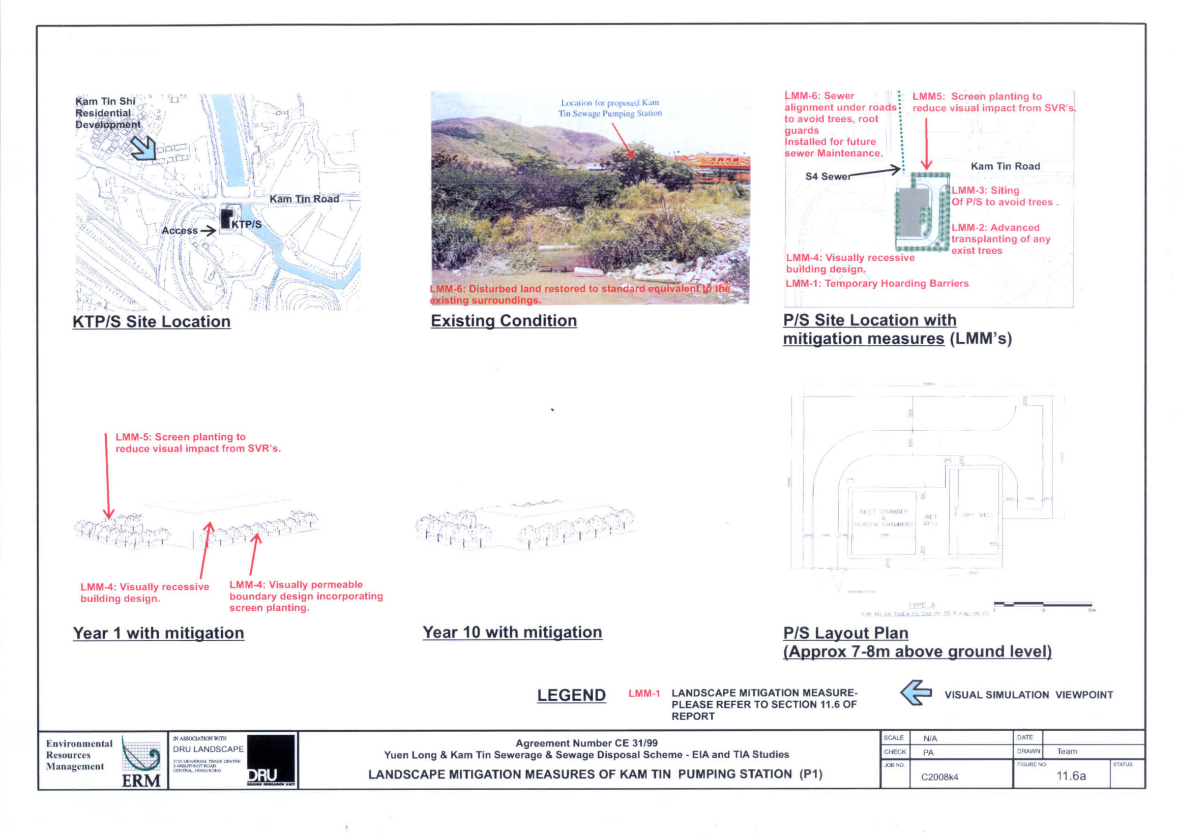
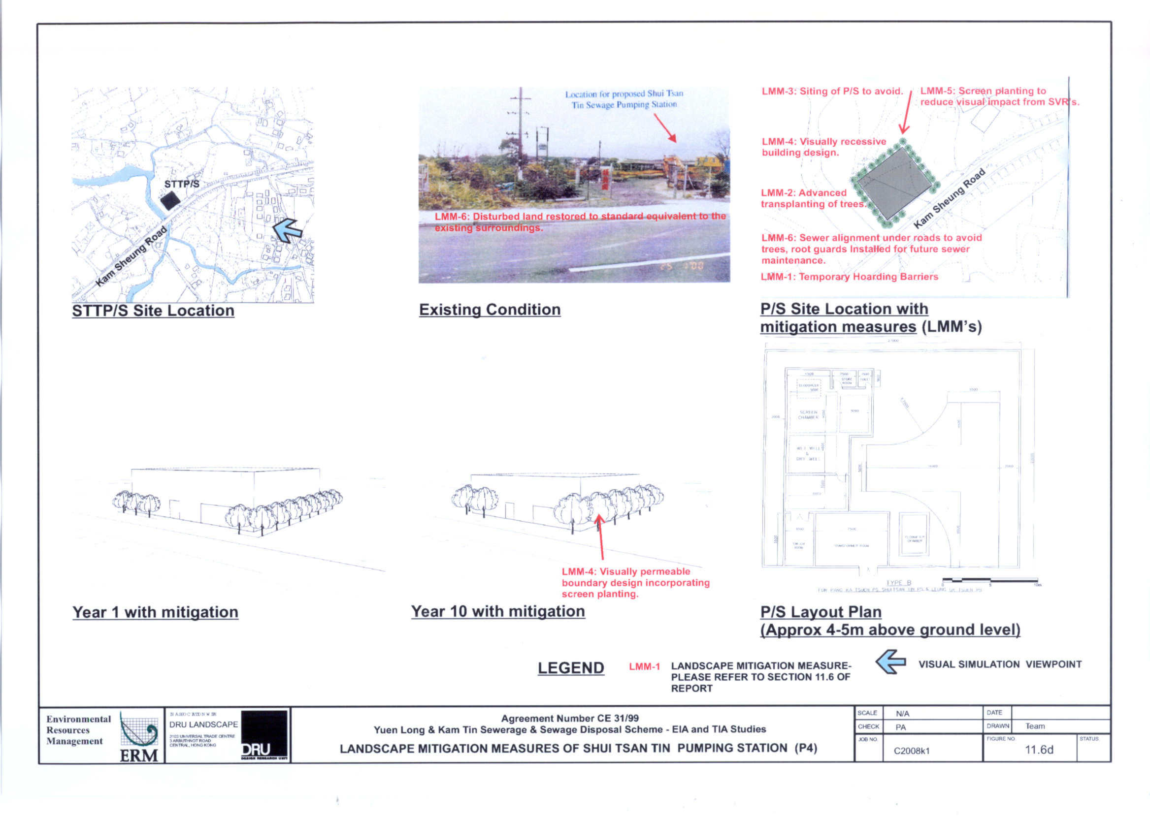
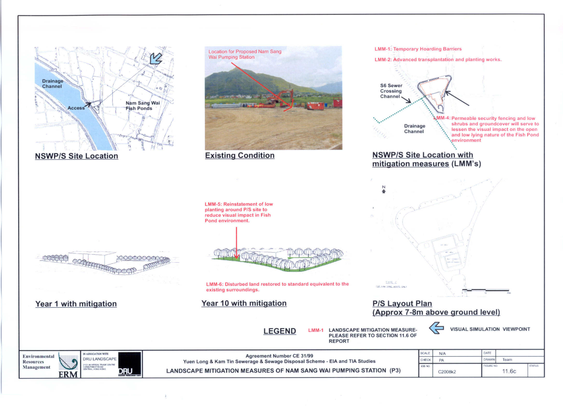
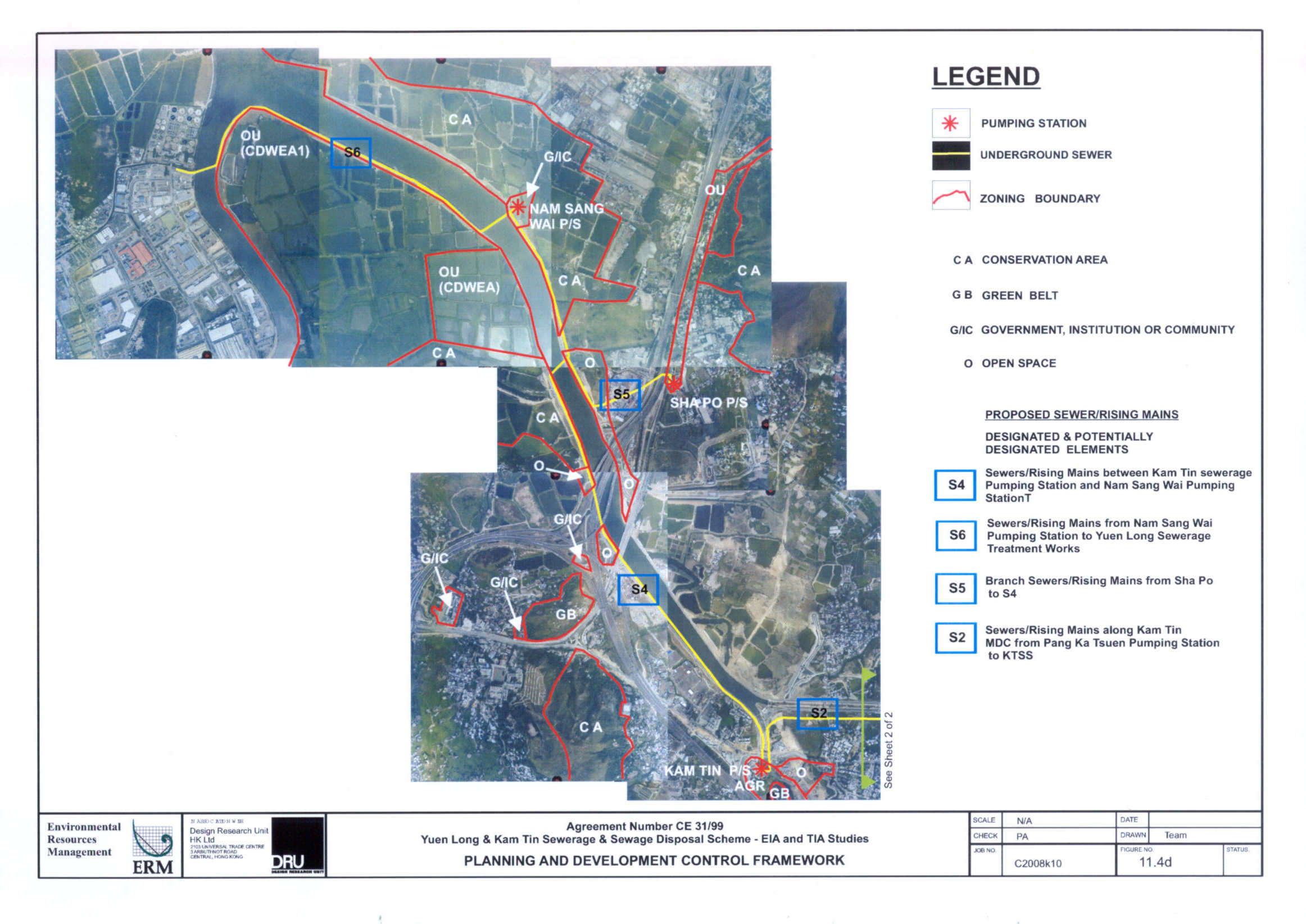
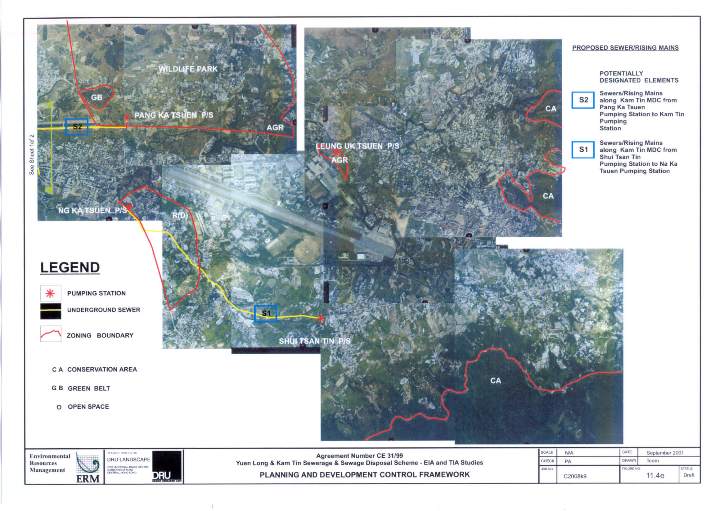
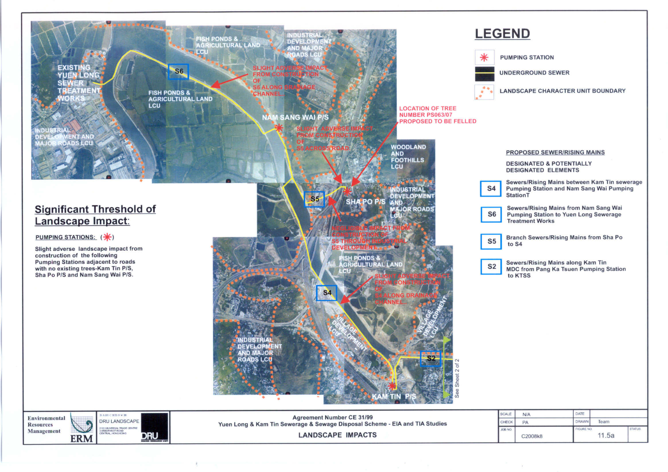
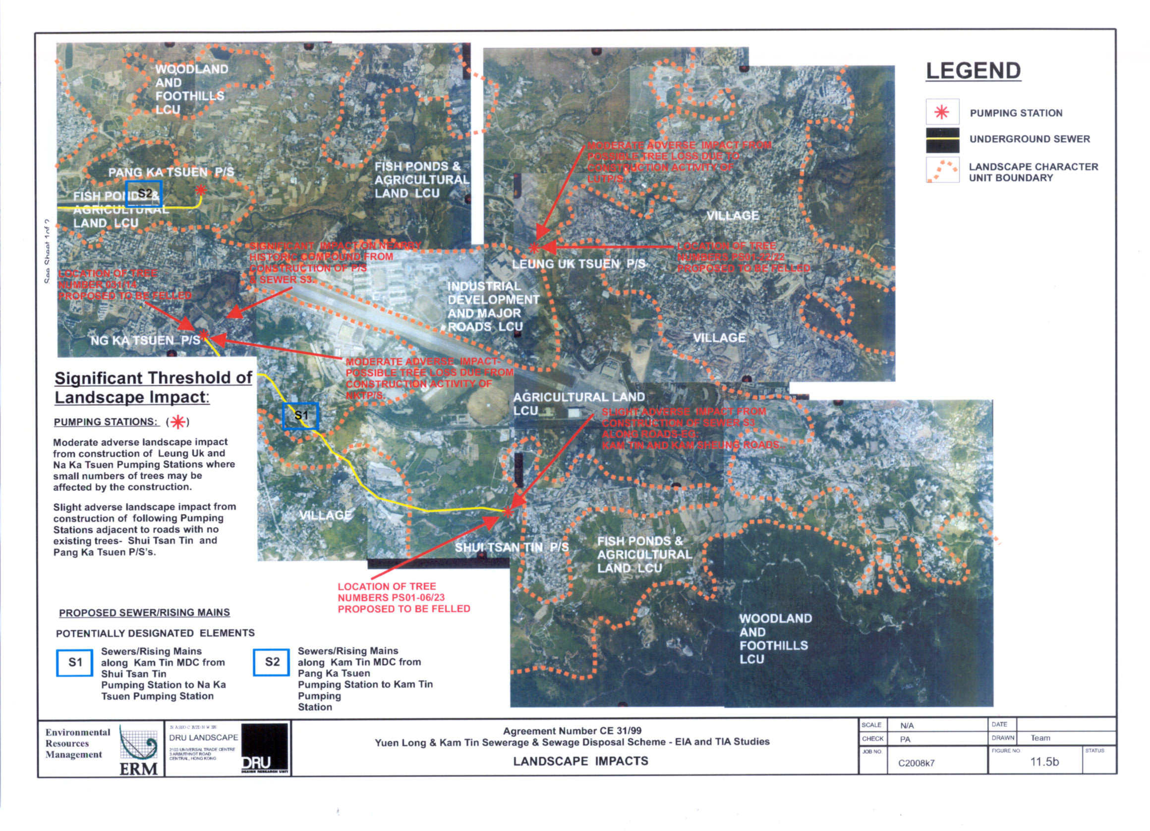
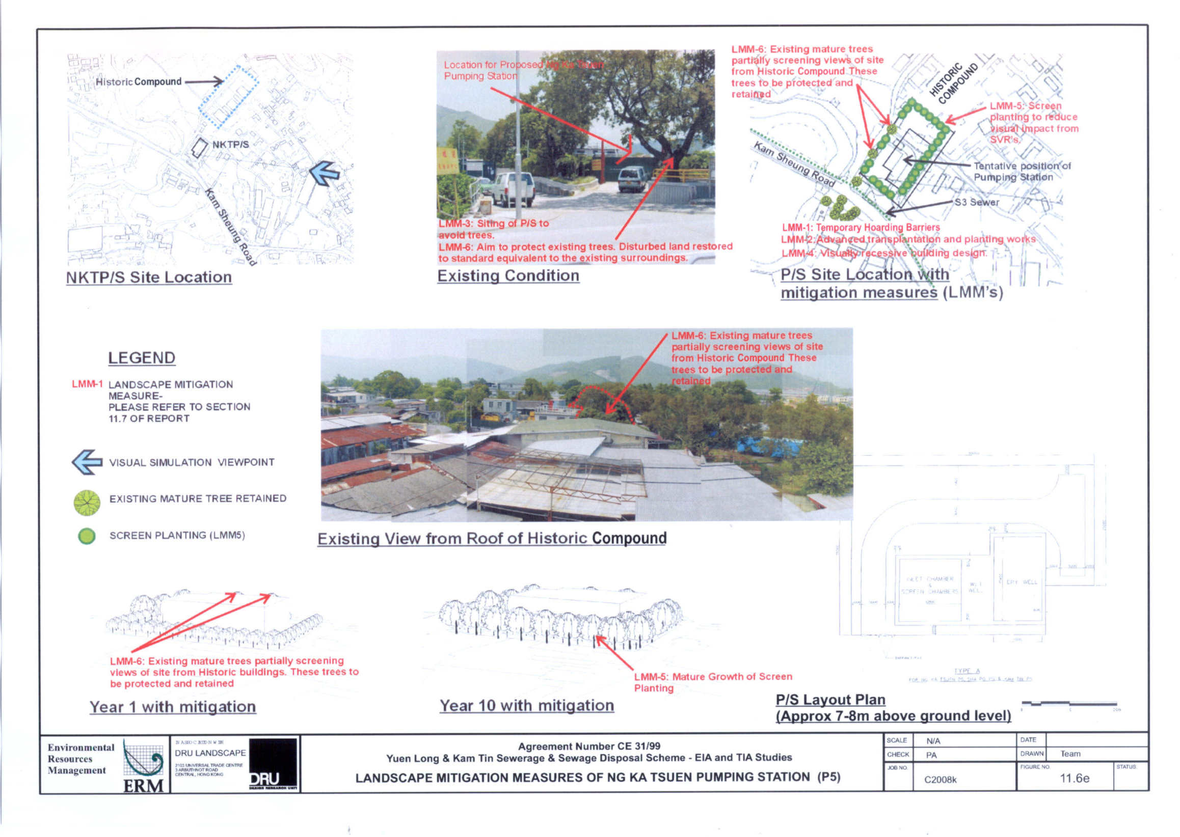
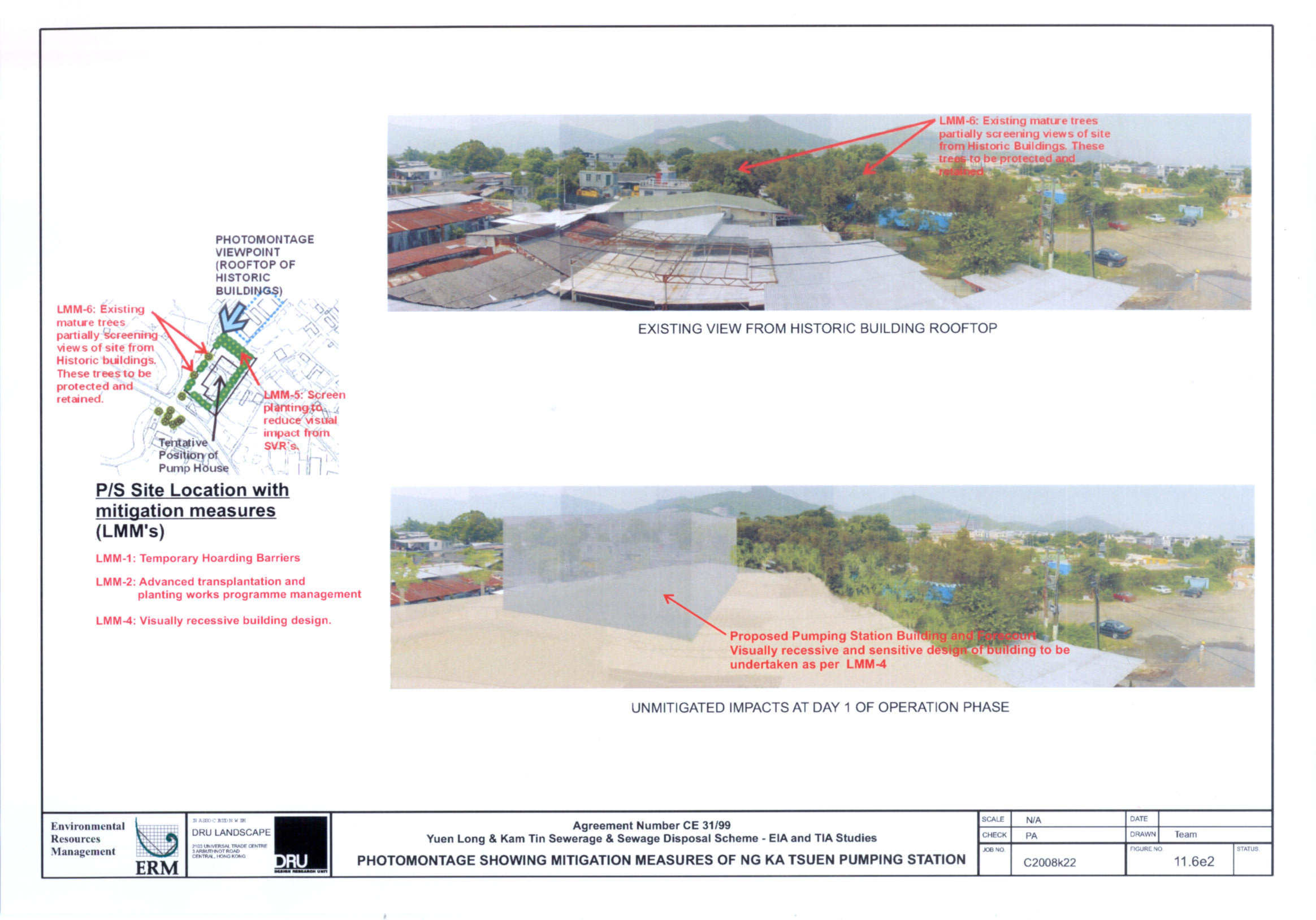
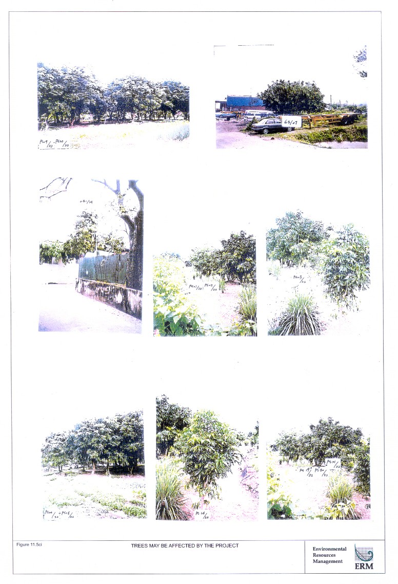
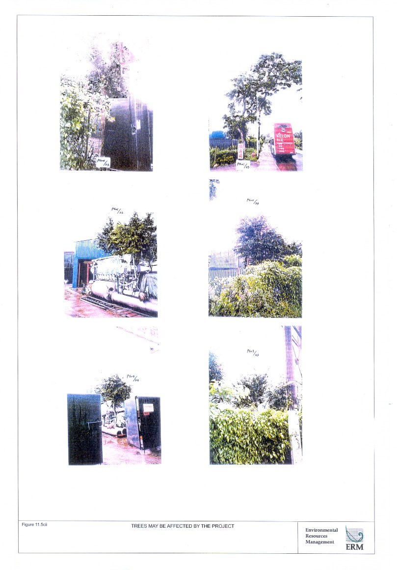
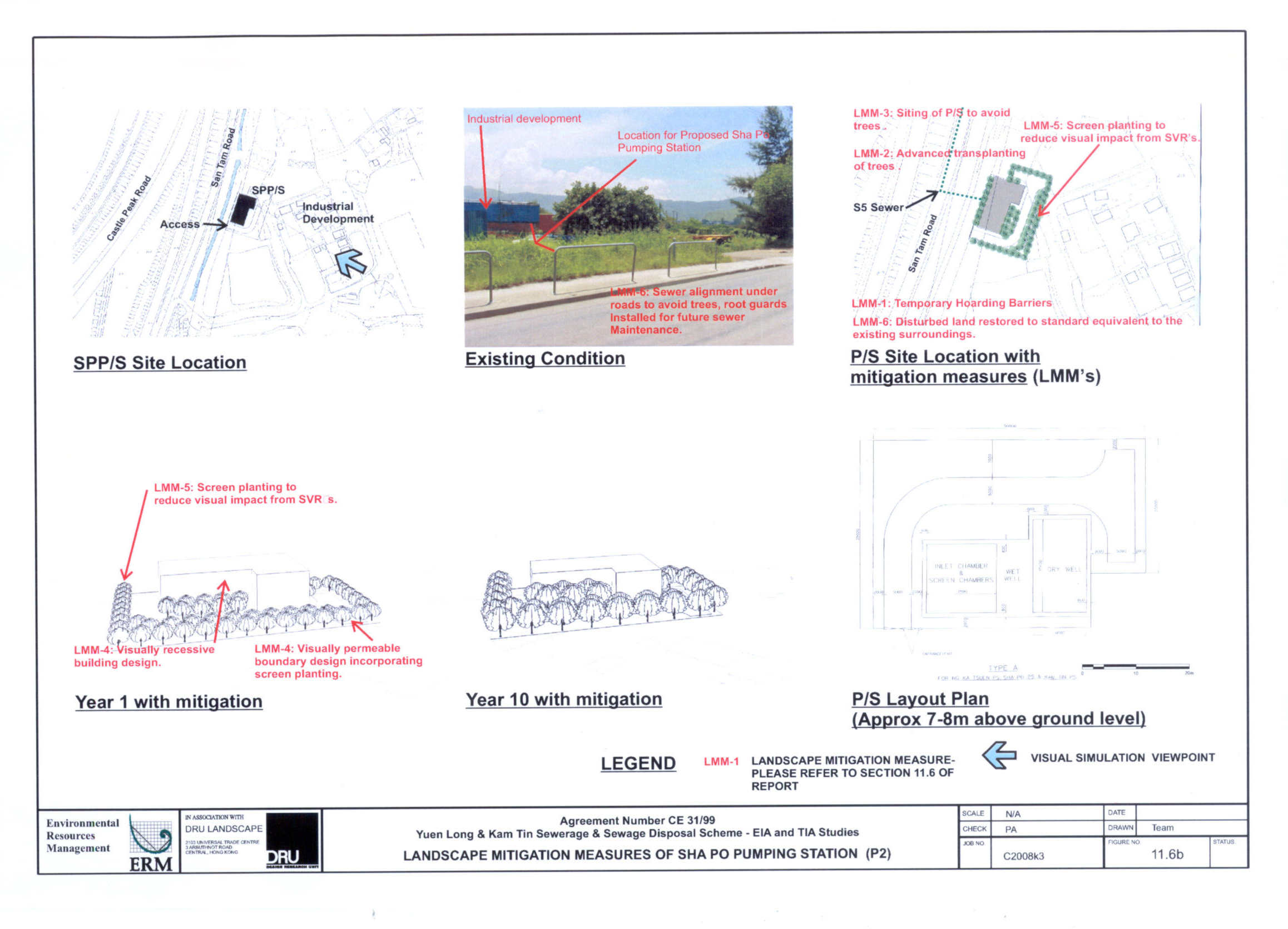
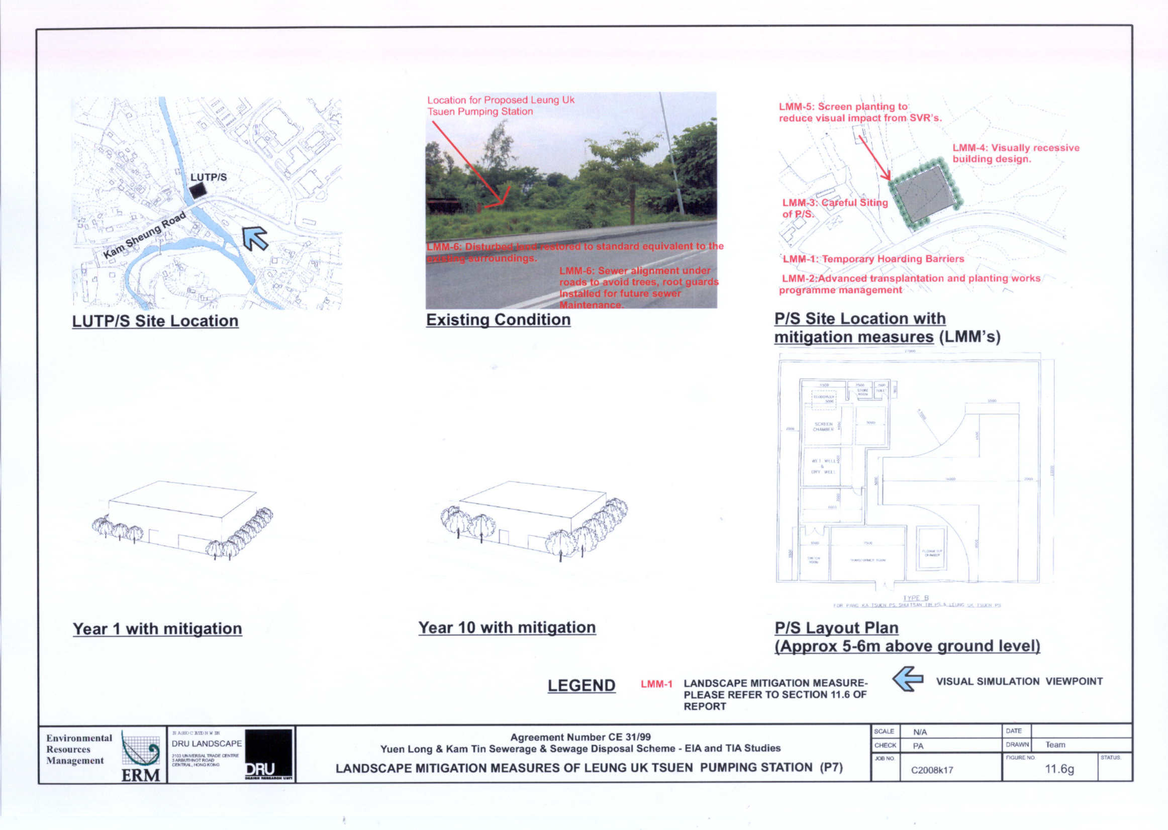