|
Contents
|
| |
| 1. INTRODUCTION |
| 2.
PROJECT DESCRIPTION |
| 3. NOISE
IMPACT ASSESSMENT |
| 4. AIR
QUALITY IMPACT ASSESSMENT |
| 5. WATER
QUALITY |
| 6. ECOLOGICAL
IMPACT ASSESSMENT |
| 7. CULTURAL
HERITAGE ASSESSMENT |
| 8.
LANDSCAPE AND VISUAL IMPACT |
| 9.
SUMMARY AND CONCLUSION AND IMPLEMENTATION
SCHEDULE |
| |
| LIST OF ANNEXES |
| |
Annex A Environmental
Impact Assessment Study Brief |
| |
|
| |
Annex B Environmental
Legislation and Planning Guidelines |
| |
|
| |
Annex C Noise Impact Assessment |
| |
C1 Details
of Construction Noise Impact Assessment |
| |
C2 Details
of Traffic Noise Impact Assessment |
| |
C3 Train
Noise Impact Assessment |
| |
C4 Details
of Fixed Noise Impact Assessment |
| |
|
| |
Annex D Air Quality Impact Assessment |
| |
D1 Traffic
Emission Assessment |
| |
D2 Industrial
Emission Assessment |
| |
|
| |
Annex E Sewage
Impact Assessment |
| |
|
| |
Annex F Ecology |
| |
F1 Plant
Species Recorded within the Assessment Area |
| |
F2 Plant
Species Recorded at Wu Kai Sha fung shui Wood (Chu 1998) |
| |
F3 Bird
Species and Abundance on Roadside Plantations |
| |
F4 Bird
Species and Abundance on Headland Plantations |
| |
F5 Bird
Species and Abundance on Secondary Woodlands |
| |
F6 Bird
Species and Abundance in fung shui Woods |
| |
F7 Bird
Species and Abundance of Agriculture |
| |
F8 Bird
Species and Abundance on Sandy Shores |
| |
F9 Bird
Species and Abundance in outer Starfish Bay |
| |
F10 Bird
Species and Abundance Recorded in September 2001 |
| |
F11 Butterfly
Species Recorded in the Study Area |
| |
F12 Dragonfly
Species Recorded in the Study Area |
| |
|
| |
Annex G Cultural Heritage |
| |
G1 Results
of the Auger Survey |
| |
G2 Test
Pit Results |
| |
|
| |
Annex H Section
at Interface between Trunk Road T7 and Property Development at Wu
Kai Sha Station |
| |
|
| TABLES |
| |
2.1
Preliminary Development Parameters from the Study Brief |
| |
2.2
Schedule of Development for the Base Scheme |
| |
2.3
Development Schedule of the Alternative Scheme |
| |
2.4
Development Schedule of the Further Alternative Scheme with 10 hectares
Recreational Area |
| |
2.5
Development Schedule of the Further Alternative Scheme with 15 hectares
Recreational Area |
| |
2.6
Development Schedule of the Further Alternative Scheme with 18.5
hectares Recreational Area |
| |
2.7
Development Schedule for the Preliminary Preferred Development Option
with 11-ha Recreation Development (plot ratio 6.5) |
| |
2.8
G/IC Facilities and Open Space Requirements for the PDO with 11-ha
Recreation Development |
| |
2.9
Estimated Land Area, Facilities Sizes and Annual Attendance of the
Proposed Recreation Uses |
| |
2.10
Actual Patronage of the Proposed Recreation Uses |
| |
2.11
Development Schedule for the Preferred Development Option with 11-ha
Recreation Development (plot ratio 5) |
| |
2.12
Works to be Implemented by government for Preferred Development
Option |
| |
2.13
Development Programme |
| |
2.14
Designated Projects under this Study |
| |
2.15
Concurrent Projects |
| |
|
| |
3.3.1
TMEIA Daytime Construction Noise Standards |
| |
3.3.2
Operational Noise Assessment Criteria |
| |
3.4.1
Details of the Representative NSRs during Construction Phase |
| |
3.4.2
Details of the Representative NSRs during Operational Phase |
| |
3.5.1
Worst Case Construction Scenarios |
| |
3.5.2
Predicted (Unmitigated) Construction Noise Level |
| |
3.5.3
Predicted (Mitigated) Construction Noise Level |
| |
3.5.4
Summary of Proposed Construction Noise Mitigation Measures |
| |
3.6.1
Characteristics of Roads |
| |
3.6.2
Assumptions on Potential Noise Shielding Structures of the Preliminary
Preferred Development Option |
| |
3.6.3
Summary of Traffic Noise Assessment on the future NSRs in the Preliminary
Preferred Development Option |
| |
3.6.4
Summary of Traffic Mitigation Incorporated into the Preliminary
Preferred Development Option (School) |
| |
3.6.5
Evaluation of constraints associated with the Wu Kai Sha Station
Development in accordance with Annex 13 of TM-EIAO |
| |
3.6.6
Summary of Proposed Noise Mitigation Measures / Assumptions Used
in the Proposed Development in Relation to Traffic Noise |
| |
3.7.1
Acceptable Noise Levels (ANLs) in dB(A) |
| |
3.7.2
Information of the Selected NSRs for the Assessment |
| |
3.7.3
Parameters and Equations adopted in the MOS Rail Noise Calculation |
| |
3.7.4
Unmitigated Rail Noise Levels |
| |
3.7.5
Mitigated Noise Levels at NSR 10-1 |
| |
3.7.6
Summary of the Mitigation Measures for MOS Train Noise |
| |
3.8.1
Categories of Fixed Noise Assessment |
| |
3.8.2
Monitoring Results of Pumping Station |
| |
3.8.3
Predicted Noise Levels generated from the Pumping Station at Ground
Levels of NSR 10 |
| |
3.8.4
Maximum Allowable Sound Pressure Level for Fixed Noise Sources Associated
with MOS Rail Wu Kai Sha Station |
| |
3.8.5
Maximum Allowable Sound Pressure Level for Fixed Noise Sources Associated
with the proposed Utility Services |
| |
|
| |
4.1
Hong Kong Air Quality Objectives (AQOs) |
| |
4.2
Monthly Average Concentrations at Shatin EPA Station (2000) |
| |
4.3
Representative ASRs around the Project during Construction Phase |
| |
4.4
Movement of Cut and Fill Material within Project |
| |
4.5
Air Quality Guidelines of Carparks |
| |
|
| |
5.1
Water Quality of EPD Monitoring Station (TM6) from 1995 to 1999 |
| |
5.2
Water Quality of EPD Monitoring Station TS4 from 1995 to 1999 |
| |
5.3
Summary of Potential Construction Impacts and Mitigation Measures |
| |
5.4
Estimated Sewage Flows |
| |
5.5
E.Coli and Faecal Coliform Levels at EPS Monitoring Station TM6 |
| |
5.6
Summary of Potential Operational Impacts and Mitigation Measures |
| |
|
| |
6.1
Bird Abundance and Species Richness in 2000 and 2001 |
| |
6.2
Bird Abundance and Species Richness in Each Type of Habitat |
| |
6.3
Species Richness of Butterfly in Each Type of Habitat |
| |
6.4
Intertidal Fauna on the Sandflat in Starfish Bay |
| |
6.5
Seabed Attributes along the Survey Transects |
| |
6.6
Description of the Seabed Recorded along each Transect |
| |
6.7
Plant Species of Conservation Importance |
| |
6.8
Bird Species of Conservation Importance |
| |
6.9
Marine Species of Conservation Importance |
| |
6.10
Evaluation of Ecological Importance of the Study Area |
| |
6.11
Estimated Habitat Loss Caused by Proposed Housing Development |
| |
6.12
Construction-stage Impacts |
| |
6.13
Operation-stage Impacts |
| |
|
| |
7.5.1
Summary of the Archaeological Findings in Each Unit of Evaluation |
| |
7.8.1
Summary of Field Evaluation Conducted in Each Unit and its Results
(AH = Auger Holes, TP = Test Pit) |
| |
7.8.2
Summary of Proposed Impacts in Areas of Archaeological Potential |
| |
7.8.3
Summary of Proposed Mitigation Recommendations in Areas of Archaeological
Potential |
| |
7.9.1
The Recorded Resources within the Study Area, the Assessment, Existing
Land Use in their Immediate Vicinity and the Type and Distance of
the Proposed Development |
| |
7.9.2
The Recorded Resources Outside of the Study Area, the Assessment,
Existing Land Use in their Immediate Vicinity and the Type and Distance
of the Proposed Development |
| |
7.9.3
Mitigation Recommendations for the Recorded Resources inside the
Study Area |
| |
7.9.4
Mitigation Recommendations for the Recorded Resources outside the
Study Area |
| |
|
| |
8.3.1
Relationship between Receptor Sensitivity and Impact Magnitude in
Defining Impact Significance |
| |
8.5.1
Landscape Resources and Character Areas |
| |
8.5.2
Characteristics of Key Views |
| |
8.5.3
Identity and Characteristics of the Key Visual Receivers |
| |
8.6.1
Significance of Landscape Impacts during the Construction Phase |
| |
8.6.2
Significance of Visual Impacts during the Construction Phase |
| |
8.6.3
Proposed Construction Phase Mitigation Measures |
| |
8.7.1
Significance of Landscape Impacts during the Operational Phase |
| |
8.7.2
Significance of Visual Impacts during the Operational Phase |
| |
8.7.3
Proposed Permanent Mitigation Measures |
| |
8.9.1
Quantification Key Landscape Resources Affected by Works |
| |
|
| |
9.1
Quantification Key Landscape Resources Affected by Works |
| |
9.2
Description of Column Headings for the Implementation Schedule |
| |
9.3
Implementation Schedule for Recommended Mitigation Measures |
| |
|
| FIGURES |
| |
Figure
1.1 Location of Study Area |
| |
|
| |
Figure
2.1 Master Layout Plan (Base Scheme) |
| |
Figure
2.2 Master Layout Plan (Alternative Scheme) |
| |
Figure
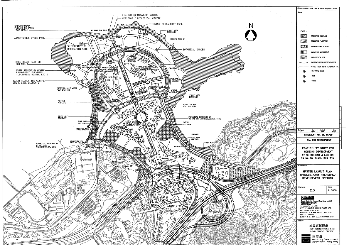
2.3 Master Layout Plan (Preliminary Preferred Development Option) |
| |
Figure
2.4 Master Layout Plan (Preferred Development Option) |
| |
Figure
2.5 Conceptual Layout of Highway Structures |
| |
Figure
2.6 Extend of Designated Projects within Study Area |
| |
|
| |
Figure
3.4.1 Location of Construction Noise Sensitive Receivers |
| |
Figure
3.4.2 Location of Operational Noise Sensitive Receivers |
| |
Figure
3.8.1 Locations of Potential Fixed-Noise Sources |
| |
Figure
3.6.1 Locations of new roads |
| |
Figure
3.6.2 Locations of Committed Noise Barrier by Other Projects |
| |
Figure
3.7.1a Mitigation Measures Proposed on MOS Rail Viaduct next to
Lee On Estate by MOS EIA |
| |
Figure
3.7.1b Deck General Arrangement |
| |
Figure
3.7.1c Cross Section |
| |
Figure
3.7.1d Key Plan - Concourse Level |
| |
Figure
3.7.1e Shek Mun to Lee On Station - Longitudinal Section A-A |
| |
Figure
3.7.1f Cross Section B-B, C-C, D-D, E-E, F-F, G-G & H-H |
| |
Figure
3.7.2a Proposal Railway Noise Measure (Semi Enclosure) |
| |
Figure
3.7.2b Proposal Railway Noise Measure (Central Plenum) |
| |
Figure
3.7.3 Multi-Plenum System on the Rail Viaduct |
| |
|
| |
Figure
4.1 Wind Rose of Shatin Area |
| |
Figure
4.2 Location of Proposed Wheel Wash |
| |
Figure
4.3 Maximum NO2 concentration from Traffic Emission at Pedestrian
Level (Hourly Average) |
| |
Figure
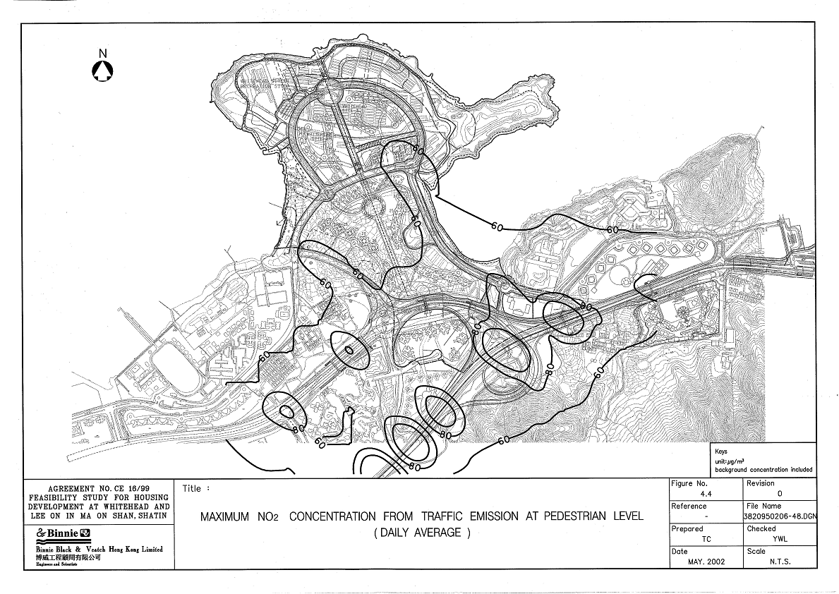
4.4 Maximum NO2 concentration from Traffic Emission at Pedestrian
Level (Daily Average) |
| |
Figure
4.5 Maximum RSP concentration from Traffic Emission at Pedestrian
Level (Daily Average) |
| |
Figure
4.6 Location of Chimneys |
| |
Figure
4.7a Maximum NO2 concentration from Industrial Emission (Hourly
Average) |
| |
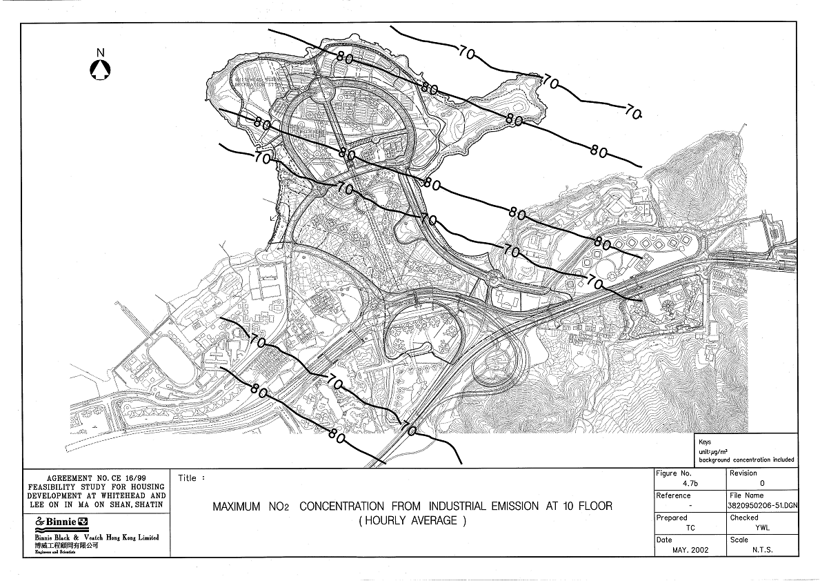
Figure
4.7b Maximum NO2 concentration from Industrial Emission at 10 Floor
(Hourly Average) |
| |
Figure
4.7c Maximum NO2 concentration from Industrial Emission at 20 Floor
(Hourly Average) |
| |
Figure
4.7d Maximum NO2 concentration from Industrial Emission at 30 Floor
(Hourly Average) |
| |
Figure
4.7e Maximum NO2 concentration from Industrial Emission at 40 Floor
(Hourly Average) |
| |
Figure
4.8a Maximum NO2 concentration from Industrial Emission (Daily Average) |
| |
Figure
4.8b Maximum NO2 concentration from Industrial Emission at 10 Floor
(Daily Average) |
| |
Figure
4.8c Maximum NO2 concentration from Industrial Emission at 20 Floor
(Daily Average) |
| |
Figure
4.8d Maximum NO2 concentration from Industrial Emission at 30 Floor
(Daily Average) |
| |
Figure
4.8e Maximum NO2 concentration from Industrial Emission at 40 Floor
(Daily Average) |
| |
Figure
4.9a Maximum SO2 concentration from Industrial Emission (Hourly
Average) |
| |
Figure
4.9b Maximum SO2 concentration from Industrial Emission at 10 Floor
(Hourly Average) |
| |
Figure
4.9c Maximum SO2 concentration from Industrial Emission at 20 Floor
(Hourly Average) |
| |
Figure
4.9d Maximum SO2 concentration from Industrial Emission at 30 Floor
(Hourly Average) |
| |
Figure
4.9e Maximum SO2 concentration from Industrial Emission at 40 Floor
(Hourly Average) |
| |
Figure
4.10 Cumulative NO2 concentration from Traffic Emission and Industrial
Emission at Pedestrian Level (Hourly Average) |
| |
Figure
4.11 Cumulative NO2 concentration from Traffic Emission and Industrial
Emission at Pedestrian Level (Daily Average) |
| |
|
| |
Figure
5.1 Existing Streamcourses and Sensitive Receivers |
| |
Figure
5.2 Location of EPD Monitoring Station |
| |
Figure
5.3a Conceptual Drainage Plan |
| |
Figure
5.3b Conceptual Sewerage Plan |
| |
|
| |
Figure
6.1 Habitat map and sampling locations of the Study Area |
| |
Figure
6.2 Photomontages showing various habitats at Whitehead and Lee
On, Ma On Shan |
| |
Figure
6.3 Locations of species with conservation value within the Study
Area |
| |
Figure
6.4 Photo of black coral Antipathes sp. in the control site during
the dive survey |
| |
Figure
6.5 Extension of existing secondary woodland as a mitigation measure
to loss of woodland |
| |
|
| |
Figure
7.1 Map Showing the Location of the Study Area in the Territory |
| |
Figure
7.2 Map of the Study Area |
| |
Figure
7.3a View of the Former Whitehead Detention Centre Site from the
Northeast |
| |
Figure
7.3b View of the Wu Kai Sha Headland (east) with Tai Po Hoi in the
Foreground taken from the South |
| |
Figure
7.4a View of the Study Area from the South East Looking across the
Central Area of Fill towards Lok Wo Sha and Ma On Shan Town |
| |
Figure
7.4b View towards the South West showing the Nursey (Unit 3) in
Foreground; Central Fill Area in Use for Vehicle Storage, Lok Wo
Sha and the Fung Shui Wood in the Background |
| |
Figure
7.5a View of Unit 7 from the North East showing the Former Lagoon
Area under Cultivation and the Sandbar (Unit 6) beyond |
| |
Figure
7.5b View of To Tau Tsuen from the Southeast |
| |
Figure
7.6 Aerial Photograph of the Study Area taken in 1978 |
| |
Figure
7.7 Aerial Photograph of the Study Area taken in 1995 |
| |
Figure
7.8 Aerial Photograph of the Study Area taken in 1999 |
| |
Figure
7.9 Map Showing the Location of the Wu Kai Sha Archaeological Site |
| |
Figure
7.10a Photograph showing Surface Material of Unit 3 |
| |
Figure
7.10b Photograph showing Unit 4 |
| |
Figure
7.11a Photograph showing Unit 6 |
| |
Figure
7.11b Photograph showing Surface Material of Unit 7 |
| |
Figure
7.12 Map of Unit 1 Showing Location of Auger Holes |
| |
Figure
7.13 Map of Unit 3 Showing Location of Auger Holes |
| |
Figure
7.14 Map of Unit 4 Showing Location of Auger Holes |
| |
Figure
7.15 Map of Unit 5 Showing Location of Auger Holes |
| |
Figure
7.16 Map of Unit 6 Showing Location of Auger Holes and Test Pits |
| |
Figure
7.17 Map of Unit 7 Showing Location of Auger Holes and Test Pit |
| |
Figure
7.18a Photograph showing Finds form Test Pit 1: (L-R) Context 03,
Context 04, Context 05, Context 05 |
| |
Figure
7.18b Photograph showing 2 Bronze Buttons (SF#1) from Test Pit 1:
Context 05 |
| |
Figure
7.18c Photograph showing finds from Test Pit 2: (L-R) Context 02,
Context 03, Context 04 |
| |
Figure
7.19a Photograph showing a Rectangular unmodified adze (SF#2) contained
in the sand bar (Test Pit 3, Context 04) |
| |
Figure
7.19b Photograph showing finds of Test Pit 3 (L-R): Context 02,
Context 04 (SF#2) |
| |
Figure
7.20 Illustrations of Special Find #2, Adze, from Test Pit 3, Unit
6 |
| |
Figure
7.21a Photograph showing finds of Test Pit 4: Context 5 |
| |
Figure
7.21b Photograph showing finds of Test Pit 5 (L-R): Context 02,
Context 05 |
| |
Figure
7.22 Illustration of Feature Sherds recovered from Test Pit 4, Unit
6 |
| |
Figure
7.23a Photograph showing finds of Test Pit 5: Context 03 |
| |
Figure
7.23b Photograph showing finds of Test Pit 5: Context 04 |
| |
Figure
7.24 Map showing the Locations of the Villages in and Bordering
the Study Area |
| |
Figure
7.25 Map Showing the Locations of the Cultural Heritage Features
in the Villages of Wu Kai Sha San Tsuen, Wu Kai Sha Cheung Tsuen
and Kwai Po Lau |
| |
Figure
7.26 Map Showing the Locations of the Cultural Heritage Features
in the Village of Lok Wo Sha |
| |
Figure
7.27 Map Showing the Location of the Cultural Heritage Feature in
the Village of Cheung Kang |
| |
Figure
7.28 Map Showing the Location of the Cultural Heritage Feature in
the Village of To Tau Tsuen |
| |
Figure
7.29 Map Showing the Location of 1950s features in To Tau Tsuen |
| |
Figure
7.30 Photographs Illustrating the Traditional Lifestyle of the Tanka
People at To Tau Tsuen |
| |
Figure
7.31 Photographs showing 1950s Structure (1-3) in To Tau Tsuen |
| |
Figure
7.32 Photographs showing 1950s Structure (4-6) in To Tau Tsuen |
| |
Figure
7.33 Photographs showing 1950s Structure (7-9) in To Tau Tsuen |
| |
Figure
7.34 Photographs showing 1950s Structure (10-12) in To Tau Tsuen |
| |
Figure
7.35 Photographs showing 1950s Structure (13-15) in To Tau Tsuen |
| |
Figure
7.36 Photographs showing 1950s Structure (16-18) in To Tau Tsuen |
| |
Figure
7.37 Photographs showing 1950s Structure (19-20) in To Tau Tsuen |
| |
Figure
7.38 Map showing the Site of the Former Whitehead Detention Centre |
| |
Figure
7.39 Map showing the Location of the Grave Group on the Fung Shui
Hill |
| |
Figure
7.40 Map showing the Locations of Burial Associated Sites, Traditionally
Cultivated Areas and Fung Shui Features |
| |
Figure
7.41 Photographs of Permanent Graves B and D and the Cemetery Site
on the Fung Shui Hill |
| |
Figure
7.42 Photograph of an Urn Repository and a Coffin Slot |
| |
Figure
7.43 Photograph of Permanent Graves A and C |
| |
Figure
7.44 Inscription of Grave A and C |
| |
Figure
7.45 Proposed Boundary of Pre-historical Archaeological Site |
| |
Figure
7.46 Recommended Area requiring Archaeological Field Evaluation |
| |
|
| |
Figure
8.1 Landscape Planning Designations |
| |
Figure
8.2 Location of Landscape Resources |
| |
Figure
8.3 Landscape Resources |
| |
Figure
8.4 Landscape Character Areas |
| |
Figure
8.5 Views of Landscape Character Areas |
| |
Figure
8.6 Views of Landscape Character Areas |
| |
Figure
8.7 Potential Visual Envelope |
| |
Figure
8.8 Location of Key Views |
| |
Figure
8.9 Key Views (No.1 and 2) |
| |
Figure
8.10 Key Views (No.3 and 4) |
| |
Figure
8.11 Key Views (No.5 and 6) |
| |
Figure
8.12 Visually Receivers |
| |
Figure
8.13a Landscape Impacts - During Construction |
| |
Figure
8.13b Landscape Impacts - During Operation (Day 1) |
| |
Figure
8.13c Landscape Impacts - Residual Impact (Year 10) |
| |
Figure
8.13d Significance of Impacts on Landscape Character - Construction |
| |
Figure
8.13e Significance of Impacts on Landscape Character - Day 1 of
Operation |
| |
Figure
8.13f Significance of Impacts on Landscape Character - Day 10 of
Operation |
| |
Figure
8.14a Visual Impacts - During Construction |
| |
Figure
8.14b Visual Impacts - During Operation (Day 1) |
| |
Figure
8.14c Visual Impacts - Residual Impact (Year 10) |
| |
Figure
8.15a Photomontage from View Point 1 - Existing |
| |
Figure
8.15b Photomontage from View Point 1 - During Construction |
| |
Figure
8.15c Photomontage from View Point 1 - During Operation (Day 1) |
| |
Figure
8.15d Photomontage from View Point 1 - Residual Impact (Year 10) |
| |
Figure
8.16a Photomontage from View Point 2 - Existing |
| |
Figure
8.16b Photomontage from View Point 2 - During Construction |
| |
Figure
8.16c Photomontage from View Point 2 - During Operation (Day 1) |
| |
Figure
8.16d Photomontage from View Point 2 - Residual Impact (Year 10) |
| |
Figure
8.17a Photomontage from View Point 3 - Existing |
| |
Figure
8.17b Photomontage from View Point 3 - During Construction |
| |
Figure
8.17c Photomontage from View Point 3 - During Operation (Day 1) |
| |
Figure
8.17d Photomontage from View Point 3 - Residual Impact (Year 10) |
| |
Figure
8.18a Photomontage from View Point 4 - Existing |
| |
Figure
8.18b Photomontage from View Point 4 - During Construction |
| |
Figure
8.18c Photomontage from View Point 4 - During Operation (Day 1) |
| |
Figure
8.18d Photomontage from View Point 4 - Residual Impact (Year 10) |
| |
Figure
8.19a Photomontage from View Point 5 - Existing |
| |
Figure
8.19b Photomontage from View Point 5 - During Construction |
| |
Figure
8.19c Photomontage from View Point 5 - During Operation (Day 1) |
| |
Figure
8.19d Photomontage from View Point 5 - Residual Impact (Year 10) |
| |
Figure
8.20a Photomontage from View Point 6 - Existing |
| |
Figure
8.20b Photomontage from View Point 6 - During Construction, Operation
(Day 1), Residual Impact (Year 10) |
| |
Figure
8.20b1 Photomontage from View Point 6 - During Construction, Operation
(Day 1), Residual Impact (Year 10) (Plot Ratio = 5.0) |
| |
Figure
8.21 Landscape Mitigation Measure Plan during Construction Phase |
| |
Figure
8.22 Landscape Mitigation Measure Plan during Operational Phase |