Table
4.4 Sediment Quality Data Collected between 1997 and 2000
at East of Sha Chau
|
Parameter |
DL1 |
LCEL2 |
UCEL3 |
Average |
StDev |
Min |
Max |
|
Metals (mg kg-1) |
|
|
|
|
|
|
|
|
Cadmium |
0.02 |
1.5 |
4 |
0.07 |
0.02 |
0.05 |
0.10 |
|
Chromium |
0.05 |
80 |
160 |
20 |
6 |
12 |
30 |
|
Copper |
0.05 |
65 |
110 |
15 |
4 |
11 |
23 |
|
Mercury |
0.05 |
0.5 |
1 |
0.07 |
0.02 |
0.05 |
0.10 |
|
Nickel |
0.05 |
40 |
40 |
12 |
4 |
7 |
19 |
|
Lead |
0.05 |
75 |
110 |
27 |
7 |
22 |
38 |
|
Silver |
0.05 |
1 |
2 |
0.12 |
0.04 |
0.09 |
0.20 |
|
Zinc |
5 |
200 |
270 |
51 |
15 |
33 |
76 |
|
Metalloid (mg
kg-1) |
|
|
|
|
|
|
|
|
Arsenic |
0.5 |
12 |
42 |
8 |
2 |
6 |
12 |
|
Organic - PAHs
(mg kg-1) |
|
|
|
|
|
|
|
|
Low M Wt PAHs |
50 |
550 |
3160 |
75 |
0 |
75 |
75 |
|
High M Wt PAHs |
150 |
1700 |
9600 |
26 |
2 |
25 |
32 |
|
Organics - non - PAHs (mg kg-1) |
|
|
|
|
|
|
|
|
Total PCBs |
2 |
23 |
180 |
1.2 |
0.2 |
1.0 |
1.6 |
|
Notes: 1.
DL
= Detection Limit 2.
LCEL
= Lower Chemical Exceedance Level 3.
UCEL
= Upper Chemical Exceedance Level |
|||||||
Ground Investigation Works
In addition to the background data presented above, a ground
investigation and marine sediment sampling survey was conducted within both the
South Brothers and East of Sha Chau areas as part of the Site and Disposal
Option Selection phase of the study.
Although the primary objective of this survey was to investigate the
thickness of mud, sediment samples were also analysed to determine the
potential for contamination.
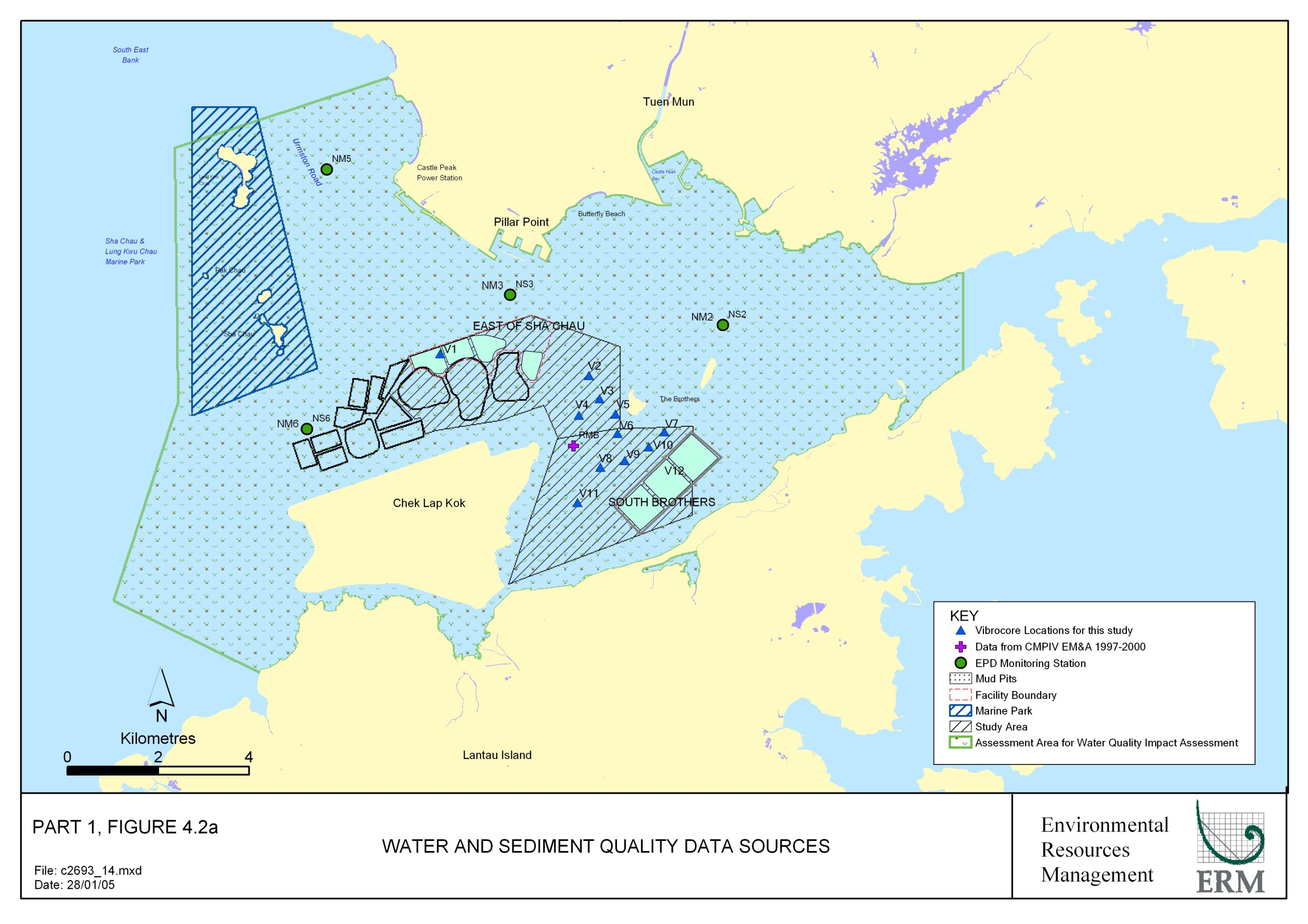
Locations of the vibrocores are presented
in Figure 4.2a. The results from vibrocore V12 are
considered to be applicable to the South Brothers area, this sample exhibited
no exceedances of the LCEL.
Vibrocore V1 provided information on the sediment quality in the East of
Sha Chau area, which also exhibited no exceedances of the LCEL. It can be concluded from the ground
investigation works that the sediments in the two locations appear to be
predominantly uncontaminated.
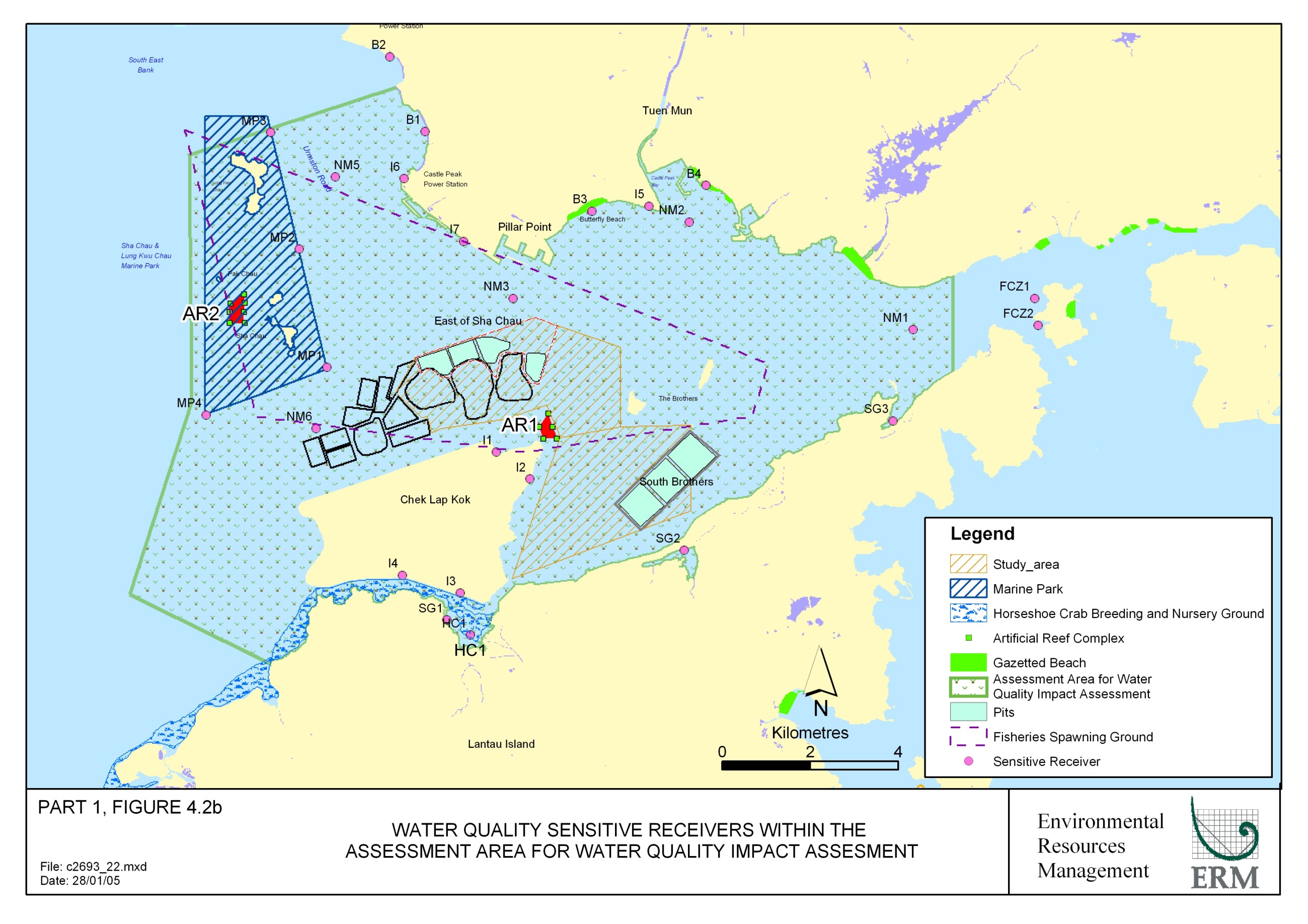
4.2.5
The sensitive receivers that may be affected by changes in
water quality during the construction or operation of the facility are listed
in the Study Brief, discussed below and presented on Figure 4.2b. For each of the sensitive receivers,
established threshold criteria or guidelines have been identified and the
method of reviewing these sensitive receivers (either through discrete points
or contour plots) during the water quality modelling has been described. The shortest distances from the water
quality sensitive receivers to the CMPs at South Brothers and East of Sha Chau
is presented in Table 4.5.
Table 4.5 Water Quality Sensitive
Receivers (SR)
|
SR |
Name |
Shortest Distance to CMPs (m) |
|
|
|
|
|
South
Brothers |
East
of Sha Chau |
|
|
Marine Parks |
Sha Chau and Lung Kwu Chau SE (MP1) |
7,289 |
2,005 |
|
|
Sha Chau and Lung Kwu Chau E (MP2) |
9,291 |
3,594 |
||
|
Sha Chau and Lung Kwu Chau NE (MP3) |
11,595 |
6,090 |
||
|
|
Sha Chau and Lung Kwu Chau SW (MP4) |
9,570 |
4,926 |
|
|
Fish Culture Zone |
Ma Wan N (FCZ1) |
8,114 |
10,885 |
|
|
Ma
Wan S (FCZ2) |
7,932 |
10,949 |
||
|
Artificial
Reefs |
Airport
AR (AR1) |
2,397 |
1,041 |
|
|
Sha
Chau and Lung Kwu Chau AR (AR2) |
9,778 |
4,232 |
||
|
Beaches |
Lung
Kwu Tan Lower (B1) |
9,162 |
4,795 |
|
|
Lung
Kwu Tan Upper (B2) |
10,951 |
6,662 |
||
|
Butterfly
Beach (B3) |
5,596 |
2,730 |
||
|
Tuen Mun Beaches (B4) |
5,681 |
4,653 |
||
|
Intakes |
Airport
(I1) |
3,047 |
1,700 |
|
|
Airport
(I2) |
2,113 |
2,186 |
||
|
Airport
(I3) |
4,109 |
4,967 |
||
|
Airport
(I4) |
5,185 |
4,583 |
||
|
|
Tuen
Mun (I5) |
5,246 |
3,435 |
|
|
|
Castle
Peak Power Station (I6) |
8,737 |
3,950 |
|
|
|
Area
38 Industries (I7) |
6,746 |
2,150 |
|
|
Seagrass
& Horseshoe Crabs |
San
Tau (SG1) |
4,645 |
5,491 |
|
|
Tai
Ho Bay (SG2) |
1,016 |
5,079 |
||
|
Yam
O Bay (SG3) |
4,129 |
7,942 |
||
|
Horseshoe
Crab Tung Chung Bay (HC1) |
4,449 |
5,890 |
||
|
EPD
WQM Stations |
NM1
– close to Yam O |
5,418 |
8,100 |
|
|
NM2
– close to Castle Peak Bay |
4,858 |
3,822 |
||
|
NM3
– close to River Trade Terminal |
5,031 |
566 |
||
|
NM5
- Urmston Road |
9,854 |
4,477 |
||
|
NM6
– between Marine Park and Airport |
7,107 |
2,666 |
||
Fish Culture Zone
There is only one fish culture zone (FCZ)
located within the northwestern waters of Hong Kong, which is at Ma Wan. This FCZ is actually outside of the
water quality assessment area but is included for completeness. The only Water Quality Objective (WQO)
that is specific to FCZs is for dissolved oxygen, which is set at no less than
5 mg L-1. In addition
to dissolved oxygen there is a general water quality protection guideline for
suspended solids (SS), which has been proposed by AFCD ([6]). The guideline requires that SS levels
remain below 50 mg L-1.
With regard to the water quality modelling, the FCZs were included as
discrete points for evaluation in the assessment against the above criteria and
guideline.
Marine Ecological Resources
The following Marine Ecological Resources have been
identified as water quality sensitive receivers.
Marine Parks
There is one designated Marine Park located within the Study
Area which is the Sha Chau and Lung Kwu Chau Marine Park (see Section 4.3). The park was designated specifically
for the protection of the Indo-Pacific Humpback Dolphin (Sousa chinensis). There are no specific legislative water
quality criteria for Marine Parks rather; the water quality at this sensitive
receiver is typically compared with the WQO. The Marine Park will be plotted as a discrete point at the
marine water boundary facing the proposed mud pits for evaluation in the water
quality assessment.
Artificial Reef Deployment
Sites
There are two gazetted Artificial Reef Deployment Sites
(ARD) within the Study Area:
·
Sha
Chau and Lung Kwu Chau ARD site (situated within the Sha Chau and Lung Kwu Chau
Marine Park);
·
Airport
ARD site (Figure 4.2b).
The ARD sites are proposed as a fisheries resource
enhancement tool to encourage growth and development of a variety of marine
organisms and provide feeding opportunities for the Indo-Pacific Humpback
Dolphin. There is no specific
water quality criterion for the ARD sites; rather water quality impacts are
measured presently against compliance with the WQO. The ARD sites will be treated as discrete points in the
model.
Seagrass Beds, Mangroves & Horseshoe Crabs
There are seagrass beds, mangroves and areas where horseshoe
crabs are known to breed within the Study Area, such as within Tung Chung Bay,
Tai Ho and Yam O Bays (see Section 4.3). There are no specific legislative water quality criteria for
these seagrass beds/breeding areas, rather, the water quality at these
sensitive receivers is typically compared with the WQO. The sensitive habitats will be plotted
as discrete points for evaluation in the water quality assessment.
Non-Gazetted & Gazetted Bathing Beaches
There are several non-gazetted and gazetted bathing beaches
within the Study Area, which have been identified in the Study Brief as
sensitive receivers. These include
the beaches at Lung Kwu Tan and around Tuen Mun. Water quality impacts are determined based on the compliance
with the WQO. Bathing beaches have
been plotted as discrete points for evaluation in the water quality
assessment.
Seawater Intakes
There are several water intakes in the
Study Area which are mainly for cooling purpose. In absence of specific criteria for each intake we have
assumed the WQO as a default. The exception to the above is for the Castle Peak
Power Station intake for which there is a specific requirement that suspended
sediment concentrations be maintained below a level of 150 mg L-1
within a 5 km radius of the intake.
The intakes will be plotted as discrete points for evaluation in the
water quality assessment.
Summary
A summary of the assessment criteria to be applied for each
sensitive receiver for this Project is presented in Table 4.6
Table 4.6 Summary of Assessment Criteria
for Water Quality Sensitive Receivers
|
Sensitive
Receiver |
Specific
Assessment Criteria |
Value |
|
Fish Culture Zone (FCZ) |
Dissolved oxygen Suspended Solids |
No less than 5 mg L-1 No more than 50 mg L-1 |
|
Marine Park, Artificial Reefs,
Seagrass, Horseshoe Crabs, Non-gazetted & Gazetted Bathing Beaches |
Water Quality Objectives |
|
|
Seawater Intakes |
Water Quality Objectives |
Water Quality Objectives |
4.3
Marine Ecology
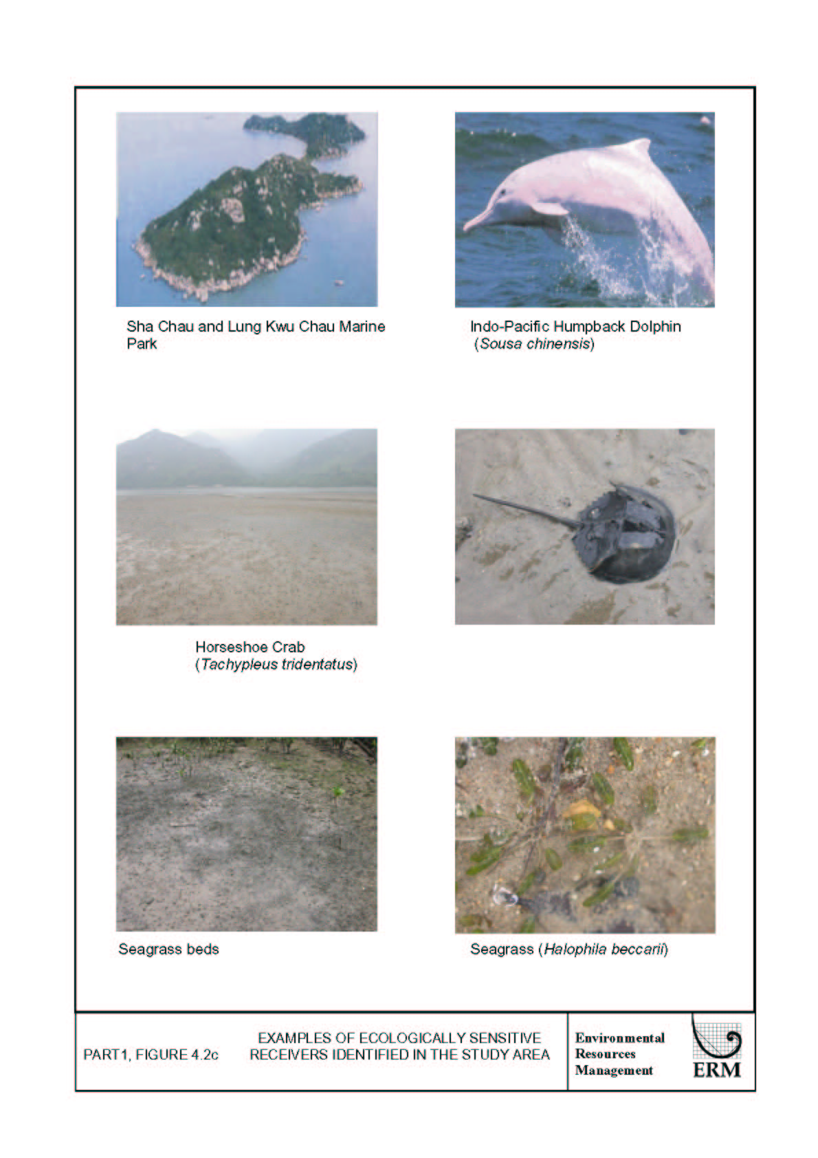
4.3.1 Introduction
This section of the report presents baseline information on
the marine ecological resources within the Study Area, summarises their
ecological value and identifies sensitive receivers, examples of which can be
see in Figure 4.2c.
The marine ecology of north
Lantau is well documented. The
distribution of the marine ecological important habitats, including seagrass,
mangrove, mudflat, dolphin and benthic soft bottom habitats, have been
comprehensively studied, sources are listed below:
·
Barros
NB, Jefferson TA and ECM Parsons (2004) Feeding habits of Indo-Pacific humpback
dolphins (Sousa chinensis) stranded in Hong Kong. Aquatic Mammals.
30:179-188
·
Binnie
Consultants Limited (1996) Fill
Management Study - Phase IV Investigations and Development of Marine Borrow
Areas: Coral Growth at High Island Dam.
For the Civil Engineering Department, Hong Kong SAR Government.
·
Binnie
Consultants Limited (1997) Chek
Lap Kok Qualitative Survey. Final Report.
For the Civil Engineering Department, Hong Kong SAR Government.
·
Chiu
HMC and Morton B (1999) The distribution of horseshoe crabs (Tachypleus
tridentatus and Carcinoscorpius rotundicauda) in Hong Kong. Asian
Marine Biology. 16, 185-196.
·
CityU
Professional Services Limited (2002) Agreement No. CE 69/2000 - Consultancy
Study on Marine Benthic Communities in Hong Kong. Final Report. Submitted to the Agriculture, Fisheries
and Conservation Department. Hong
Kong SAR Government.
·
ERM
– Hong Kong, Ltd (1995) Proposed
Aviation Fuel Receiving Facility at Sha Chau. Environmental Impact Assessment. Prepared for the Provisional Airport Authority.
·
ERM
- Hong Kong, Ltd (2000) Northshore
Lantau Development Feasibility Study.
Environmental Impact Assessment.
Final Report. For the Civil
Engineering Department, Hong Kong SAR Government.
·
ERM
- Hong Kong, Ltd (2002) Agreement
No CE 44/97 - Environmental Monitoring and Audit for Contaminated Mud Pit IV at
East of Sha Chau. Final Report. For the Civil Engineering Department,
Hong Kong SAR Government.
·
ERM-Hong
Kong, Ltd (2000) Construction of
an International Theme Park in Penny’s Bay of North Lantau together with its
Essential Associated Infrastructures – EIA Report. For the Civil Engineering Department, Hong Kong SAR
Government
·
Fong
TCW (1998) Distribution of Hong Kong seagrasses. Porcupine! 18, December 1998.
·
Fong
TCW (1999) Tai Ho Bay: breeding and nursery ground of horseshoe crabs.
Porcupine! No. 20, November 1999.
·
Jefferson
TA (2000) Population biology of the Indo-Pacific Humpback dolphin in Hong Kong
waters. Wildlife Monographs 144:1-65.
·
Jefferson
TA (2002) Monitoring of Indo-Pacific Humpback Dolphins (Sousa chinensis)
in Hong Kong waters. Final
Report. For the Agriculture,
Fisheries and Conservation Department, Hong Kong SAR Government.
·
Jefferson
TA and SK Hung (2004) A review of the status of the Indo-Pacific humpback
dolphin (Sousa chinensis) in Chinese waters. Aquatic Mammals. 30:149-158
·
Jefferson
TA, Hung SK, Law I, Torey M and Tregenza N (2002) Distribution and abundance of
finless porpoises in Hong Kong and adjacent waters of China. Raffles Bulletin
of Zoology Supplement 10:43-55.
·
Lee
SY (1997) Annual cycle of biomass
of a threatened population of the intertidal seagrass Zostera japonica. Marine Biology 129: 183 - 193.
·
Lun
JCY (2003) Hong Kong. Reef
Building Corals. Cosmos Books
Limited.
·
Mott
Connell Ltd (2003) Environmental Impact Assessment for Tung Chung - Ngong Ping
Cable Car Project. Final
Report. For the MTR Corporation.
·
Mouchel
Asia Limited (2002) Agreement No CEO 01/2001 - Environmental Assessment Study
for Backfilling of Marine Borrow Pits at North of the Brothers. Environmental Assessment Report. For the Civil Engineering Department,
Hong Kong SAR Government.
·
Mouchel
Asia Ltd (2002) Permanent Aviation
Fuel Receiving Facility for Hong Kong International Airport. Environmental Impact Assessment
Report. For the Airport Authority
Hong Kong.
·
Scott
PJB (1984) The Corals of Hong
Kong. Hong Kong University Press.
·
Tam NFY and Wong YS (1997)
Ecological Study on Mangrove Stands in Hong Kong: Volume 1. University Press,
Hong Kong.
·
ERM – Hong Kong Ltd
(2000) Environmental Impact
Assessment, Construction of an International Theme Park in Penny’s Bay of North
Lantau and its Essential Associated Infrastructures. Final EIA Report Annex (Volume 1)
·
ERM (1998) Seabed Ecology
Studies: Composite Report for CED
·
ERM (2003) Study in
Terrestrial Habitat Mapping and Ranking Based on Conservation Value. Report for SDU.
·
ERM (2000) SUSDEV 21
Environmental Baseline Survey on Terrestrial Habitat Mapping and Ranking based
on Conservation Value, Report for PlanD.
Taking into consideration the available literature, marine ecological
baseline surveys were not considered necessary. The existing conditions of each of the ecological sensitive
areas at north Lantau are presented in the following sections.
4.3.2 Existing Conditions and
Ecological Value
The Study Area has been defined in the EIA Study Brief and is the same as that for the Water Quality
Impact Assessment presented in Figure 4.2b. The waters lie wholly in the North
Western Water Control Zone (WCZ), the baseline conditions of which have been
described in Section 4.2. As
unacceptable perturbations to water quality are unlikely to extend outside of
the Study Area, the characterisation of existing conditions will focus on the
marine ecological resources inside this area.
Based on current understanding of the Study Area, the
following habitats and/or organisms of ecological interest have been identified
within the Study Area:
·
Soft
Bottom Habitats;
- Subtidal
Soft Bottom Habitats
·
Infauna
·
Epibenthic
Fauna
- Intertidal
Soft Bottom Habitats
·
Mangroves
·
Mudflats
(including Horseshoe Crabs)
·
Seagrass
·
Hard
Bottom Habitats;
- Subtidal Hard Bottom
Habitats
- Intertidal
Hard Bottom Habitats
·
Marine
Mammals;
·
Sites
of Special Scientific Interest (SSSI)
·
Marine
Parks
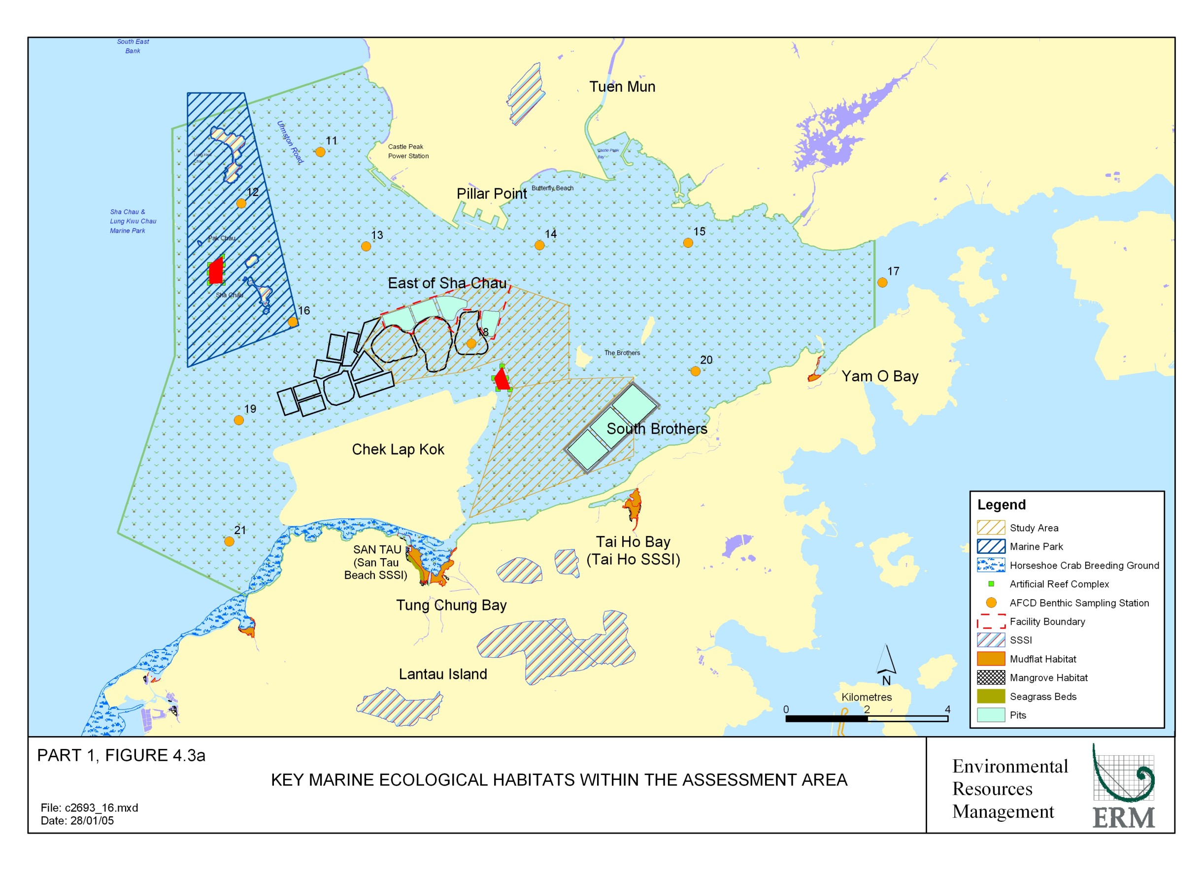
Key locations of each of the above habitats are presented in
Figure 4.3a.
The existing conditions of each of the
above habitats/organisms based on currently available literature, are presented
in the following sections. Based
on these conditions, the ecological value for each habitat has been determined
according to the EIAO-TM Annex 8 criteria, as follows:
·
Naturalness
·
Size
·
Diversity
·
Rarity
·
Re-creatability
·
Fragmentation
·
Ecological
Linkage
·
Potential
Value
·
Nursery
Ground
·
Age
·
Abundance
Soft Bottom Habitats
Subtidal Soft Bottom Habitats
Infauna
Soft sediments consisting of mud, clay and sand dominate the
seabed of Hong Kong. These soft
bottom habitats support both infauna and epibenthic faunal marine communities,
which in turn play a vital role as a food source for the majority of Hong
Kong’s inshore fisheries resources.
A number of studies provide information on infaunal assemblages with the
Study Area. The most recent of
these studies examined infaunal benthic assemblages throughout Hong Kong and,
using multivariate statistics, identified 5 major groupings of infauna ([7]).
The data from the studies allow a comparison to be made of the diversity
and abundance of infaunal benthic assemblages within the Study Area
(represented by Stations 11 – 21, with those throughout Hong Kong waters ([8]) (see Figure 4.3a).
From the summer survey results, it appears that all the
stations within the Study Area, with the exception of Stations 11 and 12 in the
vicinity of Lung Kwu Chau, lie within the same group as those in Western
Harbour, South Lantau waters, Southern and Eastern Waters, thus the majority of
stations in Hong Kong (48.5% of stations surveyed). Dominant fauna within this group were polychaetes. No species considered to be of high
ecological value were identified.
The two stations within the vicinity of Lung Kwu Chau were considered to
be more similar to stations in Deep Bay due to the presence of more freshwater
associated species present at these sites during the summer months. In contrast, during the winter months,
all stations within the Study Area were found to be similar to other stations
in Hong Kong (49.5% of stations surveyed). Dominant fauna within this group were again found to be
polychaetes. No species considered
to be of high ecological value were identified in the winter survey.
Based on the findings of the Hong Kong
wide survey, the benthic infaunal assemblages within the Study Area can be
expected to be typical of Hong Kong soft bottom habitats. Two stations, located within close
proximity to Lung Kwu Chau, were identified as demonstrating seasonal changes,
which are likely to be as a result of the more estuarine conditions experienced
at these sites ([9]) . The assemblages were all dominated by polychaetes and all
species recorded occur frequently in Hong Kong with no rare species
observed. Following the EIAO-TM
criteria, the ecological importance of the benthic infaunal assemblages
both within and within close proximity to, the proposed CMPs at South Brothers
and East of Sha Chau has been assessed in Table 4.7.
Table 4.7 Ecological Value of Benthic
Infaunal Assemblages at the proposed CMPs at South Brothers and East of Sha Chau
|
EIAO-TM Criteria |
South Brothers |
East of Sha Chau |
|
Naturalness |
The
assemblages are expected to be moderately disturbed due to fishing operations
and high marine traffic within these waters |
The
assemblages are expected to be moderately disturbed due to fishing operations
and high marine traffic within these waters |
|
Size |
Total
area of the temporarily affected subtidal habitats will involve approximately
164 hectares |
Total
area of the temporarily affected subtidal habitats will involve approximately
115 hectares |
|
Diversity |
The
assemblages are of similar diversity to the majority of other areas in Hong
Kong |
The
assemblages are of similar diversity to the majority of other areas in Hong
Kong |
|
Rarity |
No
organisms were found that are considered as rare |
No
organisms were found that are considered as rare |
|
Re-creatibility |
The
habitat can be expected to recreate naturally within a relatively short
timeframe through sediment deposition |
The
habitat can be expected to recreate naturally within a relatively short
timeframe through sediment deposition |
|
Fragmentation |
The
surrounding environment contains many other areas of soft substrate |
The
surrounding environment contains many other areas of soft substrate |
|
Ecological
Linkage |
The
benthic infauna act as a food source for epibenthic organisms |
The
benthic infauna act as a food source for epibenthic organisms |
|
Potential
Value |
Unlikely
that the site can develop conservation interest |
Unlikely
that the site can develop conservation interest |
|
Nursery
Ground |
None
identified |
None
identified |
|
Age |
The
sediments in the habitat are constantly accreting and eroding and the fauna
present there are typically short lived |
The
sediments in the habitat are constantly accreting and eroding and the fauna
present there are typically short lived |
|
Abundance |
Abundance
of infauna are comparable to the majority of other areas in Hong Kong |
Abundance
of infauna are comparable to the majority of other areas in Hong Kong |
|
Summary |
The
subtidal soft bottom habitat within the proposed CMP at South Brothers is
likely to support species that are typical of Hong Kong with no rare species
present. |
The
subtidal soft bottom habitat within the proposed CMP at East of Sha Chau is
likely to support species that are typical of Hong Kong with no rare species
present. |
|
Ecological
Value |
Low |
Low |
Epibenthic Fauna
Subtidal soft bottom habitats, as well as supporting
infaunal species, commonly support epibenthic macrofauna. These organisms are generally greater
than 1mm in size and live either on or within the surface sediments. As part of the ongoing monitoring
studies of the existing CMPs, data on the epibenthic fauna in vicinity of the
proposed CMPs have been extensively collected. Recent studies recorded species diversity as low in
comparison to other areas in Hong Kong.
Such characteristics have been attributed to periodic fluctuations in
the physio-chemical environment associated with Pearl River run-off and high
anthropogenic impact through intensive demersal trawling ([10]).
Additional studies have also found the epibenthic faunal species within
proximity to the proposed CMPs at South Brothers and East of Sha Chau to be
composed of low commercial value bivalve, crab and shrimp species, commonly
characterised by low abundance and diversity ([11]).
Following the EIAO-TM criteria, the ecological
importance of the epifaunal assemblages both within, and within close proximity
to the proposed CMPs at South Brothers and East of Sha Chau have been assessed
in Table 4.8.
Table 4.8 Ecological Value of Epifaunal Assemblages
at the proposed CMPs at South Brothers and East of Sha Chau
|
EIAO-TM Criteria |
South Brothers |
East of Sha Chau |
|
Naturalness |
The
assemblages are expected to be disturbed due to fishing operations within
these waters |
The
assemblages are expected to be disturbed due to fishing operations within
these waters |
|
Size |
Total
area of the temporarily affected subtidal habitats will involve approximately
164 hectares |
Total
area of the temporarily affected subtidal habitats will involve approximately
115 hectares |
|
Diversity |
The
assemblages are of low diversity compared to the majority of other areas in
Hong Kong |
The
assemblages are of low diversity compared to the majority of other areas in
Hong Kong |
|
Rarity |
No
organisms were found that are considered as rare |
No
organisms were found that are considered as rare |
|
Re-creatibility |
The
habitat can be expected to recreate naturally within a relatively short
timeframe |
The
habitat can be expected to recreate naturally within a relatively short
timeframe |
|
Fragmentation |
The
surrounding environment contains many other areas of similar substrate |
The
surrounding environment contains many other areas of similar substrate |
|
Ecological
Linkage |
Epibenthic
fauna act as a food source for demersal fisheries |
Epibenthic
fauna act as a food source for demersal fisheries |
|
Potential
Value |
Unlikely
that the site can develop conservation interest |
Unlikely
that the site can develop conservation interest |
|
Nursery
Ground |
None
identified |
None
identified |
|
Age |
The
fauna appear to be typical of those present in Hong Kong's Epibenthic fauna
assemblages |
The
fauna appear to be typical of those present in Hong Kong's Epibenthic fauna
assemblages |
|
Abundance |
Abundance
of epifauna is generally low in comparison to the majority of other areas in
Hong Kong |
Abundance
of epifauna is generally low in comparison to the majority of other areas in
Hong Kong |
|
Summary |
The
subtidal epibenthic fauna assemblages within the proposed CMP at South
Brothers are likely to be typical of common subtidal epibenthic fauna in Hong
Kong with no rare species present. |
The
subtidal epibenthic fauna assemblages within the proposed CMP at East of Sha
Chau are likely to be typical of common epibenthic fauna assemblages in Hong
Kong with no rare species present. |
|
Ecological
Value |
Low |
Low |
Intertidal Soft Bottom
Habitats
Mangroves
Mangroves provide food, shelter and breeding grounds for a
range of organisms including various pelagic and coastal fisheries, and
birds ([12]).
Three main mangrove stands are present within the Study Area located at
Tung Chung Bay, Tai Ho Bay and Yam O.
Within Tung Chung Bay, there are two separate stands, namely Tung Chung
Bay itself and San Tau Beach (see Figure 4.3a). On the basis of the presence of locally
rare mangroves and seagrass beds at San Tau Beach, this area covering
approximately 2.7 ha has been designated as an SSSI and is discussed later in
this section under the corresponding heading. One locally rare mangrove species has been recorded as
present in Tung Chung Bay (San Tau Beach) during a Hong Kong wide study on
mangrove habitats ([13]).
However, due to the relatively large mangrove stand at this site (2.14
ha) and high floristic diversity (18 mangrove species and associated flora),
this habitat ranked highly in comparison to other mangrove habitats in Hong
Kong.
The mangrove habitat at Tai Ho Bay was found to be smaller
in size (~1.9 ha) in comparison to that at Tung Chung Bay, with less floristic
diversity (12 species of mangrove and associated flora) ([14]).
The habitat is dominated by the relatively common mangrove Kandelia
candel.
Mangrove habitats have also been recorded at Yam O, in the
northeast of the Study Area which also support 2 small stands (~0.5 ha) ([15]).
Of the two mangrove stands at Yam O, one at the Luk Keng entrance and
one at Yam O Tuk (inner Yam O Bay), both were found to support moderate
floristic diversity in comparison to other mangrove habitats in Hong Kong,
particularly considering the small habitat size. However, both habitats appeared to be disturbed, possibly
due to the log storage area works in close proximity to the site and the nearby
Yam O reclamation works.
Following the EIAO-TM criteria, the ecological
importance of mangrove habitats within the Study Area for the proposed CMPs at
South Brothers and East of Sha Chau has been assessed in Table 4.9.
Table
4.9 Ecological
Value of Mangrove Habitats within the Study Area for the proposed CMPs at South
Brothers and East of Sha Chau
|
EIAO-TM Criteria |
Mangrove Habitat |
||
|
Tung Chung Bay |
Tai Ho Bay |
Yam O Bay |
|
|
Naturalness |
The
habitat is natural, although potentially affected by the Tung Chung
Development |
The
habitat is natural |
The
habitat is natural, although potentially affected by the Yam O reclamation |
|
Size |
The
2 stands are both large (2.7 and 2.14ha) |
Mangrove
stand is medium in size (1.9ha) |
Mangrove
stand is small ~0.5ha |
|
Diversity |
Diversity
is high in comparison to other mangroves in Hong Kong |
Diversity
is similar to other mangroves in Hong Kong |
Diversity
is moderate in comparison to other sites in Hong Kong |
|
Rarity |
One
locally rare mangrove species has been recorded at San Tau Beach within Tung
Chung Bay |
No
rare mangrove species recorded |
No
rare mangrove species recorded |
|
Re-creatibility |
Although
re-creatable, the habitat may not return to it original status |
Although
re-creatable, the habitat may not return to it original status |
Habitat
is considered poor thus re-creatable |
|
Fragmentation |
The
mangrove stand at this site is not fragmented |
The
mangrove stand at this site is not fragmented |
The
mangroves at this site are fragmented |
|
Ecological
Linkage |
Site
also includes mudflat, seagrass and horseshoe crab habitat |
Site
also includes mudflat, seagrass and horseshoe crab habitat |
Site
also includes mudflat and seagrass habitat |
|
Potential
Value |
Mangroves
provide high value habitat |
Mangroves
provide high value habitat |
Mangroves
provide high value habitat |
|
Nursery
Ground |
Mangroves
act as a nursery ground for many species |
Mangroves
act as a nursery ground for many species |
Mangroves
act as a nursery ground for many species |
|
Age |
Mangrove
habitat are relatively slow growing |
Mangrove
habitat are relatively slow growing |
Mangrove
habitat are relatively slow growing |
|
Abundance |
Abundance
of mangroves is high in comparison to other sites in Hong Kong |
Abundance
is similar to other mangroves in Hong Kong |
Abundance
is low in comparison to other sites in Hong Kong |
|
Summary |
The
mangrove habitat has high species diversity and is large in comparison to
other sites in Hong Kong. The
site has associated mudflat and seagrass habitat and has been recorded as a
nursery ground for horseshoe crabs in Hong Kong. |
The
mangrove habitat has medium species diversity in comparison to other sites in
Hong Kong. The site has
associated mudflat and seagrass habitat and has been recorded as a nursery
ground for horseshoe crabs in Hong Kong. |
The
mangrove habitat is small in comparison to other sites in Hong Kong with
moderate species diversity. The site has associated mudflat and
seagrass habitat, however, is potentially under continued stress from nearby
works. |
|
Ecological
Value |
High |
Medium |
Low |
Mudflats & Horseshoe Crab Habitats
Mudflats are classified as areas of fine-grained sediment
(ie silt or fines) which lie between the high and low tide marks which are not
covered by seagrass, mangroves or typical wetland vegetation and are generally
fed with freshwater streams.
Generally considered to be habitats of ecological importance, mudflats
provide key breeding grounds for a variety of species, and species present
there act as food source for both fish and, resident and wintering birds in
Hong Kong.
Mudflats occur throughout Hong Kong, with the largest
present in the Deep Bay area.
Within the Study Area, each of the above locations described above for
mangrove habitats also have mudflat habitats present (see Figure 4.3a). In addition of these mudflat habitats,
those at Tung Chung Bay and Tai Ho Bay have been identified as having juvenile
horseshoe crabs, namely the species Tachypleus tridentatus and Carcinoscorpius
rotundicauda, recorded at each site ([16]) ([17]). In addition, recent surveys at Tai Ho Bay identified
breeding pairs Carcinoscorpius rotundicauda present ([18]).
Following the EIAO-TM criteria, the ecological
importance of mudflat habitats within the Study Area for the proposed CMPs at
South Brothers and East of Sha Chau has been assessed in Table 4.10.
Table 4.10 Ecological Value of Mudflat and
Horseshoe Crab Habitats within the Study Area for the proposed CMPs at South
Brothers and East of Sha
Chau
|
EIAO-TM Criteria |
Mudflat and Horseshoe Crab Habitat |
||
|
Tung Chung Bay |
Tai Ho Bay |
Yam O Bay |
|
|
Naturalness |
The
mudflats are natural but under stress from surrounding works and shellfish
collection |
The
mudflats are natural |
The
mudflats are natural but under stress from surrounding works |
|
Size |
In
comparison to other mudflats in Hong Kong the habitat is of medium size |
In
comparison to other mudflats in Hong Kong the habitat is of medium size |
In
comparison to other mudflats in Hong Kong the habitat is of small size |
|
Diversity |
In
general species diversity on mudflats is high |
In
general species diversity on mudflats is high |
In
general species diversity on mudflats is high |
|
Rarity |
Two
species of horseshoe crab have been identified as using these mudflats |
Two
species of horseshoe crab have been identified as using these mudflats |
No
rare species have been identified |
|
Re-creatibility |
The
habitat can be expected to recreate naturally within a relatively short
timeframe |
The
habitat can be expected to recreate naturally within a relatively short
timeframe |
The
habitat can be expected to recreate naturally within a relatively short
timeframe |
|
Fragmentation |
The
mudflats at this site are relatively unfragmented |
The
mudflats at this site are relatively unfragmented |
The
mudflats at this site are relatively fragmented |
|
Ecological
Linkage |
Site
also contains mangroves and seagrass species |
Site
also contains mangroves and seagrass species |
Site
also contains mangroves and seagrass species |
|
Potential
Value |
The
site is of conservation interest |
The
site is of conservation interest |
The
site is of limited conservation interest due to small size and potential
impact of nearby works |
|
Nursery
Ground |
Mudflats
act as a nursery ground for numerous species. Also identified as nursery ground for two species of
horseshoe crab |
Mudflats
act as a nursery ground for numerous species. Also identified as nursery ground for two species of
horseshoe crab |
Mudflats
act as a nursery ground for numerous species. |
|
Age |
Mudflats
constantly accreting and eroding and the fauna present there are typically
short lived |
Mudflats
constantly accreting and eroding and the fauna present there are typically
short lived |
Mudflats
constantly accreting and eroding and the fauna present there are typically
short lived |
|
Abundance |
Mudflats
generally support organisms in high abundances in comparison to other marine
habitats |
Mudflats
generally support organisms in high abundances in comparison to other marine
habitats |
Mudflats
generally support organisms in high abundances in comparison to other marine
habitats |
|
Summary |
The
mudflats at Tung Chung Bay provide a nursery ground for horseshoe crabs in
Hong Kong and have associated mangrove and seagrass habitat. |
The
mudflats at Tai Ho Bay provide a nursery ground for horseshoe crabs in Hong
Kong and have associated mangrove and seagrass habitat. |
The
mudflats at Yam O Bay have associated mangrove and seagrass habitat, however,
are under stress from nearby works |
|
Ecological
Value |
Medium |
High |
Low |
Seagrass
Seagrass beds occur in shallow, sheltered or subtidal areas
and are recognised as areas of high biological productivity. They provide high value habitat as
feeding and nursery ground for a range of marine species ([19]).
Within Hong Kong, seagrass beds have been recorded with a very low
distribution, occupying less than 0.1% of the total land area. Nevertheless, within the Study Area,
three sites have been identified where seagrass beds have been recorded, namely
San Tau, Tai Ho Bay and Yam O Bay ([20]) (see Figure 4.3a).
The mudflats at Yam O Bay and San Tau
support seagrass beds of Halophila ovalis, with Zostera japonica
also present at San Tau. Although
the latter of these species has been recorded elsewhere in Hong Kong, San Tau
represents this species only habitat, albeit of a relatively small size (15m2),
on Lantau. In contrast, the
seagrass beds (500m2) at Tai Ho Bay are seasonal and consist solely
of the species Halophila beccarii.
Studies on this species appear to indicate that the habitat is an
important feeding ground for juvenile horseshoe crabs ([21]).
Following the EIAO-TM criteria, the ecological
importance of seagrass beds within the Study Area for the proposed CMPs at
South Brothers and East of Sha Chau has been assessed in Table 4.11.
Table
4.11 Ecological
Value of Seagrass Beds within the Study Area for the proposed CMPs at South
Brothers and East of Sha Chau
|
EIAO-TM Criteria |
Seagrass Beds |
||
|
San Tau |
Tai Ho Bay |
Yam O Bay |
|
|
Naturalness |
The
seagrass beds are natural but under stress from surrounding works and
shellfish collection |
The
seagrass beds are natural |
The
seagrass beds are natural but under stress from surrounding works |
|
Size |
Size
of the Zostera japonica bed is relatively small (15m2) but
the Halophila ovalis bed is large (2 ha) |
Size
of the seagrass bed is medium (500m2) |
Size
of the seagrass bed is relatively large (~ 1 ha) |
|
Diversity |
In
general, species diversity associated with seagrass beds is high |
In
general, species diversity associated with seagrass beds is high |
In
general, species diversity associated with seagrass beds is high |
|
Rarity |
Seagrass
beds are relatively rare in Hong Kong.
In addition, this site represents the only Zostera japonica habitat
on Lantau. Two species of
horseshoe crab have also been identified as using these seagrass beds |
Seagrass
beds are relatively rare in Hong Kong.
In addition, two species of horseshoe crab have been identified as
using these seagrass beds |
Seagrass
beds are relatively rare in Hong Kong.
|
|
Re-creatibility |
Seagrass
beds have been found to be difficult to re-create in Hong Kong |
Seagrass
beds have been found to be difficult to re-create in Hong Kong |
Seagrass
beds have been found to be difficult to re-create in Hong Kong |
|
Fragmentation |
The
seagrass beds at this site are relatively unfragmented |
The
seagrass beds at this site are relatively unfragmented |
The
seagrass beds at this site are relatively unfragmented |
|
Ecological
Linkage |
Site
also contains mangroves and mudflat habitat |
Site
also contains mangroves and mudflat habitat |
Site
also contains mangroves and mudflat habitat |
|
Potential
Value |
The
site is of conservation interest |
The
site is of conservation interest |
The
site is of conservation interest |
|
Nursery
Ground |
Seagrass
beds act as a nursery ground for numerous species. Also identified as nursery ground for two species of
horseshoe crab |
Seagrass
beds act as a nursery ground for numerous species. Also identified as nursery ground for two species of
horseshoe crab |
Seagrass
beds act as a nursery ground for numerous species. |
|
Age |
The
seagrass beds at this site are somewhat seasonal, therefore, relatively
short-lived |
The
seagrass beds at this site are somewhat seasonal, therefore, relatively
short-lived |
The
seagrass beds at this site are somewhat seasonal, therefore, relatively
short-lived |
|
Abundance |
Seagrass
at this site is of relatively low abundance |
Seagrass
at this site is of medium abundance |
Seagrass
at this site is of medium abundance |
|
Summary |
The
seagrass beds atSan Tau within Tung Chung Bay provide a nursery ground for
horseshoe crabs in Hong Kong and have associated mangrove and mudflat
habitat. Although small in size, these seagrass beds are the only site on
Lantau for Zostera
japonica |
The
seagrass beds at Tai Ho Bay provide a nursery ground for horseshoe crabs in
Hong Kong and have associated mangrove and mudflat habitat. |
The
seagrass beds at Yam O Bay have associated mangrove and mudflat habitat,
however, are under stress from nearby works |
|
Ecological
Value |
High |
Medium |
High |
Hard Bottom Habitats
Subtidal Hard Bottom Habitats
As described above, the majority of the subtidal habitat
within Hong Kong waters, including those within the Study Area, consists of
soft bottom habitat. However,
closer to the shoreline, the seabed will be commonly composed of hard bottom
habitat, so much so that approximately 80% of Hong Kong's complex shorelines and
many islands are composed of rocky outcrops. Of the numerous marine organisms that inhabit this
substratum, corals, due to the protected status and ecological value, are of
particular concern.
Over 80 species of coral occur in Hong Kong, with the
highest diversities recorded in eastern waters. It appears that coral distribution in Hong Kong is primarily
controlled by hydrodynamic conditions as Hong Kong’s western waters are
influenced by the Pearl River, which lowers salinities and generally records
higher concentrations of suspended solids. As such, the western waters of Hong Kong, in which the Study
Area is located has previously been identified as being relatively devoid of
coral species ([22]) ([23]).
Surveys of subtidal hard bottom habitats within the Study
Area, excluding Artificial Seawalls (see below) have, however, indicated the
presence of both hard and soft corals, albeit in both limited density and of
limited diversity. Scattered
hermatypic hard corals (family Faviidae), ahermatypic gorgonian seawhips and
seapens have been identified within the Sha Chau and Lung Kwu Chau Marine Park,
whereas, ahermatypic cup corals, soft corals such as Dendronephthya spp
and seapens have also been recorded on the northern shore of the Study Area in
the vicinity of Sham Tseng ([24]) ([25]).
Hermatypic hard corals possess vast numbers of symbiotic
unicellular algae (zooxanthellae) within their endodermal lining. These photosynthesising algae require
light for growth. The low salinity
conditions coupled with high levels of suspended solids, which reduce light
penetration, of the Study Area, reduce the potential for colonies of corals of
high ecological value to be present.
Following the EIAO-TM criteria, the ecological
importance of subtidal hard bottom habitats within the Study Area for the
proposed CMPs at South Brothers and East of Sha Chau has been assessed in
Table 4.12.
Table 4.12 Ecological
Value of Subtidal Hard Bottom Habitats within the Study Area for the proposed
CMPs at South Brothers and East of Sha Chau
|
EIAO-TM Criteria |
Study Area |
|
Naturalness |
There
is limited natural subtidal hard bottom habitat within the study area |
|
Size |
No
subtidal hard bottom habitat will be permanently affected by the proposed
works |
|
Diversity |
Due
to the estuarine conditions, diverse assemblages are not expected to be
present |
|
Rarity |
No
rare species are expected to be present |
|
Re-creatibility |
Subtidal
hard bottom habitats can be re-created |
|
Fragmentation |
The
subtidal hard bottom habitat within the Study Area is fragmented |
|
Ecological
Linkage |
The
subtidal hard bottom habitats within the Study Area have low ecological
linkage with habitats of conservation interest |
|
Potential
Value |
Unlikely
that these habitats can develop conservation interest within the Study Area |
|
Nursery
Ground |
Unlikely
that these habitats act as nursery grounds within the Study Area |
|
Age |
Subtidal
hard bottom habitats within the study area are not expected to be mature |
|
Abundance |
Abundance
of subtidal hard bottom associated species is expected to be low |
|
Summary |
Due
to extensive development in the area, natural subtidal hard bottom habitat
within the Study Area is limited.
Artificial subtidal hard bottom habitat (eg seawalls) generally
support less abundance and diversity than natural substratum. However, the estuarine conditions of
the Study Area generally do not support subtidal hard bottom species of
conservation interest. |
|
Ecological
Value |
Low |
Intertidal Hard Bottom Habitats
The majority of the coastal areas in the Study Area,
although particularly in vicinity of the proposed CMPs at South Brothers and
East of Sha Chau, have been reclaimed, thus in general artificial seawalls have
replaced naturally occurring intertidal hard bottom habitats. The largest of these seawalls is at the
Chek Lap Kok International Airport (see Figure 4.3a). Surveys have been conducted on the
colonisation of organisms on artificial seawalls in Hong Kong and fouling
organisms have been recorded as common on such artificial seawalls, wharf piles
and other marine structures ([26]).
A relatively recent survey on the artificial seawall at the
Chek Lap Kok International Airport found that colonisation had occurred by
organisms such as polychaetes and bivalves, however, the habitat was considered
to be in poor condition ([27]).
Whilst colonisation of organisms considered to be of high ecological
value, such as corals, has been recorded on artificial seawalls or structures
in the waters in the east of Hong Kong, it is unlikely for the reasons stated
above (see Subtidal Hard Bottom Habitats) that the artificial seawalls
in the Study Area will be able to support high ecological value
assemblages ([28]).
Following the EIAO-TM criteria, the ecological
importance of intertidal hard bottom habitats within the Study Area for the
proposed CMPs at South Brothers and East of Sha Chau has been assessed in Table 4.13.
Table
4.13 Ecological
Value of Intertidal Hard Bottom Habitats within the Study Area for the proposed
CMPs at South Brothers and East of Sha Chau
|
EIAO-TM Criteria |
Study Area |
|
Naturalness |
There
is limited natural intertidal hard bottom habitat within the study area |
|
Size |
No
intertidal hard bottom habitat will be permanently affected by the proposed
works |
|
Diversity |
Due
to the estuarine conditions, diverse assemblages are not expected to be
present |
|
Rarity |
No
rare species are expected to be present |
|
Re-creatibility |
Intertidal
hard bottom habitats can be re-created |
|
|
The
intertidal hard bottom habitat within the Study Area is fragmented |
|
Ecological
Linkage |
The
intertidal hard bottom habitats within the Study Area have low ecological
linkage with habitats of conservation interest |
|
Potential
Value |
Unlikely
that these habitats can develop conservation interest within the Study Area |
|
Nursery
Ground |
Unlikely
that these habitats act as nursery grounds within the Study Area |
|
Age |
Intertidal
hard bottom habitats within the study area are not expected to be mature |
|
Abundance |
Abundance
of intertidal hard bottom associated species is expected to be low |
|
Summary |
Due
to extensive development in the area, natural intertidal hard bottom habitat
within the Study Area is limited.
Artificial intertidal hard bottom habitats (eg seawalls) generally
support less abundance and diversity than natural substratum. However, the estuarine conditions of
the Study Area generally do not support intertidal hard bottom species of
conservation interest. |
|
Ecological
Value |
Low |
Marine Mammals
There are two resident species of cetacean in Hong Kong’s
waters, the Finless Porpoise (Neophocaena phocaenoides) and the Indo-Pacific
Humpback Dolphin, (Sousa chinensis). Recent studies appear to indicate that the Finless Porpoise
only occurs in the southern and eastern waters of Hong Kong, with no sightings
being recorded in the Study Area ([29]) (2) (3).
The distribution, abundance, habitat use, and life history
of Indo-Pacific Humpback Dolphins in Hong Kong has been extensively studied
since 1995 ([30])(4). The distribution and abundance of dolphins has been studied
using line transect methods allowing any patterns to be determined. As sightings are obtained relative to
known levels of search effort, corresponding densities have been obtained.
The line transect analysis of vessel surveys
undertaken from 1995 to 2003 for the Indo-Pacific Humpback Dolphin Monitoring
Programme showed that the abundance of dolphins is highest in the North Lantau
area in all four seasons Figure
4.Figure 4.Figure4.3b.
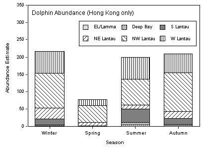
Figure 4.3b Estimates of abundance of Indo-Pacific Humpback Dolphins in Hong Kong waters, based on
line transect analysis of vessel surveys from 1995 to 2003 ([31])
In spring, almost all sightings of the Indo-Pacific Humpback Dolphins in Hong Kong
have been made in North Lantau with a seasonal influx of individuals into South
Lantau (and to a lesser extent, Deep Bay and East Lantau/Lamma areas) during
summer, autumn and winter. The
seasonal influx of Indo-Pacific
Humpback Dolphins is thought to be due to the spread of freshwater from the Pearl River,
directly to the west of Hong Kong ([32]). Indo-Pacific Humpback Dolphins are present in
Hong Kong waters in their highest densities in summer and lowest in spring ([33]) ([34]). The proportion of the local population
that utilize the North Lantau waters as opposed to other areas of Hong Kong
varies from 72% in spring to 92% in winter when the abundance of Indo-Pacific Humpback Dolphins occurring in
Hong Kong waters is at its lowest ([35]).
According to data from the Agriculture, Fisheries and
Conservation Department, which has been collected between 1995 and 2004, it
appears that the use of waters by Indo-Pacific Humpback Dolphins within the Study Area is not
uniform (Figure
4Figure
4Figure 4.3c to Figure
4.Figure
4.Figure 4.3g).
In all four seasons, Indo-Pacific
Humpback Dolphins are most abundant in the western waters between Castle Peak and Black
Point in the east and the islands of Sha Chau and Lung Kwu Chau in the
west. High densities have also been
recorded in areas to the north of the airport especially near the northeast
corner and around the Brothers Islands ([36]).
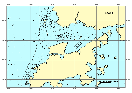
Figure
4.3c Indo-Pacific
Humpback Dolphin distribution in the Study Area in Spring (Data collected
between 1995 and 2004) ([37]).
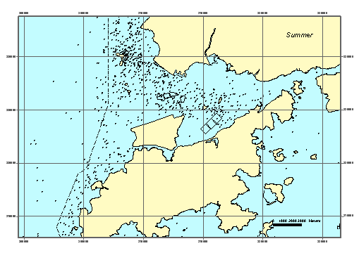
Figure 4.3d Indo-Pacific Humpback Dolphin
distribution in the Study Area in Summer (Data collected between 1995 and 2004) ([38]).
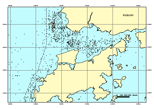
Figure 4.3e Indo-Pacific Humpback Dolphin
distribution in the Study Area
in Autumn (Data collected between 1995 and 2004) ([39]).
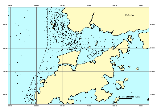
Figure 4.3f Indo-Pacific Humpback Dolphin
distribution in the Study Area in Winter (Data collected between 1995 and 2004) ([40]).
The exact status of the Hong Kong population of the
Indo-Pacific Humpback Dolphin is not known with certainty. An analysis of recent dolphin data by
Dr Thomas Jefferson for the present study comprises data collected between 1995
and mid 2002 appears to indicate that the population may be relatively stable, or at
least that it is probably not decreasing at a rapid rate (Figure 4.3g) ([41]).
Studies have also revealed several areas of very low
Indo-Pacific Humpback Dolphin density in the North Lantau area. One of these is the region along shore
from Pillar Point to Brothers Point in the vicinity of the proposed CMPs at
East of Sha Chau. Another such
region is in the approximate location of the CMP at South Brothers, ie directly
to the east of the airport platform and extending east along the Lantau
coastline to Sham Shui Kok. Within
this area very low numbers of dolphins have been sighted in comparison to other
areas in North Lantau waters and in Hong Kong. It should also be noted that the coastline of West Lantau has
densities of Indo-Pacific Humpback Dolphin among the highest known in Hong Kong
Figure 4.3h.
Based on the review of baseline information on Indo-Pacific
Humpback Dolphins in Hong Kong, it appears that the areas proposed for CMPs at
South Brothers and East of Sha Chau have both recorded low sightings of
dolphins in comparison to other areas in North Lantau and Hong Kong.
Following the EIAO-TM criteria, the ecological
importance of the waters within the proposed CMPs at South Brothers and East of
Sha Chau for marine mammals has been assessed in Table 4.14.
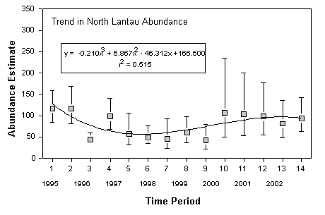
Figure 4.3g Trends in abundance of
Indo-Pacific Humpback Dolphins in North Lantau (data collected between 1995 and
2002)