CONTENTS
1 Introduction
1.1 General
1.2 Project Background
1.3 Purpose and Approach of the EIA Study
1.4 Structure of this EIA Study Report
2 project description
2.1 Key Project Requirements
2.2 Project History and Site Selection
2.3 Project Characteristics and Site Location
2.4 Nearby Projects
2.5 Likely Future Environmental Conditions
Without the Project
3 Air Quality impact assessment
3.1 Introduction
3.2 Relevant Guidelines, Standards &
Legislation
3.3 Baseline Conditions and Air Sensitive
Receivers
3.4 Construction Dust Impact Assessment
3.5 Mitigation Measures
3.6 Environmental Monitoring and Audit
Requirements
3.7 Conclusions and Recommendations
4 Noise impact assessment
4.1 Introduction
4.2 Relevant Guidelines, Standards &
Legislation
4.3 Noise Sensitive Receivers
4.4 Noise Environment at Peng Chau
4.5 Construction Noise Impact Assessment
4.6 Operational Noise Impact Assessment
4.7 Environmental Monitoring and Audit
Requirements
4.8 Conclusions and Recommendations
4.9 References
5 Waste MANAGEMENT aSSESSMENT
5.1 Introduction
5.2 Legislation & Standards
5.3 Baseline Conditions & Sensitive
Receivers
5.4 Assessment Methodology
5.5 Waste Types
5.6 Impact Assessment and Evaluation
5.7 Summary of Waste Materials Generated
5.8 Impact Mitigation & Residual Impact
Assessment
5.9 Environmental Monitoring and Audit
Requirements
5.10 Conclusions and Recommendations
5.11 References
6 water quality impact assessment
6.1 Introduction
6.2 Assessment Approach
6.3 Regulations, Standards and Guidelines
6.4 Baseline Conditions
6.5 Assessment Approach & Methodology
6.6 Impact Assessment & Evaluation
6.7 Impact Mitigation & Residual Impact
Assessment
6.8 Environmental Monitoring & Audit
6.9 Conclusions and Recommendations
6.10 References
7 Ecology
7.1 Introduction
7.2 Assessment Approach
7.3 Regulations, Standards and Guidelines
7.4 Ecological Baseline
7.5 Impact Assessment & Evaluation
7.6 Impact Mitigation & Residual Impact
Assessment
7.7 Environmental Monitoring & Audit
Requirements
7.8 Conclusions & Recommendations
7.9 References
8 fisheries
8.1 Introduction
8.2 Assessment Approach
8.3 Applicable Regulations, Standards
and Guidelines
8.4 Assessment Methodology
8.5 Fisheries Baseline
8.6 Impact Assessment & Evaluation
8.7 Impact Mitigation & Residual Impact Assessment
8.8 Environmental Monitoring & Audit
Requirements
8.9 Conclusions & Recommendations
8.10 References
9 CULTURAL HERITAGE IMPACT ASSESSMENT
9.1 Introduction
9.2 Assessment Approach
9.3 Regulations, Standards and Guideline
9.4 Assessment Methodology
9.5 Baseline Conditions
9.6 Impact Assessment and Evaluation
9.7 Impact Mitigation & Residual Impact
Assessment
9.8 Environmental Monitoring & Audit
9.9 Conclusions & Recommendations
9.10 References
10 Implementation
Schedule of Recommended Mitigation Measures
10.1 Introduction
11 summary Conclusion & recommendations
11.1 Summary Conclusion of Technical Assessments
11.2 Key Recommendations
11.3 Summary of Environmental Outcomes
LIST OF FIGURES
Figure 2.1 Peng
Chau Helipad Siting Options
Figure 2.2 Peng
Chau Helipad – Site Location
Figure 3.1 Proposed
Helipad Location and Environs
Figure 4.1 Representative
Noise Sensitive Receiver Locations
Figure 4.2 Geographical
Centres of Construction Activities
Figure 4.3 Approach
and Departure Area and Surface Profile
Figure 4.4a Index
Plan for Cross Sections between NSR and Helipad
Figure 4.4b Index
Plan for Cross Sections between NSR and Flight Path
Figure 4.5a Cross
Sectional View for NSR to the Helipad (NSR1, NSR2, NSR3)
Figure 4.5b Cross
Sectional View for NSR to the Helipad (NSR4, NSR5, NSR6)
Figure 4.5c Cross
Sectional View for NSR to Flight Path (NSR3, NSR4)
Figure 4.5d Cross
Sectional View for NSR to Flight Path (NSR5, NSR6)
Figure 4.6 Illustration
of Affected Area by Helicopter Noise
Figure 5.1 Cross
Section of Helipad Footprint
Figure 5.2 EVA
Footprint – Cross Section A
Figure 5.3 Helipad
Footprint – Cross Section B and C
Figure 6.1 Frequency
and Direction of Current Velocity at Peng Chau
Figure 6.2 Cumulative
Spatial Extent of Construction Phase Mixing Zone
Figure 7.1 Ecology
Assessment Area and Sensitive Receivers
Figure 7.2 Habitat
Map of the Peng Chau Study Area
Figure 7.3 Habitat
Photographs
Figure 8.1 Fisheries
Areas of Peng Chau
Figure 9.1 Marine
Geophysical / Marine Archaeology Survey Area and Sea Floor Features of Note
LIST OF TABLES
Table
2.1 Summary Matrix for
Evaluation of Helipad Site Options & Alternatives
Table 2.2 Summary
of Peng Chau Helipad Construction Programme
Table 3.1 Hong
Kong Air Quality Objectives
Table 3.2 Annual Average Pollution
Concentrations Recorded in Tap Mun (Year 2002)
Table 4.1 Recommended
Construction Noise Levels (Non-restricted Hours)
Table 4.2 Area
Sensitivity Rating Criteria
Table 4.3 Acceptable
Noise Levels in Leq(5 min) dB(A)
Table 4.4 Helicopter
Noise Standards for Planning Purposes
Table 4.5 Location
of NSR Assessment Points in Peng Chau
Table 4.6 Noise
Monitoring Results at Sea Crest Villa
Table 4.7 Powered
Mechanical Equipment to be used for Construction of Helipad
Table 4.8 Construction
Activities
Table 4.9 Predicted
Construction Noise Levels Leq(30 min) dB(A) - Unmitigated
Table 4.10 Sound
Power Levels for the Silenced Equipment
Table 4.11 Predicted
Construction Noise Levels Leq(30 min) dB(A) – Mitigated
Table 4.12 Predicted
Cumulative Construction Noise Levels Leq(30 min) dB(A) at NSR1
Table 4.13 Helicopter
Noise Data – Airborne Helicopter with Lateral Movements
Table 4.14 Measured
Lmax Noise Level of GFS Helicopters – Without Lateral Movements
Table 4.15 Helicopter
Use for Peng Chau ‘Casevac’ Operations during years 2000 – 2004
Table 4.16 Worst-case
Helicopter Noise Levels at NSRs during Helicopter Manoeuvring
Table 4.17 Worst-case
Helicopter Approach / Departure Noise Levels at NSRs
Table 5.1 Material
Import Requirements
Table 5.2 Summary
of Construction Phase Waste Generation
Table 6.1 Relevant
Water Quality Objectives for Southern WCZ
Table 6.2 Summary of Water
Quality at ‘SM10’ between 1997 and 2001
Figure 6.1 Frequency
and Direction of Current Velocity at Peng Chau
Table 6.3 Predicted
SS Elevation
Table 7.1 Representative
Species in the Peng Chau Marine Benthic Community (CityU, 2002)
Table 7.2 Univariate
Statistics for S. Peng Chau & Similar HKSAR Survey Areas (CityU, 2002)
Table 7.3 Habitat
Types in the Assessment Area
Table 7.4 Categorisation
of Benthic Cover and Substrate
Table 7.5 Rank
Abundance of Pak Wan Sub-tidal Benthic Community
Table 7.6 Inter-tidal
Survey Data for Pak Wan (BMT, October 2002)
Table 7.7 Butterfly Survey Data
for Pak Wan, Peng Chau (BMT, 2002 & 2003)
Table 7.8 Bird Survey Data for
Northwest Peng Chau (BMT, 2002 & 2003)
Table 7.9 Ecological
Evaluation of the Sub-tidal Habitat
Table 7.10 Ecological
Evaluation of the Sandy Shore (Beach) habitat
Table 7.11 Ecological
Evaluation of the Hard Shore habitat
Table 7.12 Ecological
Evaluation of the Coastal Scrub habitat
Table 7.13 Ecological
Evaluation of the Secondary Woodland habitat
Table 7.14 Ecological
Evaluation of the Developed / Disturbed Area
Table 7.15 Summary
of Ecological Impacts
Table 8.1 Top Ten
Ranked Adult Fish / Crustacean Families (from AFCD, 2003)
Table 8.2 Top
Adult Fish / Crustacean Species by Weight from Peng Chau (AFCD, 1998)
Table 8.3 Production
of Peng
Chau Fisheries Areas (AFCD, 1998)
Table 8.4 Production
Range for Fishing Methods at Peng Chau (AFCD, 2003)
Table 8.5 Commercial
Value of Top Adult Fish Species around Peng Chau (AFCD, 1998; BMT, 2003).
Table 8.6 Common
Fish Catch species at Northwest Peng Chau (BMT, 2003)
Table 10.1 Air Quality – Implementation
Schedule of Recommended Mitigation Measures
Table 10.2 Noise – Implementation
Schedule of Recommended Mitigation Measures
Table 10.3 Waste Management –
Implementation Schedule of Recommended Mitigation Measures
Table 10.4 Water
Quality – Implementation Schedule of Recommended Mitigation Measures
Table 10.5 Ecology
– Implementation Schedule of Recommended Mitigation Measures
Table 10.6 Fisheries
– Implementation Schedule of Recommended Mitigation Measures
LIST OF
Appendices
Appendix 2.1 Visual Illustrations
Appendix 2.2 Construction Schedule
Appendix 2.3 Construction Schedule for DSD’s Sewage
Treatment Works Upgrade
Appendix 4.1 Construction Equipment Inventory
Appendix 4.2 Construction Noise Calculation – Unmitigated
Appendix 4.3 Construction Noise Calculation – Mitigated
Appendix 4.4 Cumulative Construction Noise Calculation
Appendix 4.5 Helicopter Noise Measurement Points and
Noise Levels
Appendix 4.6 Helicopter Noise Survey Report
Appendix 4.7 Helicopter Noise Calculations
Appendix 5.1 Historical Sediment Quality Monitoring
Locations & Results at Peng Chau
Appendix 5.2 Sediment Classification Flow Chart
Appendix 5.3 Actual Sediment Sampling Locations within
Helipad Footprint
Appendix 6.1 Summary
of Sediment Quality for Routine Marine Sediment Quality Monitoring Station
‘SS5’ (1997 - 2000)
Appendix 7.1 Rapid Ecological Assessment (REA)
Evaluation Framework
Appendix 7.2 Inter-tidal Survey Data for Pak Wan (BMT,
April 2003)
Appendix 7.3 Marine Habitat Loss / Disturbance
Calculations
1
Introduction
1.1
General
1.1.1
In August 2002 BMT Asia Pacific
Limited (BMT) was awarded the contract for Agreement No. CE 18/2002: Environmental Impact Assessment Study for
Construction of Helipads at Peng Chau and Lamma Island / Investigation by
the Civil Engineering Office, Civil Engineering & Development Department
(CEDD).
1.1.2
The Agreement requires the completion
of Environmental Impact Assessment (EIA) studies for two proposed helipads: one
at Peng Chau and one Yung Shue Wan, Lamma Island.
1.1.3
This Report presents the approach to
and findings of the EIA study for the proposed Peng Chau helipad, and follows the requirements of Environmental Impact Assessment Study Brief No. ESB-091/2001.
1.2
Project Background
1.2.1
The Project involves the construction
and operation of a permanent helipad at Peng Chau, and is ‘designated’ under
Item B.2, Schedule 2 of the Environmental Impact Assessment Ordinance (EIAO) by
virtue of being: “A helipad within 300m
of existing or planned residential development”. Accordingly, an Environmental Permit is required for the Project.
1.2.2
The Project has
been planned and managed in-house by the Land Works Division of CEDD.
Construction works are to be completed by contractors under CEDD’s
supervision. CEDD will hand over the
helipad to the management department (yet to be determined) upon its
commissioning.
1.2.3
The
helipad is solely required for transporting Peng Chau
residents to urban areas for medical treatment in emergency situations, and is
not for commercial use. The current Peng Chau helipad is located on a soccer pitch near Tai
Lung Tsuen and is the only landing site for the island. This site, located at the top of a hill, is
still being used by Government Flying Service (GFS) for casualty evacuation (‘casevac’) operations but is not considered ideal on flight safety
grounds, as the site constitutes a confined area – being surrounded by tall
lighting posts.
1.2.4
Furthermore, the Tai Lung Tsuen
landing site is only accessible by climbing long stairs. Vehicle access is
impossible, and so the current helipad is very inconvenient for paramedics who
presently must carry patients up the stairs by foot. The path to the existing landing site cannot be upgraded without
significant reconstruction works, including partial demolition of village
property. As such, the anticipated
environmental and community impact associated with such upgrade works would be
considerable. In view of the present
situation, the Home Affairs Department (HAD) had commissioned CEDD to construct
a permanent helipad to serve the local community.
1.2.5
A full description of the Project is
presented in Section 2 of this
Report.
1.3
Purpose and Approach of the EIA Study
1.3.1
The
purpose of this EIA Study is to provide information on the nature and extent of
environmental impacts arising from the Project and other concurrent works. This information will contribute to decisions by the Director of the
Environmental Protection Department (EPD) on:
(i)
The overall acceptability of
any adverse environmental consequences that are likely to arise as a result of
the proposed Project;
(ii)
The conditions and
requirements for the detailed design, construction and operation of the
proposed Project to mitigate against adverse environmental consequences
wherever practicable; and
(iii)
The acceptability of
residual impacts after implementation of proposed mitigation measures.
1.3.2
Satisfying the aims of the EIA Study has been managed by achieving a number of
more specific objectives as listed in the EIA Study Brief. The objectives of the EIA study are to:
(i)
Describe the proposed Project
and associated works together with the requirements for carrying out the
proposed Project;
(ii)
Consider alternative design and construction method(s) for the proposed
Project and to compare the environmental benefits and disadvantages of each of
the method(s) and design in selecting a preferred one;
(iii)
Identify and describe elements of community and environment likely to
be affected by the proposed Project and/or likely to cause adverse impacts to
the proposed Project, including natural and man-made environment;
(iv)
Identify and quantify emission sources and determine the significance
of impacts on sensitive receivers and potential affected uses;
(v)
Identify and quantify potential losses or damage to aquatic organism
and natural habitats and to propose measures to mitigate these impacts;
(vi)
Identify and quantify potential losses or damage to flora, fauna and
natural habitats and to propose measures to mitigate these impacts;
(vii)
Propose the provision of mitigation measures so as to minimize
pollution, environmental disturbance and nuisance during construction and
operation of the proposed Project;
(viii) Identify, predict
and evaluate the residual (i.e. after practicable mitigation) environmental
impacts and the cumulative effects expected to arise during the construction
and operation phases of the proposed Project in relation to the sensitive
receivers and potential affected uses;
(ix)
Identify, assess and specify methods, measures and standards, to be
included in the detailed design, construction and operation of the proposed
Project which are necessary to mitigate these environmental impacts and
reducing them to acceptable levels;
(x)
Investigate the extent of the secondary environmental impacts that may
arise from the proposed mitigation measures, and to identify the constraints
associated with the mitigation measures recommended in the EIA study as well as
the provision of any necessary modification;
(xi)
Design and specify environmental monitoring and audit requirements, if
required, to ensure the implementation and the effectiveness of the environmental
protection and pollution control measures adopted.
1.4
Structure of this EIA Study Report
1.4.1
The EIA Report is divided into a total
of 10 sections. Following this Section 1, Introduction, the Report is
organised as follows:
·
Section 2 – Project Description
·
Section 3 – Air Quality Assessment
·
Section 4 – Noise Assessment
·
Section 5 – Waste Management
Assessment
·
Section 6 – Water Quality Assessment
·
Section 7 – Ecological Assessment
·
Section 8 – Fisheries Assessment
·
Section 9 – Cultural Heritage
Assessment
·
Section 10 – Implementation Schedule
of Recommended Mitigation Measures
·
Section 11 – Summary Conclusion &
Recommendations.
1.4.2
The
respective assessments for each technical discipline follow the appropriate
requirements as set out in the Technical Memorandum on Environmental Impact Assessment Process
(EIA-TM).
1.4.3
For each section, all Figures referred
to are at the back of the appropriate section for ease of reference, while all
Appendices are together at the back of the EIA Report.
2
project description
2.1
Key Project Requirements
2.1.1
The fundamental Project requirements
are the construction of an easily accessible and permanent helipad and an
associated Emergency Vehicle Access (EVA) link with sufficient width to allow
free movement of an ambulance. The Fire
Services Department has requested a 4.5-metres wide EVA for the Peng Chau
helipad, while the GFS has confirmed that a round helipad of 25 metres diameter
is sufficient for helicopter operations.
2.1.2
The helipad is solely intended for emergency use and
associated essential ‘casevac’
training flights, and will not be used for commercial operations. As such, helipad use will be
intermittent, with no fixed flight schedule. The primary
considerations for helipad development are flight operation safety and its
accessibility by ground emergency vehicles from the Peng Chau Clinic
in emergency situations. The helipad must also be operable and accessible at
all times.
2.1.3
According to the GFS Helipad Specification Guidelines,
the guiding factors for siting a ‘surface-level helipad’ are as follows:
a)
The design and the location should be
such that downwind operations are avoided and crosswind operations are kept to
minimum to maximise helicopter manoeuvrability and operational safety. It should have two approach surfaces,
separated by at least 150 degrees
(i.e., a minimum flight path angle of
150 degrees).
b)
The site should be conveniently
situated as regards ground transport access mainly for emergency service (e.g.
ambulance, fire engines) and adequate vehicle parking facilities.
c)
The ambient noise level should be
considered near noise sensitive receivers, and especially in relation to areas
below the helicopter approach / departure path(s). This means that the helicopter flight path should be situated away
from residential areas as far as is practicable, and for this reason the flight
path for the proposed Peng Chau Helipad will approach and depart from the
proposed helipad across the sea.
d)
Ground conditions beneath the take-off
climb and approach surfaces should permit safe landings in the event of engine
failure or forced landings during which injury to persons on the ground and
damage to property is minimized.
e)
Consider, and assess with flight tests
if necessary, the potential for and effects of eddies and turbulence that may
be caused by any large structures close to the proposed helipad.
f)
Consider the presence of high terrain or other
obstacles, especially power lines, in the vicinity of the proposed site that
may pose a potential hazard.
2.1.4
As information on the usage frequency of the proposed Peng Chau Helipad is
critical for accurate operational phase impact assessment, relevant flight data
from GFS for the 2000 – 2004 period has been reviewed (Section 4.6
refers). Data for the year 2002
represents the greatest number of casevac flights in recent years, and so has
been used as a basis for the impact assessment.
2.1.5
Information
on possible future changes in the size of the resident population is also
important, and the Notes of the draft Peng Chau OZP No.
S/I-PC/6 (dated April 15th 2005) estimate a planned population of
about 6,200 persons: up 1% from the population of around 6,130 persons
estimated from the 2001 Census. Given that the GFS data for the year 2002
already represents a worst-case scenario for determining casevac flight
frequency, this small population increase is considered insignificant.
2.1.6
There is no specific data available on
tourist vists to Peng Chau, indicating that the island is not considered a
significant tourist destination.
2.2
Project History and Site Selection
Identification of Options / Alternatives
2.2.1
With reference to Clause 3.3 of the EIA Study Brief, a number of construction and
operational scenarios have been considered for the Project, with the preferred
option selected accordingly.
Consideration has been given to alternatives for:
·
Helipad location and EVA link alignment;
·
Project Design and construction methods; and
·
Helicopter approach and departure paths.
2.2.2
As regards potential helipad siting
options, three potential options identified through a site selection exercise
initiated in 1997 by the then District Planning Office (DPO) for Sai Kung &
Islands (now DPO for Lantau & Islands) were taken forward for
consideration, namely Options A1, B1 and C.
2.2.3
A further ten site options /
alternatives were identified under this Study for investigation. However, two
of these additional ten sites – both located beyond the immediate Study Area
(at east Peng Chau (Tung Wan) and southeast Peng Chau) – were found to be
either of insufficient helicopter manoeuvring room or with unsuitable approach /
departure paths and so were not taken forward for detailed consideration.
2.2.4
The characteristics of the eleven
options / alternatives that were taken forward for more detailed consideration
are summarised below. Figure 2.1 displays the locations of the
eleven sites.
Option A: Alternative A1 - Pak Wan (Marine EVA)
2.2.5
The proposed ‘Option A: Alternative A1’ is situated on the north coast of Peng
Chau, and would require construction of approximately 150 metres of new EVA
along the natural existing rocky / sandy coastline from the junction of Peng
Lei Road with the Tai Lei bridge crossing. The helipad would be constructed
slightly offshore.
2.2.6
The proposed site is immediately
adjacent to a natural rock wall that would provide some noise shielding from
the construction and operation of the helipad.
Option A: Alternative A2 - Pak Wan (Land EVA)
2.2.7
The proposed ‘Option A: Alternative A2’ would access the same helipad as for ‘Option A: Alternative A1’ but by way of
an inland coastal EVA that would follow the approximate alignment of the
existing Pak Wan footpath and would thereby largely avoid disturbing the
natural shoreline.
2.2.8
The start of this alternative EVA
would also be from the Peng Lei Road / Tai Lei bridge crossing junction, and is
also about 150 metres long.
Option B: Alternative B1 - Pei Lei
2.2.9
The proposed ‘Option B: Alternative B1’ would involve developing the helipad on
top of the small islet of Pei Lei, off the northeast coast of Tai Lei. As the Pei Lei islet is on rocky ground, it
was assumed that the construction of this alternative would require rock
drilling / blasting activities to form a level platform for use by the
helicopter.
2.2.10
There would also be a need to develop
approximately 100m of EVA from the Tai Lei end of the bridge crossing, of which
some 70m could be developed on existing formed land with the re-provisioning of
a landscaped area. The remaining 30m of
EVA would be developed by concrete on top of small diameter mini bored piles.
2.2.11
It was noted that there is a hard
coral community of some ecological conservation value around Pei Lei that would
need to be considered should there be any development of this option.
Option B: Alternative B2 - Pei Lei Southwest
2.2.12
The proposed ‘Option B: Alternative B2’ site would involve developing the
helipad on a raised platform supported by small pre-bored mini piles on the
relatively flat southwestern edge of Pei Lei. This alternative could avoid
directly disturbing coral communities of ecological and conservation value
around Pei Lei.
2.2.13
As with ‘Option B: Alternative B1’, there would be the need to construct an
80m long EVA link from the Tai Lei end of the bridge crossing, although most of
this length can be developed relatively easily through re-provisioning of the
existing landscaped area at the east of Tai Lei.
Option C – Kam Peng Estate
2.2.14
The proposed ‘Option C’ site is located to the west of Kam Peng Estate. As the land has been reclaimed, the
construction works required would be relatively minor. However, this site is in close proximity to
nearby residences.
Option D – Tai Lei South
2.2.15
The proposed ‘Option D’ site is located at the southern site of Tai Lei Island
beside the existing Peng Chau Sewage Treatment Works (STW). The Drainage
Services Department (DSD) is planning for an extension of the STW under which a
submarine outfall would be constructed. Through liaison with DSD, it was
determined that the alignment of the planned effluent outfall could still leave
sufficient space for the development of a helipad at this location.
2.2.16
The helipad would be situated on the
existing land between the STW and the seawall. It is required to extend the
southern side of the landing area by about 15 metres to meet the minimum
helipad size requirement. The EVA can
be developed on existing formed land.
As there are also coral communities of ecological conservation value
adjacent to the ‘Option D’ site,
these need to be considered should there be any development of this option.
Option E – Pak Wan
2.2.17
The ‘Option E’ site was proposed to minimise the potential loss of
natural shoreline, and hence potential water quality, ecology and fisheries
impacts, as compared with ‘Option A’ site. The helipad would be situated at a similar
location to the ‘Option A’ site but
closer to the existing Tai Lei bridge crossing so that only about 50 metres of
EVA would be required. However, this
site cannot take advantage of the noise shielding effect of the rock wall near ‘Option A’ site and so noise impacts to
adjacent residences would be correspondingly greater.
Option F – Pak Wan Reclamation Area (Open Space)
2.2.18
The proposed ‘Option F’ site is an open space at the north end of the Pak Wan
reclamation area. It was proposed to
use part of the vacant area as a helipad site. As with the ‘Option C’ site, there are residential buildings nearby that would
be particularly sensitive to helicopter noise.
Option G – Works Area of Highways Department on Tai Lei
2.2.19
The proposed ‘Option G’ site is currently used as a works area by a Highways
Department (HyD) contractor and liquefied petroleum gas (LPG) cylinder storage
area. If the site was to be adopted, an
alternative site would need to be provided for a new LPG storage facility.
Option H – Existing Small Pier on Tai Lei
2.2.20
This proposed ‘Option H’ site comprises the existing small pier on the southern
side of Tai Lei Island, primarily used for the delivery of LPG cylinders and
other goods. The size of the pier deck
has to be enlarged to comply with the minimum size requirements of the helipad.
2.2.21
There are also coral communities of
ecological conservation value adjacent to the ‘Option H’ site that would need to be considered should there be
development at this site.
Option I – Pak Wan (EVA East Extension)
2.2.22
This proposed ‘Option I’ helipad site would involve an eastwards extension to the
‘Option A: Alternative A1’ EVA by
approximately 70 metres. The extended
EVA would pass along a sandy beach and around a ‘Coastal Protection Area’, but
would allow the helipad to be located beyond the helicopter noise impact zone.
Construction Methods
2.2.23
Three
construction methods for forming the helipad platform and the
EVA link have been considered and these are briefly summarized as follows:
·
The dredge and reclaim method would
require dredging of marine sediment to a suitable depth to allow construction
of a stable foundation, followed by deposition of filling materials up to the
required platform level.
·
Small
diameter pre-bored piling method involves sinking a
casing through the substrate and removing the material within. Concrete is then poured into the casing to
form the pile. A platform structure is then constructed on top of the piles.
·
Percussive piling method involves
driving steel piles into the bedrock. As the piles are driven through to the
bedrock, sediments are laterally displaced without the need for dredging or
excavation. A platform is constructed similarly as for the pre-bored piling
method.
Evaluation of Options / Alternatives
2.2.24
Under the broader remit of the Assignment, the
Consultants established a framework based on the basic
principles of the EIA process that collectively aim to protect the environment
through prevention.
2.2.25
The evaluation framework comprised an
initial assessment, mainly on environmental issues, through which environmental
impacts were predicted through joint consideration of helipad location and
construction method
/ programme.
This was followed by a Value Management (VM) exercise that involved
consultation with the local community and other stakeholders at an early stage
of the Project and before detailed technical assessment had been undertaken.
The VM exercise also took other
non-environmental evaluation criteria, including time-frame, engineering
feasibility, project cost, site availability, land ownership and community /
social impacts into consideration.
2.2.26 The key community concerns identified through the consultation meetings
and the VM exercise are listed below (in order of importance):
·
Operational
safety – the safety of the helicopter crew,
passengers and the nearby community during helicopter activity were the main
concern.
·
Time
frame – site availability and the speed of
construction was raised as important factors due to the fact the helipad is for
emergency casualty evacuation.
·
Direct
ground access – given the inconvenience of the
existing helipad, proximity to and availability of direct and uninterrupted
access to the Peng Chau Clinic is another issue of key concern.
2.2.27
Cost
is another factor to be considered as it may indirectly affect the project
delivery schedule. If the project cost exceeds the available budget ceiling, a
more lengthy funding allocation exercise will be required that will delay
project development.
2.2.28
In
accordance with ETWB Technical Circular (Works) No.
13/2003 on “Guidelines and Procedures for Environmental Impact Assessment of
Government Projects and Proposals”, regular consultation has also been conducted
with EPD and the local District Council throughout the duration of the EIA
Study.
2.2.29
A summary of the helicopter site option evaluation in relation to
environmental benefits, dis-benefits and other key non-environmental
considerations (e.g., access and safety issues) is presented in Table 2.1. Elaboration on the factors affecting site selection is provided
in the following paragraphs.
2.2.30
For the ‘Option A: Alternative A2’ site,
consideration had been given to combining the EVA construction works with those
for the Pak Wan footpath. However, the
result of the assessment and evaluation exercise indicated that this approach
would give rise to a range of unacceptable environmental impacts. In
particular:
·
Widening the footpath to 4.5m wide to
cater for the need of the EVA would require slope cutting some 3 metres into
the natural hillside along the 150m long EVA. Assuming that the slope faces
along the EVA are very stable rock and can be formed vertically to ~3m height,
there would be a loss of at least 500m2 of natural vegetation. There
would also be a need to form a vertical strip of engineered slope some 3m high
and 150m long across the middle of the hillside parallel to the coastline.
·
The elevation of the footpath is at
approximately 14mPD at its closest point to the proposed helipad. The helipad
would be built to a final elevation of 5.15 mPD. In order to link up the EVA with the helipad to match the level
difference while satisfying the maximum allowable gradient for use of the
emergency vehicles, the length of the EVA has to be extended and the helipad
would need to be located further offshore.
Both requirements would increase the scale of the project and associated
environmental impact potential.
2.2.31
The ‘Option B’ (both Alternatives
B1 and B2) and ‘Option D’ sites
were considered environmentally unacceptable, as they are too close to the
ecologically sensitive coral communities that may be disturbed by sediment
release during construction. The possible shading effect from the helipad
platform could also adversely affect coral growth and survival. These three options would also give rise to
a helicopter noise impact at the Sea Crest Villa
Noise Sensitive Receiver (NSR) under normal operating conditions.
2.2.32
The ‘Option C’ and ‘Option F’
sites would give rise to unacceptable safety concerns and helicopter noise
impacts due to their close proximity to built areas and infrastructure
nearby. Similarly, the ‘Option E’ site –, as the closest to Sea Crest Villa – would generate unacceptable helicopter
noise impacts on residents.
2.2.33
The ‘Option G’ and ‘Option H’
sites are not acceptable due to safety concerns over relocating the existing
LPG storage / handling areas, while a helipad at either of these sites would
also generate a helicopter noise impact at Sea Crest
Villa under normal operating conditions.
2.2.34
As
presented in more detail under sub-section
4.6, the coastal cliff adjacent to the ‘Option A: Alternative A1’ location effectively
shields the Sea Crest Villa NSRs from helicopter ‘manoeuvring’ noise. This location is also sufficiently distant
from Sea Crest Villa and other NSRs such that no helicopter ‘approach’ noise
impacts are predicted during normal operations when the preferred ‘Eurocopter EC 155B1’
type helicopter is in use.
2.2.35
Helicopter ‘approach’ noise levels are
predicted to reach up to 88dB(A) at Sea Crest Villa on occasions when the preferred ‘EC 155B1’ type
helicopter is not available for use, and the ‘Super
Puma AS332 L2’ type helicopter is required. However, the impact duration is predicted to
last 5-10 seconds while the impact frequency is predicted to be just once
approximately every 12 days.
2.2.36
Consideration
was given to implementing direct and indirect mitigation measures to satisfy
the 85dB(A) helicopter noise standard. It was found that if direct mitigation measures were pursued,
involving relocation of the helipad further 70m to the
east to eliminate residual helicopter noise generated by the ‘Super Puma’ type
helicopter (i.e., ‘Option I’), such relocation would infringe
upon an area zoned “Coastal Protection Area” on the draft Peng Chau OZP No.
S/I-PC/6 and
therefore give rise to adverse landscape impacts, increased waste handling,
habitat loss and water quality impacts.
2.2.37
As the helipad is
intended for emergency use there is no fixed flight schedule. Accordingly, the use of indirect mitigation,
such as improved window glazing and installation of air conditioners, was not
considered practicable due to the short impact duration (< 10 seconds) and
unpredictable timing of helicopter operations at the proposed helipad.
2.2.38
Overall,
in addition to consideration of the residual helicopter noise impact on the
local community as mentioned in above paragraphs, as the residual helicopter
noise impact is not predicted to cause significant adverse long-term effects on
the local community, development at the ‘Option A: Alternative A1’ helipad location is preferred. It is also noted that the noise impact due to helicopter manoeuvring at the existing
helipad is estimated to adversely affect over 100 residential buildings. Furthermore, the noise level at Sea Crest
Villa from existing helicopter flight is 92 dB(A) when the ‘Super Puma’ is in
operation and 89 dB(A) when the ‘EC 155B1’ is operational [sub-section 4.6 refers]. These levels are above the permissible
noise standard of 85dB(A).
2.2.39
Reclamation was selected as the
preferred construction method by virtue of the shorter time frame required for
development in the absence of any significant adverse construction phase
environmental impacts. Percussive piling would give rise to significant
construction noise impacts due to the proximity of the works area to residences
at Sea Crest Villa, while the main disadvantage of mini pre-bored piling is the
slow rate of construction and hence delay in availability of the project to the
local community. The footprints of the
helipad and EVA are small due to the shallow water depth, and hence the scale
of the reclamation is relatively minor.
Reclamation also ensures there is no adverse construction noise impact
at Sea Crest Villa [Section 4 refers].
Design Refinements to the Preferred Option
2.2.40
Consideration has been given to means
by which the design could be refined to minimise the scale and duration of the
works, and hence avoid or reduce the environmental impact potential. This
approach of proactive avoidance and minimisation through design takes
precedence over impact mitigation.
2.2.41
During the course of the study the
following measures have been taken to refine the project design with a view to
avoiding potential impacts:
·
The elevation of the helipad and EVA
have been lowered as far as practicable in order to minimize their footprint,
and hence the disturbance to the affected coastal waters.
·
The sea-facing sloping boulder wall
has been designed to a steeper gradient, resulting in a reduction in the size
of the foundation.
·
The construction sequence shall be
optimised to avoid cumulative construction noise effects with works for the
proposed upgrading works of the Peng Chau Sewage Treatment Works.
2.2.42
In addition, during the detailed
design stage of the Project the alignment of the EVA shall be further refined
to make it as close to the existing cliff-face as is practicable in order to
minimise marine-based works and the loss of shallow sub-tidal habitat.
Operational Considerations
2.2.43
Helicopter noise is the main
environmental concern during operation of the helipad. It is predicted that
there would be residual noise impact of 3 dB(A) at Sea Crest Villas under the
worst-case scenario, compared with the existing worst-case scenario exceedance
of the noise criterion of 7 dB(A).
Based on worst-case GFS data for ‘casevac’ operations at Peng Chau, the
predicted frequency of the residual impact is approximately once every 12
days. The impact duration would last
for not more than 5-10 seconds per event.
A number of issues have been considered in this regard, and are
discussed in greater detail in sub-section
4.6. They include:
Helipad distance from the built environment
2.2.44 It has been predicted that the helicopter flight noise impact ‘zone’
for the ‘Super Puma’ type helicopter is 221 metres [para. 4.6.19 refers]. Given
the hilly nature of the topography at north and south Peng Chau and the
relatively densely populated central isthmus that needs to be protected from
helicopter noise impacts as far as is practicable, there are no suitable
land-based helipad options. On the other hand, there is need to minimize the
travelling time from the Clinic to the helipad. A suitable balance must be struck between these conflicting
requirements.
2.2.45
Of all the Options / Alternatives
considered, ‘Option A: Alternative 1’
offers the best noise environment as it is relatively remote from the built
environment, while a natural rocky cliff-face will effectively shield Sea Crest
Villa – the nearest Noise Sensitive Receiver – from adverse helicopter
manoeuvring noise impacts. There will
be no adverse helicopter noise impact under normal operating conditions.
Helicopter Type
2.2.46 Consideration has been given to use of helicopter types generating
lower noise levels for casualty evacuation operations. However, GFS has confirmed that at present
only the two helicopter types that have been assessed in this EIA Report (i.e.,
the ‘Eurocopter EC155 B1’ and ‘Eurocopter Super Puma AS332 L2’) are
available for such operations.
2.2.47 For operational considerations,
the GFS would not be able to exclude the ‘Super Puma’, the noisier of the two
types, from using the helipad although the GFS has agreed to give priority to
the quieter ‘EC155 B1’ type helicopter for ‘casevac’ operations wherever
practicable. This approach also follows the trend of current usage of the two
helicopter types in Peng Chau. As only one helicopter would be able to operate at the helipad at
any one time, no cumulative helicopter noise effects will be generated. During
the years 2003 and 2004, GFS has only used the smaller and quiter EC155 B1 type helicopter for
night-time casevac operations and GFS has advised that this usage trend is
expected to continue.
Table 2.1 Summary Matrix for Evaluation of Helipad Site Options &
Alternatives
|
Option / Alternative
|
Location
*
|
Key
Environmental Benefit(s)
|
Key
Environmental Dis-benefit(s)
|
Other
Key Considerations (e.g., safety
& access)
|
Conclusion
|
|
A1
|
Pak
Wan – marine EVA
|
· No helicopter manoeuvring noise impact during any
operations.
· No helicopter flight path noise impacts under normal
operations.^
|
· Helicopter flight path noise impact from use of ‘Super Puma’ type
helicopter.
|
· Easy access from Clinic.
· No flight safety concerns.
|
Residual flight path noise
impact from Super Puma, but no helicopter noise impact under normal
operations.
|
|
A2
|
Pak
Wan – land EVA
|
· No helicopter flight path noise impacts under normal
operations.
|
· Potential ecological impact
from necessary slope works.
· Manoeuvring noise impact from both helicopter types and flight path noise from ‘Super Puma’.
|
· Easy access from Clinic,
although steep slopes to navigate to helipad.
· No flight safety concerns.
|
Potential ecology impact from
necessary EVA construction / slope works, and residual manoeuvring noise impacts for both helicopter
types.
|
|
B1
|
Pei
Lei
|
· Minimal construction works.
|
· Potential impacts on hard
corals from construction works.
· Helicopter flight path and manoeuvring
noise impact.
|
· Easy access from Clinic.
· No flight safety concerns.
|
Potential adverse impacts on
hard corals, and likely residual helicopter noise impact under normal
operations.
|
|
B2
|
Pei
Lei Southwest
|
· Minimal construction works.
|
· Potential impacts on hard
corals from construction works and shading effect of EVA & Helipad.
· Helicopter flight path and manoeuvring
noise impact.
|
· Easy access from Clinic.
· No flight safety concerns.
|
Potential adverse impacts on
hard corals, and likely residual helicopter noise impact under normal
operations.
|
|
C
|
Kam
Peng Estate
|
· No significant construction
phase impacts (land already formed).
|
· Significant helicopter flight path and manoeuvring noise impact on nearby residences.
|
· Best access from Clinic.
· Helicopter flight safety
concerns due to proximity to built-up area.
|
No construction phase concerns,
but likely significant residual helicopter noise impacts under normal operations.
Unacceptable flight safety concerns.
|
|
D
|
Tai
Lei South
|
· Minimal construction works.
|
· Potential impacts on hard
corals from construction works.
· Helicopter flight path and manoeuvring
noise impact.
|
· Easy access from Clinic.
· No flight safety concerns.
|
Potential adverse impacts on
hard corals, and residual helicopter noise impact under normal operations.
|
|
E
|
Pak
Wan
|
· No significant construction
phase impacts.
|
· Significant helicopter flight path and manoeuvring noise impacts on nearby residences.
|
· Easy access from Clinic.
· Some flight safety concern due
to proximity of Sea Crest Villa.
|
Likely significant residual
helicopter noise impacts under normal operations, and flight safety concerns.
|
|
F
|
Pak Wan Reclamation (Open Space)
|
· No significant construction
phase impacts (land already formed).
|
· Significant helicopter flight path and manoeuvring noise impact on nearby residences.
|
· Best access from Clinic.
· Helicopter flight safety
concerns due to proximity to built-up area.
|
Likely
significant residual helicopter noise impacts under normal operations.
Unacceptable flight safety concerns.
|
|
G
|
Works Area of Highways Department on
Tai Lei
|
· No significant construction
phase impacts (land already formed).
|
· Helicopter flight path and manoeuvring
noise impact.
|
· Easy access from Clinic.
· Need to reprovision LPG storage
/ handling area, otherwise no flight safety concerns.
|
Likely significant residual
helicopter noise impacts under normal operations.
|
|
H
|
Existing Small Pier on Tai Lei
|
· No significant construction
phase impacts.
|
· Helicopter flight path and manoeuvring
noise impact.
|
· Easy access from Clinic.
· Need to reprovision LPG storage
/ handling area, otherwise no flight safety concerns.
|
Likely significant residual
helicopter noise impacts under normal operations.
|
|
I
|
Pak Wan (EVA East Extension)
|
· No helicopter manoeuvring or flight path noise impact.
|
· Extended EVA will encroach into
zoned “Coastal Protection Area” (CPA).
|
· Easy access from Clinic.
· No flight safety concerns.
|
The extended EVA on to the
‘CPA’ zone would create a significant adverse landscape impact.
|
Helicopter Flight Path
2.2.48 The flight path is necessarily constrained by the flight safety
requirements of GFS. The GFS guideline states that a surface level helipad
should have two approach surfaces extending from the helipad. In plan view, the centreline of the two
flight paths should ideally be separated by at least 150 degrees so that should
wind conditions impose constraints on flight safety (para 2.1.3(a) refers)
there is always one other option for safe helicopter approach / departure.
2.2.49 It was determined that a flight path separation angle of 150 degrees
would adversely affect all residences at Sea Crest Villa. With the agreement of
GFS, the angle of separation between the two flight paths for the ‘Option A: Alternative A1’ site has been
reduced to 115 degrees [Figure 4.3
refers]. The re-aligned helicopter flight path will increase the distance
between the noise source (helicopter) and the noise sensitive receiver
(residential area) so that helicopter approach noise generated by the ‘EC155
B1’ type helicopter can be reduced to within the 85dB(A) guideline at all noise
sensitive receivers.
2.2.50 There will be a residual helicopter noise impact when the ‘Super
Puma AS332 L2’ helicopter is used although this helicopter type is not
frequently used.
2.3
Project
Characteristics and Site Location
2.3.1
The Project involves the construction
of a helipad by the ‘dredge and
reclaim’ method in shallow coastal waters of 2-3 metres depth at Pak Wan,
northwest Peng Chau.
The project will be
constructed off a natural, predominantly rocky coastline. The project location was selected after detailed
consideration of the operational requirements and environmental impact
potential of developing the Project at each of thirteen site locations. With reference to the current statutory Peng Chau Outline Zoning Plan
(No. S/I-PC/6), the proposed site
is within a “Government, Institution or Community”
(“G/IC”) zone and has been identified as a possible helipad. According to the
Notes of the OZP, “Helicopter Landing Pad” is a Column 2 use that may be
permitted with or without conditions on application to the Town Planning Board.
2.3.2
The helipad deck
will be located approximately 10 metres from the back of the Pak Wan shore
(i.e., existing land). An EVA will be
constructed along the natural shoreline to link the proposed helipad with the
existing EVA located adjacent to Sea Crest Villa. The works contractor shall install a standard 2.4m
high solid corrugated metal hoarding along the Peng Lei Road site boundary,
opposite to Sea Crest Villa, to fence the site and with the effect of also
avoiding adverse visual impacts on pedestrians. Figure 2.2 shows the site
location, while Appendix 2.1 presents
a visual illustration of the Project.
2.3.3
The site location was selected after
due consideration of the operational requirements and environmental impact
potential of constructing and operating the Peng Chau helipad at each of eleven
site locations. Specific Project details are as
follows:
·
Approximately 14,000m3 of
fine to coarse marine sand will need to be dredged.
·
The EVA link will be about 150 metres
long and 4.5 metres wide.
·
The helipad will have a diameter of 25
metres.
·
The EVA link and helipad surfaces will
be formed to a height of approximately +5.0 mPD.
·
Wave deflectors will be installed
around the helipad to enhance operational safety.
·
An off-site works area (including site
office) to be located on existing vacant land immediately south of Sea Crest
Villa that will be required for about 2 years, from December 2005. No off-site
pre-casting works are anticipated.
2.3.4
The construction programme can be
broadly summarised as presented by Table
2.2.
Table 2.2 Summary of Peng Chau Helipad Construction Programme
|
Construction Activity
|
Construction Period
|
|
Site Clearance
|
Dec 2005 – Jan 2006
|
|
Reclamation
|
Feb 2006 – Sept 2006
|
|
Construction of Helipad
|
Jan 2006 – Nov 2006
|
|
Construction of EVA
|
Jul 2006 – Nov 2006
|
2.3.5
Further details of the construction
works are presented in Section 4,
while the full construction programme is presented in Appendix 2.2.
Landscape Treatment
2.3.6
Clause 3.4.8 of the ESB that requires
the provision of landscape design proposals.
On the advice of PlanD, it is proposed that vegetation cover be
established beside the junction of the proposed new EVA with the existing Peng
Lei Road, opposite the low-rise Sea Crest Villa residential development. This area is the only part of the proposed
EVA alignment that will be visible to the general public from and occupants of
some of the middle and upper floor residences at Sea Crest Villa. The coastal section of the proposed EVA
comprises a natural vertical cliff face that does not require landscape
treatment, while this section of the EVA and the actual helipad will be exposed
to seawater splash where terrestrial vegetation cannot be established. Hard landscaping measures have been proposed
in these areas with the sensitive design of a sloping boulder seawall (Figure A2.1b and Figure A2.1c in Appendix 2.1
refer).
2.3.7
For the soft landscaping works, it is
proposed that the area immediately west of the EVA at the Peng Lei Road
junction and the strip between the coastal EVA and the foot of the cliff be
hydroseeded with a commercially available mix of grass seeds. A suitable composition of such a mixture
that is currently being applied for hydroseeding works for CEDD’s Fill Bank at
Tseung Kwan O Area 137 includes:
·
Carpet Grass (Anoxopus compressus): 5 g/m2
·
Bermuda Grass (Cynodon dactylon): 10 g/m2
·
Bahia Grass (Paspalum notatum): 10 g/m2
·
Mulch: 200 g/m2
·
Fertilizer (NPK 15:15:15): 100 g/m2
2.3.8
The location of the proposed
hydroseeding is illustrated on Figure
A2.1a and covers an approximate area of 100 m2.
2.3.9
Given the presence of a fairly diverse
vegetation community at northwest Peng Chau, including a range of native trees
and shrubs, it can be expected that natural colonisation of the hydroseeded
area will occur in time, thereby adding to the 'greening' effect in the area.
2.4
Nearby Projects
2.4.1
Other projects identified in the
vicinity that require consideration for the purposes of identifying and
assessing as necessary the potential for cumulative effects are as follows:
Peng Chau Sewage Treatment Works Upgrade
2.4.2
The construction of DSD’s Peng Chau
Sewage Treatment Works (STW) Upgrade is scheduled to commence in mid-2005 and
is tentatively scheduled for completion by the end of 2007. In addition to DSD’s further advice, the
associated marine works are tentatively scheduled from August 2005 to April
2006, although the programme is still under vetting. The latest agreed construction programme for the STW Upgrade
project and DSD’s further information are presented in Appendix 2.3.
2.4.3
As the STW upgrading works may be
implemented in parallel with the helipad project, the potential for, and
magnitude of, cumulative impacts have been assessed in detail using a standard
calculation based on the Gaussian theory, as presented in the following
sections.
Drainage Improvement Works at Peng Chau
2.4.4
DSD is currently implementing a
sewerage improvement scheme, mainly in the centre of Peng Chau town but also
involving some works within the helipad project boundary. It has been confirmed with DSD that the
overall works are scheduled for completion in early / mid 2005, while the
portion within the Peng Chau helipad project boundary – involving mains upgrade
and construction of a pumping station – was completed in 2004. As such, these works will not lead to any
cumulative effects.
2.5
Likely Future
Environmental Conditions Without the Project
2.5.1
Without the Project the existing helipad site on a
hard surface soccer pitch located atop a hill near Tai
Lung Tsuen will continue to be used. In addition to flight safety concerns (para.
1.2.3 refers) and access difficulty (para. 1.2.4 refers), use of the existing
helipad will generate a significant helicopter noise impact on surrounding
residents.
2.5.2
It has been estimated that over 100 village type
and medium rise residential buildings, principally in Shan Ting Tsuen, Kam Peng
and Tung Wan Villa are presently exposed to noise levels above the 85dB(A)
helicopter noise standard under normal operating conditions (i.e., using the
quieter EC155 B1 type helicopter). In
particular, the flight path to the existing helipad
passes over Sea Crest Villa.
2.5.3
The noise assessment
detailed in Section 4 predicts that
helicopter noise levels at Sea Crest Villa due to the existing flight path are
greater than the 85dB(A)
limit. Furthermore, the noise level is predicted to be greater than the corresponding helicopter flight noise level upon operation of
the proposed helipad at Pak Wan due to a shorter distance separation. As such, if the project is
not implemented a large number of residents will continue to be adversely
affected by helicopter noise, including those at Sea Crest Villa.
3
Air Quality impact assessment
3.1
Introduction
3.1.1
It should be noted that the EIA Study
Brief ESB-091/2001 issued under the
Environmental Impact Assessment Ordinance does not include a requirement for an
Air Quality Impact Assessment, as use of the proposed helipad will be limited.
3.1.2
This section shall give a brief
account of the potential for the construction dust generation and
recommendations on the appropriate remedial actions to minimise any potential
impacts. This will be done to ensure compliance
with the Air Pollution Control (Construction Dust) Regulation and to ensure
effective control of any potential dust impacts.
3.1.3
Emissions from helicopter will be
short-lived and occur infrequently during the operation of the helipad due to
its emergency nature of use. No potential
operational phase dust impacts are anticipated.
3.2
Relevant Guidelines, Standards & Legislation
Air Pollution Control Ordinance (Cap. 311)
3.2.1
The Air Pollution Control Ordinance
(APCO) provides the statutory authority for controlling air pollutants from a
variety of stationary and mobile sources, including fugitive dust emissions
from construction sites. It encompasses
Air Quality Objectives (AQOs) for 7 common air pollutants. The AQOs are given in Table 3.1.
Table 3.1 Hong Kong Air Quality Objectives
|
|
Concentration (mg/m3)(1) Averaging
Time
|
|
Pollutant
|
1 Hour(2)
|
8 Hour(3)
|
24 Hours(3)
|
3 Months(4)
|
1 Year(4)
|
|
Sulphur
Dioxide SO2
|
800
|
-
|
350
|
-
|
80
|
|
Total
Suspended Particulates (TSP)
|
-
|
-
|
260
|
-
|
80
|
|
Respirable
Suspended Particulates (RSP)(5)
|
-
|
-
|
180
|
-
|
55
|
|
Nitrogen
Dioxide NO2
|
300
|
-
|
150
|
-
|
80
|
|
Carbon
Monoxide CO
|
30000
|
10000
|
-
|
-
|
-
|
|
Photochemical
Oxidants (as ozone(6))
|
240
|
-
|
-
|
-
|
-
|
|
Lead
|
-
|
-
|
-
|
1.5
|
-
|
3.2.2
Section 1, Annex 4 of EIA-TM
stipulates the hourly average Total Suspended Particulate (TSP) concentration
of 500 mg/m3 measured at 298 K
(25°C) and 101.325 kPa (1 atmosphere) for construction dust impacts. Mitigation
measures for construction sites specified in the Air Pollution Control
(Construction Dust) Regulation should be followed.
3.2.3
The APCO subsidiary regulation Air
Pollution Control (Construction Dust) Regulation defines notifiable and
regulatory works activities that are subject to construction dust control.
(a) Site formation;
(b) Reclamation;
(c) Demolition of a building;
(d) Work carried out in any part of a tunnel that
is within 100 m of any exit to the open air;
(e) Construction of the foundation of a building;
(f) Construction of the superstructure of a
building; or
(g) Road construction work,
(a) Renovation carried out on the outer surface of
the external wall or the upper surface of the roof of a building;
(b) Road opening or resurfacing work;
(c) Slope stabilization work; or
(d) Any work involving any of the following
activities:
·
Stockpiling of dusty materials;
·
Loading, unloading or transfer of
dusty materials;
·
Transfer of dusty materials using a
belt conveyor system;
·
Use of vehicles;
·
Pneumatic or power-driven drilling,
cutting and polishing;
·
Debris handling;
·
Excavation or earth moving;
·
Concrete production;
·
Site clearance; or
·
Blasting.
3.2.4
Notifiable works require that advance
notice of activities be given to EPD.
The Regulation also requires the works contractor to ensure that both
notifiable works and regulatory works will be conducted in accordance with the
Schedule of the Regulation, which provides dust control and suppression
measures.
3.3
Baseline Conditions and Air Sensitive Receivers
Existing Environment
3.3.1
The existing air quality in Peng Chau
is generally rural. No major air
polluting sources are located near Peng Chau.
The nearest potential source is the Penny’s Bay Gas Turbine Plant that is
over 3.5km away, due north of Peng Chau.
There are no major road networks within Peng Chau and therefore there
are no vehicular emissions related air quality impacts.
3.3.2
Environmental Protection Department
(EPD) operates a network of Air Quality Monitoring Stations in Hong Kong, but
none of these monitoring stations is located within or near Peng Chau. As such,
air quality data collected at the Tap Mun monitoring station in Sai Kung
District – which resembles a rural area type setting similar to the environs of
Peng Chau – has been selected as being broadly representative of the existing ambient air quality
conditions at Peng Chau. These data are summarised in Table 3.2.
Table 3.2 Annual Average
Pollution Concentrations Recorded in Tap Mun (Year 2002)
|
Pollutants
Monitored
|
Annual
Average in micrograms per cubic metre
|
|
Respirable Suspended Particulates
(RSP)
|
39
|
|
Sulphur
Dioxide (SO2)
|
11
|
|
Nitrogen Dioxide (NO2)
|
13
|
|
Carbon Monoxide (CO)
|
688
|
|
Ozone (O3)
|
63
|
Future Conditions
3.3.3
Based on current information, the
Drainage Services Department’s (DSD) project Peng Chau Sewage Treatment Works
(STW) Upgrade at Tai Lei Island will commence in mid 2005. This STW upgrading work will be a potential fugitive dust source during
the works phase. There may be other
construction works to be carried out on the reclaimed area that may be a source
of fugitive dust. However, these will
only be a short-term change in the ambient condition locally and will not alter
the nature of the air quality condition of Peng Chau once the works are
completed.
3.3.4
Based on the helicopter flight paths
advised by GFS, helicopters will not over-fly the Phase 1 Reclamation area and
the distance of the sand depot from the helipad would be too far for any dust
(wind-blown sand) impacts to be generated.
As such, no adverse air quality (dust) impacts are anticipated from
Project operation. There are no distributor roads or other major
infrastructure development planned in Peng Chau and therefore, the air quality
conditions are not expected to have any significant change in the
future.
Air Sensitive Uses
3.3.5
Sea Crest Villa, a low-rise (3-storey
high) residential development, is located at the junction of Peng Lei Road and
the future helipad EVA link. This is
the closest domestic air sensitive receiver to the proposed works. There are no domestic premises in the
immediate environs of the helipad site.
Another existing domestic air sensitive use is Kam Peng Estate that is
located about 200 metres south east of Sea Crest Villa. Figure
3.1 displays the locations
of Sea Crest Villa and Kam Peng Estate.
3.4
Construction Dust Impact Assessment
Identification of Impacts
3.4.1
If uncontrolled, construction
activities dust may result in construction dust impacts. Construction of the helipad and the
associated EVA using reclamation method will include dust generation
activities, some of which are notifiable / regulatory works. They are described below.
3.4.2
The construction will begin with site
clearance, including breaking of existing ground near the north of Sea Crest
Villa. This will be a regulatory works
procedure that requires appropriate dust suppression measures under the
Regulation to adequately control dust to within an acceptable level.
3.4.3
Erection of site office will be
required at the off-site works area (approximately 800 m2), which is
located immediately south of Sea Crest Villa.
Development of the off-site works area will not involve any
dust-generating activities. However,
the erection of hoarding and fencing at the works area may involve very minor
excavation that comprises a regulatory works procedure, and for which dust
control measures will be implemented.
Dusty material stockpiling and handling will only be conducted in the
works area and measures shall be implemented to ensure dust levels are
controlled to within an acceptable level.
3.4.4
Reclamation includes dredging and
placement of rocks / rubble, is a notifiable work and is controlled by the
Regulation. The dredged materials will
have a high moisture content that is unlikely to result in dust emissions. The fill materials will be directly placed
into the water from barge and no fugitive dust impacts are anticipated.
3.4.5
The
construction of the helipad and EVA may result in minor wind blown dust
impacts. However,
this activity is a regulatory works procedure and requires proper suppression
measures to control dust to within an acceptable level.
3.4.6
There may be use of trucks for material transport
from the off-site works area to the works area via the existing concrete paved
EVA. Use of vehicles is a regulatory
work procedure and the required dust control measures shall ensure dust levels
are controlled to an acceptable level.
Cumulative Impacts
3.4.7
Based on the tentative construction
schedule of the Drainage Services Department's project Peng Chau Sewage
Treatment Works (STW) Upgrade at Tai Lei Island that would commence
construction in mid 2005, it would be a cumulative source of dust impacts. However, dust control measures will be
implemented during the helipad construction of which the scale of work is
relatively limited. Furthermore, the
DSD’s project also will have to implement dust control measures during their
construction phase. As a result, no
significant cumulative dust impacts are anticipated.
Evaluation of Potential Impacts
3.4.8
In view of the small scale of works,
construction dust impacts can be controlled with appropriate implementation of
dust suppression measures. Moreover,
dust control and suppression measures are statutory requirements under the Air
Pollution Control (Construction Dust) Regulation. As such, fugitive dust impacts during the construction can be
adequately controlled and no significant impacts are anticipated.
3.5
Mitigation
Measures
·
The working area for site clearance
adjacent to Sea Crest Villa shall be sprayed with water or a dust suppression
chemical immediately before, during and immediately after the operation so as
to maintain the entire surface wet.
·
Restricting heights from which
materials are dropped, as far as practicable to minimise the fugitive dust
arising from unloading/loading.
·
For reclamation works, if a stockpile
of dusty materials is more than 1.2 m high and within 50m of Peng Lei Road or
the Pak Wan footpath, the stockpile shall be properly treated and sealed with
latex, vinyl, bitumen or other suitable surface stabilizer.
·
Immediately before leaving a
construction site, every vehicle shall be washed to remove any dusty materials
from its body and wheels.
·
All spraying of materials and surfaces
should avoid excessive water usage.
·
Where a vehicle leaving a construction
site is carrying a load of dusty materials, the load shall be covered entirely
by clean impervious sheeting to ensure that the dusty materials do not leak
from the vehicle.
·
Travelling speeds should be controlled to reduce traffic induced
dust dispersion and re-suspension within the site from the operating haul
trucks.
·
Erection of hoarding
of not less than 2.4 m high from ground level along the site boundary.
·
Any stockpile of dusty materials shall
be either: (a) covered entirely by impervious sheeting; (b) placed in an area
sheltered on the top and the 3 sides; or (c) sprayed with water or a dust
suppression chemical so as to maintain the entire surface wet.
·
All dusty materials shall be sprayed
with water or a dust suppression chemical immediately prior to any loading,
unloading or transfer operation so as to maintain the dusty materials wet.
3.6
Environmental Monitoring and Audit Requirements
3.6.1
It is necessary to ensure proper
implementation of the dust control measures as required under the Air Pollution
Control (Construction Dust) Regulation.
No specific construction dust monitoring is necessary, although
environmental audits will be carried out to ensure proper implementation of air
quality control measures.
3.7
Conclusions and Recommendations
3.7.1
Through proper implementation of dust
control measures as required under the Air Pollution Control (Construction
Dust) Regulation, construction dust can be controlled to acceptable level and
no significant impacts are anticipated.
4
Noise impact assessment
4.1
Introduction
4.1.1
This Section provides an evaluation of
the potential noise impacts associated with the construction and operational
phases of the proposed development of a helipad at Peng Chau.
4.1.2
During the construction phase of the
helipad, Powered Mechanical Equipment (PME) used for the helipad construction
will be the primary noise sources. The
key noise generating activities include:
·
Site
clearance for the erection of site office, hoarding and fencing;
·
Reclamation
for the helipad and the Emergency Vehicle Access (EVA); and
·
Construction
of helipad and EVA.
4.1.3
The helipad will solely be used for emergency
use and associated essential ‘casevac’ training flights, and will not be used
for commercial operations. The sole
noise source during the operational phase of the Project will be from
helicopter activities, as follows:
·
Helicopter
‘approaching’ the helipad while it is descending at an angle to the helipad
surface;
·
Helicopter
manoeuvring on and directly over the helipad; and
·
Helicopter
‘taking-off’ from the helipad while it is climbing up at an angle to the
helipad surface during departure.
4.1.4
Noise sensitive receivers (NSRs) have
been identified in accordance with Annex 13 of the EIA-TM. As required under Clause 3.4.5.2 (iii) (b) of the EIA
Study Brief, the selection of representative NSRs has been presented to and
agreed by the Authority prior commencement of this noise impact assessment.
4.1.5
Where appropriate, practicable
mitigation measures are recommended to alleviate any potential noise impacts
identified during both the construction and operational phases of the helipad
so that the applicable noise guidelines and regulations can be achieved.
4.2
Relevant Guidelines, Standards & Legislation
Construction Noise During Non-restricted Hours
4.2.1
Noise arising from construction for
designated projects during the non-restricted periods, i.e., between
07:00-19:00 hours of any days not being a Sunday or general holiday, is
assessed with reference to the noise criteria listed in Table 1B, Annex 5 of
the EIA-TM, which are summarized in Table
4.1. These criteria shall be met as
far as practicable according to Annex 5 of the EIA-TM.
Table 4.1 Recommended Construction Noise Levels (Non-restricted Hours)
|
Noise Sensitive Receiver
Uses
|
Noise
Levels Leq(30 min) dB(A)
|
|
All domestic premises
including temporary housing accommodation, hotels and hostels
|
75
|
|
Schools
|
70 (normal school hours)
65 (during examination
periods)
|
4.2.2
Subsidiary regulations of the Noise
Control Ordinance (NCO) include the Noise
Control (Hand Held Percussive Breakers) and Noise Control (Air
Compressors) Regulations. These
require compliance with relevant noise emission standards and the fixing of
noise emission labels to hand-held percussive breakers and air compressor. Whilst these requirements are not directly
relevant to the construction noise impact assessment, contractors must comply
with these regulations during the construction phase.
Construction Noise During Restricted Hours
Table 4.2 Area Sensitivity Rating Criteria
|
|
Degree to which NSR is affected by IF(4)
|
|
Type of area containing the NSR
|
Not Affected(1)
|
Indirectly Affected(2)
|
Directly Affected(3)
|
|
(i) Rural area, including
country parks or village type developments
|
A
|
B
|
B
|
|
(ii) Low density residential
area consisting of low rise or isolated high-rise developments
|
A
|
B
|
C
|
|
(iii) Urban area
|
B
|
C
|
C
|
|
(iv) Area other than those
above
|
B
|
B
|
C
|
4.2.5
The noise criteria for construction
noise during restricted hours for each ASR are given in Table 4.3.
Table 4.3 Acceptable Noise Levels in Leq(5 min) dB(A)
|
Time Period
|
Area Sensitivity Rating
|
|
|
A
|
B
|
C
|
|
All days during the evening (1900-2300) and general holidays
(including Sundays) during the day and evening (0700-2300)
|
60
|
65
|
70
|
|
All days during the night-time (2300-0700)
|
45
|
50
|
55
|
4.2.6
Regardless of any description or
assessment made in the following paragraphs, in assessing a filed application
for a CNP the Noise Control Authority will be guided by the relevant Technical
Memoranda. The Authority will consider all the factors affecting their decision
taking contemporary situations / conditions into account. Nothing in this Report shall bind the
Authority in making their decision, and there is no guarantee that a CNP will
be issued. If a CNP is to be issued,
the Authority shall include any conditions they consider appropriate, and such
conditions are to be followed while the works covered by the CNP are being
carried out. Failing to do so may lead
to cancellation of the permit and prosecution action under the NCO.
4.2.7
There are some factors affecting the
assessment results of a CNP application, such as the assigning of Area
Sensitivity Rating, Acceptable Noise Levels etc. The Noise Control Authority would decide these at the time of
assessment of such an application based on the contemporary
situations/conditions. It should be noted that the situations/conditions around
the sites may change from time to time.
Helicopter Noise
4.2.8
Table 1A, Annex 5 of the EIA-TM
stipulates the noise standards of the helicopter noise (between 07:00 and 19:00 hours) for planning purposes. These are summarized in Table 4.4.
Table 4.4 Helicopter
Noise Standards for Planning Purposes
|
Uses
|
Helicopter Noise Lmax dB(A)
07:00 to 19:00 hours
|
|
- All domestic premises including
temporary housing accommodation;
- Hotels and hostels
- Educational institutions
including kindergartens, nurseries and all others where unaided voice
communication is required
- Place of public worship and
courts of law
- Hospitals, clinics,
convalescences and home for the aged, diagnostic rooms, wards
|
85
|
|
Offices
|
90
|
4.2.9
There are no specified night-time
helicopter noise guidelines for the HKSAR, and accordingly a document review
was undertaken to determine international practice. The review included the US
Federal Aviation Agency (US FAA), the International Civil Aviation
Organization, the US-based National Organization to Insure a Sound-controlled
Environment (NOISE), and various individual airport / heliport web-sites.
4.2.10 From this review it was identified that most literature on aircraft
noise concerns relates to commercial airplane
and helicopter noise. However, during
the ‘US FAA [public] Hearings on [non-military] Helicopter Noise’ it was noted
that noise from emergency medical
services was to be exempted in the list of “Recommended Noise Reduction
Approaches”. In other words, after
widespread consultation the public expressed their general tolerance of noise
from emergency helicopter operations.
This situation also applies to existing casevac operations for Peng
Chau, which both GFS and CAD confirm have never received a noise complaint from
the local community.
4.2.11 Recognising the tolerable necessity of emergency helicopter flights
at night-time, during the US FAA hearings it was remarked that consideration
might be given to imposing some regulation on these operations to reduce noise
impacts to NSRs. Such consideration has
been given during the course of this EIA Study in determining both the proposed
helipad location and the proposed helicopter flight-path, and such details are
provided in Section 4.6.
4.3.1
Noise sensitive receivers (NSRs) have
been identified in accordance with the criteria set out in Annex 13 of the
EIA-TM. The spatial scope of the noise
impact assessment shall include all areas within 300 metres from the Project
boundary in accordance with the EIA Study Brief.
4.3.2
Site visits have been conducted to
ensure the selection of representative existing NSRs. A review of the latest
Outline Zoning Plan (Peng Chau OZP No. S/I-PC/6), Outline Development Plan
(Peng Chau ODP No. D/I-PC/2), and consultation with the Planning Department was
conducted to identify the most likely location for future / potential future
NSRs.
4.3.3
As required under Clause 3.4.5.2 (iii) (b) of the EIA Study Brief, the selection of
representative NSRs has been presented to and agreed by the Authority prior to
commencement of this noise impact assessment.
A brief description of existing and planned NSRs is provided below,
while Figure 4.1 displays their
locations.
Existing Noise Sensitive Receivers
4.3.4
Peng Chau has been developed mainly
with low-rise developments that are located in the central portion of the island. At the northwest of Peng Chau close to the
proposed helipad site, there are low-rise (3 storeys) apartment type
residential buildings and a medium-rise (7 storeys) public housing estate that
are NSRs. Given the natural hilly
topography at northwest Peng Chau there is no direct line of sight between the
NSRs and the proposed helipad (i.e., there is natural shielding of noise at
NSRs).
4.3.5
Based on site visits, Blocks C and D
of Sea Crest Villa (NSR1 and NSR2) are located approximately 160 metres
west-southwest of the proposed helipad and are the closest NSRs to the proposed
helipad. These two NSRs have a direct
line of sight to part of the EVA works area.
Kam Peng House at Kam Peng Estate (NSR3) is located further south (about
330m) of the proposed helipad and the line of sight is completely blocked by
the northern ridgeline at Peng Chau.
These existing NSRs have been selected as representative NSRs for the
noise impact assessment.
4.3.6
Block A of Sea Crest Villa (NSR7) does
not have a direct line of sight to the helipad, but is included to assess the
impact of the off-site works area for the project that is located on reclaimed
land approximately 15 metres to the south. The noise impact for this
NSR has been assessed for the construction phase only.
Planned Noise Sensitive Receivers
4.3.7
The main purpose of selecting planned
NSRs is for the assessment of future noise impacts due to the operation of the
helipad. Based on the current Peng Chau
OZP No. S/I-PC/6 and the latest Peng Chau ODP No. D/I-PC/2, three potential
future NSRs have been selected and agreed by the Authority.
4.3.8
One potential future NSR, denoted by
NSR4, is located within a “Government, Institution or Community” zone to the
southeast of the helipad site. It is designated for educational use and has been
assumed to be a school with a maximum building height of 24 metres. Another NSR is located within a “Residential
(Group B)” zone (assuming maximum 8-storey, 24 metres high), namely NSR5, and
the third NSR is located within an “Other Specified Uses” zone annotated
“Comprehensive Residential Development including a Commercial Complex”, namely
NSR6, which is subjected to a maximum building height of 2 storeys not
exceeding 6m and 8m for residential blocks and commercial complex,
respectively.
4.3.9
The characteristics of NSRs in the
vicinity of the proposed Peng Chau Helipad are summarised in Table 4.5. Figure 4.1 illustrates
their locations. Figures 4.5a and 4.5b display cross sections for NSRs
1-6.
Table
4.5 Location of NSR Assessment
Points in Peng Chau
|
NSR Assessment Point
|
NSR Location
|
Number of storeys
|
Ground Level (mPD)
|
Land Use
|
|
NSR1
|
Sea Crest Villa - Block D,
Flat A
|
3
|
4.8
|
Residential
|
|
NSR2
|
Sea Crest Villa - Block C,
Flat A
|
3
|
4.8
|
Residential
|
|
NSR3
|
Kam Peng Estate – Kam Peng
House
|
7
|
4.7
|
Residential
|
|
NSR4*
|
Future Development in
“Government, Institution or Community” Zone
|
24 metres#
|
20.0
|
School
|
|
NSR5*
|
Future Development in
“Residential (Group B)” Zone
|
8 storey (maximum 24
metres)#
|
6.0
|
Residential
|
|
NSR6*
|
Future Development in
“Other Specified Uses” Zone
|
2 storey (residential: 6 m; commercial: 8 m)#
|
3.9
|
Commercial &
Residential
|
|
NSR7^
|
Sea Crest Villa - Block A,
Flat B
|
3
|
4.8
|
Residential
|
4.4
Noise Environment at Peng Chau
Existing
Noise Environment at NSRs
4.4.2
CEDD is monitoring noise levels
at north Peng Chau (Sea Crest Villa) due to construction works at Penny’s Bay. The noise monitoring results for the three
months June - August 2003 are summarised in Table
4.6 to demonstrate baseline noise levels at north Peng Chau. There has been no development in the area
since this time that would have lead to a change in the baseline noise
environment.
Table 4.6 Noise Monitoring Results at Sea Crest Villa
|
Time Period
|
June 2003
|
July 2003
|
August 2003
|
|
Day Time Leq(30 min)
|
54 – 66 dB(A)
|
51 – 64 dB(A)
|
55 – 62 dB(A)
|
|
Evening Time Leq(15 min)
|
49 – 57 dB(A)
|
52 – 57 dB(A)
|
45 – 52 dB(A)
|
|
Night Time Leq(15 min)
|
45 – 54 dB(A)
|
48 – 61 dB(A)
|
50 – 56 dB(A)
|
Future Trend
4.4.3
Based on the latest planning
information, the Peng Chau Sewage Treatment Works (STW) upgrading works are a
potential noise source that may affect NSRs close to the works site during
construction. There will be no significant change in the noise environment at
Peng Chau upon completion of the upgrading works. Future increase in the population (upon occupancy of all planned
developments) may result in more human activity and potentially a higher noise
background.
4.5
Construction Noise Impact Assessment
Assessment Methodology
4.5.1
This construction noise impact
assessment has been conducted based on the construction schedule and equipment inventory as presented in Appendix 2.2 and Appendix 4.1, respectively.
The construction schedule provided by CEDD is based upon all
works to be undertaken during non-restricted hours only. The construction noise impacts
at representative NSRs were assessed using the methodology specified in
Annex 13 of the EIA-TM. The noise level
at the most affected floor (i.e., 1/F) has been assessed and appropriate
corrections such as façade correction and barrier correction have been applied.
4.5.2
Based on the construction schedule,
the noise assessment has been divided into 27 ‘assessment periods’ throughout a
12-month construction period in accordance with the worst-case sound power
level that may arise from the Site.
Each ‘assessment period’ represents a distinct construction task in the
overall programme that can be used as a basis for construction noise impact
assessment.
Identification of Potential Construction Noise Impacts
4.5.3
It is anticipated that the use of
Powered Mechanical Equipment (PME) during the construction phase will generate
potential noise impact upon the existing NSRs in the vicinity of the helipad
site. Based on a practicable equipment
inventory provided by the Project Proponent, Table 4.7 presents the likely PME that shall be used to construct
the Project according to schedule and the corresponding sound power levels.
Table
4.7 Powered Mechanical
Equipment to be used for Construction of Helipad
|
Identification Code
|
Description
|
Sound Power Level, dB(A)
|
|
CNP 003
|
Air compressor
|
104
|
|
CNP 021
|
Bar bender (electric)
|
90
|
|
CNP 045
|
Concrete mixer (electric)
|
96
|
|
CNP 048
|
Crane, mobile (diesel)
|
112
|
|
CNP 061
|
Derrick barge/ Split barge
|
104
|
|
CNP 063
|
Dredger, grab
|
112
|
|
CNP 067
|
Dump truck
|
117
|
|
CNP 081
|
Excavator/ Backhoe
|
112
|
|
CNP 101
|
Generator, Standard
|
108
|
|
CNP 170
|
Poker, vibratory, hand-held
|
113
|
|
CNP 186
|
Roller, vibratory
|
108
|
|
CNP 221
|
Tug boat
|
110
|
4.5.4
The entire construction sequence can
be separated into four activities according to the construction schedule given
in Appendix 2.2 and as summarised in Table 4.8. The geographical centre for each activity to determination the
equipment locations (i.e., Notional Source Position) for the calculation of construction noise levels are presented in Figure 4.2.
Table
4.8 Construction Activities
|
Construction Activities
|
Details of Works
|
|
Site Clearance
|
·
Existing
ground breaking;
·
Removal
of demolition/ waste materials; and
·
Erection
of office, hoarding and fencing
|
|
Reclamation
|
·
Dredging;
·
Placing/
trimming of pell mell rubble;
·
Placing/
trimming of rock underlayer; and
·
Placing/
trimming of rock armour.
|
|
Construction of Helipad
|
·
Casting
pre-cast concrete wave deflector;
·
Installation
of pre-cast wave deflector;
·
Filling
the pad with granular material;
·
Compaction
of foundation material;
·
Construct
reinforced concrete slab; and
·
Install
helipad facilities.
|
|
Construction of EVA
|
·
Filling
EVA with granular material;
·
Compaction
of foundation material;
·
Construct
reinforced concrete slab;
·
Associated
drainage;
·
Install
railing and other E&M facilities; and
·
Landscape
work.
|
Prediction and Evaluation of Construction Noise Impacts
4.5.5
Based on the construction schedule and
equipment inventory, the predicted unmitigated construction noise levels for
each assessment period is summarised in Table
4.9. Detailed calculations are
presented in Appendix 4.2.
Table
4.9 Predicted Construction
Noise Levels Leq(30 min) dB(A) - Unmitigated
|
Assessment Period #
|
NSR1
|
NSR2
|
NSR3
|
NSR4
|
NSR5
|
NSR6
|
NSR7
|
|
1
|
78*
|
80*
|
64
|
56
|
68
|
83*
|
80*
|
|
2
|
84*
|
85*
|
64
|
59
|
68
|
84*
|
80*
|
|
3
|
60
|
61
|
64
|
53
|
67
|
83*
|
80*
|
|
4
|
56
|
56
|
49
|
56
|
54
|
53
|
54
|
|
5
|
77*
|
77*
|
54
|
58
|
58
|
67
|
62
|
|
6
|
82*
|
82*
|
57
|
61
|
62
|
72
|
66
|
|
7
|
80*
|
80*
|
55
|
60
|
60
|
70
|
64
|
|
8
|
81*
|
81*
|
56
|
60
|
61
|
71
|
65
|
|
9
|
74
|
74
|
52
|
57
|
57
|
64
|
59
|
|
10
|
77*
|
77*
|
53
|
58
|
58
|
67
|
61
|
|
11
|
76*
|
77*
|
51
|
55
|
56
|
67
|
61
|
|
12
|
77*
|
77*
|
52
|
57
|
57
|
67
|
61
|
|
13
|
74
|
74
|
51
|
56
|
55
|
64
|
59
|
|
14
|
80*
|
81*
|
53
|
57
|
57
|
67
|
62
|
|
15
|
77*
|
77*
|
51
|
56
|
56
|
65
|
60
|
|
16
|
77*
|
77*
|
51
|
56
|
56
|
65
|
60
|
|
17
|
83*
|
84*
|
55
|
59
|
60
|
70
|
65
|
|
18
|
83*
|
84*
|
54
|
58
|
59
|
70
|
65
|
|
19
|
83*
|
84*
|
56
|
61
|
61
|
70
|
65
|
|
20
|
83*
|
84*
|
55
|
60
|
60
|
69
|
65
|
|
21
|
84*
|
85*
|
56
|
61
|
61
|
71
|
66
|
|
22
|
85*
|
86*
|
56
|
61
|
61
|
71
|
66
|
|
23
|
85*
|
86*
|
57
|
61
|
61
|
71
|
67
|
|
24
|
80*
|
82*
|
54
|
60
|
59
|
67
|
63
|
|
25
|
74
|
75
|
53
|
59
|
57
|
62
|
59
|
|
26
|
74
|
75
|
46
|
51
|
51
|
61
|
56
|
|
27
|
79*
|
80*
|
50
|
54
|
55
|
66
|
61
|
4.5.6
Due to the proximity of the site, the
highest unmitigated construction noise levels at NSR1, NSR2, NSR6 and NSR7
(i.e. Sea Crest Villa and the planned development on the reclaimed land) are
predicted to be more than 80 dB(A). As
such, appropriate mitigation measures are required in order to reduce
construction noise to an acceptable level.
Given the distance separation and topography between NSR3, NSR4 and NSR5
(i.e. Kam Peng Estate, a planned school and a planned residential development)
and the site, the predicted noise levels at these NSRs are within the noise
standard.
Mitigation of Adverse Construction Noise Impacts
Table
4.10 Sound Power Levels for the
Silenced Equipment
|
Identification Code
|
Description
|
Sound Power Level, dB(A)
|
Source of Information
|
|
CNP 001
|
Air compressor
|
100
|
NCO GW-TM, CNP 001
|
|
CNP 067
|
Dump truck
|
109
|
BS5228, Table C.3 Item 52
|
|
CNP 081
|
Excavator/ Backhoe
|
102
|
BS5228, Table C.8 Item 33
|
|
CNP 103
|
Generator, super silenced, 70 dB(A) at 7m
|
95
|
NCO GW-TM, CNP 103
|
|
CNP 170
|
Poker, vibratory, hand-held
|
100
|
BS5228, Table C.6 Item 32
|
4.5.9
The predicted construction noise
levels with the implementation of the silenced equipment and the erection of
noise barriers are summarised in Table
4.11. Detailed calculations are
presented in Appendix 4.3.
Table 4.11 Predicted Construction Noise Levels Leq(30
min) dB(A) – Mitigated
|
Assessment Period
|
NSR1
|
NSR2
|
NSR3
|
NSR4
|
NSR5
|
NSR6
|
NSR7
|
|
1
|
65
|
66
|
54
|
46
|
57
|
73
|
69
|
|
2
|
70
|
72
|
54
|
50
|
58
|
73
|
69
|
|
3
|
50
|
51
|
53
|
43
|
57
|
73
|
69
|
|
4
|
45
|
46
|
39
|
46
|
44
|
42
|
44
|
|
5
|
72
|
72
|
52
|
55
|
56
|
67
|
61
|
|
6
|
75
|
75
|
54
|
58
|
59
|
70
|
64
|
|
7
|
71
|
71
|
51
|
55
|
55
|
66
|
60
|
|
8
|
72
|
72
|
51
|
55
|
56
|
67
|
61
|
|
9
|
62
|
62
|
43
|
48
|
48
|
57
|
52
|
|
10
|
65
|
65
|
46
|
50
|
50
|
60
|
54
|
|
11
|
65
|
65
|
44
|
48
|
49
|
60
|
54
|
|
12
|
65
|
66
|
49
|
55
|
54
|
60
|
56
|
|
13
|
63
|
63
|
48
|
54
|
53
|
58
|
54
|
|
14
|
68
|
69
|
49
|
55
|
54
|
61
|
57
|
|
15
|
70
|
71
|
50
|
55
|
54
|
62
|
58
|
|
16
|
69
|
71
|
47
|
51
|
52
|
62
|
57
|
|
17
|
68
|
69
|
46
|
51
|
51
|
61
|
56
|
|
18
|
68
|
69
|
47
|
52
|
52
|
61
|
56
|
|
19
|
68
|
69
|
46
|
50
|
50
|
61
|
55
|
|
20
|
66
|
68
|
44
|
48
|
48
|
58
|
53
|
|
21
|
68
|
70
|
45
|
49
|
50
|
60
|
55
|
|
22
|
69
|
70
|
45
|
50
|
50
|
61
|
56
|
|
23
|
69
|
70
|
45
|
50
|
50
|
61
|
56
|
|
24
|
65
|
67
|
43
|
48
|
48
|
57
|
53
|
|
25
|
59
|
61
|
41
|
47
|
46
|
51
|
48
|
|
26
|
59
|
60
|
36
|
40
|
40
|
51
|
46
|
|
27
|
64
|
65
|
40
|
43
|
45
|
56
|
51
|
·
Noisy equipment and noisy activities
should be located as far away from the NSRs as is practical;
·
Unused equipment should be turned off;
·
Powered mechanical equipment should be
kept to minimum and the parallel use of noisy equipment / machinery should be
avoided;
·
Regular maintenance of all plant and
equipment; and
·
The Contractor shall observe and
comply with the statutory requirements and guidelines.
Cumulative Noise Impacts
4.5.11
Based on the information obtained from
the Drainage Services Department, works for the STW upgrading project at Tai
Lei Island are tentatively scheduled to commence in mid-2005. The works programme is presented in Appendix 2.3.
4.5.12
According to the construction schedule
of the helipad site, the 12-month works will commence in December 2005. Therefore, both sites will be constructed in
parallel throughout the entire construction period of the helipad. Given the proximity of two sites, there is
potential for cumulative construction noise impacts upon common NSRs.
4.5.13 It has been identified that NSR1 (Block D, Flat A of Sea Crest
Villa) will be the closest and therefore the most affected NSR for both sites,
and was therefore selected for cumulative noise impact assessment. Based on the DSD’s EIA Study for the STW
upgrade project, the unmitigated cumulative construction noise impacts at NSR1
during the 12-month construction period of the helipad will exceed the noise
standard of 75 dB(A). Accordingly,
mitigation measures should be implemented for both projects to reduce their
individual noise contribution down to 72 dB(A) or below at the common NSR1.
4.5.14
The construction equipment to be used
during Assessment Period 6 (i.e., reclamation works from 20 February 2006 to 7
March 2006) are tugboats, derrick barges, split barges and a grab dredger for
which no silenced type models are available.
Moreover, as these PME are to be operated on the sea, mitigation options
are limited. However, erecting a 3m
high mobile barrier along the coastline north of Peng Lei Road can mitigate
construction noise. As the reclamation
works progress along the coastline to the east, the distance separation between
PMEs and NSR1 will increase and hence noise levels will decrease until PME are
screened from sight by the hilly terrain immediately northeast of Sea Crest
Villa.
4.5.15
According to Appendix 4.4, it has been identified that NSR1 will be exposed to a
construction noise level of 74.5 dB(A) during ‘Period 6’. As such, it is anticipated that the
cumulative noise level may exceed the 75 dB(A) standard if the noise
contribution from the STW Upgrade project exceeds 68 dB(A). However, in consultation with DSD it has
been determined that the noise contribution from the STW Upgrade project during
‘Period 6’ is 67.4 dB(A). As such, the cumulative
noise impact is predicted to be below 75 dB(A) at all NSRs, and accordingly no
residual impacts are anticipated. The
predicted cumulative construction noise levels at the common NSR1 are
summarised in Table 4.12 and detailed
calculations are presented in Appendix
4.4.
Table 4.12 Predicted Cumulative Construction Noise
Levels Leq(30 min) dB(A) at NSR1
|
Assessment Period
|
Predicted Noise Level (Leq(30 min)) dB(A)
|
Assessment Period
|
Predicted Noise Level (Leq(30 min)) dB(A)
|
Assessment Period
|
Predicted Noise Level (Leq(30 min)) dB(A)
|
|
1
|
70
|
10
|
71
|
19
|
72
|
|
2
|
72
|
11
|
71
|
20
|
71
|
|
3
|
68
|
12
|
71
|
21
|
72
|
|
4
|
68
|
13
|
70
|
22
|
72
|
|
5
|
73
|
14
|
72
|
23
|
72
|
|
6
|
75
|
15
|
73
|
24
|
70
|
|
7
|
73
|
16
|
73
|
25
|
69
|
|
8
|
74
|
17
|
72
|
26
|
69
|
|
9
|
70
|
18
|
72
|
27
|
70
|
4.6
Operational Noise Impact Assessment
Assessment Methodology
Without
Lateral Movements
Helicopter manoeuvring above the
helipad within the Final Approach and Take-off Areas (FATO)[†††] includes several modes:
·
‘Hovering’
– helicopter turns on the spot over the helipad to achieve the desirable
orientation for touchdown / lift-off;
·
‘Touchdown’
– helicopter descends on to the helipad surface;
·
‘Idling’
– helicopter remains on the helipad surface with its rotary blades kept
running; and
·
‘Lift-off’
– helicopter ascends vertically from the helipad surface to achieve a hover
before departure.
With
Lateral Movements
·
Helicopter
‘approaching’ the helipad while it is descending at an angle to the helipad
surface; and
·
Helicopter
‘taking-off’ from the helipad while it is climbing up at an angle to the
helipad surface.
4.6.2
According to Table 1A, Annex 5 of the
EIA-TM, helicopter noise impacts shall be assessed in terms of the Lmax
level, which is the maximum instantaneous sound pressure level at the noise
sensitive receiver. Since all the identified NSRs are located at considerable
distances (over 150 m) from the helipad, helicopter noise can be considered as
a ‘point’ source. Therefore, the sound
pressure level at NSRs can be evaluated based on standard acoustic principle of
a ‘point’ source, i.e., the sound pressure level in any direction (in the open)
will decrease at a rate of 6 dB per doubling of distance away from the source. The difference in noise levels at two
different distances, r1
and r2, can be calculated
using the following formula:
Noise Level Difference (dB)
= 20 log10 ![]()
4.6.3
Noise source terms (i.e., the Lmax
at a given distance) for each helicopter operation mode have been provided by
the Government Flying Service (GFS). On
site noise measurements have also been conducted to supplement the noise source
terms data.
Table 4.13 Helicopter Noise Data –
Airborne Helicopter with Lateral Movements
|
Reference Measurement Configurations
|
Super Puma AS332 L2
|
EC155 B1
|
|
ICAO Max. Noise Level EPNdB
|
Demonstrated Noise Level EPNdB
|
ICAO Max. Noise Level EPNdB
|
Demonstrated Noise Level EPNdB
|
|
Approach
|
100.7
(87.7)
|
96.1
(83.1)
|
97.9
(84.9)
|
95.7 (82.7)
|
|
Take-off
|
99.7
(86.7)
|
94.6
(81.6)
|
96.9
(83.9)
|
92.2
(79.2)
|
|
Flyover
|
98.7 (85.7)
|
93.5 (80.5)
|
95.9
(82.9)
|
88.9
(75.9)
|
4.6.5
Based on the given noise data in Table 4.13, the ‘approach’ mode
generates the highest noise level when the helicopter is airborne with lateral
movements. Accordingly, the helicopter
noise assessment makes reference to the ICAO standard for the approach mode
that represents the worst-case scenario. By assessing the worst-case scenario
any uncertainty in the quantitative prediction has been taken into
consideration.
4.6.6
According to GFS Helipad Specification
Guidelines, the helicopter approach and departure trajectory will be projected
at an 8% slope within 245 metres from the edge of the helipad. Beyond 245 metres the slope increases to
12.5%. GFS has advised that the
approach and departure angle is generally within the sector between the bearings
of 300 and 055 degrees from the centre of the helipad [Figure 4.3 refers].
Accordingly, the closest distance between the airborne helicopter and
the identified NSR (on the top floor) can be measured and used for evaluating
the worst-case noise level.
4.6.7
The ICAO standards do not include
standards for helicopter manoeuvring on and over the helipad, i.e., hovering,
touchdown, idling and lift-off. As
such, on-site noise surveys on GFS’s helicopters were conducted at GFS helipad
at Chek Lap Kok on 24 June 2003 to generate supplementary noise data. The noise
survey involved measuring the Lmax noise level generated by GFS
helicopters simulating manoeuvring on and over a helipad. The measurements were taken at the far-field
region such that the formula quoted below paragraph 4.6.2 can be applied. The Lmax noise level measured has
been used for assessing the worst-case scenario when the helicopter is at the
helipad. Details of the noise survey
are provided in Appendix 4.6.
4.6.1
It was found that the Lmax
noise level is less when helicopter is idling (with rotors on) on ground and
the Lmax noise level occurs when the helicopter is in the air
without lateral movements (either during lift-off mode or hovering mode). Table
4.14 displays the measured Lmax noise levels.
Table
4.14 Measured Lmax
Noise Level of GFS Helicopters – Without Lateral Movements
|
Measurement Configurations
(Reference distance: 150m)
|
Super Puma AS332 L2
|
EC155 B1
|
|
Helicopter on ground, Idling
|
82.0
|
80.0
|
|
Helicopter in the air *
|
90.6
|
87.7
|
Identification of Potential Noise Impacts
4.6.2
Assessment of helicopter noise has
been conducted for each of the operational modes as introduced in paragraph 4.6.1.
4.6.4
The Super Puma was introduced into the
GFS helicopter fleet in November 2001, while the EC155 B1 was introduced into
the GFS fleet in November 2002. Prior
to this time the GFS relied on Sikorsky S76 / Sikorsky S70 type helicopters for
casevac operations, and these were phased out during 2003. Table 4.15 summarises actual GFS helicopter usage data for
‘casevac’ operations from 2000 through 2004.
Table 4.15 Helicopter Use for Peng Chau
‘Casevac’ Operations during years 2000 – 2004
|
Year
|
Total
No. of Casevac from 0700 to 2200
hours1
|
Total
No. of Casevac from 2200 – 0700 hours2
|
No. of
Casevac Training Flights3
|
|
2000
|
97 (1)
|
51
|
2
|
|
2001
|
125 (9)
|
57
|
3
|
|
2002
|
234 (29)
|
56
|
5
|
|
2003
|
167 (4)
|
42
|
5
|
|
2004
|
140 (5)
|
37
|
3
|
Notes:
1.
The figures
in brackets ( ) are the number of casevac flights carried out by Super Puma (or
Sikorsky prior to 2004).
2.
Since 2003, all nighttime casevac has
been undertaken using the EC155 B1 type helicopter only, although for the
purpose of this noise impact assessment it cannot be discounted that the Super
Puma may be required for nighttime casevac in future years.
3.
Five casevac training flights were
conducted to the Peng Chau helipad in 2003 (i.e., an additional 2.3% of the
total casevac flights). As no such data
is available for other years, the number of casevac training flights for 2000-2002
and 2004 have been calculated using the same % contribution. It should be noted that GFS does not
anticipate any increase in training flights in the short to medium term as the
helicopter fleet was upgraded in 2001/02 and there are no plans to add additional
types of helicopters.’
4.6.5
Using the flight data for the year
2002 as a worst-case scenario, it has been assumed that there may be a total of
295 flights in a single year. Of this
total it has been assumed that the ‘Super Puma’ would be operated for up to 29
casevac flights a year. In the absence
of a specific data breakdown, it has also been assumed that two of the five
training flights would be using the Super Puma. Overall, as a worst-case scenario it is assumed that the Super
Puma would be used on no more than 31 ocassions in a year: equivalent to one
flight every 12 days.
4.6.6
Using the same calculation method, and
including all nigh-time flights, it has been assumed that the EC155 B1 type
helicopter would be used for casevac at Peng Chau on no more than 264 ocassions
in a year: equivalent to one flight every 1.4 days.
Cumulative Helicopter Noise
Impacts
4.6.7
Upon commencement of operations at the
proposed Peng Chau helipad, use of the currently used landing site on the
soccer pitch near Tai Lung Tsuen will cease.
There are no other helipads located in the vicinity of the proposed
helipad that would cause any cumulative helicopter noise impacts. GFS also confirmed that only one helicopter
will use the helipad at one time and therefore no cumulative noise impacts are
anticipated.
4.6.8
There is no other significant noise
source in the area that may contribute to a cumulative operational noise
effect.
Prediction and Evaluation of Noise Impacts
Without Lateral Movements
Table 4.16 Worst-case Helicopter Noise
Levels at NSRs during Helicopter Manoeuvring
|
NSR ID
|
Horizontal separation to centre of the
Helipad (metres)
|
Lmax @ NSR dB(A) 1
|
Façade Correction dB(A)
|
Topographical Correction dB(A) 2
|
Corrected Lmax @ NSR dB(A)
|
|
Super Puma AS332 L2
|
EC155 B1
|
Super Puma AS332 L2
|
EC155 B1
|
|
NSR1
|
167
|
90 (81)
|
87
(79)
|
3
|
-10
|
83
(74)
|
80
(72)
|
|
NSR2
|
156
|
90
(82)
|
87
(80)
|
3
|
-10
|
83
(75)
|
80
(73)
|
|
NSR3
|
336
|
84
(75)
|
81
(73)
|
3
|
-10
|
77
(68)
|
74
(66)
|
|
NSR4*
|
162
|
90
(81)
|
87
(79)
|
3
|
-10
|
83
(74)
|
80
(72)
|
|
NSR5*
|
193
|
88
(80)
|
86
(78)
|
3
|
-10
|
81
(73)
|
79
(71)
|
|
NSR6*
|
238
|
87
(78)
|
84
(76)
|
3
|
-10
|
80
(71)
|
77
(69)
|
4.6.10
The evaluation results in Table 4.16 show that the worst-case Lmax
noise level during helicopter manoeuvre above the helipad without lateral
movements complies with the 85 dB(A) limit for both helicopter types.
With Lateral Movements
4.6.11
Regarding the helicopter approach
mode, the projected worst-case trajectory of the approach path (i.e., closest
to the NSR), is at the bearing of 300 degrees to the centre of the proposed
helipad. NSR1, NSR2, NSR4 and NSR5 are
closest to the approach path and will therefore be the most affected by
helicopter noise during approach. While NSR1 and NSR2 are exposed to helicopter
flight noise, shielding by the natural terrain reduces the predicted noise
level at NSR 4 and NSR5 to an acceptable level. Cross-sections showing the influence of topography on NSRs 3-4
and NSRs 5-6 are displayed by Figure 4.5c and Figure 4.5d, respectively. Figure
4.4b presents a plan of the cross-sections. Table 4.17 displays the worst-case Lmax
noise levels, based on the ICAO maximum noise level. Calculation details are
provided in Appendix 4.7.
Table 4.17 Worst-case Helicopter Approach / Departure
Noise Levels at NSRs
|
NSR ID
|
Slant distance between helicopter &
NSR (m)
|
Lmax @ NSR dB(A) 1
|
Façade Correction dB(A)
|
Topographical Correction dB(A) 2
|
Corrected Lmax @ NSR dB(A)
|
|
Super Puma
|
EC155 B1
|
Super Puma
|
EC155 B1
|
|
NSR1
|
163
|
85
|
82
|
3
|
0
|
88
|
85
|
|
NSR2
|
161
|
85
|
82
|
3
|
0
|
88
|
85
|
|
NSR3
|
336
|
79
|
76
|
3
|
-10
|
72
|
69
|
|
NSR4
|
165
|
85
|
82
|
3
|
-10
|
78
|
75
|
|
NSR5
|
193
|
84
|
81
|
3
|
-10
|
77
|
74
|
|
NSR6
|
238
|
82
|
79
|
3
|
-10
|
75
|
72
|
4.6.12
With reference to Table 4.17, the
worst-case Lmax noise level for the helicopter approach mode
complies with the 85 dB(A) limit for the ‘EC155 B1’. However, the worst-case Lmax
noise level is predicted to be 88 dB(A) at NSR1 and NSR2 during approach by the
‘Super Puma AS332 L2’ type helicopter. In order to comply with the 85 dB(A)
helicopter noise limit, the minimum distance separation between the ‘Super Puma
AS332 L2’ in flight and Sea Crest Villa is 221 metres. Note that while compliance with the 85 dB(A)
daytime standard is anticipated, helicopter noise nuisance may still be
experienced.
Mitigation of Adverse Noise Impacts
Alternative
Land Use Arrangement and Siting
4.6.14 With reference to the current statutory Peng Chau Outline Zoning
Plan OZP No. S/I-PC/6, the selected helipad site is located within a
“Government, Institution or Community” (“G/IC”) zone. According to the Notes of
the OZP, Helicopter Landing Pad is a column 2 use that may be permitted with or
without conditions on application to the Town Planning Board. This site is considered to be optimally
located in terms of operational safety, and environmental implications, while
the site is distant from the built environment but still accessible to the Peng
Chau community. In particular,
shielding by the natural rocky cliff at north Peng Chau will eliminate
helicopter-manoeuvring noise at all NSRs in the assessment area.
4.6.16 It
is estimated that over 100 residential buildings, principally in Shan Ting
Tsuen, Kam Peng and Tung Wan Villa, are exposed to noise levels considerably
greater than 85dB(A) from use of the existing helipad near Tai Lung Tsuen. In
particular, the flight path to the existing helipad passes over Sea Crest Villa
where noise levels at the NSR nearest to the flight-path have been calculated
to be 89dB(A) for the ‘EC 155B1’ type helicopter and up to 92 dB(A) for the
‘Super Puma’ type helicopter.
4.6.17 Based on the predicted extent of the impact zone (para. 4.6.17
refers), the noise level at Sea Crest Villa with the
current helicopter flight path exceeds the 85dB(A) limit for both helicopter types.
This is due to the closer distance between Sea Crest Villa and the existing helicopter flight path (slant
distance: 104m) compared to the greater
distance between Sea Crest Villa and the proposed new helicopter flight path (slant distance:
161m; Table 4.17 refers). Accordingly, the predicted existing helicopter flight
noise level at Sea Crest Villa is 92dB(A) for the ‘Super Puma’ and 89dB(A) for
the ‘EC 155B1’ type helicopter.
4.6.18 These existing levels are less favourable than the maximum predicted
noise levels for the proposed helipad of 88dB(A) and 85dB(A) from the ‘Super
Puma’ and ‘EC 155B1’ type helicopters, respectively. The predicted 4dB(A)
improvement for both helicopter types that the proposed new helipad can provide
corresponds to a 100% improvement for the Super Puma (i.e., a 3dB(A) residual
impact is predicted); and corresponds to 100% compliance with the noise
standard for the EC155 B1.
Screening
by Noise Tolerant Buildings
4.6.19 There are no noise tolerant buildings nearby to form any effective
noise screen to the NSR at Sea Crest Villa.
Since the predicted noise exceedance is caused by airborne helicopter
flying above ground, there are no options to effectively mitigate the helicopter
noise by constructing physical noise tolerant buildings.
Setback
of Buildings
4.6.20 The proposed helipad does not involve any building development, and
therefore this measure is not applicable.
Decking
Over
4.6.21 This measure relates to road traffic noise control and is not
applicable to helicopter noise control.
Extended
Podium
4.6.22 The proposed helipad does not involve any building development. This option is not applicable.
Building
Orientation
4.6.23 The proposed helipad does not involve any building development, so
this measure is not applicable.
Treatment
at Source
4.6.24 GFS has agreed to give priority to deploying the quieter ‘EC155 B1’
type helicopter for ‘casevac’ and emergency operations at Peng Chau wherever
practicable [Table 4.15 refers]. However, it is not possible to exclude the
‘Super Puma AS332 L2’ from using the helipad in serious emergency situations
when a larger capacity helicopter type is required. As the ‘Super Puma AS332
L2’ and ‘EC155 B1’ type helicopters were only introduced into the GFS fleet
late in 2001 and 2002 respectively, there are no plans at this time to replace
the existing helicopter fleet.
Alternative
Alignment
4.6.25 GFS has already agreed to reduce the angle of the helicopter flight
path from the standard 150 degrees to 115 degrees. This re-alignment of the helicopter flight had the effect of
increasing the distance between the noise source (helicopter) and the noise
sensitive receiver (residential area) so that helicopter approach noise from
the ‘EC155 B1’ type helicopter was reduced to within the 85 dB(A) guideline. Proximity of the proposed helipad to Sea
Crest Villa means that no further reduction in flight path angle is possible to
reduce helicopter noise impact from the Super Puma type helicopter.
4.6.26
In the case of the Peng Chau helipad,
physical structures such as noise barriers / enclosures cannot be constructed
to provide effective noise shielding of the helicopter noise. This is because
the noise is airborne (at an elevation of approximately 17 mPD) and will be
emitted when the helicopter is at a linear distance of approximately 30 metres
from the helipad.
Special
Building Design
4.6.27 The proposed helipad does not involve any building development, and
therefore this measure is not applicable.
Architectural
Features / Balcony
4.6.28 The proposed helipad does not involve any building development, and
therefore this measure is not applicable.
Open-textured
Road Surfacing
4.6.29 This measure is not applicable to helicopter noise control.
Indirect
Mitigation Measures
4.6.30 The application of indirect mitigation measures would require installation
of acoustic insulation into all NSRs at which the predicted Lmax exceeds
85 dB(A). Effective indirect mitigation
requires that NSR occupants comply with a ‘closed-window’ living environment
during helicopter manoeuvring.
Evaluation of Residual Noise Impact
4.6.32
The significance of the residual
helicopter noise impact has been considered in accordance with appropriate
factors referred to under section 4.3.3 of the TM on the EIA Process, as set
out below.
4.6.33
In terms of effect on public health,
the proposed helipad location and flight path will reduce the ambient noise
level on the exposed community compared with the currently tolerated situation.
As regards the duration of the residual impact, it is known that the sense of
hearing becomes less acute when the ear is exposed to intense loud noise for a
period of time (Ward et al, 1959). In
accordance with this principle, the Factories and Industrial Undertakings
(Noise at Work) Regulation (CAP 59T) established a daily personal exposure (Lepd)
noise level of 85 dB(A), meaning that a person exposed to noise level of
85dB(A) for 8 hours may require hearing protection. As a basis for comparision only, the anticipated duration of the
residual helicopter noise impact will be no more than 10 seconds, equivalent to
a Lepd of 53 dB(A). As such the effect of the residual helicopter
noise on public health will be insignificant.
4.6.34
As regards risk to life, it is
considered that the quicker and far easier access to the proposed helipad /
emergency helicopter compared with the current situation may potentially
decrease the risk to life.
Magnitude,
duration and frequency of Impact
4.6.35
After taking into account all the
practicable direct mitigation measures, the worst-case Lmax noise
level is predicted to be 88 dB(A) (residual noise is 3dB(A)) at NSR1 and NSR2
resulting from the approach / departure of a ‘Super Puma AS332 L2’ type
helicopter along the flight path of 300 degrees bearing. The noise impact duration will last 5-10
seconds according to GFS. No adverse helicopter manoeuvring noise impact is
predicted. It is also noted that noise
levels at Sea Crest Villa from the existing flight path are predicted to be in
the range 89 – 92 dB(A) (residual noise ranges from 4 to 7dB(A)), and so while
there will remain a residual impact from the proposed new helipad, both the
impact magnitude and duration will be less than at present and hence improved.
4.6.36
It should be noted that GFS primarily
uses the EC155 B1 type helicopter for casevac operations at Peng Chau. With
reference to the casevac data from GFS for the period 200-2004, the flight
frequency of the Super Puma type helicopter is equivalent to one flight every 12 days, incurring a
maximum 3 dB(A) exceedance of the 85 dB(A) limit. The duration of the residual impact would be
5-10 seconds per event.
4.6.37
GFS has been directly consulted
throughout the preparation of this EIA study report, and being fully aware of
the residual helicopter noise issue, has expressed a willingness to avoid use
of the Super Puma whenever practicable (i.e., provided the ‘EC155 B1’ is
available). Based on actual GFS casevac
data for 2003 and 2004, only the ‘EC155 B1’ has been used for nighttime
casevac. However, it cannot be
discounted that under special circumstances (e.g., large-scale emergency) the
use of the ‘Super Puma’ may be required for nighttime casevac.
4.6.38 Only the first tier buildings with facades directly facing the
northern coast of Peng Chau would be subject to the residual helicopter noise
impact. Whilst only the ‘Super Puma’
type helicopter will cause residual noise impacts, buildings that are within
the distance of about 221 metres from the helicopter flight path and also have
direct view to the airborne helicopter will be affected.
4.6.39 With reference to the Notes of the draft Peng Chau OZP No. S/I-PC/6
(dated April 15th 2005), the planned population for Peng Chau of
about 6,200 persons represents an insignificant increase in the current
estimated population of about 6,130 persons.
In addition, there is no planned residential development at the north
coast of Peng Chau, and as such the affected area approximates to three
buildings at Sea Crest Villa only.
4.6.40 The proposed situation compares favourably with the current
situation under which over 100 residential buildings, principally in Shan Ting Tsuen, Kam Peng
and Tung Wan Villa, are exposed to noise levels considerably greater than
85dB(A) from use of the existing helipad near Tai Lung Tsuen. Use of the proposed new helipad will therefore offer an improved
noise environment compared with the existing flight path and landing site. The
areas affected by the existing and proposed helipad are displayed in Figure
4.6.
4.6.41 The predicted residual helicopter noise impacts associated with the
proposed helipad operation will only occur locally, i.e., northwest Peng
Chau. There will be no spread of such
noise impacts elsewhere.
Reversibility of Impact
4.6.42
The operational helicopter noise
impact shall be reversible. The impact
will occur less than daily, and each incident shall be of short duration only.
Other Considerations
4.6.43
Consideration had been given to
eliminating this residual noise impact altogether such as relocating the
proposed helipad a further 70 metres eastwards (section 4.6.15), however for the reasons outlined therein, such a
proposal will not be acceptable on landscape and ecological grounds.
Consideration has been given to constructing physical structures such as noise
barriers / enclosures to provide effective noise shielding of the helicopter
noise (section 0) however for the reasons outlined therein erection of
such structures is not practicable. Taking into account the various other
mitigation measures that have been considered/adopted as outlined in sections 4.6.13 to 4.6.31, it would appear that there would still be a residual
noise impact of 3dB(A). Considering that this residual noise impact is of short
duration lasting less than 10 seconds, as well as occurring only once about
every 12 days, this will not cause long term noise nuisance to the affected
residents at Sea Crest Villa.
4.6.44
As residual noise may be audible
during night-time from 7pm to 7am, research was undertaken to identify a
suitable local or international guideline to govern helicopter noise at night.
The proposed use of the helipad is for emergency use. Research has indicated
that the noise from emergency medical helicopter services was exempted from the
list of ‘Recommended Noise Reduction Approaches’ in the United States of
America Federal Aviation Agency Hearings on [Non-military] Helicopter Noise,
and that emergency helicopter service is a tolerable necessity. However
consideration may be given to imposing some regulation on these operations to
reduce noise impacts to NSRs such as the helicopters should use routes that
take them as a matter of regulation over the least densely populated areas.
4.6.45
Locally there is no standard for
helicopter noise at night time. In accordance with the Civil Aviation (Aircraft
Noise) Ordinance (Cap 312), which is the legislative means in Hong Kong to
control the helicopter noise arising from the operation of the helipad,
administrative means can be used to reduce the noise impact of the helipad
operations on the NSRs. However restrictions such as limiting the number of
helicopter flights at night time or restrictions on the operating hours of the
helipad are not practical as the use concerned is for emergency service, which
will be on an as needed basis that cannot be controlled.
4.6.46
Regarding the control of helicopter
flightpath, the proposed route displayed Figure 4.3 represents the best
arrangement to satisfy operational requirements. As the helipad is for emergency purposes, and considering that
this is a tolerable necessity, it is proposed that construction of the helipad
at the proposed location is acceptable.
4.6.47
Section 4.5 of the EIAO-TM allows for
approval of the EIA report even with residual environmental impact provided
there is sound environmental justification and no long-term serious
environmental implications. The only
environmental impact in this case is the residual noise impact. To totally
remove the residual noise impact will involve further relocating the proposed
site eastwards which will not be environmentally acceptable as outlined above.
Also since the residual noise impact being of short duration and infrequent
will not have long term environmental implications, the proposed works would
fall under this category of the EIAO for which approval seems to be in order.
4.7
Environmental Monitoring and Audit Requirements
Construction Phase
4.7.1
No construction phase noise exceedance
is anticipated. However, regular
construction noise impact monitoring and audit is recommended during the
construction period in order to ensure the construction noise impacts at NSRs
are in an acceptable limit. As there is
no anticipated residual construction phase noise impact, there is no
requirement for real-time reporting of monitoring data as raised under Clause 4.2 of the EIA Study Brief.
4.7.2
The Environmental Monitoring and Audit (EM&A) requirements are
detailed in the stand-alone Project EM&A Manual.
Operational
Phase
4.7.4
Accordingly, due to the small
magnitude and short duration of impacts, and the exhaustion of all practicable
means to mitigate residual helicopter noise impacts, operational phase noise
monitoring, including real-time reporting, is not recommended..
4.7.5
Should the need arise, the local
community may lodge noise complaints with the Islands District Office by the
following means:
- Fax: 2815
2291
- Email: dois@had.gov.hk
- Address: Islands District Office, Harbour
Building, 20th Floor, 38 Pier road, Central.
4.8
Conclusions and Recommendations
Construction Phase
4.8.1
The potential noise levels arising
from daytime construction activities of the helipad during the period from
December 2005 to November 2006 at nearby NSRs have been evaluated. Based on the construction schedule and plant
inventory given, the unmitigated construction noise levels at Sea Crest Villa
are found to exceed the daytime noise standards stated in Table 1B, Annex 5 of
the EIA-TM. However, with
implementation of appropriate mitigation measures, including use of silenced
equipment and temporary noise barriers, the construction noise impacts can be
reduced to the acceptable level in compliance with the noise standards.
4.8.2
The cumulative noise impacts arising
from the construction of the proposed helipad and DSD’s proposed STW upgrade
project at Tai Lei Island upon the common NSR have also been evaluated, and no
adverse cumulative construction noise impacts are anticipated.
Operational Phase
4.8.3
In accordance with Table 1A, Annex 5
of the EIA-TM, and with reference to noise data provided by GFS and obtained
through on-site measurements, helicopter noise impacts have been assessed based
on the maximum instantaneous sound pressure level at a specified NSR – i.e.,
the Lmax level. The Lmax
was calculated for two types of helicopter used for ‘casevac’ operations
by GFS during a series of manoeuvring modes on and immediately over the helipad
(i.e., without lateral movements) and during helipad approach / departure
(i.e., with lateral movements).
4.8.4
The worst-case Lmax noise
level during helicopter manoeuvring over the helipad (without lateral movement)
is predicted to comply with the 85 dB(A) limit for both ‘EC155 B1’ and ‘Super
Puma AS332 L2’ type helicopters.
4.8.5
An initial assessment of helicopter
noise levels with lateral movements predicted that the Lmax for both
helicopter types would exceed the limit of 85 dB(A). Accordingly, the flight path angle was reduced with the agreement
of GFS to eliminate the impact caused by the ‘EC155 B1’ type helicopter. There is, however, a predicted exceedance of
3 dB(A) at some residences at Sea Crest Villa from approach / departure flight
of the ‘Super Puma AS332 L2’ type helicopter. Accordingly, mitigation options
have been investigated in accordance with Annex 13 of the EIA-TM.
4.8.6
Of the applicable direct mitigation
measures, consideration was given to relocating the proposed helipad site
eastwards along the Pak Wan coastline. Helipad relocation beyond the noise
impact zone was not recommended given the low magnitude, and the short duration
and frequency of the predicted residual noise impact. Against this, it was also considered that relocation would
introduce potentially significant landscape impacts, including impacts on a
‘Coastal Protection Area’ and the loss of a sandy beach, as well as increased
dredging and associated water quality and marine / coastal ecology impacts.
4.8.7
After exhaustion of direct mitigation
measures, the application of indirect mitigation measures was considered.
Ultimately indirect mitigation was not recommended due to the impracticability
of providing prior notice of an impending helicopter arrival and the very short
impact duration (i.e., 5-10 seconds).
4.8.8
In summary, based on actual GFS flight
data for Peng Chau, the residual helicopter noise impact from operation of the
‘Super Puma AS332 L2’ type helicopter would involve a 3 dB(A) exceedance of the
85 dB(A) limit approximately every 12 days, and would affect approximately
three buildings at Sea Crest Villa only.
The impact duration would last for less than 10 seconds per event, and the
predicted magnitude, frequency and duration of residual impacts would not give
rise to serious long-term environmental implications.
4.9
References
·
Nelson, P. M. (1987), Transportation Noise Reference Book,
Butterworths.
·
Ward, W.D., Glorig, A. & Sklar,
D.L. (1959). Temporary threshold shift
produced by
intermittent exposure to noise. Journal of the Acoustic Society of America
31, pp791 –794.
5
Waste MANAGEMENT aSSESSMENT
5.1
Introduction
5.1.1
This section presents the approach to
and the findings of the waste management assessment. The aim of this assessment
is to analyse the type of activities associated with the construction of the
helipad and the likely types of waste to be generated in order to outline
measures to minimize impacts to the surrounding environment and where possible
to minimize generation in the first place.
5.2
Legislation & Standards
5.2.1
In carrying out the assessment,
reference has been made to Hong Kong legislation governing waste management and
disposal. Directly relevant legislation
include:
·
The Waste Disposal Ordinance (Cap. 354) and subsidiary legislation such
as the Waste Disposal (Chemical Waste)
(General) Regulation sets out requirements for the storage, handling and
transportation of all types of wastes.
·
The Dumping at Sea Ordinance (Cap. 466) provides for the control on
marine dumping, extends control on marine pollution, and gives legal effect to
the Marine Dumping Action Plan.
·
Land (Miscellaneous Provisions)
Ordinance (Cap 28).
·
Public Health and Municipal Services
Ordinance (Cap 132) – Public Cleansing and Prevention of Nuisance Regulation –
control of disposal of general refuse.
·
EIAO
and EIA-TM (Annexes 7 and 15).
5.2.2
Other relevant documents and
guidelines are also applicable to waste management and disposal in Hong Kong:
·
Environmental, Transport and Works
Bureau Technical Circular (Works) No. 22/2003, Additional Measures to Improve
Site Cleanliness and Control Mosquito Breeding on Construction Sites;
·
Environmental, Transport and Works
Bureau Technical Circular (Works) No. 15/2003, Waste Management on Construction
Sites;
·
Buildings Department, Practice Note
for Authorised Person and Registered Structured Engineers 252, Management
Framework for Disposal of Dredged/Excavated Sediments;
·
Environment, Transport and Works
Bureau Technical Circular (Works) No. 33/2002, Management of Construction and
Demolition Material Including Rock;
·
Works Bureau Technical Circular No.
34/2002, Management of Dredged/Excavated Sediment;
·
Environmental, Transport and Works
Bureau Technical Circular (Works) No. 31/2004 Trip-ticket System for Disposal
of Construction and Demolition Materials;
·
Works Bureau Technical Circular No.
6/2002, Enhanced Specification for Site Cleanliness and Tidiness;
·
Environment, Transport and Works
Bureau Technical Circular (Works) No. 6/2002A, Enhanced Specification for Site
Cleanliness and Tidiness;
·
Works Bureau Technical Circular No.
12/2000, Fill Management;
·
Environmental Guidelines for Planning
in Hong Kong (1990), Hong Kong Planning and Standards Guidelines, Hong Kong
Government;
·
New Disposal Arrangements for
Construction Waste (1992), Environmental Protection Department and Civil
Engineering Department;
·
Waste Disposal Plan for Hong Kong
(December 1989), Planning Environment and Lands Branch, Hong Kong Government
Secretariat.
5.3
Baseline Conditions & Sensitive Receivers
5.3.1
The only development in the immediate
vicinity of the Project site is the existing Tai Lei road / bridge that was
constructed around 1983 and the more recent development of a low-rise
residential complex, Sea Crest Villa [Section
4, Figure 4.2 refers].
5.3.2
There is an existing footpath across
the hill behind (south) of the site that is presently being upgraded by Home
Affairs Department (HAD) (“Construction of a footpath along Pak Wan, Peng Chau”
under HAD’s Rural Planning and Implementation Strategy).
Site Conditions
5.3.3
Review of previous literature revealed
that the surface of the seabed around the proposed helipad site is
predominantly sandy (51-75% cover) with scattered rocks and boulders (<30%
cover) (Oceanway Corporation Limited, 2001).
5.3.4
More detailed sediment quality data
was collected in November 1996 under the EIA
Study for the Peng Chau Sewage Treatment Plant Development in 1996 by CES
(Asia) Limited (1997). In the study,
two of the five surface sediment samples were collected approximately 1 km west
of the helipad Project site boundary. Based on the chemical analyses of the
samples and assessment in accordance with the sediment quality evaluation
criteria Environmental, Transport and Works Bureau Technical Circular (Works)
(ETWB TCW) No. 34/2002, it was determined that the sediments are Category L
type and thus are not contaminated.
5.3.5
Appendix
5.1 presents a plan indicating the historical
sediment sampling locations and the sediment quality results of the two surface
sediment samples taken compared against the sediment quality criteria as set
out in ETWB TCW No. 34/2002, Management of Dredged/Excavated Sediments. A flow chart illustrating the categorization
of sediments in accordance with ETWB TCW No. 34/2002 is presented in Appendix 5.2.
5.3.6
A Sediment Testing Proposal was prepared
under this study and approved by the relevant Authority, including EPD, to
carry out additional sediment sampling and analysis to reconfirm the findings
of previous literature and studies.
However, given the nature of the sediments within the helipad footprint
(weak decomposed granite with coral and shell fragments), the number of samples
taken was necessarily limited and complete sample cores could not be taken. As
such, sampling was abandoned upon agreement with CEDD subsequent to the
collection of two samples.
5.3.7
Based on the borehole logs, the
geological description from the two cores are similar, with the upper 3-6
meters comprised of unconsolidated Hang Hau Formation sediments overlying a
bedrock of highly / completely decomposed
granite (Bachy, 2003). No evidence of
silt or mud was recorded.
5.3.8
Given the characteristics of the
sediments, undisturbed nature of the site area, lack of streams discharging
into the area (therefore no sources of particulate matter) and presence of live
coral communities nearby, there is little likelihood for marine contamination
to be present. The analytical results
further support the categorization of the sediment as Category L type. This information was presented to in a Tier
1 sediment quality proposal that was accepted by EPD under ETWB 34/2002. Allocation of
dumping of 14,000m3 of marine sediment from the Project has also
been obtained from EPD.
5.4
Assessment Methodology
5.4.1
In addition to Annexes 7 and 15 of the
EIA-TM, the waste management assessment has also been carried out in accordance
with the requirements of Clause 3.4.4 of the EIA Study Brief that stipulates
the assessment
of waste management implications shall also cover an analyses of works
activities and waste generation and propose options/measures for managing waste.
5.4.2
The waste management hierarchy has
been adopted in carrying out the assessment and in developing mitigation
measures for waste. The hierarchy is comprised of the following key elements in
order of their priority:
·
Avoidance;
·
Reduce;
·
Reuse/Recycle;
·
Bulk Waste Reduction; and
·
Dispose.
5.4.3
Opportunities for reducing waste
generation have been evaluated in the process of the assessment and have been
based on the following factors:
·
Avoiding or minimizing the generation
of waste where possible during the design stage (i.e. use of prefabricated
elements);
·
Adopting better site management
practices in material control and promoting on site sorting of Construction and
Demolition (C&D) material;
·
Exploring the potential for
reuse/recycling of materials (i.e. reuse of inert C&D material); and
·
Diverting C&D material to Public
Fill Areas, Fill Banks or other construction sites (if it cannot be reused on
site).
5.4.4
The types and quantities of waste have
been estimated and disposal options for each category of waste identified in
this assessment, having taken into account the existing or future spare
capacities of the waste disposal facilities and the environmental implications
of the handling, collection and disposal of waste material.
5.5
Waste Types
5.5.1
The key waste issues arising from the
construction of the helipad will primarily be related to the handling and
disposal of the uncontaminated dredged marine sediments and the import of fill
materials.
5.5.2
In addition, the following types of
waste are also anticipated to be generated during the construction activities
although estimated to be in much smaller quantities:
(i)
General construction waste (e.g. wood,
scrap metal, concrete);
(ii)
Chemical wastes generated by general
site practices (e.g. vehicle and plant maintenance/servicing); and
(iii)
Municipal wastes generated by site
workers.
Background
5.6.1
The generation of waste will primarily
arise from the construction of the helipad whilst during its operation, waste
generation is predicted to be minimal. The following sections present the
assessment conducted to evaluate the source and potential volumes of waste to
be generated during each of these two phases.
5.6.2
All waste materials shall be disposed
of to designated waste disposal facilities (i.e. landfills, Public Fill Banks,
Public Filling Areas, etc.) whose operations are covered under an approved EIA
report or environmental permit (issued under the EIAO) except where the
materials may be reused or recycled.
Construction Phase
5.6.3
The preliminary design requires
dredging to be undertaken to enable the construction of the foundation for the
proposed helipad and EVA. The dredging
profile varies slightly at different sections along the EVA and the helipad [Figures 5.1 to 5.3 refer]. In total, it is estimated that 14,000m3
of sediment will be dredged.
5.6.4
As referred previously, the core
samples collected and analysed under this study were found to have little
likelihood for marine contamination to be present and as such were considered
to be Category L type sediment.
5.6.5
The potential for retaining the
dredged sediments in place has been considered by CEDD. However, based on the results of the
sediment physical characterization tests that show the marine sediment in the
works area to be is too ‘fine’ and without the integrity to physically support
reclamation / Project construction. As such, the
options to leave the sediments in place or to reuse in the construction works
have since been ruled out by CEDD and dredging of this material down to a suitable rock grade is
necessary, and all dredged sediments will be required
to be disposed of off-site.
5.6.6
Although the volume of dredged
sediments is relatively small, the Contractor will still need to obtain
approval from the Marine Fill Committee (MFC) for off-site disposal and
allocation of disposal space. As at the
issuing of this report, the Director of the Environmental Protection (DEP) has
indicated that it is acceptable to dispose of the sediments at the South Cheung
Chau Spoil Disposal Area. However, the
Contractor is required to reconfirm this once the final dredging volumes are
confirmed and apply for a dredging permit from Territory Control Group (TCG) of
EPD.
5.6.7
It is estimated that the number of
barge movements required for the disposal of the marine sediments (for off-site
marine disposal) will be 3 barges every 2 days. Given the nature of the works and the duration at which it is
conducted (07:00-19:00), this frequency is not considered to cause any
significant increase in marine traffic or impacts to nearby sensitive
receivers.
5.6.8
The principle of avoidance in the
waste management hierarchy has been adopted in the design of the helipad and
EVA. As a means to reduce rock fill
requirements, the helipad design has incorporated the use of rock armour around
the perimeter of the helipad and the outer wall of the EVA. Furthermore, the
elevation of the helipad and the EVA will be lowered as far as practicable in
order to minimize the extent of the footprint and thereby reducing fill
requirements. Nevertheless, even with
these reductions in fill requirements, the delivery and handling of the
imported fill materials will be a key issue given the presence of coral nearby
and the potential visual impacts on residents at Sea Crest Villa.
5.6.9
Table
5.1 below presents the estimated volumes of rock
fill, general fill, rock armour and concrete to be imported for the works. A total volume of 30,200m3 of
imported material will be required over an estimated period of 7 months.
Table 5.1 Material
Import Requirements
|
Imported Material Type
|
Quantity
(m3)
|
|
|
Recycled
Material
|
Virgin
Material
|
Total
|
|
Rock fill
|
-
|
11,700
|
11,700
|
|
Sand fill
|
-
|
-
|
-
|
|
Sandy
foreshore
|
-
|
-
|
-
|
|
Hardcore
|
-
|
-
|
-
|
|
General fill
|
4,500
|
-
|
4,500
|
|
Rock armour
|
-
|
13,000
|
11,500
|
|
Concrete
|
-
|
1,000
|
1,000
|
|
Total
|
4,500
|
25,700
|
30,200
|
5.6.10
Although the Works Programme [Appendix 2.2 refers] indicates a 2-week
overlap in the dredging (final stage) and the reclamation (initial stage)
works, there is considered to be no nuisance impacts arising during this period
assuming that the works and material delivery do not coincide with the barge
transport of dredged sediments.
5.6.11
It is envisaged that imported
materials will not be stockpiled in any significant quantities at site at any
one time. During the reclamation phase,
it is envisaged that the imported fill material will be directly deposited from
the barge and into place. While the
frequency of material delivery will be dependent on the progress of the
reclamation works, it is estimated that the material import rate will be on
average 1 to 2 barges every day throughout the estimated 7-month
reclamation/construction period (between February 2006 and September
2006). As a conservative estimate, this
frequency is not considered to cause any significant increase in marine traffic
or impacts to nearby sensitive receivers.
5.6.12
While in most cases the material will
likely be used immediately upon delivery to site, where stockpiling of
materials is necessary, the use of the site office area should be avoided as
far as practicable to minimize any impacts to sensitive receivers from the
stockpiling and removal activities. The
reclaimed sections of the EVA and helipad can be made use of although
stockpiling near the vegetated slopes should be avoided.
5.6.13
Based on the engineering design of the
helipad, the construction of the EVA extension and the landing pad itself will
likely generate various types of construction waste including the following:
·
Site clearance waste (vegetation,
rocks);
·
Waste metal (off cuts) from in-situ concrete casting work;
·
Spent concrete (limited if
pre-fabricated elements are largely used); and
·
Material and equipment wrappings.
5.6.14
The wave deflector blocks around the
perimeter of the helipad will be constructed of pre-cast elements. Given the
location and size of the proposed site office area (south of Sea Crest Villa)
it is envisaged that these works, if conducted on-site, will take place on the
works areas. Alternatively, the
Contractor may consider off-site pre-casting.
Provisions shall be made in the Contractor’s Particular Specifications
to ensure that the appropriate environmental legislation is adhered to if
pre-casting works are carried out at an off-site location. Any storage of pre-cast elements is also
assumed to be within the works area.
5.6.15
Overall, it is estimated that site
clearance activities will result in the generation of 10m3 of
C&D waste that should be disposed of to landfill while generation of
another 40m3 of C&D materials is predicted during the remainder
of the construction period. This will
include any waste metal off-cuts and if in the event that pre-casting is
carried out on site, excess spent concrete will also likely be generated
although the volumes are considered to be small. All C&D materials generated on site should be sorted into
inert (public fill) and non-inert (C&D wastes) material. Where possible, reuse of these materials on
site should be identified and implemented as far as practicable to minimize the
material volume for landfill disposal.
Alternatively, outlets such as Public Fill Banks should be identified
for the inert material if no on-site reuse opportunities exist.
5.6.16
Due to design restrictions (safety
considerations) and the irregularity (in size) of the waste material, it is
unlikely that these waste materials will be reused on site. However, the Contractor should identify
recycling options for select materials (i.e. waste metal, plastic film wrap,
etc.) prior to considering landfill disposal.
5.6.17
Plant
and vehicle maintenance will likely be the primary source of chemical wastes
during the construction period. The majority of chemical waste produced is
therefore expected to consist of waste oils and solvents. Typical wastes may include the following:
·
Solid wastes (empty fuel/lubricant
drums, used oil/air filters, scrap batteries, brake clutch linings which may
contain asbestos); and
·
Liquid wastes (waste oils/grease,
spent solvents/detergents, which may be halogenated, and possibly spent
acid/alkali from batteries maintenance).
5.6.18
The volume of chemical waste will depend
upon the total number of plant / vehicles and how much maintenance is actually
carried out on site. However based on
the proposed plant list as provided by CEDD [Section 4, Table 4.7 refers] it is unlikely that volumes of
chemical waste will exceed 450 litres / month.
These wastes may pose environmental and safety hazards if not properly
handled, stored and disposed of. As
small waste quantities are anticipated, no impacts are predicted to arise with
proper handling, storage and disposal.
5.6.19
The construction workforce will
generate general refuse such as waste paper (e.g., newspaper and office paper),
plastic packaging and possibly food waste.
Such refuse will generally be collected on site and brought to the
nearby refuse transfer station for disposal to landfill.
5.6.20
It is expected that no canteen will be
established for site workers given the close proximity of the site works area
to the commercial areas of Peng Chau. However, as a worst case, it is estimated
that a factor of 1.06kg/person/day of municipal solid waste (MSW) will be
generated (EPD, 2000). The total
quantity of waste generated will thus be dependent on the Contractor size of
work force to be stationed on site. For estimation purposes, we have assumed
that the size of the work force will be a maximum of 40 site workers. Based on
these assumptions, the volume of MSW likely to be generated on site will be
254kg/week.
5.6.21
These wastes have the potential to
cause adverse impacts (environmental, health and nuisance) if not properly handled,
stored and disposed of. If the waste is
not regularly removed (for disposal), odour issues may also arise. Given that the site is located along the
shoreline, any windblown debris will cause water quality impacts if the debris
lands in the water and result in visual impacts (if blown onto surrounding land
areas as well). Moreover, if the storage area of these wastes are not regularly
cleaned and maintained, there is potential to attract vermin and pests to the
site. With proper on-site handling storage
and disposal of wastes to designated off-site waste facilities, no adverse
impacts are predicted.
Sewage
5.6.22
The construction work force will
generate sewage on a daily basis and which will require proper disposal. It is anticipated that chemical toilets
shall be provided by the Contractor for the workforce, in which case night-soil
will need to be collected by an approved contractor for disposal on a regular
basis to avoid odour issues.
Alternatively, the use of a septic tank system may be acceptable provided
that appropriate connection is made to sewerage or sewage is treated prior to
disposal.
5.6.23
Upon completion, the helipad will only
be used for emergency purposes. No
equipment will be placed on the landing pad or along the EVA. Helicopters will
not be parked at the landing pad and all repair and maintenance works (on the
helicopters) will be conducted off site.
As such the only source of waste generation during the operation of the
helipad is anticipated to be from the long-term maintenance of the pad.
5.6.24
During the operational phase of the
helipad, storage of maintenance materials will not be permitted at any time
either along the EVA or on the helipad itself.
It is envisaged that little or no waste will be generated during regular
maintenance of the helipads and thus is considered to have no adverse impact to
the environment.
5.7
Summary of Waste Materials Generated
5.7.1
The generation of waste will primarily
result from the construction phase of the helipad and EVA whilst negligible
volumes will be generated once the helipad becomes operational.
5.7.2
Based on the assessment above,
estimates for the amount of generated waste have been assigned for each waste
type and are presented in Table 5.2. In general, the inert portion of C&D
materials should be disposed of to Public Fill Banks or other Public Filling
Areas while the non-inert portion should be sent to landfill for disposal. Any potential for reuse of materials on site
should be explored prior to disposal.
5.7.3
As the sediments to be dredged are
classified as Category L type (as per EWTB TCW No. 34/2002), the DEP has
indicated that it is acceptable to dispose of the sediments at the South Cheung
Chau Spoil Disposal Area.
Table 5.2 Summary of Construction Phase Waste Generation
|
Activity
|
Material Type
|
Likely time of arising
|
Estimated total volumes
|
Disposal / Treatment Site
|
|
Ground
preparatory works
|
Site
clearance C&D waste
|
Pre-construction
|
10
m3*
|
Landfill
(via Outlying Islands Transfer Facility located on Pei Lei Island).
|
|
Dredge
& Reclaim
|
Sediment
|
First
4 months of Construction
|
14,000
m3
|
South
Cheung Chau Spoil Disposal Area ^
|
|
General
works
|
Construction
waste
|
Throughout
construction
|
40
m3**
|
Public
Fill Bank #
|
|
|
Chemical
waste
|
Throughout
construction
|
450
litre/month**
|
Chemical
Waste Treatment Centre
|
|
|
General
refuse (generated by site staff)
|
Throughout
construction
|
254
kg/week
(assumes
max of 40 staff and a 6 day week)
|
Landfill
(via Outlying Islands Transfer Facility located on Pei Lei Island).
|
i)
An on-site environmental co-ordinator
should be identified at the outset of the works. The co-ordinator shall prepare a Waste Management Plan (WMP) in
accordance with the requirements as set out in the ETWB TCW No. 15/2003, Waste
Management on Construction Sites. The
WMP shall include monthly and yearly Waste Flow Tables (WFT) that indicate the
amounts of waste generated, recycled and disposed of (including final disposal
site), and which should be regularly updated;
ii)
The reuse/recycling of all materials
on site shall be investigated prior to treatment/disposal off site;
iii)
Good site practices shall be adopted
from the commencement of works to avoid the generation of waste and to promote
waste minimization practices;
iv)
All waste materials shall be sorted on
site into inert and non-inert C&D materials, and where the materials will
be recycled or reused, these shall be further segregated. Inert material, or public fill, is comprised
of stone, rock, masonry, brick, concrete and soil which is suitable for land
reclamation and site formation whilst non-inert material includes all other
waste generated from the construction process including items such as plastic
packaging and vegetation (from site clearance). The Contractor shall be responsible for identifying which
materials can be recycled/reused, whether on site or off site. In the event of
the latter, the Contractor shall make arrangements for the collection of the
recyclable materials. Any remaining
non-inert waste shall be collected and disposed of to the refuse transfer station
whilst any inert C&D material shall be re-used on site as far as
possible. Alternatively, if no use of
the inert material can be found on site, the material can be delivered to a public
filling area or public fill bank after obtaining the appropriate licence;
v)
With reference to WBTC No. 21/2002, Trip-ticket System for Disposal of Construction and Demolition Material,
a trip ticket system should be established at the outset of the construction of
the helipad to monitor the disposal of C&D and solid wastes from the site
to public filling facilities and landfills;
vi)
Dredged sediments shall be handled in
accordance with the ETWB TCW No. 34/2002 on Management of Dredged/Excavated
Sediment and where the sediments cannot be reused onsite, arrangements shall be
made with the MFC for allocation of dumping space;
vii)
Stockpiling is not envisaged, however
if it becomes unavoidable, stockpiling in any vegetated areas shall be avoided
(as far as possible) and shall be covered with tarpaulin and/or watered to
prevent windblown dust and/or surface runoff;
viii)
Under the Waste Disposal (Chemical
Waste) (General) Regulation, the Contractor shall register with EPD as a
Chemical Waste Producer if there is any use of chemicals on site including
lubricants, paints, diesel fuel, etc.
Only licensed chemical waste collectors shall be employed to collect any chemical waste
generated at site. The handling,
storage, transportation and disposal of chemical wastes shall be
conducted in accordance with the Code of
Practice on the Packaging, Labelling and Storage of Chemical Wastes and A Guide to the Chemical Waste Control Scheme
both published by EPD;
ix)
A sufficient number of covered bins
shall be provided on site for the containment of general refuse to prevent
visual impacts and nuisance to sensitive receivers. These bins shall be cleared daily and the collected waste
disposed of to the refuse transfer station on Tai Lei. Further to the issue of ETWBTC (Works) No.
6/2002A, Enhanced Specification for Site Cleanliness and Tidiness, the
Contractor is required to maintain a clean and hygienic site throughout the
Project works;
x)
All chemical toilets shall be
regularly cleaned and the night soil collected and transported by a licensed
contractor to a Government Sewage Treatment Works facility for disposal;
xi)
Toolbox talks should be provided to
workers about the concepts of site cleanliness and appropriate waste management
procedures, including waste reduction, reuse and recycling; and
xii)
A recording system for the amount of
wastes generated, recycled and disposed (including the disposal sites) should
be proposed, and the ET leader shall include a
summary of such information in each of the monthly EM&A Reports.
5.9
Environmental Monitoring and Audit Requirements
5.9.1
The assessment has concluded that
under proper handling, storage, collection, transportation and disposal of
waste materials generated during construction of the helipad will not give rise
to any significant impacts to nearby sensitive receivers. While no specific
EM&A requirements have been identified, it is recommended that during the
construction phase, site inspections and supervision of waste management
procedures and auditing of the effectiveness of implemented mitigation measures
be undertaken on a regular basis (weekly as a minimum). These tasks shall be scheduled in the WMP to
be prepared by the Contractor, and a summary of the site audits shall be
presented in the EM&A reports as required by the EM&A Manual.
5.9.2
Given the nature of use of the
helipad, there are no EM&A requirements for the project operational phase.
5.10
Conclusions and Recommendations
5.10.1 The proposed construction activities associated with the proposed
works will generate a number of waste materials. These include:
·
Vegetation and demolition wastes from
site clearance;
·
Excavated materials;
·
Construction waste;
·
Chemical waste;
·
Marine sediments; and
·
Municipal waste.
5.10.2
Organic (vegetation) waste is
anticipated to be the only form of waste generated due to the operation of the
helipad (from intermittent maintenance works).
However, given that volume of such waste is expected to be negligible,
no adverse environmental impacts are anticipated during the operational phase
of the helipad.
5.10.3 In view of the HKSAR policy towards the promotion recycling schemes
and due to the clear environmental benefits this will provide, recycling and
waste reduction by site staff/contractors (construction phase) and operators
(operational phase) alike should be encouraged.
5.10.4
While an estimate has been made on the
likely volumes and types of waste to be generated from the construction of the
helipad, the Contractor should regularly update and submit the details of their
WMP, including monthly and yearly WFT, to the Project Proponent. These WFT tables should provide a more
accurate estimate on volumes of waste generation on site.
5.10.5
The potential impacts of wastes
arising from the construction and operational phases of the Project have been
assessed. Provided that the mitigation
measures outlined above [Section 5.8 refers]
are put in place and incorporated into the site specific EM&A Manual,
potential impacts to the environment associated with waste generated by the
construction and operational phases of the Project will be controlled.
5.10.6
With the recommended
procedures/measures in place, the construction and operational wastes generated
/ disposed as part of this Project, will not lead to any significant adverse
environmental impacts.
5.11
References
·
Bachy Soletanch (2003). Construction
of Helipad at Peng Chau: Marine Ground Investigation and Reference Sediment
Sampling. Ground Investigation Factual Fieldwork Report. Final report submitted
to Civil Engineering Department, HKSAR Government.
·
CES (Asia) Ltd. (1997). Outlying Islands Sewerage Stage 1, Phase 1. EIA Study – Final Assessment Report. Drainage Services Department,
HKSAR Government.
·
EPD (2000). Monitoring of Municipal Solid Waste 1999.
Environmental Protection Department, Hong Kong Government.
·
Oceanway Corporation Ltd. (2001). Underwater Survey at Peng Chau and
Neighbouring Islands.. Unpublished final report submitted to the
Agriculture and Fisheries Department, HKSAR Government.
6
water quality impact assessment
6.1
Introduction
6.1.1
This section presents the approach to
and the findings of the water quality impact assessment; the aim of which is to
identify and examine all beneficial uses and sensitive receivers within the
assessment area in order to protect, maintain or rehabilitate the natural
environment.
6.1.2
The water quality assessment area is a
1-km radius around the Project site.
6.2
Assessment Approach
6.2.1
The water quality impact assessment
has been carried out in accordance with Annexes 6 and 14 of the EIA-TM under
the EIAO, and the requirements set out in Clause
3.4.1 of the EIA Study Brief as follows:
(i)
Collect
and review relevant background information on the existing and planned water
system;
(ii)
Characterize
water and sediment quality based on existing information collected during the
last 5 years or the more recent information collected from appropriate site
surveys/tests;
(iii)
Identify
and analyze existing, planned/committed activities and beneficial uses related
to the water system and identify all water sensitive receivers;
(iv)
Evaluate
the possible impacts arising from the construction, including any possible
dredging, filling and/or piling works;
(v)
Identify
any alteration(s) / change(s) to bathymetry or flow regimes;
(vi)
Identify,
and analyze all existing, future and other project(s) related water and
sediment pollution sources; and analyze these in relation to the provision and
adequacy of future facilities to reduce such pollution in terms of capacity and
levels of treatment;
(vii)
Calculate the impacts on the
affected water system and the sensitive receivers due to those alterations and
changes identified in (v) above and the pollution sources identified in (vi)
above;
(viii)
Predicting
the cumulative impacts due to other construction activities within a radius of
2 km around the Project area (e.g., Peng Chau Sewage
Treatment Works Upgrading);
(ix)
Propose
water pollution prevention and mitigation measures to be implemented during the
construction and operational stages so as to minimize the water / sediment
quality impacts;
(x)
Evaluate and quantify residual impacts on
the water system and sensitive receivers with regard to the appropriate water
quality criteria, standards or guidelines; and
(xi)
If
necessary, identify and quantify all
dredging, fill extraction, filling, mud/sediment transportation and disposal
activities and requirements as stipulated under Clauses 3.4.1.4(xii)(a) –
(c)
of the EIA Study Brief.
Water Pollution Control Ordinance (Cap. 358)
6.3.1
The Water Pollution Control Ordinance (WPCO)
is the principal legislation for the control of water quality in the
HKSAR. Under the Ordinance, HKSAR
waters are divided into 10 Water Control Zones (WCZs) – each with specific
Water Quality Objectives (WQOs).
6.3.2
The water quality
study area for the Peng Chau helipad falls entirely within the Southern
WCZ. The
coastal waters around Peng Chau are designated as a secondary contact
recreation sub-zone within Group 4a Southern WCZ under the WPCO. The WQOs for this WCZ are presented in Table 6.1.
Table 6.1 Relevant Water Quality Objectives for
Southern WCZ
|
Parameters
|
WQOs
|
|
Dissolved Oxygen (depth average, 90% of
sampling occasions during the year)
|
4 mg/L
|
|
Dissolved Oxygen (within 2m of seabed, 90% of
sampling occasions during the year)
|
2 mg/L
|
|
Unionized Ammonia (annual average)
|
0.021 mg/L
|
|
Total Inorganic Nitrogen (annual depth
average)
|
0.1 mg/L
|
|
Suspended Solids
|
<30% increase
over the ambient level
|
Technical Memorandum on Environmental
Impact Assessment Process
6.3.3
Annexes 6 and 14
of the Technical Memorandum sets out the criteria and guidelines for evaluating
and assessing water pollution.
Environmental Transport and Works Branch Technical
Circular (Works) No. 34/2002: Management of Dredged/Excavated Sediment
6.3.4
This Technical Circular provides guidelines and procedures for obtaining
an approval to dredge/excavate sediment and the management framework for marine
disposal of such sediment.
6.4
Baseline Conditions
Beneficial Uses Sensitive to Water Pollution – Water
Sensitive Receivers (WSRs)
6.4.1
Beneficial uses sensitive to water
pollution with a radius of 1 km from the Project site have been identified in
accordance with Annex 14 of the EIA-TM. The coastal waters around Peng Chau are
designated as a secondary contact recreation sub-zone for recreation uses.
6.4.2
While no water sports or leisure
boating activities were been observed in the immediate vicinity of the Project
area during this Study, small sailing boats from Discovery Bay were noted to
utilise waters ~100m offshore on several occasions – particularly at
weekends. The entrance to the Discovery
Bay Marina is located approximately 1 km from the Project area.
6.4.3
There are no bathing beaches or
seawater abstraction sites in the assessment area.
Ecology
6.4.4
Live coral communities have been
identified around Tai Lei [Section 7;
Figure 7.1 refers]. These coral communities are WSRs and have
been subject to impact assessment. The impact evaluation is presented in Section 7. There are no other sites of ecological conservation importance
within the assessment area.
6.4.5
As regards fisheries, there are no
recognised fish spawning grounds or fish culture zones in the assessment area,
although casual (i.e., apparently not commercial) shellfish harvesting and
recreational fishing activities have been observed in the assessment area.
There is evidence of shore-based and boat-based fishing activity within the
Project boundary, although such activities are on a very limited scale. The fisheries impact assessment is presented
in Section 8.
Water
Quality
6.4.6
Routine
water quality monitoring is undertaken by EPD at fixed stations within
WCZs. The closest monitoring station in
the vicinity of proposed Project site, ‘SM10’, is located inside the Southern
WCZ, approximately 1.7 km to the northwest of the site (coordinate: 22o18.125’N,
114 o 1.919’E).
6.4.7
The
water quality of SM10 for the past 5 years is extracted from Marine Water
Quality in Hong Kong (1997-2001) and summarised in Table 6.2.
6.4.8
As
it can be seen that the baseline water quality complies with the relevant WQOs
except for Total Inorganic Nitrogen (TIN).
The baseline TIN level exceeds the WQOs and has shown the tendency of
increasing over the last 5 years.
Table
6.2 Summary of Water Quality at ‘SM10’
between 1997 and 2001
|
|
1997
|
1998
|
1999
|
2000
|
2001
|
|
DO mg/L
|
6.9
(6.3-7.7)
|
5.9
(3.2-7.2)
|
6.1
(4.7-7.7)
|
6.5
(4.9-8.0)
|
6.0
(4.7-7.4)
|
|
DO mg/L (bottom)
|
6.8
(6.3-8.0)
|
5.9
(3.9-7.2)
|
6.3
(4.9-8.0)
|
6.5
(4.7-8.0)
|
6.2
(4.8-7.5)
|
|
DO % Saturation
|
94
(86-104)
|
90
(70-101)
|
85
(67-97)
|
90
(72-105)
|
84
(65-108)
|
|
DO % Saturation (bottom)
|
93
(86-100)
|
91
(83-98)
|
87
(69-101)
|
90
(68-104)
|
86
(70-106)
|
|
Suspended Solids (mg/L)
|
6.4
(3.3-14.5)
|
6.9
(4.1-9.9)
|
12.5
(4.3-45.0)
|
12.8
(1.7-36.0)
|
17.9
(6.4-50.5)
|
|
Unionised Ammonia (mg/L)
|
0.003
(0.001-0.008)
|
0.003
(0.001-0.009)
|
0.003
(0.001-0.005)
|
0.004
(0.001-0.014)
|
0.004
(<0.001-0.010)
|
|
Total Inorganic Nitrogen (mg/L)
|
0.28
(0.16-0.45)
|
0.27
(0.14-0.43)
|
0.25
(0.11-0.40)
|
0.30
(0.09-0.59)
|
0.33
(0.21-0.44)
|
Sediment
Quality
6.4.9
The
closest EPD monitoring station for sediment quality within the Southern WCZ is
SS5 which is located to the south of Hei Ling Chau, approximately 4 km from the
Project site (coordinate: 22o15.443’N, 114o1.078’E).
6.4.10 The sediment
quality of SS5 for the past 5 years as extracted from Marine Water Quality in
Hong Kong (1997 - 2000) is summarised in Appendix
6.1. It can be seen that the
sediment belongs to Category L (i.e., sediment contamination levels do not
exceed the Lower Chemical Exceedance Level).
6.4.11 Previous ecology
field investigation around the proposed helipad site indicated that the surface
is predominantly comprised of sand (51-75% cover), with scattered rocks and
boulders (Oceanway, 2001).
6.4.12 An approved Sediment Testing Proposal was implemented under this
study to determine the chemical characteristics of the marine sediment in the
proposed Project area. However, despite
several attempts to collect samples from within the footprint of the proposed
helipad and EVA link the sampling failed due to the coarse sediment nature,
i.e., mainly dead coral and shell fragments on the seabed surface.
6.4.13 From consequent
ground investigation works two sediment core samples were collected from within
the proposed helipad footprint, from which they were characterised as
comprising fine to coarse sand and gravel overlying a bedrock of highly /
completely decomposed granite (Bachy, 2003).
No evidence of silt or mud was recorded. Accordingly, as
potential sediment contamination was considered highly unlikely, a Tier 1
sediment quality proposal for the Project was prepared and accepted by EPD
under WBTC 34/2002 and allocation for the disposal of 14,000m3
marine sediment from the Project has been obtained.
Tidal
Hydrodynamics
6.4.14 The tidal currents in the area change periodically. The peak
velocity at mid ebb and mid flood tide is approximately 0.4 m/s and 0.6 m/s
respectively.
Identification
of Impacts
6.4.15
As presented in Section 5, the marine
sediment around the Project site has been reasonably assumed to be Category L
(i.e. the contaminant level not exceeding the Lower Exceedance Level). Therefore, suspended solid (SS) is the only
parameter concerned in this water quality impact assessment.
6.4.16
Impacts from SS may be caused by
sediment plumes being transported to WSRs, in this case the corals and the
Southern WCZ, leading to the elevation of the SS levels at the WSRs. The level of elevation will determine
whether the impact is acceptable. The
WQOs in terms of SS for the Southern WCZs are defined as being an allowable
maximum elevation of 30% above the background for bathing beaches and sites of
ecological interest.
6.4.17
The 90th percentile of SS
at SM10 over the last 4 years (1997 – 2000) is 33.5 mg/l, which has been used
as the background level. A 30% increase above the background level is thus 10.1
mg/l, giving a total SS limit of 43.6 mg/l. Due to the cumulative impacts from
other Projects in 2001, the monitoring data of 2001 was not used in deriving
the background SS level.
6.4.18
Silt and clay, also called cohesive
sediment, will form large particles by the process of flocculation after being
released into the water column, which will then settle back to the seabed,
resulting in a smothering effect. This
smothering effect can be detrimental to the corals. Given the ecological interest in the area, a limit on the
sedimentation rate of 0.1kg/m2/day was applied to the Project,
following the study for Sand Dredging at the West Po Toi Marine Borrow Area
(ERM, 2001).
6.4.19
During the operation stage of the
Helipads, the helipad footprint may alter the tidal flow regime of the region,
thus affecting the water quality, in particular the area between the Helipad
and the closest land point ‘The Discovery Bay Marina’. Models have been used to
predict the alteration to the flow regime, thus the impacts on the water
quality identified in Section 6.6.
6.4.20
The predicted maximum SS elevation
resulting from the dredging has been compared to the SS tolerance value (i.e.,
10.1 mg/l) to determine the acceptability of the WQ impacts.
6.5
Assessment Approach & Methodology
Gaussian equation
6.5.1
The following equations, based on the
Gaussian theory (CIRIA), were used to estimate the resulting elevation of SS
concentration:
ct(x,t)
= Mt exp{-(x-x)2/(4Dxt)-y2/(4Dyt)-Wst/h}/{4phtÖ(DxDy)} (1)
C (x,t1)
= S ct
(x,t) where t=0 to t1 (2)
Where: ct
– SS concentration from one-off releasing source at time t
C – Cumulative SS
concentration (kg/m3) resulting from
the source released from the beginning to time t1
M –
Amount of sediment released (kg)
X –
Distance from the releasing point along the flow direction (m)
Y –
Distance from the releasing point normal to the flow direction (m)
t –
Time after release (s)
Ws
– Settling velocity (m/s)
h –
Water depth (m)
Dx
– Dispersion coefficient in X-direction (m2/s)
Dy
– Dispersion coefficient in Y-direction (m2/s)
x = ut (m) and
u - Flow velocity (m/s)
6.5.2
The critical activity in the helipad
construction is the dredging activities associated with the site formation, and
thus the impact of this dredging activity on marine water quality has been
assessed. The backfill material will have a minimum particle size of 20mm. As such, no fine sediment is expected to be
released during the backfilling operation.
It is reasonable to consider that the potential impact of other
activities such as backfilling will be acceptable as long as the dredging
impact is acceptable.
Model Input and Assumptions
6.5.3
To ensure that the assessment does not
under-estimate potential water quality impacts, a series of worst-case
assumptions have been made for input to the model. These relate to ‘S-factors’ (i.e., the sediment leakage rate from
dredging), peak tidal velocity for extreme sediment plume formation and
dispersal, and bathymetry (i.e., a shallow water depth scenario was assessed,
as this will allow conservative estimation of suspended solids levels).
6.5.6
The typical sediment leakage rate (or
S-factor) for a grab dredger is 12 to 25 kg/m3 (i.e. there will be
25 kg sediment leakage for every cubic metre of volume dredged). Using the S-factor of 25 kg/m3 as
the worst-case scenario, the calculated leakage rate is 0.405 kg/s.
6.5.7
Based on borehole sampling data, on
average 85% of the marine sediment is consisted of sand or coarser material
(i.e., gravels), with 15% comprising finer sediment. As such, there will be 0.344 kg/s sand or coarser material and
0.061 kg/s silt or clay released into the water column during the dredging
period.
6.5.8
The model was run separately to assess
the SS elevation resulting from the sand and the fine sediments. The SS
elevation resulting from the sand release is then superimposed to that from
releasing the fine sediments. The total
SS elevation is then compared to the tolerance value to determine the
acceptability of the water quality impact. A typical particle size for sand,
200μm is conservatively adopted for assessing the impact of sand release.
The settling velocity of the sand is estimated to be 0.02 m/s.
6.5.9
The water depth at the offshore end of
the proposed works area is approximately 1 mCD, and reaches 5 mCD some 50m from
the shoreline. For the purpose of this
assessment, a constant total water depth of 2 m has been used for estimating
the mixing zone (i.e., within which SS elevation is in excess of 30% above the
baseline SS level). A constant total water depth of 5.8m has been used for
estimating the SS elevation at the coral site around Tai Lei Island, based on
the information from the site survey and the navigation chart.
6.5.10
The tidal currents in the area change
periodically. The peak velocity at mid ebb and mid flood tide is approximately
0.4 m/s and 0.6 m/s respectively. The frequency distribution of current
velocity at Peng Chau for the wet and dry seasons is displayed in Figure
6.1. As the coral sites are to the west
of the dredging area, there will be no dredging impact on the coral communities
during the flood tide as the dredging plume will be travelling eastwards, in
the opposite direction.
6.5.11
The constant peak velocity at the ebb
tide has been adopted for calculating the impact on the coral communities
during the ebb tide. It is
conservatively assumed that this peak constant velocity is for a continuous 6.5
hours during the entire ebb tide. The
flood tide peak velocity, as it is bigger than the ebb tide velocity, is
however conservatively adopted for estimating the extent of the mixing zone.
6.5.12 As the sediment will be released continuously during the dredging
period, the resulting sediment concentration from the dredging within each time
element as calculated using the Gaussian Equation (1) is superimposed to obtain
the resultant sediment concentration of the continuous release.
6.5.13
A typical dispersion coefficient of 1
m2/s is used for both Dx and Dy.
6.6
Impact Assessment & Evaluation
6.6.1
As discussed above, the background SS
level based on the 90th percentile over the 4-year period from 1997
to 2000 is 33.5 mg/l, and the tolerance of SS elevation is 10.1 mg/l.
6.6.2
Table
6.3 summarises the calculated SS elevation. It can be seen that the SS elevation will
not exceed the tolerance level even in the very vicinity of the dredging
location for the average water depth of 5.8m in the study area. However, the mixing zone where the SS
elevation exceeds the tolerance level will be about 16m (along the flow
direction) by 5m (normal to the flow direction) for a water depth of 3m. The mixing zone will increase to 25m (along the flow direction) by
8m (normal to the flow direction) if the water depth is reduced to 2m. Figure
6.2 displays the cumulative spatial extent of the mixing zone in relation
to the works area.
Table 6.3 Predicted
SS Elevation
|
X (m)
|
Y (m)
|
Csand (mg/l)
|
Csilt (mg/l)
|
C= Csand+ Csilt (mg/l)
|
|
Depth = 5.8m
|
|
20
|
0
|
4.17
|
0.84
|
5.01
|
|
15
|
0
|
4.92
|
0.96
|
5.88
|
|
10
|
0
|
6.44
|
1.22
|
7.66
|
|
9
|
0
|
6.71
|
1.26
|
7.97
|
|
8
|
0
|
6.85
|
1.29
|
8.14
|
|
7
|
0
|
6.82
|
1.27
|
8.09
|
|
6
|
0
|
6.59
|
1.23
|
7.82
|
|
5
|
0
|
6.14
|
1.15
|
7.29
|
|
2
|
0
|
3.92
|
0.72
|
4.64
|
|
8
|
1
|
6.72
|
1.26
|
7.98
|
|
8
|
2
|
6.34
|
1.19
|
7.53
|
|
Depth = 3.0m
|
|
18
|
0
|
7.69
|
1.70
|
9.39
|
|
16
|
0
|
8.30
|
1.80
|
10.10
|
|
15
|
0
|
8.69
|
1.86
|
10.55
|
|
10
|
0
|
11.72
|
2.36
|
14.08
|
|
9
|
0
|
12.26
|
2.44
|
14.70
|
|
8
|
0
|
12.56
|
2.49
|
15.05
|
|
7
|
0
|
12.54
|
2.47
|
15.01
|
|
8
|
2
|
11.62
|
2.30
|
13.92
|
|
8
|
5
|
7.83
|
1.57
|
9.40
|
|
Depth = 2.0m
|
|
26
|
0
|
7.63
|
2.14
|
9.77
|
|
25
|
0
|
7.92
|
2.19
|
10.11
|
|
8
|
8
|
5.62
|
1.23
|
6.85
|
|
8
|
6
|
9.08
|
1.94
|
11.02
|
6.6.3
Only one dredger will be in operation
during the dredging works. As such, the spatial extent of exceedance of the WQO
for SS will be localised, and no significant adverse impacts are expected in
the secondary contact recreation sub-zone.
6.6.4
The dredging at the helipad and the
associated EVA will lead to some SS elevation at the coral sites
identified. However, the maximum SS
elevation at the identified coral sites around Tai Lei Island is at a negligible
level of 0.002mg/l and the sedimentation rate is estimated to be considerably
less than 0.1kg/m2/d.
6.6.5
As such, given the small scale of
dredging, no adverse water quality-induced impacts are anticipated either at
the coral community at east Tai Lei [Section
7 refers] or on fisheries resources within the Project boundary [Section 8 refers]. There will be no adverse water quality
impacts on the WSRs at the Discovery Bay Marina.
6.6.6
During the operation stage, the flow
cross-section to be affected by the helipad footprint is in the shallow water
near the coast and is less than 50m in length.
In view of a total cross-section length of ~ 1km between the proposed
Project and the closest land point on Lantau (i.e., the Discovery Bay Marina),
no significant impact on the tidal regime and therefore water quality around
the Project area is anticipated during the operational phase.
6.6.7
Given the nature of the Project, there
will be no waste / materials generated during the operational phase, and
therefore no water quality impacts are anticipated that could potentially
translate into impacts on the marine environment.
Cumulative Impacts
6.6.8
The marine works for the Peng Chau STW
submarine outfall shall be developed by the open trench method from August 2005 for completion around April 2006. Marine works for the Peng
Chau Helipad are scheduled between February and July 2006. Although the latest information from DSD
indicates there may be around 2 months of concurrent works, the impact
assessment using a standard calculation based on the Gaussian theory has indicated
no overlap in the affected area. As
such, no cumulative water quality impacts are anticipated.
6.7
Impact Mitigation & Residual Impact Assessment
6.7.1
An
increase in the dredging rate without additional mitigation measures would lead
to an increase in the sediment leakage rate and an increase in water quality
impact, and should be avoided. If an increase in the dredging rate is
unavoidable, the potential water quality impact on the WSRs should be
re-assessed.
·
The daily dredging volume should be
spread as evenly as possible over the working hours whenever practical to avoid
sudden surge of pollution elevation during short spells;
·
Special care should be taken during
lowering and lifting grabs to minimize unnecessary disturbance to the seabed;
·
To ensure vessels used have adequate
clearance of the seabed in order to reduce undue turbidity generated by
turbulence from vessel movement or propeller wash;
·
Barges should be fitted with tight
fitting seals to their bottom openings to prevent leakage of material;
·
The contractor should ensure that
grabs are tightly closed and the hoist speed is suitably low;
·
Barges should not be filled to a level
which will cause overflow of materials during loading and transportation; and
·
Large objects should be removed from
the grab to avoid losses from partially closed grabs.
6.8
Environmental Monitoring & Audit
As no
significant adverse water quality impacts are anticipated, no water quality
monitoring is required for the Project.
6.9
Conclusions and Recommendations
6.9.1
There is some potential for water
quality impacts associated with proposed construction phase dredging
activities.
6.9.2
As only one dredger will be in
operation during the dredging works, calculations predict that elevations in
suspended solids at the identified sensitive receivers are negligible and well
within the tolerance level. It is also
predicted that the SS elevation will not exceed the tolerance level of 10.1
mg/l even in the very vicinity of the dredger, based on an average water depth
of 5.8m in the study area. The mixing
zone where the SS elevation will exceed the tolerance level is only 16m (along
the main flow direction) by 5m (normal to the flow direction) at a water depth
of 3m and 25m by 8m at a water depth of 2m, and will not affect water sensitive
receivers.
6.9.3
The use of silt curtains will further
limit the extent of the mixing zone, and will ensure compliance with the water
quality criteria at the WSRs. As such,
no significant adverse water quality impacts are anticipated during the
construction phase and, accordingly, no adverse residual impacts are expected.
6.9.4
As regards cumulative effects, the
construction method for the Peng Chau STW submarine outfall will involve the
open trench method. These works will be
commenced in August 2005 for tentative completion around April 2006. As there will be no overlap in the affected
area, no cumulative impacts are anticipated.
6.9.5
Hydrodynamic effects of the
constructed Project will be negligible, while there will be no operational
discharges that could potentially translate into impacts on the marine
environment.
6.9.6
As the backfilling material will be
rock armour and granular material with a minimum particle size of 20mm, no fine
sediment is expected to be released into water column during the backfilling
stage and this activity will have much less water quality impacts than the
dredging activities.
6.9.7
It is concluded that the potential
adverse water quality impacts of the proposed helipad are insignificant during
both the construction and operation stages.
The proposed good practice measures will further safeguard the
compliance of the water quality with the water quality criteria during
construction works.
6.10
References
·
Bachy Soletanch (2003). Construction
of Helipad at Peng Chau: Marine Ground Investigation and Reference Sediment
Sampling – Ground Investigation Factual Fieldwork Report. Final report
submitted to Civil Engineering Department, HKSAR Government.
·
CDM (2004). EIA Study Report for Peng
Chau Sewage Treatment Works Upgrade. Drainage Services Department, HKSAR Government.
·
CES (Asia) Ltd. (1997). Outlying Islands Sewerage Stage 1, Phase 1. EIA Study – Final Assessment Report. Drainage Services Department,
HKSAR Government.
·
CIRIA (2000). Scoping the Assessment of Sediment Plumes from Dredging, CIRIA
Publication C547.
·
ERM (2001). Focused Cumulative Water
Quality Impact Assessment of Sand Dredging at the West Po Toi Marine Borrow
Area. Final report submitted to Civil Engineering Department, HKSAR Government.
·
Oceanway Corporation Ltd. (2001). Underwater
Survey at Peng Chau and Neighbouring Islands. Unpublished final report
submitted to the Agriculture, Fisheries and Conservation Department, HKSAR
Government.
7
Ecology
7.1
Introduction
7.1.1
This section presents the approach to
and the findings of the ecological impact assessment. The aim of the ecological
impact assessment is to examine all marine ecosystem components (including
sub-tidal and inter-tidal habitats) within the assessment area in order to
protect, maintain or rehabilitate the natural environment.
7.1.2
For the purpose of the marine
ecological assessment the ‘assessment area’ is the same as that for the water
quality impact assessment, i.e., a 1 km radius around the Project site.
7.1.3
For the terrestrial ecological impact assessment, the assessment area is defined
in the EIA Study Brief as that area of terrestrial habitat likely to be impacted by the Project. Given the scale, nature and location of the works, this area has
been defined as an area of 100 metres radius from the proposed Project. Any direct impacts during the construction
phase of the Project would be within this area.
7.1.4
Figure 7.1 illustrates the boundaries of the marine and terrestrial ecology
assessment areas.
7.2
Assessment Approach
7.2.1
The ecological assessment has been
undertaken in accordance with the criteria and guidelines in Annexes 8 and 16
respectively of the EIA-TM, and with reference to the requirements of Clause 3.4.2 and Clause 3.4.3 (for corals) of the EIA Study Brief. For ease of presentation, the objectives of
these two EIA Study Brief clauses have been consolidated as follows:
(i)
Review the findings of relevant
studies and collate all the available information regarding the ecological
characters of the assessment area;
(ii)
Evaluate the information collected and
identify any information gap relating to the assessment of potential ecological
impacts to the aquatic environment;
(iii)
Carry out necessary ecological field
surveys of at least four months duration and investigations to verify the
information collected and fill the information gaps identified;
(iv)
Establish the general ecological
profile of the assessment area and describe the characteristics of each habitat
found;
(v)
Using suitable methodology, and
considering cumulative effects, identify and quantify as far as possible any
direct, indirect, on-site, off-site, primary, secondary and cumulative
ecological impacts;
(vi)
Determine that the ecological impacts
are avoided by design to the maximum practicable extent;
(vii)
Evaluate the significance and
acceptability of the ecological impacts identified using well-defined criteria;
(viii)
Recommend all possible alternatives
and practicable mitigation measures to avoid, minimize and/or compensate for
the adverse ecological impacts identified;
(ix)
Evaluate the feasibility and
effectiveness of the recommended mitigation measures and define the scope,
type, location, implementation arrangement, subsequent management and
maintenance of such measures;
(x)
Determine and quantify as far as
possible the residual ecological impacts after implementation of the proposed
mitigation measures;
(xi)
Evaluate the severity and
acceptability of the residual ecological impacts using well-defined criteria;
and
(xii)
Review the need for and recommend any
ecological monitoring programme required.
7.3
Regulations, Standards and Guidelines
7.3.1
In order to evaluate the significance
of any potential impact upon the ecological components within the assessment
area, it is necessary to understand which components are of ‘conservation
importance’ – defined as any species and / or habitat regularly occurring in
the assessment area that is: globally, regionally threatened / important;
protected in the HKSAR; and /or locally or regionally endemic, rare or
restricted.
7.3.2
In addition to the requirements of the
EIAO (Cap. 499), those regulations, standards and guidelines applicable to the
ecological evaluation are summarised as follows:
7.3.3
In accordance with Section 4(1)(g) of
the Town Planning Ordinance (the Ordinance), draft plans prepared under Section
3(1)(a) of the Ordinance for the lay-out of any such area may show or make provision
for country parks, coastal protection areas, Sites of Special Scientific
Interest, green belts or other specified uses that promote conservation or
protection of the environment.
7.3.4
Under Chapter 10 of the Hong Kong Planning Standards & Guidelines there are
guidelines for the identification and protection of Natural Landscapes and
Habitats.
7.3.5
This Ordinance protects both natural
and planted forests, and the Forestry Regulations under this Ordinance provide
for the protection of specified local wild plant species.
Wild Animals Protection Ordinance (Cap. 170)
7.3.6
The Wild Animals Protection Ordinance
provides for the protection of species listed in ' Schedule 2 ' of the
Ordinance by prohibiting the disturbance, taking or removal of such animals,
their nests and eggs.
7.3.7
This Ordinance excludes fish and
marine invertebrates, but does allow for the protection of all marine mammals
found in Hong Kong waters.
7.3.8
This Ordinance controls the local
possession of any endangered species of animals and plants listed in its
schedules. These include various types
of coral, including Stony (hard) corals (order Scleractinia) and Black corals
(order Antipatharia). Soft coral is not
protected under this Ordinance.
Fisheries Protection Ordinance and Regulations (Cap. 171)
7.3.9
Through the regulation of fishing
practices and the prevention of activities detrimental to the fishing industry,
this Ordinance aims to protect fishes and other marine biota in HKSAR waters.
Regionally / Internationally protected species
7.3.10
Chinese White Dolphin and Finless
Porpoise are listed as "Insufficiently Known" in the International
Union for Conservation of Nature and Natural Resources (IUCN) Red Data Book,
and both species are listed in Appendix I (i.e., highest protection) of the
Convention on International Trade in Endangered Species (CITES) [of Wild Flora
and Fauna].
7.3.11
In the Mainland PRC, the Chinese White
Dolphin is listed as a Grade I National Key Protected Species, whilst the
Finless Porpoise is listed as a Grade II protected species.
7.3.12
Both CITES and the international Convention on Biological Diversity both
include provisions for the protection of corals.
7.4
Ecological Baseline
7.4.1
Clause 3.4.2.4 (iv) (a) – (f) of the
EIA Study Brief provides guidelines for establishing a general ecological
profile of the assessment area. To this
end, the characteristics of the general area and the key habitats are described
under the sub-sections below.
7.4.2
Where appropriate, sensitive receivers
referred to under the literature review and identified through the field survey
are displayed on Figure 7.1 and / or Figure 7.2.
Literature Review
General
7.4.3
A literature review has been
undertaken to collate relevant data and information regarding ecological
resources within the assessment area – including the locations of recognised
sites of conservation importance and other ecologically sensitive areas.
7.4.4
Literature reviewed is from both
public and private sector studies, and includes the following:
·
Consultancy Study on Marine Benthic
Communities in Hong Kong (CityU Professional Services Limited, 2002).
·
Underwater
Survey of Peng Chau and Neighbouring Islands: September 2001. (Oceanway Corporation Limited, 2001a).
·
Outlying
Islands Sewerage Stage 1, Phase 1. EIA
Study – Final Assessment Report. Drainage Services Department (CES (Asia) Limited, 1997).
·
Construction of Footpath along Pak
Wan, Peng Chau Rural Planning & Implementation Strategy (Home Affairs Department, 2002).
7.4.5
Discussion
of fisheries resources is presented in Section
8.
Sub-tidal Ecology
7.4.6
A comprehensive survey of the HKSAR’s
marine benthic community was undertaken on behalf of AFCD throughout 2001, and
included sampling two stations in proximity to Peng Chau: one station located
approximately 1 km due north of Tai Lei, and one located approximately 1 km due
south of Tai Lei. Both survey stations
are slightly outside the marine ecology assessment area, but survey data is
broadly indicative of the marine benthic community within the assessment area.
7.4.7
The community was characterised by a
number of polychaetes and other species that were represented in at least half
of the 120 sampling stations across the HKSAR (CityU, 2002). Table
7.1 below summarises these representative species and shows their presence
/ absence in the seabed community at north (N) and south (S) Peng Chau from
summer and winter surveys.
Table 7.1 Representative
Species in the Peng Chau Marine Benthic Community (CityU, 2002)
|
Family
|
Species
|
Summer
Survey
|
Winter
Survey
|
|
N. Peng Chau
|
S. Peng Chau
|
N. Peng Chau
|
S. Peng Chau
|
|
Polychaete
|
Mediomastus spp.
|
-
|
Ö
|
Ö
|
Ö
|
|
|
Sigambra hanaokai
|
Ö
|
-
|
-
|
Ö
|
|
|
Agalaophamus dibranchis
|
Ö
|
Ö
|
Ö
|
-
|
|
|
|
-
|
Ö
|
-
|
-
|
|
|
Ophiodromus angustifrons
|
-
|
-
|
-
|
Ö
|
|
|
Paraprionospio pinnata
|
Ö
|
-
|
-
|
-
|
|
|
Prinospio malmgreni
|
-
|
-
|
-
|
-
|
|
|
Prinospio ehlersi
|
-
|
-
|
Ö
|
Ö
|
|
|
Otopsis sp.
|
-
|
-
|
Ö
|
Ö
|
|
Crustaceae
|
Callianassa japonica
|
-
|
-
|
-
|
-
|
|
|
Neoxenophthalamus obscuris
|
-
|
-
|
Ö
|
-
|
|
Echinoderm
|
Amphiodia obtecta
|
Ö
|
-
|
-
|
-
|
|
Sipunculan
|
Apionsoma trichocephalus
|
-
|
-
|
-
|
-
|
|
|
Total
Species Richness (0.5 m2)
|
10
|
17
|
15
|
20
|
|
|
Total
Individuals (m2)
|
44
|
56
|
50
|
130
|
|
|
Total Wet
Weight (g/m2)
|
0.44
|
27.26
|
46.62
|
18.96
|
7.4.8
Table
7.1 shows that seasonal variation in total species
richness is low, although there is some seasonal variation in abundance at
South Peng Chau. The seasonal change in
wet weight at North Peng Chau is of note given that the overall abundance
changes little and that the species evenness at this survey station was relatively
high in both summer (0.80) and winter (0.96).
7.4.9
To appreciate the ecological
significance of the marine benthic community, a comparison was made of
univariate indices (d, H’ and J) at South Peng Chau (the more diverse of the two Peng Chau survey
areas) with the mean indices values from other comparable survey areas in
western and southern (W & S) HKSAR waters [Table 7.2 refers].
Table 7.2 Univariate Statistics for S. Peng Chau
& Similar HKSAR Survey Areas (CityU, 2002)
|
Index
|
Summer
|
Winter
|
|
S.
Peng Chau
|
W
& S HKSAR
|
S.
Peng Chau
|
W
& S HKSAR
|
|
Species Richness index (d)
|
4.80
|
7.26
|
4.55
|
4.90
|
|
Species Diversity index (H’)
|
2.68
|
2.87
|
1.93
|
2.32
|
|
Species Evenness index (J)
|
0.95
|
0.82
|
0.64
|
0.73
|
7.4.10
Table
7.2 shows that there is no significant difference
(p>0.05) between the summer and winter indices for species richness (d), diversity (H’) or evenness (J) at
South Peng Chau. Compared to the mean value for other survey stations with
similar characteristics (mainly in western and southern waters) the South Peng
Chau community generally has lower species richness and lower diversity.
Species evenness in the summer survey was high, indicating a relatively
balanced benthic community, while this changed in the winter survey to a lower
than average level, indicating increased dominance (abundance) by one or more
species.
7.4.11
Overall, the community can be
considered as having lower than average ecological value (compared to other
surveyed areas with a similar character), while no marine benthic species of
particular note were found in the Peng Chau area.
7.4.12
As regards corals, reconnaissance
dives around the entire coastline of Peng Chau conducted in February 2001
recorded a total of 24 hard coral species and five octocorals species
(Oceanway, 2001a). The percentage cover for both coral groups was less than 5%,
and the most abundant coral taxa recorded was the common hard coral family,
Faviidae.
7.4.13
Figure
7.1 shows the locations of several live coral
communities in the assessment area.
That closest to the Project area is a hard coral community at east Tai
Lei (labelled community ‘A’), where the seabed comprises a mixture of sand and
rocky outcrops at an average depth of -2.3m CD (ibid.). A total of 14 hard
coral species were recorded here, with Favites
spp., Leptastrea spp. and Platygyra sp. dominating the
community. The coral community was
described as having a low area of coral cover, but relatively high species
richness. Other benthic species in the same area included anemones, sea
cucumbers, hydroids and sea urchins.
7.4.14
This same location was re-surveyed in
February 2003 under the Peng Chau Sewage Treatment Plant Upgrade project EIA
for Drainage Services Department. A
total of 13 species of hard coral were recorded and it was concluded that the community is essentially the same as that
surveyed in February 2001 (CDM, 2004).
7.4.15
A summary of other communities as
presented on Figure 7.1 is as
follows:
·
Community ‘B’: Four species of
hard coral and two of soft coral have been recently recorded, all with very low cover. The green-lipped mussel P. viridis was abundant, and bryozoans, burrowing anemones and seapens were occasional (CDM, 2004).
·
Community ‘C’: Oceanway (2001a) recorded one species of hard coral (Favites pentagona) and two species of
soft coral (Euplexaura sp. and Dendronephytha sp.), and a fairly
diverse invertebrate community comprising bryozoans, hydroids and particularly
the green-lipped mussel, Perna viridis.
·
Community ‘D’: No hard corals were found in this community. Encrusting bryozoans and the green-lipped
mussel P. viridis were abundant (CDM,
2004).
·
Community ‘E’: From three transects in this area Oceanway (2001a) recorded 15
species of hard coral from this predominantly bedrock habitat: Favites pentagona, Platygyra speciosa and Psammocora
superficialus being most abundant. Other characteristic taxa are encrusting
coraline algae and bryozoans, anemone beds and the black urchin Anthocidaris crassispina.
·
Community ‘F’: Oceanway (2001a) survey reported that boulders and sand patches
dominate the substrate, with 14 species of hard coral recorded: Cyphastrea sp. and Psammocora superficialus being most abundant. The remaining taxa
were largely restricted to encrusting coraline algae and bryozoans.
7.4.16
No live coral was recorded from the
shallow, sub littoral shoreline at Pak Wan.
However, the remains of a dead coral community were noted off the small
beach adjacent to Sea Crest Villa – parallel to the proposed EVA (Oceanway,
2001a). An unidentified anemone (most
likely Haliplanella luciae, but
potentially Spheractis cheungae) was
recorded as highly abundant at this location, as was the encrusting coralline
algae (Corallina sp.). The seabed composition at this point is
primarily sand to an average depth of -2.1m C.D.
7.4.17
The profile was reportedly similar at
the proposed helipad footprint where no live corals were recorded, and the seabed
predominantly comprised of sand with scattered boulders (medium to large in
size) to an average depth of -3.1m C.D.
Typical benthic species by the proposed helipad footprint included
hydroids, anemones, Perna viridis,
and encrusting coralline algae (ibid.).
7.4.18
Regarding cetacean use of Peng Chau’s
coastal waters, and with reference to accumulated records provided by AFCD,
between October 1995 and April 2003 there have been several sightings of the
Chinese White Dolphin Sousa chinensis
around the island (AFCD, 2003). Four of
these sightings were within 1 km of the island, with the closest observation to
the Project area being some 500m west-southwest of Tai Lei. There have been several sightings off
northeast Lantau, due north of Pak Wan, but all sightings were greater than 1.5
km from the Project area. There is no
clear seasonal pattern to the distribution, although most observations have
been made in the summer (June – August) and the winter (December – February) periods
(ibid.).
7.4.19
The scenario is similar for the
Finless Porpoise Neophocaena phocaenoides,
with only two sighting recorded – both over 1.5 km off the southeast of Peng
Chau (ibid.). The data suggests the coastal waters of Peng
Chau (particularly north Peng Chau / Tai Lei) are infrequently visited by
cetaceans, and do not appear to be an important part of the habitat range for
these species.
Inter-tidal Ecology
7.4.20
As the Pak Wan coastal environment has
not been subject to any past development there is no data for the area. There is, however, some historic data from
August 1996 that was gathered from two transects for the then proposed
development of a sewage treatment works at Peng Chau by CES (1997).
7.4.21
The data was collected from the rocky
southwest shoreline of Tai Lei which has a similar shoreline character to that
at Pak Wan: granite bedrock outcrop with crevices and pools, and with small
boulders embedded in sand at the lower shore.
7.4.22
A total of 22 species of epifauna were
recorded, and none of the species were uncommon on hard shores. Overall, gastropods were the dominant taxa,
and limpets and periwinkles were the most abundant species. There were generally few species present at
the mid and upper shore areas, with a more abundant and diverse community around
the low water level. It was reported that
“in general the fauna along the transect was sparse…” (ibid.).
Terrestrial Ecology
7.4.23
From the Tree Survey conducted on behalf of HAD (2002)
for the Pak Wan footpath improvement works, 34 trees were recorded within the
assessment area of the proposed helipad:
Schefflera octophylla (14 no’s); Litsea
rotundifolia (6 no’s); Cratoxylum
ligustrimum (6 no’s); Macaranga
tanarius (5 no’s); Ficus microcarpa
(1 no.); Rhus succedanea (1 no.), and
Sapium sebiferum (1 no.). None of the trees exists in the immediate vicinity
of the helipad works area – all being generally upslope of the footpath
improvement works area – and none will be affected by the works.
Field Survey Methodologies
7.4.24
The Ecological Baseline Survey was
conducted between October 2002 and April 2003.
Details of the mapping and survey methodologies and findings are
presented under the following headings.
Habitat Mapping
7.4.25
A Habitat Map of the immediate area
around the proposed helipad was developed with reference to land use maps and
aerial photographs of the assessment area taken and supplied by GFS. This was supported by ‘ground truthing’
conducted during March and April 2003, which involves systematically surveying
the assessment area to verify the accuracy of the initial interpretation of
maps and photographs.
Sub-tidal Habitat
7.4.26
A Rapid Ecological Assessment (REA)
survey was conducted at high water on the 27th April 2003, with the
objective of assessing the composition of the marine benthos of the shallow,
sub-tidal community. The REA method was
developed for the Indo-Pacific (DeVantier et
al. 1998, 2000) and has been refined for use in Hong Kong SAR waters, and
involves an assessment of the benthic cover (Tier I)
and taxon abundance (Tier II). Data on various
related environmental attributes were also collected (e.g., depth, substrate
type, and visibility). Further details of the REA assessment categories (Tiers)
are presented in Appendix 7.1.
7.4.27
The survey comprised five
semi-quantitative dive surveys [Figure 7.2 refers]. Due to surveyor
familiarity with the assessment area there was no need to conduct routine
spot-check dives. From past coral dive
survey in the area by the dive team the most promising areas for coral growth
were selected.
7.4.28
A ‘P4’ survey vessel was moored over
the selected dive area and the five transect locations positioned within a
single ecological zone - habitat - depth range using GPS. At the desired survey location belt transect tapes 1-2 m wide and 50 metres long were laid across
the seabed adjacent to the shoreline.
Surface markers buoys were used to verify the survey area.
7.4.29
Prior to visual census work, due to
the possibility of silt disturbance, the area 1m either side of each transect
was first filmed using a mini-DV format camera. The REA field data were recorded on underwater data sheets by an
experienced marine biologist, swimming ‘down-current’ along the identified
section of coastline on SCUBA. Representative video footage and still images were taken on mini
digital-video format, using a 3CCD camera system.
7.4.30
Incidental observations of fish were
made during the ecological dive survey conducted on 27th April.
Inter-tidal Habitat
7.4.31
A
semi-quantitative survey of inter-tidal benthic fauna was conducted on 24th
October 2002 (wet-dry transitional period) and again on 30th April
2003 (dry-wet transitional period). The
survey covered the entire length of shoreline across which the proposed EVA is
to be developed and ended on the larger of the two sandy beach areas off which
the proposed helipad is to be constructed.
On both days survey work was conducted at low water, and investigations
were conducted at intervals of approximately every 10 metres along the
shore. Figure 7.2 presents the survey alignment.
7.4.32
The
October 2002 survey involved the random placement of a series of 0.25m2
quadrats within the mid-lower shore zone.
A more extensive survey was conducted in April 2003 when the same
alignment as used for the October 2002 survey was followed, but which involved
survey of upper shore fauna.
7.4.33
For
both seasons the number and species name of all individual organisms was
recorded. Infauna sampling was undertaken at the sandy beach areas for both
seasons using a 10 cm diameter core to depths of 20 cm. Five core replicates
were sampled at each sandy beach location.
Terrestrial Habitat
7.4.34
To complete an ecological profile for the area, a
qualitative survey of vegetation was conducted on 24th October
2002. Surveys of birds and butterflies
present around inter-tidal and terrestrial habitat were conducted on 24th
October 2002, and 17th and 27th April 2003. Survey involved walking a line-transect
along the shoreline of the Assessment area [Figure
7.2 refers].
Field Survey Results
Habitat Mapping
7.4.35
From the Habitat Mapping exercise, a
total of six discreet habitat types were identified in the assessment
area. Figure 7.2 presents the delineation of the habitats, and Table 7.3 summarises their respective
areas.
Table 7.3 Habitat
Types in the Assessment Area
|
Habitat Type
|
Approximate Area
(hectares)
|
|
Sub-tidal
|
~ 235 ^
|
|
Sandy
Shore
|
0.19 ^
|
|
Rocky
/ Boulder Shore
|
0.25 ^
|
|
Coastal
Scrub
|
5.80
|
|
Secondary
Woodland
|
0.15
|
|
Developed
/ Disturbed Area
|
0.90
|
7.4.36
A brief summary of these habitat
categories is provided below, with further details provided under “Evaluation of Ecological Value”. Representative colour photographs of the
habitats are presented as Figure 7.3.
1.
Sub-tidal [Pak Wan has a shallow seabed, predominantly of sand widely
overlain with scattered boulders. This
mix of soft and hard substrates supports a community of benthic epifauna, while
the overlying shallow water column supports a pelagic community].
2.
Sandy
Shore [there are two small sandy coves in the
immediate vicinity of the works area.
Both beaches are of medium / coarse grained sand from rock / boulder
weathering. There are no streams along the north coast of Peng Chau, and
hence no persistent natural sources of fine particulate material].
3.
Rocky
/ Boulder Shore [This habitat type is present at
exposed shoreline areas that are subject to wind / wave erosion, with a few
areas of scattered cobbles and coarse sand, and with a few pools and gullies].
4.
Coastal
Scrub [Behind the shoreline and growing upslope
from the coastal cliff is a coastal shrub community with occasional immature /
semi-mature trees].
5.
Secondary
Woodland [There is a small area of secondary
broad-leaved woodland behind some small shrines and a temple at the southwest
of the assessment area].
6.
Developed
/ Disturbed Area [This category includes the east
of Tai Lei island (Refuse transfer station, Sewage treatment works and various
storage areas), the Tai Lei road / bridge, Sea Crest Villa residential development
and a small works area for HAD’s footpath improvement at the west and southwest
of the assessment area – the ongoing (as of August 2003) footpath improvement
works traverse the north coast of Peng Chau].
Sub-tidal Ecology
7.4.37
The sub-tidal survey was conducted in
a semi-sheltered with some wave turbulence as a result of passing vessels. The five belt transects were surveyed at a
depth of around -3m CD, and the entire sub-tidal zone was generally very
shallow with depths no greater than around -4m CD approximately 50 metres from
the coast. The underwater visibility on
the day of survey was poor at 0.2 - 0.3 metres, although not unusual given the
location, and so the transects were swum in a ‘S’-shape to gain full coverage
of the seabed.
Table
7.4 Categorisation of Benthic Cover
and Substrate
|
|
Ecological attributes
|
Substratum
|
|
Transect
|
Hard
Coral
|
Dead
Coral
|
Soft
Coral
|
Black
Coral
|
Macro-algae
|
Turf
algae
|
Large
Boulders
|
Small
Boulders
|
Rubble
|
Sand
|
Silt
|
|
A1
|
0
|
1
|
0
|
0
|
0
|
0
|
0
|
3
|
0
|
6
|
0
|
|
A2
|
0
|
1
|
0
|
0
|
0
|
0
|
1
|
2
|
0
|
6
|
0
|
|
A3
|
0
|
1
|
0
|
0
|
0
|
0
|
2
|
3
|
0
|
5
|
0
|
|
A4
|
0
|
1
|
0
|
0
|
0
|
0
|
2
|
3
|
0
|
5
|
0
|
|
A5
|
0
|
0
|
0
|
0
|
0
|
0
|
2
|
3
|
0
|
5
|
0
|
7.4.39 With reference to Table 7.4,
there was no live coral in the survey area, although there was evidence of the
past presence of hard corals with isolated patches of dead coral observed. The dead skeletal sections of coral
indicated that the coral Goniopora sp.
previously existed along this section of coastline. It could not be determined when or why this generally
sediment-tolerant species had died.
7.4.40 The benthic taxa were generally restricted to hard substrate in
permanent sub-tidal waters. Table 7.5 presents the survey dataset.
Table 7.5 Rank Abundance of Pak Wan Sub-tidal Benthic
Community
|
Benthic Taxa
|
A1
|
A2
|
A3
|
A4
|
A5
|
Mean
|
|
Porifera
|
Callyspongia
|
sp.
|
1
|
0
|
0
|
0
|
0
|
0.2
|
|
|
Encrusting sponge
|
Unidentified
|
0
|
2
|
2
|
0
|
0
|
0.8
|
|
|
Cliona
|
sp.
|
0
|
2
|
0
|
2
|
0
|
0.8
|
|
Cnidaria
|
Haliplanella
|
luciae
|
4
|
3
|
3
|
3
|
3
|
3.2
|
|
|
Hydroid
|
Unidentified
|
2
|
2
|
2
|
2
|
2
|
2.0
|
|
Bryozoa
|
Schizoporella
|
errata
|
2
|
1
|
1
|
2
|
1
|
1.4
|
|
Echinodermata
|
Holothuria
|
leucospilota
|
1
|
0
|
2
|
2
|
0
|
1.0
|
|
|
Colochirus
|
crassus
|
0
|
1
|
0
|
0
|
0
|
0.2
|
|
|
Astropecten
|
sp.
|
0
|
0
|
0
|
0
|
1
|
0.2
|
|
Crustacea
|
Portunus
|
pelagicus
|
0
|
1
|
0
|
1
|
0
|
0.4
|
|
|
Balanus
|
sp.
|
3
|
0
|
2
|
0
|
0
|
1.0
|
|
Bivalve
|
Saccostrea
|
sp.
|
3
|
2
|
2
|
3
|
3
|
2.6
|
|
|
Perna
|
viridis
|
2
|
2
|
2
|
3
|
3
|
2.4
|
|
Algae
|
Turf algae
|
Unidentified
|
4
|
3
|
3
|
3
|
3
|
3.2
|
Abundance
Rank: 0=Absent; 1=Rare*; 2=Uncommon; 3=Common; 4=Abundant; 5=Dominant
[Appendix 7.1, Table 3 refers]
7.4.41
The benthic community predominantly
comprises a dense covering of the anemone Haliplanella
luciae, turf algae, and a range of calcareous fouling organisms:
particularly the bivalves, rock oyster Saccostrea
sp., and the green-lipped mussel Perna
viridis. Other species present
throughout the surveyed area were the bryozoan Schizoporella errata and hydroids, whilst holothurians (sea
cucumbers), sponges (encrusting and ball forms), the barnacle Balanus sp., and the swimming crab Portunus pelagicus were locally
present. A typical view of sub-tidal
habitat dominated by anemones is presented on Figure 7.3.
7.4.42
Sightings of fishes during the course
of the ecological survey were limited to just two species seen at very close
quarters: Terapon jarbua (tiger fish)
and Sebasticus marmoratus (rock
fish).
7.4.43
From
field investigations (i.e., interview / observations) conducted for the
‘Fisheries’ assessment, a fairly diverse fish community is evident in the
Project vicinity. Common species
include Diagramma
pictum (painted sweetlip), Monacanthus chinensis (filefish); Acanthopagrus latus (yellow-finned seabream); Pagrus major (red seabream); Mylio
macrocephalus (black bream) and Lateolabrax
japonicus (common sea bass).
7.4.44
Further details of fisheries resources
around Peng Chau are presented in Section
8.
Inter-tidal Ecology
7.4.45
Table
7.6 presents the type and relative abundance of the
Pak Wan inter-tidal benthic community as surveyed in October 2002.
Table 7.6 Inter-tidal Survey Data for Pak Wan
(BMT, October 2002)
|
Quadrat
Number
|
1
|
2
|
3
|
4
|
5
|
6
|
7
|
8
|
9
|
10
|
11
|
|
Shoreline
Character *
|
S
|
B/S
|
S
|
R/B
|
B/Co
|
Co
|
B/Co
|
Co
|
R/B
|
R/B
|
S
|
|
Infauna
(present?)
|
N
|
N
|
N
|
N
|
N
|
N
|
N
|
N
|
N
|
N
|
N
|
|
Epifauna
(present?)
|
N
|
Y
|
N
|
Y
|
Y
|
Y
|
Y
|
Y
|
Y
|
Y
|
N
|
|
Species
|
Abundance
†
|
|
Capitulum mitella
|
|
4
|
|
3
|
|
|
|
|
4
|
9
|
|
|
Haliplanella luciae
|
|
2
|
|
VA
|
A
|
|
6
|
3
|
|
A
|
|
|
Patelloida saccharina
|
|
|
|
A
|
VA
|
|
VA
|
|
A
|
3
|
|
|
Thais clavigera
|
|
|
|
3
|
|
|
3
|
1
|
8
|
|
|
|
Tetraclita squamosa
|
|
|
|
2
|
|
|
|
|
|
2
|
|
|
Monodonta labio
|
|
|
|
|
|
|
4
|
|
4
|
2
|
|
|
Patelloida pygmea
|
|
7
|
|
|
|
|
|
|
|
4
|
|
|
|
|
|
|
|
A
|
|
1
|
A
|
|
|
|
|
Nerita albicilla
|
|
A
|
|
6
|
|
6
|
A
|
|
|
A
|
|
|
Perna viridis
|
|
|
|
|
|
|
|
|
6
|
8
|
|
|
Porcelain
crab
|
|
|
|
1
|
|
|
|
|
3
|
|
|
|
Hemigrapsus penicillatus
|
|
|
|
|
|
3
|
|
1
|
|
|
|
|
Acanthopleura japonica
|
|
|
|
4
|
|
|
1
|
|
8
|
3
|
|
|
Ligia exotica
|
|
2
|
|
1
|
|
A
|
|
1
|
|
|
|
|
Total Epifauna species
|
0
|
5
|
0
|
9
|
3
|
3
|
7
|
5
|
7
|
9
|
0
|
|
Seaweed (% cover)
|
|
|
|
|
|
|
|
|
|
|
|
|
Enteromorpha sp.
|
|
|
|
|
|
|
|
|
5
|
|
|
|
Ulva lactuca
|
|
|
|
|
|
|
|
|
30
|
|
|
|
|
|
|
|
|
|
|
|
|
|
|
|
|
7.4.46
The data shows that in terms of coastal habitat type, the sandy
shore locations surveyed held neither epifauna nor infauna. As would be expected, there was also no
infauna at any of the hard shore locations.
The rocky / boulder shore habitat supported the greatest species
diversity, with the limpet Patelloida saccharina typically
abundant on stable hard substrate and the anemone Haliplanella luciae
abundant in shallow pools with small boulders / cobbles at the lower shore. The neritid shell Nerita albicilla was also represented in a range of hard shore habitats, whilst the
hermit crab was present in all quadrats with a pool – often occupying a shell
of Chlorostoma rustica.
7.4.47
None
of the epifauna species encountered in the October 2002 survey were uncommon,
and all are characteristic of hard shore environments.
7.4.48
The
May 2003 inter-tidal survey recorded similar species richness, despite more
survey effort on inter-shore zonation.
There was generally a decline in species richness from lower to upper
shore zones, with an average richness for the lower, middle and upper shore
zones of 4.1, 3.4 and 2.9, respectively.
The full inter-tidal survey data are presented in Appendix 7.2, and can be summarised as follows.
7.4.49
At the
upper shore the periwinkle Nodolittorina
trochoides that was able to take advantage of nooks in the rough granite
was generally very dominant. The barnacle Capitulum
mitella was locally dominant in this zone, while the limpet Patelloida saccharina was locally
common. The algae Ulva sp. was locally abundant, and particularly at quadrat #2 where
flat rocks and boulders provided a good substrate for growth.
7.4.50
The
most widespread and abundant species in the mid-shore zone by far was the
barnacle Terraclita squamosa. The only exception to this was at quadrat #9 where a rock pool was
located dominated by hermit crabs (most often inside shells of Chlorostoma rustica). The limpets Cellana toreuma and Patelloida saccharina and the top shell Monodonta labio being locally common in
this zone. The whelk Thais clavigera and the chiton Acanathopleura japonica were very locally
common in this zone.
7.4.51
As
with the upper shore, Ulva sp. was
the dominant algae on the mid-shore zone, although there was generally more
algal diversity in this zone than the upper shore with both coralline algae and
Ralfsia spp. being locally
common. Enteromopha sp. was also present in two mid-shore quadrats.
7.4.52
The
lower shore zone was characterised by a number of small pools on rocky shore
(e.g., quadrat #4) and pools amongst cobbles (e.g., quadrat #5 and #6). These niches were colonised by the green anemone
Haliplanella luciae that was the most
abundant and widespread species at the lower shore. The barnacle Terraclita squamosa was locally abundant where there
were boulders present (e.g., quadrat #9 and #10), while hermit crabs, Monodonta labio, Patelloida saccharina, Cellana toreuma and Capitulum mitella were all very locally common. The dominant algae in the low-shore zone
were coralline algae that was locally abundant, and Ralfsia spp. that was locally common. Each of these species was present in six of the 11 survey areas.
7.4.53
As
with the October 2002 survey, no epifauna nor infauna were found on the three
surveyed areas of sandy shore, although it is of note that a significant volume
of dead coral and various bivalves – particularly Ruditapes philippinarum – were present at the backshore of the main
sandy beach in the assessment area, close to quadrat #11.
7.4.54
Overall,
none of the epifauna and algal species encountered in the May 2003 survey was
uncommon, and all are characteristic of hard shore environments.
Terrestrial Ecology
7.4.55
As
regards vegetation, the coastal scrub community above Pak Wan is the largest
and the most contiguous with adjacent land outside the assessment area. The inland coastal community was
characterized by mixed low and tall shrub species, with an area of woodland
situated opposite Sea Crest Villa. There are also pockets of backshore
vegetation at sandy beach areas that are characterized by species such as Pandanus tectorius, Clerodendrum inerme and Macaranga tanarius. None of the coastal vegetation species are
of conservation value, all being common and widespread in similar habitats.
7.4.56
Abundant species in the inland coastal
community include the common grasses Apluda
mutica, Melinis repens, Chloris barbata and Miscanthus sinensis; common herbs such as Bidens alba, the widespread fern Dicranopteris pedata, and the common shrubs Lantana camara and Melastoma
candidum. There are also a number
of native trees (generally immature, but with a few semi-mature specimens)
upslope of the Pak Wan footpath, with the common native tree Schefflera octophylla dominant.
7.4.57
A survey of the butterfly community
was conducted along the Pak Wan shoreline in October 2002 and May 2003 [Figure
7.2 refers]. A total of 14
butterfly species were recorded: originally 8 species in October 2002, with an
additional 6 species recorded in May 2003, as presented in Table 7.7.
Table 7.7 Butterfly Survey Data for Pak Wan, Peng Chau (BMT, 2002 & 2003)
|
Species
|
Status
|
October 2002
|
May
2003
|
|
Eurema hecabe
|
VC
|
1
|
2
|
|
Lampides boeticus
|
C
|
2
|
/
|
|
Chilades lajus
|
VC
|
3
|
2
|
|
Pelopidas assamensis
|
U
|
1
|
/
|
|
Ypithima lisandra
|
VC
|
1
|
/
|
|
Ypithima baldus
|
C
|
2
|
/
|
|
Euploea core
|
VC
|
1
|
/
|
|
Abisara echerius
|
VC
|
5
|
3
|
|
Catopsilia pomona
|
C
|
/
|
1
|
|
Papilio demoleus
|
C
|
/
|
1
|
|
Papilio polytes
|
VC
|
/
|
1
|
|
Papilio (cf. Chilasa) clytia
|
C
|
/
|
1
|
|
Faunis eumeus
|
C
|
/
|
2
|
|
Graphium sarpendon
|
VC
|
/
|
1
|
7.4.58
According to Young & Chung (2001),
almost all species recorded are either very common
or common. The only exception was an individual of the uncommon Great Swift Pelopidas assamensis that was found in
the coastal scrub habitat upslope of HAD’s footpath improvement area,
approximately 12m above the shoreline. The most abundant butterfly species was
Plum Judy, Abisara echerius.
7.4.59
The Great Swift P.
assamensis is a medium-sized member of the Hesperiidae and can be found in
densely vegetated habitat. As reported
in Bascombe et al (1999), prominent
adult nectar sources include Buddleja
davidii and Vitex negundo – the
latter being a common plant species that was noted during the ecological
baseline survey. While the coastal
scrub habitat in the assessment area is of some importance to P. assamensis, this habitat type is
widespread across north Peng Chau.
7.4.60
Bird
survey was conducted in October 2002 and May 2003. The survey route is
displayed on Figure 7.2. A total of 16 bird species were recorded: originally 11 species in
October 2002 and an additional 5 species in May 2003, as presented in Table 7.8.
Table 7.8 Bird Survey Data for Northwest Peng Chau (BMT, 2002 & 2003)
|
Species
|
HKSAR Status ^
|
HKSAR
Abundance +
|
Site
Abundance #
|
|
October 2002
|
May
2003
|
|
Milvus migrans *
|
R
/ WV
|
C / W
|
4
|
2
|
|
Corvus marcorhynchos *
|
R
|
C / W
|
4
|
/
|
|
Pycnonotus sinensis
|
R
|
C / W
|
A
|
A
|
|
Pycnonotus aurigaster
|
R
|
C / W
|
/
|
6
|
|
Garrulax perspicillatus
|
R
|
C / W
|
4
|
A
|
|
Acridotheres cristatellus *
|
R
|
C / W
|
6
|
A
|
|
Egretta sacra *
|
R
|
U / L
|
4
|
/
|
|
Dicaeum cruentatum
|
R
|
LC / W
|
1
|
2
|
|
Motacilla alba ocularis *
|
R
/ WV
|
C / W
|
2
|
/
|
|
Streptopelia chinensis *
|
R
|
C / W
|
2
|
/
|
|
Myiphoneus caerulus *
|
R
|
C / W
|
2
|
/
|
|
Passer montana
|
R
|
C / W
|
A
|
6
|
|
Actitis hypoleucos
|
PM / WV
|
C / W
|
/
|
1
|
|
Tringa brevipes
|
PM
|
L
|
/
|
2
|
|
Lanius schach
|
R
|
C / W
|
/
|
1
|
|
Zosterops japonica
|
R
|
C / W
|
/
|
3
|
7.4.61
Of
the bird species observed, according to Viney et al (1994), all species recorded are common and widespread with the
exception of the localised Reef Egret Egretta
sacra observed on the hard shore within the Project boundary in October
2002, and the Grey Tailed Tattler Tringa
brevipes that is a passage migrant with localised distribution – also
observed on the Pak Wan hard shore, but in a more isolated area approximately
100 metres east of the Project boundary.
The Reef Egret E. sacra prefers
rocky coastal areas and is a typically solitary, while T. brevipes is often observed in small parties in similar habitat (ibid.).
Accordingly, as these species are dependent on undeveloped shores, the
hard shore habitat in the assessment area is likely to be of some importance. However, there is similar undisturbed habitat around the
north, northwest and southwest coastlines of Peng Chau that these species can
use.
7.4.62
The
Scarlet-backed Flower Pecker Dicaeum cruentatum was observed during
October 2002 and May 2003 in coastal scrub habitat upslope of the ongoing
footpath improvement works area, approximately 30 metres from the closest
section of the Project boundary. This
species is locally common in the HKSAR, and requires pockets of trees for nest
building. The three observations of this species were found in such an area,
although no signs of a nest were observed.
7.4.63
Several bird species were observed
flying between the generally disturbed Tai Lei and Pak Wan. This indicates that
the Pak Wan area, where coastal vegetation is more expansive and undisturbed,
affords local refuge to these birds.
Recognised Sites of Conservation Importance
7.4.64
With reference to Appendix A (Note 1)
of Annex 16 of the EIAO TM, there are no recognised sites of conservation
importance at or in the vicinity of the Project site.
Habitat Evaluation
7.4.65
Based on the data / information for the assessment area as
presented in the literature review and field surveys results, an ecological evaluation of each habitat type within the assessment
area has been conducted in accordance with the criteria listed in Annex 8 of
the EIAO TM, as follows.
Sub-tidal
7.4.66
The
evaluation of the ecological value of the sub-tidal habitat waters is presented
in Table 7.9 below.
Table 7.9 Ecological Evaluation of the
Sub-tidal Habitat
|
Criteria
|
Evaluation
|
|
Naturalness
|
Largely
natural, but localised degradation close to the proposed helipad footprint
from historic coral-deposits (from lime burning) and some abandoned fishing
gear.
|
|
Size
|
Approximately 0.57 hectares of marine
benthic habitat in the Project area.
Contiguous with surrounding seabed.
|
|
Diversity
|
Pelagic –
Moderate diversity due to linkage with coastal / marine waters.
Benthic –
Low diversity, dominated by anemones and other species typical of a ‘fouling’
community.
|
|
Rarity
|
|
|
Re-creatability
|
Loss of
pelagic habitat, but potential for recreation of benthic habitat.
|
|
Fragmentation
|
Continuous
with seabed to the west, north and east.
|
|
Linkage
|
Linkage with
adjacent hard shore and sandy shore habitats, but none are of particular
ecological value. Contiguous with surrounding waters.
|
|
Potential
Value
|
Limited by
water quality and baseline levels of suspended solids.
|
|
Nursery /
Breeding Ground
|
Of local
significance to benthic organisms, but no special value. Not a nursery ground for fish of
ecological significance.
|
|
Age
|
|
|
Wildlife
Abundance / Richness
|
Comprises a
fouling benthic community typical of inshore western HKSAR waters. High abundance of anemones,
but moderate species richness.
|
|
Ecological Value
|
|
Sandy Shore
7.4.67
The evaluation of the ecological value of the
sandy shore habitat is presented in Table
7.10 below.
Table 7.10 Ecological Evaluation of the
Sandy Shore (Beach) habitat
|
Criteria
|
Evaluation
|
|
Naturalness
|
The sandy
shore closest to Sea Crest villa adjoins an artificial rock / boulder
seawall. The furthest beach area is
relatively natural, but is affected by flotsam (mainly fishing gear) that has
accumulated at the backshore.
|
|
Size
|
|
|
Diversity
|
A homogenous
habitat comprising medium-coarse sand.
No inflowing streams, and generally limited backshore vegetation due
to the presence of rocks and cliff-face.
Ecological survey recorded no epifauna / infauna.
|
|
Rarity
|
|
|
Re-creatability
|
Can be easily
recreated (e.g., artificial sandy beaches nearby at Discovery Bay and Ma
Wan).
|
|
Fragmentation
|
The closer
of the two sandy shores is partly fragmented with rock / boulder
seawall. The further of the sandy
shores is not fragmented.
|
|
Linkage
|
Linkage with
adjacent hard shore and coastal waters, but none are of particular ecological
value.
|
|
Potential
Value
|
Limited by
human fishing activities (hand-lining, netting and shellfish
collection). Presumably limited by
natural environmental conditions given the absence of infauna.
|
|
Nursery /
Breeding Ground
|
None identified.
|
|
Age
|
|
|
Wildlife
Abundance / Richness
|
Very low. No
fauna species recorded from field survey.
Backshore vegetation community has low abundance and low species
richness.
|
|
Ecological Value
|
|
Hard Shore
7.4.68
The evaluation of the ecological value of the
hard shore habitat is presented in Table
7.11 below.
Table 7.11 Ecological Evaluation of the Hard
Shore habitat
|
Criteria
|
Evaluation
|
|
Naturalness
|
Hard shore
in the assessment area is physically intact, but is locally affected by human
fishing activities (abandoned fishing gear).
|
|
Size
|
Approximately
0.25 hectares, and a combined length of ~630m in the marine ecology
assessment area. There are around
160m of hard shore along the affected Pak Wan shoreline west of the proposed
Helipad.
|
|
Diversity
|
Low
diversity epifauna community, supporting a range of common species –mainly
gastropods. Most habitat / species
diversity at the lower shore zone.
Supports a few bird species, most notably the localised Reef Egret and Grey Tailed Tattler that may feed off
rocky shores, although these birds are not of any particular conservation
value.
|
|
Rarity
|
|
|
Re-creatability
|
Can be
easily recreated.
|
|
Fragmentation
|
No
artificial fragmentation, but naturally fragmented by areas of sandy shore.
|
|
Linkage
|
Contiguous
with hard shore habitat that extends eastwards along the north Peng Chau
coastline for approximately 180m (including 100m within the boundary of the
ecological assessment area).
|
|
Potential
Value
|
|
|
Nursery /
Breeding Ground
|
Of local
significance to hard shore organisms, but no special value.
|
|
Age
|
|
|
Wildlife
Abundance / Richness
|
High
abundance of typical ‘fouling’ organisms and species richness.
|
|
Ecological Value
|
|
Coastal Scrub
7.4.69
The evaluation of the ecological value of the
coastal scrub habitat is presented in Table
7.12 below.
Table 7.12 Ecological Evaluation of the
Coastal Scrub habitat
|
Criteria
|
Evaluation
|
|
Naturalness
|
Appears to
be natural and is physically intact.
Likely subject to localised fire damage.
|
|
Size
|
Coastal
scrub habitat in the assessment area covers approximately 5.80 ha.
|
|
Diversity
|
Moderately
diverse with a range of short shrub, grasses and ferns present. The Dichotomy Forked Fern Dicranopteris pedata is dominant.
Birds and butterflies are moderately diverse, although the only uncommon
species of note was the Great Swift
butterfly.
|
|
Rarity
|
|
|
Re-creatability
|
Some
possibility to recreate, although several years would likely be required to
return the habitat to one of similar structure and diversity.
|
|
Fragmentation
|
There is a
sizable grave area and various isolated gravesites in and adjacent to this
habitat, but it is generally not fragmented.
|
|
Linkage
|
Good linkage
with similar habitat type across north and east Peng Chau.
|
|
Potential
Value
|
|
|
Nursery /
Breeding Ground
|
No breeding
grounds were noted during survey, but this habitat type will likely have some
such role for insects, reptiles and possibly resident birds.
|
|
Age
|
|
|
Wildlife
Abundance / Richness
|
|
|
Ecological Value
|
|
Secondary Woodland
7.4.70 The
evaluation of the ecological value of the secondary woodland habitat is
presented in Table 7.13 below.
Table 7.13 Ecological Evaluation of the
Secondary Woodland habitat
|
Criteria
|
Evaluation
|
|
Naturalness
|
Appears to
be natural and is physically intact, but is close to existing sources of
disturbance from adjacent development.
No evidence of recent fire damage, but adjacent to a sizable area of
graves.
|
|
Size
|
Secondary
woodland in the assessment area covers approximately 0.15 ha.
|
|
Diversity
|
Moderately
diverse habitat, mainly comprising immature and semi-mature native
broadleaved tree and shrub species, but also with occasional mature tree
specimens. Various common herb, grass
and creepers are present.
|
|
Rarity
|
|
|
Re-creatability
|
Difficult to
recreate given age and size of the habitat.
|
|
Fragmentation
|
Unfragmented.
|
|
Linkage
|
A single
isolated stand of woodland, but with linkage to the east with partly
undisturbed coastal scrub habitat.
|
|
Potential
Value
|
Potential to
develop into mature broadleaved woodland provided there is no fire damage to
the habitat. Potential for lateral
extension of the woodland through ecological succession of adjacent coastal
scrub habitat.
|
|
Nursery /
Breeding Ground
|
Potential
for bird and other wildlife breeding is limited due to the small size of the
woodland stand. Natural vegetation
growth and regeneration likely limited due to vegetation density (light
limiting).
|
|
Age
|
|
|
Wildlife
Abundance / Richness
|
Limited due
to small habitat area.
|
|
Ecological Value
|
|
Developed / Disturbed Area
7.4.71
The evaluation of the ecological value of the
developed / disturbed area is presented in Table
7.14 below.
Table 7.14 Ecological Evaluation of the Developed
/ Disturbed Area
|
Criteria
|
Evaluation
|
|
Naturalness
|
Completely
artificial habitat.
|
|
Size
|
The
developed / disturbed area in the assessment area covers approximately 0.90
hectares.
|
|
Diversity
|
Very low –
only weed and ornamental flora species and common birds / butterfly species
present.
|
|
Rarity
|
|
|
Re-creatability
|
N/A
|
|
Fragmentation
|
N/A
|
|
Linkage
|
N/A
|
|
Potential
Value
|
Limited –
only by planting with native vegetation and / or increasing coverage of
vegetation.
|
|
Nursery /
Breeding Ground
|
None
identified.
|
|
Age
|
|
|
Wildlife
Abundance / Richness
|
|
|
Ecological Value
|
|
7.5
Impact Assessment & Evaluation
Methodology
7.5.1
The assessment of ecological impacts
has been conducted with reference to Annex 16 of the EIAO TM, and is based on
the scale and duration of the Project, and the ecological significance
(importance) of habitats and / or species that may be affected.
7.5.2
For sub-tidal ecology – particularly
coral impacts – the assessment makes use of calculations for suspended solids
levels at the closest coral community to the Project area. The area of habitat directly affected by
dredging and / or reclamation activities has also been calculated and the
impact significance has been evaluated with reference to the criteria listed in
Table 1, Annex 8 of the EIAO TM. These
criteria are: Habitat Quality (Table 7.9
– Table 7.14 refer); Species (protection status, distribution and rarity);
Size / Abundance of affected area / species; Duration and Reversibility of
impact; and Magnitude of environmental change.
Construction Phase
Sub-tidal Ecology
7.5.3
The Project requires the dredging of
approximately 14,000m3 of seabed material from an area of
approximately 0.57 hectares (ha). Of this area, approximately 0.33 ha will be
permanently lost under the reclamation. The remaining 0.24 ha will be
temporarily affected by the dredging. Calculation of these areas is presented
in Appendix 7.3.
7.5.4
The marine benthic community in the
assessment area is characterised by a range of common species that are not of
any particular conservation significance.
The 0.57 ha of shallow sub-tidal habitat to be directly impacted (i.e.,
dredged) does not support any live corals. Of this area, the 0.24 ha that will
be temporarily affected by dredging activities only will be available for
natural recolonisation by marine benthic species once the construction works
are complete.
7.5.5
The recolonisation process will likely
take in the order of weeks to months for most marine benthic species. On completion of the marine works the
sloping seawall will also be available for colonisation by a range of species
(particularly gastropods), and potentially mobile coral larvae from the nearby
coral community east of Tai Lei.
7.5.6
Overall the ecological impact of the
reclamation, without mitigation, is considered to be low by virtue of the low
ecological value of the habitat and the availability of similar undisturbed
coastal marine habitat along the north and northeast coastline of Peng Chau.
7.5.7
In summary, without mitigation there
will be a net permanent loss of approximately 0.33 ha of marine benthic
habitat. Some artificial marine benthic
habitat will, however, be created through construction of the sloping seawall
along the seaward-edge of the EVA link and around the helipad. The significance
of this mitigation is discussed under the sub-section
7.6.
7.5.8
As regards water quality-induced
impacts from dredging activities, dredging at the helipad and the associated
EVA will lead to some SS elevation at the coral sites identified. However, the maximum SS elevation at the
identified coral sites around Tai Lei Island is at a negligible level of
0.002mg/l and the sedimentation rate is estimated to be considerably less than
0.1kg/m2/d. As such, no significant adverse impacts on any of the
coral communities in the assessment area are anticipated from dredging
activities [Figure 7.1 refers].
7.5.9
The other species in the marine
benthic community in the assessment area are typical fouling species that are
widespread in coastal waters of the HKSAR, and which are not of conservation
significance. The low predicted
sedimentation rate (i.e., the small scale and duration of the dredging)
combined with the natural flushing of the Project area means that no
significant adverse water quality-induced ecological impacts on the marine
benthic community are anticipated.
Inter-tidal Ecology
7.5.10
The Project will lead to the permanent
loss of most of the inter-tidal habitat within the Project area through
reclamation. This amounts to
approximately 0.10 ha of mixed sandy and rocky / boulder habitat, as follows:
·
Sandy
shore: approximately 0.01 hectares (~80m length).
·
Rocky
/ Boulder shore: approximately 0.09 hectares (~
160m length).
7.5.11
The only inter-tidal habitat within
the Project area not to be entirely lost is the most easterly and larger of the
two sandy beaches, where neither infauna nor infauna was recorded through the
ecological baseline survey. Most (~
80%) of this sandy beach would not be reclaimed for the Project.
7.5.12
The inter-tidal habitats are
characterised by a community of generally low species diversity, with no
infauna recorded through the ecological baseline survey due to the lack of
suitable substrate. All epifauna
species recorded were common and typical of hard shores in the western HKSAR.
No species of conservation significance were recorded.
7.5.13
Overall the ecological impact of the
reclamation on the inter-tidal habitat is considered to be low by virtue of the
low ecological value of the habitat and the availability of similar undisturbed
inter-tidal habitats along the north and northeast coasts of Peng Chau.
7.5.14
There will be some replacement of the
permanently lost inter-tidal habitats through the construction of the sloping
seawall along the seaward-edge of the EVA link and the helipad, as discussed
under sub-section 7.6.
Terrestrial Ecology
7.5.15
The construction works will be
primarily along the Pak Wan shoreline that is generally characterised by rock
and boulder habitat. There is some
terrestrial vegetation growing in some areas of the backshore, but such areas
are generally restricted to locations on the rocky cliff-face above the splash
zone. There will be no construction
works at the backshore or cliff-face where vegetation exists. Butterfly use of the shoreline
area is limited due to the general absence of vegetation, compounded by
seawater spray and a general wind climate (i.e., turbulence) that is not
conducive to butterfly activity.
7.5.16
Given that the works are restricted to
the shoreline area, and as there is a steep cliff-face separating the shore
from the inland terrestrial habitats, there will be no direct or indirect
impacts on the coastal scrub or secondary woodland habitats from the
construction of the Project.
7.5.17
There is one area of disturbed land
situated between Sea Crest Villa and the small sandy beach area at the western
side of the Project area that will be directly affected by the Project. This area of land is presently (as of April
2005) occupied by the works area for HAD’s ongoing Pak Wan footpath improvement
works. As such, this area is largely
disturbed. The baseline ecological
survey did not record any species of ecological significance from this
disturbed area, from which approximately 10m2 of vegetation will be
cleared – predominantly the grasses Chloris
barbata and Miscanthus sinensis
that are of low ecological significance.
The impact is thus negligible and no impact mitigation is considered
necessary.
Operation Phase
Sub-tidal Ecology
7.5.18 Given the nature of the Project, there will be no waste / materials
generated during the operational phase, and therefore no water quality impacts
are anticipated that could potentially translate into impacts on the marine
environment.
7.5.19
As concluded in the water quality
impact assessment, the small scale of the Project and the coastal works
involved, and the absence of any other physical constraints to water flow in
the Project area, mean that no hydrodynamic and / or associated water quality
impacts are anticipated during the operational phase of the Project.
Inter-tidal Ecology
7.5.20
As with sub-tidal ecology, no waste /
materials will be generated and no water quality impacts are anticipated that
could affect adjacent areas of shoreline.
7.5.21
As with sub-tidal ecology, no hydrodynamic
and / or associated water quality impacts are anticipated during the
operational phase of the Project.
Terrestrial Ecology
7.5.22
The operational helipad will be a
source of noise when in use that has the potential to disturb birds in the
Project area. There may also be some
localised air turbulence that could disturb birds and butterflies in the
coastal areas and at the backshore behind the proposed helipad. There may also be some visual disturbance to
certain shorebirds, such as the reef egret Egretta
sacra and the Grey Tailed Tattler Tringa brevipes – both of which are localised species that are sensitive to human intrusion.
7.5.23
As the helipad is to be situated
approximately 50 metres from the coastal scrub habitat, no significant impacts
on birds or butterflies in this habitat are anticipated. This coastal scrub habitat is extensive
along the northern end of Peng Chau and species that inhabit it have a large
contiguous area for refuge. Furthermore, no nesting areas or breeding birds
were noted during the course of the baseline ecological survey.
7.5.24
As regards the two species of
shorebirds of some conservation note observed within the assessment area (i.e.,
E. sacra and T. brevipes), with the
construction of the Project it is possible that these species would prefer more
natural rocky shoreline and would vacate the immediate Project area. This is particularly the case with Tringa brevipes that was observed
approximately 100m east of the proposed Project area in a very sheltered /
protected part of the rocky coastline.
For both of these species, there is sufficient available undisturbed
coastal habitat for refuge along the north and northeast of Peng Chau in the
event of noise or visual disturbance, while when the helipad is not in use the
Project area would be available for use by these species. As such, no significant impacts are
anticipated.
Cumulative Impacts
7.5.25
The marine works for the Peng Chau STW
submarine outfall shall be developed by the open trench method in August 2005
for completion around April 2006.
Marine works for the Peng Chau Helipad are scheduled between February
and September 2006. Although there is a
period of around 2 months concurrent works, the impact assessment has indicated
no overlap in affected area. As such,
no cumulative water quality-induced ecological impacts are anticipated.
Summary of Ecological Impacts
7.5.26
Table
7.15 below summarises the predicted ecological
impacts and their significance.
Table 7.15 Summary
of Ecological
Impacts
|
|
Construction Phase
|
Operational
Phase
|
Cumulative
Effects
|
|
Sub-tidal Ecology
|
· Permanent loss of ~0.33 ha of marine
benthic habitat. Mitigation proposed.
· Temporary loss of ~0.24 ha of marine
benthic habitat. Natural recolonisation predicted, and no mitigation
proposed.
· Localised water quality impacts. No coral
impacts predicted, but precautionary measures proposed.
· Overall, no adverse direct or
indirect impact on species of conservation significance.
|
No
significant impacts predicted. No mitigation proposed.
|
|
|
Inter-tidal Ecology
|
· Permanent loss of ~0.10 ha of mixed
sandy and rocky / boulder shore habitat. Mitigation proposed.
· Overall, no adverse direct or
indirect impact on species of conservation significance.
|
No
significant impacts predicted. No mitigation proposed.
|
No
significant impacts predicted. No mitigation proposed.
|
|
Terrestrial Ecology
|
· Clearance of ~10m2 of
weedy vegetation. Natural recolonisation predicted, and no mitigation
proposed.
|
No
significant impacts predicted. No mitigation proposed.
|
No
significant impacts predicted. No mitigation proposed.
|
7.6
Impact Mitigation & Residual Impact Assessment
Construction Phase
Sub-tidal Ecology
7.6.3
It is anticipated that the rough texture
of the artificial boulder seawall may be conducive to colonisation by hard
corals from established communities nearby.
Such an occurrence has been observed on the seawall constructed under
the Yung Shue Wan Phase 1 Reclamation project, with hard corals having become
well established in a period of approximately 3-4 years from completion of
construction (BMT, 2003). Furthermore, the nearest pre-construction coral
community to the Yung Shue Wan Phase 1 Reclamation seawall was approximately
400 metres, compared with a distance of approximately 110 metres between the
east Tai Lei coral community and the nearest section of seawall proposed under
the Peng Chau helipad project.
7.6.4
Should corals colonise the seawall
then this would give the Project area a significantly higher marine ecological
value than under baseline conditions.
It could also be expected that should corals colonise the proposed
seawall that a generally more diverse and ecologically valuable marine community
would develop. For example, increased fish diversity. Thus, although the Project would lead to a net loss in the area
of marine benthic habitat, it is considered that the adverse residual impact is
of low significance given the low baseline ecological value and increased
potential ecological value from seawall development.
Intertidal Ecology
7.6.6
Permanent
Habitat Loss: The proposed seawall would provide
mitigation for the permanent loss of approximately 0.10 ha of inter-tidal
habitat; most of which would be all rocky / boulder shore habitat in the
Project area. This sum includes
approximately 0.01 ha of sandy beach, although most of the sandy beach habitat
in the Project area will not be affected.
7.7.1
Construction phase monitoring is not
proposed as the suspended sediment impact zone is not predicted to reach closer
than 75m from the east Tai Lei coral community, and since a silt curtain(s) is
to be used around the dredger as a precautionary measure.
7.7.2
No operational phase monitoring is
required as there is no coral in the Project area that could be affected to by
localised hydrodynamic change or increased shading, while it is universally
accepted that intertidal and sub-tidal sessile invertebrates would colonise the
proposed artificial sloping seawall.
7.8
Conclusions & Recommendations
7.8.1
The Project requires approximately
14,000m3 of dredging covering a seabed area of approximately 0.57
ha. Of this area, approximately 0.33 ha of marine benthic habitat will be
permanently lost under the reclamation, with the remaining 0.24 ha temporarily
affected and available for recolonisation on completion of marine works. There will also be the permanent loss of approximately
0.1 ha of mixed sandy, rocky and boulder habitat.
7.8.2
As regards impact mitigation, a length
of approximately 200m of artificial sloping boulder seawall is to be
constructed that will provide some level of mitigation for the permanent loss
of natural habitat. Approximately 0.08
ha of marine benthic habitat and 0.12 ha of inter-tidal habitat can be created,
resulting in a net loss of some 0.25 ha of marine benthic habitat and a net
gain of some 0.02 ha of inter-tidal habitat.
Given the low baseline ecological value of the marine and inter-tidal
habitat at Pak Wan, the adverse residual impact is not considered significant.
7.8.3
The small scale and short duration of
the marine works will not cause any adverse water quality-induced impacts on
the nearest coral community at east Tai Lei.
No significant terrestrial ecology impacts are anticipated.
7.8.4
No significant ecological impacts are
anticipated during the operational phase of the Project.
7.8.5
There are no monitoring requirements
for the Project.
7.9
References
·
AFCD (2003). Sightings of Chinese White Dolphin and Finless Porpoise around Waters
of Peng Chau. Marine Conservation Division, AFCD.
·
Bascombe, M.J., Johnston, G. and
Bascombe, E.S. (1999). The Butterflies of Hong Kong.
·
Binnie Consultants Ltd. (1995). Fill Management Study, Phase IV – Marine Ecology of Hong Kong: Report on
Underwater Dive Surveys. Volume I, January 1995.
·
BMT Asia Pacific Limited (2003).
Agreement No 18/2002 (EP): EIA Study for Construction of Helipads at Peng Chau
and Lamma Island – Investigation. Key Issues Report. Unpublished final
report submitted to Civil Engineering Department, HKSAR Government.
·
CDM (2004). Agreement No. CE 83/2001 (DS) Peng Chau Sewage Treatment
Works Upgrade – Investigation, Design and Construction. Environmental Impact Assessment Report. Report
submitted to Drainage Services Department, HKSAR Government.
·
CES (Asia) Ltd. (1997). Outlying Islands Sewerage Stage 1, Phase 1. EIA Study – Final Assessment Report. Drainage Services Department,
HKSAR Government.
·
CityU Professional Services Limited
(2002). Agreement No. CE 69/2000.
Consultancy Study on Marine Benthic Communities in Hong Kong. Final report
for the Agriculture & Fisheries Department of the HKSAR Government. Centre
for Coastal Pollution and Conservation, City University of Hong Kong.
·
DeVantier, L.M., De’Ath, G., Done,
T.J. and Turak, E. (1998). Ecological Assessment of a complex natural system: A
case study from the Great Barrier Reef. Ecological
Applications 8: 480-496.
·
DeVantier, L.M., Turak, E., Al-Shaikh,
K.A. and De’Ath, G. (2000). Coral communities of the central-northern Saudi
Arabian Red Sea. Fauna of Arabia 18:
23-66.
·
ERM (1998). Fisheries Resources and Fishing Operations in Hong Kong Waters.
Final report for the Agriculture & Fisheries Department of the HKSAR
Government.
·
Fabricius, K.E. (2001). Identification and documentation of
octocorals from Hong Kong waters.
Unpublished final report for the Agriculture, Fisheries and Conservation
Department, HKSAR Government.
·
HAD (2002). Construction of Footpath
along Pak Wan, Peng Chau Rural Planning & Implementation
Strategy. Home Affairs Department, HKSAR Government.
·
Jefferson, T. A. (2001). Conservation Biology of the Finless Porpoise
in Hong Kong Waters. Final report to Agriculture, Fisheries & Conservation
Department, HKSAR Government.
·
Oceanway Corporation Ltd. (2001a). Underwater Survey at Peng Chau and
Neighbouring Islands. Unpublished final report submitted to the
Agriculture, Fisheries and Conservation Department, HKSAR Government.
·
Oceanway Corporation Ltd. (2001b). Reconnaissance Dive Survey: Tai Lei Island,
Peng Chau. Unpublished final report
submitted to the Agriculture, Fisheries and Conservation Department, HKSAR
Government.
·
Oceanway Corporation Ltd. (2002). Corals and coral communities of Hong Kong:
Ecological values and status 2001-02. Underwater Survey in Coastal Waters of
Hong Kong. Unpublished final report submitted to the Agriculture, Fisheries
and Conservation Department, HKSAR Government.
·
Viney, C., Phillipps, K. and Lam, C.Y.
(1994). Birds of Hong Kong and South China. Government Printer, Hong Kong.
·
Young, J.J. and Chung, L.P. (2001). Butterflies of Tai Po Kau Nature Reserve: A
Checklist of Butterflies [recorded in
Tai Po Kau Nature Reserve and Hong Kong].
Commercial Press, Hong Kong.
8
fisheries
8.1
Introduction
8.1.1
This section presents the approach to
and the findings of the fisheries impact assessment. The aim of the assessment is to examine all fisheries resources
within the assessment area to ensure their protection.
8.1.2
For the purpose of this assessment the
‘assessment area’ is the same as that for the marine ecology assessment, i.e.,
a 1 km radius around the Project site.
8.2
Assessment Approach
8.2.1
The fisheries assessment has been
undertaken in accordance with the criteria and guidelines in Annexes 9 and 17
respectively of the EIA-TM, and with reference to the requirements of Clause
3.4.4 of the EIA Study Brief as follows:
(i) Description
of the physical environmental background;
(ii) Description
and quantification as far as possible existing capture fisheries activities;
(iii) Description
and quantification as far as possible the existing fisheries resources;
(iv) Identification
of parameters and areas that will be affected;
(v) Identification
and quantification as far as possible any direct/ indirect and onsite/ offsite
impacts of fisheries;
(vi) Evaluation
of impacts and make proposals for any environmental mitigation measures as per
Clause 3.4.4.3(vi) of the EIA Study Brief; and
(vii) Review
the need for monitoring and, if necessary, propose a monitoring and auditing
programme.
8.3
Applicable Regulations, Standards and Guidelines
8.3.1
In addition to the requirements of the
EIAO (Cap. 499), the Fisheries Protection
Ordinance and Regulations (Cap. 171) are applicable. This Ordinance exists
“to promote the conservation of fish and other forms of aquatic life within the
waters of Hong Kong and … to prevent activities detrimental to the fishing
industry”.
8.3.2
The Marine Fish Culture Ordinance (Cap. 353) is generally not
applicable to this Project as there are no fish culture zones within 1 km of
the site (the nearest zones are Ma Wan and Cheung Sha Wan – both ~7km away).
8.3.3
A maximum suspended solids
concentration of 50 mg/l has been used as a guideline for fisheries impact
assessment. The guideline was derived by CityU (2001) using local chronic
toxicity data.
8.4
Assessment Methodology
8.4.1
The assessment methodology for
fisheries comprised two parts: literature review, and interview / site
observations.
8.4.2
The literature review relied upon the
AFCD Port Survey 2001/02 (AFCD, 2003) and the AFCD Port Survey 1996/97 (AFCD,
1998). These surveys characterise the
fisheries resources and fisheries value in Peng Chau waters.
8.4.3
The field survey element involved
informal interviews with fishermen on the Tai Lei bridge – a popular fishing
location – conducted on 30th April 2003. The fishermen interviewed could be considered as ‘recreational’,
although the fish catch was for personal consumption. The interviews were supplemented with direct and indirect
observations of fishing activity around the coastline of Tai Lei and north Peng
Chau during April and May 2003.
8.4.4
Incidental observations of fish were
made during the ecological dive survey conducted at high water on 27th
April 2003 [Section 7 also refers].
8.5
Fisheries Baseline
Literature Review
8.5.1
The Port Survey 2001/02 (AFCD, 2003)
provides a range of fisheries data, including the following that has been used
to generate some of the tables that follow:
·
Distribution of fishing operations
(number of vessels)
-
Overall
-
By vessel type
·
Major species of fish catch (adult
fish & fish fry)
·
Distribution of fisheries production
(adult fish) in terms of kg / hectare
-
Overall
-
By vessel type
-
By Top 10 families
·
Distribution of fisheries production
(fish fry) in terms of tails / hectare
·
Distribution of fisheries production
in terms of dollar value (adult fish & fish fry)
8.5.2
Accordingly, catch data for the top
ten HKSAR families in waters (i) the north of Peng Chau, and (ii) to the east,
south and west of Peng Chau, provide an indication of fish / crustacean family
abundance. Figure 8.1 displays the
delineation of these two areas.
8.5.3
To represent the worst-case scenario
for impact assessment, the peak adult fish productivity data (kg/ha) for each
of the top 10 families for the two Peng Chau fishing areas has been ranked
against the top 10 major species of fish catch for the entire HKSAR. This comparison is presented in Table 8.1.
Table 8.1 Top
Ten Ranked Adult Fish / Crustacean Families (from AFCD,
2003)
|
Family
|
Rank
|
|
HKSAR
|
Peng Chau
|
|
Rabbitfish
(SIGANIDAE)
|
1
|
=1
|
|
Sardines /
Shad (CLUPEIDAE)
|
2
|
=6
|
|
Croakers
(SCIAENIDAE)
|
3
|
3
|
|
Scad (CARANGIDAE)
|
4
|
=6
|
|
Squid
|
5
|
9
|
|
Shrimp
|
6
|
=4
|
|
Anchovy
(ENGRAULIDAE)
|
7
|
10
|
|
Crab
|
8
|
=1
|
|
Seabreams / Breams (SPARIDAE)
|
9
|
=4
|
|
Threadfin
bream (NEMIPTERIDAE)
|
10
|
8
|
8.5.4
Of note from the above Table 8.1 the top ranked Family in both
HKSAR and Peng Chau waters is the Siganidae. Other locally important taxa are
crabs (mixed species), croakers Sciaenidae, seabream Sparidae, and shrimp
(mixed species).
8.5.5
It
is noted that the top ten families at Peng Chau presented in Table 8.1 are relative to the overall
ranking for all HKSAR waters, and so it is possible that other families not
included in the HKSAR top ten are locally important around Peng Chau. No specific data for the Peng Chau area were
presented in the Port Survey 2001/02, although area-specific data does exist
from the Port Survey 1996/97.
Accordingly, the top adult species caught (by weight) specifically in
the Peng Chau fishing zone based on AFCD (1998) data are presented in Table 8.2.
Table 8.2 Top Adult Fish / Crustacean
Species by Weight from Peng Chau (AFCD, 1998)
|
Species
|
Common Name
|
Family
|
|
Acetes spp.
|
Silver
Shrimp
|
N/A
|
|
Siganus oramin
|
Rabbitfish
|
SIGANIDAE
|
|
Charybrids cruciata
|
Red Crab
|
N/A
|
|
Johnius belengeri
|
Croaker
|
SCIAENIDAE
|
|
Pseudosciaena crocea
|
Yellow
Croaker
|
SCIAENIDAE
|
|
Ilisha elongata
|
White
Herring
|
PRISTIGASTERIDAE
*
|
|
Apogon spp.
|
Cardinal
Fish
|
APOGONIDAE
*
|
|
Eleutheronema tetradactylum
|
Threadfin
|
POLYNEMIDAE
*
|
|
Clupanodon punctatus
|
Gizzard
Shad
|
CLUPEIDAE
|
8.5.6
Of the above species, three belong to
families not listed in Table 8.1: Ilisha elongata (Pristigasteridae), Apogon spp. (Apogonidae) and Eleutheronema tetradactylum
(Polynemidae). Thus, these species /
families are of some fisheries importance at Peng Chau.
8.5.7
The Port Survey 2001/02 also provides
data on fisheries production (fish fry) in terms of tails / hectare. Fry
production in the waters around Peng Chau was in the lowest of six assessment
categories: 0 – 50 tails / hectare. The
scenario was the same for all southern and western HKSAR waters, with the
exception of fishing areas to the east of Peng Chau (around Kau Yi Chau) and
southwest of Peng Chau (around Mui Wo / west Hei Ling Chau) where fry
production was in the second lowest category of 50 – 100 tails / hectare.
8.5.8
For comparison, fry production in
eastern waters (i.e., Port Shelter, Tai Long Wan and Tolo Harbour) was
generally in the category 100 – 500 tails / ha, while fry productivity in far
northeast waters (i.e., Double Haven / Yan Chau Tong Marine Park) was between
1,000 – 3,000 tails / ha.
8.5.9
Despite the low fish fry productivity,
the overall value of fisheries production (adult fish and fish fry) around Peng
Chau is high, at HK$ 5,000 – 10,000 / ha.
This places the waters immediately around Peng Chau is the second
highest of six value categories for the HKSAR, and indicates that while the
fish fry productivity is low, the adult fishery is of high value.
8.5.10
In terms of overall productivity and
fisheries value (HK$ value and ranking), the results of the Port Survey 2001/02
correspond with the results of the first Port Survey 1996/97, as summarised in Table 8.3 below.
Table 8.3 Production of Peng Chau Fisheries Areas (AFCD, 1998)
|
|
|
Production
(Catch / ha –1)
|
Rank
Production / HKSAR Total
|
|
Name
(Code)
|
Area
(ha)
|
Adult
Fish (Kg)
|
Fry
(Tails)
|
Value
(HK$)
|
Adult
Fish
|
Fry
|
Value
|
|
Peng
Chau (0027)
|
542
|
441
|
N/A
|
9,451
|
17
/ 210
|
N/A
|
22
/ 210
|
8.5.11
For comparison, the overall value of
fisheries production around Peng Chau based on AFCD (2003) data is the same as
that at the Double Haven / Yan Chau Tong Marine Park. Other smaller outlying islands in the western HKSAR have a
similar overall production value to Peng Chau (e.g., Lamma Island, Soko Islands
and Shek Kwu Chau), while out of all southern and western HKSAR waters only
Cheung Chau, Kau Yi Chau and the Po Toi Island have a higher valued total
productivity.
8.5.12
The Port Survey 2001/02 presents data
for fisheries productivity for a range of fishing methods. Based on a total of
between 400 and 700 fishing vessels of all types, Table 8.4 presents the peak production by each method from the two
Peng Chau fishing areas.
Table 8.4 Production
Range for Fishing Methods at Peng Chau (AFCD, 2003)
|
Fishing Operation
|
Peak
Production (kg / ha)
|
|
Stern
Trawler
|
0
|
|
Pair
Trawler
|
0
|
|
Shrimp
Trawler
|
100
|
|
Hang
Trawler
|
200
|
|
Gill
Netter
|
50
|
|
Long Liner
|
50
|
|
Hand Liner
|
50
|
|
Purse
Seiner
|
200
|
|
Sampan
(P4’s)
|
100
|
|
Miscellaneous
Craft
|
50
|
|
All
Methods
|
800
|
8.5.13
For
each of the four most productive fishing methods presented in Table 8.4 for Peng Chau waters, the
percentage contribution of each method to overall HKSAR productivity is as
follows: Shrimp Trawler [20%], Hang Trawler [5%], Purse Seiner [7%] and Sampan
[40%] (AFCD, 2003).
8.5.14
As
regards the commercial value of individual taxa in Peng Chau waters, no such
data was presented in the Port Survey 2001/02.
However, an estimate can be made with reference to data on the top adult
species caught (by weight) in the Peng Chau fishing zone from the Port Survey
1996/97 (AFCD, 1998).
8.5.15
Table 8.5 below presents an estimate of commercial
value for these top adult species based on averaged
real commercial data (wholesale
price / kg) released by the Fish Marketing
Organization (FMO)
for various dates in August 2003. A ranking method has been devised based on
FMO prices, as follows:
·
Very Low Value (up to HK$ 10 / kg).
·
Low Value (HK$ 11 – 30 / kg).
·
Moderate (HK$ 31 – 60 / kg).
·
High (HK$ 61 – 90 / kg).
·
Very
High (HK$ 91+ / kg).
Table 8.5 Commercial Value
of Top Adult Fish
Species around Peng Chau (AFCD, 1998; BMT, 2003).
|
Species
|
Common Name
|
Commercial Value
|
|
Acetes spp.
|
Silver
Shrimp
|
Moderate /
High *
|
|
Siganus oramin
|
Rabbitfish
|
Very Low
|
|
Charybrids cruciata
|
Red Crab
|
Unavailable
|
|
Johnius belengeri
|
Croaker
|
Very Low
|
|
Pseudosciaena crocea
|
Yellow
Croaker
|
Moderate
|
|
Ilisha elongata
|
White
Herring
|
Unavailable
|
|
Apogon /Apogonichthys spp
|
Cardinal
Fish
|
Very Low
|
|
Eleutheronema tetradactylum
|
Threadfin
|
Moderate
|
|
Clupanodon punctatus
|
Gizzard
Shad
|
Very Low /
Low *
|
Field Survey
8.5.16 The survey was undertaken through direct and indirect observations
of fishing activities within and adjacent to the assessment area.
8.5.17 Within the assessment area, along the Pak Wan shoreline, evidence of
fishing activity includes:
·
Direct and indirect observations of
shellfish harvesting on the rocky shore (and along much of the north coast of
Peng Chau) as indicated by rock scars.
As the number of oysters removed was significant within the study area
(i.e., complete removal), it is possible that the oysters have some commercial
value and may have been sold into the local market (as opposed to only personal
consumption). It should be noted that
no rock oysters were observed during the ecological inter-tidal survey.
·
Remnants of hand-lines, fishing
weights and nets along the Pak Wan shoreline.
Some fishing gear would be used for fishing from the rocky shore, while
others would be deployed from small boats (P4’s) slightly offshore. For example, 2 - 3 P4’s were observed
fishing with hand-lines and nets in the assessment area in May 2003.
·
Dead fish, apparently cast-aside due
to small size and / or unsuitability for consumption – particularly the Hong Kong puffer-fish Takifugu
alboplumbeus, of
which several were found on the rocky promontory beside
the proposed helipad footprint.
8.5.18
The Tai Lei bridge is a popular fishing
area for hand-liners, with approximately ten individuals fishing off
the bridge – most with 2-3 hand-lines each. From
interviews and supporting observations, fishing is predominantly for
self-consumption.
8.5.19
Table
8.6 summarises the common catch species based on site interviews and
observations. As with the data in Table, commercial
value is generally
based on averaged market prices from the FMO.
Table 8.6 Common
Fish Catch species
at Northwest Peng Chau (BMT, 2003)
|
Species
|
Common Name
|
Commercial Value
|
|
Diagramma pictum
|
Painted
sweetlip
|
Unavailable
|
|
Monacanthus chinensis
|
Filefish
|
Low
|
|
Acanthopagrus latus
|
Yellow-finned
seabream
|
Moderate
|
|
Pagrus major
|
Red seabream
|
Moderate *
|
|
Mylio macrocephalus
|
Black bream
|
Unavailable
|
|
Lateolabrax japonicus
|
Sea perch
|
Moderate
|
|
Apogon fasciatus
|
Broadbanded cardinalfish
|
Very Low
|
8.5.20
Of
some note during the fisheries survey were observations of schools of adult Apogon fasciatus (broadbanded
cardinalfish) in the
shallows under the Tai Lei bridge, and beside the vertical seawall
approximately 50m south of the bridge, indicating that this species is locally
abundant in inshore waters of west / northwest Peng Chau. Based
on data from the Port Survey 1996/97, A. fasciatus was ranked 8th in terms of common
adult fish catch in the Peng Chau area.
8.5.21
A number of jellyfish were also
observed off the Tai
Lei bridge, although it is not known if locally they
have a commercial value. From interviews it was also determined there are occasional catches of
sea cucumber from the bridge.
8.5.22
Other observations of fishing activity
in the broader area include five trawlers and two sampans seen fishing with
nets on the western side of Peng Chau. There is a small fleet of ~ 20 sampans
(P4’s) moored at the south side of Tai Lei.
A few of these boats were observed fishing the waters off Pak Wan using
nets and hand-lines. However, fishing
activity by this method in the immediate vicinity of the Project area would
appear to be limited.
8.5.23
The
waters further off the north coast of Peng Chau form part of the ferry route
between Discovery Bay and Central. Evidence of fishing activity in these waters
was limited to a small number of Hang Trawlers – typically only one vessel
operating at any one time – observed throughout the period April – August
2003. The most popular area for Hang
Trawlers in the general vicinity of the Project is the northern part of Tai Pak
Wan (Discovery Bay) where there is no ferry traffic.
8.5.24
Only two species of fish were observed
during the sub-tidal ecological survey were limited to just two species seen at
very close quarters due to poor visibility: Therapon
jarbua (tiger fish) and Sebasticus
marmoratus (rock fish). Based on
FMO (2003) data, both of these species have low commercial value.
8.6
Impact Assessment & Evaluation
8.6.1
The impact assessment shall draw upon
the findings of the above literature review and field survey results, and the
results of the water quality impact assessment.
8.6.2
Impact evaluated shall be conducted
according to the criteria provided in Annex 9 of the EIA-TM, as follows:
·
Nature of impact
·
Size of affected area (permanent loss
and water quality impact)
·
Loss of fisheries resources /
production
·
Destruction of nursery and spawning
grounds
·
Impact on fishing activity
·
Impact on aquaculture
8.6.3
Evaluation of fisheries impacts based
on water quality (elevated suspended sediment levels) shall refer to guideline
of 50 mg/l determined by CityU (2001).
Construction Phase
8.6.4
The Project will involve dredging over
a marine area of some 0.57 hectares, and will result in the permanent loss of
approximately 0.33 hectares of shallow coastal environment. As fish are highly mobile species, and as
there are undisturbed coastal waters around the Project area, no significant
adverse fisheries impacts are anticipated from the reclamation.
8.6.5
The potential for fisheries impacts
through deteriorating water quality (i.e., the effects of increased suspended
sediment and / or decreased dissolved oxygen levels from dredging activities)
has been determined with use of the water quality calculations, as referred to
in Section 6. The maximum elevation
in suspended solids above baseline levels adjacent to the Project area were
predicted for each of two dredging scenarios: (1) dredging at the proposed helipad footprint; and (2) dredging at
the closest point of the proposed EVA
link to the popular Tai Lei bridge
fishing area – a distance of approximately 90 metres to the centre of the
bridge.
8.6.6
Calculations prepared for the water
quality impact assessment [Section 6] predict a maximum suspended solids
elevation of approximately 0.002mg/l above baseline levels in waters below Tai
Lei bridge for scenario (1) – a negligible increase as regards fisheries
impacts. Suspended sediment levels
would be more elevated within the immediate vicinity of dredging, although as
only one dredger will be used during the works, suspended sediment levels
greater than the 50 mg/l guideline would be highly localised around the
immediate dredging location. In this
case, adult fish would be able to avoid these areas, and no adverse fisheries
impacts are anticipated.
8.6.7
As the scale and duration of the
dredging works for the proposed EVA link are substantially smaller than the
helipad dredging works, the extent of the mixing zone under scenario (2) is
correspondingly smaller – estimated to be no greater than 25m either side of
the dredging point at a water depth of 2m.
The main fishing area of the Tai Lei bridge is approximately 90m from
the closest EVA link dredging point and is some distance from the mixing
zone. However, even at the edge of the
mixing zone it can be expected that sediment levels would be within the 50 mg/l
guideline. As with the helipad
footprint dredging, adult fish can avoid areas of elevated sediment levels around
the immediate dredging location, and no adverse fisheries impacts are
anticipated.
8.6.8
While there will be greater elevations
of suspended solids within the scenario (2) mixing zone close to the Tai Lei
bridge, these coastal waters do not support any fisheries nursery area and do
not appear to be important as a spawning ground. The adult fish that dominate
the fish community are sufficiently mobile to avoid any area of localised water
quality deterioration (given the small scale and short duration of dredging at
this location). As such, no adverse
fisheries impacts are anticipated from the Project.
8.6.9
As determined from Sub-section 8.5, based on the adult fish
catch the waters around Peng Chau fall into the second highest of six
production (HK$ value) categories for the HKSAR. Despite this, there are no aquaculture production areas in the
area that would be affected by the Project. The area around the Tai Lei bridge
where recreational fishing is popular can be considered as a kind of capture
fishery. Despite this, no adverse
fisheries impacts are anticipated at this location.
8.6.10
No fish nursery or spawning grounds
have been identified in the Project area from the literature review and field
surveys. The Port Survey 2001/02
concluded that fish fry production in waters around Peng Chau was low, at 0 –
50 tails / hectare. Accordingly, no
destruction or disturbance of nursery or spawning grounds is anticipated from
the Project.
8.6.11
While there is some fishing activity
from the actual Pak Wan shoreline, as is evident from fishing debris, this is
generally limited due to the narrowness, and hence inaccessibility, of the
shore. Most fishing in the immediate
vicinity is restricted to ‘hand-lining’ from the Tai Lei bridge, although the
Project would not cause permanent loss of fisheries habitat (or general fishing
opportunity) in this area.
8.6.12
Shore-based fishing activity at Pak
Wan and from the Tai Lei bridge would appear to be recreational, rather than
commercial.
8.6.13
Due to very shallow water depth,
vessel-based fishing activity in the Project area at Pak Wan is limited to
P4’s. It would also appear that this is
not a popular fishing area as it is exposed and the waters are relatively rough
compared to the leeward side of the Island.
For the same reason, better vessel-based fishing opportunities exist in
waters to south, east and west Peng Chau, and particularly towards the
productive waters around Kau Yi Chau.
8.6.14
Given the scale of the Project and the
distance from any areas of aquaculture activity, there will be no impacts on
aquaculture resources. Accordingly,
given the limited use of waters in the Project area for fishing, and the scale
of the Project and duration of marine works, no significant impacts on fishing
activity are anticipated.
Operation Phase
8.6.15
Given the nature of the Project, there
will be no waste / materials generated during the operational phase, and
therefore no water quality impacts are anticipated that could potentially
translate into impacts on the marine environment.
8.6.16
The small scale of the Project and the
coastal works involved, and the absence of any other physical constraints to
water flow in the Project area, mean that no hydrodynamic and / or associated
water quality and hence fisheries impacts are anticipated during the
operational phase of the Project.
8.6.17
It is most likely that as the Project
will improve access, opportunities for shore-based fishing in the area will
increase. It is also possible that upon
construction of the artificial boulder seawall along the seaward edge of the
EVA and helipad, a range of benthic and fish species may be attracted to the
area. Such a scenario has been observed
at the seawall constructed under the Yung Shue Wan Phase I Reclamation project,
and whereat signs of the development of a fairly diverse fish community were
observed (BMT, 2003).
Cumulative Impacts
8.6.18
The marine works for the Peng Chau STW
submarine outfall shall be developed by the open trench method in August 2005
for completion around April 2006.
Marine works for the Peng Chau Helipad are scheduled between February and
September 2006. Although there is a
period of around 2 months concurrent works, the impact assessment has indicated
no overlap in affected area. As such,
no cumulative water quality-induced fisheries impacts are anticipated.
8.7
Impact Mitigation & Residual Impact Assessment
8.7.1
No adverse impacts are anticipated and
no specific mitigation measures are required.
However, the various good site practices that have been recommended to
minimize water quality impact potential are also applicable for fisheries [Section 6.7 refers].
8.8
Environmental Monitoring & Audit Requirements
8.8.1
There are no EM&A requirements for
fisheries.
8.9
Conclusions & Recommendations
8.9.1
While the Project will lead to the
permanent loss of approximately 0.33 hectares of shallow coastal environment,
the permanently affected area is not of any particular fisheries value being
situated in very shallow coastal waters.
There is unrestricted fisheries habitat in adjacent waters contiguous
with the Project area, including undeveloped / undisturbed shallow coastal
water habitat east of the Project area.
8.9.2
No significant water quality-induced
impacts are predicted in the popular fishing area off Tai Lei bridge given the
small scale of the dredging activities for the EVA link, while there are no
impacts on the waters of this popular fishing area form the larger dredging
activity scheduled for the helipad footprint due to the greater distance
separation.
8.9.3
The operational Project will not give
rise to any fisheries impacts, while there may be some fisheries benefits from
the construction of approximately 200m length of artificial seawall
habitat. No fisheries monitoring is
necessary.
8.10
References
·
AFCD (1998). Port Survey 1996/97.
Fisheries Management Division, Agriculture, Fisheries & Conservation
Department, HKSAR.
·
AFCD (2003). Port Survey 2001/02.
Fisheries Management Division, Agriculture, Fisheries & Conservation
Department, HKSAR.
·
BMT Asia Pacific Limited (2003).
Agreement No 18/2002 (EP): EIA Study for Construction of Helipads at Peng Chau
and Lamma Island – Investigation. Key
Issues Report. Unpublished final report submitted to Civil Engineering
Department, HKSAR
Government.
·
City University (2001). Agreement No. CE 62/98: Consultancy Study on
Fisheries and marine Ecological Criteria for Impact Assessment. City University
of Hong Kong. Final Report submitted to
Agriculture, Fisheries & Conservation Department, HKSAR.
·
FMO (2003). Wholesale Prices of Fresh
Marine Fish on 13/08/2003: Fish Price Information for Castle Peak Wholesale
Market. Fish Marketing Organisation.
9
CULTURAL HERITAGE IMPACT ASSESSMENT
9.1
Introduction
9.1.1
This section presents the approach to
and the findings of the cultural
heritage impact assessment; the aim of which is to
identify and examine the nature and extent of potential impacts of the helipad
development at Peng Chau on cultural
heritage and marine archaeology.
9.1.2
For the purpose of the marine
archaeology assessment the ‘assessment area’ occupies an area offshore of about
300m2 that includes the proposed helipad site and EVA link. The assessment area for the marine
archaeology investigation is provided on Figure
9.1.
9.1.3
There is no specific requirement for
terrestrial cultural heritage assessment in the EIA Study Brief. However, Clause
3.4.7.2 of the EIA Study Brief states that the cultural heritage assessment
shall try to identify “other unknown items of archaeological and historical
interests at or close to the proposed Project”. As such, the coastline and adjoining slopes above the helipad and
EVA link were included in the terrestrial cultural heritage assessment area – a
radius of approximately 100 metres from the Project location.
9.2
Assessment Approach
9.2.1
The cultural heritage impact
assessment has been carried out in accordance with Annex 10 and 19 of the
EIA-TM which pertain to criteria for evaluating the impacts on sites of
cultural heritage and guidelines for impact assessment, respectively; and the
requirements referred under Clause 3.4.7 and Appendix A of the EIA Study Brief
as follows:
·
The cultural heritage study shall
assess both direct and indirect impacts on the marine archaeology, as well as
identifying other unknown items of archaeological and historical interests at
or close to the proposed Project, and propose appropriate mitigation measures.
·
Assessment requirements for the Marine
Archaeological Investigation (MAI) are detailed in Sub-section 9.4 below.
9.3
Regulations, Standards and Guideline
9.3.1
The legislation directly relevant to
the protection and preservation of the local cultural heritage is the
Antiquities and Monuments Ordinance (Cap. 53).
This Ordinance, enacted in January 1976, provides for the preservation
of any “site of cultural heritage”. This refers to the following:
·
Historical
buildings and structures, i.e. currently pre-1950
buildings and structures that possess definite heritage value.
·
Archaeological sites and structures.
·
Palaeontological
sites, i.e. pre-Holocene geological beds of
sedimentary rocks containing fossil remains and their impressions.
·
Other
cultural features, e.g. in the assessment area
these may include amongst others, stone engravings, foundation and boundary
stones, graves and track ways.
9.3.2
The Ordinance provides for two main
areas of heritage protection:
·
The statutory declaration of sites of
cultural heritage of exceptional qualities and significance in the Government Gazette
as Monuments, Historical Buildings, Archaeological Sites, etc., under the
Antiquities and Monuments (Declaration of Historical Building) Notice.
·
Relics, (defined under the Ordinance
as fossils and objects/artefacts created, modified, etc. by human agency before
1800 AD) discovered after 1976 are, by law, properties of the Hong Kong SAR
Government. Search and excavation for
relics should comply with the Ordinance. All discoveries of antiquities or
supposed antiquities must also be reported.
9.3.3
Annexes 10(2) and 19(2) of EIA-TM
present guidelines for the evaluation and assessment of impacts on cultural
heritage, respectively. In addition,
Guidance Notes on Assessment of Impact on
Sites of Cultural Heritage in Environmental Impact Assessment Studies under
the Environmental Impact Assessment Ordinance (Cap. 499) are applicable.
9.3.4
Other legislation that supplements the
work of heritage preservation includes the Lord Wilson Heritage Trust Ordinance
(Cap. 425) that came into operation in 1992.
9.4
Assessment Methodology
Marine Archaeology
9.4.1
As detailed in Appendix A of the EIA
Study Brief, marine archaeology assessment involves four stages, as follows:
Baseline Study
9.4.2
A review was undertaken to identify
the potential for archaeological resources and, if identified, their likely
character, extent, quality and value. This includes:
·
Historical land use and settlement
data as well as archive records such as seabed survey data collected from
previous geological research (GEO).
·
Marine Department, Hydrographic Office
- the Department holds a substantial archive of hydrographic data and charts;
and
·
Royal Naval Hydrographic Department in
the UK.
9.4.3
The above data sources – including
dredging history - will provide historical records and more detailed geological
analysis of submarine features which may have been subsequently masked by more
recent sediment deposits and accumulated debris.
9.4.4
Throughout the course of the
assessment meetings and discussions were held with representatives of the
Antiquities and Monuments Office (AMO).
Geophysical Survey
9.4.5
In accordance with marine
archaeological investigation (MAI) guidelines a marine geophysical survey was
carried out in the assessment area in October and November 2002 with the
following aims:
(a) Providing exact definition of greatest archaeological potential;
(b) Assessment of the depth and nature of the
seabed sediments to define which areas consist of suitable material to bury and
preserve archaeological material; and
(c) Detailed examination of the geophysical
records to map anomalies on the seabed that may be archaeological material.
9.4.6
The geophysical survey involved the
use of side scan sonar and a seismic boomer. Echo sounding was conducted in
conjunction with the seismic survey to be able to get reasonably detailed
coverage (side scan sonar survey lines are more widely separated). Further
details of the geophysical survey and equipment involved are presented in Sub-section 9.6.
9.4.7
Prior to the geophysical survey a tide
gauge was installed and checked for correct operation at the southeast corner
of Cheung Chau typhoon shelter. The
tide gauge data was required to calibrate the distance range between the survey
vessel / equipment and the seabed, and to refer all data acquired to the Hong
Kong Principal Datum (HKPD). Position
fixing was carried out by differential GPS (DGPS) system. The system was checked for correct
calibration at a known coordinated point onshore prior to installation on the
survey vessel. A professional geophysicist has interpreted the data to identify
potential areas of archaeological interest.
Establishing Archaeological Potential
9.4.8
The data examined during the desktop
review and geophysical survey will be analyzed to provide an indication of the
likely character and extent of archaeological resources with the assessment area.
This would facilitate formulation of a strategy for investigation.
Remote Operated Vehicle (ROV) / Visual Diver Survey /
Watching Brief
9.4.9
Subject to the outcome of the above
tasks, a field evaluation programme may be planned to acquire more detailed data
on areas identified as having archaeological potential. Either ROV or divers
could be employed to conduct inspection given that the marine traffic in the
vicinity of the proposed helipad at Peng Chau is not heavy. Alternatively, an archaeological watching
brief can be used to monitor dredging operations should any area of high
potential be identified through previous survey.
Cultural Heritage
Desktop Study
9.4.10
The aim of the desktop study is to
identify archaeological and cultural heritage resources in the assessment Area
from previous studies / investigations relevant to terrestrial
archaeology. The study initially
involves compiling details of geology
and geomorphology in the assessment area through reference to geological maps;
available bore hole data, early maps of the area and aerial photographs.
9.4.11
Any unpublished papers, records,
archives and historical documents or archaeological investigation and
excavation reports kept by the AMO were also reviewed where appropriate and
possible. For information on historic buildings and other structures, reference
was made to the list of declared monuments (via the AMO’s Internet pages). The list of deemed (but not declared)
monuments and the list of sites of cultural heritage identified by the AMO were
also reviewed.
Field Evaluation
9.4.12
Verification of historical buildings
and structures as well as existing and potential archaeological sites has been
carried out in and around the assessment area.
9.5
Baseline Conditions
Geological and Topographical Setting
9.5.1
The geology of
the area is of the medium grained tertiary intrusive igneous rhyolitic bedrock.
Shallow colluvial deposits are also common along gentle swales along the
northern coastline at Peng Chau. There is also large
fine-grained acidic dyke which runs parallel to the coastline adjacent the development area. The coastline is
moderately sloping with a small beach adjacent the area of the helipad
footprint
Land use
history: Historic background
9.5.2
Peng Chau has a recorded onshore
archaeological site of the Neolithic period as well as an archaeological site
where kiln remains of the historic period were discovered.
9.5.3
It is unlikely that there was any
shore-based settlement at Peng Chau before 1725-1750, and doubtful that even
the anchorage was much used before about 1700. The first shore-based settlement
consisted of sheds and workshops on the landward side of a footpath that ran
around the head of the bay that formed the anchorage (Sayer, 1975).
9.5.4
The northern edge of the original town
is marked by the existing Tin Hau Temple that has been dated back to the 57th
year of Emperor Qianlong of the Qing Dynasty (i.e., the year of 1792). The town was a success, and even as early as
1834 there were enough fishing junks using the bay as their home anchorage to
petition the Viceroy against abuses by the naval authorities. By 1857 there were 200 junks in the
anchorage and an association was founded to protect their interests. Most of
these 200 vessels were deep-sea trawlers engaged in the Yellow Croaker
fisheries, but there were also a large number of inshore sampan fishermen,
mostly Hoklos, who fished particularly for shrimps (ibid.).
9.5.5
The original settlement was extended
in the middle nineteenth century by reclamation over the beach to provide a
second row of shops on the seaward side of Wing On Street. Further large areas of reclamation north and
south of the town were completed at the very end of the nineteenth century to
support the lime-burning trade that, along with fishing, was the main industry
of the town. Sayer (1975) reports that there were corals across the seabed
between Peng Chau and East Lantau that could be dredged for stone to be burnt
into lime – a resource much in demand by the building trade throughout the
Pearl River Delta. There were regular ferries before 1900 running between Peng
Chau and the cities of the Delta: it is likely that lime was a major part of
the cargo they carried.
9.5.6
Before the late nineteenth century
reclamations, the limekilns had been located mostly on the shore of East
Lantau, although they continued to be operated by Peng Chau people. Early in the twentieth century reports state
that nearby some 80 Peng Chau-based boats were actively dredging corals, and by
which time 12 limekilns were in operation on the island. Some of the boats engaged in dredging were
Hoklo sampans that collected coral part of the year, and fished for shrimps in
the summer.
9.5.7
In the last few decades there has been
considerable additional reclamation at Peng Chau, and the original shoreline is
now well inland. It is likely that
reclamation and new buildings disturbed much of the marine archaeological
deposits.
Land use
history: Prehistoric background
9.5.8
While the area surrounding the entire
Hong Kong archipelago was dry land some 8, 000 – 10,000 years ago with
sea-level stability being reached at 6,000 B.P – preservation of habitation
sites of this period (now submerged) is likely to be rare.
Historical Building and
Structures
9.5.9
Verification of historic buildings and
structures was conducted in June 2003.
The area covered the shoreline, slopes above (including graves sites)
and various built structures adjacent to Sea Crest Villa.
9.6
Impact Assessment and Evaluation
Marine Archaeology
9.6.1
The geophysical survey recorded seabed
levels in the assessment area range from -0.0 to -4.1 mPD (Cosine Ltd.,
2003). The shallowest part of the study
area is closest to shore, and the seafloor gently dips away to the north and
northwest with few irregularities.
9.6.2
From an archaeological perspective,
finer sediments including muds and silts are deposited in relatively calm or
sheltered waters and therefore tend to offer better conditions for burial and
preservation of artefacts. In contrast,
turbulent water conditions would be physically detrimental to archaeological
preservation, keeping silts and muds in suspension and selectively depositing
coarse sands and cobbles.
9.6.3
The seabed for the most part is
composed of rock rubble and cobbles.
There appears to be a distinct edge of rubble and cobbles in the
northern part of the site, which runs parallel to the shoreline. This may possibly be a rock terrace.
9.6.4
The northwest of the study area is
composed of sand with boulders protruding from, or resting on, the seabed.
There is a small depression in the seabed approximately 60 m to the north west
of the high water mark. With reference to Figure
9.1, this depression is labelled item ‘A’.
The feature is 0.5 m deep with a weakly elevated rim and irregular
outline. It has been interpreted as
possibly being coral rather than a rock outcrop. However, given its irregularity it is also possible that it could
be a cultural feature.
9.6.5
Taking the difficulties of obtaining
good quality data into consideration, some sense of the stratigraphy of the
study area can be ascertained.
Generally, the thickness of the coarse sand stratum increases with
distance from shore. At approximately
10 to 15 m from shore there is little or no sand coverage. At approximately 70 m from shore the
sediment thickness reaches 15 m. Areas
of larger pebbles and small rock boulders were more obvious closer to the
shoreline.
9.6.6
The sediments rest on bedrock, the
gradient of the bedrock suggesting that prior to sea level rise in the early
Holocene, the study area was once an exposed hillside. It was not possible to distinguish weathered
rock, Grade IV to VI.
9.6.7
As regards step 2 of the MAI
guidelines, establishing archaeological potential involved consideration of the
potential for the following: shipwrecks;
anchors; artefacts associated with submerged terrestrial sites; and / or
artefacts from adjacent terrestrial sites.
9.6.8
Of these categories, the potential for
encountering shipwreck remains was a possibility given the absence of any land reclamation in the study
area, although the distance of the Pak Wan area from the main town would
diminish the likelihood. The casting
off of anchors from a vessel may be a response to trying to avoid getting
shipwrecked, although the likelihood of finding such remains in the study area
is considered very low. There is also
some potential that the objects identified from the geophysical survey could be
associated with past activity on the shoreline.
9.6.9
Task 3 of the MAI
guidelines, dive survey, was enacted as a precautionary measure given: (i) the anomalies recorded during the geophysical survey; and (ii) the
presence of ‘dead zones’ close to the shore that the geophysical survey was
unable to survey due to shallow water depth constraints.
9.6.10
A dive survey of
the helipad site was conducted on the 24th June. A total of six separate dives were
undertaken: three to examine the anomalies recorded during the geophysical
survey and three long transects parallel to the coastline, in the rocky areas
close to shore.
9.6.11
The visual diver
survey at the Peng Chau study area found two possible distinct forms of
cultural activity: (i) Artefacts (mostly ceramics) deposited on the seabed from
shore; and (ii) Deposits of coral rubble offshore forming mounds. The coral mound is item ‘A’ as indicated on
Figure 9.1. Item ‘B’ was confirmed to
be a boulder.
9.6.12
As regards artefacts being deposited
from shore, it would appear that these were mostly thrown from the cliff
overlooking the study area. That this
activity was partly linked with visitation to the graves located on the upper
slope above the cliff as evidenced by the recovery of a fragment of a grave
bowl. On initial examination the ceramics appear to be mostly that of ‘village
ware’ of indistinct date and provenance, although likely to be less than 200
years old and of low archaeological significance.
9.6.13
The coral rubble mounds appear to have
been deposited as a temporary dump for the lime burning activities on
shore. Their possible association with
early 20th century industry on Peng Chau is notable although this
material is also of low cultural significance.
Historical Buildings and Structures
9.6.14
Field investigation at the western
edge of the proposed helipad site, at the backshore area, revealed a large
deposit of kiln residue – presumably the refuse from an early 20th
century limekiln. It is likely that a large kiln was located immediately
upslope from this deposit and has since been removed.
9.6.15
Several graves within 40-50m of the
proposed development - above the beach - were noted although these will not be
impacted by Helipad development. A small temple and sister shrines located
about 50m south of Sea Crest Villa will also not be impacted by the
Project.
9.7
Impact Mitigation & Residual Impact Assessment
No potential impacts on resources of
cultural heritage or archaeological value will arise from the proposed
Project. As such, there is no
mitigation requirement.
9.8
Environmental Monitoring & Audit
9.8.1
There are no archaeological / cultural
heritage monitoring and audit requirements for the Project.
9.9
Conclusions & Recommendations
9.9.1
Given that two items / objects were
recorded during the geophysical survey at Pak Wan, and the limitations of the
geophysical survey in accessing shallow coastal waters due to insufficient
water depth, it was decided to conduct a precautionary dive survey to cover
these areas.
9.9.2
The two items / objects were recorded
by the marine geophysical survey were an area of coral rubble that was
deposited from the shoreline, and a boulder.
Various small items were recorded form the dive survey in waters too
shallow for the geophysical survey boat, and these have been assessed to be of
minimal to low cultural heritage significance.
No
further field investigation is recommended for the Peng Chau study area.
9.9.3
Desktop and field evaluation of
terrestrial cultural heritage in and around the study area at Peng Chau
revealed no archaeological sites, historic buildings or structures which are
likely to be impacted by the helipad development.
9.10
References
·
Cosine Ltd. (2003). Island Helipads
EIA Study: Yung Shue Wan, Lamma Island and Peng Chau – Geophysical
Investigation
·
EPD (2002). Environmental Impact Assessment Ordinance (Cap. 499). Guidance
Notes: Assessment of Impact on Sites of
Cultural Heritage in Environmental Impact Assessment Studies. Environmental
Protection Department / Antiquities and Monuments Office.
·
Hase, P. H. (2002). Notes on the
history of Peng Chau (unpublished).
·
Sayer, G.R. (1975). Hong Kong 1862-1919. Hong Kong
University Press.
10
Implementation Schedule of
Recommended Mitigation Measures
10.1
Introduction
10.1.1 The
implementation schedules of the recommended mitigation measures for each environmental aspect assessed in
this EIA are given in the following Tables
10.1 - 10.6, as appropriate.
Table 10.1 Air Quality – Implementation Schedule of
Recommended Mitigation Measures
|
EIA Ref.
|
EM&A Ref.
|
Recommended Environmental Protection
Measures / Mitigation Measures
|
Objectives of the recommended
measures & main concerns to address
|
Who to implement measures?
|
Location / Timing of
implementation of Measures
|
What requirements or standards for
the measures to achieve?
|
|
S.3.5.1
|
S.4.2.3
|
All the dust control measures as recommended in the Air Pollution Control
(Construction Dust) Regulation, where applicable,
should be implemented.
|
Air
Quality During Construction
|
Contractors
|
At all construction work sites, throughout the whole duration of
the construction period
|
EIA-TM, Air Pollution Control (Construction Dust) Regulation
|
|
S.3.5.1
|
S.4.2.2
|
Typical dust control measures include:
The working area for site clearance adjacent to Sea Crest Villa
shall be sprayed with water or a dust suppression chemical immediately
before, during and immediately after the operation so as to maintain the
entire surface wet.
|
Air Quality During Construction
|
Contractors
|
At
all construction work sites, throughout the whole duration of the
construction period
|
EIA-TM,
Air Pollution Control (Construction Dust) Regulation
|
|
S.3.5.1
|
S.4.2.2
|
For
reclamation works, if a stockpile of dusty materials is more than 1.2 m high
and within 50m of Peng Lei Road or the Pak Wan footpath, the stockpile shall
be properly treated and sealed with latex, vinyl, bitumen or other suitable
surface stabilizer.
|
Air Quality During Construction
|
Contractors
|
At
all construction work sites, throughout the whole duration of the
construction period
|
EIA-TM,
Air Pollution Control (Construction Dust) Regulation
|
|
S.3.5.1
|
S.4.2.2
|
Immediately
before leaving a construction site, every vehicle shall be washed to remove
any dusty materials from its body and wheels.
|
Air Quality During Construction
|
Contractors
|
At
all construction work sites, throughout the whole duration of the
construction period
|
EIA-TM,
Air Pollution Control (Construction Dust) Regulation
|
|
S.3.5.1
|
S.4.2.2
|
Where a vehicle leaving a
construction site is carrying a load of dusty materials, the load shall be
covered entirely by clean impervious sheeting to ensure that the dusty
materials do not leak from the vehicle.
|
Air Quality During Construction
|
Contractors
|
At
all construction work sites, throughout the whole duration of the
construction period
|
EIA-TM,
Air Pollution Control (Construction Dust) Regulation
|
|
S.3.5.1
|
S.4.2.2
|
Erection of hoarding of not less than
2.4 m high from ground level along the site boundary.
|
Air Quality During Construction
|
Contractors
|
At
all construction work sites, throughout the whole duration of the
construction period
|
EIA-TM,
Air Pollution Control (Construction Dust) Regulation
|
|
S.3.5.1
|
S.4.2.2
|
Any stockpile of dusty materials
shall be either: (a) covered entirely by impervious sheeting; (b) placed in
an area sheltered on the top and the 3 sides; or (c) sprayed with water or a
dust suppression chemical so as to maintain the entire surface wet.
|
Air
Quality During Construction
|
Contractors
|
At all construction work sites, throughout the whole
duration of the construction period
|
EIA-TM, Air Pollution Control (Construction Dust)
Regulation
|
|
S.3.5.1
|
S.4.2.2
|
All dusty materials shall be sprayed
with water or a dust suppression chemical immediately prior to any loading,
unloading or transfer operation so as to maintain the dusty materials wet.
|
Air
Quality During Construction
|
Contractors
|
At all construction work sites, throughout the whole
duration of the construction period
|
EIA-TM, Air Pollution Control (Construction Dust)
Regulation
|
Table 10.2 Noise – Implementation Schedule of
Recommended Mitigation Measures
|
EIA Ref.
|
EM&A Ref.
|
Recommended Environmental Protection
Measures / Mitigation Measures
|
Objectives of the recommended
measures & main concerns to address
|
Who to implement measures?
|
Location / Timing of
implementation of Measures
|
What requirements or standards for
the measures to achieve?
|
|
S.4.5.7
|
-
|
Use of
silenced plant, or plant equipped with mufflers or dampers in substitute of
ordinary plant.
|
Noise During Construction
|
Contractors
|
At
all construction work sites, throughout the whole duration of the
construction period.
|
Annex 5 of
EIA-TM
|
|
S.4.5.8
|
-
|
Movable
noise barriers positioned as close as possible to PMEs such that none of the
PMEs will be visible when viewed from any noise sensitive facades.
|
Noise During Construction
|
Contractors
|
At
all construction work sites, throughout the whole duration of the
construction period.
|
Annex 5 of
EIA-TM
|
|
S.4.5.10
|
S.5.9.3
|
Adopt good working practices in order to minimise construction
noise as far as possible:
Noisy equipment and noisy activities
should be located as far away from the NSRs as is practical;
|
Noise During Construction
|
Contractors
|
At
all construction work sites, throughout the whole duration of the
construction period
|
Annex 5 of
EIA-TM
|
|
S.4.5.10
|
S.5.9.3
|
Unused equipment should be turned
off;
|
Noise During Construction
|
Contractors
|
At
all construction work sites, throughout the whole duration of the
construction period
|
Annex 5 of
EIA-TM
|
|
S.4.5.10
|
S.5.9.3
|
Number of powered mechanical
equipment (PME) should be kept to minimum and the parallel use of noisy
equipment / machinery should be avoided;
|
Noise During Construction
|
Contractors
|
At
all construction work sites, throughout the whole duration of the
construction period
|
Annex 5 of
EIA-TM
|
|
S.4.5.10
|
S.5.9.3
|
Regular maintenance of all plant and
equipment; and;
|
Noise During Construction
|
Contractors
|
At
all construction work sites, throughout the whole duration of the
construction period
|
Annex 5 of
EIA-TM
|
|
S.4.5.10
|
S.5.9.4
|
Observe and comply with the statutory
requirements and guidelines.
|
Noise During Construction
|
Contractors
|
At
all construction work sites, throughout the whole duration of the
construction period
|
Annex 5 of
EIA-TM
|
Table 10.3 Waste Management – Implementation Schedule of
Recommended Mitigation Measures
|
EIA Ref.
|
EM&A Ref.
|
Recommended mitigation measures
|
Objectives of the recommended
measures & main concerns to address
|
Who to implement measures?
|
Location / Timing of
implementation of Measures
|
What requirements or standards for
the measures to achieve?
|
|
S.5.8.1
|
S.6.1.2
|
Ensure that
proper handling, storage, transportation and disposal of materials is
implemented at the outset and throughout the construction phase of the
helipad.
|
Waste Management During Construction
|
Contractors
|
At
all construction work sites, throughout the whole duration of the construction
period.
|
Annex
7 of EIA-TM
|
|
S.
5.8.1
|
-
|
In line with Government’s position on waste minimization, the
practice of avoiding and minimizing waste generation and waste recycling
should be adopted as far as practicable.
|
Waste Management During Construction
|
Contractors
|
At
all construction work sites, throughout the whole duration of the
construction period.
|
Annex
7 of EIA-TM
|
|
S.5.8.2
|
-
|
Recommended mitigation measures to be implemented include:
An
on-site environmental co-ordinator should be identified at the outset of the
works. The co-ordinator shall prepare
a Waste Management Plan in accordance with the requirements as set out in the
Environmental, Transport and Works Bureau Technical Circular (ETWBTC) No.
15/2003;
|
Waste Management During Construction
|
Contractors
|
At
all construction work sites, throughout the whole duration of the
construction period
|
Environmental,
Transport and Works Bureau Technical Circular (ETWBTC) No. 15/2003
|
|
S.5.8.2
|
S.6.2.2
|
The reuse/recycling of all materials
on site shall be investigated prior to treatment/disposal off site;
|
Waste Management During Construction
|
Contractors
|
At
all construction work sites, throughout the whole duration of the construction
period
|
Environment,
Transport and Works Bureau Technical Circular (Works) (ETWBTCW) No. 33/2002,
ETWBTC No. 15/2003
|
|
S.5.8.2
|
S.6.2.2
|
Good
site practices shall be adopted from the commencement of works to avoid the
generation of waste and to promote waste minimization practices;
|
Waste Management During Construction
|
Contractors
|
At
all construction work sites, throughout the whole duration of the
construction period
|
ETWBTCW
No. 33/2002
|
|
S.5.8.2
|
S.6.2.2
|
All
waste materials shall be sorted on site into inert and non-inert C&D
materials, and where the materials will be recycled or reused, these shall be further
segregated. The Contractor shall be
responsible for identifying which materials can be recycled/reused, whether
on site or off site. In the event of the latter, the Contractor shall make
arrangements for the collection of the recyclable materials. Any remaining non-inert waste shall be
collected and disposed of to the refuse transfer station (at Tai Lei) whilst
any non-inert C&D material shall be re-used on site as far as
possible. Alternatively, if no use of
the material can be found on site, the inert C&D material can be
delivered to a public filling area, public barging point or public stockpile
area after obtaining the appropriate licence;
|
Waste Management During Construction
|
Contractors
|
At
all construction work sites, throughout the whole duration of the
construction period
|
ETWBTCW
No. 33/2002, ETWBTCW No. 34/2002
|
|
S.5.8.2
|
S.6.2.2
|
A
trip ticket system shall be established
|
Monitor the disposal of C&D and
solid wastes from the site
|
Contractors
|
At
the outset of the construction of the helipad
|
(WBTC
No. 21/2002
|
|
S.5.8.2
|
S.6.2.2
|
Dredged
sediments shall be handled in accordance with the Environment, Transport and
Works Bureau Technical Circular (ETWBTC) No. 34/2002 on Management of Dredged/Excavated Sediment and
where the sediments cannot be reused onsite, arrangements shall be made with
the MFC for allocation of dumping space;
|
Waste Management During Construction
|
Contractors
|
At
all construction work sites, throughout the whole duration of the
construction period
|
ETWBTC
No. 34/2002
|
|
S.5.8.2
|
S.6.2.2
|
Stockpiling
is not envisaged, however if it becomes unavoidable, stockpiling in any
vegetated areas shall be avoided (as far as possible) and shall be covered with tarpaulin and/or watered to
prevent windblown dust and/or surface runoff;
|
Waste Management During Construction
|
Contractors
|
At
all construction work sites, throughout the whole duration of the
construction period
|
ETWBTCW
No. 33/2002, ETWBTC No. 15/2003
|
|
S.5.8.2
|
S.6.2.2
|
The Contractor shall register with EPD
as a Chemical Waste Producer if there is any use of chemicals on site
including lubricants, paints, diesel fuel, etc. Only licensed chemical waste collectors shall be employed to
collect any chemical waste generated at site. The handling, storage, transportation and disposal of chemical
wastes shall be conducted in accordance with the Code of Practice on the
Packaging, Labelling and Storage of Chemical Wastes and A Guide to the
Chemical Waste Control Scheme both published by EPD;
|
Waste
Management During Construction
|
Contractors
|
At
all construction work sites, throughout the whole duration of the
construction period
|
Waste Disposal (Chemical Waste) (General) Regulation,
Code of Practice on the Packaging, Labelling and Storage of Chemical Wastes,
Guide to the Chemical Waste Control Scheme
|
|
S.5.8.2
|
S.6.2.2
|
A
sufficient number of covered bins shall be provided on site for the
containment of general refuse to prevent
visual impacts and nuisance to sensitive receivers. These bins shall be cleared daily and the collected waste
disposed of to the refuse transfer station on Tai Lei. Further to the issue of ETWBTC (Works) No.
6/2002A, Enhanced Specification for Site Cleanliness and
Tidiness, the Contractor is required to maintain a clean and hygienic site
throughout the Project works; and
|
Waste Management During Construction
|
Contractors
|
At
all construction work sites, throughout the whole duration of the
construction period
|
ETWB
TCW No. 6/2002A, ETWBTC No. 15/2003
|
|
S.5.8.2
|
S.6.2.2
|
All
chemical toilets shall be regularly cleaned and the nightsoil collected and
transported by a licensed contractor to a Government Sewage Treatment Works facility for
disposal.
|
Waste Management During Construction
|
Contractors
|
At
all construction work sites, throughout the whole duration of the
construction period
|
ETWBTCW
No. 6/2002A
|
|
S.5.8.2
|
S.6.2.2
|
Tool
box talks shall be provided to workers about the concepts of site cleanliness
and appropriate waste management procedures, including waste reduction, reuse
and recycling.
|
Waste Management During Construction
|
Contractors
|
Throughout
construction period
|
ETWBTCW
No. 15/2003
|
|
S.5.8.2
|
S.6.2.2
|
A
recording system for the amount of wastes generated, recycled and disposed
(including the disposal sites) should be proposed
|
Waste Management During Construction
|
Contractors
|
Throughout
construction period
|
EIAO
- TM
|
|
S.5.8.3
|
S.6.2.3
|
Contractor
shall comply with all relevant statutory requirements and guidelines and
their updated versions.
|
Waste Management During Construction
|
Contractors
|
Throughout
construction period
|
EIAO
- TM
|
Table 10.4 Water Quality – Implementation Schedule of Recommended Mitigation
Measures
|
EIA Ref.
|
EM&A Ref.
|
Recommended mitigation measures
|
Objectives of the recommended
measures & main concerns to address
|
Who to implement measures?
|
Location / Timing of
implementation of Measures
|
What requirements or standards for
the measures to achieve?
|
|
S.6.5.4
|
-
|
A
single backhoe dredger with a grab capacity of 6 – 8 m3 per grab
will be engaged for the dredging.
|
Water Quality During Construction
|
Contractors
|
At
all dredging areas, prior to the commencement of dredging.
|
Water
Pollution Control Ordinance (Cap. 358), WQOs for Southern WCZ
|
|
S.6.5.5
|
-
|
Dredging
rate not to exceed the daily maximum rate of 465 m3.
|
Water Quality During Construction
|
Contractors
|
At
all dredging areas, prior to the commencement of dredging.
|
Water
Pollution Control Ordinance (Cap. 358), WQOs for Southern WCZ
|
|
S.6.7.2
|
S.7.2.3
|
Silt
curtains to be installed at all dredging areas prior to the commencement of
dredging. The silt curtains should be
extended to the seabed level as far as possible.
|
Water Quality During Construction
|
Contractors
|
At
all dredging areas, prior to the commencement of dredging.
|
Water
Pollution Control Ordinance (Cap. 358), WQOs for Southern WCZ
|
|
S.6.7.3
|
S.7.2.4
|
The following good site practices are also recommended to
further minimize the potential water quality impact:
The daily dredging volume should be spread as evenly as
possible over the working hours whenever practical to avoid sudden surge of
pollution elevation during short spells;
|
Water Quality During Construction
|
Contractors
|
At
all dredging areas, throughout the whole duration of the dredging period.
|
Not
applicable
(good
practice only)
|
|
S.6.7.3
|
S.7.2.4
|
Special care should be taken during lowering and lifting
grabs to minimize unnecessary disturbance to the seabed;
|
Water Quality During Construction
|
Contractors
|
At all
dredging areas, throughout the whole duration of the dredging period.
|
Not
applicable
(good
practice only)
|
|
S.6.7.3
|
S.7.2.4
|
To ensure vessels used have adequate clearance of the
seabed in order to reduce undue turbidity generated by
turbulence from vessel movement or propeller wash;
|
Water Quality During Construction
|
Contractors
|
At all marine
construction areas, throughout the whole duration of the construction period
|
Not
applicable
(good
practice only)
|
|
S.6.7.3
|
S.7.2.4
|
Barges should be fitted with tight fitting seals to their
bottom openings to prevent leakage of material;
|
Water Quality During Construction
|
Contractors
|
At all
marine construction areas, throughout the whole duration of the construction
period
|
Not
applicable
(good
practice only)
|
|
S.6.7.3
|
S.7.2.4
|
The contractor should ensure that grabs are tightly closed
and the hoist speed is suitably low;
|
Water Quality During Construction
|
Contractors
|
At all
dredging areas, throughout the whole duration of the dredging period.
|
Not
applicable
(good practice
only)
|
|
S.6.7.3
|
S.7.2.4
|
Barges should not be
filled to a level which will cause overflow of materials during loading and
transportation;
|
Water
Quality During Construction
|
Contractors
|
At all marine construction areas, throughout the whole duration of
the construction period
|
Not applicable
(good practice only)
|
|
S.6.7.3
|
S.7.2.4
|
Large objects should be removed from the grab to avoid
losses from partially closed grabs.
|
Water Quality During Construction
|
Contractors
|
At all
dredging areas, throughout the whole duration of the dredging period.
|
Not
applicable
(good practice
only)
|
Table 10.5 Ecology
– Implementation Schedule of Recommended Mitigation Measures
|
EIA Ref.
|
EM&A Ref.
|
Recommended mitigation measures
|
Objectives of the recommended
measures & main concerns to address
|
Who to implement measures?
|
Location / Timing of
implementation of Measures
|
What requirements or standards for
the measures to achieve?
|
|
S.7.6.1
|
-
|
Sub-tidal Ecology
·
The marine area of sloping seawall
to be constructed will cover approximately 0.08 ha, based on an estimated
average width (seawall foot and lower slope) of 4 metres and a total seawall
length of approximately 200 metres.
|
Ecology During Construction
|
Contractors
|
At
the marine area of sloping seawall, during the construction period.
|
Annex
16, EIA-TM
|
|
S.7.6.2
|
-
|
·
The substrate of the artificial
habitat will be granite boulder, similar to the substrate along the existing
rocky and boulder shoreline and as occasionally present in the shallow
coastal waters.
|
Ecology During Construction
|
Contractors
|
At
the marine area of sloping seawall, during the construction period.
|
Annex
16, EIA-TM
|
|
S.7.6.7
|
-
|
Intertidal Ecology
·
Inter-tidal area of
sloping seawall to be constructed will cover approximately 0.12 ha, based on
an estimated average width of 5 metres and a total seawall length of
approximately 200 metres – an overall net increase of 0.02 ha of inter-tidal
habitat area. This is a balance of the net loss of 0.01 ha of low ecological
value sandy beach habitat and the net gain of 0.03 ha of higher ecological
value rocky / boulder shore habitat.
|
Ecology During Construction
|
Contractors
|
At
the inter-tidal area of sloping seawall, during the construction period.
|
Annex
16, EIA-TM
|
|
S.7.6.2
|
-
|
·
The substrate of the artificial
habitat will be granite boulder, similar to the substrate along the existing rocky
and boulder shoreline and as occasionally present in the shallow coastal
waters.
|
Ecology During Construction
|
Contractors
|
At
the inter-tidal area of sloping seawall along the existing rocky and boulder
shoreline, during the construction period.
|
Annex
16, EIA-TM
|
|
S.7.6.5
|
S.8.2.3
|
Water Quality induced Ecology Impacts
·
Silt curtains to be
installed at all dredging areas prior to the commencement of dredging
|
Ecology During Construction
|
Contractors
|
At
all dredging areas, prior to the commencement of dredging.
|
Animals
& Plants Ordinance (Protection of Endangered Species) (Cap. 187)
|
|
S.6.7.3
|
S.7.2.4
|
·
The daily dredging
volume should be spread as evenly as possible over the working hours whenever
practical to avoid sudden surge of pollution elevation during short spells;
|
Water Quality During Construction
|
Contractors
|
At
all dredging areas, throughout the whole duration of the dredging period.
|
Not
applicable
(good
practice only)
|
|
S.6.7.3
|
S.7.2.4
|
·
Special care should
be taken during lowering and lifting grabs to minimize unnecessary
disturbance to the seabed;
|
Water Quality During Construction
|
Contractors
|
At
all dredging areas, throughout the whole duration of the dredging period.
|
Not applicable
(good
practice only)
|
|
S.6.7.3
|
S.7.2.4
|
·
To ensure vessels
used have adequate clearance of the seabed in order to reduce undue turbidity
generated by turbulence from vessel movement or propeller wash;
|
Water Quality During Construction
|
Contractors
|
At
all marine construction areas, throughout the whole duration of the
construction period
|
Not
applicable
(good
practice only)
|
|
S.6.7.3
|
S.7.2.4
|
·
Barges should be
fitted with tight fitting seals to their bottom openings to prevent leakage
of material;
|
Water
Quality During Construction
|
Contractors
|
At all marine construction areas, throughout the
whole duration of the construction period
|
Not applicable
(good practice only)
|
|
S.6.7.3
|
S.7.2.4
|
·
The contractor
should ensure that grabs are tightly closed and the hoist speed is suitably
low;
|
Water Quality During Construction
|
Contractors
|
At
all dredging areas, throughout the whole duration of the dredging period.
|
Not
applicable
(good
practice only)
|
|
S.6.7.3
|
S.7.2.4
|
·
Barges should not be
filled to a level which will cause overflow of materials during loading and
transportation;
|
Water Quality During Construction
|
Contractors
|
At
all marine construction areas, throughout the whole duration of the
construction period
|
Not
applicable
(good practice
only)
|
|
S.6.7.3
|
S.7.2.4
|
·
Large objects should
be removed from the grab to avoid losses from partially closed grabs.
|
Water Quality During Construction
|
Contractors
|
At
all dredging areas, throughout the whole duration of the dredging period.
|
Not
applicable
(good
practice only)
|
Table 10.6 Fisheries
– Implementation Schedule of Recommended Mitigation Measures
11
summary Conclusion & recommendations
11.1
Summary Conclusion of Technical Assessments
11.1.1 The Project will involve the construction of a permanent helipad at
Pak Wan on the northwest coast of Peng Chau to serve the local community in the
absence of an existing permanent facility.
The helipad is required mainly for emergency use. The Pak Wan site was one of eleven site
options for the Helipad considered in detail, and was selected as the optimal
location for the Project due to its remoteness from the built environment,
while it is still easily accessible from the Peng Chau medical clinic.
11.1.2 Based on the construction schedule and plant inventory given, the
unmitigated construction noise levels at Sea Crest Villa are found to exceed the
daytime noise standards stated in Table 1B, Annex 5 of EIA-TM. However, through implementation of
appropriate mitigation measures, including use of silenced equipment and
temporary noise barriers, the construction noise impacts can be reduced to an
acceptable level. The cumulative noise level with the construction of the Peng
Chau STW Upgrade at Tai Lei Island was evaluated and no adverse impacts are
anticipated.
11.1.3 Through liaison with the Government Flying Service (GFS) the
helicopter flight path angle has been reduced to eliminate residual noise
impacts from the EC155 B1 during helicopter approach, while an existing natural
rocky cliff-face will effectively screen the Sea Crest Villa residential
development from helicopter manoeuvring noise impacts. There is a predicted residual helicopter
noise impact of 3dB(A) from flight of the Super Puma AS332 L2 type helicopter
(worst-case scenario), although it has been calculated that the helicopter
noise levels at Sea Crest Villa from the currently used flight path range
between 89dB(A) for the ‘EC 155B21’ type helicopter to 92 dB(A) for the ‘Super
Puma’ type helicopter.
11.1.4 It is also noted that the predicted impact duration for the proposed
helipad will be very short (less than 10 seconds) as the impact zone only arises
when the Super Puma is approximately 30m from helipad landing. Eliminating the
residual noise impact from the ‘Super Puma’ would require moving the proposed
helipad another 70m to the east, resulting in more construction work and
greater landscape and environmental impact potential. The frequency of the residual helicopter noise impact is
predicted to be once every 12 days.
11.1.5 Consideration was given to helicopter noise mitigation. However it
was found that there are no options for direct mitigation of helicopter noise
without creating potentially significant landscape and ecological impacts;
while indirect measures such as use of increased window glazing and
installation of air conditioners were considered impracticable due to the
intermittent / unpredictable helipad use and the short helicopter noise impact
duration.
11.1.6 Provided that the proposed controls on waste management are
implemented, no potential environmental impacts from the construction and
operational phases of the Project are anticipated. As regards water quality, only one dredger will be used for the
works and predictions are that elevations in suspended solids levels at
sensitive receivers will be negligible, and will not exceed the tolerance level
of 10.1mg/l even in the very vicinity of the dredger, based on an average water
depth of 5.8m in the study area. As such, no significant adverse water quality
impacts are anticipated from Project construction. Likewise, there will be no adverse water quality-induced
ecological impacts on the nearest coral community at east Tai Lei.
11.1.7
There will be a net loss (residual
impact) of approximately 0.25 ha of marine benthic habitat and a net gain of
some 0.02 ha of inter-tidal habitat, although given the low baseline ecological
value of the marine and inter-tidal habitat at Pak Wan, the adverse residual
impact is not considered significant. No significant terrestrial ecology
impacts are anticipated. No significant ecological impacts are anticipated
during the operational phase of the Project and there are no monitoring
requirements for the Project. Likewise,
no adverse fisheries impacts are anticipated and no fisheries monitoring is
required.
11.1.8 Two objects were recorded during the marine geophysical survey
conducted at Pak Wan to support the marine archaeological / cultural heritage
assessment. A dive survey confirmed the objects to be rock and dead coral of no
archaeological interest. There were no terrestrial archaeological sites,
historic buildings or structures that will be impacted by the Project.
11.2
Key Recommendations
11.2.1
Although no construction phase noise
exceedance is predicted, noise impact monitoring and audit is recommended
during throughout the construction period to ensure noise levels at NSRs are
kept within an acceptable limit. The Environmental Monitoring and Audit
(EM&A) requirements are detailed in the stand-alone Project EM&A
Manual. As regards helicopter noise,
all practicable measures have been taken to avoid / minimise impacts, and as
the unpredictability of helipad use makes EM&A impracticable, it is not
recommended. However, should the need arise, the local community may lodge
noise complaints with the Islands District Office.
11.2.2
No specific EM&A requirements have
been identified for waste management, although it is recommended that regular
construction phase site inspections and the supervision of waste management
procedures be included as part of the WMP to be prepared by the
Contractor. The implementation of
additional good practice measures proposed in Section 3 will ensure there are no construction dust impacts.
11.2.3 No adverse water quality impacts are anticipated from Project
construction. However, it has been recommended that silt curtains be used
around the dredging area as a good practice measure to ensure compliance with
water quality criteria. This measure will also ensure no adverse water quality
induced ecological impacts on the coral community at east Tai Lei, or on the
fisheries area off the Tai Lei bridge that is a popular recreational fishing
area.
11.3
Summary of Environmental Outcomes
11.3.1 The key environmental outcomes of the Project may be summarised as
follows:
11.3.2
Population and environmentally
sensitive area protected: An optimum Project site has been selected that
that is relatively distant from the built environs of Peng Chau, but which is
also readily accessible from the Peng Chau Clinic. The chosen helipad site offers the local community a significant
time saving compared with the existing helipad at Tai Lung Tsuen, while the existing
helipad is predicted to generate significant helicopter noise impacts (i.e.,
> 85 dB(A)) on residents of over 100 village type and medium rise
residential buildings, principally in Shan Ting Tsuen, Kam Peng and Tung Wan
Villa. In addition, it is predicted
that the existing flight path across Sea Crest Villa
currently exposes residents to greater noise levels than will be experienced
once the prposed new helipad is operational.
11.3.3
Environmentally friendly designs
recommended:
Other measures incorporated into the Project design to
avoid / minimise environmental impacts include reducing the Project footprint
by (i) reducing the elevation of the helipad and EVA as far as practicable, and
(ii) reducing the gradient of the sloping boulder seawall from standard design.
The construction sequence has been optimised to minimise cumulative
construction noise effects with works for the proposed Peng Chau Sewage
Treatment Works Upgrade.
11.3.4
Key environmental problems
avoided: As
referred under 11.3.2 above, the proposed permanent helipad will significantly
improve the accessibility to / from the helipad and greatly reduce the travel
time in emergency situations. There
will also be a significant reduction in the number of buildings that are
adversely affected by helicopter noise. The helipad location makes use of the natural rocky cliff-face between the helipad surface and Sea Crest
Villa that will effectively shield the residential development from helicopter
manoeuvring noise.
11.3.5
Compensation areas included: There
will be a net loss of approximately 0.25 ha of marine benthic habitat and a net
gain of some 0.02 ha of artificial inter-tidal habitat from seawall
construction, although given the low baseline ecological value of the marine
and inter-tidal habitat at Pak Wan, the adverse residual impact is not
considered significant. The seawall will also benefit
local fisheries that favour shallow coastal waters.
11.3.6
Environmental benefits of
environmental protection measures recommended: Residual
helicopter noise impacts associated with helicopter approach / departure of the
‘EC 155B1’ type helicopter that will be used in most cases have been
effectively eliminated through realignment of the helicopter flight path. While there will be a residual helicopter
noise impact when the noisier ‘Super Puma AS L2’ type helicopter) is in use,
although GFS will aim to use the quieter ‘EC 155B1’ type wherever possible.
Existing slant distance calculated based
on horizontal distance separation of 340m between Sea Crest Villa and the
landing site at Tai Lung Tsuen, and a vertical distance separation of 88m
between Sea Crest Villa (top floor: +11.6mPD) and the existing flight path
(+99.6mPD) that is located approximately 55m from Sea Crest Villa. Based on GFS Guidelines, it has been assumed
that the approaching helicopter will maintain a descending angle of 12.5
degrees down the flight path to the landing site at Tai Lung Tsuen over the
entire 340m horizontal distance (i.e., max. elevation over NSR assumed).
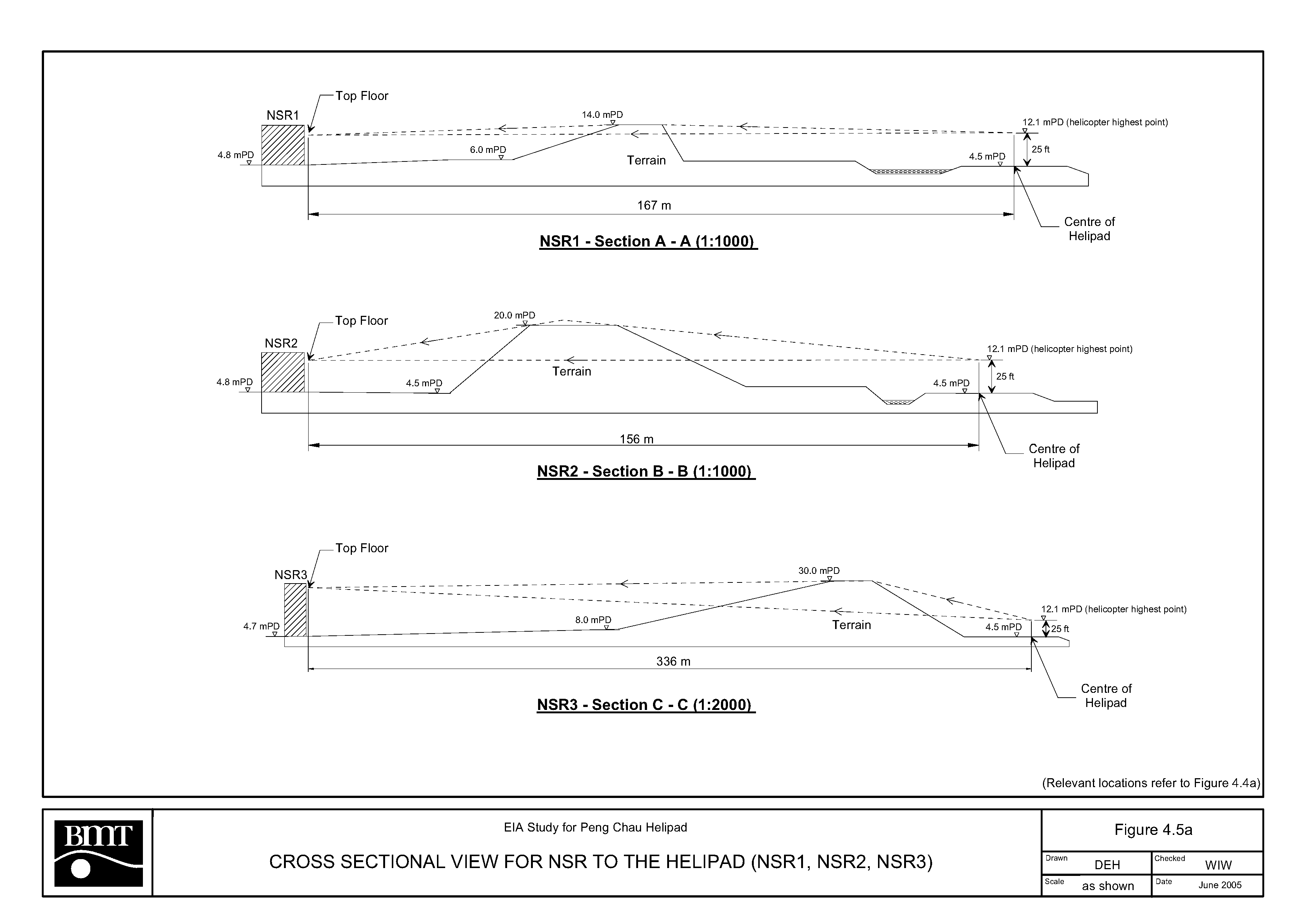
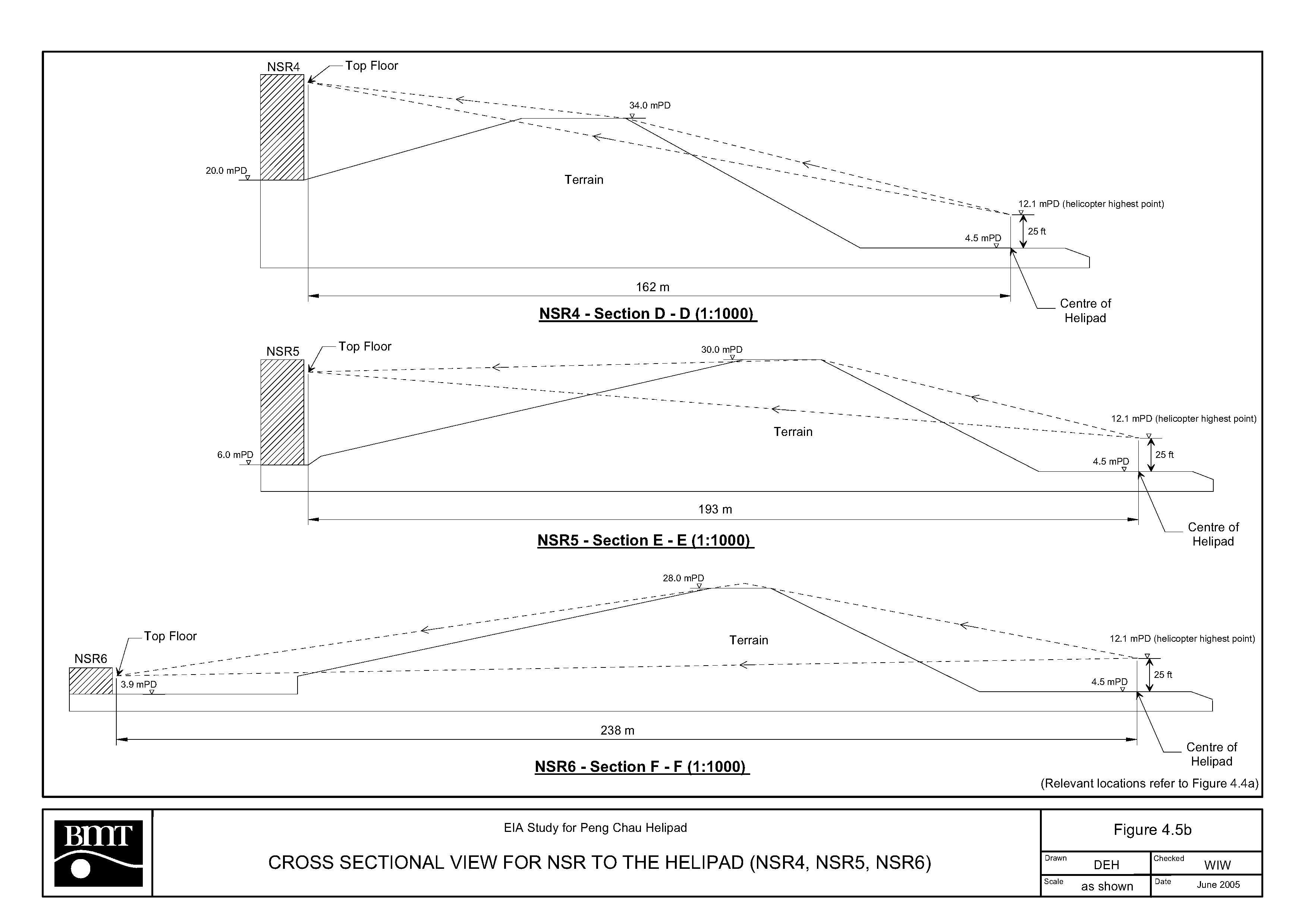
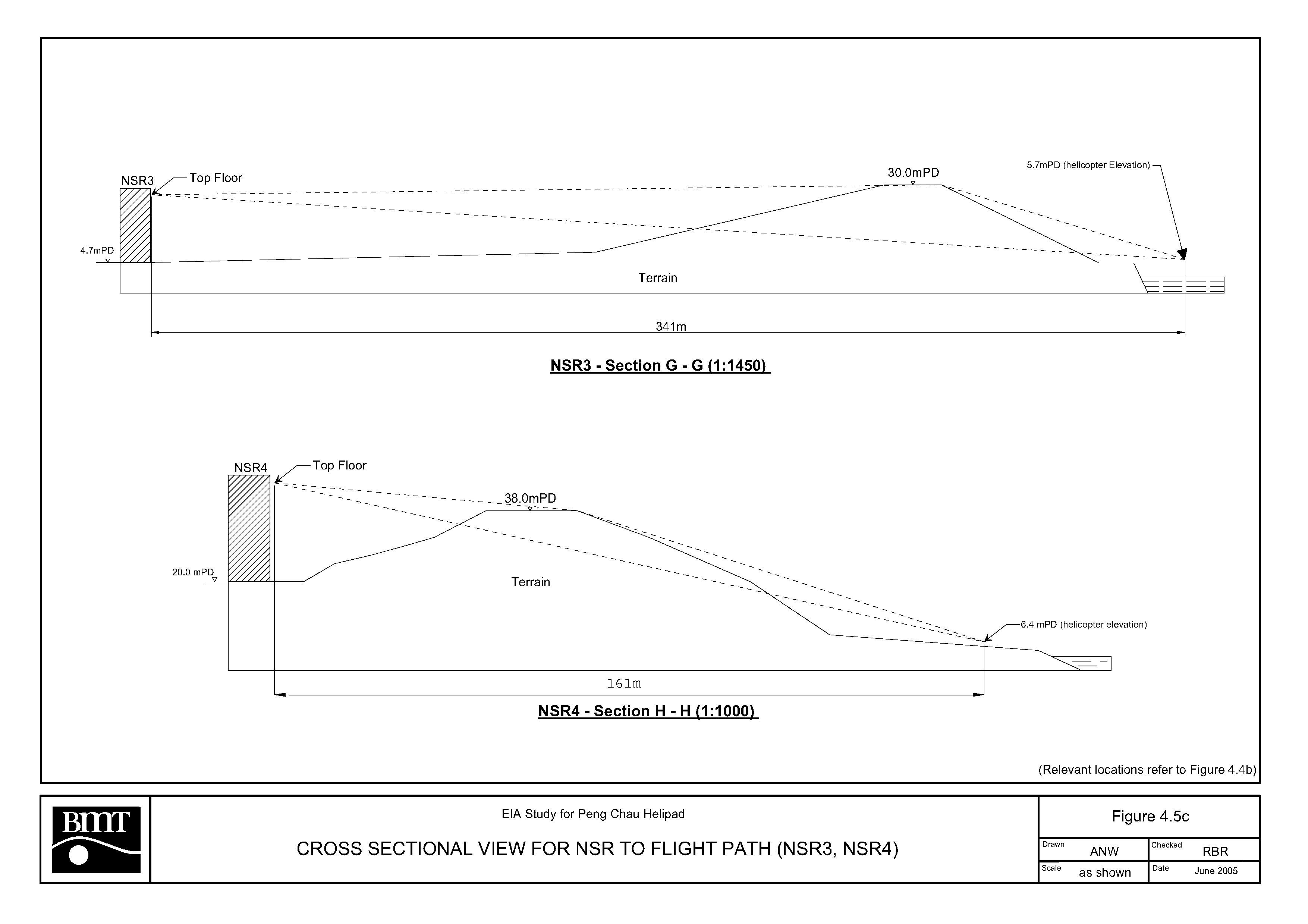
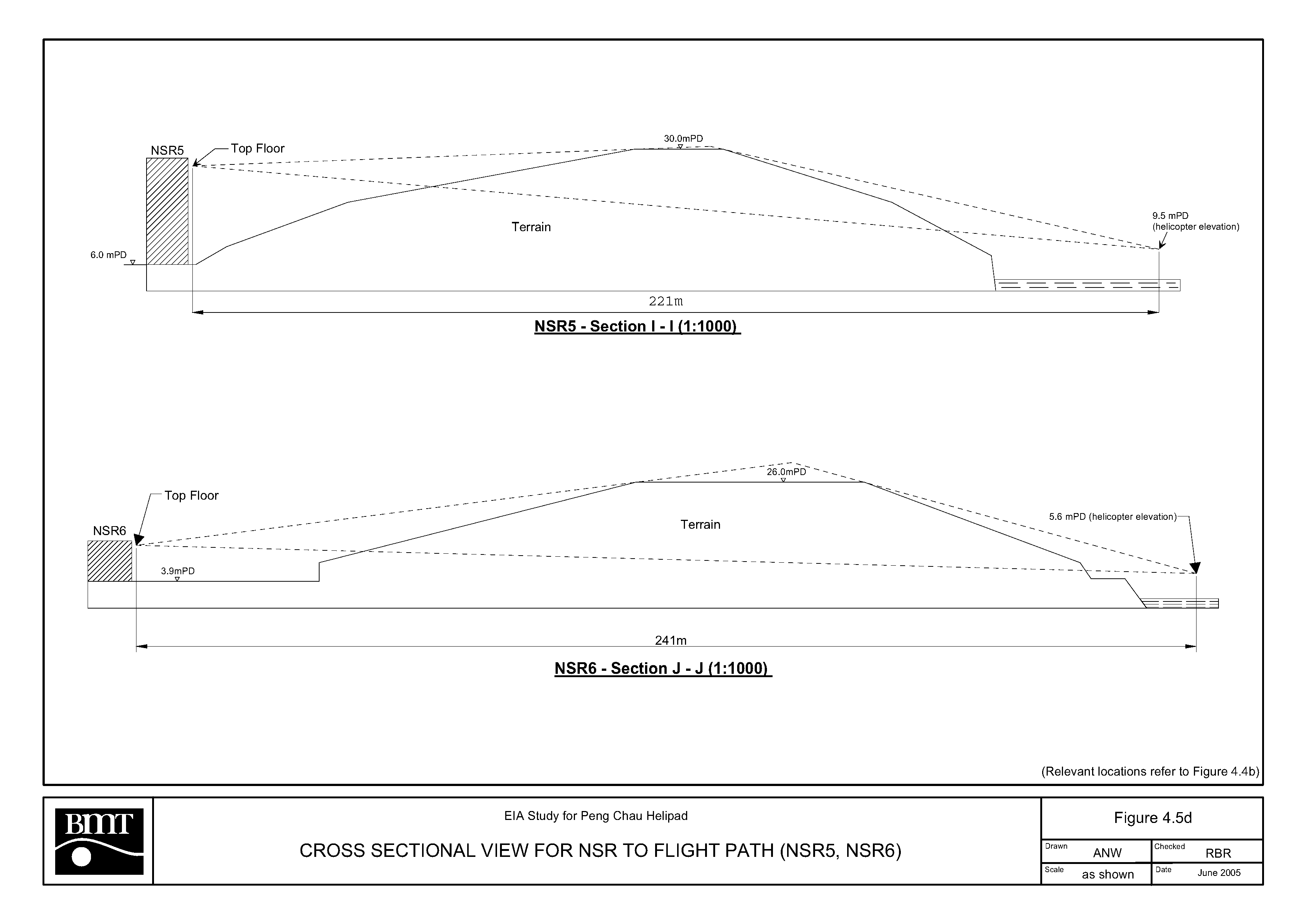
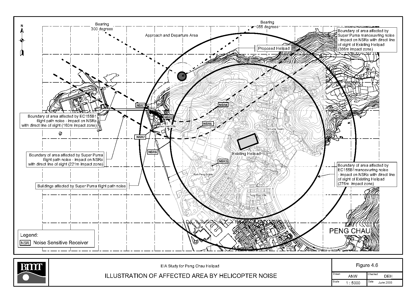
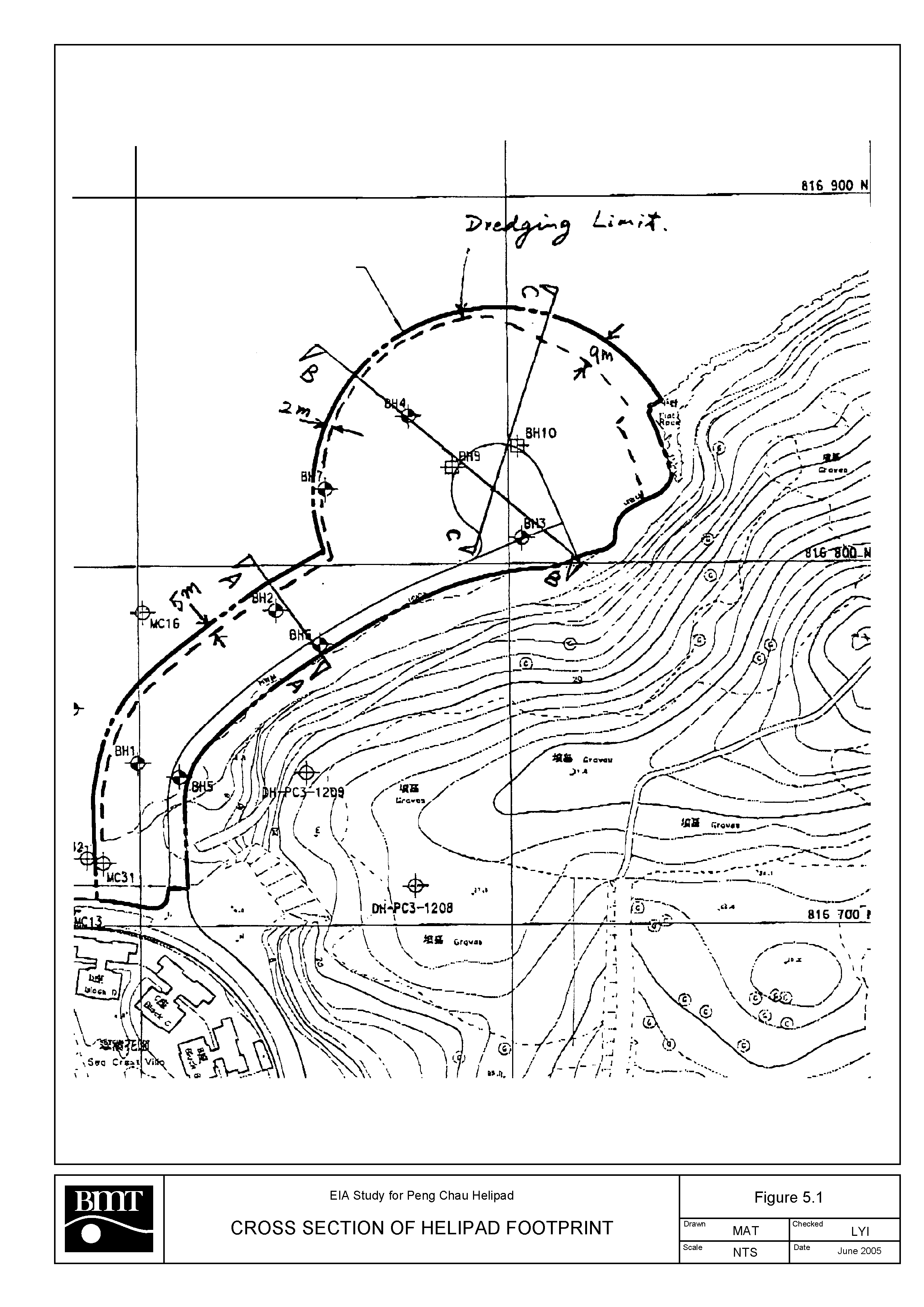
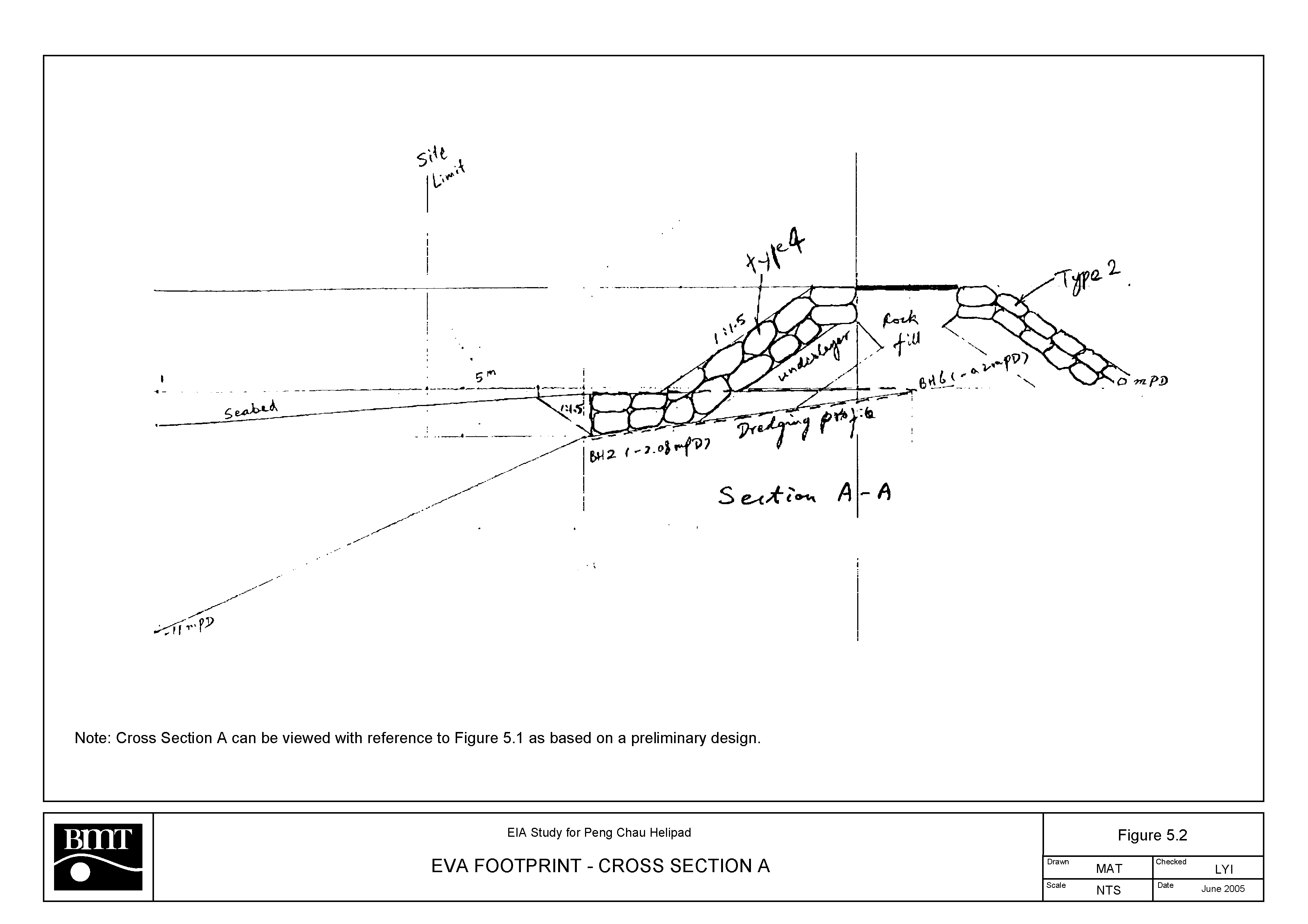
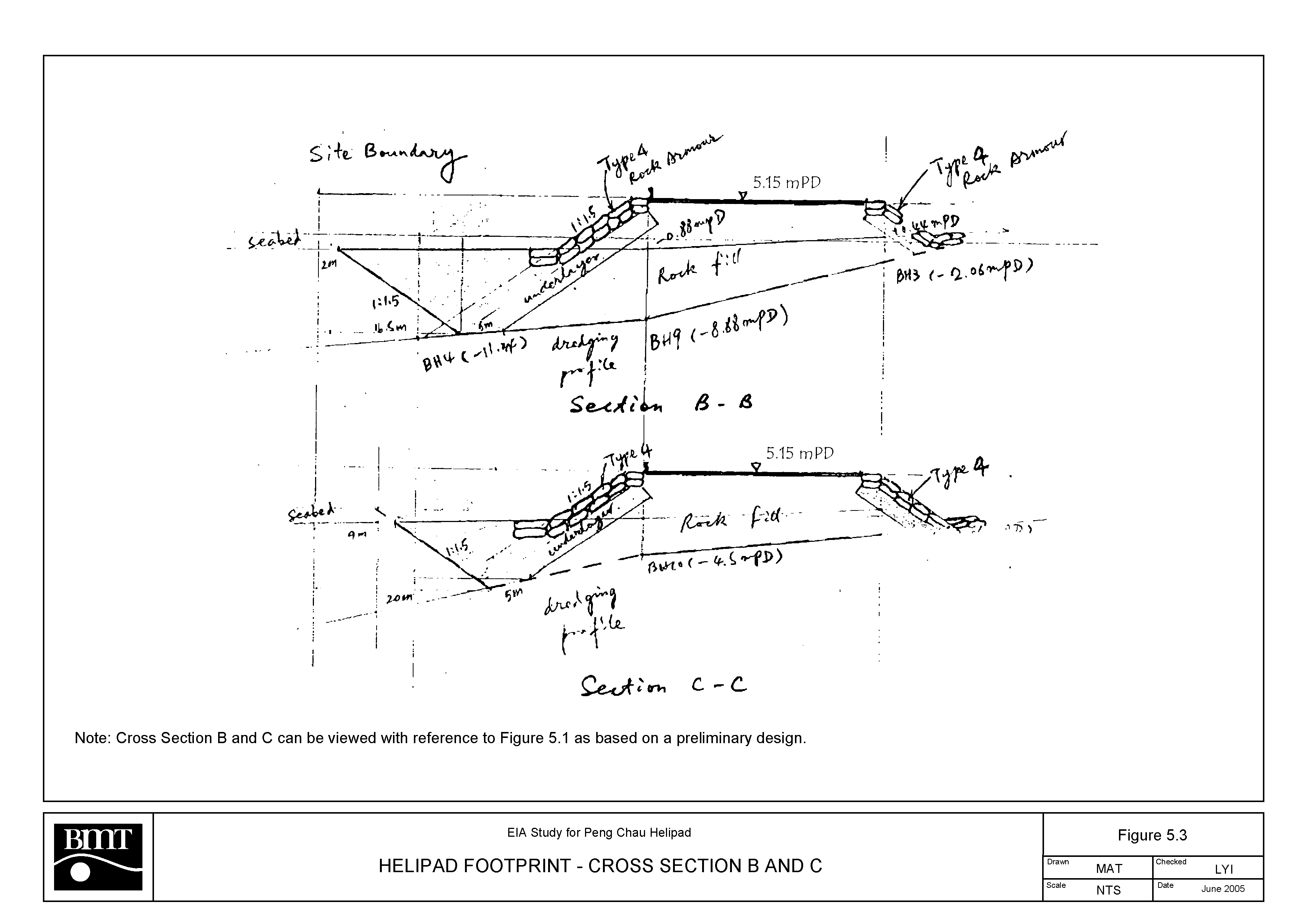
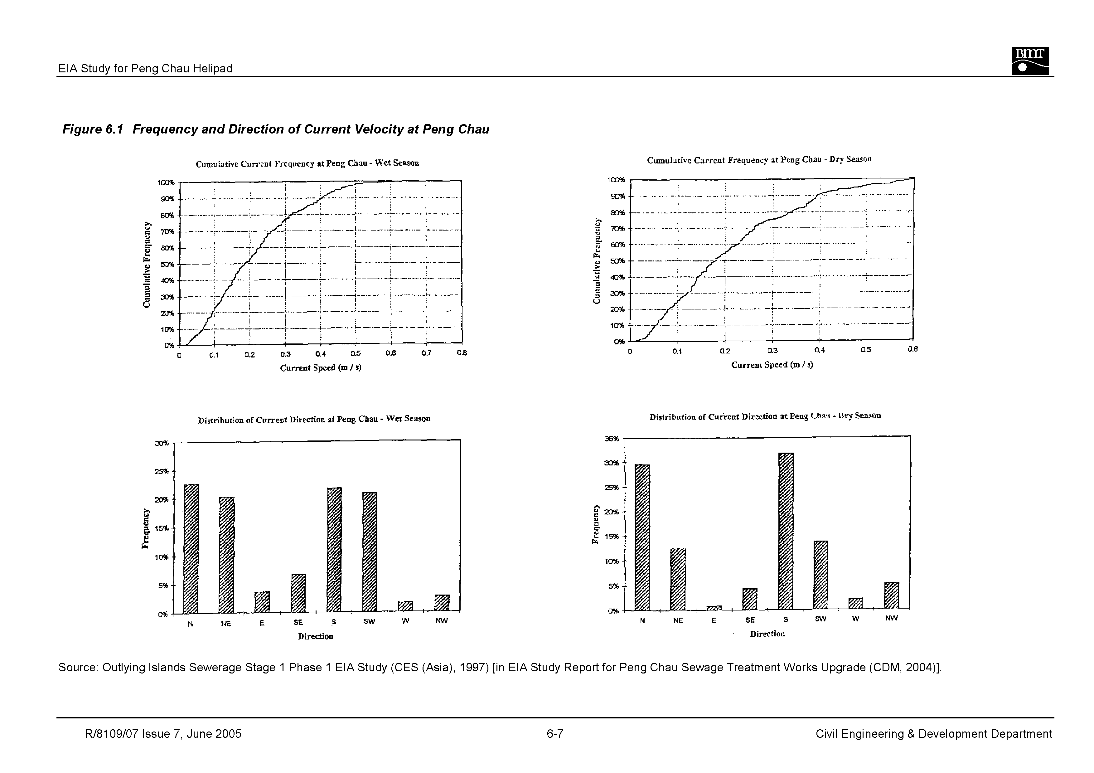
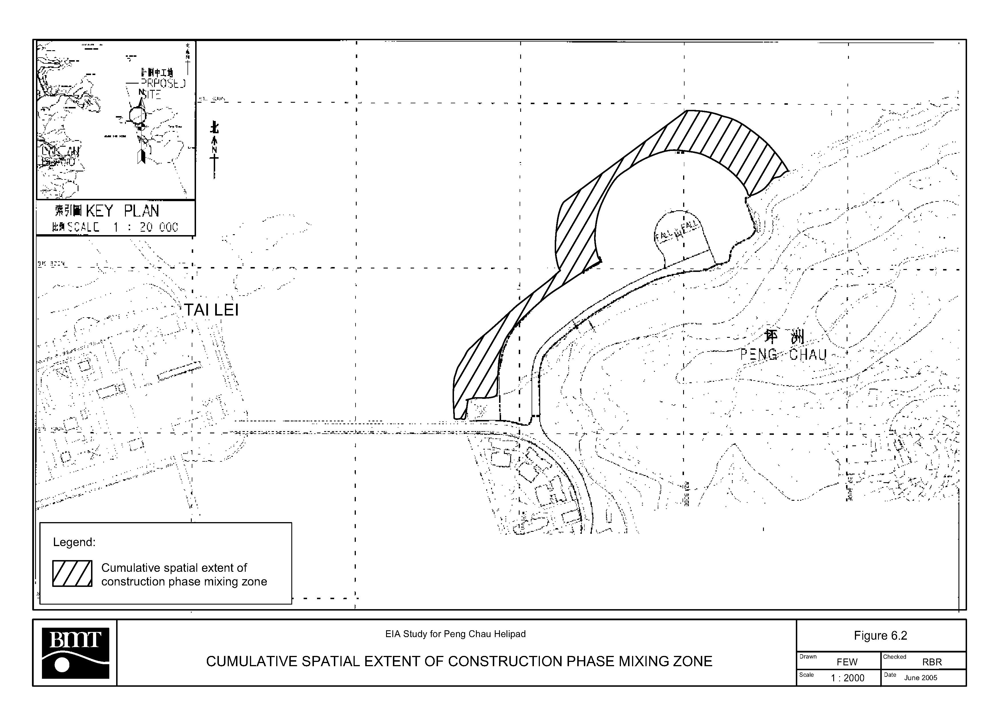
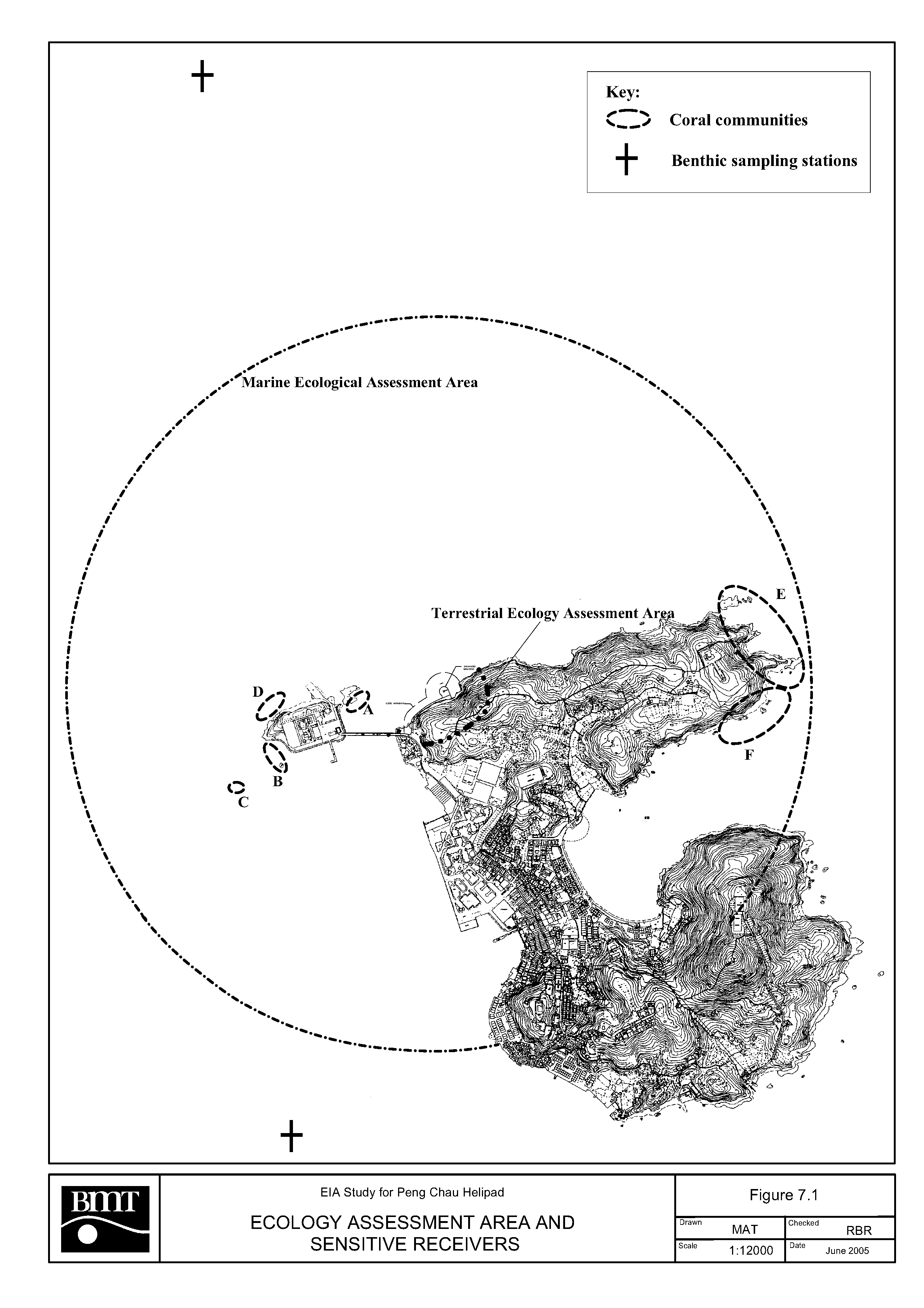
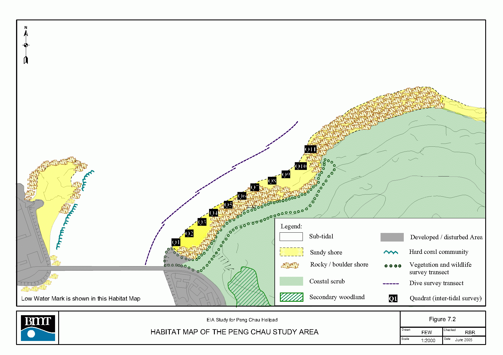
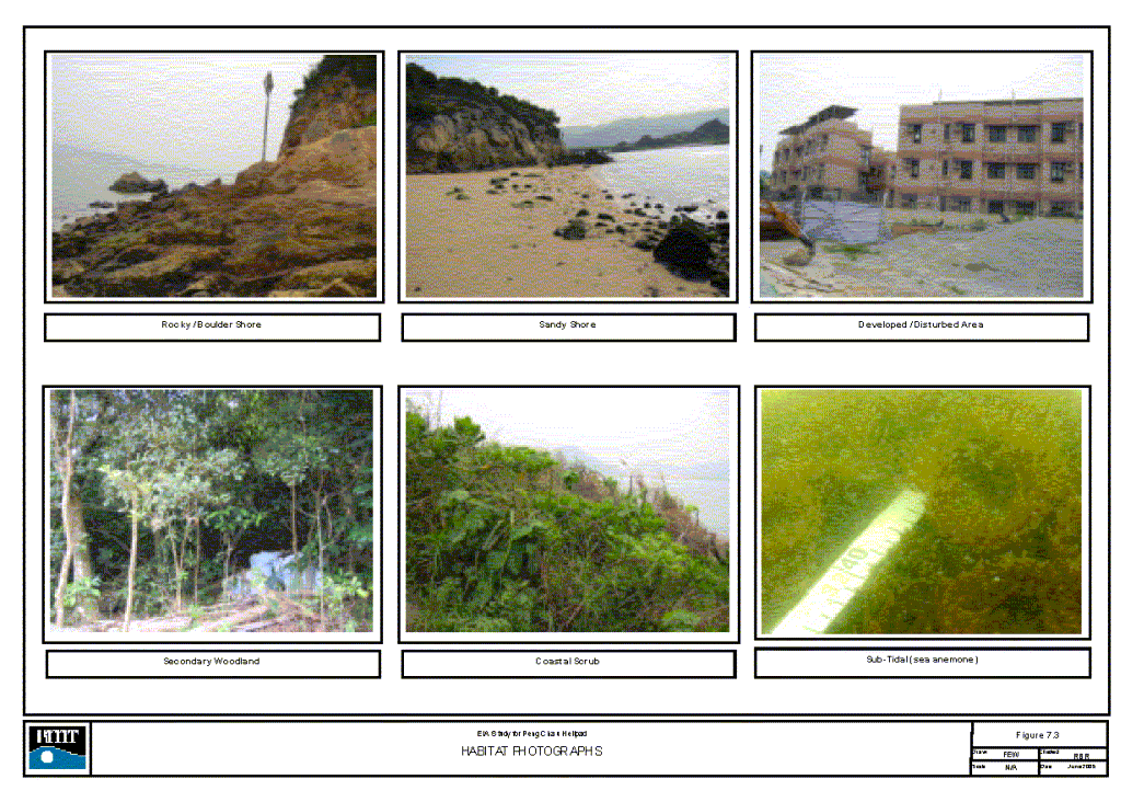
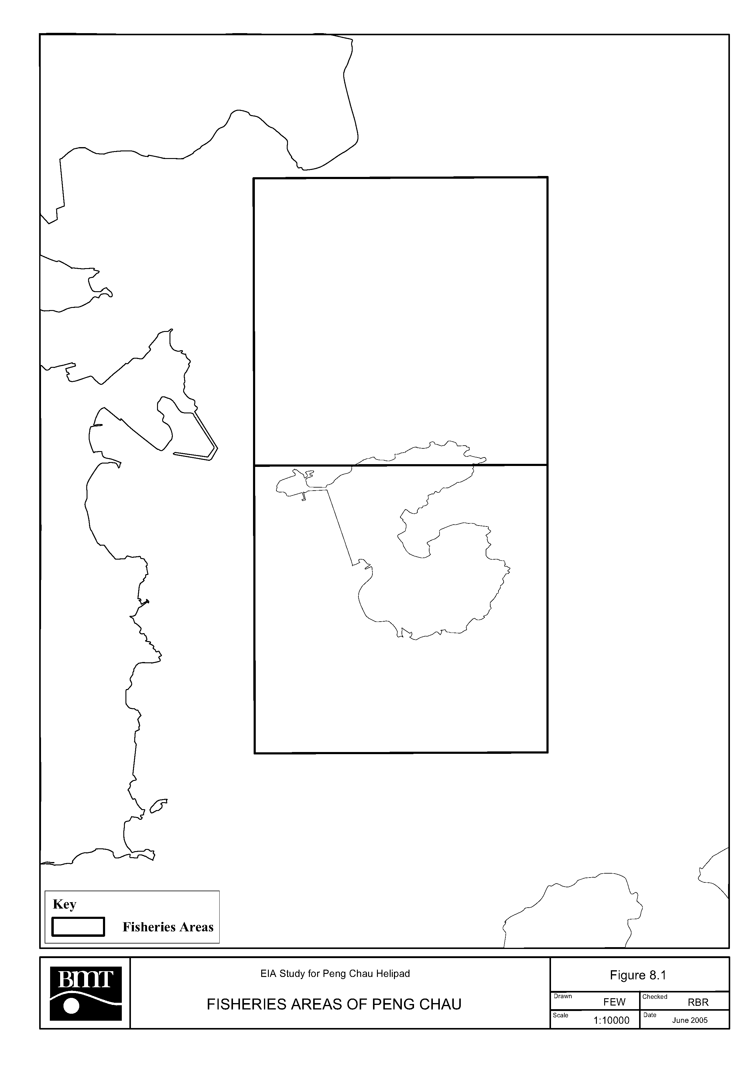
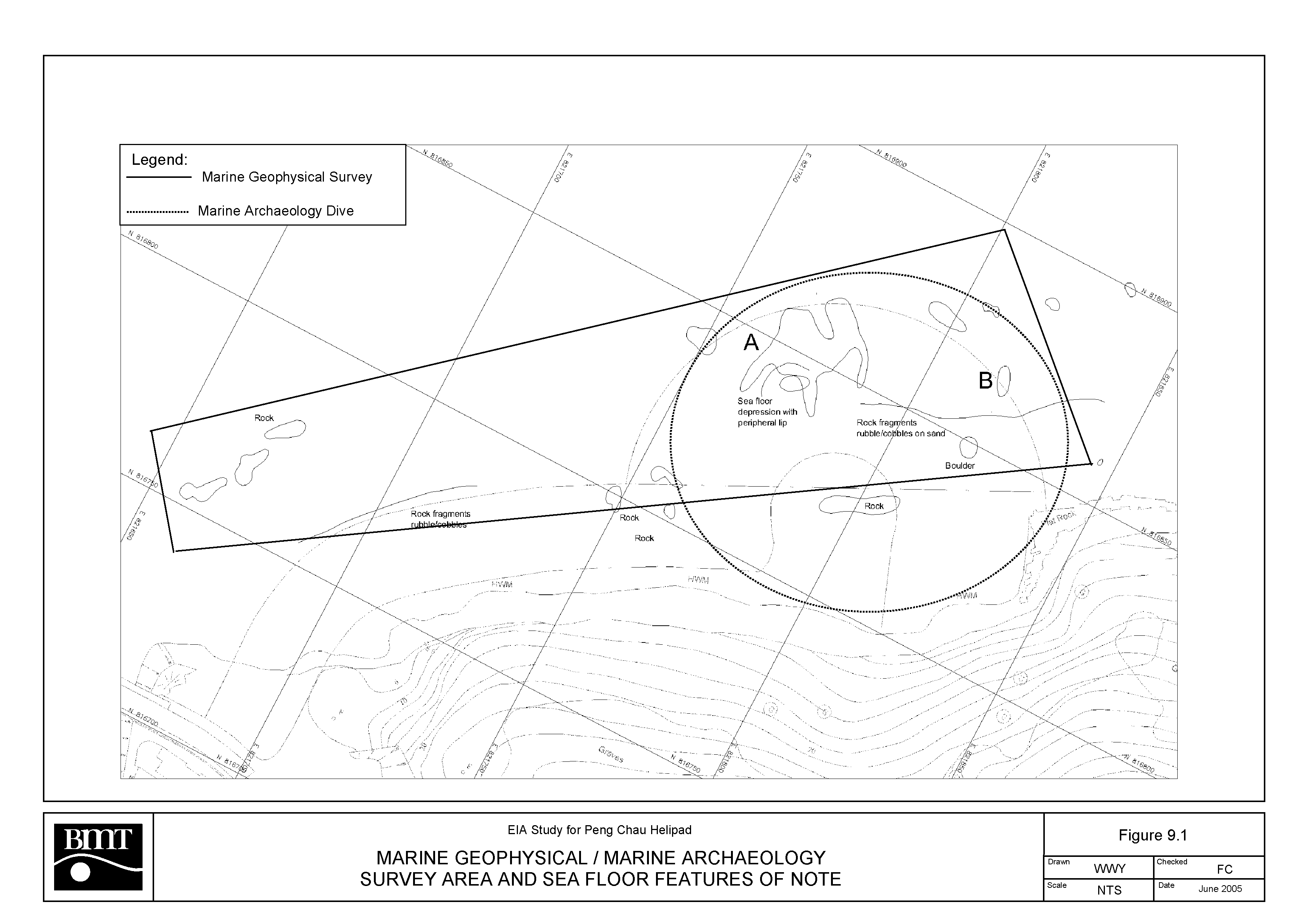
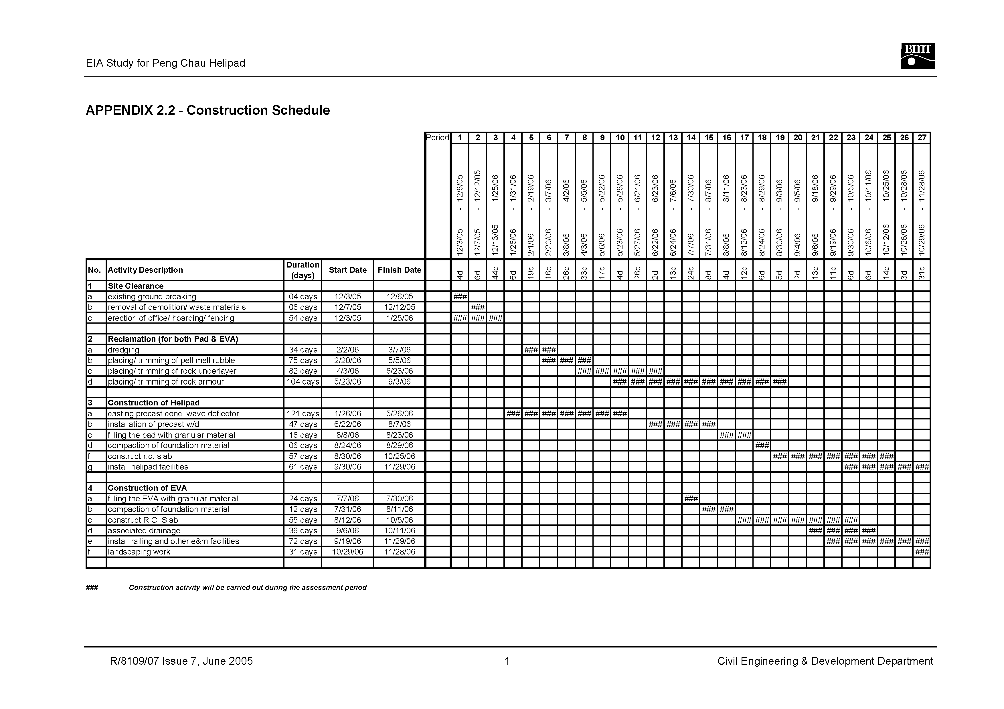
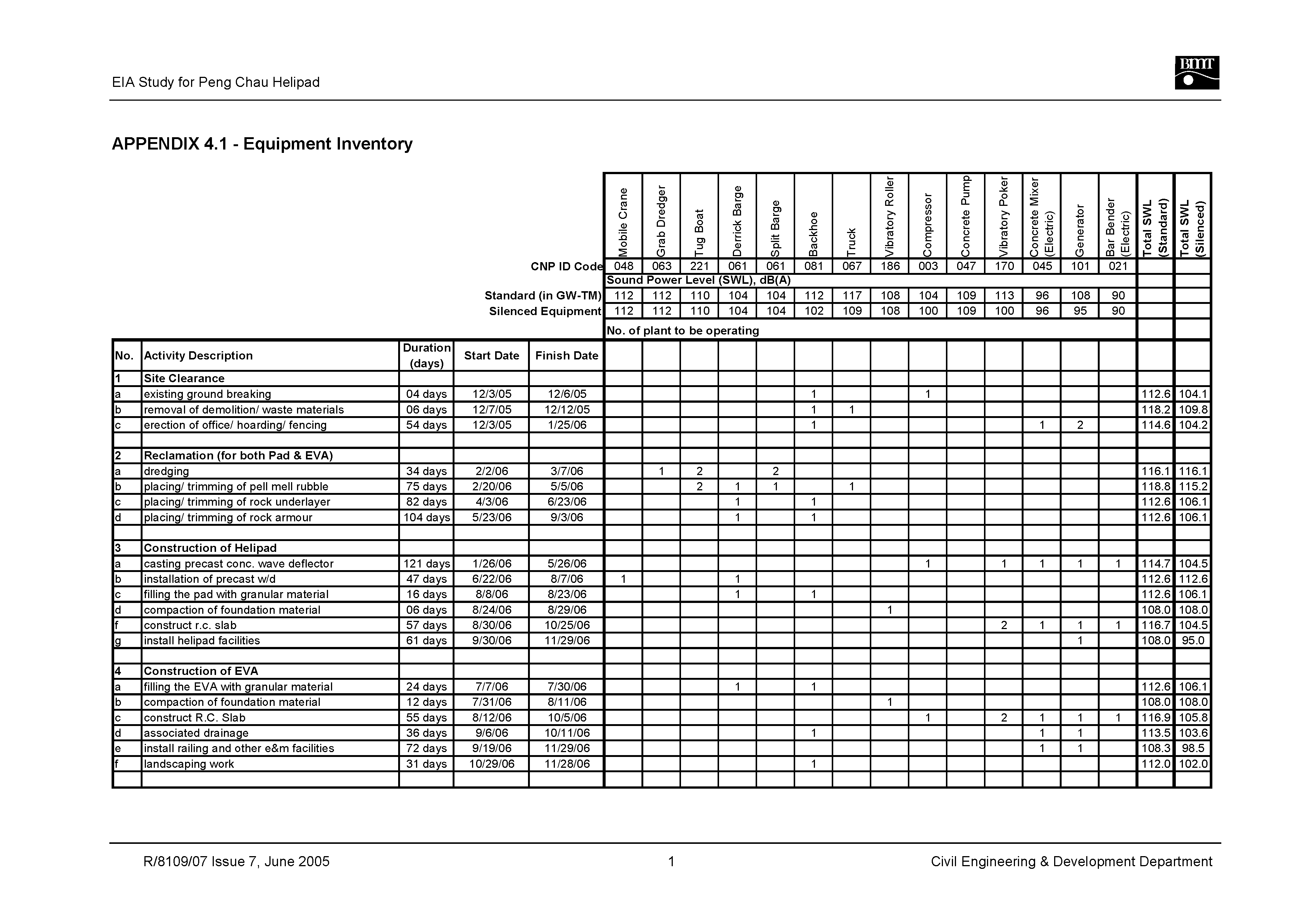
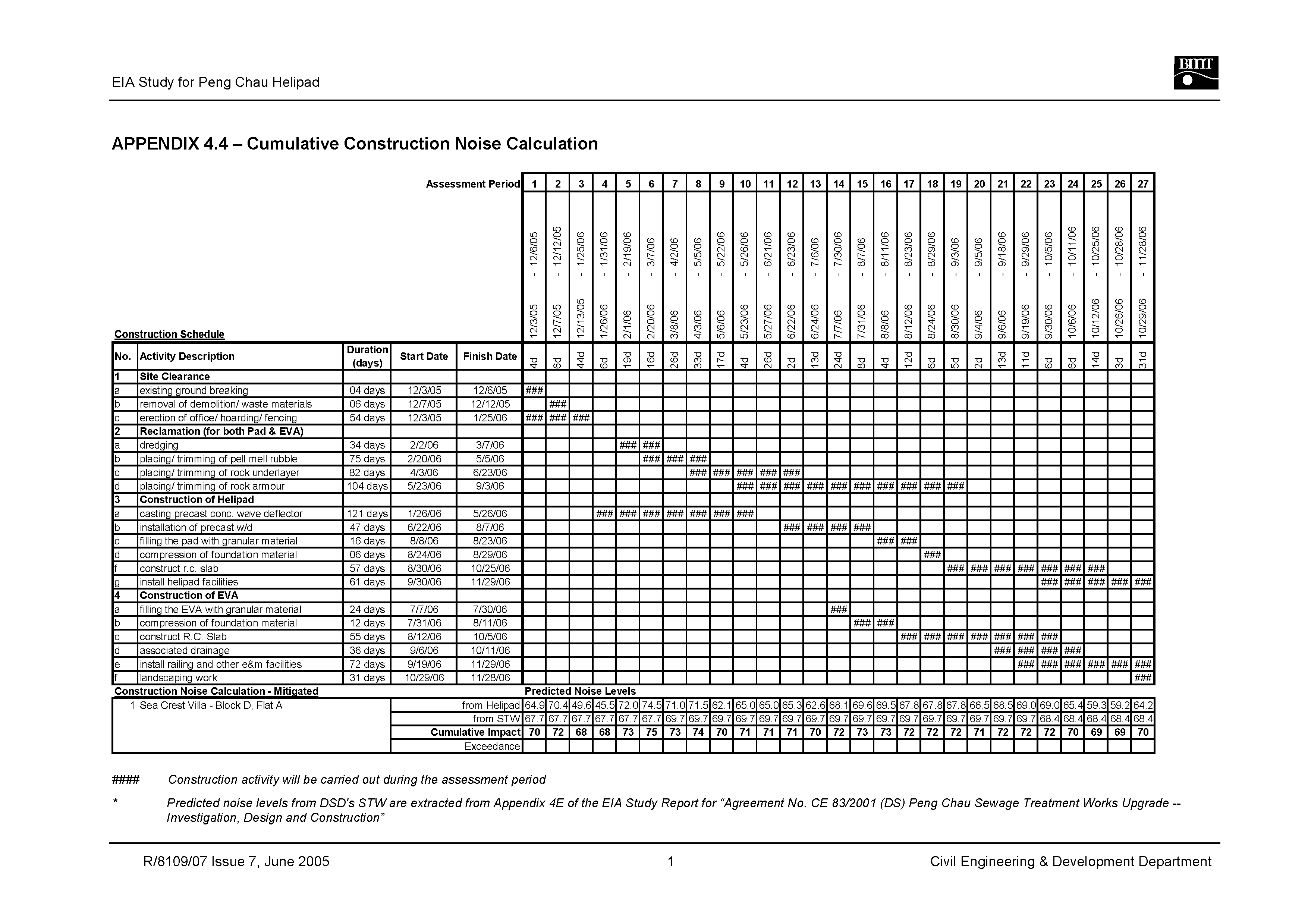
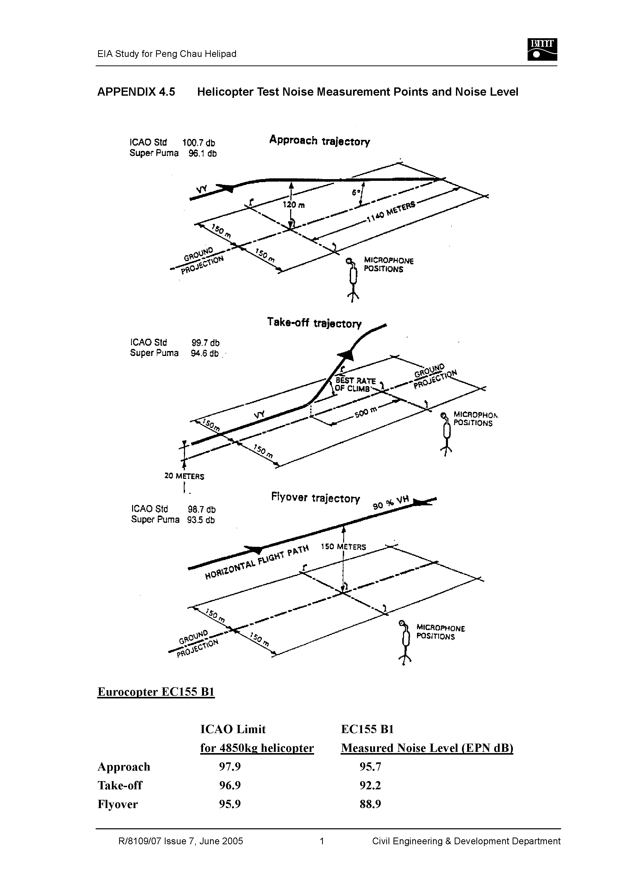
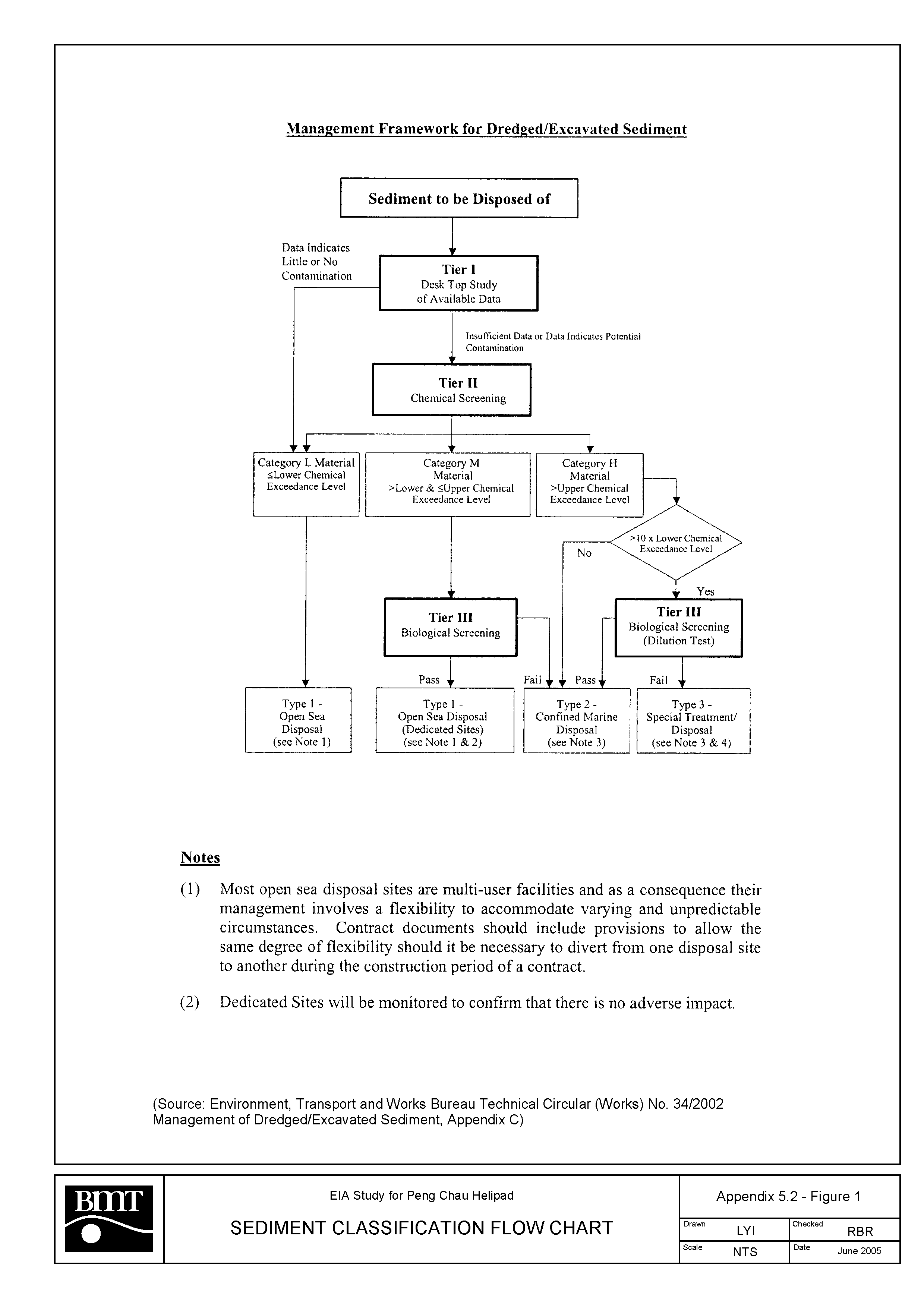