9
LANDSCAPE AND
VISUAL Impact
Assessment
9.1
Introduction
This section presents the findings
of the landscape and visual impact assessment (LVIA) for the Project and
outlines the potential
impacts to the existing landscape and visual context of the area together with
the mitigation measures proposed to alleviate those impacts.
9.2
Relevant Legislation and Guidelines
·
The methodology of the LVIA is based on
Annexes 10 and 18 of the Technical Memorandum on the Environmental
Impact Assessment Process (EIAO-TM)
under the EIA Ordinance (Cap.499,
S16), entitled "Criteria for Evaluating Visual and Landscape Impact"
and "Guidelines for Landscape and Visual Impact Assessment",
respectively. Other relevant
documents and guidelines applicable to this assessment are as follows: EIAO Guidance Note No. 8/2002
“Preparation of Landscape and Visual Impact Assessment Under the Environmental
Impact Assessment Ordinance.”;
· The
· WBTC No. 14/2002 on Management and Maintenance of
Natural Vegetation and Landscape Works and Tree Preservation; and
· WBTC No. 7/2002 on Tree Planting in Public
Places.
9.3
Assessment Methodology
In accordance with the EIAO Guidance Note No.8/2002, the main components
of the LVIA will be as follows:
·
description of the Project;
·
baseline study of landscape and visual resources;
·
review of planning and development control framework;
·
landscape impact assessment during construction and
operation;
·
visual impact assessment during construction and operation;
·
recommendations for landscape and visual mitigation measures for both
construction and operation stage; and
·
assessment of residual impact
and conclusion on the acceptability of the Project.
9.3.1
Description of the
Project
For the LVIA, it is necessary to
describe how the proposed karting track fits into the
scope of the landscape and visual environment and to indicate what element of
the Project may give rise to landscape or visual impacts.
9.3.2
Review of
Planning and Development Control Framework
A review of the existing planning
studies and documents has been undertaken as part of the assessment to gain and
insight into the planned role of the site, its context and to help determine
whether the Project fits into the wider existing and future landscape
context. A review of the existing
and development framework of the site and surrounding areas has been undertaken
in order to identify any issue of conflict with the neighbouring planned land
uses and to identify the full extent of the ‘Visual Sensitive Receivers’ (VSRs). For the
purpose of this Study, the Outline Zoning Plans (OZPs)
form the basis of getting an accurate picture of the future landscape setting
and visual context of the Study Area.
This will also ensure that the landscape proposals are compatible with
the surrounding landscape character context.
9.3.3
Landscape Impact
Assessment
The assessment of the potential
impacts of the proposed karting track on the existing
landscape comprises two distinct sections:
·
Baseline survey; and
·
Assessment of potential impacts to the
existing landscape.
Baseline Survey
A baseline survey of the existing
landscape character and resources has been undertaken from site inspections and
desktop surveys. As required by the
Study Brief (ESB-135/2005), a 100m boundary from the Project Area forms the
Study Area for the landscape impact assessment (LIA). The baseline study describes the
landscape resources by identifying broadly landscape character areas (LCA) and
key landscape elements within the Study Area. The landscape character is rated low,
medium or high depending on the quality of elements present, its sensitivity to
change and its importance at a local, district, regional or international
level.
Landscape
Impacts
The assessment of the potential
landscape impacts of the proposed karting track will
results from the following:
·
Identification of the sources of
impact, and their magnitude, that would be generated during the operation; and
·
Identification of the principal
impacts, primarily in consideration of the degree of change to the baseline
conditions. The impacts are
considered systemically in terms of the landscape elements, the site and its
context.
Factors affecting the magnitude of change for assessing
landscape impacts are:
·
Compatibility of the project with the
surrounding landscape;
·
Scale of the development; and
·
Reversibility of change.
The magnitude of change is classified as follows:
·
Large
–
notable change in the landscape characteristics over an extensive area ranging
to very intensive change over a more limited area;
·
Intermediate
–
moderate changes to a local area;
·
Small –
changes to components;
·
Negligible
–
no perceptible changes.
Factors affecting the sensitivity
of change for evaluation of landscape are:
·
Quality of landscape characters /
resources;
·
Importance and rarity of special
landscape elements;
·
Ability of the landscape to accommodate
change;
·
Significance of the change in local and
regional context; and
·
Maturity of the landscape.
The degree of sensitivity of the landscape is
classified as follows:
·
High
–
eg important components or landscape of particularly
distinctive character susceptible to small changes;
·
Medium
–
eg a landscape of moderately valued characteristics
reasonably tolerant to change;
·
Low
–
eg a relatively unimportant landscape which is able
to accommodate extensive change.
The landscape impact is a product
of the magnitude of change which the proposed karting
track will create in the existing landscape context and its ability to tolerate
the change, ie its quality and sensitivity. The significance threshold is derived
from the Significant Threshold of Potential Landscape / Visual Impacts as
described in Table 9.1. Table
9.2 explains the terms used in Table
9.1.
Table
9.1 Significance
Threshold of Potential
Landscape/Visual Impact
|
Magnitude
of Change caused by Proposals |
Large |
Moderate Impact |
Moderate/Significant Impact |
Significant Impact |
|
|
Intermediate |
Slight / Moderate Impact |
Moderate Impact |
Moderate / Significant Impact |
|
|
Small |
Slight Impact |
Slight / Moderate Impact |
Moderate Impact |
|
|
Negligible |
Negligible Impact |
Negligible Impact |
Negligible Impact |
|
|
|
Low |
Medium |
High |
|
|
Sensitivity
to Change |
|||
Table
9.2 Adverse
/ Beneficial Impact of Landscape / Visual Impact
|
Significant: |
Moderate: |
Slight: |
Negligible |
|
Adverse / beneficial impact where the
proposal would cause significant degradation or improvement in existing
landscape baseline conditions |
Adverse / beneficial impact where
the proposal would cause noticeable degradation or improvement in existing
landscape baseline conditions |
Adverse /beneficial impact where the
proposal would cause a barely noticeable degradation or improvement in
existing landscape conditions or where the changes brought about by the
project would not be apparent in visual terms |
The proposal does not affect the
existing landscape baseline conditions |
9.3.4
Visual Impact
Assessment
The assessment of the
potential visual impact of the proposed karting track
comprises two distinct parts:
·
Baseline visibility survey; and
·
Visual impact assessment.
For the visual impact assessment
(VIA), the assessment area is defined by the visual envelope, within which the
proposed karting track would be visible.
Baseline Survey
The baseline survey of all views
towards the proposed karting track is undertaken by identifying:
·
The visual envelope which is generally
defined by the viewshed formed by natural / manmade
features such as buildings and ridgelines; and
·
The visual sensitive receivers (VSRs) within the visual envelope whose views will be
affected by the proposed karting track.
Visual Sensitive
Receivers
The potential receivers are
considered as three groups including:
·
Views from residences (the most
sensitive of receivers due to the high potential of intrusion on the visual
amenity and quality of life);
·
Views from workplaces (less sensitive
then residences due to visual amenity being less important within the work
environment); and
·
Views from public areas including areas
such as Country Parks, recreational grounds, hiking trails, roads, cultural
sites (sensitivity of this group depends on the transitory nature of the
receiver).
The location and direction of
views relative to the scheme also influence the sensitivity of each group. The baseline survey describes and
records by photograph typical views from each of the visually sensitive groups
within the visual envelope for low-level viewpoints (sea or street levels) and
high level viewpoints (hillside vantage points). These will be used as a basis to
describe the visual impact. The
sensitivity of each VSR is therefore influenced by its location, both in
relation to its proximity to the proposed development, and the direction and
nature of the view relative to the proposed karting
track.
Visual Impact
Assessment
The baseline survey has formed
the basis of the visual characterisation and quality of the site. The assessment of the potential visual
impacts will result from:
·
Identification of sources of visual
impacts, and their magnitude, that would be generated during the operation; and
·
Identification of the principal visual
impacts primarily in considerations of the degree of change to the baseline
conditions.
The impact assessment will relate
to the typical views from the visually sensitive group, as identified
previously, and their existing and potential views subsequent to the proposed karting track development. The visual impact will result from the
magnitude of change of the baseline conditions. In assessing the magnitude of
change, consideration of the following is required:
·
Compatibility of the project with the
surrounding landscape;
·
Scale of the development;
·
Reversibility of change;
·
Viewing distance;
·
Potential blockage of view; and
·
Duration of impact under construction
and operation phases.
Factors affecting the sensitivity
of receivers for the evaluation of visual impacts are:
·
Value and quality of existing views;
·
Availability and amenity of alternative
views;
·
Type and estimated number of receiver
population;
·
Duration of frequency of view; and
·
Degree of visibility.
The views available to the
identified VSRs are rated in accordance with their
sensitivity to change using low, medium or high and are defined as follows:
·
High –
i. The
nature of the viewer groups expect a high degree of control over their
immediate environment, (eg people residing in their
homes); and
ii. The
viewer groups are in proximity to the Project.
·
Medium -
i.
The nature of the viewer groups expect
a high degree of control over their immediate environment, (eg
people residing in their homes); or
The
nature of the viewer groups expect some degree of
control over their immediate environment, (eg
teachers in schools);
ii.
People in transit (eg
drivers and passengers in vehicles);
iii.
The transit viewer groups are in
proximity to the Project, the others are not.
·
Low –
i.
The nature of the viewer groups do not
expect a high degree of control over their immediate environment, (eg people at their place of employment or temporarily in
attendance at the VSR location); or
As the proposed development is to
be located within an area that contains modified landscape areas, both to the
north and south of the site, it is reasonable to assume that most transient
visitors will have a medium sensitivity as they have already encountered a
variety of landscape elements. The users also vary from tourists to truck drivers.
Therefore ‘medium’ has been selected as an average.
The magnitude
of change to the view is rated as negligible, small, intermediate or large and
are defined as follows:
·
Large: eg the majority of viewers affected / major change in view.
·
Intermediate: eg many viewers affected / moderate change in view.
·
Small: eg few viewers affected / minor change in view.
·
Negligible: eg very few viewers affected / no discernible change in
view.
The degree of visual impact or significance
threshold is rated in a similar fashion to the landscape impact, ie significant, moderate, slight and negligible. The
impacts may be beneficial or adverse.
Therefore, the visual impact is a
product of the magnitude of change to the existing baseline conditions, the
landscape context and the sensitivities of VSR’s. The significance threshold of visual
impact is rated for the construction phase and for Day 1 and Year 10 of the
operation phase as described in Table 9.1.
9.3.5
Recommended
Landscape and Visual Impact Mitigation Measures
The identification of the
landscape and visual impacts will highlight those sources of conflict requiring
design solutions or modifications to reduce the impacts, and, if possible,
blend the development and associated activities in with the surrounding
landscape.
Mitigation measures may include
revisions / refinement to the engineering design, retention of vegetation,
especially tree groups; and/or implementation of landscape design measures
including screen tree planting to minimise adverse landscape and visual
impacts. Mitigation measures should
not be limited to a reduction of negative impacts, but also consider
opportunities for visual enhancement.
Any designs that enhance the landscape or visual quality should be adopted.
9.3.6
Defining the
Residual Impacts
In accordance with Annex 10 of
the EIAO-TM, the residual impacts are those, which remain after the proposed
mitigation measures have been successfully implemented. The levels of significance threshold is
classified as follows:
·
The impact is beneficial if the
project will complement the landscape and visual character of its setting, will
follow the relevant planning objectives and will improve the overall and visual
quality of the study area;
·
The impact is acceptable if the
assessment indicates that there will be no significant effects on the
landscape, no significant visual effects caused by the appearance of the
project, or no interference with key views;
·
The impact is acceptable with
mitigation measures if there will be some adverse effects, but these can be
eliminated, reduced or offset to a large extent by specific measures;
·
The impact is unacceptable if
the adverse effects are considered too excessive and are unable to mitigate
practically; and
·
The impact is undetermined if
significant adverse effects are likely, but the extent to which they may occur
or may be mitigated cannot be determined from the study. Further detailed study
will be required for the specific effects in question.
9.4
Project Description
The project will comprise of the construction and
operation of an outdoor karting track design to
international standard for kart racing.
The overall track length is about 900m, in a site of about 1.8 ha. The site is currently approximately 5 mPD and only very minor track levelling will be
required. No slope cutting or major
site formation is required as part of the construction and no superstructure
will be constructed within the site.
An existing village house within the site boundary will be used as an
office for the karting track and four units of mobile
toilets will be provided at the site.
Due to the fact that the proposed site is on short term
lease arrangement, this limits the options for structures. Thirteen maintenance and storage
areas will be constructed on site.
These will be constructed from modified ISO containers of 6m long and
2.4m high. The containers will have
doors and windows cut into the walls, and will appear as small houses rather
than containers that have been dumped on site. The structures will also be painted
green to complement the surrounding landscape. Figure
9.1 below shows an artists impression of the
maintenance structures and the detailed design of a typical maintenance
structures is shown in Annex D.
Figure 9.1 Maintenance Structures
|
|
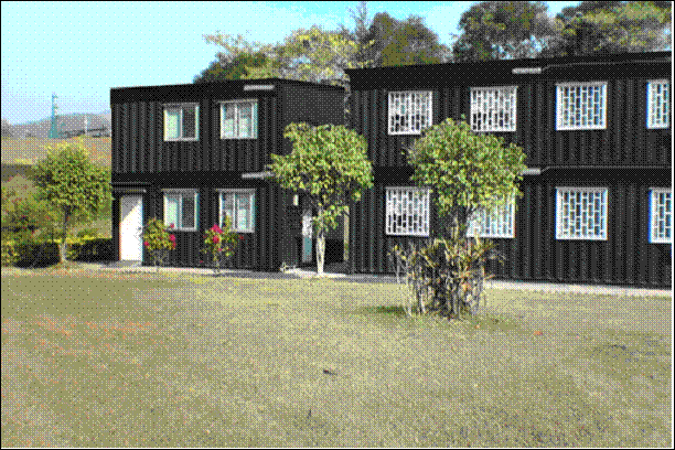
Figure 9.2 Proposed Site Layout
|
|
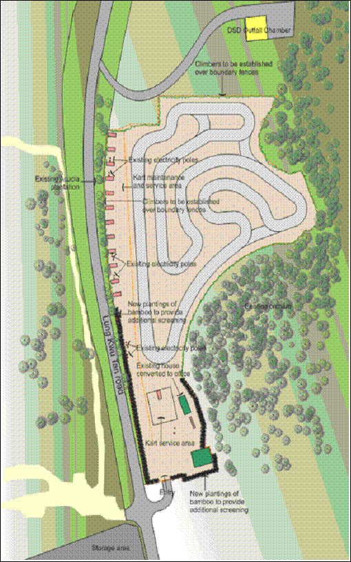
The proposed site layout plan is shown in Figure 9.2 above. Note that there are no
viewing areas or viewing stands proposed.
9.5
Review of Planning and Development
Control Framework
There
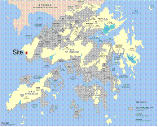
are currently no OZPs covering the proposed karting track study area (see Figure 9.3) and hence potential conflict with future planned land
uses cannot be determined. It is
understood through discussion with various government departments and the
village representative, that a short term tenancy for
a recycling factory has recently been granted and in addition, a few dangerous
good (DG) stores are currently under short term tenancy application. As currently a large part of this area
is occupied by several plastics recycling factories and open storage for
construction plant equipment, it is considered that these planned facilities
are compatible with the land use baseline condition of the area. The LVIA will be assessed against the
land use baseline conditions of the area as well as the existing landscape
baseline conditions and natural landscape setting outlined in Section 9.6
Figure 9.3 Coverage of
OZPs
|
|
9.6
Existing Landscape Baseline Conditions
9.6.1
Existing
Landscape Context
Landscape
Character
The site is set at the base of
The
baseline landscape character is mapped and illustrated as Landscape Character
Units (LCU) in Figure 9.4a. Details are discussed below.
The
proposed karting track is located at Lung Kwu Sheung Tan and lies at the
based of
Figure 9.5 Existing
landscape features at Lung Kwu Sheung
Tan – LCU 1
|
|
The
general site context for the proposed karting track
is shown in Figure 9.6. The proposed
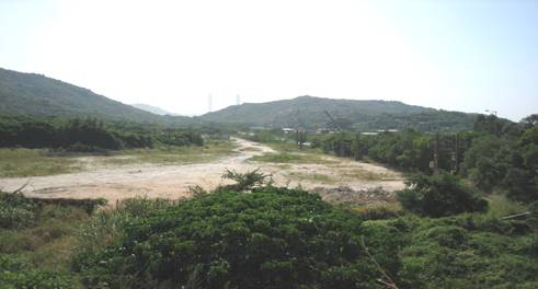
tracking track occupied most of the disturbed area (LCU 2 – disturbed area), which
was dominated by bare land with patches of weed plants occupied the western and
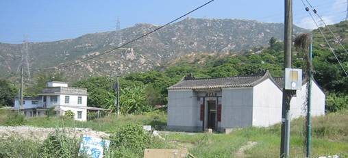
the northern areas. Within the proposed site is a 2 storey high village house
which will be used as an office for the karting
track. In addition, the Tsz Tong (Lau’s ancestral hall) will be kept and to be used
only by the Lau’s family members of Lung Kwu Tan
village for private functions (see Figure
9.7).
Figure
9.6 Proposed Site for the Karting Track
|
|
Figure
9.7 Existing Village
House and Tsz Tong Located at the South of the Site
|
|
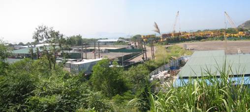
To the
west of the site lies the
Figure
9.8 Existing
landscape features at Lung Kwu Sheung
Tan – Open Storage
|
|
Landscape Resources
In
accordance with the Study Brief, the Study Area is defined as the area within 100m
from the site boundary. To assist
in the assessment of landscape resources in the study area, three landscape
resources (LRs) have been identified (see Figure 9.4a). These include:
· Orchard;
· Disturbed Area; and
· Open Storage Area.
Colour photographs of all habitat
types surveyed and the Project Area are presented in Figures 9.9 to 9.11. None of the recorded plant species are
of conservation interest. Table
9.3 lists the number of plant species and the area recorded in each habitat
type.
Table
9.3 Landscape
Resources Recorded Within the Study Area
|
Landscape Resources |
Area
(hectare) |
Number
of plant species recorded |
|
LR1 - Orchard |
4.9 |
10 |
|
LR2 - Disturbed area |
3.8 |
14 |
|
LR3 - Open storage area |
3.6 |
5 |
The botanical names of the
species found on site are detailed in Annex C.
Orchard – LR1
Orchard was found on the original
steeply shrubland to the west of the Proposed
Site. The site is fenced off and
under active management for cultivation of fruit plants including Dimocarpus longan and Litchi chinensis. These fruit trees were in good form at about 2.5 meters high and
the understorey was well maintained as bare
land. The fruit trees are of a high
value as they are currently used for commercial cropping. The photographic records of the orchard
are shown in Figure 9.9. Ten
plant species were recorded in this landscape resource and no rare/protected
species were found.
This Landscape Resource LR1 – Orchard
has an overall medium
landscape sensitivity.
Disturbed Area – LR2
The proposed site and the area to
the north of the site comprised of mainly disturbed area. The photographic records
of this landscape resource are presented
in Figure
9.10. This landscape
resource consisted mainly of flattened bare land, with a
village house located at the south and a DSD outfall chamber at the north. Patches of weed plants dominated by Pennisetum alopecuroides
and Leucaena leucocephala
were found at the western and northern ends. A patch of Acacia plantation of about 3
meters high was found along the verge between the landscape resource and
This Landscape Resource LR2 – Disturbed
Area has an overall low landscape
sensitivity.
Open
Storage Area – LR3
Open storage area was found to the west of the proposed
site, which mainly consisted of open area, recycling factories, construction
plants and materials. The
photographic records of the developed area are shown in Figure 9.11. Only patches of weed plants such as Leucaena leucocephala
and Ipomoea cairica were found occupying the edges of the
storage areas. This landscape
resource was highly developed with limited landscape significance and only 5
plant species were found in this landscape resource, without any rare or
protected species recorded. No old
or valuable trees were encountered within this landscape resource area.
This Landscape Resource LR3 – Open
Storage Area has an overall low landscape
sensitivity.
9.7
Landscape Impact Assessment
9.7.1
Prediction and
Evaluation of Landscape Impacts during Construction
The proposed karting
track, in a site of about 1.8ha, is located within the disturbed area and no
felling of trees or slope cutting is required as part of the construction
works. A 1.8 metre high chain link
mesh fence will be erected along the length of the south-east boundary to
prevent any damage to the trees in the adjacent orchard (landscape resource
area 1). Similarly, the trees
located within the disturbed area (landscape resource area 2) will be retained
where possible to maintain the existing screen between the site and the road.
The karting track will be
paved using asphaltic concrete and part of the site
that will be used for regular maintenance work will also be paved using
concrete. As the existing village
house within the site boundary will be used as an office for the karting track, no superstructure will be constructed within
the site. Four units of mobile
toilets will be provided at the site together with thirteen double deck ISO
container to be used as maintenance and storage area for the petrol kart. However, these structures will only be
located to the site once the karting track and
associated area are paved.
Therefore impacts on the natural topography and loss of vegetation in
connection with the construction work are not expected. No old or valuable
trees will be removed.
Table
9.4 Summary
of Disturbance to Various Landscape Resource During
Construction
|
Landscape
Resources |
Quantification
of LR within the Study Area (hectare) |
Area in
conflict with the proposed works |
Magnitude
of Change during Construction |
Reversibility
of Change during Construction |
|
|
LR1 - Orchard |
4.9 |
0 |
Negligible |
N/A |
|
|
LR2 - Disturbed area |
3.8 |
1.8 ha |
Intermediate |
High |
|
|
LR3 - Open storage |
3.6 |
0 |
Negligible |
N/A |
|
|
LCU1 – Hillslopes |
4.9 |
0 |
Negligible |
N/A |
|
|
LCU2–Disturbed area |
3.8 |
1.8 ha |
Intermediate |
High |
|
|
LCU3 – Transport |
0.7 |
0 |
Intermediate |
N/A |
|
|
LCU4 – Industrial area |
3.6 |
0 |
Intermediate |
N/A |
|
Table 9.4 above shows that there will be a negligible impact on LR1 and LR3. The magnitude of change on LR2 is
considered intermediate. The
reversibility of change during the construction period is not applicable to LR1
and LR3 as there will be no changes to those Landscape Resource areas. The reversibility of change for LR2 is
considered high as it is easy to return the LR2 to its existing condition if
the construction process was to be reversed.
9.7.2
Prediction and
Evaluation of Landscape Impacts during Operation
During operation, the ISO container as well as the karting track will be the permanent features within the site
area, and would change the characteristics of the existing landscape. In view of the scale of the project, the
magnitude
of change caused by the proposed karting track during
operational phase is assessed as intermediate
when considered in relation to the landscape context of the surrounding area. The significance threshold is slight/moderate.
However, most of the karting
track and the double deck ISO container would be screened from the views by the
patch of Acacia plantation of about 3 meters high adjacent
Table 9.5 Summary
of Disturbance to Various Landscape Resources During
Operation
|
Landscape
Resources |
LR area within the
Study Area (ha) |
Area in conflict
with the proposed works (ha) |
Magnitude
of Change during Operation |
Reversibility
of Change during Operation |
Impact day
1 no mitigation |
Residual
impact day 1 mitigation |
Residual
impact yr 10 mitigation |
|
LR1
- Orchard |
4.9 |
0 |
Negligible |
N/A |
Moderate |
Moderate |
Low |
|
LR2 - Disturbed area |
3.8 |
1.8 ha |
Intermediate |
High |
Moderate |
Moderate |
Moderate |
|
LR3
- Open storage area |
3.6 |
0 |
Negligible |
N/A |
Moderate |
Moderate |
Low |
|
LCU1
– Hillslopes |
4.9 |
0 |
Negligible |
N/A |
Moderate |
Moderate |
Low |
|
LCU2–Disturbed
area |
3.8 |
1.8 ha |
Intermediate |
High |
Moderate |
Moderate |
Moderate |
|
LCU3
– Transport |
0.7 |
0 |
Intermediate |
N/A |
Moderate |
Moderate |
Low |
|
LCU4
– Industrial area |
3.6 |
0 |
Intermediate |
N/A |
Moderate |
Moderate |
Low |
9.8
Existing Visual Context
In order to assess the impact of the proposed
development on the visual amenity of the surrounding landscape, it is necessary
to first identify what elements of the development would be visible from
outside the site, where those elements would be seen from and, who would be
able to see the development.
The visually significant elements of the proposed karting track are as follows:
· Maintenance and Storage structures;
· Karting track; and
· Associated lighting.
The visual envelope relates to the potential area
within which the site and the proposed development would be visible. The site itself is well contained by the
hillsides surrounding the site. Also, due to the fact that
9.8.1
Visually Sensitive
Receivers
In accordance with the study
methodology, the Visually
Sensitive Receivers (VSRs)
within the visual envelope are identified.
In summary, the VSRs can be
classified into three main groups.
· VSR 1. Residential receivers are typically
sensitive to visual impact because of the permanent impact on their daily
outlook. Most people within the
visual envelope enjoy views of a landscape which is of a high amenity
value. This group of people may be
regarded as having a high level of sensitivity to visual intrusion of this
nature. There are none of these receivers in proximity to the project, therefore they have not been included in the
table. However, it should be noted
that agreement has been made between the land owner and the Project Proponent
that the proposed site (including the village house to be used as an office for
the karting track) will be leased to the Project
Proponent for the development of an outdoor karting
track. The village house within the
site boundary will be used as an office for the karting
track only. Residential use is not
permitted at the village house while the land is used as an outdoor karting track.
The Project Proponent also confirmed that the village house will only be
used as an office of the karting track. In view that the village house will not
be used as residential purpose during the karting
track leasing period, for the purpose of this EIA, the village house has not
been identified as a VSR. However,
should this village house is to be used for residential purpose during the
operation of the karting track, mitigation measures
in terms of noise barriers have been proposed to mitigate the noise
impacts. In the unlikely event that
the office building is to be used for residential purpose, this group of people
may regarded as having a high level of sensitivity to visual intrusion.
· VSR 2. Views from workplaces such as the nearby
open storage and factory areas are less sensitive than residences due to visual
amenity being less important within the work environment. The view within the work environment is
typically of a heavily modified environment. Therefore this group of people may be
regarded as having medium level of sensitivity to visual intrusion of this
nature.
· VSR 3. Visitors and viewers in transit such as
those on hiking tracks and along transport corridor. Although the visitors on hiking tracks
will be more sensitive to the visual impact of the proposed karting
track than users on transport corridor, people in transit are considered to be
less sensitive to visual impact than people residing in their homes. This group of people may be regarded as
having a medium level of sensitivity to visual intrusion.
It should be noted that our site
investigation and GIS analysis (Figure 9.12) that the site will not be
visible from the surrounding hiking trail and from Lung Kwu
Tan Chinese White Dolphin lookout due to the rolling hill terrain and hill
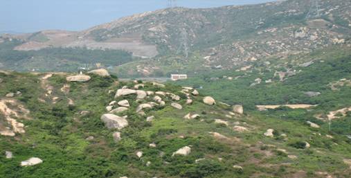
knoll located to the south of Lung Chung Tan Road. Figure 9.13 show the existing view from
the Chinese White Dolphin Lookout and the hiking trail looking towards the
proposed site, and demonstrated that the proposed site is not visible from
these locations. Some areas of
Table 9.6 lists the key VSRs found within the visual
envelope. The locations of the VSRs are also shown in Figure 9.12.
Table
9.6 Visual
Sensitive Receivers
|
VSR |
Location |
Viewer Type |
Value/Qty of existing views |
Availability of alternative views |
Type and no. of receiver |
Duration of view |
Degree of visibility |
Overall Sensitivity |
|
VSR 1 |
Village house within the site
boundary |
Residential purpose |
Moderate |
Medium |
<5 |
Up to 12 hrs |
High |
High |
|
VSR 2 |
|
Range users |
Moderate |
High |
<200 |
Up to 10 hrs |
Medium |
Medium |
|
VSR 3 |
Lung |
Road users |
Moderate |
High |
Approx 500/day |
<60 sec |
Medium |
Medium |
Table 9.6 above shows that the overall sensitivity of the VSR’s
is medium, expect for the unlikely event that the office building is to be used
for residential purpose, the overall sensitivity of
this VSR is high.
The
degree of visibility is assessed as medium for VSR 2 as many views from the
industrial areas are obscured by
As
illustrated in Figure 9.12, the proposed karting track would not be visible to the majority of the
land-based VSR groups. This is due
to the fact that Lung Kwu Tan road is elevated
adjacent to the site and the road effectively screens the site from the areas
to the west of Lung Kwu Tan road. In particular, the more sensitive
receivers including
9.9
Visual Impact Assessment
The
proposed karting track is located adjacent to the DSD
outfall chamber and has relatively few VSRs. As
discussed in Section 9.7, no felling of trees or slope
cutting is required as part of the construction works. In addition, only minimal construction
works will be required including the paving of the karting
track and part of the site that to be used for regular maintenance work and no
superstructure will be constructed within the site. It is therefore considered that the
magnitude of change caused by the construction stage would be small.
As discussed in
Section 9.8, the nearest residential
development is the Lung Kwu Tan village (over 1km
away), but there are no views of the karting track
from it. Other VSR groups would be
the users of the Lung Kwu Tan firing range, however
views from workplaces are considered to be less important within the work
environment. The level of visual
impact is considered to be negligible.
Other visual
sensitive groups which would have a direct view of the site will be the road
users on
Considering the
small number of potential viewers affecting and the partial screening from the
existing vegetation, the level of visual impact is considered to be
slight. A summary of the visual
impacts are presented in Table 9.8. To illustrate the potential visual
impacts, a typical view of the proposed karting track
from a representative viewpoint (the road user) is presented in Figures
9.14 to 9.17. This view was
selected as this road junction is the main access road leading to the main open
storage area and also to the coastal area of Lung Kwu
Sheng Tan.
The photomontage shows that the visual impact will be very minor, and
with the proposed planting measures proposed as part of the development the
visual impact will be negligible. It should be noted that the duration of any
visual impact during construction will be 3 months and 10 years for operation
for both VSR’s.
It should be
noted that agreement has been made between
the land owner and the Project Proponent that the village house within the site
boundary will be used as an office for the karting
track only. Residential use is not
permitted at the village house while the land is used as an outdoor karting track.
However, in the unlikely event that this village house is to be used for
residential purpose during the operation of the karting
track, the level of visual impact is considered to be significant.
Table
9.7 Magnitude
of Change
|
VSR |
Sensi-tivity |
Existing
View |
Project
compatibility |
Scale |
Reversibility
of change |
Viewing
Distance |
Potential
Blockage of view |
Magnitude of Change |
Significance Threshold |
||
|
Const. |
Opera-tion |
Const. |
Opera-tion |
||||||||
|
VSR
1 |
High |
Disturbed
Area |
Moderate |
High |
High |
<50m |
Low |
Inter. |
Large |
Mod/sign |
Sign. |
|
VSR
2 |
Medium |
Seascape
Industry |
Moderate |
Mod. |
High |
500m |
Low |
Small |
Small |
Slight/Mod |
Slight/Mod |
|
VSR
3 |
Medium |
Hills
/ industry |
Moderate |
Mod. |
High |
10m |
Low |
Small |
Small |
Slight/Mod |
Slight/Mod. |
The project compatibility is considered
moderately compatible with the surrounding as the natural surroundings have
been modified by developments such as road works, transmission lines, man-made
cut slope and open storage areas.
Table 9.8 Visual
Impact
|
VSR |
Sensitivity |
Magnitude of Change |
Visual
Impact |
Visual
Impact after mitigation |
|||
|
Const. |
Operation |
Const. |
Operation |
Const. |
Operation |
||
|
VSR
1 |
High |
Inter. |
Large |
Intermediate |
Sign. |
Sign. |
Moderate |
|
VSR
2 |
Medium |
Small |
Small |
Slight/ Moderate |
Slight/ Moderate |
Slight |
Slight |
|
VSR
3 |
Medium |
Small |
Small |
Slight/ Moderate |
Slight/ Moderate |
Slight |
Slight |
The above table shows that the
visual impact of the proposed development will be slight/moderate, expect for the unlikely event that the office
building is to be used for residential purpose (VSR 1), the visual impact of
this VSR is significant.
For VSR 2 (Views from workplaces)
the sensitivity has been assessed as medium given the viewer types, numbers and
opportunities for alternatives. Similarly the magnitude of change was also
rated as small due to the distance from the site and its moderate
compatibility. Therefore the visual
impact has been assessed as slight/moderate.
For VSR 3 (Views from road users)
the sensitivity was medium due to the short duration of views, the high
opportunity for alternatives and the degree of visibility. Similarly the magnitude of changes was
small given the immediate surroundings that contain man modified elements of similar
scale. Therefore the visual impact has been assessed as slight/moderate.
9.9.1
Lighting
The operating hours for the karting track is only until 19:00 hours. Some lighting is proposed, however it
will only be required for a maximum of approximately 1.5 hrs in the winter
months. Any potential impacts from
the lighting will be minimal.
9.9.2
Proposed Noise
Barriers
Section 5.3.2 of this report notes that during the
operation of the kart track, the existing village house is not to be used for
residential purposes. If the house was to be used as a
residence noise mitigation measures are proposed (ref Annex B) in the form of a
7.5m high noise barrier to the north and part of the eastern and western sides
of the house.
In the
unlikely event that the noise barrier is required, some landscape improvement
of this barrier is recommended.
These improvements are proposed on the barrier surfaces facing away from
the house and would involve the installation of tall growing Bamboo and
establishing climbers up the barrier face.
These
measures would ensure that any noise barriers would complement the existing
development and minimise any potential visual impacts. The proposed mitigation measure
is shown in Figure 9.18.
Figure 9.18 Proposed
Mitigation Measure Recommended for the Noise Barrier
|
|
9.10
Recommended Mitigation Measures
9.10.1
Construction
As no felling of trees or slope
cutting is required as part of the construction works, the detailed tree survey
is not required prior to the construction work. As the visual and landscape impacts
associated during the construction stage are slight only some minor mitigation
measures are necessary. These are
detailed below and whilst these measures will mitigate any visual and landscape
impacts during operation they will be installed as part of the construction.
The mitigation measures will be constructed and
maintained by the proponent.
9.10.2
Operation
As
there are no superstructures to be constructed as part of the proposed development,
the visually significant elements of the proposed karting
track include the double deck ISO container, the paved karting
track and the associated lighting.
Most of the karting
track and the double deck ISO container would be screened from the views by the
existing plantation of about 3 meters high adjacent
The recommended
plant species and sizes are as follows:
·
Bamboo - Bambusa vulgaris or Bambusa
textiles installed at a size of 1m height
· Climbers – Bouganvillea
species installed in 15cm diameter pot size
The maintenance
structures will also be painted green and constructed to appear as small houses
as to minimize any potential visual impacts.
In the unlikely event that the noise barrier is required, some landscape
improvement of this barrier is recommended. These improvements are proposed on the
barrier surfaces facing away from the house and would involve the installation
of tall growing Bamboo and establishing climbers up the barrier face. The recommended plant species and sizes
will be similar to the one recommended for the karting track.
These are as follows.
· Bamboo - Bambusa vulgaris or Bambusa textiles installed at a size of 1m height
·
Climbers – Bouganvillea species installed in
15cm diameter pot size
9.11
Residual Impacts
Considering the small number of
potential VSRs affected and the existing landscape
character of the area, the residual landscape and visual impact of the proposed
karting track is considered acceptable with
mitigation measures.
9.12
Implementation and Maintenance
The
proposed karting track including any landscape and
visual mitigation works will be undertaken by a contractor to be appointed by
HGH Ltd. The karting
track will be managed by HGH Ltd and oversee by the Hong Kong Kart Club and
will provide the funds for any maintenance works required. Table
10.1 details the implementation schedule of the mitigation measures.
9.13
Environmental Monitoring and Audit
No environmental monitoring and
audit is required for this Project as the extent of the landscape and visual
impacts are considered to be acceptable. All works associated with the proposal
will have to be constructed and maintained in accordance with the environmental
permit.
9.14
Conclusions
Given that the proposed karting track is selected to be located within a remote and
shielded area, the proposed karting track would be
only visible from limited viewpoints, including the transient road users along