1
INTRODUCTION
1.1
Background to the
Archaeology Survey
ERM-Hong
Kong, Limited (ERM) has been commissioned by
the Castle Peak Power Company Limited (CAPCO) to undertake an Environmental
Impact Assessment (EIA) EIA for the construction and operation of a wind turbine and the associated facilities at Hei Ling Chau. A
Cultural Heritage Impact Assessment (CHIA) has been included in the EIA Study Brief as one of the
requirements. In order to obtain
field data for the CHIA, an archaeological
survey at this island as a part of the EIA was undertaken between 30 June and 6
July 2006.
The purpose of the archaeological survey was
to investigate the presence of any archaeological deposits within an area
extending to 25m from the
site boundary of the proposed works area and including areas likely to be
impacted by the Project on Hei Ling Chau and the proposed transmission cable alignment. Where archaeological remains were
identified, their nature, chronology, significance, horizontal and vertical
extent were recorded. The findings
of the survey would contribute to the CHIA for the EIA.
Prior to archaeological survey commencement,
a Licence to conduct the archaeological survey was obtained from the
Antiquities Authority under the Antiquities and Monuments Ordinance (Cap.
53) and access consent was obtained from the Correctional Services
Department (CSD), who manage the operations on the island.
This Report presents the findings for the
archaeological survey.
1.2
Archaeological Survey Team Members
The individuals that participated
in the archaeological survey were Mr Steven Ng and Ms Peggy Wong. In addition to the above team
members, two trained labourers were employed to
assist in the survey and a team of qualified Land Surveyors from Land Marker
(1980) HK Company Limited assisted with the land surveying work. Steven Ng undertook the
post-excavation processing and analysis of field records and archives.
The remainder of this report is structured
as follows:
Section 2 describes the objectives and methodology for the
archaeological survey;
Section
3 presents the site
background (including information on the geology, topography, hydrology,
historical, ethnology and archaeology);
Section 4
presents the
archaeological survey findings;
Section
5 presents the
impact assessment and conclusion ; and
Section
6 presents the bibliography.
The following appendixes have also been included:
Appendix C2a Test Pits Stratigraphy;
Appendix C2b Soil Profile
of Auger Holes; and
Appendix C2c Land Survey of Test Pits
Positions.
2
Objective and methodology
The objective of the archaeological survey was to obtain adequate data
to determine the presence, extent, depth, chronology, character and survival condition
of identified archaeological deposits, if any, for subsequent CHIA as part of
the EIA for the construction and operation of a wind turbine and the associated facilities at Hei Ling Chau.
2.2.1
Study Area
The Study
Area for this archaeological survey includes the works area extending 25m from
the site boundary of the works area and other areas likely to be impacted by
the Project. Special attention has
been paid to the access roads and areas near the Hei
Ling Chau Addiction Treatment Centre and the Lai Sun
Correctional Institution. The
proposed development included the proposed wind turbine site (the Project Site)
and the proposed minor enabling works along the long and short access
routes. Focus of this survey was
placed on the proposed Project Site and areas where minor enabling works are
required.
2.2.2
Desktop
Research
Prior to field surveys, a desktop study was undertaken to establish the
archaeological potential and scope of the field surveys in order to obtain adequate
field data. The methodology
followed Sections 1.4.3 and 1.5.3 of the AMO Criteria for Cultural Heritage Impact Assessment.
This desktop study included a review of site conditions, past
land use, vegetation cover, landform, hydrogeology, fresh water sources, food
and mineral sources, annual wind
direction, previous archaeological fieldwork findings, historical and
geological maps and old aerial photographs. In addition to the desktop review, site
inspections were undertaken to evaluate the archaeological potential of the
Study Area. Based on these results,
the scope of the field
surveys was consulted with the AMO prior to the commencement of the field
surveys.
2.2.3
Fieldwork
Scope and Strategy
Based on the findings of the desktop research, the archaeological
potential within the development boundary was evaluated to identify the
archaeological potential and decide the subsequent fieldwork strategy. Test pits and auger holes were proposed
at areas considered to have archaeological potential and would likely be
impacted by the proposed development.
In evaluating the archaeological potential, a number of factors were
reviewed including original landform (such as orientation, inclination of slope,
elevation), food, freshwater and mineral resources availability, geology,
annually sea current, wind pattern, and vegetation to identify potential areas
that favour human inhabitation.
Past land uses, natural erosion and previous archaeological investigations
were also evaluated to establish archaeological potential. Field walking, test pitting and hand augering were carried out within the Study Area where
potential construction works exist.
2.2.4
Field Walking
Field walking was then
conducted within the Study Area to assess the archaeological potential based on
the distribution density of artefacts on the ground surface. The extent, quantity and chronology of
artefacts were recorded and the location of any special artefacts was
noted. The findings of the field
walking exercise helped to refine proposed test pit and auger hole locations.
2.2.5
Hand Augering
Ten auger holes (see Figure C2.2a) were bored
within the Study Area to investigate the vertical soil profile. The soil colour and texture were
investigated to determine the presence of any cultural layers. Correlation of the stratigraphy
of the auger holes was taken into account in determining the extent of an
archaeological deposit area.
2.2.6
Test Pits
Excavation
Test pitting was undertaken to investigate the vertical and horizontal
extent of any identified potential cultural layers. A total of three test pits were
dug (see Table 4.1b and Figure C2.2a). Each pit measured 2 m x 1 m in area and
depth ranged from 1.2 m to 1.7 m below ground. Three auger holes were bored in the
bottom of each test pit, down to the sterile layer. All test pits were excavated to the
sterile layer. Trained labourers
were employed under the supervision of the licensed archaeologist to undertake
the excavation and after completion of excavation works, all test pits were
backfilled.
2.2.7
Recording,
Reporting and Processing of Finds
The site code of the archaeological
surveys was designated “HLC 2006”, ‘HLC’ denoting ‘Hei
Ling Chau’, 2006 for the year including the fieldwork
was conducted.
The positions of the test
pits were recorded by a team of qualified land surveyors according to the
The stratum of each test pit or auger hole
was distinguished by natural deposit in terms of soil colour, soil texture and
any human activities or cultural remains.
A soil layer without human
or artificial remains was classified as a “natural layer”. A soil layer with man-made features or
remains was regarded as a “cultural layer”.
All auger holes, test pits
and deposits were recorded using ERM’s recording
system and compliant with AMO’s standard.
Section drawings of the
soil stratigraphy and photographic records of at
least one section of each test pit were undertaken whenever site conditions
allowed.
All artefacts identified were carefully
washed, cleaned, labelled, bagged and boxed. A preliminary assessment of their
functions and chronology was made, and when possible, the artefacts were sorted
typologically. Special or datable
finds were registered, drawn and photographed.
A “cross-dating method([1])”
was used to determine the chronology of artefacts in
this investigation, that is, the finds were dated by referencing datable
findings recorded in published archaeological reports.
3
Site
Background
3.1
Geology,
Topography and Hydrology
The bedrock of Hei Ling Chau
mainly consists of three kinds of volcanic rocks: quartz syenite,
feldspaporphyry and granite([2]).
These bedrocks form the two main northerly and southerly hills on the
island with heights of 122m and 187m respectively. Three bays accommodating small flat
areas are located at the southwest and west shores of the island. These bays favour human
inhabitation. Streams are found
running from hills to the bays.
Discussion with Ms Doris Chan of AMO noted that Bronze
Age stone tools and geometric design pot shards had been identified during
construction of the former leprosy hospital staff hostels at Ngau Tau Tong on Hei Ling Chau
in the 1950s. The precise locations
of where the Bronze Age finds were discovered cannot be determined due to lack
of detail records taken at the time.
According to the information provided by Inspector Ko
of the CSD on Hei Ling Chau
and Ms Doris Chan of AMO, it is noted that all the artifacts discovered in the
1950s are reported to AMO in 2004 and currently kept by the Correctional
Services Department (CSD) for display in their Education Centre on Hei Ling Chau.
In 1983 and 1997, two territory wide terrestrial
archaeological investigations were carried out by the government. However, Hei
Ling Chau was not covered by the investigations. In 1994 ([3]), an archaeological
survey was undertaken at the south of the current
According to AMO, the Ngau Tau Tong area is considered to have archaeological
potential due to the findings made here in the 1950s. The area is now used as the Hei Ling Chau Addiction Treatment
Centre and Lai Sun Correctional Institution. However, as the Project Site is located
far from this area and no enabling works have been proposed in the vicinity of Ngau Tau Tong, no test pits or
auger holes were considered necessary in this area.
The proposed Project Site is on a slope at the
mountain ridge at the southern part of the island. Cut and fill works were used to modify
the landscape in the past, and at present this area is used by CSD’s construction contractors. As the area has undergone heavy
disturbance, it is unlikely to have archaeological potential.
3.3
Historical
and Ethnological Background
Hei Ling Chau
was originally named as Nai Gu
Island (尼姑洲)
according to the 1897 edition of the Map of Sun-On District in the Kwang Tung Directory (廣東通志)([4]). Review of the Xin’an
Gazetteer of 1819([5])
and Report on Extension of The Colony of Hong Kong of 1898([6])
identified no
village recorded on Hei Ling Chau
in the 19th century.
According to the Map of the Hong Kong and of the Territory Leased to Great
Britain,
published in 1905 by the War Office of Colonial Government([7]), three settlements recorded
in Hei Ling Chau
namely Kwo
Lo Wan (過路灣), Ngau Tau Tong village (牛頭塘村) and Pak Pai
village (白排村).
It is believed that two brothers of a Lam clan
originally from Kwei Chau
in
During the post-war years, leprosy cases were rife in
In 1951, a nursing team led by an experienced leprologist, Dr Neil Duncan Fraser, came to Hong Kong from
The island was then taken over by the CSD to be used
as an addiction treatment centre and correctional institution ([10]). Currently, there are three institutions
on the island, comprising the Lai Sun Correctional Institution, Hei Ling Chau Addiction Treatment
Centre and the Hei Ling Chau
Correctional Institution (HLCCI).
In the 1980s, the HLCCI site was used as a detention centre for the
4
Archaeological
Survey Findings
4.1
Findings
for the Proposed Project Site
The proposed Project Site is located on a hill ridge with elevation between
66mPD to 74mPD. The area had been
cut and filled and has been used by CSD’s construction
contractor as a storage yard since the 1980s. Field walking and test pitting were
conducted in the proposed Project Site (see Figures C2.2a, C4.1a and C4.1b).
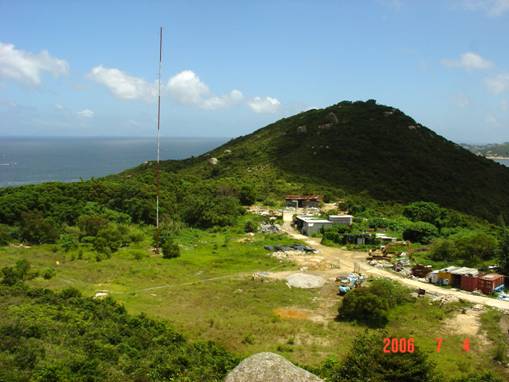
Figure
4.1b General View of Proposed
Project Site
4.1.1
Fieldwalking
Fieldwalking within the proposed Project Site
identified no significant archaeological finds.
4.1.2
Test Pit
Excavation
Three test pits were excavated within the proposed Project Site (see Figure C4.1a for location). As the proposed Project Site is situated
on a site that had previously been cut and filled, the stratigraphy
of the test pits comprised a filled soil layer with rubbish as top soil, then
the original soil layer and then the regolith
layer. No artefacts or cultural
layers were found in any at the excavated test pits. A summary of the test pit stratigraphy is presented in Table 4.1a and detailed information on stratigraphy
is presented in Appendix C2a.
Table 4.1a Summary of Test Pit Results
|
TP No. |
Soil Profile |
Finds |
|
1 |
Layers 1 to 4 are filled soil, layers 5 to 6 are
original loamy soil, layer 7 is regolith layer |
No
artefacts or
cultural layers discovered |
|
2 |
Layers 1 to 4 are filled soil with modern rubbish, Layer 5 is original top
soil, Layers 6 is sandy soil, Layer 7 is loamy soil, and Layer 8 is clayey
soil |
No
artefacts or
cultural layers discovered |
|
3 |
Layer 1 is filled soil with modern rubbish, layer 2
is original top soil, layers 3 and 4 are loamy soil, layer 5 is regolith
layer |
No
artefacts or
cultural layers discovered |
4.1.3
Augering
in Test Pits within the Proposed Project Site
Three
auger holes (AH) were bored to the sterile layer from the bottom of the test
pits (TPs).
No artefacts or cultural layers were identified from augering. Table 4.1b presents a summary of
the findings from the auger holes result and the detailed soil profile of each
auger hole.
Table 4.1b Summary
of Auger Holes Results in TP 1 to 3
|
AH Nos. |
Location |
Soil Profile |
Finds |
|
TP1-AH |
Bottom of TP 1 |
Loamy soil and completely decomposed bedrock soil |
No
artefacts or
cultural layers discovered |
|
TP2-AH |
Bottom of TP 2 |
Loamy soil and completely decomposed bedrock soil |
No
artefacts or
cultural layers discovered |
|
TP3-AH |
Bottom of TP 3 |
Loamy soil and completely decomposed bedrock soil |
No
artefacts or
cultural layers discovered |
4.2
Findings for the Enabling Works for
Access Routes
The fieldwork covers the areas that minor enabling works are required
(see Figure C2.2a). The cut slope area next to the existing
access routes.
4.2.1
Fieldwalking
The fieldwalking at the proposed enabling
works area identified no significant archaeological finds.
4.2.2
Augering
A total of 10 auger holes (AH) were bored at the enabling works area
(see Figure C2.2a for a general plan
of the location s of the 10 auger holes and Figures C4.2a
to C4.2e for detailed parts and photographs). No archaeological deposits and finds
were identified. The soil profile
of the ten auger holes was, from ground level:
·
Humus
top soil;
·
·
Sandy
loam soil; and
·
Completely
weathered rock soil.
Detailed soil profile of each auger hole are presented in Appendix
C2b.
5
Impact
assessment and Conclusion
The desktop review indicated that the proposed Project Site area had
previously been cut-and–filled, this coupled with the site’s location at the
hill ridge area at an elevation between 66 mPD to 74 mPD means that this area would have been unfavourable for
human inhabitation. Thus, the
proposed Project Site is considered to have no archaeological potential.
Fieldwork comprising field walking and excavation of three test pits
confirmed these findings and identified no archaeological deposits or cultural
layers at the proposed Project Site.
Therefore, no impact on archaeological resources is expected at the
proposed development at the Project Site.
With regard to the proposed minor enabling works areas, these areas
mainly involved rockcut, localised road widening and
establishment of retaining work at existing modified slopes. Thus, these areas have already been
heavily modified and are very steep.
They are considered to have no archaeological potential.
Fieldwork comprising field walking and boring of 10 auger holes
identified no archaeological deposits or cultural layers at these enabling
works areas. Therefore, no impact
on archaeological resources is expected as a result of the proposed enabling
works.
6
Bibliography
Chan, Lai Lee 1963 A Regional
Study of Hay Ling Chau, Hong Kong:
Fu Kuo Tai and Dr Wu Wing Cheung, c. 2004
"A Leprosy Centre at Hei Ling Chau" in Repair,
Reconstruct and Rehabilitate : Half a Century of Orthopaedics in Hong Kong,
Hong Kong :
Geographical Section General Staff No.1393, 1905, Map of Hong Kong and of the
Territory Leased to
Geotechnical Control Office 1988 Geotechnical
Area Studies Programme Report X; Islands,
Lockhart, Stewart 1900 Report on Extension of the Colony of Hong
Kong,
Whitehouse, R.D. ed 1983 Macmillan
Dictionary of Archaeology,
舒懋官 編 1819 《新安縣志》,新安縣衙。
兩廣總督府 編 1897 《廣東通志》,廣州,兩廣總督府。
區家發 1994 《香港喜靈洲考古勘察報告》,香港,古物古蹟辦事處 (未刊) 。
懲教署 2002 《綠色喜靈》(Greenish
Hei Ling) , 香港, 懲教署。