6
Landscape
& Visual IMPACT Assessment
This Section presents the Landscape and Visual Impact Assessment
(LVIA) for the construction and operation of the proposed wind turbine at Hei Ling Chau.
In accordance with the EIAO Guidance Note No.
8/2002, the main
components of the LVIA are as follows:
·
Description
of the Project;
·
Review
of the planning and development control framework;
·
Baseline
study of landscape character and landscape resources of the Study Area;
·
Landscape
impact assessment during construction and operation of the Project;
·
Visual
impact assessment during construction and operation of the Project;
·
Assessment
of night lighting and glare; and
·
Recommendations
for landscape and visual mitigation measures for both the construction and
operation phases;
·
Assessment
of the residual impacts and conclusion on the acceptability of the Project.
The background to the Project and the general description of the wind
turbine at Hei Ling Chau
are presented in Sections 1 and 3, respectively.
The Project
will comprise the enabling works for the access roads and the construction and
operation of an 800 kW to 1.3 MW wind turbine and associated equipment. The following description of the major visual components of the Project
is based on the initial design and will be subject to refinement at the
detailed engineering design stage. The
layout plan of the Project Site is illustrated in Figure 3.1b.
6.2.1
Wind
Turbine
The wind turbine comprises 3 rotor blades
connected by a hub to a nacelle which is in turn attached to the top of a
tapered tower. The hub height of the
wind turbine is 60m and the diameter of the rotor blade swept path is 60m. The
total maximum height of the structure is 90m and the base of the wind turbine
is at +70mPD. This gives the maximum height of the wind turbine at 160 mPD.
6.2.2
Temporary
Steel Platform and Bridge and Construction Access Routes
The major components of the wind turbine (ie,
the blades, nacelle and tower) will be delivered by a barge to the temporary
steel platform of the short access route (see Figure
3.3f). Each of these components
will then be lifted to the deck of the temporary bridge by a 300-tonne mobile
crane and transported to the Project Site by a transporter using the short
access route. The wind turbine
components will be assembled at the Project Site and erected using mobile
cranes.
The other construction plant and equipment will be delivered to the existing
jetty at the northern side of the island and transported to the Project Site
using the long access route.
6.2.3
Project
Site Areas
The site measures 100m in length and 54m at its widest point (not
including the entry driveway) and is on a concrete hardstand (see Figure 3.1b). The total area of the site is about 5,157 m2. The other visually prominent components are
as follows:
·
Two laydown areas for wind turbine assembly (10m x 35m and 4m x
15m);
·
Jib assembly area
(4m x 80m);
·
Two temporary cabins
(5m x 10m each);
·
A substation (5m x
6m);
·
A transformer (2.4m
x 2.6m); and
·
Crane area (18m x
22m).
6.2.4
Construction
Programme
The construction of the Project is
scheduled to commence in 2007 and expected to complete in 2008.
6.3
Legislation Requirements and Evaluation Criteria
The LVIA was undertaken in accordance with the guidelines and
requirements stipulated in Annexes 10
and 18 of the EIAO-TM under the EIAO (Cap.499, S16),
entitled "Criteria for Evaluating Visual and Landscape Impact" and
"Guidelines for Landscape and Visual Impact Assessment", respectively and the EIAO Guidance Note No. 8/2002 “Preparation
of Landscape and Visual Impact Assessment Under the
Environmental Impact Assessment Ordinance.”
The landscape assessment considers the potential impacts of the Project
on the existing landscape and particularly on the landscape resources within
500m of the Project Site and the work areas of the enabling works along the
access routes.
The visual assessment analyses the potential impacts of the wind turbine
on the existing views and the visual amenity, particularly from the Visually
Sensitive Receivers (VSR) within the viewshed
(sometimes referred to as the Zone of
Visual Influence (ZVI). This report
will use the term “viewshed”. In order to illustrate the visual impacts of
the wind turbine, photomontages prepared from selected viewpoints compare the
existing conditions with the view after commissioning. The residual impacts are evaluated
qualitatively, in accordance with the requirements of Annex 10 of the EIAO-TM.
There are currently no
Outline Zoning Plans (OZP) covering the Project Site at Hei
Ling Chau (see Figure 6.3a) and
hence potential conflict with future planned landuses
cannot be determined. The LVIA will be
assessed against the baseline conditions of the Study Area.
In accordance with Annex 18 of the EIAO-TM,
the landscape
impact assessment will cover the following:
·
Describe the baseline landscape. This section describes the landscape within 500m of the Project Site and
the works area of the enabling works along the access routes.
·
Describe the Landscape Character Areas (LCAs) and Landscape Resources (LRs).
The existing LCAs and LRs
are based on both topography and vegetation.
As well this section also describes edges as different LRs.
·
Map the distribution of the LCAs and LRs at Hei Ling Chau. This section maps both the distribution of the LRs
at present.
·
Propose a qualitative and quantitative
assessment methodology. This is based on an assessment of significant
thresholds which reflects the magnitude of change and sensitivity to change of
a particular LCA and LR.
·
Analyse the landscape impacts during
construction, impact after development, and off-site landscape impacts. This section analyses the extent to which these landscape units and edges
are changed, using both quantitative and qualitative assessments.
·
Discuss mitigation measures. This
section examines landscape measures that will contribute to reducing any
landscape impacts and that will enhance the landscape associated with the
development. This may include planting,
new landscaped areas and re-vegetation.
The residual landscape impacts are also analysed.
·
Provide conclusions on the impacts of the
Project. These are discussed along with the Visual
Impact and Landscape Character Impacts in Section 6.15.
6.4.1
Baseline
Landscape Conditions
As specified by the EIA Study Brief, the area for
the Landscape Impact Assessment covers the area within 500m of the proposed
development. The landscape baseline
study examines the potential impacts on the Project Site and surrounding areas
in terms of both the Landscape Character Areas (LCAs)
and the Landscape Resources (LRs).
The LCAs and LRs of the Study Area have been categorised according to the presence of common elements. These include factors such as:
·
Topography;
·
Vegetation type (both species and age);
·
Built forms;
·
Evidence on human modifications;
·
Land use (past and present); and
·
Edges.
6.4.2
Landscape
Sensitivity
An understanding
of the sensitivity to change of the LCAs and LRs is important when analysing the overall landscape
impact of the Project upon the LCAs and LRs.
Factors affecting the sensitivity of change for evaluation of landscape
are:
·
Quality
of LCAs and LRs;
·
Importance
and rarity of special landscape elements;
·
Ability
of the landscape to accommodate change;
·
Significance
of the change in the local and regional context; and
·
Maturity
of the landscape.
The degree of sensitivity of the LCAs and LRs is classified as follows:
·
High – eg important components
or landscape of particularly distinctive character susceptible to small
changes;
·
Medium – eg a landscape of
moderately valued characteristics reasonably tolerant to change; and
·
Low – eg a relatively
unimportant landscape which is able to accommodate extensive change.
The following section describes each of the LCAs and LRs within the Study
Area.
6.4.3
Landscape
Character Areas (LCAs)
The landforms on Hei Ling Chau
are characterised by hill slopes that vary
between gently undulating to three steep main peaks. The central peak is approximately 187 mPD, the north-eastern peak at
92 mPD and the southern peak near the Project Site at
122 mPD. The
island includes habitats such as plantation, shrubland,
abandoned wet agricultural land, reservoir and streams. However the island has also undergone a
number of man-made changes, including the construction of:
·
Two
Addiction Treatment Centres,
·
Correctional
Institution,
·
Staff
Quarters,
·
Roads;
and
·
Associated
Infrastructure.
The Landscape Character Map of Hong Kong describes Hei Ling Chau as ‘Coastal Waters
Landscape’. However, within this classification a number of more descriptive
Landscape Character Areas are identified. These include:
·
LCA1 –
·
LCA2 – The Institutional Landscape;
·
LCA3 – The Reservoir Landscape;
·
LCA4 – The Typhoon Shelter Landscape; and
·
LCA5 – The Inshore Water Landscape.
These Landscape Character Areas are illustrated in Figure 6.4o and are described in more detail
below.
Island Landscape (LCA1)
This LCA accounts for the largest area of the island.
It is characterised by vegetated areas, most commonly
shrubland, that range generally from 2-5m in height.
There are also isolated boulders and rocky areas protruding from the
vegetation. The terrain is generally sloping, quite steeply in some areas and
falls down to the mostly rocky shoreline. This LCA is considered to have a high
sensitivity to change.

Figure 6.4a
Institutional Landscape (LCA2)
This LCA consists of the CSD’s
buildings and infrastructure. It also includes the staff quarters on the
island. This LCA is considered to have a low sensitivity to change.

Figure 6.4b Institutional
Landscape
Reservoir Landscape (LCA3)
The reservoir is a small area of the island, but has a
unique landscape character. It is
characterized by the fresh water body with a vegetated edge. The reservoir is considered to have a medium
sensitivity to change.

Figure 6.4c Reservoir Landscape
Typhoon Shelter Landscape (LCA4)
The typhoon shelter is located in the bay to the south
east of the island. This area is characterised by
calm waters, moored marine vessels and the man made seawalls. This LCA is
considered to have a medium sensitivity to change.

Figure 6.4d Typhoon Shelter
Landscape
Inshore Waters Landscape
(LCA5)
The inshore waters landscape
is characterised by generally calm waters with
passing marine vessels. There are a number of nearby surrounding islands and
shores that gives this marine environment and intimate atmosphere. The
shorelines are generally rock lined with some sandy beaches. This LCA is
considered to have a high sensitivity to change.

Figure 6.4e Coastal Waters
Landscape
6.4.4
Landscape
Resources (LRs)
Eight LRs have been identified and are described below.
Shrubland (LR1)
Shrubland is the dominant LR within
the Study Area and the vegetation is generally about 1 to 4 m in height.

Figure 6.4f Shrubland (LR1)
Shrubland is dominated by several
native shrub species including Rhodomrytus tomentosa, Cratoxylum
cochinchinensis, Eurya
nitida, Embelia
laeta, Embelia
ribes and Gardenia jasminoides. Shrubland patches in the valleys are taller with an average
2 to 4 m in height while those on the hill slopes and ridges of the hills are 1
to 2.5 m in height. A total of 62 plant
species, with one of them, the Golden Eulophia Eulophia flava, a rare
and protected plant species in
The Shrubland is considered
to have a medium sensitivity to change.
Two small patches of plantations are located at the east and south of
the Study Area, which comprised a total area of 1.1 ha. A total of 33 plant species were recorded in
the plantations.

Figure 6.4g
The canopy species was dominated by Delonix regia, Casuarina
equisetifolia and Artocarpus hypargyrea. The middle layer of understorey is dominated
by Dimocarpus
longan, Melia
azedarach and Sterculia lanceolata while the lower layer of understorey
is dominated by Macaranga tanarius, Schefflera octophylla and Celtis
sinensis. Three
individuals of a locally protected tree species Artocarpus
Artocarpus hypargyrea were recorded at the plantation, which are mature
in size. The plantation located at the south of the
Study Area are exotic plantation dominated by tree species Acacia confusa of canopy height of 3 to 5
m. They are young in age and the understorey is scarcely occupied by native shrubs and weeds
including Bridelia
tomentosa, Lantana camara and Miscanthus
sinensis. The plantation is located at
the east next to the proposed wind turbine.
The
Abandoned Wet Agricultural Land (LR3)
A small patch of abandoned wet agricultural land is located in the
middle of the

Figure 6.4h Abandoned Wet
Agricultural Land (LR3)
This LR is dominated by a cultivated plant Zingiber
officinale at a height of 1.5 m. The abandoned wet agricultural land was
moist most of the time during the surveys with sedges being the dominant
vegetation type. A total of 31 plant
species were recorded within this LR and none of them are rare or protected.
The
Streams (LR4)
Three partially modified streams, are located within the Study
Area. Twenty plant species were recorded
along the streams and no rare/protected species were found during the surveys.

Figure 6.4i Stream (LR4)
The streams are considered to have a medium sensitivity to change.
Reservoir (LR5)
A reservoir is located in the middle of the

Figure 6.4j Reservoir (LR5)
The Reservoir is considered to have a medium sensitivity to change.
Developed Areas (LR6)
Developed areas comprise the buildings of the Hei
Ling Chau Correctional Institution, Hei Ling Chau Addiction Treatment
Centre, Hei Ling Chau
Addiction Treatment Centre (annex) and Lai Sun Correctional Institution, as
well as other associated facilities, including administration buildings, staff
quarters, two helipads, a guard dog kennel and a few old village houses. A typhoon shelter was constructed at the
western side of the

Figure
6.4k Developed Areas (LR6)
All of the vegetation
recorded within this LR, such as Acacia confusa, Delonix
regia, Bauhinia blackeana
and Ficus microcarpus, were planted for landscaping
purposes. This LR was highly developed
in nature with limited ecological significance.
A total of 33 plant species were found in this LR and no rare plant
species were found.
The
Developed Areas is considered to have a low sensitivity to change.
Rocky Shoreline (LR7)
The Rocky Shoreline LR is the most common edge to the
island.

Figure
6.4l Rocky Shoreline (LR7)
Along the indented
rocky shore there are steep rock-faces which extend up from the shore.
The Rocky Shoreline LR generally provides the border
to the Shrubland LR as it meets the sea. The Rocky Shoreline comprises approximately 95% of the perimeter of Hei Ling Chau.
The Rocky Shoreline is considered to have a high
sensitivity to change.

Figure 6.4m
The Sandy Shore LR accounts for approximately 5% of the islands edge.
6.4.5
The
Distribution of LRs
Most of the Study Area remained natural with some areas partly disturbed
by rural/village developments. Habitats
found within the Study Area include, Shrubland,
Figure 6.4n shows the distribution of
the existing LRs. The most dominant landscape
resource is shrubland followed by developed area.
Table 6.4a LCAs and LRs Recorded Within the
Study Area

6.4.6
Landscape
Impacts During
Construction
The two key factors that affect the evaluation of LCA and LR impacts are
the magnitude of change and the sensitivity of the landscape
areas/resources. The sensitivity to
change for each of the LCAs and LRs
has been described above and the factors affecting the magnitude of change are
outlined below.
Factors affecting the magnitude of
change for assessing landscape impacts are:
·
Compatibility
of the Project with the surrounding landscape, ie how
well will the proposed development fit with its surrounds. For example, a new housing development
constructed in an area with other housing developments or built forms will have
a higher compatibility.
·
Scale
of the development, ie how big is the development
relative to its surroundings. For
example a 30-storey building constructed on
·
Reversibility
of change. This refers to how easily the
changes on the landscape can be reversed.
For the purposes of this assessment, we have assumed the wind turbine
changes are ‘irreversible’.
The magnitude of change is classified as follows:
·
Large – notable change in the landscape characteristics
over an extensive area ranging to very intensive change over a more limited
area;
·
Intermediate – moderate changes to a local area;
·
Small – changes to specific landscape components; and
·
Negligible – no substantial changes to the baseline condition.
The landscape impact is a product of the magnitude of change the wind
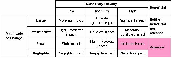
turbine will have and the sensitivity of the LR. Table 6.4b shows the significance threshold of the LR impacts.
Table 6.4b Significance
Threshold of Potential Landscape Resource Impact

Table 6.4c provides some definitions of the significance
thresholds for landscape impacts.
Table 6.4c Adverse /
Beneficial Impact of Landscape Impact
|
Level of Impacts
(Negative / Beneficial) |
|||
|
Significant: |
Moderate: |
Slight: |
Negligible |
|
Adverse / beneficial impact where the Project would cause significant
degradation or improvement in existing landscape baseline conditions |
Adverse / beneficial impact where the Project would cause noticeable
degradation or improvement in existing landscape baseline conditions |
Adverse /beneficial impact where the Project would cause a barely
noticeable degradation or improvement in existing landscape conditions or
where the changes brought about by the Project would not be apparent in
visual terms |
The Project does not affect the existing landscape baseline
conditions |
Unmitigated Landscape Impacts During
Construction
Table 6.4d shows the impact of the Project on each
of the LRs and the overall impact based on the
preceding Landscape Impact Assessment Matrix.
Table 6.4d Unmitigated Landscape Impact Significance Threshold
Matrix
|
LR |
Area / Length |
LR Affected by Proposed Development |
% of LR Area / Length Affected |
Sensitivity to Change |
Magnitude of Change |
Significance Threshold of Landscape
Impact |
|
LR1
Shrubland |
160 ha |
0.16ha |
0.1% |
Medium |
Small |
Slight |
|
LR2
|
1.1 ha |
Nil |
0% |
Medium |
Negligible |
Negligible |
|
LR3
Abandoned Wet Agricultural Land |
0.1 ha |
Nil |
0% |
Medium |
Negligible |
Negligible |
|
LR4
Streams |
0.4 km |
Nil |
0% |
Medium |
Negligible |
Negligible |
|
LR5
Reservoir |
0.2 ha |
Nil |
0% |
Medium |
Negligible |
Negligible |
|
LR6
Developed Area |
29.9 ha |
0.67 ha |
2% |
Low |
Small |
Slight |
|
LR7
Rocky Shoreline |
8.17 km |
Nil |
0% |
High |
Negligible |
Negligible |
|
LR8
|
0.43km |
Nil |
0% |
High |
Negligible |
Negligible |
|
LCA1
|
169 ha |
0.16ha |
0.09% |
High |
Small |
Moderate |
|
LCA2
Institutional Landscape |
29.9ha |
0.67 ha |
2% |
Low |
Small |
Slight |
|
LCA3
Reservoir |
0.2ha |
Nil |
0% |
Medium |
Negligible |
Negligible |
|
LCA4
Typhoon Shelter |
190ha |
Nil |
0% |
Medium |
Negligible |
Negligible |
|
LCA5
Inshore Waters |
350ha |
Nil |
0% |
High |
Negligible |
Negligible |
Summary of Un-mitigated Impacts on Landscape
Resources During Construction
The Project will impact on approximately 0.1% of the shrubland resources and 2% of the developed area. These are both assessed as slight
adverse impacts.
Figures 6.4p to
6.4v
show the unmitigated potential impacts on the LR of Hei
Ling Chau.
Summary of Un-mitigated Impacts on Landscape
Character Areas During Construction
The Project will impact on approximately 0.4% of LCA1
Island Landscape. As the sensitivity to
change for the LCA1 is High, even the smallest impact is considered moderate. There will also be a slight impact on
the LCA2 Institutional Landscape. Both of these impacts are considered to be adverse.
Qualitative LCA Impact Assessment
As Landscape Character is defined more generally than LRs (views, surrounding landscapes, etc), the impacts on
the LCAs are assessed qualitatively. This is more difficult to define, and is
based on the professional judgment of the author. It is also predicated on the ability to see
the development, which is assessed in Section 6.5. In
order to qualitatively assess the impacts on the LCAs,
the findings of the visual impact assessment in Section 6.5 have been consulted.
LCA1 –
The impacts on the quality of the LCA1 Island
landscape will be varied. Many parts of the island will not see the wind
turbine, particularly the northern areas therefore the impact will be
negligible. However from the southern areas the wind turbine and associated
works will be visible from a number of areas. The overall Impact on the quality
of this LCA is considered to be moderate.
LCA2 – Institutional Landscape
As for LCA1, the wind turbine and associated works
will not have any impact on many parts of this LCA. Also, given this LCA
contains many build forms, this will lessen any impact on the quality of the
LCA. Therefore the impact is considered to be slight.
LCA3 – Reservoir Landscape
The works will have no direct impact on this area, and
will only be partially visible. However given the proximity of the wind turbine
to this LCA and its inherent intimate atmosphere, there may be some views to
the wind turbine therefore the impact on the quality of this LCA is considered
to be slight.
LCA4 – Typhoon Shelter Landscape
The wind turbine will be visible from nearly all areas
within this LCA. However the presence of the man made seawalls and the moored
marine vessels indicates that the impacts on the quality of this LCA will be slight.
LCA5 – Inshore Waters Landscape
The wind turbine will not be visible from most of the
areas within this LCA, and there will not be any impact. However, some areas will experience an impact
as the wind turbine will be visible. The
effect this impact will have on the Inshore Waters Landscape within the Study
Area is considered to be moderate.
Summary of Impacts on LCAs
The quantitative and qualitative assessments are summarised in Table
6.4e and below. In order to define
the impact on the LCAs an average of the two
assessment methodologies has been taken.
Table 6.4e LCA
Impact
|
LCA |
Quantitative Impact |
Qualitative Impact |
Impact |
|
1 |
Moderate |
Moderate |
Moderate |
|
2 Institutional
Landscape |
Slight |
Slight |
Slight |
|
3 Reservoir |
Negligible |
Slight |
Slight |
|
4 Typhoon Shelter |
Negligible |
Slight |
Slight |
|
5 Inshore Waters |
Negligible |
Moderate |
Slight |
The impacts on LCAs 1, 2, 3, 4 and 5 are considered to be adverse as the turbine will be a new man made facility and these four LCAs are mostly natural environments.
6.4.7
Landscape
Impacts During Operation
It is anticipated that all of the impacts on the LR of Hei Ling Chau will only be
created during the construction phase, therefore no further impacts on the LRs are expected during operation of the wind turbine. There would however be continuing impacts on
the LCAs as the presence of the wind turbine will
change the character of some LCAs for the duration of
the Project. These impacts will continue
as described in Table 6.4e.
6.4.8
Landscape
Mitigation
The landscape mitigation measures proposed will be implemented
progressively throughout the construction of the wind turbine.
Several mitigation measures are proposed to reduce the potential impacts
on the existing LRs.
These are illustrated in Figures 6.4p to
6.4v.
LMM 1 – Cultivation of areas impacted during
construction. Areas impacted during the construction phase
that are not required during the operation phase, are to be cultivated to a
depth of 300mm in accordance with the future Landscape Specification.
LMM 2 – Soil stabilisation and embankment planting.
During the design process a soil stabilisation and embankment planting
strategy will ensure that all land affected by slope excavation can be
replanted, wherever practicable. All
soil preparation and the selection and provision of a suitable growing medium
is to be completed in accordance with the relevant best practice guidelines. This mitigation measure will require
long-term maintenance and management which will be the responsibility of the
Project Proponent.
LMM 3 – Tree and shrub planting.
All planting of trees and shrubs is to be carried out in accordance with
the relevant best practice guidelines.
Plant densities are to be provided in future detailed design documents
and are to be selected so as to achieve a finished landscape that matches the
surrounding, undisturbed, equivalent landscape types. This mitigation measure will require
establishment maintenance which will be the responsibility of the Project
Proponent.
The impacts on the LCAs will also be naturally
mitigated over time. The landscape is constantly changing, as are people’s
perceptions of the Landscape Character. People will become more accustomed to
seeing the wind turbine over time, therefore time is a natural mitigation
measure of the wind turbine’s impact on the LCAs.
Table 6.4f describes the predicted un-mitigated
impacts on the landscape resources of Hei Ling Chau in both construction and operation phases. It also shows the predicted mitigated impacts
during construction, day 1 of operation and year 10 of operation.
Table 6.4f Mitigated
Landscape Impacts

The landscape mitigation measures will be carried out by the
contractor. The contractor may elect to
have the works carried out by a specialist landscape sub-contractor. Once the impacted areas are re-vegetated, there
is no particular maintenance requirement for the vegetation.
Effectiveness of Landscape Resource Mitigation
Measures
Due to the operational requirements of the wind turbine, some landscape
impacts cannot be mitigated.
6.4.9
Residual
Landscape Impacts
The residual landscape impacts (see Table
6.4g) are those that will exist after all mitigation measures have been
implemented.
Table 6.4g Residual
Landscape Impacts
|
LR/LCU |
Area / Length |
Area Affected by the Project |
Mitigated Area |
Residual Impact |
|
LR1
Shrubland |
160 ha |
0.16 ha |
0.01 ha |
0.15 ha |
|
LR2
|
1.1 ha |
Nil |
Nil |
Nil |
|
LR3
Abandoned Wet Agricultural Land |
0.1 ha |
Nil |
Nil |
Nil |
|
LR4
Streams |
0.4 km |
Nil |
Nil |
Nil |
|
LR5
Reservoir |
0.2 ha |
Nil |
Nil |
Nil |
|
LR6
Developed Area |
29.9 ha |
0.67 ha |
0.67 ha |
Nil |
|
LR7
Rocky Shoreline |
8.17 km |
Nil |
Nil |
Nil |
|
LR8
|
0.43km |
Nil |
Nil |
Nil |
|
LCA1
|
169 ha |
0.16ha |
0.01ha |
0.15ha |
|
LCA2
Institutional Landscape |
29.9ha |
0.67 ha |
0.67ha |
Nil |
|
LCA3
Reservoir |
0.2ha |
Nil |
Nil |
Nil |
|
LCA4
Typhoon Shelter |
190ha |
Nil |
Nil |
Nil |
|
LCA5
Coastal Waters |
350ha |
Nil |
Nil |
Nil |
Residual Impact Summary
There will be a residual landscape impact of 0.15 ha
of Shrubland (LR1) and 0.15 ha on Island Landscape
(LCA1). As the developed areas will all
be replaced with new developed areas as part of the wind turbine construction,
there would be no residual impacts on the developed area and the Institutional
Landscape.
6.4.10
Landscape
Impact Conclusion
The Project will affect two types of LRs (Shrubland and Developed Area) principally as a result of
the excavation required for the wind turbine such as the enabling works and
formation of the Project Site. The
potential un-mitigated impacts are considered to be slight adverse. Mitigation
measures have been recommended to minimise the impacts. With the implementation of the recommended
mitigation measures the long term impact will be negligible.
The LCAs will be affected by both the
construction and operational phases of the Project. There will be a moderate adverse
impact on LCA 1, Island Landscape, with the potential impacts on LCAs 2, 3, 4 and 5 considered to be slight adverse. Whilst these impacts may reduce over time as
the landscape accepts the development, however the impacts on the LCA’s cannot be actively mitigated.
The impacts on the LRs and LCAs,
are therefore considered to be acceptable.
6.5.1
Introduction
The following tasks were undertaken in the visual impact assessment.
Define the viewshed
that would be potentially impacted by the Project and map the areas of visual
impact
This task describes the viewshed of the wind turbine, which was developed based on
both the planning guidelines and the parameters of human vision. Geographical Information System (GIS)
software was then utilised to determine areas that could potentially see the
wind turbine. This GIS viewshed analysis was based solely on topography and did
not take into account the screening potential of vegetation, which would
further reduce the actual viewshed. The GIS viewshed
analysis also mapped the visibility of the wind turbine from roads and houses.
Discuss atmospheric conditions
This task discusses the mitigating effects
of weather, particularly sea haze and rainfall.
Assessing
indicative viewpoints as
a means of assessing the visual impact on the broader landscape
This task describes a number of Visually Sensitive Receiver (VSR) viewpoints around the
wind turbine, which have been selected as indicative of the range of views from
accessible locations within the viewshed. Photomontages have been prepared to show the
existing landscape and the landscape with the wind turbine at the key VSRs.
Discuss visual mitigation measures
This task examines measures (if required)
that will reduce any potential visual impacts.
This may include planting and recommendations for material and
finishes. These measures will also help
improve the overall amenity of the Project.
Residual impacts are also discussed.
Assess night lighting and glare impacts
This task examines the potential glare and
night lighting impacts associated with the Project.
6.5.2
Viewshed Determination
and Areas of Potential Visual Impact
The baseline for a visual impact assessment is an understanding of the
existing visual qualities within the region that can be visually affected by a
development. This area is referred to as
the viewshed.
Defining an appropriate viewshed is the
starting point to understand the visual impacts of a development as the area of
the viewshed will vary depending on the nature and
scale of the proposed development. The
larger a development the greater the viewshed as it
may be visually apparent for a greater distance. Once the viewshed
is established, locations can be identified within the viewshed
that are either particularly sensitive or indicative of the visual impact for a
number of locations. In some circumstances,
viewpoints may be identified beyond the viewshed to
recognise the visual impact on locations of particularly high sensitivity.
The wind turbine is the major visual element of the Project and may
visually impact on the surrounding landscape.
As the viewer moves further away from the wind turbine, the visual
impact decreases until the wind turbine is no longer visible. However, before the point of non-visibility
is reached, the wind turbine has reduced in scale such that it no longer has a
significant visual impact on the landscape.
In most landscapes, especially those which have some degree of human
intervention, the limit of the viewshed is defined as
that point at which the wind turbine would have an insignificant effect on the
view.
6.5.3
Types
of Viewshed
In recognising that the viewshed is not the
limit of visibility, but rather the extent to which the wind turbine would have
an insignificant visual impact on the landscape, then the extent of a viewshed differs in the context of different landscapes.
A viewshed in a man-modified landscape is
different to a viewshed in a pristine landscape or
landscapes where there are no apparent signs of human influence. This is because in landscapes that appear
‘natural’ or pristine, a man made element such as a wind turbine, can visually
influence the landscape for as long as a viewer can discern that newly
introduced element. A man made element
in a pristine landscape irrevocably changes a pristine landscape from natural
to man modified. Therefore, viewsheds in pristine areas are extended to the limit of
human visibility.
However in man modified landscapes, in which there are many other
existing built forms or modifications to the landscape, the viewshed
extends to that distance at which the wind turbine becomes a minor element in
the landscape to all but the most sensitive of viewers. The wind turbine may still be visible beyond
this viewshed, however it is considered that beyond
this viewshed the visual impact will be
insignificant.
The viewshed then is that area that is most
likely to be visually impacted and once again, it is stressed that particularly
sensitive locations beyond the viewshed may still
need to be reviewed.
6.5.4
Viewshed Determination
The visual impact of a development can be quantified by reference to the
degree of influence on a person’s field of vision. Figure 6.5a illustrates the typical
parameters of human vision and are based on anthropometric data ([1]).
This data provides a basis for assessing and
interpreting the impact of a development by comparing the extent to
which the development would intrude into the central field of vision (both
horizontally and vertically).
Horizontal Cone of View
The
central field of vision for most people covers an angle of between 50° and
60°. Within this angle, both eyes
observe an object simultaneously. This
creates a central field of greater magnitude than that possible by each eye
separately. This central field of vision
is termed the 'binocular field' and within this field images are sharp, depth
perception occurs and colour discrimination is possible. These physical parameters are illustrated in
the Figure 6.5a.
|
|

Figure 6.5a Horizontal Field of View
The visual impact of a development will vary according to the proportion
in which a development impacts on the central field of vision. Developments, which take up less that 5% of
the central binocular field, are usually insignificant in most landscapes (5%
of 50° = 2.5°).
In assessing the visual impact of the wind turbine it is assumed that
the largest horizontal component is the entire rotor, which is approximately
60m wide.
Table 6.5a Visual
Impact Based on the Horizontal Field of View
|
Horizontal Field
of View |
Impact |
Distance from an Observer to a 60m Rotor |
|
<2.5° of view |
The
development will take up less than 5% of the central field of view. The development, unless particularly
conspicuous against the background, will not intrude significantly into the
view. The extent of the vertical
angle will also affect the visual impact. |
|
|
2.5° – 30° of view |
The development may be noticeable and
its degree of visual intrusion will depend greatly on its ability to blend
in with its surroundings. |
150 m – 2km |
|
>30° of view |
Potentially visually dominant Developments
that fill more than 50% of the central field of vision will always be
noticed and only sympathetic treatments will mitigate visual effects. |
< 150m |
As shown in Table 6.5a, these
calculations suggest that the impact of a 60m wide wind turbine rotor would reduce
to insignificance at about 2km, as it would form less than 5% or 2.5° of the
horizontal field of view.
Vertical Field of View
A similar analysis can be undertaken based upon the vertical line of
sight for human vision. As can be seen
in the Figure 6.5b the typical line of sight is considered horizontal or
0 °. A person’s natural or
normal line of sight is normally a 10 ° cone of view below the
horizontal and, if sitting, approximately 15 °.
|
|

Figure 6.5b Vertical
Field of View
Objects, which take up 5% of this cone of view (5% of
10 ° = 0.5 °) would only take up a small proportion of
the vertical field of view, and are only visible when one focuses on them
directly. Objects that take up such a
small proportion of the vertical view cone are not dominant, nor do they create
a significant change to the existing environment when such short objects are
placed within a disturbed or man-modified landscape.
Table 6.5b shows the relationship between impact and the
proportion that the development occupies within the vertical line of sight.
Table 6.5b Visual Impact Based on Vertical Field of
View
|
Vertical Line |
Impact |
Distance from an Observer to a 90m Tall Wind Turbine |
|
< 0.5° of vertical
angle |
Insignificant A thin line in
the landscape. |
>10 km |
|
0.5° – 2.5° of vertical
angle |
Potentially
noticeable The degree of
visual intrusion will depend on the development’s ability to blend in with
the surroundings. |
1.5 – 10, km |
|
> 2.5° of vertical
angle |
Visually
evident Usually visible, however the degree of
visual intrusion will depend of the width of the object and its placement
within the landscape. |
< 1.5km |
These calculations suggest distances at which the magnitude of visual
impact of the wind turbine will reduce with distance. At distances greater than 10km, a fully
visible wind turbine would be an insignificant element within the
landscape.
These calculations seem closer to the observed distances at which levels
of impact seem to change. It is stressed
that these ranges will only provide a guide for the visual impact
assessment.
An apparent discrepancy will occur when analysing horizontal and
vertical parameters separately.
Generally, the more conservative figures form the basis for the
assessment. In this example it is
proposed to extend the viewshed to 10km, although it
could be argued that a lesser extent would also be valid.
For the wind turbine, it is proposed that
the distances described in Table 6.5c are used for the viewshed analysis.
Table 6.5c Viewshed
and Degrees of Visual Influence

6.5.5
Areas
of Potential Visual Impact
A GIS viewshed analysis can determine those
areas that can potentially be visually impacted by the wind turbine. Such analysis is based on topography only,
and shows those areas that would be screened by intervening hills etc. It does not account intervening vegetation or
buildings, nor does it take into account small variations in topography, such
as road cuttings. Therefore it is a
conservative assessment of those areas that may be potentially able to view the
wind turbine.
Figure 6.5c shows an analysis of those areas within a 10km viewshed that may be able to see any part of any of the
wind turbine.
The viewshed is divided into two zones. The zone of greatest potential visual impact
is those areas that lie within 1.5 km of the wind turbine. Since the wind turbine is shielded by the Hei Ling Chau Headland Hill, the
majority of the areas that can see the turbine are in the ocean.
6.5.6
Atmospheric
Factors Which Will Affect Visual Impact
Many climatic conditions result in changes to visibility. For example, sea haze, rainfall and other atmospheric
conditions will alter the visibility of the wind turbine. The diminution of visual clarity bought about
by atmospheric conditions increases with distance. As the much of the areas that can
see the wind turbine are located on or across the sea, the impact of sea haze
and other atmospheric conditions will reduce visibility.
Sea Haze
Sea haze is a climatic condition along coastlines
that can reduce visibility even on days when the weather is fine. Wind which blows across the ocean or other
atmospheric conditions can cause a sea haze, limiting views to the wind turbine
from surrounding areas.
However sea haze is unlikely to have much impact on the visibility of
the wind turbine when viewed from close proximity, say less than 1.5km. When the same features are viewed from
greater distances within the viewshed the effect of
sea haze will greatly reduce visibility and any potential visual impact.
Cloud Cover
Cloudy days can also reduce visibility of wind turbine. During site inspections of similar facility
it was apparent that a backdrop of grey cloud reduced the visual impact. Full cloud cover also reduced the apparent
contrast on elements that extend above the landscape backdrop and as these
elements were neither strongly shadowed nor reflective, they merged into the
sky.
Figure 6.5d shows that in
Rainfall
The effect that rainfall has on visibility can be measured in two
ways. Firstly the event of falling rain
reduces visibility as the water droplets obscure vision. This varies greatly depending on the
heaviness of the precipitation, but even light rain obscures distant objects
greatly.
Secondly, the event of rain, particularly sustained rain periods,
reduces visitor numbers. Therefore, the
visual impact is reduced on those days as lesser viewers are visiting the area
and looking at the wind turbine.

Figure 6.5d Hong Kong Weather (Source:
Figure
6.5d
shows that during the wetter months, particularly from May through September,
6.5.7
Assessment
Scenarios
Whilst the above Section 6.5.6
describes some of the climatic conditions that reduce the visibility of the
wind turbine, the following assessment is based on a worst case impact scenario
on visual quality and character assuming perfectly clear viewing
conditions. Mitigation measures are
proposed to reduce these impacts.
6.5.8
Baseline
Visual Character
The area within the viewshed is of varying
visual character and quality. The
dominant features that define the visual character are the Islands of Hei Ling Chau, Peng Chau and Lantau,
with scattered smaller surrounding islands. These islands are all generally
similar in general landscape character.
They are characterised by undulated vegetated slopes with protruding
rocky outcrops. The coastal edge is
generally rocky with scattered sandy beaches. There are also clear signs of
human habitation on most of the islands.
The islands are farmed by the coastal waters that are generally
calm. The coastal waters also contain
many passing marine vessels.
The presence of the vegetated hills, islands and water all contribute to
an area of high visual quality and character.
6.5.9
Visually
Sensitive Receivers
To determine the likely VSRs, a desktop
assessment and detailed site assessment were carried out. The most sensitive VSRs
were then identified and to encompass the likely range of potentially affected VSRs. These include VSRs in the following areas:
·
Residents;
including Villages such as
·
Visitors;
including
·
Visitors
on Marine vessels; these include visitors on passing ferries as well as
recreation visitors to the area.
6.5.10
VSR
Assessment
The following factors have been considered in the
visual impact assessment.
VSR Sensitivity
The first set of criteria relate to the sensitivity of the VSRs. They include:
·
Value
and quality of existing views;
·
Availability
and amenity of alternative views;
·
Type
and estimated number of receiver population;
·
Viewer
numbers;
·
Duration
of frequency of view; and
·
Degree
of visibility.
The views available to the identified VSRs
were rated in accordance with their sensitivity to change using high, medium or
low and are defined as follows:
·
High
i.
The
nature of the viewer groups who expect a high degree of control over their
immediate environment; and
ii.
The
viewer groups are in proximity to the wind turbine.
·
Medium
i.
The
nature of the viewer groups who expect a medium degree of control over their
immediate environment; or
ii.
The
nature of the viewer groups who have some degree of control over their
immediate environment, people in transit.
·
Low
i.
The
nature of the viewer groups does not expect a high degree of control over their
immediate environment.
It should be noted that the above provided
are a guide only, and each VSR regardless of type is assessed according to its
specific circumstances.
Magnitude of Change
This set of criteria is related to the specific details of the proposal
and how it relates to the existing landscape and the visible magnitude of
change it will cause. The criteria to be
assessed are:
· Compatibility of the wind turbine with the surrounding landscape;
·
Scale
of the development;
·
Reversibility
of change;
·
Viewing
distance;
·
Potential
blockage of view; and
·
Duration
of impact under construction and operation phases.
The magnitude of change to a view was rated as large, intermediate,
small or negligible and are defined as follows:
·
Large: eg major change
in view.
·
Intermediate: eg moderate
change in view.
·
Small: eg minor
change in view.
·
Negligible: eg no
discernible change in view.
The degree of visual impact or significance threshold was rated in a
similar fashion to the landscape impact, ie
significant, moderate, slight and negligible.
Therefore, the visual impact is a product of the magnitude of change to
the existing baseline conditions, the landscape context and the sensitivities
of VSRs. The
significance threshold of visual impact was rated for the construction phase
and for Day 1 and Year 10 of the operation phase as described in Table 6.4b.
6.5.11
Photomontage
Preparation
The visual impact assessments were also partly based on photomontages, which
showed the view with and without the wind turbine.
Photographs that form the base of the photomontages
are taken with a 70mm Nikon lens on a 35mm film single lens reflex camera. A 70mm lens has a picture angle of 34.34°
and a horizontal angle of view of 28.84° ([2]).
When two photographs taken with a 70mm lens are overlapped approximately
1/3, the resultant image has a picture angle of approximately 50°, which is
very similar to the central cone of view of human vision.
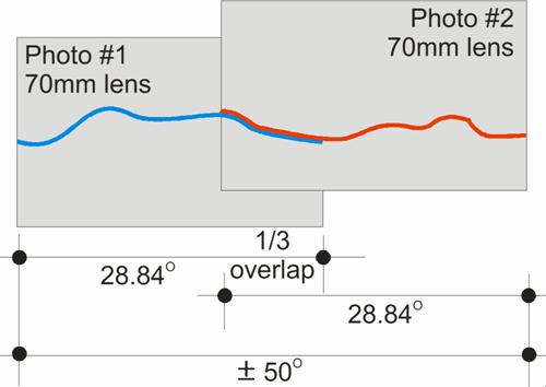
Figure 6.5e Two Photographs Overlapped 1/3 to Create an Image Approximately
the Same as the Central Cone of View of Human Vision
The central field of human vision is approximately 50° - 60°. Two photographs taken with a 70mm lens with
approximately 1/3 overlap best show this static view.
6.5.12
Turbine
Markings
The photomontages discussed in the following pages show the wind turbine
with aviation warning marking (with orange and white bands) as required by the
Civil Aviation Department.
6.5.13
Viewer
Perception
Several studies (see below) have shown that a larger portion of the
general public is in favour of wind turbines.
The visual impact of the wind farm ultimately depends on the perception
of the viewer and viewer perception is an important issue to consider,
especially in areas near tourist destinations or other attractions. The degree of visual impact also partly
depends on how the viewer perceives renewable energy, the wind turbines and the
landscape. The following section builds
upon ERM’s discussion of perception issues in past
visual impact assessments of other wind turbines and wind farms.
Community perception studies have also
been undertaken overseas to gauge levels of community support and opposition to
wind farms.
Peoples’ Perception of Wind Farms in
Market research has been undertaken by government
agencies as well as wind farm proponents, to ascertain people’s perception and
response to wind farms in
Research on the Victorian Coastal Region
was undertaken by TQA Research Pty Ltd for The Department of Natural Resources
and Environment.

Figure 6.5f Reaction
to Wind Farms on Coastal Headlands ([3])
This report looked at many issues involving the
Victorian Coastline by questioning participants at various clinics and
workshops. Amongst the issues addressed
was participants’ support or opposition to the presence of wind farms on
coastal headlands. The support (or
opposition) was measured on people’s initial reaction and then after being exposed
to arguments on renewable energy, greenhouse gas emissions and climate change
issues. This study found that after
these arguments were presented, opposition reduced from 27% to 21%.
Peoples Perception
of Wind Farms in
A paper presented at the 20th British Wind Energy Association
Conference ([4]), gives an overview of public opinion
surveys undertaken from 1996 and reports:
·
Overwhelming
majority of respondents supports the principal of development of wind power in
the
·
Those
with direct experience of an operating wind farm are more supportive and
positive than those without experience.
·
Once
wind farms are in operation, concerns about noise and visual impact decrease.
·
The
majority of people find the wind farms acceptable in the landscape and more
find the wind turbines graceful than ugly.
·
A
strong majority support and a small minority oppose wind farms, with more
expressing no opinion than opposition.
Anne Marie Simon Planning and Research produced a detailed study ([5]) for the British Wind Energy Association
in September 1996. It compiled the
results for 13 different research studies undertaken by wind power proponents,
opposition groups, the BBC, statutory authorities and a
Peoples Perception
of Wind Farms in
The experience in the

Figure 6.5g Placement Issues –
The Sounds are the coastal areas of
These examples support the theory that in general terms, more people
support wind turbines and wind farms than those that oppose them. No such studies have been undertaken in Hong
Kong, however the construction of this demonstration project for public
interest will be a valuable gauge of the acceptability of future wind turbines
in
6.5.14
Visual
Impact Assessment from Visually Sensitive Receivers (VSR)
Figure 6.5h shows the indicative viewpoints from publicly
accessible locations, which have been selected for analysis. The viewpoints have been selected to
represent the range of views from accessible locations.
VSR1 – View from Cheung Chau
The VSR from Cheung Chau is located at about 4.5km south of the wind turbine. Cheung Chau experiences large numbers of visitors and has many permanent residents. Whilst this location is a little further away from the turbine than the northern tip of the island, it wasted as it experiences relatively high numbers of visitors that will have an elevated view of the turbine. It therefore represents a worst-case scenario.

Figure
6.5i VSR1 - Cheung Chau
Photomontage 1 (see Figure 6.5j)
shows that the wind turbine will be noticeable.
However the peak at the southern end of Hei
Ling Chau blocks much of the view of the base of the
wind turbine, leaving the top portion of the mast, the blades and the nacelle
visible.
Table
6.5d Sensitivity / Quality of VSR at
Cheung Chau

Table 6.5e Magnitude
of Change

Table 6.5f Significance
Threshold during Construction
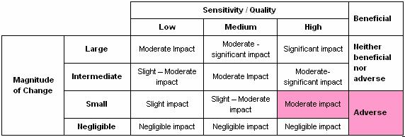
Table 6.5g Significance Threshold during Operation
The wind turbine will be noticeable on clear
days; however, given the long distance from this viewpoint and the high
availability of other attractive views, there will be a moderate adverse visual impact.
VSR2 – View from Mui Wo
The VSR at
Mui Wo is located at about
4.9km north-west of the wind turbine. Mui Wo experiences high visitor
numbers and has permanent residents.

Figure 6.5k VSR2
- Mui Wo
Photomontage 2 (see Figure 6.5l)
shows that the wind turbine will be noticeable.
However there are several developments on the western side of the Hei Ling Chau that are also
visible.
Table 6.5h Sensitivity /
Quality of VSR at Mui Wo

Table 6.5i Magnitude of Change

Table 6.5j Significance
Threshold during Construction

Table 6.5k Significance
Threshold during Operation

The visual impact of the wind turbine from this location is considered moderate
adverse due to the presence of other man made structures and the high availability of other attractive
views.
VSR 3 - View From
The VSRs at

Figure 6.5m VSR3 -
From this viewpoint the wind turbine may be noticeable from some areas
of
Table
6.5l Sensitivity / Quality of VSR

Table
6.5m Magnitude of Change

Table 6.5n Significance
Threshold during Construction

Table 6.5o Significance
Threshold during Operation

The long distance and the topography of the area will limit views to the
wind turbine from this location.
Therefore the impact is assessed as slight-moderate adverse.
VSR4 – View from Peng Chau
The VSR at
Peng Chau is located at
about 4km north of the wind turbine. Peng Chau has permanent residents
and experiences moderate visitor numbers.

Figure
6.5n VSR4 - Peng
Chau
Photomontage 3 (see Figure 6.5o)
shows that the wind turbine will be noticeable.
However there is a large cutting at the site location associated with
the existing prison which detracts from the visual amenity of this view. In addition, only the top portion of the mast
and blades as well as the nacelle will protrude above the ridgeline.
Table 6.5p Sensitivity / Quality of VSR

Table 6.5q Magnitude of Change

Table 6.5r Significance
Threshold during Construction

Table 6.5s Significance
Threshold during Operation

Given the long distance from this viewpoint
and the high availability of other attractive views, there will be a moderate
adverse visual impact.
VSR5 – View from Cheung Chau
- Mui Wo Ferry
This VSR on
the Cheung Chau – Mui Wo Ferry is located 2.4 km south-west of the wind turbine.

Figure 6.5p VSR5
- Cheung Chau- Mui Wo Ferry
Photomontage 4 (see Figure 6.5q)
shows that the wind turbine will be noticeable.
The whole of the wind turbine is visible from this location. However there are large road cuttings, a man
made typhoon shelter and other structures visible.
Table 6.5t Sensitivity / Quality of VSR

It should be noted that due to the transient nature of
this VSR, the overall sensitivity is low.
Table
6.5u Magnitude of Change

Table 6.5v Significance
Threshold during Construction

Table 6.5w Significance
Threshold during Operation

Given the long distance from this viewpoint
and the high availability of other attractive views, there will be a slight-moderate adverse visual impact.
VSR6 - Chi Ma Wan
The Chi Ma Wan Peninsula is largely covered by the

Figure 6.5r VSR6
– Chi Ma Wan
Table 6.5x Sensitivity /
Quality of VSR

Table 6.5y Magnitude
of Change

Table 6.5z Significance
Threshold during Construction

Table 6.5aa Significance
Threshold during Operation

The relatively low numbers of user to this
area and the proximity of the VSRs to the wind
turbine indicate that the visual impact will be moderate adverse.
VSR7 - Lantau
Hikers
There are a number of walking trails across

Figure 6.5s VSR7
– Lantau Hikers
Whilst the distance to the wind turbine vary,
the sensitivity of the walkers can generally be assumed as higher than general
visitors as walkers generally expect a more natural views and vistas. The walker numbers are relatively few
however. Photomontage 5 (see Figure
6.5t) shows that the wind turbine will be noticeable from walking
trails across Lantau Island at about 3km away from
the wind turbine. However there are
several developments on the western side of the Hei
Ling Chau that are also visible.
Table 6.5ab Sensitivity / Quality of VSR

Table
6.5ac Magnitude of Change

Table 6.5ad Significance
Threshold during Construction

Table 6.5ae Significance
Threshold during Operation

Due to the relatively low visitor numbers, the
variety of available views and the varying distance, the impact is assessed as moderate
adverse.
VSR8 – View from Hei Ling Chau
This VSR
is located at about 1.6 km north-west of the wind turbine on Hei Ling Chau itself. Hei Ling Chau has restricted access as it contains a Correctional
Institution and an Addiction Treatment Centre. The Correctional Services
Department (CSD) has indicated that it is supportive of the proposal.

Figure
6.5u VSR8 - Hei Ling Chau
Photomontage 6 (see Figure 6.5v)
shows that the wind turbine is clearly noticeable from this location.
Table
6.5af Sensitivity / Quality of VSR

Table 6.5ag Magnitude
of Change

Table 6.5ah Significance
Threshold during Construction

Table 6.5ai Significance
Threshold during Operation

Due to the undulating nature of Hei Ling Chau, a large proportion
of the island will not be able to see the wind turbine. Some areas are in relatively close proximity
to the turbine although relatively low numbers of VSRs
will be affected. This will result in a moderate -significant adverse
visual impact from this location.
VSR9 – View from
This VSR
is located at about 7.5km south-east of the wind turbine.

Figure
6.5w VSR9 -
Photomontage 7 (see Figure 6.5x)
shows that the wind turbine is hardly noticeable from this location.


Due to the large distance to the wind turbine,
the visual impact is slight-moderate adverse.
VSR10 -
Parts of

Figure 6.5y VSR10 –


Photomontage 8 (see Figure 6.5z)
shows that the wind turbine will be noticeable on clear days. Due
to the large distance to the wind turbine, the visual impact is slight-moderate
adverse.
VSR11 –
The Disneyland Hong Kong site at Penny’s Bay
is one of

Figure 6.5aa VSR11 – Disneyland


The view to the proposed wind turbine will be obscured by the higher
peak on Hei Ling Chau which
is approximately 187 mPD, and the lower hills of Peng Chau. Disneyland Hong Kong has been created as its
own ‘fantasy world’ and views from the development have been carefully
restricted. The turbine blades may be
just noticeable from some elevated viewpoints (eg
from the higher floors of the Disneyland Resort hotels), but to the majority of
viewers within the park the wind turbine will not be visible. Therefore the impact from this VSR is
assessed as negligible.
6.5.15
Visual
Mitigation Measures
As shown in Table 6.5av, the construction and operation of the
wind turbine will cause negligible to
moderate adverse visual impact.
However, the impacts with respect to the wind turbine cannot be
mitigated.
