4.1
Consideration of
Different Options for an LNG Supply Facility Within Hong Kong SAR
This
section of the EIA Report presents a
summary of the alternatives that have been considered by CAPCO for provision of
LNG within Hong Kong SAR, namely:
· Artificial Island in Hong
Kong,
· Gravity Base Structure (GBS);
· Floating Storage and Regasification Unit
(FSRU);
· Shipboard Regasification;
· Coastal Location; and
· The No Action Alternative.
4.2
Use of an
Artificial Island in Hong Kong
One
option that was examined by CAPCO was that of constructing an artificial island
for the purposes of siting the LNG Terminal.
The intention was that the island would be constructed using public
fill, referred to as Construction and Demolition (C&D) materials. A preliminary engineering and environmental
appraisal of this option has been conducted and is summarised below.
4.2.1
Background
In
recent years, a number of investigations have been carried out to identify
suitable sites for the construction of artificial islands. Their uses have varied from disposal of
C&D materials to urban landfills, and developments have included waste
management and other industrial facilities for which sites elsewhere may be
more heavily constrained. A site search
exercise taking on board a wide range of constraints, identified an area in the
West Lamma Channel (south of Cheung Chau and south west of Lamma) for further
consideration. The site which was
termed, Lamma South West, was investigated further as a potential location for
an artificial island constructed for the purpose of locating a LNG
terminal.
4.2.2
Preliminary Engineering Appraisal
Artificial
/ the island was prepared on the basis that the use of C&D materials is
maximised and that the whole Hong Kong supply
rate is used in the construction of the island.
This is an optimistic assumption and relies on there being no competing
outlets for C&D materials. The rate
of island development programme would be subject to:
·
The
supply of C&D materials; and
·
The
need to protect the island construction by building the east and southern
seawalls first. These seawalls require screened and sorted C&D materials at
a lower percentage of the original C&D supply rate. The rate for suitable screened and sorted
material has been assumed at 30% of the C&D material supply rate.
The
resulting programme indicates that construction of the infrastructure for the
LNG Terminal could not start until 5.5 years after commencement of construction
on the eastern side of the island and 6.3 years after commencement on the
western side based on the high forecast C&D material supply rates, and
almost twice as long assuming the low forecast C&D material supply
rates. Such a timeline would present
insurmountable programming constraints.
Pipeline
Issues
The
artificial island would require a submarine pipeline to transport the
re-gasified natural gas to the Black Point Power Station (BPPS). The alignment for the pipeline would run west
of the site prior to following the same alignment as the option for the South Soko. The
pipeline would be significantly more complex than the South
Soko option. This is
because the pipeline would be approximately 60 km in length and would cross
between 8 and 10 utilities (depending on the exact alignment adopted).
Another
major constraint would be the need to pass the active South Cheung Chau
Disposal Ground (SCCDG). The seabed in
and around the SCCDG varies considerably in bathymetry from – 6mPD to
-16mPD. The seabed sediments are also
dredged muds of low in situ density,
low load bearing capacity and hence geotechnically unstable. For the submarine pipeline to pass through
this area, remedial measures would have to be taken to ensure the long term
stability of the pipeline in order to prevent unacceptable span stresses. Such measures would involve the dredging of
deep trenches along possibly the entire length of the pipeline in this area,
the result of which would be significant quantities of mud for offsite
disposal.
Environmental Appraisal
From
an environmental perspective the construction of the artificial island for
locating the LNG terminal introduces the following issues.
Water Quality: The information summarised above has
indicated that the construction of the island would require extensive dredging
for the seawalls which has the ability to cause impacts to water quality. The pipeline from the site to BPPS would run
west of the site prior to following the same alignment as the option for South Soko. The
pipeline will be longer and much of it will require dredged trenches with rock armour
protection due to the presence of anchorages and shipping lanes. Consequently the pipeline has a greater
potential to cause adverse impacts to water quality in an area where key
sensitive receivers are located such as the Potential South
Lamma Marine
Park.
Marine Ecology: If the LNG terminal were located on an
artificial island southwest of Lamma, then it would introduce a permanent loss
of habitat to the Finless Porpoise. The
area to the southwest of Lamma is regarded as one of the key areas for Hong Kong’s population of Finless Porpoise and is an area
where they are known to calve. The Potential South Lamma
Marine Park
is also located < 2 km to the site.
Landscape/Visual: The artificial island would introduce a
permanent change to the landscape and seascape of the southern waters. In terms of visual sensitive receivers the
island and terminal would be visible mainly from Lamma Island
and Cheung Chau.
Conclusions
and Recommendations
From
an environmental perspective, if the LNG terminal were located on an artificial
island southwest of Lamma, then it would introduce a permanent loss of habitat
to the Finless Porpoise. The area to the
southwest of Lamma is regarded as one of the key areas for Hong
Kong’s population of Finless Porpoise and is an area where they
are known to calve. The pipeline from
the site to BPPS would run west of the site prior to following the same
alignment as the option for South Soko. The pipeline would be significantly more
complex than the South Soko option and would
be expected to involve substantially larger amounts of dredging.
Although
construction of an artificial island at South West Lamma is technically
feasible, the proposal has two major constraints in comparison to other sites,
namely timing and cost. Additionally,
impacts to landscape and water quality would potentially be significant.
Even
using the high forecast for C&D materials supply, it is considered that the
minimum time of six years needed for the construction of the island will mean
that the first gas would not be available before the Yacheng would be
essentially depleted. If lower supply
rates of screened C&D material are used, longer delays to commissioning a
LNG terminal will result.
If
rockfill was also used for the seawall core and sandfill used for the
reclamation, as well as the use of C&D materials, the construction period
could be significantly reduced. However,
because of the thickness and low level of the base of the marine deposits and
depth of water, the seawall construction, reclamation filling and surcharge
periods are going to be longer than the options for South
Soko and Black Point.
4.3
Consideration of
a Gravity Base Structure
An
option that has been examined worldwide is an offshore facility referred to as
a Gravity Base Structure (GBS). The
option of a GBS is typically considered for shallow water locations, with water
depths limited to the range of 15 to 30m.
LNG storage tanks are placed inside large concrete caissons that sit on
the seabed. Receiving and
re-gasification facilities are installed on top of these concrete
structures. Breakwater protection may be
required to increase the operating availability of offshore unloading of the
LNG carriers. Regasified LNG is sent out
as natural gas using a submarine pipeline to the end user.
An
offshore terminal in the form of a GBS was considered as a potential
alternative to a land-based terminal.
The use of a GBS LNG terminal in Hong Kong was examined and serious
geotechnical concerns were raised on the use of such a structure on the muds
that are prevalent in Hong Kong. A GBS facility is a relatively new
technology. At present, there are no GBS
LNG receiving terminals in operation worldwide.
Due to the geotechnical uncertainties associated with siting a GBS in Hong Kong waters, which may introduce schedule issues, it
was concluded that the site selection efforts should focus on a land-based
terminal.
4.4
Floating Storage
and Regasification Unit
A
Floating Storage and Regasification Unit (FSRU) is a floating LNG storage
vessel with regasification and offloading facilities on top. The FSRU would be moored to an anchored
turret and would weathervane to adapt to changing weather conditions. LNG carriers moor alongside the FSRU to
offload LNG to the FSRU to be vaporised.
Industry has several proposals for FSRU’s, but no actual
installations.
The
FSRU is not as dependent on soil conditions as the GBS, which results in
greater location flexibility. However,
the FSRU concept requires a sufficient water depth, 40 - 60 metres, to provide
for a long term, safe operating environment for the risers that connect the gas
pipeline to the FSRU. During severe
weather, the risers in water depths less than 40 - 60 m may get damaged, posing
safety, environmental, and economic risks.
CAPCO was not able to locate a site with a suitable water depth within
the HKSAR that also had suitable environmental and metocean conditions. The siting constraints coupled with the lack
of actual installations (ie not proven technology which is critical where
security of gas supply is so important) mean that the FSRU option was not
considered further.
4.5
Shipboard
Regasification
The
shipboard regasification option is similar to an FSRU, however it is comprised
of a fleet of LNG vessels that have been constructed specifically with
regasification and offloading facilities on the deck. These ships serve as both the transport ships
and the regasification terminals that offload gas to a pipeline via an offshore
buoy (2 buoys for continuous operation).
This concept eliminates the requirement to offload LNG offshore between
two vessels (required for an FSRU). The
first shipboard regasification terminal has just been implemented by Excelerate
in the U.S.
and it is called Energy BridgeTM and uses ExxonMobil licensed
vaporisation technology.
Like
the FSRU concept, commercially proven Shipboard Regasification requires a
sufficient water depth, 40 - 60 metres, to provide for a long term, safe
operating environment for the risers that connect the gas pipeline to the
vessels. During severe weather, the
risers in water depths less than 40 - 60 m may get damaged, posing safety,
environmental, and economic risks. CAPCO
was not able to locate a site with a suitable water depth within the
HKSAR.
With
this technology, regasification equipment is installed on each LNG
carrier. It also requires an additional
LNG carrier in the fleet, since each remains on station to act as a LNG storage
tank. This technology can be cost effective
only if the source of LNG is very close to Hong Kong. The longer the voyage, the more ships are
needed to deliver the required annual volume.
Since each ship must be outfitted with regasification equipment, thus
adding substantially to the project costs.
In
addition, since the LNG ship is used as storage, it could take up to 11 days to
unload the LNG ship versus 14-18 hours when it is transferred to shore-based
storage tanks. If severe weather occurs,
the LNG ship would be required to disconnect from the mooring system and stop
gas transfer. Conversely, with onshore
LNG storage and regasification the gas transfer would continue. Therefore, this technology is used where the
market does not require a highly reliable supply of gas, ie a situation which
is in direct contrast with Hong Kong where we
require a stable and secure supply to be able to burn gas at Black Point Power
Station. For these reasons, this
technology was determined to be unacceptable for Hong Kong.
4.6
Consideration of
a Coastal Location
The
above discussions and analyses of options for LNG provision have indicated that
siting a LNG receiving terminal along the coast in Hong
Kong would be the most preferred option. Further details on the selection of
appropriate sites for a coastal LNG receiving terminal are presented in Section 4.9.
4.7
The No Action
Alternative
The
alternative of not replacing the depleting gas source from Yacheng 13-1 would
signify that CAPCO would eventually, once the gas source was exhausted, have to
suspend power generation at Black Point Power Station. This would increase the burden of electricity
generation on CAPCO’s other power plants, particularly the Castle Peak Power
Station which utilises coal.
CAPCO
would therefore have to increase the percentage of coal in its fuel mix which
would lead to an increase above existing levels of emissions of NOx,
SOx and total particulates until a replacement source of natural gas
is identified. The no action alternative
has also been discussed in Section 2.8.5.
4.8
Conclusion
The
assessment presented above supports the conclusion that the development of a
LNG terminal at a coastal location in Hong Kong
is the preferred alternative for securing the timely implementation of a future
reliable gas supply to the Black Point Power Station.
4.9
Alternative Site
Locations Study
An alternative site location study was
conducted by CAPCO in order to aid in the identification of suitable sites in Hong Kong for the development of a LNG terminal. In conducting the siting study CAPCO was
mindful of the EIA Study Brief requirement (Clause 2.1v) to avoid and reduce
potential environmental impacts on marine waters and ecological sensitive
areas. Consequently, as discussed below
in Section 4.10.2 a series of
environmental sensitive uses were identified such as Country Parks, Marine
Parks, bathing Beaches etc and these were excluded from further
consideration.
4.9.1
Overview of Methodology
In considering alternatives for securing
timely implementation of a future reliable gas supply to the Black Point Power
Station, the preferred option was to develop the LNG terminal at a coastal
location in Hong Kong. To identify potential suitable coastal sites
where the LNG terminal and its associated infrastructure could be located and
to examine the feasibility of the development, an alternative site location
study has been conducted.
The alternative site location study used a
qualitative approach consistent with other similar studies undertaken in Hong Kong ()
().
The study was subdivided in two
consecutive phases. The first phase
allowed, through a constraint mapping exercise, the identification of a
longlist of potential LNG sites within HK SAR compatible with environmental,
physical and social constraints.
In the second phase, the longlist of
potential sites was subjected to a three step screening assessment during which
the sites were evaluated in a qualitative narrative manner and eliminated from
the longlist on the basis of their environmental, social, planning and marine
transit drawbacks.
The methodology therefore comprises a
series of consecutive tasks which are listed and briefly discussed below:
Phase I – Longlisting of Viable Sites
Task 1 Definition
of Necessary Characteristics/ Features of the Required Site. In order to guide the alternative site
location process, the first step was to define general site requirements for
the LNG terminal’s construction and operation.
Task 2 Environmental
Constraint Mapping: A comprehensive set of environmental
screening criteria was identified and compiled onto digital base maps using a
Geographic Information System (GIS).
This exercise allowed the identification of existing environmental
constraints within HK SAR coastal areas, thus highlighting environmentally
suitable sites for the LNG.
Task 3 Physical & Social
Constraint Mapping. Similar to the previous task, a comprehensive
set of physical and social constraint screening
criteria was identified and compiled onto digital base maps using a GIS. This exercise permitted the identification of
sites compatible with HK SAR’s physical and social constraints.
Task 4 Identification of
Longlist of Viable Sites. The environmental and physical & social
constraint maps were combined to determine the areas that would not be
considered further for the siting of the LNG terminal. The remaining unconstrained areas became, in
essence, the potential coastal locations for the LNG terminal within Hong Kong. These
areas were further scrutinised to determine the longlist of 27 sites deemed
potentially viable for the location of the LNG terminal.
Phase II – Analysis and Identification of Preferred
Site(s)
Task 5 Preliminary Screening
of Longlisted Sites. The longlisted sites identified in Task 4 were subjected to a feasibility
review against three key site suitability criteria:
·
Proximity
to residential/commercial population,
·
Land
availability/constraints, and
·
Exposure
to meteocean conditions.
This approach led to the direct
elimination of 20 sites and the identification of 7 potentially suitable
shortlisted sites.
Task 6 Detailed Review of
Shortlist of Sites. The 7 shortlisted sites identified in Task 5 were subject to further
review. The approach adopted was a
qualitative narrative one which identified the potential environmental, social,
planning and marine transit advantages and disadvantages of each site based on
preliminary conceptual layouts. The
screening process led to the direct elimination of 4 of the 7 shortlisted
sites.
Task 7 Final Selection: The 3 sites remaining from Task 6
were subjected to further detailed qualitative narrative assessment based on a
suite of pre-defined environmental and technical criteria. This final detailed
assessment provided the necessary support for the elimination of one of the 3
sites and the election of the 2 preferred sites to carry forward to the
EIA.
The following sections present in detail
the rationale and outcome of each of the seven tasks which brought the election
of the two preferred sites for the LNG terminal location: Black Point and South Soko. The
environmental, social and planning suitability of these two sites is further
assessed in Parts 2 and 3 of this EIA
Report.
4.10
Phase I -
Longlisting of Viable Locations
4.10.1
Task 1 - Definition of Necessary
Characteristics/ Features of the Required Site
In
order to guide the alternative site analysis process, the general site
requirements of the LNG terminal were defined.
Overall, the LNG terminal would require the following:
·
About
30 – 40 ha of land to locate the terminal infrastructure;
·
Approach
channel, turning basin and berth of depth around –15 mPD;
·
Submarine
gas pipeline to the Black Point Power Station.
4.10.2
Task 2 – Environmental Constraint Mapping
Constraint
mapping makes extensive use of GIS-presented information to take account of
potential territorial constraints. For
the purpose of this alternative site selection study, the first step was to identify a broad
range of environmental features and characteristics of Hong
Kong coastal areas that would constitute a constraint for siting
and operation of the LNG terminal and its associated facilities. The general site requirements identified in
Task 1 were also considered in the context for the compilation of the
constraint map.
The key sets of environmental information
used were:
·
Designated
marine park or marine reserves;
·
Gazetted
fish culture zones;
·
Wild
animal protection areas;
·
Coastal
protection areas;
·
Conservation
areas;
·
Sites
of Special Scientific Interest (SSSIs);
·
Gazetted
and potential artificial reef deployment sites; and
·
Country
Parks.
The environmental constraints that have
been reviewed include formally identified areas under the Environmental Impact Assessment Ordinance (EIAO) and other constraints associated with areas recognised under
existing legislation/regulations as being of environmental importance that
could be expected to be of interest to key government departments.
There are a number of areas within Hong Kong waters that are considered to be important for
marine life which, at present, have no official protection status. It is noted though that some of the items
listed below are regarded as recognised sites of conservation importance and/or
important habitats where ecological impact assessment is necessary under the EIAO TM.
Such marine life and/or habitats are as follows, and are included in the
review and evaluation of each environmental feature presented in Table
4.3:
·
Marine
mammal habitat;
·
Mudflats;
·
Mangroves;
·
Seagrass
Beds;
·
Horseshoe
crab breeding grounds;
·
Sea turtle
nesting grounds;
·
Coral
communities of high abundance and diversity;
·
Important
areas for marine life; and
·
Potential Marine
Parks and Marine Reserves.
A detailed description and evaluation of
the environmental constraint mapping criteria utilised in this task is outlined
in Section 4.10.4. The composite outcome of the environmental
constraint mapping exercise is presented in Figure 4.8.
4.10.3
Task 3 – Physical and Social Constraint
Mapping
In a similar fashion to Task 2, a broad range of key physical
and social features and characteristics of Hong Kong
coastal areas were identified and reviewed to determine whether they constitute
a constraint for siting and operation of the LNG terminal and its associated
facilities. The key set of physical and
social information used were:
Physical Constraints
·
Designated
areas of marine dredging and mud disposal;
·
Existing
anchorages;
·
Marine
vessel fairways;
·
Areas
of current, future or proposed reclamation;
·
Restricted
areas;
·
Gazetted
bathing beaches;
·
Typhoon
shelters;
·
Utilities
(submarine cables, pipelines and outfalls); and,
·
Water
depth.
Social Constraints
·
Areas
of high population density; and
·
Areas
of marine recreational value.
A detailed description and evaluation of
the physical and social constraint mapping criteria utilised in this task is
outlined in Section 4.10.4. The composite outcome of the physical and
social constraint mapping exercise is reported in Figure 4.9.
4.10.4
Constraint Mapping Criteria
For the purpose of the constraint mapping
exercise, environmental, physical and social constraints were examined and
subdivided into either Exclusion
Constraints or Non-exclusion
Constraints to the siting of a LNG terminal and its associated facilities:
·
Exclusion constraints consist of locations/areas which possess
features where Government Departments/ Policies would not be compatible with a
LNG terminal and would thereby be recommended to be avoided; and,
·
Non-exclusion constraints exist at locations/areas that are
considered to be either important in terms of their ecological or environmental
value; or recognised by Government
Departments that, although not considered to be “no go areas”, their
sensitivity should be taken into account during the alternative site location
analysis so as to facilitate future permitting requirements and to allow an
objective assessment of the implementation risk.
A summary of this classification is
presented in Table 4.1 and 4.2 and a detailed description and
evaluation of the environmental constraint mapping criteria utilised in Tasks 2 and 3 is reported in Tables 4.3 and
4.4.
Table 4.1 Classification
of Environmental Constraints
|
Exclusion Constraints
|
Non-exclusion Constraints
|
|
Designated marine parks and marine reserve
|
Important areas for marine life
|
|
Gazetted fish culture zones
|
Coral communities
|
|
Wild animal protection areas
|
Potential marine parks and marine reserves
|
|
Coastal protection areas
|
Biologically Productive Areas such as Spawning Grounds and/or Nursery
Areas for Commercial Fisheries Resources
|
|
Conservation areas`
|
Mudflats
|
|
Sites of Special Scientific Interest
|
Sandy Shores
|
|
Gazetted artificial reef deployment sites
|
Mangroves
|
|
Country parks and special areas
|
Seagrass Beds
|
|
|
Horseshoe crab breeding grounds
|
|
|
Sea turtle nesting grounds
|
|
|
Marine mammal habitat
|
Table 4.2 Classification
of Physical & Social Constraints
|
Exclusion Constraints
|
Non-exclusion Constraints
|
|
Designated or gazetted areas of marine dredging and mud disposal
(active areas)
|
Designated or gazetted areas of marine dredging and mud disposal
(gazetted inactive areas and constrained sand deposits)
|
|
Existing anchorages
|
Marine vessel fairways (minor fairways)
|
|
Marine vessel fairways (major fairways)
|
Future or proposed reclamations
|
|
Areas of current reclamation
|
Utilities (submarine cables, pipelines and outfalls)
|
|
Restricted areas
|
Water depth
|
|
Gazetted bathing beaches
|
Areas of recreational value
|
|
Typhoon shelters
|
|
|
Areas of high population density
|
|
Table 4.3 Evaluation
of Identified Environmental Features
|
Feature
|
Review
|
Evaluation
|
|
Designated
Marine Parks and Marine Reserve (Figure
4.2)
|
There are four designated Marine Parks
in Hong Kong waters and one Marine
Reserve ()
. These are as follows:
·
Marine
Parks - Yan Chau Tong
- Hoi Ha Wan
- Tung Ping Chau
- Sha Chau and Lung Kwu Chau
·
Marine
Reserve - Cape
d’Aguilar
The
Marine Parks Ordinance allows for the prohibition of a number of activities
within marine parks and reserves, including development. The Sha Chau and Lung Kwu Chau Marine
Park contains within it
a temporary Aviation Fuel Receiving Facility (AFRF). The AFRF was permitted prior to the
designation of the Marine
Park, which was
recommended in the EIA for the AFRF as a mitigation measure.
|
Designated
Marine Parks
and Marine Reserve can be considered to be Exclusion Constraints to the siting of a proposed LNG terminal in
Hong Kong waters.
|
|
Gazetted
Fish Culture Zones (Figure 4.3)
|
Marine fish culture in Hong
Kong is protected and regulated by the Marine Fish Culture Ordinance (Cap. 353) that requires all marine fish culture activity to
operate under licence in designated Fish Culture Zones (FCZs). At present, there are 26 FCZs in Hong Kong ()
that, in total, occupy an
area of 209 ha with approximately 1,200 licensed operators. No developments (eg reclamation) are
allowed inside the gazetted area of an FCZ.
|
Each FCZ is considered to be an Exclusion Constraint to the siting of
a proposed LNG terminal in Hong Kong waters.
|
|
Wild Animals Protection Areas (Figure 4.2).
|
The Wild Animals Protection Ordinance
(Cap. 170) restricts access to designated areas of wildlife habitat. Under the Ordinance three areas have been
designated as Wild Animal Protection Areas and are protected by the
Agriculture, Fisheries and Conservation Department. These areas are identified as the Mai Po
Marshes, Sham Wan Turtle Nesting Area and the Yim Tso Ha Egretry ([5]) .
|
Wild Animal Protection Areas can be
considered to be Exclusion Constraints
to the siting of a proposed LNG terminal in Hong Kong.
|
|
Coastal
Protection Areas and Conservation Areas (Figure 4.2)
|
To promote the environment, areas of
conservation value may be declared as Conservation Zones under the Town
Planning Ordinance. Such areas include
Coastal Protection Areas, which have been identified to retain natural
coastline, and Conservation Areas, which have been identified to retain
existing natural features and rural use ([6]) .
|
Coastal
Protection Areas and Conservation Areas can be considered to be Exclusion Constraints to the siting of a proposed LNG terminal in
Hong Kong.
|
|
Sites
of Special Scientific Interest (SSSIs) (Figure 4.2).
|
Sites of Special Scientific Interest
(SSSIs) may be land based or marine sites that are of special interest
because of their flora, fauna, geographical, geological or physiographic
features as identified by the Agriculture, Fisheries and Conservation
Department. Hong
Kong has a total of 64 SSSIs, distributed throughout the
region ([7]) .
|
SSSIs
can be considered to be Exclusion
Constraints to the siting of a proposed LNG terminal in Hong
Kong.
|
|
Important
Areas for Marine Mammals
|
The Indo-Pacific Humpback or Chinese
White Dolphin (Sousa chinensis) and
the Finless Porpoise (Neophocaena
phocaenoides) are the only species of marine mammal regularly sighted in
Hong Kong waters ()
. The population of Sousa chinensis is reported to be centred around the Pearl River
Estuary and Hong Kong waters are thought to represent the eastern portion of
its range ([9]).
West and Northwest Lantau represent the major areas of distribution of
Sousa chinensis in Hong Kong waters..
Individuals are most frequently sighted in the western part of these
waters around the Sha
Chau & Lung Kwu Chau Marine Park,
the Chek Lap Kok platform and the west coast of Lantau near Tai O. Furthermore, it appears that dolphins
breed, calf and feed throughout their range in Hong Kong
waters and do not restrict particular activities to specific areas.
|
Both of these species are mobile and
have large areas that they inhabit, often seasonally. Because of their mobile nature and the
large areas of their habitats, they are considered to be Non-exclusion Constraints to the siting of a proposed LNG terminal
in Hong Kong waters.
|
|
|
The finless porpoise, Neophocaena phocaenoides, is a small
cetacean endemic to southern and eastern Asia
and is protected under the Convention on International Trade in Endangered
Species of Wild Fauna and Flora (CITES) Appendix I. In Hong Kong,
until recently, little information was available regarding the distribution
and abundance of the finless porpoise in local waters. Surveys were conducted in southern waters
for 12 months between December 1996 and November 1997. The surveys revealed that the finless
porpoise is the most common and most important species of cetacean in the
Lamma Island area and these waters appear to be the most important habitat in
Hong Kong for this marine mammal ([10]).
The presence of the porpoise in the waters around Lamma Island
appears to vary on both a spatial and temporal basis. Sightings to date indicate that the only
months of the year when this cetacean is absent from Lamma Island
are July and August. During these
months the porpoise is thought to move east to the waters around Po Toi,
Waglan and Sung
Kong Islands. Sightings of the porpoise in SW Lantau
usually occur only in winter and spring.
|
|
|
Biologically Productive Areas such as
Spawning Grounds and/or Nursery Areas for Commercial Fisheries Resources (Figure 4.4)
|
The location of spawning grounds and
nursery areas for commercial fisheries resources was identified in the Hong Kong wide fisheries study ([11]).
Although seasonal, the majority of the southern and eastern inshore
waters are considered to be spawning grounds, whereas, nursery areas are more
restricted being limited to the southwestern waters, Port Shelter and the
inshore waters of the northeast New
Territories.
|
As these areas cover large areas and are
seasonal they can be considered to be Non-exclusion
Constraints to the siting of a proposed LNG terminal in Hong
Kong waters.
|
|
Mudflats (Figure 4.4)
|
Mudflats often lie in sheltered heads of
harbours or in bays land-locked by the surrounding coasts ()
. They are classified as areas of
fine-grained sediment (ie silt or fines) which lie between the high and low
tide marks and which are not covered by seagrasses, mangroves or typical
wetland vegetation. The habitat is
generally fed with freshwater streams.
Wave action is weak but currents agitate fine sediments from the
substrate and create constantly turbid conditions. The habitat is susceptible to pollution
because of its poor flushing conditions.
Mudflats are known to support a variety of soft-bottom invertebrates
and thus provide valuable feeding habitat for migratory bird populations as
well as other organisms ([13]).
The largest of Hong Kong’s mudflats occurs in Deep
Bay where the ample sediment load
provided by the Pearl River and shelter from
wave action allows the accumulation of silt.
Deep Bay’s mudflat benthos forms the
trophic basis for the large number of resident and wintering birds in the
area.
|
Mudflats are considered to be a Non-exclusion Constraint to the
siting of a proposed LNG terminal in Hong Kong
waters.
|
|
Sandy
shores (Figure
4.4)
|
Sandy shores are mobile and unstable
environments subjected to constant water movement and wave action and harbour
an array of marine species. Sandy shores may
provide nursery and spawning ground for fish as well as marine invertebrates.
They may also be foraging habitat for avifauna. Findings of a territory wide
habitat survey of soft shores (predominantly sandy shores) conducted in
2000-2002 have been used to rank the conservation importance of 40 soft
shores, which covered about 80% of Hong Kong’s total number of soft shores ()
. Based on a variety of defined criteria, the
shores were ranked for conservation value and classified into 5 conservation
categories. The findings were that one
shore, located on South Lantau, was assigned
the top ranking of “extremely important”. A total of 12 shores were
classified as “very important”, 16 were classified as “important”, while 9
were in the category “can be conserved” and 2 shores were given the
conservation ranking of “low priority”.
|
Sandy shores are considered to be a Non-exclusion Constraint to the
siting of a proposed LNG terminal in Hong Kong
waters.
|
|
Mangroves
(Figure
4.4)
|
Mangroves
are characteristic of the tropics and mostly are found on intertidal to high shore
areas in the estuarine waters of sheltered bays, and seawards of salt
meadows. The mild climate and the
massive freshwater of the Pearl River (especially during the summer) promote
the development of mangrove communities in Hong Kong, particularly in the
western region (eg Deep
Bay). The local distribution of the mangrove
community is governed by the salinity regime and the availability of
sheltered, depositing shores ([15]). Apart from the largest mangroves
established in Mai Po, much smaller patches of mangrove are scattered in
areas such as Three Fathoms Cove and Ting Kok in Tolo Channel. Mangrove habitats are generally highly
productive areas that support biological diversity and which area known as
breeding and nursery grounds for a range of fauna. They can also serve to reduce coastal
erosion.
|
Acknowledged
mangrove habitats in Hong Kong are considered to be a Non-exclusion Constraint to the siting of a proposed LNG terminal
in Hong Kong waters.
|
|
Seagrass
Beds (Figure 4.4).
|
Seagrass beds occur in shallow,
sheltered intertidal or subtidal areas and are recognised as areas of high
biological productivity. As such, they
provide high value habitat as feeding and nursery grounds for a range of
marine species ().
However, seagrass beds have been recorded with a very low distribution
in Hong Kong and occupy less than 0.1% of
the total land area. Seagrasses are protected under the Marine Parks Ordinance (Cap
476) under the category of marine grasses in designated Marine Parks
and Marine Reserves only. Rapid
development of the inshore environment and the associated terrestrial
catchments, together with impacts to offshore water quality threaten the
survival of the Hong Kong seagrasses, and
hence the extent of the seagrass habitat.
|
Seagrass habitats in Hong Kong are
considered to be a Non-exclusion
Constraint to the siting of a proposed LNG terminal in Hong
Kong waters.
|
|
Horseshoe Crab Breeding Grounds (Figure 4.4)
|
Two species of Horseshoe Crabs (Tachypleus tridentatus and Carcinoscorpius rotundicauda) have
been recorded in Hong Kong waters. As numbers of these marine organisms are
known to have drastically declined in recent years, recommendations for their
conservation have been made ().
In Hong Kong, the intertidal sand/sandy-mud flats at Shui Hau and San
Tau, on Lantau Island, the mud flats at Pak Nai, in Deep Bay have recorded
juveniles of both species, whereas, adult horseshoe crabs are occasionally
fished from the subtidal mud along the northwest coast to the Lantau Island,
including Tai O, Yi O, Sham Wat Wan, Sha Lo Wan and Tung Chung Bay.
|
These habitats are considered to be Non-exclusion Constraints to the
siting of a LNG terminal in Hong Kong.
|
|
Sea Turtle Nesting Grounds (Figure 4.4).
|
Although four ([18]) species of sea turtle have been found in Hong Kong waters, only the
Green Turtle (Chelonia mydas) has
been recorded as breeding locally ([19]).
The Green Turtle is a highly endangered species listed under the
Convention on International Trade in Endangered Species of Wild Fauna and
Flora (CITES) Appendix I. Locally, the
Green Turtle is protected under the Wild Animals Protection Ordinance
Cap.170. Presently, the sandy beach at
Sham Wan on Lamma Island is the only Green Turtle nesting site known
in Hong Kong and is one of the few remaining nesting sites in Southern China.
|
The beach has been designated as a
Restricted Area and can be considered to be a Non-exclusion Constraint to the siting of a LNG terminal in Hong Kong.
|
|
Gazetted Artificial Reef Deployment
Sites (Figure
4.3).
|
At present, the Agriculture, Fisheries
and Conservation Department is undertaking an artificial reef deployment
programme to enhance fisheries and promote bio-diversity in Hong
Kong's marine environment.
Artificial reefs are recognised worldwide as having the potential to
encourage growth and development of marine organisms, which in turn provide
food, shelter and protection for fish.
The programme is being implemented in two phases. The first phase deployed a number of
gazetted artificial reefs within the waters of the Hoi Hai Wan and Yan Chau
Tong Marine
Parks as well as
biofilter reefs within the Kai Sai Chau gazetted Fish Culture Zone. The
second phase will deploy artificial reefs in Port Shelter and Long Harbour,
and was completed in 2003 ()
.
|
Due to their ecological and fisheries
value, gazetted artificial reef deployment sites in Hong Kong are considered
to be an Exclusion Constraint to
the siting of a proposed LNG terminal in Hong Kong
waters.
|
|
Coral Communities (Figure 4.4) ([21]) ([22]) ([23]) ([24]).
|
The Agriculture, Fisheries and
Conservation Department report that there are over 80 species of corals
recorded in Hong Kong waters ([25]).
Coral reefs support a range of species providing shelter, feeding,
spawning and nursery areas, resulting in the large and diverse community for
which they are renowned. The greatest
diversity and abundances of corals are generally found in the northeastern
waters of Hong Kong due to the optimal
environmental conditions for settlement, growth and survival found in these
waters. The western and southern
waters of Hong Kong are influenced by the Pearl River,
greatly reducing salinities, increasing turbidity and therefore reducing
light penetration. Ahermatypic
octocorals, including soft and black corals, which unlike the hermatypic hard
corals do not require light for zooxanthellae photosynthesis, are more widely
distributed and often occur at greater depths.
Numerous studies have been undertaken in
Hong Kong that have provided information on the distribution of corals in Hong Kong. However, it is relatively widely
acknowledged that this information is data limited and the actual
distribution of corals is likely to be more extensive than currently
documented.
|
Coral communities can be considered to
be Non-exclusion Constraints to
the siting of a proposed LNG terminal in Hong Kong
waters.
|
|
Country Parks and Special Areas (Figure 4.2)
|
A total of twenty-three
Country Parks and fifteen Special Areas (eleven of which lie inside Country
Parks) have been established in Hong Kong under the Country Parks Ordinance, which provides a legal framework for
their designation, development and management ()
. In total, the area of land protected under
this Ordinance covers approximately 42,000 hectares. Country Parks comprise scenic hills,
woodlands, reservoirs and coastline throughout Hong Kong Several islands,
such as Tung Ping Chau in Mirs
Bay, are also
included. Country Parks are designated
for the purposes of nature conservation, countryside recreation and outdoor
education, whereas, Special Areas have been designated mainly for the purpose
of nature conservation.
|
Due to their conservation and recreation
value, Country Parks are considered to be an Exclusion Constraint to the siting of a proposed LNG terminal in Hong Kong.
|
|
Potential Marine
Parks and Marine Reserves (Figure 4.2)
|
In addition to Hong Kong’s
existing gazetted four Marine
Parks and one Marine
Reserve, discussed above, five other sites are currently under consideration
to be designated as Marine Parks.
These areas are:
·
Proposed Southwest Lantau
Marine Park;
·
Proposed Soko Islands
Marine Park;
·
South Lamma Potential
Marine Park;
·
Outer Port Shelter
Potential Marine
Park; and,
·
Tai Long Wan Potential Marine
Park.
Due to the potential for
these areas to be gazetted under the Marine
Parks Ordinance and thereby being granted protection from development,
each of these areas are considered to be Non-exclusion Constraints to the
siting of a LNG terminal in Hong Kong.
It should be noted, that although it is understood that South Lamma,
Outer Port Shelter and Tai Long Wan in Sai Kung have also been identified as
potential marine parks ([27])
it is presently understood
that these areas are only at the feasibility stage and no firm plans have
been drawn up. It is noted that under
the Southwest New Territories Development Study the Southwest of Lantau as
well as the Soko
Islands were identified
as Potential Marine Parks. The two
were subsequently the subject of a study examining their feasibility for
marine park designation (HKIE 1999).
The recently published Lantau Concept Plan has an area from Fan Lau to
Peaked Hill marked as recommended for Marine
Park designation but not an area
around the Soko
Islands. It is also noted that the operation of a
LNG terminal is not considered incompatible with the designation of marine
park status should that occur at a later date at the South Soko
Island. Reference is made to the Lung Kwu Sha Chau Marine Park
which has the Aviation Fuel Receiving Facility operating within its
boundaries. Consequently, potential
marine parks as such are not considered to be a constraint.
|
As those areas have yet to be designated
under the Marine Parks Ordinance
these areas are considered to be Non-exclusion
Constraints to the siting of a LNG terminal in Hong
Kong.
|
Table 4.4 Evaluation
of Identified Physical Features
|
Feature
|
Review
|
Evaluation
|
|
Designated or Gazetted Areas of Marine Dredging and
Mud Disposal (active and inactive) (Figure 4.5)
|
The Civil Engineering and Development Department
(CEDD) of the Hong Kong SAR Government currently maintains a number of
gazetted areas in Hong Kong waters for sand
dredging and mud disposal purposes.
Within these areas, there are areas that have been designated for
specific marine fill/disposal uses.
These are classified as:
·
Open sea disposal areas for
uncontaminated mud;
·
Exhausted sand borrow pits for disposal
of uncontaminated mud;
·
Sand deposit areas (extent prior to
dredging, sand remaining); and,
·
Contained disposal pits for contaminated
mud.
|
Each of areas designated for specific marine
fill/disposal uses is considered to be an Exclusion Constraint to the siting of a LNG terminal in Hong Kong waters.
However, as there are no formal restrictions on the inactive waters
within the gazetted areas, these areas, as well as areas of sand deposits
that are not being used due to constraints based on either environmental or
other grounds, are only considered to be Non-exclusion
Constraints.
|
|
Existing Anchorages (Figure 4.6)
|
There are a total of nineteen existing anchorages
in Hong Kong waters, excluding the typhoon
shelters. A number of these anchorages
have been designated for Immigration and Quarantine purposes, whereas, others
have been designated for dangerous goods or are simply general-purpose
anchorages providing temporary berthing spaces for vessels. The areas and water depths of the
anchorages are diversified in order to accommodate difference sizes and
draughts of vessels.
|
The Marine Department considers each anchorage to
be closed to future development and, as such, can therefore be considered as
an Exclusion Constraint to the
siting of a LNG terminal in Hong Kong.
|
|
Marine Vessel Fairways (Figure 4.6)
|
The LNG carrier must be provided with safe access
to the LNG terminal. In doing so, the
density and routes of other traffic within the same navigable waterway must
be considered in order to mitigate against potential incidents. Control of transit speed, traffic control and
reporting are important elements while within designated channel fairways for
mitigating the incidence and consequences of either a collision or grounding. 'The LNG carrier is required to comply with
the applicable rules-of-the-road as are other ship types while within HK
waters A study of Hong Kong’s marine traffic,
based on a review of Marine Department casualty files between 1992 and 1994,
has subsequently designated four different marine categories to signify risk ([28]) as follows:
·
Highly restricted water area with high
traffic volumes;
·
Highly restricted water area with low
traffic volumes;
·
Unrestricted water area with high traffic
volumes; and,
·
Unrestricted water area with low traffic
volumes.
In addition to these areas, frequently used access channels to Hong Kong are as follows:
· The Tathong Channel, which is the main
access channel on the eastern side of Hong Kong
and is mainly used by general cargo vessels and fishing vessels;
· The East Lamma Channel, which is the major
entry and exit route for Hong Kong. Whilst all types of vessels used this
channel, the traffic is dominated by container ships. The channel also supports the tanker
traffic for the Tsing Yi terminals;
· The West Lamma Channel, which is mainly
used by traffic to and from southerly destination and primarily by general
cargo vessels.
· The
Adamasta (South West Lantau) Channel,
which is used mainly by smaller cargo vessels to and from the southwest and
the high speed ferries to and from Macau.
|
Highly
restricted water areas and unrestricted water area with high traffic volumes are considered to be Non-exclusion Constraints to the
siting of a LNG terminal due to the associated risk. Unrestricted water area with low traffic
volume is considered not to be a constraint.
Due to
restrictions on use imposed by Marine Department, frequently used access
channels are considered to be an Exclusion
Constraint to the siting of a LNG terminal. It should be noted that the LNG pipeline
would be able to pass through these channels as such use is allowed in Hong Kong (subject to engineering and protection
requirements, and approval of Marine Department).
There are also a number of other fairways in
Hong Kong waters, such as the Yantian Fairway and Tolo Harbour
Channel.. These fairways are not,
however, considered to be a constraint due to their lower marine traffic.
|
|
Areas of Current, Future or Proposed Reclamation (Figure 4.5)
|
Civil Engineering and Development Department
records () indicate several areas of current, future or proposed reclamation
including at Tsing Yi, Pak Shek Kok, Victoria Harbour, North Lantau, Penny’s
Bay and Tseung Kwan O.
|
All
reclamations currently in progress have been identified as Exclusion Constraints to the siting
of a LNG terminal in Hong Kong. Although planning and development
intentions may change over time, any reclamation sites that are currently
under review or are proposed and are sufficiently likely to occur are
considered to be Non-exclusion
Constraints.
|
|
Restricted Areas (Figure 4.5).
|
There are three types of restricted areas in Hong Kong waters, based on restrictions in vessel
air-draught ().
Each area either surrounds or is in the vicinity of the Chek Lap
Kok International
Airport platform
Permission to pass through these areas must be obtained from the Marine
Department and the Airport Authority.
|
Restricted Areas have been classified as an Exclusion Constraint to the siting of
a LNG terminal in Hong Kong.
|
|
Gazetted
Bathing Beaches (Figure 4.1)
|
There are currently forty-one gazetted
beaches in Hong Kong, separated into five
districts ().
The Environmental Protection Department (EPD) of the Hong Kong SAR
Government monitors each of these beaches throughout the year. At present, only four beaches are
considered to be open year-round, in terms of being actively managed by the
Leisure and Cultural Services Department (LCSD) of the Hong Kong SAR
Government. These are Deep Water
Bay; Clear Water Bay Second; Golden Beach
and Silverstrand
Beach. The remaining thirty-seven beaches are only
open during the LCSD designated bathing season, which lasts from the
beginning of March to the end of October.
|
All gazetted beaches in Hong Kong would
be considered to be Exclusion
Constraints to the siting of a proposed LNG terminal in Hong
Kong waters.
|
|
Typhoon Shelters (Figure 4.6).
|
There are fourteen public-use typhoon shelters
located within Hong Kong waters. Vessels are
limited to 50 m in length in each, however, vessels over 30.5 m long are
allowed in only seven of the shelters.
Although typhoon shelters are managed by the Marine Department and
development is possible inside the shelter it is to be avoided where
possible.
|
Hong Kong’s typhoon shelters are considered to be
an Exclusion Constraint to the
siting of a LNG terminal in Hong Kong.
|
|
Utilities (Submarine Cables, Pipelines and
Outfalls) (Figure 4.5)
|
There are numerous
submarine cables, pipelines and outfalls in Hong Kong
waters ()
. The majority of these
approach Hong Kong from the southern waters,
particularly fibre-optic cables.
|
Each submarine cable, pipeline and outfall is
considered to be a Non-exclusion
Constraint to the siting of a coastal LNG terminal in Hong
Kong waters. These
utilities would, however, be considered as Exclusion Constraints to the siting of an artificial
island/gravity based LNG facility.
|
|
Water Depth (Figure 4.7).
|
One of the requirements for a safe transit and
approach to the proposed LNG terminal is to have a seabed depth of around
-15m PD and this would require some dredging.
|
Water depth of less than 10m is considered to be a Non-exclusion Constraint to the
siting of a LNG terminal in Hong Kong due to
the need for comparatively high amounts of dredging. Waters shallower than this would require
the dredging of access channels and a turning basin for the LNG carrier.
|
Table
4.5 Evaluation
of Identified Social Features
|
Feature
|
Review
|
Evaluation
|
|
Areas of High
Population Density () (Figure 4.1)
|
The
construction and operation of a LNG terminal could be considered to provide
an associated risk as well as having potentially adverse social
implications.
|
Areas of
high population density, which, based on best professional judgement, are
taken as areas housing > 100,000 people per km2 are
considered to be an Exclusion
Constraint to the siting of a LNG terminal in Hong
Kong.
|
|
Areas
of Recreational Value (Figure 4.1)
|
Apart from the
recreational value provided by Hong Kong’s Country Parks, Marine Parks and
Marine Reserve, a number of Hong Kong’s coastlines and the surrounding waters
have been categorised by the Environmental Protection Department (EPD) of the
Government as Secondary Contact Recreation Zones ()
.
|
Whilst
there are no regulations against development within these areas, they can be
considered to be a Non-exclusion
Constraint to the siting of a LNG terminal in Hong
Kong due to their perceived recreational value. It is noted that these areas are also
environmental in nature and are protected by the Water Pollution Control Ordinance.
|
|
|
|
|
4.10.5
Task 4 - Identification of Potentially Viable
Longlisted Sites for a LNG Terminal
The environmental and physical &
social exclusion maps (Figures 4.8 and 4.9 respectively) were combined
to produce a composite constraint map which details all those constrained areas
that would not be considered further for the siting of the LNG terminal. The comprehensive composite map is reported
in Figure
4.11.
Based on the examination of the composite
constraint map and taking into consideration the residential and commercial
premises of HK SAR (Figure 4.10), a total of 27 unconstrained
sites for the potential siting of the LNG terminal were identified and compiled
into a longlist. In the Project Profile
for this EIA Study it is mentioned that there were 29 sites. Two of the 29 (Fan Lau East and Fan Lau West)
were revealed to be within the Country
Park following revisions to digital Country Park boundary files and were
consequently excluded. The names of the
27 sites are listed in Table 4.6 and
the locations of these are shown in Figure 4.12.
Table 4.6 Longlist
of the 27 Potentially Viable Sites
|
N.
|
Site
|
N.
|
Site
|
|
1
|
Black
Point
|
15
|
Man Kok Peninsula
|
|
2
|
Lung
Kwu Sheung Tan
|
16
|
Tsing
Yi
|
|
3
|
Castle
Peak North
|
17
|
Beaufort Island
|
|
4
|
West
Brothers
|
18
|
Po Toi Island
|
|
5
|
Yam
Tsai
|
19
|
Sung
Kong - Fury Rocks
|
|
6
|
Brothers
Point
|
20
|
Waglan Island
|
|
7
|
Sham
Wat Wan
|
21
|
Stanley Peninsula
|
|
8
|
North
Tai O
|
22
|
Cape Collinson
|
|
9
|
Yi O
|
23
|
Tung
Lung Chau
|
|
10
|
Peaked
Hill Island
|
24
|
Area
137
|
|
11
|
North Soko
|
25
|
Wang
Chau
|
|
12
|
South Soko
|
26
|
Town Island
|
|
13
|
Shek
Kwu Chau
|
27
|
Tap
Mun
|
|
14
|
Sunshine Island
|
|
|
4.11
Phase II -
Analysis and Identification of Preferred Site(s)
4.11.1
Task 5 - Preliminary Screening of
Longlisted Sites
In order to proceed in the elimination of
sites deemed unsuitable for the LNG terminal, the 27 longlisted sites were
subjected to a social and technical feasibility review against three key site
exclusion criteria:
·
Criterion
1: Proximity
to existing residential/commercial population. The presence
of inhabited areas within a buffer zone of 500 m from the site’s perimeter was
selected as a safety-based exclusion criteria.
·
Criterion
2: Land
availability and physical constraints. The
availability of at least 30 - 40 ha of unconstrained land (natural or
reclaimed) is a necessary requirement for the siting of the LNG terminal. Failing to meet either of the parameters that
make up this criterion will lead to the direct elimination of the site from the
list of potentially viable sites.
·
Criterion
3: Exposure to
metocean conditions. The exposure of a site to significant
metocean (mainly wave and currents) conditions has direct repercussions on the
flexibility of site layout, and the extent of the marine works needed to
provide adequate safety for marine operations.
The extent of marine works introduces permitting risk as adverse
environmental impacts may be incurred.
Criterion 1: Proximity to Existing Residential/Commercial
Population
For the purpose of this site selection
study, a distance of 500 m from the LNG terminal’s boundary (including turning
circle, jetty and terminal) has been adopted as safety-based exclusion
criteria. The distance of 500 m has some
relevance in Hong Kong as Potentially
Hazardous Installations (PHIs) that involve hydrocarbon storage typically have
a consultation zone of 500 m from the site boundary.
The application of this criterion allows
to automatically exclude all sites which present residential or commercial
population within the 500 m buffer zone from the site’s perimeter. Based on this exclusion criterion, 10 sites
were eliminated from the longlist of 27 sites.
The eliminated sites are listed in Table
4.7.
Table 4.7 Criterion 1 –
Eliminated Sites
|
N.
|
Site
|
N.
|
Site
|
|
3
|
Castle Peak North
|
13
|
Shek Kwu Chau
|
|
6
|
Brothers Point
|
14
|
Sunshine Island
|
|
7
|
Sham Wat Wan
|
15
|
Man Kok
Peninsula
|
|
8
|
North Tai O
|
21
|
Stanley Peninsula
|
|
9
|
Yi O
|
22
|
Cape Collinson
|
Criterion 2: Land Availability and Physical Constraints
The site selection Criterion 2 is a
combination of two strongly correlated parameters deemed essential for the
location of the LNG terminal: Land
availability and land constraint
·
Land Availability:
The suitability of a potential site for the LNG terminal is strongly
dependent on the availability of least 30 - 40ha of land which may be natural
or artificially reclaimed. The need for
30 - 40 ha is an essential requirement based on technical and safety parameters
determined by the LNG industry for a terminal of the capacity proposed in Hong Kong.
·
Physical Constraints:
From a construction feasibility point of view, certain areas/sites can
automatically be eliminated on the basis of their physical characteristics
(i.e. steep morphology/bathymetry).
On the basis of the above, the potential
viable candidate for the siting of the LNG terminal will necessarily have to
meet the physical characteristics/criteria listed in Table 4.8.
Table 4.8 Site’s Physical
Requirements
|
Requirement
|
Technical
Description of Requirement
|
|
30 ha of
land either on land or partially in the sea
|
The need
for 30 ha is an essential requirement based on technical and safety
parameters determined by the LNG industry for a terminal of this capacity.
|
|
Reclamation
needs to be completed in water depth less than 10 m
|
This
requirement is based on the practical limitations of the marine works.
|
|
Sufficient
access for hill cutting activities
|
Where
cuttings are required in steep land areas, there must be sufficient means of
access from nearby areas without requiring the formation of additional
reclaimed platforms within the sea.
|
|
50x50
area within 100m of the proposed site boundary
|
This area
is essential for the initial stages of the construction of the LNG
terminal. A platform will be created
on this area to enable the initial mobilisation of the building material and
will serve as a logistic/storage base for construction works
|
|
If
metocean conditions necessitate a breakwater (see Criterion 3), then the water depths within
100 m of the seaward of the side of the jetty should be less than – 15m
|
This
requirement is based on the practical limitations of the marine works.
|
Based on this exclusion criterion, 4 sites
were eliminated from the longlist of 27 sites.
The eliminated sites are listed in Table
4.9, together with a brief description of the rationale that led to their
exclusion.
Table 4.9 Criterion 2 –
Eliminated Sites
|
N.
|
Site
|
Description
|
|
4
|
West Brothers
|
Airport restrictions, shipping lanes, contaminated
mud pits, dredging areas
|
|
16
|
Tsing Yi
|
Insufficient space on land, requires reclamation in
an area where reclamation is heavily constrained
|
|
17
|
Beaufort Island
|
Technical and environmental difficulties in
excavation and reclamation due to slope heights and surrounding water depths
|
|
18
|
Po Toi
Island
|
Technical and environmental difficulties in
excavation and reclamation due to slope heights and surrounding water depths
|
Criterion 3: Exposure to Metocean Conditions
Exposure of a site to adverse metocean
conditions means that, in order to grant protection to the terminal structures
and to the LNG carrier during unloading operations, a breakwater would need to
be constructed. In such adverse/extreme
metocean conditions the extensive marine works that arise from the construction
of the breakwaters could in turn potentially have severe environmental and
technical implications which could introduce a major permitting risk.
Two metocean parameters were considered in
the evaluation of Criterion 3 as they are deemed directly correlated with
potential interference or damage to the LNG terminal/LNG carriers and,
therefore, with the siting of the LNG terminal:
·
Waves: Wave action
has the potential to affect the LNG carrier’s berthing and mooring manoeuvres
as well as causing potential damage to the LNG terminals structures (jetty,
etc.). The wave climate in Hong Kong waters is mostly determined by the seasonal
Monsoon winds, typhoon events and the coastal geomorphology which influences
the wave trains as they propagate inshore.
Wave energy from the eastern to south western sectors is developed from
locally generated wind waves and more distant swell waves, or a combination of
both. Wave energy across HKSAR waters is
greater in the southeastern outer islands and reduces at sites to the west, and
those sheltered within the island confines of Hong Kong
harbour. This pronounced effect is due
to the sheltering effect of the Lima
islands 15km south of HK which act as a natural breakwater against storm waves
generated from the southeast and south.
·
Currents: Currents
have the potential to affect the safety and efficiency of an LNG carrier’s
berthing and mooring manoeuvres. Current
velocities are influenced by the semi diurnal tidal regime of the South China Sea and the fresh water flows of the Pearl
River Delta during the wet season. In
general proximity to narrow channels, which constrain flow and the key tidal
streams within the Pearl River Estuary presents more adverse current
environments.
Based on these parameters, sites directly
exposed to long deepwater fetches extending towards the easterly and
south-easterly sectors were deemed not viable for the siting of the LNG
terminal as special measures would be required to mitigate the metocean
conditions. The measures themselves have
the potential to introduce insurmountable permitting risks as a result of
potentially severe environmental implications.
On the basis of this criterion 4 sites were eliminated from the longlist
due to their exposure to metocean conditions.
These sites and a brief description of the exclusion rationale are
listed in Table 4.10.
Table 4.10 Criterion
3 – Eliminated Sites
|
N.
|
Site
|
Description
|
|
19
|
Sung Kong
|
Sung Kong
Island (Fury Rocks) is
a small island located in the south-eastern corner of Hong Kong SAR’s
waters. Its location and small size
exposes the entire island to prevailing easterly/south easterly metocean
conditions which would require the construction of a large breakwater to
provide year round access for berthing and unloading of LNG because of water
depth at the site and storm wave heights..
This would in turn may lead to potentially severe environmental,
schedule and technical implications which could introduce a major permitting
risk
|
|
20
|
Waglan Island
|
Waglan Island is a very small island located
approximately 2 km east of Sung Kong.
The metocean exposure and potential environmental drawbacks are the
same as the ones listed for Sung Kong.
|
|
23
|
Tung Lung Chau
|
Tung Lung Chau Island is located approximately 500
m south of Fat Tong Mun and and Joss House Bay (Tai Miu Wan). With the exception of the north and
north-eastern shore (where a village and Fish Culture Zone are located), the
island is exposed to the prevailing easterly/south easterly metocean
conditions. In order to provide year
round access for berthing and unloading of LNG a large breakwater would be
required along the island’s exposed shores which in turn may lead to severe
environmental and technical implications.
Locating the LNG terminal on the more protected north and north
eastern shores has not been considered feasible due to the presence of the
village and gazetted fish culture zone..
|
|
25
|
Wang Chau
|
Wang Chau is a small island located approximately 1
km east of Town Island and approximately 2 km east of the
southernmost tip of Sai Kung - High
Island. The metocean exposure and potential
environmental drawbacks are comparable to the ones identified for Sung Kong
and Waglan Island.
|
Conclusions
The application of the three exclusion
criteria discussed in this section led to the direct elimination of 20 sites
and thus the identification of 7 sites on an interim shortlist (Table 4.11).
Table 4.11 Interim Shortlisted
Sites
|
N.
|
Site
|
|
1
|
Black
Point
|
|
2
|
Lung Kwu
Sheung Tan
|
|
5
|
Yam Tsai
|
|
10
|
Peaked
Hill
|
|
11
|
North Soko
|
|
12
|
South Soko
|
|
24
|
Area 137
|
4.11.2
Task 6 - Detailed Review of Interim
Shortlist of Sites
The 7 shortlisted sites identified in Task 5 were further assessed in a
qualitative integrated manner whereby the environmental aspects of each of the
sites, as well as their safety, social and marine transit considerations, were
subject to a detailed review.
A qualitative narrative approach was
adopted which identified the potential environmental advantages and
disadvantages of each site. The
screening process led to the direct elimination of the sites, based on objective
assessment of the environmental drawbacks or advantages of each option.
The initial approach was to conduct a
detailed review of the general site requirements that characterise the 7
selected sites with the aim to better identify and evaluate the potential
environmental aspects of the LNG terminal’s construction and operation. Once this first review was completed, a
number of environmental, safety and social parameters were examined to assess
the overall suitability of the sites.
In order to provide the qualitative
approach with the consistency needed for the site selection exercise, the same
list of both the general site requirements and the environmental, safety,
social and marine transit aspects was used to review each site’s suitability
criteria. This list is presented below:
General Site Requirements
1.
Land Availability and Constraints:
Approximately 30 ha of unconstrained land to locate the terminal
infrastructure. Further detailed
assessment with respect to Task 5 (Criterion 2) was completed with the aim of
determining the site’s potential issues related to land availability and
associated constraints.
2.
Operational Depth:
Approach channel, turning basin and berth require a water depth of approximately
–15 mPD to provide safe transit and manoeuvrability depths for the LNG
carriers. In order to reduce extensive
dredging and maintenance for the creation of a suitable turning basin and
approach channel, a water depth of > -10m within 50m and > -15m within
500m from the site’s coastline were adopted to determine the suitability of the
sites.
3.
Pipeline: Submarine
gas pipeline to the Black Point Power Station.
The primary aspects that were used to determine the suitability of a
site were length of the pipeline and the level of physical/planning constraints
along the proposed route. The level and
extent of constraints is strongly correlated with construction time and
potential environmental risks. Thus, in general terms, fewer constraints would
mean fewer potential environmental impacts.
4.
Distance from Sensitive Receivers:
Distance from populated areas.
Further detailed assessment with respect to Task 5 (Criterion 1) was
completed with the aim of determining the site’s potential safety drawbacks
concerning populations living in proximity to the LNG terminal’s site.
Environmental, Social and Planning
5.
Terrestrial Environment:
An overview of the site’s terrestrial environment, including its
proximity to terrestrial habitats of high ecological value, was completed in
order to determine the overall environmental sensitivity of the site. The primary objective of this review was to
identify major terrestrial habitats that may suffer, directly or indirectly, from
the construction and operation of the LNG terminal at the selected site. Loss of high ecological value habitat, loss
of rare/protected/endemic species and interferences with sensitive terrestrial
habitats found in close proximity of the site were considered as major
environmental drawbacks. The ecological
value of a habitat/species was determined in respect of its/their conservation
value, spatial distribution and abundance within HK SAR based on available
information.
6.
Marine Environment:
An overview of each location’s marine environmental characteristics,
including its proximity to marine habitats of high ecological value, was
completed to determine the overall sensitivity of the site. The primary objective of this review was to
identify major marine habitats that may be impacted directly or indirectly from
the construction and operation of the LNG terminal at the selected site. Loss of high ecological value habitat, loss
of rare/protected/endemic species and interference with sensitive marine habitats
found in close proximity of the site were considered as environmental
drawbacks. The ecological value of a
habitat/species was determined by virtue of its/their conservation value,
ecological importance, spatial distribution and abundance within HK SAR.
Although not strictly of an ecological
nature, data from AFCD’s Port Survey 2001/2002 data was examined for each site,
in order to determine the status of the fisheries resources/operations in and
around their coastal waters. Proximity
of the site to fish culture zones and gazetted artificial reefs were also
addressed in the assessment.
7.
Social: The
potential social interferences to local/neighbouring communities caused by the
LNG terminal’s construction and operation were assessed. The primary objective was to determine the
existing social conditions at and around the site and therefore identify
potential direct and indirect impacts that could arise from the development of
the LNG terminal.
8.
Planning: The site’s
existing/established planning framework was determined in order to identify the
potential for planning related conflicts as a consequence of the construction
and operation of the LNG terminal.
9.
Permitting Risk:
The permitting risks and complexity with regard to the likelihood of
objections that may result in significant schedule delays were determined.
Marine Transit
10.
Exposure: The
prevailing “metocean” conditions (waves and currents) at the site have the
potential to affect the ability of the LNG carrier to berth and manoeuvre. Further detailed assessment with respect to Task 5 (Criterion 3) was completed with the aim of determining the site’s
suitability with respect to its exposure to wave and currents.
11.
Interference with Shipping:
The terminal, jetty, turning circle and approach channel have the
potential to interfere with passing ships and vice versa. The chosen determining factors for this
marine transit aspect were the location and orientation of the site and its
approach channel/turning basin with respect to major or minor vessel fairways.
12.
Volume of Marine Traffic:
The transit of the LNG carrier to the terminal will require passage
through Hong Kong waters, and the approaches
to its busy port areas. Sites with
longer transits through busier harbour areas expose the LNG carrier to greater
traffic activity, than sites in more secluded areas.
4.11.3
Black Point
Introduction
Black Point is a headland located in the
western most part of the New Territories at the southern tip of the Deep Bay
coast. The headland is extended on an
east – west axis dividing the waters of Deep
Bay and north western Hong Kong and presents a relatively steep morphology with
a maximum height of approximately 135 m.
The site is located to the north western
side of the headland, adjacent to BPPS.
Due to its steep morphology, the site will need to be created through a
combination of cutting into the hillside/headland and reclamation. The berth and jetty will be located towards
the west end of the reclamation in order to be in water as deep as possible and
yet to avoid the passage of vessels up and down the Urmston Road. A dredged turning basin will be required to
provide access to the berth and a short dredged navigation channel extending
southwest into waters that are approximately -15 m PD.
The coastline at Black Point has partially
been modified in the past as a result of the works for the BPPS (Figure 4.13). The overall quality of the headland’s
surrounding marine waters is strongly affected by the discharges from the Pearl
River Delta and the Shenzhen River and, as a result, the marine ecology at
Black Point is under the influence of the seasonal changes in freshwater fluxes
between the summer and winter months which directly affects species diversity
and abundance.
With the exception of the reported
presence of the Indo-Pacific Humpback Dolphin (Sousa chinensis), recent information on marine ecological resources
of Black Point has not identified any assemblages of high ecological value and
the majority of marine habitats identified are considered to be of low
ecological importance.
Although Humpback dolphins have been
sighted in the area it must be noted that the waters around Blank Point’s
headland support a low number of sightings in comparison to other areas in Hong Kong and that marine waters around Black Point are
regarded as of low importance to the Humpback Dolphins.
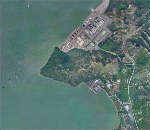
Figure 4.13 Aerial
View of the Black Point Site
Terrestrial ecology at Black Point is
mainly dominated by shrubland habitat interspersed with grassland which is
typical of the granite hill slopes in Hong Kong. Similar vegetation, flora and fauna are well
represented in the Hong Kong Country Parks and no rare or endangered species
were recorded.
The site is located on the northern coast
of the headland and it is relatively sheltered from prevailing metocean conditions.
The proximity to the Urmston Road
provides deepwater access to the area; however the final approach from the
fairway towards the headland will require dredging due to the shallow
bathymetry that characterises the coastal waters of the area.
The site is relatively remote from densely
populated areas and the closest villages are located at Lung Kwu Tan
(approximately 2 km from the potential site) where the population is
approximately 1,800. The closest
developments to the site, other than BPPS, are a mixture of small scale
industrial uses at Lung Kwu Sheung Tan.
No declared monuments or known sites of archaeology, graded buildings,
graves or significant archaeological deposits have been reported at Black Point
site.
Conceptual Layout
The main construction aspects of the site
are outlined below. These are based on
the preliminary conceptual layout reported in Figure 4.14:
·
Dredging: In order to
locate the LNG berth away from the marine traffic in Urmston Road significant
dredging will be required (approximately 2.5 Mm3) for the formation
of the approach channel and turning basin.
The dredging of the turning circle down to –15mPD, i.e. 9m deep in
places, will require maintenance dredging once every 4 years.
·
Reclamation: The area to
be reclaimed is approximately 16 ha and the mud underneath the seawall and
reclamation may reach 7 m in depth. The
majority of material excavated from Black Point shall be used within the
reclamation. However, due to the
relative timing of the excavation and reclamation works and the limited space
available on site it may be necessary to temporarily store the excavated
material at a designated stockpile site.
·
Site Formation and Construction:
In order to minimise blasting and yet provide material for the
reclamation only the LNG tanks have been located on the existing land at a
level of +5 mPD. Marine access and in
particular road access is already well established. There would be no requirement for gazettal of
access roads. The heavy load berth in
front of the power station could be used for marine access. For the most part tidal velocities at the
reclamation are relatively low and are not likely to affect construction
activities. Only at mid ebb tide on
Spring Tides are velocities likely to be strong enough to affect some
construction activities.

Figure 4.14 Conceptual
Layout for Black Point Site
Site Review
The general site requirements and the
environmental, safety, social, planning and marine transit aspects of the Black
Point site are summarised in Table 4.12.
Table 4.12 Site Review – Black
Point
|
General
site requirements
|
|
1
|
Land Availability and Constraints: The site will be created through a combination of cutting into the
hillside/headland and reclamation. The
land impacted by the reclamation is unconstrained. The Planning Department stated that Black
Point has been identified as a potential second landing point for the
proposed Ling Ding Yang
Bridge.
|
|
2
|
Operational Depth: The waters bordering the headland are consistently shallow, often less
than -5mPD. Considerable dredging will
be required for turning circle and approach channel, dependant on the jetty
location and the approach channel orientation.
|
|
3
|
Pipeline:
No pipeline is required due to close proximity to BPPS.
|
|
4
|
Distance from Sensitive Receivers: The closest villages are located at Lung Kwu Sheung Tan (approximately
2 km from the potential site) where the population is approx. 1,800. The closest developments to the site, other
than BPPS, are small scale industrial complexes at Lung Kwu Sheung Tan.
|
|
Environmental, Social and Planning
|
|
5
|
Terrestrial
Environment:
·
The
headland is mainly composed of shrubland habitat interspersed with grassland.
The northern slopes present the densest and tallest shrubland vegetation,
whilst the southern side is mainly covered with grassland and scattered rocky
boulders and outcrops.
|
|
6
|
Marine
Environment:
·
The
site is located to the south of mudflats at Ha Pak Nai and is relatively
distant from Mai Po Inner Deep Bay Ramsar Site.
·
Approximately
4km to the south west of Black Point is the designated Sha Chau and Lung Kwu
Chau Marine
Park.
·
Presence
of the Indo-Pacific Humpback Dolphin (Sousa
chinensis).
·
The
waters to the south of Black Point are reported as a spawning ground for
commercial fisheries. The adult fish production is however relatively low in
comparison to elsewhere in Hong Kong water
and low numbers and size of fishing vessels, low fish catch value and
production characterise the waters in the vicinity of Black Point.
·
Water quality at Black Point is
strongly influenced by the Pearl River,
resulting in reduced salinity and relatively high turbidity levels during the
summer.
|
|
7
|
Social: The area is presently uninhabited and the
closest villages lie approximately 2 km from the site (Lung Kwu Sheung Tan).
|
|
8
|
Planning: The northern
portion of the site is a Secondary Contact Recreation Zone. The coastline has
been proposed for potential reclamation for Tuen Mun Port Development, which
contains a recommendation for siting LPG facilities. Some government land landscaped by the BPPS
will be affected. Black Point has been identified as a second landing point for
the proposed Ling
Ding Yang
Bridge.
|
|
9
|
Permitting Risk: The
northern portion of the site is a Secondary Contact Recreation Zone and some objections
may arise due to perceived safety concerns and Fung Shui from local
residents.
|
|
Marine Transit
|
|
10
|
Exposure: The LNG terminal will be sited on the north western
coast of the Black Point headland on the edge of Deep Bay
and is relatively sheltered from prevailing metocean conditions. While the site is exposed to northerly
winter monsoon winds, it is well sheltered from summer south-easterlies. The site is exposed to waves from the south
west to the north west
sectors; however, these are limited by the short fetch distance, shallow
water and the low wind strengths from these quadrants. While currents in the Urmston Road channel to the west of the
site may be strong, berthing at the terminal would occur in a basin away from
these currents.
|
|
11
|
Interference with Shipping: Although
the site is near the northern reaches of the busy Urmston Road, the approach channel and
turning basins are located sufficiently far away from the vessel fairway and
will not interfere with existing shipping activities.
|
|
12
|
Volume of Marine Traffic:
Transit to the site is assumed to be via the East
Lamma Channel, Western Fairway, Ma Wan Channel and the Urmston Rd
Channel. This is a long passage
through the “heart” of Hong Kong
harbour. While this transit is now
performed regularly and safely by some of the world's largest container ships
which access the ports of the Shekou peninsular, it will expose the LNG
carrier to significant marine traffic activity.
|
|
13
|
Need
to conduct a Quantitative Risk Assessment of the transit of LNG via a LNG
carrier to Black Point via the Ma Wan channel at the EIA stage to verify the
acceptability of the transit route.
|
A summary of the environmental, social and
planning characteristics of the Black Point site are reported in Figure 4.15.
Conclusions
From a review of Black Point’s
environmental, social, planning and marine transit characteristics it emerges
that the site poses a series of advantages for the location of the LNG
terminal, namely:
·
The
main advantage from an environmental perspective is Black Point’s close
proximity to BPPS meaning that the construction of the subsea import pipeline
to the power station will not be needed.
This allows the elimination of environmental impacts associated with the
pipeline’s construction.
·
The
area is presently uninhabited and the closest village is located at
approximately 2 km from the site at Lung Kwu Tan. The nearest developments are small
scale industrial complexes.
·
The
site is relatively sheltered from prevailing metocean conditions.
·
Although
the necessary land for the construction of the LNG terminal will need to be
obtained from reclamation and excavation works, the coastal waters and the land
potentially affected by the works are largely unconstrained.
·
The
approach channel and turning basins will be located sufficiently far away from
the vessel fairway and will not interfere with existing shipping activities.
The location of the LNG terminal at Black
Point does have some disadvantages, summarised below:
·
Land
for the construction of the LNG terminal will be obtained partly from
reclamation and partly from the excavation of the hillside. This will lead to the loss of natural habitat
(marine and terrestrial) and to the overall change in morphology of the coast
and the hillside.
·
Recorded
presence of Indo-Pacific Humpback Dolphin (Sousa
chinensis) in the coastal waters of Black Point.
·
Considerable
dredging will be required for turning circle and approach channel. The final volumes will be dependent on the
jetty location and the approach channel orientation.
·
Marine
Transit of the LNG carrier will be via East Lamma Channel, West Harbour,
Ma Wan and the Urmston Road. The shipping lanes are some of the busiest in
Hong Kong and there are nearby populations
along the transit route. A Marine
Quantitative Risk Assessment would be required to verify the acceptability of
the transit route.
The site’s proximity to BPPS is considered to be the
site’s major environmental asset which, together with the site’s remoteness
form inhabited areas, its sheltered position with respect to prevailing
metocean conditions and the unconstrained nature of the area to be reclaimed
will strongly reduce the overall environmental impacts.
4.11.4
Lung Kwu Sheung Tan
Introduction
The site at Lung Kwu Sheung Tan lies on
the south side of Black Point headland in close proximity to the BPPS (Figure 4.16). Due to the headland’s relatively steep
morphology, the Lung Kwu Sheung Tan site will be created through reclamation.
The southern coastline of the headland
consists mostly of natural rocky shoreline with the exception of a relatively
short artificial section (approximately 200 m) found corresponding to a
government owned reclaimed land on the south eastern portion of the headland.
Figure 4.16 Aerial View of the Lung Kwu Sheung Tan
Site
Due to the nature of the site’s
development, the construction of the LNG terminal will interfere with marine
and coastal habitats only and will comprise little to no terrestrial works as
it is assumed that the pipeline connecting this site with BPPS will run along
the shoreline.
Recent data on marine ecological resources
of Black Point has identified marine habitats of low ecological
importance. Indo-Pacific Humpback
Dolphin (Sousa chinensis) have been
recorded in the area, however the marine waters within Lung Kwu Sheung Tan bay
are regarded as of low importance to the humpback dolphins due to the
relatively low abundance of sightings with comparison to other areas of Hong
Kong Waters.
The site is in close proximity to the Urmston Road which
provides deepwater access to the area; however the final approach from the
fairway towards the headland will require dredging due to the shallow
bathymetry that characterises the coastal waters of the headland.
The site is relatively remote from densely
populated areas and the closest villages are located at Lung Kwu Tan (<2 km
from the potential site) where the population is approximately 1,800. There appear to be no declared or deemed
monuments, graded buildings, graves or archaeological sites within the
site. However, in relatively close
proximity to the site is the Lung Kwu Sheung Tan site of archaeological
interest. Recent archaeological
investigations at this site have found artefacts from the late Neolithic (2500
- 1500BC).
Conceptual Layout
The main construction aspects of the site
are outlined below. These are based on
the preliminary conceptual layout reported in Figure 4.17:
·
Dredging: Dredge
quantities will be significantly larger than for Black Point as it is assumed
that that the site will be all reclamation with no cut into the hillside.
·
Reclamation: The marine
deposit thickness under the reclamations is up to 14 m thick and consequently
will require longer and higher surcharges than Black Point if not dredged. As there is no excavation reclamation fill
will have to be imported (marine sand or other suitable material). Additionally more seawall materials will be
required for the embankment which skirts the headland and carries the LNG
pipeline to BPPS and the access road.
·
Site Formation and Construction:
As all the land is formed by reclamation there is very little site
formation from existing land. Access to
the site from the main highway will have to be improved and a temporary jetty
constructed for the import of materials.
Access to BPPS is provided by extending the coastline embankment which
runs between the terminal site and the jetty access trestle.

Figure 4.17 Conceptual
Layout for Lung Kwu Sheung Tan Site
Site Review
The general site requirements and the
environmental, safety, social and marine transit aspects of the Lung Kwu Sheung
Tan site are summarised in Table 4.13.
Table 4.13 Site Review - Lung
Kwu Sheung Tan
|
General
site requirements
|
|
1
|
Land Availability and Constraints: The site will need to be created through reclamation and the land impacted by the
reclamation is unconstrained.
|
|
2
|
Operational Depth: The waters bordering the headland are consistently
shallow, often less than -5mPD.
Considerable dredging will be required for turning circle and approach
channel, dependent on the jetty location and the approach channel
orientation.
|
|
3
|
Pipeline:
A short onshore pipeline will connect to BPPS
|
|
4
|
Distance from Sensitive Receivers: The berthing/unloading facilities will be located on the north western
shore of the headland at < 2 km away from the closest village (Lung Kwu
Tan). The LNG terminal will be located
on the south shore of the headland at approximately 1 km from Lung Kwu Sheung
Tan. The site is in close proximity to
the BPPS.
|
|
Environmental, Social and Planning
|
|
5
|
Terrestrial
Environment: The construction area will involve marine
and coastal habitats only and does not comprise any terrestrial habitats. Impacts
to wildlife are likely to be minor as those animals that may be disturbed by
the construction activities will move away from the disturbed area to the
similar habitats nearby.
|
|
6
|
Marine
Environment:
· Presence of the Indo-Pacific Humpback
Dolphin (Sousa chinensis).
· Approximately 4km to the south west of
Black Point headland is the designated Sha Chau and Lung Kwu Chau Marine
Park.
· The site is located to the south of
mudflats at Ha Pak Nai and is relatively distant from Mai Po Inner Deep Bay
Ramsar Site.
· The waters to the south of Black Point
are reported as a spawning ground for commercial fisheries. The adult fish
production is however relatively low in comparison to elsewhere in Hong Kong water and low numbers and size of fishing
vessels, low fish catch value and production characterise the waters in the
vicinity of Lung Kwu Sheung Tan.
· Water
quality at Lung Kwu Sheung
Tan is strongly influenced by the Pearl
River, resulting in reduced salinity and relatively high
turbidity levels during the summer.
|
|
7
|
Social:
The site is presently uninhabited and the closest buildings lie
approximately 1 km from the LNG terminal (Lung Kwu Sheung Tan). The site also
abuts the boundary of the proposed Lung Kwu Tan archaeological site.
|
|
8
|
Planning:
The site was identified in a 1992 Planning Study (TDD of HKSARG) for
Special Industry (Bulk Chemical Storage, LPG or liquid hydrocarbon
storage). There is Government Land Allocation
in the northeast of Lung
Kwu Sheung
Tan Bay
for the Water Supplies Department (WSD).
Planning Department has also included Black Point as a second landing
point for Ling Ding Yang
Bridge. It is possible that the construction and
operation of the LNG terminal may indirectly affect adjoining land uses.
|
|
9
|
Permitting
Risk: Peninsula
at Black Point is regarded to be of Fung Shui importance to Leung Kwu Sheung
Tan villagers. Furthermore, as the
proposed site is exposed to Lung Kwu Sheung Tan village and the Lung Kwu
Sheung Tan beach, it is expected that local objections may be submitted
during the public notification period of gazetting due to landscape and
visual objections.
|
|
Marine Transit
|
|
10
|
Exposure: The LNG terminal will be sited on the
southwestern coast of the Black Point headland on the edge of Deep Bay
and is relatively sheltered from prevailing metocean conditions. The site is exposed to waves from the
southern to the western sectors; however, theses are limited by the short
fetch distance, the shallow water and the low wind strengths from these
quadrants. While currents in the Urmston Road
channel to the west of the site may be strong, berthing at the terminal would
occur in a basin away from these currents.
|
|
11
|
Interference with Shipping:
The approach channel and turning basins are located in closer
proximity to the vessel fairway than those for the northern edge of the
headland and while final berthing will not interfere with existing shipping
activities the approach and slowing manoeuvres will occur close to the
channel.
|
|
12
|
Volume of Marine Traffic:
Transit to the site is assumed to be via the East Lamma Channel,
Western Fairway, Ma Wan Channel and the Urmston Road Channel. This is a long passage through the “heart”
of Hong Kong harbour. While this transit is now performed
regularly and safely by some of the world’s largest container ships which
access the ports of the Shekou peninsular, it will expose the LNG carrier to
significant marine traffic activity.
|
A summary of the environmental, social and
planning characteristics of the Lung Kwu Sheung Tan site are reported in Figure 4.15.
Conclusions
From a review of Lung Kwu Sheung Tan’s
environmental, social, planning and marine transit characteristics it emerges
that the site poses some of advantages for the location of the LNG terminal,
namely:
·
The
main advantage from an environmental perspective is Lung Kwu Sheung Tan’s close
proximity to BPPS meaning that the construction of the subsea import pipeline
to the power station will be limited to a short onshore pipeline. This will allow to strongly reduce the potential
environmental impacts associated with the pipeline’s construction.
·
The
area is presently uninhabited and the closest village is located at
approximately 1 km from the LNG site and approximately 2 km from the jetty at
Lung Kwu Sheung Tan. The nearest
developments are small scale industrial complexes.
·
The
jetty is relatively sheltered from prevailing metocean conditions.
·
The
approach channel and turning basins will be located sufficiently far away from
the vessel fairway and will not interfere with existing shipping activities.
The location of the LNG terminal at Lung
Kwu Sheung Tan will however pose a number of potential environmental and marine
traffic issues summarised below:
·
Land
for the construction of the LNG terminal will need to be obtained form
extensive reclamation leading to the loss of natural habitat and coastline.
·
Recorded
presence of Indo-Pacific Humpback Dolphin (Sousa
chinensis) in the coastal waters of Lung Kwu Sheung Tan.
·
Considerable
dredging will be required for the turning circle and approach channel and
reclamation. The volume will be
dependent on the jetty location and the approach channel orientation.
·
Marine
Transit of the LNG carrier will be via East Lamma Channel, West Harbour,
Ma Wan and the Urmston Road. The shipping lanes are some of the busiest in
Hong Kong and there are nearby populations
along the transit route. A Marine
Quantitative Risk Assessment would be required to verify the acceptability of
the transit route.
Although several site selection advantages
discussed above are comparable to the ones discussed for Black Point, it is
deemed that the need for an onshore connecting pipeline to BPPS, the extensive
dredging for the reclamation, the proximity to Lung Kwu Tan and the expected
severe landscape and visual impacts makes the site less suitable from an environmental
perspective. Based on the above, it is
deemed that the disadvantages posed by siting the LNG terminal at Lung Kwu
Sheung Tan do not make the area a viable candidate site for further
consideration.
4.11.5
South Soko
Introduction
South Soko Island (also called Tai A Chau)
is the largest (120 ha) of a small group of islands located over 6 km to the
south of southwest Lantau Island and about 2 km north of the boundary of HKSAR
territorial waters. The most dominating
feature of the island is the presence of a former Vietnamese detention centre
which has now been demolished (Figure
4.18).

Figure 4.18 Aerial
Photo of the South Soko Site
A large concrete platform now remains on
the centre of the island, surrounded by modified landforms such as cut slopes,
access road, reclaimed seawalls and a helicopter landing area. The topography of South
Soko mainly consists of hills (Fei Kei Teng, Nam Shan and Tai Chau
Mei Teng) with a maximum height of approximately 140 m. The coastline is mainly steeply sloped and
rocky in nature. Notable coastal
features include two bays located on the east and west side of the island
(called Tung Wan and Sai Wan, respectively) with a shallow, gently sloping
bathymetry ranging between 0 to -12 m in depth.
The Indo-Pacific Humpback Dolphin (Sousa chinensis) and Finless Porpoise (Neophocaena phocaenoides) have been
recorded in the waters of Southern Lantau and South Soko, however sightings of
the Humpback Dolphins are more concentrated in Western Lantau whilst the Finless
Porpoises sightings are more concentrated in and around South Lamma.
The surrounding waters have been
identified as both a spawning ground and a nursery area for commercial
fisheries resources. The spawning ground
extends east through to the Po Toi and Ninepin
Islands whereas the nursery area
extends from the Soko
Islands to southern
Lamma. Recent surveys have indicated
that fish eggs and fry do not differ substantially between the Soko Islands
and elsewhere in the Southern HKSAR waters.
Although the southern coast of the island
has higher exposure to the prevailing ocean swells, the metocean conditions are
reduced by the sheltering presence of the Lima
islands approximately 15km to the south and south-east. The western shore (Sai Wan) is most sheltered. Waters on the northern side of South Soko are
affected by fairly strong tidal currents causing some seabed scouring due to
the narrow channel that exists between South
Soko Island
and North Soko Island.
Overall, South Soko
is in a remote location, and the closest marine traffic fairway (the Adamasta
Channel) passes about 2 km to the north of the island. This channel is predominantly used by fast
ferries between Hong Kong and Macau. While it is busy, navigation is closely
constrained in the channel and it is not crossed during transits to the
terminal.
Seabed features surrounding South Soko Island include a submarine electricity cable and one
water main, which connect to Lantau
Island and were installed
to service the former detention centre as well as a gazetted sand dredging and
mud disposal area to the west.
Conceptual Layout
The main construction aspects of the site
are outlined below. These are based on the preliminary conceptual layout
reported in Figure 4.19:
·
Dredging: In order
allow access to the site dredging will be required (approximately 1.1 Mm3)
for the formation of the approach channel and turning basin. Maintenance dredging requirement is expected
to be required once every ten years and will be restricted to specific small
areas.
·
Reclamation: An area of
approx. 0.6 ha will be reclaimed. A
relatively small proportion of the soil and rock material will be used within
the reclamation and therefore most of the material will need to be exported off
site. As there is no land access to the
island the material will need to be transported by barge.
·
Site Formation and Construction:
The site formation works will be carried out from several berms formed
at pre-determined levels to accommodate the necessary drainage works and landscaping
works. The berms are typically provided
at 10 m vertical intervals and will likely be used as a temporary working
platform for the drilling and blasting works.

Figure 4.19 Conceptual
Layout for South Soko Site
Site Review
The general site requirements and the
environmental, safety, social and marine transit aspects of the South Soko site are summarised in Table 4.14.
Table 4.14 Site
Review - South Soko
|
General Site Requirements
|
|
1
|
Land Availability and Constraints: Sufficient land is available for LNG site
and associated facilities at South Soko,
including land for potential expansion.
Little reclamation will be needed to accommodate the terminal
facilities and the land impacted by the reclamation is unconstrained.
|
|
2
|
Operational Depth: Approximate depth at potential approach
channel/turning basin location: 12-14 mPD.
Some dredging would be required and quantity would depend on the
orientation of the approach channel/turning basin.
|
|
3
|
Pipeline: Pipeline route to BPPS will be
approximately 40 km in length. The chosen route via Lantau’s western waters
is physically unconstrained, although the presence of Indo-Pacific Humpback
Dolphin (Sousa chinensis) would
require an ecological assessment to be undertaken.
|
|
4
|
Distance from Sensitive Receivers: South Soko
is in a remote location from land based sensitive receivers. However there
are marine sensitive receivers in the waters around South
Soko such as Indo-Pacific Humpback Dolphin’s (Sousa chinensis) and Finless Porpoises
(Neophocaena phocaenoides).
|
|
Environmental, Social and Planning
|
|
5
|
Terrestrial Environment
·
Terrace cultivation, two small
abandoned settlements (Ha Tsuen and Sheung Tsuen) and a disused Vietnamese
detention centre have in the years modified most of the island’s terrestrial
habitats which result partially altered and of low ecological value. Shrubland is the dominant habitat type and
covers most of the hillsides.
·
The site of the ex-detention centre
occupies the flat land between Tung Wan and Sai Wan where no habitat of
ecological value can be found. The
hill slopes to the south of the ex-detention centre were modified into cut
slopes and all of the vegetation was removed.
The changes in the island terrain are expected to have disturbed the
soil strata containing the archaeological deposits of the Tai A Chau
archaeological site present on the island.
|
|
6
|
Marine Environment:
·
Indo-Pacific Humpback Dolphin and
Finless Porpoise have been recorded in the waters of Southern Lantau, including
South Soko.
However sightings of both species are more concentrated elsewhere in Western Lantau ( Humpback Dolphin) and Po Toi (Finless
Porpoise).
·
The surrounding waters have been
identified as both a spawning ground and a nursery area for commercial
fisheries resources. The spawning
ground extends east through to the Po Toi and Ninepin
Islands whereas the nursery area
extends from the Soko
Islands to southern
Lamma. Recent surveys have indicated that fish eggs and fry do not differ
substantially between the Soko Islands and elsewhere in the Southern
HKSAR waters.
·
The scale of capture fisheries
operations in and around the Soko Islands is considered to be moderate-high compared
to other fishing grounds in Hong Kong. Adult fish production for these waters is
considered moderate, whereas production of fish fry for these waters is
low. There are no existing gazetted
Fish Culture Zones in the vicinity of South Soko.
·
Surveys indicate that this coast
supports sparse cover of isolated and scattered hard corals. Most species found are common in Hong Kong waters, with the exception of the False
Pillow Coral, Pseudosiderastrea tayami
found at the southern side of Tai A Chau.
This False Pillow Coral is known to occur only at isolated locations
of Lamma Island
and South Soko. Soft corals and gorgonian seawhips were
also recorded from this coast.
·
Wet and Dry season survey using
grab samples recorded Amphioxus in low abundance in Tung Wan.
·
The shorelines of Tung Wan and Sai
Wan bays have been partially reclaimed and are artificial. A rubble mound seawall was constructed in
Tung Wan and piers were constructed on the northern and southern edges of Sai
Wan bay.
·
Water quality of South Soko is
influenced the Pearl River, resulting in
reduced salinity and relatively high turbidity levels during the summer.
|
|
7
|
Social: The island was formerly a detention centre
for Vietnamese illegal immigrants which is now disused and demolished. Tai A Chau is a Recognised Village
however, although some private lots remain on the island, there are no
permanent inhabitants. The island is
regularly visited due to the presence of the Tai A Chau Tin Hau Temple and
graves.
|
|
8
|
Planning: The island does not come under any
statutory plans, however it has been identified as a potential Marine Park and Tourism/Recreation area by
HKSARG SWNT Planning Study (not included in the Lantau Concept Plan). The waters are designated as secondary
contact recreation zones (). The site is of archaeological/historical
interest as it includes several archaeological/historical resources including
the Tai A Chau archaeological site and the Tai A Chau Tin Hau Temple.
|
|
9
|
Permitting Risk: Potential objections to the development of
the site may come from NGOs. The
island’s coastal waters have also been identified as a potential marine
park. There is a potential need to
acquire land, however the permitting risks are considered to be relatively
low as the land is all is owned by one company.
|
|
Marine Transit
|
|
10
|
Exposure: The southern coast of the Island
is exposed to offshore conditions during the summer while the northern coast
(facing Siu A Chau) is protected from ocean swells.
|
|
11
|
Interference with Shipping: The
terminal and approach would be located away from main shipping routes
|
|
12
|
Volume of Marine Traffic: South Soko
is located close to the boundary of the HKSAR waters and set away from the
busy Adamasta Channel. The approach to
the site would be from the southeast with transits along the proposed PRD
Traffic Separation Schemes.
|
A summary of the environmental, social and
planning characteristics of the South Soko
site are reported in Figure 4.20.
Conclusions
From a review of South
Soko’s environmental, social, planning and marine transit
characteristics it emerges that the site poses a series of advantages for the
location of the LNG terminal, namely:
·
Sufficient
and unconstrained land is available for the construction and operation of the
LNG terminal and associated facilities.
Low severity environmental impacts are expected from the terrestrial
works due to the generally disturbed nature of the habitats. Little reclamation will be needed strongly
reducing potential environmental impacts to the marine environment.
·
The
site will provide unconstrained access to the LNG carriers avoiding major
shipping lanes and populated areas.
Little/no interference with existing shipping channels and marine
traffic would be expected.
·
South Soko is a very remote location, away from densely
populated areas. The closest village is
located approximately 6 km north (Shek Pik) and consequently there are few air,
noise and landscape visual Sensitive Receivers.
·
The
unconstrained pipeline route to BPPS will reduce potential impacts on existing
seabed features.
·
The
absence of key sensitive terrestrial habitat due to the modified concrete
platform, predominance of shrubland and the presence of vegetation/faunal
assemblages of low ecological value.
Although South Soko
presents several environmental and social advantages for the siting of the LNG
terminal, a number of potential environmental and planning issues have been
highlighted, namely:
·
The Soko Islands
have been identified as a potential Marine
Park and
Tourism/Recreation area by HKSARG SWNT Planning Study.
·
Recorded
presence of Indo-Pacific Humpback Dolphin (Sousa
chinensis) and Finless Porpoise (Neophocaena
phocaenoides).
·
Although
the pipeline route to BPPS is physically unconstrained, it will
pass through acknowledged Indo-Pacific Humpback Dolphin habitat.
·
The
presence of the Tai A Chau archaeological site located on the isthmus between
Tung Wan and Sai Wan, and the Tai A Chau Tin Hau Temple will require careful
examination.
·
Based
on the above, it is deemed that the environmental advantages posed by siting
the LNG terminal on the existing concrete platform on South Soko Island makes
the area a viable candidate site for further consideration. Planning and environmental disadvantages will
be further discussed in greater detail to determine their potential magnitude.
4.11.6
North Soko
Introduction
North Soko (Siu A Chau) is a small island
located approximately 2 km south of Lantau
Island. The coastline is mainly natural rocky shore
with areas of boulders and sandy beaches.
The island’s morphology is characterised by two hills located to the
east and west of the island, the highest of which reaches 120 m. They are joined by a strip of flat lowland on
which the potential site is located (Figure 4.21).
To provide sufficient land for the
construction a cut and fill reclamation will be required to expand the existing
area. Due to the shallow water depth
within Siu A Chau Wan, the preliminary layout positions the jetty in the
channel between North Soko and South Soko. Minimal dredging will be required to allow
the approach of the carriers to the jetty.
Indo-Pacific Humpback Dolphin (Sousa chinensis) and Finless Porpoise (Neophocaena phocaenoides) have been recorded
in the waters of North Soko and throughout Southern Lantau.
It must however be noted that sightings of these species are more concentrated
in Western Lantau (Humpback Dolphins) and around South
Lamma (Finless Porpoises).
The surrounding waters have been
identified as both a spawning ground and a nursery area for commercial
fisheries resources. Recent surveys have
however indicated that fish eggs and fry do not differ substantially between
the Soko Islands
and elsewhere in the Southern HKSAR waters.
The vegetation of North
Soko is typical of the outlying islands and well represented
elsewhere in Hong Kong SAR. The east of North Soko is covered by low shrubs with a high
percentage of grass cover, while the western part of the island is dominated by
tall shrub.

Figure 4.21 Aerial
Photo of the North Soko Site
Of particular note for the North
Soko site is the presence of the Siu A Chau Archaeological Site in
which prehistoric coarse ware, polished stone and Tang dynasty limekiln debris
have recently been identified.
The southern coast of the Island is exposed to offshore conditions while the
northern coast (facing Lantau) is protected from ocean swells but bounded by
the Adamasta shipping channel south of Lantau.
There are no residential or commercial developments on the island;
however the busy Adamasta channel is located approximately 1 km North of the
site
Conceptual Layout
The main construction aspects of the site
are outlined below. These are based on the preliminary conceptual layout
reported in Figure 4.22:
·
Dredging: Only nominal
dredging is required for the turning circle.
However, to achieve a navigation depth of –15 m PD, a 4 km navigation
channel is required to reach deeper water.
Existing depths of about –13 m are recorded. The channel initially lies in an Easterly
direction before turning South East, through the breakwaters to deep water.
·
Reclamation and Breakwaters: A
cut and fill reclamation will be required to expand the existing lowland area
at the centre of the island. The
materials for the reclamation will mostly be sourced from the excavation of the
land site formation.
·
Site Formation and Construction:
The excavation required should be balanced with the reclamation fill
quantities to provide the land needed.

Figure 4.22 Conceptual
Layout for North Soko Site
Site Review
The general site requirements and the
environmental, safety, social and marine transit aspects of the North Soko site are summarised in Table 4.15.
Table 4.15 Site Review – North Soko
|
General
site requirements
|
|
1
|
Land Availability and Constraints: A cut and fill reclamation will be required to expand the existing
lowland area at the centre of the island.
The land impacted by the reclamation is unconstrained.
|
|
2
|
Operational Depth: Turning circle and approach channel will require significant dredging
|
|
3
|
Pipeline:
The pipeline route to BPPS is approximately 38 km. The chosen route via Lantau’s western
waters is largely unconstrained, although the presence of Indo-Pacific
Humpback Dolphin (Sousa chinensis)
would require an ecological assessment to be undertaken.
In addition, there are a number of submarine cables that have been
laid between the island and Lantau island, as well as more to the east in
between the island and the South Cheung Chau Disposal Ground.
|
|
4
|
Distance from Sensitive Receivers: The North Soko site lies in the southwestern waters of Hong Kong on the relatively undisturbed and remote
location. Siu A Chau is a Recognised Village but it is not known if the
structures are occupied, which are all within 500m of the site.
|
|
Environmental, Social and Planning
|
|
5
|
Terrestrial
Environment:
·
The
area within the proposed construction site on North Soko
Island is occupied by a
variety of terrestrial habitats including shrubland, grassland, wetland,
cultivation, bare rock/soil and plantation.
·
A
small abandoned village, Siu A Chau Tsuen is located behind the sandy beach
at Siu A Chau Wan.
·
With
the exception of the tropical climber Malaisia
scandens (not recorded in the Hong Kong SAR until 1996 when the species
was first recorded in Lantau Island), most of the vegetation species recorded
on North Soko Island are typical of outlying islands and well-represented
elsewhere within the Hong Kong SAR. Malaisia scandens was found to be
present in high abundance in the woodland and shrubland areas of the
island.
|
|
6
|
Marine
Environment:
·
Indo-Pacific Humpback Dolphin (Sousa chinensis) and Finless Porpoise
(Neophocaena phocaenoides) have
been recorded in the waters of Southern Lantau. However sightings of both species are more
concentrated elsewhere in Western Lantau
(Humpback Dolphin) and Po Toi (Finless Porpoise).
·
The surrounding waters have been
identified as both a spawning ground and a nursery area for commercial
fisheries resources.
·
The scale of capture fisheries
operations in and around the Soko Islands is considered to be moderate-high compared
to other fishing grounds in Hong Kong. Adult fish production for these waters is
considered moderate, whereas production of fish fry for these waters is
low. There are no Fish Culture Zones
in the vicinity of North Soko.
·
Water quality at North Soko is
influenced by the Pearl River, resulting in
reduced salinity and relatively high turbidity levels during the summer.
|
|
7
|
Social:
Siu A Chau is a Recognised
Village, but it is not known
if the structures are occupied, which are all within 500m of the site. More than 50 private lots are found on the
island. There is a lighthouse at Pak
Kok and a jetty in middle of Island
|
|
8
|
Planning: The site is identified as a Potential Marine Park
and Tourism/Recreation area by HKSARG SWNT Planning Study, but not in the
Lantau Concept Plan. The island is the
site of a low level radioactive waste facility (Sum Wan). To the west of the site lies a gazetted
area for sand dredging that is partially exhausted but currently considered
constrained to continue such works.
|
|
9
|
Permitting Risk: The waters are designated as secondary
contact recreation zones (). The site is of archaeological/historical
interest. There is a potential need to
acquire land from approximately 70 private owners, which will require
assistance from the Government and South Lantau Rural Committee
|
|
Marine Transit
|
|
10
|
Exposure:
The island is relatively sheltered from prevailing metocean
conditions. The
southern coast of the Island is more exposed
to offshore conditions during the summer while the northern coast is
relatively more protected from ocean swells.
|
|
11
|
Interference with Shipping:
The jetty’s extension into channel between North and South
Soko will not result in issues to passing traffic.
|
|
12
|
Volume of Marine Traffic:
Local traffic between the two Soko islands is comparatively light and
the proposed location is well clear of fast ferry routes. The approach to the
site would be from the southeast with transits along the proposed PRD Traffic
Separation Schemes.
|
A summary of the environmental, social and
planning characteristics of the North Soko
site are reported in Figure 4.20.
Conclusions
From a review of North
Soko’s environmental, social, planning and marine transit
characteristics it emerges that the site poses advantages for the location of
the LNG terminal, namely:
·
The
site will provide easy access to the LNG carriers which will be approaching the
site from the southern unconstrained waters of HK SAR avoiding major shipping
lanes and populated areas. Little
interference with existing shipping channels and marine traffic is also
expected.
·
North Soko is in a relatively remote location, away from
densely populated areas. The closest
village is located on the southern coast of Lantau Island,
approximately 2 km north (Shek Pik).
·
The
unconstrained pipeline route to BPPS will reduce potential impacts on existing seabed
features.
·
The
reclamation needed to provide sufficient land for the LNG terminal’s
construction and operation will affect unconstrained land.
Although North Soko
presents several marine transit, environmental and social advantages for the
siting of the LNG terminal, a number of potential environmental and planning
issues have been highlighted, namely:
·
Land
for the construction of the LNG terminal will need to be obtained from
extensive cut and fill reclamation leading to the loss of natural terrestrial
and marine habitat.
·
The Soko Islands
have been identified as a potential Marine
Park and
Tourism/Recreation area by HKSARG SWNT Planning Study.
·
Recorded
presence of Indo-Pacific Humpback Dolphin (Sousa
chinensis), Finless Porpoise (Neophocaena
phocaenoides) in the islands coastal waters.
·
Although
the pipeline route to BPPS is unconstrained, it will pass
through acknowledged Indo-Pacific Humpback Dolphin habitat.
·
The
presence the Siu A Chau Archaeological Site will require careful examination.
·
Significant
dredging will be required for the approach of the LNG carrier. The quantities are related to the fact that a
navigation channel approximately 4 km long will be required.
·
There
will be the need to acquire land from approximately 70 private owners and the
removal of the Siu
A Chau
Recognised Village.
Although several site selection advantages
discussed above are comparable to the ones discussed for South
Soko, it is deemed that the need for an extensive dredging and
cut/fill reclamation, as well as the need to acquire land from approximately 70
owners makes the site less suitable from environmental and planning
perspectives.
Based on the above, it is deemed that the
disadvantages posed by siting the LNG terminal at North
Soko do not make the area a viable candidate site for further
consideration.
4.11.7
Peaked Hill
Introduction
Peaked Hill is an isolated and uninhabited
offshore island located west of Tsin Yue Wan on Lantau Island
(Figure 4.23). It covers a land area of approximately 7 ha
with a maximum elevation of about 69 m. The islands bathymetry is characterised
by very shallow water to the east in the channel between Peaked Hill and Lantau Island
whilst deeper water borders the island to the west.
Due to the small size of the island and
its relatively steep morphology, the LNG terminal would be located on a cut and
fill reclamation which will create the necessary land for the construction and
operation of the LNG terminal. The jetty
would extend westward to the –10 mPD contour where the turning basin will be dredged. The waters to the west of the turning basin
are sufficiently deep to require minimal to no dredging for the navigation
channel.
The primary characteristic of Peaked
Hill’s marine ecology is the presence of Indo-Pacific Humpback Dolphin (Sousa chinensis). Abundance of humpback dolphins in Hong Kong waters is highest in the north and west Lantau
areas. Peaked Hill Island is located within this major habitat for
humpback dolphins and also within the boundaries of the proposed Southwest Lantau Marine
Park which aims to
protect the dolphin’s habitat.
The island’s terrestrial ecology is
characterised by undisturbed habitats such as shrubland, grassland, plantation
woodland and bare rock/soil. The
community structure and vegetation species found on these islands are typical
to other similar habitats in parts of Hong Kong
where human disturbance is limited.

Figure 4.23 Aerial
Photo of the Peaked Hill
Island Site
Offshore of Peaked Hill Island are the navigation
entrances to the existing deep water channel to Nansha and Guangdong, the
proposed Tonggu Waterway and any future Container Terminal 10, should the north
west Lantau option for their development be chosen. The site is well protected by its proximity
to Lantau Island from the prevailing easterly/south easterly metocean
conditions, however it is more exposed to locally generated waves from the
south west, albeit waves limited by the shallow waters of the PRD.
A review of the available literature
indicates that there are no declared or deemed monuments, graded buildings,
graves or archaeological sites within the site at Peaked Hill.
Conceptual Layout
The main construction aspects of the site
are outlined below. These are based on the preliminary conceptual layout
reported in Figure 4.24:
·
Dredging: The berth
and turning circle are located inshore of the 10 m contour so that dredging to
–15 mPD will be required.
·
Reclamation: The
reclamation can be formed by excavation of Peaked Hill
Island. The reclamation is assumed to be founded on
soft marine deposits. Should the seabed
be comprised of granular material, ground improvement techniques will not be
required. Should the dredging be in
granular material it can also be used in the reclamation.
·
Site Formation and Construction:
It is assumed the west side of the island is reduced to a level of about
10 mPD for location of the tanks. The
material removed from the island can be used for reclamation and any surcharge
loading required. There are no existing
berthing facilities at the site and no access roads to the adjacent Lantau
headland.

Figure 4.24 Conceptual Layout for Peaked Hill Site
Site Review
The general site requirements and the
environmental, safety, social and marine transit aspects of the Peaked Hill
site are summarised in Table 4.16.
Table 4.16 Site
Review – Peaked Hill
|
General site requirements
|
|
1
|
Land Availability and Constraints: The site would partially be formed by reclamation with no constraints
on the extent of the reclamation.
|
|
2
|
Operational Depth: Minimal dredging would be required for the construction for the
turning basin
|
|
3
|
Pipeline:
The pipeline route to BPPS is ~ 25 km.
The chosen route via Lantau’s western waters is
unconstrained, although the presence of Indo-Pacific Humpback Dolphin (Sousa chinensis) would require an
ecological assessment to be undertaken.
|
|
4
|
Distance from Sensitive Receivers:
The island is uninhabited and it is located in a remote and relatively undisturbed area
on the western coast of Lantau
Island characterised by
a low population density. There are no
sensitive receivers in close proximity of the site.
|
|
Environmental, Social and Planning
|
|
5
|
Terrestrial Environment:
·
The
island’s terrestrial ecology is characterised by undisturbed habitats such as
shrubland, grassland and bare rock/soil.
·
The
surrounding terrestrial habitat on Lantau
Island is a Country Park
·
In
proximity to the island are sensitive habitats such as: mudflat and mangrove habitat, an SSSI, and
a horseshoe crab breeding ground.
|
|
6
|
Marine Environment:
·
Peaked
Hill’s coastal waters are considered to be Hong Kong's
major habitat for Indo-Pacific Humpback Dolphins (Sousa chinensis)
·
The
island coastal waters are within the perimeter of the proposed Southwest Lantau Marine
Park.
·
Information
on the subtidal soft bottom assemblages indicates that the marine sediments
in vicinity of the site support high species abundance and biomass in
comparison to other areas in Hong Kong.
·
Capture
fisheries operations in waters off Yam Tsai are reported to be of
moderate-high magnitude compared to other Hong Kong
waters. Catches of adult fish are
moderate-high while production of fish fry in these waters was reported as
moderate-low compared to other Hong Kong
fishing grounds.
·
Water
quality at Peaked Hill is influenced by the Pearl River,
resulting in reduced salinity and relatively high turbidity levels during the
summer.
|
|
7
|
Social: The island is uninhabited and there are no
residential/commercial areas in close proximity of the site. However the island is in close proximity to
the Lantau South
Country Park
at Tsing Yue Wan and along the South Lantau
and Fan Lau Trails.
|
|
8
|
Planning: The site is part of the Potential Southwest
Lantau Marine
Park which was
recommended in the Lantau Concept Plan.
|
|
9
|
Permitting Risk: The site is within a Secondary Contact Recreation
Zone. Although the development of the
Terminal is preferred on western side of Island this will have limited
ability to shield the development from Country Park
users.
|
|
Marine Transit
|
|
10
|
Exposure:
The site is well protected by its proximity to Lantau Island
from the prevailing easterly/south easterly metocean conditions and from the
persistent NE monsoon waves, however it is exposed to locally generated waves
from the south west.
|
|
11
|
Interference with Shipping: The LNG
terminal extension and the location of the jetty near the shipping channel
has the potential to create passing vessel effects on moored LNG
carriers.
|
|
12
|
Volume of Marine Traffic: The
approach to the site would be from the southeast with transits along the
proposed PRD Traffic Separation Schemes.
While the LNG terminal is set away from the PRD Traffic Separation
Scheme LNG carriers would be slowing to approach the terminal within the TSS,
and close to its crossing within the Adamasta Channel.
|
A summary of the environmental, social and
planning characteristics of the Peaked Hill site are reported in Figure 4.25.
Conclusions
From a review of Peaked Hill’s
environmental, social, planning and marine transit characteristics it emerges
that the site poses advantages for the location of the LNG terminal, namely:
·
Peaked
Hill Island is in a remote location, away
from densely populated areas. There are
no sensitive receivers in close proximity to the site.
·
The
site will provide easy access to the LNG carriers which will be approaching the
site from the Lema Channel, south of Lantau, causing no major impact on marine
traffic.
·
The
unconstrained pipeline route to BPPS will reduce potential impacts on existing
seabed features.
Although Peaked Hill
Island presents several
social, marine transit and planning advantages for the siting of the LNG
terminal, a number of potential environmental and planning issues have been
highlighted, namely:
·
Peaked
Hill Island is remote and located in
relatively pristine surroundings.
Development of the LNG terminal would introduce major changes to the
landscape of SW Lantau. Visual impacts
to users of Lantau
Country Park
would be expected to be severe.
·
Peaked
Hill Island’s
coastal waters are considered to be the major habitat for Indo-Pacific Humpback
Dolphins in Hong Kong.
·
Land
for the construction of the LNG terminal will need to be obtained form
extensive cut and fill reclamation leading to the loss of natural terrestrial
and marine habitat, including major Indo-Pacific Humpback Dolphin habitat.
·
Peaked
Hill Island
and its coastal waters have been identified as part of the Potential Southwest
Lantau Marine
Park which was
recommended in the Lantau Concept Plan.
·
Although
the pipeline route to BPPS is unconstrained, it will pass
through major Indo-Pacific Humpback Dolphin habitat.
The potentially severe landscape and
visual impacts of the LNG terminal on the unspoilt natural landscape of SW
Lantau, the presence of major Indo-Pacific Humpback Dolphins habitat and the
need for an extensive cut and fill reclamation to provide sufficient land for
the construction and operation of the LNG terminal makes the site undesirable
from an environmental perspective and less suitable with respect to South Soko
which is located approximately 8 km to the south east.
Based on the above it is deemed that the
disadvantages posed by siting the LNG terminal at Peaked Hill do not make the
area a viable candidate site for further consideration.
4.11.8
Area 137
Introduction
Area 137 (Fat Tong O) occupies an area of
approximately 104 hectares and it is located on the southern side of the new
town development of Tseung Kwan O (Junk Bay) on the opposite shore to Chai Wan
(Figure 4.26).

Figure 4.26 Aerial Photo of the Area 137 Site
The area has recently been reclaimed for special
industrial use and it is within close proximity to the Tathong Channel and a
restricted area of low marine traffic volume.
Due to its artificial nature, the area’s
terrestrial and marine habitats are generally of low ecological value and
complexity. Neither Indo-Pacific
Humpback Dolphins (Sousa chinensis),
nor Finless Porpoises (Neophocaena
phocaenoides) have been recorded in the vicinity of the Tseung Kwan O and
the nearest sighting of a Finless Porpoise was recorded 2km south of Tung Lung
Chau. Important terrestrial habitats can
be found in the neighbouring Clear
Water Bay
Country Park
which borders the area to the north and south.
Across the Tathong Channel are densely populated areas of Siu Sai Wan
and Chai Wan.
Conceptual Layout
Area 137 is an existing industrial site
intended for Deep Waterfront Industry.
No dredging, reclamation or site formation will be needed. The preliminary conceptual layout reported in
Figure 4.27.

Figure 4.27 Conceptual
Layout for Area 137 Site
Site Review
The general site requirements and the
environmental, safety, social and marine transit aspects of the Area 137 site
are summarised in Table 4.17.
Table 4.17 Site
Review - Area 137
|
General Site Requirements
|
|
1
|
Land Availability and Constraints: Sufficient land is available for LNG site
and associated facilities at Area 137.
No reclamation or site preparation works will be needed.
|
|
2
|
Operational Depth: Little or no dredging would be required to access the site.
|
|
3
|
Pipeline: The site is remote from BPPS and would require a pipeline of > 80
km. The route to the power station is
highly constrained as a number of submarine cables are buried in the southern
waters of Hong Kong Island and Lantau Island. Once passed the Soko Islands
the pipeline route is largely unconstrained, although the
presence of Indo-Pacific Humpback Dolphin (Sousa chinensis) would require an ecological assessment to be
undertaken.
|
|
4
|
Distance from Sensitive Receivers: Siu Sai Wan is located less than 2 km from Area 137 with a population
of 35,000 and Chai Wan at between 2 and 3 km from Area 137 has a population
of 111,4000. In addition planned residential
development in Area 85 (approx.10,000 people) and Area 86 (approx. 57,000
people) are located approximately 2 km to the North of Area 137. A number of seawater intake points are also
located relatively close to the site and there is a Fish Culture Zone approx
1 km from the site at Tung Lung Chau.
|
|
Environmental, Social and Planning
|
|
5
|
Terrestrial Environment: Area 137 is located on reclaimed land. The site is therefore characterised by vegetation/faunal
assemblages of low ecological value.
However it must be noted that the majority of the surrounding area is
country park (Clear
Water Bay
Country Park).
|
|
6
|
Marine Environment:
·
The coastline around Area 137 is artificial
and it is unlikely to have corals of particular ecological value. A recent study on Tseung Kwan O indicated
low abundance and diversity of hard corals on the natural coast of the bay,
including Junk Island, while moderate coral cover and
low diversity of hard corals were recorded in East Joss House Bay and Tung
Lung Chau.
·
Capture fisheries operations in
waters off Area 137 are reported to be of moderate-high magnitude compared to
other Hong Kong waters. Catches of adult fish are moderate while production
of fish fry in these waters was reported as low compared to other Hong Kong
fishing grounds.
·
There is a Fish Culture Zone at
Tung Lung Chau, within approx. 1 km of the site.
|
|
7
|
Visual: Visual
impacts at this site are a potential concern given the direct facing views of
residents in Chai Wan, Siu Sai Wan, Yau Tong, users of beaches in Shek O and
hikers in the Clear
Water Bay
Country Park.
|
|
8
|
Social: Planned
residential development in Area 85 (approx.10,000 people) and Area 86
(approx. 57,000 people) are located approximately 2 km to the North of Area
137. Siu Sai Wan is located less than
2 km from Area 137 with a population of 35,000 and Chai Wan at between 2 and
3 km from Area 137 has a population of 111,4000.
|
|
9
|
Planning:
·
Area 137 has been zoned into two
areas, the north as a Deep Waterfront Industry and the south (33 ha) for Open
Use (OU). Area 137 is zoned “Other
Specified Uses” annotated for “Deep Waterfront Industry” on the Approved
Tseung Kwan O Outline Zoning Plan (OZP) No. S/TKO/15. According to the statutory planning
intention, this zone is intended primarily for special industries which
require marine access, access to deep water berths or water frontage.
·
According to the Definition of
Terms Used in Statutory Plans, there is no provision within the existing land
use zone for the LNG Terminal (either as of right or upon application to the
Town Planning Board - TPB). A rezoning
request to the TPB would be required.
·
At present, Area 137 is being used
as a Public Fill Storage Area (Fill Bank) and the contract expires in
2008. There are no plans at present to
extend it.
·
It is understood the Hong Kong and China Gas Planning Company has examined
the site to use 15 ha of Area 137 and EPD is planning for extension of the SENT
landfill which could potentially encroach the site.
·
No breakwater/ reclamation is
allowed into the Tathong Channel gazetted limits.
·
The majority of the surrounding
terrestrial habitat is a Country
Park.
|
|
10
|
Permitting Risk: Although
the area has been zoned for uses compatible for a LNG terminal, there is a
history of local residents objecting to the use of Area 137 for such
developments.
|
|
|
Marine Transit
|
|
11
|
Exposure: The site is somewhat exposed to southeast monsoon storm conditions.
|
|
12
|
Interference with Shipping: The jetty
has been located on the western limit of the site due to the environmental
and marine transit issues (i.e. close proximity to Tung Lung Chau fish
culture zone, presence of the foul area, potential hazards to the LNG
manoeuvres within the turning circle) associated with the southern location within Joss House Bay (Tai Miu Wan). Any jetty extension required for clearance distances pushes the LNG
berthing area closer to the Traffic Separation Scheme and increases the
potential to create passing vessel effects on moored LNG carriers.
|
|
13
|
Volume of Marine Traffic: The site lies adjacent to the Tathong Channel, the principal access to
HKSAR’s central and eastern harbour areas.
Traffic activity at this site is dominated by smaller craft, fishing
vessels and rivertrade, with strong growth in feeder services between Yantian
and Kwai Chung. Ocean-going vessel
activity is limited, with the largest vessels comprising cruise liners accessing
Kowloon Bay or Ocean Terminal.
|
A summary of the environmental, social and
planning characteristics of Area 137 are reported in Figure 4.28.
Conclusions
From
a review of Area 137’s environmental, social, planning and marine transit
characteristics it emerges that the site presents environmental and planning
advantages, namely:
·
Area 137 has been zoned in the OZP for uses
compatible with Deep Waterfront Industry.
·
Little to no dredging would be required to
access the site;
·
The absence of key sensitive terrestrial,
coastal and marine habitat due to the recent artificial nature of the
site. The construction and operation of
the site would not lead to the direct loss of important habitats. Furthermore, based on existing data sets on
marine mammals distribution in HKSAR waters, neither Indo-Pacific Humpback
dolphins (Sousa chinensis), nor
Finless Porpoises (Neophocaena
phocaenoides) have been recorded in the immediate vicinity of the site.
The
site review has however highlighted several social, marine transit and planning
drawbacks associated with Area 137, namely:
·
Due to environmental and marine transit
issues identified within Joss
House Bay
(Tai Miu Wan), the jetty will have to be located on the
western limit of the site and in close proximity to the Tathong Shipping
Channel. The location of the approach
channel and turning basin in close proximity to the vessel fairway will potentially
upset the LNG terminal’s operations and ship transits. A safety zone to facilitate the LNG carrier’s
manoeuvres and off-loading operations would encroach on the vessel fairway and
would thus not be permitted in Hong Kong. Furthermore the location of the jetty exposes
the moored LNG carriers and the jetty itself to potential collisions with
passing ships. A Marine Quantitative
Risk Assessment (MQRA) will be required.
·
The area is visually exposed to densely
populated residential areas, the closest being Siu Sai Wan which is located less
than 2 km away. The site’s visibility to major urban districts will lead to a
high level of public interests and impacts to perceived safety of the local
population.
·
The site is remote from BPPS and would
require a pipeline of > 80 km. The
route to BPPS is highly constrained as a number of submarine cables are buried
in the southern waters of Hong Kong Island and Lantau
Island. Once passed the Soko Islands
to the west, the pipeline route is largely unconstrained, although the presence
of Indo-Pacific Humpback Dolphin (Sousa
chinensis) would require an ecological assessment to be undertaken.
Based
on the above, it is considered that the environmental advantages posed by
siting the LNG terminal on the existing site at Area 137 with little to no
associated environmental impacts and its potential compatibility with the OZP -
Deep Waterfront Industry land use makes the area a viable candidate site for
further consideration.
However,
the potential marine traffic disadvantages highlighted will be further discussed
in greater detail at a later stage of this site selection study to determine if
the location of the jetty in close proximity to the Tathong Channel without a
safety zone makes the site unacceptable for reliable LNG unloading operations. Planning and social issues will also be
further examined.
4.11.9
Yam Tsai
Foreword
From a preliminary overview of the site’s
suitability criteria, it emerges that the site, although potentially viable
from an environmental, social and technical perspective, presents numerous
planning and permitting issues deemed sufficient for the site’s “early”
exclusion from the list of preferred sites.
The rationale behind this exclusion is summarised below.
Statutory planning context:
·
Yam
Tsai is not covered by any existing OZP, however, it is located immediately
adjacent to the Planning Scheme Boundary for the Approved North East Lantau
Port OZP No S/I-NEL/12 and north of the Approved Discovery Bay OZP No.
S/I-DB/4. The nearest land use zone is a
“Green Belt” at Cheung Sok and Penny’s Bay, the statutory planning intention of
which is for conservation of the existing natural landscape, ecological and
heritage areas, scenic areas and visual backdrops to the visitor
attractions. An LNG terminal which would
be highly visible from the Lantau Link, Airport Railway, the Tuen Mun Coastline
and Ma Wan would be contrary to this planning intention. There is also an approx. 79ha of land next to
Yam Tsai that is designated as the Sunny Bay Tourism and Entertainment Node a
strip of land along the northern coast is intended as a reserve the proposed
Road P1 extension.
Non-statutory planning context:
·
In
1995 the Visitors and Tourism Study identified the potential for a tourism
corridor along the northern coast of Lantau.
This intention has since been reinforced by a number of Government studies and
reports including the Territorial Development Strategy Review, the South West
New Territories Development Strategy Review and the Northshore Lantau
Development Feasibility Study. In the
2001 South West New Territories Development Strategy Review (SWNTDS), Yam Tsai
is identified as a Conservation Area (Landscape Protection Area/Coastal
Protection Area). An LNG Terminal is at direct odds with this intention. The SWNTDS has also proposed a large area to
the east of Yam Tsai for proposed additional development of
Tourist/Recreational facilities.
·
The
Concept Plan for Lantau has recommended Yam Tsai as a Green Belt/Countryside
area. In addition, there is a large proposed Country Park Extension to the
south and large Leisure and Entertainment Node to the immediate east.
Introduction
Yam Tsai is located on the north eastern
coast of Lantau Island just north of the North Lantau
Expressway at Ta Pang Po (Figure 4.29). The site borders Yam Tsai Wan which extends
on a south west-north east axis for approximately 1.5 km. Due to the morphology of the area, the site
will have to be formed largely by reclamation.
The bathymetry of Yam Tsai headland’s
coastal waters are characterised by shallow waters to the east of the headland
in Yam O Wan and steeper shelving waters to the north and the west of the site
towards the Urmston Road vessel fairway.
With the exception of the presence of the
Indo-Pacific Humpback Dolphin (Sousa
chinensis), a review of existing information on the marine ecological
resources of Yam Tsai coastal waters has not identified any assemblages of high
ecological value. Although Humpback
dolphins have been sighted in the area, it must be noted that the waters of
north eastern Lantau do not support high number of sightings in comparison to
other areas in Hong Kong (such as West and Northwest Lantau) and that marine
waters around Yam Tsai are regarded as of low importance to the humpback
dolphins.
The terrestrial ecology of Yam Tsai is of
a little conservation importance and similar vegetation, flora and fauna are
well represented on Lantau
Island as well as the
rest of Hong Kong SAR. The site is located on the northern coast of Lantau which provides shelter from prevailing metocean
conditions. The proximity to the Urmston
Road provides deepwater access to the area;
however the final approach from the fairway towards the Yam Tsai will require
extensive dredging due to the shallow bathymetry that characterises the near
shore waters of the site.

Figure 4.29 Aerial Photo of the Yam Tsai Site
Site Review
The general site requirements and the
environmental, safety, social and marine transit aspects of the Yam Tsai site
are summarised in Table 4.18.
Table 4.18 Site Review – Yam
Tsai
|
General
site requirements
|
|
1
|
Land Availability and Constraints: The site would have to be formed largely by reclamation. The land impacted by the
expansion/reclamation is unconstrained.
|
|
2
|
Operational Depth: Minimal dredging would be required
|
|
3
|
Pipeline:
The submarine pipeline route to BPPS is < 20 km. The submarine
pipeline route to BPPS is severely constrained by the need for crossing
submarine cables, pipelines and outfalls.
There are a number of submarine cables traversing the channel to the
west of the site.
|
|
4
|
Distance from Sensitive Receivers: Luk Keng Tsuen, a Recognised
Village, lies within 1
km of the site.
|
|
Environmental, Social and Planning
|
|
5
|
Terrestrial
Environment: The terrestrial habitats at Yam Tsai are of
low conservation importance.
|
|
6
|
Marine
Environment:
·
Indo-Pacific
Humpback Dolphin (Sousa chinensis)
have been sighted in the vicinity of the site, however it must be noted that
sightings in this area are less common than in the waters of western and
northern Lantau.
·
To
the east of the site, in Yam O Wan, lies a small area of mudflat and mangrove
habitat. .Seagrass has also been recorded in the bay.
·
Capture fisheries operations in
waters off Yam Tsai are reported to be of moderate-high magnitude compared to
other Hong Kong waters. Catches of adult fish are moderate while
production of fish fry in these waters was reported as low compared to other
Hong Kong fishing grounds.
·
Water quality at Yam Tsai is
influenced by the Pearl River, resulting in
reduced salinity and relatively high turbidity levels during the summer.
|
|
7
|
Social:
Luk Keng Tsuen, a Recognised
Village, lies within 1
km of the site. This site is located on
a headland on the northeast of Lantau
Island in the vicinity
of Yam O, which is proposed for future reclamation.
|
|
8
|
Planning:
·
Yam
Tsai is not covered by any existing OZP; however it is located immediately
adjacent to the Planning Scheme Boundary for the Approved North East Lantau
Port OZP No S/I-NEL/12 and north of the Approved Discovery Bay OZP No.
S/I-DB/4.
·
The
nearest land use zone is a “Green Belt” at Cheung Sok and Penny’s Bay, the
statutory planning intention of which is for conservation of the existing
natural landscape, ecological and heritage areas, scenic areas and visual
backdrops to the visitor attractions.
·
The
Concept Plan for Lantau has recommended Yam Tsai as a Green Belt/Countryside
area. In addition, there is a large
proposed Country Park Extension to the south and large Leisure and
Entertainment Node to the immediate east.
·
The
2001 South West New Territories Development Strategy Review (SWNTDS)
identifies Yam Tsai as a Conservation Area (Landscape Protection Area/Coastal
Protection Area).
·
There
is an approx. 79ha “Undetermined” zone next to Yam Tsai which is intended as
a reserve the proposed Road P1 extension.
·
The
waters to the north of Yam Tsai are an exhausted sand borrow area which, until
late 2001, was used for the disposal of uncontaminated mud. The waters remain, however, gazetted for
such a purpose.
|
|
9
|
Permitting
Risk: please refer to
the foreword of this section
|
|
Marine Transit
|
|
10
|
Exposure:
The site is located on the northern coast of Lantau
which provides shelter from prevailing metocean conditions. While the site is exposed to northerly
winter monsoon winds, the fetches over which waves are generated are
limited. While currents in the Urmston Road
channel to the north of the site may be strong, berthing at the terminal
would occur in a basin away from these currents.
|
|
11
|
Interference with Shipping:
Access to the site will be via the East Lamma Channel, West Harbour
and Ma Wan. The site is sufficiently
far from the main channel area, but would be close to the approach of the
recently designated anchorages at Shan Shui Kok.
|
|
12
|
Volume of Marine Traffic:
Transit to the site is assumed to be via the East Lamma Channel,
Western Fairway, Ma Wan Channel. This
is a long passage through the “heart” of Hong Kong
harbour. While this transit is now
performed regularly and safely by some of the world’s largest container ships
which access the ports of the Shekou peninsular, it will expose the LNG
carrier to significant marine traffic activity.
|
A summary of the environmental, social and
planning characteristics of Yam Tsai are reported in Figure 4.30.
Conclusions
From a review of Yam Tsai’s environmental,
social, planning and marine transit characteristics it emerges that the site
poses limited advantages for the location of the LNG terminal, namely:
·
The
site is relatively sheltered from prevailing metocean conditions; hence
breakwaters will not be needed reducing potential environmental impacts form
the marine works.
·
Although
the necessary land for the construction of the LNG terminal will need to be obtained
form reclamation and excavation works, the coastal waters and the land
potentially affected by the works are unconstrained.
In addition to the planning and permitting
drawbacks identified in the Foreword of this section, the location of the LNG
terminal at Yam Tsai will pose a number of potential environmental and marine
transit issues, namely:
·
The
submarine pipeline route to BPPS will be severely constrained by the need for
crossing submarine cables, pipelines and outfalls.
·
Recorded
presence of Indo-Pacific Humpback Dolphin (Sousa
chinensis) in the coastal waters of Yam Tsai. It must be noted that marine waters around
Yam Tsai are regarded as of low importance to the humpback dolphins.
·
Land
for the construction of the LNG terminal will be obtained partly from
reclamation and partly from the excavation of the hillside. This will lead to the loss of natural habitat
(marine and terrestrial) and to the overall change in morphology of the coast
and the hillside.
·
Marine
Transit of the LNG carrier will be via East Lamma Channel, West Harbour,
and Ma Wan.. The shipping lanes are some
of the busiest in Hong Kong and there are
nearby populations along the transit route.
A Marine Quantitative Risk Assessment would be required to verify the
acceptability of the transit route.
·
The
LNG terminal will be in close proximity to the Sunny Bay Disney MTR station.
Based on the above, it is deemed that the
disadvantages posed by the numerous planning issues of the Yam Tsai site and
its few environmental advantages do not make suitable area for the siting of
the LNG terminal and will therefore not be considered as a viable candidate for
further examination.
4.11.10
Conclusion
A summary of the site characteristics of
the 7 sites is provided in Table 4.19.
Table 4.19 Summary
of Site Characteristics
|
Location
|
Marine Works
|
Onshore works
|
Pipeline to Black Point
|
Marine Transit
|
Permitting Risks
|
Remarks
|
|
Black
Point
|
·
Extensive reclamation would be required
(approx. 16 ha).
·
Dredging
of approach channel and turning basin would require extensive dredging
(approximately 2.5 x 10⁶ m3).
|
·
Extensive onshore works would be
required. The headland would be excavated and graded.
|
·
No pipeline would be required
|
·
Although the site is near the
northern reaches of the busy Urmston
Road, the approach channel and turning basins
would be located sufficiently far away from the vessel fairway and would not
interfere with existing shipping activities.
|
·
The site presents no significant
planning or, social issues. There are
no visually sensitive receivers and thus no major objections are expected
during the public notification period.
|
·
The site is SUITABLE and will be further assessed
|
|
Lung Kwu
Shung Tan
|
·
Extensive reclamation would be
required.
·
Rock armour would be required for
the onshore coastal pipeline route to BPPS.
·
Dredging of approach channel and
turning basin would require extensive dredging.
|
·
Minor onshore works would be
required. The site would be located on
reclaimed land
|
·
Very short onshore coastal pipeline
would connect the LNG terminal to BPPS.
|
·
As above
|
·
The site presents no significant
planning or, social issues; however the area is exposed to visually sensitive
receivers: Lung Kwu Sheung Tan village and the Lung Kwu Sheung
Tan beach. It is expected that local
objections may be submitted during the public notification period of
gazetting due to landscape and visual objections.
|
·
The site is NOT A PREFERRED SITE
and will thus not be assessed further.
|
|
South Soko
|
·
Little reclamation is required
(approx. 0.6 ha)
·
Dredging of approach channel and
turning basin would require extensive dredging (approximately 1.1 x 10⁵ m3).
|
·
Onshore works would be limited as the
LNG site would be constructed on an existing concrete platform of a disused
detention centre. Onshore excavation
works would be needed to accommodate the tanks.
|
·
Pipeline of approx. 40 km in
length. The route presents no
significant physical constraints however it would potentially interfere with Sousa chinensis habitat and would thus
need further assessment.
|
·
The terminal and approach channel
would be located away from main shipping routes.
·
The approach to the site would be from
the southeast away from the busy Adamasta Channel or other busy vessel
fairways.
|
·
The site presents no insurmountable
planning or, social issues. There are
no visually sensitive receivers.
|
·
The site is SUITABLE and will be
further assessed in Task 7
|
|
North Soko
|
·
A
cut and fill reclamation would be required to expand the existing lowland
area at the centre of the island
·
Dredging of approach channel and
turning basin would require extensive dredging. A 4 km navigation
channel is required to reach deeper water.
|
·
Extensive onshore works would be
required.
|
·
Pipeline of approx. 40 km in length
and presents no significant physical constraints. However it would potentially interfere with
Sousa chinensis habitat and would
thus need further assessment.
|
·
No
significant marine transit impacts.
The jetty’s extension into channel between North and South
Soko would not result in issues to passing traffic.
|
·
The site presents no significant
planning or, social issues. There are
no visually sensitive receivers.
However there is a potential need to acquire land from approximately
70 private owners, which will require assistance from the Government and
South Lantau Rural Committee which will cause potential permitting delays.
|
·
The site is NOT A PREFERRED SITE
and will thus not be assessed further.
|
|
Peaked
Hill
|
·
Due to the small size of the
island, extensive marine works and reclamation would be required to provide
the 30 ha required for the site construction.
·
Minimal
dredging would be required for the construction for the turning basin
|
·
Extensive onshore works would be
required.
|
·
The
pipeline route to BPPS is ~ 25 km and presents no significant
physical. However it would potentially interfere with Sousa chinensis habitat and would thus need further assessment.
|
·
Access
to the site would be via Lema Channel..
The site is sufficiently far from the main channel area and the
recently designated anchorages at Shan Shui Kok.
|
·
The site presents no significant
planning or, social issues. However,
it would be exposed to Country Park users
which may object to the development and cause permitting delays.
|
·
The site is NOT A PREFERRED SITE
and will thus not be assessed further.
|
|
Area 137
|
·
No marine works are required. The site is an existing industrial site
|
·
No onshore works are required. The site is an existing industrial site
|
·
The
pipeline route to BPPS is ~ 80 km. The
route to the power station is highly constrained as a number of submarine
cables are buried in the southern waters of Hong
Kong Island and Lantau Island. Once passed the Soko Islands
the pipeline route is largely unconstrained however it would
potentially interfere with Sousa
chinensis habitat and would thus need further assessment.
|
·
The jetty would be in close
proximity to the Tathong Shipping Channel.
·
LNG terminal’s operations and ship
transits would potentially be impacted.
·
A safety zone to facilitate the LNG
carrier’s manoeuvres and off-loading operations would encroach on the vessel
fairway and would thus not be permitted in Hong Kong.
·
The location of the jetty exposes
the moored LNG carriers and the jetty itself to potential collisions with
passing ships.
·
A Marine Quantitative Risk
Assessment (MQRA) would be required.
|
·
Although the area has been zoned in
the OZP for uses compatible with Deep Waterfront Industry, the area is
visually exposed to densely populated residential areas, the closest being
Siu Sai Wan which is located less than 2 km away. The site’s visibility to major urban
districts will lead to a high level of public interests and impacts to
perceived safety of the local population.
This may ultimately cause permitting delays.
|
·
The site is SUITABLE and will be
further assessed in Task 7
|
|
Yam Tsai
|
·
The
site would have to be formed largely by reclamation. Extensive
reclamation would be required.
·
Minimal
dredging would be required
|
·
Extensive onshore works would be
required.
|
·
The
submarine pipeline route to BPPS is < 20 km. The submarine pipeline route to
BPPS is severely constrained by the need for crossing submarine cables,
pipelines and outfalls. There are a
number of submarine cables traversing the channel to the west of the site.
|
·
Access
to the site would be via the East Lamma Channel, West Harboure
and Ma Wan. The site is sufficiently
far from the main channel area, but would be close to the approach of the
recently designated anchorages at Shan Shui Kok.
|
·
Numerous
planning issues have been identified (see Section
4.9.9)
|
·
The site is NOT A PREFERRED SITE
and will thus not be assessed further.
|
This initial shortlisting assessment provided the
necessary support for the elimination of 4 sites. The preferred suitable sites identified for
further examination were:
·
South Soko,
·
Black
Point, and
·
Area
137.
4.11.11
Task 7 - Final Selection
The 3 sites identified in the previous
task were subjected to further detailed qualitative narrative assessment based
on a suite of pre-defined environmental and technical criteria:
1.
Planning
and Land Use Features
2.
Potential
Hazard to Life Impacts (including transit route and terminal)
3.
Potential
Water Quality Impacts
4.
Potential
Terrestrial Ecological Impacts
5.
Potential
Marine Ecological Impacts
6.
Potential
Impacts to Fisheries Resources and Operations
7.
Potential
Impacts to Cultural Heritage Resources
8.
Potential
Impacts to Landscape and Visual Environment
9.
Potential
Impacts from Waste Disposal
10.
Other
potential impacts (e.g. air, noise that may be site specific)
The assessment against the above criteria
was based upon the engineering items listed in the EIAO Study Brief (Clauses
3.3.3 and 3.6.6) around which the
CAPCO team has sufficient conceptual detail available:
·
Size
and location of the facility;
·
The
size of reclamation;
·
The
extent of dredging for the navigation channel;
·
The
extent of natural slope cutting;
·
Submarine
pipeline alignment;
·
Submarine
power cable;
·
Submarine
water main;
·
Construction
method;
·
Number
and size of the fuel tanks and piers.
The potential conceptual layouts for South Soko, Black Point and Area 137, together with their
main engineering parameters, are presented Figures 4.31, 4.36 and 4.39 respectively. It must be noted that these layouts are
intended for indicative illustration purposes only and are not to be considered
as the final layout that will be assessed in the EIA.
This final assessment will provide the
necessary support for the election of the final 2 preferred sites, Black Point
and South Soko, placing an emphasis on their
determining environmental, planning and social advantages.
4.11.12
South Soko
General Layout
South Soko Island (also called Tai A Chau)
is the largest (120 ha) of a small group of islands located over 4 km to the
south of southwest Lantau Island and about 2 km north of the boundary of HKSAR
territorial waters.
The coastline is mainly steeply sloped and
rocky in nature. Notable coastal
features include two bays located on the east and west side of the island
(called Tung Wan and Sai Wan, respectively). The southern coast of the island
has higher exposure to the prevailing ocean swells, while the northern shores
(facing the neighbouring island
of Siu A Chau) are more
sheltered. Waters on the northern side of South Soko are affected by fairly
strong tidal currents causing some seabed scouring due to the narrow channel
that exists between South Soko Island
and North Soko Island.
Overall, South Soko
is in a remote location, although a marine traffic fairway called the Adamasta
Channel passes about 2 km to the north of the island. Seabed features
surrounding South Soko Island
include a submarine electricity cable and one water main, which connect to Lantau Island
and were installed to service the former detention centre.
The potential conceptual site layout ()
for South
Soko, together with its main engineering parameters (as listed in
the EIAO Study Brief), are reported in Figure 4.31. The layout positions the approach channel,
turning basin and jetty on the southern coast of South Soko Island, away from main shipping routes and
closer to the southern boundary of the HKSAR waters. This location will allow the LNG carriers to
approach the LNG terminal’s jetty from a relatively unconstrained route,
reducing the risks of collisions of existing shipping activities with the jetty
and strongly reducing potential interferences with the LNG carriers operations.
Planning and Land Use Features
South Soko is currently abandoned and although there
remain some private lots on the island, there are no inhabitants. The island does not come under any statutory
plans. The island and its adjacent
marine waters have been the subject of several earlier studies which have
examined its potential for a variety of uses, including a Marine Park,
an LNG terminal, a spa resort, a gas or coal-fired power station and as a new
landfill.
Historically, Soko Island
supported two small settlements of Ha Tsuen and Sheung Tsuen on the west and
south sides of island. These settlements
which were established in the early 20th century, consisted of about
50 dwellings according to aerial photographs available from the 1960s (aerial
photograph 1963 Figure 4.32). During this period, terrace cultivation was
evident and extensive on South Soko so that
most of the lowland and some of the hillsides had been modified by agriculture
and related activity. Inhabitants of these villages left the island in the
1980s due to government land resumption and construction of a Detention Centre
for Vietnamese refugees.
The construction of the Detention Centre
started in 1989 (aerial photograph 1989 Figure 4.33) and was completed in
1991. The Detention Centre occupied the
flat land between Tung Wan and Sai Wan and reclaimed some of the shoreline in
both of these bays. The hill slopes to
the south of the Detention Centre were modified into cut slopes and all the
vegetation removed. The natural
shoreline of Sai Wan was modified into artificial shore with piers constructed
on the northern and southern edges of this bay.
The natural shore
of Tung Wan was also
modified into artificial shore consisting rubble mound seawall. Prior to 1997, the Detention Centre was
cleared and all the building structures were demolished and abandoned.
Water Quality Conditions
The location of South
Soko Island
in the western waters of Hong Kong means that this site is influenced by
freshwater plumes from the Pearl River, with
this effect most pronounced during the summer (wet season) months. Coastal waters surrounding the South Soko can generally be characterised as having
reduced salinity and relatively high turbidity levels.
South Soko
Island is located in the Southern Water Control
Zone (WCZ) and is also designated as a Secondary Contact Recreational
Zone. Routine monitoring of waters close
to the Soko is conducted by the Environmental Protection Department ().
Based on the latest available monitoring data (i.e., 2003), waters in
this WCZ showed full compliance with Water Quality Objectives (WQOs) for dissolved
oxygen and partial compliance for unionised ammonia, E. coli and total inorganic nitrogen levels. Monitoring of water quality at EPD station
SM17 which is considered broadly representative of waters surrounding South Soko, has shown that between 1989 and 2003, the
trend has been for increases in dissolved oxygen and lower total inorganic
nitrogen levels. E. coli levels are considered to be low in comparison to other
stations in Hong Kong.
The marine works foreseen for the
construction of the LNG terminal have the potential to impact the water quality
parameters of South Soko. At this early stage of the assessment it is
deemed that, the dredging of the approach channel and turning basin, as well as
the offshore construction of the subsea pipeline, will have a localised
detrimental effect on the water quality of South Soko
and the proposed pipeline route. Further
assessment is at this stage needed to confirm the magnitude and level of
significance of such impacts.
Sediment Quality Conditions
Sediment quality monitoring data ()
collected at Station SS6
approximately 10km to the northeast of the Soko Islands would suggest that the
site would be considered uncontaminated (Category L) as there were no
exceedances of the Lower Chemical Exceedance Level (LCEL).
Terrestrial Ecological Resources
Ecology surveys previously conducted in
2004 on South Soko Island
have indicated that terrestrial habitats are highly modified/disturbed due to
previous developments on the island (as described above). Terrestrial habitats on the island are
generally considered to have low ecological value. Shrubland was the dominant habitat type and
covered most of the hillsides. Other
habitats present included young woodland (derived from the plantation of exotic
tree species), grassland, abandoned wet and dry agricultural land, disused
reservoir, stream and disturbed area derived from the abandoned former
Detention Centre and associated facilities.
One of the plant species recorded during survey on the island was
considered rare or protected, ie Golden Eulophia.
All faunal species recorded on the island
were considered common and widespread with the exception of small number (11)
of bird species of conservation interest, 8 uncommon butterflies, and one
protected snake. The majority of the
species were recorded in habitats that would not be directly impacted by the
proposed terminal footprint. Terrestrial ecology issues associated with
proposed LNG terminal and associated facilities at the South
Soko site were considered to be of relatively low concern owing to
the fact that much of the proposed project could be accommodated on the
existing abandoned concrete platform and disturbed land.
The LNG terminal will be constructed on an
existing concrete platform, thus significant direct and indirect impacts on
terrestrial habitats present on South Soko
are, at this early stage of the assessment, not expected to be significant.
Marine Ecological Resources
The waters and
coastal areas of Southwest Lantau including the Soko Island group, which are
located away from the major population centres of Hong Kong, have been
considered by some academics, government and green groups to be a general area
of high ecological value including from a marine perspective. Both dolphins and porpoises are sighted in
the waters of Southwest Lantau, although
typically at different times of the year.
There have been a variety of studies,
which have investigated the marine ecology of Southwest Lantau waters and as a
result of these, in particular the AFCD-commissioned Marine Park feasibility
study (), both the coastal waters off Southwest
Lantau Island and the waters around the Soko Island Group have been proposed
for designation as Marine Parks. Recently gathered
information on the West Lantau area would also
indicate high ecological value. It is important to note that there are
significant spatial variations in the ecological characteristics within this
large area.
Of the two marine cetacean species
(Indo-Pacific Humpback Dolphin, Sousa
chinensis; and Finless Porpoise, Neophocaena
phocaenoides) that are resident in Hong Kong waters, both are recorded in South Lantau waters, although their distribution and
abundance in these waters varies by season over the year.
Based on Agriculture, Fisheries and
Conservation Department (AFCD) monitoring data (1995-2006), dolphin numbers in South Lantau waters peak in summer and are lowest in
spring. Although dolphins have been
sighted in waters close to South Soko,
monitoring records indicate this area is not highly utilised. In comparison to neighbouring waters, dolphin
usage of waters around South Soko is low.
Finless Porpoise are also recorded in
South Lantau waters, including in waters close to South
Soko. AFCD monitoring data
indicate that utilisation of these waters by Finless Porpoises is highly
seasonal. Sightings of Finless Porpoises
are recorded in South Lantau waters in winter
and spring. In contrast, these animals
are largely absent from these waters in summer and autumn. While South Lantau
waters are frequented by Finless Porpoises on a seasonal basis, sightings are
most concentrated in the neighbouring waters around the Po Toi Islands. Although waters close to South Soko may be
frequented by Finless Porpoises, these waters are of lower use in comparison to
neighbouring Hong Kong waters to the east.
In addition to the AFCD data set (1995 –
2006), a recent extensive programme of vessel-based surveys has been
conducted. These surveys have provided a
detailed overview of dolphin utilisation of Hong Kong western waters spanning
South West Lantau, West Lantau, North West Lantau and Deep Bay
areas. During field surveys, dolphins
were observed throughout all the surveyed areas except directly south of the
Sha Chau/ Lung Kwu
Chau Marine
Park and the very northern end of the Deep Bay
survey area.
Deep Bay has relatively low densities (0.08
- 0.23 dolphins km-2) and low estimates of abundance (<10 dolphins). As such it appears that dolphins use the
mouth of Deep Bay at a low level throughout the
year. In contrast, West
Lantau had highest dolphin densities (1.71 – 2.81 dolphins km-2)
and comparatively higher abundance (47 - 78) of dolphins. It was evident that dolphins use this area as
part of their habitat in all seasons.
Southwest Lantau had lower levels of dolphin density (0.10
- 0.44 dolphins km-2)
and abundance (26 - 29 dolphins) than West Lantau but higher than Deep Bay.
Finless Porpoises were only seen in Southwest Lantau and estimates of abundance (0 - 15
porpoises) and density (<0.01 - 0.17 porpoises km-2) were low for
all seasons.
Surveys ()
conducted at the Soko Islands indicate that this coast supports sparse cover of
isolated and scattered hard corals. Most
species found are common in Hong Kong waters,
with the exception of the False Pillow Coral, Pseudosiderastrea tayami found in an isolated location at the
southern side of Tai A Chau. This False
Pillow Coral is known to occur only at isolated locations of Lamma Island
and South Soko. Soft corals and gorgonian seawhips were also
recorded from this coast.
The marine works foreseen for the
construction of the LNG terminal have the potential to impact the marine
ecology of South Soko. At this early stage of the assessment, it is
deemed that, due to the reduced extent of nearshore marine works, the sensitive
nearshore habitat will not be significantly impacted by construction
activities. However, as a result of the
dredging of the approach channel and turning basin, as well as the offshore
construction of the subsea pipeline, potential impacts may arise. Further assessment is at this stage needed to
determine the magnitude and level of significance of such impacts.
Fisheries Resources and Operations
The South Soko Island is at the western part of both a
spawning and nursery area for commercial fisheries resources ().
The spawning ground extends east through to the Po Toi and Ninepin Islands
whereas the nursery area extends from the boundary of HKSAR waters by the Soko Islands
to southern Lamma.
It must be noted that a recent fisheries
survey (Part 2 of the EIA - Annex 10)
shows an overall low density of fish larvae for the waters of South Soko and a
family composition dominated by non-commercially important fish (i.e.,
Clupeiform, Engraulidae, and Ambassidae).
Furthermore the survey concludes that there is no statistically
significant difference in fish density and eggs density between the
non-spawning/non-nursing grounds of western Lantau and the spawning/nursing
grounds of southern Lantau and South Soko
allowing for a potential reinterpretation of the sensitivity and extent of the
identified nursery and spawning grounds.
The scale of capture fisheries operations
in around the Soko Islands is considered to be moderate-high compared to
other fishing grounds in Hong Kong ().
Adult fish production for these waters is considered moderate, whereas
production of fish fry (i.e.,
collection of fish fry for grow out in FCZs) for these waters is low. There are no Fish Culture Zones in the
vicinity of South Soko.
In view of the overall moderate level of
importance of the commercial fisheries activities at South
Soko, it is expected that the potential construction and operation
impacts of the LNG terminal on the local fisheries will not be significant.
Cultural Heritage Resources
South Soko is the location of the Tai A Chau
Archaeological Site. This archaeological
site has been impacted significantly in the past by the construction and later
demolition of the Detention Centre. The resultant changes in the islands’ terrain
are expected to have disturbed the soil strata containing archaeological
deposits that were previously identified on the isthmus between Tung Wan and
Sai Wan. This area is also the location
for Tai A Chau Tin Hau Temple (approximately 5m wide by 3m high). Built in 1828 the temple was renovated in
2000 and is well maintained and regularly visited. The temple is not managed by the Chinese
Temples Committee and is likely to be maintained by private individuals from
the fishing community.
At this early stage of the assessment it
is expected that the construction of the LNG terminal at South
Soko may have potential detrimental effects on the Tai A Chau
Archaeological Site. However, it must be
noted that, due to the altered and disturbed nature of the archaeological site,
the additional impacts associated with the development of the LNG terminal will
be potentially not significant.
Landscape and Visual Conditions
In terms of landscape, South
Soko has a varied form and shape and its terrain is moderate with broad
convex hillcrests and a few rugged and steep hill slopes with rocky
outcrops. There are four main rises, two
on the northern headland and two on the south mainland. The flat low land area
of the island is a concrete platform surrounded by engineered slopes. Despite previous disturbance on the island,
landscape quality is relatively high due to varied island landscape character
and the relatively natural appearance of the majority of the island.
The siting of the LNG
terminal on the island will potentially have a significant negative impact on
the existing Landscape Character of South Soko island, and to a lesser extent,
the Soko Islands as a whole. However, this impact will only be apparent
when the islands are viewed from relatively close proximity (<1,260m).
As the Visually Sensitive Receivers (VSRs)
within this distance are located in ocean areas, or from other islands in the
Soko chain, the impact is greatly reduced as all visitors will experience this
impact from marine vessels, or when visiting the Soko Islands. No VSRs located in residential areas, on
public roads, or in publicly accessible lookouts or Country Parks will
experience this impact on the Landscape Character (Figure 4.34).
4.11.13
Black Point
General Layout
The Black Point site is adjacent to BPPS
and borders the northern reaches of the Urmston Road which provides deepwater
access to the site. To the northeast of
the site lies Deep
Bay where the waters are
consistently shallow, often less than –5 mPD.
To the west of the site, across Urmston Road, lies the route of the
Tonggu Waterway Project, which is a proposed shipping channel, intended to be
dredged to a depth of –15 mPD. The site
is in a relatively sheltered location in terms of wave exposure (Figure 4.35).
The major development that has occurred at
Black Point is the construction of the Black Point Power Station (the first
natural gas-fired plant in Hong Kong), which
is located on the northern side of the headland.
The potential conceptual site layout ()
for Black Point, together
with its main engineering parameters (as listed in the EIAO Study Brief), are
reported in Figure 4.36. The layout positions the approach channel,
turning basin and jetty near the northern reaches of the Urmston Road. The distance that separates these from the
vessel fairway is however deemed sufficient to avoid potential interferences of
the existing shipping activities with the LNG carriers operations. No significant risks of collision of vessels
with the jetty or the LNG carriers during approach/berthing and off-loading
activities is foreseen.
It must however be noted that the transit
route of the LNG carriers to the site is assumed to be via the East Lamma
Channel, Western Fairway, Ma Wan Channel and the Urmston Rd Channel which will
expose the LNG carrier to significant marine traffic activity and thus
potential collision risks.
Planning and Landuse
Black Point does not fall under any statutory
plans. The site has been studied in the
past for the development of the Tuen Mun Port.
As part of this study, a recommended plan was prepared including
locations for PHIs. The plan included
provisions for LPG and other hydrocarbon storage. There are no private lots within the area
proposed for locating the LNG terminal.
The closest developments to the site, other than the BPPS, are a mixture
of small scale industrial uses at Lung Kwu Sheung Tan (0.8 km from site) and
the closest villages are located at Lung Kwu Tan (> 2 km from site) where
the population is around 1,800.
As mentioned above, studies have been
conducted to assess the future development of the area for a port. Additional studies on other uses include the
potential siting of a Waste-to-Energy Facility, Sludge Treatment Facility and
Animal Carcass Treatment Facility.
Water Quality Conditions
The quality of the surrounding marine
waters is dominated by the influence of discharges from the Pearl
River. High fluctuations in
the background levels of suspended solids (1 – 100 mg L-1) are known
to occur throughout both seasons and tidal cycles.
Black Point waters are located in the Deep
Bay Water Quality Control Zone. Waters in the northern portion of the site are
also part of a Secondary Contact Recreation Zone that extends into the western
reaches of Deep Bay. Based on the latest water quality
monitoring data (), inner Deep Bay was highly polluted and
had the highest levels of nitrogen of any marine waters in Hong Kong and low
dissolved oxygen and did not comply with Water Quality Objectives. At the outer
Deep Bay where Black Point is located, waters
are further from pollution sources.
Water quality in these waters as indicated by monitoring station DM5,
comply with Water Quality Objectives for ammonia nitrogen, total inorganic
nitrogen and were generally compliant for Dissolved Oxygen.
From a review of the engineering
parameters listed in Figure 4.36, it emerges that the marine
works necessary for the construction of the LNG terminal at Black Point would
entail a large reclamation area of approximately 16 ha and the dredging of both
approach channel and turning basin. As a
result, it is expected that the overall impacts to the water quality of Black
Point, though primarily localised to the marine works areas (reclamation and
dredging), will impact water quality parameters both in nearshore and offshore
areas.
Sediment Quality Conditions
Some marine sediments in the vicinity of
the site are known to have levels of Arsenic that exceed the Lower Chemical
Exceedance Level, which could indicate contamination, and the requirement for
confined marine disposal.
Terrestrial Ecological Resources
Black Point is mainly composed of
shrubland habitat interspersed with grassland. The densest and tallest
shrubland vegetation occurs on the northern slopes of the headland. The southern side of the headland is covered
with grassland and scattered rocky boulders and outcrops. The vegetation is typical of granite hill
slopes in Hong Kong and similar vegetation is
well-represented in the Hong Kong Country Parks.
Land for the construction of the LNG
terminal at Black Point will be obtained partly from the excavation of the
hillside (Figure
4.36). This will lead to the
direct loss of natural habitat (marine and terrestrial) and will potentially
lead to an increase of several detrimental effects on the headland’s fauna and
flora by increasing the level of fragmentation of the natural habitats. It must however be noted that the absence of
a subsea interconnecting pipeline partially compensates the greater magnitude
of water quality impacts associated with the reclamation works.
Marine Ecological Resources
The site at Black Point is located at the
outer limit of Deep
Bay. While Deep Bay
supports sensitive seagrass beds, mangroves and Horseshoe Crab nursery grounds,
the Black Point site is relatively remote from these areas. The closest mudflat and mangrove (i.e., Ha
Pak Nai) is located 4km away to the north. The coastline at Black Point has
been modified in the past as a result of the reclamation for the Black Point
Power Station, the neighbouring ash lagoons and the WENT Landfill. The adjoining coast, where the LNG terminal
would be located on reclaimed land, presently consists of natural rocky shore.
The composition of benthic fauna
inhabiting subtidal soft bottom sediments off Black Point comprise estuarine
species reflecting the pronounced influence of freshwater discharges from the
Pearl River. Species richness of fauna is medium and diversity is low compared
to other areas in Hong Kong ().
Despite the ever-present marine traffic in
the Urmston Road Channel, the waters off the west New Territories,
including Black Point, are a habitat for the Indo-Pacific Humpback Dolphin (Sousa chinensis). Dolphin monitoring data has indicated the
waters south of Black Point support a high abundance of dolphins and the waters
are utilised by these animals throughout the year. Approximately 4km to the
south west of Black Point is the designated Sha Chau and Lung Kwu Chau Marine
Park.
In addition to the AFCD data set (1995 –
2004), a recent extensive programme of vessel-based surveys has been
conducted. The survey has provided a
detailed updated overview of dolphin utilisation of Hong Kong western waters
spanning South West Lantau, West Lantau, North West Lantau and Deep Bay
areas. During the field survey, dolphins
were observed throughout all the surveyed areas except directly south of the
Sha Chau/ Lung Kwu
Chau Marine
Park and the very northern end of the Deep Bay
survey area.
The results of the survey showed that Deep Bay
has relatively low densities (0.08 – 0.23 dolphins km-2) and low
estimates of abundance (<10 dolphins).
As such it appears that dolphins use the mouth of Deep Bay
at a low level throughout the year. In
contrast, West Lantau had highest dolphin
densities (1.71 – 2.81 dolphins km-2) and comparatively higher
abundance (47-78) of dolphins. It was evident that dolphins use this area as
part of their habitat in all seasons.
The extensive reclamation foreseen for the
construction of the LNG terminal at Black Point (Figure 4.36) will lead to the
loss of natural habitat and the alteration of water quality parameters (e.g.
suspended sediments) that have potential detrimental effects on the marine
organisms of Black Point’s coastal waters.
Due to the overall low ecological importance of the marine habitats identified
at and around Black Point, it is however expected at this early stage of the
assessment that the overall impacts as a result of the construction and
operation of the LNG terminal will not be significant. Furthermore, with respect to South Soko and Area 137, the absence of a subsea
interconnecting pipeline (and its associated impacts on marine ecology),
partially compensates the greater magnitude of marine impacts associated with
the reclamation works.
Fisheries Resources and Operations
The waters beyond 3km to the south of
Black Point are reported to be a spawning ground for commercial fisheries and
hang trawl fishermen are particularly dependent on these waters for their
catches. Overall, in comparison to other
Hong Kong waters, capture fishing operations
in terms of the number of vessels operating in the waters adjacent to Black
Point are, according to AFCD’s data, generally low. Adult fish production in these waters was
reported to be relatively low and these waters were not known for fish fry
production. The dollar value of catches from these waters was reported as low
in comparison to other fishing grounds in Hong Kong.
In view of the overall low level of
importance of the commercial fisheries activities at Black Point, it is
expected that the potential construction and operation impacts of the LNG
terminal on the local fisheries will not be significant.
Cultural Heritage Resources
The site of the Black Point Power Station
was formerly the Yung Long Archaeological Site.
This archaeological site was rescue excavated during the construction of
the Black Point Power Station. Although
the hillsides of the site for the LNG terminal are part of the area of the
former archaeological site it is not expected that significant archaeological
deposits remain.
There are some graves in the vicinity of
the site but a review of information on declared monuments and recognised sites
of archaeological significance indicated there were no declared or deemed
monuments, graded buildings, graves or significant archaeological deposits
within the Black Point site. Owing to historic use of waters around the Pearl River estuary, marine sediments may have potential
to contain artefacts of marine archaeological significance and would require
further investigation.
At this early stage of the assessment it is expected
that the potential impacts associated with the construction of the LNG terminal
at Black Point will have no significant impact on sites of cultural,
historical/heritage or archaeological importance.
Landscape and Visual Conditions
Owing to the presence of the Black Point
Power Station and current industrial usage of areas adjacent to Black Point,
this site is generally considered to be of low landscape quality, which could
accommodate additional industrial facilities such as the LNG terminal. The proposed terminal will only be visible
from a limited number of locations, and these impacts will only be significant
at close proximity to the Black Point Terminal as at distances of greater than
1260m, the LNG terminal will not have a substantial visual impact.
The installation of the LNG terminal will
potentially have a moderate to significant negative impact on the existing
Landscape Character of Black Point, particularly the hill slope area. However, this impact will only be apparent
when the site is viewed from relatively close proximity. As most of the Visually Sensitive Receivers
(VSRs) are located in ocean areas, the impact is greatly reduced as all
visitors will experience this impact from marine vessels. No VSRs located in residential areas, on
public roads, or in publicly accessible lookouts or Country Parks will
experience this impact on the Landscape Character.
Therefore whilst the impact on the
Landscape Character of Black Point is moderate - significant, it is considered
acceptable, as there is a low number of VSRs affected (Figure 4.37).
4.11.14
Area 137 - Tseung Kwan O
General Layout
Located on a site that has recently been
reclaimed for special industrial use, this site lies on the opposite shore to Cape Collinson
and Chai Wan. The site is within close
proximity to the Tathong Channel and a restricted area of low marine traffic
volume. There are a number of submarine
cables buried nearby and these generally pass south to the boundary of HKSAR
waters. Area 137 (Fat Tong O) is located to the southern side of the new town
development of Tseung Kwan O (Junk
Bay).
Area 137 occupies an area of approximately
104 hectares. This reclamation site has
served as a public filling area since January 1997 to receive public fill
generated from the construction industry.
Reclamation works in the northern part of Area 137 were completed in
2004 (Figure
4.38).
The potential conceptual site layout ()
for Area 137, together with
its main engineering parameters (as listed in the EIAO Study Brief), are
reported in Figure 4.39. The jetty has been located on the western
limit of the site facing the Tathong Shipping Channel.
This
layout has been preferred to the location of the jetty on the southern limit of
the site within Joss
House Bay
(Tai Miu Wan) due to potential fisheries and marine works issue. Due to the shallow waters that characterise
the bay, extensive dredging would be required to allow the safe approach and
manoeuvrability of the LNG carriers. The
proximity of the fish culture zones at Tung Lung Chau to the extensive marine
works would potentially lead to detrimental effects on the fish cultures and thus
cause potential issues with the fishing community on the island.
Furthermore,
the northern portion of Joss House Bay (just south of the site) has been
identified on the admiralty charts as a Foul
Area in which anchoring or trawling should be avoided. Marine works within Joss House Bay may be
feasible; however they may potentially be constrained due to the presence of
sunken/abandoned facilities or objects.
It must however be noted that, although
the selected layout avoids the potential issues highlighted above for Joss
House Bay, it will potentially pose marine operation/collision risk issues due
its proximity to the Traffic Separation Scheme of the Tathong vessel fairway,
increasing the potential impacts of passing vessels on the LNG carriers manoeuvres,
as well as exposing the jetty and the LNG carrier to potential collision risks
with existing shipping activities.
In order to reduce the frequency of
existing shipping activities interfering with the LNG carriers operations
(approach, manoeuvre, berthing and unloading), international maritime
practices, as well as standard operators procedures, set a safety zone around
the terminal/approach channel/turning basin to allow the LNG carriers to
manoeuvre safely. This however is deemed
not feasible for the Area 137 site as, due to the proximity of the site to the
Tathong channel, the safety zone would encroach on one of Hong
Kong’s principal vessel fairways greatly impacting its shipping
activities. For this reason shipping
safety zones are generally not permitted in Hong Kong
waters.
Planning and Landuse
Area 137 is zoned “Other Specified Uses”
annotated for “Deep Waterfront Industry” on the Approved Tseung Kwan O Outline
Zoning Plan (OZP) No. S/TKO/15.
According to the statutory planning intention, this zone is intended
primarily for special industries which require marine access, access to deep
water berths or water frontage.
Industries to be accommodated within this zone are usually capital
intensive, land intensive and cannot be accommodated in conventional industrial
buildings.
According to the Definition of Terms Used
in Statutory Plans, there is no provision within the existing land use zone for
the LNG Terminal (either as of right or upon application to the Town Planning
Board). Thus a rezoning request would be
required which entails a statutory procedure under Section 12A of the Town
Planning Ordinance with potential statutory opportunities for public comment
and associated planning delays/risks. As
the site is relatively close to major urban areas and clearly visible from Hong
Kong Island East and parts of Tseung Kwan O, there is potential for significant
public objections to slow down the process.
Presently there are several planning
intentions for Area 137 which can be referred back to a number of strategic
planning documents including:
·
Port
and Airport Development Strategy – Strategy Statement No. 5 – Tseung Kwan O
Port Development which sets out the requirements to be met by the proposed port
facilities in TKO
·
Territorial
Development Strategy Review (TDSR) which identified Area 137 as a Special
Industrial Zone for various port-related uses that require deep water for the
delivery of bulk products
Existing land uses in the Tseung Kwan O
area located within 2 km of the site are mainly industrial in nature. Tseung Kwan O Industrial Estate, Fat Tong
Chau (Junk Island)
and the South East New Territories (SENT) Landfill are located
to the north of the site. The TVB
Broadcast and Production Centre is located adjacent to the northern boundary of
the site. To the east of the site is the
hillside along the eastern boundary of Clear Water
Bay Country
Park.
Existing residential developments and
schools on the New Territories side are located in excess of 3 km of the site,
with the nearest existing residential development, Oscar By The Sea (OBS),
located 3.2 km from the boundary of the site (to the North). Planned residential developments in Area 85
(approx. 10,000 people) and Area 86 (approx 57,000 people) are located
approximately 2.0 km to the North of the site.
The first phases of these planned developments are anticipated to have
population intake in 2007/8, according to information provided by Planning
Department. On the Hong Kong Island
side, across the Tathong Channel, Siu Sai Wan is located less than 2 km from
the site with a population of 35,000 and Chai Wan at between 2 and 3 km from
the site with a population of 111,400 (Figure 4.40).
Area 137 is not located within close
proximity to residential developments. However, it is much more visible than
the other two potentially eligible sites and closer to major urban districts
thus having more public interests that are directly affected by the proposal
and raising the site’s level of sensitivity from a planning perspective. Major viewpoints would be from Siu Sai Wan, Shek O Back Beach (Rocky Bay), Shek O Road and Devils Peak
(Tseung Kwan O) and the visual impacts on these will be assessed in the
following section Visual and Landscape
Conditions.
Water Quality Conditions
Waters off Tseung Kwan O are located in
the Eastern Buffer Control Zone. These
waters are not markedly affected by Pearl River
discharges and are dominated by the inflow of oceanic waters from the
east. Routine monitoring of water
quality in Junk Bay indicates that waters fully complied
with Water Quality Objectives for dissolved oxygen, total inorganic nitrogen
and unionised ammonia in 2003. Compared
to previous years, the latest available data indicate substantial improvements
in water quality in 2003. These waters have experienced reductions in E. coli and nutrients (nitrogen and
phosphorus) as a result of the diversion of major pollution discharges from
outfalls in the area to Stonecutter’s Island Sewage Treatment Works.
No significant marine works are foreseen
for the construction of the LNG terminal, thus the potential impacts on the
water quality parameters of Area 137’s coastal waters are expected to be
acceptable. However, due to the
remoteness of Area 137 from BPPS, the extent of the impacts on water quality as
a result of the interconnecting pipeline’s construction activities will
potentially be significant.
Sediment Quality Conditions
Routine monitoring of sediment quality in
the vicinity of the Area 137 site at Station ES4, located approximately 2km to
the west of Area 137, has indicated that coppers levels exceed the Lower
Chemical Exceedance Level (LCEL), while silver levels exceed the Upper Chemical
Exceedance Level (UCEL), which could indicate contamination, and the
requirement for confined marine disposal.
Terrestrial Ecological Resources
The Tseung Kwan O site is formed by
recently reclaimed land and is therefore considered to be of no particular
ecological value. Nevertheless the eastern side of Area 137 is bounded by the Clear Water
Bay Country
Park.
The LNG terminal will be constructed on an
existing industrial site, thus significant direct and indirect impacts on
terrestrial habitats present in and around Area 137 are not expected to be
significant.
Marine Ecological Resources
Neither Indo-Pacific Humpback dolphins (Sousa chinensis) nor Finless Porpoises (Neophocaena phocaenoides) have been
recorded in the vicinity of the Tseung Kwan O site. The nearest sighting of a Finless Porpoise
was 2km south of Tung Lung Chau.
As the Tseung Kwan O site consists of
newly reclaimed land it is considered that this coast is unlikely to have
corals of particular ecological value. A recent study ()
on Tseung Kwan O indicated
low abundance and diversity of corals on natural coasts in the bay including
Junk Island, while moderate coral cover and low diversity of hard corals was
recorded in East Joss House Bay and Tung Lung Chau. The west coast of Junk Bay
consisting natural coast was reported as having sparsely scattered hard coral
cover of low diversity. Areas of
abundant soft corals were reported at the southwest corner of Junk Bay and
Ngan Wan on the eastern coast of Hong
Kong Island.
No significant marine works are foreseen
for the construction of the LNG terminal, thus the potential impacts on the
marine ecological resources of Area 137 are expected to be acceptable. However, the overall magnitude of marine
ecology impacts along the proposed pipeline route from Area 137 to BPPS will
potentially be significant due to the length of the pipeline (>80 km) and
the level/number of physical constraints present. The first ~40 km of the pipeline route from
Area 137 to the Soko Islands is characterised by the presence of numerous
submarine cables which have been laid in the southern waters of Hong Kong Island
and Lantau Island.
The elevated number of cable crossings associated with this first
section of the Area 137 – BPPS pipeline route will increase the potential
impacts to the marine environment as installation time will be increased. Once the pipeline reaches the Soko Islands,
the remaining ~40 km to BPPS is largely unconstrained and aligned with the
South Soko-BPPS route.
Fisheries Resources and Operations
Capture fisheries operations in waters off
Area 137 are reported to be of moderate to high magnitude compared to other Hong Kong waters.
Sampans are among the most common fishing vessels in these waters. Catches of adult fish are moderate while
production of fish fry in these waters was reported as low compared to other
Hong Kong fishing grounds. The dollar
value of these catches was high compared to other Hong
Kong waters. There is also
a Fish Culture Zone at Tung Lung Chau, within 1.5 km of the site.
In view of the overall moderate level of
importance of the commercial fisheries activities at Area 137, it is expected
that the potential construction and operation impacts of the LNG terminal on
the local fisheries will not be significant.
Cultural Heritage Resources
Owing to the fact that Area 137 is formed
by reclaimed land, the site is considered to have no archaeological
potential. Monuments and buildings of
recognised cultural or historical interest in the vicinity of Area 137 include
a Tin Hau Temple located about 1.2km to the east of the site in Joss House Bay
and the Old Customs House located 1.5km to the north on Junk Island.
Due to the artificial nature of the site,
the construction of the LNG terminal at Area 137 will have no significant
impact on sites of cultural, historical/heritage or archaeological importance.
Visual and Landscape Conditions
The landscape character of Area 137 is
considered to be urban industrial and it is expected that the Area 137 site
could accommodate an LNG terminal and associated facilities with no substantial
change to landscape quality.
The proposed LNG Terminal location at Area
137 would be visible from several Visually Sensitive Receivers (VSRs) which
would include residents at densely populated urban areas of Siu Sai Wan and
Chai Wan as well as residents at some of the existing or future residential
developments at Tseung Kwan O including the cemetery. Other sensitive receivers may include hikers
in the Clearwater Bay Country Park and visitors to the Tin Hau Temple at Joss House Bay. Visitors to the Tin Hau Temple would be visually screened from
the site to a large extent by hillside at the east of the Area 137 site.
Four VSRs (Siu Sai Wan, Shek O Back Beach, Shek O Road and Devils Peak)
were examined with the aid of a photomontage technique with the aim to determine
the potential visual/landscape impact of siting the LNG terminal at Area
137. All four of these viewpoints have
been identified as having a high sensitivity to change, and moderate to high
user numbers. The assessment concluded that the proposed LNG Terminal would
have a significant adverse visual impact on all of these four VSRs (Figure
4.41).
Although Area 137 has been built to
accommodate Deep Waterfront Industry, the site’s high visibility to major urban districts such as Siu Sai
Wan and Chai Wan (total population of approximately 146 000) will expose a
large population to increased levels of perceived risks/perceived safety due to
the apparent vicinity of the LNG terminal to these populated areas. This will potentially lead to an increase in
the level of public interests with regards to the proposed development and may
cause planning issues.
4.11.15
Conclusions
From a review of the detailed
environmental, social and planning information of the three elected sites, it
is deemed that South Soko and Black Point both
present the necessary characteristics for the siting of the LNG terminal. The primary reasons for discarding Area 137
as a viable site for the LNG terminal are essentially attributable to drawbacks
associated with the impact of passing traffic on the terminal’s unloading
operations, perceived safety and landscape/visual issues, impacts from pipeline
construction and to a lesser extent potential planning delays.
From a terminal perspective, due to the
environmental and marine transit issues identified within Joss House Bay (Tai Miu Wan), the jetty will have
to be located on the western limit of the site and in close proximity to the
Tathong Shipping Channel. The location
of the approach channel and turning basin in close proximity to the vessel
fairway will potentially impact the LNG terminal’s operations and ship
transits. As a safety zone to facilitate
the LNG carrier’s off-loading operations is unlikely to be permitted in Hong
Kong, the potential impacts on the reliability of the LNG supply
to the terminal and thus to BPPS are deemed significant. Area 137 is therefore considered to be less
suitable with respect to Black Point and South Soko
which present no marine transit or associated reliability issues.
From a perceived safety perspective,
although Area 137 is not located within close proximity to residential
developments, it is much more visible than the other two elected sites and
closer to major urban districts, leading to greater public interests in an area
which bears a history of local residents objecting to the use of Area 137 as an
industrial site on site for Potentially Hazardous Installations (PHIs). In this respect, this site is considered to
present greater permitting risks than the development of the South
Soko and Black Point sites.
From a landscape and visual impact
perspective, the development of the LNG terminal at Area 137 is estimated to
have a significant adverse visual impact due to its exposure and proximity to
densely populated areas. On the other
hand, due to the remoteness and orientation of the sites at South
Soko and Black Point, no VSRs located in populated areas or other
sensitive receivers (such as residential areas, public roads, lookouts or
Country Parks) will experience the visual impacts of the development of the LNG
terminal.
To highlight the greater perceived safety
issue and the landscape intrusion of Area 137 with respect to South
Soko and Black Point, a direct comparison of the post-construction
conditions is presented in Figure 4.42.
The greater length and level of
constraints of the connecting pipeline from Area 137 to BPPS is considered to
be a further drawback to the selection of Area 137 as a viable site for the LNG
terminal due to the greater potential impacts of the marine works to marine
ecology and water quality. In comparison
to the South Soko - BPPS pipeline, the > 80 km pipeline from Area 137 to
BPPS presents approximately 40 km (from Area 137 to the Soko
Islands) of a highly constrained route
as numerous submarine cables have been laid in the southern waters of Hong Kong
and Lantau Islands.
Once passed the Soko
Islands the remaining 40
km to BPPS is largely unconstrained and aligned with the South Soko-BPPS route.
From a planning perspective, although Area
137 has been zoned in the OZP for uses compatible with Deep Waterfront
Industry, there is no provision within the existing land use zone for the LNG
Terminal (either as of right or upon application to the Town Planning
Board). A rezoning request would
therefore be required which would entail a statutory procedure creating
potential statutory opportunities for public comment and associated planning
delays/risks.
4.12
Summary and Conclusions
Following the conduct of an alternatives
assessment, the results indicate that the development of a LNG terminal at a
coastal location in Hong Kong is the preferred
alternative for securing a future reliable gas supply to the Black Point Power
Station. A phased approach to the
screening and assessment of sites within Hong Kong
was utilised, accounting for comment from the ESMG. This approach is consistent
with other site selection projects undertaken recently in the Hong Kong SAR.
The results of this Hong Kong wide site search
exercise indicated that two sites were worthy of further analysis based on
their relative performance against a series of other shortlisted sites in
relation to environmental, risk, planning, social, marine traffic and
engineering criteria. The two preferred
sites were South Soko Island,
at the location of the former detention centre, and Black Point, on the
headland adjacent to the existing power station.
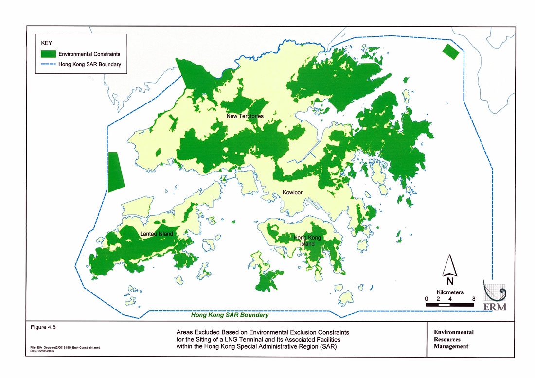
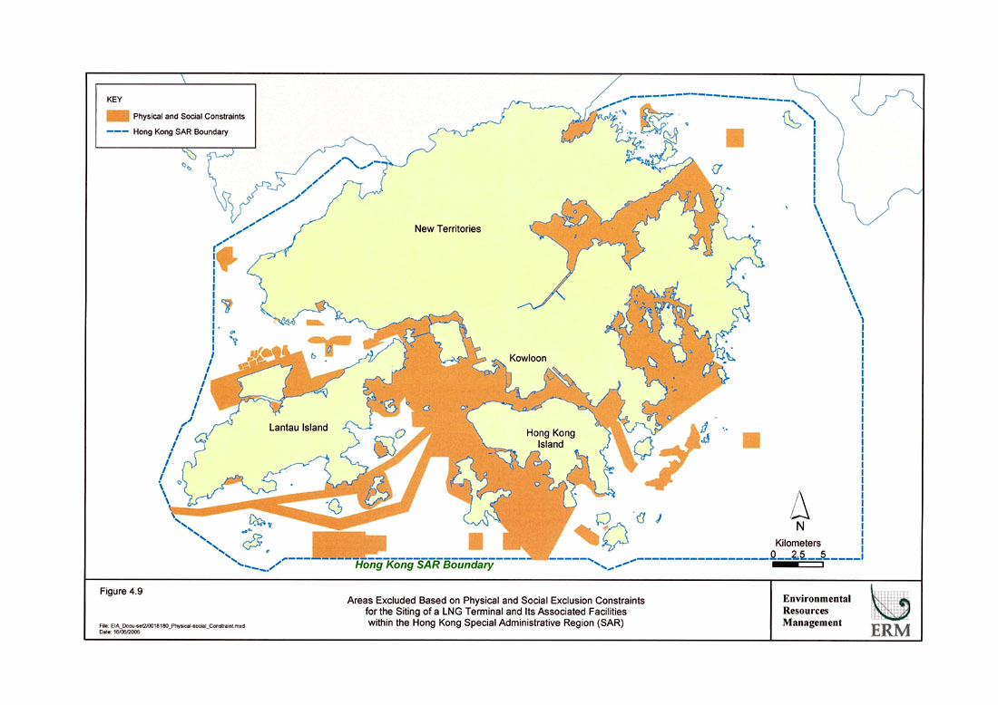
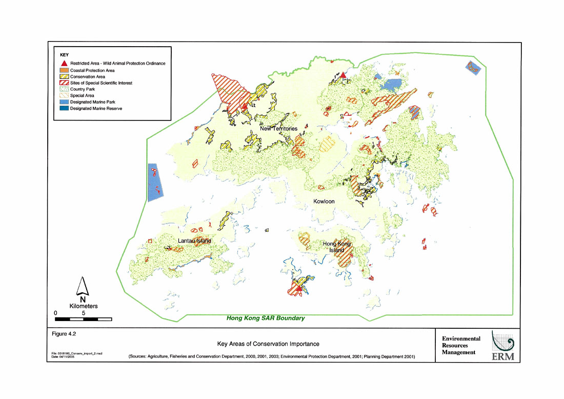
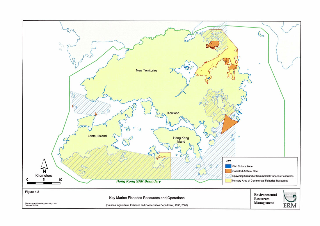
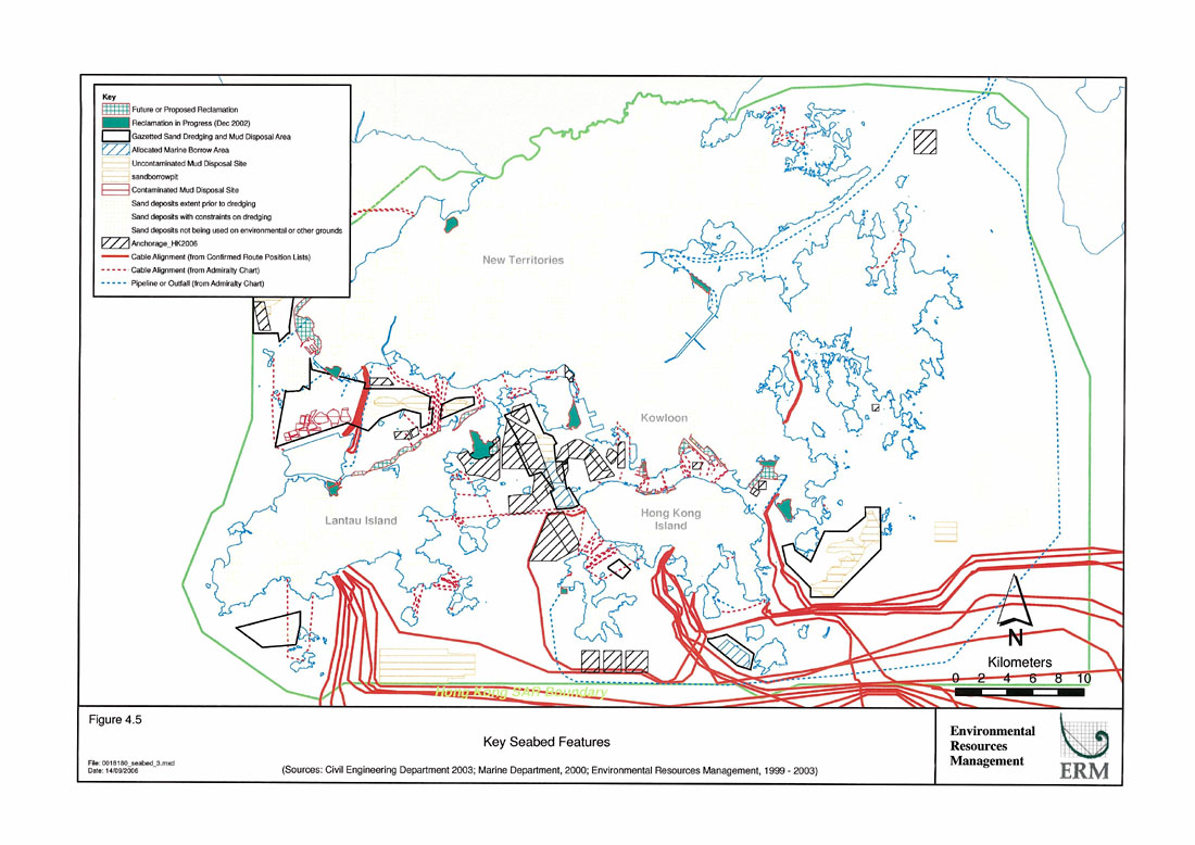
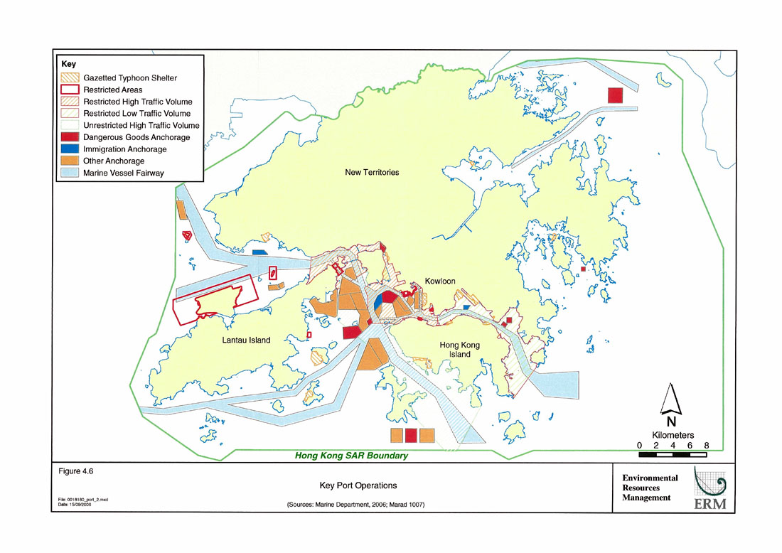
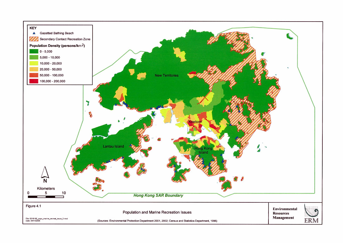
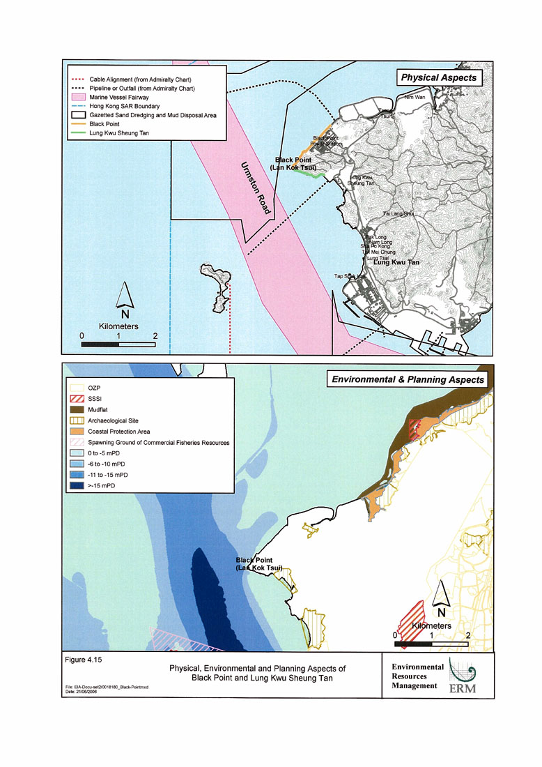
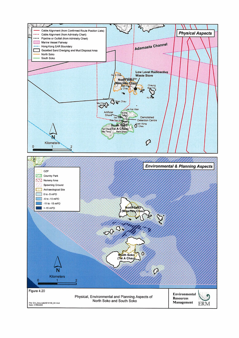
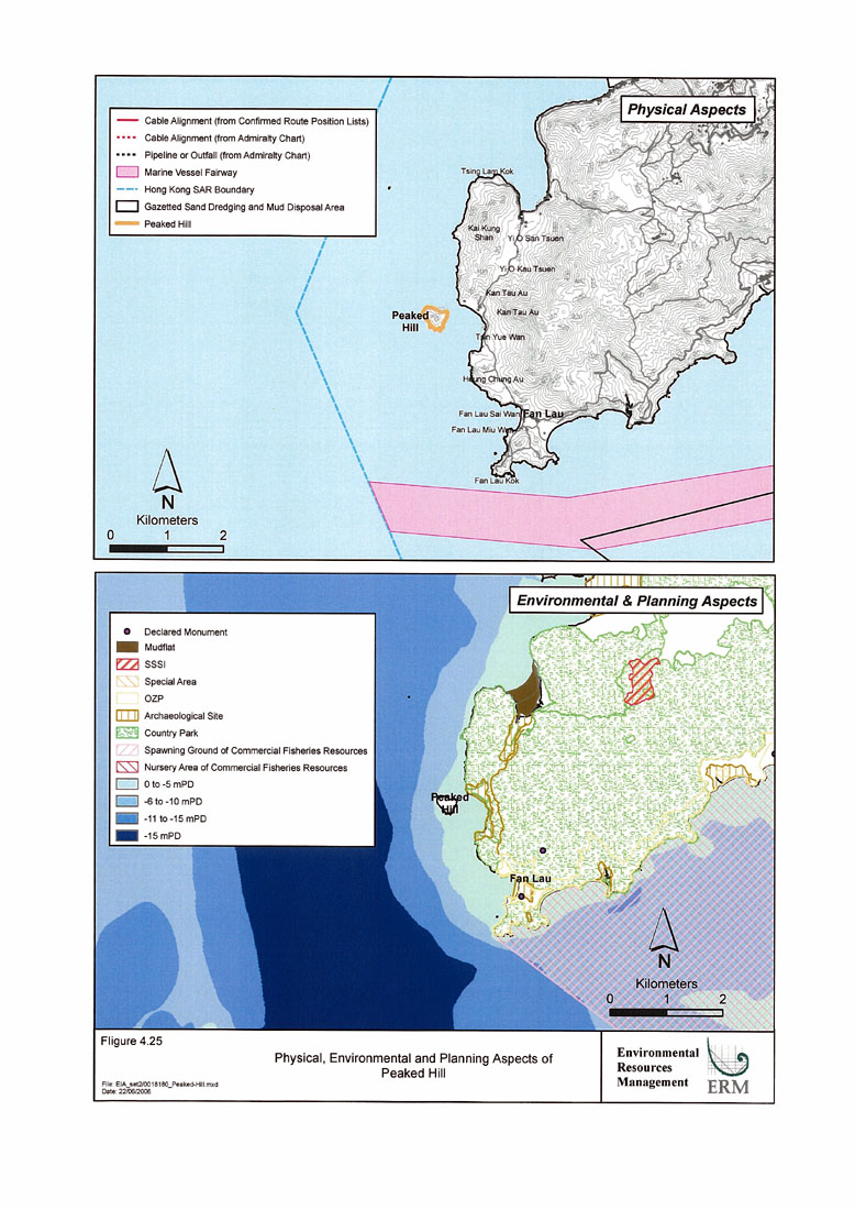
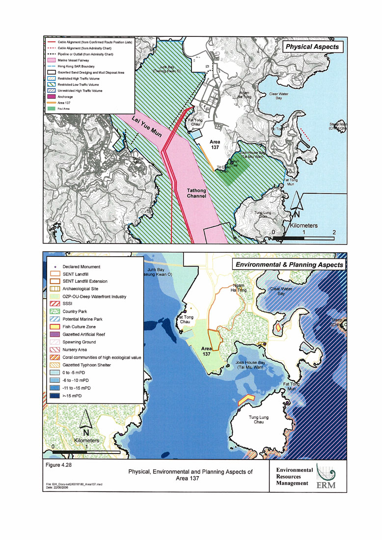
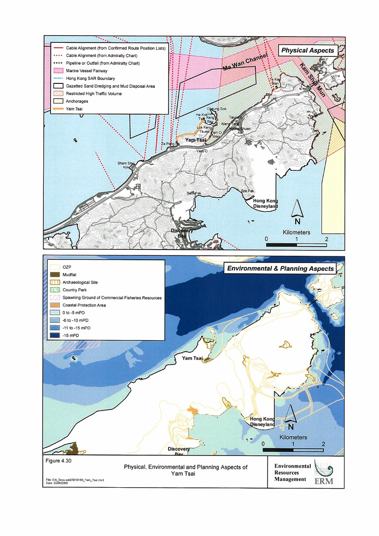
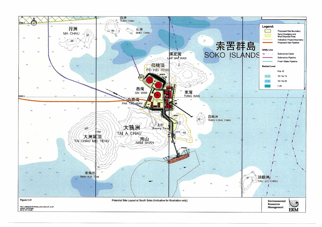
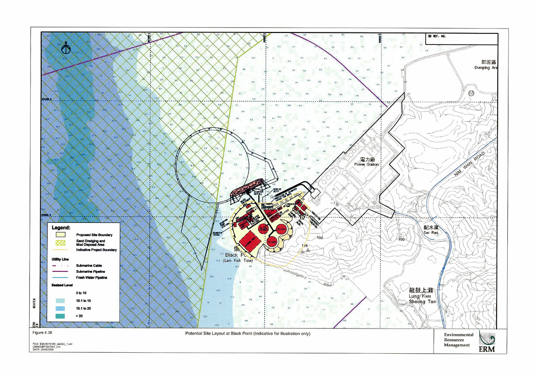
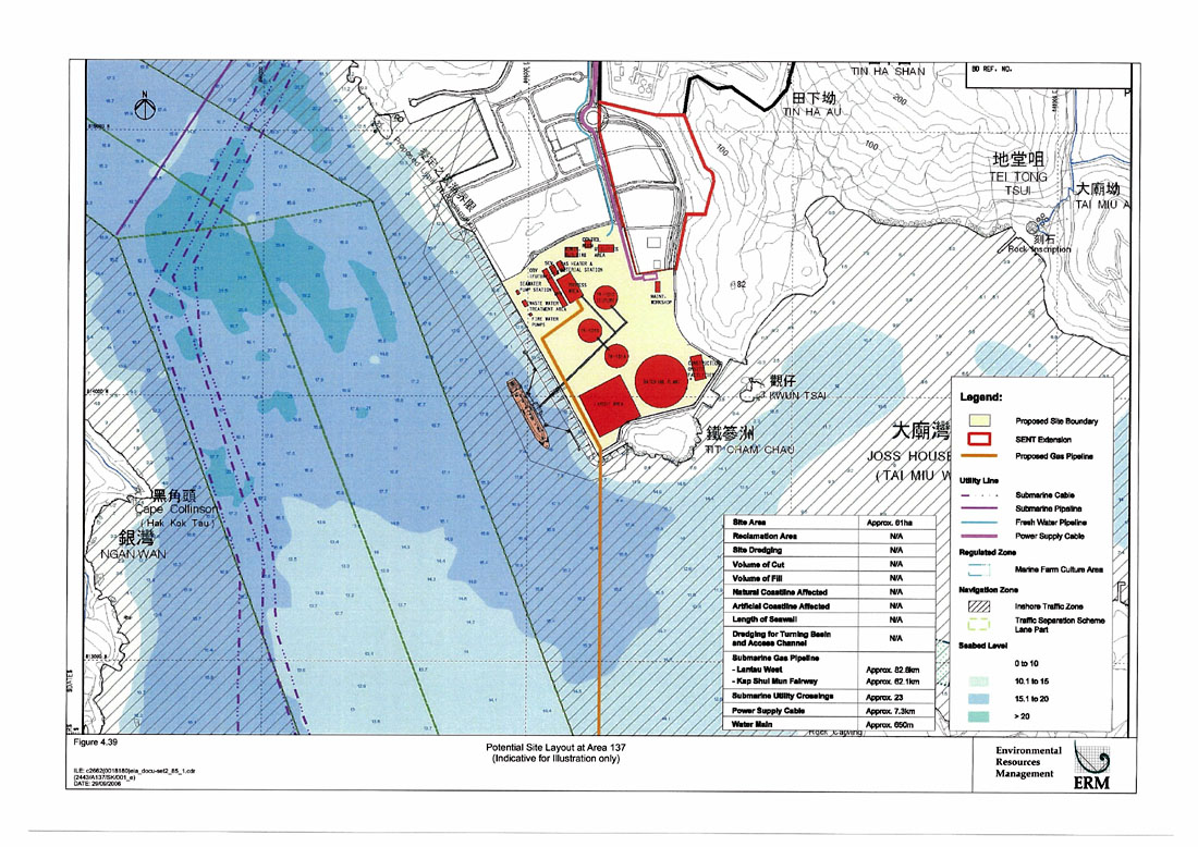
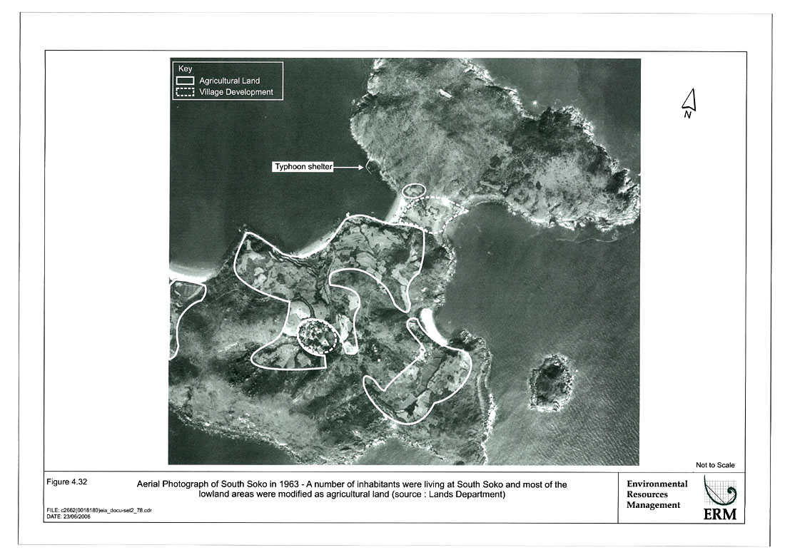
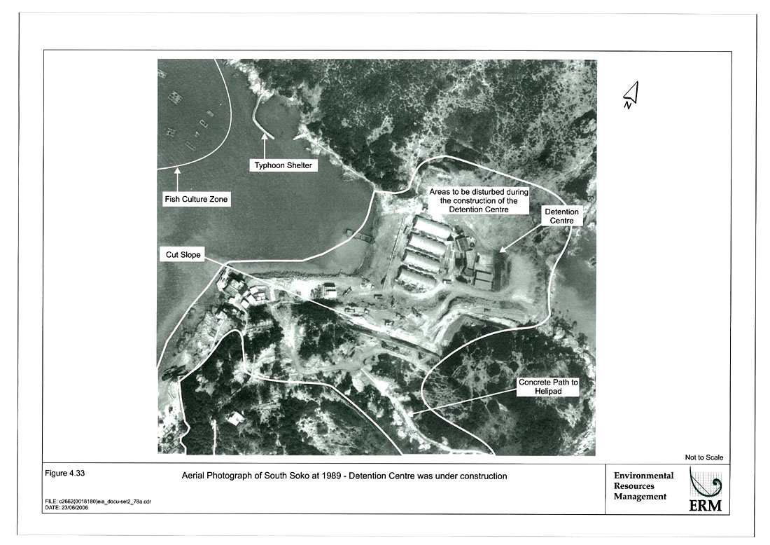
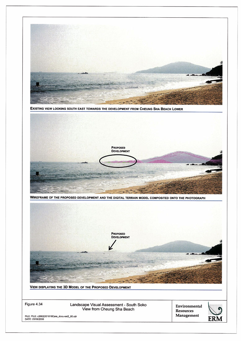
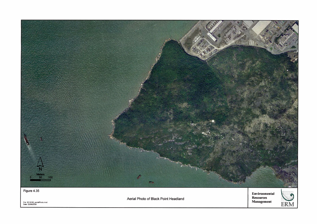
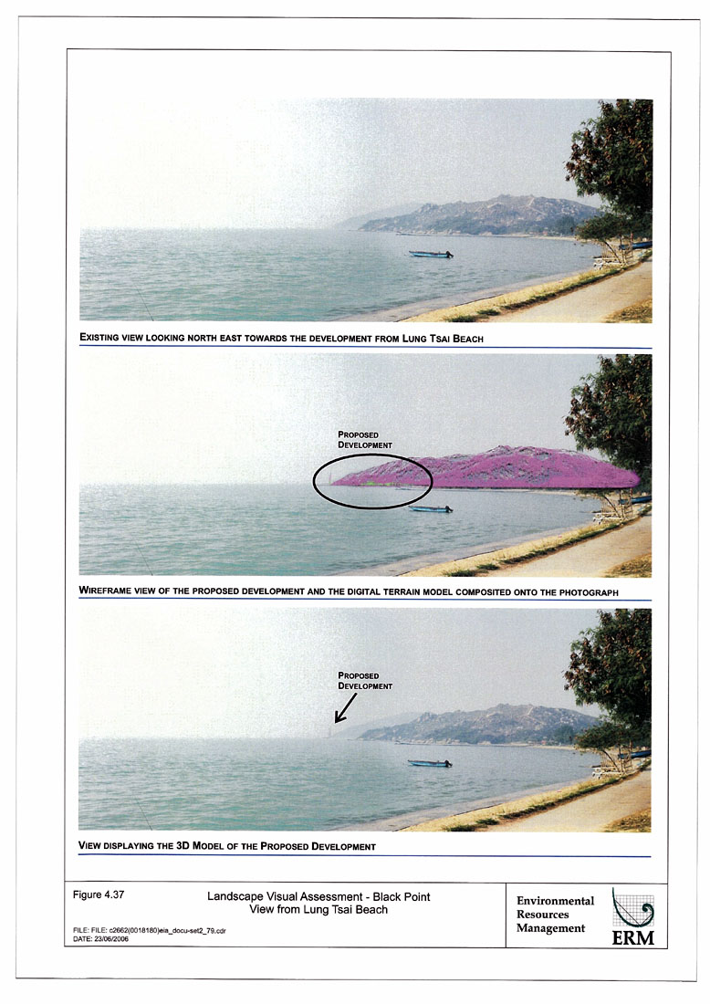
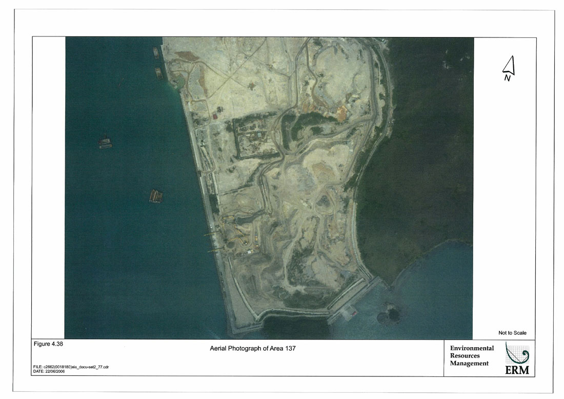
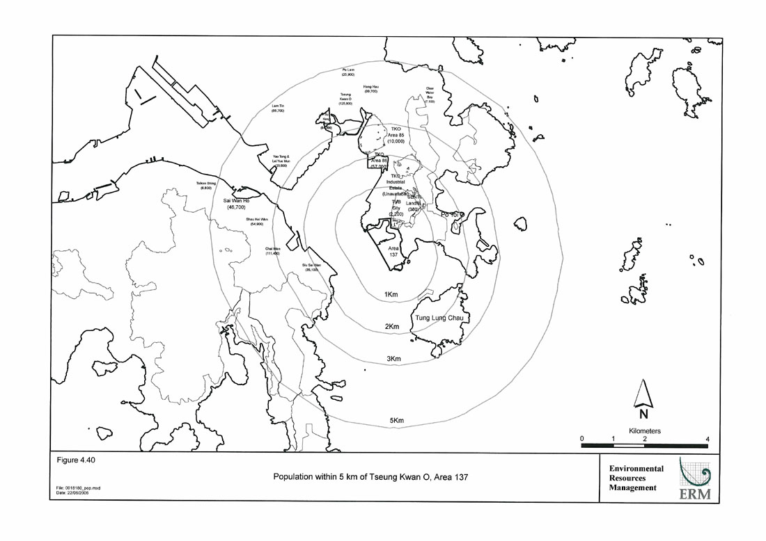
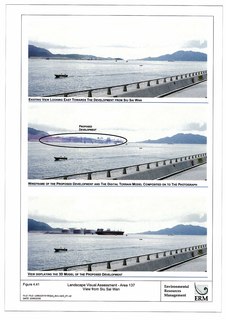
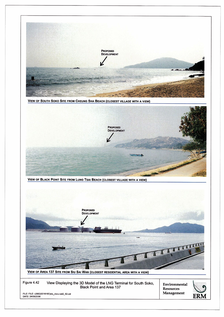