1.1
Introduction
Potentially, a container port, CT10, will
be built to the west of Lantau (near Tai O). If this is the case, it will hence be
necessary to alter the LNG submarine gas pipeline in order to avoid the
intersection with the CT10 which may require dredging the port area to
substantial depth for reclamation.
As seen from the figure below, an
alternative pipeline route was designed to bypass the CT10. To assess any potential impacts due to
the alternative pipeline route was thus simulated by Delft3D model.
The same modelling approach as presented
in the Section 3 of Annex 6A was adopted. The modelling is mainly carried out for
KP7 – 14, KP14 – KP20 and KP20 – KP34.5 since the changes are mainly at these
three zones. The model results are
presented in the next section of this Appendix.

1.2
Model Results
1.2.1
Suspended Solids
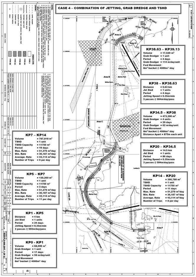
TSHD
Dredging at Lantau Channel (KP7-14)
Modelling
results (Table 1.1) indicate that SS
elevations will be compliant with the WQO and tolerance criterion at all
sensitive receivers in both seasons.
TSHD
Dredging at West Lantau (KP14-20)
Modelling results (Table 1.1) indicate that SS elevations will be compliant with the
WQO at all sensitive receivers in both seasons, with the exception of SR12
(horseshoe crab habitat near Tai O).
As seen from Table 1.1, the
maximum depth-averaged SS concentrations at Pak Tso Wan would be about 52.3 and
45.7 mg L-1, exceeding the WQOs of 8.9 and 5.6 mg L-1 in
the dry and wet seasons, respectively, whereas the mean depth-averaged SS
concentrations are comply with the WQO.
This suggests that the exceedances are not persistent.
Jetting
at the Urmston Road
Crossing (KP20-34.5)
Modelling results (Table 1.1) indicate that SS elevations will be compliant with the
WQO at all sensitive receivers in both seasons, with the exception of SR6a and
6b (boundary of Sha Chau and Lung
Kwu Chau
Marine Park).
The maximum depth-averaged SS elevations
at SR6a and 6b will exceed the WQOs of 8.2 and 5.6 mg L-1 in the dry
and wet seasons, respectively, whereas the mean depth-averaged SS
concentrations are well below the WQO.
This indicates that the exceedances are in short duration.
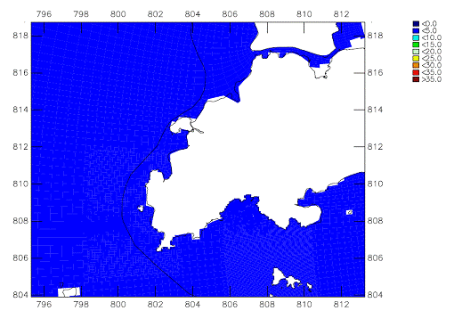
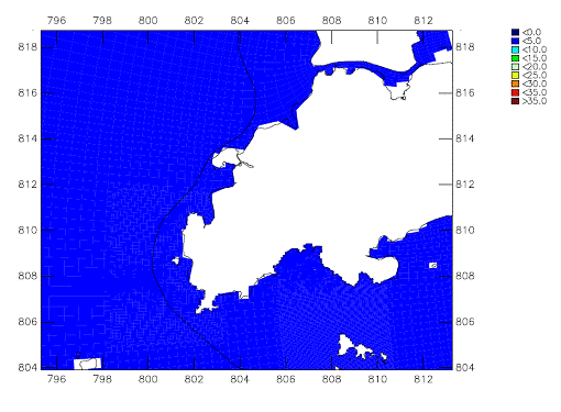
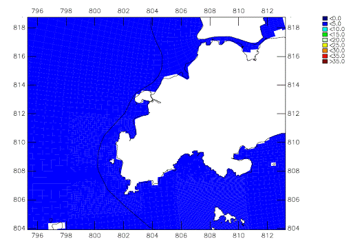
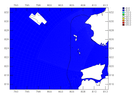
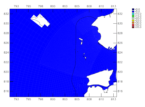
Figures
1.1 – 1.3 show the
contour plots (mean depth-averaged) of SS elevations for the alternative gas
pipeline route for the above three zones.
They show that the sediment plume is in low concentrations (mean over 15
day spring-neap cycle), i.e. below 5 mg L-1. This shows that there are no
continually unacceptable impacts to water quality.
1.2.2
Sediment Deposition
The
majority of SS elevations in water have been predicted to be temporary and to
remain within relatively close proximity to the dredging or jetting works and,
as such, the majority of sediment has been predicted to settle within
relatively close proximity of the works areas.
The simulated deposition rates () at the artificial reefs (ARs), i.e.,
SR6e and SR7d during the dry and wet seasons have been assessed for the
respective construction works. Table 1.2 summarises
the predicted deposition rates. No exceedance are
predicted at both ARs and hence no unacceptable impacts are expected to be
posed by the works.
Table 1.1 Predicted
SS Elevation (mg L-1) for Alternative
Pipeline Route
|
Sensitive Receiver
|
Name
|
ID
|
Depth (a)
|
WQO Allowable Elevation
|
TSHD Dredging at Lantau Channel
(KP7-14)
|
TSHD Dredging at West Lantau
(KP14-20)
|
Jetting at the Urmston Road Crossing
(KP20-34.5)
|
|
Max
|
Mean
|
Max
|
Mean
|
Max
|
Mean
|
|
Dry
|
Wet
|
Dry
|
Wet
|
Dry
|
Wet
|
Dry
|
Wet
|
Dry
|
Wet
|
Dry
|
Wet
|
Dry
|
Wet
|
|
Intertidal Mudflats
|
Pak Nai
|
SR01
|
s
|
7.1
|
3.6
|
0.0
|
0.0
|
0.0
|
0.0
|
0.0
|
0.0
|
0.0
|
0.0
|
0.0
|
0.0
|
0.0
|
0.0
|
|
Horseshoe Crab Nursery Grounds
|
Pak Nai
|
SR01
|
a
|
9.7
|
6
|
0.0
|
0.0
|
0.0
|
0.0
|
0.0
|
0.0
|
0.0
|
0.0
|
0.0
|
0.0
|
0.0
|
0.0
|
|
Seagrass Beds/Mangroves/Oyster Farm
|
Pak Nai
|
SR02
|
s
|
7.1
|
3.6
|
0.0
|
0.0
|
0.0
|
0.0
|
0.0
|
0.0
|
0.0
|
0.0
|
0.0
|
0.0
|
0.0
|
0.0
|
|
Seawater Intakes
|
Black Point Power Station
|
SR04
|
b
|
700 (b)
|
700 (b)
|
0.0
|
0.0
|
0.0
|
0.0
|
0.0
|
0.0
|
0.0
|
0.0
|
0.0
|
0.0
|
0.0
|
0.0
|
|
Non-gazetted Beaches
|
Lung Kwu Sheung Tan
|
SR05a
|
a
|
8.2
|
5.6
|
0.0
|
0.0
|
0.0
|
0.0
|
0.0
|
0.0
|
0.0
|
0.0
|
0.0
|
0.0
|
0.0
|
0.0
|
|
Non-gazetted Beaches
|
Lung Kwu Tan
|
SR05b
|
a
|
8.2
|
5.6
|
0.0
|
0.0
|
0.0
|
0.0
|
0.0
|
0.0
|
0.0
|
0.0
|
0.0
|
0.0
|
0.0
|
0.0
|
|
Gazetted Beaches
|
Butterfly Beach
|
SR05c
|
a
|
8.2
|
5.6
|
0.0
|
0.0
|
0.0
|
0.0
|
0.0
|
0.0
|
0.0
|
0.0
|
0.0
|
0.0
|
0.0
|
0.0
|
|
Marine Park
|
Designated Sha Chau and Lung Kwu Chau
|
SR06a
|
a
|
8.2
|
5.6
|
0.0
|
0.0
|
0.0
|
0.0
|
0.0
|
0.0
|
0.0
|
0.0
|
44.9 (c)
|
79.2(c)
|
1.1
|
0.8
|
|
Marine Park
|
Designated Sha Chau and Lung Kwu Chau
|
SR06b
|
a
|
8.2
|
5.6
|
0.2
|
0.0
|
0.0
|
0.0
|
0.2
|
0.0
|
0.0
|
0.0
|
12.8(c)
|
12.1(c)
|
0.8
|
0.2
|
|
Marine Park
|
Designated Sha Chau and Lung Kwu Chau
|
SR06c
|
a
|
8.2
|
5.6
|
0.0
|
0.0
|
0.0
|
0.0
|
0.0
|
0.0
|
0.0
|
0.0
|
0.2
|
0.0
|
0.0
|
0.0
|
|
Marine Park
|
Designated Sha Chau and Lung Kwu Chau
|
SR06d
|
a
|
8.2
|
5.6
|
0.0
|
0.0
|
0.0
|
0.0
|
0.0
|
0.0
|
0.0
|
0.0
|
0.4
|
0.3
|
0.0
|
0.0
|
|
Artificial Reef Deployment Area
|
Sha Chau and Lung Kwu Chau
|
SR06e
|
a
|
8.2
|
5.6
|
0.0
|
0.0
|
0.0
|
0.0
|
0.1
|
0.0
|
0.0
|
0.0
|
3.1
|
4.7
|
0.4
|
0.1
|
|
Seawater Intakes
|
Castle Peak Power Station
|
SR07a
|
b
|
700 (b)
|
700 (b)
|
0.0
|
0.0
|
0.0
|
0.0
|
0.0
|
0.0
|
0.0
|
0.0
|
0.0
|
0.0
|
0.0
|
0.0
|
|
Seawater Intakes
|
Tuen Mun Area 38
|
SR07b
|
b
|
14.2
|
9.8
|
0.0
|
0.0
|
0.0
|
0.0
|
0.0
|
0.0
|
0.0
|
0.0
|
0.0
|
0.0
|
0.0
|
0.0
|
|
Seawater Intakes
|
Airport
|
SR07c
|
b
|
8.9
|
8.8
|
0.0
|
0.0
|
0.0
|
0.0
|
0.0
|
0.0
|
0.0
|
0.0
|
0.0
|
0.0
|
0.0
|
0.0
|
|
Seawater Intakes
|
Airport
|
SR07d
|
b
|
8.9
|
8.8
|
0.0
|
0.0
|
0.0
|
0.0
|
0.0
|
0.0
|
0.0
|
0.0
|
0.0
|
0.0
|
0.0
|
0.0
|
|
Artificial Reef Deployment Area
|
Northeast Airport
|
SR07d
|
a
|
4.7
|
5.2
|
0.0
|
0.0
|
0.0
|
0.0
|
0.0
|
0.0
|
0.0
|
0.0
|
0.0
|
0.0
|
0.0
|
0.0
|
|
Seawater Intakes
|
Airport
|
SR07e
|
b
|
8.9
|
8.8
|
0.0
|
0.0
|
0.0
|
0.0
|
0.0
|
0.1
|
0.0
|
0.0
|
0.0
|
0.6
|
0.0
|
0.0
|
|
Seawater Intakes
|
Airport
|
SR07f
|
b
|
8.9
|
8.8
|
0.0
|
0.0
|
0.0
|
0.0
|
0.0
|
0.0
|
0.0
|
0.0
|
0.0
|
0.1
|
0.0
|
0.0
|
|
Spawning/Nursery Grounds
|
Fisheries Spawning Ground in North Lantau
|
SR08
|
a
|
8.2
|
5.6
|
0.0
|
0.0
|
0.0
|
0.0
|
0.0
|
0.0
|
0.0
|
0.0
|
0.0
|
0.0
|
0.0
|
0.0
|
|
Horseshoe Crab Nursery Grounds
|
Sham Wat Wan
|
SR10
|
a
|
8.9
|
6.5
|
0.4
|
0.2
|
0.0
|
0.0
|
1.2
|
1.3
|
0.2
|
0.1
|
2.0
|
2.5
|
0.1
|
0.1
|
|
Protection Zone
|
Chinese White Dolphin Protection Zone in Mainland Waters
|
SR11
|
a
|
8.9
|
6.5
|
0.6
|
0.4
|
0.1
|
0.0
|
0.2
|
0.1
|
0.0
|
0.0
|
0.4
|
0.3
|
0.0
|
0.0
|
|
Protection Zone
|
Chinese White Dolphin Protection Zone in Mainland Waters
|
SR11a
|
a
|
8.9
|
6.5
|
0.6
|
0.7
|
0.1
|
0.1
|
0.2
|
0.2
|
0.0
|
0.0
|
0.3
|
0.2
|
0.0
|
0.0
|
|
Protection Zone
|
Chinese White Dolphin Protection Zone in Mainland Waters
|
SR11b
|
a
|
8.9
|
6.5
|
0.5
|
0.8
|
0.1
|
0.0
|
0.2
|
0.3
|
0.0
|
0.0
|
0.3
|
0.2
|
0.0
|
0.0
|
|
Horseshoe Crab Nursery Grounds
|
Tai O
|
SR12
|
a
|
8.9
|
6.5
|
0.7
|
1.1
|
0.1
|
0.1
|
52.3(c)
|
45.7(c)
|
2.4
|
1.9
|
1.3
|
1.3
|
0.1
|
0.1
|
|
Intertidal Mudflats
|
Yi O
|
SR14
|
s
|
6.5
|
3.6
|
0.5
|
0.0
|
0.1
|
0.0
|
2.3
|
1.3
|
0.2
|
0.0
|
0.6
|
0.3
|
0.0
|
0.0
|
|
Horseshoe Crab Nursery Grounds
|
Yi O
|
SR14
|
a
|
8.9
|
6.5
|
0.7
|
0.9
|
0.2
|
0.1
|
3.1
|
3.9
|
0.4
|
0.2
|
0.7
|
0.4
|
0.1
|
0.0
|
|
Non-gazetted Beaches
|
Fan Lau Sai Wan
|
SR15a
|
a
|
6.9
|
5.5
|
0.7
|
0.8
|
0.2
|
0.1
|
0.4
|
0.4
|
0.1
|
0.0
|
0.2
|
0.1
|
0.0
|
0.0
|
|
Mangroves
|
Fan Lau Tung Wan
|
SR15b
|
s
|
4.5
|
3
|
0.1
|
0.0
|
0.0
|
0.0
|
0.0
|
0.0
|
0.0
|
0.0
|
0.0
|
0.0
|
0.0
|
0.0
|
|
Non-gazetted Beaches
|
Fan Lau Tung Wan
|
SR15b
|
a
|
6.9
|
5.5
|
0.1
|
1.3
|
0.0
|
0.1
|
0.0
|
0.0
|
0.0
|
0.0
|
0.0
|
0.0
|
0.0
|
0.0
|
|
Non-gazetted Beaches
|
Tsin Yue Wan
|
SR15c
|
a
|
6.9
|
5.5
|
0.8
|
0.5
|
0.2
|
0.1
|
0.6
|
0.7
|
0.1
|
0.1
|
0.2
|
0.3
|
0.0
|
0.0
|
|
Fish Fry Habitat
|
Pak Tso Wan
|
SR16b
|
a
|
6.9
|
5.5
|
0.2
|
0.2
|
0.0
|
0.0
|
0.0
|
0.1
|
0.0
|
0.0
|
0.0
|
0.0
|
0.0
|
0.0
|
|
Horseshoe Crab Nursery Grounds
|
Sha Lo Wan
|
SR18
|
a
|
7.8
|
4.8
|
0.2
|
0.1
|
0.0
|
0.0
|
0.5
|
0.2
|
0.1
|
0.0
|
0.7
|
1.5
|
0.0
|
0.1
|
|
Spawning/Nursery Grounds
|
Fisheries Spawning/Nursery Grounds in South
Lantau
|
SR24
|
a
|
6.9
|
5.5
|
0.6
|
0.2
|
0.0
|
0.0
|
0.1
|
0.0
|
0.0
|
0.0
|
0.0
|
0.0
|
0.0
|
0.0
|
|
Spawning/Nursery Grounds
|
Fisheries Spawning/Nursery Grounds in South
Lantau
|
SR27
|
a
|
6.9
|
5.5
|
0.5
|
0.2
|
0.0
|
0.0
|
0.1
|
0.0
|
0.0
|
0.0
|
0.0
|
0.0
|
0.0
|
0.0
|
|
Subtidal Hard Bottom Habitat (coral)
|
Southern Side of South Soko
|
SR31
|
a
|
10
|
10
|
0.0
|
0.2
|
0.0
|
0.0
|
0.0
|
0.1
|
0.0
|
0.0
|
0.0
|
0.0
|
0.0
|
0.0
|
|
Intertidal Mudflats
|
Shui Hau Wan
|
SR33
|
s
|
3.9
|
2.5
|
0.0
|
0.0
|
0.0
|
0.0
|
0.0
|
0.0
|
0.0
|
0.0
|
0.0
|
0.0
|
0.0
|
0.0
|
|
Horseshoe Crab Nursery Grounds
|
Tong Fuk Miu Wan
|
SR33
|
a
|
4.8
|
3.9
|
0.0
|
0.0
|
0.0
|
0.0
|
0.0
|
0.0
|
0.0
|
0.0
|
0.0
|
0.0
|
0.0
|
0.0
|
|
Gazetted Beaches
|
Tong Fuk
|
SR34
|
a
|
4.8
|
3.9
|
0.0
|
0.0
|
0.0
|
0.0
|
0.0
|
0.0
|
0.0
|
0.0
|
0.0
|
0.0
|
0.0
|
0.0
|
|
Gazetted Beaches
|
Upper Cheung Sha Beach
|
SR35
|
a
|
4.8
|
3.9
|
0.0
|
0.0
|
0.0
|
0.0
|
0.0
|
0.0
|
0.0
|
0.0
|
0.0
|
0.0
|
0.0
|
0.0
|
|
Seagrass Beds/Mangroves
|
Tung Chung Bay
|
SR39
|
s
|
6.5
|
3.6
|
0.0
|
0.0
|
0.0
|
0.0
|
0.0
|
0.0
|
0.0
|
0.0
|
0.0
|
0.0
|
0.0
|
0.0
|
|
Horseshoe Crab Nursery Grounds
|
Tung Chung Bay
|
SR39
|
a
|
8.9
|
6.5
|
0.0
|
0.0
|
0.0
|
0.0
|
0.0
|
0.0
|
0.0
|
0.0
|
0.0
|
0.0
|
0.0
|
0.0
|
|
|
|
|
|
|
|
|
|
|
|
|
|
|
|
|
|
|
|
|
|
|
|
|
|
|
Notes:
a. s
= surface, m = middle, b = bottom, a = depth-averaged
b.
The
assessment criterion of 700 mg L-1 was adopted for these seawater
intakes.
c.
Shaded area indicates non-compliance with
the assessment criterion.
Table 1.2 Predicted
Deposition Rate (g m-2 day-1) for the Alternative Gas Pipeline Route at the
Artificial Reefs and Subtidal Hard Bottom Habitat
|
Sensitive Receiver
|
Name
|
ID
|
Depth
|
WQO Allowable Elevation
|
TSHD Dredging at Lantau
Channel
(KP7-14)
|
TSHD Dredging at West Lantau
(KP14-20)
|
Jetting at the Urmston Road
Crossing
(KP20-34.5)
|
|
|
|
Dry
|
Wet
|
Dry
|
Wet
|
Dry
|
Wet
|
Dry
|
Wet
|
|
|
|
Max
|
Max
|
Max
|
Max
|
Max
|
Max
|
|
Artificial Reef Deployment Area
|
Sha Chau and Lung Kwu Chau
|
SR06e
|
b
|
200
|
200
|
0.0
|
0.0
|
0.1
|
0.0
|
15.1
|
3.7
|
|
Artificial Reef Deployment Area
|
Northeast Airport
|
SR07d
|
b
|
200
|
200
|
0.0
|
0.0
|
0.0
|
0.0
|
0.0
|
0.0
|
1.3
Conclusion
Installation for the alternative gas
pipeline route has been simulated by water quality model using the same
modelling approach as for the proposed route presented in the EIA report Section 6. This model results show that the SS
elevations exceed the WQO at two locations whereas the SS deposition rate
remain below the assessment criteria.
It is expected the SS exceedances are short-term and do not have
unacceptable impacts to water quality.
At the EIA stage, the alternative gas
pipeline route is not considered to be a preferred option. Should the alternative gas pipeline
route be selected at next stage as a result of any planning uncertainties, a further
impact detailed assessment should be conducted and the following
implementations should be considered:
·
Jetting
works next to the designated Sha Chau and Lung Kwu Chau Marine
Park will be replaced by
grab dredging in order to minimise the instantaneous SS elevations.
·
Dredging
works along the route designated Sha Chau and Lung
Kwu Chau
Marine Park
and in West Lantau will be operated during
daytime (maximum 12 hours a day) and will avoid the peak calving season of the
Indo-Pacific Humpback Dolphin, i.e. March through August.
·
Appropriate
mitigation measures will be derived if any predicted WQO exceedances are
predicted.
The residual impacts, if any, will be
assessed.