9
Marine Ecology Assessment
This
section of the report presents the findings of the marine ecological impact
assessment associated with the construction and operation of an LNG terminal on
the
9.2
Legislative
Requirements and Evaluation Criteria
The criteria for evaluating marine
ecological impacts are laid out in the EIAO-TM
as well as the Study Brief (No. ESB-126/2005). Annex 16 of the EIAO-TM
sets out the general approach and methodology for the assessment of marine
ecological impacts arising from a project or proposal. This assessment allows a
complete and objective identification, prediction and evaluation of the
potential marine ecological impacts. Annex
8 of the EIAO-TM recommends the
criteria that can be used for evaluating marine ecological impacts.
Legislative requirements and evaluation
criteria relevant to the study for the protection of species and habitats of
marine ecological importance are summarised below. The details on each are
presented in Annex 9.
1.
Marine Parks Ordinance (Cap 476);
2.
Wild Animals Protection Ordinance (Cap
170);
3.
Protection of Endangered Species of
Animals and Plants Ordinance (Cap 586);
4.
Town Planning Ordinance (Cap 131);
5.
Hong Kong Planning Standards and
Guidelines Chapter 10 (HKPSG);
6.
The Technical Memorandum on Environmental
Impact Assessment Process under the Environmental Impact Assessment Ordinance
(EIAOTM);
7.
United Nations Convention on Biodiversity
(1992);
8.
Convention on Wetlands of International
Importance Especially as Waterfowl Habitat (the Ramsar
Convention); and,
9.
PRC Regulations and Guidelines.
10. City
University of Hong Kong (2001). Agreement No. CE 62/98, Consultancy Study on
Fisheries and Marine Ecological Criteria for Impact Assessment, AFCD, Final
Report July 2001.
The
marine ecological habitats in the immediate vicinity of the South Soko Island have undergone some anthropogenic disturbance
through reclamations in Sai Wan and Tung Wan as a
result of the site formation for the Detention Centre (now
decommissioned). Even before this
facility was built, the village developments at Ha Tsuen
and Sheung Tsuen (both now
abandoned) had resulted in some reclamation over the previous coastline, in the
form of piers and seawalls. To the
east of the South Soko Island lies the active mud
disposal ground at South Cheung Chau (approximately 6
km from the terminal) and to the west a former marine sand borrow area
(approximately 1.3 km from the terminal) which remains as a gazetted sand
dredging and mud disposal area. The
Hong Kong Government has recently constructed a jetty and low level radioactive
waste store within a bay on North Soko Island (Siu A Chau).
The waters and coastal areas of Southwest Lantau including the Soko Island
group, which are located away from the major population centres of Hong Kong,
have been considered by some academics, government and green groups to be a
general area of high ecological value including from a marine perspective. Recently gathered information on the
West Lantau area would also indicate high ecological
value.
9.3.1
Summary of Baseline Conditions
The
findings of the literature review and field surveys and, an evaluation of the
ecological importance of marine resources within the Study Area are summarised
in the following section. The
details are presented in full in Annex 9. The ecological resources and importance
of marine habitats, in particular the South Soko
Island’s various habitats and organisms, have been characterised with reference
to the available literature, comprehensive seasonal field surveys, comparisons
with other similar habitats in Hong Kong and the criteria presented in Annexes 8 and 16 of the Technical
Memorandum on Environmental Impact Assessment Process under the Environmental
Impact Assessment Ordinance (EIAO-TM).
Due
to the limited literature available for some components of the marine
environment, field surveys were necessary to fill the information gaps
identified for the baseline conditions of the habitats. Detailed and comprehensive seasonal
surveys were conducted examining the major habitats and species surrounding the
South Soko Island and the pipeline, cable and watermain alignments.
The baseline surveys have included both the dry and wet seasons. The findings of the field surveys are
presented in Annex 9.
Dolphins and Porpoises
The
key finding of the literature review was the recorded presence in the waters in
southern Lantau of both of Hong Kong’s resident
marine mammal species, the Indo-Pacific Humpback Dolphin Sousa chinensis and the Finless Porpoise Neophocaena phocaenoides.
For
this EIA, an extensive programme of vessel-based surveys has been conducted to
supplement data available from ongoing long-term AFCD monitoring. In accordance with the requirements of
the Study Brief, the surveys have been conducted on a monthly basis covering
the period October through May.
Since this EIA study commenced in July, surveys were also conducted
during July, August and September.
These surveys have provided a detailed overview of dolphin utilisation
of Hong Kong western waters spanning Southwest Lantau,
West Lantau, Northwest Lantau
and Deep Bay areas. During the
field surveys, dolphins were observed throughout the surveyed areas except
directly south of the Sha Chau
and Lung Kwu Chau Marine
Park and at the very northern end of the Deep Bay survey area.
The
survey data gathered (July 2005 to May 2006) has indicated that Deep Bay has
relatively low densities (0.08 - 0.23 dolphins
km-2) and a low abundance (<10 dolphins). West Lantau
had higher dolphin densities (1.71 - 2.81 dolphins
km-2) and a higher abundance (47 – 78 depending on the season)
of dolphins. It was evident that
dolphins use this area as a part of their habitat in all seasons. Southwest Lantau
had lower levels of dolphin density (0.10 - 0.44 dolphins
km-2) and abundance (6 - 29 dolphins depending on the season)
than West Lantau but was higher than Deep Bay. Northwest Lantau had lower levels of dolphin density
(0.57-0.94) compared to West Lantau but similar
abundance (49-82). Northwest Lantau had higher levels of dolphin density and abundance
than Deep Bay and Southwest Lantau.
Finless Porpoises were only seen in
Southwest Lantau and estimates of abundance (0 - 15
porpoises depending on the season) and density (<0.01 - 0.17 porpoises km-2)
were low. Other areas of Hong Kong
such as key habitats at Lamma and Po Toi support considerably higher densities (Lamma: 0.02 - 0.52 porpoises km-2, Po Toi; 0.02 - 0.17 porpoises km-2) and abundance (Lamma: 4 - 90 porpoises, Po Toi:
4 - 32 porpoises) of these animals ([1]).
Within
all of the marine areas of Hong Kong, the marine waters Southwest of Lantau Island (including the Soko
Islands area) are the region where the Indo-Pacific Humpback Dolphin and
Finless Porpoise significantly overlap in distribution. It appears that most other areas are
utilized by one or the other species.
Thus, those areas that are strongly influenced by the Pearl River
outflow (Deep Bay, West Lantau, Northwest Lantau, and Northeast Lantau)
appear to offer suitable conditions for the Indo-Pacific Humpback Dolphins,
which feed mostly on estuarine fish (Jefferson 2000) ([2]). Those areas that are more
marine-influenced (Southeast Lantau, Lamma, Po Toi, and the eastern
waters) are used nearly exclusively by Finless Porpoises (Jefferson et al.
2002) ([3]).
Subtidal
Hard Bottom Habitats
For
this EIA a comprehensive series of dive surveys were conducted on South Soko and its environs.
The dive surveys at South Soko yielded similar
results to those reported previously by BCL ([4])
in that hard corals were in low abundance and diversity. In total, fifteen hard coral species and
four octocoral species, were
recorded within the Study Area (Annex 9).
The majority were common faviids, poritids and siderasteriids, with
three predominant species – Oulastrea crispata, Psammocora sp. and
the ahermatypic cup coral Balanophyllia sp. Corals occurred in
extremely low abundance and percentage cover estimates ranged from 1 - 5%. Of the live corals recorded, many were
highly damaged and bioeroded by macroborers
and barnacles. Consequently, the
majority of colonies exhibited partial mortality. The corals recorded are all common Hong
Kong species with the exception of the relatively little known hard coral, the
False Pillow Coral Pseudosiderastrea tayami which
was recorded on the southern coast of
the South Soko Island.
Subtidal
Soft Bottom Habitats
Literature
was reviewed as part of the EIA which indicated that field sampling would be
necessary due to the lack of comprehensive data in the Project Area. Consequently, for this EIA a
comprehensive series of benthic surveys were conducted around South Soko and along the gas pipeline route. A total of 96 grab samples were taken
from 16 sites during both the wet and dry seasons: 8 of the sites (48 grabs)
were located close to South Soko Island; 6 of the
sites (36 grabs) were located along the submarine pipeline alignment; and 2 of
the sites (12 grabs) were located off Black Point. In both seasons, benthic assemblages
were dominated by polychaete worms, except off Black
Point were bivalves were recorded in higher numbers. In terms of diversity and abundance,
benthic communities at the sites were similar to other locations reported in
Hong Kong. At sites close to the
South Soko Island, the level of diversity and biomass
was generally higher than the Hong Kong average reported from the
literature. In addition, a low
number of amphioxus Branchiostoma belcheri ([5])
were recorded in Tung Wan on the east coast of South Soko
Island. This area was previously
disturbed during reclamation associated with construction of a Detention Centre
in the late 1980’s. The presence of
this species therefore indicates that it survived the disturbance or was able
to recolonise the bay in the intervening years.
Two species of Horseshoe Crab (Tachypleus
tridentatus and Carcinoscorpius
rotundicauda) have been recorded in Hong Kong
waters. In Hong Kong, the intertidal sand/sandy-mud flats at Shui
Hau and San Tau, on Lantau Island, the mud flats at Pak Nai,
in Deep Bay have recorded juveniles of both species, whereas, adult horseshoe
crabs are occasionally fished from the subtidal mud
along the northwest coast to the Lantau Island,
including Tai O, Yi O, Sham Wat Wan, Sha Lo Wan and Tung Chung Bay. All of the horseshoe crab breeding
grounds are located far away from the LNG terminal (at least 13 km), proposed
gas pipeline (at least 2 km), submarine cable and watermain
(at least 11 km).
Intertidal
Hard Bottom Habitats
Quantitative
transect surveys and spot checks were conducted on natural rocky shore and
artificial seawalls on the west, east and south coasts of South Soko Island.
Rocky shore species were common and widespread and no species of note
were recorded. At South Soko, assemblages with the highest diversity were recorded
on the south coast of the island.
In comparison to records of other shores in Hong Kong reported in the
literature, the diversity of intertidal biota at
Intertidal
Soft Bottom Habitats
The
sandy shores at South Soko and Shek
Pik supported very low species diversity in the dry
and wet season, which is a typical feature of mobile sandy shores with unstable
substrates.
The
details of all of the baseline surveys conducted for this EIA are summarised in
Table 9.1.
Table 9.1 Marine
Ecology Baseline Surveys
|
Survey Type |
Methodology |
Date |
|
Intertidal
Assemblages at South Soko |
Rocky shore/ artificial shoreline Quantitative (belt transects at 7
locations) survey, three 100 m belt transects (at high, mid and low intertidal zones) for each location, covered both wet and
dry seasons. Sandy Shore Quantitative (line transects at two locations)
survey, 50 x 50 x 50cm core at three points (high,
mid and low intertidal zones) along
each of the transects, covered both wet and
dry seasons. |
8 & 9 March, 28 & 29 July, 14
September 2004, 29 & 30 September 2005 and 27 January 2006 |
|
Intertidal
Assemblages at Shek Pik |
Rocky shore/ artificial shoreline Quantitative (belt transects at 1
locations) survey, three 100 m belt transects (at high, mid and low intertidal zones) covered both wet and dry seasons. Sandy Shore Quantitative (line transects at 3 locations)
survey, 50 x 50 x 50cm core at three points (high,
mid and low intertidal zones) along
each of the transects, covered both wet and
dry seasons. |
30 August 2005 & 14 March 2006 |
|
Subtidal
Benthic Assemblages |
Quantitative grab sampling survey;
covered both wet and dry seasons.
Six stations sampled in each of 10 locations, covering the reclamation
area, approach channel and turning circle, and along the pipeline corridor. |
25 & 26 February, 5 & 6 July, 9
September, 8 November 2004, 23 September 2005 and 13 December 2005. |
|
Subtidal
Hard Bottom Habitat (Coral) |
Quantitative (Rapid Ecological
Assessment (REA) technique, a total of twenty three 100 m transects at 15
locations) and qualitative (recorded within Study Area and areas in the
vicinity, 3 locations); covered wet season. |
9 & 15 May 2004, 29,30 September
& 3 October 2005. |
|
Marine Mammals |
Land-based visual survey during daytime,
5 days per month and 6 hours per day, covered four seasons and 12 months. |
13, 14, 21, 23 & 26 February, 8, 9,
10, 17 & 18 March, 16, 19, 20, 21 & 26 April, 10, 12, 14, 19 & 25
May, 10, 14, 17, 18 & 28 June 2004, 23, 26, 27, 28 & 29 July 2004,
25, 26, 27, 30 & 31 August, 6, 7, 13, 14 & 22 September 2004, 27, 28,
29, 30 & 31 October 2004, 16, 17, 24, 25 & 26 November 2004, 16, 21,
28, 30 & 31 December 2004, 10, 12, 14, 17 & 28 January 2005 |
|
|
Quantitative vessel based survey using
line transect methods spanning Hong Kong western waters (Deep Bay, Southwest Lantau, Northwest Lantau and
West Lantau) 6 days per month |
18, 19, 20, 21, 22, 25, 26, 27 July
2005, 3, 4, 5,15,24 & 25 August 2005, 5,7,15, 16 & 20 September 2005,
5, 6, 7, 17, 18 & 19 October 2005, 22, 24, 25, 28, 29 & 30 November
2005, 6,7,8 & 22 December 2005, 13, 16, 17, 19, 20 & 24 January 2006,
1, 2, 3, 7, 8 & 9 February 2006, 17, 23, 28, 29, 31 March 2006, 3, 6, 18,
25, 26, 27 April 2006, 2, 4, 8, 9, 10, 11 May 2006. |
9.3.2
Ecological Importance
The waters and coastal areas of Southwest Lantau including the Soko Island
group, which are located away from the major population centres of Hong Kong,
have been considered by some academics, government and green groups to be a
general area of high ecological value including from a marine perspective. As discussed in Section 9.3.1 both dolphins and porpoises are sighted in the waters
of Southwest Lantau, although typically at different
times of the year.
There
have been a variety of studies, which have investigated the marine ecology of
Southwest Lantau waters and as a result of these, in
particular the AFCD-commissioned Marine Park feasibility study ([6]),
both the coastal waters off Southwest Lantau Island
and the waters around the Soko Island Group have been
proposed for designation as Marine Parks.
Recently gathered
information on the West Lantau area would also
indicate high ecological value. It
is important to note that there are significant spatial variations in the
ecological characteristics within this large area. To provide information of key relevance
to the marine ecological assessment, the ecological importance of habitats
presented in this baseline was therefore primarily focused on the vicinity of
the works areas of the proposed Project.
The ecological importance of the habitats was determined with
reference to the following:
·
Literature
review findings;
·
Findings
of the field surveys;
·
Comparison
with other outlying islands in Hong Kong, as well as South Lantau;
and,
·
Annexes 8 and 16 of the EIAO TM.
The
ecological importance of the marine habitats and their locations relative to
the LNG terminal layout are summarised in Table 9.2. The
key findings are presented below
·
Areas to be Reclaimed: The information on marine ecological
resources presented in this report has not identified any habitats within the
reclamation areas that are of high ecological importance.
·
Inshore Marine Waters of
·
Marine waters of the Proposed Pipeline
Corridor:
The waters along or in proximity to the proposed submarine pipeline
corridor have higher numbers of sightings of Sousa chinensis and few, if any,
sightings of Neophocaena phocaenoides. Along the submarine pipeline corridor,
the waters around West Lantau have been classified as
Sousa chinensis
habitat and have the highest density of sightings recorded in Hong Kong.
The ecological importance of the marine
habitats and their locations relative to the LNG terminal layout are summarised
in Table
9.2.
Table 9.2 Ecological
Importance of the Marine Habitats in the Vicinity of the Works Areas
|
Habitat |
Ecological Importance |
|
Natural Rocky Shore |
Medium at |
|
Artificial Shoreline |
Low at |
|
Sandy Shore |
Low at South Soko,
except Medium for Pak Tso Wan. Low at Shek Pik. |
|
Subtidal
Hard Surface Habitat along Natural Rocky Shore |
Low except Low to Medium at sites with Pseudosiderastrea tayami on
south coast of |
|
Subtidal
Hard Surface Habitat along Artificial shoreline |
Low |
|
Subtidal
Soft Bottom Habitats at South Soko |
Low to Medium, except Medium for Tung
Wan where amphioxus was reported. |
|
Subtidal
Soft Bottom Habitats along the Corridor of the Proposed Submarine Natural Gas
Pipeline |
Low |
|
Marine Waters at Tung Wan and Sai Wan of |
Low for Sousa chinensis, Medium for Neophocaena phocaenoides. |
|
Marine Waters at the southeast of |
Low for both Sousa chinensis and Neophocaena phocaenoides. |
|
Marine Waters along the Corridor of the
Proposed water main and submarine cable circuit |
Medium for both Sousa chinensis, Low for Neophocaena phocaenoides. |
|
Marine Waters along the Corridor of the
Proposed Submarine Natural Gas Pipeline |
Medium for both Sousa chinensis and Neophocaena phocaenoides west of South Soko. Medium in southwest Lantau
for Sousa chinensis,
Low for Neophocaena phocaenoides. High in west and northwest Lantau only for
Sousa chinensis. Low at Black Point landing area only for Sousa chinensis. |
9.3.3
Marine Ecological Sensitive Receivers
The
construction and operation phases of the proposed LNG terminal and the
installation of the submarine gas pipeline, water main and power cable have the
potential to affect marine ecological Sensitive Receivers (SRs). The marine ecological SRs have been identified in accordance with the EIAO-TM criteria and are consistent with
the ones identified in the Water Quality Assessment (Section 6):
·
Marine
Parks;
·
Seagrass
Beds, Mangroves, Intertidal Mudflats and Horseshoe
Crabs; and
·
Chinese
White Dolphin Protection Zone in Mainland China.
The marine ecological SRs
and their distance from the LNG terminal site, connecting pipeline and
utilities (power cable and water mains) are listed in Table 9.3 and their location is shown in Figure
6.4
(see Section 6).
Table
9.3 Approximate Shortest
Distance to Marine Ecological Sensitive Receivers (SRs)
around Proposed LNG Terminal at South Soko and
Submarine Pipeline Section from
|
Sensitive Receiver |
Name |
ID |
Distance (km) from SR to |
|||
|
LNG terminal |
Water Mains |
Cable |
Pipeline |
|||
|
Seagrass
Beds |
Pak Nai |
SR2 |
>
10 |
>
10 |
>
10 |
5.1 |
|
|
Tung Chung Bay |
SR39 |
>10 |
7.8 |
7.8 |
6.6 |
|
Marine Parks |
Designated Sha
Chau and Lung Kwu Chau |
SR6a-d |
>
10 |
>
10 |
>
10 |
<
1 |
|
Potential Marine Parks |
Proposed Fan Lau Marine Park Proposed Soko
Island Marine Park |
MP19a-19c various |
>5 within |
3.9 within |
3 within |
<
1 within |
|
Intertidal
Mudflats |
Pak Nai |
SR1 |
>
10 |
>
10 |
>
10 |
1.7 |
|
|
Tai O |
SR12 |
>
10 |
5.7 |
5.7 |
1.9 |
|
|
Yi O |
SR14 |
>10 |
5.6 |
5.1 |
1.7 |
|
|
Shui
Hau Wan |
SR33 |
6.6 |
2.85 |
2.1 |
5.9 |
|
Mangroves |
Pak Nai |
SR2 |
>
10 |
>
10 |
>
10 |
5.1 |
|
|
Tung Chung Bay |
SR39 |
>10 |
7.8 |
7.8 |
6.6 |
|
|
Fan Lau Tung Wan |
SR15b |
7.05 |
3.9 |
3 |
1.89 |
|
Horseshoe Crab Nursery Grounds |
Pak Nai |
SR1 |
>
10 |
>
10 |
>
10 |
1.7 |
|
|
Sham Wat Wan |
SR10 |
>
10 |
6.9 |
6.9 |
2.3 |
|
|
Tai O |
SR12 |
>
10 |
5.7 |
5.7 |
1.9 |
|
|
Yi O |
SR14 |
>10 |
5.6 |
5.1 |
1.6 |
|
|
Sha
Lo Wan |
SR18 |
>
10 |
7.65 |
7.65 |
3.1 |
|
|
Tong Fuk Miu Wan |
SR33 |
6.6 |
2.85 |
2.1 |
5.9 |
|
|
Tung Chung Bay |
SR39 |
>
10 |
7.8 |
7.8 |
6.6 |
|
Protection Zone |
Chinese White Dolphin Protection Zone in
Mainland Waters |
SR11 |
>10 |
>10 |
>10 |
4.2 |
|
|
|
SR11a |
>10 |
9.15 |
8.25 |
1.9 |
|
|
|
SR11b |
9.15 |
7.2 |
6.45 |
1.9 |
|
Subtidal
Hard Bottom Habitat (coral) |
Southern side of South Soko |
SR31 |
0.370 |
1.9 |
1.9 |
1.9 |
A desktop literature review and supporting
field surveys (summarized in Section 9.3
and detailed in full in Annex 9) were
conducted in order to establish the ecological profile of the area within and
surrounding the Study Area. The
importance of potentially impacted ecological resources identified within the
Study Area was assessed using the methodology defined in the EIAO-TM. The potential impacts due to the
construction and operation of the terminal and associated developments were
then assessed (following the EIAO-TM Annex 16 guidelines) and the impacts
evaluated (based on the criteria in EIAO-TM
Annex 8).
9.5 Potential Sources of Impact on Marine Ecological Resources
9.5.1
Construction Phase
Potential impacts to marine ecological
resources arising from the construction works may be divided into those due to
direct disturbances to the habitat and those due to perturbations to key water
quality parameters. Potential
impacts to marine mammals are discussed in Section
9.7. Impacts due to
construction wastewater discharge on marine ecology and marine mammals would
not be expected as it should satisfy the requirement of WPCO-TM effluent discharge standard (details refer to Part 2 Section 6.6.7). As discussed in Part 2 Section 6.6.9, minor water quality impacts will be expected
due to vessel discharges during construction, and therefore impacts on marine
ecology and marine mammals will not consider as a concern. Impacts associated with the proposed LNG
terminal are divided into those occurring during:
·
Dredging, reclamation and
seawall modifications for the proposed LNG terminal, including dredging seawall
trenches, filling with sand and suitable fill and dredging for the seawater
intake and outfall pipes;
·
Dredging for the approach
channel and turning basin;
·
Construction of the jetty;
·
Submarine gas pipeline
installation;
·
Watermain
and cable installation; and,
·
Relocation of the public
access pier.
Dredging, Reclamation and Seawall
Modifications for the Terminal
Along the line of the seawalls the
existing marine sediments will be dredged to provide suitable foundations
covering an area of approximately 1.1 ha.
After completion of the seawall, the muds
within the reclamation sites will be partially dredged and then filled using
sand and/or public fill.
It should be noted that the reclamation
works at South Soko for the LNG terminal are of
relatively small scale and it is expected to be approximately 0.6 ha. Impacts to the marine ecological
resources potentially arising from dredging and reclamation at South Soko are summarised in Table
9.4 and discussed in further detail below.
Table 9.4 Summary
of Potential Construction Phase Impacts associated with Dredging and
Reclamation for the LNG terminal at
|
Nature of Impact |
Marine Habitat Affected |
Location |
Potential Impact |
|
Habitat Loss |
Subtidal Soft Bottom Habitat |
Sai Wan |
Permanent
loss of approximately 0.6 ha of seabed due to reclamation and along 150m long
margin of seawall modification works |
|
|
Tung
Wan |
Permanent
loss of seabed at the margin of 465 m long seawall modification works |
|
|
|
Subtidal Hard Bottom Habitat |
Sai Wan |
Permanent
loss of approximately 190 m of subtidal artificial
seawall coastline inside the reclamation area, and along 150 m long margin of
seawall modification works |
|
|
Tung
Wan |
Permanent
loss of approximately 245 m subtidal natural rocky
and 220 m artificial seawall coastline covering 1.1 ha |
|
|
|
Intertidal Natural Rocky Shore |
Tung
Wan |
Permanent
loss of approximately 245 m natural rocky shore |
|
|
Intertidal Artificial Shore |
Sai Wan |
Permanent
loss of approximately 190 m of artificial shore inside the reclamation area,
and along 150 m long margin of seawall modification works |
|
|
Tung
Wan |
Permanent
loss of approximately 220 m of artificial shore |
|
|
|
Intertidal Sandy Shore |
Sai Wan |
Permanent
loss of approximately 35 m of sandy shore |
|
Short term Changes in Water Quality |
Subtidal Soft Bottom Habitat |
Sai Wan |
Potential
smothering and burial of benthic organisms during dredging |
|
Tung
Wan |
Potential
smothering and burial of benthic organisms during dredging |
||
|
|
Subtidal Hard Bottom Habitat |
Sai Wan |
Potential
water quality impacts on subtidal organisms |
|
|
Tung
Wan |
Potential
water quality impacts on subtidal organisms |
|
|
|
Intertidal Natural Rocky Shore |
Sai Wan |
Potential
water quality impacts on intertidal organisms |
|
|
Tung
Wan |
Potential
water quality impacts on intertidal organisms |
|
|
|
Intertidal Sandy Shore |
Sai Wan (including Pak Tso Wan) |
Potential
water quality impacts on intertidal organisms |
|
|
|
Tung
Wan |
Potential
water quality impacts on intertidal organisms |
Habitat Loss
The
Project will involve the direct loss and temporary disturbance of marine
habitats.
Subtidal Soft Bottom Habitats
Within
the reclamation footprint in Sai Wan, impacts will be
due to the smothering and burial of organisms during filling, or removal of
organisms during dredging. Dredging
would also be required for forming the foundations during seawall modification
works, which may also directly affect the margins of seabed at the base of
existing seawalls and rocky shore. These impacts are an unavoidable consequence
of the project and would occur during dredging and filling operations associated
with the reclamation works for the terminal.
Findings
from a literature review, supplemented by focussed field surveys, indicate that
the benthic assemblage within, and in the vicinity of, the reclamation were
dominated by polychaetes and characterised by similar
species diversity and dry season biomass as elsewhere in Hong Kong. The wet and dry season biomass of the
benthic assemblage at South Soko was comparatively
higher than most of the areas in Southern Waters, except Hei
Ling Chau, but lower than that of North-western Hong
Kong Waters. All of the species
recorded occur frequently in Hong Kong and no rare species were observed, with
the exception of the amphioxus Branchiostoma belcheri in Tung Wan. This species has been recorded at
several sites in Hong Kong’s eastern waters. It occurred in low numbers in Tung Wan
on the east side of South Soko. As a result of the presence of this
species, the assemblages at Tung Wan were regarded as being of medium
ecological value. All other areas
were regarded as being of low - medium ecological value.
Branchiostoma belcheri
is recognised as a species of high conservation interest in the region. As a result of its presence in Tung Wan,
the LNG terminal layout was modified as part of the design process so as to
largely avoid all permanent loss of subtidal soft
bottom habitat in this bay (see Part 2
Section 2 – Consideration of South Soko Terminal Alternatives for details). Potential permanent loss of soft bottom
habitat would be limited to only the margins of seawall modification
works. These works would involve
modifications to existing areas of subtidal hard
bottom habitats which are habitats which are not considered important to Branchiostoma. Permanent subtidal
soft bottom habitat loss in Tung Wan, would therefore be confined to a thin
strip near the base of the existing sloping armour rock shoreline. According to the limited information
available from the literature review on the ecology of amphioxus, it was
reported that this species (Branchiostoma) prefers deeper waters of between 5 – 8 m
depth. The potential loss of
shallower areas at the margin of the seawall slopes therefore may not be as
important habitat for Branchiostoma
than the deeper areas of the bay.
In conclusion, permanent loss of subtidal soft
bottom habitat in Tung Wan, has almost entirely been avoided at the design
stage of the LNG terminal and is therefore not expected to have unacceptable
impacts on amphioxus (Branchiostoma).
Subtidal Hard Surface Habitats
Reclamation
in Sai Wan bay will result is loss of approximately
190 m of subtidal artificial seawall coast covering
an area of approximately 0.6 ha.
Based on underwater dive survey findings, reclamation along this section
would result in the loss of sparse, isolated and scattered colonies of one hard
and one gorgonian seawhip coral species, which are
common and widespread in Hong Kong.
Seawall
modification works in Tung Wan will result in the loss of approximately 220 m
of subtidal artificial seawall and approximately 245
m of subtidal habitat along natural rocky coastline
in all covering a total area of approximately 1.1 ha. No corals were found on the artificial
seawall in this bay during dive surveys.
Along the natural rocky shore, seawall modification works would result
in the loss of a sparse and scattered, low cover and low diversity (7 species)
assemblage of common hard corals of low ecological value. Owing to their scarcity and limited
ecological value, the loss of these corals, which are well represented in coral
communities across Hong Kong, is not considered to be unacceptable.
The
assemblages on hard bottom habitat within the South Soko
reclamation area and seawall modification works area will be lost through the
burial of organisms present there.
These impacts are an unavoidable consequence of the Project and would
occur during dredging and filling operations associated within the reclamation
works and during works to modify seawalls.
Rubble
mound and/or armour rock/concrete armour seawalls will be used mostly along the
reclamations and will provide approximately 280 m of habitat at Sai Wan and approximately 360 m at Tung Wan for subtidal organisms to colonise. It has been demonstrated that marine
organisms have recolonised such seawalls after
construction ([7])
([8]). It is anticipated that similar
assemblages will settle on and recolonise the newly
constructed seawalls, as environmental conditions of that area would be similar
to the existing conditions that have allowed the growth of subtidal
organisms.
Intertidal Habitats - Rocky
Shores, Sandy Shore and Artificial Shorelines
The
revised engineering layout for the terminal has reduced impacts on natural intertidal habitats by ensuring that the reclamation will
be along existing artificial seawall shoreline, thereby reducing the loss of
natural intertidal habitats. However, a loss of a small amount of
natural intertidal habitat would be inevitable due to
the seawall modification works.
Loss
of natural intertidal habitat will occur at Tung Wan
with the loss of approximately 245 m of medium ecological value natural rocky
shore. In addition, part (35 m) of
the sandy shore at Sai Wan, which has low ecological
value, will also be lost. The sandy
beach at Pak Tso Wan which was reported as
“important” ([9]),
is of medium ecological value and will not be directly affected by the
development.
As
stated above, most of the intertidal habitat loss at
South Soko will affect the artificial coastline. At Sai Wan and
Tung Wan, approximately 340 m and 220 m of low ecological value artificial
shoreline will be lost, respectively.
These
intertidal habitats will be replaced by artificial
seawalls. The artificial seawalls
can, over time, support similar assemblages of intertidal
fauna and flora. Organisms present
on intertidal shores in Hong Kong rely on larval
settlement for recruitment.
Assuming that there is a regular supply of larvae brought to the area, recolonisation of new seawalls will occur. The design of the seawall is important
in determining the extent to which the community re-establishes post
reclamation. The more heterogeneous
the seawall, the more diverse a community the habitat can support.
Although
the seawall modification works will result in the loss of approximately 280 m
of natural intertidal habitats (approximately 245 m
of rocky shore and 35 m of sandy shore), the severity of the impact is reduced
by the provision of sloping ecologically enhancing seawalls (approximately 360
m at Tung Wan and 90 m at Sai Wan). The sloping seawalls are all expected to
be of rubble mound/rock or concrete armour design.
Changes in Water Quality
Suspended Sediment
The
construction of the reclamations for the terminal will involve dredging of the
sediments within the reclamation site and along the line of the seawalls and
filling of the reclamations using sand and public fill. The modelling works have analysed SS
dispersion from dredging of the reclamation site in the case that some marine muds have to be removed (Part 2 Section 3).
Subtidal Soft Benthos: The subtidal
soft benthos in and around the proposed terminal is considered to be of
low-medium ecological value in Sai Wan and medium
ecological value in Tung Wan.
Sessile organisms will be susceptible to the effects of increased
sediment loads through smothering and burial. Sediment may be deposited on the seabed
outside the reclamation sites during dredging and backfilling (following the
dispersion of sediment) and post-placement (through erosion and wave-induced
re-suspension). Impacts to benthic
assemblages immediately outside of the reclamation site are expected to occur
temporarily while works are underway.
The effects of sedimentation on organisms will also depend on other
factors, such as an organism’s tolerance, growth orientation of sessile
organisms and water movement.
Based
on the water quality modelling results (Part
2 Section 6), sediment dispersion associated with the reclamation works for
the LNG terminal in Sai Wan as well as seawall modification
in Sai Wan and Tung Wan is expected to be small. Sediment will be deposited within a
short distance of the dredging and filling works. Owing to the localized extent and low
severity of sedimentation associated with the reclamation and seawall modification
works, indirect impacts on benthic communities in the vicinity of works in Sai Wan are anticipated to be of low severity and
localized. Based on the assumption
that eventually the affected areas will be recolonised
by fauna typical of the area, then the temporary loss of these low-medium and
medium ecological value assemblages is not considered to be unacceptable. It is also important to note that Tung
Wan was previously the site of reclamation during construction of the Detention
Centre on the island between 1989 -1991.
It is noted therefore that Branchiostoma either survived the impact from these
reclamation works or was capable of recolonisation of
the bay following cessation of works.
It is therefore reasonable to expect that Branchiostoma individuals will be
able to recolonise the bay following completion of
dredging and seawall modification works.
The indirect impacts associated with temporary short term changes to
water quality are therefore considered to be acceptable.
Subtidal Hard Surface Habitats: Soft corals and hard corals can be
injured by both high suspended sediment concentrations and high deposition
rates. Damage (sublethal
effects) or mortality (lethal effects) can result from a reduction in light
penetration which kills the photosynthesising symbiotic algae associated with
the hard corals, and also from the deposition of sediment onto the coral’s
surface which physically blocks the respiratory and feeding apparatus. Since there were no coral assemblages
(include soft corals, gorgonians, black corals and hard corals) of ecological
interest found in the areas to be affected, adverse impacts are not predicted
to occur.
Intertidal Habitats: Intertidal
habitats within the Study Area which may be affected by the reclamation and dredging
activities associated with the LNG terminal include the natural rocky shores
and sandy beaches located at Sai Wan (including Pak Tso Wan) and Tung Wan.
Sediment dispersion modelling results predict that the SS elevations due
to dredging for the reclamation will be short-term and, in general, will be
confined to the proposed works area.
It is expected that unacceptable impacts to the intertidal
assemblages on South Soko arising from elevated SS
levels will not occur. (Please refer to Fisheries
Impact Assessment – Part 2 Section 10 for assessment of impacts on fish fry
reported at Pak Tso Wan).
Dissolved Oxygen
The relationships between SS and DO are complex, with
increased SS in the water column combining with a number of other factors to reduce
DO concentrations in the water column.
Elevated SS (and turbidity) reduces light penetration, which may lower
the rate of photosynthesis by phytoplankton (microscopic algae) and thus lowers
the rate of oxygen production in the water column. Eggs and larvae of fish are most
susceptible to harm due to low oxygen levels because these stages of
development have a high metabolic rate and hence oxygen demand. Sessile organisms are also more likely
to be affected if low oxygen conditions arise as they cannot move away from
affected area (unlike mobile species such as fish). With reference to the water quality
modelling results (see Part 2 Section 6),
it is expected that unacceptable impacts to marine ecological habitats and
populations present in the vicinity of the reclamation site in Sai Wan, would not occur since the dredging
would only generate temporary and localised elevations of SS and not
significant depletions of DO.
Nutrients
The rate of algal growth is mediated by
nutrient supply. If high levels of
nutrients (total inorganic nitrogen - TIN and ammonia) in seawater occur, this
can induce rapid phytoplankton growth, which, if conditions are favourable, may
result an algal bloom. An intense
bloom of algae can lead to sharp increases in DO levels in surface water. However, at night and when these algae
die there is usually a sharp decrease in the levels of dissolved oxygen in the
water, as dead algae fall through the water column and decompose on the bottom. Anoxic
conditions may result if DO concentrations are already low or are not
replenished. This may result in
mortality to marine organisms due to oxygen deprivation.
The modelling results have indicated that
dredging would generate low level SS elevation in a localised area close to the
works. With reference to the water
quality modelling results (see Part 2
Section 6), nutrient levels would not increase appreciably from background
conditions during the reclamation and dredging operations. Algal blooms and unacceptable impacts to
the marine ecological habitats and populations present in the vicinity of the
terminal and dredging areas are not expected to arise due to the works.
Dredging for the Approach Channel and
Turning Basin
Dredging
for the approach channel and turning basin will be scheduled after the
completion of the dredging under the seawall and with similar timing as the
filling of the reclamations using sand and public fill. These activities will cause minimal
perturbations to water quality.
Impacts to the marine ecological resources potentially arising from the
dredging activities off the south of
Table
9.5 Summary
of Potential Construction Phase Impacts associated with Dredging for the
Approach Channel and
|
Nature of Impact |
Marine Habitat Affected |
Location |
Potential Impact |
|
Habitat Loss |
Subtidal Soft Bottom Habitat |
Off
the south coast of South Soko |
Temporary
disturbance of approximately 52 ha of seabed |
|
Change in Water Quality |
Subtidal Soft Bottom Habitat |
Off
the south coast of South Soko |
Potential
smothering and burial of benthic organisms |
|
|
Subtidal Hard Bottom Habitat |
Off
the south coast of South Soko |
Potential
water quality impacts on isolated coral colonies in particular False Pillow
Corals |
|
|
Intertidal Natural Rocky Shore |
South
coast of South Soko |
Potential
water quality impacts on intertidal organisms |
Habitat Loss
The
area within the boundary of the proposed turning basin and approach channel is
approximately 51.5 ha. Dredging
will be only required for those areas with a water depth less than 15 m. This direct impact on the subtidal soft bottom habitat will be temporary in nature
and the disturbed seabed will be available for recolonisation
by benthic fauna after the removal of sediment. For these reasons as well as the
low-medium ecological value of this habitat, the severity of the impact is
anticipated to be acceptable.
During the EIA process, the area required to be dredged was
substantially reduced from 150 ha to 52 ha through relocation of the jetty to
the south side of South Soko in the engineering
designs. As a result of relocating
the jetty, the dredging quantity for the approach channel and turning basin has
been reduced to approximately 1.07 Mm3 from 3.1 Mm3. Intertidal and
subtidal hard surface habitats will not be directly
affected by the dredging works.
Changes in Water Quality
Suspended Solids
Subtidal Soft Benthos: Water
quality modelling results indicated that the extent of the sediment plume is
localised to the works areas and would be compliant with the assessment
criteria. Mean depth averaged SS
levels of > 10 mg L-1 in the absence of mitigation measures would
be generally confined to the works area in both the dry and wet seasons (see Part
2 Section 6). The elevated
concentrations are expected to persist for a short duration. The affected areas will be recolonised by fauna typical of the area and hence the
temporary loss of these low-medium ecological value assemblages is deemed
acceptable.
Subtidal Hard Surface Habitats: Dive
surveys recorded a sparse cover (<approximately 1-5% cover) of scattered
hard coral colonies along the south coast of ([10]) (10),
based on the assessment criteria suitable for use in turbid western waters,
elevations in SS levels above 10mg L-1 or sedimentation rates over
200 g m2 day-1 due to dredging works have the potential
to affect the physiology of the coral.
The
results of the water quality modelling of elevations in SS under different
conservative unmitigated works scenarios have been analysed and are presented
in Table 6.13. Under scenarios which model the effects
of unmitigated dredging of the turning basin and approach channel, it was
predicted that areas with isolated colonies of Pseudosiderastrea tayami would
experience relatively small exceedances in SS levels,
mainly in the dry season. Water
quality modelling of these worse-case unmitigated scenarios also predicted exceedances of the sedimentation tolerance criterion,
mainly in the wet season (refer to Table
6.30).
Deployment
of silt curtains has therefore been recommended to reduce the dispersion of
sediment from the dredging works.
Typically, silt curtains can reduce sediment levels outside the works
area by 75%. With this mitigation
measure in place, the area with Pseudosiderastrea tayami is not expected to experience elevations in SS
levels or sedimentation rates above critical values. Consequently, impacts to
the colonies of Pseudosiderastrea tayami are
not expected to be unacceptable following the implementation of the proposed
silt curtain mitigation.
Intertidal Habitats: Intertidal
habitats that may be indirectly affected by the dredging activities are the
natural rocky shores at the south coast of South Soko. The SS elevations are anticipated to be
transient and confined to proposed works areas. No unacceptable impacts to these intertidal assemblages arising from elevated SS levels are
likely to occur.
Dissolved Oxygen
Depletions
of DO as a result of dredging activities are expected to be low and compliant
with the relevant WQOs due to the relatively low SS
elevation. It is thus expected that
unacceptable impacts to the marine ecological habitats and populations present
in the vicinity of the dredging areas will not occur.
Nutrients
The
levels of nutrients are not expected to increase appreciably from background
conditions during the reclamation and dredging operations. Algal blooms are not expected to arise
as a consequence of the works and unacceptable impacts to the marine ecological
habitats and populations present in the vicinity of the terminal and dredging
areas are not expected.
Construction of the Jetty
Construction
of the jetty on the south coast of South Soko is
scheduled after completion of dredging works for the approach channel and
turning basin. The jetty would be
constructed using piling construction methods. Water quality impacts associated with
piling are negligible and would not impact marine ecological resources. Impacts with the potential to arise due
to the construction of the jetty are introduced in Table
9.6 and discussed below.
Table 9.6 Summary
of Potential Construction Phase Impacts associated with Jetty Construction at
|
Nature of Impact |
Marine Habitat Affected |
Location |
Potential Impact |
|
Habitat Loss |
Intertidal Hard Bottom Habitat |
South
coast of South Soko |
Disturbance
of approximately 20m of natural rocky shore |
|
|
Subtidal Soft Bottom Habitat |
Off
the south coast of South Soko |
Disturbance
to a small area of seabed under the jetty |
|
|
Subtidal Hard Bottom Habitat |
Off
the south coast of South Soko |
Permanent
loss of approximately 20m of natural rocky shore coastline |
Habitat Loss
Intertidal Hard Bottom Habitat
Construction
of the jetty on the south coast of South Soko will
result in minor disturbance to a small stretch (approximately 20 m) of natural
rocky shore, which is regarded as having medium ecological value. Direct impacts on this small stretch of
coastline will be very minor since the trestle will be elevated above the
shore.
Subtidal Hard Bottom Habitat
Dive
surveys along the coastal stretch where the jetty would be constructed
indicated the presence of a sparse cover of scattered colonies of 6 hard coral
species. Works on subtidal hard bottom habitat may result in the minor loss
of a small number of coral colonies in a small section of coastline (< 20
m). Owing to the low ecological
value of this habitat and because the majority of the corals are common species
which are well represented in coral communities across Hong Kong, small scale
loss of isolated coral colonies would be an unavoidable consequence of the
Project and would not be deemed unacceptable. It should be noted that the False Pillow
Coral was not recorded in the works area for the jetty and thus no impacts are
expected to this coral as a result of the construction of the LNG jetty.
Submarine Gas Pipeline Installation
Potential
impacts to marine ecological resources arising from the gas pipeline
installation may be divided into those due to direct disturbances to that
habitat and those due to perturbations to key water quality parameters. The submarine gas pipeline installation
works will involve grab dredging and trailing suction hopper dredging (TSHD)
works (refer to Annex 6A – Part 2 Section
3.4.6 for details). The
adoption of dredging works instead of jetting techniques was recommended as an
alternative construction method to reduce water quality and associated marine
ecological impacts (refer to Part 2 –
Section 2.2.5). A summary of
potential impacts associated with the gas pipeline is presented in Table
9.7. The
alignment of the gas pipeline is presented in Figure
9.2 of Annex 9.
Table
9.7 Summary
of Potential Construction Phase Impacts associated with Gas Pipeline
Installation from
|
Nature of Impact |
Marine Habitat Affected |
Location |
Potential Impact |
|
Direct Impacts |
Intertidal Hard Bottom Habitat |
Sai Wan |
Temporary
loss of approximately 5m of artificial shore at pipeline landing |
|
|
|
Black
Point |
Temporary
loss of approximately 5m of artificial shore at pipeline landing, loss of 100m
of artificial shore due to reclamation for Gas Receiving Station |
|
|
Subtidal Soft Bottom Habitat |
Sai Wan to Black Point |
Temporary
loss of 76.5 ha seabed along the approximately 38 km pipeline route: TSHD
trenches: 1km
x 29m, 4km x 5.8m, 19.5km x 28m Grab
dredged trenches: 9.8km
x 5.8m, 3.5km x 28m, 0.5km x 24m |
|
|
|
Black
Point |
Permanent
loss of approximately 0.5 ha of seabed due to the reclamation for the Gas
Receiving Station |
|
|
Subtidal Hard Bottom Habitat |
Sai Wan |
Temporary
loss of approximately 5m of artificial shore at pipeline landing |
|
|
|
Black
Point |
Temporary
loss of approximately 5m of artificial shore at pipeline landing and loss of
100m of artificial coastline due to reclamation |
|
Short term Changes in Water Quality |
Subtidal Soft Bottom Habitat |
Sai Wan to Black Point |
Potential
deposition of sediment onto the seabed affecting benthic organisms |
|
|
Subtidal Hard Bottom Habitat |
Sai Wan bay |
Potential
water quality impacts on subtidal organisms |
|
|
Intertidal Hard Bottom Habitat |
Sai Wan bay |
Potential
water quality impacts on intertidal organisms on
rocky and artificial shores |
|
|
|
Black
Point |
Potential
water quality impacts on intertidal organisms on
Black Point artificial shores |
|
|
Intertidal Sandy Shore |
Sai Wan bay (including Pak Tso Wan) |
Potential
water quality impacts on intertidal organisms |
Direct Impacts
No long term direct impacts are expected
to occur due to the installation of the gas pipeline. Short term impacts are predicted to
occur as a result of the dredging operations associated with the burial of the pipeline.
Subtidal Soft Bottom Habitats
Short term impacts are predicted to occur
as a result of dredging operations associated with the deployment of the
pipeline, although once these operations have ceased marine ecological
resources in the affected areas are expected to return due to the recolonisation of the seabed by benthic fauna. The width of dredged area has been
reduced where practical. The width
of the dredged trench is approximately 5.8 - 29 m wide. The pipeline (approximately 30 inches in
diameter) will be laid in soft seabed habitats that are regarded to be of
generally low ecological value.
Following installation, the pipeline will be protected by rock armour in
certain sections (refer to Part 2 Section
3 for complete details).
Rock armour is necessary to achieve
adequate protection against anchor drop and drag for the gas pipeline. The vessel for rock armour placement
will manoeuvre to the designated areas where the rocks will be placed. A barge will transport rocks from the
quarry to the material storage barge.
Rock dumping is based on the use of
typical Hong Kong Derrick Lighters (1,800 – 3,000T) configured to place rocks
using grabs (as experienced on the installation of the twin gas pipelines from
Shenzhen to Tai Po for Towngas). These units have the capability to place
2,400/3,600 T/day of graded rock.
It is possible that the Contractor may elect to utilize specialized
side-dump equipment for some of the deeper water areas (e.g. areas with Type 3A
and 3B protection – see Section 3 for
explanation of these types of protection).
It is also likely that the Contractor will manipulate the numbers of
units working in any area depending on the equipment available at any time and
on its actual progress vs. planned.
The expected overall duration of rock armour placement on the gas pipeline
is around 200 days.
Natural back-filling of marine sediment
over the rock armour will occur and is expected to be quickly recolonised by benthic organisms. Water quality impacts from these works
are not expected as the fines content of the armour rock material is low.
Intertidal Habitats
The submarine pipeline will launch from
the reclamation area at South Soko and land at the
area reclaimed for the Gas Receiving Station (GRS) at Black Point. Consequently, no direct impacts are
expected to natural intertidal habitats. The GRS at Black Point would be
constructed on reclaimed land and, as a result, approximately 100m of
artificial shoreline would be replaced with approximately 250m of the same
habitat. It would be expected that
this coastline would be recolonized by similar
species.
Subtidal Hard Surface Habitats
The submarine pipeline will be launched
from recently reclaimed shoreline at South Soko and
hence will not affect any marine life as they would not have colonised the new
seawall in such a short period of time.
The situation will be similar at Black Point where the pipeline will
land at the new reclamation for the GRS.
Changes in Water Quality
Impacts to marine ecological resources
arising from changes in water quality during the construction phase include
sediment release associated with the dredging works. Potential impacts to water quality from
sediment release are listed below:
·
increased
concentrations of suspended solids (SS);
·
a
resulting decrease in DO concentrations; and,
·
an increase
in nutrient concentrations in the water column.
Suspended Solids
Subtidal Soft Benthos: The
subtidal soft benthos along the route of the gas
pipeline is considered to be of low ecological value. These organisms may be susceptible to
the effects of increased sediment deposition. Impacts to benthic assemblages
immediately outside of the pipeline trenches are expected to occur temporarily
as the modelling results indicate that as the pipeline construction works
result in short-term elevations of SS in each particular location. The habitats affected along the route
are expected to be generally confined to the works corridor since suspended
sediments entering the water column will not be subject to a high degree of
lateral dispersion (refer to Part 2
Section 6).
The TSHD will not be permitted to overflow
during dredging and hence water quality impacts will be well controlled. Along the West Lantau
and South Lantau section of the pipeline, the daily maximum contour plots (Part 2 Section 6 Figure
6.12), show that the sediment plume (maximum depth-averaged of > 5 mg L-1)
is not expected to extend to more than 200 m from the centreline of the gas
pipeline alignment during the TSHD works (refer to Part 2 Section 6). These elevations will
be short-term as TSHD dredging operations will only operate on a 12 hour per
day basis and during this period will only dredge for about 40-45 minutes
within every 2-3 hours due to the need to move off site to dispose of the
dredged sediment.
In terms of the potential impact on subtidal soft benthos inside the Sha
Chau and Lung Kwu Chau Marine Park, the daily maximum contour plots (Part 2 Section 6 Figure
6.11), it is expected that the sediment plume will spread just inside the
boundary of the marine park (refer to Part 2 Section 6). However, with cage type silt curtains in
place, there are not expected to be exceedances of
the WQO for SS at the boundary of the Marine Park, and hence, adverse impacts
to benthic assemblages within the Sha Chau and Lung Kwu Chau Marine Park are not expected.
As all the areas affected are
frequently disturbed by demersal trawling and high SS
laden discharges from the Pearl River, the
organisms present are considered to be adapted to seabed disturbances. As the affected areas will be recolonised by fauna typical of the area, the temporary
loss of these low ecological value assemblages is deemed acceptable.
Subtidal Hard Surface Habitats: Dive
surveys on the west coast of South Soko and elsewhere
around the island indicated there are no coral assemblages (including soft
corals, gorgonians, black corals and hard corals) of particular ecological
value on these coasts. Surveys at Sai Wan indicated corals were virtually absent and occurred
as isolated individuals. Similarly,
there are no records of notable coral communities at West Lantau,
Sha Chau, Lung Kwu Chau and Black Point, which
experience marginal conditions for coral growth due to reduced salinity and
turbid estuarine conditions.
Consequently, adverse impacts are not predicted to occur.
Intertidal Habitats: With
reference to the water quality modelling predictions, elevations in SS as a
consequence of the gas pipeline installation works would not result in exceedances at intertidal
habitats at South Soko, West Lantau,
Lung Kwu Chau, Sha Chau or Black Point. Unacceptable impacts to these intertidal assemblages arising from elevated SS levels will
not occur.
Marine Mammals: Dolphins and Porpoises are air breathing
and therefore SS in the water column has no effect on their respiratory
surfaces. Impacts
to marine mammals are discussed in Part
2 Section 9.7.
Dissolved Oxygen
Depletions
of DO as a result of the dredging activities have been predicted to be
undetectable and compliant with the relevant WQOs.
It is thus expected that unacceptable impacts to the marine
ecological habitats and populations present in the vicinity of the pipeline
alignment, including marine mammal habitats and the existing Marine Park, are
not expected to occur.
Nutrients
Given
that SS elevations are short term and restricted to the pipeline route, it is
not expected that unacceptable impacts to the marine ecological habitats and
populations present in the vicinity of the pipeline alignment, including marine
mammal habitats and the existing marine park will occur as a result of nutrient
releases.
Watermain
and Cable Installation from South Soko to Shek Pik
The
Project requires the installation of the watermain
and cable between Sai Wan, South Soko
and Shek Pik. Installation of the cable circuit will
be conducted largely using jetting, while installation of the watermain will involve a combination of jetting and
dredging. Potential impacts arising
from these works would be direct loss or disturbance of marine habitats and
impacts due to changes in water quality.
Potential impacts associated with these works are presented in Table
9.8 and discussed below.
Table
9.8 Summary
of Potential Construction Phase Impacts associated with Watermain
and Cable Circuit Installation from
|
Nature of Impact |
Marine Habitat Affected |
Location |
Potential Impact |
|
Direct Impacts |
Intertidal Hard Bottom Habitat |
Sai Wan |
Temporary
loss of approximately 30m of artificial shore at pipeline landing |
|
|
Intertidal Soft Bottom Habitat |
Shek Pik |
Temporary
loss of approximately 30m of sandy shore at water main and cable landing |
|
|
Subtidal Soft Bottom Habitat |
Sai Wan to Shek
Pik |
Temporary
loss of seabed along approximately 8 km cable route and approximately 7.5 km watermain. |
|
|
Subtidal Hard Bottom Habitat |
Sai Wan |
Temporary
loss of approximately 30m of artificial shore at the watermain
and cable landings |
|
Change in Water Quality |
Subtidal Soft Bottom Habitat |
Sai Wan to Shek
Pik |
Potential
deposition of sediment onto the seabed affecting benthic organisms |
|
|
Subtidal Hard Bottom Habitat |
Sai Wan bay |
Potential
water quality impacts on subtidal organisms |
|
|
Intertidal Hard Bottom Habitat |
Sai Wan bay |
Potential
water quality impacts on intertidal organisms on
rocky and artificial shores |
|
|
|
Shek Pik |
Potential
water quality impacts on intertidal organisms on
Black Point artificial shores |
|
|
Intertidal Sandy Shore |
Sai Wan bay (including Pak Tso Wan) |
Potential
water quality impacts on intertidal organisms |
Direct Impacts
Subtidal Soft Bottom Habitats: Short
term disturbance and habitat loss are predicted to occur as a result of the jetting
and dredging operations associated with the deployment of the water main and
cable, although once these operations have ceased marine ecological resources
in the affected areas are expected to return due to recolonisation
of the seabed by benthic fauna.
Owing to the relatively low ecological value of this habitat and that
the disturbed area will be recolonised by similar
species, the temporary loss of benthic fauna along the approximately 8 km cable
route and 7.5 km watermain route would not result in
unacceptable impacts. It is noted
that approximately 30% of the watermain and cable
routes pass through an area that has previously been disturbed through dredging
(West Soko Marine Borrow Area).
Intertidal Habitats: The
cable and watermain will land at an artificial
seawall habitat at Sai Wan, South Soko. Since the artificial seawall is of low
ecological value, impacts on a short section of the shore would not be of
concern. At Shek
Pik, the water main and cable would land on a sandy
shore habitat. Works in this area
would result in the temporary loss of intertidal
habitat. Surveys at this shore
indicate this shore is of low ecological value and due to the very small
stretch affected, impacts are considered acceptable.
Subtidal Hard Bottom Habitats: Temporary loss of subtidal
hard bottom habitat on the newly constructed artificial seawall at the watermain and cable landing at Sai
Wan, South Soko, would not be considered to be an
adverse impact due to the low ecological value of this habitat and small scale
of the works.
Change in Water Quality
Suspended Sediment
Subtidal Soft Bottom Habitats:
The subtidal
soft bottom habitat along the watermain and cable
routes is regarded as having low ecological value. Jetting and dredging works may result in
the deposition
of sediment onto the seabed affecting benthic organisms
adjacent to the utility trenches.
With reference to the water quality modelling results, suspended
sediments entering the water column due to jetting are predominantly confined
to the bed layer and are not subject to a high degree of lateral
dispersion. Impacts on the benthic
organisms would be temporary and localised in extent. Given that the subtidal
soft bottom habitat along the watermain and cable
routes is regarded as having low ecological value, direct impacts on this
habitat are considered acceptable.
Subtidal Hard Bottom Habitats:
Surveys indicated that the artificial
seawall and natural rocky coasts at Sai Wan are of
low ecological value. Elevations in
sediment levels due to works at these areas would not be regarded as
unacceptable.
Intertidal Habitats:
In Sai Wan the
artificial shore and sandy shore are considered to be of low ecological value,
whereas the sandy shore at Pak Tso Wan and the
natural rocky shore are considered to be of medium ecological value. The rocky shore and sandy shore at Shek Pik are regarded as having
low ecological value. Dispersal of
sediment from jetting and dredging works is not expected to result in adverse
impacts. The SS elevation at Pak Tso Wan found to marginally exceed the WQO during the watermain jetting close to Pak Tso
Wan (refer to Part 2 Section 6 in
details) is not expected to cause adverse impacts to ecological resources.
Public Access Pier
In
order to provide access for the relocated Tin Hau
Temple at the west of Pak Tso Wan, a public access
pier (approximately 30 m long and 3 m wide) will be constructed. The potential impacts on the marine
ecological resources due to the construction and operation of the public access
pier are expected to be low due to the limited footprint area.
The
pier will be of block work design consisting of concrete jetty connected to the
shore by a walkway set on precast concrete pier
supports. No dredging or piling works
are required for the pier construction.
Direct impacts from the pier would be limited to small scale permanent
loss of low ecological value subtidal hard and soft
bottom due to construction of the jetty and pier supports. Loss of medium ecological value intertidal habitat would be minimal due to the narrow width
and elevated design of the walkway.
On completion, the jetty and pier supports will provide suitable hard
surfaces for recolonisation by similar assemblages of
marine organisms.
Water
quality impacts associated with the pier construction works would be negligible
and therefore associated indirect impacts to marine ecology are not expected.
Hydrotest
Water
The
potential additive to the hydrotest water for the LNG
tanks will be low concentration of chlorine (0.05 mgL-1) and for the
pipeline will be non-toxic oxygen scavenger (used to consume all oxygen in the
water) and/or antifoulant. The impacts on marine ecology due to the
discharge of hydrotest water with antifoulant
and chlorine are similar to the cooled water discharge and were addressed in
the following section (Section 9.5.2). The discharge of oxygen scavenger (if
used for pipeline) will only last for about 2 days and the dilution achievement
would be obtained less than 1 km from the outfall, and therefore impacts on
marine ecology will not be a significant concern.
9.5.2
Operation Phase
Hydrodynamic Regime
The
reclamation for the LNG terminal will create a minor change in the shape of the
existing coastline. If this causes significant
change in the hydrodynamic regime of the surrounding waters, there would be
potential for impacts on marine ecological resources to occur. Impacts of this nature could lead to
increased seabed current speeds which may cause seabed scour thus impacting subtidal assemblages, or conversely the current speeds may
drop, affecting flushing and water exchange of an area. Inadequate flushing could lead to a
reduction in dissolved oxygen (DO), an increase in nutrient levels and
consequent impacts to marine ecological resources.
The
effects of changes in coastal configuration on the current velocities have been
assessed (see Part 2 Section 6). Owing to the small scale of the
reclamation, which is generally confined to a narrow strip along the existing shoreline,
no significant changes in the hydrodynamic regime around the South Soko Island were predicted. Consequently, no operational phase
impacts on marine ecological resources due to changes in the hydrodynamic
regime are expected.
Maintenance Dredging
To
the extent practical, the selection of the fairway transit and approach channel
for the LNG carrier was based on the availability of the required charted water
depth. The intent was to reduce the
dredging quantities and hence potential impacts to water quality. The difference in water depth between
the dredged channel and areas in the vicinity are thus reduced, and
consequently the maintenance dredging will be reduced down to less than once in
ten years and restricted to specific small areas. Dredging works associated with
maintenance of the approach channel and turning basis are expected to be of a
lower magnitude than those associated with the construction phase dredging
requirements discussed above. As no
unacceptable adverse impacts to water quality have been predicted to occur as a
result of construction phase dredging, it can be expected that no unacceptable
adverse impacts to marine ecological resources would occur through maintenance
dredging.
Discharge of Cooled Water
Cooled Water -
Temperature
Cooled
water with a decreased temperature of approximately -12.5°C
from ambient will be discharged at the seawater outfall, which is located at
the sea bed on the south coast of South Soko Island. The flow rate of the discharge is
equivalent to 18,000 m3 hr-1 (peak flow). The discharge will be compliant with the
WQO (Part 2 Section 6). The potential impacts of this discharge
are principally related to the ecological effects in a zone of reduced temperature
near the point of discharge.
Impacts will be limited to a relatively small area in the bottom layer
of the water column (Part 2 Section 6). The results from the cooled water
discharge modelling obtained for both the wet and dry seasons have shown that
the temperature change is predicted to be confined to the bottom layer with
little or no impact to the surface layer.
As
such impacts within the intertidal zone will not be
expected as there is little or no impact to the surface layer of the water
column (intertidal zone). In deeper water or the subtidal zone, impacts to the benthos are expected to be
minor as the extent of the affected area is small.
Cooled Water - Antifoulants
There
are considerable operational and ecological issues caused by organisms within,
and passing through industrial water systems and, these problems can be costly
([11]). Mussels, oysters and other marine
organisms growing within cooled water circuits have resulted in losses in
thermal efficiency and even total shutdowns. To counteract settling and actively
growing fouling organisms, cooled water circuits are usually dosed with antifoulants (typically chlorine in the form of sodium
hypochlorite). The discharge of the
resulting (chlorinated) effluents may in turn have effects on the habitat
beyond the outfall.
The
effluent from the cooled water system will contain traces of antifoulant at a concentration of approximately 0.3 mg L-1,
which is below the EPD’s (12) statutory limit of 1.0
mg L-1.
Values
for observed toxic effects of chlorine are available from the literature and
can be used for reference purposes (Table 9.9). For
the majority of organisms the toxicity of residual free chlorine depends on the
concentration and exposure time.
Short exposure to high concentrations often leads to lethal effects as
do long term exposures to low concentrations ([12]).
Table
9.9 Toxic Responses of Marine
Organisms to Residual Free Chlorine in Discharges ([13])
|
Organism |
Toxic Responses |
Cl (mg L-1) |
|
Phytoplankton |
Photosynthesis of marine phytoplankton
depressed by 70-80% |
0.02-0.04 |
|
Zooplankton |
Short term exposure has led to rapid but
temporary responses demonstrated through depression in metabolic rate and
reproductive activity. |
0.01 |
|
Oyster Larvae (Ostrea edulis) |
Tolerant of short term exposure with no
demonstrated toxic response. |
0.2-0.5 |
|
Barnacle Larvae (Elminius modestus) |
Tolerant of short term exposure with no
demonstrated toxic response. |
0.2-0.5 |
|
Lobster Larvae (Homarus americanus) |
Respiration rate increased after 60
minute exposure to 0.1 mg L-1 and after 30 minute exposure to 0.1
mg L-1. |
0.01 0.1 |
Concentrations
of residual chlorine typically diminish rapidly with time and distance from the
discharge point ([14]). The modelling exercises conducted for
the water quality assessment (reported in Part
2 Section 6) indicate that residual chlorine concentrations exceeding 0.01
mg L-1 are only likely to occur within 300m of the outfall and are
mainly confined to the bed layer of the water column. These predicted increases do not exceed
tolerance thresholds established in the literature (0.02 mg L-1) and
are in accordance with those levels recommended in previous studies in Hong
Kong (0.01 mg L-1). As a
result, impacts to marine ecology as a result of potential concentrations of
residual chlorine are not expected to occur.
Impingement and Entrainment of Fauna in
the Seawater System
In order to provide water for regasification of LNG, seawater will be extracted from the
eastern bay of Tung Wan via a submarine intake. The intake will extend approximately 300
m from the pumphouse to the offshore intake heads. The intake from the tower
would be placed at an approximate depth of between -1 mPD
to –3mPD.
There
is a potential for impingement and subsequent entrainment of marine organisms
in the intake system. This affects
different groups of animals to differing degrees. Smaller pelagic species are the most
vulnerable, while burrowing animals are rarely impinged, and large pelagic
species are usually strong enough to avoid the intake stream.
Not
all animals that impinge on the system will be entrained within it. Screening of water intakes will prevent
the entrainment of all but the smallest organisms. Impinged animals may suffer mechanical
and physiological stress, but evidence from power station cooling systems
suggest that this is not a significant source of mortality ([15]).
Entrained
animals may be subject to additional thermal stresses and mortality is
relatively high. However, these
will typically be confined to plankton, which have an extremely high natural
mortality. Extensive research shows
that the mortality of plankton in seawater systems does not give rise to a
significant impact ([16])
([17]).
An
assessment of impacts associated with impingement and entrainment of marine
organisms is presented in the Fisheries
Impact Assessment (Part 2 Section 10). It was concluded that impacts associated
with operation of the water intake would not cause unacceptable impacts on
fisheries resources. Operation of
the water intake would not be expected to result in unacceptable impacts on
marine ecological resources.
Submarine Gas Pipeline
The
pipeline is designed to be maintenance free but should it require inspection
this will be done using a remotely operated intelligent pipe inspection gauge
(PIG). This type of inspection will
be within the pipeline.
Consequently, there will be no need to disturb the seabed during
inspection and therefore marine ecology will not be affected.
Accidental Spillage of LNG
An
accidental LNG release would be vaporized quickly into the atmosphere and would
not be expected to impact water or sediment quality and hence would not be
expected to impact marine ecology.
If spilled onto the LNG terminal platform or into the ocean (LNG is less
dense than water), LNG would boil rapidly (due to exposure to higher ambient
temperatures). Because of the material’s
density and turbulence created by the rapid boiling, an LNG spill would
vaporize rapidly, leaving no environmental residue. Any accidental LNG spill would therefore
be of short duration, reversible and have no discernable impacts to either primary
or secondary production and will occur within a limited and transient mixing
zone.
Modelling
of an accidental spill at the unloading berth has been conducted and the
results are presented in Section 6. The results indicate that a spill size
of 30m radius on the surface of the water would evaporate within 120 seconds
and leave no environmental residue.
As the spill would occur on the ocean, which has a very large capacity
to buffer temperature changes, only short term cooling would occur at the sea surface.
It
is worth noting that there is a sump at the berth large enough to capture and
manage a major spill from the unloading lines and contain it on the site. Other leaks at the terminal are designed
to be routed to containment basins for evaporation and treatment and would not
reach the sea. It should also be
noted that the LNG terminal has an emergency shutdown system (PERC) that
continuously monitors the mooring system and motions of the unloading arms
during unloading. If the ship were
to break from its mooring, the LNG transfer would shutdown instantly without
loss of cargo. A leak from the unloading arms has a frequency of 4 x10⁻³
per year, while a full rupture has a frequency of 4 x10⁻⁵ per year
(for details refer to Part 2 - Section 13.5). Owing to the extremely low likelihood of
an accidental LNG spill and because there is no possibility for any spilt LNG
to impact water or sediment, impacts to marine ecological resources are not
expected.
This
LNG leakage issue is further discussed in Part
2 Section 6 – Water Quality and Part
2 Section 13 Quantitative Risk Assessment (in particular the consequential
fire hazard). The assessment
presented in Part 2 Section 13
Quantitative Risk Assessment indicates the fire hazard risk during the
operation phase of the LNG terminal is, to all intensive purposes,
non-existent. Hence for credible
LNG spill scenarios identified under Study
Brief Clause 3.4.9, the potential for marine mammals to be injured from
this type of occurrence is extremely low.
Accidental Spill of Fuel from LNG Carrier
It is considered that a spillage of
fuel is highly unlikely (details refer to Part
2 Section 6.7.8), therefore potential risk on the Finless Porpoise and
Chinese White Dolphins due to accidental spill of fuel is expected to be
low.
9.6
Evaluation of the Impacts to Marine Ecological
Resources
The following section discusses and
evaluates the significance of the impacts to marine ecological resources
identified in the previous section.
Based upon the information presented above, the significance of the
marine ecological impacts associated with the construction and operation of the
LNG terminal have been evaluated in accordance with the EIAO-TM (Annex 8, Table 1),
as follows.
·
Habitat Quality: Impacts are predicted to occur to the
low and medium quality coastal habitats (intertidal
and subtidal) and benthic habitats identified during
the field surveys within the reclamation site, seawall modification areas and
along the pipeline, watermain and cable routes. To avoid permanent loss of habitat where
amphioxus (a species of high conservation interest) was recorded, the LNG
terminal layout was modified during the design process so no reclamation works
will occur in Tung Wan. Water
quality impacts and associated impacts to marine ecological resources of the Sha Chau and Lung Kwu Chau Marine Park have also
been largely avoided through selection of grab dredging rather than jetting
method for trench excavation for the submarine pipeline. Operational phase discharges from the
terminal are not expected to impact any habitats of high ecological value.
·
Species: Organisms
of ecological interest were colonies of False Pillow coral, Pseudosiderastrea tayami on the
south coast of
·
Size: The
size of the reclamation site at South Soko is
approximately 0.6 ha with 1.1 ha of seawall modifications which cover
approximately 560 m of artificial shoreline, approximately 245 m of natural
rocky shore and 35 m of sandy shore located at Tung Wan and Sai
Wan. 20 m of natural rocky shore
would be affected at the landing site of the trestle that leads from the LNG
jetty. The low and medium
ecological value intertidal habitats and low
ecological value subtidal hard surface and low-medium
and medium benthic assemblages within the terminal footprint will be directly
impacted. The low - medium
ecological value benthic assemblages within an approximate area of 52 ha of the
turning basin and approach channel will be lost during dredging but are
expected to become re-established within a year (see Reversibility). The
total length of the gas pipeline is approximately 38 km, running across
North-western, West and Southern Lantau waters. The width of dredged trenches ranges
from approximately 6 to 29 m. The
low ecological value benthic assemblages within the pipeline dredging areas
(approximately 38 km) will be directly affected, but expected to recolonise following cessation of works, as well as a small
area of low ecological value habitat (artificial seawall) at the Black Point
landing point. Reclamation of the
Gas Receiving Station at Black Point will result in direct loss of
approximately 0.5 ha of low ecological value benthic assemblages and 100 m of
low value ecological shore (artificial seawall). Installation of a 7.5 km watermain and 8 km cable from South Soko
to Shek Pik will have
direct impacts on low ecological benthic assemblages and short stretches of low
ecological value artificial and sandy shores at the landing points, which are
expected to be recolonised.
·
Duration: The
reclamation works are predicted to last for approximately 7 months and the
dredging for the turning basin and approach channel approximately 4
months. The works operations for
dredging works along the gas pipeline alignment in the various locations are
predicted to last for about 3 months.
Dredging and jetting for the watermain is
expected to take 4 months each, whilst jetting for cable installation is
expected to take less than 3 months.
Increases in SS concentrations in the vicinity of sensitive receivers
are expected to be low and temporary, and generally within environmentally
acceptable limits (as defined by the WQO).
Piling works for the jetty are expected to take approximately 9 months
for bored piling and 4-6 months for percussive piling. Operational phase discharges will
continue during the life of the LNG terminal but are not predicted to cause
adverse impacts to marine ecological resources as the discharges disperse
rapidly and do not affect high ecological value habitats.
·
Reversibility: Impacts
to the benthic assemblages inhabiting the soft bottom habitats along the
alignments of the submarine utilities and dredged areas are expected to be
relatively short term and recolonisation of the
sediments is expected to occur.
Similarly, the low ecological value assemblages present on the
artificial seawalls can be expected to recolonise the
seawalls once they are reinstated.
·
Magnitude: No
unacceptable impacts to ecologically sensitive habitats have been predicted to
occur. The impacts to the
ecologically sensitive habitats defined in this assessment will be of low
magnitude during the jetting and dredging operations associated with the
reclamation, turning circle and approach channel, and the laying of the gas
pipeline, watermain and cable. Operational phase impacts are not
expected to cause adverse impacts and are considered to be of low magnitude.
The
impact assessment indicates that no unacceptable adverse impacts to marine
ecology are expected to occur.
Furthermore, any predicted changes to water quality, and hence
surrounding marine habitats, are as a result of applying specific mitigation
measures likely to be localised to the works area, to be of short duration, to
be reversible and will occur within a limited and transient mixing zone.
Although
soft bottom habitat will be temporarily lost, it has been demonstrated through
long term monitoring of previously dredged areas and existing Contaminated Mud
Pits in the East of Sha Chau
area that marine organisms have recolonised the areas
following the completion of the works ([18]). As such, it is anticipated that subtidal assemblages influenced by dredging and jetting
will settle on and recolonise the seabed returning it
to the former conditions.
The
previous discussion has indicated that the loss of intertidal
and subtidal assemblages within the Study Area is
expected to be compensated through the provision of seawalls that provide
adequate surfaces for colonisation once reclamation works have been completed
(810 m of rubble mound and/or concrete armour seawalls, ie
560 m at South Soko and 250 m at Black Point). In order to assist in rehabilitating the
area after reclamation, a rubble mound or concrete armour rock design has been
adopted, where practical, for the construction of the seawalls. It has been demonstrated that marine
organisms have recolonised seawalls of these
types ([19]). It is anticipated that intertidal and subtidal
assemblages similar to those recorded in the field surveys, will settle on and recolonise the newly constructed seawalls of the
reclamation.
Impacts
to marine ecological resources during operation of the terminal are predicted
to be within environmentally acceptable levels through appropriate design of
the seawater outfall system (as discussed in Part 2 Section 6 - Water Quality).
9.7 Potential Sources of Impacts on Marine Mammals
The
Indo-Pacific Humpback Dolphin (Sousa chinensis) occurs in waters from Deep Bay to Southwest Lantau. The
Finless Porpoise (Neophocaena phocaenoides)
has only been recorded in the Study Area in Southwest Lantau
waters. Differences in their
distribution, seasonality, density, abundance and other details are presented
in Annex 9. Owing to the potential for both of Hong
Kong’s resident marine mammals to be present in the vicinity of the project
area, potential impacts on these animals has been highlighted as an assessment
requirement in the EIAO Study Brief (Clause
3.4.5.5).
In
this section of the report, the potential for impacts associated with various
marine works and activities involved in the proposed project are examined in
detail to provide an assessment of the significance of the effects on these
animals. The significance of a
potential impact from works or activities on marine mammals can be determined
by examining the consequences of the impact on the affected animals. This is related to the source, nature,
magnitude and duration of the impact, the level of exposure to the impact in
terms of the number (and lifestage) of affected
animals and their response to an impact.
The
consequences of an impact on these marine mammals have the potential to range
from behavioural changes of individual animals through to population level
effects ([20]) ([21]) ([22]). The potential consequences of impacts on
marine mammals are as follows:
·
Behavioural changes: Affected individual animals may change travelling speed, dive times, avoid areas, change travel
direction to evade vessels, change vocalisation due to acoustic interference,
reduce resting, socialising and mother-calf nursing. Provided that disturbances leading to
behavioural changes are temporary and localised, disturbances causing
behavioural changes would generally not be considered significant (i.e. effects
would be of short duration, normal activities will resume with no appreciable
effect on fitness or vital rates).
·
Life function immediately affected: Avoidance
of affected areas may diminish individual animals’ feeding activity. Loss of a marine area to reclamation
will permanently eliminate a foraging area. Similarly, disturbance/loss of prey
resources due to water quality impacts may diminish available feeding
opportunities in the vicinity of works. Interference with echolocation through
underwater noise could also affect feeding. Provided that disturbances are temporary
and localised or permanent losses of habitat represent a small portion of
available habitat, impacts would generally not be considered to have
significant effect on marine mammals (ie effect would
be short term and therefore have no appreciable effect on fitness or vital
rates).
·
Fitness and Vital Rates: If
works cause widespread and prolonged adverse impacts, with limited or no
alternative habitat available for animals to use, fitness and vital rates will
be affected including growth rates, reproduction rates and survival rates
(life-stage specific). In the same
way, any works or activity likely to result in injury or mortality of marine
mammals would self-evidently affect survival rates. Activities causing impacts on fitness
and vital rates would be considered significant (i.e. if effects are long-term
or inescapable, they will diminish the health and survival of individuals).
·
Population effect: Impacts
on the fitness and survival of individuals have the potential to, for instance,
affect population growth rates and population structure. Impacts resulting in population effects
would be considered significant (i.e if effects are
long term and detrimental to the population as a whole).
It
is noted that the potential impacts of dredging activities in Hong Kong on
dolphins have not been addressed through focused scientific studies. However, marine mammal researchers have
observed humpback dolphins in Hong Kong around dredging activities a number of
times, and areas in which dredging occurs (such as the Contaminated Mud Pit
areas at East of Sha Chau)
have not been abandoned by dolphins.
The observations by the researchers appear to show that the dolphins
have short-term, avoidance of the immediate works areas of dredging activities
(on the order of movements of several hundreds or thousands of meters). Minimizing both the duration of marine
construction and the area of marine concurrent anthropogenic activity will
ensure that any short-term behavioural disturbance is limited and not detrimental
to conservation. Due to the very
slow vessel speeds there is no prior evidence that dolphins have ever been
injured by dredging activity.
It
is noted that some marine construction works such as dredging works will, in
some areas for specific activities, take place over 12 hours. This scheduling measure has been adopted
as marine mammal exclusion zone will be used during dredging works in along the
gas pipeline route and for the approach channel and turning circle at South Soko. Such
exclusion zones are most effectively enforced during daylight hours and hence
dredging works along the pipeline route and for the approach channel and
turning circle in South Soko have been scheduled to
take place over 12 hours during daylight.
For
safety reasons, grab dredgers will operate 24 hours on the pipeline section
which crosses the Urmston Road channel off Black Point. It is important to minimise the duration
of works in these areas to prevent risk to vessels and high speed ferries in
this busy channel. It is not expected
that night time dredging along this short section of the route will have any
significant impact on marine mammals.
Although some species of dolphins have very clearcut
differences in their activities at night vs. daytime most coastal dolphins appear
to have similar activity levels throughout the day. It is expected that their behavioural
changes are more likely to be affected by tidally induced changes in the
abundance and distribution of prey species than day / night effects.
9.7.1
Construction Phase
As
discussed previously, works for the proposed LNG terminal will involve:
·
Dredging
and reclamation for the proposed LNG terminal, including dredging seawall
trenches, filling with sand and suitable fill and dredging for the seawater
intake and outfall pipes;
·
Dredging
for the approach channel and turning basin;
·
Construction
of the jetty;
·
Submarine
gas pipeline installation;
·
Watermain
and cable installation; and,
·
Relocation
of the public access pier.
The
following sections provide an assessment of potential impacts associated with
these works and activities and effects on these animals.
Reclamation Works - Habitat Loss
The
LNG terminal requires approximately 0.6 ha of reclamation in Sai Wan and 1.1 ha of seawall modification works in both Sai Wan and Tung Wan.
Given that the seawall modification works are at the shoreline the main
works at the terminal will be the permanent loss of approximately 0.6 ha of sea
area and hence the potential permanent loss of a very small area of marine
mammal habitat. It is noted from Part 2 Section 2 of this EIA report that
the size of the reclamation has been reduced from approximately 13 ha through
the substantial modification of the engineering layout of the terminal which
has consequently reduced the loss of marine mammal habitat.
The
physical loss of habitat due to reclamation works for the Project could
potentially affect some individuals of Indo-Pacific Humpback Dolphin, Sousa chinensis,
and the Finless Porpoise, Neophocaena phocaenoides, that utilise the South Soko waters.
Humpback dolphins are sighted throughout the year around South Soko, whereas Porpoises are mainly restricted to winter and
spring.
Based
on the vessel-based and land-based survey findings, as well as AFCD monitoring
records, neither species has been sighted regularly in waters immediately next
to the existing coast where the proposed reclamations would occur. Although both species have been recorded
in the waters around South Soko, it appears that the
waters in Sai Wan are little utilised. The affected areas, primarily along
artificial shoreline, are not used as an important foraging area or an area
where mother-calf pairs are frequently sighted. For this reason, the relatively small
scale loss of approximately 0.6 ha of open waters in Sai
Wan is not expected to be significant for marine mammal populations. The loss of these open waters, which
area adjacent to artificial shoreline, would represent a very minor loss of
marine habitat in the context of the size of marine areas in the range of these
animals. Provided the recommended
mitigation measures are followed during construction, no unacceptable adverse
impacts on dolphin and porpoise individuals that utilise South Soko waters are anticipated.
Information from the fisheries impact assessment (Part 2 Section 10) indicates that the
permanently loss of small area of the marine habitat due to reclamation are not
predicted to adversely impact fisheries
resources. As a consequence,
impacts to marine mammals through the loss of small area of feeding ground (the
fisheries resources in the marine habitat serve as marine mammal’s food prey)
are not predicted to be significant.
Direct
impacts due to gas pipeline laying, water mains and cable laying to the
Indo-Pacific Humpback Dolphin and Finless Porpoise habitats in North-western,
West and South Lantau are not expected to be severe
as the pipeline construction works would not cause any permanent loss of the
marine water habitats in the area (other than the a very small reclamation for
the GRS at Black Point).
In
Hong Kong, there is a lot of experience of pipeline impact assessment and the
present Project would be the seventh similar pipeline to be installed or
permitted (Table 9.10). These projects have all been installed
or permitted in areas of high ecological importance and this Project has made
reference to the construction methodology and mitigation measures.
Table 9.10 Summary of
Previous Pipeline Projects in Areas of High Ecological Importance*
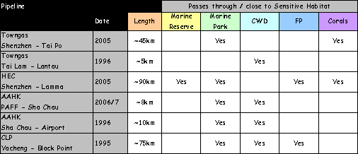
* CWD – Chinese White Dolphin, FP – Finless
Porpoise
The
nature of works for the proposed pipeline for this proposed project is the same
as these previously approved projects, which with appropriate mitigation and
EM&A requirements, were deemed environmentally acceptable.
Potential Impacts from Works Vessels (all
marine works)
Increased marine traffic: There are two key ways increased vessel
traffic has the potential to impact marine mammals. Firstly, vessel movements may
potentially increase physical risks to dolphins. In Hong Kong, there have been instances
of dolphins and porpoises having been killed or injured by vessel collisions
and it is thought that this risk is mainly attributed to high-speed vessels
such as ferries. Secondly, the
physical presence of works vessels due to construction may cause short-term
avoidance of the area where works vessels are operating. It is therefore important to minimize
the duration of marine works such as dredging and where practicable, the amount
of concurrent vessel activity to limit any short-term displacement.
The
inshore waters surrounding the project area at South Soko
do not support high densities of dolphins or porpoises. Similarly, the majority of the routes of
the watermain and cable do not traverse areas with
high dolphin or porpoise sightings densities. Along the submarine gas pipeline route,
West Lantau has the highest densities of dolphins in
comparison to other areas in Hong Kong (Dolphin density = 0.67 ± 0.51 km2) and
also higher densities of young dolphins (Unspotted Calves and Unspotted
Juveniles). The encounter rate of
mother and calves at West Lantau is the highest
compared with (7.1 per 100 km of survey effort) other areas of Hong
Kong
(23). ([23]). Dolphins
have been observed feeding in West Lantau waters, and
are often seen surfacing with mud on their bodies, indicating that they have
been feeding on demersal fish. It is noted that the dolphins also feed
in other areas of Hong Kong waters and the Pearl River Estuary and do not feed
exclusively in West Lantau. Unlike some other marine mammal species,
the Indo-Pacific Humpback Dolphin does not have a specific and confined nursery
area and mother-calf pairs have been spotted in the baseline surveys and in AFCD’s surveys throughout the animals’ range including the
Pearl River Delta. The limited data
collected to date suggests that dolphin calving occurs throughout the year with
higher frequency between March and August ([24]).
The
EIAO-TM specifies the priorities for
addressing ecological impacts is avoidance and minimization. This philosophy has been observed
in designing the marine works construction programme. There is a consensus among the leading
local marine mammal specialists that reducing the duration of marine works is
the most effective approach to reduce impacts on marine mammals. Grab dredging and TSHD have been used
extensively in Hong Kong and there is no evidence of significant residual
impacts on marine mammals due to these techniques. With a shorter works programme, any
marine mammals that have avoided the vicinity of the works areas can return to
the area sooner.
Given
the importance of minimizing the duration of the construction works, the
potential impact control measures were reviewed to ensure that they would not
be potentially detrimental to the population, and consistent with both marine
mammal specialist opinion and the EIAO-TM. For example, closed working periods for
pipeline construction activity could potentially cause either significant
extension of the overall duration of works or intensification of works to meet
the required construction schedule, both of which would be potentially detrimental
to marine mammal populations.
The risk of vessel strike by works vessels
on dolphins and porpoises arising due to increased vessel traffic associated
with the marine construction works, is considered to be very small as work
vessels would be slow moving. For
instance, works vessels such as dredgers must necessarily move at slow speed as
they perform works on the seabed.
By comparison, their rate of movement would be considerably less than
fishing vessels and other craft which regularly traverse the Study Area. As construction vessels move slowly,
they would not pose a significant collision risk to dolphins or porpoises
including young animals.
Furthermore, to err on the side of caution, vessel strike will also be
managed through a series of precautionary measures (see Part 2 – Sections 9.9.2 and
9.10 for details).
Along
the gas pipeline route between South Soko and Black
Point which passes through the relatively high dolphin density area of West Lantau, a number of other vessels, including tugs for the
anchor lines, may be involved during the gas pipeline installation activities
in addition to the works vessels such as pipeline lay barge, dredging plant and
vessels for armour rock placement.
Between Sai Wan and across West Lantau waters, trenches will be dredged by TSHD. It should be noted that the vessel would
be active on site for a period of only about 40 – 45 minutes every 2 – 3 hours
and therefore have a much lower presence in the area than other works
vessels. It is also important to
note the TSHD will not be permitted to overflow during dredging and hence water
quality impacts will be well controlled.
In line with the philosophy presented above, TSHD was adopted to reduce
the duration of works in these waters, thus potentially avoiding unnecessary
prolonged exposure to works.
Across
Northwest Lantau waters, the remainder of the trench
will be excavated by grab dredgers operating 12 hours per day. A number of grab dredgers would be
operating concurrently in order to reduce the duration of works in different
works area (see Section 6-Annex 6A
for details). The movements of
these and all other works vessels will be maintained to the specific works
areas, and given the implementation of the rules for
vessel operation (Part 2 Section 9.9.2),
adverse impacts on marine mammals due to increased marine traffic and
their works activities are not expected.
Following dredging, the submarine pipeline will be laid from barges into
the trenches on the seabed, and therefore will not cause an underwater
obstruction to marine mammals. It
should also be noted that the duration of the various activities is short as
pipe laying would be expected to occur for a couple of weeks in the
Similarly
vessels involved in armour protection placement will proceed along the pipeline
in a specific area and their activities are not expected to impact marine
mammals. The placement of rock
armour is not expected to cause impacts to water quality or marine ecological
resources as the vessel will comply with the speed limitations and the backfill
material will have a low fines content.
Similar to the dredging works, noise generated by armour rock placement
is not expected to acoustically interfere significantly with dolphins or porpoises. As the armour rocks will be placed
directly on top of the pipe which is located at the bottom of the dredged
trench, it is not expected to pose a collision risk to dolphins or porpoises.
It
should be noted that many similar pipelines have been installed or permitted in
Hong Kong with similar post construction protection using armour rock including
HEC Shenzhen to Lamma pipeline, AAHK PAFF pipeline
and Towngas Shenzhen to Tai Po pipeline, in which
some of the pipeline sections pass through marine mammal habitats, ie South Lamma, Po Toi and the Sha Chau Lung Kwu Chau
Marine Park. Consequently,
placement of rock armour on the gas pipeline is not expected to cause impacts
to marine mammals.
The
inshore waters surrounding the project area at South Soko
have very low densities of dolphins or porpoises. Similarly, the majority of the routes of
the watermain and cable traverse areas with
relatively low dolphin or porpoise densities (see Annex 9 – Figures
9.38 and 9.39). Any effect of the physical presence of
works vessels in these works areas on dolphins and porpoises would be limited
to temporary behavioural disturbance of a small number of animals. It would be expected that these animals
may avoid the vicinity of the works areas whilst works vessels are in
operation. The dolphin monitoring
data show few sightings from the affected area indicating that these waters are
little utilised. These disturbances
would not be expected to have a biologically significant impact on the affected
animals. As detailed in Part 2 –Annex 9 – Baseline Marine Ecological
Resources, photo-identification of individual dolphins has shown these
animals have extensive home ranges typically of more than 100 km2 and perform their main functions
(feeding, socialising, breeding) throughout their home ranges.
Similarly,
along the submarine gas pipeline route, if and when encounters between works
vessels and dolphins occur, effects would be limited to temporary behavioural
disturbance (ie swimming avoidance of vessels), which
would not be expected to have biologically significant consequences. It can also be noted that separation of
calves from their mothers is highly improbable. Whole scale changes to dolphin’s
behaviour are highly improbable during the pipeline installation works. Mothers and calves are in constant
communication with each other, and it is extremely unlikely that there be a
separation between the two because of the proposed works. The marine mammal impact assessment has
indicated that there is little risk of the gas pipeline installation works
causing either physical harm or water quality related impacts to dolphin mothers
and their calves. The submarine gas
pipeline programme was reviewed and it became apparent that the dredging works
for the submarine gas pipeline could be scheduled to take place during the
period September through February.
Consequently, the preferred programme for the Project has adopted this
scheduling measure for the entire length of dredging for pipeline installation.
It
is noted from the sightings information that younger dolphins, especially in
West Lantau, stay inshore which is away from the
alignment of the submarine gas pipeline (Annex
9 – Figures 9.29-9.31).
This
assumption that the presence of works vessels would not adversely impact marine
mammals is consistent with other EIA and environmental monitoring studies in
Hong Kong. Contaminated mud
disposal facilities have been in operation in the East of Sha
Chau area for over ten years. Data available on the use of the waters
do not appear to indicate that the operations of these facilities are resulting
in avoidance behaviour by dolphins ([25]).
Similarly, construction of a blockwork jetty and
dredging at Lung Kwu Chau
inside Lung Kwu Chau and Sha Chau Marine Park have not
significantly affected dolphin utilisation in this area. Dolphins were observed in proximity to
major reclamation works at Penny’s Bay ([26]). Waters near Po Toi
also remain high utilisation areas for Finless Porpoise in spite of extensive
sand extraction works nearby ([27]).
Underwater sound: Construction works including dredging
and backfilling activities as well as jetting for the submarine utility (gas
pipeline, water main and cable) installation can result in a minor and short
term increase in underwater sound from marine vessels which may potentially
affect Indo-Pacific Humpback Dolphin and Finless Porpoise. Effects from pile driving are considered
in a later section.
The
proposed gas pipeline route passes close to the western boundary but does not
enter the Marine Park. In the West Lantau section of the pipeline route (outside of the Proposed
Marine Park at Fan Lau) the main works will involve pre-trenching (ie dredging).
According to the project description, the works activities proposed off
West Lantau would be of relatively short
approximately 24 - 48 days.
Small
cetaceans are acoustically sensitive at certain frequencies, and sound is
important to their behavioural activities.
Most dolphins can hear within the range of 1 to 150 kHz, though the peak
for a variety of species is between 8 and 90 kHz ([28]). Indo-Pacific Humpback dolphins have been
reported to use five categories of vocalisation associated with different
activities([29]). These animals use high frequency
broad-band clicks in the range of 8 kHz to > 22 kHz during foraging. During both foraging and socialising,
burst pulse sounds of barks and quacks in the frequency range of 0.6 kHz to
>22 kHz are used. Low frequency
narrow band grunt vocalisations in the range of 0.5 kHz to 2.6 kHz are also
used during socialising activity.
Dolphins also have whistle vocalisations in a wide frequency from 0.9
kHz to 22 kHz. Finless porpoises,
vocalise at much higher frequencies than humpback dolphins. Finless porpoises produce high frequency
ultrasonic narrowband clicks at a peak frequency of 142 kHz, which are
inaudible to the human ear ([30]). Dredging and large vessel traffic
generally results in low frequency noise, typically in the range of 0.02 to 1
kHz ([31]),
which is below the peak range of 8 - 90 kHz and 142 kHz reported for dolphins
and porpoises respectively. For
this reason, noise generated by dredging, jetting and pipe laying and cable
laying operations is not expected to acoustically interfere significantly with
dolphins or porpoises.
Water Quality Impacts
High
SS levels do not have a direct impact on dolphins. Indo-Pacific Humpback Dolphins have
evolved to inhabit areas near the mouth of rivers and are therefore
well-adapted for hunting in turbid waters owing to their use of echolocation
rather than visual information. In
addition, dolphins are air breathing and therefore SS in the water column has
no effect on their respiratory surfaces.
Impacts may occur to these mammals as an indirect result of increased SS
levels. The Indo-Pacific Humpback
Dolphin is thought to be an opportunistic feeder with the most important prey
species being demersal fish (such as croakers, Sciaenidae) as well as several pelagic groups (engraulids, clupeids and trichiurids).
The
Finless Porpoise is also thought to be an opportunistic feeder with known prey
including crustaceans (shrimps and prawns), cephalopods (squid and octopus) and
small pelagic fish of low commercial value (anchovies, croakers and
sardines). These two species of
marine mammals could potentially be affected if there are any significant
changes in key water quality parameters arising from the development that
affect fisheries resources.
Information
from the fisheries impact assessment (Part
2 Section 10) indicates that indirect impacts are not predicted to
adversely impact fisheries resources from the various marine works. Potential water quality impacts
associated with dredging and jetting activities for all marine works were
predicted to be compliant with fisheries assessment criterion and sediment
plumes would only affect a localized area close the works for a short period of
time as the dredgers/jetting machine passes through the area. It should be noted that the two resident
marine mammal species, in particular the Indo-Pacific Humpback Dolphin, and
their prey species are naturally exposed to high levels of suspended solids in
the Pearl River Estuary (see Part 2
Section 6 for a discussion of how SS levels fluctuate greatly in this part
of Hong Kong) ([32]).
The
basis for this assessment are water quality modelling predictions presented in Part 2 – Section 6. While contour plots of water quality
parameters were used to determine the extent and severity of impacts close to
the works areas, which is the most important information for determining
impacts on marine mammal habitat, reference was also made to a variety of
assessment points for various water sensitive receivers that are distributed at
various points across marine mammal habitat including SR1, SR4, SR6a-e, SR8,
SR10, SR11, SR11a-b, SR12, SR14, SR15a-b, SR16b, SR24 and SR27 (see Figure
6.4 in Part
2 – Section 6).
Of the proposed marine works associated
with the Project, dredging in West Lantau, which is a
marine mammal habitat of high ecological importance, was identified as a major
issue for examination in the assessment.
West Lantau is the area with the highest
density of dolphins and young animals compared to any other area in Hong
Kong. Along the West Lantau section of the pipeline, the daily maximum contour plots (Part 2 Section 6 Figure
6.12), show that the sediment plume (maximum depth-averaged of > 5 mg L-1)
are not expected to extend to more than 200 m from the centreline of the gas
pipeline alignment during the trailing suction hopper
dredging works (refer to Part 2 Section 6).
These elevations will be short-term as TSHD dredging operations will only
operate on a 12 hour per day basis and during this period will only dredge for
about 45 minutes within every 2-3 hours due to the need to move off site to
dispose the dredged sediment.
In terms of the potential impacts on
marine mammal habitat inside the Sha Chau and Lung Kwu Chau Marine Park, the daily maximum contour plots (Part 2 Section 6 Figure
6.11), show that the sediment plume (maximum depth-averaged of > 5 mg L-1)
is not expected to extend to more than 50 m inside the Marine Park
during grab dredging works (refer to Part
2 Section 6). Owing to the
proximity of the works to the western boundary of the Marine Park, the water
quality assessment has recommended deployment of cage type silt curtains as a
preventative measure to restrict SS entering the Marine Park waters. With silt curtains in place, there are
not expected to be exceedances of the WQO for SS
inside the Marine Park. Adverse
impacts to marine mammal habitat within the Sha Chau and Lung Kwu Chau Marine Park are therefore not expected.
Other
EIA Studies that have addressed impacts due to elevated SS have drawn similar
conclusions. For instance, a
previously approved EIA study for the Permanent Aviation Fuel Facility (PAFF)
(EIA-077/2002) ([33])
stated that: “There is no reason to
assume that suspended solid releases during pipeline construction will have an
impact on dolphins.” Based on
the assessment above and other experience of the effect of suspended sediment
on marine mammals, elevations in SS associated with the reclamation works for
the LNG terminal are not anticipated to adversely impact dolphins or porpoises.
The
above analysis is supported by experience with ongoing projects in Hong
Kong. Contaminated mud disposal
facilities have been in operation in the East of Sha Chau area for over ten years. Data available on the use of the waters
do not appear to indicate that the operations of these facilities are resulting
in avoidance behaviour by dolphins.
Contaminant Release and Bioaccumulation
Another
potential impact on marine mammals associated with disturbance of bottom
sediment that require assessment in accordance with Clause 3.4.5.5 of the Study Brief, are potential bioaccumulation of
released contaminants. The
potential for release of contaminants from dredged sediments has been assessed
in Part 2 Section 6, whereas, a
comprehensive set of data on the quality of marine sediment is provided in Part 2 Section 7 – Waste Management.
Within
these sections it is concluded that a number of samples from West Lantau contained levels of arsenic in excess of the Lower
Chemical Exceedance Level (LCEL) but below the Upper
Chemical Exceedance Level (UCEL), ie
Category M. Further biological
testing has led to the conclusion that these sediments would require Type 2
disposal, ie at a confined marine disposal site such
as that at East of Sha Chau. This disposal site is permitted for
sediments of this nature and is the subject of an extensive monitoring
programme which has been ongoing for several years.
It
is noted that one sample exceeded the LCEL for Silver, one exceeded the UCEL
for Lead and one exceeded the LCEL/UCEL for Nickel. All other samples for Lead, Silver and
Nickel were within the LCEL. No organochlorine exceeded their threshold level and all other
related exceedances were solely attributable to
Arsenic. Given that virtually all
of the exceedances were related to Arsenic this is
the only contaminant discussed below as the others can be confirmed to be
present at low levels in sediments within the Project’s various dredging areas.
It
is highly likely that the elevated levels of arsenic in the West Lantau area are derived from natural sources and are not
present as a result of human activity.
The Geochemical Atlas of Hong Kong
published by the Civil Engineering Department (CED) shows anomalously high
arsenic concentrations along the southwestern
coastline of Lantau and states that these
concentrations are a consequence of the local geology. Arsenic concentrations in this area are
amongst the highest recorded in the SAR.
In
terms of the potential for impacts to occur to marine mammals, a recent EIA
conducted on the continuation of the disposal of highly contaminated marine muds into dedicated mud pits in the East of Sha Chau area provides the best
available information on bioaccumulation in marine mammals in Hong Kong ([34]).
The
assessment, which was based on bio-concentration factors and metal
concentrations in local fish and shellfish species, also provided a comparison
between the risks to dolphins in areas where Category H marine sediments would
be dredged / disposed and those areas considered being uncontaminated. Exposure pathways were assumed to be
consumption of contaminated food by dolphins that utilise waters in the
vicinity of the disposal ground, and in an area representative of background
conditions.
The
result of this detailed risk assessment, which has been approved under the EIAO, concluded that elevated levels of
Arsenic in dredged marine sediments do not pose an adverse risk to the
Indo-Pacific Humpback dolphins from coastal waters near Hong Kong.
Concentrations
of Arsenic are low (compared to concentrations in potential prey) in liver and
kidney of most cetaceans, including Indo-Pacific Humpback Dolphins. The highest concentration of Arsenic
measured in Indo-Pacific Humpback Dolphin liver is 12.9 mg / kg-1
dry wt ([35]). The highest Arsenic concentration
measured in other cetaceans was in the liver of a narwal,
Monodon monoceros,
from -1) ([36]). Concentrations of Arsenic in cetacean
tissues usually are lower than those in their prey ([37])
([38]). Most of the Arsenic in dolphin prey is
in organic forms, particularly arsenobetaine, which
is excreted unmetabolized in the urine by most
mammals and poses little threat to their livelihood.
From
the results discussed above, it is considered important to note two key
features:
·
The
assessment was based on highly contaminated mud, ie
Category H. Extensive monitoring of
sediment quality in the West Lantau area has been
documented in Part 2 Section 7 – Waste
Management, specifically in Table 7.6. The suite of analytes
has included a range of organic compounds specified in the relevant Technical
Circular (ETWBTC No. 34/2002) and 12 chlorinated pesticides. For all samples taken from the West Lantau area, reported concentrations of these substances
were below the reporting limits.
·
Organochlorines
were not found to be at levels that were considered to result in systemic
toxicity to the exposed dolphins.
It is noted that it has been proposed in the literature that first born
calves may be at risk from organochlorine compounds
passed to the offspring during nursing, however, this has yet to be confirmed
and is not known to be a factor impacting the mortality rates of marine mammal
calves in Hong Kong. Nevertheless,
the low concentrations organic contaminants are not expected to pose any
significant threat to marine mammals in West Lantau
as a result of pipeline installation works.
Therefore,
as unacceptable water quality impacts due to the potential release of heavy
metals and micro-organic pollutants from the dredged sediment are not expected
to occur, impacts on marine mammals due to bioaccumulation of released
contaminants from dredged sediments are also not expected to occur.
Potential Impacts from Piling Works
Underwater sound: Marine piling works will be required to
construct the jetty on the south side of the South Soko
Island. Certain piling activities
are known to generate high intensity underwater sounds, which due to the
potential presence of dolphins and porpoises in the vicinity of works, requires
assessment. Based on the findings
of the detailed design works a decision will be made as to whether bored,
driven (percussive) or a combination of both will be used to construct the
jetty and pipeline trestle. No
underwater blasting is required.
Details on the differences between bored and percussive piling are
presented below.
Bored piling:
The pile installation of the main jetty
may be carried out by bored piling works.
This involves the sinking of a casing down to almost the rock head level
with underwater excavation of the soil by a grab and the top layer of rock
using a reverse circulation drilling rig (RCD). Noise created by the bored piling method
tends to be a less intensive continuous noise, rather than the pulsed high
power sounds emitted through percussive piling and is expected to be similar to
that associated with dredging.
Bored
piling is less disruptive to dolphins than percussive piling ([39]).
Dolphins are known to habituate to low-level sounds such as those produced
through bored piling ([40]).
Percussive piling: The trestle foundations will consist of
circular piles installed by the percussive method using piling barge with
hydraulic hammer. As detailed in Part 2 Section 3, the equipment for
percussive piling works used in Hong Kong is typically fitted with a bubble
jacket for reducing underwater sound propagation. Although, percussive piling will produce
high-intensity underwater sound, the progress of piling works is quicker than
bored piling. It is expected it
would take approximately 4 months to complete the piling for the approximately
240 m long trestle. Sound from
percussive piling activities will be transmitted to the water via both
structure-borne and air-borne sound pathways. Structure-borne vibrations from the
percussive hammer will be re-radiated as sound into the water via the piles,
the rock substrata and the piling rig to the barge. The air-borne sound pathway consists of
sound propagation from the percussive hammer and the piles through the air and
into the water. The sound
transmitted to the water via the air-borne sound path is not expected to be
significant as a large proportion of this sound will be reflected at the water
and air interface and therefore not penetrate the water.
As
discussed previously, humpback dolphins use frequencies ranging from 0.5 kHz to
>22kHz ([41]).
Finless porpoises, on the other hand, use higher ultrasonic frequencies at a
peak of 142 kHz ([42]). Activities such as percussive piling
have their highest energy at lower frequencies from about 20 Hz to 1 kHz, and
whilst smaller cetaceans (~ 3 - 4 m in length) are not known to be highly
sensitive to sounds below 1 kHz they can hear in some of this range (peak range
of 8 - 90 kHz reported for dolphins).
Cetaceans are animals that rely on acoustic information to communicate
and to explore their environment.
Therefore, sound that disrupts communication or echolocation channels
could have a potential impact. The
reactions from impacted cetaceans can range from brief interruption of normal
activities to short- or long-term displacement from noisy areas.
Percussive
piling will produce some high-intensity underwater sound, particularly through
the structure-borne noise pathway.
Experience of percussive piling in Hong Kong indicates that this type of
piling may result in temporary avoidance of the affected area by individual
animals. Although it appeared that
dolphins avoided the area around Sha Chau during the construction of an aviation fuel receiving
facility, they returned on cessation of construction activities, suggesting
that disturbance impacts are transient and only present during the construction
phase ([43]). It is noted that this avoidance
behaviour only has the potential to affect the very small number of individuals
that have been sighted in the waters south of South Soko
Island and would not be expected to significantly affect the population as a
whole. Sightings density
information for the Humpback Dolphins and Porpoises indicates that these
species have not been frequently sighted immediately off the coast where the
proposed jetty would be located.
The survey data, including that from AFCD’s
long term monitoring programme, has not indicated that either of these marine
mammals utilise the habitat in the area of the jetty at the southeast of the
South Soko Island for critical functions (ie breeding or raising calves).
As
noted previously, in line with common local practice, the percussive piling
equipment used in Hong Kong is typically fitted with a bubble jacket or bubble
curtains. This feature of the
percussive piling equipment is beneficial in reducing underwater sound
propagation from the works site.
Bubble
curtains have been reported to be effective at reducing transmission of
underwater sound generated during pile driving. A study ([44])
conducted during the construction of the Aviation Fuel Receiving Facility on Sha Chau reported sound level
reduction by 3 to 5 dB in the overall broadband range. The largest sound attenuation was
between 1.6 to 6.4 KHz where a reduction of 15 to 20 dB was recorded.
The
size of the disturbed area will be small in the context of the size of the
range of these animals. Given
the low density of dolphins and finless porpoises in South Soko,
it is expected that any disturbance impacts would affect individual animals
representing a very small portion of the overall cetacean population. By additionally employing a bubble
jacket/curtain to reduce the generation of high-intensity impulsive sounds, and
taking account previous experience of reaction of marine mammals to marine
works, underwater construction noise associated with the piling works is not
expected to give rise to unacceptable adverse impacts. Any effect of underwater sound caused by
piling works would be limited to behavioural disturbance impacts on affected
dolphins, and there may be some avoidance of the waters in close proximity to
the works. These impacts are not
likely to cause biologically significant impacts on affected animals.
9.7.2
Operation Phase
Vessel Traffic
Tugs
will be used to manoeuvre the LNG carrier until moored along side the jetty. Owing to the slow approach
speed and slow manoeuvring of the LNG carrier under tug control, it is not expected
that there would be a significant risk of carrier/tug collision (boat strike)
with either dolphins or porpoises.
Sightings density information for the Humpback Dolphins and Porpoises
indicates that these species have not been frequently sighted immediately off
the coast where the proposed jetty would be located and consequently
operational phase vessel traffic is not expected to cause unacceptable risk of
impacts to either species.
Impacts
from accidental LNG and fuel spills have been addressed in Section 9.5.2.
9.8 Evaluation of the Impacts to Marine Mammals
The following section discusses and
evaluates the significance of the impacts to marine mammals identified in the
previous section. Based upon the information
presented above, the significance of the marine mammal impacts associated with
the construction and operation of the LNG terminal have been evaluated in
accordance with the EIAO-TM (Annex 8,
Table 1), as follows.
·
Habitat Quality:
o
Reclamation
Area:
The reclamation works will affect approximately 0.6 ha of marine waters
where few sightings of the Indo-Pacific Humpback Dolphin and Finless Porpoise
have been recorded at South Soko and a small area at
Black Point for the GRS where few sightings of the Indo-Pacific Humpback
Dolphin have been made. The marine
waters in both of these locations have been disturbed through reclamation in
the past and are not considered to represent key habitat for either species.
o
Approach
Channel and Turning Circle: The approach channel and turning circle
are located south of the South Soko Island in an area
where sightings of Indo-Pacific Humpback Dolphins are low and Finless Porpoises
are present only in low numbers in winter and spring. Significant impacts due to the dredging
works are not predicted to occur to these species, as water quality
perturbations are predicted to be transient, localised and generally compliant
with the WQO.
o
Submarine
Gas Pipeline:
The submarine gas pipeline passes through areas of high dolphin
sightings in West and Northwest Lantau. However with implementation of
appropriate mitigation and additional precautionary measures (Section 9.9), the installation of the
submarine gas pipeline would not result in unacceptable impacts to marine mammals
along its route.
o
Submarine
Watermain and Cable: The submarine watermain
and cable pass through areas of moderate dolphin and porpoise sightings in
Southwest Lantau. The installation of these utilities
would not be expected to result in unacceptable impacts to marine mammals along
their route.
o
LNG
Receiving Jetty:
The jetty is located on the southern shore of the South Soko Island in an area where sightings of Indo-Pacific
Humpback Dolphins are low and Finless Porpoises are present only in low numbers
in winter and spring.
o
Operational
Phase Discharges: The outfall is located on the southern
shore of the South Soko Island in an area where
sightings of Indo-Pacific Humpback Dolphins are low and Finless Porpoises are
present only in low numbers in winter and spring.
·
Species: Organisms
of ecological interest reported from the literature and field surveys include
the Indo-Pacific Humpback Dolphin and Finless Porpoise. Significant impacts due to the marine
works are not predicted to occur to these species as water quality
perturbations are predicted to be transient, localised and generally compliant
with the WQO. Impacts on these
marine mammal species due to disturbance and noise from increased marine traffic
in any of the works areas are not expected to be significant. Indirect, temporary disturbance to
marine mammals are not expected during marine piling works as construction
methodologies have been designed to reduce underwater sounds. Operational phase discharges from the
terminal or marine vessel movements are not expected to impact the limited
number of marine mammals present in the area of the LNG terminal.
·
Size:
The reclamation works will affect
approximately 0.6 ha of marine waters where few sightings of the Indo-Pacific
Humpback Dolphin and Finless Porpoise have been recorded. The marine waters where the reclamation
works will take place have been disturbed through reclamation in the past and
are not considered to represent key habitat for either species. The total length of the gas pipeline is
approximately 38 km, running across Northwest, West and Southwest Lantau waters.
The width of the dredged trench ranges from about 6 to 29 m. The nature and scale of pipeline
installation works is comparable to other pipeline projects in Hong Kong which
were deemed acceptable to construct in habitats of Indo-Pacific Humpback
Dolphin inside the Sha Chau
and Lung Kwu Chau Marine
Park and habitat for finless porpoises in Mirs Bay, Lamma and Po Toi waters. Experience from these projects indicates
that with appropriate mitigation and monitoring, marine mammals are not likely
to be adversely affected by such works.
·
Duration: The
reclamation works are predicted to last for approximately 5-7 months and the dredging
for the turning basin and approach channel approximately 4 months. The dredging works operations along the
gas pipeline alignment are predicted to last for about 3 months. Dredging and jetting for the watermain is expected to take 4 months each, whilst jetting
for cable installation is expected to take less than 3 months. Increases in SS concentrations in the
vicinity of sensitive receivers are expected to be low and temporary, and
generally within environmentally acceptable limits (as defined by WQO and
marine ecological assessment criteria).
Piling works for the jetty are expected to take approximately 9 months
for bored piling and 4 months for percussive piling. The underwater sounds emanating from the
percussive piling works will be dampened through the use of a bubble
jacket. Operational phase
discharges will continue during the life of the LNG terminal but are not
predicted to cause adverse impacts to marine mammals as the discharges disperse
rapidly and only affect an area close to the LNG jetty where low sightings of
marine mammals occur.
·
Reversibility: The
only permanent impacts at South Soko to marine
mammals are likely to be from the reclamation works and seawall modification
works that will affect approximately 0.6 ha of marine waters where few
sightings of the Indo-Pacific Humpback Dolphin and Finless Porpoise have been
recorded. A small area at Black
Point will be reclaimed for the GRS and this affects an area where very few
sightings of the Indo-Pacific Humpback Dolphin have been made.
·
Magnitude: No
unacceptable impacts to ecologically sensitive habitats have been predicted to
occur. The impacts to the
ecologically sensitive habitats defined in this assessment are considered to be
of low magnitude during the jetting and/or dredging operations associated with
the reclamation, turning circle and approach channel, and the laying of the gas
pipeline, watermain and cable. Operational phase impacts are not
expected to cause adverse impacts and are considered to be of low magnitude.
The
impact assessment indicates that with adoption of appropriate mitigation and
precautionary measures, no unacceptable adverse impacts to marine mammals are
expected to occur.
Impacts to marine mammals during operation
of the terminal are predicted to be within environmentally acceptable levels
through appropriate design of the seawater outfall system (as discussed in Part 2 Section 6 - Water Quality).
9.9.1
General
In accordance with the guidelines in the EIAO-TM on marine ecology impact
assessment, the general policy for mitigating impacts to marine ecological
resources, in order of priority, are:
·
Avoidance: Potential impacts should be avoided to
the maximum extent practicable by adopting suitable alternatives;
·
Minimisation: Unavoidable impacts should be minimised
by taking appropriate and practicable measures such as constraints on the
intensity of works operations (eg dredging rates) or
timing of works operations; and
·
Compensation: The loss of important species and
habitats may be provided for elsewhere as compensation. Enhancement and other conservation
measures should always be considered whenever possible.
To
summarize, this initial assessment of impacts demonstrates that impacts have
largely been avoided during the
construction and operation of the South Soko
terminal, particularly to the key ecological sensitive receivers (marine
mammals), through the following measures:
·
Avoid Direct and Indirect Impacts to
Ecologically Sensitive Habitats: The site for the South Soko LNG terminal has been selected based on a review of
alternative locations (Part 1, Section 5)
and has avoided the majority of key habitats for the Indo-Pacific Humpback
Dolphin (including Sha Chau
and Lung Kwu Chau Marine
Park, Peaked Hill Island, West Lantau) and Finless
Porpoise (South Lantau and South Lamma),
and many areas of high marine mammal sighting density (Figures
9.3
& 9.4– Annex 9).
Alternative construction methods for pipeline construction were compared and
the selected preferred mitigated technique avoids indirect water quality
impacts to marine habitats of Sha Chau
and Lung Kwu Chau Marine
Park (Part 2 Sections 2 & 6). The terminal location has been selected
on previously disturbed areas (former Detention Centre lined with an artificial
shoreline) and a small reclamation of less than approximately 0.6 ha confined
to Sai Wan to avoid direct impacts to ecologically
sensitive habitats ([45]) The jetty is also located in an area of
comparatively low sightings of marine mammals. The dispersion of sediment from dredging
and filling does not affect the receivers at levels of concern, with the
exception of a site with a notable coral which will be protected by silt
curtains (see Part 2 Section 6) and
monitored. With the silt curtain in
place, the coral is not expected to experience increases in sedimentation that
would cause adverse impacts.
·
Pipeline Alignment: A number
of alternative pipeline routes were studied (Part 2, Section 2) and the preferred alignment is at a sufficient
distance from ecologically sensitive habitats such as the Potential Marine Park
at Southwest Lantau ([46]),
so that the transient ([47])
elevation of suspended sediment concentrations from the installation works does
not affect the receivers at levels of concern. The alignment also reduces the length of
the pipeline within the dolphin habitat at West Lantau
and avoids the proposed Southwest Lantau Marine Park.
·
Installation Equipment: The use of dredging along the route of
the gas pipeline will reduce the severity of perturbations to water quality and
hence allow compliance with the impact assessment criteria at sensitive
receivers. The careful selection of
installation equipment will help avoid impacts to sensitive ecological
receivers and marine mammals.
·
Adoption of Acceptable Working Rates: The modelling work has demonstrated that
the selected working rates for dredging and jetting works will not cause
unacceptable impacts to the receiving water quality. Consequently, unacceptable indirect
impacts to marine ecological resources have been avoided.
·
Design Process - Reduction in Reclamation
Areas: Reclamation
impacts have been substantially reduced in the design process from
approximately 13 ha through to the adoption of one small reclamation area at
South Soko Island totalling approximately 0.6
ha. Consequently loss of natural
coastline has been reduced.
·
Design Process – Relocation of LNG jetty
from in Sai Wan to the South coast of South Soko: By
locating the LNG jetty along the south coast of South Soko
Island dredging volumes have been substantially reduced from more than 5 Mm3
to less than 1.5 Mm3 at the terminal and consequently impacts to
marine ecological resources have been reduced. This design revision is consistent with Clause 3.3.4 of the Study Brief which
requests that impacts are avoided / reduced where practicable to the sensitive
area between the two Soko Islands.
9.9.2
Specific Measures for Marine Mammals
Measures to mitigate the impact of the construction and operation
of the terminal have been developed in consultation with local and
international marine mammal experts.
The following recommendations will be adopted to reduce potential
construction and operation impacts on dolphins and porpoises:
·
All vessel operators working on the Project construction or
operation will be given a briefing, alerting them to the possible presence of
dolphins and porpoises in the area, and guidelines for safe vessel operations
in the presence of cetaceans. If
high speed vessels are used, they will be required to slow to 10 knots when
passing through a high density dolphin area (west Lantau, Sha Chau and Lung Kwu Chau, north and southwest of
South Soko). With implementation
of this measure, the chance of boat strike resulting in physical injury or
mortality of marine mammals will be extremely unlikely. Similarly, by observing the guidelines, vessels will be operated in an
appropriate manner so that marine mammals will not be subjected to undue
disturbance or harassed;
·
The vessel operators will be required to use predefined and
regular routes, as these will become known to dolphins and porpoises using
these waters. This measure will
further serve to reduce disturbance to marine mammals due to vessel movements;
·
The vessel operators will be required to control and manage all
effluent from vessels. This measure
will serve to prevent avoidable water quality impacts in marine mammal habitat;
·
A policy of no dumping of rubbish, food, oil, or chemicals will be
strictly enforced. This will also
be covered in the contractor briefings.
While this measure is already a requirement of law, it is considered
appropriate to make sure it is observed so as to prevent avoidable water
quality impacts in marine mammal habitat;
·
The effects of construction of the Projects on the water quality
of the area will be reduced as described in the Water Quality section. These measures will serve to ensure
water quality impacts in marine mammal habitat are compliant with the relevant
water quality standards as set out in statutory Water Quality Objectives.
Periodic
re-assessment of mitigation measures for marine mammals and their effectiveness
will be undertaken.
9.10 Additional (Precautionary) Measures for Marine
Mammals
In
accordance with the requirements of Clause
3.4.5.5 (vii) of the Study Brief, precautionary measures have been identified
to assist the protection of marine mammals. During piling works for the jetty
construction, the following additional measures will be adopted:
·
To
reduce underwater sound levels associated with percussive piling, the following
steps will be taken:
-
Quieter hydraulic hammers should be
used instead of the noisier diesel hammers;
-
Acoustic decoupling of noisy equipment on work barges should be
undertaken.
·
Additional
practices are recommended during percussive piling including:
-
Instigate ‘ramping-up’ of the piling
hammer to gradually increase the level of underwater sound generation;
-
Activities will be continuous without
short-breaks and avoiding sudden random loud sound emissions.
·
An exclusion zone of 500 m radius will be scanned around the work
area for at least 30 minutes prior to the start of piling from the barge or an
elevated observation point on land.
If cetaceans are observed in the exclusion zone, piling will be delayed
until they have left the area. This
measure will ensure the area in the vicinity of the piling is clear of marine
mammals prior to the commencement of works and will serve to reduce any
disturbance to marine mammals;
·
When dolphins/ porpoises are spotted by qualified personnel within
the exclusion zone, construction works will cease and will not resume until the
observer confirms that the zone has been continuously clear of dolphins/
porpoises for a period of 30 minutes.
This measure will ensure the area in the vicinity of the piling is clear
of marine mammals during works and will serve to reduce any disturbance to
marine mammals;
·
Consistent with standard Hong Kong
practice, the percussive pile driving will be restricted to a daily maximum of
12 hours with daylight operations avoiding generation of underwater sounds at
night time; and,
Percussive
pile driving will not be conducted during the peak calving season of the
Finless Porpoise, ie October through January ([48]).
After
discussion with project stakeholders including the Government of the Hong Kong
SAR on potential additional construction restrictions, during the dredging
works for the pipeline (aside from in the Urmston road) and the LNG carrier
approach channel and turning circle, the following additional measures will be
adopted:
·
A marine mammal exclusion zone within a radius of 250 m from dredgers
will be implemented during the construction phase. Qualified observer(s) will scan an
exclusion zone of 250 m radius around the work area for at least 30 minutes
prior to the start of dredging. If
cetaceans are observed in the exclusion zone, dredging will be delayed until
they have left the area. This
measure will ensure the area in the vicinity of the dredging work is clear of
marine mammals prior to the commencement of works and will serve to reduce any
disturbance to marine mammals. As per previous practice in Hong
Kong, should cetaceans move into the dredging area during dredging, it is
considered that cetaceans will have acclimatised themselves to the works
therefore cessation of dredging is not required ([49]).
·
Dredging work along the entire pipeline
route will not be conducted during the peak calving season of the Indo-Pacific
Humpback Dolphin, ie March through August.
·
Except the pipeline section along Urmston
Road (waters of busy marine traffic), dredging works for the pipeline will be
restricted to a daily maximum of 12 hours with daylight operations. Because of marine
traffic constraints, grab dredgers may need to operate 24 hours on the pipeline
section which crosses the Urmston Road channel off Black Point enabling
completion in the shortest possible time.
·
Dredging works for the approach channel and turning circle (Annex 9 - Figures
9.38 - 9.39) will be restricted to a daily maximum of 12
hours with daylight operations and will avoid the peak calving period for the Finless Porpoise, ie October through January.
9.11 Residual Environmental Impacts
Taking
into consideration the ecological value of the habitats discussed in the
previous sections and the resultant mitigation and precautionary measures,
residual impacts occurring as a result of the proposed terminal have been
determined and are as follows:
·
The
loss of approximately 410 m of artificial shoreline covering approximately 1.1
ha, approximately 265 m of natural rocky shore and approximately 35 m of sandy
shore which are of low to medium ecological value. The residual impact is considered to be
acceptable, as the loss of these habitats will be compensated by the provision
of approximately 650 m of sloping rubble mound/rock or concrete armour seawalls
that have been demonstrated to become recolonised by
assemblages of a similar nature after construction.
·
The
loss of approximately 0.6 ha of subtidal soft bottom
assemblages within the reclamation site at South Soko
and 0.5 ha at Black Point for the GRS. The residual impact is considered to be
acceptable as the habitats are of low ecological concern and small in size and
supports comparatively low sightings of marine mammals.
·
The
residual impacts occurring as a result of the installation of the submarine
utilities are the loss of the low ecological value subtidal
assemblages present within the jetting/dredging areas and the loss of those at
the landing points.
·
The
benthic habitats within the approach channel and turning circle will be lost
during dredging during the construction phase and, to a much lesser extent,
during maintenance dredging, but will recolonise over
time. The residual impacts are
considered to be acceptable as the habitats are of low ecological value and
because infaunal organisms and epibenthic
fauna are expected to recolonise the sediments after
the pipeline has been laid.
·
Maintenance
dredging of small specific areas of the approach channel and turning circle is
expected to be required once every 10 years. Since the impact to water quality
is expected to be compliant with applicable standards (refer to Part 2 Section 6.7.2), the residual
impact associated with maintenance dredging is considered to be acceptable.
·
With
implementation of all mitigation measures, there will be water quality
objectives (WQO) exceedances for suspended solids in
the mixing zone surrounding dredging and jetting works. Mixing zones, which are inevitable when
dredging or jetting occurs, will only persist during the works and in terms of
the residual impact effects are considered short-lived and minor. They will not cause long term environmental
impacts. Two identified marine
ecological water quality sensitive receivers would experience exceedances of the WQO inside waters defined as the mixing
zone. An assessment of these
residual impacts on these ecological sensitive receivers is presented in Table 9.11 and it is concluded that
neither residual impact would have long term serious environmental
implications.
·
The
temporary disturbance and displacement of dolphins is expected to occur during
the marine works activities. Given
that the closed periods and daylight operations have been specified for
dredging activities in the more sensitive areas it is expected that the above
impacts will be temporary and of relatively short duration making them not
unacceptable.