1. INTRODUCTION AND Modelling Approach
1.1 The detailed HATS model developed and applied under the Environmental and Engineering Feasibility Assessment Studies in Relation to the Way Forward of the Harbour Area Treatment Scheme (EEFS) was proposed for simulation of the water quality changes due to the proposed Advance Disinfection Facilities (ADF). The detailed HATS model covers the North Western, Western Buffer, Victoria Harbour, Junk Bay, Eastern Buffer and Southern WCZ as well as the Pearl Estuary in Mainland waters. Details of the HATS model setup are provided in the Briefing Document “Tools for Water Quality Modelling” prepared under the EEFS.
1.2 This document aimed to review the performance of the detailed HATS model in terms of its E.coli predictions for this ADF project. The model performance review was conducted by comparing the model results with the field data collected at the EPD marine water quality monitoring stations for two time horizons:
¨ Year 2003 - represents the situation after the commissioning of HATS Stage 1;
¨ Year 1997 - represents the situation before the commissioning of HATS Stage 1.
1.3 The pollution loading inventory adopted for model input were extracted from the approved EIA Study for Tai Po STW Stage 5 (CE43/2001) and the EPD Cumulative Study (CE42/97) for 2003 and 1997 respectively. The loading inventory covered all the storm and sewage outfalls in HKSAR and its adjacent Mainland waters.
1.4 Simulation of the hydrodynamic model was performed for the 2003 Scenario and the 1997 Scenario and has taken into account the change of coastline configurations at these two different time horizons. Each hydrodynamic modelling scenario covered two 15-day full spring-neap cycles (excluding the spin-up period) for dry and wet seasons respectively. For each modelling scenario and for each season, the 15-day hydrodynamic results were used repeatedly to drive the water quality simulations for 30 days (excluding the spin-up period) as required in the EIA Study Brief.
2. Model Performance Review
2.1 The model results for 1997 Scenario are compared against the field data collected in the period from 1995 to 1998. The model results for 2003 Scenario are compared with the field data collected in the period from 2002 to 2005. The period from 2002 to 2005 represents the situation after the commissioning of HATS Stage 1. The model results for E.coli are shown in Figure 1 and Figure 2 for 2003 and 1997 respectively. Figure 1 and Figure 2 show the average model results for individual WCZ for both dry and wet seasons.
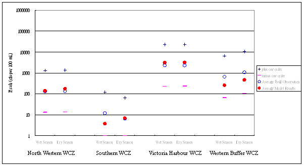
Figure 1 Model Results for Year 2003
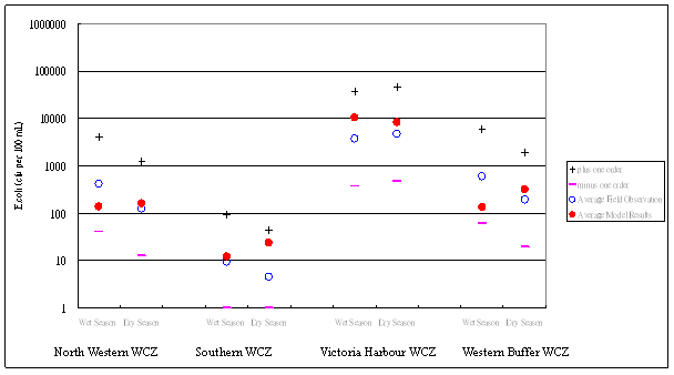
Figure 2 Model Results for Year 1997
2.2 Similar to the approach adopted in the EEFS Briefing Document “Tools for Water Quality Modelling”, the average model results are compared to the field data as follows:
¨ The average of the field observations in July and August during the period from 1995 to 1998 of all stations within the WCZ (symbol o) are compared with the 1997 average model output for wet season.
¨ The average of the field observations in January and February during the period from 1995 to 1998 of all stations within the WCZ (symbol o) are compared with the 1997 average model output for dry season.
¨ The average of the field observations in July and August during the period from 2002 to 2005 of all stations within the WCZ (symbol o) are compared with the 2003 average model output for wet season.
¨ The average of the field observations in January and February during the period from 2002 to 2005 of all stations within the WCZ (symbol o) are compared with the 2003 average model output for dry season.
¨ The average of the field observations plus one order of magnitude (symbol +) and minus one order magnitude (symbol -) are indicated in the figures for comparison.
3. Discussions
3.1 As stated in the EIA Study Brief, one key objective of the EIA is to quantify the impacts on the sensitive receivers identified such as the Tsuen Wan beaches due to undisinfected effluent from Stonecutters Island Sewage Treatment Works (SCISTW) in order to demonstrate the need of this Project. The EIA Study Brief also requires that the level of disinfection should be quantitatively determined in order to ensure the beneficial uses of the identified sensitive receivers would be properly protected.
3.2 As detailed in the “Working Paper on Water Quality Model Tools & Impact Assessment Methodology” prepared for this EIA, there is a set of specific “compliance requirements” for E.coli covering the following beneficial uses:
|
Beneficial Use |
Water Quality Objective |
Period |
Source |
|
Bathing beach subzones only |
<=180/100mL |
Geometric mean for the period from March to October |
WPCO |
|
Secondary contact recreation subzones and fish culture subzones only |
<=610/100mL |
Annual geometric mean |
WPCO |
3.3 It can be seen from Figure 1 and Figure 2 that the agreement between the model results and the field data for E.coli was good. The differences between the model and the field data were well within one order of magnitude for both 2003 and 1997.
3.4 The model results however showed an under-prediction of the average E.coli levels in Western Buffer WCZ which contains the key sensitive receivers of the HATS discharges such as Ma Wan FCZ and Tsuen Wan beaches. The northern and central Western Buffer WCZ is subject to large influence from the HATS discharge as compared to other WCZ which are farther away as indicated by field observations. Figure 3 below is extracted from EPD publication “Marine Water Quality in Hong Kong 2003” which showed that the E.coli levels in northern and central Western Buffer WCZ (Stations WM2, WM3 and WM4) significantly increased after the commissioning of HATS Stage 1 in 2001.
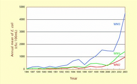
Figure 3 Trend of E.coli Level in Western Buffer WCZ
3.5 Whilst the HATS model was able to provide reliable assessment for option evaluation by comparing the water quality changes due to different HATS options under the EEFS, the modelling approach may not be able to fully satisfy the purpose of this EIA where the impacts on the Tsuen Wan beaches need to be quantified by comparing the model results with the absolute bathing water quality objective. Under-prediction of the E.coli levels in Western Buffer WCZ implied that the degree of WQO compliances predicted by the HATS model for future assessment scenarios would likely be overoptimistic for the Tsuen Wan beaches.
3.6 Three major factors that affect E.coli concentration prediction at the Tsuen Wan coast have been reviewed. These factors are:
i. Pollution loading;
ii. Hydrodynamics; and
iii. Decay rates.
Pollution Loading
3.7 The pollution loading inventory for the two time horizons (1997 and 2003) was compiled under previous approved studies using the historic population and employment statistics for these two time horizons. The inventory covered all the discharges within the Hong Kong, Pearl Estuary, Deep Bay and Macau and was used as input for cumulative effect assessment. Where possible, measured pollution load data were directly adopted in the pollution loading inventory. The inventory has incorporated all possible pollution sources including those from landfill sites, non-point source surface run-off and sewage from cross connections. The inventory has also taken into account the removal of pollutants due to wastewater treatment facilities and the possible redistribution of pollution loads due to different sewage disposal plans and sewage export schemes.
3.8 For the 2003 loading inventory, after commissioning of HATS Stage 1, the latest flow and load measured at the SCISTW was used in the model.
3.9 The model verification was conducted by comparing the model results with the field data collected at the marine stations in open waters which would be subject to little influence from the change of local sources from Sham Tseng. Nevertheless, the loading inventory adopted for Sham Tseng was based on the latest information provided by DSD on the progress of Sham Tseng sewerage construction and connection works. For 1997, it was assumed that 100% of the total load generated in Sham Tseng would be lost to storm before commissioning of the Sham Tseng STW. For the 2003 loading inventory, after commissioning of Sham Tseng STW, it was assumed that about 60% of the total load generated in Sham Tseng would be lost to storm. This assumption was based on the actual progress of sewerage construction and connection works in Sham Tseng which indicated that some existing developments in Sham Tseng (including Lido Garden, Bellagio, Rhine Garden, Ocean Pointe and Garden Factory) were already connected to the Sham Tseng STW.
Hydrodynamics
3.10 The hydrodynamic performance of the HATS model for Western Buffer WCZ was reviewed under the EEFS by comparing in detail the salinity results in the area around the HATS outfall, and Ma Wan Channel with field data. This was to make sure that the flow distribution predicted by the model was correct. Based on the review conducted under the EEFS, the model results for salinity were considered satisfactory.
Decay Rates
3.11 It is recommended to improve the model agreement with the field data in Western Buffer WCZ by reducing the E.coli decay rates. As the key water sensitive receivers of the HATS discharges identified in this EIA such as Ma Wan FCZ and Tsuen Wan beaches are located within the northern Western Buffer WCZ and the outfall of SCISTW is located in the central Western Buffer WCZ, it is reasonable to give more emphasis on the Western Buffer WCZ for calibrating the process parameter for the HATS model. This approach would provide conservative assessment to protect the health of future bathing beach users.
4. Model Adjustment and Performance Verification
4.1 Trial model runs suggested that reducing the decay of E.coli for 33% as compared to the EEFS model setting would provide the best agreement with the field observations in Western Buffer WCZ. The adjusted parameters for this EIA are shown in the table below. Figure 4 and Figure 5 show the model output for 2003 and 1997 respectively after adjusting the model setting.
|
Parameter |
Description |
Unit |
EEFS Value |
Proposed Value for This EIA |
|
RcMrtEColi |
First-order mortality rate |
d-1 |
4.8 |
3.2 |
|
CFRAD |
Specific mortality UV radiation |
m2 W-1 d-1 |
0.1 |
0.069 |
|
SpMrtEColi |
Specific mortality w.r.t. chloride |
m3 g-1 d-1 |
1.3 x 10⁻⁵ |
8.8 x 10⁻⁶ |
4.2 The Delft3D-WAQ Technical Reference Manual September 2005 Version 2.02 stated that the normal range of the first order mortality rate for coliform bacteria species would be 0.8 to 5 d-1 based on the reference “Mancini, J. L., 1978. Numerical estimates of coliform mortality rates under various conditions. Jour. Water Poll. Control Fed.” The first order mortality rates proposed for this EIA and EEFS are 3.2 d-1and 4.8 d-1 respectively which are within the identified normal range.
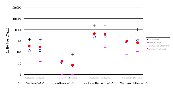 |
Figure 4 New Model Results for Year 2003 (After Model Adjustment)
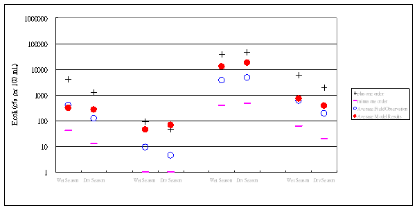 |
Figure 5 New Model Results for 1997 (After Model Adjustment)
4.3 Figure 4 and Figure 5 indicated that the new model results (after the model adjustment) are still compared reasonably well with the field observations. However, the average E.coli levels for North Western, Southern, Victoria Harbour and Western Buffer WCZ tended to be slightly over-predicted after the model adjustment. This was intended to provide conservative assessment for this EIA to safeguard the health of future bathing beach users.
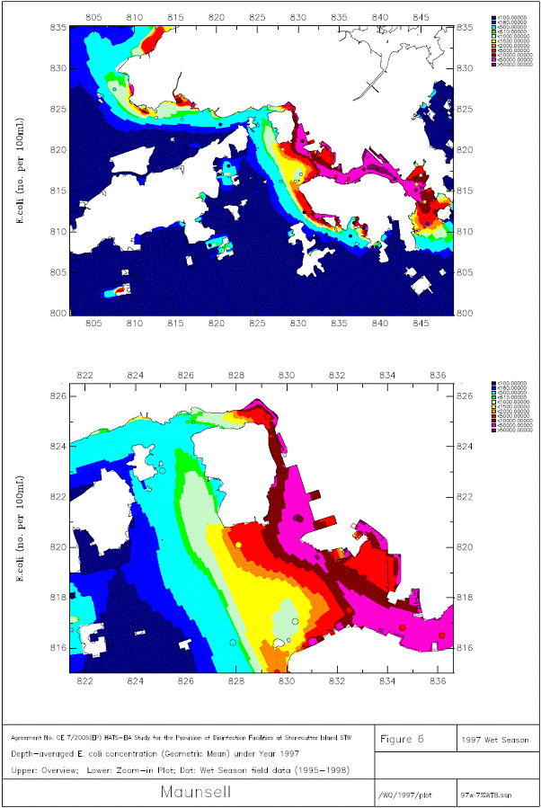
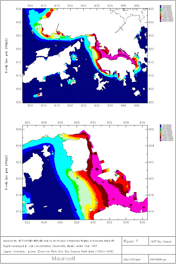
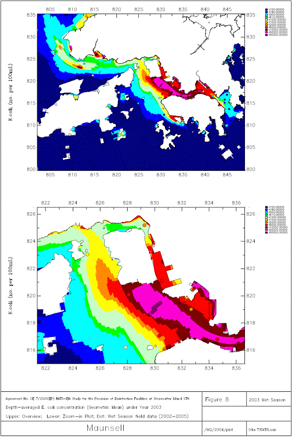
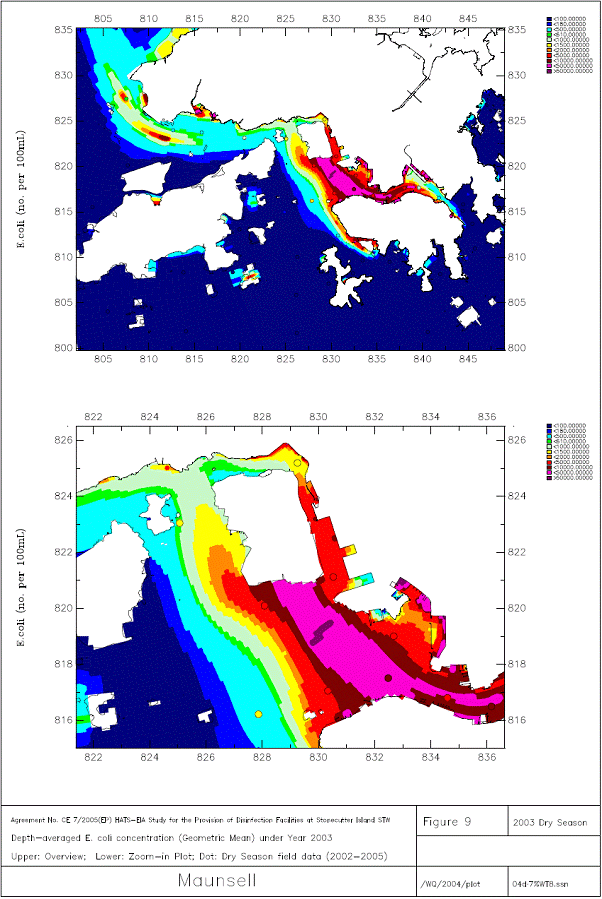
4.4 Figure 6, Figure 7, Figure 8 and Figure 9 compare the new model output with field data at individual monitoring stations for 1997 wet season, 1997 dry season, 2003 wet season and 2003 dry season respectively. The results presented in Figure 6 to Figure 9 are average model output over the simulation period and the field data are presented as circles for comparison. The average of the field data collected during the period from 1995 to 1998 are compared against the 1997 model output in Figure 6 and Figure 7 for wet season and dry season respectively. The average of the field data collected during the period from 2002 and 2005 are compared with the 2003 model output in Figure 8 and Figure 9. The figures showed that the model predictions are within a reasonable range as compared to the field observations which suggested that the proposed new model setting is acceptable for prediction of future assessment scenarios to be considered under this ADF project.