This section identifies the landscape and
visual impacts associated with the Extension in accordance with the Environmental Impact Assessment Ordinance. Construction, operation / restoration
and aftercare phase impacts have been assessed.
The assessment includes:
·
A
list of the relevant environmental legislation and guidelines;
·
a
definition of the scope and contents of the Assignment, including a description
of the assessment methodology;
·
a review
of the relevant planning and development control framework;
·
a
review of comments on landscape and visual issues received during previous
consultation with the public and/or advisory bodies and how these have been
addressed in the design;
·
a
baseline study providing a comprehensive and accurate description of the
baseline landscape and visual character;
·
recommendation
of appropriate mitigation measures and associated implementation programmes;
and
·
identification of potential landscape and visual impacts and
prediction of their magnitude and potential significance, before and after the
mitigation measures.
All potential impacts and proposed
mitigation measures are clearly mapped in colour and illustrated with clear
annotation and cross-referencing between text, tables and illustrations. Colour photographs showing baseline
conditions, and photomontages and illustrative materials supporting conclusions
are provided and the locations of all viewpoints are clearly mapped. Photomontages at representative locations
provide comparison between existing views; proposals on day 1 after completion
without mitigation; on day 1 after mitigation, and at year 10 after mitigation.
The following
legislation, standards and guidelines are applicable to the assessment of
landscape and visual impacts associated with the construction, operation /
restoration and aftercare of the Extension:
·
Forests and Countryside Ordinance (Cap. 96) and its subsidiary legislation
the Forestry Regulations;
·
Town Planning Ordinance (Cap 131);
·
Animals And Plants (Protection of
Endangered Species) Ordinance (Cap 187);
·
Country Parks Ordinance (Cap 208);
·
Marine Parks Ordinance (Cap 476) and associated subsidiary
legislation;
·
Environmental Impact Assessment Ordinance (Cap.499, S.16) and the Technical
Memorandum on EIA Process (EIAO TM), particularly Annexes 10, 11, 18, 20 and 21;
·
EIAO Guidance Note 8/2002;
·
Tseung
Kwan O Outline Zoning Plan No.S/TKO/15 (2 November 2004);
·
·
Work
Branch Technical Circular (WBTC) No. 25/93 - Control of Visual Impact of
Slopes;
·
SILTech
Publication (1991) – Tree Planting and Maintenance in
·
WBTC
No. 17/2000 – Improvement to the Appearance of slopes in connection with WBTC
25/93;
·
WBTC
No. 7/2002 – Tree Planting in Public Works;
·
ETWB
TC (Works) No. 34/2003 – Community Involvement in Greening
Works;
·
ETWB
TC (Works) No. 2/2004 : Maintenance of Vegetation and Hard
Landscape Features;
·
ETWB
TC (Works) No. 29/2004 :
·
ETWB TC
(Works) No. 11/2004 – Cyber Manual for Greening;
·
ETWB TC
(Works) No. 3/2006 - Tree Preservation;
·
Land
Administration Office Instruction (LAOI) Section D-12 – Tree Preservation;
·
Geotechnical
Engineering Office (GEO) publication (1999) – Use of Vegetation as Surface
Protection on Slopes;
·
GEO
1/2000 – Technical Guidelines on Landscape Treatment and Bio-engineering of
Man-made Slopes and Retaining Walls;
·
Urban
Council Publication (1998) - Champion Trees in Urban
·
Urban
Services Department ‘Plant Selection Matrix’ (1992);
·
Housing
Department ‘Basic Plant List’ (1988);
·
AFCD
‘Check List of
·
AFCD
'Rare and Precious Plants of
In addition, reference has been made to the
The nature and extent of the Extension is
described in detail in Section 3 of this
Report.
The limit of the landscape impact study is
500m beyond the limit of the works. The limit of the visual impact study is the
maximum extent of the Visual Envelope of the works during the construction
phase and operation / restoration and aftercare phases, which are illustrated
in Figures 10.3a and 10.3b.
Landscape and
visual impacts have been assessed for the construction, operation, restoration
and aftercare phases. However, as
the operation and restoration phases occur concurrently in a phased manner,
impacts for the operation / restoration phases are assessed together.
The assessment of landscape impacts has involved the following procedures.
·
Identification of the baseline landscape
resources (physical and cultural) and landscape character found within the
Study Area. This is achieved by site visit and
desk-top study of topographical maps, information databases and photographs.
·
Assessment of the degree of sensitivity to
change of landscape resources / character. This is
influenced by a number of factors including whether the resource/character is
common or rare, whether it is considered to be of local, regional, national or
global importance, whether there are any statutory or regulatory limitations /
requirements relating to the resource, the quality of the resource/character,
the maturity of the resource, and the ability of the resource / character to
accommodate change. The sensitivity of each landscape feature and character
area is classified as follows:
|
High: |
Important landscape or landscape resource of
particularly distinctive character or high importance, sensitive to
relatively small changes |
|
Medium: |
Landscape or landscape resource of moderately valued
landscape characteristics reasonably tolerant to change |
|
Low: |
Landscape or landscape resource, the nature of which
is largely tolerant to change |
·
Identification
of potential sources of landscape impacts. These are the various elements of the construction,
operation works and aftercare works that will generate landscape impacts.
·
Identification
of the magnitude of landscape impacts. The
magnitude of the impact depends on a number of factors including the physical
extent of the impact, the landscape and visual context of the impact, the
compatibility of the project with the surrounding landscape; and the time-scale
of the impact ie whether it is temporary (short, medium or long term),
permanent but potentially reversible, or permanent and irreversible. Landscape impacts have been quantified
wherever possible. The magnitude of landscape impacts is classified as follows:
|
Large: |
The landscape or landscape resource will experience a
major change |
|
Intermediate: |
The landscape or
landscape resource will experience a moderate change |
|
Small: |
The landscape or
landscape resource will experience slight or barely perceptible changes |
|
Negligible: |
The landscape or
landscape resource will experience no discernible change. |
·
Identification
of potential landscape mitigation measures. These
may take the form of adopting alternative designs or revisions to the basic
engineering and architectural design to prevent and/or minimise adverse
impacts; remedial measures such as colour and textural treatment of building
features; and compensatory measures such as the implementation of landscape
design measures (eg tree planting, creation of new open space etc) to
compensate for unavoidable adverse impacts and to attempt to generate
potentially beneficial long term impacts. A programme for the mitigation
measures is provided. The agencies
responsible for the funding, implementation, management and maintenance of the
mitigation measures are identified and their approval-in-principle has been
sought.
·
Prediction
of the significance of landscape impacts before and after the implementation of
the mitigation measures.
By synthesising the magnitude of the various impacts and the sensitivity of the
various landscape resources it is possible to categorise impacts in a logical,
well-reasoned and consistent fashion.
Table 10.3a shows the
rationale for dividing the degree of significance into four thresholds, namely
insubstantial, slight, moderate, and substantial, depending on the combination
of a negligible-small-intermediate-large magnitude of impact and a
low-medium-high degree of sensitivity of landscape resource/character. The significant thresholds are defined
as follows:
|
Substantial: |
Adverse / beneficial impact where the proposal will cause significant
deterioration or improvement in existing landscape quality |
|
Moderate: |
Adverse /
beneficial impact where the proposal will cause a noticeable deterioration or
improvement in existing landscape quality |
|
Slight: |
Adverse / beneficial
impact where the proposal will cause a barely perceptible deterioration or
improvement in existing landscape quality |
|
Insubstantial: |
No discernible
change in the existing landscape quality |
·
Prediction of Acceptability of Impacts.
An overall assessment of the acceptability, or otherwise, of the impacts
according to the five criteria set out in Annex
10 of the EIAO-TM.
Table
10.3a Relationship Between Receptor Sensitivity and Impact Magnitude in
Defining Impact Significance
|
|
Large |
Slight / Moderate* |
Moderate /
Substantial* |
Substantial |
|
Magnitude of
Impact |
Intermediate |
Slight / Moderate* |
Moderate |
Moderate / Substantial* |
|
|
Small |
Insubstantial /
Slight* |
Slight / Moderate* |
Slight / Moderate* |
|
|
Negligible |
Insubstantial |
Insubstantial |
Insubstantial |
|
|
Positive |
Positive |
Positive |
Positive |
|
|
|
Low |
Medium |
High |
|
|
|
Receptor
Sensitivity (of Landscape
Resource, Landscape Character Area or VSR) |
||
* In these instances, if the lower level
of impact is predicted, this will be justified in the description of landscape
impacts.
The assessment of visual impacts has involved the following procedures.
·
Identification of the Visual Envelope during the construction, operation /
restoration and aftercare phases of the Extension. This is achieved by site visit and
desk-top study of topographic maps and photographs, and preparation of
cross-sections to determine visibility of the Extension from various locations.
·
Identification of the Visually Sensitive Receivers
(VSRs) within the Visual
Envelope at construction, operation / restoration and aftercare phases. These are the people who reside within,
work within, play within, or travel through, the Visual Envelope.
·
Assessment of the degree of sensitivity to change
of the VSRs. Factors considered include:
- the
type of VSRs, which is classified according to whether the person is at home,
at work, at play, or travelling.
Those who view the impact from their homes are considered to be highly
sensitive as the character of views from their home will have a substantial
effect on their perception of the quality and acceptability of their home
environment and their general quality of life. Those who view the impact from their
workplace are considered to be of low sensitivity as the character of views
will have a less important effect on their perception of their quality of
life. Those who view the impact
whilst taking part in an outdoor leisure activity may display varying
sensitivity depending on the type of leisure activity, but will generally be
high. Those who view the impact
whilst travelling on a public thoroughfare will also display varying
sensitivity depending on the speed of travel, but will generally be medium.
- Other factors which are
considered (as required by EIAO GN 8/2002) include the value and quality of
existing views, the availability and amenity of alternative views, the duration
or frequency of view, and the degree of visibility.
The sensitivity of VSRs is classified as
follows:
|
High: |
The VSR is highly sensitive to any
change in their viewing experience |
|
Medium: |
The VSR is moderately sensitive to any change in their
viewing experience |
|
Low: |
The VSR is only slightly sensitive to any change in their
viewing experience |
·
Identification of the relative numbers of
VSRs. This is expressed in terms
of whether there are very few, few, many or very many VSRs in any one category
of VSR.
· Identification of potential sources of visual impacts. These are the various elements of the construction, operation/restoration, and aftercare works that will generate visual impacts.
·
Assessment of the potential magnitude of
visual impacts. Factors considered include:
- compatibility with the surrounding landscape;
- duration of the impact;
- reversibility of the impact;
- scale of the impact and distance of the source of impact
from the viewer; and
- degree of visibility of the impact, and the degree to which the
impact dominates the field of vision of the viewer.
The magnitude of visual impact is
classified as follows:
|
Large: |
The VSRs will experience a major change in the
character of their existing views; |
|
Intermediate: |
The VSRs will experience
a moderate change in the character of their existing views; |
|
Small: |
The VSRs will experience
a small change in the character of their existing views; |
|
Negligible: |
The VSRs will experience
no discernible change in the character of their existing views. |
·
Identification
of potential visual mitigation measures. These may take the form of adopting alternative
designs or revisions to the basic engineering and architectural design to
prevent and/or minimise adverse impacts; remedial measures such as colour and
textural treatment of building features; and compensatory measures such as the
implementation of landscape design measures (eg tree planting, creation of new
open space etc) to compensate for unavoidable adverse impacts and to attempt to
generate potentially beneficial long term impacts. A programme for the
mitigation measures is provided.
The agencies responsible for the funding, implementation, management and
maintenance of the mitigation measures are identified and their
approval-in-principle has been sought.
·
Prediction
of the significance of visual impacts before and after the implementation of
the mitigation measures.
By synthesising the magnitude of the various visual impacts and the sensitivity
of the VSRs, and the numbers of VSRs that are affected, it is possible to
categorise the degree of significance of the impacts in a logical,
well-reasoned and consistent fashion.
Table 10.3a shows the
rationale for dividing the degree of significance into four thresholds, namely,
Insubstantial, Slight, Moderate, Substantial and Positive, depending on the
combination of a negligible-small-intermediate-large magnitude of impact and a
low-medium-high degree of sensitivity of VSRs. Consideration is also given to the
relative numbers of affected VSRs in predicting the final impact significance -
exceptionally low or high numbers of VSRs may change the result that might
otherwise be concluded from Table 10.3a.
The significance of the visual impacts is categorised as follows:
|
Substantial: |
Adverse / beneficial impact where the proposal will
cause significant deterioration or improvement in existing visual character; |
|
Moderate: |
Adverse / beneficial impact where the proposal will cause
a noticeable deterioration or improvement in existing visual character; |
|
Slight: |
Adverse / beneficial impact where the proposal will
cause a barely perceptible deterioration or improvement in existing visual
character; |
|
Insubstantial: |
No discernible change in the existing visual
character. |
·
Prediction of Acceptability of Impacts.
An overall assessment of the acceptability, or otherwise, of the impacts
according to the five criteria set out in Annex
10 of the EIAOTM.
In addition, it is assumed that funding,
implementation, management and maintenance of the mitigation proposals can be
satisfactorily resolved according to the principles in WBTC 14/2002. All mitigation proposals in this Report
are practical and achievable within the known parameters of funding,
implementation, management and maintenance. The suggested agents for the
funding and implementation (and subsequent management and maintenance, if
applicable) are indicated in Tables 10.7a
to 10.7c. Approval-in-principle to the
implementation, management and maintenance of the proposed mitigation measures
has been sought from the appropriate authorities.
A review has been undertaken of the current
planning goals and objectives, statutory land-use and landscape planning
designations for the Study Area.
The statutory designations for the Study
Area are shown on the Tseung Kwan O Outline Zoning Plan (S/TKO/15) 2 November
2004 (see extract in Figure 10.4a).
The Extension will lie on two OZP planning
areas:
·
Area
101 - currently the existing SENT Landfill, zoned ‘O’ – Open Space
·
Area 137
- currently a vacant reclamation, zoned ‘OU’ – Other Uses
The planning intention for Area 101 is stated on Page
18 of the OZP as being:
“This zone is intended primarily for the provision
of outdoor open-air space for active and/or passive recreational uses serving
the needs of local residents as well as the general public.”
and at
“The landfill sites in Areas 77, 101 and 105 will
be developed into major open spaces upon completion of the landfill. However, any development proposals
within the 250m Consultation Zone of these landfills will need to include a
Landfill Gas Hazard Assessment to the satisfaction of the Environmental
Protection Department.”
The planning intention for Area 137 is
stated on Page 22 of the OZP as being:
“This zone is intended primarily for special
industries which require marine access, access to deep water berths or water
frontage. Industries to be
accommodated within this zone are usually capital intensive, land-intensive and
cannot be accommodated in conventional industrial buildings.”
and at
“deep-waterfront industry
in Area 137 for industries which require marine access”
In the short-term, the Extension will not
accord with the planning intention for Area 101 (ie the existing SENT
Landfill), in that its use as public open space will be delayed until
completion of the restoration works of the Extension. However, in the longer term, the area
can still be used as public open space after restoration of the Extension.
The use of Area 137 as part of the
Extension does not accord with its proposed OZP land use as Deep Waterfront
Industry. However, in landscape
terms, the possible use of the restored Extension as a public open space would
probably be preferable to its use as Deep Waterfront Industry.
The proposed Extension will also fall
within the
·
To encourage
recreation and tourism;
·
To
protect vegetation and wildlife;
·
To
preserve and maintain buildings and sites of historic or cultural significance;
and
·
To
provide facilities and services for the public enjoyment.
The planning intention for Country Parks
is set out in the
“for the purposes of
nature conservation, countryside recreation and nature education…criteria for
determining whether or not a particular location is suitable for designation as
a
In so far as the planning objectives of
Country Parks relate to landscape, the small part of the Extension
(approximately 5 ha out of the total 50 ha of the Extension) encroached into
the CWBCP will to a certain degree conflict (at least in the short term) with
the Country Park objectives relating to ‘landscape quality’ identified above,
and also of allowing the public to enjoy “the countrypark” and also of
protection of landscape resources such as flora. However, in the long term when the
Extension is restored and landscaped, the landscape quality would be improved
and the conflict with landscape planning objectives will diminish.
The baseline physical landscape resources
that will be affected during the construction, operation / restoration and
aftercare phases, together with their sensitivity to change, are described
below. The locations of the
landscape resources are mapped in Figure 10.5a.
Photo-views illustrating the landscape resources are shown in Figures 10.5b to 10.5e
inclusive. For ease of reference
and co-ordination between text, tables and figures each landscape resource is
given an identity number.
Geology
The Study Area
lies on volcanic rocks (mainly acid lavas and tuffs) of the
Topography within the Study Area is highly
varied. Most of the Extension Site
lies on land reclaimed from
The uplands of
Vegetation within the Study area includes
shrubland, grassland and plantation.
On the Area 137 Reclamation, the process of succession has resulted in
invasion of scrub and grassland.
Vegetation on restored areas of the existing SENT Landfill includes
exotic plantation. Other vegetation
in the Study area includes roadside and amenity planting along
A small part of the Extension Site and
that part of the Study Area east of the Site lies within
The soils of the
This landscape resource consists of 3.52
ha of steep natural hillside with shrubs on the former
This landscape resource consists of
approximately 10 semi-mature ornamental trees such as Erythrina variegata,
with a typical height of 5m. There
are also some ornamental shrubs planted in this area. The sensitivity of this landscape
resource is “Low”.
This landscape resource consists of a
small area of ornamental shrubs planted in front of one of the units on the
Industrial Estate. The sensitivity
of this landscape resource is “Low”.
This landscape resource consists of about
20 semi-mature roadside trees, comprising mainly Melaleuca quinquenervia
and Crateva unilocularis.
They have a typical height of 6m.
The sensitivity of this landscape resource is “Low”.
This landscape resource consists of
approximately 100 mature Ficus microcarpa trees with an average height
of 6m and 200 semi-mature trees, with a typical height of 3m comprising mainly Lagerstroemia
speciosa, Ficus altissima.
The sensitivity of this landscape resource is “Low”.
This landscape resource consists of a
man-made concrete-lined channel approximately 0.2m deep, 5m wide and 1,435m
long with algae present in the water.
The sensitivity of this landscape resource is “Low”.
This landscape resource consists of approximately
100 young trees comprising mainly the weedy species, Leucaena leucocephala
with an average height of 3m. The
sensitivity of this landscape resource is “Low”.
This landscape resource consists of around
1.73 ha of coastal water lying east of Area 137, and forming part of
This landscape resource consists of around
2.71 ha of scattered grass and shrubs on the vacant reclamation of Area 137.
The sensitivity of this landscape resource is “Low”.
This landscape resource consists of an
artificial channel (around 100m long) flowing from Fat Tong Chau to TKOIE. The sensitivity of this landscape
resource is “Low”.
This landscape resource consists of about
40 semi-mature trees lying on what appears to be re-graded lower
hillsides. Vegetation comprises
mainly Ficus microcarpa, Macaranga tanarius and Sapium
sebiferum. They have a typical
height of 4m. There is also some
shrub in the area. The sensitivity
of this landscape resource is “Medium”.
This landscape resource consists of
approximately 20 mature ornamental trees situated around the landfill offices
and laboratories. Trees comprise Ficus
microcarpa, Hibiscus tiliaceus, Ficus virens and Melaleuca
quinquenervia. They have a
typical height of 6m. Soils in this
area are fabricated, and not of great sensitivity. The sensitivity of this landscape
resource is “Medium”.
This landscape resource consists of about
7.50 ha of semi-mature trees comprising Acacia confusa, Albizia lebbeck,
Ficus fistulosa, Ficus microcarpa planted as Phases 1-3 of the restoration
of the existing SENT Landfill. They
have a typical height of 7m.
Recreated topography appears slightly artificial, although this effect
diminishes as vegetation matures.
Soils in this area are fabricated, and not of great sensitivity. The sensitivity of this landscape
resource is “Medium”.
This landscape resource consists of about
5.80 ha of semi-mature trees comprising Acacia mangium, Acacia
auriculiformis, Casuarina equisetifolia, Hibiscus tiliaceus
and Macaranga tanarius planted as Phases 1-6 of the restoration of the
existing SENT Landfill. They have a
typical height of 6m. Recreated
topography appears slightly artificial, although this effect diminishes as
vegetation matures. Soils in this
area are fabricated, and not of great sensitivity. The sensitivity of this landscape resource
is “Medium”.
This landscape resource consists of about
15.11 ha of young trees comprising Acacia
mangium, Acacia auriculiformis, Casuarina equisetifolia planted mainly
as Phase 3 of the restoration of the SENT Landfill. They have a typical height of 3m. Recreated topography appears slightly
artificial, although this effect diminishes as vegetation matures. Soils in this area are fabricated, and
not of great sensitivity. The sensitivity
of this landscape resource is “Low”.
This landscape resource consists of about
6.89 ha of hydroseeded grassland on recently filled areas in the existing SENT
Landfill. Recreated topography
appears slightly artificial. Soils
in this area are fabricated, and not of great sensitivity. The sensitivity of this landscape
resource is “Low”.
This landscape resource consists of about
10.28 ha of steep man-made slopes.
Slopes are benched and comprise areas of rock, shotcrete and soil with
grass and a few scattered shrubs scattered. Soils in this area are fabricated, and
not of great sensitivity. The
sensitivity of this landscape resource is “Low”.
This landscape resource consists of a
group of approximately 40 trees comprising mainly Acacia confusa, Casuarina
equisetifolia with a typical height of 7m which lie on rolling hillsides at
Ha Shan Tuk (probably with some natural topsoil cover). There is also some scrub vegetation. The
sensitivity of this landscape resource is “High”.
This landscape resource consists of an
area of 30.45 ha of the natural slopes of the hill of Tin Ha Shan (probably
with some natural topsoil cover), which has a covering of common native shrub
species. The sensitivity of this
landscape resource is “High”.
This landscape resource consists of a
natural stream approximately 0.5m wide and 327m long flowing from Tin Ha Shan
to
This landscape resource consists of the
valley of Tin Ha Au which is densely covered by about 8.30 ha of mature trees
comprising typically Litsea glutinosa, Sapium sebiferum, Rhus
succedanea and Zanthoxylum avicennae (probably with some natural
topsoil cover). They have a typical
height of 7m. The sensitivity of
this landscape resource is “High”.
This landscape resource consists of an
area of about 17.1 ha of natural lower hillsides on the south-west tip of the
This landscape resource consists of an
area of about 19.54 ha of natural upper hillsides on the south-west tip of the
This landscape resource consists of a
sandy shore / beach approximately 130m long and 5m wide on the south west tip
of the
This landscape resource consists of a
series of natural stream courses falling down the sides of the valley at Tin Ha
Au. They are characterised by
common riparian vegetation species along their banks. In total, they are approximately 4,200m
long, and are typically around 1m wide and 0.2m deep. The sensitivity of this landscape
resource is “High”.
This landscape resource consists of a
sandy shore / beach approximately 140m long and 10m wide at the mouth of the
Tin Ha Au Valley. The shore is
backed by rocks. The sensitivity of
this landscape resource is “High”.
This landscape resource consists
approximately 18.00ha of coastal waters south/east of Tin Ha Au. The
sensitivity of this landscape resource is “Medium”.
Several landscape and visual character
areas (LCAs) have been identified within the Study Area. These areas, and their sensitivity to
change, are described below. The
locations of the character areas are indicated on Figure 10.5f. For ease of reference and co-ordination
between text, tables and figures each landscape character area is given an
identity number.
LCA1 - Fat Tong O Reclamation
This landscape comprises an area of
completed and ongoing reclamation located at the south western tip of the
This low-lying landscape lies south of
Tseung Kwan O town on the west coast of Clear Water Bay Peninsula, between the
MTR depot and Fat Tong Chau (see Figure 10.5f). The landscape comprises an industrial
estate and is built on land reclaimed from
This landscape lies on reclaimed land on
the west coast of
This landscape consists of the hilly
former
This upland landscape forms the spine of
the
This landscape comprises the areas of
inshore water between
The Visual Envelope will vary during the
life of the Extension. The Visual
Envelope during the construction phase will reflect the extent of progressive
clearance of vegetation and topsoil at the existing SENT Landfill (see Figure
10.3a). As the Extension
fills during the operational / restoration phase and rises in height, the
extent of the Visual Envelope will increase. The Visual Envelope for the aftercare
phase (ie the maximum extent of the Visual Envelope) is illustrated in Figure
10.3b. Both figures show the extent of the Primary Visual Envelope which is
that area within 10km of the Extension from which it can be seen. Although in a small number of cases, there
will be a direct line of sight to the Extension from areas beyond this distance, it is considered that the effects of distance will
mean that any visual impacts are “Insubstantial”.
To the north,
the Primary Visual Envelope will extend as far as Fei Ngo Shan (602mPD) and
Razor Hill (432mPD) as well as high ground around Tai Sheung Tok, Mau Wu Shan
(233mPD), Black Hill (281mPD) and
To the east,
the Primary Visual Envelope is almost wholly contained by the ridge of hills
along the
To the west,
the Primary Visual Envelope is defined by the high ground of
To the south,
the Primary Visual Envelope extend to the northern slopes of Tung Lung Chau, to
the Tathong Channel (as far as the Po Toi Islands) and to the Dragon’s Back,
Shek O Peak (284mPD) and Shek O on Hong Kong Island.
Cross-sections showing the derivation of
the Visual Envelope (especially with regard to
Within the Visual Envelope, a number of key
Visually Sensitive Receivers (VSRs) have been identified. These VSRs are mapped in Figure 10.5j. They are listed, together with their
sensitivity, in Table 10.7a.
For ease of reference, each VSR is given an identity number, which
is used in the text tables and figures.
The Extension will involve various sources
of landscape and visual impact. The
extent of the above works is indicated in Figure 10.5a.
The proposed development will create
varying levels of impact on the physical landscape resources and landscape
character of the surrounding areas at different stages of its lifetime.
During the Construction Phase, potential impacts will result from the
following:
·
Access
road construction;
·
Temporary
slope works;
·
Removal
of vegetation and re-grading of existing slopes;
·
Presence
of machinery and plant;
·
Relocation
and construction of the leachate treatment plant, laboratory and offices;
·
Liner
installation works; and
·
Storage
of existing topsoil for reinstatement works.
During the Operational / Restoration Phase, potential impacts will result from
the following:
·
Filling
material;
·
Presence
of machinery and plant;
·
Lorry
and other vehicle traffic to the Extension;
·
Temporary
cover and final cover earthworks;
·
Night
lighting;
·
Storage
of existing topsoil for reinstatement works;
·
Presence
of landfill gas and leachate treatment plants, laboratory and offices; and
·
Restored
slope profiles with channels.
During the Aftercare Phase, potential impacts will result from the following:
·
Restored
slope profiles with channels; and
·
Presence
of the landfill gas and leachate treatment plants, laboratory and offices.
The magnitude of the impacts, before
implementation of mitigation measures, on landscape resources and landscape
character areas that will occur in the Construction Phase are described below
and tabulated in Table 10.6d. All impacts are adverse unless otherwise
stated.
LR7 – Trees in Northern TKO Area 137:
The construction of an access road and filling operations will be close to
the resource, but are unlikely to significantly affect it. The magnitude of this impact will be
“Small”.
LR9 - Scrub in southern part of TKO Area
137: Earthworks and vegetation clearance will require the
removal of around 0.16 ha of scrub currently self-seeded on the Area
137 reclamation. The magnitude of
this impact will be “Small”.
LR11 - Trees and shrubs along lower
hillside of Tin Ha Shan: Slope works will require the removal of
around 40 semi-mature trees (mainly of Ficus microcarpa, Macaranga
tanarius and Sapium sebiferum) currently found on what appears to be
re-graded topography. The
magnitude of these impacts will be “Intermediate”.
LR12 – Infrastructure area of the existing
SENT Landfill: Earthworks
and clearance works will require the removal of around 20 mature
ornamental trees situated around the landfill offices and laboratories
(typically Ficus microcarpa, Hibiscus tiliaceus, Ficus virens,
Melaleuca quinquenervia.).
The magnitude of these impacts will be “Small”.
LR13 - Plantation and topography in the
south of the existing SENT Landfill:
Earthworks and
clearance works for the Extension on the existing SENT Landfill, will require
the removal / loss of about 6.03 ha of semi-mature trees comprising (Acacia
confusa, Albizia lebbeck, Ficus fistulosa and Ficus microcarpa) planted as Phases 1-3 of the
restoration of the existing SENT Landfill, as well as recreated
topography. The magnitude of this
impact will be “Large”.
LR14 – Plantation and topography in the
south-east of the existing SENT Landfill:
Earthworks and
clearance works for the Extension on the existing SENT Landfill, will require
the removal / loss of about 3.63 ha of semi-mature trees comprising Acacia
mangium, Acacia auriculiformis, Casuarina equisetifolia, Hibiscus
tiliaceus and Macaranga tanarius planted as Phases 1-6 of the
restoration of the existing SENT Landfill, as well as recreated
topography. The magnitude of this
impact will be “Intermediate”.
LR15 - Plantation and topography in the
west of the existing SENT Landfill:
Earthworks and clearance works for the Extension on the existing SENT
Landfill, will require the removal / loss of about 3.57 ha of young trees
comprising of Acacia mangium, Acacia auriculiformis, Casuarina equisetifolia
planted mainly as Phase 3 of the restoration of the SENT Landfill, as well as
recreated topography. The magnitude
of this impact will be “Small”.
LR23 - Shrubs and topography in lower
ridge east of TKO Area 137: Re-grading of slopes for the Extension
will require the loss / removal of about 6.24 ha of natural lower hillsides
(including topsoils) on the south-west tip of the Clearwater Bay Peninsula,
which are covered with a scattering of grass and common native shrub species
(e.g. Rhaphiolepis indica, Rhodomyrtus
tomentosa, Melastoma candidum).
The magnitude of this impact will be “Large”.
LR24 - Grass and topography on upper ridge
east of TKO Area 137:
Re-grading of slopes for the Extension will require the loss / removal of about
0.05 ha of natural upper hillsides (including topsoils)on
the south-west tip of the
Landscape
Character
The Extension will have potential impacts
on three Landscape Character Areas during the Construction phase.
LCA1 – Fat Tong O Reclamation:
Preparatory works for the Extension on the reclamation will include a
small amount of vegetation clearance and the establishment of the office,
leachate treatment plant and laboratory.
This will last about 3 years.
The magnitude of these impacts on this LCA will be “Small”, as only the
north-east corner of the reclamation will be affected (2.75 ha).
LCA3 – The existing SENT Landfill:
Preparatory works for the Extension on the existing SENT Landfill will
include vegetation clearance, stabilisation of slopes and demolition of
infrastructure area over 3 years.
Works will affect approximately one third of the existing SENT Landfill
area (29.50 ha) and the magnitude of these impacts on this LCA will be
“Intermediate”.
LCA5 –
The magnitude of the impacts, before
implementation of mitigation measures, on landscape resources and landscape
character areas that will occur in the Operation/Restoration Phase are described
below and tabulated in Table 10.6d. All impacts are adverse unless stated as
being “Positive”.
LR7 – Trees in Northern TKO Area 137:
The construction of an access road and filling operations will be close
to the resource, but are unlikely to significantly affect it. The magnitude of this impact will be
“Small”.
LR9 - Scrub in southern part of TKO Area
137: Filling operations will require the removal of around
0.16 ha of scrub currently self-seeded on the Area 137 reclamation. The magnitude of this impact will be
“Small”.
LR11 - Trees and shrubs along lower
hillside of Tin Ha Shan: Filling operations will require the
removal of around 40 semi-mature trees (mainly of Ficus microcarpa, Macaranga
tanarius and Sapium sebiferum)
currently found on what appears to be re-graded topography. The magnitude of these impacts will
be “Intermediate”.
LR12 – Infrastructure area of the existing
SENT Landfill: Filling works will require the removal of
around 20 mature ornamental trees situated around the Infrastructure
area (typically Ficus microcarpa, Hibiscus tiliaceus, Ficus
virens, Melaleuca quinquenervia.). The magnitude of these impacts will be
“Small”.
LR13 - Plantation and topography in the
south of the existing SENT Landfill:
Filling operations
for the Extension on the existing SENT Landfill, will require the removal /
loss of about 6.03 ha of semi-mature trees comprising (Acacia confusa, Albizia
lebbeck, Ficus fistulosa and
Ficus microcarpa) planted as Phases 1-3 of the restoration of the
existing SENT Landfill, as well as recreated topography. The magnitude of this impact will be
“Large”.
LR14 – Plantation and topography in the
south-east of the existing SENT Landfill:
Filling operations
for the Extension on the existing SENT Landfill, will require the removal /
loss of about 3.63 ha of semi-mature trees comprising Acacia mangium, Acacia
auriculiformis, Casuarina equisetifolia, Hibiscus tiliaceus
and Macaranga tanarius planted as Phases 1-6 of the restoration of the
existing SENT Landfill, as well as recreated topography. The magnitude of this impact will be
“Intermediate”.
LR15 - Plantation and topography in the
west of the existing SENT Landfill: Filling
operations for the Extension on the existing SENT Landfill, will require the
removal / loss of about 3.57 ha of young trees comprising of Acacia mangium,
Acacia auriculiformis, Casuarina equisetifolia planted mainly as Phase 3 of
the restoration of the SENT Landfill, as well as recreated topography. The magnitude of this impact will be
“Small”.
LR23 - Shrubs and topography in lower
ridge east of TKO Area 137: Filling operations for the Extension
will require the loss / removal of about 6.24 ha of natural lower hillsides
(including topsoils) on the south-west tip of the Clearwater Bay Peninsula,
which are covered with a scattering of grass and common native shrub species
(e.g. Rhaphiolepis indica, Rhodomyrtus
tomentosa, Melastoma candidum) . The magnitude of this impact will be
“Large”.
LR24 - Grass and topography on upper ridge
east of TKO Area 137: Filling operations for the Extension
will require the loss / removal of about 0.05 ha of natural upper hillsides
(including topsoils) on the south-west tip of the
Landscape
Character
The Extension will have potential impacts
on three LCAs during the Operational/Restoration Phase.
LCA1 – Fat Tong O Reclamation:
Landfilling works (with associated lorry movements) of the Extension for
6 years, together with temporary and final cover grading, and permanent
infrastructure such as drainage channels, gas wells and flares. The magnitude of these impacts on this
LCA will be “Intermediate” (15.64 ha).
LCA3 – The existing SENT Landfill:
Landfilling works (with associated lorry movements) of the Extension for
6 years, together with temporary and final cover grading, and permanent
infrastructure such as drainage channels, gas wells and flares. Works will affect approximately one
third of the existing SENT Landfill area (29.50 ha) and the magnitude of these
impacts on this LCA will be “Intermediate”.
LCA5 –
The magnitude of impacts, before
implementation of mitigation measures, on the landscape resources and landscape
character areas that will occur in the Aftercare Phase are the same as the
permanent and irreversible impacts described above for the Operation /
Restoration Phase. They are
tabulated in Table 10.6d.
All impacts are adverse unless stated as being “Positive”.
Alternative
Layout Options
Several different layouts / profiles for
the Extension were examined during the development of the final layout /
profile. The merits of each of the
options with regard to landscape and visual issues are provided in Section 2 of this Report.
Other
Mitigation Measures
The proposed landscape and visual
mitigation measures for potential impacts generated during the construction,
operation / restoration and aftercare phases are described in Tables 10.6a to 10.6c together with the associated funding, implementation,
management and maintenance agencies.
The mitigation measures, both on-site and off-site are illustrated in Figures
10.6a and 10.6b.
Table 10.6a Proposed
Construction Phase Landscape and Visual Mitigation Measures
|
ID No. |
Landscape and Visual Mitigation Measure |
Funding Agency |
Implementation Agency |
|
CM1 |
The construction area and area allowed for the
contractor’s office, leachate treatment plant and laboratory areas will be
minimised to a practical minimum, to avoid impacts on adjacent
landscape. |
EPD |
Contractor |
|
CM2 |
Topsoil, where identified, will be stripped and stored for
re-use in the construction of the soft landscape works, where practical. The Contract Specification will
include storage and reuse of topsoil as appropriate. |
EPD |
Contractor |
|
CM3 |
All existing trees at the edges of the Extension will be
carefully protected during construction.
Detailed Tree Protection Specification will be provided in the
Contract Specification. Under this specification, the Contractor will be
required to submit, for approval, a detailed working method statement for the
protection of trees prior to undertaking any works adjacent to all retained
trees, including trees in contractor’s works areas. |
EPD |
Contractor |
|
CM4 |
Trees unavoidably affected by the works will be
transplanted where necessary and practical. A detailed Tree Transplanting
Specification will be provided in the Contract Specification, if applicable.
Sufficient time for necessary tree root and crown preparation periods will be
allowed in the project programme. |
EPD |
Contractor |
|
CM5 |
Within 3 months of taking possession of the Extension
Site, the Contractor will plant advance screen planting of Casuarina sp or Acacia sp at Light Standard size at 1.5m centres along the High
Junk Peak Trail so as to screen views of the Works from the trail. Tree planting locations will be agreed
with AFCD. Works will be
completed within 9 months of taking possession of the Extension Site. |
EPD |
Contractor |
|
CM6 |
The Contractor’s office, leachate treatment plant and
laboratory will be given an aesthetic treatment in earth tone colours to
reduce their visual impact and albedo and blend them into the surrounding
landscape. |
EPD |
Contractor |
|
CM7 |
The Contractor’s office, leachate treatment plant and
laboratory will be surrounded by a min 5m wide and 0.75m high earth bund on
the west and south sides planted with a dense screen of tree and shrub
vegetation. Additional tree
planting will be provided in unused spaces with thin infrastructure site,
along access roads and in and around car parks. This will be supplemented with shrub
planting, where appropriate. |
EPD |
Contractor |
|
CM8 |
Planting trials will be carried out in an on-site nursery
prior to implementation of the first phase of restoration to establish the
best planting matrix and management intensity of the recommended plant
materials for the restoration. |
EPD |
Contractor |
Table
10.6b Proposed
Operation/Restoration Phase Landscape and Visual Mitigation Measures
|
ID No. |
Landscape
and Visual Mitigation Measure |
Funding
Agency |
Implementation
Agency |
|
OM1 |
Landfill
materials will be covered with general fill material or CDG on a daily basis to
reduce visual impact. |
EPD |
Contractor |
|
OM2 |
Filling
and restoration will be phased during the course of operations in a minimum
of 6 phases, the restoration of each phase to commence immediately on the
completion of filling in that phase. |
EPD |
Contractor |
|
OM3 |
Catch
fences will be erected at the perimeter of the waste boundary, to ensure that
all waste stays within the site and is not blown into surrounding areas. |
EPD |
Contractor |
|
OM4 |
All night-time
lighting will be reduced to a practical minimum both in terms of number of
units and lux level and will be hooded and directional. |
EPD |
Contractor |
Table
10.6c Proposed Aftercare
Phase Landscape and Visual Mitigation Measures
|
ID No. |
Landscape Mitigation Measure |
Funding Agency |
Implementation Agency |
Management Agency*(a) |
Maintenance Agency*(a) |
|
AM1 |
The Extension will be restored to
resemble a natural hillside/ upland landscape as far as possible. |
EPD |
Contractor |
Contractor (for 30 years) |
Contractor (for 30 years) |
|
AM2 |
Final restoration earthworks
grading will provide both vertical and horizontal variation to simulate as
far as practicable, natural terrain. |
EPD |
Contractor |
Contractor (for 30 years) |
Contractor (for 30 years) |
|
AM3 |
Compensatory Tree Planting for all
felled trees will be provided to the satisfaction of relevant Government
departments. Required numbers and
locations of compensatory trees will be determined and agreed separately with
Government during the Tree Felling Application process under ETWB-WBTC
3/2006. |
EPD |
Contractor |
Contractor (for 30 years) |
Contractor (for 30 years) |
|
AM4 |
The restored Extension will be
substantially vegetated so as to mimic the patterns of natural vegetation on
surrounding hills. At least
18.8ha of the area of the Extension Site will be planted with woodland mix
planting at no less than 1.2m spacings.
80% of all plants planted will be native species. The remainder of the site will
be planted as a grassland / shrub mosaic. |
EPD |
Contractor |
Contractor (for 30 years) |
Contractor (for 30 years) |
|
AM5 |
Drainage channels will be treated with
stone pitching or coloured pigment in an earth tone and will not be untreated
concrete. |
EPD |
Contractor |
Contractor (for 30 years) |
Contractor (for 30 years) |
|
AM6 |
Soil mix in accordance with the Government’s
General Specification for Engineering Works will be used in the restoration
works. In areas of tree planting
soil; mix will not be less than 1.2m deep. In areas of scrub planting and
grassland, it will not be less than 600mm deep. |
EPD |
Contractor |
Contractor (for 30 years) then AFCD |
Contractor (for 30 years) then AFCD |
|
AM7 |
All above ground structures,
including gas wells and flares will be sensitively designed in a manner that responds
to the existing and planned urban context, and minimises potential adverse
landscape and visual impacts. |
EPD |
Contractor |
Contractor |
Contractor |
|
AM8 |
Permanent access and maintenance
tracks will not have an unfinished concrete surface. Acceptable finish materials might
include granite, or concrete blocks in an earth tone colour. |
EPD |
Contractor |
Contractor (for 30 years) |
Contractor (for 30 years) |
|
Note: (a) Management
and Maintenance Agencies are identified as per WBTC 14/2002. |
|||||
Construction phase mitigation measures above
will be carried out before or during the operational/restoration phase of the
Extension.
The operation/restoration phase measures
listed above will be in place during the operational life of the
Extension.
The aftercare phase measures listed above will
be adopted during the detailed design, and be built as part of the restoration
works and maintained thereafter, so that they are in place at the date of
completion of filling of the Extension and during the aftercare period. However, landscape restoration
mitigation will be phased during the operational life of the Extension and will
be completed in a minimum of 6 restoration phases. It will be noted that the full effect of
the soft landscape mitigation measures would not be appreciated for several years.
The
potential significance of the landscape impacts during the construction,
operation / restoration and aftercare phases, before and after mitigation, are
provided below in Table 10.6d and
mapped in Figures 10.6c to 10.6h. This assessment follows the methodology
outlined above and assumes that the appropriate mitigation measures identified
in Tables 10.6a and 10.6c above will be implemented, and that
the full effect of the soft landscape mitigation measures will be realised
after ten years. Photomontages of
the proposed development before and after mitigation are illustrated in Figures 10.6i to 10.6p inclusive.
Construction
Phase
In the construction phase, after the
implementation of the proposed mitigation measures, there will still be some
adverse residual landscape impacts as described below.
Adverse residual landscape impacts of “Substantial”
significance will be experienced by the following landscape resources:
LR23 - Shrubs and topography in lower
ridge east of TKO Area 137: Re-grading of slopes for the
Extension will require the loss / removal of about 6.24 ha of natural lower
hillsides (including topsoils) on the south-west tip of the Clearwater Bay
Peninsula, which are covered with a scattering of grass and common native shrub
species (eg Rhaphiolepis indica,
Rhodomyrtus tomentosa, Melastoma candidum). The temporary loss of natural upland
topography and native vegetation will constitute a “Substantial” impact during
the Construction phase.
Adverse residual landscape impacts of
“Moderate” significance will be experienced by the following landscape
resources:
LR11 - Trees and shrubs along lower
hillside of Tin Ha Shan: Preparation works will require the removal
of around 40 semi-mature trees (mainly of Ficus microcarpa, Macaranga
tanarius and Sapium sebiferum) currently found on what appears to be
re-graded topography. It is unlikely
that these trees can be transplanted and resulting temporary impacts during the
construction phase will be “Moderate”.
LR13 - Plantation and topography in the
south of the existing SENT Landfill:
Vegetation
clearance in preparation for the Extension on the existing SENT Landfill, will
require the removal / loss of about 7.50 ha of semi-mature trees comprising (Acacia
confusa, Albizia lebbeck, Ficus fistulosa, Ficus microcarpa) planted as
Phases 1-3 of the restoration of the SENT Landfill. Given the ”Large” scale of this impact
and the fact that the trees are now semi-mature, temporary impacts during the
construction phase before mitigation will be “Substantial”. However, as a number of the affected trees
will be transplantable, the residual impacts will be reduced to “Moderate”
after mitigation.
LR14 – Plantation and topography in the
south-east of the existing SENT Landfill:
Vegetation
clearance in preparation for the Extension on the existing SENT Landfill will
require the removal / loss of about 3.63 ha of semi-mature trees comprising Acacia
mangium, Acacia auriculiformis, Casuarina equisetifolia, Hibiscus
tiliaceus and Macaranga tanarius planted as Phases 1-6 of the
restoration of the SENT Landfill.
Given the scale of this impact and the fact that the trees are now
semi-mature, temporary impacts during the Construction Phase will be
“Moderate”.
LR24 - Grass and topography on upper ridge
east of TKO Area 137: Re-grading of slopes for the Extension
will represent a “Small” change to this resource, involving the loss / removal
of about 0.05 ha of natural upper hillsides (including topsoils) on the
south-west tip of the Clearwater Bay Peninsula, which are covered predominantly
with grass and also with some scattered shrubs of common native species. Although the sensitivity of this
resource is “High”, the extent of topography and vegetation affected will be
small and resulting temporary impacts during the construction phase after
mitigation will therefore be “Moderate”.
Adverse residual landscape impacts of
“Slight” significance will be experienced by the following landscape resources
and character areas:
LR9 - Scrub in southern part of TKO Area
137: Vegetation clearance in preparation for the Extension
will require the removal of around 0.56ha of scrub currently self-seeded on the
Area 137 reclamation. Given the
“Low” sensitivity of this resource and the “Small” magnitude of change,
resulting impacts during the construction phase will be “Slight”.
LR12 – Infrastructure area of the existing
SENT Landfill: Vegetation clearance in preparation for
the Extension will require the removal of around 20 mature ornamental
trees situated around the landfill offices and laboratories (typically Ficus
microcarpa, Hibiscus tiliaceus, Ficus virens, Melaleuca
quinquenervia.). Given this
“Medium” change to this resource of “Medium” sensitivity, temporary impacts
during the construction phase before mitigation will therefore be
“Moderate”. As the number of trees
affected will be relatively small and many may be transplantable, resulting
temporary impacts after mitigation will be “Slight”.
LR15 - Plantation and topography in the
west of the existing SENT Landfill:
Vegetation
clearance in preparation for the Extension, on the existing SENT Landfill, will
represent a “Small” change requiring the removal / loss of about 3.57 ha of
young trees comprising Acacia mangium, Acacia auriculiformis, Casuarina
equisetifolia planted mainly as Phase 3 of the restoration of the SENT
Landfill, as well as recreated topography.
As the vegetation affected will be relatively immature and small in
extent, resulting temporary impacts on this resource of “Low” sensitivity
during the construction phase will be “Slight”.
LCA3 – The existing SENT Landfill: Preparatory works for the Extension of the existing
SENT Landfill will include vegetation clearance, stabilisation of slopes and
demolition of the infrastructure area.
Works will affect approximately one third of the existing SENT Landfill
area (29.50 ha) and represent an “Intermediate” change. Given that landfilling works will only
just be complete at the existing SENT Landfill (and landscape restoration will
not be very mature on some areas of the site at the time of the Extension)
additional landfill-related works will not represent a very significant change
to this landscape of “Low” sensitivity and resulting temporary impacts during
the construction phase will therefore be “Slight”.
LCA5 –
Adverse residual landscape impacts of
“Insubstantial” significance will be experienced by the following landscape
resources and character areas:
LR7 – Trees in Northern TKO Area 137:
The construction of an access road and filling operations will be close
to the resource, but are unlikely to significantly affect it. The magnitude of this impact will be
“Small”, resulting in “Slight” impacts before mitigation. Application of protective mitigation
measures will reduce residual impacts to “Insubstantial”.
LCA1 – Fat Tong O Reclamation:
Preparatory works for the Extension on the reclamation will include a
small amount of vegetation clearance and the establishment of the office,
leachate treatment plant and laboratory.
Given the “Low” sensitivity of this landscape, this “Small” magnitude of
change would normally result in “Slight” impacts. However, due to ongoing reclamation
works in this area and the fact that only the north-east corner of the
reclamation will be affected (2.75 ha) the temporary impacts on this landscape
during the construction stage will be “Insubstantial”.
All other impacts will be of
“Insubstantial” significance.
Operation
/ Restoration Phase
In the operation/restoration phase (which will
take place more or less concurrently), after the implementation of the proposed
mitigation measures, there will still be some adverse residual landscape
impacts as described below.
There will be no adverse residual
landscape impacts of “Substantial” significance.
Adverse residual landscape impacts of
“Moderate” significance will be experienced by the following landscape
resources and character areas:
LR23 - Shrubs and topography in lower
ridge east of TKO Area 137: Filling operations for the Extension
will require the loss / removal of about 6.24 ha of natural lower hillsides
(including topsoils) on the south-west tip of the Clearwater Bay Peninsula,
which are covered with a scattering of grass and common native shrub species
(eg Rhaphiolepis indica, Rhodomyrtus
tomentosa, Melastoma candidum).
These works will be accompanied by a phased landscape restoration. The temporary loss of natural upland
topography and native vegetation will constitute a “Moderate” impact during the
operation/restoration phase.
Adverse residual landscape impacts of
“Slight” significance will be experienced by the following landscape resources
and character areas:
LR11 - Trees and shrubs along lower
hillside of Tin Ha Shan: Filling operations will require the
removal of around 40 semi-mature trees (mainly of Ficus microcarpa, Macaranga
tanarius and Sapium sebiferum) currently found on what appears to be
re-graded topography. These works
will be accompanied by a phased landscape restoration. It is unlikely that these trees can be
transplanted and resulting temporary impacts during the operation/restoration
phase will be “Slight”.
LR13 - Plantation and topography in the
south of the existing SENT Landfill:
Filling operations
for the Extension on the existing SENT Landfill, will require the removal /
loss of about 7.50 ha of semi-mature trees (comprising Acacia confusa,
Albizia lebbeck, Ficus fistulosa, Ficus microcarpa) planted as Phases 1-3
of the restoration of the existing SENT Landfill, as well as recreated
topography. These works will be
accompanied by a phased landscape restoration. Given the ”Large” magnitude of this
impact on a resource of “Medium” sensitivity and the fact that the trees are
now semi-mature, temporary impacts during the operation/restoration phase before
mitigation will be “substantial”.
However, transplanting of trees and other mitigation measures will
reduce residual impacts to “Slight”.
LR14 – Plantation and topography in the
south-east of the existing SENT Landfill:
Filling operations
for the Extension on the existing SENT Landfill, will require the removal /
loss of about 3.63 ha of semi-mature trees (comprising Acacia mangium, Acacia
auriculiformis, Casuarina equisetifolia, Hibiscus tiliaceus
and Macaranga tanarius) planted
as Phases 1-6 of the restoration of the existing SENT Landfill, as well as
recreated topography. These works
will be accompanied by a phased landscape restoration. Given the relatively large scale of this
impact and the fact that the trees are now semi-mature, temporary impacts
during the operation/restoration phase will be “Slight”.
LR24 - Grass and topography on upper ridge
east of TKO Area 137: Filling operations for the Extension
will require the loss / removal of about 0.05 ha of natural upper hillsides
(including topsoils) on the south-west tip of the
LCA1 – Fat Tong O Reclamation:
Works for the Extension on the reclamation will include landfilling
(with associated lorry movements) over 6 years, together with temporary and
final cover grading, and permanent infrastructure such as drainage channels,
gas wells and flares. These works
will be accompanied by a phased landscape restoration. As only the north-east corner of the
reclamation will be affected (15.64 ha) and given the incoherent landscape
character and “Low” sensitivity of the existing reclamation, the Works will
represent a ”Small decline in character. Resulting temporary impacts during the
operation/restoration phase will therefore be “Slight”.
LCA5 –
Adverse residual landscape impacts of
“Insubstantial” significance will be experienced by the following landscape
resource:
LR7 – Trees in Northern TKO Area 137:
The new access road and filling operations will be close to this
resource of “Low” sensitivity, but are unlikely to significantly affect
it. The magnitude of this impact
will therefore be “Small”, resulting in “Slight” temporary impacts, reducing to
“Insubstantial” after mitigation.
LR9 - Scrub in southern part of TKO Area
137: Filling operations will require the removal of around
0.16 ha of scrub currently self-seeded on the Area 137 reclamation. Given the “Low” sensitivity of this
resource and the “Small” magnitude of change, resulting temporary impacts
during operation / restoration will be “Slight”, reducing to “Insubstantial”
after mitigation.
LR12 – Infrastructure area of the existing
SENT Landfill: Filling works will require the removal of
around 20 mature ornamental trees situated around the Infrastructure
area (typically Ficus microcarpa, Hibiscus tiliaceus, Ficus
virens, Melaleuca quinquenervia). Given this “Small” change to this
resource of “Medium” sensitivity, impacts during the operation / restoration
phase before mitigation will therefore be “Moderate”. As the number of trees affected will be
relatively small and many may be transplantable, resulting temporary impacts
after mitigation will be “Insubstantial”.
LR15 - Plantation and topography in the
west of the existing SENT Landfill:
Filling operations
for the Extension on the existing SENT Landfill, will require the removal /
loss of about 3.57 ha of young trees comprising of Acacia mangium, Acacia
auriculiformis, Casuarina equisetifolia planted mainly as Phase 3 of the
restoration of the SENT Landfill, as well as recreated topography. As the vegetation affected will be
relatively immature and small in extent, resulting temporary impacts on this
resource of “Low” sensitivity will be “Slight”. After mitigation, residual impacts
during the operation / restoration phase will be “Insubstantial”.
LCA3 – The existing SENT Landfill: Landfilling works (with associated lorry movements)
of the Extension for 6 years, together with temporary and final cover grading,
and permanent infrastructure such as drainage channels, gas wells and
flares. Works will affect
approximately one third of the existing SENT Landfill area (29.50 ha) and the
magnitude of these impacts on this LCA will be “Intermediate”. Given that landfilling works will only
just be complete at the existing SENT Landfill (and landscape restoration will
not be very mature on some areas of the site at the time of the Extension)
additional landfill-related works will not represent a very significant change
to this landscape of “Low” sensitivity and resulting temporary impacts during
the operation / restoration phase will therefore be “Slight”, reducing to
“Insubstantial” after mitigation.
All other impacts will be of
“Insubstantial” significance.
In the aftercare phase, after the implementation
of the proposed mitigation measures, there will still be some adverse residual
landscape impacts as described below.
At Day 1 of the aftercare phase, adverse
residual landscape impacts of Moderate significance will be experienced by the
following landscape resources and character areas:
LR23 - Shrubs and topography in lower
ridge east of TKO Area 137:
Landscape restoration on former lower hillsides east of the Extension Site,
will have the effect of partially compensating for the loss of natural
topography, scrub vegetation and topsoils on the south-west tip of the
At Day 1 of aftercare, adverse residual
landscape impacts of “Slight” significance will be experienced by the following
landscape resources and character areas:
LR11 - Trees and shrubs along lower
hillside of Tin Ha Shan: The removal of around 40 semi-mature trees
to allow for slope works and filling operation will be mitigated in the final
restoration by restored slopes profiles and mitigation planting. The result is that although impacts will
be “Slight” at Day 1 of aftercare when vegetation is still young, impacts will
be “Insubstantial” at Year 10 when vegetation matures.
LR13 - Plantation and topography in the
south of the existing SENT Landfill:
Filling operations
for the Extension on the existing SENT Landfill, will represent a “Large”
change to this resource, requiring the removal / loss of about 6.03 ha of
semi-mature trees as well as recreated topography over a fairly extensive area,
thus resulting in “Moderate” impacts before mitigation. The landscape restoration (regrading and
replanting) associated with the Extension will mean that at Day 1 of aftercare,
landscape impacts will be reduced to “Slight”. At Year 10, after this vegetation has a
chance to mature, residual impacts will be “Insubstantial”.
LR14 –
LR24 - Grass and topography on upper ridge
east of TKO Area 137: Re-grading of slopes and filling
operations for the Extension will require the loss / removal of about 0.05 ha
of natural upper hillsides (including topsoils) on the south-west tip of the
Clearwater Bay Peninsula, which are covered predominantly with grass and also
with some scattered shrubs of common native spaces. The resulting impacts will therefore be
“Moderate” before mitigation.
However, the extent of topography and vegetation affected will be small
and with landscape restoration, landscape impacts at Day 1 of aftercare will be
reduced to “Slight”. At Year 10,
after compensation vegetation has a chance to mature, residual impacts will be
“Insubstantial”.
LCA5 –
There will be “Slight Positive” landscape
impacts on the following:
LCA1 – Fat Tong O Reclamation:
Given the low sensitivity and ongoing reclamation works in this area,
landfilling works together with temporary and final cover grading, and
permanent infrastructure such as drainage channels, gas wells and flares will
result in “Slight” impacts before mitigation. Final cover grading and landscape
restoration works will have the effect of turning what is currently a flat,
open, un-vegetated and monotonous reclamation into a more diverse and more natural
landscape than at present, with topographic variation and vegetation
cover. At Day 1 of aftercare, this
effect on landscape character may not be very significant (and resulting
impacts on landscape character “Insubstantial”) but as vegetation matures at
Year 10, there will be “Slight Positive” impacts on existing landscape
character.
Adverse residual landscape impacts of
“Insubstantial” significance will be experienced by the following landscape
resource:
LR7 – Trees in Northern TKO Area 137:
The new access road and filling operations will be close to this
resource of “Low” sensitivity, but are unlikely to significantly affect
it. The magnitude of this impact
will therefore be “Small”, resulting in “Slight” impacts before
mitigation. Landscape restoration
and mitigation planting will reduce residual impacts to “Insubstantial” at Day
1 and at Year 10 of aftercare.
LR9 - Scrub in southern part of TKO Area
137: Filling operations will require the removal of around
0.16 ha of scrub currently self-seeded on the Area 137 reclamation. Given the “Low” sensitivity of this
resource and the “Small” magnitude of change, resulting impacts during the
aftercare phase will be “Slight” before mitigation. Final cover grading and landscape
restoration will reduce residual impacts to “Insubstantial” at Day 1 and at
Year 10 of aftercare.
LR12 – Infrastructure area of the existing
SENT Landfill: Filling works will require the removal of
around 20 mature ornamental trees situated around the Infrastructure
area (typically Ficus microcarpa, Hibiscus tiliaceus, Ficus
virens, Melaleuca quinquenervia). Given this “Small” change to this
resource of “Medium” sensitivity, impacts during the aftercare phase before
mitigation will therefore be “Moderate”.
As the number of trees affected will be relatively small and many may be
transplantable, residual impacts after mitigation will be “Insubstantial” at
Day 1 and at Year 10 of aftercare.
LR15 - Plantation and topography in the
west of the existing SENT Landfill:
Filling operations
for the Extension on the existing SENT Landfill, will require the removal /
loss of about 3.57 ha of young trees comprising of Acacia mangium, Acacia
auriculiformis, Casuarina equisetifolia planted mainly as Phase 3 of the
restoration of the SENT Landfill, as well as recreated topography. As the vegetation affected will be
relatively immature and small in extent, resulting temporary impacts on this
resource of “Low” sensitivity will be “Slight”. Final cover grading and landscape
restoration works will reduce residual impacts during the aftercare phase to
“Insubstantial” at Day 1 and at Year 10.
LCA3 – The existing SENT Landfill: Landfilling works (with associated lorry movements)
of the Extension for 6 years, together with temporary and final cover grading,
and permanent infrastructure such as drainage channels, gas wells and
flares. Works will affect
approximately one third of the existing SENT Landfill area (29.50 ha) and the
magnitude of these impacts on this LCA will be “Intermediate”. The new topography will not represent a
very significant change to this landscape of “Low” sensitivity and resulting
impacts will therefore be “Slight”.
Final cover grading and landscape restoration works will reduce residual
impacts during the aftercare phase to “Insubstantial” at Day 1 and at Year 10.
All other impacts will be of
“Insubstantial” significance.
Table 10.6d Significance of Landscape Impacts in Construction,
Operation / Restoration and Aftercare Phases (Adverse Impacts unless otherwise
stated)
|
ID No. |
Landscape Resource / Landscape Character |
Sensitivity to Change
(Low, Medium, High) |
Magnitude of Change BEFORE Mitigation (Negligible,
Small, Intermediate, Large) |
Impact Significance BEFORE Mitigation (Insubstantial, Slight, Moderate, Substantial) |
Recommended Mitigation Measures |
Residual Impact Significance Threshold AFTER
Mitigation (Insubstantial, Slight, Moderate, Substantial) |
|||||||
|
|
|
|
|
|
|
Construction |
Operation / Restoration |
Aftercare |
|||||
|
|
|
|
Construction |
Operation /
Restoration |
Aftercare |
Construction |
Operation / Restoration |
Aftercare |
|
|
|
DAY 1 |
YEAR 10 |
|
Part 1 – Physical Landscape Resources (Topography, Vegetation,
Soil, Open Space, Special Features, etc) |
|||||||||||||
|
LR1 |
Shrubs and topography on Fat Tong Chau Hillside |
High |
None |
None |
None |
Insubstantial |
Insubstantial |
Insubstantial |
None |
Insubstantial |
Insubstantial |
Insubstantial |
Insubstantial |
|
LR2 |
Trees and shrubs in TVB City of Tseung Kwan O Industrial
Estate |
Low |
None |
None |
None |
Insubstantial |
Insubstantial |
Insubstantial |
None |
Insubstantial |
Insubstantial |
Insubstantial |
Insubstantial |
|
LR3 |
Shrubs in Hong Kong Aircraft Engineering building, TKOIE |
Low |
None |
None |
None |
Insubstantial |
Insubstantial |
Insubstantial |
None |
Insubstantial |
Insubstantial |
Insubstantial |
Insubstantial |
|
LR4 |
Trees along |
Low |
None |
None |
None |
Insubstantial |
Insubstantial |
Insubstantial |
None |
Insubstantial |
Insubstantial |
Insubstantial |
Insubstantial |
|
LR5 |
Trees along Wan |
Low |
None |
None |
None |
Insubstantial |
Insubstantial |
Insubstantial |
None |
Insubstantial |
Insubstantial |
Insubstantial |
Insubstantial |
|
LR6 |
Drainage channel in TKO Area 137 |
Low |
None |
None |
None |
Insubstantial |
Insubstantial |
Insubstantial |
None |
Insubstantial |
Insubstantial |
Insubstantial |
Insubstantial |
|
LR7 |
Trees in northern part of TKO Area 137 |
Low |
Small |
Small |
Small |
Slight |
Slight |
Slight |
CM1-CM4; CM8; AM1-4; AM6. |
Insubstantial |
Insubstantial |
Insubstantial |
Insubstantial |
|
LR8 |
Coastal water east of TKO Area 137 |
Medium |
None |
None |
None |
Insubstantial |
Insubstantial |
Insubstantial |
None |
Insubstantial |
Insubstantial |
Insubstantial |
Insubstantial |
|
LR9 |
Scrub in southern part of TKO Area 137 |
Low |
Small |
Small |
Small |
Slight |
Slight |
Slight |
CM1-CM4; CM8; AM1-4; AM6. |
Slight |
Insubstantial |
Insubstantial |
Insubstantial |
|
LR10 |
Stream at Fat Tong Chau Hillside |
Low |
None |
None |
None |
Insubstantial |
Insubstantial |
Insubstantial |
None |
Insubstantial |
Insubstantial |
Insubstantial |
Insubstantial |
|
LR11 |
Trees and shrubs along lower hillside of Tin Ha Shan |
Medium |
Intermediate |
Intermediate |
Intermediate |
Moderate |
Moderate |
Moderate |
CM1-CM4; CM8; AM1-4; AM6. |
Moderate |
Slight |
Slight |
Insubstantial |
|
LR12 |
Site office area of SENT Landfill |
Medium |
Small |
Small |
Small |
Moderate |
Moderate |
Moderate |
CM1-CM4; CM8; AM1-4; AM6. |
Slight |
Insubstantial |
Insubstantial |
Insubstantial |
|
LR13 |
|
Medium |
Large |
Large |
Large |
Substantial |
Substantial |
Substantial |
CM1-CM4; CM8; AM1-4; AM6. |
Moderate |
Slight |
Slight |
Insubstantial |
|
LR14 |
|
Medium |
Intermediate |
Intermediate |
Intermediate |
Moderate |
Moderate |
Moderate |
CM1-CM4; CM8; AM1-4; AM6. |
Moderate |
Slight |
Slight |
Insubstantial |
|
LR15 |
|
Low |
Small |
Small |
Small |
Slight |
Slight |
Slight |
CM1-CM4; CM8; AM1-4; AM6. |
Slight |
Insubstantial |
Insubstantial |
Insubstantial |
|
LR16 |
Grassland and topography in SENT Landfill |
Low |
None |
None |
None |
Insubstantial |
Insubstantial |
Insubstantial |
None |
Insubstantial |
Insubstantial |
Insubstantial |
Insubstantial |
|
LR17 |
Man-made slope with shrubs and grass in SENT Landfill |
Low |
None |
None |
None |
Insubstantial |
Insubstantial |
Insubstantial |
None |
Insubstantial |
Insubstantial |
Insubstantial |
Insubstantial |
|
LR18 |
NOT USED |
|
|
|
|
|
|
|
|
|
|
|
|
|
LR19 |
Trees, shrubs and topography in Ha Shan Tuk |
High |
None |
None |
None |
Insubstantial |
Insubstantial |
Insubstantial |
None |
Insubstantial |
Insubstantial |
Insubstantial |
Insubstantial |
|
LR20 |
Shrubs and topography in Tin Ha Shan |
High |
None |
None |
None |
Insubstantial |
Insubstantial |
Insubstantial |
None |
Insubstantial |
Insubstantial |
Insubstantial |
Insubstantial |
|
LR21 |
Streams in Tin Ha Shan |
High |
None |
None |
None |
Insubstantial |
Insubstantial |
Insubstantial |
None |
Insubstantial |
Insubstantial |
Insubstantial |
Insubstantial |
|
LR22 |
Trees, shrubs and topography in Tin Ha Au |
High |
None |
None |
None |
Insubstantial |
Insubstantial |
Insubstantial |
None |
Insubstantial |
Insubstantial |
Insubstantial |
Insubstantial |
|
LR23 |
Shrubs and topography in lower ridge east of TKO Area 137 |
High |
Large |
Large |
Large |
Substantial |
Substantial |
Substantial |
CM1-CM4; CM8; AM1-4; AM6. |
Substantial |
Moderate |
Moderate |
Slight |
|
LR24 |
Grass, shrubs and topography in upper ridge east of TKO
Area 137 |
High |
Small |
Small |
Small |
Moderate |
Moderate |
Moderate |
CM1-CM4; CM8; AM1-4; AM6. |
Moderate |
Slight |
Slight |
Insubstantial |
|
LR25 |
|
High |
None |
None |
None |
Insubstantial |
Insubstantial |
Insubstantial |
None |
Insubstantial |
Insubstantial |
Insubstantial |
Insubstantial |
|
LR26 |
Streams in Tin Ha Au |
High |
None |
None |
None |
Insubstantial |
Insubstantial |
Insubstantial |
None |
Insubstantial |
Insubstantial |
Insubstantial |
Insubstantial |
|
LR27 |
|
High |
None |
None |
None |
Insubstantial |
Insubstantial |
Insubstantial |
None |
Insubstantial |
Insubstantial |
Insubstantial |
Insubstantial |
|
LR28 |
Coastal water off Tin Ha Au |
Medium |
None |
None |
None |
Insubstantial |
Insubstantial |
Insubstantial |
None |
Insubstantial |
Insubstantial |
Insubstantial |
Insubstantial |
|
Part 2 – Landscape Character Areas |
|||||||||||||
|
LCA1 |
Fat Tong O Reclamation |
Low |
Small |
Intermediate |
Intermediate |
Insubstantial |
Slight |
Slight |
CM1; CM6; CM7; OM1-4; AM1; AM2; AM4; AM7 |
Insubstantial |
Slight |
Insubstantial |
Slight Positive |
|
LCA2 |
Tseung Kwan O Industrial Estate |
Medium |
Negligible |
Negligible |
Negligible |
Insubstantial |
Insubstantial |
Insubstantial |
None |
Insubstantial |
Insubstantial |
Insubstantial |
Insubstantial |
|
LCA3 |
SENT Landfill |
Low |
Intermediate |
Intermediate |
Intermediate |
Slight |
Slight |
Slight |
CM1; CM6; CM7; OM1-4; AM1; AM2; AM4; AM7 |
Slight |
Insubstantial |
Insubstantial |
Insubstantial |
|
LCA4 |
Fat Tong Chau Headland |
High |
Negligible |
Negligible |
Negligible |
Insubstantial |
Insubstantial |
Insubstantial |
None |
Insubstantial |
Insubstantial |
Insubstantial |
Insubstantial |
|
LCA5 |
|
High |
Small |
Small |
Small |
Moderate |
Moderate |
Moderate |
CM1; CM6; CM7; OM1-4; AM1; AM2; AM4; AM7 |
Slight |
Slight |
Slight |
Insubstantial |
|
LCA6 |
Tathong Channel |
High |
Negligible |
Negligible |
Negligible |
Insubstantial |
Insubstantial |
Insubstantial |
None |
Insubstantial |
Insubstantial |
Insubstantial |
Insubstantial |
The sources of visual impact will be those
identified above.
The proposed
landscape and visual mitigation measures for impacts caused during the
construction, operation / restoration and aftercare phases are described in Tables 10.6a to 10.6c, together with the associated funding, implementation,
management and maintenance agencies, and the proposed implementation
programme. The mitigation measures
are illustrated in Figures 10.6a and 10.6b. Various views experienced by VSRs are
illustrated in Figures 10.7a to 10.7d and Figures 10.6i to 10.6p.
An assessment of the potential significance
of the visual impacts during the construction, operation / restoration and
aftercare phases, before and after mitigation, is listed in detail in Table 10.7a. Residual impacts are described
below. This follows the methodology
outlined above and assumes that the appropriate mitigation measures identified
in Tables 10.6a to 10.6c would be implemented, and that the
full effect of the soft landscape mitigation measures would be realised after
ten years of Aftercare.
Photomontages of the proposed development before and after mitigation
are illustrated in Figures 10.6i to 10.6p inclusive.
Construction
Phase
Residual visual impacts in the
Construction Phase are mapped in Figure 10.7e.
VSRs
North of Extension Site
Adverse residual visual impacts of
“Slight” significance will be experienced by:
·
Hikers
on the High Junk Peak Trail (R2) will have close range views (less than 250m)
of the Extension, in which earthworks, lorry movements and the presence of
construction plant will contrast unfavourably with the natural forms and muted
colours of the hills of the Clearwater Bay Peninsula, Fat Tong Chau and the
surrounding seascape (see Figure 10.6l). The effect of the impacts will be offset
to a certain degree by the presence of the existing SENT Landfill, the
industrial character of the landscape of the TKOIE and Area 137, which forms
the middle distance of these views, as well as the limited numbers of these
VSRs in comparison with other VSR groups.
Impacts will also be mitigated to a certain extent by advance screen
planting along the trail. This will
constitute a “Slight” level of visual impact on these VSRs.
·
Residential
VSRs in the future Pak Shing Kok development (H1); Future Residents in Phase 2
of TKO new town (H2) and Future Residents in the TKO Area 86 development (H3)
will have long distance views (1.6-2.7km) of the Extension (see Figure
10.6p). Those affected will
be only those residents living on the south side of towers and will be limited
predominantly to those on the southern side of these developments. In these views, earthworks and the
presence of construction plant will contrast unfavourably with the natural
forms and muted colours of the hills of the
All other VSRs north of the Extension Site
will experience “Insubstantial” residual visual impacts as noted in Table 10.7a.
VSRs East of
Extension Site
There are few VSRs east of (or on the east
side of) the
VSRs South of
Extension Site
Adverse residual visual impacts of
“Slight” significance will be experienced by:
·
Boat
Users and Workers in Vessels in the Tathong Channel (R15) will have close range
views (around 800m) of the construction works on the Extension seen behind
TKOIE and TKO Area 137 Works, in which earthworks, lorry movements and the
presence of construction plant will contrast unfavourably with the natural
forms and muted colours of the hills of the Clearwater Bay Peninsula, Fat Tong
Chau and the surrounding seascape.
The effect of the impacts will be offset to a certain degree by the
presence of the existing SENT Landfill, the industrial character of the
landscape of the TKOIE and TKO Area 137, which forms the foreground of these
views, as well as the limited numbers of these VSRs in comparison with other
VSR groups. This will constitute a
“Slight” level of visual impact on these VSRs.
All other VSRs south of the Extension Site
will experience “Insubstantial” residual visual impacts as noted in Table 10.7a.
VSRs West of Extension Site
Adverse residual visual impacts of
“Slight” significance will be experienced by:
·
Residents
in Siu Sai Wan (H5) will have long distance views (2.7km) of the Extension (see
Figure 10.6n). Those affected will be only those
residents living on the north and east side of towers and will be limited
predominantly to those on the north and east side of developments. In these views, earthworks and other
construction works will contrast unfavourably with the natural forms and muted
colours of the hills of the
All other VSRs west of the Extension Site
will experience “Insubstantial” residual visual impacts as noted in Table 10.7a.
Operation
/ Restoration Phase
Residual visual impacts in the operation /
restoration phase are mapped in Figure 10.7f.
VSRs
North of Extension Site
Adverse residual visual impacts of
“Moderate” significance will be experienced by:
·
Hikers
on the High Junk Peak Trail (R2) will have close range views (less than 250m)
of the Extension, in which earthworks, landfilling works, lorry movements and
the presence of construction plant will contrast unfavourably with the natural
forms and muted colours of the hills of the Clearwater Bay Peninsula, Fat Tong
Chau and the surrounding seascape (Figure 10.6l). The effect of the impacts will be offset
to a certain degree by advance screen planting mitigation measures, the
presence of the existing SENT Landfill, the industrial character of the landscape
of the TKOIE and TKO Area 137, which forms the middle distance of these views,
as well as the limited numbers of these VSRs in comparison with other VSR
groups. This will constitute a
“Moderate” level of visual impact on these VSRs.
·
Residential
VSRs in the future Pak Shing Kok development (H1); Future Residents in Phase 2
of TKO new town (H2) and Future Residents in the TKO Area 86 development (H3)
will have long distance views (1.6-2.7km) of the SENT Extension (see Figure
10.6p). Those affected will
be only those residents living on the south side of towers and will be limited
predominantly to those on the southern side of these developments. In these views, earthworks and
landfilling works will contrast unfavourably with the natural forms and muted
colours of the hills of the
Adverse residual visual impact of “Slight”
significance will be experienced by:
·
Residential
VSRs in the Tseung Kwan O New Town (H4) will have very long distance views
(3.6-5km) of the Extension. Those
affected will be only those residents living on the south side of towers and
will be limited predominantly to those on the southern side of these
developments. Views are likely to
be obscured or broken by other buildings (including new development in TKO
Phase 2). In these views,
earthworks and landfilling works will contrast unfavourably with the natural
forms and muted colours of the hills of the
·
Recreational
VSRs using the restored TKO Landfill site (R25) will have long range views
(2.2km) of the Extension, in which earthworks and landfilling works will
contrast unfavourably with the natural forms and muted colours of the hills of
the
·
Those
using Wan Po Road (T3) (especially those close to the Extension Site) will experience
views of the Extension Site – generally glimpsed through roadside vegetation –
often from close range (around 20m) in which earthworks, landfilling works,
lorry movements and the presence of construction plant will contrast
unfavourably with the natural forms and muted colours of the hills of the
Clearwater Bay Peninsula (see Figure 10.6m). Resulting visual impacts will be
“Slight” due to the presence of the existing SENT Landfill and industrial areas.
All other VSRs
north of the Extension Site will experience “Insubstantial“
residual visual impacts as noted in Table
10.7a.
VSRs East of
Extension Site
There are few VSRs east of (or on the east
side of) the
VSRs South of
Extension Site
Adverse residual visual impacts of
“Moderate” significance will be experienced by:
·
Boat
Users and Workers in Vessels in the Tathong Channel (R15) will have close range
views (around 800m) of the Extension seen behind TKOIE and Area 137 Works, in which
the later stages of earthworks, landfilling works, lorry movements and the
presence of construction plant will contrast unfavourably with the natural
forms and muted colours of the hills of the Clearwater Bay Peninsula, Fat Tong
Chau and the surrounding seascape.
The effect of the impacts will be offset to a certain degree by the
presence of the existing SENT Landfill, the industrial character of the
landscape of the TKOIE and TKO Area 137, which forms the foreground of these
views, as well as the limited numbers of these VSRs in comparison with other
VSR groups. This will constitute a
“Moderate” level of visual impact on these VSRs.
Adverse residual visual impact of “Slight”
significance will be experienced by:
·
Residents
in Cape Collison Correctional Institute (H11); Residents in Shek O (H9),
Visitors to Shek O (R7) and Hiker’s on the Dragon’s Back (R8) (see Figure
10.6o) will have very distant views (3-4.8km) of the Extension seen
behind Area 137 Works, in which the later stages of earthworks and landfilling
works will contrast unfavourably with the natural forms and muted colours of
the hills of the Clearwater Bay Peninsula, Fat Tong Chau and the surrounding
seascape. These views will only be
visible to those on the northern side of Shek O. The effect of the impacts will be offset
by the distance of these views and presence of the existing SENT Landfill, the
industrial character of the landscape of Area 137, which forms the foreground
of these views. Resulting visual
impacts will be “Slight”.
·
Workers
in TKO Area 137 (O2) will experience close range views of the Extension often
from close range (around 30m) in which earthworks, landfilling works, lorry
movements and the presence of construction plant will contrast unfavourably
with the natural forms and muted colours of the hills of the
All other VSRs south of the Extension Site
will experience “Insubstantial” residual visual impacts as noted in Table 10.7a.
VSRs West of Extension Site
Adverse residual visual impacts of
“Moderate” significance will be experienced by:
·
Residents
in Siu Sai Wan (H5) will have long distance views (2.7km) of the Extension (see
Figure 10.6n). Those affected will be only those
residents living on the north and east side of towers and will be limited
predominantly to those on the north and east side of developments. In these views, earthworks and
landfilling works will contrast unfavourably with the natural forms and muted
colours of the hills of the
Adverse residual visual impacts of
“Slight” significance will be experienced by:
·
Visitors
to Chai Wan Cemetery (East) (R14); Hikers on Pottinger Peak / Cape Collison
(R13) and Visitors to TKO Cemetery and Devil’s Peak (R20) will have long
distance views of the Extension (2.5-3.1 km). In these views, earthworks and
landfilling works will contrast unfavourably with the natural forms and muted
colours of the hills of the
·
Residents
in Chai Wan (H6); Residents in Heng Fa Chuen (H7); and Residents in Sha Kei Wan
(West) (H8) will have long distance views (3.7-4.7km) of the Extension. Those affected will be only those
residents living on the east side of towers and will be limited predominantly
to those on the east side of developments.
In these views, earthworks and landfilling works will contrast
unfavourably with the natural forms and muted colours of the hills of the
·
Travellers
at the eastern end of the Island Eastern Corridor (T1) and Travellers on the
Future Cross Bay Link (T2) will have distant views of the Extension (2.0-3.5
km). In these views, earthworks and
landfilling works will contrast unfavourably with the natural forms and muted
colours of the hills of the
·
Workers
in Existing (and Planned) Phases of TKOIE (O1) will experience close range
views of the Extension often from close range (around 100m) in which
earthworks, landfilling works, lorry movements and the presence of construction
plant will contrast unfavourably with the natural forms and muted colours of
the hills of the Clearwater Bay Peninsula and Fat Tong Chau. However, these impacts will be offset by
the presence of the existing SENT Landfill and the Area 137 industrial areas in
these views, as well as the Low sensitivity of these receivers. Resulting visual impacts will be
“Slight”.
All other VSRs west of the Extension Site
will experience “Insubstantial” residual visual impacts as noted in Table 10.7a.
Aftercare
Phase
Residual
visual impacts in the Aftercare Phase are mapped in Figure 10.7g.
VSRs North of
Extension Site
At Day 1 of the aftercare phase, adverse
residual visual impacts of “Slight” significance will be experienced by:
·
Recreational
VSRs using the restored SENT Landfill site (R1) and Hikers on the High Junk
Peak Trail (R2) (see Figure 10.6l) will have close range views (less than
250m) of the restored Extension, in which newly restored and vegetated slopes
(as well as slopes restored some years before in early phases of the
restoration) will be visible. Newly
restored slopes and vegetation will contrast slightly with the natural land
forms, vegetation patterns and muted colours of the hills of the
·
Residential
VSRs in the future Pak Shing Kok development (H1); Future Residents in Phase 2
of TKO new town (H2) and Future Residents in the TKO Area 86 development (H3)
will have long distance views (1.6-2.7km) of the restored Extension (see Figure
10.6p). Those affected will
be only those residents living on the south side of towers and will be limited
predominantly to those on the southern side of these developments. In these views, newly restored slopes
and vegetation will contrast slightly with the natural land forms, vegetation
patterns and muted colours of the hills of the
All other VSRs north of the Extension Site
will experience “Insubstantial” residual visual impacts as noted in Table 10.7a.
VSRs East of Extension Site
There are few VSRs east of (or on the east
side of) the
VSRs South of Extension Site
Adverse residual visual impacts of Slight
significance will be experienced by:
·
Boat
Users and Workers in Vessels in the Tathong Channel (R15) will have close range
views (around 800m) of the restored Extension seen behind TKOIE and TKO Area
137 Works. In these views, newly
restored slopes and vegetation will contrast slightly with the natural land
forms, vegetation patterns and muted colours of the hills of the
All other VSRs south of the Extension Site
will experience “Insubstantial” residual visual impacts as noted in Table 10.7a.
VSRs West of Extension Site
Adverse residual visual impacts of
“Slight” significance will be experienced by:
·
Residents
in Siu Sai Wan (H5) will have long distance views (2.7km) of the SENT Extension
(see Figure 10.6n). Those affected will be only those
residents living on the north and east side of towers and will be limited
predominantly to those on the north and east side of developments. In these views, newly restored slopes
and vegetation will contrast slightly with the natural land forms, vegetation
patterns and muted colours of the hills of the
All other VSRs west of the Extension Site
will experience “Insubstantial” residual visual impacts as noted in Table 10.7a.
Table 10.7a Significance of Visual Impacts in the
Construction, Operation / Restoration and Aftercare Phases (Note: All impacts
adverse unless otherwise noted)
|
|
Key Visually
Sensitive Receiver (VSR) |
Degree of
Visibility of Source(s) of Visual Impact (Full, Partial, Glimpse) &
Distance Between VSR & Nearest Source(s) of Impact |
Magnitude of
Impact BEFORE Mitigation (Negligible,
Small, Intermediate, Large) |
Receptor
Sensitivity & Number
|
Impact
Significance BEFORE Mitigation (Insubstantial,
Slight, Moderate, Substantial) |
Recommended
Mitigation Measures |
Residual Impact
Significance Threshold AFTER Mitigation (Insubstantial,
Slight, Moderate, Substantial) |
||||||||
|
VSR Type |
Construction |
Operation /
Restoration |
Aftercare |
||||||||||||
|
& ID. |
|
Operation |
Construction |
Operation / Restoration |
Aftercare |
Sensitivity (Low, Medium, High) |
Number (Very Few, Few, Many,
Very Many) |
Construction |
Operation / Restoration |
Aftercare |
|
(Substantial, Moderate, Slight Insubstantial) |
(Substantial, Moderate, Slight, Insubstantial |
DAY 1 |
YEAR 10 |
|
R1 |
Users of Restored SENT Landfill |
Full, 10 |
N/A |
N/A |
Large |
High |
Very Few |
N/A |
N/A |
Substantial |
CM5-7; OM1-OM4; AM1-2; AM4-5;
AM7-8 |
N/A |
N/A |
Slight |
Insubstantial |
|
R2 |
Hikers on High Junk Peak Trail |
Partial, 260 |
Intermediate |
Large |
Large |
High |
Very Few |
Moderate |
Substantial |
Substantial |
CM5-7; OM1-OM4; AM1-2; AM4-5;
AM7-8 |
Slight |
Moderate |
Slight |
Insubstantial |
|
R3 |
Hikers / Campers on Tung Lung
Chau |
Partial, 2100 |
Negligible |
Small |
Small |
High |
Very Few |
Insubstantial |
Slight |
Slight |
CM5-7; OM1-OM4; AM1-2; AM4-5;
AM7-8 |
Insubstantial |
Insubstantial |
Insubstantial |
Insubstantial |
|
R4 |
Hikers on Razor Hill |
Partial, 5700 |
Negligible |
Negligible |
Negligible |
High |
Very Few |
Insubstantial |
Insubstantial |
Insubstantial |
CM5-7; OM1-OM4; AM1-2; AM4-5;
AM7-8 |
Insubstantial |
Insubstantial |
Insubstantial |
Insubstantial |
|
R5 |
Hikers on |
Partial, 6000 |
Negligible |
Negligible |
Negligible |
High |
Few |
Insubstantial |
Insubstantial |
Insubstantial |
CM5-7; OM1-OM4; AM1-2; AM4-5;
AM7-8 |
Insubstantial |
Insubstantial |
Insubstantial |
Insubstantial |
|
R6 |
Hikers on |
Partial, 8300 |
Negligible |
Negligible |
Negligible |
High |
Few |
Insubstantial |
Insubstantial |
Insubstantial |
CM5-7; OM1-OM4; AM1-2; AM4-5;
AM7-8 |
Insubstantial |
Insubstantial |
Insubstantial |
Insubstantial |
|
R7 |
Visitors to Shek O |
Full, 5100 |
Negligible |
Small |
Small |
High |
Many |
Insubstantial |
Moderate |
Moderate |
CM5-7; OM1-OM4; AM1-2; AM4-5;
AM7-8 |
Insubstantial |
Slight |
Insubstantial |
Insubstantial |
|
R8 |
Hikers on Dragon’s Back |
Full, 4600 |
Negligible |
Small |
Small |
High |
Few |
Insubstantial |
Moderate |
Moderate |
CM5-7; OM1-OM4; AM1-2; AM4-5;
AM7-8 |
Insubstantial |
Slight |
Insubstantial |
Insubstantial |
|
R9 |
Hikers on Violet Hill |
Partial, 8000 |
Negligible |
Negligible |
Negligible |
High |
Very Few |
Insubstantial |
Insubstantial |
Insubstantial |
CM5-7; OM1-OM4; AM1-2; AM4-5;
AM7-8 |
Insubstantial |
Insubstantial |
Insubstantial |
Insubstantial |
|
R10 |
Users of |
Full, 6500 |
Negligible |
Negligible |
Negligible |
High |
Few |
Insubstantial |
Insubstantial |
Insubstantial |
CM5-7; OM1-OM4; AM1-2; AM4-5;
AM7-8 |
Insubstantial |
Insubstantial |
Insubstantial |
Insubstantial |
|
R11 |
Hikers on |
Full, 4300 |
Negligible |
Small |
Small |
High |
Very Few |
Insubstantial |
Slight |
Slight |
CM5-7; OM1-OM4; AM1-2; AM4-5;
AM7-8 |
Insubstantial |
Insubstantial |
Insubstantial |
Insubstantial |
|
R12 |
Hikers on |
Full, 4500 |
Negligible |
Small |
Small |
High |
Very Few |
Insubstantial |
Slight |
Slight |
CM5-7; OM1-OM4; AM1-2; AM4-5;
AM7-8 |
Insubstantial |
Insubstantial |
Insubstantial |
Insubstantial |
|
R13 |
Hikers on |
Full, 2500 |
Small |
Intermediate |
Intermediate |
High |
Very Few |
Slight |
Moderate |
Moderate |
CM5-7; OM1-OM4; AM1-2; AM4-5;
AM7-8 |
Insubstantial |
Slight |
Insubstantial |
Insubstantial |
|
R14 |
Visitors to Chai Wan Cemetery
(East) |
Full, 3000 |
Small |
Intermediate |
Intermediate |
High |
Few |
Slight |
Moderate |
Moderate |
CM5-7; OM1-OM4; AM1-2; AM4-5;
AM7-8 |
Insubstantial |
Slight |
Insubstantial |
Insubstantial |
|
R15 |
Boat Users (and Workers in
Vessels) in |
Full, 800 |
Intermediate |
Large |
Large |
High |
Few |
Moderate |
Substantial |
Substantial |
CM5-7; OM1-OM4; AM1-2; AM4-5;
AM7-8 |
Slight |
Moderate |
Slight |
Insubstantial |
|
R16 |
Boat Users (and Workers in
Vessels) in Waters east of |
Partial, 1600 |
Negligible |
Small |
Small |
High |
Very Few |
Insubstantial |
Slight |
Slight |
CM5-7; OM1-OM4; AM1-2; AM4-5;
AM7-8 |
Insubstantial |
Insubstantial |
Insubstantial |
Insubstantial |
|
R17 |
Boat Users (and Workers in
Vessels) in Waters south of |
Partial, 4500 |
Negligible |
Negligible |
Negligible |
High |
Very Few |
Insubstantial |
Insubstantial |
Insubstantial |
CM5-7; OM1-OM4; AM1-2; AM4-5;
AM7-8 |
Insubstantial |
Insubstantial |
Insubstantial |
Insubstantial |
|
R18 |
Boat Users (and Workers in Vessels)
in waters south-east of Tung Lung Chau |
Partial, 4500 |
Negligible |
Negligible |
Negligible |
High |
Very Few |
Insubstantial |
Insubstantial |
Insubstantial |
CM5-7; OM1-OM4; AM1-2; AM4-5;
AM7-8 |
Insubstantial |
Insubstantial |
Insubstantial |
Insubstantial |
|
R19 |
Boat Users (and Workers in
Vessels) in Waters east of |
Full, 4500 |
Negligible |
Small |
Small |
High |
Very Few |
Insubstantial |
Slight |
Slight |
CM5-7; OM1-OM4; AM1-2; AM4-5;
AM7-8 |
Insubstantial |
Insubstantial |
Insubstantial |
Insubstantial |
|
R20 |
Visitors to |
Full, 3100 |
Negligible |
Small |
Small |
High |
Many |
Insubstantial |
Moderate |
Moderate |
CM5-7; OM1-OM4; AM1-2; AM4-5;
AM7-8 |
Insubstantial |
Slight |
Insubstantial |
Insubstantial |
|
R21 |
Hikers on Black Hill |
Full, 4200 |
Negligible |
Small |
Small |
High |
Very Few |
Insubstantial |
Slight |
Slight |
CM5-7; OM1-OM4; AM1-2; AM4-5;
AM7-8 |
Insubstantial |
Insubstantial |
Insubstantial |
Insubstantial |
|
R22 |
Users of Clear water |
Partial, 1900 |
Negligible |
Small |
Small |
High |
Very Few |
Insubstantial |
Slight |
Slight |
CM5-7; OM1-OM4; AM1-2; AM4-5;
AM7-8 |
Insubstantial |
Insubstantial |
Insubstantial |
Insubstantial |
|
R23 |
Users of |
Partial, 3900 |
Negligible |
Small |
Small |
High |
Few |
Insubstantial |
Slight |
Slight |
CM5-7; OM1-OM4; AM1-2; AM4-5;
AM7-8 |
Insubstantial |
Insubstantial |
Insubstantial |
Insubstantial |
|
R24 |
Users of |
Partial, 6000 |
Negligible |
Negligible |
Negligible |
High |
Many |
Insubstantial |
Insubstantial |
Insubstantial |
CM5-7; OM1-OM4; AM1-2; AM4-5;
AM7-8 |
Insubstantial |
Insubstantial |
Insubstantial |
Insubstantial |
|
R25 |
Future Recreational Users of TKO
Landfill |
Full, 2200 |
Small |
Intermediate |
Intermediate |
High |
Few |
Slight |
Moderate |
Moderate |
CM5-7; OM1-OM4; AM1-2; AM4-5;
AM7-8 |
Insubstantial |
Slight |
Insubstantial |
Insubstantial |
|
R26 |
Visitors to Museum of Coastal
Defence |
Partial, 3500 |
Negligible |
Small |
Small |
High |
Few |
Insubstantial |
Slight |
Slight |
CM5-7; OM1-OM4; AM1-2; AM4-5;
AM7-8 |
Insubstantial |
Insubstantial |
Insubstantial |
Insubstantial |
|
T1 |
Travellers on |
Partial, 3500-7000 |
Negligible |
Small |
Small |
Medium |
Very many |
Insubstantial |
Moderate |
Moderate |
CM5-7; OM1-OM4; AM1-2; AM4-5;
AM7-8 |
Insubstantial |
Slight |
Insubstantial |
Insubstantial |
|
T2 |
Travellers on |
Partial, 2000 |
Small |
Intermediate |
Intermediate |
Medium |
Many |
Slight |
Moderate |
Moderate |
CM5-7; OM1-OM4; AM1-2; AM4-5;
AM7-8 |
Insubstantial |
Slight |
Insubstantial |
Insubstantial |
|
T3 |
Travellers on Wan |
Glimpse, 20-3000 |
Intermediate |
Large |
Large |
Medium |
Few |
Slight |
Moderate |
Moderate |
CM5-7; OM1-OM4; AM1-2; AM4-5;
AM7-8 |
Insubstantial |
Slight |
Insubstantial |
Insubstantial |
|
H1 |
Future Residents at Pak Shing
Kok |
Partial, 2700 |
Small |
Intermediate |
Intermediate |
High |
Many |
Moderate |
Substantial |
Substantial |
CM5-7; OM1-OM4; AM1-2; AM4-5;
AM7-8 |
Slight |
Moderate |
Slight |
Insubstantial |
|
H2 |
Future Residents in TKO Phase 2 |
Full, 3000 |
Small |
Intermediate |
Intermediate |
High |
Very many |
Moderate |
Substantial |
Substantial |
CM5-7; OM1-OM4; AM1-2; AM4-5;
AM7-8 |
Slight |
Moderate |
Slight |
Insubstantial |
|
H3 |
Future Residents at TKO Area 86 |
Full, 1600 |
Small |
Intermediate |
Intermediate |
High |
Many |
Moderate |
Substantial |
Substantial |
CM5-7; OM1-OM4; AM1-2; AM4-5;
AM7-8 |
Slight |
Moderate |
Slight |
Insubstantial |
|
H4 |
Residents in TKO |
Partial, 3600-5000 |
Negligible |
Small |
Small |
High |
Very many |
Insubstantial |
Moderate |
Moderate |
CM5-7; OM1-OM4; AM1-2; AM4-5;
AM7-8 |
Insubstantial |
Slight |
Insubstantial |
Insubstantial |
|
H5 |
Residents in Siu Sai Wan |
Full, 2400 |
Small |
Intermediate |
Intermediate |
High |
Very many |
Moderate |
Substantial |
Substantial |
CM5-7; OM1-OM4; AM1-2; AM4-5;
AM7-8 |
Slight |
Moderate |
Slight |
Insubstantial |
|
H6 |
Residents in Chai Wan |
Full, 3700 |
Negligible |
Small |
Small |
High |
Very many |
Slight |
Moderate |
Moderate |
CM5-7; OM1-OM4; AM1-2; AM4-5;
AM7-8 |
Insubstantial |
Slight |
Insubstantial |
Insubstantial |
|
H7 |
Residents in Heng Fa Chuen |
Partial, 3800 |
Negligible |
Small |
Small |
High |
Very many |
Insubstantial |
Moderate |
Moderate |
CM5-7; OM1-OM4; AM1-2; AM4-5;
AM7-8 |
Insubstantial |
Slight |
Insubstantial |
Insubstantial |
|
H8 |
Residents in Shau Kei Wan (West) |
Partial, 4700 |
Negligible |
Small |
Small |
High |
Very many |
Insubstantial |
Moderate |
Moderate |
CM5-7; OM1-OM4; AM1-2; AM4-5;
AM7-8 |
Insubstantial |
Slight |
Insubstantial |
Insubstantial |
|
H9 |
Residents in Shek O |
Full, 4800 |
Negligible |
Small |
Small |
High |
Many |
Insubstantial |
Moderate |
Moderate |
CM5-7; OM1-OM4; AM1-2; AM4-5;
AM7-8 |
Insubstantial |
Slight |
Insubstantial |
Insubstantial |
|
H10 |
Future Residents Hung Hom (East) |
Partial, 9100 |
Negligible |
Negligible |
Negligible |
High |
Many |
Insubstantial |
Insubstantial |
Insubstantial |
CM5-7; OM1-OM4; AM1-2; AM4-5;
AM7-8 |
Insubstantial |
Insubstantial |
Insubstantial |
Insubstantial |
|
H11 |
Residents in |
Full, 3000 |
Small |
Intermediate |
Intermediate |
High |
Few |
Slight |
Moderate |
Moderate |
CM5-7; OM1-OM4; AM1-2; AM4-5;
AM7-8 |
Insubstantial |
Slight |
Insubstantial |
Insubstantial |
|
C/R1 |
Residents and Workers in Taikoo Shing (North) |
Partial, 5100 |
Negligible |
Negligible |
Negligible |
Medium |
Very many |
Insubstantial |
Insubstantial |
Insubstantial |
CM5-7; OM1-OM4; AM1-2; AM4-5;
AM7-8 |
Insubstantial |
Insubstantial |
Insubstantial |
Insubstantial |
|
C/R2 |
Residents and Workers in North Point |
Partial, 6200 |
Negligible |
Negligible |
Negligible |
Medium |
Very many |
Insubstantial |
Insubstantial |
Insubstantial |
CM5-7; OM1-OM4; AM1-2; AM4-5;
AM7-8 |
Insubstantial |
Insubstantial |
Insubstantial |
Insubstantial |
|
O1 |
Workers in existing (and planned phases of ) TKOIE |
Full, 100 |
Intermediate |
Large |
Large |
Low |
Many |
Slight |
Moderate |
Moderate |
CM5-7; OM1-OM4; AM1-2; AM4-5;
AM7-8 |
Insubstantial |
Slight |
Insubstantial |
Insubstantial |
|
O2 |
Future Workers in TKO Area 137 |
Full, 30 |
Intermediate |
Large |
Large |
Low |
Many |
Slight |
Moderate |
Moderate |
CM5-7; OM1-OM4; AM1-2; AM4-5;
AM7-8 |
Insubstantial |
Slight |
Insubstantial |
Insubstantial |
|
O3 |
Workers Chai Wan Dock Area |
Partial, 3000 |
Small |
Intermediate |
Intermediate |
Low |
Few |
Insubstantial |
Slight |
Slight |
CM5-7; OM1-OM4; AM1-2; AM4-5;
AM7-8 |
Insubstantial |
Insubstantial |
Insubstantial |
Insubstantial |
|
O4 |
Workers on Vessels in |
Partial, 4000 |
Negligible |
Small |
Small |
Low |
Few |
Insubstantial |
Insubstantial |
Insubstantial |
CM5-7; OM1-OM4; AM1-2; AM4-5;
AM7-8 |
Insubstantial |
Insubstantial |
Insubstantial |
Insubstantial |
|
* O = Occupational; C/R = Mixed
Commercial/Residential; H = Residential; R = Recreational; T = Travelling. |
|||||||||||||||
It is recommended that EM&A for landscape and
visual resources is undertaken during the design, construction, operation and
restoration / aftercare phases of the Extension. The design, implementation and
maintenance of landscape mitigation measures is a key aspect of this should be
checked to ensure that they are fully realised and that potential conflicts
between the proposed landscape measures and any other Extension works and
operational requirements are resolved at the earliest possible date and without
compromise to the intention of the mitigation measures. In addition, implementation of the
mitigation measures recommended by the EIA will be monitored through the site
audit programme throughout construction, operation, restoration and aftercare
phases.
Construction
phase mitigation measures will comprise the following (described in detail in Table 10.6a):
·
CM1 -
The construction area and area allowed for the contractor’s office, leachate
treatment plant and laboratory areas will be minimised to a practical minimum,
to avoid impacts on adjacent landscape.
·
CM2 -
Topsoil, where identified, will be stripped and stored for re-use in the
construction of the soft landscape works, where practical. The Contract Specification will include
storage and reuse of topsoil as appropriate.
·
CM3 -
All existing trees at the edges of the landfill will be carefully protected
during construction. Detailed Tree
Protection Specification will be provided in the Contract Specification. Under
this Specification, the Contractor will be required to submit, for approval, a
detailed working method statement for the protection of trees prior to
undertaking any works adjacent to all retained trees, including trees in Contractor’s
works areas.
·
CM4 -
Trees unavoidably affected by the works will be transplanted, where necessary
and practical. A detailed Tree
Transplanting Specification will be provided in the Contract Specification, if
applicable. Sufficient time for necessary tree root and crown preparation
periods will be allowed in the project programme.
·
CM5 -
Within 3 months of taking possession of the Extension Site, the Contractor will
plant advance screen planting of Casuarina
sp or Acacia sp at Light Standard
size at 1.5m centres along the High Junk Peak Trail so as to screen views of
the Works from the trail. Tree
planting locations will be agreed with AFCD. Works should be completed within 9
months of taking possession of the Extension Site.
·
CM6 -
The Contractor’s office, leachate treatment plant and laboratory will be given
an aesthetic treatment in earth tones to reduce their visual impact and albedo
and blend them into the surrounding landscape.
·
CM7 -
The Contractor’s office, leachate treatment plant and laboratory will be
surrounded by a minimum of 5m wide and 0.75m high earth bund on the west and
south sides planted with a dense screen of tree and shrub vegetation. Additional tree planting will be
provided in unused spaces with thin infrastructure site, along access roads and
in and around car parks. This will
be supplemented with shrub planting, where appropriate.
·
CM8 - Planting trials will be carried
out in an on-site nursery prior to implementation of the first phase of
restoration to establish the best palette of plant materials for the
restoration.
Operation/restoration
phase mitigation measures will comprise the following (described in detail in Table 10.6b):
·
OM1 -
Landfill materials will be covered with general fill material or CDG on a daily
basis to reduce visual impact.
·
OM2 -
Filling and restoration will be phased during the course of operations in a
minimum of 6 phases, the restoration of each phase to commence immediately on
the completion of filling in that phase.
·
OM3 -
Catch fences will be erected at the perimeter of the waste boundary, to ensure
that all waste stays within the site and is not blown into surrounding areas.
·
OM4 -
All night-time lighting will be reduced to a practical minimum both in terms of
number of units and lux level and will be hooded and directional.
Aftercare phase mitigation measures will
comprise the following (described in detail in Table 10.6c):
·
AM1 -
The Extension will be restored to resemble a natural hillside/ upland landscape
as far as possible.
·
AM2 -
Final restoration earthworks grading will provide both vertical and horizontal
variation to simulate as far as practicable, natural terrain.
·
AM3 -
Compensatory Tree Planting for all felled trees will be provided to the
satisfaction of relevant Government departments. Required numbers and locations of
compensatory trees will be determined and agreed separately with Government
during the Tree Felling Application process under ETWB-WBTC 3/2006.
·
AM4 -
The restored Extension will be substantially vegetated so as to mimic the
patterns of natural vegetation on surrounding hills. At least 18.8ha of the area of the
Extension will be planted with woodland mix planting at no less than 1.2m
spacings. 80% of all plants planted
will be native species.
The remainder of the site will be planted as a grassland / shrub mosaic.
·
AM5 -
Drainage channels will be treated with stone pitching or coloured pigment in an
earth tone and should not be untreated concrete.
·
AM6 -
Soil mix in accordance with the Government’s General Specification for Engineering
Works will be used in the restoration works. In areas of tree planting, soil mix will
not be less than 1.2m deep. In
areas of scrub planting and grassland, it will not be less than 600mm deep.
·
AM7 -
All above ground structures, including gas wells and flares will be sensitively
designed in a manner that responds to the existing and planned urban context,
and minimises potential adverse landscape and visual impacts.
·
AM8 -
Permanent access and maintenance tracks will not have an unfinished concrete
surface. Acceptable finish
materials might include granite, or concrete blocks in an earth tone colour.
Generally, construction phase and
operation / restoration phase, landscape resource impacts are similar (as the
magnitude of impacts on landscape resources does not really increase in phases
after the construction phase).
Construction phase visual impacts are limited due to the relatively small
scale of the construction and preparation works. Generally these impacts are relatively
insignificant due to the fact that the Extension Site is currently either a
landfill or a recent reclamation, meaning that it has few sensitive landscape
resources.
The most significant visual impacts and impacts
on landscape character occur during the operation / restoration phase. But even during this phase and
subsequently, visual impacts are in many cases not very significant, due to the
fact that most sensitive residential receivers are relatively distant and
because the numbers of sensitive recreational receivers are relatively
small. Screen planting and the
rather incoherent visual context of the Extension Site will limit visual
impacts on users of the High Junk Peak Trail. Visual impacts are also offset to a
certain extent by the indifferent visual amenity associated with views of the
Extension Site, including the presence of the unrestored parts of the SENT
Landfill, the existing TKOIE and the future industrial area at TKO Area 137, in
views of the Extension Site.
Residual landscape impacts in the
construction phase are listed in Table
10.6d and mapped in Figures 10.6c and 10.6f. Residual visual impacts in the
construction phase are listed in Table
10.7a and mapped in Figure 10.7e.
The
potentially most significant impacts after mitigation during the construction
phase will be “Substantial” landscape impacts on LR23 - Shrubs and topography
in lower ridge east of TKO Area 137 (6.24 ha).
There will be “Moderate” landscape impacts
during the construction phase on LR11 - Trees and shrubs along lower hillside
of Tin Ha Shan (2.81 ha); LR13 - Plantation and topography in south SENT
Landfill (6.03 ha); LR14 – Plantation and topography in south-east SENT
Landfill (3.63 ha) and LR24 - Grass and topography on upper ridge east of TKO
Area 137 (0.05 ha).
There will be “Slight” landscape Impacts
during the construction phase on LR9 - Scrub in southern part of TKO Area 137
(0.56 ha); LR12 - Site office area of SENT Landfill (around 20 mature trees);
LR15 -
There will be “Slight” visual Impacts
during the construction phase on Hikers on the High Junk Peak Trail (R2);
Residential VSRs in the future Pak Shing Kok development (H1); Future Residents
in Phase 2 of TKO new town (H2) and Future Residents in the TKO Area 86
development (H3); Boat Users and Workers in Vessels in the Tathong Channel
(R15) and Residents in Siu Sai Wan (H5).
Residual landscape impacts after
mitigation in the operation / restoration phase are listed in Table 10.6d and mapped in Figures
10.6d and 10.6g. Residual visual impacts in the operation
/ restoration phase are listed in Table
10.7a and mapped in Figure 10.7f.
There will be
no “Substantial” landscape impacts during the operation / restoration phase.
The
potentially most significant impacts during the operation / restoration phase
will be “Moderate” landscape impacts on LR23 - Shrubs and topography in lower
ridge east of TKO Area 137 (6.24 ha).
There will be “Slight” landscape impacts
during the operation / restoration phase on LR11 - Trees and shrubs along lower
hillside of Tin Ha Shan (2.81 ha); LR13 - Plantation and topography in the
south of the existing SENT Landfill (6.03 ha); LR14 – Plantation and topography
in the south-east of the existing SENT Landfill (3.63 ha) and LR24 - Grass and
topography on upper ridge east of TKO Area 137 (0.05 ha);on LCA1 – Fat Tong
Reclamation (15.64ha); and on LCA5 – Clear Water Bay Peninsula Coastal Uplands
(6.29 ha).
There will be “Moderate” visual Impacts
during the operation / restoration phase on Hikers on the High Junk Peak Trail
(R2); Residential VSRs in the future Pak Shing Kok development (H1); Future
Residents in Phase 2 of TKO new town (H2) and Future Residents in the TKO Area
86 development (H3); Boat Users and Workers in Vessels in the Tathong Channel
(R15) and Residents in Siu Sai Wan (H5).
There will be “Slight” visual Impacts during
the operation / restoration phase on Residential VSRs in the Tseung Kwan O New
Town (H4); Recreational VSRs using the restored TKO Landfill site (R25) and
Travellers on Wan Po Road (T3); Residents in Shek O (H9), Visitors to Shek O
(R7), Residents in Cape Collison Correctional Institute (H11), and Hiker’s on
the Dragon’s Back (R8); Workers in TKO Area 137 (O2); Visitors to Chai Wan
Cemetery (East) (R14); Hikers on Pottinger Peak / Cape Collison (R13) and
Visitors to TKO Cemetery and Devil’s Peak (R20); Residents in Chai Wan (H6);
Residents in Heng Fa Chuen (H7); Residents in Sha Kei Wan (West) (H8);
Travellers at the eastern end of the Island Eastern Corridor (T1) and
Travellers on the Future Cross Bay Link (T2) and Workers in Existing (and
Planned) Phases of TKOIE (O1).
Residual landscape impacts in the
aftercare phase are listed in Table 10.6d
and mapped in Figures 10.6e and 10.6h. Residual visual impacts in the Aftercare
Phase are listed in Table 10.7a and
mapped in Figure 10.7g.
The potentially most significant impacts
during the aftercare phase will be “Moderate” landscape impacts on LR23 -
Shrubs and topography in lower ridge east of TKO Area 137 (6.24 ha) at day 1,
reducing to “Slight” impacts at Year 10.
There will be “Slight” landscape impacts
at Day 1 of the aftercare phase on LR11 - Trees and shrubs along lower hillside
of Tin Ha Shan (2.81 ha); LR13 - Plantation and topography in south SENT
Landfill (6.03 ha); LR14 – Plantation and topography in south-east SENT
Landfill (3.63 ha); LR24 - Grass and topography on upper ridge east of TKO Area
137 (0.05 ha) and on LCA5 – Clear Water Bay Peninsula Coastal Uplands (6.29
ha).
There will be “Slight Positive” landscape
impacts on LCA1 – Fat Tong Reclamation.
At Day1 of aftercare, all other Landscape
Impacts will be “Insubstantial”.
At Year 10 of aftercare, all Landscape
Impacts will be reduced to “Insubstantial” (except for LCA1 – Fat Tong
Reclamation, which will be “Slight Positive”).
There will be “Slight” visual impact at
Day 1 of the aftercare phase on Recreational VSRs using the restored SENT
Landfill site (R1) and Hikers on the High Junk Peak Trail (R2); Residential
VSRs in the future Pak Shing Kok development (H1); Future Residents in Phase 2
of TKO new town (H2) and Future Residents in the TKO Area 86 development (H3);
Boat Users and Workers in Vessels in the Tathong Channel (R15); and residents
in Siu Sai Wan (H5). At Year 10,
Visual Impacts will be reduced in all cases to “Insubstantial”.
Overall, it is considered that, in the
terms of Annex 10 of the EIAO-TM, the landscape and visual
impacts are acceptable with mitigation measures.
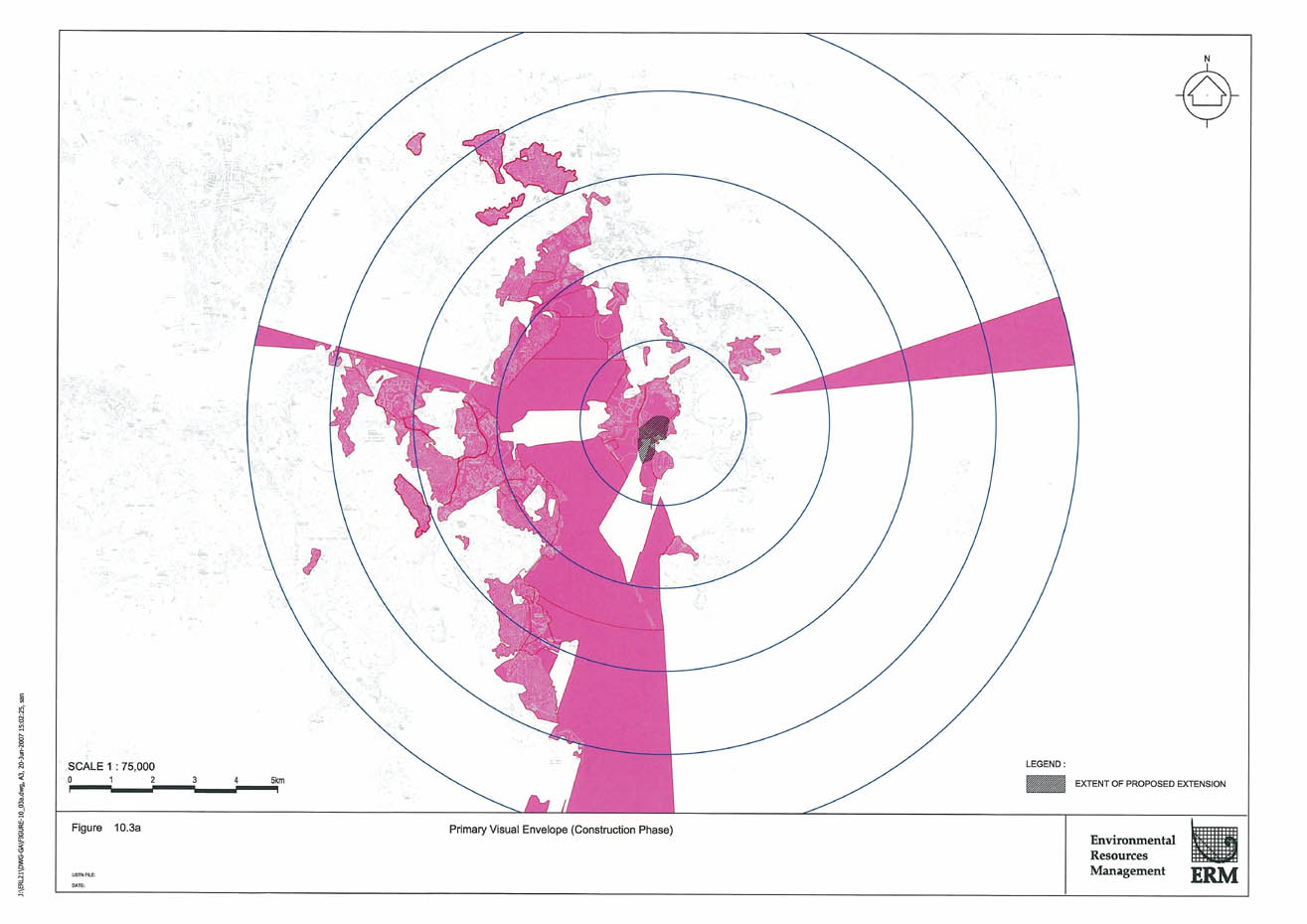
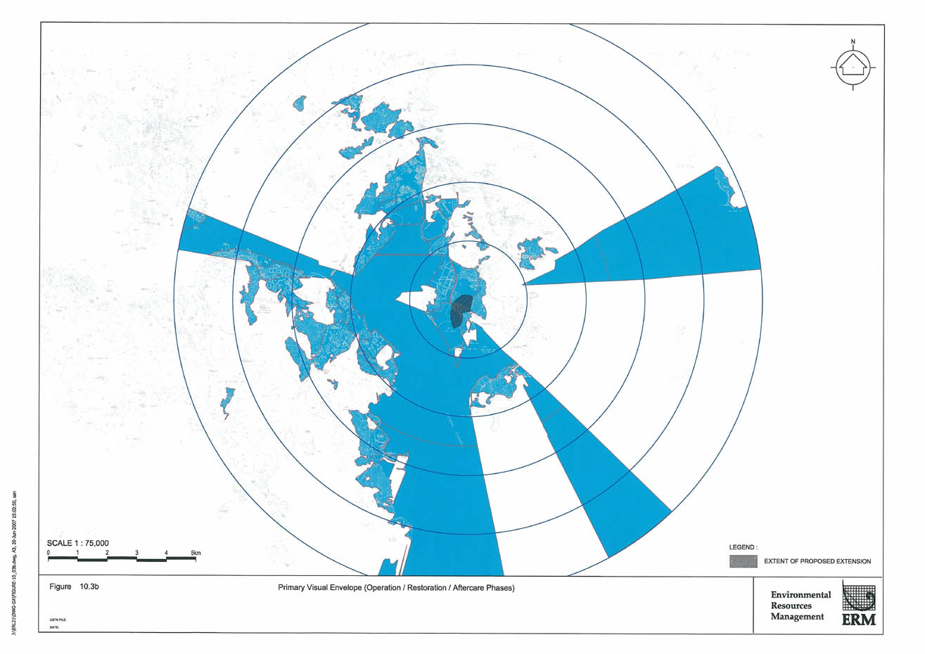
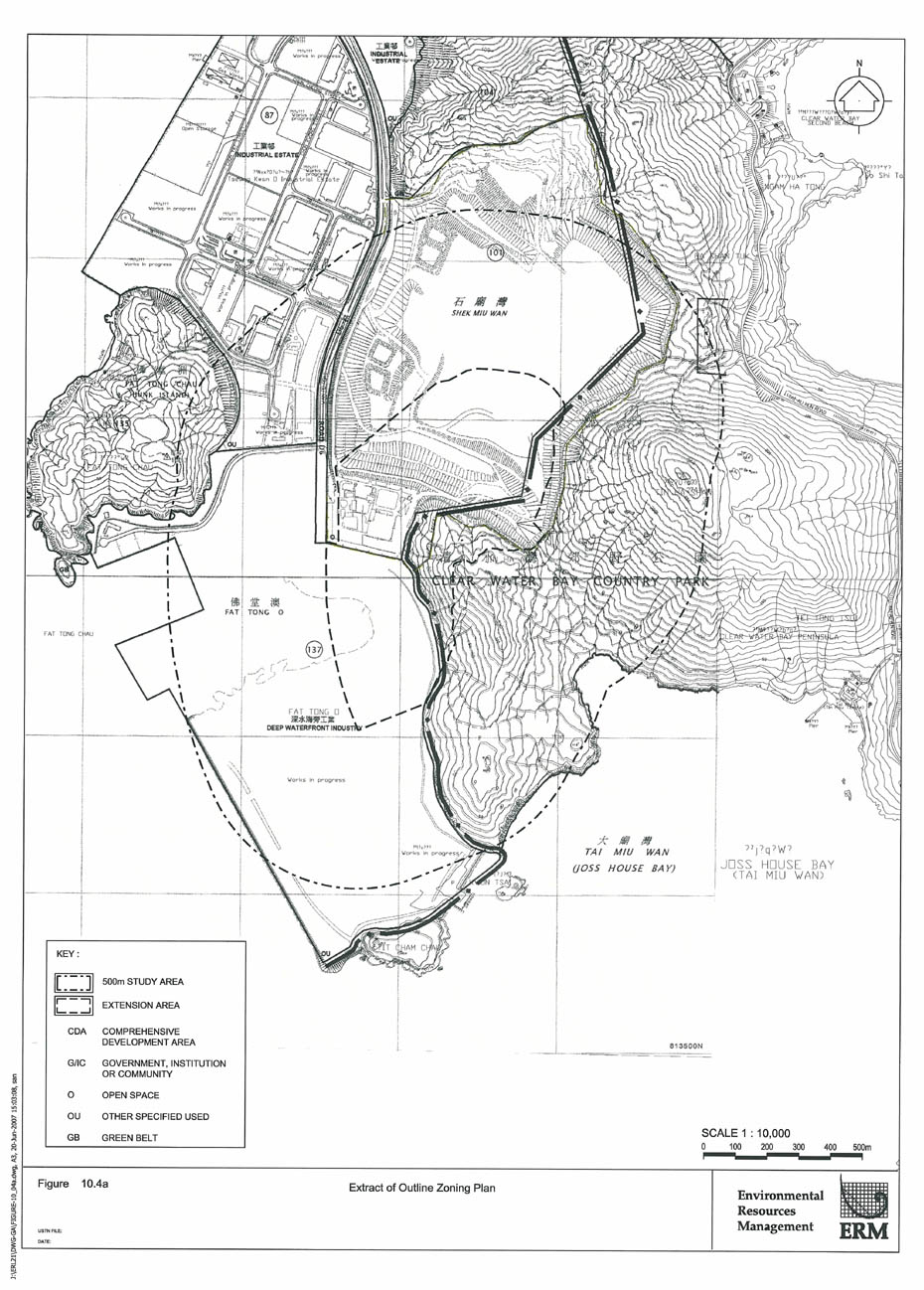
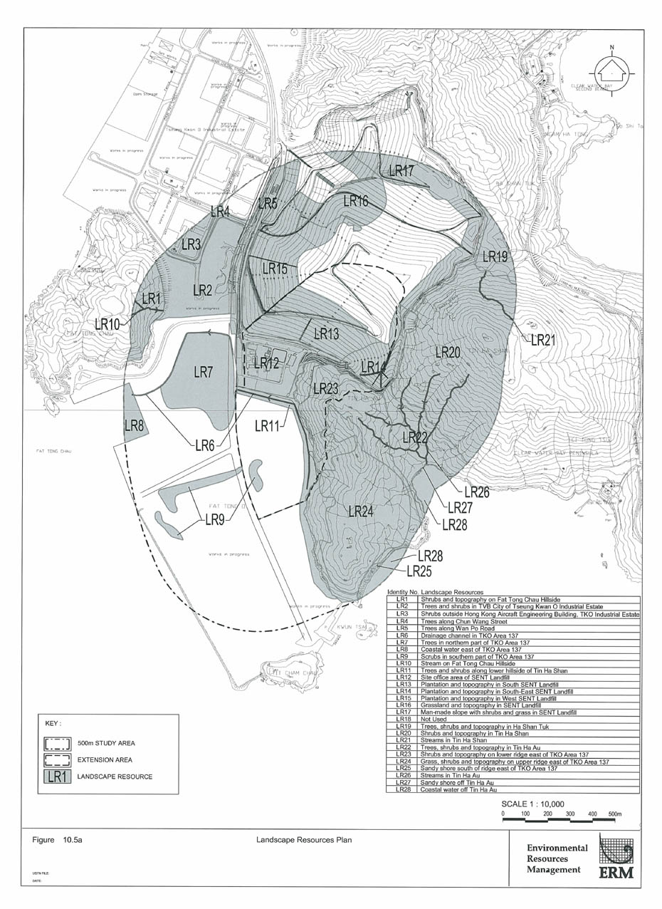
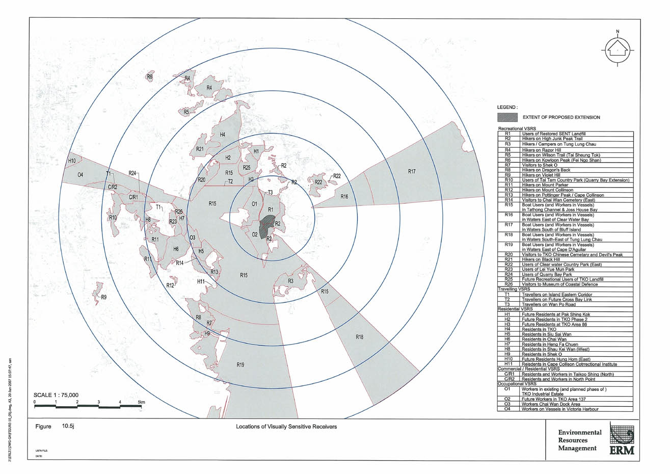
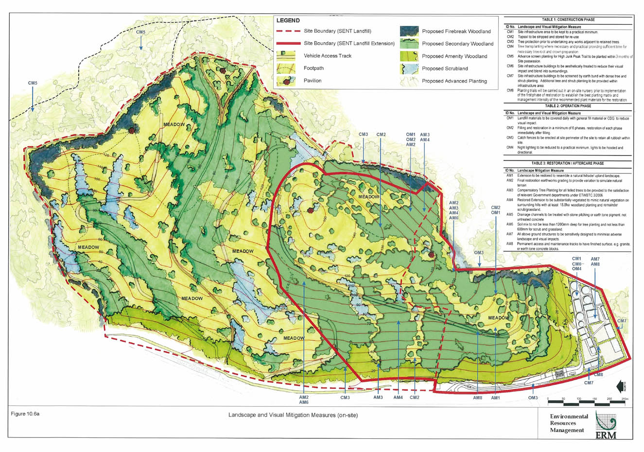
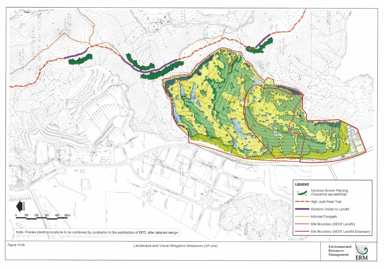
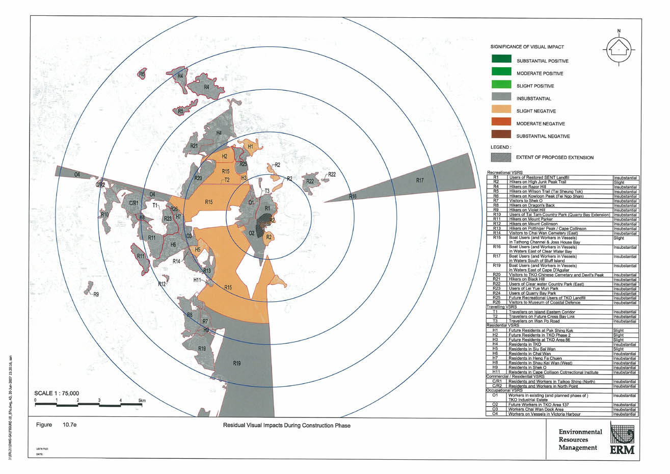
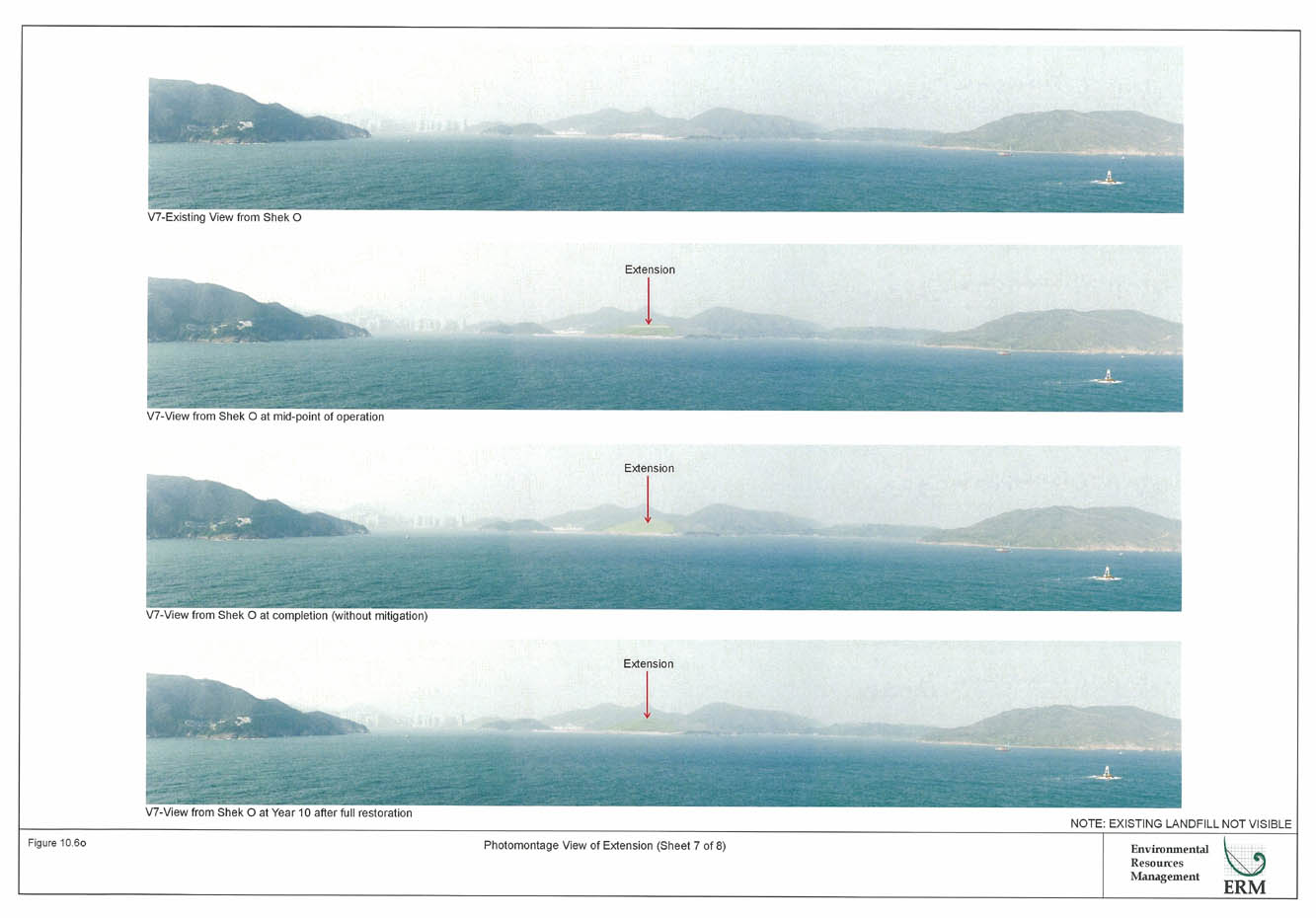
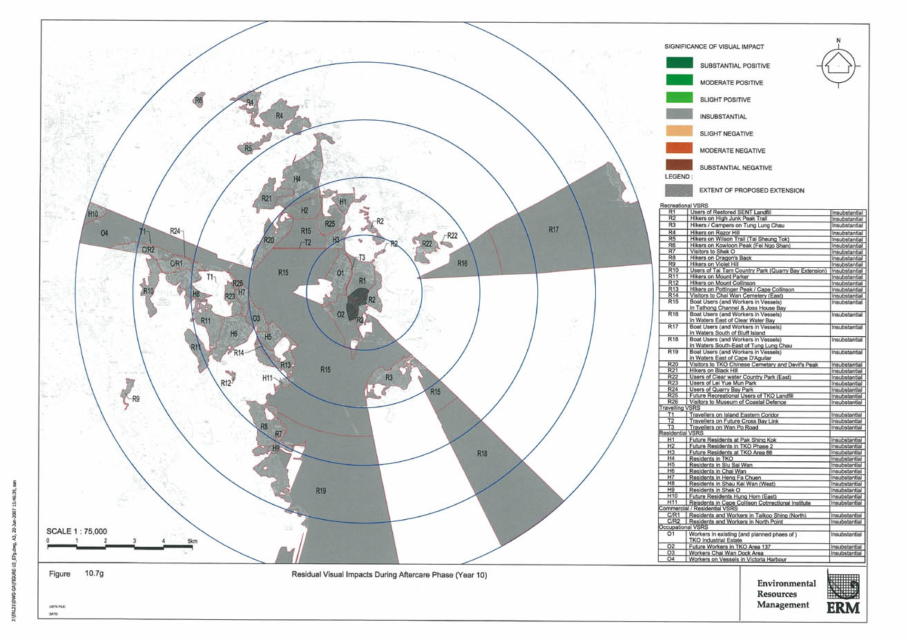
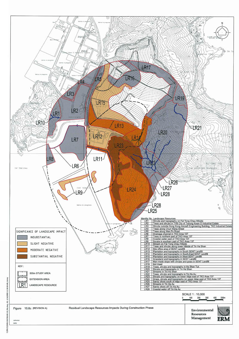
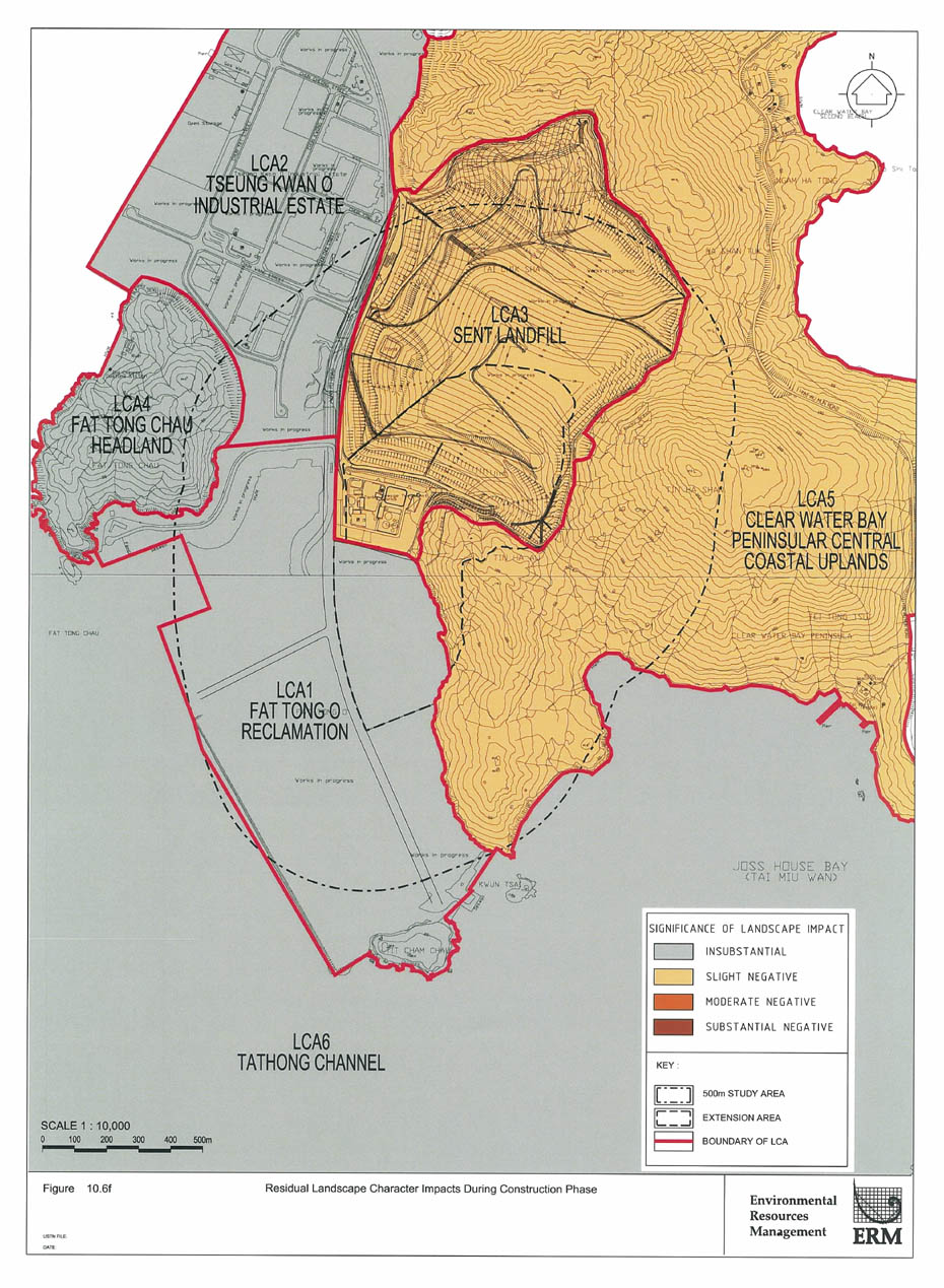
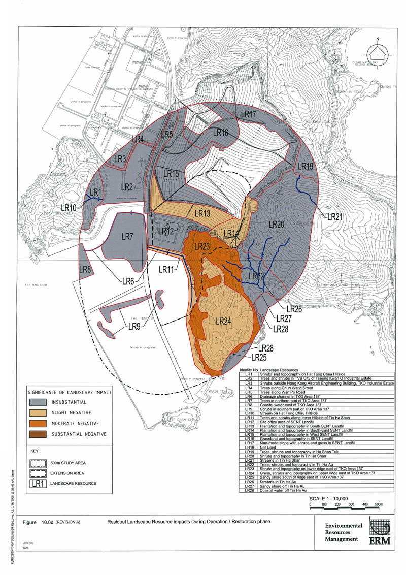
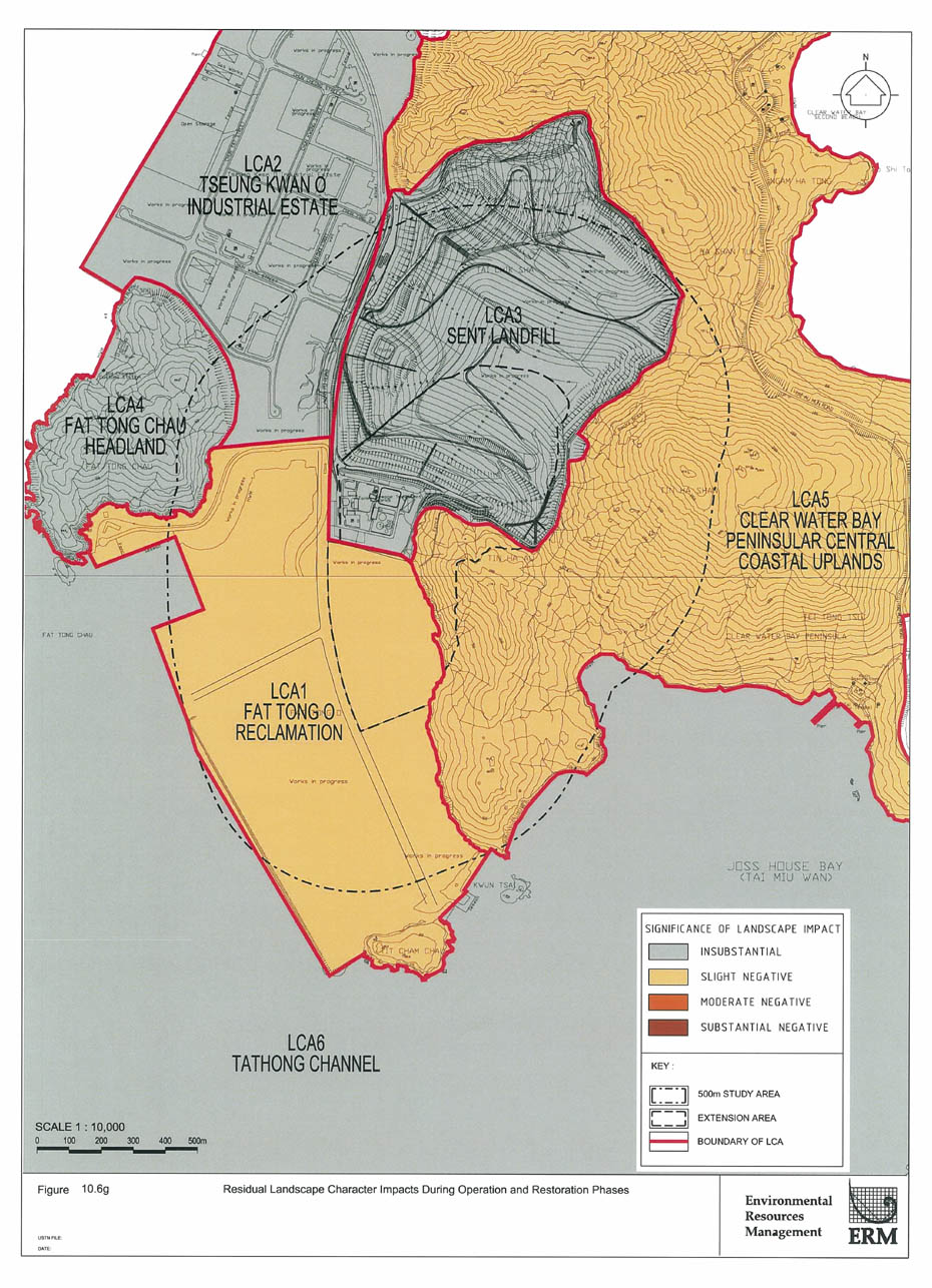
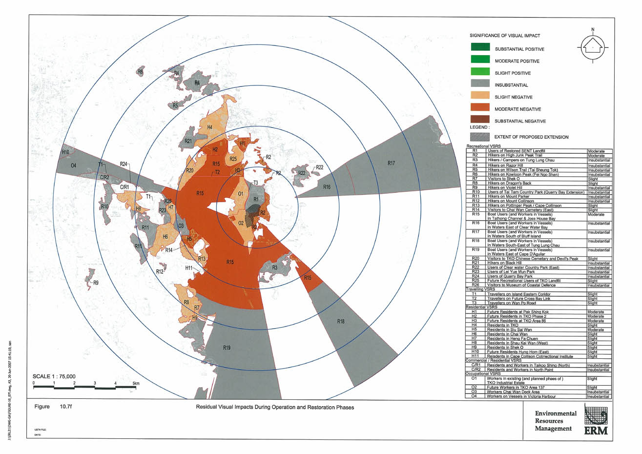
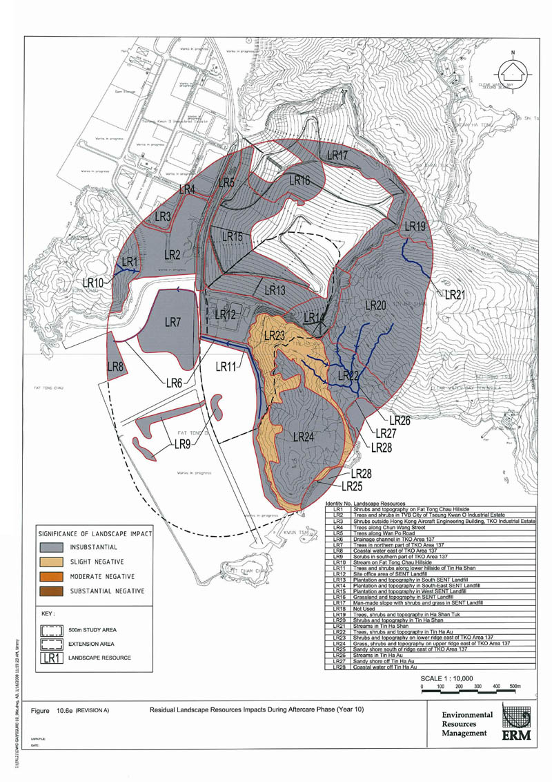
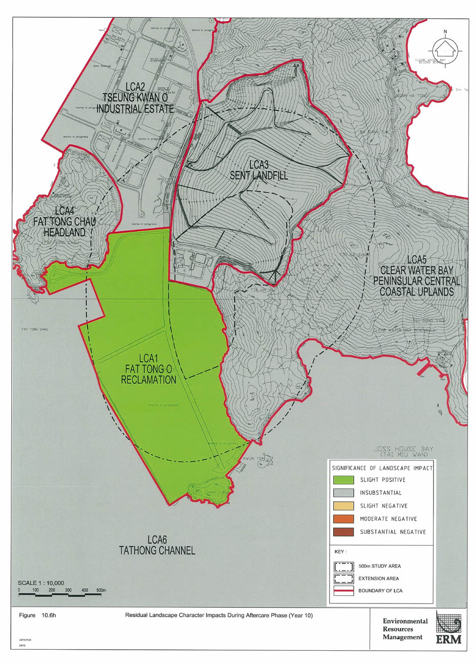