Agreement No. CE 35/2006(CE)
Kai Tak Development Engineering Study
cum Design and Construction of Advance Works
– Investigation, Design and Construction
Kai Tak Development
Environmental Impact Assessment Report
Contents
14.......... ECOLOGical IMpact
14.2 Environmental Legislation, Policies, Plans, Standards and Criteria
14.4 Description of the Environment
14.5 Identification of Environmental Impacts
14.6 Prediction and Evaluation of Environmental Impacts
14.7 Mitigation of Environmental Impacts
14.8 Evaluation of Residual Environmental Impacts
14.9 Evaluation of Cumulative Environmental Impacts
14.10 Environmental Monitoring and Audit
Lists of Tables
Table 14.1 Size of Terrestrial Habitat Type within the Assessment Area
Table 14.2 Criteria and Evaluation of Ecological Importance of Terrestrial Habitats in the Assessment Area
Table 14.3 Criteria and Evaluation of Ecological Importance of Marine Habitats in the Project Area
Table 14.4 Evaluation of Ecological Impacts on Terrestrial Resources
Table 14.5 Evaluation of Ecological Impacts on Marine Resources
14 ECOLOGical IMpact
14.1 Introduction
14.1.1 This section identifies and evaluates the nature and extent of potential impacts on terrestrial and marine ecological resources in the Assessment Areas resulting from all land-based and marine works proposed under the Kai Tak Development, hereinafter referred to as “the Project”. Several relevant baseline studies and assessment reports were reviewed and both direct and indirect impacts on terrestrial and marine ecological resources during construction and operation phases were included in the assessment.
14.1.2 The Assessment Area for the purpose
of terrestrial ecological impact assessment includes all areas within 500 m
from site boundaries of the Project area for all land based works. Assessment Area
for marine ecological impact assessment includes all areas within and 300m
beyond the Project area boundaries, plus the Victoria Harbour
14.1.3 Where necessary, field surveys were undertaken in the Assessment Area to update the current knowledge on ecological baseline conditions. Ecological importance of habitats and species potentially affected by the proposed works were identified and assessed. The scale and significance of potential ecological impacts resulting from the Project was evaluated, and necessary mitigation measures are recommended. Residual and cumulative ecological impacts were also identified and evaluated, and ecological monitoring and audit requirements discussed.
14.2 Environmental Legislation, Policies, Plans, Standards and Criteria
14.2.1 This assessment made reference to the following HKSAR Government ordinances, regulations, standards, guidelines and documents when identifying ecological importance of habitats and species, evaluating and assessing potential impacts of the Project on the ecological resources:
l Environmental Impact Assessment Ordinance (EIAO) (Cap. 499) - aims to avoid, minimise and control the adverse effects on the environment by designated projects through the application of the environmental impact assessment process and the environmental permit system.
l EIAO Technical Memorandum on EIA Process (EIAO-TM) Annex 8 – provides guidelines for the evaluation of the ecological impact caused by the designated project. A list of criteria is provided for assessing the importance of habitat / species and the ecological impact.
l EIAO-TM Annex 16 – describes the general approach and methodology for assessment of ecological impacts arising from a project or proposal, to allow a complete and objective identification, prediction and evaluation of the potential ecological impacts.
l EIAO Guidance Note No. 3/2002 - provides guiding principles on the approach to assess the recommended environmental mitigation measures in EIA reports.
l EIAO Guidance Note No. 6/2002 - clarifies the requirements of ecological assessments under the EIAO.
l EIAO Guidance Note No. 7/2002 - provides general guidelines for conducting ecological baseline surveys in order to fulfil requirements stipulated in the EIAO-TM.
l EIAO Guidance Note No. 11/2004 - introduces general methodologies for conducting marine ecological baseline surveys.
l Wild Animals Protection Ordinance (Cap. 170) - designated wild animals are protected from being hunted, whilst their nests and eggs are protected from injury, destruction and removal. All birds and most mammals, including marine cetaceans, are protected under this Ordinance. The Second Schedule of the Ordinance, which lists all the animals protected, was last revised in June 1997.
l Protection of Endangered Species of Animals and Plants Ordinance (Cap. 586) – to give effect to the Convention on International Trade in Endangered Species of Wild Fauna and Flora (CITES), the Ordinance strictly regulates the import, introduction from the sea, export, re-export and possession or control of certain endangered species of animals and plants and derivatives of those species scheduled in Appendices I, II and III. The Ordinance came into effect on 1 December 2006.
l
Town Planning Ordinance
(Cap.131) - provides for the designation of coastal protection areas, Sites of
Special Scientific Interest (SSSIs), Conservation Area,
l The Marine Parks Ordinance (Cap.476) and Subsidiary Legislation - allows for designation, control and management of marine parks and marine reserves through regulation of activities therein to protect, conserve and enhance the marine environment for the purpose of nature conservation, education, scientific research and recreation. The Ordinance came into effect on 1 June 1995.
l The Country Parks Ordinance (Cap. 208) - provides for the designation and management of country parks and special areas. Country parks are designated for the purpose of nature conservation, countryside recreation and outdoor education. Special Areas are created mainly for the purpose of nature conservation.
l
The Forests and Countryside Ordinance (Cap. 96) - prohibits
felling, cutting, burning or destroying of trees and growing plants in forests
and plantations on Government land. Related subsidiary Regulations
prohibit the selling or possession of listed restricted and protected plant
species. The list of protected species in
l The Marine Fish Culture Ordinance (Cap.353) - regulates and protects marine fish culture by designating areas of fish culture zone, granting license, prohibiting unauthorized vessels and any deposition of chemicals or other substance which are likely to cause injury to fish in a fish culture zone. The list of designated fish culture zones was last revised in January 2000.
l
The Protection of the
Harbour Ordinance (Cap.531) – bases on a presumption against reclamation, the
harbour is to be protected and preserved as a special public asset and a
natural heritage of
l
The Water Pollution
Control Ordinance (Cap.358) – aims to control water pollution in the waters of
14.2.2 This assessment also made reference to the following international conventions and nearby national regulation:
l
International
l The PRC National Protection Lists of Important Wild Animals and Plants - lists detailed Category I and Category II key protected animal and plant species under Mainland Chinese Legislation. The list was last updated in November 2002.
14.3 Assessment Methodology
Assessment Area
14.3.1 As required in the EIA Study Brief, the Assessment Area for the purpose of terrestrial ecological impact assessment includes all areas within 500 m from site boundaries of the Project area for all proposed land based works, whilst Assessment Area for marine ecological impact assessment includes all areas within and 300m beyond the Project area boundaries, plus the Victoria Harbour, the Eastern Buffer and the Western Buffer WCZs.
14.3.2 The terrestrial physical environment
within the Assessment Area is predominantly the former Kai Tak Airport Kai
Tak Airport
is surrounded by highly urbanised areas with mostly residential / industrial
buildings and frequent traffic roads / highways at To Kwa Wan, San Po Kong,
Choi Hung, Kowloon
Bay
14.3.3 The marine environment of the
Project area comprises the Kowloon Bay at the Victoria
Harbour
Literature Review
14.3.4 The assessment of ecological impact on terrestrial and marine ecology within the Assessment Areas was undertaken with reference to previous baseline surveys and EIA studies, Government and private sector reports, independent and Government published literature, Agriculture, Fisheries and Conservation Department (AFCD) publications and academic studies. These included the following:
l
Agreement No. CE 32/99,
Comprehensive Feasibility Study for the Revised Scheme of South
l Agreement No. CE 42/2001, Environmental and Engineering Feasibility Assessment Studies in Relation to the Way Forward of the Harbour Area Treatment Scheme – Water Quality, Ecological and Fisheries Impact Assessment (HATS EEFS Report)
l Agreement No. CE 87/2001, Further Development of Tseung Kwan O – Feasibility Study (TKOFS EIA)
l Agreement No. 54/2001, Wanchai Development Phase II and Central-Wanchai Bypass Environmental Impact Assessment (WDII & CWB EIA)
l Central Reclamation Phase III Studies - Site Investigation, Design and Construction. Comprehensive Feasibility Study for Minimum Option: Final Key Issues and Initial Environmental Impact Assessment Report (CRIII EIA Report)
l
Agreement No. CE
25/2002, Drainage Improvement in Northern
l Agreement No. CE 52/95, Strategic Sewage Disposal Scheme Environmental Impact Assessment Study (SSDS EIA study)
l Agreement No. CE 74/98, Wanchai Development Phase II Comprehensive Feasibility Study (WDII EIA Report)
l
CityU Professional
Services (2002) Consultancy Study on Marine Benthic Communities in
l AFCD (2005) Monitoring of Finless Porpoises (Neophocaena phocaenoides) in Hong Kong Waters 2003-2005
l AFCD (2006) Monitoring of Chinese White Dolphins (Sousa chinensis) in Hong Kong Waters – Data Collection
l
l EPD Marine Water Quality in Hong Kong 1986-2005
Ecological Surveys
14.3.5 As stipulated in Clause 3.2.2 (xii) and 3.4.14.4(iii) of the EIA Study Brief, field surveys on terrestrial and marine ecology were carried out from February 2007 to May 2007 in order to verify the information collected from literature review, fill in the information gaps and fulfill the objectives of the EIA study. Details of the field surveys are discussed below:
Terrestrial Ecology
14.3.6 After review of the above literatures, the existing baseline information gathered from previous literatures is considered sufficient to carry out a detailed impact assessment as there have been no substantial changes to the physical environment within the Assessment Area since the completion of the SEKDCFS EIA. However reconnaissance surveys were carried out in February and May 2007 to verify the findings of the literature review.
14.3.7 Reconnaissance surveys on habitat types, vegetation, avifauna, insect (butterfly and dragonfly), herpetofauna (reptile and amphibian) and mammal covering the whole Assessment Area were carried out in order to verify the previous literatures. Terrestrial habitats within the Assessment Area were identified and each habitat type was surveyed by active searching and all flora and fauna species and their relative abundance at each habitat type were recorded by direct observation and/or hearing. All species of conservation importance recorded during the surveys were also located and mapped.
Marine Ecology
14.3.8 Field surveys are considered necessary to supplement and check the validity of data collected through the literature review process. The field surveys undertaken under this assessment included:
l Intertidal and dive surveys within the vicinity of proposed dredging areas and in other impact areas was conducted in April 2007. The survey included spot-check reconnaissance dives on selected representative line transects and Rapid Ecological Assessment (REA) (DeVantier et al., 1998) at selected transects where presence of corals was located during the spot-check dives.
l Benthos survey on seabed within the proposed dredging areas contained in this Project was carried out in March 2007 by grab sampling method. Five replicates of grab samples over a 0.1m2 area seabed substrate were collected using a van Veen grab and samples were sieved through 0.5 mm sieves. Collected organisms were then counted and identified to the lowest practicable taxon as possible. Species diversity H’ and evenness J were calculated for pooled data, using the formulae:
H’= -å ( Ni / N ) ln ( Ni / N ); and
J = H’ / ln S
where S is the total number of species in the sample, N is the total number of individuals, and Ni is the number of individuals of the ith species.
l Intertidal communities surveys on artificial intertidal habitats that would be directly impacted were conducted in February, March and May 2007 using line transects where possible, with one transect deployed on the seawall, starting from the high water mark down to low water mark. Along each transect, standard ecological sampling quadrat was laid at 1 m intervals (or other suitable quadrat dimension and interval distance depend on the field situation). Intertidal fauna and flora were identified and enumerated. Fauna / flora species and relative abundance / coverage were recorded and identified according to Williams (2003).
Impact Assessment Methodology
14.3.9 Evaluation and assessment of potential impact on ecological resources was conducted in accordance with the criteria and guidelines specified in Annex 8 and Annex 16, respectively, of the EIAO-TM.
14.3.10 The significance of impacts was ranked as “low”, “moderate” or “high”. The description of the ranking is as below:
l Low - Impacts to species or groups are assessed as “low” if the predicted impact would result in a slight, and / or short-term reduction in the local population numbers or geographic distribution of a species or group, but the species or group is predicted to recover from the perturbation with no-long term adverse impacts. Impacts to habitat are assessed as “low” when the habitat is widely distributed locally and that no rare or restricted species are found in the habitat.
l Moderate – Impacts to species or groups are considered “moderate” if the predicted impact probably would result in non-recoverable and / or long-term reduction in population numbers. However, the species in question should be considered widely distributed or common, and abundant on a local, regional or global scale. Impacts to habitat are assessed as ‘moderate” if the habitat is of limited local or regional distribution or declining in extent and that the habitat has a potential of supporting rare or restricted flora and / or fauna.
l High – Impacts to species or groups are judged to be “high” if the predicted impact has an adverse effect on species or groups which are rare, protected or of conservation importance locally, regionally, or globally. Impacts to habitat are considered to be “high” if the habitat in question is of limited local or regional distribution or declining in extent and that it contains rare, protected or conservation importance species or generally considered by the scientific community to be of local, regional or global importance to the support of rare or restricted flora and/or fauna species.
14.3.11 If impacts on ecological resources are found to be significant (that is, moderate or high), mitigation measures would be recommended in accordance with the EIAO-TM Annex 16 and EIAO Guidance Note No. 3/2002. Impact mitigation would be sought in the following priority: avoidance, minimization, on-site compensation and off-site compensation.
14.3.12 Impact avoidance generally consists of modifications to the preferred development options, but may in some extreme cases require abandonment of the project.
14.3.13 Impact minimization includes any means of reducing the scope or severity of a given impact, for example, through timing of construction programme, modification in the design or ecological restoration of disturbed areas following the completion of works.
14.3.14 Impact compensation would be recommended if the effect on a given species or habitat is irreversible and attempts would be made to compensate it elsewhere, for example, enhancement, creation of suitable habitats or recreation of the habitat. Compensation could be on-site or off-site.
14.4 Description of the Environment
Area of Conservation Importance
14.4.1 There are no ecological sensitive
receivers, such as SSSIs, Country Park , Marine
Parks
Terrestrial Environment
14.4.2 The terrestrial physical environment
of the Assessment Area includes mostly the former Kai Tak Airport Kai
Tak Airport Kai Tak Airport Kai Tak Airport
Habitat / Vegetation
14.4.3 In total, five types of terrestrial habitats were identified within the Assessment Area, including the wasteland, developed area, plantation/grassland mosaic, watercourse and artificial coastline. The locations of each habitat type and species of conservation importance recorded during the recent surveys are shown in Figure 14.1b. Representative photographs of each identified habitat type and a list of floral species recorded in recent surveys are given in Appendix 14.1 and Appendix 14.2, respectively. Table 14.1 lists out the size of each habitat type within the Assessment Area.
Table 14.1 Size of Terrestrial Habitat Type within the Assessment Area
|
Habitat Type |
Size |
|
Developed Area |
614.8 ha |
|
Wasteland |
202.7 ha |
|
Plantation/grassland mosaic |
15.8 ha |
|
Watercourse |
1.5 km |
|
Artificial coastline |
15.7 km |
14.4.4 A broad bush tree survey undertaken by the Landscape and Visual Impact Assessment Section of this EIA study estimated that there were more than 6000 individuals of tree located within the Assessment Area. All of them were common and widespread tree species and are considered of very low ecological value. An Old and Valuable Tree (OVT) and two Champion Trees were located in the Assessment Area but they were outside the boundary of Project area and would not be directly affected. Details of the broad bush tree survey findings are presented in S13.6.9, S13.9.16, S13.10.3 and Table 13.3 & 13.5.
Wasteland
14.4.5 The wasteland area identified within
the Assessment Area covers approximately 202.7 ha area and comprises mainly the
construction sites and vacant lands found at the North and South Apron as well
as most of the runway areas of the former Kai Tak Airport Hong Kong .
Other grasses, including Neyraudia reynaudiana, Rhynchelytrum repen,
Panicum maximum, Kyllinga aromatica and Chloris barbata,
and herb species, Ageratum conyzoides and Wedelia trilobata as
well as climber Passiflora foetida were also commonly found in the
wasteland habitat.
14.4.6 There were more
than 1000 individual trees scattering throughout the wasteland habitat.
Predominant species were exotic trees / shrubs and included Leucaena
leucocephala, Albizia lebbeck and Casuarina equisetifolia.
Other exotic species including Acacia auriculiformis, Acacia confusa,
Aleurites moluccana, Archontophoenix alexandrae, Caryota
ochlandra, Cassia siamea, Delonix regia, Phoenix
Developed Area
14.4.7 A total of 614.8 ha developed area was identified within the
Assessment Area, included wholly the urban land with residential / industrial
buildings and frequent traffic road / highway found at the vicinity of the
former Kai Tak Airport Hong
Kong . No rare or protected species were recorded.
Plantation/grassland mosaic
14.4.8 Small area (15.8 ha) of
plantation/grassland mosaic habitat that was an abandoned golf facility with
dense vegetative planting were located at the southern tip of the former
airport runway. In total, there were 36 floral species recorded within this
habitat and most of them were common and exotic plantings. About 350 trees were
located in this habitat but they were mostly relatively young with trunk diameter less than 200mm. Amenity plantations
including Ficus benjamina, Hibiscus tiliaceus, Hibiscus
rosa-sinensis and Rhododendron spp. were the most dominant tree and
shrub species found in this habitat and other common tree/shrub species such as
Leucaena leucocephala, Casuarina equisetifolia,
Chrysalidocarpus lutescens, Eucalyptus citriodor, Ficus
mircocarpa, and Macaranga tanarius were also recorded. Scattered
grassy area with common grasses such as Chloris barbata and Rhynchelytrum
repen as well as weed species such as Bidens alba, Lantana camara
and Mikania micrantha were also found within this habitat. All the
recorded species are common and widespread in Hong Kong
with low ecological importance.
Watercourse
14.4.9 The watercourse identified within
the Assessment Area only included the Kai Tak Nullah, which is an artificial
concrete-lined channel of about 1.5 km long for drainage purpose and located at
the North Apron of the former Kai
Tak Airport
Artificial coastline
14.4.10 Totally 15.7 km long artificial coastline made up of mainly man-made rock / boulder slopes and vertical seawall as well as breakwaters were found along the runway area of the former Kai Tak Airport, the Kai Tak Approach Channel (KTAC) and at the To Kwa Wan Typhoon Shelter and Kwun Tong Typhoon Shelter. Only scarce and scattered tree / shrub individuals of common species such as Ficus microcarpa, Ficus virens, Hibiscus tiliaceus and Leucaena leucocephala were recorded from this habitat. No rare or protected species was found.
Fauna
Review of SEKDCFS EIA
14.4.11 The previous SEKDCFS EIA Report (Arup, 2001)
conducted and reported the terrestrial fauna surveys at the former Kai Tak
Airport
14.4.12 At the North Apron, Richard’s Pipit Anthus richardi (24.4% of total birds), Tree Sparrow (24.4%) and Fantail Warbler, Cisticola juncidis (22%) were the three most abundant bird species, with similar degree of dominance. Kestrel, Falco tinnunculus (3%) was the only species of conservation importance among those recorded in the North Apron area.
14.4.13 At the runway area, 14 species were recorded during the field surveys. No sign of breeding was observed. Black Kite, Milvus migrans, a species of conservation importance, was the most dominant species (49.6% of total birds), followed by Fantail Warblers (39.2%) but Richard’s Pipit, Anthus richardi and Crested Myna, Acridotheres cristatellus were also abundant. Also recorded and considered of conservation importance was Kestrel (2.2%).
14.4.14 At the artificial coastline surrounding the
former Kai Tak Airport
14.4.15 No sighting of reptiles, amphibians or mammals was made on either the runway or the North Apron area during the surveys. Breeding habitats of amphibians were also not observed and nor were burrows of mammal species.
14.4.16 No sighting of reptiles was made on the North
Apron area but Red-eared Slider, Trachemys scripta and Chinese Skink, Eumeces
chinensis was recorded in the runway area. Both species are of little
conservation importance. Red-eared Slider is an introduced species
(Karsen et al. 1998). Chinese Skink is common and widespread in Hong Kong (ibid.).
14.4.17 One dragonfly and one butterfly species was
recorded on the runway area and North Apron area. These were the
Wandering Glider, Pantala flavescens and the Red-based Jezebel, Delias
pasithoe, respectively. The Wandering Glider is the commonest
dragonfly in Hong Kong and can be found in many types of habitats (Wilson
Findings of recent surveys
14.4.18 The baseline information gathered from the previous SEKDCFS EIA is considered sufficient to carry out a detailed impact assessment. As all the recorded species of conservation importance, previously reported in the SEKDCFS EIA are well known to be common and widespread in the Hong Kong, and there was no substantial changes to the physical environment of the Assessment Area since the completion of the SEKDCFS EIA, reconnaissance surveys were considered sufficient to verify the findings of the literature review. Surveys were carried out in February and May 2007 to cover each terrestrial habitats identified within the Assessment Area, including wasteland, plantation/grassland mosaic, watercourse, developed area and artificial coastline with particular attention paid to presence of waterbirds and any uses of habitats (e.g. roosting and foraging) within the Assessment Area. Appendices 14.3a-c and 14.4a-c present the full list of fauna recorded in the February and May surveys, respectively.
Avifauna
14.4.19 In total, 36 bird species and 535 individuals were recorded from the Assessment Area during the February and May surveys. Generally, the species richness of bird was low in the Assessment Area but moderate abundance, especially at artificial coastline habitat in February survey, was recorded during the recent surveys.
14.4.20 In February 2007 the highest abundance of birds (177 individuals) was recorded at the artificial coastline habitat with 12 species observed. The dominant species were Great Cormorant (28%), Little Egret (21%) and Crested Myna (16%). The Great Egret and Grey Heron were also both present in relatively high numbers (11% each). Among the recorded species, Little Egret, Great Egret, Grey Heron, Black-crowned Night Heron, Chinese Pond Heron, Great Cormorant and Black Kite are considered of having conservation importance.
14.4.21 In the wasteland area, eight species of bird
and 82 individuals were recorded in February 2007. All species recorded
are common and wide spread in Hong Kong
including the dominant species, Black Kite, a species of conservation
importance, which accounted for 82% of individuals recorded. One individual of
Grey Heron, a species of conservation importance, was also recorded.
14.4.22 The habitat supporting the most diverse assemblage of birds was the plantation/grassland mosaic where 58 individuals and 16 species were recorded in the February survey. Again the Black Kite was the dominant species (25%), but White Wagtail (19%), Richards Pipit (14%) and Chinese Bulbul (9%) were relatively abundant. Only Little Egret and Black Kite are considered of conservation importance among bird species recorded from this habitat.
14.4.23 In May 2007 the highest abundance of birds (96 individuals) was recorded at the plantation/grassland mosaic habitat with 20 species observed. This area again supported the most diverse assemblage of species. The dominant species was the Scaly-breasted Myna (21%) and Cattle Egret (14%). Species of conservation importance, Little Egret, Cattle Egret and Black Kite were also observed.
14.4.24 In the wasteland area, 14 species of bird and
29 individuals were recorded in May 2007. All species recorded are common
and wide spread in Hong Kong . The dominant
species, Black Kite, is considered of conservation importance and accounted for
32% of individuals recorded. In addition, one individual each of Chinese Pond
Heron and Greater Coucal, species of conservation importance, were also
recorded.
14.4.25 Ninety-three individuals and nine species of bird were recorded at the artificial coastline within the Assessment Area in May 2007. The dominant species was Little Egret (70%) and Black Kite (12%). Both these species are considered of conservation importance. Also recorded waterbirds included Great Egret, Cattle Egret, Chinese Pond Heron and Black-crowned Night Heron which are all considered of conservation importance.
14.4.26 The species of conservation importance, Kestrel and Intermediate Egret, recorded in previous surveys carried out under the SEKDCFS EIA were not recorded during recent surveys in both February and May 2007.
14.4.27 All wild birds (including nests) are protected under the Wild Animals Protection Ordinance (Cap. 170). There were totally nine bird species of conservation importance recorded during recent surveys. The distribution and conservation status of those birds of conservation importance recorded in the recent surveys are described in detail below.
14.4.28 Black Kite is a Class II
Protected Animal of the PRC (Hua and Yin 1993) and is listed in Appendix II of
CITES (Xu, 1995). The local nesting
population of this species is declining due to increasing urbanization (Viney
et al. 1994).
14.4.29 Little Egret is a common
ardeid which is widely distributed in the coastal waters throughout Hong Kong , but it is considered to be a species of conservation
importance regionally due to its restricted site of breeding and roosting
(Fellowes et al., 2002).
14.4.30 Great Egret is a common
resident and winter visitor in Hong Kong , but
this species is considered to be of conservation importance regionally due to
its restricted breeding and roosting area (Fellowes et al., 2002).
14.4.31 Cattle
Egret occurs commonly in Hong Kong and its
roosting site is mostly confined to the local wetland habitats. Although good
numbers are still recorded, the reduction of wetland habitats and abandonment
of the use of buffaloes is causing a local decline (Viney et. al., 2005).
14.4.32 Black-crowned
Night Heron is considered to have local conservation importance due to its
restricted breeding and roosting sites in Hong Kong
(Fellowes et al., 2002).
14.4.33 Chinese
Pond Heron is considered of conservation importance due to its locally
declining populations. Despite the reduced numbers of this species in Hong Kong , the local population is still large enough to
be of regional significance (Carey et al.,
2001).
14.4.34 The
large, fair secure populations of Grey Heron that occur in Hong Kong as mostly
winter visitor are considered potentially important in a regional context (Fellowes et al., 2002).
14.4.35 Great Cormorant is abundant
winter visitor in Hong Kong and Deep Bay holds one of the largest wintering
populations in Asia (~6.8% of the regional population) (Carey
et al., 2001). It is considered to be of potential
conservation importance in regional context by Fellowes et al. (2002).
14.4.36
Although locally common and widespread, populations of
Greater Coucal in mainland China have been decreased drastically in recent
years as a result of overhunting for its high value in traditional medicine. It
is listed as ‘Vulnerable’ in the China Red Data Book and also a national
Category II protected animal in China
Other terrestrial fauna
14.4.37 Other terrestrial fauna recorded during surveys
in February and May 2007 included dragonflies, damselflies and butterflies.
All species recorded are common and widespread in Hong
Kong .
14.4.38 In February 2007, four species of butterfly and 17 individuals were recorded. The most abundant species was the Indian Cabbage White (Pieris canidia) but also present were the Red-base Jezebel (Delias pasithoe), Pale Grass Blue (Zizeeria maha) and Glassy Tiger (Parantica aglea).
14.4.39 In May 2007, only two individual butterflies were recorded. One was the Common Grass Yellow (Eurema hecabe) and the other was the Glassy Tiger (Parantica aglea).
14.4.40 Dragonflies and Damselflies recorded in both February and May 2007 were the Common Red Skimmer (Orthetrum pruinosum), Lesser Blue Skimmer (Orthetrum Triangulare), Russet Percher (Neurothemis fulvia) and Yellow Featherlegs (Copera marginipes), Orange-tailed Midget (Agriocnemis femina), Black Threadtail (Prodasineura autumnalis), respectively.
14.4.41 No sighting of reptiles, amphibians or mammals was made during field surveys in February and May 2007. Signs of reptile breeding or breeding habitats of amphibians were not observed and nor were burrows of mammal species.
Marine Environment
14.4.42 The marine environment in the Project area is
composed of the marine water of Kowloon
Bay and eastern Victoria Harbour
14.4.43 Dive surveys have been conducted to provide updated information on marine ecological resources in the area that would be directly affected by marine works and far field ecological sensitive receivers have also been identified. These potential off-site ecological sensitive receivers include coral areas located at Green Island and Little Green Island (over 10 km), Junk Bay (6 km) and Tung Lung Chau (8 km), Fish Culture Zone at Tung Lung Chau (8 km) and Ma Wan (over 10 km).
Abiotic
Water
14.4.44 Under the Water Pollution Control Ordinance
(Cap. 358), the marine water within the Project area is within the gazetted
Victoria Harbour WCZ. Due to the direct discharge of wastewater after
simple screening into the harbour area before the 1990s, water quality in the Victoria Harbour
14.4.45 However, after the commissioning of the Stonecutters Island Sewage Treatment Works (SCISTW) in 2002 under Stage 1 of the Harbour Area Treatment Scheme (HATS), water quality has improved significantly, especially in the Eastern Harbour area. According to EPD’s water quality monitoring in 2005, marine water in the Project area (Station VM1 and VM2) is now less turbid (suspended solid 0.9-10.8 mg/L), more oxygenated (dissolved oxygen 4.2-6.9 mg/L), and lower in inorganic nutrients (total nitrogen 0.22-0.63 mg/L and total phosphorus 0.02-0.06 mg/L) over the last 20 years (EPD, 2006).
14.4.46 However, the levels of faecal contamination were generally high in the Harbour area, though the Eastern Harbour (VM1 & VM2) resulted in lower levels of E. coli (88-31000 cfu per 100 mL) and faecal coliforms (300-50000 cfu per 100 mL) compared with the Central and Western Harbour areas (EPD, 2006).
14.4.47 According to EPD’s water quality monitoring results, water quality within the To Kwa Wan Typhoon Shelter (TKWTS) (VT11) was similar to the Harbour area in term of water clearance (suspended solid 1.3-7.3 mg/L), oxygenation (dissolved oxygen 3.7-8.0 mg/L), nutrient level (total nitrogen 0.51-0.58 mg/L and total phosphorous 0.04-0.09 mg/L) and faecal contamination (E. coli 150-2800 cfu per 100 ml and faecal coliforms 880-7200 cfu per 100ml).
14.4.48 In contrast, water quality within the Kwun Tong Typhoon Shelter (KTTS) (VT4) was more eutrophic (total nitrogen 0.84-1.73 mg/L and total phosphorus 0.13-0.37 mg/L) and less oxygenated (dissolved oxygen 2.9-6.7 mg/L), though water turbidity (suspended solid 1.3-3.9 mg/L) and level of faecal contamination (E. coli 1500-26000 cfu per 100 ml and faecal coliforms 3200-50000 cpu per 100ml) were more or less the same as the Harbour area (EPD, 2006).
14.4.49 As KTTS is located at the immediate downstream of Kai Tak Approach Channel (KTAC), the poor water quality at KTTS was mainly due to the poor water circulation and pollution discharges from the upstream Kai Tak Nullah and other storm culverts.
14.4.50 In general, water quality in the Harbour area
has been improved recently but the Victoria
Harbour provides a relatively poor
marine habitat compared to eastern and southern waters in Hong
Kong .
Sediment
14.4.51 The seabed in the Harbour area is mainly composed of soft bottom sediment with coarse particle size. The marine sediment in the Victoria Harbour (VS3), according to EPD sediment monitoring results, is highly anaerobic (electrochemical potential -421mV to -213 mV) due to high organic loading from sewage discharges over the years. The sediment is toxic with high level of total sulphide (200-590 mg/kg). The sediment is classified as Category M or H, as defined in the ETWB Technical Circular (Works) No. 34/2002, as it is also highly contaminated with copper (27-190 mg/kg) and silver (1.0-5.6 mg/kg) which exceed the Lower Chemical Exceedance Level (LCEL) or Upper Chemical Exceedance Level (UCEL) (EPD, 2006).
14.4.52 Numerous sediment toxicity studies have been conducted in the Victoria Harbour and the sediment within the Harbour area was usually determined as polluted in nature by ecotoxicity testing using single species or indicator groups (e.g. barnacles, Chan et al., 1990; Rainbow and Smith, 1992; Blackmore, 1999; fish, Kwan, 1999 and mussel, Nicholson, 1999).
14.4.53 A recent sediment toxicity test was carried out under the HATS EEFS Study and sediments collected from the Victoria Harbour (Station XN4 and VM7) were highly toxic to benthic amphipod Leptocheirus plumulosus, resulting in very low survivorship of 9-31% only (CDM, 2004).
14.4.54 Sediment contamination within TKWTS, KTTS and
KTAC was one of the most serious in Hong Kong
marine waters. According to EPD sediment monitoring results, sediments
collected from both typhoon shelters were also highly contaminated with various
types of heavy metals and organic pollutants which largely exceeded the
UCEL. In addition, chemical analysis of sediments collected from KTAC,
undertaken for the SEKDCFS EIA Study, showed that levels of heavy metals and/or
organic contaminants were higher than even 10 times of the LCEL (Arup, 2001).
Biotic
14.4.55 The Project area comprises several broad marine habitats including:
l
Benthic habitat on soft
bottom substratum at
l Intertidal habitats on artificial seawall along the former airport runway and at the coastlines of TKWTS, KTTS and KTAC
l
Subtidal habitat at
Soft bottom benthos
14.4.56 There have been numerous studies on benthic
fauna assemblage conducted within the Victoria Harbour
14.4.57 Thompson and Shin (1983) reported that benthic assemblages in the Harbour area were typically of low diversity and abundance, and community structure was largely dictated by organic pollution from sewage discharges in the past. As only a limited number of hypoxia tolerant species can survive the bottom conditions within the study area region, fauna was dominated by opportunists such as bivalves and polychaetes.
14.4.58 Dominant polychaetes include Minuspio cirrifera and the best-known marine organic enrichment indicator Capitella capitata. These polychaetes may be indicators of moderate and severe organic pollution, respectively. The moderately pollution tolerant bivalve Ruditapes philippinarum (stated as Tapes philippinarum) was also found dominant in the benthic infaunal population in the same study (Thompson and Shin, 1983).
14.4.59 Another field survey of soft bottom benthic
organisms at the seabed in the Victoria
Harbour Victoria Harbour
14.4.60 The field survey carried out for the SSDS EIA
Study also confirmed a very low species diversity and evenness for benthic
assemblages in the Victoria
Harbour
14.4.61 A recent study on marine benthic communities in Hong Kong showed that a coarser sediment benthic group was found in the Eastern Victoria Harbour (Station 53 & 54) as compared to eastern and southern waters, with lower species diversity and evenness resulted (CityU, 2002). This study showed that the benthic communities in the Victoria Harbour comprised of mainly polychaete (Cirratulus sp., Schistomeringo rudolphi, Dodecaceria sp., Naineris sp., Sigambra hanaoka and Prionospio sp.), oligochaete (Thalassodrilides gurwitchi), bivalve (Ruditapes philippinarum) and crustacean (amphipod Cheiriphotis megacheles) (CityU, 2002). It indicated a distinct benthic composition which is characterized by species strongly adaptable to eutrophic environment.
14.4.62 Other recent survey for HATS EEFS Study on benthic assemblages in the Victoria Harbour near North Point (Station VM2 and XM4) also indicated that the benthic assemblage was dominated by polychaeta (Naineris sp., Glycera sp., Prionospio sp.), mollusca (Ruditapes sp.) and crustacea (Corophium sp.). Bivalve Ruditapes sp. is the most abundant (44%) fauna, comprising 95% of the whole benthic assemblage biomass. Although it is a commercial species, the conservation value is not high. It was noted that the benthic community structure has been relatively stable over the years and so quite robust to environmental disturbance (CDM, 2004).
14.4.63 Previous SEKDCFS EIA Study has undertaken benthos samplings at the TKWTS, KTTS and KTAC. Only two species of benthic fauna were found at the TKWTS, including the dominant (>99% of all collected specimens) polychaete (Capitella capitata) and a juvenile ocypodid crab (Macrophthalmus sp.). The species diversity and evenness were low (both equal to 0.049). No living organism was collected from the sampling locations at the KTAC and KTTS, indicating the very poor habitat quality at these areas (Arup, 2001).
14.4.64 To fill in the information gap, recent benthos
survey was carried out at the Kowloon
Bay
14.4.65 A total of 1,367 specimens were collected in
the present survey. Collected taxa included annelids (36 polychaete
species and an oligochaete), crustaceans (12 species), molluscs (three
species), nemertean (one species) and fish (one species). In terms of
individual number, 61%, 36%, 3% of specimens were polychaeta, crustacean and
other taxa respectively. Polychaeta was the most abundant taxon and Eunice
indica was the most dominant species, followed by Mediomastus sp., Cirriformia
sp., Glycinde gurjanovae, Glycera chirori and other
species. The other common taxon was crustacea which included mostly the
amphipods. Table 3.1 of Appendix 14.6 showed
the twenty most abundant species found in this survey. All the species
recorded in the present survey are common and widespread in Hong
Kong waters.
14.4.66 Recent survey revealed similar benthos
assemblages on soft bottom seabed in the Kai Tak area and the benthic
composition found in the present survey was generally consistent with the past
recorded results (see Table 3.3 of Appendix 14.6).
Owing to the long-term sewage discharge in the Victoria Harbour
Intertidal communities (artificial)
14.4.67 The existing artificial coastline in the
Project area is made of both artificial vertical seawalls at the area of
typhoon shelters and man-made sloping seawalls as well as rockfills along the
former Kai Tak Airport
14.4.68 A number of literatures indicated that fauna presented in seawalls and rockfills in the other Harbour area were largely restricted to encrusting sessile organisms such as bivalves, molluscs and barnacles (Morton and Morton, 1983; Lee, 1985; Lee and Morton, 1985). Fauna commonly encountered included molluscs such as the common neogastropod (Thais clavigera) and the pollution-tolerant bivalve (Perna viridis), as well as encrusting crustaceans such as barnacles (Balanus spp., Tetraclita squamosa and Capitulum mitella) and the ubiquitous mobile isopod (Ligia exotica) (Morton and Morton, 1983; Lee, 1985; Lee and Morton, 1985). Flora is mostly restricted to algae that are either organic or nutrient enrichment indicators such as Ulva spp. and Cladophora (Morton and Morton, 1983; Ho, 1987; Moore, 1990).
14.4.69 A recent intertidal fauna survey on artificial seawalls and rockfills in central Harbour area at Wanchai, conducted under Wanchai Development Phase II (WDII) and Central-Wanchai Bypass (CWB) EIA Study, reported that artificial seawalls along the coastline were found to be generally inhabited densely by few species of sessile encrusting fauna, including chiton (Acanthopleura japonica), barnacle (Tetraclita squamosa) and bivalve (Saccostrea cucullata). The only mobile species found on the artificial seawalls were the common Sea Slater (Ligia exotica) and topshell (Monodonta labio). Encrusting algae (Pseudulvella applanata and Hildenbrandia sp.) were recorded on the surface of artificial vertical seawalls but no erect algae or higher flowering plant was found during the survey. All of the fauna and flora are common local intertidal species with low conservation importance. Compared with the homogenous nature of the concrete seawalls, artificial rockfills provided a more diverse and abundant intertidal community.
14.4.70 Recent intertidal surveys within the Project
area were carried out in February, March and May 2007 to confirm the validity
of the literature results. A total of five locations were surveyed on the
intertidal assemblages, including two sites (Sites 1 & 2) at KTAC and three
sites (Sites 3, 4 & 5) on the runway along the coast of the Kowloon Bay
14.4.71 Compared to other relevant findings within the Victoria Harbour
14.4.72 There was no intertidal fauna recorded for all quadrats at survey locations along the KTAC (Sites 1 and 2) during all recent surveys, only algae Hincksia mitchelliae was recorded. The habitat quality is considered as very poor due to the poor water quality and has very limited ecological value.
14.4.73 On the other hand, artificial seawalls along the former runway (Sites 3, 4 & 5) were found to be generally inhabited densely by several species of sessile encrusting fauna, such as periwinkle (Echinolittorina radiate), topshell (Monodonta labio), limpets (Cellana grata, C. toreuma and Patelloida saccharina), bivalve (Saccostrea cucullata) and barnacles (Balanus Amphitrite, Tetraclita japonica and T. squamosa). The mobile species found on the artificial seawalls included the common Sea Slater (Ligia exotica) and crabs.
14.4.74 Encrusting algae (Pseudulvella applanata and Hildenbrandia
rubra) were commonly recorded on the surface of artificial seawalls at
Sites 3, 4 & 5 while erect algae (Hincksia
mitchelliae) was also found during the recent survey. In general, the artificial intertidal
habitats within the Kai Tak area were very typical of Hong
Kong and all of the recorded fauna and flora were common local
intertidal species with low conservation importance.
Subtidal fauna
Coral
14.4.75 In Hong Kong, the richest coral communities are
found in the eastern part where water is free from the influence of estuarine
water from the Pearl River . As water in
the Victoria Harbour
14.4.76 However, recent dive surveys in the central Victoria Harbour carried out under WDII and CWB EIA (Maunsell, 2007) reported a low coverage (< 1%) of one species of hard coral (Oulastrea crispata) and one species of octocoral (gorgonian Echinomuricea sp.) at the central Harbour area (2 km and 4 km west from the Project area). All the colonies found were in fair health condition but in small size (hard coral 3-8 cm in diameter). Neither soft coral nor black coral was identified during this survey.
14.4.77 The EIA study for Tseung Kwan O Further
Development also identified the presence of small colonies of hard corals with
sparse cover of soft corals and gorgonians found in Chiu Keng Wan located at
the north western Junk
Bay
14.4.78 Recent dive survey for HATS EEFS Study also indicated that the shallow water of Joss House Bay and north-west Tung Lung Chau (8 km southeast of the Project area) supported reasonably diverse but low cover hard coral communities. However, the same study showed that there were no hard corals or soft corals observed in the North Point areas (CDM, 2004).
14.4.79 Literature review also indicated far-field soft
corals and gorgonians have been recorded at Green Island Green Island Hong Kong and are also found in areas of higher
turbidity.
14.4.80 In order to provide sufficient and updated baseline information on marine ecology in the vicinity of the Project area, recent dive surveys consisting of spot-check reconnaissance dives and Rapid Ecological Assessment (REA) were carried out in April 2007. Spot-check reconnaissance dives were first conducted to identify the extent of hard substrate with an emphasis on gaining an overview of coral occurrence within and adjacent to the proposed marine works areas in KTD. Areas with signs of coral colonies observed in spot-check dives were then further surveyed using REA technique along 100 m transects. Figure 14.2 indicates the locations of transects covered by the spot-check dives and the locations where the REA transects were deployed.
14.4.81 Twenty transects (Site 1 – 20) in and within the vicinity of the proposed marine works areas were surveyed during the spot-check surveys and information on GPS location, transect distance, visibility, substrate type, presence of coral colony and other invertebrates, and estimated size, percent cover and condition of coral were recorded. Eight transects with signs of coral colonies observed in the spot-check dives were further surveyed by REA. A 100 m horizontal transect was laid following the contour of seabed at each of the eight selected transects and benthic cover, taxon abundance, and ecological attributes within a swathe of 2 m wide (1 m of either side of the transects), were recorded following the REA technique as described in DeVantier et al. (1998). Photographs of seabed condition and representative coral colonies in each surveyed site were taken using an underwater digital camera. Information concerning the physical nature of the surveyed sites such as the degree of wave exposure of the sites, the nature of the substrate type and the topographic profile of the sites were recorded during the REA survey. More detailed information on the methodology, surveyed area, results, and discussion are provided in the Dive Survey Report (Appendix 14.9).
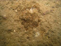
14.4.82 As illustrated in Table 2 of Appendix 14.9, 20 representative line transects of totally 6430 m were surveyed in spot-check dives. The underwater visibility at all surveyed sites was generally poor (< 2 m). The maximum water depth in all the surveyed sites ranged from 3 m to 22 m. Bottom substrata were mainly big boulders and rocks in shallow water but sand and mud in deeper water (see Photo 1 below).
Photo 1 Bottom Substrata of Kai Tak area

Boulders Rocks
Muddy
substrata
14.4.83 In all of the surveyed sites, only isolated colonies of a species of hard coral (Oulastrea crispata) were found at Sites 9, 11, 12, 13, 14, 16, 19 and 20, with extremely low coverage of less than 1% at each survey site. Neither soft coral nor black coral was identified during the recent spot-check dives.
14.4.84 More detailed REA surveys were then carried out
at Sites 9, 11, 12, 13, 14, 16, 19 and 20. Substrata at Sites 9, 11, 12, 13, 14
and 16 were mainly medium-sized boulders and rocks while Sites 19 and 20
comprised big boulders with fewer rocks. In general, the Victoria Harbour
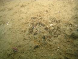
14.4.85 Very limited marine life was observed within all REA survey sites. Only sparse coverage (1-5%) of single hard coral species (Oulastrea crispata) was recorded during the REA survey. Most of the isolated colonies were attached on the surface of the boulders and rocks. All the colonies found were in fair health condition and ranged from less than 1 cm to 30 cm in diameter. In general, most of the colonies found were small in size (~3 cm to 8 cm) and some, at Sites 11, 12 and 13 were even less than 1 cm in diameter with only one single polyp (Photo 2). Most of the coral colonies were found to be covered by layer of sediment (Photo 3).
Photo 2 Colonies of Oulastrea crispata with single or few polyps
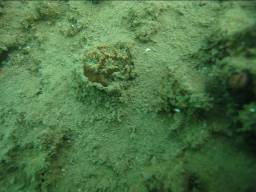
Photo 3 Layer of sediment covering on colonies of Oulastrea crispata
14.4.86 In general, the Project area is mainly composed
of muddy and sandy sea bottom with limited marine life, and is only sparsely
covered by scattered colonies of single coral species (Oulastrea crispata).
Oulastrea crispata has a wide range of adaptations to different
environmental conditions (including those unfavourable to corals) as well as
geographic locations, which is a result of its stress-tolerant ability (Chen, et
al. 2003). With an opportunistic life history trait, a wide range of
reproductive strategies and surface-orientation independent growth, O.
crispata is able to colonise a variety of substrata and to flourish as a
pioneer coloniser of newly immersed structures (Lam, 2000a & 2000b).
It is common and widespread in Hong Kong
marine waters, especially those more turbid and harsh environment in the
western waters (Chan, et al. 2005).
Marine Mammal
14.4.87 Literature review has shown that there were no
sighting or significant record of marine mammals within the Project area. One of the most important marine mammals
in Hong Kong waters is the Chinese White Dolphin (Sousa chinensis) which was only seen in the western estuarine
waters in Hong Kong including outer Deep Bay, north, south, Lantau and west
Lamma (Hung, 2007). The other
common marine mammal Finless porpoise (Neophocaena
phocaenoides) was also never reported in the Victoria
Harbour and only occurs in the eastern
and southern waters of Hong Kong (Hung,
2005). There is no significant
record of such marine mammals with high conservation importance in and within
the vicinity of the Project area.
Ecological Importance
14.4.88 Based on the available literatures and discussion presented above, the ecological values of terrestrial and marine ecological resources present within the Assessment Areas have been assessed and evaluated, in accordance with the EIAO-TM Annex 8 Table 2 criteria and are shown in Table 14.2 and Table 14.3.
Terrestrial Habitat
14.4.89 Terrestrial habitat types identified within the Assessment Area included wasteland, plantation/grassland mosaic, watercourse, developed area and artificial coastline.
14.4.90 Floral assemblages recorded in the Assessment
Area were common and widespread species found throughout the Hong
Kong region. The majority of vegetation recorded from the
wasteland area was also common and widespread ruderal species. Due to commonness
of the species recorded and the highly developed nature of Assessment Area,
vegetation found within the Assessment Area is considered to have a very low
ecological value.
14.4.91 Although a relatively high abundance of Black
Kite was recorded at the wasteland habitat, the wasteland habitat within
Assessment Area is not considered as an important habitat for this species.
The Black Kite is a Class II Protected Animal of the PRC but it is common
and widespread in the Hong Kong and there are
other similar sites available nearby, e.g. Causeway Bay Typhoon Shelter that
are commonly utilised by this species. The diversity and abundance of
other bird species was low and the species reported are common and widespread
in Hong Kong . The wasteland and
developed area are therefore considered to have very low ecological importance
due to their highly disturbed and man-made nature.
14.4.92 The plantation/grassland mosaic habitat is also
considered to have a very low ecological value as it is not a natural area and
the majority of trees and other vegetation are exotic species planted for
aesthetic purposes and therefore have little ecological value. As it is
the only highly vegetated area within the Assessment Area, it supported
relatively higher diversity of bird species which are common and widespread in Hong Kong . The ecological value of this habitat is
considered as very low due to their highly disturbed and man-made nature. The
redevelopment of the Project area under this Project would involve the
provision of district and regional open spaces that would include native
vegetation and tree species and thus provide large areas of suitable new
habitat for common bird species that currently utilise the existing habitat.
14.4.93 Watercourse identified in the Assessment Area is only man-made channel and mainly purposed for drainage use. Only very limited riparian vegetation of low ecological value was recorded and no fauna species was found from this habitat. This habitat was therefore considered of very low ecological value.
14.4.94 Although a number of waterbirds of conservation importance were recorded from the artificial coastline within the Assessment Area, especially at the KTAC and both typhoon shelters, this habitat is not considered as an important habitat and the sole roosting/feeding ground for these waterbirds in the vicinity of the Assessment Area where a number of similar roosting/feeding areas such as the Victoria Harbour and the Causeway Bay Typhoon Shelter can be identified. Also, given the poor marine water quality as described in the Marine Ecology Section and the existing high level of human disturbance, this habitat is therefore ranked as low in ecological significance.
Table 14.2 Criteria and Evaluation of Ecological Importance of Terrestrial Habitats in the Assessment Area
|
Criteria |
Wasteland |
Plantation/grassland mosaic |
Developed Area |
|
Naturalness |
Not natural, previously developed |
Relatively natural, although man-made habitat |
Not natural, highly disturbed urbanised area |
|
Size |
Large |
Small |
Large |
|
Diversity |
Low, species
recorded are common and widespread in |
Low, species recorded are
common and widespread in |
Low, species recorded are
common and widespread in |
|
Rarity |
No rare species found but 4
bird species of conservation importance including Grey Heron, Chinese Pond
Heron, Black Kite and Greater Coucal which are common and widespread in |
No rare species
found but 3 bird species of conservation importance including Little Egret,
Cattle Egret and Black Kite which are common and widespread in |
No rare species or
other species of conservation importance found |
|
Re-creatability |
Very High |
Very High |
Very High |
|
Fragmentation |
The habitat is not fragmented |
The habitat is not fragmented |
The habitat is not fragmented |
|
Ecological linkage |
Not functionally linked to any highly valued habitat in close proximity |
Not functionally linked to any highly valued habitat in close proximity |
Not functionally linked to any highly valued habitat in close proximity |
|
Potential value |
Very low |
Very Low |
Very Low |
|
Nursery ground |
No significant record |
No significant record |
No significant record |
|
Age |
NA |
NA |
NA |
|
Abundance / Richness of wildlife |
Low for abundance and species richness |
Low for abundance and species richness |
Low for abundance and species richness |
|
Ecological importance |
Very low |
Very low |
Very low |
Table 14.2 Criteria and Evaluation of Ecological Importance of Terrestrial Habitats in the Assessment Area
|
Criteria |
Watercourse |
Artificial coastline |
|
Naturalness |
Man-made habitat. |
Artificial, disturbed by marine traffic and human activities |
|
Size |
Small |
Moderate |
|
Diversity |
Very low floral diversity and no fauna recorded from this habitat during recent surveys. |
Low, species recorded are
common and widespread in |
|
Rarity |
No rare species or other species of conservation importance found |
No rare species recorded but 8 bird species of conservation importance including Little Egret, Great Egret, Grey Heron, Chinese Pond Heron, Black-crowned Night Heron, Cattle Egret, Great Cormorant and Black Kite which are common and widespread in Hong Kong were recorded |
|
Re-creatability |
Very high |
Very high |
|
Fragmentation |
The habitat is not fragmented |
The habitat is not fragmented |
|
Ecological linkage |
Not functionally linked to any highly valued habitat in close proximity |
Not functionally linked to any highly valued habitat in close proximity |
|
Potential value |
Very Low |
Very Low |
|
Nursery ground |
No significant record |
No significant record |
|
Age |
NA |
NA |
|
Abundance / Richness of wildlife |
Very low for abundance and species richness |
Moderate for abundance but low for species richness |
|
Ecological importance |
Very Low. |
Low |
Marine Habitat
14.4.95 Soft bottom seabed and artificial intertidal seawall are considered to have very low ecological importance based on the considerations of their highly disturbed and man-made nature, commonness of recorded species and low in species diversity and abundance.
14.4.96
Although hard coral (Oulastrea
crispata) was found in the subtidal habitat, this species is common in Hong Kong waters and tolerant to more turbid and harsh
environment (Chan, et al. 2005). The species diversity and
abundance of coral found in the Kai Tak area is extremely low when compared
with other coral areas in eastern and north eastern waters of Hong
Kong . In addition, most of the recorded colonies were
isolated and in low coverage (<1%) and small size (~3 cm to 8 cm).
Therefore, given the low abundance and species diversity as well as the
commonness of coral species found there, the subtidal habitat is considered as
having low ecological value and is not identified as an important habitat or
sensitive coral site in this assessment.
Table 14.3 Criteria and Evaluation of Ecological Importance of Marine Habitats in the Project Area
|
Criteria |
Soft bottom habitat |
Intertidal habitat (artificial) |
Subtidal habitat |
|
Naturalness |
Subjected to extensive anthropogenic disturbance |
Man-made habitat |
Highly disturbed by marine traffic, subjected to extensive water pollution |
|
Size |
Large |
Large |
Large |
|
Diversity |
Low, mainly dominant by pollution-tolerant fauna |
Low, mainly composed of few intertidal fauna |
Low, species confined to those resistant to polluted water |
|
Rarity |
No rare species found |
No rare species found |
No rare species found but only a single species of a common hard coral (Oulastrea crispata) was recorded |
|
Re-creatability |
High |
Very High |
High |
|
Fragmentation |
The habitat is fragmented by the former airport runway |
The habitat is not fragmented |
The habitat is fragmented by the former airport runway |
|
Ecological linkage |
Not functionally linked to any highly valued habitat in close proximity |
Not functionally linked to any highly valued habitat in close proximity |
Not functionally linked to any highly valued habitat in close proximity |
|
Potential value |
Very low |
Very low |
Very Low |
|
Nursery ground |
No significant record |
No significant record |
No significant record |
|
Age |
NA |
NA |
NA |
|
Abundance / Richness of wildlife |
Low for abundance and species richness |
Low for abundance and species richness |
Low for abundance and species richness |
|
Ecological importance |
Very low |
Very low |
Low |
14.5 Identification of Environmental Impacts
Terrestrial Ecological Impacts
Direct Impact
14.5.1 Potential ecological impacts during construction and operation of the Project would involve direct loss of habitats (permanent loss of 202.7 ha wasteland and 15.8 ha plantation/grassland mosaic and permanent and temporary loss of 0.7 km and 1.6 km artificial coastline, respectively) and associated vegetation. No potential impact to any terrestrial area of conservation importance was identified.
14.5.2 Under the worse case scenario, all existing vegetation and trees within the Project area would be cleared as part of the site formation works during construction works. Therefore there would be potential direct loss of all existing floral assemblages within the affected habitats resulting from the proposed development.
14.5.3 In addition, proposed excavation works at the Kai Tak Nullah would cause direct impact to the existing watercourse habitat during the construction phase of the Project.
Indirect Impact
14.5.4 Potential secondary impact on the waterbird populations within the Assessment Area may occur during the construction phase due to the reduced food availability arising from the potential change of marine water quality caused by the proposed marine works as discussed in detail below under the Marine Ecology Section (Para. 14.5.10 – 14.5.15 & 14.6.14 – 14.6.30).
14.5.5 Indirect disturbance impacts on
surrounding habitat and associated bird populations within the Assessment Area
may result from construction noise and increased human disturbance during both
construction and operation of the Project. Potential impact to other fauna
groups (butterfly, dragonfly, reptile, amphibian and mammal) is expected to be
minimal as only few species commonly found throughout Hong
Kong were recorded from the Assessment Area during recent
surveys.
Marine Ecological Impacts
14.5.6 The vast majority of works proposed under this Project (designated projects and non-designated projects) are terrestrial based and therefore potential impacts on marine ecological resources would mostly be resulted from deterioration of water quality due to surface runoff during construction activities. The impacts associated with surface runoff and subsequent deterioration of water quality are discussed below.
14.5.7 Works packages taking place under
the Project that would potentially impact on the marine environment include
decommissioning of an abandoned fuel dolphin, opening of a 600 m gap in the
northern part of the former runway, construction of public landing steps cum
fireboat berth, dredging works for the cruise terminal, dredging works for the
submerged tunnels of Road T2 and Central Kowloon Route (CKR) and the localised
maintenance dredging at KTAC as part of the KTAC odour remediation works.
Other concurrent projects involving dredging within the Victoria Harbour
14.5.8 No dredging works would be involved
for the decommissioning of the abandoned fuel dolphin and works would be small
in scale and undertaken within the semi-enclosure of the breakwaters of To Kwa
Wan typhoon shelter. Taking into account the small scale of the proposed
decommissioning works, no off-site marine water quality impact would be
expected and any local water quality impact would be transient. The
details are discussed in the approved EIA Report on Decommissioning of the Former Kai
Tak Airport
Direct Impact
14.5.9 Potential direct impacts on marine ecology arising from the Project would include loss of marine habitats and the associated marine species due to construction activities. This would include:
l Loss of 1.2 km (permanent loss of approximately 0.7 km and temporary loss of 0.5 km) of artificial seawall as a 600 m gap would be opened at the northern part of the former runway (600 m loss on either side of the runway).
l Temporary loss of small area (approximately 2 hectares) of soft bottom seabed and subtidal habitat during dredging, on either side of the 600 m runway gap, to remove built up sediment.
l Temporary loss of approximately 1.1 km long artificial seawall due to construction of the berthing structure of the cruise terminal and the public landing steps cum fireboat berth.
l Temporary loss of approximately 57.6 hectares (including 57 ha dredging area for the manoeuvring basin of the cruise terminal and 0.6 ha for public landing steps cum fireboat berth) of soft bottom seabed and subtidal habitat at Kowloon Bay of Victoria Harbour near the southern tip of former Kai Tak Airport runway.
l Temporary loss of approximately 5.8 hectares of soft bottom seabed and subtidal habitat (including 1.4 ha dredging area along proposed alignment of Central Kowloon Route (CKR), 4.1 ha along Road T2 alignment and 0.3 ha along the reconstructed section of Kwun Tong submarine outfall) at TKWTS, KTTS and Victoria Harbour.
l Temporary loss of approximately 9 hectares of soft bottom seabed and subtidal habitat in the KTAC due to localised dredging at KTAC as part of the KTAC odour remediation works.
Indirect Impact
Changes in water quality
14.5.10 Possible indirect impact on intertidal and subtidal habitats may include water quality deterioration due to sediment laden surface runoff from land based construction activities or the siltation effects during dredging works. Marine fauna especially sessile filter feeders are susceptible to deleterious impacts from sedimentation through smothering and clogging of their respiratory and feeding apparatus. Similarly, more turbid water may reduce the amount of light reaching beneath the water surface, which may also be detrimental to marine flora and fauna. This may result in both direct (e.g. mortality) and indirect (e.g. slow growth rate, low in reproductive success rate) impacts on marine life and may eventually cause the reduction of population size of marine assemblage.
14.5.11 To assess the impacts associated with elevated SS, the assessment was based on compliance with the statutory Water Quality Objectives (WQOs) for the concerned Water Control Zones, which is set for among other reasons, to offer protection for marine ecological resources. Water quality modelling predictions were analysed for compliance with the WQOs through comparison of worst case scenario’s SS level against baseline levels. Using this criterion, if the elevation in SS levels exceeds 30% above ambient baseline conditions, adverse impacts would be expected and suitable mitigation should be pursued.
14.5.12 There are no WQOs regarding sedimentation rates. To assess impacts due to sediment deposition on far-field ecological sensitive receivers, the sedimentation rate of not exceeding 100 mg cm-2 per day (or 0.1 kg m-2 per day) which was also adopted in other EIA studies in Hong Kong for ecological resources conservation (Hyder, 1997; ERM, 2001; Black & Veatch, 2006), is considered as suitable for coral protection in this assessment.
14.5.13 As bottom sediment is disturbed during dredging activities and particles released into the water column, organic and inorganic contaminants contained in the sediment may be released to the water column. Released contaminants may cause toxic effects to marine fauna.
14.5.14 In addition, the release of inorganic substances may cause eutrophication and algal bloom. Oxidation of dead algae may use up some of the oxygen in the water. If oxygen levels are depleted to low levels, benthic organisms unable to tolerate such conditions may suffer hypoxia-induced mortality and / or stress including reduced feeding and growth rate. The WQO standard that the average-depth and bottom water DO should remain above 4 mg/L and 2 mg/L respectively for 90% of the time was adopted.
14.5.15 In-situ bioremediation is being considered to suppress odour generated from the contaminated sediment along the seabed of KTAC. The major environmental concerns associated with in-situ bioremediation are the potential release of nitrate-nitrogen, ammonia and heavy metal contaminants from the sediments into the surrounding water bodies during the bioremediation activities. The impacts associated with the release of nitrate-nitrogen, ammonia and contaminants contained within the sediment have been discussed in Section 8.7.21 – 8.7.22.
14.6 Prediction and Evaluation of Environmental Impacts
Terrestrial Ecology
14.6.1 In general the impacts resulting from the proposed development are considered to be minor as all the affected terrestrial habitats are highly man-made and mainly consists of open sparsely-vegetated wasteland and plantation/grassland mosaic area. These habitats supported very limited assemblage of common flora and fauna and are considered of very low in ecological values. Thus the proposed redevelopment is not expected to have any significant adverse impacts on terrestrial ecological resources.
Direct Impact
14.6.2 Direct loss of all wasteland (202.7 ha) and plantation/grassland mosaic (15.8 ha) habitats within the Project area and indirect disturbance impact to the associated avifaunal assemblages would occur during the construction phase. Yet as the wasteland area is almost totally concreted and the plantation/grassland mosaic area is highly man-made, these areas are not considered to be primary habitats for those common bird species recorded during recent surveys. Direct loss of all these habitats of very low ecological values is considered very minor in nature. Beside, after the construction phase, about 127 ha open spaces with native trees and vegetation would be provided within the Project area, which are considered to be more favourable habitat for the uses of existing bird populations. Thus potential construction phase impact on the associated bird assemblages would only be minor and temporary.
14.6.3 There were more than 6000 trees of mainly exotic species with very low ecological importance such
as Leucaena leucocephala scattering throughout the Assessment Area.
According to the Landscape and Visual Impact Assessment of this EIA study
(S13.11.2 refers), it is estimated that about 2250 existing trees in habitats
of wasteland, plantation/grassland mosaic and developed area within the Project
area would be directly impacted by the Project. Although removal of these trees
would be unavoidable, all of the affected species are very common and
widespread in Hong Kong . The potential impact
due to the direct loss of vegetation is therefore considered minor in nature.
Besides, as far as possible, such impact would be mitigated by compensatory
planting after the construction works as described in Para .
14.7.2.
14.6.4 A total loss of about 2.3 km long artificial
coastline would be resulted from the proposed opening of 600 m gap at the
northern part of the former runway (1.2 km loss) and construction of the
berthing structure of the cruise terminal and the public landing steps cum
fireboat berth at the southern tip of runway (1.1 km loss). Although a number
of waterbird species were recorded from this habitat, all of them are common
and widespread species in Hong Kong . In
addition, reconstruction of new artificial coastline of totally 1.6 km long
would be provided as far as possible to recover loss of this habitat after the
construction phase. Nevertheless, considering its low ecological value,
permanent loss of a short length (0.7 km, ~ 4%) of this habitat is not expected
to result in significant adverse impact to the existing waterbird populations
in the Assessment Area.
14.6.5 Direct impact to the channel bed of existing watercourse habitat would occur during the proposed excavation works at the Kai Tak Nullah. Currently, the identified watercourse is highly concrete channel with very limited riparian floral species recorded. No rare, protected species or other species of conservation importance was recorded from this habitat. Considering the temporary nature of the proposed works and the very low ecological value of watercourse habitat, such impact is considered very minor in nature.
Indirect Impact
14.6.6 Potential secondary impact on
waterbirds may be resulted from reduced food availability within the Assessment
area caused from deterioration of marine water quality during the proposed
marine works. However alternative similar habitats, such as To Kwa Wan, Hung
Hom and Causeway Bay Typhoon Shelter are available nearby, and easily accessible to these bird
species, which are able to move easily between foraging sites (Carey et al, 2001). All the bird species of conservation importance
and other recorded species are common and widespread in Hong
Kong and thus impacts on avifaunal species is expected to be minor
and acceptable.
14.6.7 Indirect disturbance impacts to the nearby habitats (i.e. developed area) and the associated wildlife in and surrounding the Project area would be resulted from the increased human activities / noise disturbance during the construction and operation phases. Such impacts could be arisen from noise-generating machinery during excavation, demolition and other marine-/land-based construction works and general increases in human activity during and after the construction. However, in view of that the terrestrial habitat (i.e. developed area) and the associated wildlife surrounding the Project area, are considered to have very low ecological value as this habitat is highly developed and already subjected to major anthropogenic disturbance, the associated wildlife is considered to be well adapted to noise and human disturbance and such impact is considered to be very minor in nature.
Marine Ecology
Direct impact
14.6.8 Direct impacts to marine ecological resources
would include permanent loss of 0.7 km of artificial sea wall habitat, as a 600
m gap would be opened in the runway. Initially 1.2 km of the artificial
intertidal habitat would be removed but once the gap has been opened,
approximately 0.25 km of artificial intertidal habitat would be provided at
each side of the gap (in total 0.5 km new intertidal habitat), which would be
available for recolonisation by intertidal species. Intertidal species recorded
in the affected area are very common and widespread in Hong
Kong and the seawall habitat within the assessment area is thus
considered to have a very low ecological value. No species of
conservation importance were recorded during the intertidal surveys. The
opening of the runway gap is expected to increase water circulation and hence
to improve the water quality in the Kai Tak Approach Channel. As this
habitat is considered to have a very low ecological value and the opening of
the runway gap is expected to improve water quality in the Kai Tak Approach
Channel which could in turn increase diversity in this area, the loss of this
habitat is considered to have a minor and acceptable impact on marine
ecological resources.
14.6.9 Localized dredging work, to remove built up sediment on either side of the runway gap (once opened) would lead to a temporary loss of 2 ha of soft bottom and subtidal habitat.
14.6.10 In addition, construction of the submarine sections of the CKR and Road T2 as well as the reconstruction of a section of the Kwun Tong submarine outfall would also involve localized dredging activities at the TKWTS, KTTS and Victoria Harbour, and lead to temporary loss of 1.4 ha, 4.1 ha and 0.3 ha, respectively, of the soft bottom and subtidal habitat.
14.6.11 The KTAC odour remediation works would include localised maintenance dredging activities at selected areas of the KTAC and would result in temporary loss of about 9 ha of soft bottom and subtidal habitat in these areas as well.
14.6.12 The marine works for construction of the cruise terminal and public landing steps cum fireboat berth would lead to the temporary loss of approximately 57 ha and 0.6 ha, respectively, of soft bottom and subtidal habitat due to dredging.
14.6.13 The cruise terminal together with the public landing steps cum fireboat berth works would also lead to temporary loss of approximately 1 km and 0.1 km, respectively of artificial intertidal habitat due to reconstruction of the seawall.
14.6.14 Temporary loss of these habitats would only
cause minor impact on the marine ecological system in and within the vicinity
of the Project area, considering the generally very low ecological values of
the soft bottom seabed, subtidal and intertidal (artificial) habitats as well
as the associated flora and fauna species as discussed above. The only species of conservation
importance identified in these affected habitats are the small and isolated
hard coral colonies (Oulastrea crispata)
which would unavoidably be affected by the dredging works described above. To avoid and minimise direct loss or
damage of this species of conservation importance, it is recommended to
translocate those existing coral colonies attached on rocks / boulders located
in the hard substrata sea area within those dredging sites (Figure 14.3)
to the other suitable locations as far as possible. As Oulastrea
crispata is not a competing and aggressive species (Lam, 2000a ), this species is not expected to have
any negative pressure on the other existing corals in the recipient site(s) and
it is considered suitable for translocation. Considering the commonness and
opportunistic nature of this coral species that can rapidly recruit and settle
on available hard substrate, particularly in marine water of high current
movement and particulate matter, removal of some of these small and isolated
coral colonies of low ecological value as a result of the dredging works is
considered to be of minor ecological impact and acceptable.
14.6.15 Nevertheless, based on their opportunistic nature, rapid recruitment and settlement of Oulastrea crispata is expected to occur on the available substrates of the newly-formed seawalls after the construction work. Other similar benthos, subtidal and intertidal communities are also expected to naturally re-colonise in the Project area after dredging activities and this would recover such minor impact identified in this assessment.
14.6.16 Taking into account all of the mitigation measures proposed including coral translocation and provision of newly constructed seawalls, all the marine habitats and associated flora and fauna including some small and isolated coral colonies that would be directly affected due to this Project are all of low ecological values and therefore such impact is considered as minor.
Indirect impact
Changes in water quality
Elevation of Suspended Sediments
14.6.17 Site runoff would potentially contain a high level of sediment. If this is discharged into the marine environment, it could lead to deterioration in water quality which could negatively affect corals and other marine organisms. If standard good site practice is implemented and all site runoff is discharged through sediment and silt traps, no adverse impact is expected on marine ecological resources.
14.6.18 Indirect impacts on coral and marine ecology would also be associated with changes of water quality due to dredging activities. Dredging activities would be necessary for the following works associated with the Kai Tak Development:
l Construction of cruise terminal (capital and maintenance dredging)
l Construction of public landing steps cum fireboat berth
l Opening of runway gap (dredging along the seawalls)
l Submerged tunnels of Road T2 and CKR
l Reconstruction of a section of the Kwun Tong submarine outfall
l Localised maintenance dredging at KTAC as part of KTAC odour remediation works
14.6.19 Possible concurrent dredging activities that would also affect the Project include:
l Submarine gas main relocation
l Wan Chai Reclamation Phase 2
l
l Further Development of Tseung Kwan O
l Lei Yue Mun Waterfront Enhancement
14.6.20 Dredging activities would temporarily elevate the suspended sediment level and create sediment plumes. Benthic epifauna could be susceptible to the effects of increased sediment loads. Effects could be lethal or sublethal through reduction in survivorship, growth rate and reproductive potential due to stress incurred by the need to constantly flush out deposited material. The effects of sedimentation on organisms depend on several factors, such as species tolerance to suspended solids, life modes of organisms (sessile or free-swimming) and water movement.
14.6.21 In order to assess the nature and extent of potential impacts on marine ecological resources resulting from dredging activities associated with the Kai Tak Development and other possible concurrent projects as identified above, representative worst case scenarios were selected for water quality modelling. The scenarios modelled covered all possible concurrent dredging works and the assessment results were presented in Section 5 of the approved EIA Report on Dredging Works for Proposed Cruise Terminal at Kai Tak (EIAO Register No. AEIAR-115/2007).
14.6.22 In order to open the runway gap, bulk fill material would be excavated from the area between the seawalls. This excavation work would take place behind the seawalls and thus any sediment plume resulting from the excavation would be confined to the works area and would not cause deterioration in water quality outside the seawall. However once the central area has been excavated, the seawalls would have to be demolished. This would involve removal of gravel only, which would not create significant SS impact. Loss of fill material during seawall demolition is not expected and therefore the demolition of the seawall would not cause deterioration in water quality. Thus the opening of the runway gap is not expected to have any adverse indirect impacts on marine ecological resources.
14.6.23 It is likely some accumulation of sediments alongside the runway has occurred, so there will be a need to dredge the existing seabed along the seawalls during the seawall demolition works. Thus, potential water quality impact of SS will arise from the dredging on either side of the 600m opening along the seawalls. The dredging alongside the 600m opening has been included in the water quality modelling scenarios for cumulative assessment.
14.6.24 Based on the prediction of the sediment plume
modelling for the unmitigated scenarios under the water quality impact
assessment as presented in the approved EIA Report on Dredging Works for
Proposed Cruise Terminal at Kai Tak, potential water quality impact due to
elevation of SS would occur at coastal waters of the Kowloon Bay
14.6.25 Impact from the dredging works identified above are not expected to occur at far field ecological sensitive receivers including the coral areas located in the vicinity of Green Island, Little Green Island, Junk Bay and Tung Lung Chau. With the mitigation measures detailed in Section 8.8 of this report, full compliance with the relevant assessment criteria will be achieved and thus no significant adverse impact is expected on far field ecological sensitive receivers.
Contaminant Release During Dredging
14.6.26 As sediment in the Project area is contaminated with heavy metals and organic pollutants, turbulence caused by dredging activities could release these substances to the water column. Increase of toxic substances in water could cause lethal or sublethal effects to subtidal fauna. Degree of toxic level depends on a number of factors e.g. species tolerance, contaminant levels, water flow rate, etc.
14.6.27 In-vitro laboratory assessment of sediment samples indicated that the concentrations of cadmium, copper, nickel, mercury, unionised ammonia and total inorganic nitrogen contaminants exceeded the assessment criteria. However the laboratory tests do not take into account the dilution factor after the contaminants are released into the water column. Water quality modelling results predict that levels of contaminants would be much lower than the relevant standards at monitoring sites nearby the source. This is because any contaminants released during dredging are immediately diluted by the large volume of marine water within the dredging site. Thus, it is considered that long-term off-site marine water quality impact will not occur and any local water quality impact will be transient.
14.6.28 As subtidal fauna like fish and crab are mobile, it is likely that they would avoid the dredging area and re-colonise after the marine works. Furthermore, similar refuge habitat was available in the nearby coastal waters for the affected fauna. Thus, major impact due to release of contaminant on subtidal organisms is not expected.
Increased Level of Nutrients and Decrease in Dissolved Oxygen (DO)
14.6.29 Nutrient level (inorganic nitrogen and phosphorous) may also increase during dredging activities. High levels of nutrients in seawater can cause rapid increases in phytoplankton often to the point where an algal bloom occurs. An intense bloom of algae can lead to sharp decreases in the levels of DO in the water as dead algae fall through the water column and decompose on the bottom. Anoxic conditions may result if DO concentration is already low or is not replenished. This may result in mortality to marine organisms due to oxygen deprivation.
14.6.30 Based on results of the water quality modelling as presented in the approved EIA Report on Dredging Works for Proposed Cruise Terminal at Kai Tak, the possible concurrent dredging activities would cause a maximum DO depletion of less than 0.02 mg/l in the Victoria Harbour as compared to the WQO of 4 mg/l and 2mg/l for depth-averaged and bottom DO respectively. The water quality impact assessment also predicted that the maximum elevation of total inorganic nitrogen and unionized ammonia caused by the proposed dredging works would fully comply with the WQO of 0.4mg/l and 0.021mg/l respectively at the receiving water near to the Project site. Therefore, the Project would not contribute any off-site DO and nutrient impacts.
14.6.31 As discussed above, the soft bottom benthic habitats and the associated benthic and subtidal communities in the Project area are of relatively low ecological significance (very low to low value), so impact due to elevation of nutrients level and DO depletion on the associated marine fauna is not expected to be significant.
Maintenance Dredging for Cruise Terminal
14.6.32 Maintenance dredging will be required during operation of the proposed cruise terminal at a frequency of about once every 5 to 10 years. The frequency of maintenance dredging and the volume of dredged material would be much lower than during capital dredging for the cruise terminal. With reference to the approved EIA Report on Dredging Works for Proposed Cruise Terminal at Kai Tak, maintenance dredging is not expected to have any adverse effect on marine ecological resources with the implementation of the water quality mitigation measures recommended for capital dredging.
Sediment Treatment/Bioremediation of Kai Tak Approach Channel
14.6.33 Based on a pilot scale field test carried out in the KTAC in 2006, no significant adverse impact on water quality is expected from sediment treatment/bioremediation works at the KTAC (see Section 8.7.21 – 8.7.22).
Overall impact
14.6.34 Based upon the foregoing discussion, the terrestrial and marine ecological impacts associated with the Project are considered to be minor. A summary of impact evaluation is presented in Tables 14.4 and 14.5.
Table 14.4 Evaluation of Ecological Impacts on Terrestrial Resources
|
Criteria |
Direct Impact to Habitats and Associated Vegetation |
Indirect Disturbance Impact to Nearby Habitat and Fauna |
Potential Impact to Waterbirds due to Reduced Food Availability |
|
Impacted habitat |
Wasteland, Plantation/grassland mosaic, Watercourse and Artificial coastline |
Developed Area |
Artificial coastline |
|
Habitat quality |
Very low to low |
Very low |
Low |
|
Species |
No rare, protected or other flora species of conservation importance would be directly affected. |
No rare, protected or other species of conservation importance would be affected. |
A total of 8 avifaunal species of conservation importance may be affected |
|
Size / Abundance |
Permanent loss of 202.7 ha wasteland and 15.8 ha plantation/grassland mosaic. Permanent loss of 0.7 km and temporary loss of 1.6 km artificial coastline. Temporarily direct impact to 1.5 km watercourse. About 2250 scattered tree individuals would be removed. |
Large in size (614.8 ha) but low in abundance |
Moderate in size (15.7 km) but moderate in abundance |
|
Duration |
Wasteland and Plantation/grassland mosaic – long term. Artificial coastline – long term / short term. Watercourse – short term. |
Short term |
Short term |
|
Reversibility |
Wasteland and Plantation/grassland mosaic – permanent and irreversible. Artificial coastline – permanent and irreversible / temporary and reversible. Watercourse – temporary and reversible. |
Temporary and reversible. |
Temporary and reversible. |
|
Magnitude |
Minor |
Minor |
Minor |
|
Overall impact |
Very Low |
Very low |
Very low |
Table 14.5 Evaluation of Ecological Impacts on Marine Resources
|
Criteria |
Habitat loss |
Change in water quality |
|
Impacted habitat |
Benthic, subtidal and intertidal (artificial) habitats |
Subtidal and intertidal habitats |
|
Habitat quality |
Very low to low |
Very low to low |
|
Species |
Only small and isolated colonies of single hard coral species would be affected |
Only small and isolated colonies of single hard coral species would be affected |
|
Size / Abundance |
Permanent loss of 0.7 km of artificial seawall habitat and temporary loss of 0.5 km of artificial seawall habitat and 2 ha of seabed due to opening of a runway gap. Temporary loss of 57.6 ha seabed habitat as well as 1.1 km artificial seawall habitat as a result of construction of cruise ship terminal and public landing steps cum fireboat berth Temporary loss of 1.4 ha, 4.1 ha and 0.3 ha seabed habitat due to construction of submersed CKR, Road T2 and reconstructed section of Kwun Tong submarine outfall, respectively. Temporary loss of 9 ha seabed habitat due to localised maintenance dredging at KTAC as part of KTAC odour remediation works |
Moderate in size |
|
Duration |
Long term and short term |
Short term |
|
Reversibility |
Permanent and irreversible / temporary and reversible. |
Temporary and reversible. |
|
Magnitude |
Minor |
Minor |
|
Overall impact |
Low (with mitigation measures) |
Low (with mitigation measures) |
14.7 Mitigation of Environmental Impacts
14.7.1 According to EIAO-TM Annex 16, ecological impacts on habitats and the associated wildlife, especially on those important habitat and species of conservation importance, caused by the proposed works should be mitigated to the maximum practical extent. Following EIAO-TM Annex 16 and EIAO Guidance Note No. 3/2002, mitigation measures are discussed in this section to avoid, minimize, and compensate for the identified ecological impacts, in the order of priority.
Terrestrial Ecology
14.7.2
As far as possible, it is recommended that
implementation of compensatory planting of similar composition of native trees
and vegetation within the Project area should be provided after the
construction works. The compensatory ratio should be not less than 1:1 in terms
of quality and quantity. Under the Recommended Outline Development Plan (RODP)
of the Project (Figure
1.1), a total
of approximately 127 ha areas within the Project area are designed as open
spaces, including a 24 ha Metro
Park
Marine Ecology
Avoidance
14.7.3 The dredging areas on seabed and seawalls are proposed to be as minimal as possible in order to avoid extensive direct impact on existing benthic and intertidal resources within the Project area.
Minimization
14.7.4 Recent dive surveys revealed that
coral colonies that would be directly affected by the proposed dredging works
for the cruise terminal and dredging works associated with the opening of the
runway gap were low in species diversity (only one species) and coverage (1 –
5%), with generally small-sized colonies and common species recorded. The subtidal habitat was therefore
considered as low ecological value.
Nevertheless, to avoid and minimize any direct loss or damage to this
fauna of conservation importance, it is recommended to translocate the
potential directly affected coral colonies within the dredging sites (Figure 14.3)
attached on small rocks and boulders that are manually movable by a diver
underwater (possibly longest dimension less than 50 cm ) as far as practical to the nearby suitable habitats
such as Junk Bay where similar hydrographic condition and healthy coral
community of the same coral species were recorded. The translocation exercise should be
conducted before the commencement of construction phase of the Project and in
winter season (from November to March) in order to avoid disturbance to the
transplanted colonies during the spawning period (i.e. July to October). A detailed translocation plan (including
pre-translocation coral survey, translocation methodology, monitoring of transplanted
corals, etc.) should be prepared during the detailed design stage of the
Project and approved by AFCD prior to translocation. All the translocation exercises should
be conducted by experienced marine ecologist(s) who is/are approved by AFCD prior
to commencement of coral translocation.
14.7.5 The mitigation measures for coral colonies to be implemented for the dredging works for the proposed cruise terminal are detailed in the approved EIA Report and Environmental Monitoring and Audit (EM&A) Manual on Dredging Works for Proposed Cruise Terminal at Kai Tak. The proposed coral recipient site for the translocation of coral associated with the dredging works for the proposed cruise terminal is indicated in the approved EIA Report on Dredging Works for Proposed Cruise Terminal at Kai Tak (see Figure 14.4 in this report).
14.7.6 During dredging operations, a number of mitigation measures to control water quality impacts would be adopted to confine sediment plume within the proposed dredging areas and to minimize indirect impact to the nearby intertidal and subtidal flora and fauna. Recommended mitigation measures include the following:
l Installation of silt curtains around the dredgers, where appropriate, during dredging activities; and
l Use of closed grab dredger.
14.7.7 These proposed water quality control measures are expected to prevent substantial changes in water quality, and only minimal ecological impacts on marine environment and associated wildlife would result. As the recorded coral species found within the Project area are in very low coverage and abundance, and it can tolerant to more turbid water and high sedimentation, indirect impact on existing coral colonies due to change of water quality during the dredging activities would be considered as minor and insignificant.
14.7.8 As recommended under the water quality impact assessment of the approved EIA Report on Dredging Works for Proposed Cruise Terminal at Kai Tak, the maintenance dredging for the proposed cruise terminal should not be programmed in wet seasons (April to September) to minimize the potential water quality impacts. .
Other Measures
14.7.9 As described previously, impact of loss of artificial seawall habitats within the proposed dredging areas would largely be recovered since the re-construction of new seawalls would provide large area of hard substrata for settlement and recruitment of intertidal and subtidal assemblages similar to those previously recorded from existing habitats. As Oulastrea crispata is regarded as pioneer species and opportunistic in nature, it is very likely that coral recruitment and settlement of this species would be established rapidly within the Project area after the proposed marine works.
14.8 Evaluation of Residual Environmental Impacts
Terrestrial Impact
14.8.1 Residual impacts include net loss of
202.7 ha wasteland, 15.8 ha plantation/grassland mosaic and 0.7 km artificial
coastline habitats. These habitats are considered to have limited
ecological importance and upon completion of the Project most of these habitats
would be replaced by new vegetated habitats in the proposed open space areas
including the Metro
Park
Marine Impact
14.8.2 With the effective implementation of mitigation measures proposed in Section 14.7 above, residual impacts to marine ecology are expected to be relatively minor. The loss of artificial intertidal habitats would be largely recovered through the provision of the new seawall, which would provide suitable conditions for recolonisation by intertidal and subtidal flora and fauna. The translocation of those directly affected corals that are attached on movable boulders would minimise impacts to this species of conservation importance potentially affected by the proposed marine works. The most substantial residual impact would therefore be the loss of soft bottom benthic habitat, which is unavoidable. However, this habitat and the associated fauna are not considered of particular importance in terms of ecological value. Therefore, residual impacts resulting from the proposed marine works are considered as minimal and acceptable.
14.9 Evaluation of Cumulative Environmental Impacts
Terrestrial Impact
14.9.1 Potential cumulative impact on terrestrial ecological resources would be the cumulative disturbance impact to the nearby habitat (i.e. developed area) and the associate wildlife, especially birds arising from the increased level of human activities and noise during the construction and operation phases of the concurrent construction projects in the vicinity. Taking into account the highly developed nature and existing high level of disturbance in the Assessment Area, no unacceptable cumulative impact would be anticipated.
Marine Impact
14.9.2 There are a number of possible concurrent
construction projects involving dredging and marine works that would be
conducted in the vicinity of the Project area that may have cumulative effects
on the deterioration of water quality in the Victoria Harbour
14.10 Environmental Monitoring and Audit
Terrestrial Ecology
14.10.1 As only minor impacts on terrestrial ecology are identified in this assessment, no monitoring programme specific for terrestrial ecology is required under this Project.
Marine Ecology
14.10.2
To avoid and minimise
potential loss of small and sparsely distributed coral colonies found in the
Project area, it is recommended to translocate the directly affected corals
within the Project area, as far as practicable, to the nearby suitable habitat
such as Junk Bay
14.10.3 It is recommended to implement monitoring of the transplanted corals after translocation, every 3 months for one year (this follows previous examples of post-translocation monitoring methodology, proposed in the EM&A Manual for Dredging Work for Proposed Cruise Terminal at Kai Tak). Information gathered during each post-translocation monitoring survey should include observations on the presence, survival, health condition and growth of the transplanted coral colonies. Oulastrea crispata is not expected to grow significantly over the one year monitoring period but previous study (Lam, 2000) has shown it to have a growth rate of 0.9-1.04 mm per month and thus, growth should be detectable over the 12 month post-translocation monitoring period. These parameters should then be compared with the baseline results collected from the pre-translocation survey.
14.10.4 The mitigation measures for coral colonies to be implemented for the dredging works for the proposed cruise terminal are detailed in the approved EIA Report and Environmental Monitoring and Audit (EM&A) Manual on Dredging Works for Proposed Cruise Terminal at Kai Tak.
14.11 Summary
Terrestrial Ecology
14.11.1 Literature review and recent reconnaissance surveys identified five habitat types within the Assessment Areas of this Project, including developed area, wasteland, plantation/grassland mosaic, watercourse and artificial coastline. Considering their highly artificial and disturbed nature, all the identified habitats are considered of very low to low in ecological values.
14.11.2 No
area of conservation importance is located within the Assessment Area. However,
nine bird species of conservation importance, including Little Egret, Great
Egret, Cattle Egret, Grey Heron, Black-crowned Night Heron, Chinese Pond Heron,
Great Cormorant, Black Kite and Greater Coucal were recorded in the Assessment
Areas during the recent surveys. All the recorded species of conservation
importance are common and widespread in Hong Kong .
14.11.3 Permanent
loss of 202.7 ha of wasteland, 15.8 ha of plantation/grassland mosaic and 0.7
km artificial coastline in the former Kai Tak Airport
14.11.4 Other impact of the Project would be the removal of about 2250 existing trees within the Project area. However, as all of the affected trees are common and widespread species of low ecological importance, potential impact to the vegetation was considered low. No protected species or other flora of conservation importance would be affected under this Project. To mitigate such impact, it is recommended that, as far as possible, compensatory planting should be provided in a ratio not less than 1:1 in terms of quality and quantity after the construction works.
14.11.5 Other potential impacts arising from the Project would be mostly temporary and recovered after the completion of the Project. Overall, no significant and unacceptable impact on terrestrial ecological resources was expected under this Project.
Marine Ecology
14.11.6 Literature reviews of existing information with
supplement findings from recent field surveys indicated that identified marine
habitats within the Project area are of generally very low ecological
value. There are no ecological sensitive receivers, such as SSSIs, Fish
Culture Zones and Marine
Parks
14.11.7 Marine habitats within the Project area include
soft bottom seabed, artificial seawalls and subtidal habitats. All the
identified habitats are considered to have a generally very low ecological
value due to their highly artificial and disturbed nature. Species
diversity and abundance in these habitats were low and no rare or restricted
species was recorded. The species of conservation importance recorded
within the Project area only include a single species of common hard coral (Oulastrea
crispata) (but all colonies found are small in size, sparsely distributed
and in very low coverage). All these species of conservation importance
recorded within the Project area are common and widespread in other Hong Kong waters.
14.11.8 Direct and indirect ecological impacts arising from the Project were identified and evaluated. The Project will result in the temporary loss of approximately 74.4 hectares of soft bottom benthic and subtidal habitats, temporary loss of about 1.6 km long of artificial intertidal habitat and permanent loss of about 0.7 km long of artificial intertidal habitat. Considering that the benthic, subtidal and intertidal habitats within the affected areas are of generally very low ecological value and direct impact on some isolated coral colonies would largely be mitigated by translocation, no significant adverse impact is expected.
14.11.9 Other indirect impacts arsing from the Project would be temporary and minimised with implementation of proper mitigation measures. Overall, no significant and unacceptable ecological impact on marine resource is anticipated in this assessment.
14.12 References
Atkins China Ltd. (1999). Central Reclamation, Phase III, Studies, Site Investigation, Design and Construction. Comprehensive Feasibility Study for Minimum Option: Final Key issues and Initial Environmental Impact Assessment Report.
Binhai Wastewater Treatment & Disposal (HK) Consultants Ltd. (2000). Agreement CE 52/95 Strategic Sewage Disposal Scheme Environmental Impact Assessment Study Report.
Black & Veatch. (2006). Agreement No. CE 25/2002(DS) Drainage
Improvement in Northern
Blackmore, G.R. (1999). The importance of feeding ecology in
investigating accumulated heavy metal body burdens in Thais clavier (KUSTER)
(mollusca: neogastropoda: muricidae) in
Carey, G.J., Chalmers, M.L., Diskin, D.A., Kennerley, P.R., Leader,
P.J., Leven, M.R., Lewthwaite, R.W., Melville, D.S., Turnbull, M., Young, L.
(2001). The Avifauna of
CDM (2004). Environmental and Engineering Feasibility Assessment Studies in Relation to the Way Forward of the Harbour Area Treatment Scheme, Working Paper No.3 & 9.
Chan, A. L.K., Chan, K.K., Choi, C.L.S., McCorry, D., Lee, M.W. and Ang.
P. Jr. (2005). Field Guide to Hard Corals of
CityU Professional Services Limited. (2002). Agreement No. CE 69/2000 Consultancy Study on Marine Benthic Communities in Hong Kong Final report submitted to Agriculture, Fisheries and Conservation Department.
Chan, H. M., Rainbow, P. S. and Phillips, D. J. H. (1990).
Barnacles and mussels as monitors of trace metal bio-availability in
DeVantier, L. M., De’ath, G., Done, T. J. and Turak, E. (1998).
Ecological Assessment of a Complex Natural Systems: A Case Study from the
Environmental Protection Department (2006). Marine Water Quality
in
ERM. (1998). Fisheries Resources and Fishing Operations in Hong Kong Waters. Report to the Agriculture & Fisheries Department.
ERM. (2001) Focused cumulative water quality impact assessment of sand dredging at the West Po Toi Marine Borrow Area Final Report.
Fellowes, J.R., Lau, M.W.N., Dudgeon, D., Reels, G.T., Ades, G.W.J.,
Carey, G.J., Chan, B.P.L., Kendrick, R.C., Lee, K.S., Leven, M.R., Wilson,
K.D.P. & Yu, Y.T. (2002) Wild animals to watch: Terrestrial and freshwater
fauna of conservation concern in Hong Kong. Memoirs of the
HKBWS (2005) Egretry counts in
Ho, Y. B. (1987). Ulva lactuca (Chlorophyta, Ulvales) in
Hung, K.H. (2007). Monitoring of Chinese White Dolphin (Sousa chinensis) in Hong Kong Waters – Data Collection. Final report submitted to Agriculture and Fisheries Conservation Department.
Hung, K.H. (2005). Monitoring of Finless Porpoises (Neophocaena phocaenoides) in Hong Kong Waters (2003-2005). Final report submitted to Agriculture and Fisheries Conservation Department.
Karsen, S. J., Lau, M. W. N. and Bogadek, A. 1998.
Kwan, S. P. (1999) Heavy metals in
Lam, K.K.Y. (2000a). Early growth of a pioneer recruited coral Oulastrea
crispata (Scleractinia, Faviidae) on PFA-concrete blocks in a marine
Lam, K.K.Y. (2000b). Sexual reproduction of a low-temperature tolerant
coral Oulastrea crispata (Scleractinia, Faviidae) in
Lee, S. Y. (1985). The population dynamics of the green mussel,
Perna viridis, (L.) in
Lee, S. Y. and Morton, B. (1985). The Hong Kong Mytilidae.
Proceedings of the Second International Workshop on the Malacofauna of Hong
Kong and Southern China,
Maunsell (2005). Agreement No. CE 87/2001 (CE) Further development on Tseung Kwan O feasibility study EIA final report.
Maunsell (on-going). Agreement No. CE 54/2001 (CE) Wan Chai Development Phase II and Central-Wan Chai Bypass EIA Report
Moore, P. G. (1990). Preliminary notes on a collection of
amphipoda from
Morton, B. and Morton, J. (1983). The
Nicholson, S. (1999) Cytological and physiological biomakers in Perna viridis (Bivalvia: Mytilidae). PhD Thesis, HKU.
Ove Arup & Partners Hong Kong Ltd. (2001). Agreement No. 32/99
Comprehensive feasibility study for the revised scheme of south east
Rainbow, P. S. and Smith, B. D. (1992). Biomonitoring of Hong Kong
coastal trace metals by barnacles. Proceedings of the Third International
Marine Biological Workshop: the Marine Flora and Fauna of Hong Kong and
Shin, P. K. S. (1998). Biodiversity of subtidal benthic
polychaetes in
Territory Development Department (1998).
Thompson, G. B. and Shin, P. K. S. (1983). Sewage Pollution and
the Infaunal Macrobenthos of
Viney, C, Philipps, K. & Lam, C.Y. (2005). The Birds of Hong Kong
and
William, G.A. (2003). Hong Kong Field Guides: Rocky Shore. The
Department of Ecology and Biodiversity, The Hong Kong
Wong, L. C., Corlett, R.T., Young, L. and Lee, J. S. Y. (2000).
Comparative feeding ecology of Little Egrets on intertidal mudflats in Hong
Kong,