5
AIR
QUALITY IMPACT ASSESSMENT
5.1.1.1
This
section identifies potential impacts on air quality that may arise from the
construction and operation of the Project.
The construction dust impact and the operational air quality impact from
the Project have been assessed. Where necessary, appropriate mitigation
measures have been recommended to reduce the impacts from the Project on the
air sensitive receivers (ASRs) to satisfy the related environmental legislation
and guidelines.
5.2.1.1
The EIA Study
Brief No. ESB-231/2011 for this Project requires an air quality impact
assessment of the proposed EMSD Hong Kong Workshop to be conducted. The assessment would include the
potential air quality impacts during both construction and operational phases of
this Project.
5.2.1.2
This study
would follow the criteria and guidelines for evaluating and assessing the air
quality impact as stated in Section 1 of Annexes 4 and 12 respectively of the
Technical Memorandum on Environmental Impact Assessment Process (EIAO-TM).
5.2.1.3
The study
area for the air quality impact assessment would be defined by a distance of
500 metres from the boundary of the Project site. The assessment would include the
existing, planned and committed sensitive receivers within the study area,
including Tsui Wan Estate,
5.2.1.4
The
assessment of air quality impacts arising from the construction and operation
of the Project would follow the detailed technical requirements in Appendix C
of the EIA Study Brief. The air
pollutant concentrations would be assessed with reference to Appendices C-1 to
C-3 of the EIA Study Brief.
5.3
Environmental
Legislation and Guidelines
5.3.1.1
The
establishment of the air quality impact assessment criteria of this EIA study
has make reference to the Hong Kong Planning Standards and Guidelines (HKPSG),
Air Pollution Control Ordinance (APCO) (Cap 311), and Annex 4 of the EIAO-TM.
5.3.2 Air Pollution Control Ordinance
5.3.2.1
The APCO
provides a regulatory framework for controlling air pollutants from a variety
of stationary and mobile sources and encompasses a number of Air Quality
Objectives (AQOs). Moreover, the
Government’s overall policy objectives for air pollution are laid down in
Chapter 9 of the HKPSG as follows:
·
Limit the contamination of the air in
·
Ensure that the AQOs for 7 common air pollutants are met as soon as
possible.
5.3.2.2
The AQOs stipulate the concentrations
for a range of pollutants, namely sulphur dioxide (SO2), total
suspended particulates (TSP), respirable suspended particulates (RSP), nitrogen
dioxide (NO2), carbon monoxide (CO), photochemical oxidants (as
ozone) and lead (Pb). The AQOs are
summarised in Table 5.1.
Table 5.1: Hong
Kong Air Quality Objectives
|
Pollutant |
Concentration(i) mg/m3 Averaging Time |
||||
|
1 Hour(ii) |
8 Hours(iii) |
24 Hours(iii) |
3 Months(iv) |
1 Year(iv) |
|
|
|
800 |
– |
350 |
– |
80 |
|
Total Suspended Particulates (TSP) |
– |
– |
260 |
– |
80 |
|
Respirable Suspended Particulates (RSP)(v) |
– |
– |
180 |
– |
55 |
|
Nitrogen Dioxide (NO2) |
300 |
– |
150 |
– |
80 |
|
Carbon Monoxide (CO) |
30,000 |
10,000 |
– |
– |
– |
|
Photochemical Oxidants (as ozone(vi)) |
240 |
– |
– |
– |
– |
|
Lead (Pb) |
|
|
|
1.5 |
|
(i)
Measured at 298K (25oC)
and 101.325 kPa (one atmosphere)
(ii)
Not to be exceeded more than 3 times
per year
(iii)
Not to be exceeded more than once
per year
(iv)
Arithmetic means
(v)
RSP means suspended particulates in
air with a nominal aerodynamic diameter of 20 mm and smaller
(vi)
Photochemical oxidants are
determined by measurements of ozone only
5.3.2.3
The EIAO-TM stipulates that the
1-hour TSP level should not exceed 500 g/m3 (measured at 25oC
and one atmosphere) for the construction dust impact assessment. Mitigation measures for construction
sites are specified in the Air Pollution Control (Construction Dust)
Regulation. Notifiable and
regulatory works are, also, under the control of the Air Pollution Control
(Construction Dust) Regulation.
5.4.1 Background
5.4.1.1
The existing
environment in the study area comprises a mix of urban residential
institutional, commercial and industrial areas in Chai Wan in Eastern District.
As shown in Figure 1.1, the Project site is located in an industrial
zone near the promenade of Chai Wan Public Cargo Working Area, and is bounded
by Sheung On Street,
5.4.2 Air Quality in Eastern District
5.4.2.1
There are
no fixed air quality monitoring stations near the Project site. The nearest Environmental Protection
Department (EPD) Air Quality Monitoring Station (AQMS) with similar characteristics to the study area
is the Kwun Tong AQMS and its latest 5 years
of air quality data, i.e. 2006 to 2010, are
summarised in Table 5.2 to depict the trend of the air quality.
Table 5.2 EPD
Air Quality Monitoring Data at Kwun Tong AQMS (2006 to 2010)
|
Pollutant |
Year |
Highest 1-hour Average (µg/m3) |
Highest 24-hour Average (µg/m3) |
Annual Average (µg/m3) |
|
NOx |
2006 |
1199 |
433 |
131 |
|
2007 |
938 |
304 |
132 |
|
|
2008 |
807 |
369 |
125 |
|
|
2009 |
883 |
290 |
109 |
|
|
2010 |
1008 |
417 |
116 |
|
|
AQO |
N/A |
N/A |
N/A |
|
|
Annual Average in the Latest 5
Year |
967 |
363 |
123 |
|
|
NO2 |
2006 |
293 |
163 |
61 |
|
2007 |
316 |
160 |
63 |
|
|
2008 |
243 |
139 |
59 |
|
|
2009 |
249 |
134 |
58 |
|
|
2010 |
242 |
123 |
59 |
|
|
AQO |
300 |
150 |
80 |
|
|
Annual Average in the Latest 5
Year |
269 |
144 |
60 |
|
|
O3 |
2006 |
209 |
98 |
32 |
|
2007 |
161 |
93 |
31 |
|
|
2008 |
185 |
103 |
33 |
|
|
2009 |
242 |
128 |
37 |
|
|
2010 |
143 |
110 |
33 |
|
|
AQO |
240 |
N/A |
N/A |
|
|
Annual Average in the Latest 5
Year |
188 |
106 |
33 |
|
|
TSP |
2006 |
N/A |
169 |
75 |
|
2007 |
N/A |
198 |
82 |
|
|
2008 |
N/A |
160 |
72 |
|
|
2009 |
N/A |
186 |
70 |
|
|
2010 |
N/A |
142 |
67 |
|
|
AQO |
N/A |
206 |
80 |
|
|
Annual Average in the Latest 5
Year |
-- |
158 |
73 |
|
|
RSP |
2006 |
294 |
143 |
55 |
|
2007 |
273 |
134 |
53 |
|
|
2008 |
238 |
136 |
47 |
|
|
2009 |
226 |
169 |
48 |
|
|
2010 |
785* |
681* |
47 |
|
|
AQO |
N/A |
180 |
55 |
|
|
Annual Average in the
Latest 5 Year |
258 |
146 |
50 |
Note: Shaded cell denotes exceedance of
relevant AQO. The data of RSP
marked with * were recorded when Hong Kong was affected by a dust plume
original from northern part of China in March 2010 and the average values do
not include these data.
5.5
Identification of Air Sensitive Receivers
5.5.1.1
The
existing ASRs have been identified with reference to the latest information
provided on the survey maps, topographic maps, aerial photos, land status plans
and confirmed by various site surveys undertaken. One planned ASR has been identified with
reference to the latest published Chai Wan Outline Zoning Plan (OZP) No.
S/H20/20 and comprises an educational institute at the junction of Wing Tai
Road and Shing Tai Road, Chai Wan which is located at the adjacent western site
boundary of the proposed EMSD Hong Kong Workshop and is known to have a height
restriction of 70 mPD.
5.5.1.2
The
relevant stakeholders have been approached as far as practicable so as to
obtain the latest information on planning application, layout and building
height, etc. The major planned uses
in the vicinity of the area include different land uses including Commercial,
comprehensive Development Area, Residential, Government, Institution or
Community, Open Space and Other Specified Uses of Chai Wan Future Development.
5.5.1.3
With
reference to Section 3.4.2.2 of EIA Study Brief, the study area for the air
quality impact assessment should be defined by a distance of 500 metres from
the boundary of the Project site.
The assessment included the existing sensitive receivers within the
study area, including Tsui Wan Estate, Hang Tsui Court, Hong Kong Institute of
Vocational Education (Chai Wan),
5.5.1.4
The
existing ASRs are residential buildings, hospital, schools and educational
institutions, industrial buildings, commercial buildings, parks and sitting-out
areas in Chai Wan. There is a
planned ASR known as this stage, which is an educational institute. The details of the identified
representative ASRs are shown in Figure 5.1 and summarised in Table 5.3.
Table 5.3 Representative
Air Sensitive Receivers
|
ASR(1) |
Location |
Landuse |
Assessment
Height (Above Ground Level)(2) |
Building
Height (m)(3) |
Horizontal
Distance to Project Site (m) |
|
ASR 1 |
Hong Kong Institute of
Vocational Education (Chai Wan) |
Institution
|
(1.5m)/
(1.5m, 5m, 10m, 15m, 20m) |
17 |
197 |
|
ASR 2 |
Pamela Youde Nethersole
Eastern Hospital, Barrack Block |
Residential
|
(1.5m)/
(1.5m, 5m, 10m, 15m, 20m) |
28 |
253 |
|
ASR 3 |
Tsui Shou House, Tsui Wan Estate |
Residential |
(1.5m)/
(1.5m, 5m, 10m, 15m, 20m) |
87 |
47 |
|
ASR 4 |
Chai Wan |
Industrial |
(1.5m)/
(1.5m, 5m, 10m, 15m, 20m) |
62 |
147 |
|
ASR 5 |
Tsui Ching House, |
Residential |
(1.5m)/
(1.5m, 5m, 10m, 15m, 20m) |
98 |
192 |
|
ASR 6 |
Cornell Centre |
Industrial |
(1.5m)/
(1.5m, 5m, 10m, 15m, 20m) |
68 |
245 |
|
ASR 7 |
Chai Wan |
Institution |
(1.5m)/
(1.5m, 5m, 10m, 15m, 20m) |
20 |
277 |
|
ASR 8 |
Chai Wan Fire Station |
Government |
(1.5m)/
(1.5m, 5m, 10m, 15m, 20m) |
14 |
310 |
|
ASR 9 |
Federal Centre |
Industrial |
(1.5m)/
(1.5m, 5m, 10m, 15m, 20m) |
62 |
312 |
|
ASR 10 |
Planned Educational Institute |
Institution |
(1.5m)/
(1.5m, 5m, 10m, 15m, 20m) |
66(4) |
0 |
(1) ASRs
relevant to both the construction and operational phases of the Project.
(2) (1.5m)/(1/5m,
5m, etc) represent construction/operational phases respectively.
(3) The height
of each storey of the buildings is assumed as 2.8m.
(4) According
to the height restriction of 70 mPD from the OZP, the maximum height of the planned educational
institute is assumed.
5.6
Identification of Potential Air Quality Impacts
5.6.1 Construction Phase
5.6.1.1
As
mentioned in Section 3.3 of this EIA report, no major earthworks are
required for site formation works for the Project site. Only minor excavation works would be
anticipated for the construction of the concrete footing for the support of the
sandwich roof and, also, the underground drainage and plumbing works. EMSD confirmed that the construction
works would not require extensive excavation and generate only about 220 tonnes
of C&D materials, about 125 tonnes of which would be required to be
disposed offsite. Since the amount
of C&D materials generated would be
small, impacts from the transportation of dusty materials would be unlikely. In addition, dust potentially generated
as a result of the concreting works for the footing and concrete floor slab
would be insignificant as the concrete will be pre-mixed and transferred to the
Project site by concrete lorry mixer.
5.6.2 Operational phase
5.6.2.1
During the
operation of the Project, the potential sources of the Project would be the air
pollutant emissions from vehicular movement and idling vehicles with their started engines
within the Project site. In
addition, potential air quality impacts during the operational phase of this
Project would be dominated by the vehicular gaseous emissions from the
surrounding open roads, bus maintenance depots and workshop, mainly NO2
and RSP. Because the AQO limit of
CO is much higher compared to other major air quality parameters,
non-compliance of CO is not envisaged in general if the NO2 and RSP
concentrations are below the AQO standards. For SO2, because of the use
of ultra low sulphur diesel as vehicular fuel, emissions of SO2 from
vehicles has been reduced and,
therefore, the AQO limit of SO2 is, also, much higher compared
to other major air quality parameters as well and SO2 is, thus, not
considered as a key pollutant during the operational phase of the Project. Therefore, only 1-hour, 24-hour and
annual concentrations of NO2 and RSP have been calculated.
5.6.2.2
In order
to assess the cumulative air quality impact, cumulative pollutant-emitting
activities within the study area have been reviewed in the air quality impact
assessment, including:
·
Traffic emissions from nearby road carriageway including Sheung On
Street,
·
Vehicular gaseous emissions from the concurrent operation of the
adjacent New World First Bus Depot and Citybus Maintenance Depot; and
·
Site surveys have been carried out to confirm that no chimneys are
present within the study area.
5.7.1.1
The
schematic programme for the construction period of the Project is shown in Appendix
3.1. The construction works are
planned to be commenced around August 2012 and ended around September 2013. The
Project is anticipated to be operational in June 2014. All concurrent projects which may
contribute to air quality impacts during its construction and operational phases
have been identified and are summarised in Table 5.4.
Table 5.4 Concurrent
Projects with Respect to Air Quality
|
Concurrent Projects |
Cumulative Impacts |
|
|
Construction Phase |
Operational phase |
|
|
Planned |
ü |
X |
|
Existing |
X |
ü |
|
Existing Headquarters and
Bus Maintenance Depot in Chai Wan (EP-107/2001) |
X |
ü |
|
Existing
Open roads, e.g. Sheung On Street, Sheung Ping Street, Wing Tai Road, Shing
Tai Road, Island Eastern Corridor |
X |
ü |
5.7.1.2
As
discussed in Section 5.6.1 of this EIA report, the dust generated from the
construction of the Project would be expected as minimal. According to the Education Bureau, the construction works for
the planned educational
institute (future
ASR 10) at the adjacent western boundary of the Project site would be
anticipated to commence in around the third quarter of Year 2013 and completed in around the third quarter of Year 2016. Therefore, the construction of the
Project would only
have an overlapping with the planned
educational institute for a short period of time (probably only a few
months). With
the implementation of sufficient dust suppression measures as stipulated under
the Air Pollution Control (Construction Dust) Regulation and good site
practices, significant dust generated from the construction of the planned
educational institute is not anticipated.
Therefore, adverse cumulative dust impact from the construction of the
planned educational institute during the construction phase of the Project
would not be anticipated.
5.7.1.3
For the concurrent
projects during the operational phase of the Project, the methods of assessment
are detailed in Table 5.5 below.
Table 5.5: Potential Emission Sources of Concurrent
Projects during the Operational phase of the Project
|
Project |
Model Applied for Assessment |
|
Bus depots |
ISCST3 |
|
Open roads |
CALINE4 |
5.8
Construction Phase Assessment Methodology
5.8.1.1
With the
implementation of sufficient dust suppression measures as stipulated under the Air
Pollution Control (Construction Dust) Regulation and good site practices,
significant dust generation from the construction of the Project is not
anticipated. Therefore, adverse
impact would not be anticipated at the ASRs. As such, a quantitative dust impact
assessment has not been considered as being required.
5.9 Operational phase Assessment Methodology
5.9.1 General Approach
5.9.1.1
The
overall methodology for the operational phase air quality impact assessment
within the 500m study area in Chai Wan is as follows:
·
Adopt the latest five years of EPD Air Quality Monitoring Data at Kwun
Tong AQMS (i.e. 2006 to 2010) as the background air quality as shown in Table
5.6; and
·
Use near field dispersion models, i.e. CALINE4 for line sources and
ISCST3 for discrete point and area sources, to quantify the air quality impacts
at the local scale from sources including emissions from open roads, bus depots
and the Project.
Table 5.6: Annual Average
Concentrations of Pollutants at EPD’s AQMS (Kwun Tong)
|
Pollutant |
Annual Average Concentration
(g/m3) |
|||||
|
Year 2006 |
Year 2007 |
Year 2008 |
Year 2009 |
Year 2010 |
Averaged Value |
|
|
NO2 |
61 |
63 |
59 |
58 |
59 |
60 |
|
RSP |
55 |
53 |
47 |
48 |
47 |
50 |
5.9.1.2
The
overall methodology is illustrated below:
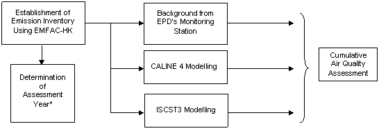

* Assessment
year = maximum EMFAC-HK emission year from modelled years 2014, 2017 and 2019
5.9.1.3
The process
for the operational air modelling is as follows and the detailed methodology
and assumptions of each phase discussed in the sections below:
·
format of traffic figures;
·
determination of the assessment year using EMFAC-HK;
·
calculate the total vehicular tailpipe emissions from open roads using
EMFAC-HK;
·
use CALINE4 to assess air quality impacts from open roads; and
·
use ISCST3 to assess air quality impacts from the Workshop site and
adjacent bus depots.
5.9.1.4
The hourly
emission rate calculated by EMFAC-HK and the traffic data have been used for
the CALINE4 modelling to calculating the 1-hour average of pollutants (i.e. NO2
and RSP) emitted from the open roads within 500m study area.
5.9.1.5
The hourly
emission rates of New World First Bus Permanent Depot (EP-052/2000) and
Headquarters and Bus Maintenance Depot (EP-107/2001) has been made reference
and adopted for the ISCST3 modelling from the corresponding EIA reports.
Therefore, the 1-hour average of pollutants from the bus depots have been
calculated.
5.9.1.6
As
mentioned in Sections 3.2.1.4 to 3.2.1.6, the working hours of the
Project are from 0800 to 1800 on Monday to Friday. As the average daily in/out traffic
volumes would equal to 50 vehicles, it is assumed that the average hourly
in/out traffic volumes would be 50 vehicles / 10 hrs, which is 5 vehicles per
hour. According to the breakdown,
it is assumed that the composition of the vehicles would be 1 motorcycle, 2
private vehicles and 2 ambulances / medium sized vans. The travelling distance of the vehicles
within the site is assumed as 140m.
In addition, the concurrent number of vehicles for repairing and
maintenance in the Project is expected to be approximately 3 vehicles, and the
continuous engine on-time would be approximately 15 minutes (or 900 seconds)
per vehicle on the three occasions, that is, 5 minutes per vehicle per
occasion. As the speedometer is powered by electricity and the engines of the
motorcycles will not be started, there would be no emissions during the
testing. In conclusion, the main
emissions sources for the Project are from the travelling vehicles within the
site and the idling vehicles with started engines.
Determination
of 1-hour Emissions
5.9.1.7
A worst
case scenario has been assumed for the determination of emissions at the
Project site:
·
5 vehicles are travelling in the Project site in 1 hour;
·
3 idling vehicles with engines running for 900 seconds in the Project
site in 1 hour (no more than 3 idling vehicles per day); and
·
Other emission sources arising from concurrent projects including the
adjacent road networks and bus depots in 1 hour.
5.9.1.8
The total
emission rate of the Project has been calculated based on the above assumptions
and the details will be shown in the following Section 5.9.6. The calculated emission rates have been
used for the input of each operating hour of the Project in a year to allow for
the fact that this situation cannot be specified to a particular hour and, thus
could occur in any operating hour of the year. As such, the cumulative 1-hour average
of pollutants has been calculated, and the highest cumulative 1-hour average of
pollutants determined.
5.9.1.9
It should
be noted that, when the Workshop is not operating, the idling and travelling
emissions have not been included in the calculation of the cumulative the
1-hour average of pollutants, as illustrated below:
|
Meteorological data, |
|
ISCST3 |
à |
NO2 (Travelling
Emission of Project, i hr) = (A) |
|
|
|
ISCST3 |
à |
NO2 (Idling
Emission of Project, i hr) = (B) |
|
|
|
ISCST3 |
à |
NO2 (Adjacent Bus Depots,
i hr) = (C) |
|
|
|
CALINE4 |
à |
NO2 (Adjacent Road Networks, i hr) = (D) |
|
|
|
|
à |
Background of NO2 |
|
Cumulative 1-hour average of NO2
(during operating hours of the Project) = (A) + (B) + (C) + (D) +
Background of NO2 |
||||
|
Cumulative 1-hour average of NO2
(during non-operating hours of the Project) = (C) + (D) + Background of NO2 |
||||
Determination of 24-hour Emissions
5.9.1.10
A worst
case scenario has been assumed for the determination of emissions at the
Project site in 24-hour:
·
5 vehicles are travelling in the Project site in every hour throughout
the 10 operating hours, i.e. from 0800 to 1800;
·
3 idling vehicles with engines running for 900 seconds in the Project site
only in 1 hour during the operation of the Project (no more than 3 idling
vehicles per day); and
·
Other emission sources arising from concurrent projects including the
adjacent road networks and bus depots throughout 24 hour.
5.9.1.11
It should
be noted that, when the Workshop is not operating, the idling and travelling
emissions have not been included in the calculation of the cumulative the
24-hour average of pollutants, as illustrated below:
|
|
ISCST3 |
à |
NO2 (Travelling
Emission of Project, i day) = (E) |
|
|
|
|
ISCST3 |
à |
NO2 (Idling
emission from Project, i day) = NO2 (Idling emission of Project, i
hr with maximum value) / 24 = (F) |
|
|
|
ISCST3 |
à |
NO2 (Adjacent Bus Depots,
i day) = (G) |
|
|
|
CALINE4 |
à |
NO2 (Adjacent Road Networks, i day) = (H) |
|
|
|
|
à |
Background of NO2 |
|
Cumulative 24-hour average of
NO2 (for operating days of the Project) = (E) + (F) + (G) + (H) +
Background of NO2 |
||||
|
Cumulative 24-hour average of
NO2 (for non-operating days of the Project) = (G) + (H) + Background of NO2 |
||||
5.9.1.12
From the
above calculation, then the highest cumulative 24-hour average of pollutants
have been determined and the cumulative annual average of pollutants calculated
by the averaging the sum of all of the calculated cumulative 24-hour average of
pollutants.
5.9.2 Traffic Figures
5.9.2.1
The
traffic figures for this EIA study have been obtained from a traffic survey
endorsed by the Transport Department (TD) and taken into account the latest
layout of the Project. As mentioned
in Sections 1.2.1.1 and 3.4.1.1, the Project will be operated as a
temporary vehicle workshop facility for around 5 years and will be anticipated
to operate in 2014. Therefore, the traffic forecasts have been prepared for the
years 2014, 2017 and 2019. Hourly
forecasts of weekday traffic flows, including a breakdown of sixteen vehicle
categories, on major roads related to the Project as shown in Figure 5.2. These have been used for the EMFAC-HK modelling for calculating the emission
factors of vehicle movements on the open roads for CALINE4 assessment. A summary of the traffic data for the
future years of 2014, 2017 and 2019, together with the road links, are
presented in Appendix 5.1.
5.9.3 Determination of Assessment Year
5.9.3.1
The
potential air pollution impacts of future road traffic have been calculated
based on the highest emission strength from the road vehicles within the
operation years after the completion of the construction of the Project, i.e.
between 2014 and 2017. The
sensitivity test would also include Year 2019 such that the assessment would be
acceptable for
any possible operation of the Project
beyond 2017. As NO2 is
the pollutant of primary concern of vehicular emissions, the worst assessment
year has been determined based on the highest NOx emission scenario
using the EMFAC-HK.
5.9.3.2
Sensitivity
tests have been conducted to determine the worst-case scenario given the
combination of vehicular emission factors and the projected traffic flow for
selected years with 5 years after the commencement of the Project, namely the
representative years of 2014, 2017 and 2019.
5.9.3.3
The whole
set of emission factors of two scenarios, vehicles travelling at travelling speeds
and vehicles travelling at speed limits for each of the years has been
calculated in the same matter and a sensitivity test conducted to determine the
worst scenario year. Based on the
emission control schemes in the selected years, together with the varied
Vehicle-Mile-Travelled (VMT), sets of emission inventories with emission
factors have been produced for each year.
Vehicles travelling at travelling speeds for these years have been
adopted, which are calculated based on the traffic flow of the corresponding
year and the volume/capacity (V/C) ratios.
5.9.3.4
Emission
factors in the year that has been shown to have the largest emission inventory
for the roads have been used as the model year for the air quality impacts
assessment as it would represent the worst-case scenario prediction associated
with vehicular gaseous emission.
5.9.4 Determination of Vehicular Emissions from Open Roads
Background
5.9.4.1
The
cumulative air quality impact generated by vehicular gaseous emissions from the
Project have been calculated based on the highest emission strength given by
the combination of traffic flow and vehicle mixture in the assessment
year. The latest version of the
model, EMFAC-HK v1.2, provided on EPD’s website, would be adopted to determine
the total emission inventory. These
results have then been input into CALINE4 for modelling of source dispersion
due to vehicle movement.
5.9.4.2
The
detailed procedures and assumptions for the EMFAC-HK modelling have been
derived in accordance with EPD’s Guideline on Modelling Vehicle Emissions and
discussed below.
Vehicle Classes
5.9.4.3
All
vehicles operating on roads included in the assessment have been categorised
into 16 vehicle classes in accordance with Appendix I of EMFAC-HK Guideline as
shown in Table 5.7 and detailed in Appendix 5.2.
Table 5.7: Vehicle Classification in
EMFAC-HK
|
Vehicle Class |
EMFAC-HK
Notation |
Descriptions |
Gross Vehicle
Weight |
|
MC 1 |
PC+LGV(1) |
Petrol Private Cars & Light Goods Vehicles |
ALL |
|
MC 3 |
PC+LGV(3) |
Diesel Private Cars & Light Goods Vehicles <=2.5 tonne |
<=2.5ton |
|
MC 4 |
LGV(4) |
Light Goods Vehicles 2.5-3.5 tonne |
>2.5-3.5ton |
|
MC 5 |
PLB |
Public Light Buses |
ALL |
|
MC 6 |
LGV(6) |
Light Goods Vehicles >3.5 tonne |
>3.5ton-5.5ton |
|
MC 7 |
HGV(7) |
Medium Goods Vehicles with GVW <15 tonne |
>5.5ton-15ton |
|
MC 8 |
HGV(8) |
Medium & Heavy Goods Vehicles with GVW >=15 tonne |
>=15ton |
|
MC 10 |
FBDD |
Double Deck Franchised Buses |
ALL |
|
MC 11 |
MC |
Motor Cycles |
ALL |
|
TAXI 3 |
Taxi |
Taxi |
ALL |
|
TAXI 4 |
PV(4) |
Private Light Buses <=3.5 tonne |
<=3.5ton |
|
TAXI 5 |
PV(5) |
Private Light Buses >3.5 tonne |
>3.5ton |
|
TAXI 6 |
NFB(6) |
Non-franchised Buses <=6.4 tonne |
<=6.4ton |
|
TAXI 7 |
NFB(7) |
Non-franchised Buses 6.4-15 tonne |
>6.4-15ton |
|
TAXI 8 |
NFB(8) |
Non-franchised Buses >=15 tonne |
>15ton |
|
TAXI 10 |
FBSD |
Single Deck Franchised Buses |
ALL |
5.9.4.4
Details of
the sixteen vehicle classes haven been agreed for use by Transport Department.
Road Groupings
5.9.4.5
Roads
within the Study Area have been grouped into 4 sections based on the road types
and the speed limit, as shown in Table 5.8 below.
The roads have been characterised by continuous and interrupted flows,
respectively. Four sets of emission
factors for the road types in each year have been calculated. The associated Road Link Map is shown in
Figure 5.3.
Table 5.8: Road Groupings
|
Road Grouping |
Road
Types |
Description |
|
Type 1 with
speed limit of 50 kph |
Primary
Distributor |
Roads with speed limit of 50 kph and with no frontage
access. Usually 24 hour stopping restrictions. |
|
Type
2 with speed limit of 50 kph |
District Distributor |
Roads with speed limit of 50 kph and with
junctions, pedestrian crossing and bus stop, etc. Usually peak hour stopping
restrictions and parking restrictions throughout the day. |
|
Type 3 with
speed limit of 50 kph |
Local
Distributor |
Roads with speed limit of 50 kph and with capacity
limited by waiting vehicles and etc. |
|
Type 4 with
speed limit of 70 kph |
Expressway |
Roads are designated as Expressways under the Road
Traffic (Expressway) Regulations.
High capacity roads with no frontage access or development, pedestrians
segregated, widely spaced gradeseparated junctions. 24 hour stopping restrictions. |
Exhaust Technology Fractions
5.9.4.6
The
underlying assumptions of EMFAC-HK are that vehicles can be categorised into
unique technology groups with each technology group representing vehicles with
distinct emission control technologies, which have similar in-use deterioration
rates, and respond the same to repair.
5.9.4.7
The
Exhaust Technology Fraction for each vehicle class has been adopted from the
information provided in the “Up to Date
Vehicle Licensed Number by Age and Technology Group Fractions” obtained
from EPD’s website. However, as
there is no further information available after 2008, in order to adopt a
conservative approach, the exhaust technology fractions after this year for
each vehicle class have been assumed to be the same as in 2008. However, some adjustments have been made
according to Appendix II of the EPD’s Guideline
on Modelling Vehicle Emissions, Implementation Schedule of Vehicle Emission
Standards in Hong Kong (Updated as at June 2010), as detailed in Appendix
5.3. The details of the
adjustments in each vehicle class are shown in Appendix 5.4.
Vehicle Population
5.9.4.8
In terms
of the vehicle populations, reference has been made to the EPD’s Guideline on Modelling Vehicle Emissions
and the latest vehicle age distribution data (Year 2008) (downloaded from EPD website) have been adopted in
this assessment, with the exception of the populations for private car, taxi,
public light bus and private light bus which are greater than 3.5 tonnes. The corresponding populations have been
calculated and provided in Appendix 5.5.
Vehicle Accrual
5.9.4.9
As there
is an absence of forecast information in the model year, “Default values and
compositions” have been adopted in accordance with the EMFAC-HK Guidelines.
Daily Trips
5.9.4.10
With
reference to the EPD’s Guideline on Modelling
Vehicle Emissions, the diurnal variation of daily trips has been used to
estimate the cold start emission of petrol vehicles. Hence, trips for vehicles other than
petrol type vehicles have been assumed to be zero. Estimations on the number of trips for
petrol type vehicles in different road sections have assumed the following:
Primary Distributor and Expressway
5.9.4.11
It is
assumed that number of trips on the road sections, including Type 1 and Type 4,
would be zero as no cold start would be reasonably expected on these road
sections under normal circumstances.
District Distributor and Local
Distributor
5.9.4.12
It is
assumed that the number of trips would be equal to the number of cold starts in
the road sections, including Type 2 and Type 3. It is also assumed that the number of
trips is directly proportional to Vehicle-Mile-Travelled (VMT) and that the
pattern would be similar throughout the
![]()
5.9.4.13
Trips per
VMT within Hong Kong have been calculated based on the default data of
EMFAC-HK, whereas VMT within Study Area have been calculated by multiplying the
number of vehicles by the length of road travelled in this study area. Corresponding trips per VMT are shown in
Appendix 5.6.
Daily Vehicle Mile Travelled (VMT)
5.9.4.14
Vehicle-Mile-Travelled
(VMTs) are inputted in the model to represent the total distance travelled on a
typical weekday. The area specific
VMT have been calculated by multiplying vehicle flow by the road section
length.
5.9.4.15
The
diurnal traffic pattern would be input to simulate the effect of different
traffic patterns on the emissions.
In order to determine the proportion of the estimated daily traffic flow
variation, hourly traffic survey of the roads were conducted by the traffic
consultant.
Hourly Temperature and Relative Humidity Profile
5.9.4.16
According
to the information provided by HKO, the nearest meteorological station of this
Project is the HKO Automatic Weather Station, with anemometer height of 42m
above ground level. It is
considered that the characteristics of the HKO Automatic Weather Station would
be representative of the study area and, therefore, the annual and monthly
hourly averaged ambient temperature and relative humidity obtained from this
station for the year 2008 are adopted in the model. The monthly averaged hourly temperature
and relative humidity values are arithmetic mean of the same hourly interval
over each calendar month while the annual averaged hourly values are arithmetic
mean of the same hourly interval over the entire year. It is confirmed that
this data has at least 90% valid data for the year. The adopted values are shown in Appendix
5.7.
Speed Fraction
5.9.4.17
In order
to simulate the effect of different road speeds during rush and non-rush hours,
sensitivity tests would be carried out.
The design road speed limits would be assumed as representing the
situation during non-rush hours, while the vehicle speeds of the peak hour
flows have been adopted to represent the situation during the rush hour. The estimated speed fractions have been
estimated using travelling speeds provided in the approved traffic data. The travelling speed profiles of the
roads are shown in Appendix 5.8.
5.9.4.18
The peak
flow hour travel speeds have been calculated based on the peak traffic flows in
each year and the volume/capacity ratios of the different road types. In order to obtain the speed fractions
of each vehicle type, the vehicle speeds of each road have first been
calculated and weighed by the VMT.
5.9.4.19
In the
model, the same travelling speeds have been applied to all vehicles for each
type to demonstrate the effect of using peak flow speed and design speed. However, the diurnal variation of VMT
for each vehicle have been, also, considered in the travelling speed
estimation. In addition, in the
speed fraction estimations, HGV, HGV and buses have been assumed to travel at
speeds not exceeding 70 kph on all roads.
The worst emission factors have been selected for predicting the vehicle
emissions.
Modelling Modes
Scenario Type
5.9.4.20
The
“Burden Mode” of EMFAC-HK is the only scenario that can consider and provide
the hourly vehicular emissions according to the diurnal variations of
vehicle-kilometer-travelled (VKT), trips, ambient temperature, relative
humidity and speed and, therefore, has been adopted.
Output Frequency
5.9.4.21
Hour-by-hour
emission factors have been derived for the purpose of obtaining worst emission
factor.
Calculation of Emission Factors
5.9.4.22
Emission
inventories and Vehicle-Mile-Travelled (VMT) have been extracted from BCD file
of the model. In respect of the
expressway sections, only “Run Exhaust” has been considered as it characterises
continuous flow, whereas both “Start Exhaust” and “Run Exhaust” have been
considered for the roads of speed limit of 50 kph for the need to take into
account cold start emissions. The
“Start Exhaust” is confined to petrol vehicles only.
5.9.4.23
In
addition, as the results from EMFAC-HK are given in different type of fuel,
hourly emission factors have been calculated by dividing the total emission
inventory by the total VKT in each vehicle class in each hour in order to
obtain representative and generic emission factors for each of the vehicle
categories. An example of this
calculation for the emission factor of a LGV is as follows:
Emission
Factor = Σ(Emission Inventory)i / Σ(VKT)i
![]()
where NCAT
= Non Catalyst;
CAT = Catalyst; and
DSL= Diesel
5.9.4.24
The
calculated hourly emission factors in grams per miles per vehicle have been
selected for use in the modelling of the open roads using CALINE4.
5.9.5 Determination of Vehicular Emissions from Open Roads
Open Road Emissions
5.9.5.1
The
modelling of impacts from open stretches of road in the study area has been
undertaken using the CALINE4 model.
The hourly emission rates of each vehicle class (in grams per mile per
vehicle) have been determined by dividing the emissions of the various road
categories calculated with the EMFAC-HK model by the hourly traffic flow and
the distance travelled. The
composite emission factors in CALINE4 model have then been calculated.
5.9.5.2
The
CALINE4 model has adopted the latest Hong Kong Observatory’s (HKO)
meteorological data (Year 2009) from Kai Tak Automatic Weather Station
(including wind speed, wind direction and stability class), Hong Kong
Observatory Manned Weather Station (including temperature, and relative
humidity) and King’s Park Automatic Weather Station (including mixing height).
5.9.5.3
The
following meteorological conditions have been assumed in the CALINE4 Model:
·
Wind speed: hourly wind speed from HKO meteorological data;
·
Stability class: hourly data HKO meteorological data;
·
Wind direction: hourly data from HKO meteorological data;
·
Directional variability: calculated according to the stability class in
PCRAMMET output file; (Stability Class A, Standard Deviation of Wind Direction
(sA) =
22.5o; Stability Class B, sA = 22.5o; Stability
Class C, sA = 17.5o; Stability Class D, sA = 12.5o; Stability
Class E, sA = 7.5o; Stability Class F, sA = 3.8o; A surface
roughness factor of (z0/15 cm)0.2 was adopted where z0 is the
surface roughness in cm);
·
Mixing height: hourly data from HKO meteorological data;
·
Temperature: hourly data from HKO meteorological data; and
·
Surface roughness: 100cm .
5.9.5.1
In view of
the constraints of the CALINE4 model in modelling elevated roads higher than
5.9.5.2
The
Ambient Ratio Method (ARM) has been adopted for the conversion of 20% NOx
to NO2 for all vehicle emissions, which is according to the EPD’s
“Guidelines on Choice of Models and Model Parameters”.
5.9.5.3
The air
quality impacts at 1.5m, 5m, 10m, 15m and 20m above local the ground level have
been modelled for at the representative ASRs, due to the high rise buildings.
5.9.6 Determination of Emissions from Operation of the Project
5.9.6.1
As
mentioned in Section 5.9.1.6, the emissions are mainly from the 5
vehicles travelling in the site and the 3 idling vehicles with started engines
for 900 seconds in the site. The
emissions have been assumed to be emitted evenly over the Project site and have
been modelled by ISCST3. The
emission heights have been taken at 0.5m above ground level which is the
approximate height of the exhaust pipes of vehicles. For the idling vehicles with engines
running, the speed have been assumed as 0 km/hr and the speed of the vehicles
travelling within the Project site have been assumed to be 20 km/hr.
5.9.6.2
With
reference to the “Road Tunnels: Vehicle
Emissions and Air Demand for Ventilation” published by PIARC Technical
Committee on Road Tunnel Operation (C5) on November 2004, the emission factors
for different Euro type engines are presented with different travelling speeds
(including idling mode and speed as 20 km/hr). Therefore, these emission factors have
been adopted and used for the calculation of the emission rates of NOx
and RSP of the idling and travelling vehicles respectively. The calculated
emission rates for idling and travelling vehicles are shown in Table 5.9. Appendix
5.9 presents the detailed calculations of the emission rates and the
locations of the sources assumed.
Table 5.9: Calculated Emission Rates of NOx and RSP for the Project
|
Events |
Emission Rates (g/s) |
|
|
NOx |
RSP |
|
|
Idling |
0.014323 |
0.000621 |
|
Travelling |
0.000810 |
0.000025 |
|
Total |
0.015133 |
0.000646 |
5.9.6.3
Similar to
the open road traffic emissions using the CALINE4 model for open roads, the ISCST3
model for the pollutant dispersion from the Project has adopted the
meteorological data from HKO, including temperature, wind speed and direction,
stability class and mixing heights.
5.9.6.4
The
Ambient Ratio Method (ARM) has been adopted for the conversion of 20% NOx
to NO2 for all vehicle emissions, which is according to the EPD’s “Guidelines on Choice of Models and Model
Parameters”.
5.9.7 Determination of Emissions from Bus Depots
5.9.7.1
The emissions
from the New World First Bus Depot and the Citybus Bus Depot have been modelled
by ISCST3, also. The locations and emission rates of the sources within the
depots have been made with reference to the EIA reports of New World First Bus
Permanent Depot at Chai Wan and Proposed Headquarters and Bus Maintenance Depot
in Chai Wan, respectively. The
details are shown in Appendix 5.10.
5.9.7.2
Similarly,
the meteorological data from HKO, including temperature, wind speed and
direction, stability class and mixing heights have been adopted for the
modelling.
5.9.8 Determination of Overall Cumulative Results
5.9.8.1
The
overall cumulative 1-hour average, 24-hour average and annual average
concentrations of NO2 and the overall cumulative 24-hour average and
annual average concentrations of RSP at the representative ASRs would be
calculated as mentioned in Sections 5.9.1.8 to 5.9.1.10.
5.9.9 Level of Uncertainty
5.9.9.1
The
emission rates adopted in the CALINE4 modelling are calculated by the EMFAC-HK
model and more accurately predicts the emission rates. Moreover, the inputs for the models have
been prepared based on Guideline on
Modelling Vehicle Emissions issued by EPD on July 2005.
5.9.9.2
The
CALINE4 and ISCST3 models used for the modelling of the operational air quality
impact assessment are the accepted models for calculating the air pollutants
impacts for the roads and stationary sources and which have made reference to
the Guidelines on Choice of Models and
Model Parameters.
5.9.9.3
In
addition, as the emission rate hourly profiles are not available in the EIA
reports of the two bus depots, so the hourly emission rates of the worst case
scenario in the EIA reports have been adopted and assumed as the same for each
hour of a day in the assessment of this EIA report. Utilising this assumption has only made
the approach of the assessment more conservative.
5.9.9.4
Uncertainties
in the assessment of impacts have been considered when drawing conclusion from
the assessment and worst case scenarios adopted.
5.10
Construction Dust Impact Assessment
5.10.1 Results
5.10.1.1
The
potential dust emission sources would be mainly from the construction work
activities of the excavation and wind erosion at the work site. As the size of the work site is limited
and the excavation is minor such that the amount of excavated materials
generated would be small, no adverse dust impact would be anticipated at the
ASRs with the implementation of sufficient dust suppression measures as
stipulated under the Air Pollution Control (Construction Dust) Regulation and
good site practices.
5.10.2 Mitigation Measures
5.10.2.1
The
implementation of sufficient dust suppression measures as stipulated under the
Air Pollution Control (Construction Dust) Regulation and good site practices
should be carried out in order to further minimise the construction dust
generated.
·
Use of regular watering, to reduce dust emissions from exposed site
surfaces and unpaved roads, particularly during dry weather;
·
Use of frequent watering for particularly dusty construction areas close
to ASRs;
·
Side enclosure and covering of any aggregate or dusty material storage
piles to reduce emissions. Where
this is not practicable owing to frequent usage, watering should be applied to
aggregate fines;
·
Open temporary stockpiles should be avoided or covered. Prevent placing dusty material storage
plies near ASRs;
·
Tarpaulin covering of all dusty vehicle loads transported to, from and
between site locations;
·
Establishment and use of vehicle wheel and body washing facilities at
the exit points of the site;
·
Imposition of speed controls for vehicles on unpaved site roads. 8 km/hr
is the recommended limit;
·
Routing of vehicles and positioning of construction plant should be at
the maximum possible distance from ASRs;
·
Every stock of more than 20 bags of cement or dry pulverised fuel ash
(PFA) should be covered entirely by impervious sheeting or placed in an area
sheltered on the top and the 3-sides; and
·
Loading, unloading,
transfer, handling or storage of large amount of cement or dry PFA should be
carried out in a totally enclosed system or facility, and nay vent or exhaust
should be fitted with the an
effective fabric filter or equivalent air pollution control system.
5.11
Operational air Quality Assessment
5.11.1 Assessment Year
5.11.1.1
Composite
emission factors for the road links of the roads have been calculated by the
weighted average of the emission factors of sixteen vehicle types. Details of the sensitivity analysis are
shown in Appendix 5.11 and summarised in Table 5.10.
Table 5.10: Comparison of Emission Inventory
|
Total Emission Inventory of the Road Links (g/s) |
|||
|
Pollutants and Road Types |
Year 2014 |
Year 2017 |
Year 2019 |
|
Vehicles Travelling at Travelling Speeds |
|||
|
NOx Type 1 |
0.0580 |
0.0532 |
0.0472 |
|
NOx Type 2 |
0.2467 |
0.2228 |
0.1989 |
|
NOx Type 3 |
0.3743 |
0.3324 |
0.3029 |
|
NOx Type 4 |
0.3212 |
0.2899 |
0.2582 |
|
RSP Type 1 |
0.0041 |
0.0032 |
0.0027 |
|
RSP Type 2 |
0.0224 |
0.0177 |
0.0146 |
|
RSP Type 3 |
0.0311 |
0.0238 |
0.0197 |
|
RSP Type 4 |
0.0196 |
0.0154 |
0.0125 |
|
Vehicles Travelling
at Speed Limits |
|||
|
NOx Type 1 |
0.0573 |
0.0525 |
0.0466 |
|
NOx Type 2 |
0.2402 |
0.2172 |
0.1939 |
|
NOx Type 3 |
0.3697 |
0.3284 |
0.2987 |
|
NOx Type 4 |
0.3212 |
0.2899 |
0.2582 |
|
RSP Type 1 |
0.0038 |
0.0030 |
0.0025 |
|
RSP Type 2 |
0.0198 |
0.0157 |
0.0129 |
|
RSP Type 3 |
0.0293 |
0.0224 |
0.0185 |
|
RSP Type 4 |
0.0196 |
0.0154 |
0.0125 |
5.11.1.2
Table 5.10 shows the
calculated total emission inventories for NOx and RSP of two
scenarios, vehicles travelling at travelling speeds and vehicles travelling at
speed limits for Year 2014, Year 2017 and Year 2019. It is apparent that each set of total emissions inventory for NOx and RSP of
the travelling speed scenario is larger than that of the speed limit
scenario. The
graphs of the total emission inventories or NOx and RSP of the
travelling speed scenario of Year 2014, Year 2017 and Year 2019 are presented
in Appendix 5.11 for the comparison. The graphs illustrated that the greatest
emission inventory for NOx and RSP is in the Year 2014. Therefore, Year 2014 has been selected
as the worst-case model year for this air quality impact assessment.
5.11.2 Calculated Emission Factors Year 2014
5.11.2.1
The
calculated emission factors for different vehicle categories for the Year 2014
are listed in Appendix 5.12.
The whole set of the calculated emission factors (Hour 1 to Hour 24) were used for the calculation of the composite emission
factors for the CALINE4 modelling.
5.11.3 Modelling Results from Open Roads
5.11.3.1
The
predicted hourly NO2 and RSP concentrations have been derived from
the CALINE4 modelling at 1.5m, 5m, 10m, 15m and 20m above ground at the
representative ASRs in the study area.
5.11.4 Modelling Results from Operation of the Project
5.11.4.1
The
predicted hourly NO2 and RSP concentrations have been derived from
the ISCST3 modelling at 1.5m, 5m, 10m, 15m and 20m above ground at the
representative ASRs in the study area.
5.11.5 Modelling Results from Bus Depots
5.11.5.1
The
predicted hourly NO2 and RSP concentrations have been derived from
the ISCST3 modelling at 1.5m, 5m, 10m, 15m and 20m above ground at the
representative ASRs in the study area.
5.11.6 Cumulative Modelling Results
5.11.6.1
The
predicted overall cumulative 1-hour, 24-hour and annual average concentrations
of NO2 and 24-hour and annual average concentrations of RSP have
been calculated and are shown in Table 5.11 below.
These results are, also, expressed as contour plots which can be seen in
Figure 5.4 for hourly average concentrations of NO2, Figure
5.5 to Figure 5.6 for 24-hour average concentrations of NO2
and RSP respectively and Figure 5.7 to Figure 5.8 for annual
average concentrations of NO2 and RSP respectively.
Table 5.11: Predicted
Maximum Overall 1-Hour, 24-hour and Annual Average of NO2 and RSP
Concentrations (g/m3) at ASRs (including Background levels)
|
|
Height Above Ground (m) |
NO2(µg/m3) |
RSP(µg/m3) |
|||
|
Receiver |
1-hour |
24-hour |
Annual |
24-hour |
Annual |
|
|
Reference |
AQO Standard (µg/m3) |
300 |
150 |
80 |
180 |
55 |
|
|
||||||
|
ASR1 |
1.5 |
140 |
76 |
65.5 |
56 |
52.2 |
|
ASR2 |
1.5 |
127 |
64 |
60.5 |
51 |
50.2 |
|
ASR3 |
1.5 |
146 |
71 |
63.7 |
54 |
51.6 |
|
ASR4 |
1.5 |
161 |
72 |
63.0 |
55 |
51.3 |
|
ASR5 |
1.5 |
129 |
72 |
63.7 |
54 |
51.6 |
|
ASR6 |
1.5 |
147 |
74 |
63.6 |
55 |
51.6 |
|
ASR7 |
1.5 |
133 |
71 |
63.6 |
55 |
51.5 |
|
ASR8 |
1.5 |
157 |
76 |
63.8 |
56 |
51.7 |
|
ASR9 |
1.5 |
159 |
75 |
63.3 |
56 |
51.5 |
|
ASR10 |
1.5 |
134 |
73 |
63.6 |
55 |
51.4 |
|
ASR1 |
5 |
138 |
75 |
65.3 |
56 |
52.2 |
|
ASR2 |
5 |
122 |
64 |
60.4 |
51 |
50.2 |
|
ASR3 |
5 |
145 |
71 |
63.3 |
54 |
51.4 |
|
ASR4 |
5 |
160 |
71 |
62.7 |
55 |
51.1 |
|
ASR5 |
5 |
128 |
72 |
63.3 |
54 |
51.4 |
|
ASR6 |
5 |
145 |
73 |
63.1 |
55 |
51.4 |
|
ASR7 |
5 |
132 |
70 |
63.1 |
54 |
51.3 |
|
ASR8 |
5 |
155 |
75 |
63.0 |
56 |
51.3 |
|
ASR9 |
5 |
154 |
73 |
62.6 |
55 |
51.2 |
|
ASR10 |
5 |
133 |
73 |
63.3 |
55 |
51.4 |
|
ASR1 |
10 |
134 |
74 |
64.8 |
55 |
52.0 |
|
ASR2 |
10 |
114 |
63 |
60.4 |
51 |
50.2 |
|
ASR3 |
10 |
140 |
70 |
62.6 |
53 |
51.1 |
|
ASR4 |
10 |
155 |
70 |
62.1 |
54 |
50.9 |
|
ASR5 |
10 |
127 |
71 |
62.5 |
53 |
51.0 |
|
ASR6 |
10 |
141 |
71 |
62.3 |
54 |
51.0 |
|
ASR7 |
10 |
130 |
70 |
62.3 |
53 |
50.9 |
|
ASR8 |
10 |
149 |
73 |
62.1 |
55 |
50.9 |
|
ASR9 |
10 |
143 |
71 |
61.9 |
54 |
50.8 |
|
ASR10 |
10 |
131 |
72 |
62.9 |
54 |
51.2 |
|
ASR1 |
15 |
129 |
73 |
64.1 |
55 |
51.7 |
|
ASR2 |
15 |
107 |
63 |
60.3 |
51 |
50.1 |
|
ASR3 |
15 |
134 |
69 |
62.0 |
53 |
50.8 |
|
ASR4 |
15 |
148 |
68 |
61.7 |
53 |
50.7 |
|
ASR5 |
15 |
125 |
70 |
61.8 |
53 |
50.7 |
|
ASR6 |
15 |
135 |
70 |
61.6 |
54 |
50.7 |
|
ASR7 |
15 |
127 |
69 |
61.6 |
53 |
50.6 |
|
ASR8 |
15 |
140 |
71 |
61.5 |
54 |
50.6 |
|
ASR9 |
15 |
130 |
69 |
61.4 |
53 |
50.6 |
|
ASR10 |
15 |
128 |
70 |
62.4 |
54 |
51.0 |
|
ASR1 |
20 |
123 |
71 |
63.3 |
54 |
51.4 |
|
ASR2 |
20 |
101 |
62 |
60.3 |
51 |
50.1 |
|
ASR3 |
20 |
127 |
67 |
61.6 |
52 |
50.6 |
|
ASR4 |
20 |
140 |
67 |
61.3 |
53 |
50.5 |
|
ASR5 |
20 |
122 |
69 |
61.4 |
53 |
50.5 |
|
ASR6 |
20 |
127 |
68 |
61.2 |
53 |
50.5 |
|
ASR7 |
20 |
123 |
68 |
61.1 |
52 |
50.4 |
|
ASR8 |
20 |
131 |
69 |
61.2 |
53 |
50.5 |
|
ASR9 |
20 |
119 |
67 |
61.1 |
53 |
50.4 |
|
ASR10 |
20 |
123 |
69 |
61.9 |
53 |
50.8 |
|
Shaded |
means the
result exceeds the AQO. |
|||||
5.11.6.2
According
to the findings, the predicted NO2 and RSP levels at the ASRs and in
all areas covered by the contour plots would comply with the relevant criteria
in the EIAO-TM and AQOs. Hence, there would be no adverse impact predicted.
5.11.7 Mitigation Measures
5.11.7.1
Since
there are no adverse air quality impacts predicted from the operation of the
Project, no mitigation measures are required.
5.12.1.1
Adverse
residual impacts during the construction or operational phases of the Project
would not be anticipated, provided that the above mitigation measures mentioned
in Section 5.10.2.1 during the construction phase of the Project are
implemented, even
though the operation would be extended beyond July 2017 as planned.
5.13
Environmental Monitoring and Audit
5.13.1 Construction Phase
5.13.1.1
No adverse
dust impact would be anticipated at the ASRs with the implementation of
sufficient dust suppression measures as stipulated under the Air Pollution
Control (Construction Dust) Regulation and good site practices. Regular site environmental audits during
the construction phase of the Project as specified in the EM&A Manual
should be conducted to ensure the recommended dust suppression measures are
implemented.
5.13.2 Operational phase
5.13.2.1 The results of the operational air quality impact
assessment indicate that no adverse impact would be expected from the operation
of the Project. Therefore, the EM&A works related to air quality for the
operational phase is not considered as necessary.
5.14.1.1
There
would be no major earthworks carried out for the site formation works for the
Project site. With the
implementation of sufficient dust suppression measures as stipulated under the
Air Pollution Control (Construction Dust) Regulation, adverse construction dust
impact would not be anticipated.
For the operation of the workshop, no adverse air quality impacts would
be predicted as there would only be a small number of vehicles involved in the
operation of the workshop, even if the operation is extended beyond the
original 5 year period.