11
Cultural
Heritage
This section provides an evaluation of the
potential cultural heritage impacts arising from the construction and operation
of the Project, including the activities at the
Development Site, Sha Lo Tung Road Improvement and Ecological Reserves. Appropriate
mitigation measures have been recommended, where necessary, in order to
mitigate any adverse impacts.
11.2
Relevant Legislation and Guidelines
The following legislations and guidelines are applicable
to the assessment of impacts on sites of cultural heritage in Hong Kong:
·
Environmental
Impact Assessment Ordinance (EIAO) (Cap. 499. S16), Technical Memorandum on the
EIA Process, Annex 10 and 19 (EIAO TM) and Guidance Notes on Assessment of Impact on Sites of Cultural Heritage
in EIA Studies;
·
Antiquities and
Monuments (AM) Ordinance (Cap. 53);
·
Requirements and
Guidelines for Cultural Heritage Impact Assessment (CHIA);
·
Hong Kong Planning
Standards and Guidelines (HKPSG); and
·
Land
(Miscellaneous Provisions) Ordinance.
11.2.1
EIAO
& EIAO TM
According to the EIAO,
Schedule 1 Interpretation, “Sites of Cultural Heritage” are defined as:
“an antiquity or monument,
whether being a place, building, site or structure or a relic, as defined in the
AM Ordinance and any place, building, site, or structure or a relic identified
by the Antiquities and Monuments Office to be of archaeological, historical or palaeontological significance”.
The technical scope for evaluating and assessing
cultural heritage impacts is defined in Annexes
10, 18 and 19 of the EIAO TM.
The approach recommended by the guidelines can be summarized as follows.
·
The general
presumption in favour of the protection and conservation of all sites of
cultural heritage because they provide an essential, finite and irreplaceable
link between the past and the future and are points of reference and identity
for culture and tradition; and
·
Adverse impacts on
sites of cultural heritage shall be kept to an absolute minimum.
11.2.2
Antiquities
and Monuments Ordinance
The AM
Ordinance (Cap. 53) provides statutory protection against the threat of
development on Declared Monuments, historic buildings and archaeological sites
to enable their preservation for posterity.
The AM Ordinance also establishes
the statutory procedures to be followed in making such a declaration.
In practice, the Antiquities and Monuments Office
(AMO) also identifies the Deemed Monuments and then seeks to reach agreements
with the owners of the monuments to provide for specific measures that will
ensure preservation. Deemed Monuments
have the potential to be upgraded to statutory Declared Monuments under the AM Ordinance.
A large range of potential sites of cultural
heritage, among which are historic buildings and structures and archaeological
sites, have been identified and recorded by AMO in addition to those for which
a declaration has been made under the AM
Ordinance.
Part of the recorded historic buildings and
structures are graded by the Antiquities Advisory Board (AAB) and the AMO
according to the grading system summarised in Table 11.1.
Table 11.1 Definition
of Grading of Historic Buildings
|
Grading |
Description |
|
1 |
Buildings of outstanding
merit, which every effort should be made to preserve if possible |
|
2 |
Buildings of special
merit; effort should be made to selectively preserve |
|
3 |
Buildings of some merit,
preservation in some form would be desirable and alternative means could be
considered if preservation is not practicable. |
Between 1996 and 2000, AMO conducted a territory-wide
historic buildings survey (mainly built before 1950) in Hong Kong and recorded
8,800 buildings. A more in-depth survey
of 1,444 buildings (selected from the 8,800 buildings and included 543 already
graded buildings) with higher heritage value was conducted between 2002 and
2004 and an Expert Panel was formed in March 2005 to undertake an in-depth
assessment of the heritage value of these buildings. The assessment comprised two stages and was
completed in February 2009. Gradings of these buildings were proposed and put forward
by AMO for consideration by AAB and the results were released to public on 19
March 2009 for a four month public comments period in July 2009. The AAB is now in the process of finalizing
the proposed gradings. The final gradings
of these historic buildings up to 23 November 2011 are considered and reflected
in this CHIA accordingly. The AAB
endorsed at its meeting on 26 November 2008 the establishment of a formal
relationship between the statutory monument declaration system and the
administrative grading system for historic buildings of AAB.
Under this endorsement arrangement, the Grade 1
buildings will be regarded as providing a pool of highly valuable heritage
buildings for consideration by the Antiquities Authority as to whether some of
these may have reached the “high threshold” of monuments to be put under
statutory protection. In case where the
buildings are under demolition threat, the Antiquities Authority will provide immediate
protection to the buildings through proposed monument declaration on
case-by-case basis.
For Grade 2 and Grade 3 buildings, appropriate
actions to preserve them will be undertaken so that the buildings should be
preserved in such a way which is commensurate with the merits of the buildings
concerned, and priority would be given to those with higher heritage value.
Over the years, surveys have been undertaken to
identify archaeological sites in Hong Kong.
The AMO has established boundaries for the identified sites and
maintains a list of Sites with Archaeological Interest which is available for
review in the Hong Kong Heritage Discovery Centre Reference Library. A set of administrative procedures for the protection
of these sites has been established by the Office. However, since many areas remain not surveyed
yet, procedures and mechanisms are required to be followed to identify unknown
archaeological resources that may be discovered during project assessment or
construction and any archaeological survey works involved should be conducted
by qualified archaeologist who should obtain a Licence to Excavate and Search
for Antiquities to be granted by the Antiquities Authority under the AM Ordinance.
11.2.3
Hong
Kong Planning Standards and Guidelines
Chapter 10, Conservation, of the HKPSG provides
general guidelines and measures for the conservation of historical buildings,
archaeological sites and other antiquities.
11.2.4
Requirements
and Guidelines for Cultural Heritage Impact Assessment
The requirements and guidelines for the CHIA are
stated in Appendices J and J-1 of the EIA Study Brief No. ESB-206/2009, which include a baseline study, field evaluation and
impact assessment.
11.2.5
Land
(Miscellaneous Provisions) Ordinance (Cap. 28)
Under this Ordinance, it is required that a permit be
obtained for any excavation within government land prior to commencement of any
excavation work commencing.
In accordance with Clauses 1 and 2 of Appendix J of the EIA Study Brief No. ESB-206/2009, the CHIA comprises two parts, the Built
Heritage Impact Assessment (BHIA) and the Archaeological Impact Assessment
(AIA). The
methodology for the BHIA and AIA follows the Requirements and Guidelines for Cultural
Heritage Impact Assessment (CHIA) as stated in Appendixes J and J-1 of
the EIA Study Brief No. ESB – 206/2009
and was submitted and agreed
with the Director and AMO and presented below.
11.3.1
Assessment
Area
The scope of this EIA covers the Project and
associated works, comprising three key components: (a) Development Site and (b) Sha
Lo Tung Road Improvement and (c) Ecological
Reserve as shown in Appendix A of
the EIA Study Brief No. ESB– 206/2009.
The assessment area for BHIA includes areas within a
distance of 50m from the site boundary of the Project, supporting facilities
and road works as shown in Figure 11.1.
The assessment area for AIA includes areas within a
distance of 50m from the site boundary of the Development Site and the Sha
Lo Tung Road Improvement of the Project as shown in Figure 11.2.
11.3.2
Methodology
A desk-based review was undertaken to determine the
presence of historical occupation, to compile a comprehensive archaeological baseline conditions, and to establish the
potential for cultural heritage resources within the Assessment Areas.
The information was obtained from a comprehensive list of
sources including the AMO,
Planning Department, Lands Department, tertiary institutions libraries and
Internet. Historical, geological and
archaeological information of the Assessment Areas was reviewed including
literatures, graphical materials, aerial photos and historical maps. A full bibliography is presented in Annex H1.
Task 2a - Built Heritage
Survey
The built heritage survey followed the requirements of
the EIAO TM and Clause 1.4, Appendix J-1
of the EIA Study Brief No. ESB–206/2009.
Photographic records of each historic building or
structure were taken and the built heritage information obtained during the
survey. The field survey includes the
identification of:
(a)
All pre-1950 buildings and structures;
(b)
Selected Post-1950 buildings and structures
of high architectural and historical significance; and
(c) Cultural
landscapes include places associated with historic event, activity, or person or exhibiting other
cultural or aesthetic values, such as sacred religious sites, battlefields, a
setting for buildings or structures of architectural importance, historic field
patterns, clan graves, old tracks, fung shui woodlands and ponds, and etc.
Although some of
the village houses have been collapsed (without a roof) and ruined within the
BHIA Assessment Area, these ruined building structures were also included in
the detailed field survey as far as possible.
Photographic records were taken to show the general conditions of the
ruined building.
A site coding system was used. A unique alphanumeric site code was allocated
to each built heritage feature identified.
The two letter prefix denotes the category of the built heritage
features. For instance, GB1 and GR01 refer
to the first graded historic building and grave identified respectively. Table 11.2
provides a list of these codes.
Table 11.2 Site Code used for Identification of the
Built Heritage Features within the BHIA Assessment Area
|
Feature’s Category |
Site Code |
|
Graded/Proposed
Graded Historic Buildings |
GB |
|
Graves |
GR |
|
Cultural/Historical
Landscape Features |
LF |
Task 2b – Archaeological
Survey
According to Clause 2, Appendix J of the EIA Study Brief No. ESB– 206/2009,
in case the existing information is inadequate or where the AIA Assessment Area
has not been adequately studied before, archaeological survey should be
conducted by the archaeologists, who shall obtain licence from the Antiquities
Authority prior to the commencement of the fieldwork.
Based
on the desktop findings and the findings of previous archaeological works
undertaken by the Study Team in the Sha Lo Tung area, an archaeological
potential evaluation of the AIA Assessment Area was conducted which assists in
defining the need for archaeological survey (or field evaluation). It was considered that the existing
information is adequate for the purpose of the AIA for the Project and
additional archaeological survey is not required.
Task 3 - Impact Assessment
Based on the findings from Tasks 1 and 2, a BHIA and
an AIA were conducted to evaluate whether the proposed developments and works
associated with the Project are acceptable from built heritage preservation and
archaeological preservation points of view. Preservation in totality has been taken as
the first priority and the impact assessment followed the requirements of Annexes 10 and 19 of the EIAO TM and Clauses 2.1 and 2.2, Appendix J-1 of the EIA Study Brief No. ESB–206/2009.
In case adverse impact on built heritage or archaeological resources
cannot be avoided, appropriate mitigation measures have been recommended.
The BHIA and AIA as part of the CHIA of the EIA for
the Project are presented in this EIA report which followed the requirements of
Clauses 1.5 and 2.3, Appendix J-1 of the EIA Study Brief No. ESB–206/2009.
11.4.1
Geological
and Topographical Review
The landform of the
Assessment Areas is mainly characterized by mountain ridges with three villages
Fung Yuen Lo Tsuen (鳳園老村), Tin Sum (田心) and
Mak Uk (麥屋) at a valley to the west
of Sha Lo Tung Road. The
proposed Nature Interpretation Centre, Multi-culture Educational Retreat
and Columbarium (the Development Site) will be located on a mountain ridge with the
elevation between 180 mPD and 207 mPD. Two streams are running towards the Sha Lo
Tung basin surrounded by the hills.
The bed rock of the Assessment Area consists of coarse ash crystal tuff,
block-bearing tuff and tuffie and medium-grained grandiorite.
Completely decomposed deposit of loamy soil, and sandy soil are
identified above the weathered bed rock stratum.
It is believed that inhabitants in Sha Lo
Tung were the Hakka people migrated from northeast region of Guangdong Province
since the middle of the 17th to early 18th centuries ([1]).
However, review of the 1688 edition of the Xin’an Gazetteer (新安縣志) identified no village recorded in Sha Lo
Tung. Until the 1819 edition of Xin’an Gazetteer ([2]), it is found
that two villages namely Sha Lo Tung and Ha Hang of Hakka villages were
recorded. Review of 1866 Map
of Sun On District, 1897 Map of Xinan of Guangdong
Gazetteer (廣東通志) identified six settlements comprising
Cheung Uk (張屋), Lei Uk (李屋), Sha Lo Tung(沙螺洞), Sha Lo Tung Lo Wai
(沙螺洞老圍), Ha Hang (下坑) and Fung Yuen(鳳園) appeared at Sha Lo Tung and its adjacent
areas. A village, “Sha Lo Tung” of 100
Hakka people was recorded in the Report
on the Extension of The Colony of Hong Kong in
1900 ([3]).
In comparing the above mentioned historical documents
and maps, it is noted that the Sha Lo Tung area comprised three settlements,
including the Cheung Uk, Lei Uk
and Sha Lo Tung Lo Wai dated to the late 19th
century as shown in a 1905 map ([4]) (see Figure 11.3) and a 1970s 1:10,000 map. These settlements were established by both
Cheung and Lei clans migrated from the northeast region of Guangdong province
in the early to middle Qing Dynasty.
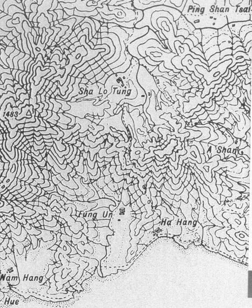
Figure 11.3 Map Showing the Topography adjacent to Sha
Lo Tung in 1905
There are limited records regarding the history in Sha
Lo Tung. However, some literatures
indicated that the Hakka people settled in Sha Lo Tung were the clans of Cheung
(張) and Lei (李). Members of these two clans migrated from
further north in the late 1600s to early 1700s after the Coastal Evacuation
(1661 – 1669).
According to the genealogy, the first generation of
the Cheung clan in Sha Lo Tung was buried in Chaozhou
(潮州) (in northeastern Guangdong) probably in early to
mid-fifteenth century. An eighth
generation wife was the first member of the clan buried in Sha Lo Tung. It therefore suggests that one branch of the
eighth generation of the Cheung clan moved to Sha Lo Tung probably in late
seventeenth century. Sha Lo Tung Lo Wai was established by the Cheung clan.
The Lei clan, according to the genealogy, traces the
clan’s origin back to Dingzhou (定州) of Fujian (福建) Province. They migrated to Guangdong to escape the
political disturbances after the fall of Yuan Dynasty in the mid-thirteenth
century. Lei Tsz-ching,
a fifteenth generation member of the clan, moved to the Tai Po area in 1689 and
settled at Wai Ha in Shuen
Wan. Lei Tsz-ching’s
oldest son, Lei Wai-yan married with a girl from the
Cheung clan and moved to Sha Lo Tung to become the first Lei clan member
settling down in Sha Lo Tung and progressively established the settlement known
as Lei Uk.
The Cheungs, after a while,
believed that the fung shui
in their original settlement in Sha Lo Tung was not good for them. Therefore, they moved to the western side of
the valley (i.e. the present location of Cheung Uk).
As a result, three village settlement areas were
established in Sha Lo Tung, namely the Lo Wai, Cheung
Uk and Lei Uk (see Figure 11.4).
The Sha Lo Tung villagers
were involved in the Tai Po (大埔) local affairs throughout history. In the early days, the Sha Lo Tung villagers
marketed at Tai Po where the market was owned and monopolized by the Tang (鄧) clan of Tai Po Tau (大埔頭). Non-Tang purchasers were tolled to
market. Seeking to end the Tang’s
monopoly, the villages of the area including Sha Lo Tung formed a federation of
seven oath-sworn inter-village mutual defense association (known as “Tsat Yeuk (七約)”) to build a new market
(i.e. the current Tai Po Market).
In 1899, the Battle of Tai Po between the British
colonists and the Punti people (literally ‘local
people’ which include the Tangs and two Lei clan members of Sha Lo Tung) also
indicated that Sha Lo Tung have involved in local affairs of Tai Po. With the British colonial development during
the first half of twentieth century, villagers of Sha Lo Tung began to find
jobs in the city. The villages had
depended on remittances from villagers working in the city and overseas for two
generations before the Second World War.
After the War, the life style of agriculture with
remittances from villagers working in the city or overseas was
re-established. According to the 1960
Hong Kong Gazetteer of Place Names, there were 445 people in Sha Lo Tung (260
in Cheung Uk and 185 in Lei Uk). In the late
1960s and 1970s, when rice farming in Sha Lo Tung became unviable, villagers
started to leave. By the mid-1970s, only
a few dozen elderly villagers stayed in the village and they depend on
remittances from relatives working in the city and overseas.
In the village of Cheung Uk,
there were over 60 houses built in irregular linear rows of around six based on
the topography and fung shui
facing north-east, with the fung shui
woods guarded behind the village houses.
Similarly in the village of Lei Uk,
the village house were connected together in three rows, the longest being in
the west known as Ma Tseuk Ha (麻竹下) while the other two are in
the east row known as Lo Wai. There were about 40 village houses in the
village.
The Cheung Uk,
Lei Uk and Lo Wai in Sha Lo Tung had been abandoned since 1979 after the land of
the area had been purchased by the project proponent. Many of the village houses had been ruined.
|
|
Figure 11.4 1974 Historical Map showing three village
areas in Sha Lo Tung (Source: Hong Kong Government 1974)
Owing to the remoteness of
11.4.3
Built
Heritage Resources Identified within the BHIA Assessment Area
Literature review and field survey identified no
declared monuments and deemed monuments within the BHIA assessment area. According to the List of Historic Buildings
in Building Assessments as of 23 November 2011 ([5]), two Graded Historic Buildings are
identified. While Sha Lo Tung
Table
11.3 Graded Historic Buildings Identified within
the BHIA Assessment Area
|
Site Code |
Site Name |
Current Grading |
ProposedGrading |
Description |
|
GB1 |
Sha Lo Tung Cheung Uk |
Grade 2
(Confirmed on 18 December 2009) |
History of the village is presented in Section 11.4.2 above.
Except the |
|
|
GB2 |
Sha
Lo Tung Lei Uk |
Grade 3 (Confirmed on 24 June 2010) |
History of the village is presented in Section 11.4.2 above. The
whole village is now abandoned. Only
the Lei Uk Ancestral Hall is in good
condition. Other village houses are
ruined and many of them are covered by vegetation. The built heritage survey recorded 3 sub
sites and coded as GB2-1 to GB2-3. Details of their records
are presented in Annex H4. |
|
Apart from the two graded historic buildings listed
by AMO, 10 clan graves and 2 landscape features are identified. No other built heritage is identified in the
BHIA Assessment. The identified graves
and landscape features are summarised in Table
11.4. Their locations are shown in Figure 11.5, the 1:1000 maps are shown in Annex H2 and
detailed records of the sites are presented in Annexes H5 and
H6.
Table 11.4 Graves and Landscape Features Identified within
the BHIA Assessment Area
|
Site Code |
Site Name |
Description |
|
Graves |
|
|
|
GR01 |
Cheung Clan Grave |
A Cheung clan grave
renovated in 1998. |
|
GR02 |
Mrs Cheung Grave |
A Cheung clan grave
renovated in 1998. |
|
GR03 |
Unknown name grave |
Most of the headstone
text is illegible. According to
legible text, the grave was renovated in 1885. |
|
GR04 |
Unknown name grave |
Most of the headstone
text is illegible. According to
legible text, the grave was renovated in 1897. |
|
GR05 |
Cheung clan branch grave |
According to headstone
information the grave was renovated in 1909 and 1994. It is one of the branches (or fong房) grave. |
|
GR06 |
Cheung clan grave |
According to headstone information,
the deceased is from Cheung clan of Sha Lo Tung and renovated in 1980. |
|
GR07 |
Ma grave |
According to headstone
inscription, the grave was renovated in 1817 and 1987. |
|
GR08 |
Mak grave |
The deceased are a couple
of the Mak clan and they are from the 16th and 17th
generations. The grave was constructed
in 1920 and renovated in 2002. |
|
GR09 |
Cheung clan grave |
The deceased is from the
Sha Lo Tung Cheung clan. The grave was
constructed in 1945 and renovated in 1999. |
|
GR10 |
Cheung grave |
According to the
headstone inscription, the deceased is from Cheung clan of Sha Lo Tung. Based on the construction material, the
grave may be constructed before 1950. |
|
Landscape Features |
||
|
LF01 |
Earth Shrine |
There is an earth shrine
located at the southern section of Sha Lo Tung Road. It was probably established by the local
people in the region when they settled there in the early 18th
century. According to the finishing material
used, it had been renovated in the late 20th century. |
|
LF02 |
Old Stone Path Sign |
This old stone path sign
is located at a junction of the Hok Tau Reservoir –
|
11.4.4
Sites
of Archaeological Interest within the AIA Assessment Area
No known sites of archaeological interest
recorded by AMO are identified within the AIA assessment area, which only
includes areas of the Development Site and Sha Lo Tung Road Improvement
(excluding Ecological Reserve area) (see Section
11.3.1 and Figure
11.2). A section of the Hok
Tau Reservoir –
11.4.5
Archaeological
Review
Prior
to 2006, there have been limited archaeological investigations conducted at Sha
Lo Tung and its adjacent areas. The latest
recorded archaeological structure is a lime kiln constructed with stone blocks
dated to the middle of the 19th to early 20th centuries
by the coast of Tolo Harbour
some 150m to the southeast of Sha Lo Tung Road at the current Ting Kok Road known as Ha Hang (see Figure 11.8) ([6]). Another recorded archaeological interest area
is located at Fung Yuen located 250m to the west of Sha Lo Tung Road where two pieces
of late Bronze Age to early Iron Age (Warring States Period of China) pottery
shards with net and union jack pattern had been collected on a cultivation
field between the Mak Uk and Fung Yuen Lo Tsuen ([7])
that reflects the archaeological potential of
Fung Yuen. However,
none of these two areas are currently recorded as sites of archaeological
interest by the AMO.
In 2006, ERM-Hong Kong,
Limited was commissioned to conduct an AIA covering the same site boundary of
the proposed Development Site and the
Sha Lo Tung Road Improvement where
field scanning, 35 auger holes and 13 test pits were conducted (see Figure 11.9). A full report of the AIA result is presented
in Annex H7 and the findings are summarized below.
The archaeological survey
unearthed nine pieces of Qing Dynasty blue-and-white porcelain bowl shards from fieldwalking and excavation of Test Pit TP7. The exterior surface of the shards are either
decorated with Chinese character “chuan” (川), floral or
stamped patterns (see Figure 11.10 or some examples). The findings provide evidence of human
activities at Sha Lo Tung as early as the early to middle Qing Dynasty. However, these finds are local common village
ware shards considered to have negligible value.
|
|
|
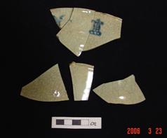
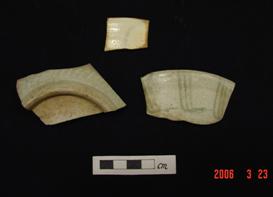
Figure
11.10 Blue-and-white Bowl
Shards Identified
Nevertheless,
a Neolithic Age stone adze not associated with datable artefacts and a Tang to Song
Dynasties brown crackled glazed pot ear shard (see Figures 11.11 and 11.12) were unearthed from TP10 and TP11
located adjacent to the southern section of the Sha Lo Tung Road. The discovery confirmed that the area
adjacent to a hill slope where TP10 and
TP11 located has archaeological potential.
However, due to the low quantity and absence of cultural layer
identified from TP10 and TP11, the archaeological potential is considered to be
low.
|
|
|
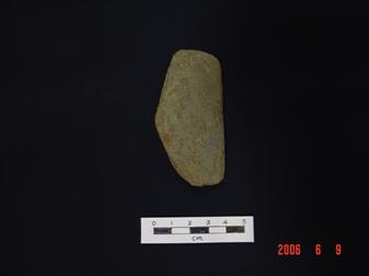
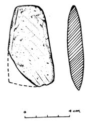
Figure
11.11 Stone Adze unearthed
from Layer 3 of TP10
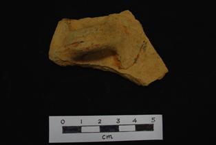
Figure
11.12 Brown Crackled Glazed
Pot Ear Shard from L2 of TP11
11.4.6
Archaeological
Potential Evaluation
In comparing the boundaries of the currently proposed
Development Site and the Sha Lo Tung Road Improvement of the Project and the
Study Area of the AIA conducted in 2006, it is noted that there is no new
developments proposed outside the Study Area of the AIA conducted in 2006. Therefore, no additional potential impact is
identified.
Given that the site boundary of the currently
proposed Development Site and the Sha Lo Tung Road Improvement of the Project
and the Study Area of the AIA conducted in 2006 are the same, the findings for
the AIA conducted in 2006 are considered valid for the archaeological potential
evaluation.
Archaeological Potential Evaluation of the
Development Site
Although some blue-and-white porcelain
bowl shards were identified within the Development Site boundary, which
provides evidence of human activities at Sha Lo Tung as early as early to
middle Qing Dynasty, these finds are local common village ware shards
considered to have negligible value.
Also, given the fact that the villages (Cheung Uk, Lei Uk and Lo Wai) in Sha Lo Tung could date
back to the middle of the 17th to early 18th century, it
is not surprised to identify similar period shards at the adjacent areas. However, as the proposed Development Site is
generally located on a ridge area with lack of superficial deposits to contain
archaeological remains and the field survey conducted in 2006 indicated that
there is no evidence of stable cultural layers identified within the
Development Site, the proposed Development Site is therefore considered to have
negligible archaeological potential.
Archaeological Potential Evaluation of Sha
Lo Tung Road Improvement
The existing Sha Lo Tung Road was mostly constructed
by cutting of existing steep hill slope.
Therefore, most of the sections of the Sha Lo Tung Road are considered
topographically unfavourable for human settlements or to contain any
archaeological potential. This is
further confirmed through the archaeological survey conducted in 2006.
Nevertheless, the southern part of the Sha Lo Tung
Road is relatively flat and topographically different from the northern
section. Two test pits and four auger
holes were conducted in the 2006 archaeological survey where one Neolithic
stone adze and a piece of Tang to Song Dynasty brown crackled glazed pot ear
shard were identified. However, no
evidence of cultural layer was identified.
It is possible that the cultural layers had been disturbed by previous
development such as the construction of Sha Lo Tung Road, underground utilities
and the building structure of the Society of Horticulture of Hong Kong at the
area.
With the small quantity (2 pieces) of artefacts
identified and the lack of cultural layer, it is concluded that the concerned area is of low
archaeological potential.
11.5.1
Construction
Phase
No declared monument is identified in the entire BHIA
assessment area. Impact assessments on
other built heritage resources within the BHIA assessment area are identified
below.
Ecological Reserve
One Grade 2 Historic Building - Sha
Lo Tung
Based on a recent condition survey report on Sha Lo Tung Lei Uk ([8]), it is recommended
that fencing along the full length of the village site boundary adjacent to the
footpath, as well as a temporary footbridge across the stream between Sha Lo Tung
Valley and Lei Uk, should be provided for the purpose
of public safety and temporary maintenance access respectively.
The installation of a fence with an entrance gate to allow villagers to access the ancestral hall in
the village in future along Lei Uk village houses has potential indirect impact to cause
landscape change to the associated cultural landscape features of the Lei Uk village houses.
Nevertheless, the impact tends to be acceptable because only minimal
soil excavation will be conducted for the posts and fences and hand tools will
be used for the installation. Provided
that the fence will be located as far away from the Lei Uk
houses as possible and due care will be taken to prevent any disturbance to the
village houses and structures of Lei Uk, the indirect
impact is considered acceptable.
Regarding the construction of a temporary footbridge, it will be made mainly of wooden materials
and span over the streambed. Construction of the bridge footings will involve minor excavation (dimensions of 500mm (height) x 500mm (length)) by using
hand tools. The temporary footbridge will be removed
manually after the erection of fencing around Lei Uk (see Section 3.3.3 for details). Since there is considerable distance between the footbridge and Lei Uk Village (approximately 25m),
and there is temporary change of access to the heritage site during the work
period, only indirect impact is anticipated.
However, such impact is considered acceptable provided that due care
will be taken to prevent any disturbance to the village houses and structures
of Lei Uk.
The landscape and visual impact assessment and the proposed mitigation
measures for Sha Lo Tung
An organic paddy farm demonstration site of about 0.2 ha in size is
proposed at the abandoned agricultural land behind
Concerning the site of archaeological interest, the Hok
Tau Reservoir –
As such, no significant adverse
impact on these resources is anticipated.
Development Site
Five graves (GR03, GR04, GR06, GR09 and GR10) are
identified which are potentially impacted by the construction of the
Development Site as they are located inside the Development
Site works area. Although
GR03, GR04 and GR10 were constructed in the late 19th or early 20th
century, GR03, GR04 GR10 are overgrown with vegetation
and in poor condition. For GR06 and GR09,
although they were constructed pre-1950, they have been renovated with modern
materials. Therefore the architectural
values of these graves are considered low and such architectural style graves
are commonly found in the New Territories.
Furthermore, the project proponent has consulted the villagers and come
up with a mutual informal agreement that any graves falling within the
Development Site will be relocated.
Thus, acceptable impact is anticipated so long as the mitigation measure
of relocation is implemented. Apart from
the graves no other built heritage are identified. Vibration impact
arising from the works in the Development Site is expected to be limited
because the site is made of soft ground.
No significant impact
on built heritage is anticipated.
Archaeological survey result confirmed the
development site has negligible archaeological potential. No archaeological impact is anticipated.
Sha Lo Tung Road
Improvement
An earth shrine (LF01) is located approximately 3m away from
the southern section of the proposed Sha Lo Tung Road Improvement. Although it falls within the works area
boundary, the shrine will be retained on site.
Therefore, direct impact is not anticipated. No site formation works including bulk
excavation/sheet piling works/shoring works is required for new road alignment
construction at the area. Potential
indirect impact is considered minimal.
Nevertheless, laying of drainage pipes may
require sheet piling for temporary earth support if there is space constraints
for open excavation. Thus, potential
construction vibration impact to the shrine arising from the potential sheet
piling works would be a concern.
Mitigation measures have been recommended if sheet piling works is
required.
Apart from the earth shrine, no other built heritage
resources is identified, and hence no impact is anticipated.
Archaeological survey result confirmed negligible
archaeological potential at most of the sections of the Sha Lo Tung Road
Improvement. No impact to most of the
Sha Lo Tung Road Improvement sections is anticipated. However, at the southern section of the
alignment where small quantity (2 pieces) of artefacts had been discovered, cultural
layer had not been identified to conclude significant archaeological
deposits had been identified. Moreover,
signs of disturbance of the area had been noted probably due to the
construction of the existing Sha Lo Tung Road, underground utilities and the
building structures on site. Thus, it is
believed that any surviving archaeological deposits in the concerned area have
probably been heavily disturbed.
Therefore, this area is considered to have low archaeological
potential. The construction of the Sha Lo Tung Road Improvement will not
cause unacceptable archaeological impact.
11.5.2
Operational
Phase
The fencing with an entrance gate to maintain future
access to the Lei Ancestral Hall along the full length of the site boundary adjacent to the footpath near Lei Uk Village has beneficial impact
on the preservation of the heritage site during the operational phase because
it prevents unauthorized
access and trespassing to the historic buildings. However, potential indirect impact arisen
from the said fence installation in terms of landscape change to the associated
cultural landscape features of the Lei Uk village
houses exists. The landscape and visual
impact assessments associated with the fencing work and the proposed mitigation
measures, if necessary, are addressed as LR9 Abandoned Villages, R4 Visitors to
The operation of the Development Site (e.g. Multi-Cultural Education
Retreat, Columbarium, etc.) would induce permanent change in setting and
general environs at the entrance of Sha Lo Tung. However, since the Development Site is far
away from the built heritage sites located in the Ecological Reserve (i.e. over 230m from
No other impact is anticipated during the operational
phase.
No built heritage impact identified in the proposed
Ecological Reserve. No mitigation measure
is required.
Relocation of five graves in the Development Site is
required for the development. The
project proponent and the grave owners have come up to an agreement that the
graves will be relocated. No mitigation
measure is required.
If laying of drainage pipes
is considered necessary adjacent to LF01, it is recommended that the
construction method be reviewed to avoid and minimise potential construction
vibration impact to LF01. If potential
construction vibration is considered unavoidable, a vibration monitoring should
be conducted by the construction contractor during the construction work
adjacent to LF01. The monitoring should
include:
·
A
pre-condition survey for LF01 conducted by a structural engineer to record the
state of the feature (including all cracks) before construction work commences;
·
Trial
test of vibration generated from ground borne vibration related works;
·
Evaluation
and review of the construction method to avoid and minimise the potential
impact; and
·
Recommendation
of vibration monitoring and protection measures. This would include the establishment of a
vibration limit, monitoring frequency and protective measures to be agreed with
the Engineer and AMO.
In addition, during the construction stage of the Sha
Lo Tung Road Improvement adjacent to LF01, the construction contractor should
ensure visitors’ safe access to the shrine.
A temporary fence with access entrance should also be erected to prevent
any direct impact to LF01 during the construction work.
An archaeological monitoring at the southern section
of the proposed Sha Lo Tung Road Improvement alignment (see Figure 11.13) is recommended during construction stage to preserve
potentially impacted archaeological resources by record. The need and the
scope of the archaeological monitoring should be reviewed during the detailed
design of construction works at the concerned area and agreement to be made
with AMO.
11.7
Environmental Monitoring and Audit Requirements
11.7.1
Construction
Phase
During
the construction stage of the southern section of the Sha Lo Tung Road
Improvement, an archaeological monitoring covering the area as shown in Figure 11.13 is recommended to preserve potentially
impacted archaeological resources by record.
The monitoring should be conducted by a professional archaeologist, who
should obtain a Licence to Excavate and
Search for Antiquities under the Antiquities and Monuments Ordinance and be
engaged by the project proponent or environmental team. The need and scope of archaeological
monitoring is subject to the detailed design of construction works.
If
laying of drainage pipes is required adjacent to LF01
and sheet piling works cannot be avoided, a construction vibration monitoring
as described in Section 11.6 should
be conducted.
11.7.2
Operational
Phase
Monitoring is not required during operational phase.
Desktop review supplemented by field survey identified
that there is no declared monument within the Built Heritage Impact Assessment
(BHIA) and the Archaeological Impact Assessment (AIA) assessment areas. Hok Tau Reservoir –
Two graded historic buildings (
Five graves are identified within the Development
Site, the project proponent and the grave owners have come up to an agreement
that all the graves in the Development Site will be relocated. No other cultural heritage resources are
identified within the Development Site.
The archaeological impact assessment identified two
pieces of artefacts dated back to Neolithic Age and Tang to Song Dynasties
respectively at the southern portion of the proposed Sha Lo Tung Road
Improvement. Archaeological monitoring
has been recommended during construction stage of the Sha Lo Tung Road
Improvement to preserve potentially impacted archaeological resources by
record. The need and scope of the archaeological monitoring is subject to the
detailed design of the construction works.
A landscape feature, an earth shrine (LF01), is
identified at the southern section of the Sha Lo Tung Road Improvement. The construction work adjacent to the shrine
may affect the access to the shrine. It
is recommended that safe access of visitors to the shrine should be
ensured. A temporary fence with access
entrance should be erected to prevent any direct impact to LF01 during the
construction work. Potential vibration
impact will also be a concern if sheet piling works are required for laying
of drainage pipes adjacent to the earth shrine.
Recommendations have been made to avoid and minimise the potential
vibration impact through construction method review. If it is considered not feasible, a vibration
monitoring has been recommended. No
other built heritage resources are identified within the Sha Lo Tung Road
Improvement.