1.6 Objectives
of the EIA Report
2.1 General
Description of the Project
2.3 Recommended Outline Development Plan and Revised
Preliminary Layout Plan
2.5 Nature,
Benefit and Scope of the Project
2.7 Tentative Implementation Programme
2.8 Concurrent
Projects and Evaluation of Potential Cumulative Impacts
Before the training of Shenzhen River, the Lok Ma Chau Loop (LMC Loop) was within the administrative boundary of Shenzhen Municipal Government. It now lies within the administrative boundary of the Hong Kong Special Administrative Region (HKSAR).
In the Chief Executive’s 2007 Policy Address, the development at LMC Loop is one of the ten major infrastructure projects for economic growth of the HKSAR. The HKSAR Government would work with the Shenzhen authorities to tap the land resources of the LMC Loop to meet future development needs and consolidate the strategic position of both cities in the Pan-Pearl River Delta region.
Subsequent to the signing of the “Co-operation Agreement on Recently Initiated Major Infrastructural Projects” at the Hong Kong-Shenzhen Co-operation Meeting on 18.12.2007, a “Hong Kong-Shenzhen Joint Task Force on Boundary District Development” (Joint Task Force), co-chaired by the Secretary for Development of the HKSAR Government and the Executive Vice Mayor of Shenzhen Municipal Government, was set up to coordinate and steer research and studies in relation to planning and development of land in the boundary district, including, inter alia, the LMC Loop.
At its first meeting on 10.3.2008, the Joint Task Force agreed that Hong Kong and Shenzhen would conduct a joint study on planning, environmental, and engineering feasibility for the development of the LMC Loop. Public engagement exercise on the possible future land uses of the LMC Loop was then carried out concurrently in Hong Kong and Shenzhen between June and July 2008. In the meanwhile, the Shenzhen Municipal Environmental Protection Bureau (SZMEPB) had appointed consultants to carry out terrestrial ecological investigation, marine/aquatic ecological baseline study and soil contamination testing works for the LMC Loop in 2008. Among the proposed land uses, higher education, research and development of new high technology and cultural and creative industries received wide support from both sides.
At the Hong Kong-Shenzhen Cooperation Meeting on 13.11.2008, a co-operation agreement was signed on the undertaking of a comprehensive study for the development of the LMC Loop. The meeting initially considered that higher education might be developed as the leading land use in the LMC Loop, complemented with some elements of high-tech research and development (R&D) facilities as well as cultural and creative (C&C) industries. This would provide impetus for human resources development in the South China region and enhance the competitiveness of the Pearl River Delta (PRD), as well as benefit the long-term economic development of the two cities. In 2009, the “Planning and Engineering Study on the Development of Lok Ma Chau Loop – Investigation” (P&E Study) was jointly commissioned by the Hong Kong Planning Department (PlanD) and Civil Engineering and Development Department (CEDD) with participation from Shenzhen. The findings of the baseline survey by SZMEPB were provided for reference under the P&E Study. In parallel, a separate study for the adjoining area on Shenzhen side was commissioned by the Shenzhen government with participation from Hong Kong.
Stage 1 Public Engagement (PE) was conducted in Hong Kong and Shenzhen between November 2010 and January 2011 to seek public views on the Preliminary Outline Development Plan (PODP)(Appendix 1-1) for the LMC Loop. Based on the public views on the PODP and engineering assessment, the draft Recommended Outline Development Plan (RODP)(Appendix 1-1) was formulated and put forward to collect public views in the Stage 2 PE between May and July 2012. A Preliminary Layout Plan was then developed taking into account the public views, planning and engineering considerations (Details are discussed in Section 2).
On 26 May 2009, PlanD in association with CEDD commissioned Ove Arup & Partners Hong Kong Limited (Arup) as the Consultant for the P&E Study.
The
P&E Study commenced on 1 June 2009 to carry out planning, environmental,
and engineering feasibility studies and associated site investigation works
with a view to formulating land use and development proposals for the LMC Loop,
confirming the feasibility of implementing the land use and development proposals,
carrying out preliminary engineering design and formulating the implementation
strategies and programme for delivering the development of LMC Loop and
associated supporting infrastructure in the adjacent area (i.e. Area B). The
P&E Study also includes reviewing the land uses alongside the supporting
infrastructure to be proposed in the areas adjoining the Loop in Hong
Kong. In view of the public views
received during Stage 1 PE, a separate land use review is carried out to
explore the development opportunities in Area B and its surrounding area. Further
separate studies may be required to ascertain the feasibility of the proposed
land uses if they are to be taken forward as a result of this review.
As a result of the training of the Shenzhen River,
which serves as the administrative boundary between Hong Kong and Shenzhen, an
area of about 87.7 ha, previously lying to the north of the river course, is now situated to the south of the re-aligned river. The area, commonly known as the LMC Loop, was
used as a disposal site for mud extracted from the river training work, some of
which were contaminated. The LMC Loop is located near several major
cross-boundary transport nodes including the Lok Ma
Chau (LMC) Boundary Control Point (BCP), the Mass Transit
Railway (MTR) LMC Station of the LMC Spur Line and the San
Tin Interchange. To the north across the
Shenzhen River is the Huanggang Port in
Shenzhen. To the southwest is the Mai Po
Nature Reserve and to the northeast is Hoo Hok Wai, comprising mainly fish ponds with high ecological value.
The Study Area comprises Area A, Area B and Added
Area B as shown in Figure 1.1. Area A is the LMC Loop
site in which the buildings, landscape, infrastructures and internal roads will
be located. Supporting infrastructures and external transport connections are
planned in Area B. Linkage of the external transport connections to the nearby
regional primary road network is located in the Added Area B. It should be noted
that no new land uses / development would be proposed in Area B and Added Area
B under the Project.
In
accordance with the Project Proponent’s clarification ref: NTNTPF2/6/44(E)
dated 12 September 2012, the project
scope shall comprise of:
(a) Both land use developments /
proposals and associated infrastructure are considered and proposed in LMC Loop
(Area A), for preparation of the Recommended Outline Development Plan (RODP);
and
(b) Only associated infrastructure
(e.g. roads, service reservoir, water mains, drainages, utilities, etc) for
supporting the development of the LMC Loop in Area B
(including Added Area B) have been considered and proposed under the
Project
The adjoining area in Shenzhen (i.e. Area C in Figure 1.1) will mainly retain the present land uses and facilities but will reserve space and provide facilities for complementary development with Area A in the future. In the long term, the conceptual plan of Area C will be implemented to promote cooperation between Hong Kong and Shenzhen. A separate study for the adjoining area in Shenzhen (i.e. Area C in Figure 1.1) was commissioned by the Shenzhen side in June 2009, which was conducted in parallel with the LMC Loop Study.
The Development of the LMC Loop comprises the
buildings, landscaping and supporting infrastructure within the site.
Externally, the essential infrastructures comprise the proposed connection roads connected
to the entrance
points at the western and eastern parts of the LMC Loop, the Direct Link to MTR LMC
Station and the
flushing water service reservoir. Their associated environmental impacts
within the study area are assessed in this EIA report.
In
accordance with the requirements of Section 5(1) of the Environmental
Impact Assessment Ordinance (EIAO), a project profile (No. PP-376/2008) of the project title
“Development of Lok Ma Chau Loop”, was submitted to
the Director of Environmental Protection (the “DEP”) for the application of an
Environmental Impact Assessment (EIA) Study Brief on 30 December 2008. Pursuant
to Section 5(7)(a) of the EIAO, the DEP issued a Study
Brief (No: ESB-201/2008 dated 23 January 2009) for the EIA study.
Subsequently, a revised project profile (No. PP-455/2011) was submitted to DEP on 3 November
2011 and a new Study Brief (No. ESB-238/2011) under section 5(1)(a) of the EIAO was issued on 12 December 2011 to adjust the Study Area due to the need to accommodate the alignment
of the proposed transport infrastructure falling outside the original Study
Area in EIA Study Brief ESB-201/2008 during the
course of the Study.
This EIA
Report is to address the environmental impacts due to the works and land uses
proposed under the P&E Study in accordance with the latest EIA Study Brief
(No. ESB-238/2011).
The LMC Loop Development is a designated
project (DP) under Item 1 Schedule 3 of EIAO - Engineering feasibility study of
urban development projects with a study area covering more than 20 ha or
involving a total population of more than 100,000.
The Project will include land use planning and development in LMC Loop (Area
A) and the associated infrastructures external in the adjacent areas in Hong Kong (within Area B and Added Area B). Individual project
components were identified in light of the need for various stages in the implementation programme (see Section
2.5.3).
In addition, the following project components
associated with the LMC Loop Development fall under various Schedule 2 DP
categories as summarized in Table 1.1.
Table 1.1 Schedule 2 designated projects in LMC Loop development
|
Project Component |
Brief Description |
Schedule 2 DP Category |
Reasons |
|
|
Ecological Area (DP1)[3] |
·
Site formation works ·
12.8
ha of Ecological Area for reed marsh compensation (Figure 2.2) ·
A
secondary
function as a flood storage pond (Figure 2.3) |
I2 |
A flood storage pond more than 10 ha in size |
The Ecological Area will have a secondary function as a flood storage pond and the area (total 12.8 ha) is larger than 10 ha in size. |
|
Western Connection Road (including LMC Road Connection to Fanling / San Tin Highway) (DP2)[1] |
·
Site formation works ·
Linkage
from LMC Loop to external road and highway network in San Tin Highway/Castle
Peak Road (Figures 2.4a to 2.10) formed by widening of existing Ha Wan Tsuen Road and Lok Ma Chau Road
(at-grade) plus a new slip road to San Tin Interchange ·
2-lane
single carriageway ·
About
1.3 km (main road) and 480m
(slip roads) in length ·
Other
components under this DP: construction haul roads, utilities (water mains,
drainage, electric cables, etc), noise barriers and cycle tracks |
Q1 |
All projects including new access roads, railways, sewers,
sewage treatment facilities, earthworks, dredging works and other building
works partly or wholly in an existing or gazette proposed country park or
special area, a conservation area, an existing or gazette proposed marine
park or marine reserve, a site of cultural heritage, and a site of special
scientific interest. |
The part of Western Connection Road (WCR) alignment, haul roads
and the temporary works area will be within the “Conservation Area” under the
Approved San Tin Outline Zoning Plan
(OZP) No.
S/YL-ST/8 to the west of LMC Loop. |
|
Direct Link to MTR LMC Station (DP3)[2] |
·
Site formation works ·
Linkage
from LMC Loop to the
proposed PTI at MTR LMC
Station (Figures
2.11a to 2.11e) ·
Road-based
2-lane single viaduct ·
Elevation:
at grade in the junction at WCR and up to 17.6 mPD ·
About
770m in length ·
Other
components under this DP: construction haul roads, utilities (water mains,
drainage, electric cables, etc), noise barriers/parapets |
A8 |
A road or railway bridge more
than 100m in length between abutments. |
Direct Link to MTR
LMC Station is in the form of viaduct
and the length between abutments is about 500m. |
|
Q1 |
All projects including new
access roads, railways, sewers, sewage treatment facilities, earthworks,
dredging works and other building works partly or wholly in an existing or
gazette proposed country park or special area, a conservation area, an
existing or gazette proposed marine park or marine reserve, a site of
cultural heritage, and a site of special scientific interest. |
The part of the alignment of Direct Link to MTR LMC Station, haul roads and the temporary works area will be
within the “Conservation Area” under the
Approved San Tin OZP No. S/YL-ST/8 to the west of LMC Loop. |
||
|
Drainage System under Internal Transport Networks (DP4)[2] [3] |
·
Site formation works ·
Drainage system within LMC
Loop (Figure 2.3) ·
The drainage system under
the internal transport network including
Main Road M1, Road L1 and Road L2 (Figure 2.1b) ·
Other
components under this DP: utilities |
I1 |
A drainage channel or river
training and diversion works which discharges or discharge into an area which
is less than 300m from the nearest boundary of an existing or planned
conservation area. |
The discharge
points of drainage system
associated with the Internal Transport Networks is less than 300m from the “Conservation Area” under the
Approved San Tin OZP No. S/YL-ST/8 to the west of LMC Loop. |
|
Sewage Treatment Works (STW)
(DP5) |
·
Footprint:
2.1 ha (Figure 2.1b, 2.26a,
2.26b
and 2.26c) ·
Average
Dry Weather Flow: 18,000 m3/day ·
Treatment
level: tertiary ·
Treatment
method: Membrane bioreactor (Subject to detailed design) ·
Components
for TSE
reuse: reclaimed water surge vessel compound, reclaimed water booster pump
compound, reclaimed water chlorine contact tank |
F2 |
Sewage treatment works with
an installed capacity of more than 5,000 m3/day
and a boundary which is less than 200m from the nearest boundary of an
existing or planned educational institution. |
The design capacity of on-site STW is 18000 m3/day
and the location is about 180m from planned education institution according
to the RODP. |
|
F4 |
An activity for the reuse of
treated sewage effluent from a treatment plant. |
The on-site STW will include treated sewage effluent for re-use. |
||
|
Eastern Connection Road (ECR)(DP6)[2] |
·
Site formation works ·
Linkage
from LMC Loop to North East New Territories New Development Areas (NENT NDAs) via Ma Tso
Lung (Figures
2.12 to 2.23f) ·
Involve
widening part of
existing Border Road and new road near Ma Tso Lung ·
2-lane
single at-grade carriageway plus depressed road/underpass crossing the
Meander and minor viaducts across streams ·
About
610m (depressed road), 200m (underpass), 50m (viaduct), 1350m (at-grade road) in length ·
Other
components under this DP: construction haul roads, utilities (water mains,
drainage, electric cables, etc), noise barriers and cycle tracks |
A9 |
A road fully enclosed by
decking above and by structure on the sides for more than 100m. |
The underpass section of ECR is about 200m. |
|
I1 |
A diversion works which
discharges or discharge into an area which is less than 300m from the nearest
boundary of an existing conservation area. |
The construction of underpass will require 50% flow contraction
by cofferdams. Treated runoff or diverted runoff will be discharged to the
Meander which is less than 300m from the nearest boundary of the “Conservation Area” under the
Approved San Tin OZP No. S/YL-ST/8 at east of LMC Loop. |
||
|
Q1 |
All projects including new
access roads, railways, sewers, sewage treatment facilities, earthworks,
dredging works and other building works partly or wholly in an existing or
gazette proposed country park or special area, a conservation area, an
existing or gazette proposed marine park or marine reserve, a site of
cultural heritage, and a site of special scientific interest. |
The part of the alignment of ECR will be within the “Conservation Area” under the
Approved San Tin OZP No. S/YL-ST/8 at east of LMC Loop.
|
||
|
Flushing Water Service
Reservoir (DP7) |
·
Include site formation works ·
Footprint:
1350 m2 (Figure 2.23a
and 2.26c) ·
Size:
3375 m3 ·
Other
components under this DP: 200m access road from ECR, the associated
designated pipelines for treated sewage effluent reuse |
F4 |
An activity for the reuse of
treated sewage effluent from a treatment plant |
The flushing water service reservoir will retain the treated
sewerage effluent for re-use. |
[1] The road type of Western Connection Road is neither
an expressway, trunk road, primary distributor nor district distributor
and the bridge span crossing Meander is less than 100m (~65m only). It is
therefore not a DP under S2 A1 and S2 A8 category respectively.
[2] The road type of Direct Link to MTR LMC Station, Internal Transport Network and Eastern Connection
Road are neither an expressway, trunk road, primary
distributor nor district distributor. They are therefore not a DP under
S2 A1 category.
[3] The entire drainage system within LMC Loop (Area A) will
involve two S2 DPs: (I) flood storage pond and (II) drainage discharges. As the
works will be under different construction contracts and involve different
operators, the flood storage pond has been included in the Ecological Area
(DP1) and drainage discharges in the Drainage System under Internal Transport Networks (DP4) respectively.
[4] Two electricity substations below 400 kV are proposed within
the LMC Loop but they are not identified as designated projects.
For the avoidance of doubt, the upgrading of Shek
Wu Hui Sewage Treatment Works (SWHSTW) in connection with DP5’s compliance with
“No Net Increase in Pollution Load requirement in Deep Bay” policy is also a
Designated Project under F.1 Schedule 2 of Part 1. The EIA for this DP will be
conducted under the North East New Territories New Development Areas Planning
and Engineering Study (NENT NDAs Study) (see Item 8 of Section 2.8.1).
1.6 Objectives of the EIA Report
This EIA report has incorporated the comments from various government departments and other concerned parties on the on-going P&E Study in addressing the environmental impacts of the existing, committed and planned developments in the vicinity. The report also compared the benefits and disbenefits of different development scenarios and options under various aspects including environmental consideration, with the aims to deriving the RODP that avoids adverse environmental impact to the maximum practical extent.
According to
Section 1.8 of the EIA Study Brief, this EIA study is to provide information on
the nature and extent of environmental
impacts arising from the construction and operation of the developments
proposed under the Project and related works that take place concurrently. This
information will contribute to decisions by the Director of Environmental Protection on:
(i)
the overall
acceptability of any adverse environmental consequences that are likely to
arise as a result of the Project and associated works, and their related staged
implementation;
(ii)
the conditions and
requirements for the detailed design, construction and operation of the Project
to mitigate against adverse environmental consequences wherever practicable;
and
(iii)
the acceptability of residual impacts after the staged as
well as the full implementation of the Project and the related proposed
mitigation measures are implemented.
The objectives of
the EIA study as per Section 2.1 of EIA Study Brief are as follows:-
(i)
to describe the Project
together with the requirements for carrying out the Project;
(ii)
to identify and
describe elements of the community and environment likely to be affected by the
Project and/or likely to cause adverse impacts on the sensitive uses at the
Project, including both the natural and man-made environment and associated environmental
constraints;
(iii)
to provide information
on the consideration of alternatives to avoid or minimize the potential adverse
environmental impacts on the sensitive uses at the Project and adjacent areas
that may be subject to (i) the adverse environmental
impacts of the Project and/or (ii) the adverse impacts of the
existing/committed/planned developments in the Project site and adjacent areas;
to compare the environmental benefits and dis-benefits
of each of different options; to provide justifications and constraints for
selecting the preferred option(s); and to describe the part environmental
factors played in the selection;
(iv)
to identify and assess
air quality impact, noise impact, water quality impact, waste management, land
contamination, hazard to life, ecological impact, fisheries impact, landscape
and visual impact, impacts on sites of cultural heritage, quantify emission
sources and determine the significance of impacts on sensitive receivers and
potential affected uses;
(v)
to identify the
negative impacts and propose measures to avoid or provision of mitigation measures to minimize pollution,
environmental disturbance and nuisance during construction and operation of the
Project;
(vi)
to investigate the
feasibility, practicability, effectiveness and implications of the proposed
impact avoidance and/or mitigation measures;
(vii)
to identify, predict
and evaluate the residual environmental impacts (i.e. after practicable
avoidance or mitigation measures) and the cumulative effects expected to arise
during the construction and operation of the Project and associated works in
relation to the sensitive receivers and potential affected uses;
(viii)
to identify, assess and
specify methods, measures and standards to be included in the detailed design,
construction and operation of the Project and associated works which are
necessary to mitigate these environmental impacts and cumulative effects and
reduce them to the acceptable levels;
(ix)
to investigate the
extent of the secondary environmental impacts that may arise from the proposed
mitigation measures and to identify constraints associated with the mitigation
measures recommended in the EIA study, as well as provision of any necessary
modification;
(x)
to identify individual
project(s) that fall under Schedule 2 of the EIAO; to ascertain whether the EIA
study has adequately addressed the environmental impacts of those projects;
and, where necessary, to identify the outstanding issues that need to be
addressed in any further detailed EIA study;
(xi)
to investigate the
extent of the secondary environmental impacts that may arise from the proposed
mitigation measures and to identify constraints associated with the mitigation
measures recommended in the EIA study, as well as provision of any necessary
modification; and
(xii)
to design and specify environmental monitoring and audit
requirements to ensure effective implementation of the recommended
environmental protection and pollution control measures.
The EIA study also demonstrates that criteria in the relevant sections of the Technical Memorandum on the EIA Process of the Environmental Impact Assessment Ordinance (TM-EIAO) are fully complied or the anticipated environmental impacts will be mitigated to acceptable levels.
According to
Section 3.2.1 of the EIA Study Brief, information on the potential impacts on
the environment within the HKSAR boundary arising from any associated works of
the Project outside the HKSAR boundary, and in combination with those impacts
arising from the Project, are provided to facilitate DEP’s consideration on the
overall acceptability of any adverse environmental consequences that are likely
to arise as a result of the Project. These information
are provided in Section 2.8.2 of
this Report.
The structure of this Report is as follows:
|
Section |
Title |
Aims |
|
1 |
Introduction |
To provide
project background, purpose and scope of the EIA study as well as to describe
the EIA study area and the Schedule 2 Designated Projects. |
|
2 |
Project Description |
To describe the project inception, public aspirations, consideration
of alternatives, green initiatives and project visions leading to the
development of RODP and major activities in the project scope. |
|
3 |
Air
Quality Impact |
To assess the
potential air quality impact of the project and recommend mitigation
measures. |
|
4 |
Noise
Impact |
To assess the
potential noise impact of the project and recommend mitigation measures. |
|
5 |
Water
Quality Impact |
To assess the
potential water quality impact of the project and recommend mitigation
measures. |
|
6 |
Sewerage
and Sewage Treatment Implications |
To assess the
potential sewerage and sewage treatment implications of the project and
recommend mitigation measures. |
|
7 |
Waste
Management Implications |
To assess the
potential waste management implications of the project and recommend
mitigation measures. |
|
8 |
Land
Contamination Impacts |
To assess the
potential land contamination impacts of the project and recommend mitigation
measures. |
|
9 |
Hazard
to Life |
To assess the
potential hazard to life impact of the project and recommend mitigation
measures. |
|
10 |
Impact
on Sites of Cultural Heritage |
To assess the
potential cultural heritage impact of the project and recommend mitigation
measures. |
|
11 |
Landscape
and Visual Impact |
To assess the
potential landscape and visual impact of the project and recommend mitigation
measures. |
|
12 |
Ecological
Impact |
To assess the
potential ecological impact of the project and recommend mitigation measures. |
|
13 |
Fisheries
Impact |
To assess the
potential fisheries impact of the project and recommend mitigation measures. |
|
14 |
Landfill
Gas Hazard |
To assess the
potential landfill gas hazard of the project and recommend mitigation
measures. |
|
15 |
Food
Safety Implication |
To assess the
potential food safety implication of the project and recommend mitigation
measures. |
|
16 |
Environmental
Outcome |
To summarise
the assumptions and limitation of assessment methodologies as well as
findings of environmental impacts, outcomes and mitigation measures adopted. |
|
17 |
Environmental
Monitoring & Audit |
To summarise
the requirement of Environmental Monitoring & Audit. |
|
18 |
Conclusion |
To draw conclusions from the assessment results of the EIA study. |
2.1
General Description of the
Project
The Project
comprises the development of LMC Loop (about 87.7ha) and associated supporting
infrastructure / works within and outside the LMC Loop. Through the P&E
Study, a Revised Preliminary Layout Plan (Revised PLP) for the development of
the LMC Loop has been developed. Preferred options of traffic and transport,
basic infrastructures and utilities provisions, off-site fishpond compensation
area and temporary works area are proposed (Figures
2.1a to 2.1d).
The Revised PLP (Figure
2.1b) and associated infrastructure was formulated with reference to the relevant
statutory town plans (including the Approved San Tin OZP (No. S/YL-ST/8), the Approved
Ngau Tam Mei OZP (No. S/YL-NTM/12) and Approved Ma Tso Lung and Hoo Hok Wai Development
Permission Area (DPA) Plan (No. DPA/NE-MTL/2)[1],
Outline Development Plans, Layout Plans and other
relevant plans as given in Figure
2.1a.
The LMC Loop will
be developed with higher education as the leading land use, complemented by
high-tech R&D and C&C
industries. The total number of students and employees for LMC Loop will be
about 53,000. The development plan, the associated infrastructures provisions
and the major activities in the project scope are outlined below.
2.2.1 Project Inception
The Project is
required to meet the future needs for the development of Hong Kong (HK) and
Shenzhen (SZ) and to consolidate the strategic position of the two cities in
the region.
Located within the
boundary area, the Loop (with a land area of about 87.7 hectares) is near the
major transport nodes including the Lok Ma Chau
Boundary Control Point (BCP), the MTR Lok Ma Chau
Station of the Lok Ma Chau Spur Line and the San Tin
Interchange.
The Loop is
located to the north of the old course of the SZ River and was within the
administrative boundary of SZ before the river was re-aligned in 1997. It had
been used as a disposal site for mud extracted from the river training works,
some of which were contaminated. As a result of the training of SZ River, the
Loop now lies to the south of the re-aligned river course. The ‘Order of the
State Council of the People’s Republic of China No. 221’ (中華人民共和國國務院令第221號) in 1997 provides that after the realignment of SZ
River, the administrative boundary of the HKSAR follows the new centre line of
the river. As such, the Loop currently falls within the administrative boundary
of HKSAR and is subject to the laws of HKSAR.
In the Chief
Executive’s 2007-08 Policy Address, the development of the Loop was identified
as one of the ten major infrastructure projects for economic growth and to meet
future development needs.
In view of the
unique history of the Loop which was within the SZ’s jurisdiction before 1997,
HK and SZ Governments have agreed to jointly develop the site for mutual
benefits of the two cities. At the first meeting of the “HK – SZ Joint Task
Force on Boundary District Development” on 10 March 2008, co-chaired by the
Secretary for Development and the Executive Vice Mayor of SZ Municipal
Government, it was agreed that both sides would, on the principles of co-study
and co-development, conduct a joint study on planning, environmental and
engineering feasibility for the development of the Loop.
At the HK-SZ
Cooperation Meeting on 13 November 2008, the two Governments signed a
cooperation agreement on the undertaking of the P&E Study. It was also
agreed that higher education might be developed as the leading use in the Loop,
with some elements of high-tech R&D facilities and C&C industries. This
would provide impetus for human resources development in South China, enhance
the competitiveness of the Pearl River Delta, and benefit the long-term
economic growth of the two cities.
The Project also
ties in with the Framework Agreement on Hong Kong/Guangdong Co-operation (the
Framework Agreement) which was signed between the two Governments in 2010. One of the major initiatives of the Framework
Agreement is to promote collaborative development in Hong Kong and the PRD
cities to form a world-class metropolitan region. To achieve this goal, Hong Kong and Guangdong
Governments have put forward a number of specific policies and measures. On the education front, specific policies to
support prestigious tertiary institutions from Hong Kong to jointly set up
institutions of higher education in the PRD region with Mainland Educational
Institutions; and to establish Hong Kong Guangdong Industry-University-Research
bases, joint laboratories, joint engineering research centres, humanities and
social sciences research bases and innovation and technology parks, support
tertiary institutions from both places in undertaking key scientific and
technology research projects of national, ministerial and provincial levels. The Project as one of the key collaborative
developments under the Framework Agreement is to develop the LMC Loop with
higher education as the leading land use, complemented by high-tech R&D and
C&C industries under the principle of “co-study, co-development and mutual
benefit”.
During the pre-study public engagement exercise between June and July 2008 to collect public views and aspirations on the possible future land uses for the LMC Loop, a total of four Focus Group Discussion sessions, one Public Forum and a briefing were held. A similar exercise was also organized by the SZ authority. General optimism was observed among the participants, expressing a wide range of views regarding how to capitalise on the opportunity to develop the LMC Loop. Apart from higher education, high-tech R&D and C&C uses which are the basis of formulating the Recommended Outline Development Plan (RODP) (Appendix 1-1), the following possible land uses are among the public views suggested for the LMC Loop:
· a design / production studio and centre for multi-media and creative industry-related education / training;
· a gold trading centre;
· an exhibition and wholesale centre for products from Mainland China;
· an entrepôt, serving as a cargo drop-off / distribution centre;
· an institution hub housing special disciplines of study at the post-graduate level and with a global orientation;
· a data-processing centre to provide outsourcing services;
· a high and innovative technology research centre;
· a bio-medical complex comprising facilities for surgical operations, bio-tech research, medical referral services, and integrated Western and Chinese medicines under a medical tourism operational model; and
· an eco-park for eco-tourism.
Weaving among these various proposed land uses, the following common threads have emerged: (1) the development of the LMC Loop should leverage on Hong Kong’s and Shenzhen’s competitive advantages; (2) developments must have added value and potential for growth; (3) support of both Governments and their collaborative efforts are crucial; (4) public policies to facilitate the LMC Loop’s development need to be deliberated; (5) early clarification on the LMC Loop’s ownership and mode of development is needed; (6) the development of the LMC Loop should be considered in a wider geographical perspective; (7) developments should be sensitive to the environmental concerns; and (8) make good use of the uniqueness and strategic location of the LMC Loop.
According to the public views collected during the 2008 public
engagement exercise, there is a general consensus on three major directions in
which the Loop should be developed:
·
Developments
on the Loop must embody the Loop’s unique attributes which are otherwise not available
elsewhere in Hong Kong or Shenzhen;
·
The Loop’s
developments must add value to Hong Kong’s and Shenzhen’s economy
significantly; and
·
Developments
on the Loop must be sustainable and environmentally acceptable.
The above-mentioned principal tenets serve as the basis of analysis with a view to identifying the possible land use options for the Loop. As a result, four land use options are identified to have gained wider public support from the public engagement exercise:
· a design / production centre for multi-media and cultural and creative industries with related education / training facilities;
· an higher education hub housing special disciplines of study at the post-graduate level and with a global orientation;
· a high and innovative technology research centre; and
· a bio-medical complex comprising facilities for surgical operations, bio-tech research, medical referral services, and integrated Western and Chinese medicines under a medical tourism operational model.
Through subsequent meetings of the Joint Task Force, the LMC Loop is decided to be developed into creation place integrating design solutions that balance social, economic, environmental and physical parameters. Moreover, it might encourage social and community interaction for the formation of knowledge networks and vibrant cluster of activities. Upon due consideration of the public views collected in 2008, the Hong Kong and Shenzhen governments agreed that the LMC Loop be developed with higher education as the leading land use, complemented by new high-tech research and development and cultural and creative industries. The creative and inspiring environment will entice people to study and work in the LMC Loop.
2.2.3 Predicted Future Environment without Project
The LMC Loop previously
served as a disposal site for mud extracted from the
Shenzhen River training work, some of which were contaminated. The filled area
was then capped with uncontaminated top soil. This area is now a combination of
reedbed and grassland. The reedbed
is self-sown and has formed in low-lying areas in which water does not drain
away for at least part of the year. Most of the
trees, apart from banana trees in the south, are self-sown trees. The area
outside the LMC Loop is mainly comprised of grassland, agricultural land,
fishponds and a few rural villages.
Vehicle repair and demolition workshops are present along LMC Road and
Ha Wan Tsuen Road.
To the west of the site lies the Lok Ma Chau BCP and MTR LMC Station. The area is characterised by infrastructure and compensatory wetland and planting surrounding the cross-boundary facilities. It extends in the south to the vehicular waiting areas for boundary crossing and open container storages at San Tin and roadside planting. To the south across the meander of Shenzhen River, the area is composed of vegetated ridges at LMC and Tai Shek Mo with knolls extending from Sandy Ridge to Lo Wu in the east and Ki Lun Shan in the south. On their lower slopes, areas of mixed woodland are dominated by planted species for either reforestation, landscaping or fruit production purposes.
To the north lies the trained Shenzhen River against the background of high-rise residential developments and facilities associated with the Shenzhen Huanggang boundary crossing, the counterpart to the LMC crossing, with its road development and extensive apron areas for cross-boundary traffic. To the east of the site lie managed and unmanaged fishponds and associated wetlands These wetlands are generally of high ecological values and form part of an extensive area of wetlands extending from Tsim Bei Tsui on the west side of Inner Deep Bay to Ng Tung River in the northeast. The LMC Loop site serves as an important linkage between these areas.
It is considered that the future environment of the Loop will change only gradually, as drier grassland succeeds to shrubland and, though in many years, woodland. Damp areas are likely to remain at an early successional stage for longer. In terms of the reedbed, this has reached its climax state, as Phragmites is a species that adapted to colonise ephemeral wetland areas quickly. This view is supported by similar experience of the Study Team at Mai Po. It took as little as two years for the reeds to reach their maximum height after being cut / planted. The reeds in the Loop are at least 10 years old. Changes will occur, though slowly, as a build-up of sediment and organic material at the base of reeds eventually leads to a rise in ground level and its consequent drying out. Quick or major changes in the area would arise only from changes in rainfall patterns, which determine long-term water levels.
With regard to areas outside LMC Loop, most habitats conditions are expected to remain unchanged, albeit with the potential for ecological enhancement if active management measures were implemented. Some habitats may be expected to increase in ecological value in future as a result of ecological succession (for example the maturation of shrubland into woodland).
Without the Project, however, there will be hard to locate alternative sites for pioneering cooperation between Shenzhen and Hong Kong, for which alternative sites serving the same purpose may require more intensive infrastructures and more significant induced carbon emissions from logistics. In addition, there is no confirmed programme from Shenzhen side to bio-remediate the background odour from Shenzhen River to the proposed criterion under this EIA study.
2.2.4 Environmental Benefits/Dis-benefits for Feasible Development Options
The environmental benefits
and dis-benefits of the above various development
scenarios/options/land use are presented in Appendix
2-1 and summarised below:-
Benefits
The major environmental benefits with the project in place include:
· Possible engagement with the SZ authorities to early discuss programme for bio-remediation of Shenzhen River to reduce odour source from Shenzhen River and the odour exposure to nearby villages.
· Remediation of contaminated land to reduce potential risk within the LMC Loop.
· Readily available location for pioneering cooperation between Shenzhen and Hong Kong, for which alternative sites serving the same purpose may require more intensive infrastructures and more significant induced carbon emissions from logistics.
The project will promote low carbon and green community for developing
a sustainable, environmentally friendly, energy efficient and people oriented
community in the LMC Loop. Green initiatives, such as clean fuels, low emission
transport system, renewable energy, built form and design, and reuse of treated
sewage effluent, etc., for the development of
LMC Loop and associated infrastructure are being
investigated (see Section 2.3.4.2). Should the green initiatives be taken
forward, it would establish a showcase for low carbon community,
encourage exchange of experience and to help promote the development of low
carbon communities in the growing urbanisation of the Mainland.
In comparison with the options involving industrial and commercial
uses, the Higher Education, High-tech R&D and C&C Industries project
will induce less industrial and vehicular emission as a result of its daytime
and night time operations while the eco-tourism or “No development” options
will result in less or no environmental impact. This renders the eco-tourism or
“No development” scenarios a preferred option from purely environmental
perspective for the LMC Loop development site. However, in a bigger picture,
the need to identify alternative sites serving the same purpose of the project
may impose further requirements for more intensive infrastructures which will
induce higher carbon emissions from the project and compromise the development
principles of “Co-study, Co-development and mutual benefit” of the project.
Thus, taking into account potential environmental impact of the alternative
site scenario, the Higher Education, High-tech R&D and C&C Industries
is considered the preferred option.
In particular, no industrial use is proposed and thus there will be no
chimney emissions and impact on residential uses including those nearby
villages and the proposed hostels within the LMC Loop.
Dis-benefits
More extensive supporting infrastructures such as
additional sewerage, drainage and transportation will be required compared with
eco-tourism or “No development” option. Thus, environmental
impacts such as air quality, noise, ecology, landscape and visual impacts,
cultural heritage, land contaminations, etc may be induced due to construction
and operation of supporting infrastructures. Nevertheless, the acceptability of
the overall environmental performance of the Project at all stages throughout
implementation and the cumulative effects due to interfacing planned, committed
and existing projects in the vicinity of the Project were demonstrated in this
EIA report.
2.2.5 Consideration of Feasible Construction Methods among Development Options
According to Appendix 2-1,
supporting infrastructures such as additional sewerage, drainage and
transportation will be required for all development options. The formation of
supporting infrastructures and the consideration of feasible construction
method will be similar among all development options except there will be no
construction impact without the Project in place. Details of construction
methods are discussed in Section 2.6.
2.2.6 Informed Decisions to Recommended Development
Public aspirations, environmental factors, and their benefits and dis-benefits formed an important consideration in deriving the recommended preferred
development options and Preliminary Outline Development Plan (PODP)(Appendix 1-1)
to avoid adverse environmental impacts to the maximum practicable extent.
After another round of consultation with major stakeholders held in
July to September 2009, the major public views identified can be summarized as
follows:
· Respect the ecological habitat and minimise impacts thereon in pursuing development so as to strike a balance between conservation and development.
· Respect the rights of private landowners and protect local character while allowing adequate development to take place to create opportunities for local development, social harmony and social inclusion.
· Upgrade existing road network and provide new infrastructure, where appropriate, to strengthen accessibility and connectivity of the LMC Loop and its surrounding areas to other parts of Hong Kong as well as to Shenzhen as part of enhancement in quality of life and well-being of existing and future communities.
· Allow flexibility in the land use, providing an enabling and interactive environment for different uses and users and hence contributing towards creating synergy between uses within the LMC Loop.
· Clarify on the policy support for the three major land uses and the mode of development, including simplified entry arrangement for the LMC Loop users, relaxation of quota for Mainland students, and any Government’s financial support for the capital cost of higher education development, etc.
The abovementioned public views formed the major consideration in formulating the recommended development option, i.e. higher education, high-tech R&D and C&C uses.
2.2.7 Project Vision and Guiding Principles
The strategic location of the LMC Loop makes it the ideal project for Hong Kong and Shenzhen to showcase the cooperation of both cities in jointly developing this piece of land into an exchange zone that meets the future development aspirations of the Pearl River Delta.
Upon due consideration of
the public views
collected in 2008, the Hong Kong and Shenzhen Governments agreed that the LMC
Loop would be developed with higher education as the leading land use,
complemented by high-tech R&D and C&C industries
in order to meet the aspirations of
the local community in respect of the LMC
Loop development. Associated infrastructures such as
transportation, public utilities, water supplies and
sewage treatment will also be needed in order to cope with the additional
populations from the development.
The vision is to develop the LMC Loop as a hub for cross boundary human resources development within a sustainable Knowledge and Technology Exchange Zone (KTEZ). The Project will be developed according to the Guiding Principles below:
· Guiding Principle 1: Capitalize on the strategic location of the LMC Loop by adopting an efficient and flexible land use planning and design approach;
· Guiding Principle 2: Adopt a low carbon economy;
· Guiding Principle 3: Provide highly accessible and convenient connections to / from the LMC Loop with appropriate cross-boundary arrangements;
· Guiding Principle 4: Enhance environmental performance with reference to local characters; and
·
Guiding Principle 5: Foster social harmony and
vibrancy and promote local development.
In conceiving alternative feasible layout options, key environmental
issues such as ecological impact of the development needs careful assessment in
view of the presence of reed marsh, marsh, ponds and seasonal wetlands and the
important ecological functional linkage provided by LMC Loop between Tsim Bei Tsui
on the west side of Inner Deep Bay and Ng Tung River in the northeast. Other
non-environmental factors such as planning parameters and transportation needs
were also assessed in the technical assessments under the P&E Study. Relevant
information regarding the formulation of layout and infrastructures is
discussed in below sections.
2.3 Recommended Outline Development Plan and Revised Preliminary Layout Plan
2.3.1 Development Opportunities and Constraints
The opportunities and constraints on the development of LMC Loop are summarised below:
Development
Opportunities
· The site created as a result of Shenzhen River regulation provides a piece of sizeable and flat land readily available for development.
· The site is close to Shenzhen’s Futian commercial area, which is part of Shenzhen’s central urban cluster, hence bringing economic benefit to Hong Kong and the Mainland, especially Shenzhen.
· The site is near the existing Huanggang Port and the MTR LMC Station of the East Rail Spur Line, hence allowing easy logistics to cross-boundary activities and enhancing close connections between Hong Kong and the Mainland.
Development
Constraints
· There is no provision of public utilities, such as water, electricity, gas, drainage, telecommunication, etc. in the LMC Loop. There is no proper connection road with other areas.
· Existing odour emission from Shenzhen River poses a constraint. Nevertheless, the Shenzhen Municipal Government has implemented / will implement measures to tackle the problem, which include interception and banning of illegal sewage discharge, construction of large scale sewage treatment plants, upgrading of existing treatment plants as well as enhancement of the sewage and pollution discharge standards. Some of the measures have been stipulated in the 12th 5-year Plan of Shenzhen Water Supplies Development 《深圳市水務發展十二五規劃》[2-3].
· Both contaminated and uncontaminated mud have been deposited in the LMC Loop during river training. According to the latest land contamination assessment (see Section 8), de-contamination would be required in compliance with the EIA requirements before development.
· Ecological impact due to the development needs to be carefully assessed in view of reed marsh, marsh, ponds and seasonal wetlands.
· Lack of transport infrastructure meeting current standards and required population.
· The “no net increase in pollution load requirement in Deep Bay” policy may imply a higher discharge standard required in the design of sewage treatment strategy.
2.3.2 Consideration of Alternative Feasible Layout Options
In the early stage of P&E Study, a PODP was formulated in consideration of the project vision and Guiding Principles.
The PODP set out the
proposed land use framework to guide the future development of the LMC Loop in
terms of spatial land use arrangements, development intensities and height
profile, major infrastructure networks, open space, and other urban design and
landscape elements.
Three layout options, namely flexible, cluster and
linear, had been investigated and formulated with regard to the overarching
project vision and Guiding Principles. They were conceptually different and
aimed to provide different urban design solutions and possibilities to optimize
land utilization by allowing a variation in development phasing, building
footprints and floor space / land use allocation requirements. These layout options are presented in Appendix 2-2.
The key considerations in deriving the layout options included
ecological functional linkage and landscape concerns. These considerations are
summarised in below:
Ecological functional linkage: In the LMC Loop, the presence of Phragmites reeds meant that reedbed-associated species would be the focus of avifaunal interest. In addition, there were records of Eurasian Otter in areas adjacent to the LMC Loop, and it had been reported as occurring in marsh in the LMC Loop by local fishermen interviewed for this Study. Phragmites reedbeds were generally regarded to be of moderate or high ecological value, and development of the LMC Loop would require mitigation in the form of compensatory managed habitat equivalent in area and function.
The fish ponds to the south and southeast of the LMC Loop, and the airspace above both of these fish ponds and the LMC Loop itself formed an ecological corridor linking wetlands at San Tin and the Mai Po Inner Deep Bay Ramsar Site with those at Hoo Hok Wai. In considering the direct and indirect impacts on flight line corridor, proper design of buildings and infrastructure layouts would be considered. Furthermore, infrastructural links might have the potential to seriously impact the function of the ecological corridor, and mitigation to avoid/minimize the impact would be required. Such mitigation might take the form of submerging below ground level any road together with planting of vegetation to preserve the ecological linkage and functions.
Landscape
Concerns: The project would involve the loss of the existing grassland,
marshes, trees and would cause change of local
landscape character. Therefore the layout should be formulated with an
integrated design approach responding to the local landscape context including
both lowland rural landscape in the HKSAR and high-rise urban setting in SZ
existing views and visual quality of visual sensitive receivers located
immediate and at distance to the proposed works with the landscape mitigation measures
successfully implemented.
Having reviewed and evaluated the three layout options against the
Guiding Principles, the flexible layout option would perform more optimally in
terms of urban arrangement, social, environmental, and economic aspects. It was
thus the preferred option and was recommended to be adopted for
formulating the PODP for next stages of work. After devising the preferred layout option,
three scenarios (with a total Gross Floor Area (GFA) of 1,200,000m2,
1,500,000m2, and 1,800,000m2 by making reference to other
sizable universities with similar scale and contexts) had been tested to
determine the recommended development density. The evaluations of
different options are discussed as follows.
2.3.2.1 Option 1: Flexible
The Flexible option (Figure 1 of Appendix 2-2) was based on the idea of an extensive, dense and
continuous series of buildings on a structured grid layout. This option
accentuated the idea of the gradual transition of the urbanized context of
Shenzhen and rural landscape of Hong Kong via the KTEZ through a series of
linear development strips that were designed to accommodate the flexibility to
extend by increments southeastwardly according to the actual land use demand.
These linear development strips could be also bundled together to form
structured clusters, which allowed greater flexibility for phased development.
The development strips were permeated by a network of open spaces that serves
as ‘green connectors’ amongst developments as well as between developments and
the natural surroundings. The merging of the green open spaces and the development
strips resembled the interconnection of the rural Hong Kong and the more
urbanized Shenzhen contexts in spatial terms similar to that of a
pair of hands with interlocking fingers.
As the development strips could be subdivided into development
plots of different sizes, this allowed a fine urban grain with human-scale
environment to emerge. Spaces in between buildings and development plots could
form part of the wider circulation network as well as provide pocket green
spaces for leisure and passive uses. The central open space could serve as a
multi-functional space where people can “go-to”, “go-through”, and
“go-past”.
2.3.2.2 Option 2: Cluster
The Cluster option (Figure 2 of Appendix 2-2) aimed to create a series of predefined development
clusters that accommodated high-density buildings with a compact building
footprint based on an overall loosely structured urban layout. Each cluster
could emerge with a distinctive identity, be independent from each other, and
have the flexibility to accommodate different building forms and disposition to
suit the needs of the end-users. This design flexibility allowed a greater
degree of autonomy for various users, whilst keeping the KTEZ as an intact
community.
The loose urban layout and the individual clusters
facilitated the permeation of a non-uniform network of continuous and dynamic
green open spaces. Swerving between development clusters, these green open
spaces seamlessly sew together the different development parcels as well as
integrating the surrounding natural environments with the KTEZ. These
interesting green transitional spaces also form a part of the wider circulation
network within the LMC Loop.
2.3.2.3 Option 3: Linear
The Linear option (Figure 3 of Appendix 2-2) emerges from a compact
linear building fabric that lined the northwestern edge along the Shenzhen
River and southeastern edges of the site along the ecological zone. The development
alongside the edges formed a chain of buildings with continuous façade. To allow for some variation in building form
and height profile, landmark buildings could be located in selected prominent
places along each of the two development strips.
Sandwiched between the two linear development strips
was a belt of enclosed, continuous open space which served as the key element
that glued together different developments as well as provide spaces for social
gathering, recreation, and leisure activities. This central open space
functioned as a key circulation feature and played a major role in facilitating
access to different buildings and uses within the site.
2.3.2.4 Option Evaluation
The formulation of a robust and flexible development
option was the key driver for the LMC Loop development. In the formulation
process, priority was accorded to layout options that took into account the LMC
Loop’s uniqueness as the “bridging” element between HK and SZ, embodied the
flexibility to cope with the changing planning circumstances, explored the
development potentials of neighboring communities, supported an integrated
infrastructure system, and applied sensitive design to enhance environmental
and ecological values.
Urban design principles and concepts, together with
the planning considerations formed the basis of the various considerations to
be taken into account when formulating the PODP. In general, the urban design
of the LMC Loop was intended to reciprocate with its adjacent surroundings to
create harmonious transitional spaces which respect the existing and new
settings. Urban design concepts such as creating a permeable and accessible
urban structure, designing responsive building height profile and urban form,
creating places with unique identity, while working with nature to achieve
environmental harmony were key in guiding the formulation of the PODP.
One of the overarching considerations for the
development of the LMC Loop was the need to ensure the developments set the
context for the future and provide a framework that enabled further
intensification as the development matures. On this basis, it was considered
that the general layout of the LMC Loop should accommodate a flexible urban
pattern that enabled the integration of various land use requirements as well
as resilience to changes and phased development.
With thorough analysis of the 3 options, the Flexible development
(Option 1) was recommended. It performed more optimally in terms of urban
arrangement, social, environmental, and economic aspects. The design approach
integrated the surrounding ecology and natural setting. The hierarchy of green spaces served
multi-functions, including improvement of microclimate and air circulation,
creation of visual corridors, and spaces for passive and active recreation. The
comparison of the 3 layout options is presented in Table 2.1.
Table 2.1 Summary of considerations of the 3 layout options
|
|
Option 1: Flexible |
Option 2: Cluster |
Option 3: Linear |
|
Pros: |
· Allow flexibility that developments could be in place gradually
from the NW side to the SE side depending on the actual land use demand. · Provide flexibility for future expansion. · Echo with the urban development on the Shenzhen side and the
rural character on the Hong Kong side. · Provide different hierarchy of open spaces respecting ecology
and river. · Easier to define development parcels for different users. · Improve internal connection. · Improve microclimate performance due to green pockets and
varying building heights. · Provide integration with the surrounding areas. · Enhance of visual and perceptual linkage between Hong Kong and
Shenzhen. |
· Easier to define development parcels for different users. · Open to ecology and river, and integration with the
surroundings. · Minimise conflict between different users. |
· Better enclosure of public environment. ·
Match with prevailing wind
direction. |
|
Cons |
· Need improvement of a linking element such as footpaths or local
roads for public environment. |
· Limited opportunities to expand if needed. · Minimise opportunities for varying building heights. |
· Create barrier to surrounding environment / ecology and minimise
permeability. · Minimise visual or perceptual linkage between Hong Kong and
Shenzhen. · Aesthetic quality of site diminishes with “wall buildings”. · Development not open to the SZ River. · Limited adaptability to future growth and change. · Limited adaptability to break up the land parcels and create
visual corridors linking up with SZ side. ·
Continuous facade line to
the south of the site contradicts with the birds
flight path. |
2.3.3
Consideration of Scale of Development
The Hong
Kong and Shenzhen Governments have a shared objective to optimize the
utilization of the scarce land resources of the Loop. Based on the
proposed land uses, options with varying scale of development (e.g. GFA, Plot
ratio and building heights) were tested for flexibility, viability and attractiveness of the Loop for
development. The GFAs of various existing universities and
R&D/C&C developments are compared and presented in Table 2.1a.
Table 2.1a Comparison of GFA for various existing universities and R&D/C&C
developments
|
University |
Total GFA (m2) |
|
University of Hong Kong |
580,893 |
|
Chinese University of Hong Kong |
548,837 |
|
Hong Kong Science Park |
220,000[2] |
|
Hong Kong Cyberport |
153,100[3] |
In addition, three scenarios (total GFA of 1,200,000m2,
1,500,000m2, and 1,800,000m2, including education,
R&D/C&C) have been assumed and studied. The purpose of these test case
scenarios was to provide a starting point as well as a platform for discussion
on the development intensity of the LMC Loop and to illustrate the
responsiveness of the flexible layout to different development densities in the event of changing
circumstances related to the number of students and staff and land
requirements.
Referring to the comparison, it is appropriate to allocate 720,000 m2
GFA (which mean about 1.3 sizable university campus area)
for Education uses while 411,000 m2 GFA for R&D /C&C uses
(which mean about 2 sizable R&D/C&C development).
Of the
options considered by the authorities and assessed, it was considered that the
development intensity of 1,200,000m2 GFA (720,000 m2 for
Education, 411,000 m2 for R&D/C&C and 68,600 m2
for other land uses) was appropriate to achieve a critical mass that would make
the project attractive for development, while having due regard to minimizing
ecological and environmental impacts of the area. Based on the principle of
sustainable development, the Loop development aims to encompass nature
conservation and development that balances environmental, social and economic
concerns.
The GFA, plot ratios and building heights are dependent parameters in
terms of development scale. With the site area of
LMC Loop of 87.7ha and the development intensity of 1,200,000m2 GFA, the overall plot ratio will then be 1.37.
Public opinion will also be one of the key considerations in designing the
building heights. Details of plot ratio and building heights profiles are
discussed in below sections.
2.3.4 Public Opinions
Upon completing the PODP, the PODP and the
preliminary proposals for the Loop was put forward in the PE Digest under Stage 1 Public Engagement (PE) of this
P&E Study to collect public views on the PODP. The Stage 1 PE was conducted from November 2010
to January 2011 under the P&E Study.
The key
features of the PODP are highlighted as follows:
Overall Planning Concept
(a)
To achieve the
vision of fostering cross-boundary exchange of talent, knowledge and technology
in the area, the Loop comprises five zones :-
(i)
‘Education Zone’
for higher education development;
(ii)
‘Innovation Zone’
as a hub for R&D and C&C industries.
The location of the ‘Education Zone’ and the ‘Innovation Zone’ in close
proximity to each other would facilitate cooperation between the higher
education and R&D sectors;
(iii)
‘Interaction
Zone’, in the centre of the Loop, to serve as a public realm for passive
recreation and social activities. It
would be a focal point where informal interaction among different sectors of
the Loop could take place;
(iv)
‘Ecological Zone’,
lying in the southern edge, mainly to preserve the existing bird’s flight path
and to compensate for the loss of existing reedbed in
the Loop; and
(v)
‘Riverside
Promenade’ to provide a pleasant and attractive waterfront environment
surrounding the Loop.
(b)
To allow
flexibility, the layout could be easily adapted to cater for different mix of
the three main land uses proposed for the LMC Loop.
(c)
Taking into
account its location and surrounding development, a maximum GFA of about
1,200,000 m2 (amounting to a gross plot ratio of 1.37) was adopted
as a basis for formulating the PODP.
(d)
To promote low
carbon economy, a number of green initiatives such as the environmentally
friendly transport system, district cooling system and on-site sewage treatment
works with effluent recycling for flushing and irrigation were recommended as technical guidelines for future
developers’ considerations and the implementation of green initiatives will be
subject to separate EIA studies (if identified as DPs) and engineering findings
during detailed design stage.
Major Land Uses and Development Intensity
(e)
On the basis that
higher education would be the leading land use and previous submissions from
the tertiary education institutes, about 22.8 ha of land, out of the total site
area of 87.7 ha, was proposed for higher education development. The area could provide a maximum of 600,000m2
GFA for academic purpose and a maximum of 120,000m2 GFA for student
hostel. It could accommodate a maximum
of 24,000 students and 6,000 staff, with half of the students assumed to be
resided in the Loop.
(f)
Amounting to a
total area of about 8.6 ha, sites were reserved in the eastern and western
parts of the Loop for the other two main uses, i.e. R&D facilities and
C&C industries. They were proposed
to be located into two clusters so as to facilitate phased development, and it
was envisaged that the western part, accessible from the Lok
Ma Chau Road, would be developed first.
(g)
About 1.2 ha of
land was reserved at the north-eastern part for commercial uses such as
offices, retail shops and hotel to provide the necessary supporting services.
(h)
Other supporting
Government, Institution or Community (G/IC) uses like medical and health
facilities and post office could be provided within the area reserved for
higher education use. While the existing
LMC Police Station would be able to serve the needs arising from the Loop, a
site was reserved adjacent to the eastern approach road for the fire and ambulance
services.
The major environmentally-related public views received on
the PODP/preliminary development proposals and the
corresponding responses are summarized in Table
2.2 below.
Table 2.2 Major
public views from the public engagement in 2011 and responses
|
Category |
Major Views |
Responses |
|
Development
scale |
The green groups
required that the study should encompass nature conservation and development
within the LMC Loop and balance environmental, social and economic concerns: ·
The original character of the
surrounding areas should be preserved and scarce land resources should be
utilized in a sustainable manner. ·
Gross plot ratio of 1.37 and maximum
building height of 15 storeys were on the high side. ·
Development scale might cause adverse
impact on the ecological and visual integrity of the overall wetland habitat
in the Deep Bay Area. |
·
A maximum GFA of 1.2Mm2 is
proposed in the LMC Loop. ·
The building height profile is adjusted
and minimized to tackle potential impacts on birds’ flight paths and visual
impact on the sensitive receivers in the surrounding area. ·
An Ecological Area at the south of Area
A adjacent to the Meander, which locates at the major flight lines, will be
formed to compensate for the direct loss of reedbeds
within Area A and off-site compensation will be implemented in San Tin and Hoo Hok Wai for the direct loss
and indirect disturbance outside Area A. |
|
Connection road
alignments |
·
The feasibility of a direct link between
the LMC Loop and the LMC MTR Station should be explored. ·
Inadequate capacity of existing LMC Road
might not be able to cater for the additional traffic arising from the
development of the LMC Loop. ·
For WCR, some demanded that the future
road works should not affect their houses and the existing living
environment. ·
For ECR, the green groups expressed
strong reservation in view of the possible adverse impact
on Hoo Hok Wai and in
turn the integrity and continuity of the wetland habitat in the Deep Bay
Area. |
·
A Direct Link to MTR LMC Station is
included in the RODP. ·
The alignment of WCR is refined to avoid
approaching the existing houses and part of LMC Road will be widened to cater
for the anticipated traffic volume. ·
The alignment of the ECR is refined to
minimise impact on wetland nearby. An underpass cum depressed road option for the section of the ECR approaching the eastern entrance of
the LMC Loop is proposed to minimize disturbance to the wetland habitat
during operation. |
|
Others |
The odour
problem of the SZ River, treatment of the contaminated mud in the LMC Loop
and potential flooding risk to/control for the surrounding areas were also
concerns raised by the local villagers. |
·
To tackle the odour problem of the
Shenzhen River, the Shenzhen Municipal Government has undertaken
steps/measures, including upgrading the existing sewage treatment works and
constructing new ones. Among various methods, bioremediation are further
looked into under the LMC Loop Study to address the odour problem of Shenzhen
River. In addition, the Shenzhen River Contaminated Sediment Remediation
Strategy Joint Study was on-going to formulate strategy to tackle environmental
concerns including odour problem at Shenzhen River. ·
The LMC Loop will be formed to such site
levels to avoid increasing flooding risks. |
The majority view collected from the Stage 1 PE has shown support for the proposed development of the
LMC Loop to be balanced with conservation under the principle of sustainable
development. On land uses, there was
general support for developing the LMC Loop for higher education as the leading
land use to be complemented by high-tech R&D as well as C&C industries.
Some, however, objected to the proposed development of the LMC Loop and
advocated preservation of the ecological integrity and continuity of the Deep
Bay wetland system.
Despite voices from some members of the public to exclude developments
from the entire Loop so as to protect the ecological integrity of the area, it
was generally agreed among other consultees that
nature conservation should form an important part of the LMC Loop’s
development. Some, however, expressed no
in-principle objection to the proposed development provided that its
development intensity would be set with due regard to the ecological
sensitivity of the surroundings and that effective measures would be
implemented to mitigate and minimize any possible adverse environmental and ecological
impacts. There was general support for
the low carbon concept, and some requested formulation of the corresponding
benchmarking criteria.
The majority supported the provision of a convenient and highly
accessible transport network for the LMC Loop with priority given to
strengthening the external connections with the surrounding areas both in Hong
Kong and Shenzhen.
2.3.4.1 Recommended Planning Parameters
With general support from the public and the stakeholders on the main
proposed uses of higher education, high-tech R&D
and C&C industries, the PODP has been refined to formulate the Recommended Outline
Development Plan (RODP) in such a way as to allow the land use and floor space
to be interchangeable among the high-tech R&D and C&C uses to meet any changing future demand. The vision, guiding principles and overall planning
concept remain unchanged. The proposed development intensity and the land use mix would,
however, be subject to the carrying capacity of the planned infrastructure and
impacts on the environment.
According to the
preliminary development parameters, the estimated total number of workers and
students for the LMC Loop is approximately 53,000, based on a maximum Gross
Floor Area (GFA) of 1,200,000m2 and an overall plot
ratio of 1.37 which include higher education, high-tech R&D facilities,
C&C industries and supporting commercial usage at full operation. Higher
education would occupy 60% of the total GFA, while the remaining GFA is
distributed amongst other land uses including high-tech R&D facilities,
C&C industries, supporting commercial, possible boundary crossing
facilities, other government uses and ancillary offices. The provision of open
spaces, amenity areas, and an ecological area, which comprise about 12%, 18%
and 15% of total site area respectively, are also included in the RODP.
The RODP has incorporated a more dynamic height profile with gradation in building heights for the LMC Loop in response to the general environment of the area. Taller developments may be located at the western corner of the site in proximity to the western entrance of the LMC Loop to serve as a primary gateway for the site. Building heights along the Shenzhen River would be of lower rise and gradually rise towards the centre of the site and again gradually decrease towards the southern boundary of the site. Furthermore, the building height of the commercial sites near Hoo Hok Wai has been reduced to minimize the impacts of the proposed buildings on the birds’ flight paths. The planning data for the LMC Loop development are presented in Tables 2.3 and 2.4.
Table 2.3 Overall GFA by land uses (including internal roads and local open space)
|
Land Use |
GFA (m²) |
Approximate Site Area (ha) |
|
Education |
720,000 |
22.8 |
|
Supporting Commercial (with Transport
Interchanges) |
60,000 |
1.2 |
|
Possible Boundary Crossing Facilities |
8,000 |
0.8 |
|
Ancillary Offices (STW) |
600 (excluding plants and equipments) |
2.1 |
|
Fire Station-cum-Ambulance Depot |
- |
0.4 |
|
Open Space |
- |
10.6 |
|
OU (AA) |
- |
15.9 |
|
Ecological Area |
- |
12.8 |
|
High-tech R&D / C&C Industries |
411,000 |
8.6 |
|
Ancillary Offices (Provisional DCS) |
400 (excluding plants and equipments) |
1.6 |
|
Electricity Sub-station (2 nos.) |
- |
1.0 |
|
Roads |
- |
9.9 |
|
Total: 1,200,000 |
Total: 87.7 |
Table 2.4 Height
profile
|
Land Use |
Building Height (no. of storeys) |
|
Higher Education |
Approx. 3 to 10 |
|
High-Tech R&D / C&C Industries |
Approx. 6 to 12 |
|
Supporting Commercial |
Approx. 8 to 9 |
2.3.4.2
Formulation of Recommended Outline Development Plan and Revised
Preliminary Layout Plan
The following planning considerations were proposed
within the framework of 1.2Mm2 GFA.
Ecological
Area at south of LMC Loop: With major birds’ flight paths located at the south of LMC Loop, the Ecological
Area would be located at south of LMC Loop to maintain the ecological linkage
between the Meander, the nearby fishponds at the south and Hoo
Hok Wai.
Plot Ratio and Height Profiles: Within the framework of 1.2Mm2
GFA, the overall plot ratio will be 1.37. The building height profile was
formulated with regard to the public comments and amenity/activity corridor.
The low-rise building will be placed at the south and east of LMC Loop to
minimize the impact to flight lines and EA. Tallest building
will be located at the western and central part of LMC Loop, where
ecological sensitivity is relatively less sensitive. The tallest buildings will
be approximately 12 storeys from ground level (about
54 mPD).
Flushing Water Service Reservoir at Horn Hill: There is a need to maintain adequate
head for flushing water supply. In order to save pumping energy for individual
buildings, the flushing water service reservoir would be located at Horn Hill,
which is the highest hill near LMC Loop.
Sewage
Treatment Works at southeast corner of LMC Loop: Given the location of flushing water service
reservoir at Horn Hill, the on-site sewage treatment works would be sited as
close as possible, i.e. southeast corner of LMC Loop. The buildings at the
on-site sewage treatment works will be low rise and there will be minor human
activities. Thus it has benefits on minimizing ecological impacts when compared
with the alternative site at other locations within LMC Loop.
Amenity/Activity
Corridor in north-south direction at centre of LMC Loop: The
location of amenity/activity corridor is designed to facilitate the activities
of the future users within the Loop and to complement the long-term proposals
in Shenzhen so that a visual and wind corridor links up Shenzhen with Hong
Kong.
The RODP has been further developed to formulate the Revised
Preliminary Layout Plan (Figure
2.1b) taking consideration of further environmental assessment and
Stage 2 Public Engagement from May to July 2012. Minor adjustments included the additional
50m buffer zones between Ecological Area and the development (see Chapter 12) and the requirement for
centralised air conditioning in the first layer of buildings along the internal road
(Road M1) (see Chapter 4).
2.3.4.3 Guidelines for Green Initiatives
To
promote low carbon and green community, a number of green initiatives such as
the environmentally friendly transport system, district cooling system and
on-site sewage treatment works with effluent recycling for flushing, irrigation and make-up
water for Provisional DCS were formulated as recommended technical guidelines for future
developers’ considerations. The implementation of these green initiatives will
be subject to separate EIA studies (if identified as DPs) and engineering
findings during detailed design stage. For the
avoidance of doubt, the environmental impact associated with the proposed TSE
reuse and Provisional DCS has been assessed in this EIA report.
Green
initiatives for different themes including urban design and planning, green
infrastructure, transport and logistics, energy, water, waste and materials
that are applicable at both district and building level are listed in the Table 2.5 below.
Table 2.5 Green initiatives in district and building levels
|
Themes |
Green Initiatives |
|
|
District Level |
||
|
Urban Design and Planning |
Avoiding urban heat island effect. |
|
|
Creating a successful public space network. |
||
|
Improving street design and layout. |
||
|
Providing comfortable internal conditions. |
||
|
Green Infrastructure |
Integrating green space into urban areas. |
|
|
Protecting established wildlife habitats and
using green spaces as wildlife habitats. |
||
|
Transport and Logistics |
Making a low-emission and car-free zone. |
|
|
Encouraging low carbon vehicle technologies and
fuels. |
||
|
Promotion of walking and cycling. |
||
|
Energy |
Adopting district cooling system (Fresh Water Cooling
Tower System using treated sewage effluent as Heat rejection) subject to
further study. |
|
|
Selecting low carbon and renewable technologies. |
||
|
Improving building energy efficiency. |
||
|
Creating opportunities for new patterns of ownership
of energy delivery system. |
||
|
Water |
Adopting water recycle strategies - Treated
Sewage Effluent (TSE). |
|
|
Designing for sustainable water use. |
||
|
Integrating sustainable drainage systems into
planning and design. |
||
|
Waste |
Formulating waste reduction strategies. |
|
|
Devising waste collection strategies. |
||
|
Integrating waste infrastructure. |
||
|
Exploring community waste management. |
||
|
Materials |
Selecting materials with lowest environmental
impacts. |
|
|
Selecting materials from local/regional sources. |
||
|
Selecting materials from sustainable sources. |
||
|
Selecting materials with high recycled content
such as reinforced glass paving block and ground granulated blast furnace
slag (GGBS). |
||
|
Building Level |
||
|
Renewable Energy |
Solar hot water. |
|
|
Photovoltaics (PV). |
||
|
Building Energy Efficiency |
Passive Design |
Proper building orientation. |
|
Daylighting. |
||
|
High performance facade. Vertical Shading. High thermal insulation performance glass. Use of automated blinds. |
||
|
Optimal window to wall ratio. |
||
|
Thermal mass. |
||
|
Improved air-tightness. |
||
|
Active Design |
Energy Efficient Lighting System. High efficiency lighting fixtures. Lighting control. |
|
|
Energy efficient ventilation system. Hybrid ventilation. Demand control ventilation. |
||
|
Energy efficient air-conditioning system. Heat recovery. Free cooling. Equipment with Variable Speed Drives (VSDs). |
||
|
High efficiency lifts and escalators. Variable voltage variable frequency (VVVF)
drives. Group selective collective control. |
||
|
Behavioural Change |
Higher indoor set-point temperature. |
|
|
High efficiency electrical appliances. |
||
|
Water Efficient Fixtures |
Low volume/ dual flushing water closets. |
|
|
Low flow urinal with sensor control. |
||
|
Automatic control of taps and toilet flushing
faucets with infrared sensors. |
||
|
Water Efficient Irrigation System. |
||
|
Waste Reduction (Operational Phase) |
Recycling Bins System (for paper, metals,
plastics, fluorescent lamps, glass, toner cartridges, rechargeable battery,
scrap electrical and electronic appliances, etc.). Turning food waste into eco-fertilizer. |
|
The environmental benefits will be carbon reduction
related to the implementation of proposed green initiatives such as improving
building energy efficiency, using energy infrastructure and adopting renewable
energy. However, the actual
carbon savings achieved by those initiatives related to Building Energy
Efficiency and Renewable Energy are subject to the
extent of application by the building developers / owners, as well as the
environmental awareness of the future occupants.
In order
to support the future development and population in LMC Loop, associated
infrastructures will be required. These include:
· Ecological Area (DP1)
· Western Connection Road (DP2)
· Direct Link to MTR LMC Station (DP3)
· Drainage System under Internal Transport Networks (DP4)
· Sewage Treatment Works (DP5)
· Eastern Connection Road (DP6)
· Flushing Water Service Reservoir (DP7)
2.4.1 Consideration of Feasible Alternative Infrastructure Options
2.4.1.1 Ecological Area (DP1)
A 12.8 ha Ecological Area (EA) will be established to compensate for the direct loss of reed marsh area within LMC Loop. Alternative sizes would be either fail to fulfil the compensation needs (if too small) or unable to achieve the development needs (if too large). In order to enhance the ecological value of the EA, its location is arranged in response to the locations of most bird flight paths and linkages with the Meander and fishponds. Alternative locations and designs would deteriorate the function and values.
In addition, the EA will have a side function as a flood storage pond for the purpose of flood retention. The profile of EA has followed the recommendations of Drainage Impact Assessment Report.
2.4.1.2 Western Connection Road (DP2)
Provision of transportation infrastructure is
required for accessing the LMC Loop and an access connecting the western part
of the LMC Loop to the existing road network has been proposed. According to the latest
estimations, it is anticipated that the current Ha Wan Tsuen
Road and LMC Road could not meet the future traffic need generated by the LMC Loop development. Thus,
new road or improvement of existing road will be required. Several options have
been investigated and the options considered for the major section of Western
Connection Road (WCR)(Appendix 2-3a) are highlighted as follows:
·
Option W1: As the existing access road of DSD along the northern boundary of LMC Loop will become
the New Boundary Patrol Road and will still fall within the Closed Area in future, its direct use as the
main access to the LMC Loop will not be appropriate, in view of complex
security and management issues. In light
of this, a new access road will run parallel to the future New Boundary Patrol
Road, outside the Closed Area boundary.
For security considerations, the access road will be at least 5.5m away
from the New Boundary Patrol Road. This
option makes use of the existing Lung Hau Road as the
main access route, which is relatively new and wide and should be able to
handle the additional traffic generated by the LMC Loop without the need for
major improvement works. The new
roundabout at the LMC Loop boundary joins together the new road connection,
access point to the LMC Loop, New Boundary Patrol Road and Ha Wan Tsuen Road, allowing better accessibility to all the
developments and roads in the area.
·
Option W2: Similar to Option W1, but the new
road connection makes use of the new turn-around facilities as proposed in the
Frontier Closed Area (FCA) Study, to serve as a proper junction between the
existing Lung Hau Road and the new connection to the
LMC Loop. The new access road follows
the existing tracks to limit the impact on the fish ponds. The linkage to the LMC Loop will be near the
abandoned pier just off Ha Wan Tsuen Road.
·
Option W3: This option makes use of the
existing LMC Road and Ha Wan Tsuen Road, with minor
works in the junction to Lung Hau Road. A new road
would branch off from Ha Wan Tsuen Road into the LMC
Loop just north of the existing Ha Wan Tsuen
village. Currently, Ha Wan Tsuen Road is a single track access road under
one-lane-two-way configuration with passing bays, road widening works would be
required to convert it to a proper road access, and the road levels will need
to be raised to above the flood levels.
Noting the presence of potential Old & Valuable Tree (OVTs) along
the eastern edge of Ha Wan Tsuen Road, the road will
be widened towards the western side, thereby requiring the resumption of the
adjacent privately owned fish ponds.
Nevertheless, this option is recommended as it provides the most direct
route to LMC Loop.
·
Option W4: This scheme makes use of a large
section of the existing Border Road, with the connection road more at the
southern side of the LMC Loop instead of the west. As the existing Border Road is only a narrow
track road, significant improvement and widening works will be required to make
it adequate for serving as the main access route for the LMC Loop. The relatively narrow junction between LMC
Road, Border Road and Lung Hau Road may need
improvement to serve as the major access route.
This option is not recommended as it will involve the most construction
works, especially for the improvement of the existing Border Road.
·
Option W5: This is similar to Option W4, but will
utilize a shorter section of the existing Border Road, thus requiring less
improvement works to the road.
Consequently, the connection road through the fish ponds will be longer,
thus affecting more of those ponds although the route has generally followed
the existing track alignments.
The abovementioned road options involved
the possible utilisation of the existing LMC Road, and either of existing Lung
Hau Road, Ha Wan Tsuen Road
and Border Road. Option W3 is recommended for the WCR as it provides the most
direct and convenient route to the LMC Loop. In addition, the reduced footprint
from the options of widening of existing road would minimize dust and noise
impact as well as generate lesser construction activities. The evaluation of
environmental benefit/dis-benefit on WCR Options W1
to W5 are summarised in Appendix 2-4.
Unlike some of the other options, this scheme need not utilize the existing
Border Road, which might induce extensive geotechnical works engineering difficulties
in road upgrading works due to limited flatlands. Furthermore, as this scheme does not directly
pass through the existing villages, resumption of private land could be
minimized.
The LMC
Road Connection to Fanling / San Tin Highway is a
direct and simple route to serve the future traffic requirement. Minimum
footprint and construction extent was designed. Alternative alignments, such as
further east or west would lead to longer span and overdesign.
2.4.1.3 Direct Link to MTR Lok Ma Chau Station (DP3)
The
purpose of Direct Link to MTR Lok Ma Chau Station is to transport local Loop users to
existing MTR networks and the cross-boundary Loop users to LMC Spurline Cross Boundary Control Point.
In
considering the limited space for deep tunnel landing and large construction
footprint due to cut-and-cover activities for shallow tunnel, tunnel is not
proposed. While utilizing existing Border Road (from LMC Loop to LMC Station)
may be an alternative, it is considered not an option from security
considerations.
Therefore,
viaduct is proposed to minimise the impact to existing fish ponds and the spans between piers are
30m to 60m. Due to security reason, cycle track and pedestrian path is not
proposed.
Instead
of at-graded road, viaduct could minimise the permanent encroachment to
wetlands. In order to avoid reedbed loss within LMC
Station, all the piers will be constructed on bunds between reedbeds.
However, there will
be temporary reedbed
loss during construction phase for the purpose of site requirements. The maximum affected area is 320m2,
compared to the entire reedbed area of 4.76 ha.
Although a longer span with suspension bridge might be an option to avoid reedbed loss, it requires high bridge tower with solid
foundations which would induce impact to bird flight lines.
The
locations of Direct Link will lie on a major flight path (See Section 12) across the Meander (Appendix 2-3c). The alignment of Direct
Link options have been designed to follow the existing railway reserve of the
LMC Spur Line as far as possible to minimise the ecological impact of the
existing fish ponds and to locate away from the existing New Boundary Patrol
Road to reduce the security impact.
Unlike
the WCR and ECR, the configuration of Direct Link to MTR Lok Ma Chau Station is not limited to road-based. The
available options could include various transportation mechanisms in the form
of Environmental
Friendly Transport System (EFTS). In view of the relative short distance between the LMC Loop and MTR LMC Station, various forms of the
Direct Link (Appendix 2-3c) had been
considered:
·
Footbridge cum Travellator Option: The Direct Link will be constructed in a form of footbridge, fitted
with a travellator to cater for the surge flow during
the peak hours. The eastern end of the footbridge connects
directly into the activity zone within the LMC Loop, while the western end
connects with the existing footbridge, directly linking into the LMC Spur Line
BCP. The section of footbridge crossing San Sham Road will
be enclosed for security reasons, and provision will be allowed for a possible
exit near the eastern side to Ha Wan Tsuen to enhance
the convenience of the footbridge to the locals.
·
Non Road-Based EFTS Linkage Option: It
comprises a viaduct linkage possibly in the form of an Automatic People Mover
(APM) system. At the western end of the
linkage, an EFTS station will be
provided with a new footbridge connecting with the existing footbridge for a
direct connection into the MTR LMC Station. On the eastern side,
the Direct Link will be provided with a station at the western transport
interchange of the LMC Loop, so that LMC Loop users could easily transfer to
the internal public transport systems.
Reserve will be allowed for the direct link to be further extended
eastward towards the eastern transport interchange near the possible future
pedestrian link with Shenzhen side.
·
Road-Based EFTS Linkage Option: A road viaduct
will allow a bus rapid transit system (BRT) using electric, supercapacitor
or hybrid vehicles to provide transport connection between the MTR LMC Station and
LMC Loop. As the road viaduct is
intended for the use by public transport services and the number of pedestrians
walking between the two areas will be minimal, it will not be necessary to
provide footpath along the new road viaduct.
The eastern end of the Direct
Link connects with future WCR and could utilize the bridge of WCR
crossing Meander such that no additional bridge is required. On the western end, as the current Transport Interchange (TI) outside the MTR LMC Station is
already operating near capacity, the Direct
Link will involve the construction of an elevated TI outside the station
to cater for the new bus routes so that the operations of the existing
ground-level TI will not be affected.
The elevated TI avoids the existing
emergency assembly area and the possible future extension reserve of BCP. Connection with the existing footbridge will
be provided, linking the new TI with the MTR LMC Station.
The
Road-Based EFTS Linkage Option will connect to the proposed WCR without
additional structures above the Meander. Nevertheless, due to the design
limitation of travellator and APM, viaducts crossing
the Meander are unavoidable and thus induce additional ecological impact.
Financial
and economic appraisals for the above mentioned options have also been carried out. In summary, the
appraisals suggested that the Footbridge cum Travellator
Option and Non Road-Based EFTS Linkage Option (Figure 6.3 in Appendix 2-3c) are not financially
viable without government support.
Having
considered the cost-benefit and possible ecological impact to major flight
paths, Road-Based EFTS Linkage Option is selected and the
alignment has been further fine-tuned to minimise the disturbance to the
existing fishponds / compensation reedbed as shown in
Figure 6.4 in Appendix 2-3c and has
been generally agreed with MTRC. The maximum disturbed reedbed
area will be 320m2 during construction phase only and the loss of sewage
polishing function could be compensated by several options. Assessments on the
loss of this reedbed are included in Section 5 and 12.
2.4.1.4 Drainage System under Internal Transport Networks (DP4)
The design of internal transport networks
together with the associated utilities such as electricity cables, as well as
drainage, sewerage and
water supply networks is in response to the selected
options of development layouts and external connections. In consideration of
the relatively small scale of overall development area, a simple road circulation
system has been proposed for the internal transport network. The alignment of the drainage system
generally follows the internal transport network.
The existing drainage catchment within LMC Loop diverts runoff to Shenzhen River via the Meander or directly to Shenzhen River. The portion is about 30% to 50% of surface runoff will be diverted to the Meander. In the drainage network design, same strategy is adopted, i.e. excess runoff will be partially diverted to Shenzhen River and Ecological Area (instead of Meander to minimise the discharge to Meander) respectively. The runoff discharged to the Ecological Area will then be conveyed and discharged at the Shenzhen River. Alternative arrangement such as diverting all flows to one side of the EA is not preferable since it will involve larger extent of site formation to maintain the topography.
2.4.1.5 Sewage Treatment Works (DP5)
An on-site sewage treatment works will be provided in the east side of Area A for treatment of sewage arising from the development of LMC Loop. In order to comply with the requirement of “No net increase in pollution load requirement in Deep Bay” policy, two compensation options have been considered:
·
On-site compensation: Flow from Shenzhen River is
proposed to be diverted and mixed with the sewage treatment work (STW) effluent
before being treated by biological filters, which will be installed inside the
proposed onsite STW. The additional biological filters will reduce the
pollutants in the diverted Shenzhen River water, therefore, compensate for the
load generated from the development area.
It is noted that the majority of existing pollution loadings to Shenzhen River is from Shenzhen side. With the loading from Shenzhen side expected to continuously reduce in the coming future (Item 7 of Section 2.8.1), this may result in a changing compensation requirement and lead to operation issues for a dedicated on-site STW facility. Therefore, this option is not recommended.
·
On-site STW cum Off-site compensation in Yuen Long Sewage Treatment
Works (YLSTW) or Shek Wu Hui Sewage Treatment Works
(SWHSTW): While on-site compensation is not feasible in
engineering consideration, provision of on-site STW cum off-site compensation
by upgrading of Yuen Long Sewage Treatment Works (YLSTW) or Shek
Wu Hui Sewage Treatment Works (SWHSTW) is considered. As the effluent from the
YLSTW/SWHSTW is discharged to the Deep Bay catchment area, the upgraded
YLSTW/SWHSTW can be designed to compensate for the additional loads from the
LMC Loop development area.
On the other hand, on-site STW cum off-site compensation is more flexible to the changing compensation requirement and thus this option is recommended. SWHSTW, which can be upgraded and is currently under planning for expansion to cater for the future increased flow from the NENT NDAs, will provide the off-site compensation for the additional loads from LMC Loop as there is currently no plan to upgrade YLSTW. Therefore, with consideration of works minimization (i.e. site footprints, programme, cost, etc), upgrading the existing SWHSTW for compliance with the “No net increase in pollution load requirement in Deep Bay” policy was recommended.
In addition, the at-graded layout of STW was selected due to cost-benefit consideration, reduced waste generation and reduced energy consumptions compared with underground options. In terms of STW design, screw pumps will not be used to minimise visual impact. Membrane Bio-Reactor (MBR) is recommended due to its compact size and efficiency compared to other conventional sewage treatment system.
2.4.1.6 Eastern Connection Road (DP6)
The LMC
Loop will be commissioned in stages, whereby the traffic flows during the first
stage operation would not warrant the need for the construction of a new road
at the eastern side. It is also
anticipated that the western connection road alone will not be able to handle
the traffic generated by the LMC Loop during full occupation stage. Therefore, an additional road linkage at the
eastern side of the LMC Loop area will be required. In addition,
it could serve as a
backup access route in the event of major accidents causing severe blockage to
the WCR or seasonal traffic surges. Similar to the WCR, several
alignment options have been investigated for the Eastern Connection Road (ECR)
(Appendix 2-3b) as follows:
·
Option E1: New road is to be
constructed from the proposed road network of KTN NDA to the existing Border
Road near Tse Koo Hang. Linkage to the
LMC Loop branches off from Border Road near Horn Hill Police Operational
Base. Apart from the short section
across LMC Meander, the entire route will be at-grade road. For the sections along fishponds, the road
will be slightly above grade on
marshland near the fishpond bunds. There
are concerns that the alignment over the fish ponds for this road option may
pose potential disruption to the flight path of birds. Nevertheless, this
option could reduce the direct loss of wetland among all other options, except
Option E6.
·
Option E2: Similar to Option E1,
but the route will not utilize the existing Border Road, thus no major
improvement works for that road is envisaged.
The routing over the fish ponds is different from Option E1. This scheme is one of the preferred option due to its distinction of providing a more direct
road connection to the LMC Loop via the fish ponds near Horn Hill.
·
Option E3: Similar to Option E1
in terms of the utilization of the existing Border Road and the alignment for
connection to the LMC Loop, but the road connection under this scheme passes
through the existing village of Ma Tso Lung San Tsuen, bringing improved accessibility to the
villages. By making use of the existing
Ma Tso Lung Road for connection to the KTN NDA, the
construction works required and the cost implications of the scheme can be
reduced. This scheme is not adopted
mainly due to noise and air quality issues arising from the alignment passing
through the existing villages. The
widening of the village roads to a proper road may also generate complex land
resumption issues.
·
Option E4: This option provides
the most direct route between the LMC Loop and the road network of KTN NDA, by
tunnelling through the hill of Ma Tso Lung. There is no need to make use of the existing
Border Road and Ma Tso Lung Road. Minor fishpond loss
is anticipated since the routing will mainly align with fishpond bunds. Thus,
this option could minimize the project footprints and the associated direct and
indirect impacts. The long road tunnel means the maintenance and operation
responsibility of the tunnel is not anticipated to be straightforward. It is
also highlighted that a tunnel option will require large amount of energy for
the lighting and ventilation operation.
·
Option E5: Similar to Option E1,
but this scheme has a straighter alignment near Tse Koo Hang by constructing a
tunnel, which will bring better sightline visibility for the road. Nevertheless, the presence of a short tunnel
brings the concerns similar to Option E4.
·
Option E6: Similar to Option E4,
but this scheme passes through the fish ponds via underground tunnel to provide
the most direct route between the LMC Loop and the KTN NDA road network. Passing through the fish ponds via
underground tunnel will mean utilizing more precious space inside the LMC Loop
to accommodate the tunnel ramps. From a
level of -15mPD up to +5.9mPD, the tunnel will take more than 500m length to raise to the site formation level. This will pose a major constraint to the land
use within the Loop. To minimize the
space required, the ramp curvature may be designed to be very tight, which may
cause sightline issues. The extremely high cost involved
in the construction and operation of the tunnel, and the possibility of
occupying too much space inside the LMC Loop for the ramp, makes this scheme
not preferable.
Among
the above alignment options, Options E6 (tunnel-based) could induce a lesser
wetland loss and lesser disturbance to surroundings than those for other
options. However, Option E6 may impose planning and engineering constraints
since it will take a longer length to rise to the site formation level within
the LMC Loop. In addition, this option does not allow connection to the
villages at Ma Tso Lung, thereby not benefiting
improvement of the accessibility to these villages. The
evaluation of environmental benefit/dis-benefit on
ECR Options E1 to E6 are summarised in Appendix
2-4.
The
alignments of Option E1 and E2, which strikes a careful balance by having the
least overall environmental impact, requirement for land resumption, and associated cost of construction, were
further investigated and refined in order to combine the environmental benefits
of Option E6 and planning/operation advantage of Options E1 and E2. Three
additional options, Options E7 to E9 have
been considered as below:
·
Option E7: This is a deep tunnel
option with landing to ground level of public roads. The tunnel option is conceived with the
intention of further minimizing the potential environmental impact generated
from the ECR. The alignment provides the most direct route between the
LMC Loop and the road network of KTN NDA, by tunnelling through the Horn Hill
without needing to make use of the existing Border Road and Ma Tso Lung Road. The ECR
will be in a tunnel configuration through the existing fish ponds and across
the Meander until rising up to ground level in the LMC Loop. To allow ecological impact to be kept minimal
even during the construction stage, construction of the tunnels with Tunnel
Boring Machine (TBM) is proposed for this scheme, whereby the existing
ecological area on ground level will remain undisturbed. To cater for the
carriageway width of the ECR, a circular diameter of at least 12m will be
required for each tunnel tube, and to satisfy traffic and fire safety
requirements a twin-tube configuration will be required. Taking into account
the currently available GI data, the road level of the deep tunnel will
therefore be at -30mPD. To allow a landing of the deep tunnel to the
ground level public road, a 915m-long ramp will be required inside the LMC
Loop, with the ramp entrance only 400m away from the western access point. This implies a tunnel vertical gradient of
about 6%, which is unfavourable for bus and heavy vehicles.
·
Option E8: This
option is intended to address some of the drawbacks arising from the deep
tunnel with ground-level landing option (Option E7). The road alignment of Option E1 is adopted,
so as to improve accessibility to the adjoining villages, and to shorten the
overall length of tunnel required. The
road will gradually ramp down along the existing Border Road to -30mPD level,
and cross the existing fish ponds and Meander using the deep tunnel TBM method
so as to avoid any ecological impact.
When reaching the LMC Loop, instead of providing a long ramp to reach
the ground level, the eastern connection road will only rise to -9mPD road
level, terminating at the underground Transport Interchange at the northeastern
corner of the LMC Loop development. This
will not only avoid causing a significant detour for people accessing the
eastern part of the LMC Loop, but could also better interface with the
currently proposed transport facilities in the development. However, a
single-ended tunnel will induce safety and maintenance problems and this option
is not selected.
·
Option E9: While the deep tunnel options have the key advantage of
generating minimal ecological impact to the existing fish ponds and the
Meander, they also carry many significant drawbacks such as the land
consumption in LMC Loop and safety issues.
This option is intended to minimise the ecological disruptions by
designing the carriageway at below-ground level, while eliminating the
constraints generated by deep tunnel configurations. This option similarly adopts the Option E1
alignment, but instead of having a deep tunnel crossing through the fish ponds
and Meander, the road passes through the fish pond as a depressed road and
crosses the Meander and Ecological Area as a shallow underpass
configuration. As the underpass section
is only 200m long, it avoids the need of a full tunnel design and could also
maintain a 2-way single carriageway configuration, unlike a possibility to
over-design a deep tunnel as Option E7 and E8. Furthermore, as the road level
of the underpass level is only -9mPD, the need for a long approach ramp will be
eliminated, thus allowing a better interface with the internal road network and
public transport services. The use of depressed road will mean some ecological
disturbance during the operational phase, which could be greatly reduced by the
use of low level shrubs and trees on both sides to serve as visual barrier to
the depressed road (See Section 12
for details). Furthermore, animal
overpass above the depressed road would be provided to maintain connectivity
for terrestrial mammals.
Detailed comparisons of environmental benefits/dis-benefits on Options E7 to E9 is presented in Appendix 2-4. After careful balancing the various important considerations, Option E9 (Shallow Underpass) has been selected as the preferred option due to the following key advantages over the other alternatives:
·
Use of underpass to cross underneath the meander
avoids permanent operational phase impacts, in particular relating to
disturbance to Eurasian Otter and the bird flight line corridor;
·
The combined use of shallow underpass and depressed
road under the fish ponds and Meander is a significant advantage over the open
access road option, and minimizes any ecological impact of the operational
phase to the maximum practical extent;
·
Potential visual impact of the depressed road could be
effectively mitigated by providing shrubs and trees on both sides;The short length of the shallow underpass strikes
out the need for a full tunnel design. No mechanical ventilation and smoke
extraction system is required for the underpass. This means significantly lower
maintenance costs and resources (e.g. energy consumption), keeps the scale of
road infrastructures more compatible with the overall scale of development,
maintains a high-integrated road system, and is a significant advantage over
the deep tunnel option;
·
Can adopt a compact design, i.e. 2-way single
carriageway configuration, whereas deep tunnel options requires dual 2-lane and
double tube for safety reason which will result in overdesign;
·
Shallow underpass option allows a higher flexibility
for arrangement of public transport services for the Loop and the associated
parking control strategy without causing major detours for Loop users, and does
not undermine the effectiveness and functioning of the eastern connection road;
and
·
Minimal impact to the land use planning of the LMC
Loop.
With these considerations in place, it is recommended to take Option E9
(Shallow Underpass) as the design for the ECR.
2.4.1.7 Flushing Water Service Reservoir (DP7)
The Treated Sewage Effluent (TSE) is proposed to be reused for non-potable uses such as toilet flushing, landscape irrigation and make-up water for provisional district cooling system (DCS), if proceeded.
Alternatives
such as on-site storage or underground storage have been reviewed. These
options could avoid additional project footprint. However, higher energy
consumptions for pumping systems are anticipated when comparing to the option
for Flush Water Service Reservoir. Thus, a Flushing Water Service Reservoir is
proposed in this EIA in considering a worst scenario consideration in terms of
project footprint.
TSE from the STW will be diverted to a flushing water service reservoir and supplied to the development for non-potable use. The locations of flushing water service reservoir should be erected in hinterland and close to the STW such that adequate hydraulic head is maintained and energy consumption saving from pumping the TSE to the service reservoir can be realised when compared with the on-site options. In addition, in order to minimize workfront areas as well as the associated direct and indirect environmental impacts, the pipeworks associated with the flushing water service reservoir will mainly align with the ECR. Due to limited choice of hinterland available, a single option is proposed.
In order to reduce the size of flushing
water service reservoir and the associated environmental impact, part of the TSE
could be diverted to Provisional DCS directly
instead of pumping to the service reservoir. However, in consideration of the worst case
scenario for project footprint, this option has not been taken into account in the EIA
study.
2.4.2 Key Infrastructure Requirements for Development Plan
2.4.2.1 Ecological Area (DP1)
A 12.8 ha of Ecological Area (EA) will be established in the south of Area A prior to reed marsh removal. A side function of the EA is to act as a flood storage pond. Figure 2.2 and 2.3 shows the proposed onsite drainage arrangement to convey the storm runoff from Area A to the Shenzhen River.
After the development, part of the runoff will be conveyed via the EA to Shenzhen River which illustrates the hydraulic operation of the ecological area. The rest of the runoff will be directly conveyed to Shenzhen River through the new proposed outfalls. The proposed drainage system is primarily determined by following the topography and alignment of the future internal roads except for a small section where a drainage reserve has been provided. The proposed drainage in Area A will drain south-east to EA and discharge north-northwest to Shenzhen River respectively. As there is no excess runoff to the Meander, hydrology change will be negligible.
2.4.2.2 Western Connection Road (DP2)
The main
purpose of Western Connection Road (WCR) is to provide a direct linkage between LMC Loop with the
external road and highway network at the southern end of the connection road,
i.e. San Tin Highway and Castle Peak Road. It is noted that San Tin
Interchange, Pak Shek Au Interchange and the junction
of LMC Road / Castle Peak Road will be operating near capacity taken into
account the traffic generated by the development of LMC Loop. Therefore, a slip
road and an additional junction connecting LMC Road and San Tin Interchange is
planned (Figures
2.4a to c).
Towards
the LMC Loop development, the layout of the proposed WCR is shown in Figures
2.4a to 2.10.
Under this scheme, the western part of LMC Loop would be connected to the
external road network using the existing LMC Road and Ha Wan Tsuen Road (Option W3 in Section 2.4.1.2), which has the key advantage of being the most
direct route (via Ha Wan Tsuen Road) leading to the
LMC Loop, and would not generate security and fire services concerns arising
from the alternative of Lung Hau Road (which is the Emergency Vehicular Access for MTR LMC Station) as the main
access road of a major development.
The existing LMC Road is a 2-lane single carriageway, though at certain locations its width is wider than a standard 2-lane carriageway. It is forecasted that with the LMC Loop development in place the volume of traffic flows along the LMC Road would exceed the current link-capacity of the road, therefore improvements to the LMC Road would be required. Under the western connection road design scheme, the southern section of the existing LMC Road is to be widened to a standard wide 2-lane (10m single carriageway) configuration with footpath and cycle track of standard widths, which would not only be able to cater for the anticipated traffic generated from the LMC Loop, but would also minimise the need for resuming existing privately owned structures along the LMC Road. The improvement of LMC Road to a wide 2-lane configuration would also enhance the overall traffic operations along the road, as the provision of public transport lay-bys along LMC Road is constrained by the need for private land resumption and public transport services could only carry out on-street pickup / drop-off activities. Moreover, LMC Road is lined with development plots with numerous local frontages to the main road. It is therefore anticipated that a wide 2-lane configuration could avoid through-traffic flows being disrupted by the on-street stops by public transport and the in/out maneouvring of vehicles to development plots. Similar wide 2-lane configurations have been successfully adopted at many locations in Hong Kong, such as Castle Peak Road (Castle Peak Bay Section), without causing any adverse traffic operational issues. Noise barriers will be provided along sections of LMC Road to address the potential noise issues generated by the LMC Loop development traffic and vehicular run-in will be provided to maintain access to existing land lots. Their cross-sectional designs are presented in Figure 2.6. For the northern section of the LMC Road near the junction with Ha Wan Tsuen Road, where the forecasted traffic flow volume is lower, the LMC Road will be realigned to a standard 2-lane single carriageway configuration. The current mini-roundabout junction between LMC Road / Ha Wan Tsuen Road / Lung Hau Road is proposed to be revised as a signalised junction, so that it could handle the anticipated LMC Loop development traffic more effectively.
Further north along the connection road, Ha Wan Tsuen Road is currently a sub-standard single track access road, improvement works will be required to widen the existing road to a proper 2-lane single carriageway with footpath and cycle track of standard widths as shown in Figure 2.6 to 2.10 to cater for the traffic generated by the future LMC Loop development, allowing it to provide the most direct vehicular route to the LMC Loop. The two different road widening schemes proposed for Ha Wan Tsuen Road and LMC Road have taken in consideration of the differences in anticipated traffic flows and the main functional purpose between the roads. Ha Wan Tsuen Road is expected to serve primarily as the connection road to the LMC Loop, and the flows along the road would generally be the development traffic which could be adequately handled by a proper 2-lane single carriageway. On the other hand, the LMC Road will have to cater for both the background traffic flows to/from the MTR LMC Station and those accessing the LMC Loop development, therefore the forecast traffic flows at LMC Road would require a wide 2-lane configuration.
2.4.2.3 Direct Link to MTR Lok Ma Chau Station (DP3)
For the LMC Loop users to access the railway network, the nearest stations would be the existing MTR LMC Station and the future Kwu Tung Station. Both stations can provide easy accessibility to the rest of Hong Kong’s railway network via the existing East Rail Link (ERL) and the future Northern Link (NOL), which provide direct connections to the existing MTR networks. In terms of physical proximity, the MTR LMC Station is closer to the LMC Loop, with a distance of approximately 1km from the station to the western boundary of the LMC Loop, making it more viable to provide a direct transport linkage between each other. Furthermore, as the station is directly connected via existing footbridge to the Shenzhen Futian Control Point, the provision of Direct Link to the MTR LMC Station will bring further convenience for cross-boundary users travelling to / from the LMC Loop.
The Direct Link to MTR LMC Station is designed as a road-based viaduct (Figures 2.11a to e). The eastern end of the Direct Link connects with Ha Wan Tsuen Road. On the western end, as the current public transport interchange (PTI) outside the MTR LMC Station is already operating near capacity, the Direct Link will involve the construction of an elevated PTI outside the station to cater for the new bus routes so that the operations of the existing ground-level PTI will not be affected. The elevated PTI avoids the existing emergency assembly area and the possible future extension reserve of LMC Boundary Control Point (BCP). Connection with the existing footbridge will be provided, linking the elevated PTI with the MTR LMC Station.
2.4.2.4 Drainage System under Internal Transport Networks (DP4)
The
general transport strategy for the LMC Loop is to provide a pedestrian friendly
campus environment. Transport strategy to minimize car movements inside the
campus could be achieved by providing interchange facilities at both ends of
the main access route. The layout of internal transport networks is presented
in Figure
2.1b.
Two
transport interchanges (TIs) are proposed with ancillary park-and-ride
facilities such that most of the private cars will be parked at the fringe of
the LMC Loop away from the main campus area. The main road is designed to be a
2-lane single carriageway and is expected to serve as the key route for the LMC
Loop’s internal development traffic. Two local branch-off roads / road reserve
of single 2-lane carriageway configuration are arranged to allow provisions for
the occasional goods delivery vehicles and Emergency Vehicular Access (EVA) to
all areas of the LMC Loop.
The
internal areas will be accessed mainly by walking and public modes of transport
including environmentally friendly transport system / electric shuttle buses,
which will be integrated with the cycling facilities as a comprehensive internal
transport and pedestrian network. However, in consideration of the worst case
scenario for traffic impact assessment, free vehicle movements were assumed
within the internal transport networks. The EIA has also been conducted on this
basis.
In addition to the internal transport networks, drainage systems (Figure 2.3), water supply networks and other utilities systems will be established to meet the development requirements. Excess runoff from drainage system will be directly discharged into Shenzhen River in a controlled manner with detailed scheme design to be developed. Silt traps and oil interceptors will be provided to the drainage systems at roadside runoff to ensure its water quality discharged to the flood retention pond (i.e. Ecological Area) and Shenzhen River. Freshwater supply will come from the proposed Kwu Tung North Fresh Water Service Reservoir (FWSR) in the future Kwu Tung North New Development Area (KTN NDA), of which the development details and technical assessment will be included in the NENT NDA PES.
2.4.2.5 Sewage Treatment Works (DP5)
An on-site sewage treatment work (STW)
with design Average Dry Weather Flow of 18,000 m3/day
will be provided. About 10,460 m3/day of Treated Sewage Effluent
(TSE) may be reused for non-potable use (flushing, irrigation and make-up water
for district cooling system) in ultimate scenario subject to further
consideration. The treatment method will be Membrane Bioreactor (MBR) System.
Under the policy of “No Net Increase in Pollution Load” in Deep Bay, off-site
compensation will be made by upgrading the existing Shek
Wu Hui Sewage Treatment Works under a separate project. The TSE will be reused for non-potable use (Section 2.4.2.7). This not only reduces
water consumptions but also minimizes the amount of
effluent discharge.
The location of on-site STW is shown in Figure
2.1b and the detailed layout including the pipe networks is shown in Figure
2.26a to c.
2.4.2.6 Eastern Connection Road (DP6)
It is anticipated
that the WCR alone will not be able to handle the traffic generated by the LMC
Loop during the full occupation stage. As such, the provision of Eastern
Connection Road (ECR) is necessary. The ECR is designed as a single 2-way
carriageway configuration with footpath and cycle track of standard widths at
the eastern side of the LMC Loop, linking it with the proposed road network of
the future KTN NDA. The possibility of
providing an alternative access to the KTN NDA and also downtown to Sheung Shui direction from the
west had been previously considered, but the capacities of WCR will be
overloaded due to lack of feasible alternative routes in the west and the fact
that placing both external access points in the west would not resolve the
emergency vehicle access route issue for the LMC Loop development, therefore it
has been recommended to design the road configuration to the eastern side of
the LMC Loop and linking it with the future KTN NDA.
Having
considered the ecological importance of Meander and the nearby fishponds, a
shallow underpass option has been adopted (Option E9 in Section 2.4.1.6). Layout
of ECR is shown in Figures
2.12 to 2.19,
while the schematic longitudinal section of the shallow underpass is shown in Figures
2.20 and 2.21. The
proposed cross-sectional arrangements are presented in Figures
2.22 and 2.23e.
As the underpass section is only 200m long, a full tunnel design is not required. There will not be any mechanical ventilation and smoke extraction system required for the underpass. Furthermore, as the road level of the underpass level is only -9mPD, the need for a long approach ramp has been eliminated, thus allowing a better interface with the internal road network and public transport services. The maximum vertical gradient of the depressed road is about 6.1%. There is a >500m uphill section between the Meander and Horn Hill, and therefore a climbing lane is proposed for the eastbound direction. To address the potential concerns of flooding, barriers above the flood-level will be provided on both sides of the depressed road, and pump systems will be in place for effective drainage. The use of depressed road will mean ecological disturbance during the operational phase could be greatly reduced by the use of low level shrubs and trees on both sides to serve as visual barrier to the depressed road. Furthermore, animal overpass above part of the depressed road would be provided to maintain connectivity for terrestrial mammals.
2.4.2.7 Flushing Water Service Reservoir (DP7)
Being one of the green initiatives and subject to further study, the TSE is proposed to be reused for non-potable purposes such as toilet flushing, landscape irrigation and make-up water for provisional district cooling system (DCS). The footprint of Flushing Water Service Reservoir is about 1350m2 (Figure 2.23f and 2.26c). The estimated amount of effluent to be reused within LMC Loop development is 10,460 m3/day. The water quality for TSE reuse for various non-potable reuses are formulated with reference to the prevailing water supply guidelines and on-going TSE reuse projects for the intended non-potable water uses, balancing with practicality and anticipated end-user satisfaction.
The treatment of TSE up to the proposed reuse quality will be located within the on-site STW, including the chlorine contact tank, chemical storage, TSE storage and distribution pumps connecting to the service reservoir and supply pipe network.
2.5 Nature, Benefit and Scope of the Project
2.5.1 Nature of Project
The
Project comprises the development and infrastructure within the LMC Loop (87.7
ha) as well as the infrastructure outside the LMC Loop for supporting the development. Higher education is the leading land use in the LMC
Loop with some elements of high-tech R&D facilities and cultural and
creative industries.
The Study Area comprises the area within the LMC
Loop together with the adjoining area in Hong Kong (i.e. Area A, Area B and
Added Area B in Figure 1.1).
2.5.2 Benefit of Project
With the strategic location of the LMC Loop at the
boundary of Hong Kong and Shenzhen, the Project provides substantial long term mutual benefit to both Hong Kong and Shenzhen
as well as the broader Pan River Delta region by developing a sustainable, environmentally
friendly, energy efficient and people oriented community. On the other hand,
development of a Knowledge and Technology Exchange Zone (KTEZ) will also act as
an incubator to provide trained workforce promoting for the Pearl River Delta
(PRD) Regions, as well as provide a platform for collaboration among the
academic research institutes and facilities with companies interested in
developing joint ventures and professional partnerships.
The Project can also serve as an important bonding point
and a hub for the regional co-operation between Hong Kong and Shenzhen. The closer co-operation would develop a world
class metropolis comparable with Greater New York and Greater London as
revealed in the second Hong Kong-Shenzhen Co-operation Forum in August
2007. It would facilitate skill and
knowledge training, and facilitate long term economic development and
co-operation for the two cities.
The development proposal is estimated to provide a
total of 29,000 job opportunities in the LMC Loop in operational phase. It is
anticipated to generate flow of economic activity to the surrounding local
population and local businesses. Apart from the job opportunities directly
created in the LMC Loop, there will be positive indirect and induced impacts
due to creation of additional job opportunities in the rest of the Hong Kong
economy. These new job opportunities associated with better technology and
commercial facilities in the LMC Loop and the rest of Hong Kong will have a
positive impact on income and employment rate.
The high value-added higher education, high-tech
R&D and C&C industries within the LMC Loop will also provide synergies
with eco-tourism and commercial proposals in the neighbouring developments of
the Closed Area and the NENT NDAs. It also provides opportunities for upgrading
of skills, increased labour productivity and long term employment opportunities
to local residents. Provision of an integrated infrastructure system in the
area as a whole would enhance connectivity and mobility and would provide
opportunity for the population.
A real
opportunity to further the economic and social development of Hong Kong and
Shenzhen would be provided. The project will promote Hong Kong as an education
hub in Asia. The knowledge-rich and diversified atmosphere can
facilitate high-tech research and application activities, and in turn benefit
the innovative economic activities which will enhance Hong Kong’s long term
competitiveness.
On the environmental front, the project will
provide opportunities to initiate odour remediation in part of Shenzhen River to the proposed level and risk reduction due to land decontamination.
Although there would be a certain extent of environmental dis-benefit
and impacts due to the development, these impacts have been assessed and
measures to avoid, minimize and mitigate these impacts have been proposed in
this EIA.
2.5.3 Scope of Project
The location plan
of LMC Loop development (Area A) is presented in Figure
2.1b and the associated infrastructures (within Area B & Added Area B) is presented in Figure
2.1a.
The off-site works
will involve fishpond compensation only (Figure
2.1c) and there will be only normal fishpond operations. Thus, adverse
environmental impact due to off-site works is not anticipated.
In
addition to the LMC Loop development (Area A) and the associated
infrastructures (within Area B & Added Area B), works area are proposed
for the purpose of construction, road markings, haul roads, etc (Figure 2.1d).
It should be noted that some of the works areas will involve minor activities such as road
markings, rocks clearance (highlighted in Figure
2.1d), in which adverse environmental impact due to off-site works is
not anticipated.
The
scope of LMC Loop development is summarised in Table 2.6 below.
Table 2.6 Scope of project
|
Phasing |
Project Components |
Works arrangement |
|
Advance Works |
Fishpond
compensation |
This project
component is included in this EIA. |
|
Land
de-contamination |
This
project component is included in this EIA. |
|
|
Establishment
of Ecological Area (DP1) |
This
project component is included in this EIA. |
|
|
Phase 1 Infrastructures |
Site formations
works |
This
project component is included in this EIA. |
|
Land
reserve of boundary crossing facilities |
In order
to improve connection between the LMC Loop and Shenzhen, an area in the north
corner of the Loop has been reserved for long term possible pedestrian
linkage with SZ and associated boundary crossing facilities in the RODP.
However, the exact landing points, alignment and feasibility of the linkages
will depend on outcomes of further discussion and agreement between Hong Kong and
Shenzhen Governments. As there is no
implementation programme on this external linkage, detail assessment is not
included in this study. |
|
|
Western
Connection Road including the connections between LMC Road and Fanling/San Tin Highway (DP2) |
This project
component is included in this EIA. |
|
|
Direct
Link to MTR LMC Station (DP3) |
This
project component is included in this EIA. |
|
|
Drainage
System under Internal Transport Networks (DP4) |
This
project component is included in this EIA. |
|
|
Sewage Treatment
Works (DP5) |
This
project component is included in this EIA. |
|
|
Provisional
District Cooling System (Western) |
The
Provisional DCS is covered by the technical guidelines for the development
plan subject to future developers initiatives (see
Section 2.3.4). Nevertheless, in considering a worst case scenario due to
additional construction and operation footprint and minor disturbance to the
surrounding, this project component is included in this EIA. |
|
|
Bio-remediation
for part of
the Shenzhen River near the LMC Loop |
The
bio-remediation works will be conducted by the project proponent. This
project component is included in this EIA. |
|
|
Landscaping
Works at Open Spaces |
This
project component is included in this EIA. |
|
|
Phase 1 Buildings |
Construction
and operation of Phase 1 Buildings |
This EIA
will include these buildings as sensitive receivers in the assessment. The
environmental impact due to building heights profiles and locations are
included in this EIA. Construction
and operation of buildings will be under a separate study. |
|
Construction
and operation of fire station cum ambulance depot |
This EIA
will include the fire station as air sensitive receivers in the assessment. The
environmental impact due to building heights profiles and locations are
included in this EIA. Construction
and operation of fire station cum ambulance depot will be under a separate
study. |
|
|
Phase 2 Infrastructures |
Provisional
District Cooling System (Eastern) |
The
Provisional DCS is covered by the technical guidelines for the development
plan subject to future developers initiatives (see Table
2.5). Nevertheless, in considering a worst
case scenario due to additional construction and operation footprint and
minor disturbance to the surrounding, this project component is included in
this EIA. |
|
Eastern
Connection Road (DP6) |
This
project component is included in this EIA. |
|
|
Flushing
water Service Reservoir (DP7) |
The TSE re-use
is covered by the technical guidelines for the development plan subject to
future study (see Table 2.5). Nevertheless,
in considering a worst case scenario due to additional construction and
operation footprint and minor disturbance to the surrounding, this project
component is included in this EIA. |
|
|
Landscaping
Works at Open Spaces |
This
project component is included in this EIA. |
|
|
Phase 2 Buildings (Full operation) |
Construction
and operation of Phase 2 Buildings |
This EIA will
include these buildings as sensitive receivers in the assessment. The
environmental impact due to building heights profiles and locations are
included in this EIA. Construction
and operation of buildings will be under a separate study |
Other
project components that are related to the implementation of LMC Loop
Development but under separate EIA studies are summarised in Table 2.7.
Table 2.7 Other projects related to LMC Loop Development but under separate studies
|
Phasing |
Projects |
Description |
|
Phase 1 Infrastructures |
Kwu Tung North Fresh Water Service Reservoir |
Fresh water supply to LMC Loop will be provided
by Kwu Tung North Fresh Water Service Reservoir in
the future KTN NDA. The EIA of this project will be included in the NENT NDA
PES. |
|
Phase 1 Infrastructures |
Upgrade of SWHSTW |
Upgrading
of SWHSTW for off-site compensation to comply with the “No net increase in
pollution load” in Deep Bay policy. The EIA of this project will be included
in the NENT NDA PES. |
Feasible
alternative construction methods, sequence of works and staged implementation
have been explored and their environmental benefits / dis-benefits
are presented in Appendix 2-5.
The
preferred construction methods, sequence of works and staged implementation are
presented in following sections:
2.6.1 Advance Works
2.6.1.1 Fishpond Compensation
Fishponds
alongside the external connection roads are high ecological value habitat.
Direct loss and indirect disturbance to adjacent fishponds are anticipated.
Compensation of fishponds is therefore required before the major construction.
The locations of fishponds intended for compensation will be mainly to the west
of Area A and other offsite area such as Hoo Hok Wai and San Tin (Figure
2.1c). No construction work is required to these offsite areas. The
works in offsite area will only involve normal fishpond operation such as fish
cultivations. Details of compensation principles and operations are discussed
in the Chapter 12 of this EIA
report.
2.6.1.2 Land De-contamination
The LMC
Loop was the disposal site of approximately 1Mm³ of contaminated mud and 3Mm³
of uncontaminated mud during the Shenzhen River Training Works Stages 1 and
2. Hot spot areas within LMC Loop
identified for decontamination is required in accordance with the Land
Contamination Assessment study. In-situ
treatment will be adopted for the decontamination on-site. Excavated soil after treatment will be
backfilled in underground within LMC Loop.
No off-site disposal of contaminated soil is necessary. The method of
de-contamination is covered in Chapter 8
of this EIA report.
2.6.1.3 Establishment of Ecological Area
A major
feature of the Lok Ma Chau Loop is the existing reed
marsh area mainly within the centre of LMC Loop. It is a high ecological value
habitat and ecological survey has been carried out to identify the coverage of
the reed marsh area. Compensation for loss of reed marsh area will take the
form of an Ecological Area (EA) in the south of LMC Loop adjacent to the
Meander for the purpose of minimizing and mitigating adverse ecological impact.
In order to comply with the “no net loss” in wetland principle, the EA will be established prior to reed marsh removal.
In addition, a 100 metre no-major-work buffer area around the existing reed
marsh will be established during the land filling works within the Loop.
The
programme strategy is to carry out filling work at the western side outside the
buffer area of the reed marsh, in parallel with the reed marsh establishment
work at the EA. The
existing reedbed will first be transplanted based on experience from similar
development in Mai Po area. The reedbed will first be
transplanted to a nursery area for a 12-month growing and strengthening.
Meanwhile, excavation of the EA will be carried out. A 3 month period is then
allowed for the transplant of the reedbed and 12
month for the establishment in the EA. It is planned that the establishment
will provide sufficient compensation for the removal of the existing reedbed. A further 12-month growing is allowed for the
further establishment of the EA to maximise the ecological value. This
programme arrangement is in response to the public high expectation / concern
on the ecological performance of the reed marsh. Details of the EA operation
and function are presented in Section 12
in this EIA report.
2.6.2 Phase 1 Infrastructures
2.6.2.1 Site Formation Works
Area A
is currently relatively flat at a reduced level of +4.5 to +6.0mPD. The
drainage impact assessment indicates that site formation levels at about
+5.90mPD would be adequate in terms of coping with the risk of flooding.
Fill would be
imported to the Site to fill the area to the site formation level, with
necessary allowance for consolidation. Appropriate sources of fill
material would be identified in consultation with the Public Fill Committee and
Environmental Protection Department. Public fill from the fill bank will
be adopted as far as available. The trucks logistic route for public fill
import will be ingress from existing Sai Kwo Road and egress at Ha Wan Tsuen
Road/Lok Ma Chau Road (Figure
2.24). Minor road improvement works at Ha Wan Tsuen Road will be carried out to form the haul road. The haul road network will also serve the entire
Phase 1 Infrastructures such as Western Connection Road, Direct Link to MTR LMC
Station and LMC Loop development.
Apart
from in-situ treatment of contaminated material for on-site backfilling, ground
improvement work is also required for the remaining on-site uncontaminated
material, so as to speed up the primary settlement and minimise the settlement
problem for the future building and utilities. In order to avoid secondary
environmental impact, external disposal of the spoil material will be minimized
as far as technically practicable subject to works programme. Instead, in-situ ground
treatment methods such as surcharging and provision of wick drains would be
identified for mitigation of the possible effects of residual and differential
settlement.
The
phasing programme of the site formation has been optimised to minimize the
impact to the wetlands in Deep Bay. There will be 7 working zones established
during site formation work, namely Zones 0 to 5 and Zone EA (Figures
2.25a to d).
Site
formation works of the WCR and ECR are scheduled for different time periods to
avoid concurrent direct ecological impact. However, to facilitate the target of
first population intake by Year 2020, construction activities in different
zones are closely linked to each other. During first stage of construction,
Zones 1 & 2 are building sites and hence
construction activities cannot be avoided. Zone EA is the area for reedbed compensation and is essential to mitigate for reedbed habitat loss. Zones 0 & 5, whose land uses are
relatively less sensitive to long-term settlement, are designated as for
on-site swamp deposit disposal. The EA Zone cannot be constructed without the
utilization of these zones for disposal. The eastern part of Zone 3 is planned
for essential infrastructure such as the sewage treatment plant and the fire
station cum ambulance depot. Construction of these facilities has to be carried
out at the same time as the higher education building construction. Although
the western parts of Zones 3 and 4 have no building work, these areas will be
assigned to reuse the surplus surcharge from Zones 1 and 2 as fill material for
Zones 3 and 4, in order to prevent double-transportation of fill material and
unnecessary increase in external traffic and the associated dust and noise
issues.
2.6.2.2 Land Reserve of Boundary Crossing Facilities
A 0.8 ha of Government (“G”) zone is reserved in the north corner of the LMC Loop in the Revised PLP (Figure 2.1b) for the purpose of possible future boundary crossing facilities and necessary Government uses. As there is no implementation programme for this external linkage, detailed assessment is not included in this study.
2.6.2.3 Road Infrastructures
The proposed
road infrastructure work includes road networks (including major roads
connections and haul roads (Figure
2.24)), the
associated drainage systems, sewerage networks, water supply networks and
utility construction to support the LMC Loop development. The road
infrastructures during Phase 1 Construction are listed below:
·
Western
Connection Road (DP2)
·
Direct
Link to MTR LMC
Station (DP3)
·
Drainage System under Internal
Transport Networks (DP4)
Typical
construction method for earthwork, utilities laying and paving will be adopted.
During
excavation works for bridge pier construction, silt curtains with diaphragm
walls will be deployed for protecting fishponds or nearby rivers. All the
bridge pier construction or road widening work will be carried out within a
cofferdam and thus the affected fishponds/rivers will be kept in dry condition.
With
regard to the road work spanning over the Meander, a bridge structure with
intermediate support at the Meander, can be considered. This arrangement is
identical to the existing adjacent Border Road crossing the Meander.
The road
work will inevitably encroach some of the existing fish ponds, which will
requires fishpond compensation. Fill material will be brought in to raise
a portion of the pond to the required road level. The sediment in the
pond will be left in-situ as far as technically practicable. Ground improvement
work will be applied in this area.
The road
infrastructures will be in operation prior to first population intake of the
Phase 1 Buildings (Section 2.5.6).
2.6.2.4
Sewage
Treatment Works (DP5)
Construction
activities for on-site sewage treatment works (STW) would include concrete
foundation works, formworks, superstructures and the associated pipeworks. The on-site STW will be in operation prior to
first population intake of the Phase 1 Buildings (Section 2.5.6). The operational details of STW are assessed in Chapter 6 of this EIA report.
2.6.2.5 Provisional District Cooling System (Western)
Construction
activities for provisional district cooling system (DCS) would include
concrete foundation works, formworks, superstructures and the associated pipeworks. The Provisional DCS is covered by the technical guidelines
for the development plan subject to future developers’ initiatives (see Table 2.5).
2.6.2.6
Bio-remediation
On-site
bio-remediation will be conducted at the portion of Shenzhen River near the LMC
Loop to tackle the current odour issue. The project proponent will implement
bio-remediation works along the Shenzhen River within 500m assessment area of
the LMC Loop Development. Subject to the progress and recommendation of
Shenzhen River Contaminated Sediment Remediation Strategy Joint Study (See Table 2.9), the odour impact from
Shenzhen River on the Loop development might be further reduced. The
assessment for odour mitigation by bio-remediation is given in Chapter 3 of this EIA report.
2.6.2.7 Landscaping Works at Open Spaces
Landscaping
works at open space (Figure
2.1b) will be
conducted after site formation works. As it will mainly involve planting and
minor pedestrian facilities, environmental impact is not anticipated.
2.6.3 Phase 1 Buildings
The
first batch of population intake will commence around Year 2020. The building arrangements will align with the RODP. Phase 1
Buildings will be mainly the western part of LMC Loop in the RODP (Figure
2.1b). Apart
from the educational purpose, complemented with high-tech
R&D and C&C industries, the operation of Phase 1 Buildings will also include a fire station
cum ambulance depot and electricity substations. Interchangeability
of high-tech R&D and C&C industries are allowed to maximise future
development flexibility. Construction activities would include concrete
foundation works, formworks and superstructures.
2.6.4 Phase 2 Infrastructures
2.6.4.1 Provisional District Cooling System (Eastern)
Construction
activities for provisional district cooling system (DCS) would include
concrete foundation works, formworks, superstructures and the associated pipeworks. The Provisional DCS is covered by the technical guidelines
for the development plan subject to future developers’ initiatives (see Table 2.5).
2.6.4.2 Eastern Connection Road (DP6)
The construction of ECR and the associated
drainage systems, sewerage networks, water supply networks and utility
construction will include earthwork, utilities laying and paving. With regard
to the road work crossing the Meander, a underpass
structure beneath the Meander will be constructed to minimize the long-term
disturbance to the bird flight path. Diaphragm walls or cofferdam will be deployed during underpass
construction crossing the Meander in order to separate the river water from the
construction site.
The ECR
will be in operation prior to full population intake of the Phase 2 Buildings (Table 2.6).
2.6.4.3 Flushing Water Service Reservoir (DP7)
Facilities for treated sewage effluent (TSE) reuse involved the flushing water service reservoir and the associated pipeworks (where pipeworks are included in DP6). The area of water service reservoir will be about 1,350 m2. The major construction works will include earthwork, slopework (including soil nailing and retaining walls), concrete works for service reservoir structure and construction of maintenance road near the ECR.
TSE re-use is part of the technical guidelines for
the development plan subject to future developers’ initiatives (see Table 2.5).
2.6.4.4 Landscaping Works at Open Spaces
Landscaping
works at open space (Figure
2.1b) will be
conducted after site formation works. As it will mainly involve planting and
minor pedestrian facilities, environmental impact is not anticipated.
2.6.5 Phase 2 Buildings (Full Operation)
The Phase 2 building arrangements will
align with the RODP (Figure
2.1b). Under full operation, the total GFA for both Phase 1 and Phase 2
Buildings will be 1,200,000 m2. About 23 ha of land are allocated for higher education use within the LMC Loop.
Facilities including teaching, research, library, ancillary offices, student
hostels and other facilities ancillary to higher education would be provided in
areas zoned for education use. It is anticipated that the Education Zone could
accommodate one or more higher education institutions. Taking into account the
surrounding context, the height of buildings in the education sites could range
from about 3 to 10 storeys. To minimize
the possible impacts on the bird’s flight path, surrounding natural setting and
the visual impact, the education sites along the Ecological Area would be
subject to a lower building height restriction and are encouraged to be heavily
landscaped to blend in with the natural environment.
The
higher education use is intended as the leading land use in the LMC Loop
development, and integration of education, research and application activities
in the education institutions and with other high-tech R&D and C&C uses
provided for within the broad land use framework of the RODP.
About
8.6 ha of land within the LMC Loop is allocated for
high-tech R&D and C&C industries uses. The establishment of high-tech
R&D uses in the LMC Loop could allow synergy between R&D uses and the
higher education institutions, therefore the provision of R&D uses in close
proximity to educational facilities would allow more flexibility in land use as
well as promote the formation of “research packs” with the educational
institutions. The facilities are to stimulate the interflow of different operators,
researchers and academia which could possibly establish a “clusters” that
benefit from the synergistic effect. High-tech R&D uses could include
offices and research spaces etc specifically related to commercial high-tech
R&D.
With
regard to cultural and creative industries, possible uses include offices,
workshops and performance space. The nature and actual mix of high-tech
R&D and cultural and creative industries would depend on market
demand. As such, interchangeability of
high-tech R&D and C&C industries uses are allowed in order to provide greater development flexibility
for future developers/users.
2.7 Tentative Implementation Programme
It is
anticipated that the LMC Loop will be commissioned in phases, with the users
during the first stage operation to be approximately half of the total students
and employees.. The tentative implementation programme is
attached in Appendix 2-6 and summarised in Table 2.8.
Table 2.8 Summary of tentative implementation programme
|
Phasing |
Description of Work |
Time Line |
|
Advance
Works |
Fishpond
compensation |
Late
2013/Early 2014 – 2015 |
|
Land
de-contaminations |
||
|
Establishment
of Ecological Area (DP1) |
||
|
Phase 1
Infrastructures |
Site
formations works |
2015 –
2020 |
|
Land reserve
of boundary crossing facilities |
||
|
Western
Connection Road including the connections between LMC Road and Fanling/San Tin Highway (DP2) |
||
|
Direct
Link to Lok Ma Chau Station (DP3) |
||
|
Drainage
System under Internal Transport Networks (DP4) |
||
|
Sewage
Treatment Works (DP5) |
||
|
District
Cooling System (Western) |
||
|
Bio-remediation for part of
the Shenzhen River near the LMC Loop |
||
|
Landscaping
Works at Open Spaces |
||
|
Phase 1
Buildings |
Construction
and operation of Phase 1 Buildings |
Construction:
2016 to 2020 Operation:
2020 onwards |
|
Construction
and operation of fire station cum ambulance depot |
||
|
Phase 2
Infrastructures |
District
Cooling System (Eastern) |
2021 -
2027 |
|
Eastern
Connection Road (DP6) |
||
|
Flushing Water
Service Reservoir (DP7) |
||
|
Landscaping
Works at Open Spaces |
||
|
Phase 2
Buildings (Full Operation) |
Construction
and operation of Phase 2 Buildings |
Construction:
2024 to 2027 Operation:
2027 onwards |
2.8 Concurrent Projects and Evaluation of Potential Cumulative Impacts
2.8.1 HKSAR
The evaluations of cumulative impacts due to the above
concurrent projects and consequential development are presented in Table 2.9.
Table 2.9 Evaluation of cumulative impacts due to
concurrent projects in HKSAR
2.8.2
Mainland
2.8.2.1 Operation of Area C
The conceptual
planning is formulated with regard to the long-term development objectives
whilst meeting the short and medium term development needs for Shenzhen. In the short and medium term, Area C will
mainly retain the present land uses and facilities, but will reserve space and
facilities for the integral development with Area A in
the future. In the long term, the
conceptual plan will be implemented in accordance with the planning intention
to promote cooperation between Hong Kong and Shenzhen as well as integrate with
the physical development of Shenzhen. The proposed developments will mainly be
concentrated at the current Huanggang Boundary
Control Point (BCP), which may have opportunity to be released for development
after the Liantang/Heung Yeung Wai BCP commences
operation. According to the current
development proposal, Area C will accommodate high-tech R&D, residential,
commercial and other related uses which would be complementary to the development
of the Loop and the total GFA will be about 1,500,000m2. To
facilitate future cross-boundary movements, a possible pedestrian linkage and
associated boundary crossing facilities is reserved in the northeastern part of
the LMC Loop. Since Area C is already a developed area with adequate
infrastructure supports such as road works, the construction of Area C will
only involve common building works in urban area. Therefore, potential cumulative environmental
impact is not anticipated.
2.8.2.2 Chimneys
The nearest potential industrial land use is located within the Futian Bonded Zone in Futian District at more than 500m away from the Study Area. In addition, Area C will accommodate high-tech R&D, residential, commercial and other related uses and no chimney will be erected. Given the chimney emissions in the mainland side are far away (>500m) from site, thus potential environmental impact is therefore not expected.
2.8.2.3
Shenzhen
River
Given the spread of
contaminated sediments across the Shenzhen River which generates the odour, is originated from the same nearby discharge points
on the Shenzhen side, there is potential cumulative odour
impact from the river. The impact evaluation is addressed in Chapter 3.
2.8.2.4
Binhe Sewage
treatment Works
The Binhe Sewage treatment Works is at about 1.8
km upstream from the boundary of LMC Loop on Shenzhen side. In addition, as Phase II sewage treatment facilities of Binhe
Waste Water Treatment Plant are fully enclosed or covered by an open garden,
cumulative odour impact is not anticipated though it is included in the odour
analysis in Chapter 3.
[2-1] 深圳市治理深圳河辦公室, 深圳河污染底泥治理策略合作研究生化處理技術實驗室試驗研究實驗報告合同編號:SZR—WRDN—YJ—SHSY (English translation:
Shenzhen River Regulation Office, Shenzhen River Contaminated Sediment
Remediation Strategy Joint Study)
[2-2] Greater Pearl River Delta Business Council, Hong Kong/Shenzhen Co-operation Meeting
[2-3] 深圳市水務發展十二五規劃 (English translation: 12th 5-year Plan of Shenzhen
Water Supplies Development)
[1] Under Section 20(5) of the Town Planning Ordinance, the Ma Tso Lung and Hoo Hok Wai DPA Plan, which was first published in the gazette on 30 July 2010, is effective for a period of 3 years until 30 July 2013.
[2] Source: Hong Kong Science & Technology Parks official website
[3] Source: Approved Pok Fu Lam Outline Zoning
Plan No. S/H10/15. It is assumed major R&D/C&C
offices development are located at sub-zone 1 & 2 only while the others are
residential development and waterfront areas.
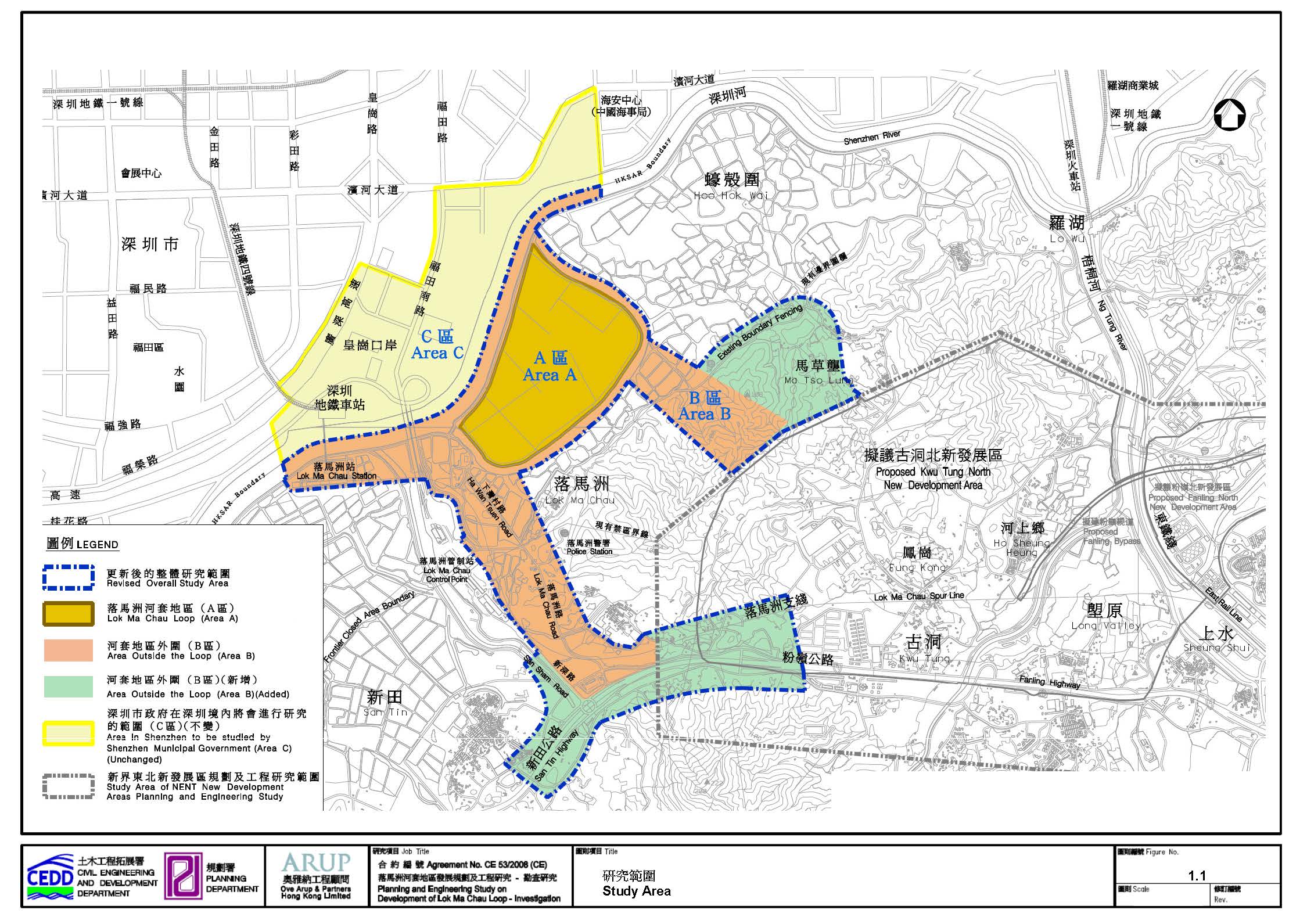
_Page_05.jpg)
_Page_06.jpg)
_Page_16.jpg)
_Page_20.jpg)
_Page_02.jpg)
_Page_44.jpg)
_Page_45.jpg)
_Page_46.jpg)
_Page_21.jpg)
_Page_38.jpg)
_Page_01.jpg)
_Page_04.jpg)
_Page_07.jpg)
_Page_09.jpg)
_Page_15.jpg)
_Page_11.jpg)
_Page_28.jpg)
_Page_29.jpg)
_Page_30.jpg)
_Page_31.jpg)
_Page_37.jpg)
_Page_03.jpg)
_Page_39.jpg)
_Page_40.jpg)
_Page_43.jpg)