10.2 Environmental
Legislation, Standards and Guidelines
10.3 Description
of the Environment
10.5 Identification
and Evaluation of Impact
This section presents the assessment of impacts on cultural heritage associated with the construction and operation of LMC Loop. The assessment includes the background information of archaeological heritage, declared monument and built heritage within the assessment area, results of archaeological surveys, the level of potential impact and recommended mitigation measures.
In accordance with the findings of the 2012 archaeological survey conducted at Lok Ma Chau Loop, Ma Tso Lung, the areas along Border Road, Ma Tso Lung Road and Ho Sheung Heung Road as well as the proposed alignments of Western Connection Road (including the connection to San Tin Highway), there was no sign of archaeological potential in the surveyed area.
Desktop review and field
survey has been conducted for historic buildings and direct impacts on them are
not expected. There will be minor visual impact from its surrounding development but it can be
mitigated by providing plant screening.
The cultural heritage impact assessment has been
conducted in accordance with the requirements of Annexes 10 and 19 of the
TM-EIAO as well as the requirements set out under Clause 3.4.11 of the EIA
Study Brief.
10.2 Environmental Legislation, Standards and Guidelines
The relevant
legislation, standards and guidelines for the assessment and protection of
cultural heritage include:
· Antiquities and Monument Ordinance;
· Environmental Impact Assessment Ordinance (EIAO);
· Hong Kong Planning Standards and Guidelines (HKPSG);
· Technical Memorandum on Environmental Impact Assessment Process;
· Guidelines for Cultural Heritage Impact Assessment.
10.2.1 Antiquities and Monuments Ordinance
Under this Ordinance, the Secretary for Development is the Antiquities
Authority. The statutory Antiquities
Advisory Board (AAB) consists of members with expertise in various relevant
fields to advise the Antiquities Authority on any matters relating to
antiquities and monuments. The
Antiquities and Monuments Office (AMO), as the executive arm of the Antiquities
Authority, provides secretarial and executive support to the AAB in conserving
places of historical and archaeological interest.
The Antiquities Authority may, after consulting AAB and with the
approval of the Chief Executive as well as the publication of the notice in
government gazette, legally declare a place to be protected. The Antiquities
Authority is empowered to prevent alterations, or to impose conditions upon any
proposed alterations as appropriate to protect the monument.
In addition to declared monuments, a large number and variety of sites
of cultural heritage are identified and recorded by AMO. Recorded historic buildings and structures
are classified into Grades 1, 2 and 3 by AAB to indicate their relative importance,
as defined below:
|
· Grade 1 |
–
Buildings of outstanding merit, which every
effort should be made to preserve if possible. |
|
· Grade 2 |
–
Buildings of special merit; efforts should be
made to selectively preserve. |
|
· Grade 3 |
–
Buildings of some merit; preservation in some
form would be desirable and alternative means could be considered if
preservation is not practicable. |
Although graded buildings and structures carry no statutory protection,
the Government has administrative procedures that require conservation be given
to those historic buildings and sites of cultural heritage.
For sites of archaeological interest, antiquities (as defined under the
Antiquities and Monuments Ordinance) discovered after 1976 are, by law,
properties of the government. All
discoveries of antiquities or supposed antiquities must also be reported. The
excavation and search for antiquities require a licence from the
Authority.
10.2.2 Environmental Impact Assessment Ordinance
10.2.3 Hong Kong Planning Standards and Guidelines
10.2.4 Technical Memorandum on Environmental Impact Assessment Process
The general criteria
and guidelines for evaluating and assessing impacts to cultural heritage are
listed in Annexes 10 and 19 of the TM-EIAO. Annexes 10 and 19 of the TM-EIAO
cite the following:
· criteria for evaluating the impacts on sites of cultural heritage;
· guidelines for impact assessment;
· the general presumption in favour of the protection and conservation of all sites of cultural heritage because they provide an essential, finite and irreplaceable link between the past and the future and are points of reference identified for culture and tradition;
· preservation in totality and measures for the integration of sites of cultural heritage into the proposed project will be a beneficial impact; and
· adverse impacts on sites of cultural heritage shall be kept to the absolute minimum.
The Guidance Note
on Assessment of Impact on Site of Cultural Heritage in Environmental Impact
Assessment Studies (http://www.epd.gov.hk/eia/english/guid/cultural/basis.html) serves as a reference to facilitate an
understanding of the requirements set out in Annexes 10 and 19 of the TM-EIAO
for assessing impacts on sites of cultural heritage in EIA studies.
10.2.5 Guidelines for Cultural Heritage Impact Assessment
The Guidelines for
Cultural Heritage Impact Assessment was issued by AMO to outline the technical
requirement for conducting terrestrial archaeological and built heritage impact
assessments including the parameters and scope of baseline study for cultural
heritage, desktop research, field survey and reporting requirement, as well as,
the guideline for evaluating the significance of impacts and recommending
mitigation measures.
10.3 Description of the Environment
10.3.1 Brief History
Before the training of Shenzhen River, the
Lok Ma Chau Loop (LMC Loop) was under administration
of Shenzhen and in the form of agricultural land and fish ponds in 1980s and early 1990s. It was used
as a dumping ground for mud extracted from Shenzhen River Training Works Stages
1 and 2 before 1997. The administration of LMC Loop was then transferred to
Hong Kong since 1997. The area was currently vacant.
In the
vicinity outside LMC Loop, it kept a rural condition with several traditional
Chinese villages. Detailed history of individual villages and areas of
archaeological potential were discussed below.
10.3.2 Geology and Topography
The landscape
setting within the Project includes both the undulating sedimentary hills to
the east of the LMC Loop and the Quaternary alluvial plain in and around the
LMC Loop - characterised by marshland and fishponds.
This alluvial plain was part of an extensive shallow sea less than 2000 years
ago. Since this period silt and floodplain deposits have produced a prograded estuarine coastline with the landscape gradually
reclaimed over the past 1000 years for paddy agriculture and later fishpond
development [10-1].
The broad-scale
disturbance of the LMC Loop and surrounding landscape by local dumping of
contaminated mud, and by conversion from paddy fields to fish ponds in the past
40 years in the area surrounding the LMC Loop, has obscured much of the
original landscape. Reference to aerial photos (Figures A10-1.4 to A10-1.9
in Appendix 10-1) and old maps (Figures A10-1.1 to A10-1.3 in Appendix 10-1)
were made during this study although these proved to be of limited value for
locating early sites of archaeological interest in such a landscape.
Maps of the 16th
and 18th centuries for this part of Hong Kong such as the Coastal
Map of Kwang Tung (1553) and Map by Chan Lun Kwing (1730) are highly stylized maps which only represent
large settlements or forts. No evidence of substantial settlement within the
Sham Chun (Shenzhen) region can be inferred from these early sources.
Sham Chun is shown
on a similarly stylized map (Gazetteer Map of Hong Kong (1864)) (Figure A10-1.1 in Appendix 10-1). The villages of Lok Ma
Chau, Lo Wu and Sham Chun are shown on a similarly stylized lease map of Hong
Kong produced in 1898 (Figure A10-1.2
in Appendix 10-1). Lok Ma Chau and Sham Chun are also shown on a Tourists
Guide to Hong Kong Map by R.C Hurley published in 1898 (Figure A10-1.3 in Appendix
10-1).
Maps produced in
the early 20th century - which include 1905
Demarcation maps and 1913 1:31,360 scale topographic maps - also show that the
region of the present LMC Loop and surrounding area was not a focus of
prominent settlement or development.
The landscape of
paddy fields which characterized the low lying landscape in and around Lok Ma Chau and Shenzhen was gradually converted into fish
ponds during the 1970s and 1980s. As
will be discussed later, while fish pond construction has disturbed the
landscape, such disturbance has thrown up traces of the early historic period
activity beneath formerly drained areas or on landforms of slightly higher
elevation, since been obscured by siltation.
The most recent
and profound impact on the landscape of the LMC Loop and surrounding study area
has been the widening or “training” of the Shenzhen River and subsequent
truncation of the LMC Loop. A sequence of aerial photographs between 1973 and
2008 (Figures A10-1.4 to A10-1.9 in Appendix 10-1) shows that the training works have occurred between
1995 and 1997. Prior to this period the LMC Loop was occupied predominantly by
paddy fields with minor fish pond development. Development of Shenzhen New Town
which has occurred on the northern side of the River commenced about a decade
earlier.
The LMC Loop has
been the site of widespread dumping of dredged sediment including contaminated
material which covers much of the site shown in the aerial photographs of year
2000.
Approximately 70
ha of land in the LMC Loop were backfilled with waste sediments from the Phase
I Regulation of Shenzhen River works. Regulation of Shenzhen River Phase II
works followed in 1996 and was completed in 2000. The LMC Loop was divided into
upstream and downstream disposal area for waste sediments. The area was
landscaped and vegetated after the completion of Phase II works. According to
the DSD, approximately 4 million m3 of soil sediment from the works
of Phase I and Phase II Regulation of Shenzhen River were disposed in the LMC
Loop. Together with the sediment originally in the LMC Loop, there is a total
of approximately 4.5 million m3 of sediment.
These works will
have substantially covered much of the LMC Loop area and therefore considerably
reduced the archaeological potential of this area.
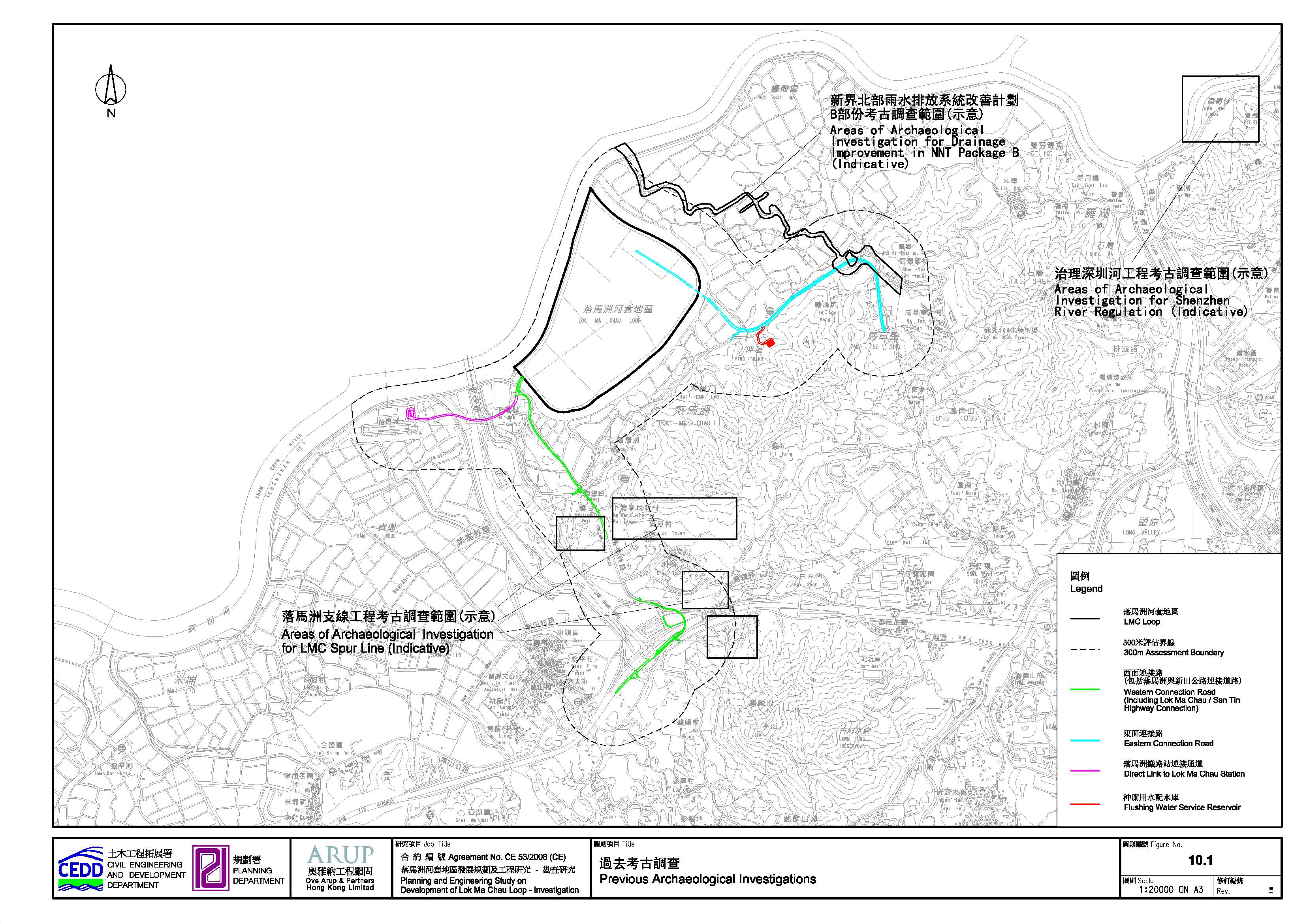
10.3.3 Review of Previous Archaeological Investigation
There have been
limited previous archaeological studies within 300m from the boundary of the
Project within HKSAR. The location plan of previous archaeological
investigation is presented in Figure 10.1.
Part of the Sheung Shui – LMC Spur Line EIA
study [10-8] included archaeological investigation near Pun Uk Tsuen,
Hill West of Pun Uk Tsuen,
Chau Tau Tsuen and South of Castle Peak Road outside
LMC Loop within HKSAR some of which are within the 300m assessment boundary. No
archaeological remains were found during this survey.
Fragments of Tang
period kiln debris and pottery dated to Han and early Tang period were
discovered 500m north-east of the LMC Loop - during an archaeological survey at
Ma Tso Lung for the Drainage Improvement in the
Northern New Territories - Package B in 2004[10-9]. This suggests
that the fishpond areas – while considered of low heritage potential - may
throw up archaeological remains by the disturbance from the fishpond
construction.
A survey and
follow-up archaeological excavation associated with the Shenzhen River
Regulation Project (HKIA 2003) [10-10] at Yuen Leng
Chai near Man Kam To –
revealed Song Dynasty remains and two Song-Yuan burials of this period within
an alluvial landscape similar to that at LMC.
10.3.4 Areas of Archaeological Potential
There are no recorded
sites of archaeological interest within the assessment area. However, there are
some areas of archaeological potential in the assessment area in particular
around the lower hill slope including small hillocks.
Prehistorical occupation was recorded in this type of setting south of the LMC Loop
at Ho Sheung Heung[10-2].
Prehistoric archaeological material has
been found on lower hill slopes in the interior of the territory including
Bronze Age (1500–221 BC) sites at Ngau Tam Mei[10-7], Yuen Long[10-3];
Tong Min Tsuen, Lam Tsuen[10-7];
Wai Tau, Tai Po[10-4] and Ho Pui, Kam Tin[10-5].
Earlier material from the Late Neolithic (2500-1500 BC) – Bronze Age (1500-221
BC) has been reported from Sheung Shui
Wa Shan, Sheung Shui[10-6]
and Hung Leng, Fanling[10-4].
In
prehistoric times those areas which are presently occupied by fishponds and
river flood plains were shallow seas fringed with marshland and mangrove[10-1]. Within this
environment present hillocks formed islands and islets;
therefore the lower hill slopes and former shorelines of these islands may have
potential for prehistoric deposits.
These
include hillocks north of Ping Hang and west of Ma Tso
Lung as well as those west of LMC Road; west of Pun Uk
Tsuen; at Pak Shek Au; just
to the north-west of Pak Shek Au; and within the Ma Tso Lung Valley. These areas have moderate archaeological potential as sites of
prehistoric or early historic period occupation at the edge of the former
shallow sea[10-1].
The rest of the
assessment area is considered with low archaeological potential including the
LMC Loop which is occupied by dumped sediment; stoney and skeletal soils at higher elevation with shallow sedimentary bedrock
where archaeological sequences are unlikely to be preserved; and areas of modern development such as highways,
railways, roads and other infrastructure, storage yards and modern villages.
According to the
Heritage Baseline Desktop Study Report under Development of LMC Loop in 2010,
the areas of archaeological potentials have been assigned according to the
following priority order:
Moderate Potential:
·
Areas around the lower hill slopes including small hillocks surrounding
Chau Tau Tsuen, Lok Ma Chau
Tsuen and Pun Uk
Tsuen but also the lower hill slopes at Ma Tso Lung area, have moderate archaeological potential as
sites of prehistoric or early historic period occupation at the edge of the
former shallow sea.
In prehistoric times those areas which are presently occupied by
fishponds and river flood plains were shallow seas fringed with marshland and mangrove[10-1]. Within this
environment present hillocks formed islands and islets; therefore the lower
hill slopes and former shorelines of these islands may have potential for
prehistoric deposits. These include hillocks north of Ping Hang and west of Ma Tso Lung as well as those west of Lok
Ma Chau Road; west of Pun Uk Tsuen;
at Pak Shek Au; and just to the north-west of Pak Shek Au.
Moreover, there is a record of prehistoric occupation at Ho Sheung Heung in this type of setting south of the LMC Loop.
Prehistoric archaeological material has been found on lower hill slopes in the
interior of the territory including Bronze Age (1500–221 BC) sites at Ngau Tam Mei, Yuen Long [10-3]; Tong Min Tsuen, Lam Tsuen[10-7]; Wai Tau, Tai Po[10-4]
and Ho Pui, Kam Tin[10-5]. Earlier
material from the Late Neolithic (2500-1500 BC) – Bronze Age (1500-221BC) has
been reported from Sheung Shui
Wa Shan, Sheung Shui[10-6] and Hung Leng,
Fanling[10-4].
Low Potential:
·
Fishponds and paddy fields (agricultural land) which surround the LMC
Loop and the off-site areas for ecological compensation under the Shenzhen
River Regulation project or LMC Spur Line have low archaeological potential.
According to the finding of a report submitted by Archaeo-Environments
Ltd for the EIA study: Drainage Improvement in the Northern New Territories
(NNT), Package B[10-9],
fragments of Tang period kiln debris and pottery dated to Han and early Tang
Dynasty (2nd to 7th Century AD) were found during field survey across an 80m
arc at the edge of two adjacent fish ponds - located about 500m northeast of
the LMC Loop area. The conversion from paddy fields to fish ponds in the past
40 years has resulted in disturbance which – in this case – appears to have
thrown up archaeological remains from prehistory and the early historic period.
·
Areas within the LMC Loop occupied by dumped sediment and marshland have
low archaeological potential.
Very Low Potential:
·
Areas of higher elevation within the undulating hills to the east of the
LMC Loop have very low archaeological potential as they are not commonly
associated with sites of prehistoric or early historic period occupation. In
addition, the low incidence of archaeological material within this landscape
can be attributed to the geological setting which is characterized by stoney and skeletal soils and shallow sedimentary bedrock
where archaeological sequences are unlikely to be preserved.
·
Areas of modern development such as highways, railways, roads and other
infrastructure, storage yards and modern villages have very low to no
archaeological potential.
Figure 10.2 shows the archaeological potential within the assessment area.
Archaeological survey was proposed in “moderate” archaeological potential area,
which locates along Eastern and Western Connection Road. An archaeological
survey at LMC Loop, Ma Tso Lung, the
areas along Border Road, Ma Tso Lung Road and Ho Sheung Heung Road as well as the proposed alignments of
Western Connection Road (including the connection to San Tin Highway) has been conducted in early 2012 to
ascertain the identified archaeological potential within the assessment area.
According to the survey findings, no sign of archaeological potential was
identified in the surveyed areas.
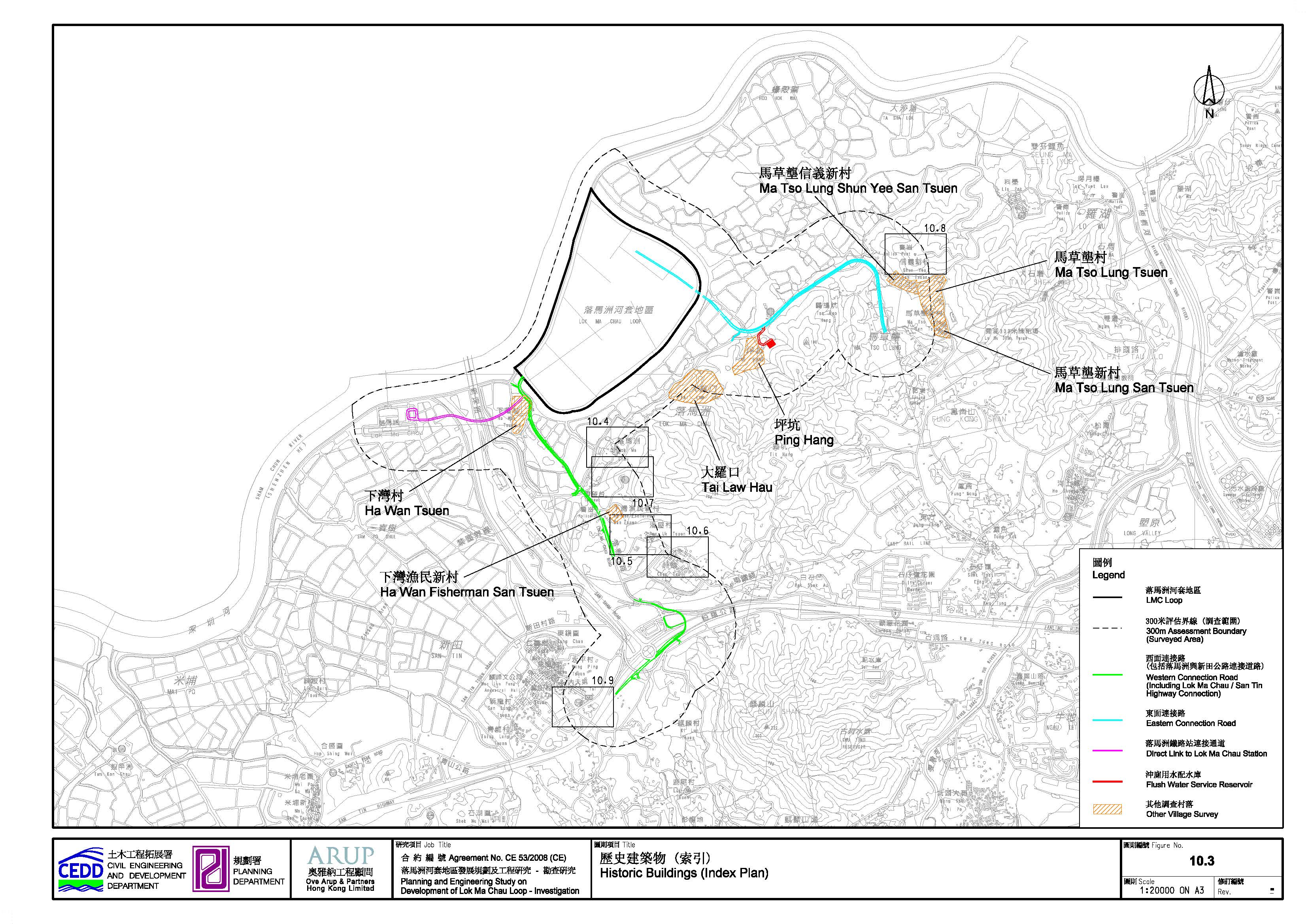
10.3.5 Built Heritage Baseline Condition
The review of built heritage baseline condition generally follows the same assessment area defined. The baseline study included desktop review and field survey in the entire assessment area. A number of villages within the assessment area were identified with recorded or potential historic buildings and structures during the baseline study. Field survey has been conducted to identify and record the historic buildings and structures in these historic villages. Figures 10.3 to 10.9 show the locations of these villages and the identified historic buildings and structures inside. The details of the built heritage survey of historic buildings and structures identified in the assessment area are presented in the Appendix 10-2. For easy reference, a coding system is adopted in which “GB” and “HB” stands for Graded Building and Historic Building respectively.
10.3.6
Historic Villages
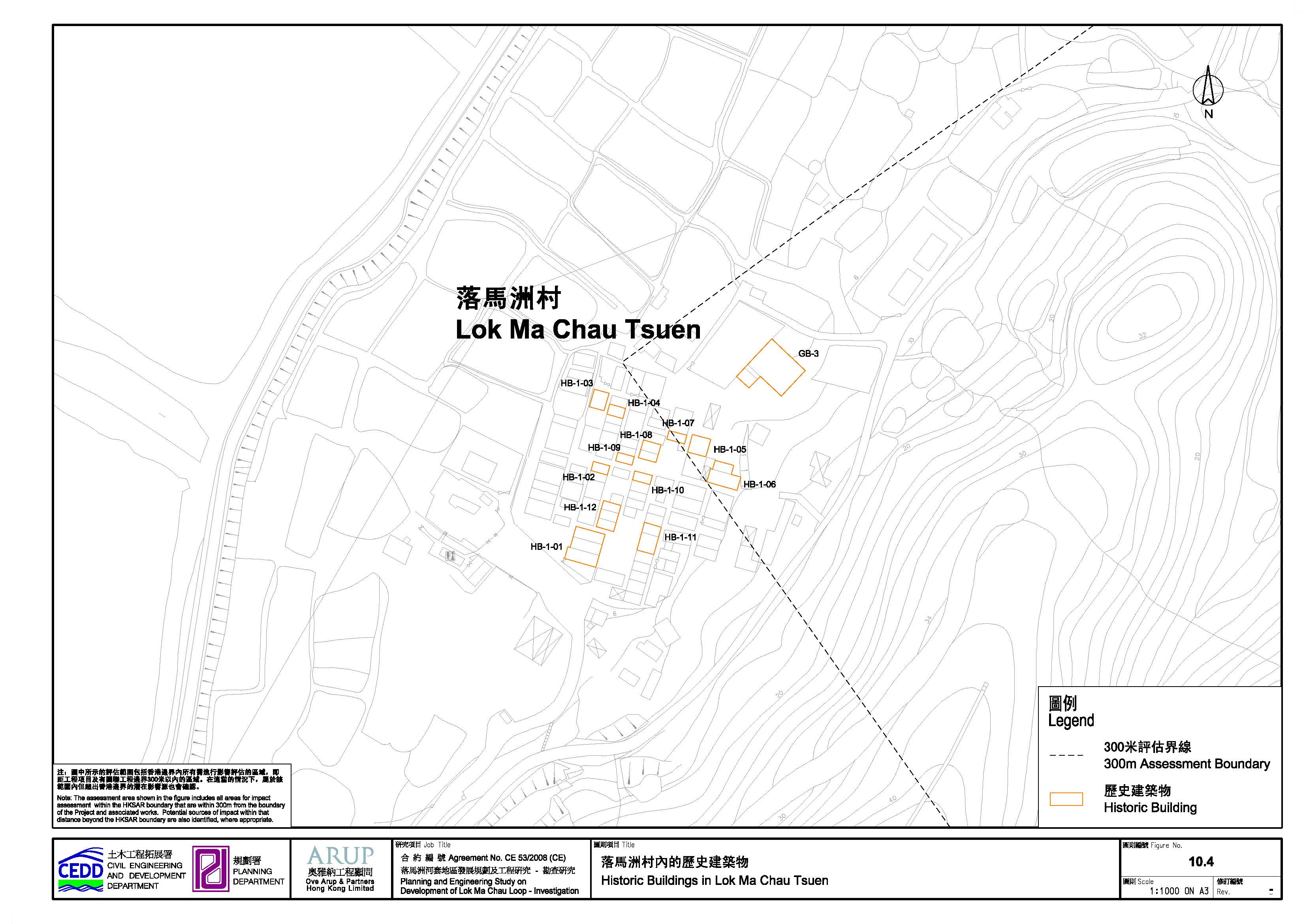
10.3.6.1 Lok Ma Chau Tsuen (落馬洲村) (HB-1-01 to HB-1-12, GB-3)
LMC Tsuen (Figure 10.4) is situated at
the north foothill of the knoll where the LMC Police Station is located. It was
established by the Cheungs (張氏) from Wong Bui Ling (黃背嶺) of Shenzhen. They came to the area and
established the village in the early Ming dynasty. They left during the Coastal
Evacuation in the early Qing dynasty, and returned after the abolishment of the
Edict of the Coastal Evacuation a few years later. The village is said to have
a history of over 500 years. The villagers have constructed fishponds on the
swampy area along the south coast of Shenzhen River. They rear fresh-water fish
and carry out farming in the area. Some fishermen living nearby rent fishponds
from them.
The village is
formed by rows of village houses, a traditional style of village establishment.
There are eight main rows of village houses. While many of the buildings are
modern styled two-storey residential houses, quite a number of historic old
village houses built with green bricks can still be found in the village.
Twelve (12) historic buildings (HB-1-01 to HB-1-12) and one (1) graded historic
building (GB-3) were recorded at LMC Tsuen (in Appendix 10-2 and Figure 10.4). These
historic buildings are mainly one-hall-one-room structures, with enclosed
courtyard or without courtyard. Many of the original appearance of the historic
buildings are preserved such as the pitched tile roof and door canopies
decorated with painting.
The current
ancestral hall of the village is a two-hall-two chamber structure with enclosed
courtyard named Mi Tak Study Hall (美德家塾) (GB-3), which is a Grade 2 historic
building. Worships of the ancestors in spring and in autumn, and Dim Dang (點燈) Ceremony are carried out yearly in the
Hall.
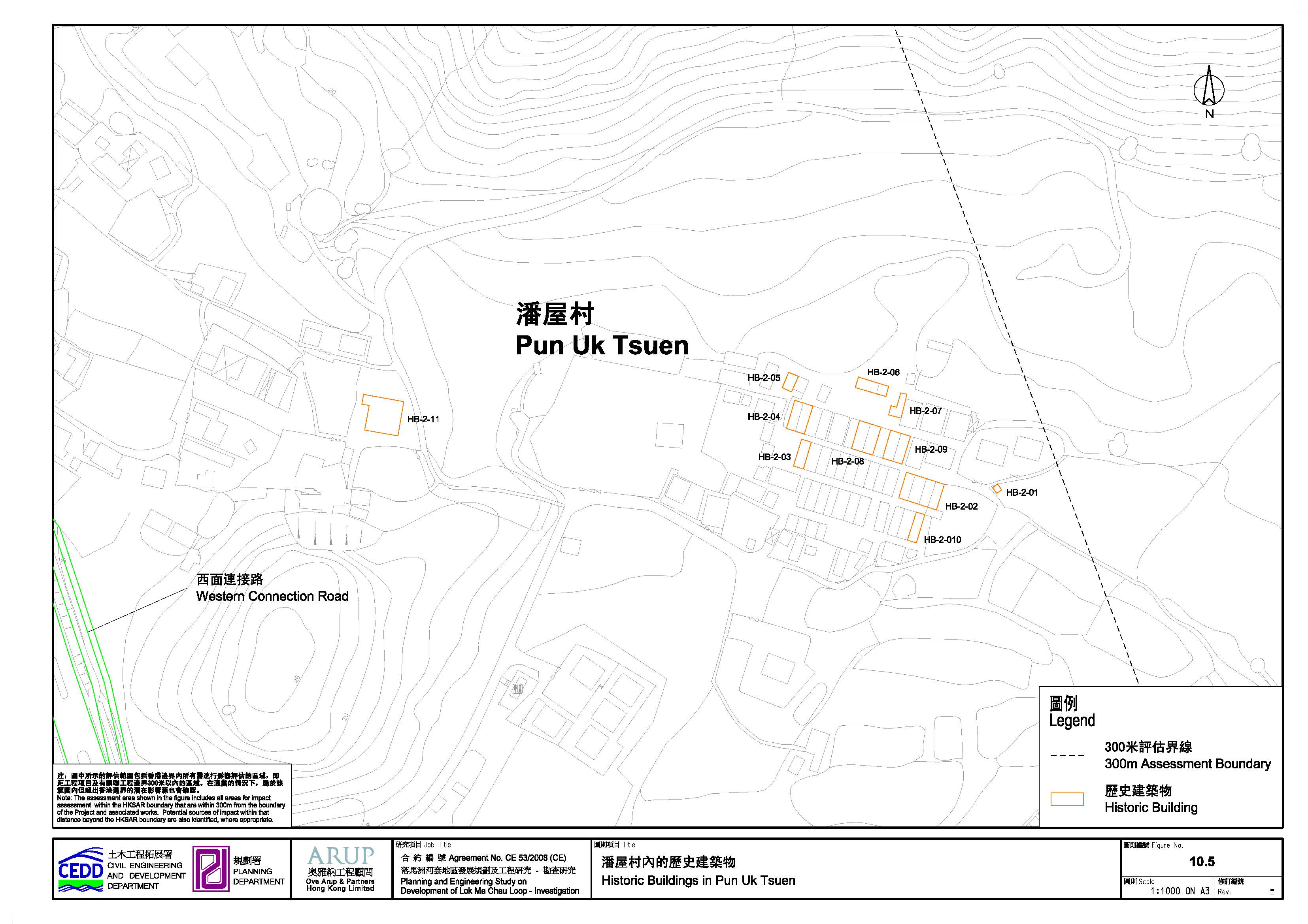
10.3.6.2 Pun Uk Tsuen (潘屋村) (HB-2-01 to HB-2-11)
Pun Uk Tsuen (Figure 10.5) is located about to 150m from WCR. It is established by the Puns (潘氏) from Siu Kwan (韶關) in the early 15th century. At that time, San Tin Area was occupied by the Lams (林氏), the Tsuis (徐氏), the Chans (陳氏), the Tses (謝氏) and the Puns (潘氏), each founded a small village called Lam Uk, Tsui Uk, Chan Uk, Tse Uk and Pun Uk. Then the Mans (文氏) of San Tin came. Later, the Lams, the Tsuis, the Chans, and the Tses left, leaving the Mans and the Puns who predominate in the area. Some descendants of the Puns moved to Sheung Tsuen (上村) of Kam Tin (錦田) and Shek Ha (石厦) of Huanggang (皇崗) in Shenzhen.
With the
prosperity of the Mans, they occupied most of the San Tin Area. Pun Uk Tsuen remains a small village
closed to Chau Tau Tsuen, a village founded by the
Mans.
The village is
formed by rows of village houses, a traditional style of village establishment.
There are four main rows of village houses. Most the buildings in the village
now are modern two-storey residential building. Eleven (11) historic buildings
(HB-2-01 to HB-2-11) were recorded at Pun Uk
Tsuen (in Appendix
10-2 and Figure 10.5).
The retained
historic and traditional village houses are generally one-hall-one-room type
with enclosed courtyard structures built with green bricks or mud and red
brick. Though the appearance of some of the historic buildings or structures
are altered with modern construction such as corrugated metal roof or stainless
steel gate, a number of them still retain their traditional characters with
pitched tile roof and door canopies decorated with painting. There were also a vacated ancestral hall and
an earth shrine.
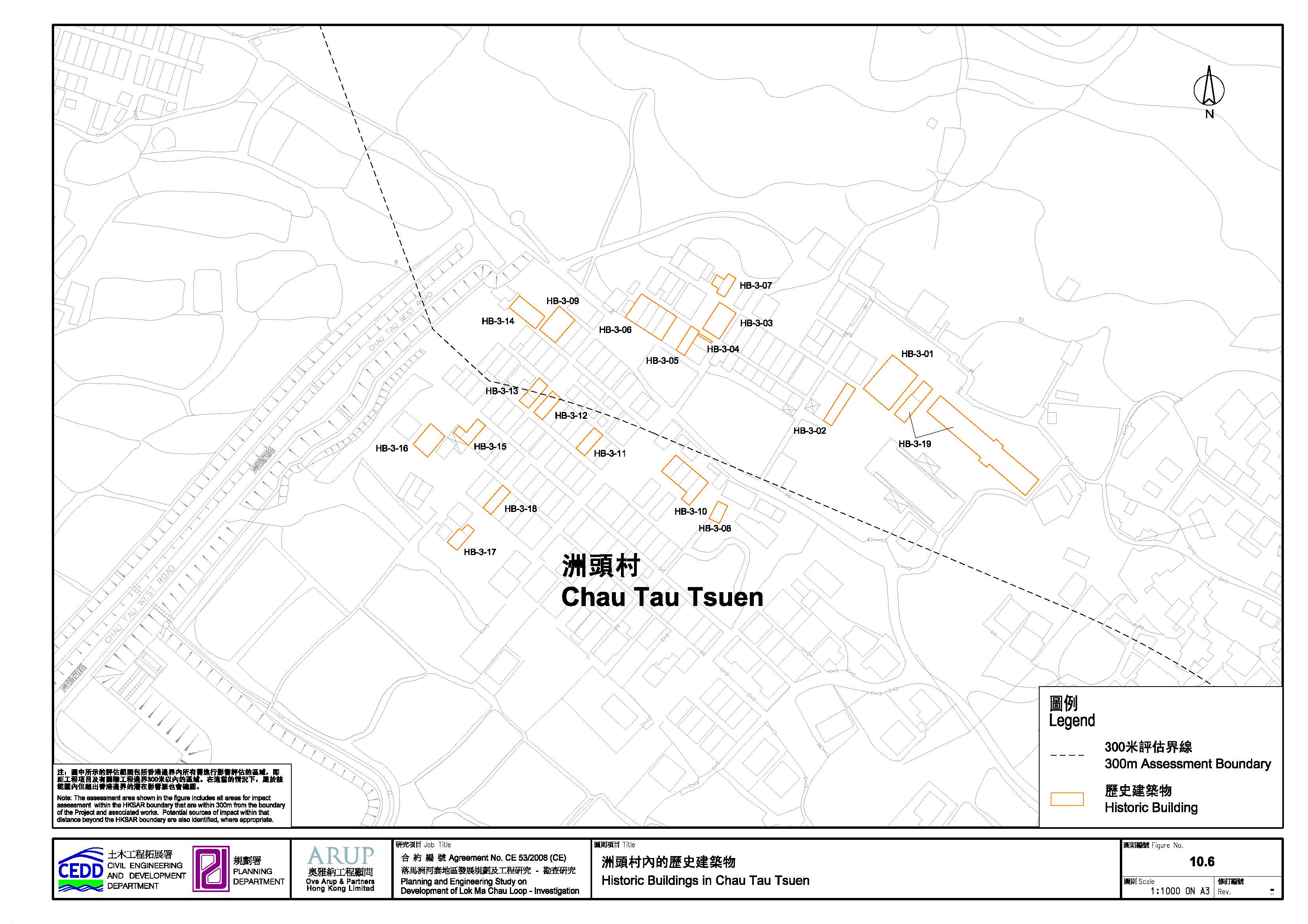
10.3.6.3 Chau Tau Tsuen (洲頭村) (HB-3-01 to HB-3-19)
Chau Tau Tsuen (Figure 10.6) lies to the
southeast of Pun Uk Tsuen. It is located about 160m from the slip road to San Tin
interchange of WCR. It is established by the Mans in the early 15th century, a
few years later than the Puns. The Mans originated from Jiangxi, they moved
south into Guangdong, and settled in Ling Ha village in Shenzhen in the late
14th century. Then, in the early Ming dynasty (during the Yung Lo reign
1403-1424), they moved south and settled in San Tin. After nine generations,
some of them moved away and formed the Chau Tau Tsuen.
The village was
formed by rows of village houses. Most of the buildings now are modern styled
two-storey residential buildings. Quite a number of historic and traditional
old village houses are found in the village, which were mostly one-hall-one
room type with or without enclosed courtyard.
Nineteen (19) historic buildings (HB-3-01 to HB-3-19) were recorded at
Chau Tau Tsuen (in Appendix 10-2 and Figure 10.6)
Some of these old
village houses were built with green bricks or mud and red bricks. Renovation
of historic buildings with corrugated metal roof, new paint and plaster are
quite common in Chau Tau Tsuen. Moreover, some of the
historic buildings are in ruined. Given the size of the village, only very few
of the remaining historic buildings are well preserved to their original
appearance. The village contains two renovated
concrete built study halls, Ting Si Study Hall (廷士家塾) and Jik Sin Study Hall(積善書室). Ting Si Study Hall is used as the ancestral
hall. Worships of the ancestors in spring and in autumn, and Dim Dang Ceremony
are carried out yearly in the Hall. There was an iron
old muzzle-loading cannon in front of the Ting Si Study Hall. However, according to the site observation
on 27 November 2009, the cannon has been removed from
the village.
10.3.7
Graded Buildings
Four graded
buildings are located within the assessment boundary area which are LMC Police
Station, MacIntosh Fort (Ma Tso
Lung), Mi Tak Study Hall and Tung Shan Temple. The existing grading of these
buildings are shown in Table 10.1.
Table 10.1 Graded buildings (as of 23 November 2011) within the
assessment boundary
|
Graded Building |
Existing Grading |
Year of Construction / Restoration |
|
LMC Police Station (GB-1 in Appendix 10-2 and Figure 10.7) |
2 |
Built in 1915 |
|
MacIntosh Fort (Ma Tso Lung) (GB-2 in Appendix 10-2 and Figure 10.8) |
2 |
Built in 1949 to 1953 |
|
Mi Tak Study Hall (GB-3 in Appendix 10-2 and Figure 10.4) |
2 |
Probably built in 1870s |
|
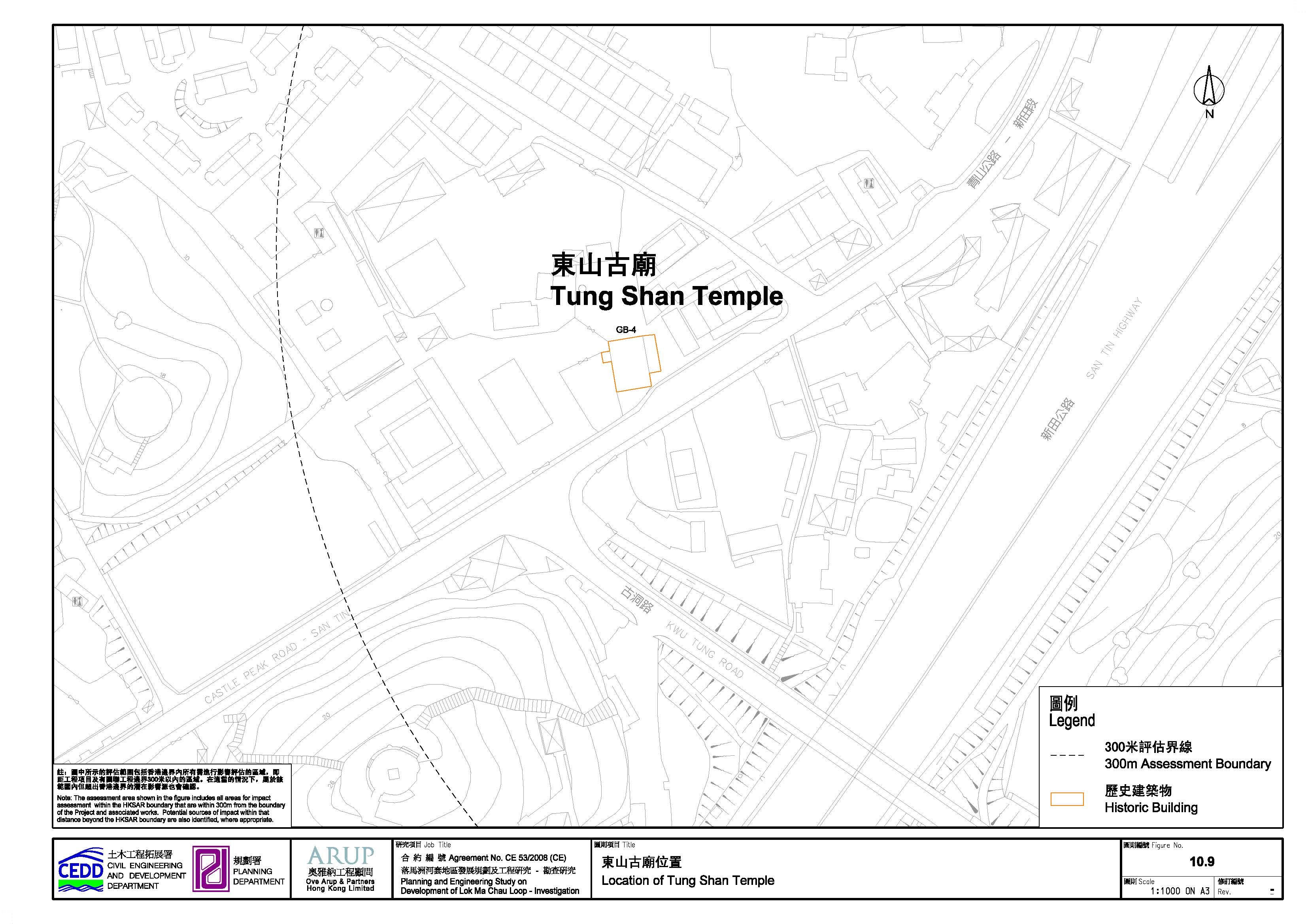
Tung Shan Temple (GB-4 in Appendix 10-2 and Figure 10.9) |
3 |
Built before 1894 |
10.3.7.1 Lok Ma Chau Police Station (落馬洲警署)
LMC Police Station
(GB-1, Photos 49 to 51 in Appendix 10-2) lies on a knoll behind
LMC Tsuen. It faces Huanggang
and was built in 1915 on the site of the former San Tin Police Station.
According to the assessment of the 1,444 historic buildings in Hong Kong
released on 23 November 2011, it is currently a Grade 2 historic building. The
station is still in use, and it guards the boundary area from LMC to Kwu Tung (古洞).
10.3.7.2 MacIntosh Fort (Ma Tso Lung) (麥景陶碉堡(馬草壟))
MacIntosh Fort (GB-2, Photo 52 in Appendix 10-2) at Ma Tso Lung is one of the seven MacIntosh
Forts built on the border between Hong Kong and mainland China between 1949 and
1953. In face of an influx of refugees from mainland China during the 1940s to
50s, Duncan William MacIntosh (D.W. MacIntosh), the commissioner of police then, decided to
build a chain of observation posts (forts) on prominent hilltops along the Hong
Kong – Shenzhen border to strengthen border defence
against illegal immigrants in 1949. The forts were guarded day and night then.
However, with the assistance of advance tele-communication
and electronic device, six out of seven of them are remotely controlled
nowadays.
MacIntosh Fort (Ma Tso Lung) is situated at the hill
north of Ma Tso Lung Shun Yee San Tsuen
and built of reinforced concrete. According to the assessment of the 1,444
historic buildings in Hong Kong released on 23 November 2011, it is currently a
Grade 2 historic building.
10.3.7.3 Mi Tak Study Hall (美德家塾)
Mi Tak Study Hall (GB-3, Photos
16 to 18 in Appendix 10-2), also known as Hin Cheung
Tong (衍昌堂), lies in the northeast of the LMC Tsuen. It was built in the 1870s. It is
a traditional two-hall three-room type building, with foundations built of
granite, and the walls constructed of green brick. It had been renovated in
1915. The name of the hall can be seen on top of the main gate. On the altar of
the main hall of the building, there are about 100 ancestral tablets. It is
still in use. Adjacent to the main building of Mi Tak Study Hall, there is an
ancillary building, which was built in around 1870. The outer walls of the
ancillary building are plastered with white paint. It was used as classroom of the village
school, but is vacant now.
The two buildings
had been used as a village school after the Japanese Occupation, and closed in
the 1950s. The main building now used as an ancestral hall.
Worships of the ancestors in spring and in autumn, and Dim Dang Ceremony are
still carried out yearly in the Hall.
Both the main and
ancillary buildings are currently Grade 2 historic buildings according to the
assessment of the 1,444 historic buildings in Hong Kong, which was released on
23 November 2011.
10.3.7.4 Tung Shan Temple (東山古廟)
Tung Shan Temple
(GB-4, Photo 53 in Appendix 10-2) in Wing Ping Tsuen (永平村) of San Tin (新田) was built before 1894 (the 20th year of the Guangxu
(光緒) reign in the Qing (清) dynasty) according to a stone tablet record about its first renovation
date. The temple serves the village alliance of the entire Mans (文) clans in San Tin area. The Mans are the
descendents of Man Tin-shui (文天瑞), a blood brother of Man Tin-cheung (文天祥) who was a renowned patriot fighting with the Mongols to protect the
Song Emperors in the late Southern Song (南宋) dynasty (1127-1279).
The main deity of
the temple is Tin Hau (天后) and two others are Yeung Hau (楊侯) and Lung Mo (龍母, Dragon Mother) on either side of the main hall. The left cockloft of
front hall accommodates a Fui Sing Kok (魁星閣) for candidates to seek blessings to have successful results in the
Civil Service Examination. The Fui Sing Kok has a round opening on the front wall. The right
chamber of the front hall houses the Kwun Yam (觀音) and the Buddha and an Earth God (土地) deity is housed in the left chamber of the
front hall.
Tung Shan Temple
is a Qing vernacular building of a two-hall-one-courtyard plan of three bays,
which has a symmetrical design. The courtyard of the temple is between the
entrance and the main hall. The Tin Hau altar locates
in the central axis in the middle of the main hall facing the entrance. The
building is mainly constructed by green bricks. The walls and granite columns
of the buildings support the pitched roofs, which is of timber rafters, purlins and clay tiles. The gables of the courtyard are
with Ma Tau (馬頭, horse head) design. The main ridge has a dragon head moulding and others are with plastered geometric mouldings. Wall friezes on the front façade are with
flowers moulding, landscape and plants. Wall
paintings above the name board at the entrance are with flowers and plants and
landscape motifs.
According to the
assessment of the 1,444 historic buildings in Hong Kong released on 23 November
2011, it is currently a Grade 3 historic building.
10.3.8
Others
Apart from the
villages with identified historic buildings and the historic buildings recorded
by AMO mentioned above, the assessment area have been
subjected to the baseline study. There is no historic village within LMC Loop
and slips road from WCR to San Tin Highway. Thus, survey was conducted along
Direct Link to LMC Station, WCR and ECR only. The following locations had been
surveyed (Figure 10.3) and no
historic buildings were identified.
10.3.8.1 Ha Wan Tsuen (下灣村)
Ha Wan Tsuen (also known as Ha Wan San Tsuen)
lies inside the assessment area, to the northwest of LMC Tsuen.
Because of the poor living condition of the land, the old village of Ha Wan Tsuen was abandoned by the villagers who then moved to
higher ground on the slope of the knoll further southeast. After 1950s, more
people, of multi-clans (雜姓), arrived, and they repopulated Ha Wan Tsuen. The village is formed by scattered temporary
squatters. The houses are two-storey with steel-plate roof. There are two
playgrounds, one lies to the north and one lies to the south of the village.
Villagers live on pond-fishing and intensive farming. There is no ancestral
hall or temple in the village.
No historic
building was found in the village.
10.3.8.2 Ha Wan Fisherman San Tsuen (下灣漁民新村)
Ha Wan Fisherman
San Tsuen was set up by the old villagers of Ha Wan Tsuen. It lies inside the assessment area. With the arrival of a greater population, it
developed outside the closed area, on the slope south of LMC Police Station.
The village is well planned with temporary squatters built in rows. The houses
are two-storey with steel-plate roof. There is no ancestral hall or temple.
No historic
building was found in the village.
10.3.8.3 Ma Tso Lung Tsuen (馬草壟村), Ma Tso Lung Shun Yee San Tsuen (馬草壟信義新村) and Ma Tso Lung San Tsuen (馬草壟新村)
Ma Tso Lung was composed of three villages, namely Ma Tso Lung Tsuen, Ma Tso Lung Shun Yee San Tsuen and
Ma Tso Lung San Tsuen.
These villages are located within the proposed Eastern Connection Road
assessment area.
Ma Tso Lung Tsuen was established by
multi-clans with the Lams (林氏) as the majority. The old village lay on
low-lying area and flooding happened frequently. In the 1950s, Ma Tso Lung Shun Yee San Tsuen was
built on higher ground, to the north-east of the old village and people
resettle there. Ma Tso Lung Tsuen
was later in ruined and no longer exist. Some people also moved to the higher
ground to the south of Ma Tso Lung Shun Yee San Tsuen and formed Ma Tso Lung San Tsuen.
The people there
believe in Buddha and Kwun Yam but no temple or
monastery was found there. To the south of Ma Tso
Lung San Tsuen, at a place called She Ling (蛇嶺), there was a school called Lung Kai School
(龍溪學校). It had been abandoned for long.
No historic
building was found in the area.
10.3.8.4 Tai Law Hau (大羅口)
Tai Law Hau positioned within the assessment area. It is also known
as Ngau Kok Shan (牛角山). There is a police watch post built in the
1980s.
No historic
building was found in this area.
10.3.8.5 Ping Hang (坪坑)
Ping Hang is
situated inside the Study Area. It is a small hamlet with only a few temporary
squatters. It was established in the 1980s. The people are fishermen who live
on fish and oysters from the ponds they established.
No historic
building was found in the hamlet.
As stipulated in Clause 3.4.11 of the EIA Study Brief, a Cultural
Heritage Impact Assessment including archaeological impact assessment and built
heritage impact assessment would be undertaken to identify the potential
impacts on sites of cultural heritage, historical buildings and structures
arising from the development of LMC Loop and its associated infrastructures.
The assessment methodology would be in accordance with the Guidelines for
Cultural Heritage Impact Assessment in Appendix C of the EIA Study Brief and
Annexes 10 and 19 of TM-EIAO.
Impacts on existing and potential heritage resources within 300m from
the Project were identified and recorded during the baseline review. Within the
300m assessment area, Designated Projects included in the cultural heritage
impact assessment have been identified.
The identified impacts would be classified into five levels of
significance based on type and extent of the effects:
a) Beneficial if the project will enhance the preservation of the heritage site(s);
b) Acceptable if the assessment indicates that there will be no significant effects on the heritage site(s);
c) Acceptable with mitigation measures if there will be some adverse effects, but these can be eliminated, reduced or offset to a large extent by specific measures;
d) Unacceptable if the adverse effects area considered to be too excessive and are unable to mitigate practically;
e) Undetermined if the significant adverse effects are likely, but the extent to which they may occur or may be mitigated cannot be determined from the study.
10.4.1
Construction Phase
Impacts, both direct and indirect, and their physical extent, on sites
of cultural heritage arising from the Project during the construction phase
would be identified. Direct impacts are such as direct loss, destruction or
disturbance in whole or in part of the cultural heritage permanently or
temporarily due to the proposed construction works. Preservation in totality
must be taken as the first priority in assessing these impacts and devising
mitigation measures.
Indirect impacts are such as adverse visual impact on built heritage,
potential damage to the physical fabric of archaeological remains, historic
buildings or historic landscapes through air pollution, change of ground water
level, vibration, and ecological damage.
10.4.2
Operational Phase
Impacts, both direct and indirect, and their physical extent, on sites of cultural heritage arising from the Project during the operational phase would be identified. Impacts are such as direct loss, destruction or disturbance in whole or in part of the cultural heritage, impact on its setting or impinging on its character through inappropriate siting or design, potential damage to the physical fabric of archaeological remains, historic buildings or historic landscapes through air pollution, change of ground water level, vibration, ecological damage, new recreation or other daily needs to be caused by the new development.
10.5 Identification and Evaluation of Impact
The cultural heritage impact assessment has covered the entire Project including the following DPs (as shown in Figure 2.1a) as follows:-
· LMC Loop:
- Ecological Area (DP1)
- Drainage System under Internal Transport Networks (DP4)
- Sewage Treatment Works (DP5)
- Other non-DP components (refer to Section 2)
· Associated Infrastructures outside LMC Loop:
- Western Connection Road (DP2);
- Direct Linkage to LMC Station (DP3);
- Eastern Connection Road (DP6); and
- Flushing Water Service Reservoir (DP7).
10.5.1 Desktop Review
Antiquities and
Monuments Office (AMO) maintains a list of known and potential sites of
cultural heritage which is being updated from time to time. This list can be
consulted at the AMO, or EPD’s EIAO Register Office. However, the list is not
meant to be exhaustive, nor is the information contained therein comprehensive,
particularly in the case of sites of archaeological interest or cultural
features buried underground. Other useful sources of relevant information
include the tertiary institutions (e.g. the Hong Kong Collection at the
University of Hong Kong Library, Departments of History and Architecture at the
University of Hong Kong and the Chinese University of Hong Kong), public
libraries and archives (e.g. the LCSD’s reference libraries, the Public Records
Office), District Offices, District Lands Offices and Land Registries, etc.
10.5.2
Terrestrial Archaeology
Survey
A general field
inspection was conducted to assess existing or potential terrestrial sites of
archaeological interest as follows:
· A field visit to accessible areas of known terrestrial archaeology within the Project and a 300m buffer around the Project.
· A reconnaissance field scan of natural land undisturbed in the recent past in detail with special attention paid to areas of exposed soil as a possible source of artefacts;
· Assemble relevant bibliography and the sources of information about terrestrial sites within the 300m assessment boundary.
· An archaeological survey in government lands at LMC Loop, Ma Tso Lung, the areas along Border Road, Ma Tso Lung Road and Ho Sheung Heung Road (along Eastern Connection Road) as well as the proposed alignments of Western Connection Road has been conducted in early 2012. The survey details were reviewed by professional archaeologist and license from the Antiquities Authority was obtained prior to commencement of archaeological field investigations (Appendix 10-3).
From the desktop review of the Lok Ma Chau study area and its 300m buffer, no recorded sites of archaeological interest were found within the area. Therefore, no direct or indirect impact on sites of archaeological interest is anticipated by the Project. In addition, no sign of archaeological potential was identified along Eastern Connection Road from the archaeological survey in 2012 and that of Drainage Improvement in the Northern New Territories – Package B (2004). Due to the similarity of geographic conditions and landuse, the survey results at government lands are also applicable to the entire portion of Eastern Connection Road and Flushing Water Service Reservoir. The survey report is attached in Appendix 10-3.
Although no test pits and augar holes were conducted on Western Connection Road as a result of access constraints, archaeological potential of the sites are not anticipated based on findings As follows:
· Existing archaeological survey results at Pun Uk Tsuen and Chau Tau Tsuen [10-8] concluded that no sign of archaeological potential was identified.
·
The archaeological survey results at Hill West of
Pun Uk Tsuen
and South of Castle Peak Road of Sheung Shui to Lok Ma Chau Spur Line EIA
Report (2002) concluded that no sign of archaeological potential was
identified.
· Field scan was conducted in part of the survey area along the proposed alignments of Western Connection Road in the archaeological survey findings given in Appendix 10-3 with no discovery of archaeological finds; and
· Field scan, auger holes and test pits were conducted at the Government Land of the survey area at Ma Tso Lung and along Border Road, Ma Tso Lung Road and Ho Sheung Heung Road in the archaeological survey findings given in Appendix 10-3 with no discovery of archaeological finds. Due to similarity of geographic conditions, history and landuse, the same is anticipated along Western Connection Road.
According to the above, the archaeological potential on Western Connection Road would be similar to that of Eastern Connection Road. Thus, the overall archaeological impact arising from the proposed construction of both Eastern Connection Road and Western Connection Road is negligible.
Refer to Sections 10.3.2 and 10.3.4, the archaeological potential is
considered as low and thus the impact is negligible for the below other project
components:
· LMC Loop: Occupied by dumped sediment and marshland have low archaeological potential.
· Direct Link to LMC Station: Fishponds and paddy fields (agricultural land) which surround the LMC Loop and the off-site areas for ecological compensation under the Shenzhen River Regulation project or LMC Spur Line have low archaeological potential.
· Slip roads to San Tin Interchange: Areas of modern development such as highways, railways, roads and other infrastructure, storage yards and modern villages have very low to no archaeological potential.
· Off-side ecological compensation areas (Figure 2.1c): The fishpond compensations will require normal fishpond operations on existing ponds, where formed after river trainings. Fishponds and paddy fields (agricultural land) which surround the LMC Loop and the off-site areas for ecological compensation under the Shenzhen River Regulation project or LMC Spur Line have low archaeological potential.
10.5.3
Built Heritage Survey
A built heritage
impact assessment was conducted in general accordance with the Guidelines for Cultural Heritage Impact Assessment provided in Appendix C of the EIA
Study Brief as follows:
· A field visit to sites of recorded and potential built heritage within the Project and 300m buffer. This includes sites of cultural heritage, such as relics, historic buildings and structures within the Project area.
· Establish photographic records of each historic building or structure as well as the surroundings of each historic building or structure.
· Interview with local elders and other informants on the local historical, architectural, anthropological and other cultural information related to the historic buildings and structures.
· Prepare maps showing the boundary of each historic building or structure.
10.5.4 Impact Assessment
From the desktop review and field survey of built heritage, no declared monuments, graded buildings and built heritages were identified within the project boundary. Therefore, no direct impact on built heritage is anticipated from the LMC Loop and the associated external infrastructures such as WCR, ECR, Direct Link to LMC Station and Flushing Water Service Reservoir.
It is expected that potential indirect visual impacts to some built heritages at Lok Ma Chau Tsuen, Pun Uk Tsuen, Chau Tau Tsuen and the Lok Ma Chau Police Station may occur during the operational phase. A summary of impact assessment is given in Table 10.2.
Table 10.2 Summary of impact
assessment for cultural heritage from the Project
|
Cultural Resource |
10.5.5
Description of proposed works in the
vicinity |
10.5.6
Horizontal distance from proposed works |
10.5.7
Construction Phase |
10.5.8
Operational Phase |
||||
|
Direct impacts |
Indirect impacts |
Mitigation measure |
Direct impacts |
Indirect impacts |
Mitigation measure |
|||
|
Sites of
archaeological interest |
||||||||
|
None recorded presence of sites of archaeological interest |
- - |
- - |
- - |
- - |
- - |
- - |
- - |
- - |
|
Villages with
historic buildings |
||||||||
|
LMC Tsuen (HB-1-01 to
HB-1-12, GB-3) |
LMC Loop / Western Connection Road |
~210 m |
No direct impact is identified as the village is
outside the project boundary. |
No indirect impact from construction vibration as
there are no large scale underground works and the village is considered far
away from construction site. |
N/A |
No direct impact is identified as the village is
outside the project boundary. |
Visual impact from buildings from LMC Loop and
Western Connection Road. |
Tree belts could be planted to screen visual impacts (see Section 11
on road side trees and Section 12 on EA zone). |
|
Pun Uk Tsuen (HB-2-01 to HB-2-11) |
Western Connection Road |
~55m for HB-2-11 ~200m for others |
No direct impact is identified as the village is
outside the project boundary. |
No indirect impact from construction vibration as
there are no large scale underground works and the village is considered far
away from construction site. |
N/A |
No direct impact is identified as the village is
outside the project boundary. |
Visual impact from Western Connection
Road. |
Tree belts could be planted to screen visual
impacts (see Section 11 on road side trees). |
|
Chau Tau Tsuen (HB-3-01
to HB-3-19) |
Western Connection Road |
~300 m |
No direct impact is identified as the village is
outside the project boundary. |
No indirect impact from construction vibration as
there are no large scale underground works and the village is considered far
away from construction site. |
N/A |
No direct impact is identified as the village is
outside the project boundary. |
Visual impact from Western Connection
Road. |
Tree belts could be planted to screen visual impacts (see Section 11
on road side trees). |
|
Graded buildings |
||||||||
|
LMC Police Station (GB-1) |
Western Connection Road |
~250 m |
No direct impact is identified as the building is
outside the project boundary. |
No indirect impact from construction vibration as
there are no large scale underground works and the building is considered far
away from construction site. |
N/A |
No direct impact is identified as the building is
outside the project boundary. |
Visual impact from Western Connection
Road. |
Tree belts could be planted to screen visual
impacts (see Section 11 on road side trees). |
|
MacIntosh Fort (Ma Tso Lung)
(GB-2) |
Eastern Connection Road |
~200 m |
No direct impact is identified as the building is
outside the project boundary. |
No indirect impact from construction vibration as
there are no large scale underground works and the building is considered far
away from construction site. |
N/A |
No direct impact is identified as the building is
outside the project boundary. |
No indirect impact since the building/roads has no direct view from the project. |
No |
|
Mi Tak Study Hall (GB-3) |
LMC Loop / Western Connection Road |
~180m |
No direct impact is identified as the building is
outside the project boundary. |
No indirect impact from construction vibration as
there are no large scale underground works and the building is considered far
away from construction site. |
N/A |
No direct impact is identified as the building is
outside the project boundary. |
Visual impact from buildings from LMC Loop and
Western Connection Road. |
Tree belts could
be planted to screen visual impacts (see Section 11 on road side trees and
Section 12 on EA zone). |
|
Tung Shan Temple (GB-4) |
Slip roads to San Tin Interchange under Western
Connection Road |
~200m |
No direct impact is identified as the building is
outside the project boundary. |
No indirect impact from construction vibration as
there are no large scale underground works and the building is considered far
away from construction site. |
N/A |
No direct impact is identified as the building is
outside the project boundary. |
No indirect impact since the slip roads to San Tin
Interchange under WCR has no direct view from the
project. |
No |
10.6.1 Construction Phase
Since there is no adverse impact on any site of archaeological interest, archaeological potential area, built heritage and declared monuments arising from the project, no mitigation measure is recommended for construction phase. However, the project proponent should inform the Antiquities and Monuments Office in case of discovery of antiquities or supposed antiquities in the course of excavation works, if any.
10.6.2 Operational Phase
No major disturbance impact to any site of archaeological interest, archaeological potential area, built heritages or declared monuments arising from the project during operational phase. There will be minor visual impact on the built heritages near LMC Loop and Western Connection Road from its surrounding development but it can be mitigated by providing plant screening.
The desktop review and field surveys of cultural heritage (archaeological heritage, built heritage and declared monument) within the 300m assessment area from the Project suggests that impacts from the Project are negligible.
The only potential impacts from the Project are the indirect visual impact on the built heritages near LMC Loop and Western Connection Road from its surrounding development but it can be mitigated by providing plant screening.
[10-1] Irving, Richard and Brian Morton, 1988. A Geography of the Mai Po Marshes. Hong Kong: Hong Kong University Press.
[10-2] CEDD, 2001. Planning and Development Study on North East New Territories; Technical Paper 13: Environmental Impact Assessment Draft Final Assessment Report.
[10-3] Au Ka-fat (1997). General Investigations of the Cultural Finds in Hong Kong: Area 1 (Yuen Long District). Report submitted to the Antiquities and Monuments Office, Hong Kong.
[10-4] Peacock, B.A.V. and T. Nixon (1986). Report of the Hong Kong Archaeological Survey. Report submitted to the Antiquities and Monuments Office, Hong Kong.
[10-5] ERM (1999a). Main Drainage Channels and Poldered Village Protection Scheme for San Tin, NWNT: Environmental Impact Assessment Study – Final Assessment Report. ERM HK Ltd., Hong Kong.
[10-6] Lovelace, G. (1978) Sheung Shui Wa Shan – A Late Prehistoric Riverine Site. Report submitted to the Antiquities and Monuments Office, Hong Kong.
[10-7] Tang, Personnel communications with village representatives in 2008
[10-8] KCRC
(2001) LMC Spur Line EIA study archaeological investigation
[10-9] DSD
(2004) Drainage Improvement in the Northern New Territories - Package B
Archaeological Survey Final Report
[10-10] HKIA (2003) Rescue Excavation Works at Yuen Leng Chai